CN115435806A - Map display method, device and equipment for travel navigation service - Google Patents
Map display method, device and equipment for travel navigation serviceDownload PDFInfo
- Publication number
- CN115435806A CN115435806ACN202210975565.6ACN202210975565ACN115435806ACN 115435806 ACN115435806 ACN 115435806ACN 202210975565 ACN202210975565 ACN 202210975565ACN 115435806 ACN115435806 ACN 115435806A
- Authority
- CN
- China
- Prior art keywords
- map
- user
- travel
- navigation
- mark
- Prior art date
- Legal status (The legal status is an assumption and is not a legal conclusion. Google has not performed a legal analysis and makes no representation as to the accuracy of the status listed.)
- Pending
Links
Images


Classifications
- G—PHYSICS
- G01—MEASURING; TESTING
- G01C—MEASURING DISTANCES, LEVELS OR BEARINGS; SURVEYING; NAVIGATION; GYROSCOPIC INSTRUMENTS; PHOTOGRAMMETRY OR VIDEOGRAMMETRY
- G01C21/00—Navigation; Navigational instruments not provided for in groups G01C1/00 - G01C19/00
- G01C21/26—Navigation; Navigational instruments not provided for in groups G01C1/00 - G01C19/00 specially adapted for navigation in a road network
- G01C21/34—Route searching; Route guidance
- G01C21/36—Input/output arrangements for on-board computers
- G01C21/3667—Display of a road map
- G01C21/367—Details, e.g. road map scale, orientation, zooming, illumination, level of detail, scrolling of road map or positioning of current position marker
- G—PHYSICS
- G01—MEASURING; TESTING
- G01C—MEASURING DISTANCES, LEVELS OR BEARINGS; SURVEYING; NAVIGATION; GYROSCOPIC INSTRUMENTS; PHOTOGRAMMETRY OR VIDEOGRAMMETRY
- G01C21/00—Navigation; Navigational instruments not provided for in groups G01C1/00 - G01C19/00
- G01C21/26—Navigation; Navigational instruments not provided for in groups G01C1/00 - G01C19/00 specially adapted for navigation in a road network
- G01C21/34—Route searching; Route guidance
- G01C21/36—Input/output arrangements for on-board computers
- G01C21/3626—Details of the output of route guidance instructions
- G01C21/3632—Guidance using simplified or iconic instructions, e.g. using arrows
- G—PHYSICS
- G01—MEASURING; TESTING
- G01C—MEASURING DISTANCES, LEVELS OR BEARINGS; SURVEYING; NAVIGATION; GYROSCOPIC INSTRUMENTS; PHOTOGRAMMETRY OR VIDEOGRAMMETRY
- G01C21/00—Navigation; Navigational instruments not provided for in groups G01C1/00 - G01C19/00
- G01C21/26—Navigation; Navigational instruments not provided for in groups G01C1/00 - G01C19/00 specially adapted for navigation in a road network
- G01C21/34—Route searching; Route guidance
- G01C21/36—Input/output arrangements for on-board computers
- G01C21/3626—Details of the output of route guidance instructions
- G01C21/3635—Guidance using 3D or perspective road maps
Landscapes
- Engineering & Computer Science (AREA)
- Radar, Positioning & Navigation (AREA)
- Remote Sensing (AREA)
- Automation & Control Theory (AREA)
- Physics & Mathematics (AREA)
- General Physics & Mathematics (AREA)
- Navigation (AREA)
Abstract
Description
Translated fromChinese技术领域technical field
本说明书多个实施例涉及信息技术领域,尤其涉及一种出行导航服务的地图显示方法、装置及设备。Multiple embodiments of this specification relate to the field of information technology, and in particular to a map display method, device, and equipment for travel navigation services.
背景技术Background technique
用户日常出行时,可以利用自己的终端获取出行导航服务。通常,终端设备上可以展示出行导航服务界面,界面中包含地图、地图上的行进标记以及导航终点标记。其中,行进标记用于动态表示用户相对于地图的实时行进方向与实时位置。When users travel daily, they can use their own terminals to obtain travel navigation services. Generally, a travel navigation service interface can be displayed on the terminal device, and the interface includes a map, a travel mark on the map, and a navigation end point mark. Wherein, the traveling mark is used to dynamically represent the real-time traveling direction and real-time position of the user relative to the map.
目前,界面中的地图的上下左右通常分别固定地代表现实世界中的方向,比如,地图的正上代表正北,正下代表正南,正左代表正西,正南代表正东。这意味着地图上的行进标记所指的方向,需要响应于用户的行进方向的变化而变化。At present, the top, bottom, left, and right sides of the map in the interface usually represent directions in the real world. For example, the top of the map represents true north, the true bottom represents true south, the true left represents true west, and the true south represents true east. This means that the directions pointed by the travel markers on the map need to change in response to changes in the user's travel direction.
然而,上述地图显示方式的导航效果对于用户来说不够直观,降低用户体验。However, the navigation effect of the above-mentioned map display manner is not intuitive enough for the user, which reduces the user experience.
发明内容Contents of the invention
本说明书的多个实施例提供一种出行导航服务的地图显示方法,应用于用户终端,所述方法包括:Multiple embodiments of this specification provide a map display method for a travel navigation service, which is applied to a user terminal, and the method includes:
展示出行导航服务界面,所述界面中包含采用第一比例尺的地图、所述地图上的行进标记以及导航终点标记,所述行进标记固定地指向所述用户终端的屏幕正上方;Displaying a travel navigation service interface, the interface includes a map using a first scale, a travel mark on the map, and a navigation end point mark, and the travel mark is fixedly pointing directly above the screen of the user terminal;
响应于用户的行进方向发生变化,确定地图偏转方式;其中,在采用所述地图偏转方式的所述地图中,正上方向代表用户的变化后的行进方向;In response to a change in the user's travel direction, determine a map deflection mode; wherein, in the map using the map deflection mode, the upward direction represents the user's changed travel direction;
对采用所述地图偏转方式与第二比例尺的所述地图进行更新显示,其中,所述第二比例尺的计算方式如下:Updating and displaying the map using the map deflection method and the second scale, wherein the calculation method of the second scale is as follows:
在采用所述地图偏转方式与所述第一比例尺的所述地图中,确定所述行进标记与行进终点之间的连线,并确定所述连线落入到所述用户终端的屏幕显示区域内的线段长度;In the map using the map deflection method and the first scale, determining a line connecting the traveling mark and the traveling end point, and determining that the connecting line falls into the screen display area of the user terminal The length of the line segment within;
根据所述用户的位置坐标与导航终点的位置坐标,确定所述用户与所述导航终点之间的距离;determining the distance between the user and the navigation endpoint according to the location coordinates of the user and the location coordinates of the navigation endpoint;
计算所述距离与所述线段长度的比值,得到所述第二比例尺。Calculate the ratio of the distance to the length of the line segment to obtain the second scale.
根据本说明书多个实施例的第二方面,提出了一种出行导航服务的地图显示装置,应用于用户终端,所述装置包括:According to the second aspect of multiple embodiments of this specification, a map display device for travel navigation service is proposed, which is applied to a user terminal, and the device includes:
展示模块,展示出行导航服务界面,所述界面中包含采用第一比例尺的地图、所述地图上的行进标记以及导航终点标记,所述行进标记固定地指向所述用户终端的屏幕正上方;The display module displays a travel navigation service interface, the interface includes a map using a first scale, a travel mark on the map, and a navigation end point mark, and the travel mark is fixedly pointing directly above the screen of the user terminal;
确定模块,响应于用户的行进方向发生变化,确定地图偏转方式;其中,在采用所述地图偏转方式的所述地图中,正上方向代表用户的变化后的行进方向;The determining module is configured to determine a map deflection mode in response to a change in the user's travel direction; wherein, in the map using the map deflection mode, the directly upward direction represents the user's changed travel direction;
显示模块,对采用所述地图偏转方式与第二比例尺的所述地图进行更新显示,其中,所述第二比例尺的计算方式如下:The display module updates and displays the map using the map deflection method and the second scale, wherein the calculation method of the second scale is as follows:
在采用所述地图偏转方式与所述第一比例尺的所述地图中,确定所述行进标记与行进终点之间的连线,并确定所述连线落入到所述用户终端的屏幕显示区域内的线段长度;In the map using the map deflection method and the first scale, determining a line connecting the traveling mark and the traveling end point, and determining that the connecting line falls into the screen display area of the user terminal The length of the line segment within;
根据所述用户的位置坐标与导航终点的位置坐标,确定所述用户与所述导航终点之间的距离;determining the distance between the user and the navigation endpoint according to the location coordinates of the user and the location coordinates of the navigation endpoint;
计算所述距离与所述线段长度的比值,得到所述第二比例尺。Calculate the ratio of the distance to the length of the line segment to obtain the second scale.
根据本说明书多个实施例的第三方面,提出了一种基于位置的服务提供方法,所述方法利用第一方面所述方法得到的导航地图,以利用所述导航地图为被服务对象提供基于位置的服务,所述基于位置的服务包括:导航、地图渲染、路线规划中的一种或多种。According to the third aspect of multiple embodiments of this specification, a method for providing location-based services is proposed. The method uses the navigation map obtained by the method in the first aspect to use the navigation map to provide service objects based on Location-based services, the location-based services include: one or more of navigation, map rendering, and route planning.
根据本说明书多个实施例的第四方面,提出了一种计算机可读存储介质,其上存储有计算机程序,所述程序被处理器执行时实现第一方面所述的方法。According to a fourth aspect of multiple embodiments of the present specification, a computer-readable storage medium is provided, on which a computer program is stored, and when the program is executed by a processor, the method described in the first aspect is implemented.
根据本说明书多个实施例的第五方面,提出了一种计算机程序产品,用于实现第一方面所述方法。According to a fifth aspect of multiple embodiments of the present specification, a computer program product is provided, which is used to implement the method described in the first aspect.
根据本说明书多个实施例的第六方面,提出了一种计算设备,包括存储器、处理器;所述存储器用于存储可在处理器上运行的计算机指令,所述处理器用于在执行所述计算机指令时实现第一方面所述方法。According to a sixth aspect of multiple embodiments of the present specification, a computing device is provided, including a memory and a processor; the memory is used to store computer instructions that can be run on the processor, and the processor is used to execute the The computer instructions implement the method described in the first aspect.
在上述技术方案中,让地图上的行进标记固定地指向用户终端的屏幕正上方,使得从用户观察用户终端所显示的地图的视角来看,自己相对于地图的行进方向始终是固定向前方的,这与用户在现实世界中对行进方向的主观感受一致(即不论实际是朝东西南北方向,自己感受到的始终是向自己的前方行进)。In the above technical solution, let the travel mark on the map point to the top of the screen of the user terminal fixedly, so that from the perspective of the user observing the map displayed on the user terminal, the direction of travel relative to the map is always fixed forward , which is consistent with the user's subjective feeling of the direction of travel in the real world (that is, no matter whether it is actually heading east, west, north, south, what I feel is always moving in front of myself).
而用户在现实世界中的行进方向如果发生变化,则以偏转地图的方式对地图进行更新显示,使得偏转后的所述地图的正上方向,依然可以代表用户在现实世界中变化后的行进方向,这样就可以适应始终固定执行用户终端屏幕正上方的行进标记,使得行进标记依然可以起到表示用户相对于地图的行进方向的作用。If the user's traveling direction in the real world changes, the map will be updated and displayed by deflecting the map, so that the deflected direction directly above the map can still represent the user's changed traveling direction in the real world , so that it can be adapted to always fix the traveling mark directly above the screen of the user terminal, so that the traveling mark can still play the role of indicating the user's traveling direction relative to the map.
此外,考虑到一方面需要尽可能利用用户终端的屏幕显示区域对地图进行放大显示以体现尽可能多的地图细节,另一方面不论地图如何偏转,地图上的行进标记与导航终点标记之间的位置关系依然需要展示给用户(不能出现导航终点标记的位置位于屏幕显示范围之外的情况),因此,更新显示地图时需要采用合适的比例尺(第二比例尺)。在计算比例尺时,确定在已经偏转但仍保持之前的比例尺(第一比例尺)的地图中行进标记与行进终点之间的连线落入到所述用户终端的屏幕显示区域内的线段长度,以及确定用户与导航终点的距离,二者之间的比值即是比例尺。In addition, considering that on the one hand, it is necessary to use the screen display area of the user terminal to zoom in on the map to reflect as many map details as possible; The positional relationship still needs to be displayed to the user (it cannot appear that the position of the navigation end mark is outside the display range of the screen), therefore, an appropriate scale (the second scale) needs to be used when updating the displayed map. When calculating the scale, determine the length of the line segment that the line between the travel mark and the travel end point falls into the screen display area of the user terminal in the map that has been deflected but still maintains the previous scale (first scale), and Determine the distance between the user and the navigation end point, and the ratio between the two is the scale.
附图说明Description of drawings
图1示例性提供一种现有的地图显示模式的示意图。FIG. 1 exemplarily provides a schematic diagram of an existing map display mode.
图2示例性提供一种本公开的地图显示模式的示意图。FIG. 2 exemplarily provides a schematic diagram of a map display mode of the present disclosure.
图3示例性提供一种包含导航路径的地图。Fig. 3 exemplarily provides a map including a navigation path.
图4示例性提供一种出行导航服务的地图显示方法的流程。FIG. 4 exemplarily provides a flow of a map display method for a travel navigation service.
图5示例性提供一种计算线段长度的示意图。FIG. 5 exemplarily provides a schematic diagram of calculating the length of a line segment.
图6是本公开提供的一种计算机可读存储介质的结构示意图。Fig. 6 is a schematic structural diagram of a computer-readable storage medium provided by the present disclosure.
图7是本公开提供的一种计算设备的结构示意图。Fig. 7 is a schematic structural diagram of a computing device provided by the present disclosure.
在附图中,相同或对应的标号表示相同或对应的部分。附图中的任何元素数量均用于示例而非限制,以及任何命名都仅用于区分,而不具有任何限制含义。In the drawings, the same or corresponding reference numerals denote the same or corresponding parts. Any number of elements in the drawings is for illustration rather than limitation, and any designation is for distinction only and has no limiting meaning.
具体实施方式detailed description
为了使本技术领域的人员更好地理解本说明书中的技术方案,下面将结合本说明书实施例中的附图,对本说明书实施例中的技术方案进行清楚、完整地描述,显然,所描述的实施例仅仅是本说明书一部分实施例,而不是全部的实施例。基于本说明书中的实施例,本领域普通技术人员在没有作出创造性劳动前提下所获得的所有其他实施例,都应当属于本说明书保护的范围。In order to enable those skilled in the art to better understand the technical solutions in this specification, the technical solutions in the embodiments of this specification will be clearly and completely described below in conjunction with the drawings in the embodiments of this specification. Obviously, the described The embodiments are only some of the embodiments in this specification, not all of them. Based on the embodiments in this specification, all other embodiments obtained by persons of ordinary skill in the art without creative efforts shall fall within the protection scope of this specification.
需要说明的是:在其他实施例中并不一定按照本说明书示出和描述的顺序来执行相应方法的步骤。在一些其他实施例中,其方法所包括的步骤可以比本说明书所描述的更多或更少。此外,本说明书中所描述的单个步骤,在其他实施例中可能被分解为多个步骤进行描述;而本说明书中所描述的多个步骤,在其他实施例中也可能被合并为单个步骤进行描述。It should be noted that in other embodiments, the steps of the corresponding methods are not necessarily performed in the order shown and described in this specification. In some other embodiments, the method may include more or less steps than those described in this specification. In addition, a single step described in this specification may be decomposed into multiple steps for description in other embodiments; multiple steps described in this specification may also be combined into a single step in other embodiments describe.
用户日常出行可以选择多种多样的出行方式,其中一些出行方式可能需要导航服务,例如步行、骑行、驾车等。Users can choose a variety of travel methods for daily travel, some of which may require navigation services, such as walking, cycling, and driving.
本文所述的用户终端可以是便于用户出行携带的移动终端,也可以是指用户出行所使用的交通工具上搭载的智能终端(比如车载导航终端)。The user terminal described herein may be a mobile terminal that is convenient for the user to carry when traveling, or may refer to an intelligent terminal (such as a vehicle navigation terminal) carried on a vehicle used by the user for traveling.
本文中所述的地图通常是指电子地图。本文中所述的行进标记可以是任何形状,只要能够起到“动态表示用户相对于地图的实时行进方向与实时位置”的作用即可。作为一种示例,行进标记可以是一种类箭头的几何形状,箭头指向的方向代表用户相对于地图的实时行进方向。The maps mentioned in this article generally refer to electronic maps. The traveling mark described in this article may be in any shape, as long as it can play the role of "dynamically representing the real-time traveling direction and real-time position of the user relative to the map". As an example, the traveling mark may be a geometric shape like an arrow, and the direction pointed by the arrow represents the real-time traveling direction of the user relative to the map.
用户终端通常可以基于自身的定位模块获取自身的位置,在假设用户与用户终端的位置一致的前提下,用户终端的位置可以作为用户的位置。此外,用户终端通常可以基于自身的传感器(比如陀螺仪)检测自身的朝向,在假设用户与用户终端的位置一致的前提下,可以基于用户终端的朝向,确定用户的行进方向。The user terminal can usually obtain its own location based on its own positioning module. On the premise that the location of the user is consistent with that of the user terminal, the location of the user terminal can be used as the location of the user. In addition, the user terminal can usually detect its own orientation based on its own sensor (such as a gyroscope), and on the premise that the location of the user and the user terminal are consistent, the user's traveling direction can be determined based on the orientation of the user terminal.
另外,用户与用户终端的位置也可以不一致,这种情况下,用户终端可以通过其他方式获取用户的实时行进方向与实时位置(比如从网络获取用户自己上传或者其他定位设备上传的实时行进方向与实时位置),进而对行进标记的指向以及行进标记相对于地图的位置进行更新。In addition, the locations of the user and the user terminal may also be inconsistent. In this case, the user terminal may obtain the real-time traveling direction and real-time location of the user in other ways (such as obtaining the real-time traveling direction and real-time location uploaded by the user or other positioning devices from the network). real-time location) to update the direction of the marker and the position of the marker relative to the map.
本文所述的导航终点标记,是用户想要前往的目的地的到达位置点的标记。在实际应用中,出行导航服务可以仅为用户规划合适的导航终点,将导航终点标记在地图上,用户根据地图上的行进标记与导航终点标记之间的位置关系,向导航终点行进。出行导航服务也可以为用户规划合适的导航终点标记,以及行进标记与导航终点标记之间的路径,用户可以根据地图上的路径逐步行进至导航终点。The navigation end mark described in this article is the mark of the arrival point of the destination that the user wants to go to. In practical applications, the travel navigation service can only plan a suitable navigation destination for the user, mark the navigation destination on the map, and the user travels to the navigation destination according to the positional relationship between the travel mark on the map and the navigation destination mark. The travel navigation service can also plan a suitable navigation end mark for the user, as well as a path between the travel mark and the navigation end mark, and the user can gradually travel to the navigation end point according to the path on the map.
目前,界面中的地图的上下左右通常分别固定地代表现实世界中的方向,比如,地图的正上代表正北,正下代表正南,正左代表正西,正南代表正东。这意味着,为了使得行进标记可以始终起到表示用户相对于地图的实时行进方向的作用,地图上的行进标记所指的方向,需要响应于用户的行进方向的变化而变化。At present, the top, bottom, left, and right sides of the map in the interface usually represent directions in the real world. For example, the top of the map represents true north, the true bottom represents true south, the true left represents true west, and the true south represents true east. This means that, in order to make the travel mark always play the role of indicating the user's real-time travel direction relative to the map, the direction pointed by the travel mark on the map needs to change in response to the change of the user's travel direction.
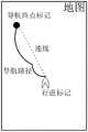
图1示例性提供一种现有的地图显示模式的示意图。如图1所示,地图中包含用户对应的行进标记以及导航终点标记。在第一时间点,用户在现实世界中的行进方向是向北,行进标记指向用户终端的屏幕上方;在第二时间点,用户在现实世界中的行进方向是向东,行进标记转而指向用户终端的屏幕右方,在第一时间点至第二时间点过程中,地图的上下左右始终代表现实世界中的北南西东。FIG. 1 exemplarily provides a schematic diagram of an existing map display mode. As shown in FIG. 1 , the map includes a travel mark and a navigation end point mark corresponding to the user. At the first time point, the user's travel direction in the real world is north, and the travel mark points to the upper screen of the user terminal; at the second time point, the user's travel direction in the real world is east, and the travel mark points to On the right side of the screen of the user terminal, during the process from the first time point to the second time point, the top, bottom, left, and right sides of the map always represent north, south, west, east in the real world.
但是,用户在现实世界中行进时,其主观感受是一直向自己的前方行进,用户关心的是在自己需要转向时,具体需要向自己的哪个方向(前后左右)进行转向,而不是自己向现实世界中的哪个方向(东南西北)进行转向。而现有的地图的上下左右通常分别固定地代表现实世界中的方向,例如,地图的正上方始终指向正北方,那么,地图上的行进标记指向的方向就需要动态变化,用户就不得不观察行进标记在地图中指向的方向,结合地图中上下左右所代表的方向,推测需要向自己的哪个方向(前后左右)进行转向,这样的导航效果对于用户来说是不够直观的,降低用户体验。However, when the user is walking in the real world, his subjective feeling is that he is always moving forward. What the user cares about is when he needs to turn, which direction (front, back, left, right) he needs to turn to, rather than his own direction towards reality. Which direction in the world (south-east-northwest) to turn. However, the top, bottom, left, and right sides of existing maps usually represent directions in the real world. Combining the direction of the travel mark on the map with the directions represented by up, down, left, and right on the map, it is estimated which direction (front, back, left, and right) you need to turn to. Such a navigation effect is not intuitive enough for users and reduces user experience.
而本公开意识到,对于用户来说,比较直观的导航体验是用户观察地图中行进标记始终指向用户终端的屏幕正上方,屏幕正上方可以很直观的代表用户的正前方,让地图偏转来适应固定指向屏幕正上方的行进标记,用户观察行进标记相对于地图所指向的方向,可以很直观的映射为自己主观上的行进方向,即地图中的上方代表用户自己的前方,地图中的左方代表用户自己的左方,地图中的右方代表用户自己的右方,地图中的下方代表用户自己的后方。这样的导航效果对于用户来说是非常直观的,提升了用户体验。However, this disclosure realizes that for the user, a more intuitive navigation experience is that the user observes the travel mark in the map and always points directly above the screen of the user terminal. Fixed pointing to the travel mark directly above the screen, the user observes the direction the travel mark is pointing relative to the map, which can be intuitively mapped to his own subjective travel direction, that is, the upper part of the map represents the front of the user himself, and the left side of the map represents the user's own left, the right of the map represents the user's right, and the bottom of the map represents the user's rear. Such a navigation effect is very intuitive for users and improves user experience.
总结来说,在本公开提供的上述技术方案中,让地图上的行进标记固定地指向用户终端的屏幕正上方,使得从用户观察用户终端所显示的地图的视角来看,自己相对于地图的行进方向始终是固定向前方的,这与用户在现实世界中对行进方向的主观感受一致(即不论实际是朝东西南北方向,自己感受到的始终是向自己的前方行进)。To sum up, in the above technical solution provided by the present disclosure, the travel mark on the map is fixedly pointing directly above the screen of the user terminal, so that from the perspective of the user observing the map displayed on the user terminal, his own relative to the map The direction of travel is always fixed to the front, which is consistent with the user's subjective feeling of the direction of travel in the real world (that is, no matter whether it is actually facing east, west, north, south, what I feel is always moving forward).
而用户在现实世界中的行进方向如果发生变化,则以偏转地图的方式对地图进行更新显示,使得偏转后的所述地图的正上方向,依然可以代表用户在现实世界中变化后的行进方向,这样就可以适应始终固定执行用户终端屏幕正上方的行进标记,使得行进标记依然可以起到表示用户相对于地图的行进方向的作用。If the user's traveling direction in the real world changes, the map will be updated and displayed by deflecting the map, so that the deflected direction directly above the map can still represent the user's changed traveling direction in the real world , so that it can be adapted to always fix the traveling mark directly above the screen of the user terminal, so that the traveling mark can still play the role of indicating the user's traveling direction relative to the map.
图2示例性提供一种本公开的地图显示模式的示意图。如图2所示,在第一时间点,用户在现实世界中的行进方向是向北,行进标记指向用户终端的屏幕上方,地图的上下左右分别代表现实世界中的北南西东;在第二时间点,用户在现实世界中的行进方向是向东,行进标记依然指向用户终端的屏幕上方,但是地图发生了偏转,偏转后的地图的在第一时间点至第二时间点过程中,地图的上下左右改为分别代表现实世界中的东西北南。FIG. 2 exemplarily provides a schematic diagram of a map display mode of the present disclosure. As shown in Figure 2, at the first point in time, the user's travel direction in the real world is north, the travel mark points to the top of the screen of the user terminal, and the top, bottom, left, and right sides of the map respectively represent the north, south, west, and east in the real world; At this point in time, the user's travel direction in the real world is eastward, and the travel mark still points to the top of the screen of the user terminal, but the map has been deflected. From the first time point to the second time point of the deflected map, the map The up, down, left, and right are changed to represent the east, west, north, and south in the real world.
此外,考虑到一方面需要尽可能利用用户终端的屏幕显示区域对地图进行放大显示以体现尽可能多的地图细节,另一方面不论地图如何偏转,地图上的行进标记与导航终点标记之间的位置关系依然需要展示给用户(不能出现导航终点标记的位置位于屏幕显示范围之外的情况),因此,更新显示地图时需要采用合适的比例尺(第二比例尺)。在计算比例尺时,确定在已经偏转但仍保持之前的比例尺(第一比例尺)的地图中行进标记与行进终点之间的连线落入到所述用户终端的屏幕显示区域内的线段长度,以及确定用户与导航终点的距离,二者之间的比值即是比例尺。In addition, considering that on the one hand, it is necessary to use the screen display area of the user terminal to zoom in on the map to reflect as many map details as possible; The positional relationship still needs to be displayed to the user (it cannot appear that the position of the navigation end mark is outside the display range of the screen), therefore, an appropriate scale (the second scale) needs to be used when updating the displayed map. When calculating the scale, determine the length of the line segment that the line between the travel mark and the travel end point falls into the screen display area of the user terminal in the map that has been deflected but still maintains the previous scale (first scale), and Determine the distance between the user and the navigation end point, and the ratio between the two is the scale.
在该比例尺下,可以确保更新显示的偏转后的地图上,行进标记与导航终点标记之间的连线位于屏幕显示区域内,并且,尽可能利用屏幕显示区域对地图进行放大显示以体现尽可能多的地图细节。Under this scale, it can be ensured that on the updated and displayed deflected map, the line between the marching marker and the navigation end marker is located in the display area of the screen, and the map is enlarged and displayed by using the display area of the screen as much as possible to reflect as much as possible Lots of map details.
需要说明的是,如果地图中还包含行进标记与导航终点标记之间的导航路径(在另一些实施例中,导航路径可以是导航出发点标记与导航终点标记之间的路径,行进标记相对于导航路径的位置动态变化),那么,在该比例尺下,可以确保更新显示的偏转后地图上,至少行进标记与导航终点标记之间的导航路径可以位于屏幕显示区域内,并且,尽可能利用屏幕显示区域对地图进行放大显示以体现尽可能多的地图细节。It should be noted that if the map also includes a navigation route between the travel mark and the navigation end mark (in other embodiments, the navigation route may be a path between the navigation starting point mark and the navigation end mark, the travel mark is relative to the navigation The position of the path changes dynamically), then, under this scale, it can be ensured that on the updated deflected map, at least the navigation path between the marching mark and the navigation end mark can be located in the display area of the screen, and the screen display can be used as much as possible Regions zoom in on the map to reflect as much map detail as possible.
容易理解,地图细节可以包括道路细节、道路中的标注信息(比如道路中某个商铺的名称)、导航路径细节、导航路径上的标注信息(比如导航路径上的某个商铺的名称)。通过确定合适的比例尺来尽可能放大显示地图,可以向用户展示丰富的地图细节,提升用户体验。It is easy to understand that the map details may include road details, marked information on the road (such as the name of a certain shop on the road), details of the navigation route, and marked information on the navigation route (such as the name of a certain shop on the navigation route). By determining an appropriate scale to zoom in on the map as much as possible, you can show users rich map details and improve user experience.
图3示例性提供一种包含导航路径的地图。如图3所示,通常只要确保行进标记与导航终点标记之间的连线位于屏幕显示区域内,就往往可以相应确保行进标记与导航终点标记之间的导航路径可以位于屏幕显示区域内。Fig. 3 exemplarily provides a map including a navigation path. As shown in FIG. 3 , generally as long as the line between the traveling marker and the navigation end marker is ensured to be within the display area of the screen, the navigation path between the marching marker and the navigation end marker can be ensured to be within the display area of the screen.
以下详细说明本公开提供的技术方案。The technical solutions provided by the present disclosure are described in detail below.
图4示例性提供一种出行导航服务的地图显示方法的流程,包括如下步骤:Figure 4 exemplarily provides a flow of a map display method for travel navigation services, including the following steps:
S400:展示出行导航服务界面。S400: displaying a travel navigation service interface.
图4所示方法流程应用于用户终端。The method flow shown in FIG. 4 is applied to a user terminal.
通常用户终端可以通过网络获取出行导航服务。在一些实施例中,用户终端可以安装出行导航服务提供的服务应用APP。在另一些实施例中,用户终端可以通过浏览器,以web网页形式获取出行导航服务。Usually, the user terminal can obtain the travel navigation service through the network. In some embodiments, the user terminal may install a service application APP provided by the travel navigation service. In some other embodiments, the user terminal may obtain the travel navigation service in the form of a web page through a browser.
出行导航服务界面中可以包含地图、地图上的行进标记以及导航终点标记,行进标记固定地指向所述用户终端的屏幕正上方。需要说明的是,屏幕正上方其实是指向屏幕顶部边缘的竖直方向。The travel navigation service interface may include a map, a travel mark on the map, and a navigation end point mark, and the travel mark is fixedly pointing directly above the screen of the user terminal. It should be noted that the directly above the screen is actually a vertical direction pointing to the top edge of the screen.
S402:响应于用户在现实世界中的行进方向发生变化,确定地图偏转方式。S402: Determine a map deflection manner in response to a change in the user's traveling direction in the real world.
S404:对采用所述地图偏转方式与第二比例尺的所述地图进行更新显示。S404: Update and display the map using the map deflection method and the second scale.
需要说明,上述的地图偏转方式,可以是指以用户终端屏幕为一个平面,在平面内偏转地图,这是一种平面上的2D偏转操作。此外,如果需要向用户展示3D立体地图,则可以在3D空间中偏转地图,这种偏转操作可能会涉及到对地图的旋转。It should be noted that the above-mentioned map deflection method may refer to deflecting the map within a plane using the user terminal screen as a plane, which is a 2D deflection operation on a plane. In addition, if a 3D stereo map needs to be displayed to the user, the map can be deflected in 3D space, and this deflection operation may involve rotation of the map.
用户终端可以获取用户在现实世界中的实时行进方向。在一些实施例中,用户终端可以周期性监测用户在现实世界中的行进方向是否发生变化。监测周期设置为比较短的时间(比如0.1s),可以相当于实现监测用户的实时行进方向的效果。The user terminal can acquire the real-time traveling direction of the user in the real world. In some embodiments, the user terminal may periodically monitor whether the user's traveling direction in the real world changes. Setting the monitoring period to a relatively short time (for example, 0.1s) can be equivalent to realizing the effect of monitoring the real-time traveling direction of the user.
另外在一些实施例中,还可以响应于用户在现实世界中的行进位置坐标发生变化,对地图进行更新显示。用户在现实世界中的行进位置坐标发生变化时,不论用户在现实世界中的行进方向有没有发生变化,都意味着地图上的行进标记与导航终点标记之间的连线缩短了,这种情况下,在确保上述连线位于屏幕显示区域内的前提下,可以进一步对地图放大显示。只不过如果同时涉及用户在现实世界中的行进方向发生变化的情况下,还需要对地图进行偏转。In addition, in some embodiments, the map may also be updated and displayed in response to changes in the coordinates of the user's traveling position in the real world. When the coordinates of the user's travel position in the real world change, regardless of whether the user's travel direction in the real world changes, it means that the line between the travel mark on the map and the navigation end mark is shortened. Under the premise of ensuring that the above connection line is within the display area of the screen, the map can be further enlarged for display. It's just that if the user's direction of travel in the real world changes, the map needs to be deflected.
类似的,也可以周期性监测用户在现实世界中的行进方向是否发生变化。Similarly, it is also possible to periodically monitor whether the user's direction of travel in the real world changes.
此外在一些实施例中,行进标记相对于地图的位置虽然可以动态变化(这主要是通过更新显示地图实现的),但是行进标记相对于屏幕显示区域的位置可以保持固定,即行进标记固定地显示于所述屏幕显示区域内的指定位置。如此,用户在观察地图上的行进标记时,视觉上可以体验到行进标记的位置是始终不变的,地图为了适应行进标记而偏转和/或放大,如果用户将自己带入到行进标记的话,这与用户自己在现实世界中的主观体验是一致的,可以进一步提升用户体验。比如,用户驾车行使过程中,始终端坐在驾驶位,始终面向自己的前方,周围的路况动态适应自己的视野。In addition, in some embodiments, although the position of the travel mark relative to the map can be changed dynamically (this is mainly realized by updating the displayed map), the position of the travel mark relative to the display area of the screen can remain fixed, that is, the travel mark is displayed fixedly at a specified location within the display area of the screen. In this way, when the user observes the travel mark on the map, he can visually experience that the position of the travel mark is always the same, and the map is deflected and/or enlarged to fit the travel mark. If the user brings himself into the travel mark, This is consistent with the user's own subjective experience in the real world, which can further enhance the user experience. For example, when the user is driving, he always sits in the driver's seat, always facing his front, and the surrounding road conditions dynamically adapt to his field of vision.
进一步的,指定位置可以是所述屏幕显示区域的下半部分区域内的位置。由于行进标记是固定指向屏幕正上方的,而导航终点标记通常设置在行进标记的上方区域(这相当于用户直觉上更远的前方),因此,为了更好的利用屏幕显示区域,将行进标记固定在屏幕显示区域的下半部分区域内。Further, the specified location may be a location in the lower half of the screen display area. Since the travel mark is fixedly pointing directly above the screen, and the navigation end mark is usually set in the area above the travel mark (this is equivalent to the user's intuition farther ahead), therefore, in order to make better use of the screen display area, the travel mark Fixed in the lower half of the screen display area.
另外,本公开中用户终端的屏幕显示区域可以屏幕范围内的区域,其可以是屏幕范围本身,也可以是小于屏幕范围的区域。屏幕显示区域可以是任何形状的区域。In addition, the screen display area of the user terminal in the present disclosure may be an area within the screen range, which may be the screen range itself, or an area smaller than the screen range. The screen display area can be an area of any shape.
确定更新显示所述地图时采用的比例尺的步骤可以包括:在采用所述地图偏转方式与所述第一比例尺的所述地图中,确定所述行进标记与行进终点之间的连线,并确定所述连线落入到所述用户终端的屏幕显示区域内的线段长度;根据所述用户的位置坐标与导航终点的位置坐标,确定所述用户与所述导航终点之间的距离;计算所述距离与所述线段长度的比值,得到所述第二比例尺。The step of determining the scale used when updating and displaying the map may include: in the map using the map deflection method and the first scale, determining a line connecting the travel mark and the travel end point, and determining The length of the line segment that the connecting line falls into the screen display area of the user terminal; according to the position coordinates of the user and the position coordinates of the navigation end point, determine the distance between the user and the navigation end point; calculate the The ratio of the distance to the length of the line segment is used to obtain the second scale.
需要说明,上述的连线可以两端无限延伸,连线与屏幕显示区域边界产生交点,行进标记与交点之间的线段长度,就是连线落入到所述用户终端的屏幕显示区域内的线段长度。It should be noted that the above-mentioned connecting line can extend infinitely at both ends, and the connecting line and the boundary of the screen display area generate an intersection point, and the length of the line segment between the traveling mark and the intersection point is the line segment where the connecting line falls into the screen display area of the user terminal length.
还需要说明,采用所述地图偏转方式与所述第一比例尺的所述地图,实际上是进行了偏转,但是未适用新计算的比例尺的地图。It should also be noted that the map using the map deflection method and the first scale is actually deflected, but the newly calculated scale is not applied to the map.
容易理解,上述确定比例尺的步骤,是指响应于用户在现实世界中的行进方向发生变化之后,在对地图进行更新显示之前执行的。It is easy to understand that the above-mentioned step of determining the scale is executed before updating and displaying the map after responding to changes in the user's traveling direction in the real world.
还容易理解,取决于比例尺如何定义,可以以距离为分子,线段长度为分母,计算比值作为比例尺。也可以以距离为分母,线段长度为分子,计算比值作为比例尺。It is also easy to understand, depending on how the scale is defined, the distance can be used as the numerator, the length of the line segment can be used as the denominator, and the calculated ratio can be used as the scale. You can also use the distance as the denominator, the length of the line segment as the numerator, and calculate the ratio as the scale.
作为一种示例,屏幕显示区域可以是矩形区域,对于手机来说,屏幕显示区域的横向边长小于纵向边长。以下提供一种屏幕显示区域是矩形区域情况下计算上述的线段长度的方法。As an example, the screen display area may be a rectangular area, and for a mobile phone, the horizontal side length of the screen display area is smaller than the vertical side length. The following provides a method for calculating the above-mentioned line segment length when the screen display area is a rectangular area.
具体而言,可以确定所述连线与竖直方向的夹角,然后根据所述夹角与所述矩形区域的边长,计算得到所述连线落入到所述用户终端的屏幕显示区域内的线段长度。Specifically, the included angle between the connecting line and the vertical direction may be determined, and then calculated according to the included angle and the side length of the rectangular area to obtain that the connecting line falls into the screen display area of the user terminal The length of the line segment in .
图5示例性提供一种计算线段长度的示意图。如图5所示,屏幕显示区域是矩形的情况下,行进标记位于屏幕显示区域的下半部分区域,以D点代表。当地图发生偏转时,在旧比例尺下,导航终点标记可能会位于屏幕显示区域之外,以H点代表,当然,H点可以在D点的周围360度的任何方向上。以D点为基点建立坐标系,X轴是横向的,位于屏幕显示区域的下半部分区域,Y轴是纵向的,位于屏幕显示区域的中央。屏幕显示区域的矩形边长数据是已知的(图中的a、b、c),在D、H已知的情况下,DH连线与X轴或Y轴的夹角(即DG向量与X轴或Y轴的夹角)也可以确定,为δ,因此,可以利用三角函数原理计算出DH连线落入到屏幕显示区域内的线段DG的长度。具体的三角函数计算公式可以如下所述:FIG. 5 exemplarily provides a schematic diagram of calculating the length of a line segment. As shown in FIG. 5 , when the screen display area is a rectangle, the travel mark is located in the lower half of the screen display area, represented by point D. When the map is deflected, under the old scale, the navigation end mark may be located outside the display area of the screen, represented by H point, of course, H point can be in any direction of 360 degrees around D point. A coordinate system is established with point D as the base point. The X axis is horizontal and located in the lower half of the screen display area, and the Y axis is vertical and located in the center of the screen display area. The rectangular side length data of the screen display area is known (a, b, c in the figure), in the case of known D, H, the angle between the DH line and the X-axis or Y-axis (that is, the DG vector and The included angle of the X-axis or Y-axis) can also be determined, which is δ, therefore, the length of the line segment DG where the line DH falls into the display area of the screen can be calculated by using the principle of trigonometric functions. The specific trigonometric function calculation formula can be described as follows:


本公开还提供一种出行导航服务的地图显示装置,应用于用户终端,所述装置包括:The present disclosure also provides a map display device for travel navigation service, which is applied to a user terminal, and the device includes:
展示模块,展示出行导航服务界面,所述界面中包含地图、所述地图上的行进标记以及导航终点标记,所述行进标记固定地指向所述用户终端的屏幕正上方;The display module displays a travel navigation service interface, the interface includes a map, a travel mark on the map and a navigation end mark, and the travel mark is fixedly pointing directly above the screen of the user terminal;
更新显示模块,响应于用户在现实世界中的行进方向发生变化,以偏转所述地图的方式对所述地图进行更新显示,使得偏转后的所述地图的正上方向,代表用户在现实世界中变化后的行进方向;The update display module, in response to changes in the user's travel direction in the real world, updates and displays the map by deflecting the map, so that the deflected upward direction of the map represents the user's travel in the real world changed direction of travel;
其中,采用如下方式确定更新显示所述地图时采用的比例尺:Wherein, the scale used when updating and displaying the map is determined in the following manner:
在偏转后的所述地图中确定所述行进标记与行进终点之间的连线,并确定所述连线落入到所述用户终端的屏幕显示区域内的线段长度;Determining a connecting line between the traveling mark and the traveling end point in the deflected map, and determining the length of the line segment that the connecting line falls into the screen display area of the user terminal;
根据所述用户的位置坐标与导航终点的位置坐标,确定所述用户与所述导航终点的距离;determining the distance between the user and the navigation endpoint according to the location coordinates of the user and the location coordinates of the navigation endpoint;
计算所述距离与所述线段长度的比值,得到比例尺。Calculate the ratio of the distance to the length of the line segment to obtain a scale.
本公开还提出了一种基于位置的服务提供方法,所述方法利用本公开实施例的方法得到的导航地图,以利用所述导航地图为被服务对象提供基于位置的服务,所述基于位置的服务包括:导航、地图渲染、路线规划中的一种或多种。The present disclosure also proposes a method for providing location-based services. The method uses the navigation map obtained by the method of the embodiment of the disclosure to provide location-based services for service objects by using the navigation map. The location-based The service includes: one or more of navigation, map rendering, and route planning.
本公开还提出了一种计算机程序产品,用于实现本公开实施例的方法。The present disclosure also proposes a computer program product for realizing the method of the embodiment of the present disclosure.
本公开还提供一种计算设备,包括存储器、处理器;所述存储器用于存储可在处理器上运行的计算机指令,所述处理器用于在执行所述计算机指令时实现本公开实施例的方法。The present disclosure also provides a computing device, including a memory and a processor; the memory is used to store computer instructions that can be run on the processor, and the processor is used to implement the methods of the embodiments of the present disclosure when executing the computer instructions .
本公开还提供一种计算机可读存储介质,如图6所示,其上存储有计算机程序,所述程序被处理器执行时实现本公开实施例的方法。The present disclosure also provides a computer-readable storage medium, as shown in FIG. 6 , on which a computer program is stored, and when the program is executed by a processor, the method of the embodiment of the present disclosure is implemented.
图7是本公开提供的一种计算设备的结构示意图,该计算设备15可以包括但不限于:处理器151、存储器152、连接不同系统组件(包括存储器152和处理器151)的总线153。7 is a schematic structural diagram of a computing device provided by the present disclosure. The
其中,存储器152存储有计算机指令,该计算机指令可以被处理器151执行,使得处理器151能够执行本公开任一实施例的方法。存储器152可以包括随机存取存储单元RAM1521、高速缓存存储单元1522和/或只读存储单元ROM1523。该存储器152还可以包括:具有一组程序模块1524的程序工具1525,该程序模块1524包括但不限于:操作系统、一个或多个应用程序、其他程序模块和程序数据,这些程序模块一种或多种组合可以包含网络环境的实现。Wherein, the
总线153例如可以包括数据总线、地址总线和控制总线等。该计算设备15还可以通过I/O接口154与外部设备155通信,该外部设备155例如可以是键盘、蓝牙设备等。该计算设备150还可以通过网络适配器156与一个或多个网络通信,例如,该网络可以是局域网、广域网、公共网络等。如图所示,该网络适配器156还可以通过总线153与计算设备15的其他模块进行通信。The
此外,尽管在附图中以特定顺序描述了本公开方法的操作,但是,这并非要求或者暗示必须按照该特定顺序来执行这些操作,或是必须执行全部所示的操作才能实现期望的结果。附加地或备选地,可以省略某些步骤,将多个步骤合并为一个步骤执行,和/或将一个步骤分解为多个步骤执行。In addition, while operations of the disclosed methods are depicted in the figures in a particular order, there is no requirement or implication that these operations must be performed in that particular order, or that all illustrated operations must be performed, to achieve desirable results. Additionally or alternatively, certain steps may be omitted, multiple steps may be combined into one step for execution, and/or one step may be decomposed into multiple steps for execution.
虽然已经参考若干具体实施方式描述了本公开的精神和原理,但是应该理解,本公开并不限于所公开的具体实施方式,对各方面的划分也不意味着这些方面中的特征不能组合以进行受益,这种划分仅是为了表述的方便。本公开旨在涵盖所附权利要求的精神和范围内所包括的各种修改和等同布置。Although the spirit and principles of the present disclosure have been described with reference to several specific embodiments, it should be understood that the disclosure is not limited to the specific embodiments disclosed, nor does division of aspects imply that features in these aspects cannot be combined to achieve optimal performance. Benefit, this division is only for the convenience of expression. The present disclosure is intended to cover various modifications and equivalent arrangements included within the spirit and scope of the appended claims.
上述实施例阐明的系统、装置、模块或单元,具体可以由计算机芯片或实体实现,或者由具有某种功能的产品来实现。一种典型的实现设备为计算机。具体的,计算机例如可以为个人计算机、膝上型计算机、蜂窝电话、相机电话、智能电话、个人数字助理、媒体播放器、导航设备、电子邮件设备、游戏控制台、平板计算机、可穿戴设备或者这些设备中的任何设备的组合。The systems, devices, modules, or units described in the above embodiments can be specifically implemented by computer chips or entities, or by products with certain functions. A typical implementing device is a computer. Specifically, the computer may be, for example, a personal computer, a laptop computer, a cellular phone, a camera phone, a smart phone, a personal digital assistant, a media player, a navigation device, an email device, a game console, a tablet computer, a wearable device, or Combinations of any of these devices.
为了描述的方便,描述以上装置时以功能分为各种单元分别描述。当然,在实施本说明书时可以把各单元的功能在同一个或多个软件和/或硬件中实现。For the convenience of description, when describing the above devices, functions are divided into various units and described separately. Of course, when implementing this specification, the functions of each unit can be implemented in one or more pieces of software and/or hardware.
本领域内的技术人员应明白,本发明的实施例可提供为方法、系统、或计算机程序产品。因此,本发明可采用完全硬件实施例、完全软件实施例、或结合软件和硬件方面的实施例的形式。而且,本发明可采用在一个或多个其中包含有计算机可用程序代码的计算机可用存储介质(包括但不限于磁盘存储器、CD-ROM、光学存储器等)上实施的计算机程序产品的形式。Those skilled in the art should understand that the embodiments of the present invention may be provided as methods, systems, or computer program products. Accordingly, the present invention can take the form of an entirely hardware embodiment, an entirely software embodiment, or an embodiment combining software and hardware aspects. Furthermore, the present invention may take the form of a computer program product embodied on one or more computer-usable storage media (including but not limited to disk storage, CD-ROM, optical storage, etc.) having computer-usable program code embodied therein.
本发明是参照根据本发明实施例的方法、设备(系统)、和计算机程序产品的流程图和/或方框图来描述的。应理解可由计算机程序指令实现流程图和/或方框图中的每一流程和/或方框、以及流程图和/或方框图中的流程和/或方框的结合。可提供这些计算机程序指令到通用计算机、专用计算机、嵌入式处理机或其他可编程数据处理设备的处理器以产生一个机器,使得通过计算机或其他可编程数据处理设备的处理器执行的指令产生用于实现在流程图一个流程或多个流程和/或方框图一个方框或多个方框中指定的功能的装置。The present invention is described with reference to flowchart illustrations and/or block diagrams of methods, apparatus (systems), and computer program products according to embodiments of the invention. It should be understood that each procedure and/or block in the flowchart and/or block diagram, and a combination of procedures and/or blocks in the flowchart and/or block diagram can be realized by computer program instructions. These computer program instructions may be provided to a general purpose computer, special purpose computer, embedded processor, or processor of other programmable data processing equipment to produce a machine such that the instructions executed by the processor of the computer or other programmable data processing equipment produce a An apparatus for realizing the functions specified in one or more procedures of the flowchart and/or one or more blocks of the block diagram.
本说明书可以在由计算机执行的计算机可执行指令的一般上下文中描述,例如程序模块。一般地,程序模块包括执行特定任务或实现特定抽象数据类型的例程、程序、对象、组件、数据结构等等。也可以在分布式计算环境中实践本说明书,在这些分布式计算环境中,由通过通信网络而被连接的远程处理设备来执行任务。在分布式计算环境中,程序模块可以位于包括存储设备在内的本地和远程计算机存储介质中。The specification may be described in the general context of computer-executable instructions, such as program modules, being executed by a computer. Generally, program modules include routines, programs, objects, components, data structures, etc. that perform particular tasks or implement particular abstract data types. The present description may also be practiced in distributed computing environments where tasks are performed by remote processing devices that are linked through a communications network. In a distributed computing environment, program modules may be located in both local and remote computer storage media including storage devices.
这些计算机程序指令也可存储在能引导计算机或其他可编程数据处理设备以特定方式工作的计算机可读存储器中,使得存储在该计算机可读存储器中的指令产生包括指令装置的制造品,该指令装置实现在流程图一个流程或多个流程和/或方框图一个方框或多个方框中指定的功能。These computer program instructions may also be stored in a computer-readable memory capable of directing a computer or other programmable data processing apparatus to operate in a specific manner, such that the instructions stored in the computer-readable memory produce an article of manufacture comprising instruction means, the instructions The device realizes the function specified in one or more procedures of the flowchart and/or one or more blocks of the block diagram.
这些计算机程序指令也可装载到计算机或其他可编程数据处理设备上,使得在计算机或其他可编程设备上执行一系列操作步骤以产生计算机实现的处理,从而在计算机或其他可编程设备上执行的指令提供用于实现在流程图一个流程或多个流程和/或方框图一个方框或多个方框中指定的功能的步骤。在一个典型的配置中,计算机包括一个或多个处理器(CPU)、输入/输出接口、网络接口和内存。These computer program instructions can also be loaded onto a computer or other programmable data processing device, causing a series of operational steps to be performed on the computer or other programmable device to produce a computer-implemented process, thereby The instructions provide steps for implementing the functions specified in the flow chart or blocks of the flowchart and/or the block or blocks of the block diagrams. In a typical configuration, a computer includes one or more processors (CPUs), input/output interfaces, network interfaces and memory.
内存可能包括计算机可读介质中的非永久性存储器,随机存取存储器(RAM)和/或非易失性内存等形式,如只读存储器(ROM)或闪存(flash RAM)。内存是计算机可读介质的示例。Memory may include non-permanent storage in computer readable media, in the form of random access memory (RAM) and/or nonvolatile memory such as read only memory (ROM) or flash RAM. Memory is an example of computer readable media.
计算机可读介质包括永久性和非永久性、可移动和非可移动媒体可以由任何方法或技术来实现信息存储。信息可以是计算机可读指令、数据结构、程序的模块或其他数据。计算机的存储介质的例子包括,但不限于相变内存(PRAM)、静态随机存取存储器(SRAM)、动态随机存取存储器(DRAM)、其他类型的随机存取存储器(RAM)、只读存储器(ROM)、电可擦除可编程只读存储器(EEPROM)、快闪记忆体或其他内存技术、只读光盘只读存储器(CD-ROM)、数字多功能光盘(DVD)或其他光学存储、磁盒式磁带、磁盘存储、量子存储器、基于石墨烯的存储介质或其他磁性存储设备或任何其他非传输介质,可用于存储可以被计算设备访问的信息。按照本文中的界定,计算机可读介质不包括暂存电脑可读媒体(transitory media),如调制的数据信号和载波。Computer-readable media, including both permanent and non-permanent, removable and non-removable media, can be implemented by any method or technology for storage of information. Information may be computer readable instructions, data structures, modules of a program, or other data. Examples of computer storage media include, but are not limited to, phase change memory (PRAM), static random access memory (SRAM), dynamic random access memory (DRAM), other types of random access memory (RAM), read only memory (ROM), Electrically Erasable Programmable Read-Only Memory (EEPROM), Flash memory or other memory technology, Compact Disc Read-Only Memory (CD-ROM), Digital Versatile Disc (DVD) or other optical storage, Magnetic cassettes, disk storage, quantum memory, graphene-based storage media or other magnetic storage devices or any other non-transmission media that can be used to store information that can be accessed by computing devices. As defined herein, computer-readable media excludes transitory computer-readable media, such as modulated data signals and carrier waves.
还需要说明的是,术语“包括”、“包含”或者其任何其他变体意在涵盖非排他性的包含,从而使得包括一系列要素的过程、方法、商品或者设备不仅包括那些要素,而且还包括没有明确列出的其他要素,或者是还包括为这种过程、方法、商品或者设备所固有的要素。在没有更多限制的情况下,由语句“包括一个……”限定的要素,并不排除在包括所述要素的过程、方法、商品或者设备中还存在另外的相同要素。It should also be noted that the term "comprises", "comprises" or any other variation thereof is intended to cover a non-exclusive inclusion such that a process, method, article, or apparatus comprising a set of elements includes not only those elements, but also includes Other elements not expressly listed, or elements inherent in the process, method, commodity, or apparatus are also included. Without further limitations, an element defined by the phrase "comprising a ..." does not exclude the presence of additional identical elements in the process, method, article or apparatus comprising said element.
上述对本说明书多个实施例进行了描述。其它实施例在所附权利要求书的范围内。在一些情况下,在权利要求书中记载的动作或步骤可以按照不同于实施例中的顺序来执行并且仍然可以实现期望的结果。另外,在附图中描绘的过程不一定要求示出的特定顺序或者连续顺序才能实现期望的结果。在某些实施方式中,多任务处理和并行处理也是可以的或者可能是有利的。The foregoing describes multiple embodiments of the present specification. Other implementations are within the scope of the following claims. In some cases, the actions or steps recited in the claims can be performed in an order different from that in the embodiments and still achieve desirable results. In addition, the processes depicted in the accompanying figures do not necessarily require the particular order shown, or sequential order, to achieve desirable results. Multitasking and parallel processing are also possible or may be advantageous in certain embodiments.
在本说明书多个实施例使用的术语是仅仅出于描述特定实施例的目的,而非旨在限制本说明书多个实施例。在本说明书多个实施例和所附权利要求书中所使用的单数形式的“一种”、“所述”和“该”也旨在包括多数形式,除非上下文清楚地表示其他含义。还应当理解,本文中使用的术语“和/或”是指并包含一个或多个相关联的列出项目的任何或所有可能组合。Terms used in various embodiments of this specification are only for the purpose of describing specific embodiments, and are not intended to limit the various embodiments of this specification. As used in the various embodiments of this specification and the appended claims, the singular forms "a", "said" and "the" are also intended to include the plural forms unless the context clearly dictates otherwise. It should also be understood that the term "and/or" as used herein refers to and includes any and all possible combinations of one or more of the associated listed items.
应当理解,尽管在本说明书多个实施例可能采用术语第一、第二、第三等来描述各种信息,但这些信息不应限于这些术语。这些术语仅用来将同一类型的信息彼此区分开。例如,在不脱离本说明书多个实施例范围的情况下,第一信息也可以被称为第二信息,类似地,第二信息也可以被称为第一信息。取决于语境,如在此所使用的词语“如果”可以被解释成为“在……时”或“当……时”或“响应于确定”。It should be understood that although the terms first, second, third, etc. may be used in multiple embodiments of this specification to describe various information, the information should not be limited to these terms. These terms are only used to distinguish information of the same type from one another. For example, without departing from the scope of multiple embodiments of this specification, first information may also be called second information, and similarly, second information may also be called first information. Depending on the context, the word "if" as used herein may be interpreted as "at" or "when" or "in response to a determination."
本说明书中的各个实施例均采用递进的方式描述,各个实施例之间相同相似的部分互相参见即可,每个实施例重点说明的都是与其他实施例的不同之处。尤其,对于方法实施例而言,由于其基本相似于方法实施例,所以描述得比较简单,相关之处参见方法实施例的部分说明即可。以上所描述的方法实施例仅仅是示意性的,其中所述作为分离部件说明的模块可以是或者也可以不是物理上分开的,在实施本说明书实施例方案时可以把各模块的功能在同一个或多个软件和/或硬件中实现。也可以根据实际的需要选择其中的部分或者全部模块来实现本实施例方案的目的。本领域普通技术人员在不付出创造性劳动的情况下,即可以理解并实施。Each embodiment in this specification is described in a progressive manner, the same and similar parts of each embodiment can be referred to each other, and each embodiment focuses on the differences from other embodiments. In particular, as for the method embodiments, since they are basically similar to the method embodiments, the description is relatively simple, and for relevant parts, please refer to part of the description of the method embodiments. The method embodiments described above are only illustrative, and the modules described as separate components may or may not be physically separated, and the functions of each module may be integrated into the same or multiple software and/or hardware implementations. Part or all of the modules can also be selected according to actual needs to achieve the purpose of the solution of this embodiment. It can be understood and implemented by those skilled in the art without creative effort.
以上所述仅为本说明书多个实施例的较佳实施例而已,并不用以限制本说明书多个实施例,凡在本说明书多个实施例的精神和原则之内,所做的任何修改、等同替换、改进等,均应包含在本说明书多个实施例保护的范围之内。The above descriptions are only preferred embodiments of multiple embodiments of this specification, and are not intended to limit multiple embodiments of this specification. Any modifications, Equivalent replacements, improvements, etc., should all be included within the scope of protection of the multiple embodiments of this specification.
Claims (13)
Priority Applications (1)
| Application Number | Priority Date | Filing Date | Title |
|---|---|---|---|
| CN202210975565.6ACN115435806A (en) | 2022-08-15 | 2022-08-15 | Map display method, device and equipment for travel navigation service |
Applications Claiming Priority (1)
| Application Number | Priority Date | Filing Date | Title |
|---|---|---|---|
| CN202210975565.6ACN115435806A (en) | 2022-08-15 | 2022-08-15 | Map display method, device and equipment for travel navigation service |
Publications (1)
| Publication Number | Publication Date |
|---|---|
| CN115435806Atrue CN115435806A (en) | 2022-12-06 |
Family
ID=84242196
Family Applications (1)
| Application Number | Title | Priority Date | Filing Date |
|---|---|---|---|
| CN202210975565.6APendingCN115435806A (en) | 2022-08-15 | 2022-08-15 | Map display method, device and equipment for travel navigation service |
Country Status (1)
| Country | Link |
|---|---|
| CN (1) | CN115435806A (en) |
Citations (6)
| Publication number | Priority date | Publication date | Assignee | Title |
|---|---|---|---|---|
| US4914605A (en)* | 1984-10-22 | 1990-04-03 | Etak, Inc. | Apparatus and method for displaying a map |
| JPH05173476A (en)* | 1991-12-25 | 1993-07-13 | Pioneer Electron Corp | Map display method for navigation device |
| US20090088969A1 (en)* | 2007-10-02 | 2009-04-02 | Denso Corporation | Map display apparatus |
| CN102278992A (en)* | 2006-12-26 | 2011-12-14 | 罗姆股份有限公司 | Position display apparatus |
| CN105190345A (en)* | 2013-03-15 | 2015-12-23 | 耐克斯特纳威公司 | Systems and methods for improving location services using three-dimensional location information |
| CN111443851A (en)* | 2020-03-25 | 2020-07-24 | 成都星时代宇航科技有限公司 | Visual angle switching method of travel track and terminal |
- 2022
- 2022-08-15CNCN202210975565.6Apatent/CN115435806A/enactivePending
Patent Citations (6)
| Publication number | Priority date | Publication date | Assignee | Title |
|---|---|---|---|---|
| US4914605A (en)* | 1984-10-22 | 1990-04-03 | Etak, Inc. | Apparatus and method for displaying a map |
| JPH05173476A (en)* | 1991-12-25 | 1993-07-13 | Pioneer Electron Corp | Map display method for navigation device |
| CN102278992A (en)* | 2006-12-26 | 2011-12-14 | 罗姆股份有限公司 | Position display apparatus |
| US20090088969A1 (en)* | 2007-10-02 | 2009-04-02 | Denso Corporation | Map display apparatus |
| CN105190345A (en)* | 2013-03-15 | 2015-12-23 | 耐克斯特纳威公司 | Systems and methods for improving location services using three-dimensional location information |
| CN111443851A (en)* | 2020-03-25 | 2020-07-24 | 成都星时代宇航科技有限公司 | Visual angle switching method of travel track and terminal |
Similar Documents
| Publication | Publication Date | Title |
|---|---|---|
| US8880341B2 (en) | Method and apparatus for displaying three-dimensional terrain and route guidance | |
| US8954275B2 (en) | Schematic maps | |
| US9223408B2 (en) | System and method for transitioning between interface modes in virtual and augmented reality applications | |
| US9092897B2 (en) | Method and apparatus for displaying interface elements | |
| US8032297B2 (en) | Method and system for displaying navigation information on an electronic map | |
| EP3004803B1 (en) | A method and apparatus for self-adaptively visualizing location based digital information | |
| KR102832110B1 (en) | Dynamically varying visual properties of indicators on a digital map | |
| CN104121910A (en) | Navigation method and device, terminal, server and system | |
| KR20170046675A (en) | Providing in-navigation search results that reduce route disruption | |
| US9528845B2 (en) | Occlusion-reduced 3D routing for 3D city maps | |
| TWI694298B (en) | Information display method, device and terminal | |
| EP2905746A1 (en) | Stereoscopic map display system | |
| CN115683152A (en) | Vehicle navigation guiding method and device based on coordinate transformation and electronic equipment | |
| CN109489654B (en) | Navigation route presenting method, device, equipment and storage medium | |
| JP6213686B1 (en) | Display device | |
| US12392629B2 (en) | Viewport system for dynamically framing of a map based on updating data | |
| CN115435806A (en) | Map display method, device and equipment for travel navigation service | |
| CN108548532A (en) | Blind man navigation method, electronic equipment and computer program product based on cloud | |
| JP6143871B2 (en) | Map display system, map display method and program | |
| CN119604741A (en) | Immersive digital map navigation using one hand | |
| JP6016765B2 (en) | 3D map display system and synthetic texture generation apparatus | |
| CN117473033A (en) | Road name display method, device and equipment in electronic map and storage medium | |
| CN117387653A (en) | Display method, device and equipment of navigation guidance arrows in navigation map | |
| KR20120006624A (en) | 3D map display method of navigation device |
Legal Events
| Date | Code | Title | Description |
|---|---|---|---|
| PB01 | Publication | ||
| PB01 | Publication | ||
| SE01 | Entry into force of request for substantive examination | ||
| SE01 | Entry into force of request for substantive examination |