CN115412883A - Intelligent network connection over-the-horizon driving auxiliary system based on 5G position sharing - Google Patents
Intelligent network connection over-the-horizon driving auxiliary system based on 5G position sharingDownload PDFInfo
- Publication number
- CN115412883A CN115412883ACN202211050241.8ACN202211050241ACN115412883ACN 115412883 ACN115412883 ACN 115412883ACN 202211050241 ACN202211050241 ACN 202211050241ACN 115412883 ACN115412883 ACN 115412883A
- Authority
- CN
- China
- Prior art keywords
- vehicle
- information
- module
- vehicles
- driving
- Prior art date
- Legal status (The legal status is an assumption and is not a legal conclusion. Google has not performed a legal analysis and makes no representation as to the accuracy of the status listed.)
- Pending
Links
Images


Classifications
- H—ELECTRICITY
- H04—ELECTRIC COMMUNICATION TECHNIQUE
- H04W—WIRELESS COMMUNICATION NETWORKS
- H04W4/00—Services specially adapted for wireless communication networks; Facilities therefor
- H04W4/30—Services specially adapted for particular environments, situations or purposes
- H04W4/40—Services specially adapted for particular environments, situations or purposes for vehicles, e.g. vehicle-to-pedestrians [V2P]
- H04W4/44—Services specially adapted for particular environments, situations or purposes for vehicles, e.g. vehicle-to-pedestrians [V2P] for communication between vehicles and infrastructures, e.g. vehicle-to-cloud [V2C] or vehicle-to-home [V2H]
- G—PHYSICS
- G08—SIGNALLING
- G08G—TRAFFIC CONTROL SYSTEMS
- G08G1/00—Traffic control systems for road vehicles
- G08G1/01—Detecting movement of traffic to be counted or controlled
- G08G1/0104—Measuring and analyzing of parameters relative to traffic conditions
- G08G1/0125—Traffic data processing
- G—PHYSICS
- G08—SIGNALLING
- G08G—TRAFFIC CONTROL SYSTEMS
- G08G1/00—Traffic control systems for road vehicles
- G08G1/09—Arrangements for giving variable traffic instructions
- G08G1/0962—Arrangements for giving variable traffic instructions having an indicator mounted inside the vehicle, e.g. giving voice messages
- G08G1/0968—Systems involving transmission of navigation instructions to the vehicle
- H—ELECTRICITY
- H04—ELECTRIC COMMUNICATION TECHNIQUE
- H04W—WIRELESS COMMUNICATION NETWORKS
- H04W4/00—Services specially adapted for wireless communication networks; Facilities therefor
- H04W4/30—Services specially adapted for particular environments, situations or purposes
- H04W4/40—Services specially adapted for particular environments, situations or purposes for vehicles, e.g. vehicle-to-pedestrians [V2P]
- H04W4/46—Services specially adapted for particular environments, situations or purposes for vehicles, e.g. vehicle-to-pedestrians [V2P] for vehicle-to-vehicle communication [V2V]
Landscapes
- Engineering & Computer Science (AREA)
- Computer Networks & Wireless Communication (AREA)
- Signal Processing (AREA)
- Physics & Mathematics (AREA)
- General Physics & Mathematics (AREA)
- Radar, Positioning & Navigation (AREA)
- Remote Sensing (AREA)
- Chemical & Material Sciences (AREA)
- Analytical Chemistry (AREA)
- Traffic Control Systems (AREA)
Abstract
Translated fromChinese
Description
Translated fromChinese技术领域technical field
本发明涉及智能交通技术领域,具体涉及一种基于5G位置共享的智能网联超视距行车辅助系统。The invention relates to the technical field of intelligent transportation, in particular to an intelligent network-linked over-the-horizon driving assistance system based on 5G location sharing.
背景技术Background technique
在匝道合流、分流、急转弯、陡坡、事故、拥挤、极端天气等视距受限的情况下,若在视野盲区内或超视距区域内发生交通事故,由于驾驶员无法快速感知前方路况,从而降低了驾驶安全性。目前智能网联技术仍是车路协同的研究热点之一,智能网联车辆通过搭载的车载传感器、控制器和执行器实现V2X的智能信息交互。因此,通过智能网联技术实现车车通信在视距受限情况下进行行车辅助成为研究关键点。In the case of ramp merges, diversions, sharp turns, steep slopes, accidents, congestion, extreme weather and other limited visibility, if a traffic accident occurs in the blind area of vision or in the area beyond the visual range, the driver cannot quickly perceive the road ahead. Thereby reducing driving safety. At present, intelligent network connection technology is still one of the research hotspots of vehicle-road coordination. Intelligent network connection vehicles realize V2X intelligent information interaction through on-board sensors, controllers and actuators. Therefore, the realization of vehicle-to-vehicle communication for driving assistance in the case of limited line-of-sight through intelligent network technology has become a key research point.
现有技术中,智能网联车辆通过多种交通信息融合和通信获得了超视距的道路交通环境感知能力。车辆根据路侧传感器发来的道路信息对下游交通状况进行判断从而做出驾驶决策,在急转弯、陡坡、事故、拥挤、极端天气等视距受限的情况下,依据在线地图提供行车辅助和路口引导,使车辆完成超视距路径规划,但并未共享控制区内所有车辆的实时位置信息,仍旧存在车辆相撞的安全隐患。In the existing technology, intelligent networked vehicles have obtained the ability to perceive the road traffic environment beyond the line of sight through the fusion and communication of various traffic information. The vehicle judges the downstream traffic conditions based on the road information sent by the roadside sensor to make a driving decision. In the case of sharp turns, steep slopes, accidents, congestion, extreme weather, etc., the vehicle provides driving assistance and Intersection guidance enables vehicles to complete over-the-horizon path planning, but does not share the real-time location information of all vehicles in the control area, and there is still a potential safety hazard of vehicle collisions.
发明内容Contents of the invention
针对现有技术存在的不足,本发明提出一种基于5G位置共享的智能网联超视距行车辅助系统,降低匝道合流、分流、急转弯、陡坡、事故、拥挤、极端天气等视距受限的情况下发生交通事故的概率。Aiming at the deficiencies in the existing technology, the present invention proposes an intelligent network-linked over-the-line-of-sight driving assistance system based on 5G location sharing, which can reduce the limited line-of-sight such as ramp merging, diversion, sharp turns, steep slopes, accidents, congestion, and extreme weather. probability of traffic accidents.
本发明采用的技术方案是一种基于5G位置共享的智能网联超视距行车辅助系统。The technical solution adopted in the present invention is an intelligent network-connected over-the-horizon driving assistance system based on 5G location sharing.
在第一种可实现方式中,一种基于5G位置共享的智能网联超视距行车辅助系统,包括:信息感知模块,与协同计算模块通信连接,信息感知模块用于获取当前车辆的第一运动状态数据;数字孪生模块,与协同计算模块通信连接,数字孪生模块用于获取控制区域内的基础设施信息和其他车辆的第二运动状态数据;协同计算模块用于根据第一运动状态数据、基础设施信息和第二运动状态数据对当前车辆与其他车辆是否会发生碰撞的冲突点进行预测;根据预测结果获取车辆行驶策略;信息发布模块与协同计算模块通信连接,信息发布模块用于接收车辆行驶策略并发布给车辆显示终端。In the first practicable way, an intelligent network-connected over-the-horizon driving assistance system based on 5G location sharing includes: an information perception module, which communicates with a collaborative computing module, and the information perception module is used to obtain the first information of the current vehicle. Motion state data; the digital twin module is connected to the collaborative computing module, and the digital twin module is used to obtain the infrastructure information in the control area and the second motion state data of other vehicles; the collaborative computing module is used to obtain the second motion state data based on the first motion state data, The infrastructure information and the second motion state data predict whether the current vehicle will collide with other vehicles at the conflict point; obtain the vehicle driving strategy according to the prediction result; the information release module communicates with the collaborative computing module, and the information release module is used to receive the vehicle The driving strategy is issued to the vehicle display terminal.
结合第一种可实现方式,在第二种可实现方式中,信息感知模块包括:车端感知模块,用于获取当前车辆的位置信息和状态信息,将位置信息和状态信息发送到协同计算模块,并将位置信息和状态信息的信息发送时刻同时发送协同计算模块;路侧感知模块,用于获取控制区域内的道路状况信息和汇总的交通流信息。In combination with the first possible way, in the second possible way, the information perception module includes: a vehicle-side perception module, which is used to obtain the current vehicle location information and status information, and send the location information and status information to the collaborative computing module , and send location information and state information information to the collaborative computing module at the same time; the roadside perception module is used to obtain road condition information and aggregated traffic flow information in the control area.
结合第一种可实现方式,在第三种可实现方式中,数字孪生模块包括:基础设施模块,用于获取控制区域内的基础设施的定位、线形和尺寸;车辆运行模块,用于获取控制区域内的其他车辆的第二运动状态数据。Combined with the first achievable way, in the third achievable way, the digital twin module includes: an infrastructure module, which is used to obtain the location, line shape and size of the infrastructure in the control area; a vehicle operation module, which is used to obtain the control Second motion state data of other vehicles in the area.
结合第二种可实现方式,在第四种可实现方式中,协同计算模块,包括:MEC服务器,用于根据第一运动状态数据获取当前车辆的下一时刻位置,还用于根据第二运动状态数据获取其他车辆的下一时刻位置;车联网云控制中心,用于根据当前车辆的下一时刻位置、其他车辆的下一时刻位置和基础设施信息对当前车辆与其他车辆是否会发生碰撞进行预测,获得预测结果;还用于根据预测结果获取车辆行驶策略。In combination with the second practicable manner, in the fourth practicable manner, the cooperative calculation module includes: an MEC server, used to acquire the current vehicle’s next moment position according to the first motion state data, and also used to obtain the next moment position according to the second motion state data. The state data obtains the next moment location of other vehicles; the Internet of Vehicles cloud control center is used to determine whether the current vehicle will collide with other vehicles based on the next moment location of the current vehicle, the next moment location of other vehicles and infrastructure information. Forecast, to obtain the prediction result; it is also used to obtain the vehicle driving strategy according to the prediction result.
结合第四种可实现方式,在第五种可实现方式中,MEC服务器通过以下方式实现根据第一运动状态数据获取当前车辆的下一时刻位置:根据信息发送时刻和信息接收时刻获取单向时延;根据位置信息、状态信息和单向时延获取当前车辆的下一时刻位置。In combination with the fourth possible way, in the fifth possible way, the MEC server realizes obtaining the next moment position of the current vehicle according to the first motion state data in the following way: Obtain the one-way time according to the information sending time and the information receiving time Delay; according to the location information, status information and one-way delay to obtain the next moment location of the current vehicle.
结合第四种可实现方式,在第六种可实现方式中,车联网云控制中心通过以下方式实现根据预测结果获取车辆行驶策略:在当前车辆与其他车辆不会发生碰撞的情况下,当前车辆与其他车辆按照原状态行驶;在当前车辆与其他车辆会发生碰撞的情况下,对当前车辆和其他车辆建立博弈联盟,通过车辆博弈协同控制模型获取联盟内各车辆的行驶策略。Combined with the fourth achievable way, in the sixth achievable way, the Internet of Vehicles cloud control center obtains the vehicle driving strategy according to the prediction result in the following way: under the condition that the current vehicle will not collide with other vehicles, the current vehicle Drive with other vehicles in the original state; in the case that the current vehicle will collide with other vehicles, establish a game alliance between the current vehicle and other vehicles, and obtain the driving strategy of each vehicle in the alliance through the vehicle game collaborative control model.
结合第六种可实现方式,在第七种可实现方式中,车辆博弈协同控制模型通过以下方式获取联盟内各车辆的行驶策略:获取联盟内的各车辆的收益;根据各车辆的收益获取联盟的总收益;在总收益最大的情况下,对联盟内的各车辆进行收益分配,获得各车辆的换道位置;将各车辆的换道位置、行驶速度、各车辆之间的相对位置确定为各车辆的行驶策略。Combined with the sixth achievable way, in the seventh achievable way, the vehicle game cooperative control model obtains the driving strategy of each vehicle in the alliance through the following methods: obtain the income of each vehicle in the alliance; obtain the alliance according to the income of each vehicle The total income of ; in the case of the maximum total income, the income distribution of each vehicle in the alliance is carried out to obtain the lane change position of each vehicle; the lane change position, driving speed, and relative position of each vehicle are determined as The driving strategy of each vehicle.
结合第一种可实现方式,在第八种可实现方式中,信息发布模块通过以下方式实现将车辆行驶策略发布给车辆显示终端:当当前车辆和其他车辆均按照原行驶状态行驶,可通过在线地图实时获取控制区内所有车辆的行驶状态;若当前车辆和其他车辆均按照原行驶状态行驶将会发生冲突,则通过信息发布模块显示控制区内各车辆的换道位置、行驶速度、各车辆之间的相对位置,从而确定各车辆的行驶策略;若不会发生冲突则仅显示车辆实时的相对位置。Combining with the first possible way, in the eighth way, the information release module publishes the vehicle driving strategy to the vehicle display terminal in the following way: when the current vehicle and other vehicles are driving according to the original driving state, they can The map obtains the driving status of all vehicles in the control area in real time; if the current vehicle and other vehicles are driving according to the original driving status, there will be conflicts, and the information release module will display the lane-changing position, driving speed, and vehicle speed of each vehicle in the control area. The relative position of each vehicle to determine the driving strategy of each vehicle; if there is no conflict, only the real-time relative position of the vehicle will be displayed.
结合第一种可实现方式,在第九种可实现方式中,一种基于5G位置共享的智能网联超视距行车辅助系统还包括:多通道通信模块,用于通过蜂窝通信模式实现车与车之间、车与路之间的运行状态、定位信息、全域环境、路径导航信息的交互。In combination with the first possible way, in the ninth possible way, an intelligent network-connected over-the-horizon driving assistance system based on 5G location sharing also includes: a multi-channel communication module, which is used to realize vehicle-to-vehicle communication through cellular communication mode. Interaction of running status, positioning information, global environment, and route navigation information between vehicles and between vehicles and roads.
结合第一种可实现方式,在第十种可实现方式中,一种基于5G位置共享的智能网联超视距行车辅助系统还包括:交通数据记录模块,分别与信息感知模块和数字孪生模块通信连接,交通数据记录模块用于将当前车辆的第一运动状态数据和控制区域内的其他车辆的第二运动状态数据传输至路局网络安全平台。Combined with the first possible way, in the tenth kind of realizable way, an intelligent network-connected over-the-horizon driving assistance system based on 5G location sharing also includes: a traffic data recording module, which is connected with the information perception module and the digital twin module respectively Communication connection, the traffic data recording module is used to transmit the first motion state data of the current vehicle and the second motion state data of other vehicles in the control area to the road bureau network security platform.
由上述技术方案可知,本发明的有益技术效果如下:信息感知模块获取当前车辆的第一运动状态数据,数字孪生模块获取控制区域内的基础设施信息和其他车辆的第二运动状态数据,协同计算模块根据第一运动状态数据、基础设施信息和第二运动状态数据对当前车辆与其他车辆是否会发生碰撞进行预测,获得预测结果;根据预测结果获取车辆行驶策略;信息发布模块将控制区域内车辆实时位置信息和行驶策略发布给车辆显示终端。这样,以车辆之间、车辆与路侧设施之间信息互通为基础,将各车之间的运动状态和基础设施信息进行数据共享,实现了未知路段的超视距交通情况感知,降低了匝道合流、分流、急转弯、陡坡、事故、拥挤、极端天气等视距受限的情况下控制区域发生交通事故的概率提高了乘车人的行车安全性。It can be seen from the above technical solution that the beneficial technical effects of the present invention are as follows: the information perception module obtains the first motion state data of the current vehicle, the digital twin module obtains the infrastructure information in the control area and the second motion state data of other vehicles, and collaboratively calculates The module predicts whether the current vehicle will collide with other vehicles according to the first motion state data, infrastructure information and second motion state data, and obtains the prediction result; obtains the vehicle driving strategy according to the prediction result; the information release module will control the vehicles in the area The real-time location information and driving strategy are released to the vehicle display terminal. In this way, based on the information exchange between vehicles and between vehicles and roadside facilities, the data sharing of the motion status and infrastructure information between vehicles is realized, which realizes the perception of over-the-horizon traffic conditions on unknown road sections, and reduces the speed of ramps. The probability of traffic accidents in the control area in the case of merging, diverging, sharp turns, steep slopes, accidents, congestion, extreme weather, etc., improves the driving safety of passengers.
附图说明Description of drawings
为了更清楚地说明本发明具体实施方式或现有技术中的技术方案,下面将对具体实施方式或现有技术描述中所需要使用的附图作简单介绍。在所有附图中,类似的元件或部分一般由类似的附图标记标识。附图中,各元件或部分并不一定按照实际的比例绘制。In order to more clearly illustrate the specific embodiments of the present invention or the technical solutions in the prior art, the following briefly introduces the accompanying drawings that need to be used in the description of the specific embodiments or the prior art. Throughout the drawings, similar elements or parts are generally identified by similar reference numerals. In the drawings, elements or parts are not necessarily drawn in actual scale.
图1为本发明提供的车辆在回头曲线处的场景图;Fig. 1 is the scene diagram of the vehicle provided by the present invention at the turn-back curve;
图2为本发明提供的一种基于5G位置共享的智能网联超视距行车辅助系统的示意图;Fig. 2 is a schematic diagram of an intelligent network-linked over-the-horizon driving assistance system based on 5G location sharing provided by the present invention;
图3为本发明提供的另一种基于5G位置共享的智能网联超视距行车辅助系统的示意图;FIG. 3 is a schematic diagram of another intelligent network-linked over-the-horizon driving assistance system based on 5G location sharing provided by the present invention;
图4为本发明提供的车辆在匝道合流处的场景图。Fig. 4 is a scene diagram of a vehicle at a ramp junction provided by the present invention.
具体实施方式Detailed ways
下面将结合附图对本发明技术方案的实施例进行详细的描述。以下实施例仅用于更加清楚地说明本发明的技术方案,因此只作为示例,而不能以此来限制本发明的保护范围。Embodiments of the technical solutions of the present invention will be described in detail below in conjunction with the accompanying drawings. The following examples are only used to illustrate the technical solutions of the present invention more clearly, and therefore are only examples, rather than limiting the protection scope of the present invention.
需要注意的是,除非另有说明,本申请使用的技术术语或者科学术语应当为本发明所属领域技术人员所理解的通常意义。It should be noted that, unless otherwise specified, the technical terms or scientific terms used in this application shall have the usual meanings understood by those skilled in the art to which the present invention belongs.
可选地,本实施例提供的一种基于5G位置共享的智能网联超视距行车辅助系统应用于多种视觉行程距离较短或者路况识别困难的路段。例如,在匝道汇入区域,匝道车辆无法感知主线车道车辆的行驶状态,匝道车辆左侧盲区为汇入主线带来了潜在风险;在团雾条件下,驾驶员前方视距较短,无法准确获取道路的线性信息和周围车辆的行驶状态信息;在如图1所示的回头曲线道路场景中,驾驶员的视线范围有限,一旦出现交通事故则后果更加严重。在上述三种情况下,本实施例提供的一种基于5G位置共享的智能网联超视距行车辅助系统通过车辆之间、车辆与路侧设施之间信息互通,将各车之间的运动状态和基础设施信息进行数据共享,实现对未知路段的超视距交通情况感知,降低由于视距受阻导致的交通事故,使风险防控稳定可靠。Optionally, the 5G location sharing-based intelligent network-connected over-the-horizon driving assistance system provided in this embodiment is applied to various road sections with short visual travel distances or difficult road condition recognition. For example, in the ramp-in area, on-ramp vehicles cannot perceive the driving status of vehicles in the main lane, and the blind area on the left side of the ramp vehicles brings potential risks for merging into the main line; Obtain the linear information of the road and the driving state information of the surrounding vehicles; in the turning-back curve road scene shown in Figure 1, the driver's line of sight is limited, and once a traffic accident occurs, the consequences will be more serious. In the above three cases, an intelligent network-linked over-the-horizon driving assistance system based on 5G location sharing provided by this embodiment can control the movement of each vehicle through information exchange between vehicles and between vehicles and roadside facilities. Data sharing of status and infrastructure information enables perception of over-the-horizon traffic conditions on unknown road sections, reduces traffic accidents caused by obstructed line-of-sight, and makes risk prevention and control stable and reliable.
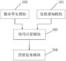
结合图2所示,本实施例提供了一种基于5G位置共享的智能网联超视距行车辅助系统,包括信息感知模块101、数字孪生模块102、协同计算模块103和信息发布模块104。信息感知模块101与协同计算模块103通信连接,信息感知模块用于获取当前车辆的第一运动状态数据;数字孪生模块102与协同计算模块103通信连接,数字孪生模块用于获取控制区域内的基础设施信息和其他车辆的第二运动状态数据;,协同计算模块用于根据第一运动状态数据、基础设施信息和第二运动状态数据对当前车辆与其他车辆是否会发生碰撞进行预测,获得预测结果;根据预测结果获取车辆行驶策略;协同计算模块103与信息发布模块104通信连接,信息发布模块用于接收车辆行驶策略并发布给车辆显示终端。As shown in FIG. 2 , this embodiment provides an intelligent network-linked over-the-horizon driving assistance system based on 5G location sharing, including an
信息感知模块获取当前车辆的第一运动状态数据,数字孪生模块获取控制区域内的基础设施信息和其他车辆的第二运动状态数据,协同计算模块根据第一运动状态数据、基础设施信息和第二运动状态数据对当前车辆与其他车辆是否会发生碰撞进行预测,获得预测结果;根据预测结果获取车辆行驶策略;信息发布模块将车辆行驶策略发布给车辆显示终端。这样,以车辆之间、车辆与路侧设施之间信息互通为基础,将各车之间的运动状态和基础设施信息进行数据共享,实现了未知路段的超视距交通情况感知,降低了控制区域发生交通事故的概率,提高了控制区域的通行效率,同时提高了乘车人的行车安全性。The information perception module obtains the first motion state data of the current vehicle, the digital twin module obtains the infrastructure information in the control area and the second motion state data of other vehicles, and the collaborative calculation module obtains the first motion state data, the infrastructure information and the second motion state data. The motion state data predicts whether the current vehicle will collide with other vehicles, and obtains the prediction result; obtains the vehicle driving strategy according to the prediction result; the information publishing module publishes the vehicle driving strategy to the vehicle display terminal. In this way, based on the information exchange between vehicles and between vehicles and roadside facilities, the data sharing of the motion status and infrastructure information between vehicles is realized, and the perception of over-the-horizon traffic conditions on unknown road sections is realized, reducing the need for control The probability of traffic accidents in the area improves the traffic efficiency in the control area, and at the same time improves the driving safety of the passengers.
可选地,信息感知模块包括车端感知模块和路侧感知模块。车端感知模块,用于获取当前车辆的位置信息和状态信息,将位置信息、状态信息发送到协同计算模块,并将位置信息、状态信息的信息发送时刻同时发送到协同计算模块;路侧感知模块,用于获取控制区域内的道路状况信息和汇总的交通流信息。Optionally, the information perception module includes a vehicle-side perception module and a roadside perception module. The vehicle-end perception module is used to obtain the current vehicle location information and status information, send the location information and status information to the collaborative computing module, and send the information sending time of the location information and status information to the collaborative computing module at the same time; roadside perception Module for obtaining road condition information and aggregated traffic flow information within the control area.
在一些实施例中,在整个匝道的预设协同控制区域内,车端感知模块通过GNSS获得当前车辆的位置信息,当前车辆的位置信息包括当前车辆的经纬度坐标和海拔高度、方向角、俯仰角等。车端感知模块通过传感器感知车辆的状态信息,当前车辆的状态信息包括当前车辆的速度、加速度和行驶意图等。路侧感知模块通过相关道路信息传感器获得控制区域中车道的道路状况信息和汇总的交通流信息。In some embodiments, in the preset cooperative control area of the entire ramp, the vehicle-side perception module obtains the current vehicle position information through GNSS, and the current vehicle position information includes the current vehicle's latitude and longitude coordinates and altitude, azimuth angle, and pitch angle Wait. The vehicle-side perception module perceives the state information of the vehicle through sensors, and the current state information of the vehicle includes the current speed, acceleration and driving intention of the vehicle. The roadside perception module obtains road condition information and aggregated traffic flow information of lanes in the control area through relevant road information sensors.
可选地,数字孪生模块包括:基础设施模块,用于获取控制区域内的基础设施的定位、线形和尺寸;车辆运行模块,用于获取控制区域内的其他车辆的第二运动状态数据。Optionally, the digital twin module includes: an infrastructure module, configured to obtain the location, alignment and size of the infrastructure within the control area; a vehicle running module, configured to obtain second movement state data of other vehicles within the control area.
在一些实施例中,车辆运行模块内置与车载设备或通过5G网络在云端传输下载。In some embodiments, the vehicle operation module is built into the vehicle equipment or transmitted and downloaded in the cloud through the 5G network.
在一些实施例中,所有搭载“5G+V2X”功能的车辆之间进行信息协同传输,即每一辆安装有基于5G位置共享的智能网联超视距行车辅助系统的车辆可以获取整个控制区域内所有车辆的运动状态数据。该系统的信息感知模块通过感知器获取当前车辆的第一运动状态数据,并将第一运动状态数据发送给协同计算模块,车辆运行模块通过“5G+V2X”功能获取控制区域内的其他车辆的第二运动状态数据,并将第二运动状态数据发送给协同计算模块。In some embodiments, all vehicles equipped with "5G+V2X" function carry out coordinated information transmission, that is, each vehicle equipped with an intelligent network-linked over-the-horizon driving assistance system based on 5G location sharing can obtain the entire control area The motion state data of all vehicles in the system. The information perception module of the system obtains the first motion state data of the current vehicle through the sensor, and sends the first motion state data to the collaborative computing module, and the vehicle operation module obtains the information of other vehicles in the control area through the "5G+V2X" function. the second motion state data, and send the second motion state data to the collaborative computing module.
可选地,协同计算模块,包括:MEC服务器,用于根据第一运动状态数据获取当前车辆的下一时刻位置,还用于根据第二运动状态数据获取其他车辆的下一时刻位置;车联网云控制中心,用于根据当前车辆的下一时刻位置、其他车辆的下一时刻位置和基础设施信息对当前车辆与其他车辆是否会发生碰撞进行预测,获得预测结果;还用于根据预测结果获取车辆行驶策略。Optionally, the collaborative calculation module includes: MEC server, used to obtain the next moment position of the current vehicle according to the first motion state data, and also used to obtain the next moment position of other vehicles according to the second motion state data; The cloud control center is used to predict whether the current vehicle will collide with other vehicles according to the next moment position of the current vehicle, the next moment position of other vehicles and infrastructure information, and obtain the prediction result; it is also used to obtain the prediction result according to the prediction result Vehicle driving strategy.
可选地,MEC服务器通过以下方式实现根据第一运动状态数据获取当前车辆的下一时刻位置:根据当前车辆的信息发送时刻和当前车辆的信息接收时刻获取当前车辆的单向时延;根据当前车辆的位置信息、状态信息和单向时延获取当前车辆的下一时刻位置。Optionally, the MEC server obtains the next moment position of the current vehicle according to the first motion state data in the following manner: obtain the one-way time delay of the current vehicle according to the information sending time of the current vehicle and the information receiving time of the current vehicle; The vehicle's position information, status information and one-way time delay obtain the current vehicle's next moment position.
在一些实施例中,当前车辆的信息发送时刻为当前车辆将位置信息和状态信息发送到协同计算模块的时刻,当前车辆的信息接收时刻为协同计算模块接收到当前车辆发送的位置信息和状态信息的时刻。In some embodiments, the information sending time of the current vehicle is the time when the current vehicle sends the position information and state information to the collaborative computing module, and the information receiving time of the current vehicle is the time when the collaborative computing module receives the position information and state information sent by the current vehicle moment.
可选地,MEC服务器通过以下方式实现根据第二运动状态数据获取其他车辆的下一时刻位置:根据其他车辆的信息发送时刻和其他车辆的信息接收时刻获取其他车辆的单向时延;根据其他车辆的位置信息、状态信息和单向时延获取其他车辆的下一时刻位置。Optionally, the MEC server obtains the next moment position of other vehicles according to the second motion state data in the following manner: obtain the one-way time delay of other vehicles according to the information sending time of other vehicles and the information receiving time of other vehicles; The vehicle's position information, status information and one-way delay obtain the next moment position of other vehicles.
在一些实施例中,其他车辆的信息发送时刻为其他车辆将位置信息和状态信息发送到协同计算模块的时刻,其他车辆的信息接收时刻为协同计算模块接收到其他车辆发送的位置信息和状态信息的时刻。In some embodiments, the information sending time of other vehicles is the time when other vehicles send location information and state information to the collaborative computing module, and the information receiving time of other vehicles is when the collaborative computing module receives the location information and state information sent by other vehicles moment.
在一些实施例中,当前车辆的单向延时和下一时刻位置,以及其他车辆的单向延时和下一时刻位置均采用以下方式获得:In some embodiments, the one-way time delay and the next time position of the current vehicle, and the one-way time delay and the next time position of other vehicles are obtained in the following manner:
可选地,根据车辆的信息发送时刻和信息接收时刻获取车辆的单向时延,包括:将消息接收时间减去消息发送时间的差值确定为单向时延。Optionally, acquiring the one-way time delay of the vehicle according to the information sending time and the information receiving time of the vehicle includes: determining the difference between the message receiving time minus the message sending time as the one-way time delay.
在一些实施例中,MEC服务器接收车辆的运动状态数据,并将接收时间记录为信息接收时刻t1,车辆的运动状态数据包括信息发送时刻t2,通过计算Δt=t1-t2,获得单向时延Δt。In some embodiments, the MEC server receives the motion state data of the vehicle, and records the receiving time as the information receiving time t1 , the vehicle motion state data includes the information sending time t2 , by calculating Δt=t1 -t2 , obtain One-way delay Δt.
在一些实施例中,MEC服务器接收到车辆的运动状态数据后,基于NTP协议和GPS网络获得信息传输的单向时延。In some embodiments, after the MEC server receives the motion state data of the vehicle, it obtains the one-way delay of information transmission based on the NTP protocol and the GPS network.
可选地,根据车辆的位置信息、状态信息和单向时延获取车辆的下一时刻位置,包括:将车辆的经纬度坐标转换为空间直角坐标;根据车辆的状态信息获取车辆的下一时刻的空间直角坐标;将车辆的下一时刻的空间直角坐标转换为下一时刻的经纬度坐标。Optionally, acquiring the next moment position of the vehicle according to the position information, state information and one-way time delay of the vehicle includes: converting the longitude and latitude coordinates of the vehicle into spatial Cartesian coordinates; Space Cartesian coordinates; transform the space Cartesian coordinates of the vehicle at the next moment into the latitude and longitude coordinates of the next moment.
在一些实施例里,车辆的经纬度坐标为GNSS经纬度坐标,包括车辆的纬度坐标、经度坐标和海拔高度。GNSS经纬度坐标描述了车辆的方向角、俯仰角、速度等行驶状态,假设车辆在运动过程中十分短的时间内速度和运动角度保持不变,O为地球的质心,Z轴穿过北极,P点为车辆所在的位置,车辆P所在的平面是地球的切平面,


在一些实施例中,将车辆的GNSS经纬度坐标转换为空间直角坐标,则车辆在P点的空间直角坐标如图3所示,单位向量


方向角θ是向量


车辆的真北向量


对公式(1)和(2)进行求解,获得车辆在单位方向上的向量
余弦函数是偶函数,所以向量


可选地,车辆的下一时刻的空间直角坐标(X,Y,Z)通过以下公式计算获得:Optionally, the space Cartesian coordinates (X, Y, Z) of the vehicle at the next moment are calculated by the following formula:
X=(N+H)·cosB·cosL (3)X=(N+H) cosB cosL (3)
Y=(N+H)·cosB·sinL (4)Y=(N+H) cosB sinL (4)
Z=[N·(1-e2)+H]·sinB (5)Z=[N·(1-e2 )+H]·sinB (5)
其中,B为车辆的纬度坐标,L为车辆的经度坐标,H为车辆的海拔高度,N为曲率值。Among them, B is the latitude coordinate of the vehicle, L is the longitude coordinate of the vehicle, H is the altitude of the vehicle, and N is the curvature value.
可选地,将公式(3)与公式(4)相除获得下列公式(6),将公式(3)与公式(5)相除获得公式(7):Alternatively, divide formula (3) by formula (4) to obtain the following formula (6), and divide formula (3) by formula (5) to obtain formula (7):


在一些实施例中,车辆在预设时间段内纬度B、经度L和海拔H变化很小。因此,曲率N的变化也很小,将当前位置的海拔值H、曲率值N、经度L以及车辆坐标Z带入公式(7)求解,获得纬度B的第一近似值B1。根据
在一些实施例中,将1秒划分为若干个小时间段,每个小时间端即为预设时间段。In some embodiments, 1 second is divided into several small time periods, and each small time end is a preset time period.
可选地,车联网云控制中心通过以下方式实现根据预测结果获取车辆行驶策略:在当前车辆与其他车辆不会发生碰撞的情况下,当前车辆与其他车辆按照原状态行驶;在当前车辆与其他车辆会发生碰撞的情况下,对当前车辆和其他车辆建立博弈联盟,通过车辆博弈协同控制模型获取联盟内各车辆的行驶策略。Optionally, the Internet of Vehicles cloud control center obtains the vehicle driving strategy according to the prediction results in the following manner: in the case that the current vehicle and other vehicles do not collide, the current vehicle and other vehicles drive in the original state; In the case of vehicles colliding, a game alliance is established for the current vehicle and other vehicles, and the driving strategy of each vehicle in the alliance is obtained through the vehicle game collaborative control model.
在一些实施例中,在整个协同控制区域内的相关车辆将感知到的运动状态数据通过C2I通信传输至协同计算模块。同时,路侧感知模块通过相关道路信息传感器获取道路信息,道路信息包括道路状况信息和汇总的交通流信息,并将道路信息传输至协同计算模块,协同计算模块对运动状态数据、道路信息进行数据分析和信息融合,协同计算模块利用车辆博弈协同控制模型进行计算,获得车辆行驶策略,并通过信息发布模块将车辆行驶策略发送至特定车辆。车辆博弈协同控制模型的应用框架是集中-分散式多智能体区域协同控制系统,CAVs(Center for Advanced Vehicular Systems,先进车辆系统中心)是协同控制系统的一个重要组成部分,其搭载的多种先进的环境感知传感器、卫星定位系统以及V2V通信网联可以获取协同控制区域内的车辆的运动状态数据。In some embodiments, related vehicles in the entire coordinated control area transmit the perceived motion state data to the coordinated computing module through C2I communication. At the same time, the roadside perception module obtains road information through relevant road information sensors. The road information includes road condition information and aggregated traffic flow information, and transmits the road information to the collaborative computing module. The collaborative computing module performs data processing on the motion state data and road information. Analysis and information fusion, the collaborative calculation module uses the vehicle game collaborative control model to perform calculations, obtains the vehicle driving strategy, and sends the vehicle driving strategy to a specific vehicle through the information release module. The application framework of the vehicle game cooperative control model is a centralized-decentralized multi-agent regional cooperative control system. CAVs (Center for Advanced Vehicular Systems, Advanced Vehicle System Center) is an important part of the cooperative control system. It is equipped with a variety of advanced Advanced environmental perception sensors, satellite positioning systems, and V2V communication networks can obtain vehicle movement status data in the collaborative control area.
可选地,车辆博弈协同控制模型通过以下方式获得车辆行驶策略:获取联盟内的各车辆的收益;根据各车辆的收益获取联盟的总收益;在总收益最大的情况下,对联盟内的各车辆进行收益分配,获得各车辆的换道位置;将各车辆的换道位置、行驶速度、各车辆之间的相对位置确定为各车辆的行驶策略。Optionally, the vehicle game cooperative control model obtains the vehicle driving strategy through the following methods: obtaining the income of each vehicle in the alliance; obtaining the total income of the alliance according to the income of each vehicle; Vehicles perform revenue distribution to obtain the lane-changing position of each vehicle; determine the lane-changing position, driving speed, and relative position of each vehicle as the driving strategy of each vehicle.
在一些实施例中,在智能网联环境下机器驾驶人作为博弈主体是具有完全信息和完全理性的个体,其所组成稳定的联盟在利益分配合理的情况下是能保证协议有强制约束力的,这种形式的合作可以使群体获得更大的收益。In some embodiments, in the intelligent network environment, the robot driver, as the game subject, is an individual with complete information and complete rationality, and the stable alliance formed by them can ensure that the agreement is mandatory and binding under the condition that the distribution of benefits is reasonable , this form of cooperation can lead to greater gains for the group.
可选地,在协同控制区域内有n辆车,建立一个n车博弈的联盟S,i为联盟S中的一个成员,对于任意的博弈方i在结盟S情况下的夏普利值通过以下公式(8)计算获得:Optionally, there are n cars in the cooperative control area, and an alliance S of n-car games is established, i is a member of the alliance S, and the Shapley value of any player i in the case of alliance S is given by the following formula (8) Calculated to obtain:

在公式(8)中,|S|为联盟S中所有博弈方的数量;S-i表示联盟S中去掉成员i,V为联盟S的特征函数,联盟S可以保证的最大利益,i和n均为整数。In the formula (8), |S| is the number of all players in the alliance S; S-i means that member i is removed from the alliance S, V is the characteristic function of the alliance S, the maximum benefit that the alliance S can guarantee, and i and n are integer.
在一些实施例中,相邻车道的车辆双方产生路权冲突的情况下,双方车辆发现对方时便形成了博弈关系。In some embodiments, when two vehicles in adjacent lanes conflict with each other, a game relationship is formed when the two vehicles find each other.
车道Lane1中的车辆C1出于战略性换道的行驶需要,必须在车道Lane1合流区停车线LC之前完成换道至车道Lane2或车道Lane3,面对车道Lane2中车辆C2和C3的行驶速度和加速度以及车辆间的可插车间隙,C1的换道策略主要考虑的是不与横向车辆C2和C3发生交通冲突。C1在t时刻换道至车道Lane2的安全收益为:Vehicle C1 in

公式(10)中,P1(t)为车辆C1在t时刻换道至车道Lane2的安全收益,l0为车辆长度,l1为车辆C1的纵向坐标,l2为车辆C2的纵向坐标,l3为车辆C3的纵向坐标,Gf为与后车应保持的最小安全距离,Gf为与前车应保持的最小安全距离,v1为车辆C1的行驶速度,v2为车辆C2的行驶速度,v3为车辆C3的行驶速度。In formula (10), P1 (t) is the safety benefit of vehicle C1 changing lanes to Lane2 at time t, l0 is the length of the vehicle, l1 is the longitudinal coordinate of vehicle C1 , andl2 is the Longitudinal coordinate, l3 is the longitudinal coordinate of vehicle C3 , Gf is the minimum safe distance with the vehicle behind, Gf is the minimum safe distance with the front vehicle, v1 is the driving speed of vehicle C1 , v2 is is the traveling speed of vehicleC2 , andv3 is the traveling speedof vehicle C3.
公式(9)可以看出C1的换道收益与换道时机和可插车间隙的位置都有关系,当C1的行驶速度越大,距离第三合流停车线LC的距离越近,其换道的紧迫程度越高。目标车道在合流区内的车流密度与当前车道的车流密度之比越大,驾驶人的换道意愿越低,这也符合通常驾驶员驾驶车辆的心理状态。随着换道紧迫程度的增加,车辆的相对换道时机在减少,这种变化是非线形的,如果车辆错过了当前的换道时机可能会增加在LC处停车排队的可能,损失较大的换道收益。From the formula (9), it can be seen that the lane-changing benefit of C1 is related to the timing of lane-changing and the position of the interstitial gap. When the driving speed of C1 is higher, the distance from the third merge stop line LC is closer. The higher the urgency of changing lanes. The greater the ratio of the traffic density of the target lane in the merge area to the traffic density of the current lane, the lower the driver's willingness to change lanes, which is also in line with the general driver's psychological state of driving. As the urgency of lane change increases, the relative lane change timing of vehicles decreases. This change is non-linear. If a vehicle misses the current lane change timing, it may increase the possibility of queuing atLC , and the loss is greater. Change of lane income.
因此,在收益函数中不能只考虑安全收益的影响,驾驶人的换道时机也会影响其换道收益,假如C1过早的换道至车道2或车道3,则有可能增加了车道2或车道3的空间占有率,增加目标车道在合流区内的车流密度。这不仅损失了车辆在车道1更高的通行效率,而且降低了车道2的通行效率,降低了匝道的整体通行效率;若C1迟迟没有完成换道,则随着距离车道1合流停车线LC的纵向距离减小,C1的换道机会在不断减少,可能会造成车辆C1在车道1排队的现象。Therefore, in the income function, we should not only consider the impact of safety benefits, the driver’s lane change timing will also affect his lane change benefits. If C1 changes lanes to
可选地,车辆C1在t时刻的换道收益通过以下公式获得:Optionally, the lane change benefit of vehicle C1 at time t is obtained by the following formula:

在公式(10)中,O1为车道1在路段S3~S4长度内的车辆空间占有率(%),O2为车道2在路段S3~S5长度内的车辆空间占有率(%),LA—l1表示车辆C1距离第一合流区停车线LA的距离,m为车辆执行一次换道所需的时间。In formula (10), O1 is the vehicle space occupancy rate (%) of lane1 within the length of road section S3-S4,O2 is the vehicle space occupancy rate (%) of
可选地,在寻找到车道3的交通流中可插车间隙后,车辆C2和车辆C3的换道收益通过以下公式获取:Optionally, after finding the gap that can be inserted in the traffic flow of lane3 , the lane-changing benefits of vehicleC2 and vehicle C3 are obtained by the following formula:

在公式(11)中,O3为车道3在路段S3~S5长度内的车辆空间占有率(%),LD为第四合流停车线。In formula (11), O3 is the vehicle space occupancy rate (%) of
可选地,车辆C1在决策时间点t选择换道或不换道的驾驶策略在行程时间上将产生不同的行驶效率收益。t时刻,车辆C1预计到达合流区停车线的时间,即为车辆C1的行驶效率收益,通过以下公式(12)计算获得:Optionally, the driving strategy of the vehicle C1 choosing to change lanes or not to change lanes at the decision time point t will produce different driving efficiency benefits in terms of travel time. At time t, the expected time for vehicle C1 to reach the stop line in the merge area is the driving efficiency gain of vehicle C1 , which is calculated by the following formula (12):

在公式(12)中,a1为车辆C1的加速度,第三合流停车线LC,LD为第四合流停车线,C1:x1表示车辆C1选择换道,C1:x2表示车辆C1选择不换道。In formula (12), a1 is the acceleration of vehicle C1 , the third merging stop line LC , LD is the fourth merging stop line, C1 : x1 means that vehicle C1 chooses to change lanes, C1 : x2 means that vehicle C1 chooses not to change lanes.
可选地,匝道车道2中的车辆C2和C3既有战略性换道的需求,也有进行战术性换道的动机,即为了更好的驾驶收益进行换道。C2在面临着C1的换道需求时可以选择避让对方换道和不避让两种策略,则车辆C2的安全收益通过以下公式(13)计算获得:Optionally, the vehicles C2 and C3 in the

在公式(13)中,C2:y1表示车辆C2选择不避让,C2:y2表示车辆C2选择避让。In formula (13), C2 :y1 indicates that vehicle C2 chooses not to avoid, and C2 :y2 indicates that vehicle C2 chooses to avoid.
在一些实施例中,车辆C2在不换道的情况下在原车道继续行驶只要确保不与当前车道的前车发生追尾即可。故在C2不换道的情况下安全收益只需要考虑与当前车道的前车保持合适的距离和相对速度,在C2换道至其他车道时,要考虑换道的目标车道中与临近的前导和后滞车辆保持安全距离和相对速度。In some embodiments, if the vehicleC2 continues to drive in the original lane without changing lanes, it only needs to ensure that it does not collide with the vehicle ahead in the current lane. Therefore, when C2 does not change lanes, the safety benefits only need to consider maintaining an appropriate distance and relative speed with thevehicle in front of the current lane. Leading and lagging vehicles maintain a safe distance and relative speed.
可选地,C2换道和不换道的行驶策略对应着不同的行驶时间,C2的行驶效率收益通过以下公式(14)计算获得:Optionally, the driving strategies of C2 changing lanes and not changing lanes correspond to different driving times, and the driving efficiency gain of C2 is calculated by the following formula (14):

在公式(14)中,a2为车辆C2的加速度,LD为第四合流停车线,C2:x1表示车辆C2选择换道,C2:x2表示车辆C2选择不换道。Informula (14), a2 is the acceleration of vehicleC2 , LD is the fourth merging stop line,C2: x1 means that vehicleC2 chooses to change lanes, andC2 :x2 means that vehicleC2 chooses not to change road.
根据公式(13)和(14)可见,C2换道至车道3显然会减少安全收益并影响行驶效益。According to formulas (13) and (14), it can be seen that changing lane C2 to
在一些实施例中,根据可插车间隙理论车辆,在换道时根据目标车道交通流间隙采取合适的速度进行换道。在智能网联环境下车辆C1、C2和C3组成的博弈对局中,C3在博弈中处于优势地位,C3如果选择配合C1和C2完成C1的战略性换道行驶需求,则只需要考虑给C1留出足够的安全间距即可。In some embodiments, according to the vehicle gap theory, when changing lanes, the vehicle adopts an appropriate speed according to the traffic flow gap of the target lane to change lanes. In the game game composed of vehicles C1 , C2 and C3 in the intelligent network environment, C3 is in the dominant position in the game, if C3 chooses to cooperate with C1 and C2 to complete the strategic lane change of C1 demand, you only need to consider leaving enough safety distance for C1 .
可选地,通过以下公式(15)计算获得C3的安全收益:Optionally, the security gain of C3 is calculated by the followingformula (15):

可选地,通过以下公式(16)计算获得C3的行驶效率收益:Optionally, the driving efficiency gain of C3 is calculated by the followingformula (16):

在公式(14)中,a3为车辆C3的加速度,LB为第二合流停车线。In formula (14), a3 is the acceleration of vehicle C3 , and LB is the second merging stop line.
可选地,综合车辆C1、C2和C3的安全收益、换道收益以及行驶效率收益,其综合收益函数通过以下公式(17)计算获得:Optionally, the safety benefits, lane change benefits and driving efficiency benefits of comprehensive vehicles C1 , C2 and C3 can be obtained by calculating the comprehensive benefit function through the following formula (17):
Fn(t)=αf(P1(t))+βf(-Q1(t))+γf(-H1(t)),n=1,2,3 (18)Fn (t) = αf (P1 (t)) + βf (-Q1 (t)) + γf (-H1 (t)), n = 1,2,3 (18)
在公式(17)式,f(·)表示归一化计算处理,α为安全收益权重,β为换道收益权重,γ为行驶效率收益权重,其中α+β+γ=1,权重的取值根据实际的匝道合流场景确定。综合收益函数中安全收益权重、行驶效率收益权重和换道收益权重会影响博弈的均衡状态,进而影响控制区域内车辆的通行效率和交通冲突率。In formula (17), f( ) represents the normalized calculation process, α is the weight of safety benefits, β is the weight of lane-changing benefits, and γ is the weight of driving efficiency benefits, where α+β+γ=1, and the weight The value is determined according to the actual ramp merge scenario. The weights of safety benefits, driving efficiency benefits and lane-changing benefits in the comprehensive benefit function will affect the equilibrium state of the game, and then affect the traffic efficiency and traffic conflict rate of vehicles in the control area.
在一些实施例中,在整个协同控制区域内的相关车辆将感知到的运动状态数据通过C2I通信传输至协同计算模块。同时,路侧感知模块通过相关道路信息传感器获取道路信息,道路信息包括道路状况信息和汇总的交通流信息,并将道路信息传输至协同计算模块,协同计算模块对运动状态数据、道路信息进行数据分析和信息融合,判断当前车辆与其他车辆是否会发生碰撞。在当前车辆与其他车辆会发生碰撞的情况下,对所有车辆进行合作博弈,对所有车辆建立博弈联盟,利用车辆博弈协同控制模型进行计算,获得总收益函数。在总收益最大的情况下,进行收益分配,即对公式17进行求解,获得各车辆的换道位置。将各车辆的空间直角坐标相减,获得各车辆之间的相对位置,将各车辆的换道位置、行驶速度、各车辆之间的相对位置确定为各车辆的行驶策略,将各车辆的行驶策略通过在线地图的方式发送给各车辆终端。In some embodiments, related vehicles in the entire coordinated control area transmit the perceived motion state data to the coordinated computing module through C2I communication. At the same time, the roadside perception module obtains road information through relevant road information sensors. The road information includes road condition information and aggregated traffic flow information, and transmits the road information to the collaborative computing module. The collaborative computing module performs data processing on the motion state data and road information. Analysis and information fusion to determine whether the current vehicle will collide with other vehicles. In the case that the current vehicle collides with other vehicles, a cooperative game is performed for all vehicles, a game alliance is established for all vehicles, and the vehicle game cooperative control model is used for calculation to obtain the total revenue function. In the case of the maximum total income, the income distribution is performed, that is, formula 17 is solved to obtain the lane-changing position of each vehicle. Subtract the space Cartesian coordinates of each vehicle to obtain the relative position of each vehicle, determine the lane change position, driving speed, and relative position of each vehicle as the driving strategy of each vehicle, and calculate the driving strategy of each vehicle The strategy is sent to each vehicle terminal through an online map.
可选地,信息发布模块通过以下方式实现将车辆行驶策略发布给车辆显示终端:当当前车辆和其他车辆均按照原行驶状态行驶,可通过在线地图实时获取控制区内所有车辆的行驶状态。若当前车辆和其他车辆均按照原行驶状态行驶将会发生冲突,则通过信息发布模块显示控制区内各车辆的换道位置、行驶速度、各车辆之间的相对位置,从而确定各车辆的行驶策略。若不会发生冲突则仅显示车辆实时的相对位置。Optionally, the information release module publishes the vehicle driving strategy to the vehicle display terminal in the following manner: when the current vehicle and other vehicles are driving in the original driving state, the driving state of all vehicles in the control area can be obtained in real time through the online map. If the current vehicle and other vehicles are driving according to the original driving state, there will be conflicts, and the information release module will display the lane-changing position, driving speed, and relative position of each vehicle in the control area, so as to determine the driving position of each vehicle. Strategy. If there is no conflict, only the real-time relative position of the vehicle will be displayed.
可选地,基于5G位置共享的智能网联超视距行车辅助系统还包括:多通道通信模块,用于通过蜂窝通信模式实现车与车之间、车与路之间的运行状态、定位信息、全域环境、路径导航信息的交互。Optionally, the intelligent network-connected over-the-horizon driving assistance system based on 5G location sharing also includes: a multi-channel communication module, which is used to realize the operating status and positioning information between vehicles and between vehicles and between vehicles and roads through cellular communication mode. , the global environment, and the interaction of path navigation information.
可选地,基于5G位置共享的智能网联超视距行车辅助系统还包括:交通数据记录模块,分别与信息感知模块和数字孪生模块通信连接,交通数据记录模块用于将当前车辆的第一运动状态数据和控制区域内的其他车辆的第二运动状态数据传输至路局网络安全平台Optionally, the intelligent network-connected over-the-horizon driving assistance system based on 5G location sharing also includes: a traffic data recording module, which communicates with the information perception module and the digital twin module respectively, and the traffic data recording module is used to record the current vehicle's first The motion state data and the second motion state data of other vehicles in the control area are transmitted to the road bureau network security platform
通过将5G技术、在线地图、位置共享、V2X、视频识别等技术进行融合集成,实现车车之间的信息互通,并结合在线地图显示下一时刻事故高发路段中车辆的预测位置,帮助驾驶员合理判断车距避免不当操作,降低由于视距受阻导致的交通事故,使风险防控系统稳定可靠。Through the integration of 5G technology, online map, location sharing, V2X, video recognition and other technologies, the information exchange between vehicles can be realized, and the online map can be used to display the predicted position of the vehicle in the high-accident road section at the next moment, helping drivers Reasonably judge the distance between vehicles to avoid improper operation, reduce traffic accidents caused by obstructed sight distance, and make the risk prevention and control system stable and reliable.
在一些实施例中,基于5G位置共享的智能网联超视距行车辅助系统在车辆进入通信区域后,实时收集通信区域内所有车辆的运动状态数据,并将运动状态数据汇集至车联网云平台,如在冲突区内发生交通事故,交警部门可通过车联网云平台查证交通事故的数据信息和视频信息。In some embodiments, after the vehicle enters the communication area, the intelligent network-connected over-the-horizon driving assistance system based on 5G location sharing collects the motion state data of all vehicles in the communication area in real time, and collects the motion state data to the Internet of Vehicles cloud platform If a traffic accident occurs in the conflict zone, the traffic police department can verify the data and video information of the traffic accident through the Internet of Vehicles cloud platform.
在一些实施例中,基于5G位置共享的智能网联超视距匝道合流辅助系统也是一种“哨兵”式的行车辅助预警系统,帮助匝道汇入车辆在视线受阻时或视觉盲区内实现“超视距”感知,通过在线地图获取系统预知的控制区域内车辆的下一时刻的位置信息,在控制区域内车辆发生碰撞前采取减速、让道等措施,有效降低了交通事故的发生,提高了视距受限条件下的行车安全。行车辅助预警系统将新一代通信条件下的传感、图像识别、全天候可视化、芯片等技术融合集成,通过车与车之间信息互通,降低了在低能见度天气时,驾驶员由于标志牌阻挡而操作失误的概率。行车辅助系统在视线较差、冲突较多的入口控制区域,形成了车辆、道路、环境三者的数据交互,针对该类高风险路段主动预防交通事故的发生,守护生命安全、降低财产损失。In some embodiments, the intelligent network-connected over-the-horizon ramp merging assistance system based on 5G location sharing is also a "sentry" driving assistance and early warning system, which helps the ramp-merging vehicle to achieve "over-the-horizon" when the line of sight is blocked or in the visual blind zone. Line-of-sight perception, through the online map to obtain the location information of the vehicle in the control area predicted by the system at the next moment, and take measures such as slowing down and giving way before the vehicle collides in the control area, which effectively reduces the occurrence of traffic accidents and improves the traffic safety. Driving safety under conditions of limited sight distance. The driving assistance and early warning system integrates technologies such as sensing, image recognition, all-weather visualization, and chips under new-generation communication conditions. The probability of operating errors. In the entrance control area with poor sightlines and many conflicts, the driving assistance system forms data interaction among vehicles, roads, and the environment. It actively prevents traffic accidents on such high-risk road sections, protects life safety, and reduces property losses.
在一些实施例中,在主线车辆由于故障停在匝道入口冲突区内的情况下,在匝道汇入车辆进入匝道通信区域后,智能网联超视距匝道合流辅助系统接收到匝道汇入车辆车辆的运动状态数据,并将发生故障的主线车辆位置,通过在线地图推送至事故车辆附近的主线车辆驾驶员和匝道汇入车辆驾驶员,主线车辆和匝道汇入车辆驾驶员接受信息后,主动减速让行,避免交通事故的二次发生。In some embodiments, when the mainline vehicle stops in the conflict zone at the entrance of the ramp due to a fault, after the on-ramp vehicle enters the ramp communication area, the intelligent network-linked over-the-horizon ramp merging assistance system receives information from the ramp-in vehicle The motion status data of the main line vehicle will be pushed to the driver of the main line vehicle and the driver of the on-ramp vehicle near the accident vehicle through the online map. After receiving the information, the driver of the main line vehicle and the on-ramp vehicle will actively slow down Give way to avoid the secondary occurrence of traffic accidents.
可选地,基于5G位置共享的智能网联超视距行车辅助系统包括应用层、传输层、数据层和感知层。在感知层,当车辆进入通信区域时,车辆的车载设备与路侧设备之间进行信息交互,获得控制区域内所有车辆的运动状态数据,并传输到传输层,同时根据控制区域内车辆的运动状态实时预测下一时刻控制区域内车辆的位置信息,并将实时预测的数据传输到数据层。数据层接收控制区域内车辆的实时位置信息,然后通过关联计算判断控制区域内的车辆是否会发生冲突,并获取行车驾驶策略,若控制区域内的车辆发生冲突,数据层将行车驾驶车辆传输到应用层。传输层接收控制区域内的运动状态数据,并传输至路局网络安全平台,为交警部门查证交通事故提供数据支持。应用层接收车辆行驶策略,并结合在线地图对车辆进行引导。Optionally, the intelligent network-connected over-the-horizon driving assistance system based on 5G location sharing includes an application layer, a transport layer, a data layer, and a perception layer. At the perception layer, when the vehicle enters the communication area, the on-board equipment of the vehicle interacts with the roadside equipment to obtain the motion state data of all vehicles in the control area and transmit it to the transmission layer. The state predicts the position information of the vehicle in the control area at the next moment in real time, and transmits the real-time predicted data to the data layer. The data layer receives the real-time position information of the vehicles in the control area, and then judges whether the vehicles in the control area will conflict through correlation calculation, and obtains the driving strategy. If the vehicles in the control area conflict, the data layer will transmit the driving vehicles to application layer. The transport layer receives the motion status data in the control area and transmits it to the network security platform of the Road Bureau to provide data support for the traffic police department to verify traffic accidents. The application layer receives the vehicle driving strategy and guides the vehicle in combination with the online map.
在一些实施例中,结合图3所示,基于5G位置共享的智能网联超视距行车辅助系统包括信息感知模块、数字孪生模块和信息收发模块。信息感知模块包括路侧系统的交通流量传感器和差分定位基准站,以及车载系统的车辆传感器、GPS定位单元和电子控制单元。数字孪生模块包括路侧系统的边缘云计算处理平台,以及中心云计算处理平台,以及车载系统的车载计算处理平台。信息收发模块用于接收信息和发布信息,信息收发模块包括路侧系统的通信基站LTE和路侧单元RSU,以及车载系统的车载单元OBU和CAN总线。In some embodiments, as shown in FIG. 3 , the 5G location-sharing based intelligent network-linked over-the-horizon driving assistance system includes an information perception module, a digital twin module, and an information sending and receiving module. The information perception module includes the traffic flow sensor and differential positioning reference station of the roadside system, as well as the vehicle sensor, GPS positioning unit and electronic control unit of the vehicle system. The digital twin module includes the edge cloud computing processing platform of the roadside system, the central cloud computing processing platform, and the vehicle computing processing platform of the vehicle system. The information transceiver module is used to receive information and publish information. The information transceiver module includes the communication base station LTE and roadside unit RSU of the roadside system, and the on-board unit OBU and CAN bus of the vehicle system.
在一些实施例中,如图4所示的匝道合流的场景中,以距主线与匝道相交点沿主线下游50m的地方为坐标原点,以东西方向道路为x轴,南北方向道路为y轴,建立直角坐标系,并设定核心控制范围Ω和监控控制范围S,即Ω={(x,y),x∈(xa,xb),y∈(yc,yd)},S={(x,y),x∈(xA,xA),y∈(yC,yD)},以图3中Cn-3为例,此时车辆的坐标为Cn-3(t0)(xn-3,yn-3),且xa<xn-3<xb且yc<yn-3<yd,说明车辆位于核心区内;以Cn为例,此时车辆的坐标为Cn(t0)(xn,yn),xb<|xn|<xB且yd<|yn|<yD,说明车辆位于监控区内。车辆进入监控区内,车联网云平台仅收集监控范围内车辆的位置信息;车辆进入核心区域后,车联网云平台获取区域内车辆的位置、速度、加速度、车辆长度等基本信息,并根据车辆行驶状态计算出主线车辆间的可插入间隙,将匝道车辆的车长与可插入间隙进行对比,如可插入间隙小于匝道车辆车长,说明匝道车辆未能安全插入主线,车联网云平台将核心区内的车辆实时信息通过在线共享地图的形式,分享至车主并提醒车主前方危险注意减速慢行。汽车驶离控制区域就不再对其进行控制,控制区域范围需考虑交叉口的结构、道路状况、进口道流量以及车主的安全隐私问题。In some embodiments, in the scene where the ramp merges as shown in Figure 4, the origin of the coordinates is 50m downstream from the intersection point of the main line and the ramp along the main line, the x-axis is the east-west road, and the y-axis is the north-south road. Establish a Cartesian coordinate system, and set the core control range Ω and the monitoring control range S, that is, Ω={(x,y),x∈(xa ,xb ),y∈(yc ,yd )}, S ={(x,y),x∈(xA ,xA ),y∈(yC ,yD )}, taking Cn-3 in Figure 3 as an example, the coordinates of the vehicle at this time are Cn-3 (t0 )(xn-3 ,yn-3 ), and xa <xn-3 <xb and yc <yn-3 <yd , indicating that the vehicle is located in the core area; For example, the coordinates of the vehicle at this time are Cn (t0 )(xn ,yn ), xb <|xn |<xB and yd <|yn |<yD , indicating that the vehicle is in the monitoring area . When the vehicle enters the monitoring area, the Internet of Vehicles cloud platform only collects the location information of the vehicle within the monitoring area; The driving status calculates the insertable gap between vehicles on the main line, and compares the length of the ramp vehicle with the insertable gap. If the insertable gap is smaller than the length of the ramp vehicle, it means that the ramp vehicle has not been safely inserted into the main line. The real-time information of the vehicles in the area is shared with the car owners in the form of an online shared map, and the car owners are reminded of the danger ahead and slow down. When the car leaves the control area, it will no longer be controlled. The scope of the control area needs to consider the structure of the intersection, road conditions, flow of the entrance road, and the safety and privacy of the car owner.
最后应说明的是:以上实施例仅用以说明本发明的技术方案,而非对其限制;尽管参照前述各实施例对本发明进行了详细的说明,本领域的普通技术人员应当理解:其依然可以对前述各实施例所记载的技术方案进行修改,或者对其中部分或者全部技术特征进行等同替换;而这些修改或者替换,并不使相应技术方案的本质脱离本发明各实施例技术方案的范围,其均应涵盖在本发明的权利要求和说明书的范围当中。Finally, it should be noted that: the above embodiments are only used to illustrate the technical solutions of the present invention, rather than to limit them; although the present invention has been described in detail with reference to the foregoing embodiments, those of ordinary skill in the art should understand that: it still The technical solutions described in the foregoing embodiments may be modified, or some or all of the technical features may be equivalently replaced; and these modifications or replacements do not make the essence of the corresponding technical solutions depart from the scope of the technical solutions of the embodiments of the present invention. , which should be included within the scope of the claims and description of the present invention.
Claims (10)
Translated fromChinesePriority Applications (1)
| Application Number | Priority Date | Filing Date | Title |
|---|---|---|---|
| CN202211050241.8ACN115412883A (en) | 2022-08-31 | 2022-08-31 | Intelligent network connection over-the-horizon driving auxiliary system based on 5G position sharing |
Applications Claiming Priority (1)
| Application Number | Priority Date | Filing Date | Title |
|---|---|---|---|
| CN202211050241.8ACN115412883A (en) | 2022-08-31 | 2022-08-31 | Intelligent network connection over-the-horizon driving auxiliary system based on 5G position sharing |
Publications (1)
| Publication Number | Publication Date |
|---|---|
| CN115412883Atrue CN115412883A (en) | 2022-11-29 |
Family
ID=84163524
Family Applications (1)
| Application Number | Title | Priority Date | Filing Date |
|---|---|---|---|
| CN202211050241.8APendingCN115412883A (en) | 2022-08-31 | 2022-08-31 | Intelligent network connection over-the-horizon driving auxiliary system based on 5G position sharing |
Country Status (1)
| Country | Link |
|---|---|
| CN (1) | CN115412883A (en) |
Cited By (5)
| Publication number | Priority date | Publication date | Assignee | Title |
|---|---|---|---|---|
| CN117376867A (en)* | 2023-11-01 | 2024-01-09 | 唐山学院 | A communication sensing integrated vehicle networking communication establishment method and system |
| CN118262571A (en)* | 2024-05-29 | 2024-06-28 | 以声动人(上海)教育科技有限公司 | Auxiliary automatic driving method |
| CN118545092A (en)* | 2024-06-12 | 2024-08-27 | 招商局重庆交通科研设计院有限公司 | A multi-vehicle game lane change trajectory planning method based on roadside cooperative control unit |
| CN119475978A (en)* | 2024-10-28 | 2025-02-18 | 重庆大学 | A training method for unfamiliar environment state recognition model in online driving scenarios |
| CN120299233A (en)* | 2025-03-25 | 2025-07-11 | 北方工业大学 | A macro-micro integrated alliance decision-making method based on intelligent connected vehicle clusters |
Citations (12)
| Publication number | Priority date | Publication date | Assignee | Title |
|---|---|---|---|---|
| US20180253973A1 (en)* | 2017-03-03 | 2018-09-06 | Kennesaw State University Research And Service Foundation, Inc. | Real-time video analytics for traffic conflict detection and quantification |
| CN110298131A (en)* | 2019-07-05 | 2019-10-01 | 西南交通大学 | Automatic Pilot lane-change decision model method for building up under a kind of mixing driving environment |
| US20190382003A1 (en)* | 2018-06-13 | 2019-12-19 | Toyota Jidosha Kabushiki Kaisha | Collision avoidance for a connected vehicle based on a digital behavioral twin |
| CN112907967A (en)* | 2021-01-29 | 2021-06-04 | 吉林大学 | Intelligent vehicle lane change decision-making method based on incomplete information game |
| CN113327421A (en)* | 2021-06-04 | 2021-08-31 | 河北省交通规划设计院 | Road network control method and system based on V2X |
| CN113335282A (en)* | 2021-06-01 | 2021-09-03 | 南京航空航天大学 | Path changing decision-making method based on game theory |
| CN113516846A (en)* | 2021-06-24 | 2021-10-19 | 长安大学 | Vehicle lane change behavior prediction model construction, prediction and early warning method and system |
| CN113593225A (en)* | 2021-07-21 | 2021-11-02 | 同济大学 | Single-point intersection vehicle control method oriented to pure internet environment |
| CN113920740A (en)* | 2021-11-16 | 2022-01-11 | 重庆邮电大学 | A vehicle-road cooperative driving system and method combining vehicle correlation and game theory |
| CN114049768A (en)* | 2021-11-15 | 2022-02-15 | 山东省交通规划设计院集团有限公司 | Low-visibility passing vehicle guiding system and method based on vehicle-road cooperation |
| CN114882705A (en)* | 2022-05-30 | 2022-08-09 | 武汉理工大学 | Freight vehicle interactive game lane change decision-making method based on lane change decision-making system |
| CN114973656A (en)* | 2022-05-10 | 2022-08-30 | 清华大学 | Methods, devices, equipment, media and products for evaluating traffic interaction performance |
- 2022
- 2022-08-31CNCN202211050241.8Apatent/CN115412883A/enactivePending
Patent Citations (12)
| Publication number | Priority date | Publication date | Assignee | Title |
|---|---|---|---|---|
| US20180253973A1 (en)* | 2017-03-03 | 2018-09-06 | Kennesaw State University Research And Service Foundation, Inc. | Real-time video analytics for traffic conflict detection and quantification |
| US20190382003A1 (en)* | 2018-06-13 | 2019-12-19 | Toyota Jidosha Kabushiki Kaisha | Collision avoidance for a connected vehicle based on a digital behavioral twin |
| CN110298131A (en)* | 2019-07-05 | 2019-10-01 | 西南交通大学 | Automatic Pilot lane-change decision model method for building up under a kind of mixing driving environment |
| CN112907967A (en)* | 2021-01-29 | 2021-06-04 | 吉林大学 | Intelligent vehicle lane change decision-making method based on incomplete information game |
| CN113335282A (en)* | 2021-06-01 | 2021-09-03 | 南京航空航天大学 | Path changing decision-making method based on game theory |
| CN113327421A (en)* | 2021-06-04 | 2021-08-31 | 河北省交通规划设计院 | Road network control method and system based on V2X |
| CN113516846A (en)* | 2021-06-24 | 2021-10-19 | 长安大学 | Vehicle lane change behavior prediction model construction, prediction and early warning method and system |
| CN113593225A (en)* | 2021-07-21 | 2021-11-02 | 同济大学 | Single-point intersection vehicle control method oriented to pure internet environment |
| CN114049768A (en)* | 2021-11-15 | 2022-02-15 | 山东省交通规划设计院集团有限公司 | Low-visibility passing vehicle guiding system and method based on vehicle-road cooperation |
| CN113920740A (en)* | 2021-11-16 | 2022-01-11 | 重庆邮电大学 | A vehicle-road cooperative driving system and method combining vehicle correlation and game theory |
| CN114973656A (en)* | 2022-05-10 | 2022-08-30 | 清华大学 | Methods, devices, equipment, media and products for evaluating traffic interaction performance |
| CN114882705A (en)* | 2022-05-30 | 2022-08-09 | 武汉理工大学 | Freight vehicle interactive game lane change decision-making method based on lane change decision-making system |
Non-Patent Citations (4)
| Title |
|---|
| CHEN N 等: "A hierarchical model-based optimization control approach for cooperative merging by connected automated vehicles", IEEE TRANSACTIONS ON INTELLIGENT TRANSPORTATION SYSTEMS, vol. 12, no. 22, 31 December 2021 (2021-12-31)* |
| 周雪峰;郑长江;: "基于博弈论的无控制路段人行横道处人车抢行分析", 华东交通大学学报, no. 06, 15 December 2012 (2012-12-15)* |
| 张雯靓;徐爱峰;史俊;: "上海智慧高速公路建设与发展探讨", 上海公路, no. 02, 30 June 2020 (2020-06-30)* |
| 马庆禄 等: "基于博弈论的无信号交叉口冲突消解方法", 重庆理工大学学报(自然科学), vol. 35, no. 10, 31 October 2021 (2021-10-31)* |
Cited By (7)
| Publication number | Priority date | Publication date | Assignee | Title |
|---|---|---|---|---|
| CN117376867A (en)* | 2023-11-01 | 2024-01-09 | 唐山学院 | A communication sensing integrated vehicle networking communication establishment method and system |
| CN118262571A (en)* | 2024-05-29 | 2024-06-28 | 以声动人(上海)教育科技有限公司 | Auxiliary automatic driving method |
| CN118545092A (en)* | 2024-06-12 | 2024-08-27 | 招商局重庆交通科研设计院有限公司 | A multi-vehicle game lane change trajectory planning method based on roadside cooperative control unit |
| CN119475978A (en)* | 2024-10-28 | 2025-02-18 | 重庆大学 | A training method for unfamiliar environment state recognition model in online driving scenarios |
| CN119475978B (en)* | 2024-10-28 | 2025-07-11 | 重庆大学 | A training method for unfamiliar environment state recognition model in online driving scenarios |
| CN120299233A (en)* | 2025-03-25 | 2025-07-11 | 北方工业大学 | A macro-micro integrated alliance decision-making method based on intelligent connected vehicle clusters |
| CN120299233B (en)* | 2025-03-25 | 2025-09-16 | 北方工业大学 | Intelligent networking vehicle cluster macro-micro integrated alliance decision method |
Similar Documents
| Publication | Publication Date | Title |
|---|---|---|
| CN115412883A (en) | Intelligent network connection over-the-horizon driving auxiliary system based on 5G position sharing | |
| TWI691927B (en) | External coordinate real-time three-dimensional road condition auxiliary device for mobile vehicle and the system | |
| CN111599194B (en) | Highway entrance ramp heterogeneous traffic flow speed guiding system and guiding method | |
| CN107833454B (en) | Vehicle-to-vehicle coordination for maintaining traffic order | |
| CN109003467B (en) | Method, device and system for preventing vehicle collision | |
| Englund et al. | Future applications of VANETs | |
| WO2019080874A1 (en) | Method for vehicle to pass by switching lanes and control center | |
| CN114566038B (en) | Vehicle-road cooperative multi-stage early warning system and method for internet-connected freight vehicle team | |
| CN112907986A (en) | Dynamic time window crossing scheduling method based on digital twin scene and edge cloud | |
| CN106601002A (en) | Urban expressway entrance ramp vehicle traffic guiding system and guiding method thereof in Internet of vehicles environment | |
| CN110260872B (en) | A dynamic overtaking trajectory planning system based on GPS in a vehicle-road collaborative environment | |
| CN111599215B (en) | Non-signalized intersection mobile block vehicle guiding system and method based on Internet of vehicles | |
| WO2021036907A1 (en) | Train control system and train control method | |
| CN110401685A (en) | A kind of intelligence control cloud platform of two visitor of automatic Pilot, one danger vehicle | |
| CN111510496A (en) | Traffic guidance system and method based on block chain information sharing | |
| CN116013101B (en) | System and method for suggesting speed of signal-free intersection based on network environment | |
| EP4330106A1 (en) | Vehicle guidance with systemic optimization | |
| CN112689024B (en) | Truck and road cooperative truck queue lane changing method, device and system | |
| Xie et al. | Design and evaluation of V2X-based dynamic bus lanes | |
| JP2021068315A (en) | Estimation method and estimation system of lane condition | |
| JP2005138710A (en) | Train operation information system | |
| Szmelter | The concepts of connected car and internet of cars and their impact on future people mobility | |
| CN111426327A (en) | Intelligent anti-collision warning system for people and vehicles going out | |
| CN115019527A (en) | Traffic signal lamp information interaction method, intersection early warning method and system | |
| CN114255604A (en) | Method, apparatus, device, medium, and system for driving control |
Legal Events
| Date | Code | Title | Description |
|---|---|---|---|
| PB01 | Publication | ||
| PB01 | Publication | ||
| SE01 | Entry into force of request for substantive examination | ||
| SE01 | Entry into force of request for substantive examination | ||
| RJ01 | Rejection of invention patent application after publication | Application publication date:20221129 | |
| RJ01 | Rejection of invention patent application after publication |