CN115258959B - Sling control method, equipment and storage medium - Google Patents
Sling control method, equipment and storage mediumDownload PDFInfo
- Publication number
- CN115258959B CN115258959BCN202211133740.3ACN202211133740ACN115258959BCN 115258959 BCN115258959 BCN 115258959BCN 202211133740 ACN202211133740 ACN 202211133740ACN 115258959 BCN115258959 BCN 115258959B
- Authority
- CN
- China
- Prior art keywords
- point cloud
- cloud data
- stern
- data
- frame
- Prior art date
- Legal status (The legal status is an assumption and is not a legal conclusion. Google has not performed a legal analysis and makes no representation as to the accuracy of the status listed.)
- Active
Links
Images


Classifications
- B—PERFORMING OPERATIONS; TRANSPORTING
- B66—HOISTING; LIFTING; HAULING
- B66C—CRANES; LOAD-ENGAGING ELEMENTS OR DEVICES FOR CRANES, CAPSTANS, WINCHES, OR TACKLES
- B66C13/00—Other constructional features or details
- B66C13/18—Control systems or devices
- B66C13/46—Position indicators for suspended loads or for crane elements
- B—PERFORMING OPERATIONS; TRANSPORTING
- B66—HOISTING; LIFTING; HAULING
- B66C—CRANES; LOAD-ENGAGING ELEMENTS OR DEVICES FOR CRANES, CAPSTANS, WINCHES, OR TACKLES
- B66C13/00—Other constructional features or details
- B66C13/18—Control systems or devices
- B—PERFORMING OPERATIONS; TRANSPORTING
- B66—HOISTING; LIFTING; HAULING
- B66C—CRANES; LOAD-ENGAGING ELEMENTS OR DEVICES FOR CRANES, CAPSTANS, WINCHES, OR TACKLES
- B66C13/00—Other constructional features or details
- B66C13/18—Control systems or devices
- B66C13/40—Applications of devices for transmitting control pulses; Applications of remote control devices
- B—PERFORMING OPERATIONS; TRANSPORTING
- B66—HOISTING; LIFTING; HAULING
- B66C—CRANES; LOAD-ENGAGING ELEMENTS OR DEVICES FOR CRANES, CAPSTANS, WINCHES, OR TACKLES
- B66C13/00—Other constructional features or details
- B66C13/18—Control systems or devices
- B66C13/48—Automatic control of crane drives for producing a single or repeated working cycle; Programme control
- G—PHYSICS
- G01—MEASURING; TESTING
- G01S—RADIO DIRECTION-FINDING; RADIO NAVIGATION; DETERMINING DISTANCE OR VELOCITY BY USE OF RADIO WAVES; LOCATING OR PRESENCE-DETECTING BY USE OF THE REFLECTION OR RERADIATION OF RADIO WAVES; ANALOGOUS ARRANGEMENTS USING OTHER WAVES
- G01S7/00—Details of systems according to groups G01S13/00, G01S15/00, G01S17/00
- G01S7/48—Details of systems according to groups G01S13/00, G01S15/00, G01S17/00 of systems according to group G01S17/00
- G01S7/4802—Details of systems according to groups G01S13/00, G01S15/00, G01S17/00 of systems according to group G01S17/00 using analysis of echo signal for target characterisation; Target signature; Target cross-section
Landscapes
- Engineering & Computer Science (AREA)
- Automation & Control Theory (AREA)
- Mechanical Engineering (AREA)
- Computer Networks & Wireless Communication (AREA)
- Physics & Mathematics (AREA)
- General Physics & Mathematics (AREA)
- Radar, Positioning & Navigation (AREA)
- Remote Sensing (AREA)
- Optical Radar Systems And Details Thereof (AREA)
- Radar Systems Or Details Thereof (AREA)
Abstract
Translated fromChinese
Description
Translated fromChinese技术领域technical field
本申请的实施例涉及计算机领域,尤其涉及一种吊具控制方法、设备及存储介质。The embodiments of the present application relate to the field of computers, and in particular to a method, device and storage medium for controlling a spreader.
背景技术Background technique
随着海上交通运输业的迅速发展,集装箱码头的自动化作业对提高运输效率、降低成本有着非常重要的意义。轨道吊对靠岸船舶上的集装箱的装箱或卸箱是集装箱码头自动化作业的重要一环,在轨道吊作业时,需要先确定轨道吊相对目标箱位的位置,并将轨道吊的吊具与船上的箱位进行对齐。With the rapid development of the maritime transportation industry, the automated operation of container terminals is of great significance to improve transportation efficiency and reduce costs. The loading or unloading of containers on docked ships by rail cranes is an important part of the automation of container terminals. Align with the box slots on the ship.
轨道吊的吊具与船上箱位的对齐主要是利用人工对齐或者在码头岸基固定位置安装传感器检测的方式将轨道吊的吊具与船舶集装箱进行对位。其中,人工对齐是通过人眼观测吊具和目标箱位的位置关系来进行对齐,需要多次调整,成本高。利用固定传感器对齐的方式中,需要在岸基设置多个传感器进行联合检测,各固定传感器的检测精度会随着其与船之间的距离增大而降低,传感器在固定观测距离、观测角度下得到的检测数据并不能准确、全面反映实际场景,使得轨道吊与箱位不能准确对齐,同时,多个传感器检测导致检测成本高。The alignment of the spreader of the rail crane and the container position on the ship is mainly to align the spreader of the rail crane with the container of the ship by manual alignment or by installing sensor detection at a fixed position on the shore foundation of the wharf. Among them, manual alignment is performed by observing the positional relationship between the spreader and the target container position with human eyes, which requires multiple adjustments and is costly. In the way of aligning fixed sensors, it is necessary to set up multiple sensors on the shore for joint detection. The detection accuracy of each fixed sensor will decrease as the distance between it and the ship increases. The obtained detection data cannot accurately and comprehensively reflect the actual scene, so that the rail crane and the container position cannot be accurately aligned. At the same time, multiple sensor detections lead to high detection costs.
发明内容Contents of the invention
本申请提供一种吊具控制方法、设备及存储介质,用以解决轨道吊的吊具与船上箱位的对齐结果不准确且成本高的技术问题。The present application provides a spreader control method, equipment and storage medium, which are used to solve the technical problem of inaccurate and high cost alignment results between the spreader of the rail crane and the container position on the ship.
第一方面,本申请提供一种吊具控制方法,方法应用于吊具控制设备,吊具控制设备用于吊取放置于目标船舶上目标箱位的集装箱,方法包括:In a first aspect, the present application provides a spreader control method, the method is applied to a spreader control device, and the spreader control device is used to lift a container placed in a target container position on a target ship, and the method includes:
获得目标箱位与目标船舶的船尾之间的距离;Obtain the distance between the target container position and the stern of the target ship;
在激光雷达沿船尾至船头的方向,从目标船舶的船尾后侧移动至船尾前侧的过程中,获得激光雷达连续采集的多帧雷达点云数据及激光雷达采集各帧雷达点云数据时所处的位置数据;During the process of the laser radar moving from the rear of the stern of the target ship to the front of the stern along the direction from the stern to the bow, the multi-frame radar point cloud data collected continuously by the laser radar and the time when the laser radar collects each frame of radar point cloud data location data;
根据各帧雷达点云数据及其对应的位置数据,计算目标船舶的船尾位置;Calculate the stern position of the target ship according to each frame of radar point cloud data and its corresponding position data;
根据船尾位置和目标箱位相对船尾的距离,确定吊具的目标位置,并控制吊具移动到目标位置。Determine the target position of the spreader according to the position of the stern and the distance of the target box position relative to the stern, and control the spreader to move to the target position.
在上述技术方案中,可移动的激光雷达从船尾后侧运动至船尾前侧过程中采集多帧雷达点云数据,并将该雷达点云数据及各帧雷达点云数据对应的位置数据传送至吊具控制设备,以使吊具控制设备通过一个激光雷达发送的点云数据获得多角度、多距离采集的与目标船舶相关的信息,不仅降低了信息采集的成本,还提高了吊具控制设备确定的目标船舶的船尾位置的准确度,在其已知目标箱位和船尾之间的距离的情况下,提高了吊具控制设备控制吊具移动到目标位置与目标箱位对齐的准确度。In the above technical solution, the movable lidar collects multiple frames of radar point cloud data during the movement from the rear of the stern to the front of the stern, and transmits the radar point cloud data and the position data corresponding to each frame of radar point cloud data to Spreader control equipment, so that the spreader control equipment can obtain information related to the target ship collected from multiple angles and distances through the point cloud data sent by a laser radar, which not only reduces the cost of information collection, but also improves the spreader control equipment. The determined accuracy of the stern position of the target ship improves the accuracy of the spreader control device to control the spreader to move to the target position and align with the target position when the distance between the target container position and the stern is known.
可选地,根据各帧雷达点云数据及其对应的位置数据,计算目标船舶的船尾位置信息,具体包括:Optionally, according to each frame of radar point cloud data and its corresponding position data, the stern position information of the target ship is calculated, specifically including:
根据各位置数据,将各帧处于位置数据对应的雷达坐标系上的雷达点云数据转化为处于同一岸基坐标系上的岸基点云数据;其中,各雷达坐标系是在激光雷达上定义的坐标系;According to each position data, the radar point cloud data of each frame in the radar coordinate system corresponding to the position data is converted into shore-based point cloud data in the same shore-based coordinate system; where each radar coordinate system is defined on the lidar Coordinate System;
根据各帧岸基点云数据,计算目标船舶的船尾位置信息。According to each frame of shore-based point cloud data, the stern position information of the target ship is calculated.
可选地,根据各帧岸基点云数据,计算目标船舶的船尾位置信息,具体包括:Optionally, calculate the stern position information of the target ship according to each frame of shore-based point cloud data, specifically including:
在岸基坐标系中设置点云感兴趣区域(region of interest,简称ROI);点云感兴趣区域包含目标船舶所处的空间区域;Set the point cloud region of interest (ROI for short) in the shore-based coordinate system; the point cloud region of interest includes the space area where the target ship is located;
从各帧岸基点云数据的数据点中,筛选出处于点云感兴趣区域内的原始感兴趣数据点,以获得多帧感兴趣点云数据;各帧感兴趣点云数据中包括多个原始感兴趣数据点;From the data points of each frame of shore-based point cloud data, the original data points of interest in the area of interest of the point cloud are screened out to obtain multiple frames of point cloud data of interest; each frame of point cloud data of interest includes multiple original Data points of interest;
计算每帧感兴趣点云数据对应的船尾的初始估计位置及位置置信度;Calculate the initial estimated position and position confidence of the stern corresponding to each frame of point cloud data of interest;
根据各帧感兴趣点云数据对应的位置置信度,将所有船尾的初始估计位置进行融合,获得目标船舶的船尾位置信息。According to the position confidence corresponding to each frame of interest point cloud data, the initial estimated positions of all ship sterns are fused to obtain the position information of the target ship's stern.
可选地,从各帧岸基点云数据的数据点中,筛选出处于点云感兴趣区域内的原始感兴趣数据点,以获得多帧感兴趣点云数据,具体包括:Optionally, from the data points of each frame of shore-based point cloud data, the original data points of interest in the region of interest of the point cloud are screened out to obtain multiple frames of point cloud data of interest, specifically including:
从各帧岸基点云数据的全部数据点中筛选掉未处于点云感兴趣区域的数据点,以获得多帧原始感兴趣点云数据;原始感兴趣点云数据的帧数等于岸基点云数据的帧数;Filter out the data points that are not in the point cloud area of interest from all the data points of each frame of shore-based point cloud data to obtain multiple frames of original point cloud data of interest; the number of frames of the original point cloud data of interest is equal to that of the shore-based point cloud data the number of frames;
统计各帧原始感兴趣点云数据中数据点的数量;Count the number of data points in the original point cloud data of interest for each frame;
将数据点的数量大于或等于预设点云数量阈值的原始感兴趣点云数据确定为感兴趣点云数据;原始感兴趣点云数据的帧数大于或等于感兴趣点云数据的帧数。The original point cloud data of interest whose number of data points is greater than or equal to the preset point cloud quantity threshold is determined as the point cloud data of interest; the number of frames of the original point cloud data of interest is greater than or equal to the number of frames of the point cloud data of interest.
可选地,岸基坐标系沿岸基以从船尾至船头的方向为x轴方向;计算每帧感兴趣点云数据对应的船尾的初始估计位置,具体包括:Optionally, the shore-based coordinate system takes the direction from the stern to the bow as the x-axis direction along the shore; calculate the initial estimated position of the stern corresponding to each frame of point cloud data of interest, specifically including:
针对各帧感兴趣点云数据,从感兴趣点云数据中获得各数据点的x维数据;x维数据是各数据点垂直投射至岸基坐标系x轴上的数据;For each frame of point cloud data of interest, obtain the x-dimensional data of each data point from the point cloud data of interest; the x-dimensional data is the data that each data point is vertically projected onto the x-axis of the shore-based coordinate system;
将x维数据按照从小到大的顺序排列,获得一组x维数据集合;x维数据集合为(x1,……,xj,……,xm),m为感兴趣点云数据中数据点的数量;Arrange the x-dimensional data in ascending order to obtain a set of x-dimensional data sets; the x-dimensional data set is (x1 ,...,xj ,...,xm ),m is the point cloud data of interest the number of data points;
在x维数据集合中,从j=1起,依次计算xj+k与xj的差值,直至获得差值小于预设突变阈值的xj,并将xj对应的数据点确定为帧感兴趣点云数据对应的船尾的初始估计位置;其中,k为正整数。In the x-dimensional data set, starting fromj = 1, the difference betweenxj+k andxj is calculated sequentially until thex j whose difference is less than the preset mutation threshold is obtained, and the data point corresponding to xjisdetermined as a frame The initial estimated position of the stern corresponding to the point cloud data of interest; wherein,k is a positive integer.
可选地,计算每帧感兴趣点云数据对应的位置置信度,具体包括:Optionally, calculate the position confidence corresponding to each frame of point cloud data of interest, specifically including:
根据各帧感兴趣点云数据对应的船尾的初始估计位置和置信度计算公式,计算每帧感兴趣点云数据对应的位置置信度;置信度计算公式包括:According to the initial estimated position of the stern corresponding to each frame of interest point cloud data and the confidence calculation formula, calculate the position confidence corresponding to each frame of interest point cloud data; the confidence calculation formula includes:

其中,e表示自然常数;Disti表示根据第i帧感兴趣点云数据确定的船尾的初始估计位置与采集感兴趣点云数据的雷达之间的直线距离,ρ表示与激光雷达特性关联的参数。Among them,e represents a natural constant;Disti represents the linear distance between the initial estimated position of the stern determined according to thei -th frame of interest point cloud data and the radar that collects the interest point cloud data, andρ represents the parameters associated with the characteristics of the lidar .
可选地,根据各帧感兴趣点云数据对应的位置置信度,将所有船尾的初始估计位置进行融合,获得目标船舶的船尾位置,具体包括:Optionally, according to the position confidence corresponding to the point cloud data of interest in each frame, the initial estimated positions of all the sterns are fused to obtain the stern position of the target ship, specifically including:
计算所有帧感兴趣点云数据对应的横向位置初始估计值的平均值和标准差;横向位置初始估计值为初始估计位置的x维数据;Calculate the mean value and standard deviation of the initial estimated value of the lateral position corresponding to all frames of interest point cloud data; the initial estimated value of the lateral position is the x-dimensional data of the initial estimated position;
根据平均值和标准差,确定横向位置初始估计值的置信区间;Determine the confidence interval for the initial estimate of lateral position based on the mean and standard deviation;
从所有横向位置初始估计值中筛选出处于置信区间的目标横向位置初始估计值;Screening out the initial estimated value of the lateral position of the target within the confidence interval from all the initial estimated values of the lateral position;
对目标横向位置初始估计值及其对应的位置置信度进行加权平均,获得目标船舶的船尾位置。The weighted average of the initial estimated value of the target lateral position and its corresponding position confidence is obtained to obtain the stern position of the target ship.
可选地,对目标横向位置初始估计值及其对应的位置置信度进行加权平均,获得目标船舶的船尾位置,具体包括:Optionally, a weighted average is performed on the initial estimated value of the target lateral position and its corresponding position confidence to obtain the stern position of the target ship, specifically including:
根据目标横向位置初始估计值、各目标横向位置初始估计值对应的位置置信度及加权平均公式,获得目标船舶的船尾位置;加权平均公式为:According to the initial estimated value of the target lateral position, the position confidence corresponding to the initial estimated value of each target lateral position and the weighted average formula, the stern position of the target ship is obtained; the weighted average formula is:

其中,o∈[1,d],d为目标横向位置初始估计值的总数;

在上述技术方案中,吊具控制设备对处于不同雷达坐标系中的雷达点云数据进行坐标系转换,获得基于不同采集距离和采集角度采集的雷达点云数据在同一岸基坐标系下数据点的分布情况,吊具控制设备通过点云感兴趣区域以及有效的船尾初始估计位置的求取筛选出包含船尾信息的点云数据,再根据有效的船尾位置估计距离对应的位置置信度的求取,确定置信区间,筛选出置信度高的船尾位置估计距离,再通过加权平均确定船尾位置,保证了船尾位置估计的准确度,以及基于该船尾位置移动的吊具与目标箱位对齐的准确度。In the above technical solution, the spreader control equipment performs coordinate system conversion on the radar point cloud data in different radar coordinate systems, and obtains the data points of the radar point cloud data collected based on different collection distances and collection angles in the same shore-based coordinate system The spreader control equipment screens out the point cloud data containing the stern information through the area of interest in the point cloud and the calculation of the effective initial estimated position of the stern, and then calculates the position confidence corresponding to the effective estimated distance of the stern position , determine the confidence interval, screen out the estimated distance of the stern position with high confidence, and then determine the stern position by weighted average, which ensures the accuracy of the stern position estimation and the alignment accuracy of the spreader based on the movement of the stern position and the target box position .
第二方面,本申请提供一种吊具控制设备,包括:处理器以及与处理器通信连接的存储器;In a second aspect, the present application provides a spreader control device, including: a processor and a memory connected to the processor in communication;
存储器存储计算机指令;the memory stores computer instructions;
处理器在执行计算机指令时用于实现第一方面涉及的吊具控制方法。The processor is used to implement the spreader control method involved in the first aspect when executing computer instructions.
第三方面,本申请提供一种计算机可读存储介质,计算机可读存储介质中存储有计算机指令,计算机指令被处理器执行时用于实现第一方面涉及的吊具控制方法。In a third aspect, the present application provides a computer-readable storage medium, in which computer instructions are stored, and when executed by a processor, the computer instructions are used to implement the spreader control method involved in the first aspect.
本申请提供一种吊具控制方法、设备及存储介质,吊具控制设备获得目标箱位与目标船舶的船尾之间的距离,以及在激光雷达沿船尾至船头的方向,从目标船舶的船尾后侧移动至船尾前侧的过程中,获得激光雷达连续采集的多帧雷达点云数据及激光雷达采集各帧雷达点云数据时所处的位置数据,根据各帧雷达点云数据及其对应的位置数据,计算目标船舶的船尾位置,并根据船尾位置和目标箱位相对船尾的距离,确定吊具的目标位置,并控制吊具移动到目标位置,以使吊具控制设备利用一个激光雷达从多角度、多距离采集的点云数据中确定船尾的位置,不仅降低了数据采集成本,还增加了数据采集的多样性,提高了基于多帧点云数据确定的船尾位置的准确度,以提高控制吊具与目标箱位对齐的准确度。The application provides a spreader control method, equipment and storage medium. The spreader control equipment obtains the distance between the target container position and the stern of the target ship, and the distance from the stern of the target ship to the laser radar along the direction from the stern to the bow. In the process of moving from the rear side to the front side of the stern, the multi-frame radar point cloud data collected continuously by the lidar and the position data of each frame of radar point cloud data collected by the lidar are obtained. According to the radar point cloud data of each frame and its corresponding According to the position data of the target ship, calculate the stern position of the target ship, and determine the target position of the spreader according to the position of the stern and the distance between the target box position and the stern, and control the spreader to move to the target position, so that the spreader control equipment uses a laser radar Determining the position of the stern from the point cloud data collected from multiple angles and distances not only reduces the cost of data collection, but also increases the diversity of data collection and improves the accuracy of the position of the stern based on multi-frame point cloud data. Improves the accuracy of controlling the alignment of the spreader to the target bin location.
附图说明Description of drawings
此处的附图被并入说明书中并构成本说明书的一部分,示出了符合本申请的实施例,并与说明书一起用于解释本申请的原理。The accompanying drawings, which are incorporated in and constitute a part of this specification, illustrate embodiments consistent with the application and together with the description serve to explain the principles of the application.
图1为本申请根据一示例性实施例提供的吊具控制方法的应用场景图;Fig. 1 is an application scene diagram of a spreader control method provided by the present application according to an exemplary embodiment;
图2为本申请根据一示例性实施例提供的吊具控制方法的流程示意图;Fig. 2 is a schematic flow chart of a spreader control method provided by the present application according to an exemplary embodiment;
图3为本申请根据一示例性实施例提供的激光雷达的移动位置示意图;Fig. 3 is a schematic diagram of the moving position of the lidar provided by the present application according to an exemplary embodiment;
图4为本申请根据一示例性实施例提供的目标船舶的船尾位置信息确定方法的流程示意图;Fig. 4 is a schematic flowchart of a method for determining the stern position information of a target ship according to an exemplary embodiment of the present application;
图5为本申请根据一示例性实施例提供的坐标系建立示意图;Fig. 5 is a schematic diagram of establishing a coordinate system provided by the present application according to an exemplary embodiment;
图6为本申请根据一实施例提供的吊具控制装置的结构示意图;Fig. 6 is a schematic structural diagram of a spreader control device provided by the present application according to an embodiment;
图7为本申请根据一实施例提供的吊具控制设备的结构示意图。Fig. 7 is a schematic structural diagram of a spreader control device according to an embodiment of the present application.
通过上述附图,已示出本申请明确的实施例,后文中将有更详细的描述。这些附图和文字描述并不是为了通过任何方式限制本申请构思的范围,而是通过参考特定实施例为本领域技术人员说明本申请的概念。By means of the above drawings, specific embodiments of the present application have been shown, which will be described in more detail hereinafter. These drawings and text descriptions are not intended to limit the scope of the concept of the application in any way, but to illustrate the concept of the application for those skilled in the art by referring to specific embodiments.
具体实施方式detailed description
这里将详细地对示例性实施例进行说明,其示例表示在附图中。下面的描述涉及附图时,除非另有表示,不同附图中的相同数字表示相同或相似的要素。以下示例性实施例中所描述的实施方式并不代表与本申请相一致的所有实施方式。相反,它们仅是与如所附权利要求书中所详述的、本申请的一些方面相一致的装置和方法的例子。Reference will now be made in detail to the exemplary embodiments, examples of which are illustrated in the accompanying drawings. When the following description refers to the accompanying drawings, the same numerals in different drawings refer to the same or similar elements unless otherwise indicated. The implementations described in the following exemplary embodiments do not represent all implementations consistent with this application. Rather, they are merely examples of apparatuses and methods consistent with aspects of the present application as recited in the appended claims.
随着海上交通运输业的迅速发展,集装箱码头的自动化作业对提高运输效率、降低成本有着非常重要的意义。轨道吊对靠岸船舶上的集装箱的装箱或卸箱是集装箱码头自动化作业的重要一环,在轨道吊作业时,需要先确定轨道吊相对目标箱位的位置,并将轨道吊的吊具与船上的箱位进行对齐。With the rapid development of the maritime transportation industry, the automated operation of container terminals is of great significance to improve transportation efficiency and reduce costs. The loading or unloading of containers on docked ships by rail cranes is an important part of the automation of container terminals. Align with the box slots on the ship.
轨道吊的吊具与船上箱位的对齐主要是利用人工对齐或者在码头岸基固定位置安装传感器检测的方式将轨道吊的吊具与船舶集装箱进行对位。其中,人工对齐是通过人眼观测吊具和目标箱位的位置关系来进行对齐,需要多次调整,成本高。利用固定传感器对齐的方式中,需要在岸基设置多个传感器进行联合检测,各固定传感器的检测精度会随着其与船之间的距离增大而降低,传感器在固定观测距离、观测角度下得到的检测数据并不能准确、全面反映实际场景,使得轨道吊与船上箱位不能准确对齐,同时,多个传感器检测导致检测成本高。The alignment of the spreader of the rail crane and the container position on the ship is mainly to align the spreader of the rail crane with the container of the ship by manual alignment or by installing sensor detection at a fixed position on the shore foundation of the wharf. Among them, manual alignment is performed by observing the positional relationship between the spreader and the target container position with human eyes, which requires multiple adjustments and is costly. In the way of aligning fixed sensors, it is necessary to set up multiple sensors on the shore for joint detection. The detection accuracy of each fixed sensor will decrease as the distance between it and the ship increases. The obtained detection data cannot accurately and comprehensively reflect the actual scene, so that the rail crane cannot be accurately aligned with the container position on the ship. At the same time, multiple sensor detections lead to high detection costs.
本申请提供一种吊具控制方法、设备及存储介质,旨在解决轨道吊的吊具与船上箱位的对齐结果不准确且成本高的技术问题。本申请的技术构思是:吊具控制设备在已知目标船舶上目标箱位相对于该目标船舶的船尾的距离时,获得从目标船舶的船尾后侧移动至船尾前侧的激光雷达连续采集并发送的多帧雷达点云数据及激光雷达在采集各帧雷达点云数据时所处的位置数据,以使吊具控制设备通过一个移动的激光雷达从多角度获取目标船舶的点云数据,在降低采集数据成本的基础上增加了采集数据的多样性,提高了在多帧雷达点云数据基础上求得的船尾位置的准确性,从而保障吊具控制设备根据船尾位置及目标箱位相对于船尾的位置,准确确定目标箱位的位置,以增加在吊具控制设备的控制下吊具与箱位对齐的准确性。The present application provides a spreader control method, equipment and storage medium, aiming to solve the technical problem of inaccurate and high-cost alignment results between the spreader of the rail crane and the container position on the ship. The technical idea of the present application is: when the spreader control device knows the distance of the target box position on the target ship relative to the stern of the target ship, it can obtain the laser radar moving from the rear side of the stern of the target ship to the front side of the stern to continuously collect and send Multi-frame radar point cloud data and the position data of the lidar when collecting each frame of radar point cloud data, so that the spreader control equipment can obtain the point cloud data of the target ship from multiple angles through a moving lidar, reducing the On the basis of collecting data cost, the diversity of collected data is increased, and the accuracy of the stern position obtained on the basis of multi-frame radar point cloud data is improved, so as to ensure that the spreader control equipment Position, accurately determine the position of the target container location, in order to increase the accuracy of the alignment of the spreader and the container location under the control of the spreader control equipment.
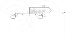
图1为本申请根据一示例性实施例提供的吊具控制方法的应用场景图,在该场景中,包括目标船舶10、位于目标船舶10上的多个集装箱13、岸基码头11、位于岸基码头11上的轨道吊14以及数据采集车12。其中,数据采集车12上安装有激光雷达15,用于生成激光信号,并根据物体反射的激光生成点云数据;轨道吊14上置有吊取集装箱13的吊具141以及吊具控制设备142,吊具141与吊具控制设备142连接,以使吊具控制设备142控制吊具141沿岸基方向左右移动直至吊具141与集装箱13上的吊取位置对齐。Fig. 1 is an application scene diagram of a spreader control method provided by the present application according to an exemplary embodiment.
在图1所示的应用场景中,目标船舶10为右弦靠岸,吊具控制设备142控制吊具141吊取目标船舶10上的目标集装箱之前,需要获取目标集装箱的位置,尤其是目标集装箱所处列的位置。此时,数据采集车12沿岸基方向从左向右行驶,在行驶过程中,激光雷达15发出激光信号,并根据目标船舶10反射的激光信号,生成对应的雷达点云数据。其中,激光雷达15所处的位置不同,生成的雷达点云数据也不同。激光雷达15将获得的多帧雷达点云数据传送至吊具控制设备142,以使吊具控制设备142根据上述多帧雷达点云数据确定船尾的位置,并根据目标集装箱所处的目标箱位相对于船尾的距离,确定目标集装箱的位置。更具体地,目标集装箱相对于船尾的距离为沿岸基方向的距离,目标集装箱的位置为目标集装箱所处的目标箱位的贝位。In the application scenario shown in FIG. 1 , the
下面基于上述应用场景,结合附图,对本申请的一些实施方式作详细说明。在各实施例之间不冲突的情况下,下述的实施例及实施例中的特征可以相互结合。另外,下述各方法实施例中的步骤时序仅为一种举例,而非严格限定。Based on the above application scenarios, some embodiments of the present application will be described in detail below in conjunction with the accompanying drawings. The following embodiments and features in the embodiments may be combined with each other under the condition that there is no conflict between the embodiments. In addition, the sequence of steps in the following method embodiments is only an example, rather than a strict limitation.
图2为本申请根据一示例性实施例提供的吊具控制方法的流程示意图,如图2所示,吊具控制方法包括:Fig. 2 is a schematic flow chart of a spreader control method provided by the present application according to an exemplary embodiment. As shown in Fig. 2, the spreader control method includes:
S201、吊具控制设备获得目标箱位与目标船舶的船尾之间的距离。S201. The spreader control device obtains the distance between the target container location and the stern of the target ship.
吊具控制设备用于吊取放置于目标船舶上目标箱位的集装箱。The spreader control equipment is used for hoisting the container placed in the target box on the target ship.
目标箱位与目标船舶的船尾之间的距离为沿岸基方向的距离,更具体地,目标船舶上处于同一列的集装箱与船尾之间的距离相同。The distance between the target container location and the stern of the target ship is the distance along the shore-based direction, more specifically, the distance between the containers in the same column on the target ship and the stern is the same.
S202、在激光雷达沿船尾至船头的方向,从目标船舶的船尾后侧移动至船尾前侧的过程中,吊具控制设备获得激光雷达连续采集的多帧雷达点云数据及激光雷达采集各帧雷达点云数据时所处的位置数据。S202. During the process of the lidar moving from the rear of the stern of the target ship to the front of the stern along the direction from the stern to the bow, the spreader control device obtains the multi-frame radar point cloud data continuously collected by the lidar and the data collected by the lidar. The location data where the radar point cloud data is framed.
激光雷达生成激光信号,并接收物体反射的激光信号。激光雷达根据获得的激光信号生成雷达点云数据。当目标船舶位于激光雷达的检测范围内时,该雷达点云数据中包含与目标船舶相关的数据点。LiDAR generates a laser signal and receives the laser signal reflected from objects. LiDAR generates radar point cloud data based on the obtained laser signals. When the target ship is within the detection range of the lidar, the radar point cloud data contains data points related to the target ship.
该激光雷达内还置有定位模块,用于获取激光雷达在生成雷达点云数据时的位置信息。在一实施例中,该定位模块为全球定位系统(Global Positioning System,简称:GPS)模快,该模块采集的位置信息为GPS信息。The laser radar is also equipped with a positioning module, which is used to obtain the position information of the laser radar when generating radar point cloud data. In one embodiment, the positioning module is a Global Positioning System (Global Positioning System, GPS for short) module, and the location information collected by the module is GPS information.
激光雷达安装在可移动物体上,可移动物体在岸基码头上,沿船尾至船头的方向,从目标船舶的船尾后侧移动至船尾前侧的过程中采集与目标船舶相关的雷达点云数据。在本申请中,可移动物体可以是数据采集车,也可以是安装在轨道上的可移动底座,还可以是其他可实现激光雷达移动的物体,此处不做具体限定。The lidar is installed on a movable object, and the movable object is on the shore-based pier, along the direction from the stern to the bow, and collects the radar point cloud related to the target ship while moving from the rear of the stern of the target ship to the front of the stern data. In this application, the movable object may be a data collection vehicle, a movable base installed on a track, or other objects capable of moving the lidar, which is not specifically limited here.
更具体地,目标船舶靠岸停泊,可移动物体位于岸基码头上,沿岸基边缘从船尾后侧移动至船尾前侧。在可移动物体移动的过程中,激光雷达按照预设采集时间间隔采集雷达点云数据,同时利用定位模块采集位置信息,以使可移动物体运动结束后,激光雷达采集多帧雷达点云数据和多个位置信息,上述各帧雷达点云数据与各位置信息呈一一对应的关系。More specifically, the target ship is berthed on the shore, and the movable object is located on the shore-based wharf, and moves from the rear of the stern to the front of the stern along the edge of the shore. During the moving process of the movable object, the lidar collects radar point cloud data according to the preset collection time interval, and at the same time uses the positioning module to collect position information, so that after the movement of the movable object ends, the lidar collects multi-frame radar point cloud data and A plurality of position information, each frame of radar point cloud data is in a one-to-one correspondence with each position information.
其中,可移动物体的开始移动位置与船尾的位置距离在岸基的投影距离为第一预设距离,可移动物体的结束位置与船尾的位置距离在岸基的投影距离为第二预设距离。该第一预设距离和第二预设距离是根据激光雷达检测目标船舶的精度设定的。当第一预设距离为a,第二预设距离为b时,上述两种预设距离、目标船舶和可移动物体的关系如图3所示,即激光雷达15从船尾后侧的开始位置A移动到船尾前侧的终止位置B,在激光雷达15的移动过程中,向周围发射激光信号以采集与目标船舶10相关的信息,其中,开始位置A与船尾的距离在岸基的投影距离为第一预设距离a,结束位置B与船尾的距离在岸基的投影距离为第二预设距离b。Wherein, the projected distance between the starting position of the movable object and the position of the stern on the shore is the first preset distance, and the projected distance between the end position of the movable object and the position of the stern on the shore is the second preset distance . The first preset distance and the second preset distance are set according to the accuracy of detecting the target ship by the laser radar. When the first preset distance is a and the second preset distance is b, the relationship between the above two preset distances, the target ship and the movable object is as shown in Figure 3, that is, the starting position of the
S203、吊具控制设备根据各帧雷达点云数据及其对应的位置数据,计算目标船舶的船尾位置。S203. The spreader control device calculates the stern position of the target ship according to each frame of radar point cloud data and its corresponding position data.
吊具控制设备对步骤S202获得的多帧雷达点云数据和对应的位置数据进行计算,获得激光雷达在各采集位置获得的目标船舶的原始船尾位置,以使其根据上述多个原始船尾位置确定目标船舶的船尾位置。The spreader control device calculates the multi-frame radar point cloud data and corresponding position data obtained in step S202, and obtains the original stern position of the target ship obtained by the laser radar at each collection position, so that it can be determined according to the above-mentioned multiple original stern positions. The stern position of the target ship.
S204、吊具控制设备根据船尾位置和目标箱位相对船尾的距离,确定吊具的目标位置,并控制吊具移动到目标位置。S204. The spreader control device determines the target position of the spreader according to the position of the stern and the distance of the target container position relative to the stern, and controls the spreader to move to the target position.
吊具控制设备利用步骤S203获得的船尾位置及步骤S201获得的目标箱位相对船尾的距离,获得目标箱位的位置,即吊具待移动的目标位置。The spreader control device uses the position of the stern obtained in step S203 and the distance between the target container location and the stern obtained in step S201 to obtain the position of the target container location, that is, the target location where the spreader is to be moved.
吊具控制设备在已知吊具当前所处位置的情况下,根据其待移动的目标位置,确定吊具的移动方向和移动距离,并将控制吊具按照上述确定的移动方向各移动距离移动。Knowing the current position of the spreader, the spreader control equipment determines the moving direction and moving distance of the spreader according to the target position to be moved, and controls the spreader to move according to the moving direction and moving distance determined above .
在上述技术方案中,可移动的激光雷达从船尾后侧运动至船尾前侧过程中采集多帧雷达点云数据,并将该雷达点云数据及各帧雷达点云数据对应的位置数据传送至吊具控制设备,以使吊具控制设备通过一个激光雷达发送的点云数据获得多角度、多距离采集的与目标船舶相关的信息,不仅降低了信息采集的成本,还提高了吊具控制设备确定的目标船舶的船尾位置的准确度,在其已知目标箱位和船尾之间的距离的情况下,提高了吊具控制设备控制吊具移动到目标位置与目标箱位对齐的准确度。In the above technical solution, the movable lidar collects multiple frames of radar point cloud data during the movement from the rear of the stern to the front of the stern, and transmits the radar point cloud data and the position data corresponding to each frame of radar point cloud data to Spreader control equipment, so that the spreader control equipment can obtain information related to the target ship collected from multiple angles and distances through the point cloud data sent by a laser radar, which not only reduces the cost of information collection, but also improves the spreader control equipment. The determined accuracy of the stern position of the target ship improves the accuracy of the spreader control device to control the spreader to move to the target position and align with the target position when the distance between the target container position and the stern is known.
下面将对吊具控制设备根据各帧雷达点云数据及其对应的位置数据,计算目标船舶的船尾位置信息的过程进行详细解释,该船尾位置信息的确定方法的流程示意图如图4所示,该方法包括:The process of calculating the stern position information of the target ship by the spreader control equipment according to each frame of radar point cloud data and its corresponding position data will be explained in detail. The flow diagram of the method for determining the stern position information is shown in Figure 4. The method includes:
S301、吊具控制设备根据各位置数据,将各帧处于位置数据对应的雷达坐标系上的雷达点云数据转化为处于同一岸基坐标系上的岸基点云数据。S301. The spreader control device converts the radar point cloud data of each frame in the radar coordinate system corresponding to the position data into shore-based point cloud data in the same shore-based coordinate system according to each position data.
雷达点云数据采用的坐标系是在激光雷达上定义的雷达坐标系,激光雷达的位置变化过程中,雷达坐标系也对应发生变化。若在激光雷达移动的过程中,目标船舶的位置不发生变化,则在各雷达坐标系中的船尾位置数据也各不相同。The coordinate system used by the radar point cloud data is the radar coordinate system defined on the lidar. When the position of the lidar changes, the radar coordinate system also changes accordingly. If the position of the target ship does not change during the movement of the lidar, the stern position data in each radar coordinate system is also different.
吊具控制设备需要根据激光雷达的位置信息,将处于不同雷达坐标系的雷达点云数据转化为处于同一岸基坐标系上的岸基点云数据,以保证各帧雷达点云数据中采集的目标船舶的船尾位置在同一岸基坐标系中保持一致,降低吊具控制设备根据多组点云数据确定船尾位置的计算复杂度,提到计算结果的准确性。The spreader control equipment needs to convert the radar point cloud data in different radar coordinate systems into shore-based point cloud data in the same shore-based coordinate system according to the position information of the lidar, so as to ensure that the target collected in each frame of radar point cloud data The stern position of the ship is kept consistent in the same shore-based coordinate system, which reduces the computational complexity of determining the stern position of the spreader control equipment based on multiple sets of point cloud data, and improves the accuracy of the calculation results.
更具体地,吊具控制设备获得的激光雷达的位置信息是该激光雷达在世界坐标系中的位置信息。吊具控制设备构建的岸基坐标系也是在世界坐标系中构建的坐标系。More specifically, the position information of the laser radar obtained by the spreader control device is the position information of the laser radar in the world coordinate system. The shore-based coordinate system constructed by the spreader control equipment is also a coordinate system constructed in the world coordinate system.
在吊具控制设备将多帧雷达点云数据转化为岸基点云数据时,需要先根据激光雷达在世界坐标系中的位置信息,将雷达点云数据从对应的雷达坐标系中转换到世界坐标系中,生成世界点云数据,然后再将世界点云数据转化到世界坐标系中定义的岸基坐标系中,生成岸基点云数据。When the spreader control equipment converts multi-frame radar point cloud data into shore-based point cloud data, it is necessary to convert the radar point cloud data from the corresponding radar coordinate system to the world coordinate system according to the position information of the lidar in the world coordinate system system, generate world point cloud data, and then transform the world point cloud data into the shore-based coordinate system defined in the world coordinate system to generate shore-based point cloud data.
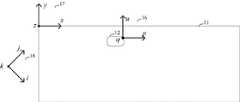
在一实施例中,上述三种坐标系的建立示意图如图5所示,在图5中,包括雷达坐标系16、世界坐标系18和岸基坐标系17,其中,雷达坐标系16是以激光雷达为原点建立的坐标系,该坐标系的三个坐标轴分别为p坐标轴、u坐标轴和q坐标轴;世界坐标系18是绝对坐标系,该坐标系的三个坐标轴分别为i坐标轴、j坐标轴和k坐标轴;岸基坐标系是以岸基码头11的起始端为原点,将沿岸基方向设置为x轴方向,垂直于岸基且从岸基向水面延伸的方向设置为y轴方向,将垂直于岸基平民的方向设置为z轴方向。In one embodiment, a schematic diagram of the establishment of the above three coordinate systems is shown in Figure 5. In Figure 5, it includes a radar coordinate
当目标船舶右弦靠岸时,激光雷达基于移动的数据采集车12沿岸基方向从左向右移动,在移动过程中,采集了n组数据,该数据包括:{(E1,L1),(E2,L2),……,(En,Ln)},其中,E1至En表示激光雷达采集的n帧雷达点云数据,L1至Ln表示激光雷达采集上述各帧雷达点云数据所处的位置数据。每帧雷达点云数据中包含多个数据点,该数据点是基于雷达坐标系的三维数据点,每帧雷达点云数据对应一组定位数据,每组定位数据中包括激光雷达在世界坐标系的位置信息和姿态信息,该位置信息为三维位置信息,姿态信息包括围绕i轴旋转的俯仰角,围绕j轴旋转的偏航角和围绕k轴旋转的翻滚角。当第e帧雷达点云数据中有m个数据点时,该m个数据点为{(p1,u1,q1),(p2,u2,q2),……,(pm,um,qm)},该帧雷达点云数据对应的定位数据为(ie,je,ke,yawe,rolle,pitche),其中,(ie,je,ke)表示采集第e帧雷达点云数据的激光雷达在世界坐标系中的位置数据,yawe表示该激光雷达的俯仰角,rolle表示该激光雷达的偏航角,pitche表示该激光雷达的翻滚角。When the target ship is docked on the right chord, the lidar-based mobile
吊具控制设备将根据上述定位数据,生成雷达点云数据转换至世界点云数据的转换矩阵,则吊具控制设备利用该转换矩阵和对应的雷达点云数据,计算得到对应的世界点云数据,其中每帧雷达点云数据中各数据点对应的转换矩阵相同,不同帧雷达点云数据对应的转换矩阵不同。更具体地,雷达点云数据转换至世界点云数据的过程为现有技术,此处不再赘述。The spreader control device will generate a conversion matrix from radar point cloud data to world point cloud data according to the above positioning data, then the spreader control device will use the conversion matrix and the corresponding radar point cloud data to calculate the corresponding world point cloud data , where the transformation matrix corresponding to each data point in each frame of radar point cloud data is the same, and the transformation matrix corresponding to different frames of radar point cloud data is different. More specifically, the process of converting radar point cloud data to world point cloud data is an existing technology, and will not be repeated here.
吊具控制设备将所有帧雷达点云数据从其对应的雷达坐标系转化至同一世界坐标系之后,再根据岸基坐标系三个坐标轴相对于世界坐标系三个坐标轴的旋转角度以及岸基坐标系的原点相对于世界坐标系的绝对原点的偏移量,生成将世界点云数据从世界坐标系转换至岸基坐标系中的岸基点云数据的转换矩阵,并基于此,获得多帧岸基点云数据,以使吊具控制设备计算得到目标船舶的船尾位置信息。其中,生成每帧岸基点云数据的转换矩阵均为同一转换矩阵,该转换方法为现有技术,此处不再赘述。After the spreader control equipment transforms all frames of radar point cloud data from its corresponding radar coordinate system to the same world coordinate system, according to the rotation angle of the three coordinate axes of the shore-based coordinate system relative to the three coordinate axes of the world coordinate system and the shore Based on the offset of the origin of the base coordinate system relative to the absolute origin of the world coordinate system, a conversion matrix for converting the world point cloud data from the world coordinate system to the shore-based point cloud data in the shore-based coordinate system is generated, and based on this, multiple Frame the shore-based point cloud data, so that the spreader control equipment can calculate the stern position information of the target ship. Wherein, the transformation matrix used to generate each frame of shore-based point cloud data is the same transformation matrix, and this transformation method is a prior art, and will not be repeated here.
S302、吊具控制设备在岸基坐标系中设置点云感兴趣区域。S302. The spreader control device sets a point cloud region of interest in the shore-based coordinate system.
点云感兴趣区域包含目标船舶所处的空间区域。在一实施例中,设定点云感兴趣区域在岸基坐标系x轴上的长度为整个岸基长度,覆盖了所有船舶的停靠位置,设定y-z平面为略大于船舶宽高的长方形,可以覆盖所有船舶上的点云。The point cloud region of interest contains the spatial region where the target ship is located. In one embodiment, the length of the point cloud region of interest on the x-axis of the shore-based coordinate system is set to be the entire length of the shore, covering the berthing positions of all ships, and the y-z plane is set to be a rectangle slightly larger than the width and height of the ship. Point clouds on all ships can be overlaid.
S303、吊具控制设备从各帧岸基点云数据的数据点中,筛选出处于点云感兴趣区域内的原始感兴趣数据点,以获得多帧感兴趣点云数据。S303. The spreader control device selects the original data points of interest in the point cloud region of interest from the data points of each frame of shore-based point cloud data, so as to obtain multiple frames of point cloud data of interest.
各帧感兴趣点云数据中包括多个原始感兴趣数据点。Each frame of point cloud data of interest includes multiple original data points of interest.
更具体地,吊具控制设备从所有岸基点云数据中获得多帧感兴趣点云数据时,先从各帧岸基点云数据的全部数据点中筛选掉未处于点云感兴趣区域的数据点,以获得多帧原始感兴趣点云数据,其中,原始感兴趣点云数据的帧数等于岸基点云数据的帧数。在获得原始感兴趣点云数据之后,吊具控制设备统计各帧原始感兴趣点云数据中数据点的数量,并将数据点的数量大于或等于预设点云数量阈值的原始感兴趣点云数据确定为感兴趣点云数据,其中,原始感兴趣点云数据的帧数大于或等于感兴趣点云数据的帧数。例如:当预设点云数量阈值为1000时,吊具控制装置仅将包含大于或等于1000个数据点的原始感兴趣点云数据保留,将其确定为感兴趣点云数据,而数据点的数量小于1000的原始感兴趣点云数据将不再参加后续船尾位置的计算。More specifically, when the spreader control equipment obtains multiple frames of point cloud data of interest from all shore-based point cloud data, it first screens out the data points that are not in the point cloud region of interest from all the data points of each frame of shore-based point cloud data , to obtain multiple frames of original point cloud data of interest, where the number of frames of the original point cloud data of interest is equal to the number of frames of the shore-based point cloud data. After obtaining the original point cloud data of interest, the spreader control device counts the number of data points in each frame of the original point cloud data of interest, and counts the original point cloud of interest with the number of data points greater than or equal to the preset point cloud quantity threshold The data is determined as point cloud data of interest, wherein the number of frames of the original point cloud data of interest is greater than or equal to the number of frames of the point cloud data of interest. For example: when the preset point cloud number threshold is 1000, the spreader control device will only retain the original point cloud data of interest that contains more than or equal to 1000 data points, and determine it as the point cloud data of interest, while the data points The original point cloud data of interest less than 1000 will no longer participate in the subsequent calculation of the stern position.
S304、吊具控制设备计算每帧感兴趣点云数据对应的船尾的初始估计位置及位置置信度。S304. The spreader control device calculates the initial estimated position and position confidence of the stern corresponding to each frame of point cloud data of interest.
吊具控制设备根据各帧感兴趣点云数据中与船尾相关的点云数据特征,从每帧感兴趣点云数据中获得一个对应的船尾的初始估计位置及位置置信度。The spreader control device obtains a corresponding initial estimated position and position confidence of the stern from each frame of point cloud data of interest according to the point cloud data characteristics related to the stern in each frame of point cloud data of interest.
更具体地,与船尾相关的点云数据特征为激光雷达在船尾后侧采集到的点云数据稀疏,而从船尾开始的位置,激光雷达采集的到的点云数据增多。More specifically, the feature of the point cloud data related to the stern is that the point cloud data collected by the lidar at the rear of the stern is sparse, while the point cloud data collected by the lidar increases from the stern.
当岸基坐标系沿岸基以从船尾至船头的方向为x轴方向,吊具控制设备计算各帧感兴趣点云数据对应的船尾的初始估计位置时,其针对各帧感兴趣点云数据,从感兴趣点云数据中获得各数据点的x维数据,该x维数据是各数据点垂直投射至岸基坐标系x轴上的数据。吊具控制设备将x维数据按照从小到大的顺序排列,获得一组x维数据集合,x维数据集合为(x1,……,xj,……,xm),其中,m为感兴趣点云数据中数据点的数量。吊具控制设备在x维数据集合中,从j=1起,依次计算xj+k与xj的差值,以确定激光雷达沿岸基坐标系的x坐标轴方向采集到的相邻k个点云数据的密度,直至获得差值小于预设突变阈值的xj,并将xj对应的数据点确定为该帧感兴趣点云数据对应的船尾的初始估计位置;其中,k为正整数,是预设点数阈值。When the shore-based coordinate system takes the direction from the stern to the bow as the x-axis direction along the shore, and the spreader control device calculates the initial estimated position of the stern corresponding to each frame of point cloud data of interest, it , obtain the x-dimensional data of each data point from the point cloud data of interest, and the x-dimensional data is the data that each data point is vertically projected onto the x-axis of the shore-based coordinate system. The spreader control equipment arranges the x-dimensional data in ascending order to obtain a set of x-dimensional data sets. The x-dimensional data set is (x1 ,...,xj ,...,xm ), wherem is The number of data points in the point cloud data of interest. In the x-dimensional data set, the spreader control equipment calculates the difference betweenxj+k andxj sequentially fromj = 1 to determine the adjacentk points collected by the lidar along the x-coordinate axis of the shore-based coordinate system. The density of the point cloud data, until thexj whose difference is less than the preset mutation threshold is obtained, and the data point corresponding toxj is determined as the initial estimated position of the stern corresponding to the frame of interest point cloud data; wherein,k is a positive integer , is the preset points threshold.
当该组x维数据集合中未能找到满足上述条件的xj,则确定该帧感兴趣点云数据中不包含可靠的船尾位置结果,吊具控制设备将不再计算该帧感兴趣点云数据对应的位置置信度,也不再利用该帧感兴趣点云数据计算目标船舶的船尾位置信息。Whenxj that meets the above conditions cannot be found in the set of x-dimensional data sets, it is determined that the frame of interest point cloud data does not contain a reliable result of the stern position, and the spreader control device will no longer calculate the frame of interest point cloud The confidence of the position corresponding to the data is no longer used to calculate the stern position information of the target ship by using the point cloud data of interest in this frame.
基于上述获得的船尾的初始估计位置的感兴趣点云数据,吊具控制设备计算对应的位置置信度。该位置置信度表示吊具控制设备根据激光雷达在其所处的位置采集的雷达点云数据计算得到的船尾的初始估计位置的可信程度。该位置置信度与激光雷达的测距精度相关,即其与船尾和激光雷达之间的距离相关,距离越近,激光雷达的测距精度越高,位置置信度的数值越大。此外,激光雷达与船尾的距离与激光雷达采集的雷达点云数据也呈正相关,距离越近,点云数据越多。Based on the point cloud data of interest of the initial estimated position of the stern obtained above, the spreader control device calculates the corresponding position confidence. The position confidence level represents the credibility of the initial estimated position of the stern calculated by the spreader control device based on the radar point cloud data collected by the lidar at its position. The position confidence is related to the ranging accuracy of the lidar, that is, it is related to the distance between the stern and the lidar. The closer the distance, the higher the ranging accuracy of the lidar, and the greater the value of the position confidence. In addition, the distance between the lidar and the stern is also positively correlated with the radar point cloud data collected by the lidar. The closer the distance, the more point cloud data.
更具体地,吊具控制设备根据各帧感兴趣点云数据对应的船尾的初始估计位置和置信度计算公式,计算每帧感兴趣点云数据对应的位置置信度。置信度计算公式包括:More specifically, the spreader control device calculates the position confidence corresponding to each frame of interest point cloud data according to the initial estimated position of the stern corresponding to each frame of interest point cloud data and the confidence calculation formula. Confidence calculation formulas include:

其中,e表示自然常数;Disti表示根据第i帧感兴趣点云数据确定的船尾的初始估计位置与采集感兴趣点云数据的雷达之间的直线距离,即初始估计位置与采集第i帧感兴趣点云数据的激光雷达在岸基坐标系中的位置之间的欧氏距离,ρ表示与激光雷达特性关联的参数,Ci∈(0,1)。在一实施例中,ρ=100。Among them,e represents a natural constant;Disti represents the linear distance between the initial estimated position of the stern determined according to the point cloud data of interest in thei -th frame and the radar that collects the point cloud data of interest, that is, the distance between the initial estimated position and the acquisition of the i-th frame The Euclidean distance between the lidar positions of the point cloud data of interest in the shore-based coordinate system,ρ represents the parameter associated with the lidar characteristics,Ci ∈ (0, 1). In one embodiment,ρ =100.
在计算Disti时,先将第i帧感兴趣点云数据对应的雷达坐标系的坐标原点结合步骤S301中涉及的两个转换矩阵,计算该坐标原点在岸基坐标系中的位置坐标,根据该位置坐标与船尾的初始估计位置的坐标,计算欧氏距离。When calculatingDisti , the coordinate origin of the radar coordinate system corresponding to the i-th frame of interest point cloud data is combined with the two transformation matrices involved in step S301 to calculate the position coordinates of the coordinate origin in the shore-based coordinate system, according to Calculate the Euclidean distance between this location coordinate and the coordinate of the initial estimated location of the stern.
S305、吊具控制设备根据各帧感兴趣点云数据对应的位置置信度,将所有船尾的初始估计位置进行融合,获得目标船舶的船尾位置信息。S305. The spreader control device fuses the initial estimated positions of all the sterns according to the position confidences corresponding to the point cloud data of interest in each frame, to obtain the stern position information of the target ship.
吊具控制设备在计算目标船舶的船尾位置信息时,将初始估计位置的x维数据记为横向位置初始估计值,计算所有帧感兴趣点云数据对应的横向位置初始估计值的平均值和标准差,并根据平均值和标准差,确定横向位置初始估计值的置信区间,从所有横向位置初始估计值中筛选出处于置信区间的目标横向位置初始估计值后,对目标横向位置初始估计值及其对应的位置置信度进行加权平均,获得目标船舶的船尾位置。在一实施例中,该置信区间为[平均值-标准差,平均值+标准差]。When the spreader control device calculates the stern position information of the target ship, it records the x-dimensional data of the initial estimated position as the initial estimated value of the lateral position, and calculates the average value and standard value of the initial estimated value of the lateral position corresponding to the point cloud data of all frames of interest. difference, and according to the average value and standard deviation, determine the confidence interval of the initial estimated value of the lateral position, and after screening out the initial estimated value of the target lateral position in the confidence interval from all initial estimated values of the lateral position, the initial estimated value of the lateral position of the target and The weighted average of the corresponding position confidences is used to obtain the stern position of the target ship. In one embodiment, the confidence interval is [mean-standard deviation, mean+standard deviation].
更具体地,吊具控制设备根据目标横向位置初始估计值、各目标横向位置初始估计值对应的位置置信度及加权平均公式,获得目标船舶的船尾位置,该加权平均公式为:More specifically, the spreader control equipment obtains the stern position of the target ship according to the initial estimated value of the target lateral position, the position confidence corresponding to each initial estimated value of the target lateral position, and the weighted average formula, and the weighted average formula is:

其中,o∈[1,d],d为目标横向位置初始估计值的总数;

吊具控制设备获得的船尾位置信息是船尾在岸基坐标系中沿x轴方向相对岸基坐标系原点的第一距离,该船尾位置信息用于使吊具控制设备在已知目标箱位相对船尾的距离后,获得目标箱位在岸基坐标中沿x轴方向相对岸基坐标系原点的第二距离,在一实施例中,第二距离为第一距离和目标箱位相对船尾的距离之和。船尾位置信息还用于使吊具控制设备在获得第二距离后,根据吊具的位置,即吊具在岸基坐标系中沿x轴方向相对岸基坐标系原点的第三距离,确定吊具的移动方向和移动距离,该移动距离为第二距离与第三距离差值的绝对值。The stern position information obtained by the spreader control equipment is the first distance of the stern relative to the origin of the shore-based coordinate system along the x-axis in the shore-based coordinate system. The stern position information is used to make the spreader control equipment relative to the known target container position After the distance of the stern, the second distance of the target container position relative to the origin of the shore-based coordinate system along the x-axis direction in the shore-based coordinates is obtained. In one embodiment, the second distance is the first distance and the distance between the target container position and the stern of the ship Sum. The position information of the stern is also used to make the spreader control equipment determine the position of the spreader according to the position of the spreader after obtaining the second distance, that is, the third distance of the spreader in the shore-based coordinate system along the x-axis direction relative to the origin of the shore-based coordinate system The moving direction and moving distance of the tool, where the moving distance is the absolute value of the difference between the second distance and the third distance.
在上述技术方案中,吊具控制设备对处于不同雷达坐标系中的雷达点云数据进行坐标系转换,获得基于不同采集距离和采集角度采集的雷达点云数据在同一岸基坐标系下数据点的分布情况,吊具控制设备通过点云感兴趣区域以及有效的船尾初始估计位置的求取筛选出包含船尾信息的点云数据,再根据有效的船尾位置估计距离对应的位置置信度的求取,确定置信区间,筛选出置信度高的船尾位置估计距离,再通过加权平均确定船尾位置,保证了船尾位置估计的准确度,以及基于该船尾位置移动的吊具与目标箱位对齐的准确度。In the above technical solution, the spreader control equipment performs coordinate system conversion on the radar point cloud data in different radar coordinate systems, and obtains the data points of the radar point cloud data collected based on different collection distances and collection angles in the same shore-based coordinate system The spreader control equipment screens out the point cloud data containing the stern information through the area of interest in the point cloud and the calculation of the effective initial estimated position of the stern, and then calculates the position confidence corresponding to the effective estimated distance of the stern position , determine the confidence interval, screen out the estimated distance of the stern position with high confidence, and then determine the stern position by weighted average, which ensures the accuracy of the stern position estimation and the alignment accuracy of the spreader based on the movement of the stern position and the target box position .
图6为本申请根据一实施例提供的吊具控制装置的结构示意图,该吊具控制装置400包括获取模块401和处理模块402,其中,Fig. 6 is a schematic structural diagram of a spreader control device provided by the present application according to an embodiment, the
获取模块401,用于获得目标箱位与目标船舶的船尾之间的距离;An
获取模块401还用于在激光雷达沿船尾至船头的方向,从目标船舶的船尾后侧移动至船尾前侧的过程中,获得激光雷达连续采集的多帧雷达点云数据及激光雷达采集各帧雷达点云数据时所处的位置数据;The
处理模块402,用于根据各帧雷达点云数据及其对应的位置数据,计算目标船舶的船尾位置。The
处理模块402还用于根据船尾位置和目标箱位相对船尾的距离,确定吊具的目标位置,并控制吊具移动到目标位置。The
在一实施例中,处理模块402具体用于:In an embodiment, the
根据各位置数据,将各帧处于位置数据对应的雷达坐标系上的雷达点云数据转化为处于同一岸基坐标系上的岸基点云数据;其中,各雷达坐标系是在激光雷达上定义的坐标系;According to each position data, the radar point cloud data of each frame in the radar coordinate system corresponding to the position data is converted into shore-based point cloud data in the same shore-based coordinate system; where each radar coordinate system is defined on the lidar Coordinate System;
根据各帧岸基点云数据,计算目标船舶的船尾位置信息。According to each frame of shore-based point cloud data, the stern position information of the target ship is calculated.
在一实施例中,处理模块402具体用于:In an embodiment, the
在岸基坐标系中设置点云感兴趣区域;点云感兴趣区域包含目标船舶所处的空间区域;Set the point cloud region of interest in the shore-based coordinate system; the point cloud region of interest includes the space area where the target ship is located;
从各帧岸基点云数据的数据点中,筛选出处于点云感兴趣区域内的原始感兴趣数据点,以获得多帧感兴趣点云数据;各帧感兴趣点云数据中包括多个原始感兴趣数据点;From the data points of each frame of shore-based point cloud data, the original data points of interest in the area of interest of the point cloud are screened out to obtain multiple frames of point cloud data of interest; each frame of point cloud data of interest includes multiple original Data points of interest;
计算每帧感兴趣点云数据对应的船尾的初始估计位置及位置置信度;Calculate the initial estimated position and position confidence of the stern corresponding to each frame of point cloud data of interest;
根据各帧感兴趣点云数据对应的位置置信度,将所有船尾的初始估计位置进行融合,获得目标船舶的船尾位置信息。According to the position confidence corresponding to each frame of interest point cloud data, the initial estimated positions of all ship sterns are fused to obtain the position information of the target ship's stern.
在一实施例中,处理模块402具体用于:In an embodiment, the
从各帧岸基点云数据的全部数据点中筛选掉未处于点云感兴趣区域的数据点,以获得多帧原始感兴趣点云数据;原始感兴趣点云数据的帧数等于岸基点云数据的帧数;Filter out the data points that are not in the point cloud area of interest from all the data points of each frame of shore-based point cloud data to obtain multiple frames of original point cloud data of interest; the number of frames of the original point cloud data of interest is equal to that of the shore-based point cloud data the number of frames;
统计各帧原始感兴趣点云数据中数据点的数量;Count the number of data points in the original point cloud data of interest for each frame;
将数据点的数量大于或等于预设点云数量阈值的原始感兴趣点云数据确定为感兴趣点云数据;原始感兴趣点云数据的帧数大于或等于感兴趣点云数据的帧数。The original point cloud data of interest whose number of data points is greater than or equal to the preset point cloud quantity threshold is determined as the point cloud data of interest; the number of frames of the original point cloud data of interest is greater than or equal to the number of frames of the point cloud data of interest.
在一实施例中,处理模块402具体用于:In an embodiment, the
针对各帧感兴趣点云数据,从感兴趣点云数据中获得各数据点的x维数据;岸基坐标系沿岸基以从船尾至船头的方向为x轴方向,x维数据是各数据点垂直投射至岸基坐标系x轴上的数据;For each frame of point cloud data of interest, the x-dimensional data of each data point is obtained from the point cloud data of interest; the shore-based coordinate system is along the shore with the direction from the stern to the bow as the x-axis direction, and the x-dimensional data is the The point is projected vertically to the data on the x-axis of the shore-based coordinate system;
将x维数据按照从小到大的顺序排列,获得一组x维数据集合;x维数据集合为(x1,……,xj,……,xm),m为感兴趣点云数据中数据点的数量;Arrange the x-dimensional data in ascending order to obtain a set of x-dimensional data sets; the x-dimensional data set is (x1 ,...,xj ,...,xm ),m is the point cloud data of interest the number of data points;
在x维数据集合中,从j=1起,依次计算xj+k与xj的差值,直至获得差值小于预设突变阈值的xj,并将xj对应的数据点确定为该帧感兴趣点云数据对应的船尾的初始估计位置;其中,k为正整数。In the x-dimensional data set, starting fromj = 1, the difference betweenxj+k andxj is calculated sequentially until thex j whose difference is less than the preset mutation threshold is obtained, and the data point corresponding to xjisdetermined as the The initial estimated position of the stern corresponding to the frame of interest point cloud data; wherein,k is a positive integer.
在一实施例中,处理模块402具体用于:In an embodiment, the
根据各帧感兴趣点云数据对应的船尾的初始估计位置和置信度计算公式,计算每帧感兴趣点云数据对应的位置置信度;置信度计算公式包括:According to the initial estimated position of the stern corresponding to each frame of interest point cloud data and the confidence calculation formula, calculate the position confidence corresponding to each frame of interest point cloud data; the confidence calculation formula includes:

其中,e表示自然常数;Disti表示根据第i帧感兴趣点云数据确定的船尾的初始估计位置与采集感兴趣点云数据的雷达之间的直线距离,ρ表示与激光雷达特性关联的参数。Among them,e represents a natural constant;Disti represents the linear distance between the initial estimated position of the stern determined according to thei -th frame of interest point cloud data and the radar that collects the interest point cloud data, andρ represents the parameters associated with the characteristics of the lidar .
在一实施例中,处理模块402具体用于:In an embodiment, the
计算所有帧感兴趣点云数据对应的横向位置初始估计值的平均值和标准差;横向位置初始估计值为初始估计位置的x维数据;Calculate the mean value and standard deviation of the initial estimated value of the lateral position corresponding to all frames of interest point cloud data; the initial estimated value of the lateral position is the x-dimensional data of the initial estimated position;
根据平均值和标准差,确定横向位置初始估计值的置信区间;Determine the confidence interval for the initial estimate of lateral position based on the mean and standard deviation;
从所有横向位置初始估计值中筛选出处于置信区间的目标横向位置初始估计值;Screening out the initial estimated value of the lateral position of the target within the confidence interval from all the initial estimated values of the lateral position;
对目标横向位置初始估计值及其对应的位置置信度进行加权平均,获得目标船舶的船尾位置。The weighted average of the initial estimated value of the lateral position of the target and its corresponding position confidence is obtained to obtain the stern position of the target ship.
在一实施例中,处理模块402具体用于:In an embodiment, the
根据目标横向位置初始估计值、各目标横向位置初始估计值对应的位置置信度及加权平均公式,获得目标船舶的船尾位置;加权平均公式为:According to the initial estimated value of the target lateral position, the position confidence corresponding to the initial estimated value of each target lateral position and the weighted average formula, the stern position of the target ship is obtained; the weighted average formula is:

其中,o∈[1,d],d为目标横向位置初始估计值的总数;

图7为本申请根据一实施例提供的吊具控制设备的结构示意图。其中,吊具控制设备500包括存储器501和处理器502,存储器501用于存储处理器可执行的计算机指令。该存储器501可能包含高速随机存取存储器(Random Access Memory,RAM),也可能还包括非易失性存储(Non-Volatile Memory,NVM),例如至少一个磁盘存储器,还可以为U盘、移动硬盘、只读存储器、磁盘或光盘等。Fig. 7 is a schematic structural diagram of a spreader control device according to an embodiment of the present application. Wherein, the
处理器502在执行计算机指令时实现上述实施例中以吊具控制设备为执行主体的吊具控制方法中的各个步骤。具体可以参见前述方法实施例中的相关描述。该处理器502可以是中央处理单元(Central Processing Unit,CPU),还可以是其他通用处理器、数字信号处理器(Digital Signal Processor,DSP)、专用集成电路(Application SpecificIntegrated Circuit,ASIC)等。通用处理器可以是微处理器或者该处理器也可以是任何常规的处理器等。结合发明所公开的方法的步骤可以直接体现为硬件处理器执行完成,或者用处理器中的硬件及软件模块组合执行完成。When the processor 502 executes computer instructions, it implements various steps in the spreader control method in the above-mentioned embodiments with the spreader control device as the execution subject. For details, refer to the related descriptions in the foregoing method embodiments. The processor 502 may be a central processing unit (Central Processing Unit, CPU), or other general-purpose processors, a digital signal processor (Digital Signal Processor, DSP), an application specific integrated circuit (Application Specific Integrated Circuit, ASIC), etc. A general-purpose processor may be a microprocessor, or the processor may be any conventional processor, or the like. The steps of the method disclosed in conjunction with the invention can be directly implemented by a hardware processor, or implemented by a combination of hardware and software modules in the processor.
可选地,上述存储器501既可以是独立的,也可以跟处理器502集成在一起。当存储器501独立设置时,该电子设备500还包括总线,用于连接存储器501和处理器502。该总线可以是工业标准体系结构(Industry Standard Architecture,ISA)总线、外部设备互连(Peripheral Component Interconnect,PCI)总线或扩展工业标准体系结构(ExtendedIndustry Standard Architecture,EISA)总线等。总线可以分为地址总线、数据总线、控制总线等。为便于表示,本申请附图中的总线并不限定仅有一根总线或一种类型的总线。Optionally, the above-mentioned memory 501 may be independent or integrated with the processor 502 . When the memory 501 is independently configured, the
本申请实施例还提供一种计算机可读存储介质,计算机可读存储介质中存储有计算机指令,当处理器执行计算机指令时,实现上述实施例中吊具控制方法中的各个步骤。The embodiment of the present application also provides a computer-readable storage medium, in which computer instructions are stored. When the processor executes the computer instructions, each step in the method for controlling the spreader in the above-mentioned embodiments is realized.
本申请实施例还提供一种计算机程序产品,包括计算机指令,该计算机指令被处理器执行时实现上述实施例中吊具控制方法中的各个步骤。The embodiment of the present application further provides a computer program product, including computer instructions, and when the computer instructions are executed by a processor, each step in the method for controlling the spreader in the above-mentioned embodiments is implemented.
本领域技术人员在考虑说明书及实践这里公开的发明后,将容易想到本申请的其它实施方案。本申请旨在涵盖本申请的任何变型、用途或者适应性变化,这些变型、用途或者适应性变化遵循本申请的一般性原理并包括本申请未公开的本技术领域中的公知常识或惯用技术手段。说明书和实施例仅被视为示例性的,本申请的真正范围和精神由下面的权利要求书指出。Other embodiments of the present application will be readily apparent to those skilled in the art from consideration of the specification and practice of the invention disclosed herein. This application is intended to cover any modification, use or adaptation of the application, these modifications, uses or adaptations follow the general principles of the application and include common knowledge or conventional technical means in the technical field not disclosed in the application . The specification and examples are to be considered exemplary only, with a true scope and spirit of the application indicated by the following claims.
应当理解的是,本申请并不局限于上面已经描述并在附图中示出的精确结构,并且可以在不脱离其范围进行各种修改和改变。本申请的范围仅由所附的权利要求书来限制。It should be understood that the present application is not limited to the precise constructions which have been described above and shown in the accompanying drawings, and various modifications and changes may be made without departing from the scope thereof. The scope of the application is limited only by the appended claims.
Claims (3)


Priority Applications (1)
| Application Number | Priority Date | Filing Date | Title |
|---|---|---|---|
| CN202211133740.3ACN115258959B (en) | 2022-09-19 | 2022-09-19 | Sling control method, equipment and storage medium |
Applications Claiming Priority (1)
| Application Number | Priority Date | Filing Date | Title |
|---|---|---|---|
| CN202211133740.3ACN115258959B (en) | 2022-09-19 | 2022-09-19 | Sling control method, equipment and storage medium |
Publications (2)
| Publication Number | Publication Date |
|---|---|
| CN115258959A CN115258959A (en) | 2022-11-01 |
| CN115258959Btrue CN115258959B (en) | 2023-01-03 |
Family
ID=83756525
Family Applications (1)
| Application Number | Title | Priority Date | Filing Date |
|---|---|---|---|
| CN202211133740.3AActiveCN115258959B (en) | 2022-09-19 | 2022-09-19 | Sling control method, equipment and storage medium |
Country Status (1)
| Country | Link |
|---|---|
| CN (1) | CN115258959B (en) |
Families Citing this family (1)
| Publication number | Priority date | Publication date | Assignee | Title |
|---|---|---|---|---|
| CN116428996B (en)* | 2023-06-06 | 2023-09-01 | 北京斯年智驾科技有限公司 | A detection method and detection device for the height of a spreader |
Citations (14)
| Publication number | Priority date | Publication date | Assignee | Title |
|---|---|---|---|---|
| JP2005145602A (en)* | 2003-11-13 | 2005-06-09 | Mitsubishi Heavy Ind Ltd | Monitoring system for harbor and container crane |
| CN101269751A (en)* | 2007-03-02 | 2008-09-24 | 科尔玛工业公司 | Positioning system for container loading equipment |
| KR20180118504A (en)* | 2017-04-21 | 2018-10-31 | 주식회사 유컴테크놀러지 | Distance measuring apparatus and method for controlling the same |
| CN108919299A (en)* | 2018-06-27 | 2018-11-30 | 武汉理工大学 | Ship freeboard intelligence sensing system and method based on multi-thread laser Surface scan |
| CN110329910A (en)* | 2019-04-30 | 2019-10-15 | 上海冠东国际集装箱码头有限公司 | Automatic cabinet gantry crane remote control trolley path planning method |
| CN111784627A (en)* | 2020-04-10 | 2020-10-16 | 福建电子口岸股份有限公司 | Container alignment method for vehicle |
| CN112099025A (en)* | 2020-08-20 | 2020-12-18 | 杭州飞步科技有限公司 | Method, device and equipment for positioning vehicle under bridge crane and storage medium |
| CN112733896A (en)* | 2020-12-30 | 2021-04-30 | 深圳市镭神智能系统有限公司 | Ship lockage management method, device, system and storage medium |
| CN113447922A (en)* | 2021-06-28 | 2021-09-28 | 武汉理工港航科技研究院有限公司 | Shore-based berthing system, method and equipment based on radar capture and laser tracking |
| CN113511597A (en)* | 2021-05-17 | 2021-10-19 | 上海振华重工(集团)股份有限公司 | Hoisting method and hoisting system of door frame assembly |
| CN214503892U (en)* | 2021-03-24 | 2021-10-26 | 南京晓庄学院 | Sea Ship Berth Ranging Device |
| CN113759906A (en)* | 2021-08-30 | 2021-12-07 | 广州文远知行科技有限公司 | Vehicle alignment method and device, computer equipment and storage medium |
| CN113870343A (en)* | 2020-06-30 | 2021-12-31 | 长沙智能驾驶研究院有限公司 | Relative pose calibration method, device, computer equipment and storage medium |
| CN114988283A (en)* | 2022-05-28 | 2022-09-02 | 聚时科技(上海)有限公司 | High-precision cabin position real-time detection system for automatic bridge crane |
Family Cites Families (1)
| Publication number | Priority date | Publication date | Assignee | Title |
|---|---|---|---|---|
| WO2015022001A1 (en)* | 2013-08-12 | 2015-02-19 | Abb Technology Ltd | Method and system for automatically landing containers on a landing target using a container crane |
- 2022
- 2022-09-19CNCN202211133740.3Apatent/CN115258959B/enactiveActive
Patent Citations (14)
| Publication number | Priority date | Publication date | Assignee | Title |
|---|---|---|---|---|
| JP2005145602A (en)* | 2003-11-13 | 2005-06-09 | Mitsubishi Heavy Ind Ltd | Monitoring system for harbor and container crane |
| CN101269751A (en)* | 2007-03-02 | 2008-09-24 | 科尔玛工业公司 | Positioning system for container loading equipment |
| KR20180118504A (en)* | 2017-04-21 | 2018-10-31 | 주식회사 유컴테크놀러지 | Distance measuring apparatus and method for controlling the same |
| CN108919299A (en)* | 2018-06-27 | 2018-11-30 | 武汉理工大学 | Ship freeboard intelligence sensing system and method based on multi-thread laser Surface scan |
| CN110329910A (en)* | 2019-04-30 | 2019-10-15 | 上海冠东国际集装箱码头有限公司 | Automatic cabinet gantry crane remote control trolley path planning method |
| CN111784627A (en)* | 2020-04-10 | 2020-10-16 | 福建电子口岸股份有限公司 | Container alignment method for vehicle |
| CN113870343A (en)* | 2020-06-30 | 2021-12-31 | 长沙智能驾驶研究院有限公司 | Relative pose calibration method, device, computer equipment and storage medium |
| CN112099025A (en)* | 2020-08-20 | 2020-12-18 | 杭州飞步科技有限公司 | Method, device and equipment for positioning vehicle under bridge crane and storage medium |
| CN112733896A (en)* | 2020-12-30 | 2021-04-30 | 深圳市镭神智能系统有限公司 | Ship lockage management method, device, system and storage medium |
| CN214503892U (en)* | 2021-03-24 | 2021-10-26 | 南京晓庄学院 | Sea Ship Berth Ranging Device |
| CN113511597A (en)* | 2021-05-17 | 2021-10-19 | 上海振华重工(集团)股份有限公司 | Hoisting method and hoisting system of door frame assembly |
| CN113447922A (en)* | 2021-06-28 | 2021-09-28 | 武汉理工港航科技研究院有限公司 | Shore-based berthing system, method and equipment based on radar capture and laser tracking |
| CN113759906A (en)* | 2021-08-30 | 2021-12-07 | 广州文远知行科技有限公司 | Vehicle alignment method and device, computer equipment and storage medium |
| CN114988283A (en)* | 2022-05-28 | 2022-09-02 | 聚时科技(上海)有限公司 | High-precision cabin position real-time detection system for automatic bridge crane |
Also Published As
| Publication number | Publication date |
|---|---|
| CN115258959A (en) | 2022-11-01 |
Similar Documents
| Publication | Publication Date | Title |
|---|---|---|
| CN113748357B (en) | Attitude correction method, device and system of laser radar | |
| CN113486797B (en) | Unmanned vehicle position detection method, unmanned vehicle position detection device, unmanned vehicle position detection equipment, storage medium and vehicle | |
| CN109283538B (en) | Marine target size detection method based on vision and laser sensor data fusion | |
| US11667036B2 (en) | Workpiece picking device and workpiece picking method | |
| CN108562913B (en) | Unmanned ship false target detection method based on three-dimensional laser radar | |
| WO2020237516A1 (en) | Point cloud processing method, device, and computer readable storage medium | |
| WO2021016854A1 (en) | Calibration method and device, movable platform, and storage medium | |
| CN113838125B (en) | Target position determining method, device, electronic equipment and storage medium | |
| CN112099025B (en) | Vehicle positioning method, device, equipment and storage medium under bridge crane | |
| CN113655453B (en) | Data processing method and device for sensor calibration and automatic driving vehicle | |
| CN109029465B (en) | Millimeter wave radar-based tracking and obstacle avoidance system for unmanned ship | |
| KR20230074438A (en) | Device and method for monitoring ship and port | |
| CN115258959B (en) | Sling control method, equipment and storage medium | |
| CN112946660A (en) | Multi-beam forward-looking sonar-based simultaneous positioning and mapping method | |
| TW202019742A (en) | Lidar detection device for close obstacles and method thereof capable of effectively detecting obstacles and enhancing detection accuracy | |
| CN115294004A (en) | Return control method and device, readable medium and self-moving equipment | |
| CN114596358A (en) | Object detection method and device and electronic equipment | |
| CN110542422B (en) | Robot positioning method, device, robot and storage medium | |
| CN114594759A (en) | Ship inland shipping lidar identification system and its operation method | |
| CN114037977B (en) | Road vanishing point detection method, device, equipment and storage medium | |
| TW202324324A (en) | Automatic berthing image ranging system for vessels and operation method thereof | |
| CN115965929A (en) | Point cloud-based obstacle detection method and device and domain controller | |
| CN112927298B (en) | Target object positioning method and device, electronic equipment and storage medium | |
| CN112400094B (en) | object detection device | |
| US20240303854A1 (en) | Target monitoring system, target monitoring method, and recording medium |
Legal Events
| Date | Code | Title | Description |
|---|---|---|---|
| PB01 | Publication | ||
| PB01 | Publication | ||
| SE01 | Entry into force of request for substantive examination | ||
| SE01 | Entry into force of request for substantive examination | ||
| GR01 | Patent grant | ||
| GR01 | Patent grant |