CN115240154A - Method, device, equipment and medium for extracting point cloud features of parking lot - Google Patents
Method, device, equipment and medium for extracting point cloud features of parking lotDownload PDFInfo
- Publication number
- CN115240154A CN115240154ACN202210764800.5ACN202210764800ACN115240154ACN 115240154 ACN115240154 ACN 115240154ACN 202210764800 ACN202210764800 ACN 202210764800ACN 115240154 ACN115240154 ACN 115240154A
- Authority
- CN
- China
- Prior art keywords
- point cloud
- parking space
- cloud data
- space line
- line
- Prior art date
- Legal status (The legal status is an assumption and is not a legal conclusion. Google has not performed a legal analysis and makes no representation as to the accuracy of the status listed.)
- Pending
Links
Images


Classifications
- G—PHYSICS
- G06—COMPUTING OR CALCULATING; COUNTING
- G06V—IMAGE OR VIDEO RECOGNITION OR UNDERSTANDING
- G06V20/00—Scenes; Scene-specific elements
- G06V20/50—Context or environment of the image
- G06V20/56—Context or environment of the image exterior to a vehicle by using sensors mounted on the vehicle
- G06V20/588—Recognition of the road, e.g. of lane markings; Recognition of the vehicle driving pattern in relation to the road
- G—PHYSICS
- G06—COMPUTING OR CALCULATING; COUNTING
- G06T—IMAGE DATA PROCESSING OR GENERATION, IN GENERAL
- G06T7/00—Image analysis
- G06T7/60—Analysis of geometric attributes
- G—PHYSICS
- G06—COMPUTING OR CALCULATING; COUNTING
- G06T—IMAGE DATA PROCESSING OR GENERATION, IN GENERAL
- G06T7/00—Image analysis
- G06T7/70—Determining position or orientation of objects or cameras
- G06T7/73—Determining position or orientation of objects or cameras using feature-based methods
- G—PHYSICS
- G06—COMPUTING OR CALCULATING; COUNTING
- G06V—IMAGE OR VIDEO RECOGNITION OR UNDERSTANDING
- G06V30/00—Character recognition; Recognising digital ink; Document-oriented image-based pattern recognition
- G06V30/10—Character recognition
- G06V30/14—Image acquisition
- G06V30/148—Segmentation of character regions
- G06V30/153—Segmentation of character regions using recognition of characters or words
- G—PHYSICS
- G06—COMPUTING OR CALCULATING; COUNTING
- G06T—IMAGE DATA PROCESSING OR GENERATION, IN GENERAL
- G06T2207/00—Indexing scheme for image analysis or image enhancement
- G06T2207/10—Image acquisition modality
- G06T2207/10028—Range image; Depth image; 3D point clouds
- G—PHYSICS
- G06—COMPUTING OR CALCULATING; COUNTING
- G06T—IMAGE DATA PROCESSING OR GENERATION, IN GENERAL
- G06T2207/00—Indexing scheme for image analysis or image enhancement
- G06T2207/30—Subject of image; Context of image processing
- G06T2207/30248—Vehicle exterior or interior
- G06T2207/30252—Vehicle exterior; Vicinity of vehicle
- G06T2207/30256—Lane; Road marking
Landscapes
- Engineering & Computer Science (AREA)
- Physics & Mathematics (AREA)
- General Physics & Mathematics (AREA)
- Theoretical Computer Science (AREA)
- Computer Vision & Pattern Recognition (AREA)
- Multimedia (AREA)
- Geometry (AREA)
- Traffic Control Systems (AREA)
Abstract
Description
Translated fromChinese技术领域technical field
本公开实施例涉及点云处理技术领域,尤其涉及一种停车场的点云特征提取方法、装置、设备及介质。The embodiments of the present disclosure relate to the technical field of point cloud processing, and in particular, to a method, apparatus, device, and medium for extracting point cloud features of a parking lot.
背景技术Background technique
目前高精地图主要集中于高速与部分普通道路场景,并无停车场的高精地图,而自动驾驶最后一公里自动泊车却对高精地图有所诉求。而且在网约车领域,火车站、机场等上车点通常在地下停车场,现有标准地图(简称SD地图)也无法满足快速准确的司乘需求。在地下停车场中,由于全球定位系统(Global Positioning System,简称GPS)信号遮蔽以及限高等限制,现有高精地图生成方案无法直接复用于地下停车场,因此,亟需一种停车场的点云特征提取方法,以满足停车场高精地图的建图需求。At present, high-precision maps mainly focus on high-speed and some ordinary road scenes, and there are no high-precision maps for parking lots. However, automatic parking in the last mile of autonomous driving requires high-precision maps. Moreover, in the field of online car-hailing, train stations, airports and other pick-up points are usually located in underground parking lots, and the existing standard maps (referred to as SD maps) cannot meet the needs of fast and accurate drivers. In the underground parking lot, due to the global positioning system (Global Positioning System, GPS) signal shielding and restrictions, the existing high-precision map generation scheme cannot be directly reused in the underground parking lot. Therefore, there is an urgent need for a parking lot. Point cloud feature extraction method to meet the mapping needs of parking lot high-precision maps.
发明内容SUMMARY OF THE INVENTION
为了解决上述技术问题,本公开实施例提供了一种停车场的点云特征提取方法、装置、设备及介质。In order to solve the above technical problems, the embodiments of the present disclosure provide a method, apparatus, device, and medium for extracting point cloud features of a parking lot.
本公开实施例的第一方面提供了一种停车场的点云特征提取方法,该方法包括:获取停车场的点云数据和图像;从点云数据中提取得到车位线的点云数据,从图像中提取得到车位编号;根据车位线的点云数据中包含的三维点之间的相对位置关系,从车位线的点云数据中分离得到单条车位线的点云数据;根据车位编号和单条车位线在三维空间中的距离,将与单条车位线距离小于预设距离的车位编号赋值给单条车位线的点云数据。A first aspect of the embodiments of the present disclosure provides a method for extracting point cloud features of a parking lot. The method includes: acquiring point cloud data and images of a parking lot; extracting point cloud data of parking space lines from the point cloud data; The parking space number is extracted from the image; according to the relative positional relationship between the three-dimensional points contained in the point cloud data of the parking space line, the point cloud data of a single parking space line is separated from the point cloud data of the parking space line; according to the parking space number and the single parking space The distance of the line in the three-dimensional space, and assign the number of the parking space that is less than the preset distance from the single parking space line to the point cloud data of the single parking space line.
本公开实施例的第二方面提供了一种点云特征提取装置,该装置包括:A second aspect of the embodiments of the present disclosure provides a point cloud feature extraction device, the device comprising:
获取模块,用于获取停车场的点云数据和图像;The acquisition module is used to acquire the point cloud data and images of the parking lot;
提取模块,用于从点云数据中提取得到车位线的点云数据,以及从图像中提取得到车位编号;The extraction module is used to extract the point cloud data of the parking space line from the point cloud data, and extract the parking space number from the image;
点云分离模块,用于根据车位线的点云数据中包含的三维点之间的相对位置关系,从车位线的点云数据中分离得到单条车位线的点云数据;The point cloud separation module is used to separate the point cloud data of a single parking space line from the point cloud data of the parking space line according to the relative positional relationship between the three-dimensional points contained in the point cloud data of the parking space line;
编号赋予模块,用于根据车位编号和单条车位线在三维空间中的距离,将与单条车位线距离小于预设距离的车位编号赋值给该单条车位线的点云数据。The number assignment module is used to assign the parking space number whose distance from the single parking space line is less than the preset distance to the point cloud data of the single parking space line according to the parking space number and the distance of the single parking space line in the three-dimensional space.
本公开实施例的第三方面提供了一种计算机设备,该计算机设备包括存储器和处理器,其中,存储器中存储有计算机程序,当该计算机程序被处理器执行时,可以实现上述第一方面的方法。A third aspect of the embodiments of the present disclosure provides a computer device, the computer device includes a memory and a processor, wherein a computer program is stored in the memory, and when the computer program is executed by the processor, the above-mentioned first aspect can be implemented method.
本公开实施例的第四方面提供了一种计算机可读存储介质,其中,该存储介质中存储有计算机程序,当该计算机程序被计算机设备执行时,使得计算机设备执行上述第一方面的方法。A fourth aspect of the embodiments of the present disclosure provides a computer-readable storage medium, wherein a computer program is stored in the storage medium, and when the computer program is executed by a computer device, the computer device is caused to perform the method of the first aspect.
本公开实施例的第五方面提供了一种计算机程序产品,该程序产品存储在存储介质中,当该程序产品被计算机设备的处理器执行时,使得处理器执行上述第一方面的方法。A fifth aspect of the embodiments of the present disclosure provides a computer program product, where the program product is stored in a storage medium, and when the program product is executed by a processor of a computer device, causes the processor to execute the method of the first aspect.
本公开实施例提供的技术方案与现有技术相比具有如下优点:Compared with the prior art, the technical solutions provided by the embodiments of the present disclosure have the following advantages:
本公开实施例,在获取到停车场的点云数据和图像后,通过从点云数据中提取车位线的点云数据,根据车位线的点云数据中包含的三维点之间的相对位置关系,能够准确的从点云数据中分离出单条车位线的点云数据;通过从图像中识别车位编号,根据车位编号和单条车位线在三维空间中的距离,将与单条车位线距离小于预设距离的车位编号赋值给单条车位线的点云数据,能够准确建立车位编号和车位线点云数据之间的对应关系,使得车位线的点云数据具备编号属性,通过编号属性可提高车位线点云数据的可区分性,在将具备编号属性的车位线点云数据作为停车场高精地图的制作资料时,可提高停车场高精地图建图的准确性。In this embodiment of the present disclosure, after the point cloud data and images of the parking lot are acquired, the point cloud data of the parking space line is extracted from the point cloud data, and the relative positional relationship between the three-dimensional points included in the point cloud data of the parking space line is calculated according to the relative positional relationship between the three-dimensional points. , which can accurately separate the point cloud data of a single parking space line from the point cloud data; by identifying the parking space number from the image, according to the parking space number and the distance of the single parking space line in the three-dimensional space, the distance from the single parking space line is smaller than the preset The parking space number of the distance is assigned to the point cloud data of a single parking space line, which can accurately establish the corresponding relationship between the parking space number and the point cloud data of the parking space line, so that the point cloud data of the parking space line has the numbering attribute, and the numbering attribute can improve the parking space line point. The distinguishability of cloud data can improve the accuracy of the high-precision map construction of the parking lot when the point cloud data of the parking space line with the number attribute is used as the production data of the high-precision map of the parking lot.
附图说明Description of drawings
此处的附图被并入说明书中并构成本说明书的一部分,示出了符合本公开的实施例,并与说明书一起用于解释本公开的原理。The accompanying drawings, which are incorporated in and constitute a part of this specification, illustrate embodiments consistent with the disclosure and together with the description serve to explain the principles of the disclosure.
为了更清楚地说明本公开实施例或现有技术中的技术方案,下面将对实施例或现有技术描述中所需要使用的附图作简单地介绍,显而易见地,对于本领域普通技术人员而言,在不付出创造性劳动性的前提下,还可以根据这些附图获得其他的附图。In order to more clearly illustrate the embodiments of the present disclosure or the technical solutions in the prior art, the accompanying drawings that are required to be used in the description of the embodiments or the prior art will be briefly introduced below. In other words, on the premise of no creative labor, other drawings can also be obtained from these drawings.
图1是本公开实施例提供的一种点云特征提取场景的示意图;1 is a schematic diagram of a point cloud feature extraction scene provided by an embodiment of the present disclosure;
图2是本公开实施例提供的一种停车场的点云特征提取方法的流程图;2 is a flowchart of a method for extracting point cloud features of a parking lot provided by an embodiment of the present disclosure;
图3是本公开实施例提供的一种示例性的数据划分方法的示意图;3 is a schematic diagram of an exemplary data division method provided by an embodiment of the present disclosure;
图4是本公开实施例提供的一种提取车位线点云数据的方法的流程图;4 is a flowchart of a method for extracting point cloud data of parking space lines provided by an embodiment of the present disclosure;
图5是本公开实施例提供的一种点云分类方法的示意图;5 is a schematic diagram of a point cloud classification method provided by an embodiment of the present disclosure;
图6是本公开实施例提供的一种提取车位线的点云数据的方法示意图;6 is a schematic diagram of a method for extracting point cloud data of a parking space line provided by an embodiment of the present disclosure;
图7是本公开实施例提供的一种车位线拟合方法的示意图;7 is a schematic diagram of a parking space line fitting method provided by an embodiment of the present disclosure;
图8是本公开实施例提供的一种车位线拟合的场景示意图;8 is a schematic diagram of a scene of a parking space line fitting provided by an embodiment of the present disclosure;
图9是本公开实施例提供的一种点云特征提取装置的结构示意图;9 is a schematic structural diagram of a point cloud feature extraction device provided by an embodiment of the present disclosure;
图10是本公开实施例中的一种计算机设备的结构示意图。FIG. 10 is a schematic structural diagram of a computer device in an embodiment of the present disclosure.
具体实施方式Detailed ways
为了能够更清楚地理解本公开的上述目的、特征和优点,下面将对本公开的方案进行进一步描述。需要说明的是,在不冲突的情况下,本公开的实施例及实施例中的特征可以相互组合。In order to more clearly understand the above objects, features and advantages of the present disclosure, the solutions of the present disclosure will be further described below. It should be noted that the embodiments of the present disclosure and the features in the embodiments may be combined with each other under the condition of no conflict.
在下面的描述中阐述了很多具体细节以便于充分理解本公开,但本公开还可以采用其他不同于在此描述的方式来实施;显然,说明书中的实施例只是本公开的一部分实施例,而不是全部的实施例。Many specific details are set forth in the following description to facilitate a full understanding of the present disclosure, but the present disclosure can also be implemented in other ways different from those described herein; obviously, the embodiments in the specification are only a part of the embodiments of the present disclosure, and Not all examples.
相关技术在停车场高精地图建图过程中通常采用如下方法提取停车场的特征:In related technologies, the following methods are usually used to extract the characteristics of the parking lot in the process of high-precision map construction of the parking lot:
方法一、通过计算机视觉算法对相机拍摄的照片进行去畸变处理,然后将去畸变后的照片转换成正摄影像,进而从正摄影像中提取出车位线。这种方法受到相机轨迹精度、照片畸变参数计算精度等影响,不能满足高精度需求。并且照片成像容易受到光线影响,无法保证车位线提取的准确性。Method 1: De-distort the photo taken by the camera through a computer vision algorithm, then convert the de-distorted photo into an orthophoto image, and then extract the parking space line from the orthophoto image. This method is affected by the accuracy of camera trajectory and the calculation accuracy of photo distortion parameters, and cannot meet the requirements of high precision. And photo imaging is easily affected by light, and the accuracy of parking space line extraction cannot be guaranteed.
方法二、利用激光雷达在停车场检测到的点云数据进行地面拟合处理,得到地面点云数据,然后从地面点云数据中提取车位线的特征。这种方式得到的各条车位线的特征过于类似,区分性较弱,不利于后续建图过程中的特征匹配。Method 2: Use the point cloud data detected by the lidar in the parking lot to perform ground fitting processing to obtain the ground point cloud data, and then extract the features of the parking space line from the ground point cloud data. The features of each parking space line obtained in this way are too similar and the distinction is weak, which is not conducive to feature matching in the subsequent mapping process.
方法三、将停车场照片去畸变后转换成正摄影像,然后通过激光点云聚类来获取车辆的凸包,通过把车辆凸包投影到正摄影像中,以去掉照片中车辆的干扰。进而在照片中提取出车位信息。这种方式主要还是利用照片来提取车道线,仍然会受到畸变参数精度和相机轨迹精度的影响,精度较低。另外,基于激光点云的车辆凸包检测,容易误检,进而导致照片信息误删除,影响特征提取的准确性。Method 3: Convert the parking lot photo into an orthographic image after distorting it, and then obtain the convex hull of the vehicle through laser point cloud clustering, and project the convex hull of the vehicle into the orthographic image to remove the interference of the vehicle in the photo. Then, the parking space information is extracted from the photo. This method mainly uses photos to extract lane lines, which is still affected by the accuracy of distortion parameters and the accuracy of camera trajectory, and the accuracy is low. In addition, vehicle convex hull detection based on laser point cloud is prone to false detection, which in turn leads to mistaken deletion of photo information, which affects the accuracy of feature extraction.
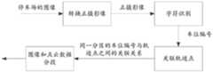
针对相关技术存在的问题以及停车场场景的建图需求,本公开实施例提供了一种停车场的点云特征提取方法。示例的,图1是本公开实施例提供的一种点云特征提取场景的示意图,如图1所示,该方法从停车场的点云数据中提取车位线的点云数据,从停车场的图像中提取停车场中包含的车位编号,然后根据车位线的点云数据中包含的三维点之间的相对位置关系,将彼此之间距离小于预设聚类距离的相邻三维点聚类到一条车位线上,得到停车场中包含的单条车位线的点云数据,进而根据车位编号和单条车位线在三维空间中的距离,将与单条车位线距离小于预设距离的车位编号赋值给该条车位线的点云数据,使得车位线的点云数据具备编号属性。In view of the problems existing in the related art and the mapping requirements of the parking lot scene, an embodiment of the present disclosure provides a method for extracting point cloud features of a parking lot. By way of example, FIG. 1 is a schematic diagram of a point cloud feature extraction scene provided by an embodiment of the present disclosure. As shown in FIG. 1 , the method extracts point cloud data of parking space lines from point cloud data of a parking lot, The parking space numbers contained in the parking lot are extracted from the image, and then according to the relative positional relationship between the three-dimensional points contained in the point cloud data of the parking space line, the adjacent three-dimensional points whose distances are less than the preset clustering distance are clustered into two groups. For a parking space line, the point cloud data of a single parking space line contained in the parking lot is obtained, and then according to the parking space number and the distance of the single parking space line in the three-dimensional space, the parking space number whose distance from the single parking space line is less than the preset distance is assigned to the parking space number. point cloud data of each parking space line, so that the point cloud data of the parking space line has the attribute of numbering.
该方法在提取出车位线的点云数据后,根据三维点之间的相对位置关系,能够准确的分离出单条车位线的点云数据,通过将车位编号赋值给与其距离小于预设距离的单条车位线的点云数据,使得车位线的点云数据具备编号属性,能够提高车位线点云数据的可区分性。另外,通过点云数据提取车位线的特征,能够避免基于照片提取车位线的方法存在的精度低的问题。After extracting the point cloud data of the parking space line, the method can accurately separate the point cloud data of a single parking space line according to the relative positional relationship between the three-dimensional points. The point cloud data of the parking space line makes the point cloud data of the parking space line have the attribute of numbering, which can improve the distinguishability of the point cloud data of the parking space line. In addition, by extracting the features of the parking space line from the point cloud data, the problem of low accuracy in the method of extracting the parking space line based on the photo can be avoided.
需要说明的是,图1仅是一种示例性的实施场景,而不是唯一场景,例如,在其他实施场景中车位线点云数据的提取和车位编号的提取也可以是顺序执行的。在顺序执行时车位线点云数据提取可以在前,车位编号提取在后,也可以车位编号提取在前,车位线点云数据提取在后。It should be noted that FIG. 1 is only an exemplary implementation scenario, not the only scenario. For example, in other implementation scenarios, the extraction of parking space line point cloud data and the extraction of parking space numbers may also be performed sequentially. When the sequence is executed, the point cloud data of the parking space line can be extracted first, and the parking space number can be extracted later, or the parking space number can be extracted first, and the point cloud data of the parking space line can be extracted later.
为了更好的理解本公开实施例的方案,下面结合示例性的实施例对本公开实施例的方案进行说明。In order to better understand the solutions of the embodiments of the present disclosure, the solutions of the embodiments of the present disclosure will be described below with reference to exemplary embodiments.
图2是本公开实施例提供的一种停车场的点云特征提取方法的流程图,该方法可以由一种计算机设备执行,该计算机设备可以被理解为诸如台式电脑、笔记本电脑、服务器等具有计算和处理能力的设备。如图2所示,该方法包括:FIG. 2 is a flowchart of a method for extracting point cloud features of a parking lot provided by an embodiment of the present disclosure. The method can be executed by a computer device, and the computer device can be understood as a desktop computer, a notebook computer, a server, etc. Devices with computing and processing power. As shown in Figure 2, the method includes:
步骤201、获取停车场的点云数据和图像。Step 201: Obtain point cloud data and images of the parking lot.
其中,点云数据可以理解为通过采集车上搭载的激光传感器(比如,激光雷达)向空间中某个点发射激光,并测量其反射光强度(又称为反射率)和反射回来的时间,从而获得这个点的空间位置信息、材料信息(比如,颜色、材质、粗糙度等)等。将这样测量出的大量空间点聚在一起形成的空间点集合,被称为激光点云数据,简称点云数据。Among them, point cloud data can be understood as the laser sensor (for example, lidar) mounted on the collection vehicle emits laser light to a point in space, and measures the reflected light intensity (also known as reflectivity) and the time it reflects back, Thereby, the spatial position information, material information (for example, color, material, roughness, etc.) of this point are obtained. The spatial point collection formed by gathering a large number of spatial points measured in this way is called laser point cloud data, or point cloud data for short.
停车场的图像可以通过采集车上搭载的拍摄设备(比如,RGB摄像头、深度摄像头等)在停车场中采集得到。The image of the parking lot can be acquired in the parking lot by capturing the shooting equipment (eg, RGB camera, depth camera, etc.) mounted on the vehicle.
在本公开实施例的一种示例性的实施方式中,采集车可以在停车场中按照预设的轨迹行驶,并在行驶的过程中采集周围环境的点云数据和图像。在每个采集位置(即轨迹点)上,采集车同时对点云数据和图像进行采集。也就是说本公开实施例的点云数据和图像在采集位置和采集时间上具有关联关系。In an exemplary implementation of the embodiments of the present disclosure, the collecting vehicle may travel according to a preset trajectory in the parking lot, and collect point cloud data and images of the surrounding environment during the traveling. At each acquisition location (ie, trajectory point), the acquisition vehicle simultaneously acquires point cloud data and images. That is to say, the point cloud data and the image in the embodiment of the present disclosure have an associated relationship in the collection position and the collection time.
采集车采集到的点云数据和图像可以被关联存储在预设的数据源中,该数据源比如可以是硬盘、数据库、业务服务器等具有数据存储能力的设备。在执行本公开实施例的方法时可以从数据源中获取停车场的点云数据和图像。The point cloud data and images collected by the collecting vehicle can be associated and stored in a preset data source, such as a hard disk, a database, a service server, and other devices with data storage capabilities. The point cloud data and images of the parking lot may be acquired from the data source when the method of the embodiment of the present disclosure is executed.
需要说明的是,本公开实施例从数据源中获取到的点云数据和图像可以是整个停车场的点云数据和图像,也可以是停车场中部分区域的点云数据和图像。比如,在停车场被划分为多个分区时,可以先获取某一个分区的点云数据和图像,然后采用本公开实施例的特征提取方法对该分区的点云数据进行特征提取。例如在停车场包括A、B、C、D四个分区的情况下,可以先任意获取一个分区(比如A分区)的点云数据和图像进行特征提取,处理完之后再获取另一个分区,比如B分区的点云数据和图像进行特征提取,直到完成整个停车场的点云特征提取为止。It should be noted that the point cloud data and images obtained from the data source in the embodiments of the present disclosure may be point cloud data and images of the entire parking lot, or may be point cloud data and images of some areas in the parking lot. For example, when the parking lot is divided into multiple partitions, the point cloud data and images of a certain partition can be obtained first, and then the feature extraction method of the embodiment of the present disclosure is used to perform feature extraction on the point cloud data of the partition. For example, in the case where the parking lot includes four partitions A, B, C, and D, the point cloud data and images of one partition (such as partition A) can be obtained arbitrarily for feature extraction, and then another partition can be obtained after processing, such as Feature extraction is performed on the point cloud data and images of partition B until the point cloud feature extraction of the entire parking lot is completed.
在一次性获取整个停车场的点云数据和图像的场景下,也可以对停车场的点云数据和图像,按照区域分区处理。在这种情况下,需要对停车场的点云数据和图像进行划分,然后根据划分结果,获取停车场部分区域的点云数据和图像进行处理。其中,数据划分的依据可以是采集轨迹的高程波动幅度,比如可以将高程波动小于预设阈值的连续轨迹上采集到的点云数据和图像化为一段,从而保证每段数据对应的地面高度是平稳的,确保每个分段特征提取的准确性。或者在其他实施方式中,数据划分的依据也可以是停车场自身的区域划分,将停车场中每个分区的点云数据和图像划为一段,以保证每段数据中的车位编号是的连续性。例如,停车场包括A、B、C、D四个分区,则可以将A区的点云数据和图像划分为一段,将B区的点云数据和图像划分为一段、将C区的点云数据和图像划分为一段、将D区的点云数据和图像划分为一段。In the scenario of obtaining the point cloud data and images of the entire parking lot at one time, the point cloud data and images of the parking lot can also be processed according to regional divisions. In this case, it is necessary to divide the point cloud data and images of the parking lot, and then obtain the point cloud data and images of some areas of the parking lot for processing according to the division results. Among them, the basis of data division can be the amplitude of the elevation fluctuation of the collected trajectory. For example, the point cloud data and images collected on the continuous trajectory whose elevation fluctuation is less than a preset threshold can be converted into a segment, so as to ensure that the ground height corresponding to each segment of data is Stationary, ensuring the accuracy of feature extraction for each segment. Or in other embodiments, the basis of data division can also be the area division of the parking lot itself, and the point cloud data and images of each partition in the parking lot are divided into a section to ensure that the parking space numbers in each section of data are continuous. sex. For example, if the parking lot includes four partitions, A, B, C, and D, the point cloud data and images in area A can be divided into one segment, the point cloud data and images in area B can be divided into one segment, and the point cloud data and image in area C can be divided into one segment. The data and images are divided into one segment, and the point cloud data and images in area D are divided into one segment.
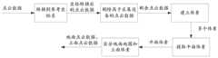
当然上述两种数据划分方式仅为示例性的方式而不是唯一方式,实际上,在其他实施方式中也可以将上述两种数据划分方式结合起来使用。比如,图3是本公开实施例提供的一种示例性的数据划分方法的示意图。在图3所示的方法中,在获取到停车场的点云数据和图像之后,可以先基于预设的转换关系,将停车场的图像转换成正摄影像,然后,基于预设的字符识别方法(比如,光学字符识别(Optical Character Recognition,简称OCR),但不局限于OCR)识别出正摄影像中的车位编号。由于实际中,停车场的车位编号一般都具有分区信息,比如A区的车位编号可能是A####的格式,B区的车位编号可能是B####的格式。因此,根据提取的车位编号中的分区信息可以确定出属于同一分区的车位编号,然后根据图像与轨迹点之间的对应关系,将车位编号与对应的轨迹点进行关联,并根据轨迹点与点云数据之间的对应关系,确定出属于同一分区的点云数据。进一步的,根据同一分区中轨迹点的高程波动情况,如果同一分区的高程波动小于预设阈值,则不用进一步进行划分,如果同一分区的高程波动大于或等于预设阈值,则可以根据高程波动情况,进一步的,对同一分区的点云数据和图像进行划分,将同一分区中高程波动小于预设阈值的子区域中点云数据和图像划为一个分段。Of course, the above two data division manners are only exemplary manners rather than the only manners. In fact, in other embodiments, the foregoing two data division manners may also be used in combination. For example, FIG. 3 is a schematic diagram of an exemplary data division method provided by an embodiment of the present disclosure. In the method shown in FIG. 3 , after the point cloud data and images of the parking lot are acquired, the image of the parking lot can be converted into an orthographic image based on a preset conversion relationship, and then, based on the preset character recognition method (For example, Optical Character Recognition (OCR for short), but not limited to OCR) recognizes the parking space number in the orthographic image. In practice, the parking space number of the parking lot generally has partition information. For example, the parking space number in area A may be in the format of A####, and the parking space number in area B may be in the format of B####. Therefore, according to the partition information in the extracted parking space number, the parking space number belonging to the same partition can be determined, and then according to the corresponding relationship between the image and the trajectory point, the parking space number is associated with the corresponding trajectory point, and according to the trajectory point and point The correspondence between cloud data determines the point cloud data belonging to the same partition. Further, according to the elevation fluctuation of the trajectory points in the same partition, if the elevation fluctuation of the same partition is less than the preset threshold, no further division is required, and if the elevation fluctuation of the same partition is greater than or equal to the preset threshold, then the elevation fluctuation can be , and further, the point cloud data and images in the same partition are divided, and the point cloud data and images in the sub-regions whose elevation fluctuations in the same partition are less than the preset threshold are divided into one segment.
在图3所示的数据划分方法中,通过车位编号中的分区信息,将同一分区的点云数据和图像划分到一起,然后根据采集轨迹的高程变化,在同一分区中将高程波动小于预设阈值的区域的点云数据和图像划为一段,不但能够保证同一分段中的地面的高度稳定,还能够保证同一分段中的车位编号的连续性,为提高特征提取的准确性提供了数据保障。In the data division method shown in Fig. 3, the point cloud data and images of the same partition are divided together by the partition information in the parking space number, and then according to the elevation change of the collected trajectory, the elevation fluctuation in the same partition is smaller than the preset value. The point cloud data and images in the threshold area are divided into one segment, which can not only ensure the height stability of the ground in the same segment, but also ensure the continuity of the parking space numbers in the same segment, which provides data for improving the accuracy of feature extraction. Assure.
步骤202、从点云数据中提取得到车位线的点云数据,以及从图像中提取得到车位编号。
本公开实施例从点云数据中提取车位线点云数据的方法有多种。There are various methods for extracting the point cloud data of the parking space line from the point cloud data in the embodiments of the present disclosure.
比如在一种示例性的方法中,可以将点云数据输入到预设的第一模型中,通过第一模型从点云数据中提取得到车位线的点云数据。其中,第一模型可以理解为一种具有车位线点云提取能力的模型,该模型可以采用相关技术中的模型训练方法训练得到,其训练过程本公开实施例不做限定。For example, in an exemplary method, the point cloud data may be input into a preset first model, and the point cloud data of the parking space line may be obtained by extracting the point cloud data through the first model. The first model can be understood as a model capable of extracting the point cloud of the parking space line, and the model can be trained by using the model training method in the related art, and the training process thereof is not limited in the embodiments of the present disclosure.
再比如,在另一种示例性的方法中,还可以根据预设的地面参考高度从点云数据中提取出地面参考高度周围预设范围内的点云数据作为地面点云数据,然后通过预设的第二模型从地面点云数据中提取出车位线的点云数据。通过从停车场的点云数据中提取出地面点云数据,再通过第二模型从地面点云数据中提取车位线的点云数据,可以提高车位线点云数据提取的准确性。For another example, in another exemplary method, point cloud data within a preset range around the ground reference height may also be extracted from the point cloud data according to a preset ground reference height as the ground point cloud data, and then pre- The second model set up extracts the point cloud data of the parking space line from the ground point cloud data. By extracting the ground point cloud data from the point cloud data of the parking lot, and then extracting the point cloud data of the parking space line from the ground point cloud data through the second model, the accuracy of the point cloud data extraction of the parking space line can be improved.
当然上述两种车位线点云数据的提取方法仅是两种示例性的方法而不是唯一方法。Of course, the above two methods for extracting the point cloud data of the parking space line are only two exemplary methods rather than the only method.
示例的,在本公开实施例中,提取车位编号的方法也可以有多种,比如在一种方式中,可以通过预设的编号提取模型从停车场的图像中提取车位编号。在另一种方式中也可以通过字符识别的方法,比如OCR,从图像中识别出车位编号。实际中,可以根据需要选择相应的车位编号提取方法,本公开实施例在这里不再一一列举。Exemplarily, in the embodiment of the present disclosure, there may be various methods for extracting the parking space number. For example, in one manner, the parking space number may be extracted from the image of the parking lot by using a preset number extraction model. In another way, a character recognition method, such as OCR, can also be used to recognize the parking space number from the image. In practice, a corresponding parking space number extraction method may be selected as required, and the embodiments of the present disclosure will not list them one by one here.
步骤203、根据车位线的点云数据中包含的三维点之间的相对位置关系,从车位线的点云数据中分离得到单条车位线的点云数据。Step 203: According to the relative positional relationship between the three-dimensional points included in the point cloud data of the parking space line, separate point cloud data of a single parking space line from the point cloud data of the parking space line.
实际中,位于同一条车位线上的两个相邻的三维点之间的距离比较紧密,而位于不同车位线上的三维点之间的距离比较大。基于此,在本公开实施例的一种实施方式中,对聚类距离(为了便于区分以下简称第二聚类距离)进行了设置,然后根据车位线的点云数据中包含的三维点之间的相对位置关系,将彼此之间距离小于第二聚类距离的相邻三位点聚类到同一个车位线上,进而使得车位线的点云数据中单条车位线的点云数据被分离出来。In practice, the distance between two adjacent three-dimensional points located on the same parking space line is relatively close, while the distance between three-dimensional points located on different parking space lines is relatively large. Based on this, in one implementation of the embodiment of the present disclosure, the clustering distance (hereinafter referred to as the second clustering distance for convenience) is set, and then according to the distance between the three-dimensional points included in the point cloud data of the parking space line The relative positional relationship between the two points, the adjacent three points whose distance is less than the second clustering distance are clustered into the same parking space line, so that the point cloud data of a single parking space line in the point cloud data of the parking space line is separated. .
在本公开实施例的另一种实施方式中,还可以根据车位线的点云数据中包含的三维点之间的相对位置关系,确定三维点和三维点之间的距离,并根据距离与紧密程度之间的映射关系,确定三维点之间的紧密程度(距离越近紧密程度越高),进而根据三维点之间的紧密程度,在车位线的点云数据中统计出三维点分布密集的区域,将单个分布密集区域中的点云数据确定为单条车位线的点云数据。In another implementation of the embodiment of the present disclosure, the distance between the three-dimensional point and the three-dimensional point can also be determined according to the relative positional relationship between the three-dimensional points included in the point cloud data of the parking space line, and the distance and the closeness The mapping relationship between the degrees determines the degree of closeness between the three-dimensional points (the closer the distance is, the higher the degree of closeness), and then according to the degree of closeness between the three-dimensional points, the point cloud data of the parking space line is counted. The point cloud data in a single densely distributed area is determined as the point cloud data of a single parking space line.
步骤204、根据车位编号和单条车位线在三维空间中的距离,将与单条车位线距离小于预设距离的车位编号赋值给该条车位线的点云数据。Step 204: According to the parking space number and the distance of the single parking space line in the three-dimensional space, assign the parking space number whose distance from the single parking space line is less than the preset distance to the point cloud data of the parking space line.
实际中,一个车位由四条车位线组成,示例的,这四条车位线中可以包括竖直方向上长度较长的两条长边线和水平方向上长度较短的两条短边线。本公开实施例所称的单条车位线可以理解为上述车位中的一条长边线或短边线。In practice, a parking space consists of four parking space lines. For example, the four parking space lines may include two long side lines with longer lengths in the vertical direction and two short side lines with shorter lengths in the horizontal direction. The single parking space line referred to in the embodiments of the present disclosure may be understood as a long side line or a short side line in the above parking spaces.
本公开实施例预先对同一个车位中的车位编号和车位线(包括车位中竖直方向上的长边线和/或水平方向上的短边线)之间的距离关系进行统计,然后根据统计结果设定车位编号与车位线中的长边线和/或短边线之间的距离阈值(即预设距离)。In the embodiment of the present disclosure, the distance relationship between the parking space number in the same parking space and the parking space line (including the long side line in the vertical direction and/or the short side line in the horizontal direction in the parking space) is calculated in advance, and then set according to the statistical result. The distance threshold (ie the preset distance) between the parking space number and the long and/or short side lines of the parking space line.
在一个实施方式中,基于步骤202和步骤203的方法得到单条车位线的点云数据以及停车场中的车位编号之后,可以根据提取出该车位编号的图像的图像坐标系与预设的三维空间(比如停车场所在的三维空间)的三维坐标系之间的映射关系,将车位编号投影到三维空间中得到车位编号在三维空间中的位置,然后根据车位编号和单条车位线在该三维空间中的距离,将与单条车位线距离小于预设距离的车位编号赋值给该条车位线的点云数据,使得该条车位线的点云数据具备编号属性。In one embodiment, after the point cloud data of a single parking space line and the parking space number in the parking lot are obtained based on the methods of
在又一个实施方式中,对于某个单条车位线来说,如果其周围没有与其距离小于预设距离的车位编号,则可以分别从该条车位线的两侧(比如左右两侧,或上下两侧)查找与其距离最近,且具有车位编号的车位线,然后根据查找到的这两条车位线的编号进行插值处理,得到插值编号,从而将插值编号赋予该条车位线。比如,某条车位线C左侧距离其最近的车位线对应的车位编号是A123,右侧距离其最近的车位线对应的车位编号是A125,则插值结果为A124,将A124赋予给车位线C。In yet another embodiment, for a single parking space line, if there is no parking space number with a distance less than a preset distance around it, it can be divided from the two sides of the parking space line (such as the left and right sides, or the upper and lower sides respectively). side) to find the parking space line with the parking space number closest to it, and then perform interpolation processing according to the numbers of the two parking space lines found to obtain the interpolation number, so as to assign the interpolation number to the parking space line. For example, the parking space number corresponding to the nearest parking space line on the left side of a certain parking space line C is A123, and the parking space number corresponding to the nearest parking space line on the right side is A125, then the interpolation result is A124, and A124 is assigned to the parking space line C .
在单条车位线周围没有与其距离小于预设距离的车位编号时,通过对其两侧与其距离最近的两个车位线的编号进行插值,并将插值得到的编号赋予给该条车位线,能够解决车位编号被遮挡时的车位线赋值问题,提高车位线点云数据编号赋值的准确性。When there is no parking space number with a distance less than the preset distance around a single parking space line, by interpolating the numbers of the two parking space lines with the closest distance on both sides of it, and assigning the numbers obtained by interpolation to the parking space line, the solution can be solved. The parking space line assignment problem when the parking space number is obscured improves the accuracy of the parking space line point cloud data number assignment.
本公开实施例,在获取到停车场的点云数据和图像后,通过从点云数据中提取车位线的点云数据,根据车位线的点云数据中包含的三维点之间的相对位置关系,能够准确的从点云数据中分离出单条车位线的点云数据;通过从图像中识别车位编号,根据车位编号和单条车位线在三维空间中的距离,将与单条车位线距离小于预设距离的车位编号赋值给单条车位线的点云数据,能够准确建立车位编号和车位线点云数据之间的对应关系,使得车位线的点云数据具备编号属性,通过编号属性可提高车位线点云数据的可区分性,在将具备编号属性的车位线点云数据作为停车场高精地图的制作资料时,可提高停车场高精地图建图的准确性。In this embodiment of the present disclosure, after the point cloud data and images of the parking lot are acquired, the point cloud data of the parking space line is extracted from the point cloud data, and the relative positional relationship between the three-dimensional points included in the point cloud data of the parking space line is calculated according to the relative positional relationship between the three-dimensional points. , which can accurately separate the point cloud data of a single parking space line from the point cloud data; by identifying the parking space number from the image, according to the parking space number and the distance of the single parking space line in the three-dimensional space, the distance from the single parking space line is smaller than the preset The parking space number of the distance is assigned to the point cloud data of a single parking space line, which can accurately establish the corresponding relationship between the parking space number and the point cloud data of the parking space line, so that the point cloud data of the parking space line has the numbering attribute, and the numbering attribute can improve the parking space line point. The distinguishability of cloud data can improve the accuracy of the high-precision map construction of the parking lot when the point cloud data of the parking space line with the number attribute is used as the production data of the high-precision map of the parking lot.
图4是本公开实施例提供的一种提取车位线点云数据的方法的流程图,如图4所示,该方法包括:FIG. 4 is a flowchart of a method for extracting point cloud data of parking space lines provided by an embodiment of the present disclosure. As shown in FIG. 4 , the method includes:
步骤401、对点云数据进行分类处理,得到地面点云数据和立面点云数据。Step 401: Classify the point cloud data to obtain ground point cloud data and elevation point cloud data.
其中,本实施例中所称的点云数据可以示例性的理解为停车场中部分区域的点云数据,该区域的高程波动小于预设阈值和/或属于停车场的同一分区。Wherein, the point cloud data referred to in this embodiment can be exemplarily understood as point cloud data of a part of the parking lot in which the elevation fluctuation is smaller than a preset threshold and/or belongs to the same partition of the parking lot.
本公开实施例中所称的立面点云数据可以理解为伫立在地面上的平面的点云数据。The elevation point cloud data referred to in the embodiments of the present disclosure may be understood as point cloud data of a plane standing on the ground.
在本公开实施例中,点云数据的分类方法可以包括多种,为了方便理解,下面以几种示例性的分类方式进行示例说明:In the embodiment of the present disclosure, the classification methods of point cloud data may include multiple types. For the convenience of understanding, several exemplary classification methods are used for illustration below:
方式一,可以通过预设的分类模型从停车场的点云数据提取得到地面点云数据和立面点云数据。In the first way, the ground point cloud data and the facade point cloud data can be extracted from the point cloud data of the parking lot through a preset classification model.
方式二,通过平面拟合的方法在停车场的点云数据进行平面拟合,将拟合得到的面积大于预设面积,且法线方向朝向地面上方的平面确定为地面,将法线方向朝向水平方向的平面确定为立面,从而地面上的点云数据即为地面点云数据,立面上的点云数据即为立面点云数据。The second method is to perform plane fitting on the point cloud data of the parking lot by the method of plane fitting. The area obtained by fitting is larger than the preset area, and the plane with the normal direction facing above the ground is determined as the ground, and the normal direction facing the ground is determined as the ground. The plane in the horizontal direction is determined as the elevation, so the point cloud data on the ground is the ground point cloud data, and the point cloud data on the elevation is the elevation point cloud data.
方式三,可以将点云数据分割成多个体素,其中,体素是体积元素(Volume Pixel)的简称,包含体素的立体可以通过立体渲染或者提取给定阈值轮廓的多边形等值面表现出来,体素是三维空间分割上的最小单位。通过对体素进行主成分分析(PrincipleComponent Analys,简称PCA)得到体素中点云分布最多的三个方向,然后根据体素中的点云数据在上述三个方向上的分布波动情况,从多个体素中提取出平面体素,其中,平面体素是指其中一个方向上的波动幅度与其他两个方向上的波动幅度的差值绝对值大于或等于预设幅度的体素。进一步的,在平面体素中,波动幅度最小的方向,即法向方向,朝向地面上方的平面体素可以确定为地面体素,波动幅度最小的方向朝向水平方向的平面体素可以确定为立面体素,从而地面体素中的点云数据即为地面点云数据,立面体素中的点云数据即为立面点云数据。Method 3: The point cloud data can be divided into multiple voxels, where the voxel is the abbreviation of volume element (Volume Pixel), and the stereo containing the voxel can be represented by stereo rendering or by extracting the polygon isosurface of a given threshold contour. , and a voxel is the smallest unit of 3D space segmentation. By performing Principal Component Analysis (PCA) on the voxel, the three directions with the most point cloud distribution in the voxel are obtained, and then according to the distribution fluctuation of the point cloud data in the voxel in the above three directions, from the multi A plane voxel is extracted from the voxels, wherein the plane voxel refers to a voxel whose absolute value of the difference between the fluctuation amplitude in one direction and the fluctuation amplitude in the other two directions is greater than or equal to a preset amplitude. Further, in the plane voxel, the direction with the smallest fluctuation amplitude, that is, the normal direction, the plane voxel facing above the ground can be determined as the ground voxel, and the plane voxel with the smallest fluctuation amplitude facing the horizontal direction can be determined as the vertical voxel. Surface voxels, so the point cloud data in the ground voxels are the ground point cloud data, and the point cloud data in the elevation voxels are the elevation point cloud data.
举例来说,图5是本公开实施例提供的一种点云分类方法的示意图,如图5所示,在对点云数据进行分类之前,可以先从点云数据的采集轨迹上确定出一个轨迹点作为参考轨迹点。其中,在确定参考轨迹点时,可以从点云数据对应的采集轨迹上任意选取一点,也可以根据预设的规则来选择符合规则的轨迹点作为参考轨迹点,比如在一种示例性的实施方式中可以根据点云数据对应的采集轨迹的位置,确定出包含采集轨迹的多边形区域,该多边形区域可以示例性的理解为包含该采集轨迹的最小多边形区域,但不局限于最小多边形区域。进一步的,可以将采集轨迹上与该多边形区域的中心点距离最近的轨迹点确定为参考轨迹点。将采集设备(比如、激光雷达)自身在参考轨迹点上的坐标系作为参考坐标系,从而通过将点云数据全部转换到参考坐标系中,以减少地面起伏对地面点云数据和立面点云数据识别的干扰。其中,对于坐标转换后的点云数据,本公开实施例根据采集设备的高度将高度高于采集设备的点云数据删除掉,以减少点云数据的数据量。对于剩余的点云数据,可以通过预设的体素大小,对剩余点云数据的分布空间进行分割,得到多个体素,其中,每个体素可以理解为一个预设大小的立方体,立方体中包括被该立方体分割的点云数据。在每个体素中,可以通过PCA的方法确定出点云分布最多的三个方向,比如,记为x方向,y方向和z方向。假设体素中的点云分布在x方向上的波动幅度与y方向上的波动幅度的差值绝对值大于或等于预设幅度,且x方向上的波动幅度与z方向上的波动幅度的差值绝对值也大于或等于预设幅度,则确定该体素为平面体素。进一步的,如果三个方向中波动幅度最小的方向x是朝向地面上方的,则确定该平面体素是地面体素,如果方向x是朝向水平方向的,则确定该体素是立面体素。地面体素中的点云数据即为地面点云数据,立面体素中的点云数据即为立面点云数据。For example, FIG. 5 is a schematic diagram of a point cloud classification method provided by an embodiment of the present disclosure. As shown in FIG. 5 , before classifying point cloud data, a The track point is used as a reference track point. Wherein, when the reference trajectory point is determined, a point can be arbitrarily selected from the collection trajectory corresponding to the point cloud data, or a trajectory point that conforms to the rule can be selected as the reference trajectory point according to a preset rule. For example, in an exemplary implementation In the method, a polygonal area containing the acquisition trajectory may be determined according to the position of the acquisition trajectory corresponding to the point cloud data, and the polygonal area may be exemplarily understood as the smallest polygonal area containing the acquisition trajectory, but is not limited to the smallest polygonal area. Further, the track point on the collection track that is closest to the center point of the polygonal area may be determined as the reference track point. The coordinate system of the acquisition device (for example, lidar) itself on the reference trajectory point is used as the reference coordinate system, so that all the point cloud data is converted into the reference coordinate system to reduce the impact of ground fluctuations on the ground point cloud data and elevation points. Interference of cloud data identification. Among them, for the point cloud data after coordinate transformation, the embodiment of the present disclosure deletes the point cloud data whose height is higher than the collection device according to the height of the collection device, so as to reduce the data amount of the point cloud data. For the remaining point cloud data, the distribution space of the remaining point cloud data can be divided according to the preset voxel size to obtain multiple voxels, wherein each voxel can be understood as a cube with a preset size, and the cube includes The point cloud data segmented by this cube. In each voxel, the three directions with the most point cloud distribution can be determined by the PCA method, for example, recorded as the x direction, the y direction and the z direction. It is assumed that the absolute value of the difference between the fluctuation amplitude of the point cloud distribution in the voxel in the x direction and the fluctuation amplitude in the y direction is greater than or equal to the preset amplitude, and the difference between the fluctuation amplitude in the x direction and the fluctuation amplitude in the z direction If the absolute value of the value is also greater than or equal to the preset amplitude, the voxel is determined to be a plane voxel. Further, if the direction x with the smallest fluctuation amplitude among the three directions is towards the top of the ground, it is determined that the plane voxel is a ground voxel, and if the direction x is towards the horizontal direction, it is determined that the voxel is a vertical voxel. . The point cloud data in the ground voxel is the ground point cloud data, and the point cloud data in the elevation voxel is the elevation point cloud data.
通过将点云数据划分成多个体素,再根据每个体素中的点云分布情况,对地面点云数据和立面点云数据进行分类,缩小了点云数据分类的粒度,提高了点云数据分类的精度。By dividing the point cloud data into multiple voxels, and then classifying the ground point cloud data and the elevation point cloud data according to the point cloud distribution in each voxel, the granularity of the point cloud data classification is reduced and the point cloud data is improved. The accuracy of data classification.
步骤402、根据地面点云数据中包含的三维点的反射强度信息,从地面点云数据中提取得到反射强度大于阈值强度的三维点作为车位线的点云数据。Step 402: According to the reflection intensity information of the three-dimensional points contained in the ground point cloud data, extract the three-dimensional points whose reflection intensity is greater than a threshold intensity from the ground point cloud data as the point cloud data of the parking space line.
示例的,图6是本公开实施例提供的一种提取车位线的点云数据的方法示意图,如图6所示,在本公开实施例的一种实施方式中,可以根据地面点云数据中包含的三维点的反射强度信息,建立地面反射强度直方图,直方图的横坐标为反射强度,纵坐标为点云数量。然后根据地面反射强度直方图,采用最大类间方差法(也称OSTU),确定得到本公开实施例所称的阈值强度,将地面点云数据中反射强度大于阈值强度点的云数据确定为车位线的点云数据。其中,采用最大类间方差法确定阈值强度的具体方法可以参见相关技术,在这里不再赘述。By way of example, FIG. 6 is a schematic diagram of a method for extracting point cloud data of parking space lines provided by an embodiment of the present disclosure. As shown in FIG. 6 , in an implementation of the embodiment of the present disclosure, the The reflection intensity information of the included three-dimensional points is used to establish a ground reflection intensity histogram. The abscissa of the histogram is the reflection intensity, and the ordinate is the number of point clouds. Then, according to the ground reflection intensity histogram, the maximum inter-class variance method (also called OSTU) is used to determine the threshold intensity in the embodiment of the present disclosure, and the cloud data of the ground point cloud data whose reflection intensity is greater than the threshold intensity is determined as a parking space Line point cloud data. The specific method for determining the threshold strength by using the maximum inter-class variance method can refer to the related art, which will not be repeated here.
通过确定地面反射强度直方图,采用最大类间方差法确定用于判断车位线点云数据的阈值强度,能够提高阈值强度对于当前停车场场景的针对性,进而提高车位线点云数据识别的准确性。By determining the ground reflection intensity histogram, and using the maximum inter-class variance method to determine the threshold intensity for judging the point cloud data of the parking space line, the pertinence of the threshold intensity to the current parking lot scene can be improved, and the accuracy of the point cloud data recognition of the parking space line can be improved. sex.
示例的,在本公开实施例的一种实施方式中,在从地面点云数据中提取得到单条车位线的点云数据,并为单条车位线的点云数据赋值车位编号之后,还可以根据立面点云数据与单条车位线之间的距离,将距离立面点云数据距离最近的单条车位线所对应的车位编号赋值给立面点云数据。Illustratively, in an implementation manner of the embodiment of the present disclosure, after the point cloud data of a single parking space line is extracted from the ground point cloud data, and the parking space number is assigned to the point cloud data of the single parking space line, it is also possible to The distance between the surface point cloud data and a single parking space line, assign the parking space number corresponding to the single parking space line closest to the elevation point cloud data to the elevation point cloud data.
通过将车位编号赋值给立面点云数据,能够进一步增加点云数据的可区分性,清晰标记车位附近立面的信息,为地图建图过程中的特征匹配提供了数据保障。By assigning the parking space number to the elevation point cloud data, the distinguishability of the point cloud data can be further increased, and the information of the elevation near the parking space can be clearly marked, which provides data guarantee for the feature matching in the process of map construction.
示例的,在本公开实施例的一些实施方式中,在将地面点云数据中反射强度大于阈值强度的三维点作为车位线的点云数据之后,还可以包括对车位线的点云数据进行分组的步骤。具体包括:For example, in some implementations of the embodiments of the present disclosure, after using the three-dimensional points in the ground point cloud data whose reflection intensity is greater than the threshold intensity as the point cloud data of the parking space line, grouping the point cloud data of the parking space line may also be included. A step of. Specifically include:
S11、基于预设的第一聚类距离,对车位线的点云数据进行欧式聚类处理,得到至少一个车位线点云组。S11. Based on the preset first clustering distance, perform Euclidean clustering processing on the point cloud data of the parking space line to obtain at least one point cloud group of the parking space line.
考虑到,实际停车场中,同一排上一般包括多个连续的车位,且位于同一排的连续的多个车位的车位编号一般也是连续的。为了将位于同一排的多个连续车位的车位线点云数据被划分到同一车位线点云组中,提高点云特征提取的准确性,本公开实施例对对第一聚类距离进行了设置,使得基于第一聚类距离对车位线的点云数据进行欧式聚类之后,位于同一排的连续多个车位的车位线点云数据能够被聚类到同一个车位线点云组。具体的,可以基于第一聚类距离对车位线点云数据中的每个三维点周围的环境进行判断,将三维点周围第一聚类距离内的三维点划分到同一分组,然后将组间存在重叠部分的分组合并到一起形成一个分组,最终得到连续排列的多个车位的车位线点云组。Considering that, in an actual parking lot, the same row generally includes a plurality of consecutive parking spaces, and the parking space numbers of the consecutive plurality of parking spaces located in the same row are generally also consecutive. In order to divide the parking space line point cloud data of multiple consecutive parking spaces located in the same row into the same parking space line point cloud group and improve the accuracy of point cloud feature extraction, the embodiment of the present disclosure sets the first clustering distance , so that after performing Euclidean clustering on the point cloud data of the parking space line based on the first clustering distance, the point cloud data of the parking space line of multiple consecutive parking spaces located in the same row can be clustered into the same parking space line point cloud group. Specifically, the environment around each three-dimensional point in the point cloud data of the parking space line can be judged based on the first clustering distance, and the three-dimensional points within the first clustering distance around the three-dimensional point are divided into the same group, and then the three-dimensional points between the groups are divided into groups. Groups with overlapping parts are merged together to form a group, and finally a point cloud group of parking space lines of multiple parking spaces arranged in a row is obtained.
S12、删除点云数量小于预设数量的车位线点云组。S12, delete the parking space line point cloud group whose number of point clouds is less than the preset number.
通过将连续排列的车位的车位线点云数据聚类到一个车位线点云组中,将点云数量小于预设数量的车位线点云组删除掉,能够去除误识别的车位线点云组,进而基于剩余的车位线点云组中包含的三维点之间的相对位置关系,即可准确识别出车位线点云组中包含的单条车位线的点云数据。By clustering the parking space line point cloud data of consecutively arranged parking spaces into a parking space line point cloud group, and deleting the parking space line point cloud group whose number of point clouds is less than the preset number, the wrongly recognized parking space line point cloud group can be removed. , and then based on the relative positional relationship between the three-dimensional points included in the remaining parking space line point cloud groups, the point cloud data of a single parking space line included in the parking space line point cloud group can be accurately identified.
示例的,在本公开实施例的又一些实施方式中,在根据车位编号和单条车位线在三维空间中的距离,将与单条车位线距离小于预设距离的车位编号赋予给该条车位线的点云数据之前,还可以包括拟合车位线的步骤,示例的,图7是本公开实施例提供的一种车位线拟合方法的示意图。如图7所示,该方法包括:Illustratively, in still other implementations of the embodiments of the present disclosure, according to the parking space number and the distance of the single parking space line in the three-dimensional space, the parking space number whose distance from the single parking space line is less than the preset distance is assigned to the parking space number of the single parking space line. Before the point cloud data, the step of fitting a parking space line may also be included. For example, FIG. 7 is a schematic diagram of a parking space line fitting method provided by an embodiment of the present disclosure. As shown in Figure 7, the method includes:
S21、在车位线点云组中,根据车位编号两侧距离车位编号距离最近的两条车位线之间的距离,确定单位车位宽度。S21. In the parking space line point cloud group, the unit parking space width is determined according to the distance between the two parking space lines that are closest to the parking space number on both sides of the parking space number.
S22、基于车位编号两侧距离车位编号距离最远的两条车位线之间的距离,确定车位线点云组中包括的多个车位的总宽度。S22. Determine the total width of the multiple parking spaces included in the parking space line point cloud group based on the distance between the two parking space lines farthest from the parking space number on both sides of the parking space number.
S23、基于多个车位的总宽度和单位车位宽度,确定车位线点云组中包括的车位数量和车位线数量。S23 , determining the number of parking spaces and the number of parking space lines included in the parking space line point cloud group based on the total width and the unit parking space width of the plurality of parking spaces.
S24、响应于车位线点云组中分离出的单条车位线的数量小于车位线数量,在车位线点云组中拟合车位线,使得车位线点云组中的所有车位线到达拟合出的车位线的距离最近。S24. In response to the number of the separated single parking space lines in the parking space line point cloud group being less than the number of parking space lines, fit the parking space lines in the parking space line point cloud group, so that all the parking space lines in the parking space line point cloud group reach the fitted value The distance to the parking space line is the closest.
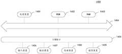
举例来说,图8是本公开实施例提供的一种车位线拟合的场景示意图,如图8所示,车位线L1、L2是车位编号“A####”两侧距离车位编号“A####”最近的两条车位线,L1和L2之间的距离h1即为单位车位宽度。L3和L4是车位编号“A####”两侧距离车位编号“A####”最远的两条车位线,L3和L4之间的距离h2为车位线点云组中包括的所有车位的总宽度,假设h2是h1的四倍,则图8中包括4个车位,对应的应该有5条竖直方向的车位线。但是实际中图8中紧包括4条车位线,缺少一条,这种情况可能是因为物体遮挡导致一条车位线没有采集到。为了解决遮挡等原因导致的车位线缺失,可以在图8所示的车位线点云组中进行车位线拟合,使得图8中的4条车位线到达该条车位线的距离最近,得到图8中用虚线表示的车位线。For example, FIG. 8 is a scene schematic diagram of a parking space line fitting provided by an embodiment of the present disclosure. As shown in FIG. 8 , the parking space lines L1 and L2 are the parking space number “A####” on both sides of the parking space number “A#” ###" The nearest two parking space lines, the distance h1 between L1 and L2 is the unit parking space width. L3 and L4 are the two parking space lines farthest from the parking space number "A####" on both sides of the parking space number "A####", and the distance h2 between L3 and L4 is all the parking spaces included in the point cloud group of the parking space line The total width of , assuming that h2 is four times that of h1, then Figure 8 includes 4 parking spaces, corresponding to 5 parking space lines in the vertical direction. However, in reality, there are 4 parking space lines in Figure 8, and one is missing. This situation may be due to the fact that a parking space line is not collected due to the occlusion of objects. In order to solve the lack of parking space lines caused by occlusion and other reasons, the parking space line fitting can be performed in the parking space line point cloud group shown in Figure 8, so that the distance between the four parking space lines in Figure 8 and the parking space line is the closest, and the figure is obtained. The parking space line indicated by the dotted line in 8.
通过在车位线缺失的情况下拟合车位线,对缺失的车位线进行补足,能够保证车位线点云数据的完整性,提高高精地图建图的准确性。By fitting the parking space line when the parking space line is missing, and supplementing the missing parking space line, the integrity of the point cloud data of the parking space line can be ensured, and the accuracy of high-precision map mapping can be improved.
图9是本公开实施例提供的一种点云特征提取装置的结构示意图,该装置可以示例性的理解为上述计算机设备或者计算机设备中的部分功能模块。如图9所示,点云特征提取装置90,包括:FIG. 9 is a schematic structural diagram of a point cloud feature extraction apparatus provided by an embodiment of the present disclosure, and the apparatus may be exemplarily understood as the above-mentioned computer equipment or some functional modules in the computer equipment. As shown in FIG. 9, the point cloud feature extraction device 90 includes:
获取模块91,用于获取停车场的点云数据和图像;an
提取模块92,用于从所述点云数据中提取得到车位线的点云数据,以及从所述图像中提取得到车位编号;The
点云分离模块93,用于根据所述车位线的点云数据中包含的三维点之间的相对位置关系,从所述车位线的点云数据中分离得到单条车位线的点云数据;The point
编号赋予模块94,用于根据所述车位编号和所述单条车位线在三维空间中的距离,将与所述单条车位线距离小于预设距离的车位编号赋值给所述单条车位线的点云数据。The
在一种实施方式中,获取模块91,可以用于获取停车场中部分区域的点云数据和图像,所述部分区域的高程波动小于预设阈值和/或所述部分区域属于所述停车场的同一分区。In one embodiment, the
在一种实施方式中,提取模块92可以包括:In one embodiment, the
分类子模块,用于对所述点云数据进行分类处理,得到地面点云数据和立面点云数据;a classification submodule, used for classifying the point cloud data to obtain ground point cloud data and elevation point cloud data;
提取子模块,用于根据所述地面点云数据中包含的三维点的反射强度信息,从所述地面点云数据中提取得到反射强度大于阈值强度的三维点作为车位线的点云数据。The extraction sub-module is configured to extract, from the ground point cloud data, three-dimensional points whose reflection intensity is greater than a threshold intensity as the point cloud data of the parking space line according to the reflection intensity information of the three-dimensional points contained in the ground point cloud data.
在一种实施方式中,编号赋予模块94,还用于将距离所述立面点云数据距离最近的单条车位线所对应的车位编号赋值给所述立面点云数据。In one embodiment, the
在一种实施方式中,点云特征提取装置90,还可以包括:第一处理模块,用于从所述点云数据的采集轨迹中确定一个轨迹点作为参考轨迹点;将采集设备在所述参考轨迹点上的坐标系作为参考坐标系,并将所述点云数据转换到所述参考坐标系中,得到转换后的点云数据;对转换后高程高于所述采集设备的点云数据进行删除处理,得到剩余的点云数据。In one embodiment, the point cloud feature extraction device 90 may further include: a first processing module, configured to determine a trajectory point from the acquisition trajectory of the point cloud data as a reference trajectory point; The coordinate system on the reference track point is used as the reference coordinate system, and the point cloud data is converted into the reference coordinate system to obtain the converted point cloud data; for the converted point cloud data whose elevation is higher than that of the acquisition device Perform deletion processing to obtain the remaining point cloud data.
在一种实施方式中,第一处理模块,具体用于:基于所述点云数据的采集轨迹,确定包含所述采集轨迹的多边形区域;从所述采集轨迹中确定与所述多边形区域的中心点距离最近的轨迹点作为参考轨迹点。In an embodiment, the first processing module is specifically configured to: determine a polygonal area including the acquisition trajectory based on the acquisition trajectory of the point cloud data; determine the center of the polygonal area from the acquisition trajectory The closest track point is used as the reference track point.
在一种实施方式中,分类子模块,具体用于:基于预设的体素大小,将剩余的点云数据分割成多个体素;In one embodiment, the classification sub-module is specifically used for: dividing the remaining point cloud data into a plurality of voxels based on a preset voxel size;
针对每个体素,基于所述体素中的点云分布,确定所述体素中点云分布最多的三个方向;根据所述体素中的点云数据在所述三个方向上的分布波动情况,从所述多个体素中提取出平面体素,其中,所述平面体素是指其中一个方向上的波动幅度与其他两个方向上的波动幅度的差值绝对值大于或等于预设幅度的体素;将法向方向朝向地面上方的平面体素确定为地面体素,以及将法向方向朝向水平方向的平面体素确定为立面体素;将所述地面体素中的点云数据确定为地面点云数据,将所述立面体素中的点云数据确定为立面点云数据。For each voxel, based on the point cloud distribution in the voxel, determine three directions with the most point cloud distribution in the voxel; according to the distribution of the point cloud data in the voxel in the three directions In the case of fluctuation, a plane voxel is extracted from the plurality of voxels, wherein the plane voxel means that the absolute value of the difference between the fluctuation amplitude in one direction and the fluctuation amplitude in the other two directions is greater than or equal to the predetermined value. Set the voxels of the amplitude; determine the plane voxels with the normal direction toward the top of the ground as the ground voxels, and determine the plane voxels with the normal direction toward the horizontal direction as the elevation voxels; The point cloud data is determined as ground point cloud data, and the point cloud data in the elevation voxel is determined as elevation point cloud data.
在一种实施方式中,点云特征提取装置90,还可以包括:In one embodiment, the point cloud feature extraction device 90 may further include:
生成模块,用于基于所述地面点云数据中包含的三维点的反射强度信息,生成地面反射强度直方图;a generating module, configured to generate a ground reflection intensity histogram based on the reflection intensity information of the three-dimensional points contained in the ground point cloud data;
确定模块,用于根据所述地面反射强度直方图,采用最大类方差间法,确定所述阈值强度。and a determining module, configured to determine the threshold intensity according to the ground reflection intensity histogram using the maximum inter-class variance method.
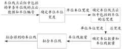
在一种实施方式中,点云特征提取装置90,还可以包括:第二处理模块,用于基于预设的第一聚类距离,对所述车位线的点云数据进行欧式聚类处理,得到至少一个车位线点云组;删除点云数量小于预设数量的车位线点云组;In one embodiment, the point cloud feature extraction device 90 may further include: a second processing module configured to perform Euclidean clustering processing on the point cloud data of the parking space line based on a preset first clustering distance, Obtain at least one parking space line point cloud group; delete the parking space line point cloud group whose number of point clouds is less than the preset number;
点云分离模块93,用于根据剩余车位线点云组中包含的三维点之间的相对位置关系,将彼此之间距离小于第二聚类距离的相邻三维点聚类到同一车位线上,得到所述车位线点云组中包含的单条车位线的点云数据。The point
在一种实施方式中,点云特征提取装置90,还可以包括:拟合模块,用于:In one embodiment, the point cloud feature extraction device 90 may further include: a fitting module, configured to:
在所述车位线点云组中,根据车位编号两侧距离所述车位编号距离最近的两条车位线之间的距离,确定单位车位宽度;In the parking space line point cloud group, the unit parking space width is determined according to the distance between the two parking space lines closest to the parking space number on both sides of the parking space number;
基于所述车位编号两侧距离所述车位编号距离最远的两条车位线之间的距离,确定所述车位线点云组中包括的多个车位的总宽度;Determine the total width of the plurality of parking spaces included in the parking space line point cloud group based on the distance between the two parking space lines farthest from the parking space number on both sides of the parking space number;
基于所述多个车位的总宽度和所述单位车位宽度,确定所述车位线点云组中包括的车位数量和车位线数量;determining the number of parking spaces and the number of parking spaces included in the parking space line point cloud group based on the total width of the plurality of parking spaces and the width of the unit parking space;
响应于所述车位线点云组中分离出的单条车位线的数量小于所述车位线数量,在所述车位线点云组中拟合车位线,使得所述车位线点云组中的所有车位线到达拟合出的车位线的距离最近。In response to the number of separated single parking space lines in the parking space line point cloud group being smaller than the number of parking space lines, fitting parking space lines in the parking space line point cloud group, so that all the parking space lines in the parking space line point cloud group are fitted. The distance from the parking space line to the fitted parking space line is the closest.
在一种实施方式中,编号赋予模块94,还用于获取所述单条车位线两侧距离所述单条车位线距离最近,且具有车位编号的车位线的车位编号;基于获取到的车位编号进行线性插值处理,得到插值编号;将所述插值编号赋值给所述单条车位线的点云数据。In one embodiment, the
本公开实施例提供的装置可以执行上述任一方法实施例,其执行方式和有益效果类似,在这里不再赘述。The apparatus provided in the embodiment of the present disclosure can execute any of the above method embodiments, and the execution manner and beneficial effects thereof are similar, and details are not described herein again.
本公开实施例还提供一种计算机设备,该计算机设备包括处理器和存储器,其中,所述存储器中存储有计算机程序,当所述计算机程序被所述处理器执行时可以实现上述任一方法实施例的方法。An embodiment of the present disclosure further provides a computer device, which includes a processor and a memory, wherein a computer program is stored in the memory, and when the computer program is executed by the processor, any of the foregoing methods can be implemented. example method.
示例的,图10是本公开实施例中的一种计算机设备的结构示意图。下面具体参考图10,其示出了适于用来实现本公开实施例中的计算机设备1400的结构示意图。本公开实施例中的计算机设备1400可以包括但不限于诸如笔记本电脑、PAD(平板电脑)、台式计算机、服务器等具有计算和数据处理能力的设备。图10示出的计算机设备仅仅是一个示例,不应对本公开实施例的功能和使用范围带来任何限制。By way of example, FIG. 10 is a schematic structural diagram of a computer device in an embodiment of the present disclosure. Referring specifically to FIG. 10 below, it shows a schematic structural diagram of a
如图10所示,计算机设备1400可以包括处理装置(例如中央处理器、图形处理器等)1401,其可以根据存储在只读存储器(ROM)1402中的程序或者从存储装置1408加载到随机访问存储器(RAM)1403中的程序而执行各种适当的动作和处理。在RAM 1403中,还存储有计算机设备1400操作所需的各种程序和数据。处理装置1401、ROM 1402以及RAM 1403通过总线1404彼此相连。输入/输出(I/O)接口1405也连接至总线1404。As shown in FIG. 10 ,
通常,以下装置可以连接至I/O接口1405:包括例如触摸屏、触摸板、键盘、鼠标、摄像头、麦克风、加速度计、陀螺仪等的输入装置1406;包括例如液晶显示器(LCD)、扬声器、振动器等的输出装置1407;包括例如磁带、硬盘等的存储装置1408;以及通信装置1409。通信装置1409可以允许计算机设备1400与其他设备进行无线或有线通信以交换数据。虽然图10示出了具有各种装置的计算机设备1400,但是应理解的是,并不要求实施或具备所有示出的装置。可以替代地实施或具备更多或更少的装置。Typically, the following devices can be connected to the I/O interface 1405:
特别地,根据本公开的实施例,上文参考流程图描述的过程可以被实现为计算机软件程序。例如,本公开的实施例包括一种计算机程序产品,其包括承载在非暂态计算机可读介质上的计算机程序,该计算机程序包含用于执行流程图所示的方法的程序代码。在这样的实施例中,该计算机程序可以通过通信装置1404从网络上被下载和安装,或者从存储装置1408被安装,或者从ROM 1402被安装。在该计算机程序被处理装置1401执行时,执行本公开实施例的方法中限定的上述功能。In particular, according to embodiments of the present disclosure, the processes described above with reference to the flowcharts may be implemented as computer software programs. For example, embodiments of the present disclosure include a computer program product comprising a computer program carried on a non-transitory computer readable medium, the computer program containing program code for performing the method illustrated in the flowchart. In such an embodiment, the computer program may be downloaded and installed from the network via the
需要说明的是,本公开上述的计算机可读介质可以是计算机可读信号介质或者计算机可读存储介质或者是上述两者的任意组合。计算机可读存储介质例如可以是——但不限于——电、磁、光、电磁、红外线、或半导体的系统、装置或器件,或者任意以上的组合。计算机可读存储介质的更具体的例子可以包括但不限于:具有一个或多个导线的电连接、便携式计算机磁盘、硬盘、随机访问存储器(RAM)、只读存储器(ROM)、可擦式可编程只读存储器(EPROM或闪存)、光纤、便携式紧凑磁盘只读存储器(CD-ROM)、光存储器件、磁存储器件、或者上述的任意合适的组合。在本公开中,计算机可读存储介质可以是任何包含或存储程序的有形介质,该程序可以被指令执行系统、装置或者器件使用或者与其结合使用。而在本公开中,计算机可读信号介质可以包括在基带中或者作为载波一部分传播的数据信号,其中承载了计算机可读的程序代码。这种传播的数据信号可以采用多种形式,包括但不限于电磁信号、光信号或上述的任意合适的组合。计算机可读信号介质还可以是计算机可读存储介质以外的任何计算机可读介质,该计算机可读信号介质可以发送、传播或者传输用于由指令执行系统、装置或者器件使用或者与其结合使用的程序。计算机可读介质上包含的程序代码可以用任何适当的介质传输,包括但不限于:电线、光缆、RF(射频)等等,或者上述的任意合适的组合。It should be noted that the computer-readable medium mentioned above in the present disclosure may be a computer-readable signal medium or a computer-readable storage medium, or any combination of the above two. The computer-readable storage medium can be, for example, but not limited to, an electrical, magnetic, optical, electromagnetic, infrared, or semiconductor system, apparatus or device, or a combination of any of the above. More specific examples of computer readable storage media may include, but are not limited to, electrical connections with one or more wires, portable computer disks, hard disks, random access memory (RAM), read only memory (ROM), erasable Programmable read only memory (EPROM or flash memory), fiber optics, portable compact disk read only memory (CD-ROM), optical storage devices, magnetic storage devices, or any suitable combination of the foregoing. In the present disclosure, a computer-readable storage medium may be any tangible medium that contains or stores a program that can be used by or in conjunction with an instruction execution system, apparatus, or device. In the present disclosure, however, a computer-readable signal medium may include a data signal propagated in baseband or as part of a carrier wave with computer-readable program code embodied thereon. Such propagated data signals may take a variety of forms, including but not limited to electromagnetic signals, optical signals, or any suitable combination of the foregoing. A computer-readable signal medium can also be any computer-readable medium other than a computer-readable storage medium that can transmit, propagate, or transport the program for use by or in connection with the instruction execution system, apparatus, or device . Program code embodied on a computer readable medium may be transmitted using any suitable medium including, but not limited to, electrical wire, optical fiber cable, RF (radio frequency), etc., or any suitable combination of the foregoing.
上述计算机可读介质可以是上述计算机设备中所包含的;也可以是单独存在,而未装配入该计算机设备中。The above-mentioned computer-readable medium may be included in the above-mentioned computer apparatus; or may exist alone without being assembled into the computer apparatus.
上述计算机可读介质承载有一个或者多个程序,当上述一个或者多个程序被该计算机设备执行时,使得该计算机设备:获取停车场的点云数据和图像;从点云数据中提取得到车位线的点云数据,从图像中提取得到车位编号;根据车位线的点云数据中包含的三维点之间的相对位置关系,从车位线的点云数据中分离得到单条车位线的点云数据;根据车位编号和单条车位线在三维空间中的距离,将与单条车位线距离小于预设距离的车位编号赋值给单条车位线的点云数据。The above-mentioned computer-readable medium carries one or more programs, and when the above-mentioned one or more programs are executed by the computer equipment, the computer equipment: acquires point cloud data and images of the parking lot; extracts parking spaces from the point cloud data The point cloud data of the line is extracted from the image to obtain the parking space number; according to the relative positional relationship between the three-dimensional points contained in the point cloud data of the parking space line, the point cloud data of a single parking space line is separated from the point cloud data of the parking space line. ; According to the parking space number and the distance of a single parking space line in three-dimensional space, assign the parking space number whose distance from the single parking space line is less than the preset distance to the point cloud data of the single parking space line.
可以以一种或多种程序设计语言或其组合来编写用于执行本公开的操作的计算机程序代码,上述程序设计语言包括但不限于面向对象的程序设计语言—诸如Java、Smalltalk、C++,还包括常规的过程式程序设计语言—诸如“C”语言或类似的程序设计语言。程序代码可以完全地在用户计算机上执行、部分地在用户计算机上执行、作为一个独立的软件包执行、部分在用户计算机上部分在远程计算机上执行、或者完全在远程计算机或服务器上执行。在涉及远程计算机的情形中,远程计算机可以通过任意种类的网络——包括局域网(LAN)或广域网(WAN)—连接到用户计算机,或者,可以连接到外部计算机(例如利用因特网服务提供商来通过因特网连接)。Computer program code for performing operations of the present disclosure may be written in one or more programming languages, including but not limited to object-oriented programming languages—such as Java, Smalltalk, C++, and This includes conventional procedural programming languages - such as the "C" language or similar programming languages. The program code may execute entirely on the user's computer, partly on the user's computer, as a stand-alone software package, partly on the user's computer and partly on a remote computer, or entirely on the remote computer or server. In the case of a remote computer, the remote computer may be connected to the user's computer through any kind of network, including a local area network (LAN) or a wide area network (WAN), or may be connected to an external computer (eg, using an Internet service provider through Internet connection).
附图中的流程图和框图,图示了按照本公开各种实施例的系统、方法和计算机程序产品的可能实现的体系架构、功能和操作。在这点上,流程图或框图中的每个方框可以代表一个模块、程序段、或代码的一部分,该模块、程序段、或代码的一部分包含一个或多个用于实现规定的逻辑功能的可执行指令。也应当注意,在有些作为替换的实现中,方框中所标注的功能也可以以不同于附图中所标注的顺序发生。例如,两个接连地表示的方框实际上可以基本并行地执行,它们有时也可以按相反的顺序执行,这依所涉及的功能而定。也要注意的是,框图和/或流程图中的每个方框、以及框图和/或流程图中的方框的组合,可以用执行规定的功能或操作的专用的基于硬件的系统来实现,或者可以用专用硬件与计算机指令的组合来实现。The flowchart and block diagrams in the Figures illustrate the architecture, functionality, and operation of possible implementations of systems, methods and computer program products according to various embodiments of the present disclosure. In this regard, each block in the flowchart or block diagrams may represent a module, segment, or portion of code that contains one or more logical functions for implementing the specified functions executable instructions. It should also be noted that, in some alternative implementations, the functions noted in the blocks may occur out of the order noted in the figures. For example, two blocks shown in succession may, in fact, be executed substantially concurrently, or the blocks may sometimes be executed in the reverse order, depending upon the functionality involved. It is also noted that each block of the block diagrams and/or flowchart illustrations, and combinations of blocks in the block diagrams and/or flowchart illustrations, can be implemented in dedicated hardware-based systems that perform the specified functions or operations , or can be implemented in a combination of dedicated hardware and computer instructions.
描述于本公开实施例中所涉及到的单元可以通过软件的方式实现,也可以通过硬件的方式来实现。其中,单元的名称在某种情况下并不构成对该单元本身的限定。The units involved in the embodiments of the present disclosure may be implemented in a software manner, and may also be implemented in a hardware manner. Among them, the name of the unit does not constitute a limitation of the unit itself under certain circumstances.
本文中以上描述的功能可以至少部分地由一个或多个硬件逻辑部件来执行。例如,非限制性地,可以使用的示范类型的硬件逻辑部件包括:现场可编程门阵列(FPGA)、专用集成电路(ASIC)、专用标准产品(ASSP)、片上系统(SOC)、复杂可编程逻辑设备(CPLD)等等。The functions described herein above may be performed, at least in part, by one or more hardware logic components. For example, without limitation, exemplary types of hardware logic components that may be used include: Field Programmable Gate Arrays (FPGAs), Application Specific Integrated Circuits (ASICs), Application Specific Standard Products (ASSPs), Systems on Chips (SOCs), Complex Programmable Logical Devices (CPLDs) and more.
在本公开的上下文中,机器可读介质可以是有形的介质,其可以包含或存储以供指令执行系统、装置或设备使用或与指令执行系统、装置或设备结合地使用的程序。机器可读介质可以是机器可读信号介质或机器可读储存介质。机器可读介质可以包括但不限于电子的、磁性的、光学的、电磁的、红外的、或半导体系统、装置或设备,或者上述内容的任何合适组合。机器可读存储介质的更具体示例会包括基于一个或多个线的电气连接、便携式计算机盘、硬盘、随机存取存储器(RAM)、只读存储器(ROM)、可擦除可编程只读存储器(EPROM或快闪存储器)、光纤、便捷式紧凑盘只读存储器(CD-ROM)、光学储存设备、磁储存设备、或上述内容的任何合适组合。In the context of the present disclosure, a machine-readable medium may be a tangible medium that may contain or store a program for use by or in connection with the instruction execution system, apparatus or device. The machine-readable medium may be a machine-readable signal medium or a machine-readable storage medium. Machine-readable media may include, but are not limited to, electronic, magnetic, optical, electromagnetic, infrared, or semiconductor systems, devices, or devices, or any suitable combination of the foregoing. More specific examples of machine-readable storage media would include one or more wire-based electrical connections, portable computer disks, hard disks, random access memory (RAM), read only memory (ROM), erasable programmable read only memory (EPROM or flash memory), fiber optics, compact disk read only memory (CD-ROM), optical storage, magnetic storage, or any suitable combination of the foregoing.
本公开实施例还提供一种计算机可读存储介质,所述存储介质中存储有计算机程序,当所述计算机程序被处理器执行时可以实现上述图2-图8中任一实施例的方法,其执行方式和有益效果类似,在这里不再赘述。An embodiment of the present disclosure further provides a computer-readable storage medium, where a computer program is stored in the storage medium, and when the computer program is executed by a processor, the method of any of the foregoing embodiments in FIG. 2 to FIG. 8 can be implemented, The implementation manner and beneficial effects thereof are similar, and are not repeated here.
本公开实施例还提供一种计算机程序产品,所述程序产品存储在存储介质中,当所述程序产品被计算机设备的处理器执行时,使得所述处理器执行图2-图8中任一实施例的方法,其执行方式和有益效果类似,在这里不再赘述。An embodiment of the present disclosure further provides a computer program product, the program product is stored in a storage medium, and when the program product is executed by a processor of a computer device, the processor is caused to execute any one of FIG. 2 to FIG. 8 . The implementation manner and beneficial effects of the method of the embodiment are similar, and are not repeated here.
需要说明的是,在本文中,诸如“第一”和“第二”等之类的关系术语仅仅用来将一个实体或者操作与另一个实体或操作区分开来,而不一定要求或者暗示这些实体或操作之间存在任何这种实际的关系或者顺序。而且,术语“包括”、“包含”或者其任何其他变体意在涵盖非排他性的包含,从而使得包括一系列要素的过程、方法、物品或者设备不仅包括那些要素,而且还包括没有明确列出的其他要素,或者是还包括为这种过程、方法、物品或者设备所固有的要素。在没有更多限制的情况下,由语句“包括一个……”限定的要素,并不排除在包括所述要素的过程、方法、物品或者设备中还存在另外的相同要素。It should be noted that, in this document, relational terms such as "first" and "second" etc. are only used to distinguish one entity or operation from another entity or operation, and do not necessarily require or imply these There is no such actual relationship or sequence between entities or operations. Moreover, the terms "comprising", "comprising" or any other variation thereof are intended to encompass a non-exclusive inclusion such that a process, method, article or device that includes a list of elements includes not only those elements, but also includes not explicitly listed or other elements inherent to such a process, method, article or apparatus. Without further limitation, an element qualified by the phrase "comprising a..." does not preclude the presence of additional identical elements in a process, method, article or apparatus that includes the element.
以上所述仅是本公开的具体实施方式,使本领域技术人员能够理解或实现本公开。对这些实施例的多种修改对本领域的技术人员来说将是显而易见的,本文中所定义的一般原理可以在不脱离本公开的精神或范围的情况下,在其它实施例中实现。因此,本公开将不会被限制于本文所述的这些实施例,而是要符合与本文所公开的原理和新颖特点相一致的最宽的范围。The above descriptions are only specific embodiments of the present disclosure, so that those skilled in the art can understand or implement the present disclosure. Various modifications to these embodiments will be readily apparent to those skilled in the art, and the generic principles defined herein may be implemented in other embodiments without departing from the spirit or scope of the present disclosure. Therefore, the present disclosure is not to be limited to the embodiments described herein but is to be accorded the widest scope consistent with the principles and novel features disclosed herein.
Claims (14)
Translated fromChinesePriority Applications (1)
| Application Number | Priority Date | Filing Date | Title |
|---|---|---|---|
| CN202210764800.5ACN115240154A (en) | 2022-06-29 | 2022-06-29 | Method, device, equipment and medium for extracting point cloud features of parking lot |
Applications Claiming Priority (1)
| Application Number | Priority Date | Filing Date | Title |
|---|---|---|---|
| CN202210764800.5ACN115240154A (en) | 2022-06-29 | 2022-06-29 | Method, device, equipment and medium for extracting point cloud features of parking lot |
Publications (1)
| Publication Number | Publication Date |
|---|---|
| CN115240154Atrue CN115240154A (en) | 2022-10-25 |
Family
ID=83671148
Family Applications (1)
| Application Number | Title | Priority Date | Filing Date |
|---|---|---|---|
| CN202210764800.5APendingCN115240154A (en) | 2022-06-29 | 2022-06-29 | Method, device, equipment and medium for extracting point cloud features of parking lot |
Country Status (1)
| Country | Link |
|---|---|
| CN (1) | CN115240154A (en) |
Cited By (2)
| Publication number | Priority date | Publication date | Assignee | Title |
|---|---|---|---|---|
| CN115690261A (en)* | 2022-12-29 | 2023-02-03 | 安徽蔚来智驾科技有限公司 | A parking space mapping method, vehicle and storage medium based on multi-sensor fusion |
| CN117012053A (en)* | 2023-09-28 | 2023-11-07 | 东风悦享科技有限公司 | Post-optimization method, system and storage medium for parking space detection point |
Citations (6)
| Publication number | Priority date | Publication date | Assignee | Title |
|---|---|---|---|---|
| CN108984599A (en)* | 2018-06-01 | 2018-12-11 | 青岛秀山移动测量有限公司 | A kind of vehicle-mounted laser point cloud road surface extracting method referred to using driving trace |
| US20180371661A1 (en)* | 2017-06-23 | 2018-12-27 | Janome Sewing Machine Co., Ltd. | Embroidery data generating apparatus, embroidery data generating method, and program for embroidery data generating apparatus |
| CN109253731A (en)* | 2018-08-06 | 2019-01-22 | 百度在线网络技术(北京)有限公司 | Parking space drawing generating method, device, equipment and readable storage medium storing program for executing |
| CN110705595A (en)* | 2019-09-04 | 2020-01-17 | 苏州工业园区测绘地理信息有限公司 | Parking space automatic extraction method based on knapsack type three-dimensional laser point cloud data |
| JP2020035226A (en)* | 2018-08-30 | 2020-03-05 | パイオニア株式会社 | Judgment device, control method, program, and storage medium |
| CN114092419A (en)* | 2021-11-09 | 2022-02-25 | 南京市测绘勘察研究院股份有限公司 | Automatic inspection method for point cloud spatial position quality based on earth surface point location |
- 2022
- 2022-06-29CNCN202210764800.5Apatent/CN115240154A/enactivePending
Patent Citations (6)
| Publication number | Priority date | Publication date | Assignee | Title |
|---|---|---|---|---|
| US20180371661A1 (en)* | 2017-06-23 | 2018-12-27 | Janome Sewing Machine Co., Ltd. | Embroidery data generating apparatus, embroidery data generating method, and program for embroidery data generating apparatus |
| CN108984599A (en)* | 2018-06-01 | 2018-12-11 | 青岛秀山移动测量有限公司 | A kind of vehicle-mounted laser point cloud road surface extracting method referred to using driving trace |
| CN109253731A (en)* | 2018-08-06 | 2019-01-22 | 百度在线网络技术(北京)有限公司 | Parking space drawing generating method, device, equipment and readable storage medium storing program for executing |
| JP2020035226A (en)* | 2018-08-30 | 2020-03-05 | パイオニア株式会社 | Judgment device, control method, program, and storage medium |
| CN110705595A (en)* | 2019-09-04 | 2020-01-17 | 苏州工业园区测绘地理信息有限公司 | Parking space automatic extraction method based on knapsack type three-dimensional laser point cloud data |
| CN114092419A (en)* | 2021-11-09 | 2022-02-25 | 南京市测绘勘察研究院股份有限公司 | Automatic inspection method for point cloud spatial position quality based on earth surface point location |
Non-Patent Citations (2)
| Title |
|---|
| GYUBEOM IM等: "Parking Line Based SLAM Approach Using AVM/LiDAR Sensor Fusion for Rapid and Accurate Loop Closing and Parking Space Detection", 《SENSORS》, vol. 19, no. 21, 5 November 2019 (2019-11-05), pages 1 - 17, XP093089526, DOI: 10.3390/s19214811* |
| 黄伟杰等: "基于视觉的停车场车位检测与分类算法", 《计算机系统应用》, vol. 31, no. 3, 14 March 2022 (2022-03-14), pages 234 - 240* |
Cited By (3)
| Publication number | Priority date | Publication date | Assignee | Title |
|---|---|---|---|---|
| CN115690261A (en)* | 2022-12-29 | 2023-02-03 | 安徽蔚来智驾科技有限公司 | A parking space mapping method, vehicle and storage medium based on multi-sensor fusion |
| CN115690261B (en)* | 2022-12-29 | 2023-04-14 | 安徽蔚来智驾科技有限公司 | A parking space mapping method, vehicle and storage medium based on multi-sensor fusion |
| CN117012053A (en)* | 2023-09-28 | 2023-11-07 | 东风悦享科技有限公司 | Post-optimization method, system and storage medium for parking space detection point |
Similar Documents
| Publication | Publication Date | Title |
|---|---|---|
| CN109658504B (en) | Map data annotation method, device, equipment and storage medium | |
| US20190206063A1 (en) | Method and apparatus for processing point cloud data | |
| EP3311110B1 (en) | Method and apparatus for locating vehicle/robot | |
| CN112613378B (en) | 3D target detection method, system, medium and terminal | |
| WO2021097618A1 (en) | Point cloud segmentation method and system, and computer storage medium | |
| US20200089236A1 (en) | Method and Apparatus for Optimizing Scan Data and Method and Apparatus for Correcting Trajectory | |
| CN114596555B (en) | Obstacle point cloud data screening method and device, electronic equipment and storage medium | |
| WO2021253245A1 (en) | Method and device for identifying vehicle lane changing tendency | |
| WO2021181647A1 (en) | Image processing device, image processing method, and computer-readable medium | |
| CN115240149A (en) | Three-dimensional point cloud detection and identification method, device, electronic device and storage medium | |
| CN115331099A (en) | Method and device for acquiring pavement point cloud data, electronic equipment and storage medium | |
| CN116109601A (en) | A real-time target detection method based on 3D lidar point cloud | |
| CN107679458B (en) | Method for extracting road marking lines in road color laser point cloud based on K-Means | |
| CN115240154A (en) | Method, device, equipment and medium for extracting point cloud features of parking lot | |
| CN114186007A (en) | High-precision map generation method and device, electronic equipment and storage medium | |
| CN114972758A (en) | Instance segmentation method based on point cloud weak supervision | |
| WO2024088445A1 (en) | Vehicle guidance method and system based on visual semantic vector, and device and medium | |
| CN110163900B (en) | Method and device for adjusting point cloud data | |
| CN117372995A (en) | Vehicle drivable region detection method, related device and storage medium | |
| CN114419180A (en) | Method, device and electronic device for reconstructing high-precision map | |
| CN117789160A (en) | Multi-mode fusion target detection method and system based on cluster optimization | |
| CN112258568A (en) | High-precision map element extraction method and device | |
| CN115760878A (en) | Three-dimensional image entity segmentation method, device, equipment, storage medium and vehicle | |
| CN115909262A (en) | Parking space detection method and device, electronic equipment and storage medium | |
| WO2025139165A1 (en) | Road boundary inspection method and apparatus, and device and medium |
Legal Events
| Date | Code | Title | Description |
|---|---|---|---|
| PB01 | Publication | ||
| PB01 | Publication | ||
| SE01 | Entry into force of request for substantive examination | ||
| SE01 | Entry into force of request for substantive examination |