CN115235500B - Pose correction method and device based on lane line constraints, full working condition static environment modeling method and device - Google Patents
Pose correction method and device based on lane line constraints, full working condition static environment modeling method and deviceDownload PDFInfo
- Publication number
- CN115235500B CN115235500BCN202211124194.7ACN202211124194ACN115235500BCN 115235500 BCN115235500 BCN 115235500BCN 202211124194 ACN202211124194 ACN 202211124194ACN 115235500 BCN115235500 BCN 115235500B
- Authority
- CN
- China
- Prior art keywords
- information
- lane line
- visual
- equation
- map
- Prior art date
- Legal status (The legal status is an assumption and is not a legal conclusion. Google has not performed a legal analysis and makes no representation as to the accuracy of the status listed.)
- Active
Links
Images


Classifications
- G—PHYSICS
- G01—MEASURING; TESTING
- G01C—MEASURING DISTANCES, LEVELS OR BEARINGS; SURVEYING; NAVIGATION; GYROSCOPIC INSTRUMENTS; PHOTOGRAMMETRY OR VIDEOGRAMMETRY
- G01C21/00—Navigation; Navigational instruments not provided for in groups G01C1/00 - G01C19/00
- G01C21/26—Navigation; Navigational instruments not provided for in groups G01C1/00 - G01C19/00 specially adapted for navigation in a road network
- G01C21/34—Route searching; Route guidance
- G01C21/3453—Special cost functions, i.e. other than distance or default speed limit of road segments
- G01C21/3492—Special cost functions, i.e. other than distance or default speed limit of road segments employing speed data or traffic data, e.g. real-time or historical
- G—PHYSICS
- G06—COMPUTING OR CALCULATING; COUNTING
- G06F—ELECTRIC DIGITAL DATA PROCESSING
- G06F16/00—Information retrieval; Database structures therefor; File system structures therefor
- G06F16/20—Information retrieval; Database structures therefor; File system structures therefor of structured data, e.g. relational data
- G06F16/29—Geographical information databases
- G—PHYSICS
- G06—COMPUTING OR CALCULATING; COUNTING
- G06T—IMAGE DATA PROCESSING OR GENERATION, IN GENERAL
- G06T17/00—Three dimensional [3D] modelling, e.g. data description of 3D objects
- G06T17/05—Geographic models
- G—PHYSICS
- G06—COMPUTING OR CALCULATING; COUNTING
- G06V—IMAGE OR VIDEO RECOGNITION OR UNDERSTANDING
- G06V20/00—Scenes; Scene-specific elements
- G06V20/50—Context or environment of the image
- G06V20/56—Context or environment of the image exterior to a vehicle by using sensors mounted on the vehicle
- G06V20/58—Recognition of moving objects or obstacles, e.g. vehicles or pedestrians; Recognition of traffic objects, e.g. traffic signs, traffic lights or roads
- G—PHYSICS
- G06—COMPUTING OR CALCULATING; COUNTING
- G06V—IMAGE OR VIDEO RECOGNITION OR UNDERSTANDING
- G06V20/00—Scenes; Scene-specific elements
- G06V20/50—Context or environment of the image
- G06V20/56—Context or environment of the image exterior to a vehicle by using sensors mounted on the vehicle
- G06V20/588—Recognition of the road, e.g. of lane markings; Recognition of the vehicle driving pattern in relation to the road
- G—PHYSICS
- G06—COMPUTING OR CALCULATING; COUNTING
- G06V—IMAGE OR VIDEO RECOGNITION OR UNDERSTANDING
- G06V20/00—Scenes; Scene-specific elements
- G06V20/70—Labelling scene content, e.g. deriving syntactic or semantic representations
- Y—GENERAL TAGGING OF NEW TECHNOLOGICAL DEVELOPMENTS; GENERAL TAGGING OF CROSS-SECTIONAL TECHNOLOGIES SPANNING OVER SEVERAL SECTIONS OF THE IPC; TECHNICAL SUBJECTS COVERED BY FORMER USPC CROSS-REFERENCE ART COLLECTIONS [XRACs] AND DIGESTS
- Y02—TECHNOLOGIES OR APPLICATIONS FOR MITIGATION OR ADAPTATION AGAINST CLIMATE CHANGE
- Y02T—CLIMATE CHANGE MITIGATION TECHNOLOGIES RELATED TO TRANSPORTATION
- Y02T10/00—Road transport of goods or passengers
- Y02T10/10—Internal combustion engine [ICE] based vehicles
- Y02T10/40—Engine management systems
Landscapes
- Engineering & Computer Science (AREA)
- Physics & Mathematics (AREA)
- General Physics & Mathematics (AREA)
- Theoretical Computer Science (AREA)
- Remote Sensing (AREA)
- Radar, Positioning & Navigation (AREA)
- Multimedia (AREA)
- Automation & Control Theory (AREA)
- Databases & Information Systems (AREA)
- Software Systems (AREA)
- Geometry (AREA)
- Computer Graphics (AREA)
- Data Mining & Analysis (AREA)
- General Engineering & Computer Science (AREA)
- Computational Linguistics (AREA)
- Traffic Control Systems (AREA)
Abstract
Translated fromChinese
Description
Translated fromChinese技术领域technical field
本发明涉及数据处理技术领域,尤其涉及一种基于车道线约束的位姿校正方法、基于车道线约束的位姿校正装置、全工况静态环境建模方法及装置、计算装置以及移动工具和存储介质。The present invention relates to the technical field of data processing, in particular to a pose correction method based on lane line constraints, a pose correction device based on lane line constraints, a static environment modeling method and device for all working conditions, a computing device, a mobile tool and a storage device. medium.
背景技术Background technique
自动驾驶车辆的自动驾驶系统(Autonomous Driving System,简称ADS)可分为环境感知、数据融合、决策系统、控制系统、执行系统五部分。其中,环境感知是指通过车载传感系统提取车辆、行人、道路、交通标示等车辆当前行驶环境信息,并将提取到的信息传输给其他系统以实现自动驾驶的路径规划和车辆行为控制。由此可见,环境感知是ADS的信息基础,现阶段对自动驾驶安全的重要要求就是如何能使自动驾驶车辆行驶得像正常车辆,不给环境造成困扰,并且符合人类司机的认知和预判。The autonomous driving system (ADS) of self-driving vehicles can be divided into five parts: environment perception, data fusion, decision-making system, control system, and execution system. Among them, environmental perception refers to the extraction of vehicle current driving environment information such as vehicles, pedestrians, roads, and traffic signs through the on-board sensing system, and the transmission of the extracted information to other systems to achieve automatic driving path planning and vehicle behavior control. It can be seen that environmental perception is the information basis of ADS. The important requirement for autonomous driving safety at this stage is how to make autonomous driving vehicles drive like normal vehicles without causing trouble to the environment, and conform to the cognition and prediction of human drivers. .
由于目前自动驾驶系统均是通过定位方案来获取较为精准的自车定位信息,并以此为基础,结合地图信息,来搭建车身周围环境模型的,因此,显然自车定位已经成为了环境感知的重要部分,更是环境建模的重要依据。目前,以GNSS为主、结合IMU和轮速计的定位方案应用广泛,但在长隧道、高楼耸立遮挡严重的环境下,易产生定位精度下降,甚至定位失效,无法做到结构化道路场景的全工况覆盖。专利CN109186616A《基于高精度地图和场景检索的车道线辅助定位方法》和专利CN107782321A《一种基于视觉和高精度地图车道线约束的组合导航方法》中,均采用视觉检测车道线辅助校正定位,解决GNSS受干扰问题。但在实际应用中,受实际环境状况影响,有可能存在无法检出可用车道线情况,存在一定的场景覆盖缺失,无法实现各种结构化道路场景工况全覆盖,如在车流密度较大及拥堵工况下,就可能会无法检出可用车道线。Since the current automatic driving system obtains more accurate self-vehicle positioning information through positioning schemes, and based on this, combined with map information, to build a model of the surrounding environment of the vehicle body, it is obvious that self-vehicle positioning has become an environmental awareness. It is an important part and an important basis for environmental modeling. At present, positioning schemes based on GNSS combined with IMU and wheel speedometers are widely used, but in environments with long tunnels and high-rise towers with severe occlusion, the positioning accuracy is prone to decline, and even the positioning fails, and it is impossible to achieve structured road scenes. Full coverage. Patent CN109186616A "Advanced Lane Line Positioning Method Based on High-Precision Map and Scene Retrieval" and Patent CN107782321A "A Combined Navigation Method Based on Vision and High-Precision Map Lane Line Constraints" both use visual detection of lane lines to assist in correcting positioning to solve GNSS interference problem. However, in practical applications, affected by the actual environmental conditions, there may be cases where the available lane lines cannot be detected, and there is a certain lack of scene coverage, and it is impossible to achieve full coverage of various structured road scene conditions. For example, when the traffic density is large and In congested conditions, it may not be possible to detect available lane lines.
此外,目前自动驾驶系统使用的地图信息主要为高精地图,具备精度高、要素全的优点,但采建制成本较高,相对而言导航地图因采建制成本低,已逐渐开始应用在自动驾驶领域中,然而目前暂无一套统一的环境建模方法,能够实现定位精度下降或失效情况下的定位校正,并同时兼容高精地图和导航地图两种地图方案。In addition, the current map information used by the automatic driving system is mainly a high-precision map, which has the advantages of high precision and complete elements, but the cost of procurement and construction is relatively high. Relatively speaking, navigation maps have gradually begun to be applied to autonomous driving due to their low procurement and production costs. However, there is currently no unified environment modeling method that can realize positioning correction when the positioning accuracy drops or fails, and is compatible with both high-precision maps and navigation maps.
发明内容Contents of the invention
本发明实施例提供一种基于车道线约束的位姿校正方案,以解决现有技术中的定位方案易受环境影响,在部分极端场景下可能出现精度下降甚至失效情况,无法实现各种结构化道路场景工况全覆盖的问题。The embodiment of the present invention provides a pose correction scheme based on lane line constraints to solve the problem that the positioning scheme in the prior art is easily affected by the environment, and the accuracy may decrease or even fail in some extreme scenarios, and various structured The problem of full coverage of road scene conditions.
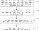
第一方面,本发明实施例提供一种基于车道线约束的位姿校正方法,其包括:In the first aspect, an embodiment of the present invention provides a pose correction method based on lane line constraints, which includes:
根据获取到的第一参数信息和第二参数信息确定出当前自车位置姿态信息,其中,所述第一参数信息包括自车在前一帧的历史位置姿态信息,第二参数信息包括前一帧和当前帧的定位数据;The current position and attitude information of the own vehicle is determined according to the obtained first parameter information and second parameter information, wherein the first parameter information includes the historical position and attitude information of the own vehicle in the previous frame, and the second parameter information includes the previous frame information. Frame and positioning data of the current frame;
基于获取到的第三参数信息确定并生成参考车道线,其中,所述第三参数信息包括地图数据;determining and generating a reference lane line based on the acquired third parameter information, where the third parameter information includes map data;
基于获取到的第四参数信息确定出视觉车道线,其中,所述第四参数信息包括视觉检测数据;Determining the visual lane line based on the obtained fourth parameter information, wherein the fourth parameter information includes visual detection data;
根据所述参考车道线和视觉车道线对所述当前自车位置姿态信息进行校正。The current self-vehicle position and attitude information is corrected according to the reference lane line and the visual lane line.
第二方面,本发明实施例提供一种全工况静态环境建模方法,其包括:In a second aspect, an embodiment of the present invention provides a method for modeling a static environment under full working conditions, which includes:
根据本发明第一方面所述的基于车道线约束的位姿校正方法获取当前自车位置姿态信息;According to the pose correction method based on lane line constraints described in the first aspect of the present invention, the current position and posture information of the vehicle is obtained;
根据所述当前自车位置姿态信息和获取到的地图信息构建静态环境模型,其中,构建的静态环境模型为用于描述周围环境信息的语义信息。A static environment model is constructed according to the current vehicle position and attitude information and the obtained map information, wherein the constructed static environment model is semantic information used to describe surrounding environment information.
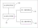
第三方面,本发明实施例提供一种基于车道线约束的位姿校正装置,其包括:In a third aspect, an embodiment of the present invention provides a pose correction device based on lane line constraints, which includes:
位姿确定模块,用于根据获取到的第一参数信息和第二参数信息确定出当前自车位置姿态信息,其中,所述第一参数信息包括自车在前一帧的历史位置姿态信息,第二参数信息包括前一帧和当前帧的定位数据;A pose determining module, configured to determine the current position and attitude information of the own vehicle according to the obtained first parameter information and second parameter information, wherein the first parameter information includes the historical position and attitude information of the own vehicle in the previous frame, The second parameter information includes positioning data of the previous frame and the current frame;
第一辅助模块,用于基于获取到的第三参数信息确定出参考车道线,其中,所述第三参数信息包括地图数据;A first auxiliary module, configured to determine a reference lane line based on the acquired third parameter information, where the third parameter information includes map data;
第二辅助模块,用于基于获取到的第四参数信息确定并生成视觉车道线,其中,所述第四参数信息包括视觉检测数据;A second auxiliary module, configured to determine and generate visual lane lines based on the acquired fourth parameter information, where the fourth parameter information includes visual detection data;
位姿校正模块,用于根据所述参考车道线和视觉车道线对所述当前自车位置姿态信息进行校正。A pose correction module, configured to correct the current vehicle position and pose information according to the reference lane line and the visual lane line.
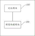
第四方面,本发明实施例提供一种全工况静态环境建模装置,其包括:In a fourth aspect, an embodiment of the present invention provides a full-condition static environment modeling device, which includes:
定位模块,用于根据本发明第一方面所述的基于车道线约束的位姿校正方法获取当前自车位置姿态信息;A positioning module, configured to acquire current vehicle position and posture information according to the pose correction method based on lane line constraints described in the first aspect of the present invention;
模型构建模块,用于根据所述当前自车位置姿态信息和获取到的地图信息构建静态环境模型,其中,构建的静态环境模型为用于描述周围环境信息的语义信息。A model construction module, configured to construct a static environment model according to the current position and attitude information of the self-vehicle and the obtained map information, wherein the constructed static environment model is semantic information used to describe the surrounding environment information.
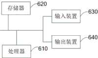
第五方面,本发明实施例提供了一种计算装置,其包括:In a fifth aspect, an embodiment of the present invention provides a computing device, which includes:
存储器,用于存储可执行指令;以及memory for storing executable instructions; and
处理器,用于执行存储器中存储的可执行指令,所述可执行指令在由所述处理器执行时实现本发明第一方面或第二方面提供的方法步骤。A processor, configured to execute executable instructions stored in the memory, and when the executable instructions are executed by the processor, implement the method steps provided in the first aspect or the second aspect of the present invention.
第六方面,本发明实施例提供了一种移动工具,其包括根据本发明第五方面所述的计算装置。In a sixth aspect, an embodiment of the present invention provides a mobile tool, which includes the computing device according to the fifth aspect of the present invention.
第七方面,本发明提供了一种存储介质,其上存储有计算机程序,该程序被处理器执行时实现上述第一方面或第二方面提供的方法的步骤。In a seventh aspect, the present invention provides a storage medium on which a computer program is stored, and when the program is executed by a processor, the steps of the method provided in the first aspect or the second aspect are implemented.
本发明实施例的有益效果在于:本发明实施例提供的方法将前一帧的历史数据作为当前帧的补充输入,同时结合定位数据、视觉检测数据和地图数据来实现对当前自车位置姿态信息的确定和校正,解决了单一方面数据信息精度降低或失效导致的自车定位不准确问题,实现了全工况覆盖,即使在定位精度低且受车流密度影响车道线检测效果差的工况下,也能够实现当前自车位置姿态信息的精准定位,能够有效应用于全工况结构道路场景下。The beneficial effect of the embodiment of the present invention is that: the method provided by the embodiment of the present invention uses the historical data of the previous frame as a supplementary input of the current frame, and at the same time combines the positioning data, visual detection data and map data to realize the current self-vehicle position and posture information It solves the problem of inaccurate self-vehicle positioning caused by the reduction or failure of data information accuracy in one aspect, and realizes the coverage of all working conditions, even in working conditions where the positioning accuracy is low and the lane line detection effect is poor due to traffic density. Under this condition, it can also realize the precise positioning of the current position and attitude information of the vehicle, and can be effectively applied to the road scene with full working condition structure.
附图说明Description of drawings
为了更清楚地说明本发明实施例的技术方案,下面将对实施例描述中所需要使用的附图作简单地介绍,显而易见地,下面描述中的附图是本发明的一些实施例,对于本领域普通技术人员来讲,在不付出创造性劳动的前提下,还可以根据这些附图获得其他的附图。In order to more clearly illustrate the technical solutions of the embodiments of the present invention, the following will briefly introduce the drawings that need to be used in the description of the embodiments. Obviously, the drawings in the following description are some embodiments of the present invention. Those of ordinary skill in the art can also obtain other drawings based on these drawings without any creative effort.
图1为本发明一实施方式的基于车道线约束的位姿校正方法的流程示意图;1 is a schematic flowchart of a pose correction method based on lane line constraints according to an embodiment of the present invention;
图2为本发明一实施方式的确定参考车道线的方法流程示意图;Fig. 2 is a schematic flowchart of a method for determining a reference lane line according to an embodiment of the present invention;
图3示意性地显示了本发明一实施方式的确定车道线的方法的流程示意图;Fig. 3 schematically shows a schematic flowchart of a method for determining lane lines according to an embodiment of the present invention;
图4示意性地示出了本发明一实施方式的根据历史环境模型来生成车道线的方法流程示意图;Fig. 4 schematically shows a schematic flowchart of a method for generating lane lines according to a historical environment model according to an embodiment of the present invention;
图5示意性地显示了本发明一实施方式的根据参考车道线和车道线对所述当前自车位置姿态信息进行校正的方法的流程示意图;Fig. 5 schematically shows a flow diagram of a method for correcting the current position and posture information of the vehicle according to the reference lane line and the lane line according to an embodiment of the present invention;
图6示意性地显示了本发明一实施方式的确定校正参数的方法的流程示意图;Fig. 6 schematically shows a schematic flowchart of a method for determining correction parameters according to an embodiment of the present invention;
图7示意性地显示了本发明另一实施方式的基于车道线约束的位姿校正方法的流程示意图;Fig. 7 schematically shows a schematic flowchart of a pose correction method based on lane line constraints according to another embodiment of the present invention;
图8为本发明一实施方式的全工况静态环境建模方法的流程示意图;FIG. 8 is a schematic flow diagram of a method for modeling a static environment under full working conditions according to an embodiment of the present invention;
图9示意性地示出了本发明一实施例的基于车道线约束的位姿校正装置的原理框图;Fig. 9 schematically shows a functional block diagram of a pose correction device based on lane line constraints according to an embodiment of the present invention;
图10为本发明另一实施方式的基于车道线约束的位姿校正装置的原理框图;Fig. 10 is a functional block diagram of a pose correction device based on lane line constraints according to another embodiment of the present invention;
图11为本发明一实施方式的全工况静态环境建模装置的原理框图;Fig. 11 is a functional block diagram of a full working condition static environment modeling device according to an embodiment of the present invention;
图12为本发明一实施方式的计算装置的原理框图;12 is a functional block diagram of a computing device according to an embodiment of the present invention;
图13为本发明一实施方式的移动工具的原理框图;Fig. 13 is a functional block diagram of a mobile tool according to an embodiment of the present invention;
图14为本发明的基于车道线约束的位姿校正装置的一实施例的结构示意图。Fig. 14 is a schematic structural diagram of an embodiment of a pose correction device based on lane line constraints according to the present invention.
具体实施方式Detailed ways
为使本发明实施例的目的、技术方案和优点更加清楚,下面将结合本发明实施例中的附图,对本发明实施例中的技术方案进行清楚、完整地描述,显然,所描述的实施例是本发明一部分实施例,而不是全部的实施例。基于本发明中的实施例,本领域普通技术人员在没有做出创造性劳动前提下所获得的所有其他实施例,都属于本发明保护的范围。In order to make the purpose, technical solutions and advantages of the embodiments of the present invention clearer, the technical solutions in the embodiments of the present invention will be clearly and completely described below in conjunction with the drawings in the embodiments of the present invention. Obviously, the described embodiments It is a part of embodiments of the present invention, but not all embodiments. Based on the embodiments of the present invention, all other embodiments obtained by persons of ordinary skill in the art without making creative efforts belong to the protection scope of the present invention.
需要说明的是,在不冲突的情况下,本申请中的实施例及实施例中的特征可以相互组合。It should be noted that, in the case of no conflict, the embodiments in the present application and the features in the embodiments can be combined with each other.
本发明可以在由计算机执行的计算机可执行指令的一般上下文中描述,例如程序模块。一般地,程序模块包括执行特定任务或实现特定抽象数据类型的例程、程序、对象、元件、数据结构等等。也可以在分布式计算环境中实践本发明,在这些分布式计算环境中,由通过通信网络而被连接的远程处理设备来执行任务。在分布式计算环境中,程序模块可以位于包括存储设备在内的本地和远程计算机存储介质中。The invention may be described in the general context of computer-executable instructions, such as program modules, being executed by a computer. Generally, program modules include routines, programs, objects, components, data structures, etc. that perform particular tasks or implement particular abstract data types. The invention may also be practiced in distributed computing environments where tasks are performed by remote processing devices that are linked through a communications network. In a distributed computing environment, program modules may be located in both local and remote computer storage media including storage devices.
在本发明中,“模块”、“装置”、“系统”等指应用于计算机的相关实体,如硬件、硬件和软件的组合、软件或执行中的软件等。详细地说,例如,元件可以、但不限于是运行于处理器的过程、处理器、对象、可执行元件、执行线程、程序和/或计算机。还有,运行于服务器上的应用程序或脚本程序、服务器都可以是元件。一个或多个元件可在执行的过程和/或线程中,并且元件可以在一台计算机上本地化和/或分布在两台或多台计算机之间,并可以由各种计算机可读介质运行。元件还可以根据具有一个或多个数据包的信号,例如,来自一个与本地系统、分布式系统中另一元件交互的,和/或在因特网的网络通过信号与其它系统交互的数据的信号通过本地和/或远程过程来进行通信。In the present invention, "module", "device", "system" and the like refer to related entities applied to computers, such as hardware, a combination of hardware and software, software or software in execution, and the like. In particular, for example, an element may be, but is not limited to being, a process running on a processor, a processor, an object, an executable element, a thread of execution, a program and/or a computer. Also, an application program or a script program running on a server, and the server may both be components. One or more elements can be within a process and/or thread of execution and an element can be localized on one computer and/or distributed between two or more computers and executed by various computer-readable media . Components may also communicate via a signal having one or more packets of data, for example, from one interacting with a local system, another component in a distributed system, and/or interacting with other systems via a network over the Internet. local and/or remote procedures to communicate.
最后,还需要说明的是,在本文中,诸如第一和第二等之类的关系术语仅仅用来将一个实体或者操作与另一个实体或操作区分开来,而不一定要求或者暗示这些实体或操作之间存在任何这种实际的关系或者顺序。而且,术语“包括”、“包含”,不仅包括那些要素,而且还包括没有明确列出的其他要素,或者是还包括为这种过程、方法、物品或者设备所固有的要素。在没有更多限制的情况下,由语句“包括……”限定的要素,并不排除在包括所述要素的过程、方法、物品或者设备中还存在另外的相同要素。Finally, it should also be noted that in this text, relational terms such as first and second etc. are only used to distinguish one entity or operation from another, and do not necessarily require or imply that these entities or operations, any such actual relationship or order exists. Moreover, the terms "comprising" and "comprising" not only include those elements, but also include other elements not explicitly listed, or also include elements inherent in such a process, method, article, or device. Without further limitations, an element defined by the statement "comprising..." does not exclude the presence of additional same elements in the process, method, article or device comprising said element.
本发明实施例中的基于车道线约束的位姿校正方法可以应用在任何需要使用定位技术的产品中,特别是基于以GNSS为主、结合IMU、轮速计、高清相机和硬件传感器等感知模块以获取上游输入信息的智能产品中,以使得这些智能产品能够利用本发明实施例的定位方案来实现自车定位和环境建模。这些需要使用定位技术的产品例如包括但不限于能够实现自动行驶或半自动驾驶的移动工具,例如自动驾驶车辆(乘用车、公交车、大巴车、货车、卡车等)、无人扫地机、无人清洁车、机器人、无人扫地车、扫地机器人、其他机器人等智能移动平台,本发明对此不作限定。The pose correction method based on lane line constraints in the embodiment of the present invention can be applied to any product that needs to use positioning technology, especially based on GNSS-based perception modules combined with IMU, wheel speedometer, high-definition camera and hardware sensors In smart products that obtain upstream input information, these smart products can use the positioning solution of the embodiment of the present invention to realize self-vehicle positioning and environment modeling. These products that require the use of positioning technology include, but are not limited to, mobile tools capable of automatic driving or semi-autonomous driving, such as self-driving vehicles (passenger cars, buses, buses, trucks, trucks, etc.), unmanned sweepers, wireless Intelligent mobile platforms such as human cleaning vehicles, robots, unmanned sweeping vehicles, sweeping robots, and other robots are not limited in the present invention.
图1示意性地显示了根据本发明一实施方式的基于车道线约束的位姿校正方法,该方法的执行主体可以为自动驾驶车辆上的定位装置或控制器,也可以为智能平板、个人PC、计算机、云端服务器等基于车道线约束的位姿校正装置的处理器,还可以为诸如无人清洁车、无人扫地车、扫地机器人、自动驾驶车辆、半自动驾驶设备等智能移动平台的处理器,本发明实施例不对此进行限制。如图1所示,本发明实施例的方法包括:Figure 1 schematically shows a pose correction method based on lane line constraints according to an embodiment of the present invention. The execution subject of this method can be the positioning device or controller on the self-driving vehicle, or it can be a smart tablet or a personal PC. , computer, cloud server, etc. based on the processor of the pose correction device based on lane line constraints, and can also be the processor of intelligent mobile platforms such as unmanned cleaning vehicles, unmanned sweeping vehicles, sweeping robots, automatic driving vehicles, and semi-automatic driving equipment. , which is not limited in this embodiment of the present invention. As shown in Figure 1, the method of the embodiment of the present invention includes:
步骤S10:根据获取到的第一参数信息和第二参数信息确定出当前自车位置姿态信息,其中,所述第一参数信息包括自车在前一帧的历史位置姿态信息,第二参数信息包括前一帧和当前帧的定位数据;Step S10: Determine the current position and attitude information of the own vehicle according to the obtained first parameter information and second parameter information, wherein the first parameter information includes the historical position and attitude information of the own vehicle in the previous frame, and the second parameter information Including the positioning data of the previous frame and the current frame;
步骤S11:基于获取到的第三参数信息确定并生成参考车道线,其中,所述第三参数信息包括地图数据;Step S11: Determine and generate a reference lane line based on the acquired third parameter information, wherein the third parameter information includes map data;
步骤S12:基于获取到的第四参数信息确定出视觉车道线,其中,所述第四参数信息包括视觉检测数据;Step S12: Determine the visual lane line based on the obtained fourth parameter information, wherein the fourth parameter information includes visual detection data;
步骤S13:根据所述参考车道线和视觉车道线对所述当前自车位置姿态信息进行校正。Step S13: Correcting the current position and posture information of the own vehicle according to the reference lane line and the visual lane line.
在本发明实施例中,确定出的当前自车位置姿态信息是指当前帧下自车的位置姿态信息,其中,位置姿态信息优选是由自车在UTM坐标系(Universal Transverse MercatorGrid System,通用横墨卡托格网系统,用于描述全局定位信息)下的位置横坐标、位置纵坐标和车头朝向共同限定,示例性地,位置姿态信息由(xg,yg,heading)来标识,其中,xg为UTM坐标系下位置横坐标,yg为UTM坐标系下位置纵坐标,heading为UTM坐标系下车头朝向。由于本发明实施例是基于不同帧的数据信息来确定相应帧下的自车位置姿态信息的,因此,在当前帧下,各在前的历史帧的自车位置姿态信息均是已经确定的先验信息,因而本发明实施例在具体实现中可以通过将确定的各个帧下的自车位置姿态信息进行存储,即可在步骤S10中获取到自车在前一帧的历史位置姿态信息。In the embodiment of the present invention, the determined current position and attitude information of the own vehicle refers to the position and attitude information of the own vehicle under the current frame, wherein the position and attitude information is preferably obtained by the own vehicle in the UTM coordinate system (Universal Transverse MercatorGrid System, universal transverse Mercator grid system, which is used to describe the position abscissa, position ordinate and vehicle head orientation under the global positioning information), for example, the position and posture information is identified by (xg, yg, heading), where xg is the abscissa of the position in the UTM coordinate system, yg is the ordinate of the position in the UTM coordinate system, and heading is the heading of the vehicle in the UTM coordinate system. Since the embodiment of the present invention determines the position and attitude information of the vehicle in the corresponding frame based on the data information of different frames, therefore, in the current frame, the position and attitude information of the vehicle in the previous historical frames are the previously determined information. Therefore, the embodiment of the present invention can obtain the historical position and posture information of the ego vehicle in the previous frame in step S10 by storing the determined ego vehicle position and posture information in each frame in the specific implementation.
作为一种优选实施方式,本发明可以基于GNSS(Global Navigation SatelliteSystem,全球导航卫星系统,泛指所有可用的导航定位系统,如GPS、伽利略、北斗等),并结合IMU(Inertial Measurement Unit,惯性测量单元,用于测量物体在三维空间中的角速度、角速率和加速度等)、轮速计、高清相机和多个传感器来实现车道线检测,以实现对当前自车位置姿态信息的辅助定位。由此,本发明实施例的提供有定位数据的第二参数信息、提供有地图数据的第三参数信息、提供有视觉检测数据的第四参数信息均可以通过GNSS、IMU、轮速计、高清相机和多个传感器等硬件模块获取到。在其他实施例中,第二参数信息、第三参数信息和第四参数信息也可以从其他前置模块获取,本发明实施例对此不进行限制。As a preferred embodiment, the present invention can be based on GNSS (Global Navigation Satellite System, global navigation satellite system, generally refers to all available navigation and positioning systems, such as GPS, Galileo, Beidou, etc.), combined with IMU (Inertial Measurement Unit, inertial measurement Unit, used to measure the angular velocity, angular velocity and acceleration of the object in three-dimensional space), wheel speedometer, high-definition camera and multiple sensors to realize lane line detection, so as to realize the auxiliary positioning of the current position and attitude information of the vehicle. Therefore, the second parameter information provided with positioning data, the third parameter information provided with map data, and the fourth parameter information provided with visual detection data in the embodiment of the present invention can all be passed through GNSS, IMU, wheel speedometer, high-definition Hardware modules such as cameras and multiple sensors are acquired. In other embodiments, the second parameter information, the third parameter information and the fourth parameter information may also be obtained from other front-end modules, which is not limited in this embodiment of the present invention.
示例性地,从上述硬件模块或其他前置模块获取的第二参数信息具体可以为包括定位数据,定位数据例如包括UTM坐标系下定位信息、DR坐标系下定位信息和当前定位精度状态;获取的第三参数信息具体可以为包括高精地图信息或导航地图信息;获取的第四参数信息具体可以为包括视觉检测信息,视觉检测信息例如包括在车体坐标系下的检测到的多个车道点和当前视觉检测状态。Exemplarily, the second parameter information obtained from the above-mentioned hardware module or other front-end modules may specifically include positioning data, and the positioning data includes, for example, positioning information in the UTM coordinate system, positioning information in the DR coordinate system, and the current positioning accuracy status; The third parameter information can specifically include high-precision map information or navigation map information; the obtained fourth parameter information can specifically include visual detection information, and the visual detection information includes, for example, multiple lanes detected in the vehicle body coordinate system points and the current state of visual inspection.
为了方便下文描述,在本发明实施例中,对定位数据和车道线信息的标识方式作出定义如下:将在UTM坐标系下的位置姿态信息定义为由(xg,yg,heading)来标识,并用字符“loc”来区分标记当前帧的定位数据,如(xgloc,ygloc,headingloc)表示当前定位数据中包含的常用位置姿态信息,用字符“env”来区分标记在当前帧下确定出的当前自车的位姿信息,如(xgenv,ygenv,headingenv)表示确定出的当前自车位置姿态信息,用字符“hd”来区分标记高精地图中的车道线信息,用字符“re”来区分标记中间计算过程中用到的参考车道线信息,各类车道线信息内包含的车道点用字符“point”定义,车道点中UTM坐标系下位置姿态信息用(e_xg,e_yg,e_heading)来标识,其中e_xg为在UTM坐标系下位置横坐标,e_yg为在UTM坐标系下位置纵坐标,e_heading为在UTM坐标系下车头朝向;车道点中车体坐标系下位置姿态信息用(e_x,e_y,e_angle)来标识,其中e_x为车体坐标系下横向坐标,沿车头方向为正,e_y为车体坐标系下纵向坐标,沿车头左侧方向为正,e_angle为车体坐标系下相对角度,同时可结合上述定义符号区分定义信息类别,例如参考车道线中车道点在UTM坐标系下位置姿态为(e_xgre,e_ygre,e_headingre),再如高精地图车道线下包含的多个车道点标识为hd_point,用下角标“-1”来区别标记上一帧数据,例如LOC_data-1表示上一帧的定位数据,(xgloc-1,ygloc-1,headingloc-1)表示上一帧定位数据LOC_data中包含的常用位置姿态信息,用前符号“△”来区别标记当前帧与上一帧历史数据的相对变化,例如△LOC_data=LOC_data-LOC_data-1,表示当前帧与上一帧定位数据的相对变化,以此类推。另外,由于车道线不只存在一条,其数量和车道数量相关,因此在本发明实施例中,还在定义字符中间插入数字以用于表示车道线编号,例如,车道线编号定义为从0开始累加,高精地图中当前道路下最左侧车道线为HD_0_line。For the convenience of the following description, in the embodiment of the present invention, the identification mode of positioning data and lane line information is defined as follows: the position and attitude information in the UTM coordinate system is defined as being identified by (xg, yg, heading), and used The character "loc" is used to distinguish the positioning data of the current frame. For example, (xgloc , ygloc , headingloc ) indicates the common position and attitude information contained in the current positioning data. The current pose information of the own vehicle, such as (xgenv , ygenv , headingenv ) indicates the determined current position and attitude information of the own vehicle, the character "hd" is used to distinguish and mark the lane line information in the high-precision map, and the character "re" is used to distinguish the reference lane line information used in the intermediate calculation process of the mark. The lane points contained in various lane line information are defined by the character "point", and the position and attitude information in the UTM coordinate system of the lane points is used (e_xg,e_yg ,e_heading) to identify, where e_xg is the abscissa of the position in the UTM coordinate system, e_yg is the ordinate of the position in the UTM coordinate system, e_heading is the heading of the vehicle in the UTM coordinate system; position and attitude information in the vehicle body coordinate system in the lane point Use (e_x, e_y, e_angle) to identify, where e_x is the horizontal coordinate in the car body coordinate system, positive along the front direction, e_y is the longitudinal coordinate in the car body coordinate system, positive in the left direction of the car front, and e_angle is the car body The relative angle in the coordinate system can be combined with the above definition symbols to distinguish and define the information category. For example, the position and posture of the lane point in the reference lane line in the UTM coordinate system is (e_xgre , e_ygre , e_headingre ), and another example is the high-precision map lane line The multiple lane points contained below are identified as hd_point, and the subscript "-1" is used to distinguish and mark the data of the previous frame. For example, LOC_data-1 indicates the positioning data of the previous frame, (xgloc-1 , ygloc-1 , headingloc-1 ) indicates the commonly used position and attitude information contained in the previous frame of positioning data LOC_data, and the previous symbol "△ " is used to distinguish and mark the relative change between the current frame and the previous frame of historical data, for example,△ LOC_data=LOC_data-LOC_data-1 , Indicates the relative change of positioning data between the current frame and the previous frame, and so on. In addition, since there is not only one lane line, its number is related to the number of lanes, so in the embodiment of the present invention, a number is inserted between the defined characters to represent the lane line number, for example, the lane line number is defined to be accumulated from 0 , the leftmost lane line under the current road in the HD map is HD_0_line.
在本发明实施例中,是基于从前置模块获取的定位数据、视觉检测数据和地图数据,并结合历史记录信息来共同确定出当前自车位置姿态信息的,其包括了初步确定当前自车位置姿态信息的处理过程和对初步确定的当前自车位置姿态信息进行校正的处理过程,由于充分利用了地图信息、定位信息、感知信息和历史信息,因而解决了单一方面数据信息精度降低或失效导致的定位不准确的问题,能够实现全工况覆盖和精确定位。以下将结合具体实施方式对图1中各个步骤的实现过程进行详细描述。In the embodiment of the present invention, based on the positioning data, visual detection data and map data obtained from the front module, combined with historical record information to jointly determine the current position and posture information of the own vehicle, which includes the preliminary determination of the current own vehicle The processing process of the position and attitude information and the process of correcting the initially determined current position and attitude information of the self-vehicle, due to the full use of map information, positioning information, perception information and historical information, thus solve the problem of a single aspect of data information accuracy reduction or The problem of inaccurate positioning caused by failure can achieve full working condition coverage and accurate positioning. The implementation process of each step in FIG. 1 will be described in detail below in conjunction with specific embodiments.
在步骤S10中,主要实现了基于定位数据和历史位置姿态信息对当前自车位置姿态信息的初步确定,即基于获取到的最新的当前帧定位数据对当前自车位置姿态信息的初步更新。具体地,以获取到的定位数据包括DR坐标系下的定位信息为例,根据上一帧DR坐标系下的定位信息DR_data-1和当前帧下的定位信息DR_data计算得到自车的相对移动,并基于上一帧确定出的自车位置姿态信息,即可初步确定出当前自车位置姿态信息(xgenv,ygenv,headingenv)为:In step S10, the preliminary determination of the current vehicle position and posture information based on the positioning data and historical position and posture information is mainly realized, that is, the preliminary update of the current self-vehicle position and posture information based on the latest acquired current frame positioning data. Specifically, taking the obtained positioning data including positioning information in the DR coordinate system as an example, the relative movement of the ego vehicle is calculated according to the positioning information DR_data-1 in the previous frame DR coordinate system and the positioning information DR_data in the current frame, And based on the position and attitude information of the self-vehicle determined in the previous frame, the current position and attitude information of the self-vehicle (xgenv , ygenv , headingenv ) can be preliminarily determined as:
xgenv=xgenv-1+xgdr-xgdr-1;xgenv = xgenv-1 +xgdr -xgdr-1 ;
ygenv=ygenv-1+ygdr-ygdr-1;ygenv = ygenv-1 + ygdr - ygdr-1 ;
headingenv=headingenv-1+headingdr-headingdr-1。headingenv = headingenv-1 +headingdr -headingdr-1 .
优选地,由于通过定位传感器等硬件模块获取到的定位信息具有频率快、周期短的特点,因此,在本发明的优选实施例中,会先对获取到的参数信息进行预处理,以使得在步骤S10至步骤S13中利用的参数信息具有时间上的同步性,如将基于高清相机获取的第四参数信息和基于定位传感器获取的第二参数信息在时间上进行同步,以确定本发明实施例的方法使用的数据均是在一致的时间节点下的,进而使得最终确定出的当前自车位置姿态信息更加精准。具体地,可以通过缓存多帧定位数据,并在获取到当前最新视觉检测数据时,从缓存的定位数据中选取与当前最新视觉检测数据时间匹配的定位数据作为当前帧的定位数据,以基于选取出的定位数据作为后续处理的依据。Preferably, since the positioning information obtained by hardware modules such as positioning sensors has the characteristics of fast frequency and short period, in the preferred embodiment of the present invention, the obtained parameter information will be preprocessed first, so that in The parameter information used in steps S10 to S13 has time synchronization, for example, the fourth parameter information obtained based on the high-definition camera and the second parameter information obtained based on the positioning sensor are synchronized in time to determine the The data used in the method are all at the same time node, which makes the final determined current position and attitude information of the vehicle more accurate. Specifically, by caching multiple frames of positioning data, and when the current latest visual detection data is obtained, selecting the positioning data that matches the time of the current latest visual detection data from the cached positioning data as the positioning data of the current frame, based on the selected The obtained positioning data is used as the basis for subsequent processing.
在步骤S11至步骤S13中,主要实现了基于检测到的车道线信息对当前自车位置姿态信息的校正,即实现了基于车道线对当前自车位置姿态信息的辅助定位,以期保证确定出的当前自车位置姿态信息的精准性。In steps S11 to S13, the correction of the current position and attitude information of the vehicle based on the detected lane line information is mainly realized, that is, the auxiliary positioning of the current position and attitude information of the vehicle based on the lane lines is realized, in order to ensure that the determined The accuracy of the current vehicle position and attitude information.
其中,在本发明实施例中,在步骤S11中是基于地图数据来确定参考车道线的。作为一种优选实施方式,本发明实施例可以根据地图数据类型来灵活选择确定参考车道线的策略,从而实现对不同地图场景下的兼容,以使得能够同时基于不同地图类型来进行精准定位,实现结构化道路下的全工况覆盖。图2示意性地显示了本发明一种实施方式的确定参考车道线的方法,如图2所示,步骤S11基于获取到的第三参数信息确定并生成参考车道线,具体可以实现为包括:Wherein, in the embodiment of the present invention, in step S11, the reference lane line is determined based on the map data. As a preferred implementation, the embodiment of the present invention can flexibly select the strategy for determining the reference lane line according to the type of map data, so as to achieve compatibility with different map scenarios, so that precise positioning can be performed based on different map types at the same time, and the realization of Full coverage on structured roads. Fig. 2 schematically shows a method for determining a reference lane line according to an embodiment of the present invention. As shown in Fig. 2 , step S11 determines and generates a reference lane line based on the obtained third parameter information, which may specifically be implemented as including:
步骤S111:根据获取到的地图数据进行判断,根据判断结果在所述地图数据为第一地图信息时,进行步骤S112的处理,在所述地图数据为第二地图信息时,进行步骤S113的处理;Step S111: Judging according to the acquired map data, according to the judgment result, if the map data is the first map information, perform the processing of step S112, and if the map data is the second map information, perform the processing of step S113 ;
步骤S112:根据第一地图信息中的第一参考车道线信息生成参考车道线,其中,所述第一参考车道线信息包括多个参考线车道点的第一地图位置姿态信息;Step S112: Generate a reference lane line according to the first reference lane line information in the first map information, wherein the first reference lane line information includes first map position and posture information of a plurality of reference line lane points;
步骤S113:根据历史环境模型中包括的前一帧的历史车道线生成参考车道线。Step S113: Generate reference lane lines according to the historical lane lines of the previous frame included in the historical environment model.
在本发明实施例中,示例性地,第一地图信息为高精地图,第二地图信息为导航地图,在其他实施方式中,第一地图信息也可以为其他的具有高精度特点的地图,第二地图信息也可以为其他的具有精度较低特点的地图,可以理解的是,只要是具有高精地图的元素信息全、精度高、包含高精度车道线位置信息的地图信息都可以作为本发明实施例中的第一地图信息,以实现用于根据第一地图信息来获取参考车道线;相应地,只要是具有所包含的车道线位置信息精度不够、但其拓扑信息是全的这一特点的地图都可以作为本发明实施例中的第二地图信息,以实现在这种情况下根据历史环境模型来获取参考车道线。作为一种优选实施例,当使用的地图为高精地图时,本发明是将参考车道信息等同于高精地图车道线信息,而当使用的地图为导航地图时,本发明则是将参考车道信息等同于上一帧环境建模输出的车道线信息。因此,在步骤S112中,本发明实施例是根据第一地图信息即高精地图中的第一参考车道线信息生成参考车道线,而在步骤S113中,则是根据历史环境模型中包括的前一帧的历史车道线生成参考车道线,由于在先历史环境模型中已经确定出了前一帧的车道线,因而直接从历史环境模型中获取前一帧的车道线作为补充输入,并将其作为参考车道线即可。In the embodiment of the present invention, for example, the first map information is a high-precision map, and the second map information is a navigation map. In other implementations, the first map information can also be other high-precision maps. The second map information can also be other maps with low precision characteristics. It can be understood that as long as the map information has complete element information of high-precision maps, high precision, and contains high-precision lane line position information, it can be used as this map information. The first map information in the embodiment of the invention is used to obtain the reference lane line according to the first map information; All characteristic maps can be used as the second map information in the embodiment of the present invention, so as to obtain the reference lane line according to the historical environment model in this case. As a preferred embodiment, when the map used is a high-precision map, the present invention equates the reference lane information to the high-precision map lane line information, and when the map used is a navigation map, the present invention uses the reference lane information The information is equivalent to the lane line information output by the environment modeling of the previous frame. Therefore, in step S112, the embodiment of the present invention generates the reference lane line according to the first map information, that is, the first reference lane line information in the high-definition map, and in step S113, it generates the reference lane line according to the previous The historical lane lines of one frame generate the reference lane lines. Since the lane lines of the previous frame have been determined in the previous historical environment model, the lane lines of the previous frame are directly obtained from the historical environment model as supplementary input, and its It can be used as a reference lane line.
具体地,由于高精地图中一般包括有多个参考线车道点的位置姿态信息,本发明实施例称之为参考线车道点的第一地图位置姿态信息,因此,作为一种具体实现方式,可以基于高精地图中的参考线车道点的第一地图位置姿态信息来生成参考车道线,其包括首先对高精地图中的参考线车道点进行坐标转换,将各参考线车道点在UTM坐标系下位置姿态(e_xgre,e_ygre,e_headingre,kre),经坐标转换以得到其在车体坐标系下的位置姿态为:Specifically, since a high-precision map generally includes position and attitude information of multiple reference line lane points, this embodiment of the present invention refers to the first map position and attitude information of reference line lane points. Therefore, as a specific implementation, The reference lane line can be generated based on the first map position and attitude information of the reference line lane points in the high-precision map, which includes firstly performing coordinate transformation on the reference line lane points in the high-precision map, and converting each reference line lane point in UTM coordinates The position and attitude under the system (e_xgre , e_ygre , e_headingre , kre ), after coordinate transformation, its position and attitude in the vehicle body coordinate system are:
e_xre=(e_xgre-xgenv)×cos(headingenv)+(e_ygre-ygenv)×sin(headingenv);e_xre = (e_xgre -xgenv )×cos(headingenv )+(e_ygre -ygenv )×sin(headingenv );
e_yre=-(e_xgre-xgenv)×sin(headingenv)+(e_ygre-ygenv)×cos(headingenv)。e_yre =-(e_xgre −xgenv )×sin(headingenv )+(e_ygre −ygenv )×cos(headingenv ).
在进行坐标转换之后,则将高精地图中的参考车道线信息下包含的多组参考车道点用进行曲线拟合,以得到拟合后的曲线方程表示为Lre(e_xre,e_yre),同时用数字表示对应的车道线编号,例如re_0_line对应的曲线方程为Lre0(e_xre,e_yre)。最后,再根据曲线方程计算各参考车道点处相对角度e_anglere为:After the coordinate transformation, the multiple sets of reference lane points contained in the reference lane line information in the high-precision map are used for curve fitting, so as to obtain the fitted curve equation expressed as Lre (e_xre , e_yre ) , and use numbers to represent the corresponding lane line number, for example, the curve equation corresponding to re_0_line is Lre0 (e_xre , e_yre ). Finally, calculate the relative angle e_anglere at each reference lane point according to the curve equation as:
e_anglere=tan-1(Lre(e_xre,e_yre))。e_anglere =tan−1 (Lre (e_xre , e_yre )).
由此以基于高精地图中的参考车道点信息来生成参考车道线。其中,进行曲线拟合优选是采用多项式方法进行拟合,在其他实施例也可以采用诸如高斯拟合等其他拟合方法进行曲线拟合,以得到参考车道线的曲线方程。当然,在其他实施方式中,生成参考车道线的曲线方程也可以不局限于曲线拟合的方式,而是可以采用其他生成曲线方程的方式进行实现,本发明实施例对此不进行限制。Therefore, the reference lane line is generated based on the reference lane point information in the HD map. Wherein, the curve fitting is preferably performed using a polynomial method, and in other embodiments, other fitting methods such as Gaussian fitting may also be used for curve fitting, so as to obtain the curve equation of the reference lane line. Certainly, in other implementations, generating the curve equation of the reference lane line may not be limited to the method of curve fitting, but may be realized by other methods of generating the curve equation, which is not limited in the embodiment of the present invention.
在步骤S12中,本发明实施例优选是基于视觉检测数据来确定视觉车道线的。作为一种优选实施方式,本发明实施例可以根据视觉检测状态来灵活选择确定视觉车道线的策略,从而避免视觉检测信息残缺等极限工况对定位精度和场景覆盖率的不良影响。图3示意性地显示了本发明一种实施方式的确定视觉车道线的方法,如图3所示,以获取的视觉检测数据包括视觉检测状态和多个车道点的环境位置姿态信息为例,步骤S12基于获取到的第四参数信息确定出视觉车道线,具体可以实现为包括:In step S12, the embodiment of the present invention preferably determines visual lane lines based on visual detection data. As a preferred implementation, the embodiment of the present invention can flexibly select a strategy for determining visual lane lines according to the visual detection state, thereby avoiding adverse effects of extreme working conditions such as incomplete visual detection information on positioning accuracy and scene coverage. Fig. 3 schematically shows a method for determining a visual lane line according to an embodiment of the present invention. As shown in Fig. 3 , taking the obtained visual detection data including the visual detection state and environmental position and posture information of multiple lane points as an example, Step S12 determines the visual lane line based on the obtained fourth parameter information, which may specifically be implemented as including:
步骤S121:根据视觉检测状态进行判断,在视觉检测状态为第一取值时,进行步骤S122的处理,在所述视觉检测状态为第二取值时,进行步骤S123的处理;Step S121: Judging according to the visual detection state, when the visual detection state is the first value, perform the processing of step S122, and when the visual detection state is the second value, perform the processing of step S123;
步骤S122:根据车道点的环境位置姿态信息生成视觉车道线;Step S122: Generate visual lane lines according to the environmental position and posture information of the lane points;
步骤S123:根据第一参数信息和第四参数信息生成视觉车道线,其中,所述第一参数信息包括历史环境模型。Step S123: Generate visual lane lines according to the first parameter information and the fourth parameter information, wherein the first parameter information includes a historical environment model.
其中,根据从前置模块或诸如高清相机等硬件模块获取到的视觉检测数据存在状态良好和状态较差两种情况,其中,第一取值为用于表征车道线检测结果良好的状态,第二取值为用于表征车道线遮挡或模糊等导致的较差状态。由此,在本发明实施例中,当视觉检测状态良好时,由于车道线检测结果清晰,因此可以直接根据视觉检测数据中检测到的多个车道点的环境位置姿态信息来生成视觉车道线,而在视觉检测状态较差,如车道线模糊或被遮挡等工况下,则不直接利用视觉检测数据,而是根据历史环境模型和获取到的地图数据来生成视觉车道线,从而实现全工况场景下的高覆盖高精准的定位和环境信息检测。Among them, according to the visual detection data obtained from the front-end module or hardware modules such as high-definition cameras, there are two situations: good state and poor state, wherein the first value is used to represent the good state of the lane line detection result, and the second The second value is used to represent the poor state caused by lane line occlusion or blurring. Therefore, in the embodiment of the present invention, when the visual detection state is good, the visual lane line can be generated directly according to the environmental position and posture information of multiple lane points detected in the visual detection data because the lane line detection result is clear, However, when the visual detection status is poor, such as blurred or blocked lane lines, the visual detection data is not directly used, but the visual lane lines are generated based on the historical environment model and the acquired map data, so as to realize full-time operation. High-coverage and high-precision positioning and environmental information detection in environmental scenarios.
示例性地,在步骤S122中,如果状态良好,即说明通过视觉检测能够直接检测到地面车道线并输出,此时将视觉检测数据中包括的多个车道点拟合为曲线,并以拟合得到的曲线作为视觉车道线,示例性地,视觉车道线的曲线方程可以表示为Lv(e_xv,e_yv)。其中,将多个车道点拟合生成用于表征视觉车道线的曲线,具体可以是采用多项式拟合、高斯拟合等拟合方法。Exemplarily, in step S122, if the state is good, it means that the ground lane line can be directly detected and output through visual inspection. At this time, a plurality of lane points included in the visual inspection data are fitted to a curve, and the fitting The obtained curve is used as the visual lane line, for example, the curve equation of the visual lane line can be expressed as Lv (e_xv , e_yv ). Wherein, a plurality of lane points are fitted to generate a curve used to represent the visual lane line, specifically, fitting methods such as polynomial fitting and Gaussian fitting may be used.
在本发明实施例中,环境模型是对当前移动工具如车辆所处环境的描述,其融合了GNSS导航、IMU、轮速计、高清相机和多传感器等的输入信息,旨在生成对周围环境精确、稳定的描述,并输出相应环境模型为车辆行驶规划等提供支持。示例性地,环境模型一般包含UTM坐标系下、自车坐标系下、frenet坐标系下车道线信息、车辆位置姿态信息、障碍物位置分布信息等,这些信息会在环境建模中存储,因而对于当前帧而言,上一帧的环境模型为已知信息,即历史环境模型信息已知,可作为当前帧的补充输入。在步骤S123中,即是利用了上一帧的历史环境模型来生成视觉车道线的。图4示意性显示了一种实施方式的根据历史环境模型来生成视觉车道线的方法,如图4所示,其实现为包括:In the embodiment of the present invention, the environment model is a description of the current mobile tool such as the environment in which the vehicle is located, which integrates the input information of GNSS navigation, IMU, wheel speedometer, high-definition camera and multi-sensors, etc. Accurate and stable description, and output the corresponding environment model to provide support for vehicle driving planning and so on. Exemplarily, the environment model generally includes lane line information in the UTM coordinate system, the ego coordinate system, and the frenet coordinate system, vehicle position and posture information, obstacle position distribution information, etc., and these information will be stored in the environment modeling, so For the current frame, the environment model of the previous frame is known information, that is, the historical environment model information is known, which can be used as a supplementary input for the current frame. In step S123, the historical environment model of the last frame is used to generate the visual lane line. Fig. 4 schematically shows a method for generating visual lane lines according to a historical environment model in an embodiment, as shown in Fig. 4 , which includes:
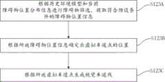
步骤S123A:根据历史环境模型和当前障碍物位置分布信息进行障碍物筛选,提取符合预设条件的障碍物位置信息;Step S123A: Perform obstacle screening according to the historical environment model and current obstacle location distribution information, and extract obstacle location information that meets preset conditions;
步骤S123B:根据所述障碍物位置信息确定出虚拟车道点的位置;Step S123B: Determine the position of the virtual lane point according to the obstacle position information;
步骤S123C:根据所述虚拟车道点生成所述视觉车道线。Step S123C: Generate the visual lane lines according to the virtual lane points.
在步骤S123A中,进行障碍物筛选可以是剔除存在压线行为的障碍物,而将其余的障碍物(即不存在压线行为的障碍物)作为符合预设条件的障碍物,以提取出其位置信息。其中,存在压线行为的障碍物,是指障碍物是至少部分地覆盖了在了车道线上。具体地,可以根据车道线与障碍物位置框之间是否存在穿越关系来判断相应障碍物是否存在压线行为。示例性地,由于历史环境模型中存储有在前一帧确定出的历史车道线对应的曲线方程,因此可以基于此确定出当前时刻历史车道线对应的曲线方程的递推方程,而由于第四参数信息包括了视觉检测数据,视觉检测数据包括了当前帧下的障碍物位置分布情况,因而根据当前帧的视觉检测数据即可确定出各障碍物的当前位置分布信息,例如根据当前帧的视觉检测数据就可以获知到当前帧下各障碍物的位置框信息,因而可以通过当前障碍物的位置框信息与历史车道线对于的曲线方程的递推方程的位置关系来判断历史车道线对应的递推方程曲线是否穿过了当前时刻的障碍物的位置框,并根据判断结果来确定该障碍物是否存在压线行为,如将历史车道线对应的递推方程曲线穿过的位置框标识的障碍物视为压线障碍物。并通过判断各障碍物的位置是否处于车道线上,来筛选出存在明显压线行为的障碍物,并将其剔除,而将余下的障碍物作为符合条件的障碍物并提取其位置信息以供后续处理使用。示例性地,确定出的障碍物的位置框信息可以是由位置框的顶点坐标信息和位置框的范围信息来限定。其中,基于前一帧确定出的历史车道线对应的曲线方程确定当前时刻的递推方程的具体实现方式可以参照现有技术实现,判断历史车道线对应的递推方程是否穿过相应帧的障碍物的外接矩形框的优选是在车体坐标系下进行的,提取出的符合预设条件的障碍物位置信息用障碍物位置坐标(xobj,yobj,angleobj)标识,xobj表示障碍物在车体坐标系下的横向坐标位置,yobj,表示障碍物在车体坐标系下的纵向坐标位置,而angleobj表示障碍物在车体坐标系下的相对角度。In step S123A, the screening of obstacles may be to eliminate obstacles with line-breaking behavior, and take the remaining obstacles (obstacles without line-breaking behavior) as obstacles that meet the preset conditions, so as to extract their location information. Wherein, the obstacle with line-pressing behavior refers to that the obstacle at least partially covers the lane line. Specifically, whether there is a line-pressing behavior of the corresponding obstacle can be judged according to whether there is a crossing relationship between the lane line and the obstacle position frame. Exemplarily, since the curve equation corresponding to the historical lane line determined in the previous frame is stored in the historical environment model, the recurrence equation of the curve equation corresponding to the historical lane line at the current moment can be determined based on this, and because the fourth The parameter information includes the visual detection data, and the visual detection data includes the obstacle position distribution in the current frame, so the current position distribution information of each obstacle can be determined according to the visual detection data of the current frame, for example, according to the visual detection data of the current frame The detection data can be used to know the position frame information of each obstacle in the current frame, so the recursion equation corresponding to the historical lane line can be judged by the positional relationship between the position frame information of the current obstacle and the recursive equation of the curve equation of the historical lane line. Whether the push equation curve has passed through the position frame of the obstacle at the current moment, and determine whether the obstacle has line-pressing behavior according to the judgment result, such as the obstacle identified by the position frame that the recursive equation curve corresponding to the historical lane line passes through Objects are regarded as line-pressing obstacles. And by judging whether the position of each obstacle is on the lane line, the obstacles with obvious line-pressing behavior are screened out and eliminated, and the remaining obstacles are regarded as qualified obstacles and their position information is extracted for used in subsequent processing. Exemplarily, the determined location frame information of the obstacle may be defined by vertex coordinate information of the location frame and range information of the location frame. Among them, the specific implementation method of determining the recursive equation at the current moment based on the curve equation corresponding to the historical lane line determined in the previous frame can be realized by referring to the existing technology, and it is judged whether the recursive equation corresponding to the historical lane line passes through the obstacle of the corresponding frame The optimization of the circumscribed rectangular frame of the object is carried out in the vehicle body coordinate system, and the extracted obstacle position information meeting the preset conditions is identified by the obstacle position coordinates (xobj , yobj , angleobj ), where xobj represents the obstacle The horizontal coordinate position of the object in the vehicle body coordinate system, yobj , represents the longitudinal coordinate position of the obstacle in the vehicle body coordinate system, and angleobj represents the relative angle of the obstacle in the vehicle body coordinate system.
在步骤S123B中,可以通过对障碍物进行移位来确定出虚拟车道点,优选可以是将提取出的障碍物(xobj,yobj,angleobj)的位置沿垂线方向进行平移,以基于选取出的符合预设条件的这些障碍物位置信息推测出车道线的可能位置。其中,在本发明实施例中,由于障碍物位置是由坐标(xobj,yobj,angleobj)标识的具有方向的矢量,因此,可以以障碍物上的点的位置和相对角度作垂线,以基于该垂线进行平移。在其他实施方式中,也可以对提取出的障碍物做其他移位处理,以基于选取出的符合预设条件的这些障碍物位置信息推测出视觉车道线的可能位置。由于剔除了存在压线行为的障碍物,提取出的是未压线的障碍物位置信息,因而可以将这些提取出的障碍物位置视为是处于车道中心线附近,因而在进行平移的实施例中,可以根据通过设置平移参数,以利用平移参数基于垂线方向向左右分别进行坐标平移,从而扩展出车道线的左右车道点位置以达到推断出视觉车道线的目的。作为一种优选实施方式,可以根据地图数据来确定平移参数。具体可以为,对获取的地图数据进行判断,根据判断结果,当判断获取到的地图数据为高精地图时,根据高精地图中记录的车道宽度将平移参数△h确定为记录的车道宽度的一半,而当判断地图为导航地图时,则根据基于视觉检测数据计算出的车道的平均宽度确定平移参数,如将平移参数△h确定为车道的平均宽度的一半。在确定出平移参数△h后,即可将障碍物位置的坐标数据沿垂线按照平移参数的量分别进行左右平移,以根据平移处理确定出左右虚拟车道点。由于提取的障碍物位置坐标为(xobj,yobj,angleobj),沿垂线的平移参数为△h,因此,通过以下公式即可确定出经平移后得到的左虚拟视觉车道点(e_xvsim,e_yvsim)为:In step S123B, the virtual lane point can be determined by shifting the obstacle, preferably, the position of the extracted obstacle (xobj , yobj , angleobj ) can be translated along the vertical direction, based on The possible position of the lane line is inferred from the position information of the obstacles that are selected and meet the preset conditions. Among them, in the embodiment of the present invention, since the position of the obstacle is a vector with direction identified by the coordinates (xobj , yobj , angleobj ), therefore, the position and relative angle of the point on the obstacle can be used to draw a vertical line , to translate based on that perpendicular. In other implementation manners, other displacement processing may be performed on the extracted obstacles, so as to estimate the possible positions of the visual lane lines based on the selected position information of these obstacles meeting the preset conditions. Since the obstacles with line-pressing behavior are eliminated, the position information of obstacles without line-breaking is extracted, so these extracted obstacle positions can be regarded as being near the centerline of the lane, so in the embodiment of translation In , the translation parameter can be set to use the translation parameter to perform coordinate translation to the left and right based on the vertical direction, so as to expand the left and right lane point positions of the lane line to achieve the purpose of inferring the visual lane line. As a preferred implementation manner, the translation parameter may be determined according to map data. Specifically, the acquired map data may be judged, and according to the judgment result, when it is judged that the acquired map data is a high-precision map, the translation parameter△ h is determined as the recorded lane width according to the lane width recorded in the high-precision map half, and when it is judged that the map is a navigation map, the translation parameter is determined according to the average width of the lane calculated based on the visual detection data, such as determining the translation parameter△ h as half of the average width of the lane. After determining the translation parameter△ h, the coordinate data of the obstacle position can be translated left and right along the vertical line according to the amount of the translation parameter, so as to determine the left and right virtual lane points according to the translation processing. Since the coordinates of the extracted obstacle position are (xobj , yobj , angleobj ), and the translation parameter along the vertical line is△ h, the left virtual vision lane point (e_xvsim , e_yvsim ) is:
e_xvsim=xobj-△h×sin(angleobj);e_xvsim = xobj -△h×sin(angleobj );
e_yvsim=yobj+△h×cos(angleobj)。e_yvsim = yobj + Δh×cos(angleobj ).
确定出经平移后得到的右虚拟视觉车道点(e_xvsim,e_yvsim)为:Determine the right virtual vision lane point (e_xvsim , e_yvsim ) obtained after translation as:
e_xvsim=xobj+△h×sin(angleobj);e_xvsim = xobj +△h×sin(angleobj );
e_yvsim=yobj-△h×cos(angleobj)。e_yvsim =yobj -Δh×cos(angleobj ).
在确定出虚拟视觉车道点的位置之后,在步骤S123C中,即可根据经由对提取出的障碍物的移位处理得到的多个虚拟视觉车道点(xvsim,yvsim),拟合得到视觉虚拟车道线曲线方程Lvsim(e_xvsim,e_yvsim),其中,在该场景下,本发明实例是将拟合到的的该虚拟车道线曲线方程表征的曲线作为视觉车道线,即该场景下确定出的视觉车道线可以通过曲线方程Lvsim(e_xvsim,e_yvsim)来表示。当然,在其他实施方式中,生成视觉车道线的曲线方程也可以不局限于拟合的方式,而是可以采用其他生成曲线方程的方式进行实现,本发明实施例对此不进行限制。由此,在因周围障碍物遮挡或车道线模糊导致视觉检测状态较差时,本发明的方案即可根据历史环境模型确定出的当前障碍物位置分布,反向推测计算出视觉车道线位置,得到视觉虚拟车道线方程,以用推算出的视觉虚拟车道线来弥补替代当前帧的视觉车道线,使得中途视觉检测信息残缺时,仍可根据周围动态环境获取参考,提高了场景覆盖率,且实现了强/弱定位和强/弱视觉检测结果下的基于高精地图和导航地图的全工况覆盖,避免因单一方面数据信息精度降低或失效导致的定位不准确的问题。Afterthe position of the virtual vision lane point is determined, in step S123C, a visual The virtual lane line curve equation Lvsim (e_xvsim , e_yvsim ), wherein, in this scene, the example of the present invention is to use the curve represented by the virtual lane line curve equation fitted to as the visual lane line, that is, in this scene The determined visual lane line can be represented by a curve equation Lvsim (e_xvsim , e_yvsim ). Certainly, in other implementation manners, the method of generating the curve equation of the visual lane line may not be limited to the fitting method, but may be realized by other methods of generating the curve equation, which is not limited in the embodiment of the present invention. Therefore, when the visual detection state is poor due to the occlusion of surrounding obstacles or blurred lane lines, the solution of the present invention can calculate the position of the visual lane line by reverse estimation based on the current obstacle position distribution determined by the historical environment model, Obtain the visual virtual lane line equation to replace the visual lane line of the current frame with the calculated visual virtual lane line, so that when the midway visual detection information is incomplete, reference can still be obtained according to the surrounding dynamic environment, which improves the scene coverage rate, and It realizes full working condition coverage based on high-precision maps and navigation maps under strong/weak positioning and strong/weak visual detection results, avoiding the problem of inaccurate positioning caused by a single aspect of data information accuracy reduction or failure.
在经过步骤S11和S12确定出参考车道线和视觉车道线后,在步骤S13中,本发明实施例则会根据参考车道线和视觉车道线对所述当前自车位置姿态信息进行校正,以实现对自车当前位姿的辅助定位,提高定位准确率。图5示意性地显示了本发明一种实施方式的根据参考车道线和视觉车道线对所述当前自车位置姿态信息进行校正的方法,如图5所示,步骤S13具体可以实现为包括:After the reference lane line and the visual lane line are determined through steps S11 and S12, in step S13, the embodiment of the present invention will correct the current self-vehicle position and posture information according to the reference lane line and visual lane line, so as to realize Auxiliary positioning of the current pose of the vehicle to improve positioning accuracy. Fig. 5 schematically shows a method for correcting the current self-vehicle position and posture information according to the reference lane line and the visual lane line according to an embodiment of the present invention. As shown in Fig. 5, step S13 may specifically be implemented as including:
步骤S131:根据所述参考车道线上距离自车位置最近的第一车道线投影点,确定第一曲线距离方程,其中,所述第一曲线距离方程用于表征所述参考车道线上任意点到所述第一车道线投影点的距离;Step S131: Determine the first curve distance equation according to the first lane line projection point closest to the position of the own vehicle on the reference lane line, wherein the first curve distance equation is used to characterize any point on the reference lane line The distance to the first lane line projection point;
步骤S132:根据所述视觉车道线上距离自车位置最近的第二车道线投影点,确定第二曲线距离方程,其中,所述第二曲线距离方程用于表征所述视觉车道线上任意点到所述第二车道线投影点的距离;Step S132: Determine the second curve distance equation according to the second lane line projection point closest to the position of the vehicle on the visual lane line, wherein the second curve distance equation is used to characterize any point on the visual lane line the distance to the projection point of the second lane line;
步骤S133:根据参考车道线、视觉车道线、第一车道线投影点、第一曲线距离方程、第二车道线投影点和第二曲线距离方程确定校正参数修正量,根据校正参数修正量对所述当前自车位置姿态信息进行校正。Step S133: Determine the correction parameter correction amount according to the reference lane line, the visual lane line, the first lane line projection point, the first curve distance equation, the second lane line projection point and the second curve distance equation. Correct the current position and attitude information of the ego vehicle.
在步骤S131中,会首先根据确定出的参考车道线的曲线方程Lre(e_xre,e_yre)和步骤S10中初步确定出的当前自车位置姿态信息,计算出参考车道线上与自车位置最近的第一车道线投影点,并基于该第一车道线投影点构建出第一曲线距离方程,其中,构建出的第一曲线距离方程用于表征所述参考车道线上任意点到所述第一车道线投影点的距离,该距离优选为参考车道线上任意点到所述第一车道线投影点的曲线距离(即沿参考车道线的长度累计距离),在其他实施方式中,该距离也可以是指地面距离、或直线距离等,本发明实施例对此不进行限制。示例性地,以该距离是指曲线距离、以第一车道线投影点用pre(e_xrecar,e_yrecar)表示为例,参考车道线上任意曲线点到此投影点的第一曲线距离方程Sre可以通过以下公式表示:In step S131, firstly, according to the determined curve equation Lre (e_xre , e_yre ) of the reference lane line and the current position and attitude information of the own vehicle initially determined in step S10, the distance between the reference lane line and the own vehicle is calculated. The first lane line projection point with the closest position, and construct the first curve distance equation based on the first lane line projection point, wherein the constructed first curve distance equation is used to characterize any point on the reference lane line to the The distance of the first lane line projection point, the distance is preferably the curve distance from any point on the reference lane line to the first lane line projection point (that is, the cumulative distance along the length of the reference lane line). In other embodiments, The distance may also refer to a ground distance or a straight-line distance, which is not limited in this embodiment of the present invention. Exemplarily, the distance refers to the curve distance, and the first lane line projection point is represented by pre (e_xrecar , e_yrecar ) as an example, the first curve distance equation from any curve point on the lane line to this projection point Sre can be expressed by the following formula:

在步骤S132中,则会根据确定出的视觉车道线的曲线方程和步骤S10中初步确定出的当前自车位置姿态信息,计算出视觉车道线上与自车位置最近的第二车道线投影点,并基于该第二车道线投影点构建出第二曲线距离方程。其中,构建出的第二曲线距离方程用于表征视觉车道线上任意点到所述第二车道线投影点的距离,该距离优选为视觉车道线上任意点到所述第二车道线投影点的曲线距离(即沿视觉车道线的长度累计距离),在其他实施方式中,该距离也可以是指地面距离、或直线距离等,本发明实施例对此不进行限制。示例性地,以该距离是指曲线距离、以视觉车道线的曲线方程用Lv(e_xv,e_yv)表示,第二车道线投影点用pv(e_xvcar,e_yvcar)表示为例,视觉车道线上任意曲线点到此投影点的第二曲线距离方程Sv可以通过以下公式表示:In step S132, according to the determined curve equation of the visual lane line and the current position and posture information of the own vehicle initially determined in step S10, the second lane line projection point closest to the position of the own vehicle on the visual lane line is calculated , and construct a second curve distance equation based on the second lane line projection point. Wherein, the constructed second curve distance equation is used to characterize the distance from any point on the visual lane line to the second lane line projection point, and the distance is preferably from any point on the visual lane line to the second lane line projection point The curve distance (that is, the cumulative distance along the length of the visual lane line), in other embodiments, the distance may also refer to the ground distance, or the straight line distance, etc., which is not limited in the embodiment of the present invention. Exemplarily, the distance refers to the curve distance, the curve equation of the visual lane line is represented by Lv (e_xv , e_yv ), and the second lane line projection point is represented by pv (e_xvcar , e_yvcar ) as an example , the second curve distance equation Sv from any curve point on the visual lane line to this projected point can be expressed by the following formula:

其中,需要说明的是,根据图3示出的步骤S12的具体实施方式可知,在本发明的优选实施例中,在不同场景下是基于不同的信息来确定视觉车道线的,即确定出的视觉车道线可能是基于视觉检测数据中的多个视觉车道点拟合出的曲线方程Lv(e_xv,e_yv),也可能是基于历史环境模型信息推测出的虚拟视觉车道点拟合出的虚拟视觉曲线方程Lvsim(e_xvsim,e_yvsim),因此,本发明实施例在进行步骤S132的处理时,所采用的视觉车道线曲线方程Lv(e_xv,e_yv)可能是前述步骤S122中确定出的曲线方程Lv(e_xv,e_yv),也可能是步骤S123中确定出的曲线方程Lvsim(e_xvsim,e_yvsim)。Wherein, it should be noted that, according to the specific implementation manner of step S12 shown in FIG. 3, in a preferred embodiment of the present invention, the visual lane line is determined based on different information in different scenarios, that is, the determined The visual lane line may be a curve equation Lv (e_xv , e_yv ) fitted based on multiple visual lane points in the visual detection data, or it may be a virtual visual lane point fitted based on historical environmental model information The virtual visual curve equation Lvsim (e_xvsim , e_yvsim ), therefore, in the embodiment of the present invention, when performing the processing of step S132, the visual lane line curve equation Lv (e_xv , e_yv ) may be the aforementioned step The curve equation Lv (e_xv , e_yv ) determined in S122 may also be the curve equation Lvsim (e_xvsim , e_yvsim ) determined in step S123.
在步骤S133具体可以首先根据确定出的参考车道线、视觉车道线、第一车道线投影点、第一曲线距离方程、第二车道线投影点和第二曲线距离方程确定校正参数修正量,以根据校正参数修正量对当前自车位置姿态信息进行更新。其中,在确定校正参数修正量时,可以通过求解第一曲线距离方程和第二曲线距离方程的夹角,并根据两个曲线方程的夹角来确定校正参数修正量。作为一种优选实施例,求解两个曲线方程的夹角可以通过选择至少一组参考点,并基于选择的至少一组参考点来计算斜率差平均值的方式实现,以此为例,图6示意性地显示了本发明确定校正参数的一种实施方案,如图6所示,步骤S133具体可以实现为包括:In step S133, the correction parameter correction amount can be determined first according to the determined reference lane line, visual lane line, first lane line projection point, first curve distance equation, second lane line projection point and second curve distance equation, so as to The current position and attitude information of the vehicle is updated according to the correction amount of the correction parameters. Wherein, when determining the correction parameter correction amount, the correction parameter correction amount can be determined by solving the angle between the first curve distance equation and the second curve distance equation, and according to the angle between the two curve equations. As a preferred embodiment, solving the angle between two curve equations can be achieved by selecting at least one set of reference points and calculating the average value of the slope difference based on the selected at least one set of reference points. Take this as an example, Figure 6 It schematically shows an implementation of the present invention to determine the correction parameters, as shown in Figure 6, step S133 can specifically be implemented as including:
步骤S133A:基于所述第一曲线距离方程选取至少一组第一直线方程参考点,基于第二曲线距离方程选取至少一组第二直线方程参考点,其中选取的第一直线方程参考点和第二直线方程参考点具有一一对应关系;Step S133A: Select at least one set of first line equation reference points based on the first curve distance equation, select at least one set of second line equation reference points based on the second curve distance equation, wherein the selected first line equation reference points There is a one-to-one correspondence with the reference point of the second straight line equation;
步骤S133B:根据第一直线方程参考点和第一车道线投影点构建第一直线方程;Step S133B: Construct the first straight line equation according to the first straight line equation reference point and the first lane line projection point;
步骤S133C:根据第二直线方程参考点和第二车道线投影点构建第二直线方程;Step S133C: constructing a second straight line equation according to the second straight line equation reference point and the second lane line projection point;
步骤S133D:根据第一直线方程和第二直线方程确定校正参数修正量。Step S133D: Determine the correction parameter correction amount according to the first straight line equation and the second straight line equation.
其中,在步骤S133A中选取的第一直线方程参考点为位于第一曲线距离方程上的点,选取的第二直线方程参考点为位于第二曲线距离方程上的点,选取的第一直线方程参考点和第二直线方程参考点优选为包括多组。第一直线方程参考点和第二直线方程参考点的一一对应关系可以根据需求设定,其一一对应关系优选是基于曲线距离来确定的,示例性地,可以将具有相同的曲线距离的参考点视为具有一一对应关系的参考点,也可以将具有设定曲线距离比值的参考点视为具有一一对应关系的参考点,本发明实施例对此不进行限制,只要能够通过设定选取的第一直线方程参考点和第二直线方程参考点的一一对应关系,实现构建具有一一对应关系的能够用于斜率求解的第一直线方程和第二直线方程即可。示例性地,以选取的第一直线方程参考点用(Sre,e_xre)表示,选取的第二直线方程参考点用(Sv,e_xv)表示为例,第一直线方程参考点和第二直线方程参考点优选是通过对应关系Sre=Sv来实现一一对应的。在步骤S133A中,通过选取多组(Sre,e_xre)和多组具有Sv=Sre关系的(Sv,e_xv),来实现对第一曲线距离方程和第二曲线距离方程上的参考点的选取。其中,由于选取的第一直线方程参考点和第二直线方程参考点具有一一对应关系,因此选取的第一直线方程参考点和第二直线方程参考点的组数是相同的。Wherein, the first line equation reference point selected in step S133A is a point located on the first curve distance equation, the second line equation reference point selected is a point located on the second curve distance equation, and the selected first line equation The line equation reference point and the second line equation reference point preferably include a plurality of sets. The one-to-one correspondence between the first line equation reference point and the second line equation reference point can be set according to requirements, and the one-to-one correspondence is preferably determined based on the curve distance. The reference points with a one-to-one correspondence relationship can also be regarded as reference points with a set curve distance ratio as reference points with a one-to-one correspondence relationship. This embodiment of the present invention does not limit this, as long as it can be passed Set the one-to-one correspondence relationship between the selected first line equation reference point and the second line equation reference point, and realize the construction of the first line equation and the second line equation with one-to-one correspondence that can be used for slope calculation. . Exemplarily, taking the selected reference point of the first linear equation as (Sre , e_xre ), and the selected reference point of the second linear equation as (Sv , e_xv ), the reference point of the first linear equation is The point and the reference point of the second straight line equation preferably realize one-to-one correspondence through the corresponding relationship Sre =Sv . In step S133A, by selecting multiple sets of (Sre , e_xre ) and multiple sets of (Sv , e_xv ) with Sv =Sre relationship, to achieve the first curve distance equation and the second curve distance equation selection of reference points. Wherein, since the selected first line equation reference point and the second line equation reference point have a one-to-one correspondence, the number of groups of the selected first line equation reference point and the second line equation reference point is the same.
在步骤S133B中,可以将选取的第一直线方程参考点(Sre,e_xre)和第一车道线投影点pre(e_xrecar,e_yrecar)线性拟合以构建出第一直线方程Kre,其中,优选地,构建出的第一直线方程与选取的第一直线方程参考点具有对应关系,对应关系如可以为构建出的第一直线方程的数量与选取的第一直线方程参考点的组数具有一一对应关系,该一一对应关系例如为构建出的第一直线方程的数量与选取的第一直线方程参考点的组数是相同的且第一直线方程与第一直线方程参考点是一一对应的。在选取的第一直线方程参考点有多组的情况下,优选是将各组第一直线方程参考点分别与第一车道线投影点进行线性拟合,以构建出多组第一直线方程。In step S133B, the selected first line equation reference point (Sre , e_xre ) and the first lane line projection point pre (e_xrecar , e_yrecar ) can be linearly fitted to construct the first line equation Kre , wherein, preferably, the constructed first linear equation has a corresponding relationship with the selected first linear equation reference point, for example, the corresponding relationship can be the number of constructed first linear equations and the selected first The number of groups of reference points of the straight line equation has a one-to-one correspondence. For example, the number of first straight line equations constructed is the same as the number of groups of first straight line equation reference points selected and the first There is a one-to-one correspondence between the straight line equation and the first straight line equation reference point. In the case that there are multiple sets of first line equation reference points selected, it is preferable to linearly fit each set of first line equation reference points with the first lane line projection points to construct multiple sets of first line equations. line equation.
在步骤S133C中,可以将第二直线方程参考点(Sv,e_xv)和第二车道线投影点pv(e_xvcar,e_yvcar)线性拟合以构建出第二直线方程Kv,其中,优选地,优选地,构建出的第二直线方程与选取的第二直线方程参考点具有对应关系,对应关系如可以为构建出的第二直线方程的数量与选取的第二直线方程参考点的组数具有一一对应关系,该一一对应关系例如为构建出的第二直线方程的数量与选取的第二直线方程参考点的组数是相同的且第二直线方程与第二直线方程参考点是一一对应的。在选取的第二直线方程参考点有多组的情况下,优选是将各组第二直线方程参考点分别与第二车道线投影点进行线性拟合,以构建出多组第二直线方程。In step S133C, the second line equation reference point (Sv , e_xv ) and the second lane line projection point pv (e_xvcar , e_yvcar ) can be linearly fitted to construct the second line equation Kv , where , preferably, preferably, the constructed second linear equation has a corresponding relationship with the selected second linear equation reference point, such as the corresponding relationship can be the number of constructed second linear equations and the selected second linear equation reference point The number of groups has a one-to-one correspondence. For example, the number of second linear equations constructed is the same as the number of selected second linear equation reference points, and the second linear equation is the same as the second linear equation. The reference points are in one-to-one correspondence. In the case that there are multiple sets of second line equation reference points selected, preferably each set of second line equation reference points is linearly fitted to the second lane line projection points to construct multiple sets of second line equations.
在步骤S133D中,将构建出的第一直线方程和第二直线方程按照第一直线方程参考点和第二直线方程参考点的一一对应关系进行对应分组,即将基于具有一一对应关系的第一直线方程参考点和第二直线方程参考点对应构建出的第一直线方程和第二直线方程分为一组,并对划分为一组的直线方程求解斜率夹角△θi,以确定校正参数修正量。其中,i为直线方程的组编号,由于构建出的第一直线方程和第二直线方程有多组,以n组为例,在构建出的第二直线方程的数量与选取的第二直线方程参考点的组数一一对应且相同的情况下,则会对应求解出n个斜率夹角,即有1≤i≤n。优选地,根据本发明实施例确定的校正参数为车头朝向,确定的校正参数修正量为Δθ=∑Δθi。由此,在步骤S133中可以是通过headingenv=headingenv-1+headingdr-headingdr-1+△θ对当前自车位置姿态的车头朝向进行修正,由此即可得到修正后的最终确定的当前自车位置姿态信息为:In step S133D, the constructed first line equation and the second line equation are correspondingly grouped according to the one-to-one correspondence between the first line equation reference point and the second line equation reference point, that is, based on the one-to-one correspondence The first straight-line equation reference point and the second straight-line equation reference point correspond to constructing the first straight-line equation and the second straight-line equation are divided into one group, and the slope angle△ θi is solved for the straight-line equations divided into one group , to determine the correction parameter correction amount. Among them, i is the group number of the straight line equation. Since there are multiple groups of the first straight line equation and the second straight line equation constructed, taking n groups as an example, the number of the second straight line equations constructed and the selected second straight line When the number of groups of reference points of the equation corresponds one to one and is the same, n slope angles will be solved correspondingly, that is, 1≤i≤n. Preferably, the correction parameter determined according to the embodiment of the present invention is the heading of the vehicle, and the determined correction parameter correction amount is Δθ=ΣΔθi . Therefore, in step S133, the head orientation of the current vehicle position and posture can be corrected by headingenv = headingenv-1 +headingdr -headingdr-1 +Δθ , and thus the corrected final determination can be obtained The current position and attitude information of the ego vehicle is:
xgenv=xgenv-1+xgdr-xgdr-1;xgenv = xgenv-1 +xgdr -xgdr-1 ;
ygenv=ygenv-1+ygdr-ygdr-1;ygenv = ygenv-1 + ygdr - ygdr-1 ;
headingenv=headingenv-1+headingdr-headingdr-1+△θ。headingenv = headingenv-1 +headingdr -headingdr-1 +△ θ.
在其他实施方式中,求解两个曲线方程的夹角也可替换为采用计算两个曲线方程的交叉点处的切线斜率差的方式实现,本发明实施例对此不进行限制,只要能够计算出两个曲线方程的夹角△θi,以便基于该夹角确定出校正参数修正量即可。In other implementations, solving the angle between the two curve equations can also be replaced by calculating the slope difference of the tangent line at the intersection point of the two curve equations. This embodiment of the present invention does not limit this, as long as it can be calculated The included angle△ θi of the two curve equations is sufficient to determine the correction amount of the correction parameter based on the included angle.
在另一优选实施例中,在步骤S133D中,在确定校正参数修正量时,还可以进一步考虑选取出的直线方程参考点与投影点之间的曲线距离的远近,并基于曲线距离的远近来设定距离权重,以通过距离权重来确定校正参数修正量,由此以消除视觉车道线的误差会随距离放大的不良影响,进一步提高定位的准确率。具体地,为每一组第二直线方程均设置一个距离权重,且设定的距离权重的取值大小与第二直线方程参考点距离第二车道线投影点的距离远近相关,即与选取的参考点的Sv的取值相关,且设定的所有距离权重的取值总和为1。示例性,在考虑距离权重的情况下,校正参数修正量具体可以实现为通过Δθ=∑ki×Δθi确定。In another preferred embodiment, in step S133D, when determining the correction amount of the correction parameter, the length of the curve distance between the reference point of the selected straight line equation and the projection point can be further considered, and based on the distance of the curve distance, the Set the distance weight to determine the correction parameter correction amount through the distance weight, so as to eliminate the adverse effect that the error of the visual lane line will enlarge with the distance, and further improve the accuracy of positioning. Specifically, a distance weight is set for each group of second line equations, and the value of the set distance weight is related to the distance between the second line equation reference point and the second lane line projection point, that is, the selected The value of Sv of the reference point is related, and the sum of all the set distance weights is 1. Exemplarily, in the case of considering the distance weight, the correction amount of the correction parameter may specifically be determined by Δθ=Σki ×Δθi .
在其他实施方式中,在步骤S133D中,在确定校正参数修正量时,也可以根据需求,为每一组第二直线方程或每一组第一直线方程分别设置一个固定的权重,以对校正参数修正量进行符合期望的调整。其中,设置固定的权重时,也可以不考虑曲线距离的远近,而是为每个参考点设置相同的权重,本发明实施例对此不进行限制。In other embodiments, in step S133D, when determining the correction amount of the correction parameter, a fixed weight can also be set for each set of second line equations or each set of first line equations according to requirements, so as to The correction parameter correction amount is adjusted as expected. Wherein, when setting a fixed weight, the distance of the curve distance may not be considered, but the same weight is set for each reference point, which is not limited in the embodiment of the present invention.
图7示意性地显示了本发明另一实施方式的基于车道线约束的位姿校正方法,如图7所示,该方法包括:Fig. 7 schematically shows a pose correction method based on lane line constraints according to another embodiment of the present invention. As shown in Fig. 7, the method includes:
步骤S70:根据获取到的第一参数信息和第二参数信息确定出当前自车位置姿态信息,其中,所述第一参数信息包括自车在前一帧的历史位置姿态信息,第二参数信息包括前一帧和当前帧的定位数据;Step S70: Determine the current position and attitude information of the own vehicle according to the obtained first parameter information and second parameter information, wherein the first parameter information includes the historical position and attitude information of the own vehicle in the previous frame, and the second parameter information Including the positioning data of the previous frame and the current frame;
步骤S71:基于获取到的第三参数信息确定并生成参考车道线,其中,所述第三参数信息包括地图数据;Step S71: Determine and generate a reference lane line based on the acquired third parameter information, wherein the third parameter information includes map data;
步骤S72:基于获取到的第四参数信息确定出视觉车道线,其中,所述第四参数信息包括视觉检测数据;Step S72: Determine the visual lane line based on the obtained fourth parameter information, wherein the fourth parameter information includes visual detection data;
步骤S73:根据获取到的第二参数信息和第三参数信息确定出定位状态代价值;Step S73: Determine the positioning state cost value according to the acquired second parameter information and third parameter information;
步骤S74:根据所述定位状态代价值,在所述定位状态代价值符合预置条件时,根据所述参考车道线和视觉车道线对所述当前自车位置姿态信息进行校正。Step S74: According to the positioning state cost value, when the positioning state cost value meets a preset condition, correct the current self-vehicle position and posture information according to the reference lane line and the visual lane line.
本发明实施例与图1所示的实施例其他步骤均相同,可以参照前文描述,其中,不同之处在于:在本发明实施例中,会通过步骤S73确定出定位状态代价值,而在步骤S74中,是根据确定的定位状态代价值来决定是否要对步骤S70中初步确定出的当前自车位置姿态信息进行校正的。在确定需要对初步确定出的当前自车位置姿态信息进行校正的情况下,本发明实施例是将校正后的当前自车位置姿态信息作为自车的当前定位位姿;否则,在所述定位状态代价值不符合预置条件时,本发明实施例则是直接将所述当前自车位置姿态信息确定为自车的当前定位位姿。Other steps of this embodiment of the present invention are the same as those of the embodiment shown in FIG. 1 , and reference may be made to the foregoing description. The difference is that in this embodiment of the present invention, the value of the positioning state is determined through step S73, and in step S73 In S74, it is determined whether to correct the current vehicle position and attitude information initially determined in step S70 according to the determined positioning state cost. In the case that it is determined that the preliminarily determined current position and attitude information of the own vehicle needs to be corrected, the embodiment of the present invention uses the corrected current position and attitude information of the own vehicle as the current positioning pose of the own vehicle; otherwise, in the positioning When the state cost value does not meet the preset condition, the embodiment of the present invention directly determines the current position and posture information of the own vehicle as the current positioning pose of the own vehicle.
在本发明实施例中,获取到的第二参数信息中的定位数据中还进一步包括有定位精度状态,由此,步骤S73具体可以实现为基于定位精度状态来确定定位状态代价值,示例性地,以定位状态代价值用Loc_cost标识为例,确定定位状态代价值的过程具体可以实现为:在判断定位精度状态良好时,将定位状态代价值设定为Loc_cost=0;当定位精度状态不好时,根据步骤S71中确定出的视觉车道线计算定位状态代价值Loc_cost,以得到的视觉车道线曲线方程用Lv(e_xv,e_yv)表示为例,根据视觉车道线计算确定定位状态代价值Loc_cost具体可以通过以下公式实现:In the embodiment of the present invention, the positioning data in the obtained second parameter information further includes a positioning accuracy state, so step S73 can be specifically implemented as determining the positioning state cost value based on the positioning accuracy state, for example , taking the Loc_cost flag as an example of the positioning state cost value, the process of determining the positioning state cost value can be specifically implemented as follows: when the positioning accuracy state is judged to be good, the positioning state cost value is set as Loc_cost=0; when the positioning accuracy state is not good , the positioning state cost value Loc_cost is calculated according to the visual lane line determined in step S71, and the obtained visual lane line curve equation is represented by Lv (e_xv , e_yv ) as an example, and the positioning state cost is determined according to the visual lane line calculation. The value Loc_cost can be realized through the following formula:
Loc_cost=∑Δy2,其中,Δy2=(e_yre-e_yv)2。Loc_cost=ΣΔy2 , where Δy2 =(e_yre −e_yv )2 .
作为另一种优选实施例,当定位精度状态不好时,也可以基于确定出的视觉车道线曲线方程,采用曲线方程差积分的方式计算确定定位状态代价值。As another preferred embodiment, when the positioning accuracy state is not good, the positioning state cost value can also be calculated and determined based on the determined visual lane line curve equation by means of curve equation difference integral.
其中,在判断定位精度状态是否良好时,可以通过为定位精度状态设定阈值,并根据定位精度状态与阈值的比较结果来确定定位精度状态是是否为良好。Wherein, when judging whether the positioning accuracy status is good, a threshold may be set for the positioning accuracy status, and whether the positioning accuracy status is good or not may be determined according to a comparison result between the positioning accuracy status and the threshold.
在本发明的其中一个实施例中,获取到的第四参数信息中的视觉检测数据中还进一步包括有视觉检测状态,在步骤S74中,具体可以是根据视觉检测状态来设定预置条件,以确定是否要对当前自车位置姿态信息进行校正的,示例性地,可以将预置条件设置成“定位状态代价值大于视觉检测状态”,由此,在步骤S74中可以将经过步骤S73确定出的定位状态代价值与视觉检测状态进行比较,如果满足定位状态代价值大于视觉检测状态则需要进行定位校正,否则不需要进行定位校正,而是直接将在步骤S70中确定出的位置姿态信息作为自车的当前定位位姿。由此,本发明实施例只需要在定位精度状态和/或视觉检测状态有缺陷时,才进行定位校正,在定位精度状态和视觉检测状态良好时,根据前置模块获取到的定位数据即可直接实现准确定位,避免无效的校正和浪费平台计算资源,能够有效优化系统效率,且能真正实现对环境状况的全工况覆盖。In one embodiment of the present invention, the acquired visual detection data in the fourth parameter information further includes the visual detection state. In step S74, the preset condition may be set according to the visual detection state, To determine whether to correct the current position and posture information of the vehicle, for example, the preset condition can be set to "the cost of the positioning state is greater than the visual detection state", thus, in step S74, it can be determined after step S73 The positioning state cost value obtained is compared with the visual detection state. If the positioning state cost value is greater than the visual detection state, positioning correction is required. Otherwise, positioning correction is not required, but the position and posture information determined in step S70 is directly as the current localization pose of the ego vehicle. Therefore, the embodiment of the present invention only needs to perform positioning correction when the positioning accuracy state and/or visual detection state are defective, and when the positioning accuracy state and visual detection state are good, the positioning data obtained by the front-end module can be used. Directly achieve accurate positioning, avoid invalid correction and waste of platform computing resources, can effectively optimize system efficiency, and can truly achieve full coverage of environmental conditions.
作为一种优选实施例,在具体应用中,还可以基于上述基于车道线约束的位姿校正方法确定的当前自车位置姿态信息来进行静态环境建模,以提供一种能够兼容高精地图和导航地图的静态环境建模方案,实现强弱定位和强弱视觉检测结果下的基于高精地图和导航地图的静态环境模型搭建,解决单一方面数据信息精度降低或失效导致的静态模型不准确问题,实现全工况覆盖,提高系统平台的通用性。As a preferred embodiment, in specific applications, static environment modeling can also be performed based on the current position and attitude information of the vehicle determined by the above-mentioned pose correction method based on lane line constraints, so as to provide a model that is compatible with high-precision maps and The static environment modeling scheme of the navigation map realizes the construction of the static environment model based on the high-precision map and the navigation map under the strong and weak positioning and strong and weak visual detection results, and solves the inaccuracy of the static model caused by the reduction or failure of the data information accuracy in a single aspect problems, achieve full coverage of working conditions, and improve the versatility of the system platform.
图8示意性地显示了本发明一种实施方式的静态环境建模方法,如图8所示,其实现为包括:Fig. 8 schematically shows a static environment modeling method of an embodiment of the present invention, as shown in Fig. 8, it is implemented as including:
步骤S80:利用基于车道线约束的位姿校正方法确定出当前自车位置姿态信息;Step S80: Using the pose correction method based on lane line constraints to determine the current position and posture information of the vehicle;
步骤S81:根据所述当前自车位置姿态信息和获取到的地图信息构建静态环境模型,其中,构建的静态环境模型为用于描述周围环境信息的语义信息。Step S81: Construct a static environment model according to the current position and posture information of the ego vehicle and the acquired map information, wherein the constructed static environment model is semantic information used to describe the surrounding environment information.
其中,步骤S80的具体实现方式可以参照前文基于车道线约束的位姿校正方法部分的描述,在此不再赘述。而在步骤S81中,具体则会根据获取到的地图信息所对应的地图类型来结合当前自车位置姿态信息构建静态环境模型。示例性地,以地图信息可以为高精地图信息和导航地图信息为例,步骤S81的具体实现中,会首先对地图信息进行判断,并根据判断结果在判断所述地图信息为高精地图信息时,将所述当前自车位置姿态信息与高精地图信息进行匹配,并根据匹配结果从所述高精地图信息中提取第一组语义选项,之后则根据当前自车位置姿态信息和所述高精地图信息,生成第二组语义选项,最后再根据所述第一组语义选项和第二组语义选项构建静态环境模型。而在判断所述地图信息为导航地图信息时,则会将所述当前自车位置姿态信息与获取到的导航地图信息进行匹配,并根据匹配结果从所述导航地图信息中提取第一组语义选项,之后再根据所述车道线拟合形成车道线中心方程,以根据车道线中心方程和所述当前自车位置姿态信息生成第二组语义选项,最后再根据第一组语义选项和第二组语义选项构建静态环境模型。其中,构建的静态环境模型为车身周围语义级描述信息,用于准确描述车身周围的环境信息。示例性地,根据当前自车位置姿态信息(xgenv,ygenv,headingenv)与地图信息的匹配结果,提取的第一组语义选项可以为对周围环境的基本描述的语义信息,例如可以为包括自车当前所在车道、所在道路、拓扑关系等信息。第二组语义选项则是用于补全静态环境模型中的位置信息描述的语义信息,其例如为包括车道中心线参考点,车道附属信息(红绿灯位置、人行横道位置、减速带位置)等。Wherein, the specific implementation of step S80 can refer to the above description of the pose correction method based on lane line constraints, and will not be repeated here. In step S81, specifically, the static environment model is constructed based on the map type corresponding to the obtained map information and combined with the current position and posture information of the own vehicle. Exemplarily, taking map information as an example of high-precision map information and navigation map information, in the specific implementation of step S81, the map information will first be judged, and the map information is judged to be high-precision map information according to the judgment result. , match the current position and posture information of the vehicle with the high-precision map information, and extract the first set of semantic options from the high-precision map information according to the matching results, and then according to the current position and posture information of the vehicle and the The high-precision map information generates a second set of semantic options, and finally constructs a static environment model according to the first set of semantic options and the second set of semantic options. When it is judged that the map information is navigation map information, the current vehicle position and attitude information will be matched with the acquired navigation map information, and the first set of semantics will be extracted from the navigation map information according to the matching result. options, and then form the lane center equation according to the lane line fitting, so as to generate the second set of semantic options according to the lane line center equation and the current self-vehicle position and attitude information, and finally according to the first set of semantic options and the second The group semantics option builds a static environment model. Among them, the static environment model constructed is the semantic-level description information around the vehicle body, which is used to accurately describe the environment information around the vehicle body. Exemplarily, according to the matching result of the current ego vehicle position and attitude information (xgenv , ygenv , headingenv ) and map information, the extracted first group of semantic options can be the semantic information of the basic description of the surrounding environment, for example, it can be Including information such as the current lane of the vehicle, the road it is on, and the topological relationship. The second group of semantic options is the semantic information used to complement the position information description in the static environment model, which includes, for example, the lane centerline reference point, lane auxiliary information (traffic light position, pedestrian crossing position, speed bump position) and so on.
具体地,在地图信息为高精地图时,可以直接根据当前自车位置姿态信息(xgenv,ygenv,headingenv)和高精地图的匹配结果确定第二组语义选项。而在地图信息为导航地图时,确定第二组语义选项的实现方式则可以为包括:首先根据确定出的视觉车道线方程Lv(e_xv,e_yv),拟合得到视觉车道中心线方程Lvc(e_xvc,e_yvc),之后根据视觉车道中心线方程与当前自车位置姿态信息(xgenv,ygenv,headingenv)进行离散处理和UTM坐标转换以得到最终输出的车道中心线,最后再将视觉检测到的车道标识的相对位置转换为UTM坐标系下的绝对位置,从而得到第二组语义选项的内容。其中,将确定出的当前自车位置姿态信息结合到获取的地图信息,通过匹配来提取第一组语义选项或第二组语义选项等语义信息的具体实现可以参照现有技术进行实现,在此不再赘述。其中,可以理解的是,在本发明实施例中,高精地图还可以扩展为任何其他具有与高精地图相同或相似特点的地图,导航地图还可以扩展为任何其他具有与导航地图相同或相似特点的地图。Specifically, when the map information is a high-precision map, the second group of semantic options can be directly determined according to the matching result of the current vehicle position and attitude information (xgenv , ygenv , headingenv ) and the high-precision map. When the map information is a navigation map, the implementation of determining the second group of semantic options may include: first, according to the determined visual lane line equation Lv (e_xv , e_yv ), the equation of the visual lane center line is obtained by fitting Lvc (e_xvc , e_yvc ), and then perform discrete processing and UTM coordinate conversion according to the visual lane centerline equation and the current vehicle position and attitude information (xgenv , ygenv , headingenv ) to obtain the final output lane centerline, Finally, the relative position of the lane marking detected by vision is transformed into an absolute position in the UTM coordinate system, so as to obtain the content of the second group of semantic options. Among them, the specific implementation of combining the determined current vehicle position and posture information with the acquired map information, and extracting the semantic information such as the first group of semantic options or the second group of semantic options through matching can be implemented with reference to the existing technology, here No longer. Among them, it can be understood that, in the embodiment of the present invention, the high-precision map can also be extended to any other map with the same or similar features as the high-precision map, and the navigation map can also be extended to any other map with the same or similar features as the navigation map. Features of the map.
图9示意性地显示了本发明一种实施方式的基于车道线约束的位姿校正装置,该装置可以应用于诸如自动/半自动驾驶车辆、无人扫地机、机器人等移动工具,以用于对当前自车位姿进行定位。如图9所示,所述装置包括:Figure 9 schematically shows a pose correction device based on lane line constraints according to an embodiment of the present invention, which can be applied to mobile tools such as automatic/semi-automatic driving vehicles, unmanned sweepers, robots, etc. The current ego pose is used for localization. As shown in Figure 9, the device includes:
位姿确定模块90,用于根据获取到的第一参数信息和第二参数信息确定出当前自车位置姿态信息,其中,所述第一参数信息包括自车在前一帧的历史位置姿态信息,第二参数信息包括前一帧和当前帧的定位数据;The
第一辅助模块91,用于基于获取到的第三参数信息确定出参考车道线,其中,所述第三参数信息包括地图数据;The first
第二辅助模块92,用于基于获取到的第四参数信息确定并生成视觉车道线,其中,所述第四参数信息包括视觉检测数据;The second
位姿校正模块93,用于根据所述参考车道线和视觉车道线对所述当前自车位置姿态信息进行校正。The
作为一种具体实施方式,获取的视觉检测数据具体包括视觉检测状态和多个车道点的环境位置姿态信息,获取的第一参数信息具体包括历史环境模型信息,所述自车在前一帧的历史位置姿态信息具体可以从历史环境模型信息中获取到。所述第一辅助模块具体可以配置为在所述地图数据为第一地图信息时,根据第一地图信息中的第一参考车道线信息生成参考车道线,在所述地图数据为第二地图信息时,根据历史环境模型中包括的前一帧的历史车道线生成参考车道线。其中,示例性地,所述第一参考车道线信息包括多个参考线车道点的第一地图位置姿态信息。所述第二辅助模块具体可以配置为根据视觉检测状态,在视觉检测状态为第一取值时,根据车道点的环境位置姿态信息生成视觉车道线,在所述视觉检测状态为第二取值时,则根据历史环境模型生成视觉车道线。As a specific implementation, the acquired visual detection data specifically includes the visual detection status and environmental position and attitude information of multiple lane points, the acquired first parameter information specifically includes historical environmental model information, and the ego vehicle in the previous frame The historical position and posture information may be obtained specifically from historical environment model information. The first auxiliary module may specifically be configured to generate a reference lane line according to the first reference lane line information in the first map information when the map data is the first map information, and generate a reference lane line when the map data is the second map information When , the reference lane line is generated according to the historical lane line of the previous frame included in the historical environment model. Wherein, for example, the first reference lane line information includes first map position and attitude information of a plurality of reference line lane points. The second auxiliary module can be specifically configured to generate a visual lane line according to the environmental position and posture information of the lane point when the visual detection state is the first value according to the visual detection state, and the visual detection state is the second value , the visual lane lines are generated based on the historical environment model.
所述位姿校正模块则具体可以用于:The pose correction module can be specifically used for:
根据所述参考车道线上距离自车位置最近的第一车道线投影点,确定第一曲线距离方程,其中,所述第一曲线距离方程用于表征所述参考车道线上任意点到所述第一车道投影点的距离;Determine the first curve distance equation according to the first lane line projection point closest to the position of the vehicle on the reference lane line, wherein the first curve distance equation is used to characterize any point on the reference lane line to the The distance of the projection point of the first lane;
根据所述视觉车道线上距离自车位置最近的第二车道线投影点,确定第二曲线距离方程,其中,所述第二曲线距离方程用于表征所述视觉车道线上任意点到所述第二车道投影点的距离;Determine the second curve distance equation according to the second lane line projection point closest to the vehicle position on the visual lane line, wherein the second curve distance equation is used to characterize any point on the visual lane line to the The distance of the projection point of the second lane;
根据参考车道线、视觉车道线、第一车道线投影点、第一曲线距离方程、第二车道线投影点和第二曲线距离方程确定校正参数修正量,根据校正参数修正量对所述当前自车位置姿态信息进行校正。According to the reference lane line, the visual lane line, the first lane line projection point, the first curve distance equation, the second lane line projection point and the second curve distance equation, the correction parameter correction amount is determined, and the current self is adjusted according to the correction parameter correction amount. The vehicle position and attitude information is corrected.
其中,根据参考车道线、视觉车道线、第一车道线投影点、第一曲线距离方程、第二车道线投影点和第二曲线距离方程确定校正参数修正量,具体可以是通过计算出第一曲线距离方程和和第二曲线距离方程的夹角,并基于两个曲线方程的夹角来实现对校正参数修正量的确定的,其具体实现方式可以参照前文叙述,在此不再赘述。Wherein, the correction parameter correction amount is determined according to the reference lane line, the visual lane line, the first lane line projection point, the first curve distance equation, the second lane line projection point and the second curve distance equation, specifically by calculating the first The curve distance equation and the angle between the second curve distance equation, and based on the angle between the two curve equations to realize the determination of the correction parameter correction, the specific implementation method can refer to the previous description, and will not be repeated here.
图10示意性地显示了本发明一种实施方式的基于车道线约束的位姿校正装置,如图10所示,所述装置在图9所示实施例的基础上还包括:Fig. 10 schematically shows a pose correction device based on lane line constraints according to an embodiment of the present invention. As shown in Fig. 10, the device further includes on the basis of the embodiment shown in Fig. 9:
定位状态确定模块94,用于根据获取到的第二参数信息和第四参数信息确定出定位状态代价值;A positioning
校正调度模块95,用于根据所述定位状态代价值,在所述定位状态代价值符合预置条件时,调用所述位姿校正模块对所述当前自车位置姿态信息进行校正。The
需要说明的是,本发明实施例的基于车道线约束的位姿校正装置中涉及的各个模块的具体实现过程可以参照前文方法部分的描述,在此不再赘述。It should be noted that, for the specific implementation process of each module involved in the device for correcting pose based on lane line constraints in the embodiment of the present invention, reference may be made to the description in the previous part of the method, and details will not be repeated here.
图11示意性地显示了本发明一种实施方式的静态环境建模装置,如图11所示,该装置包括:Fig. 11 schematically shows a static environment modeling device according to an embodiment of the present invention. As shown in Fig. 11, the device includes:
定位模块100,用于获取当前自车位置姿态信息;The
模型构建模块200,用于根据所述当前自车位置姿态信息和获取到的地图信息构建静态环境模型,其中,构建的静态环境模型为用于描述周围环境信息的语义信息。The
其中,定位模块具体是采用前述任一实施例的基于车道线约束的位姿校正方法来获取当前自车位置姿态信息,而模型构建模块的具体实现可以参照前文静态环境建模方法部分的叙述,故在此不再赘述。Among them, the positioning module specifically adopts the pose correction method based on lane line constraints in any of the above-mentioned embodiments to obtain the current position and posture information of the vehicle, and the specific implementation of the model building module can refer to the description of the static environment modeling method above. So I won't repeat them here.
图12示意性地显示了本发明一实施方式的计算装置,如图所示,其实现为包括:Figure 12 schematically shows a computing device according to an embodiment of the present invention, as shown in the figure, it is implemented to include:
存储器1,用于存储可执行指令;以及
处理器2,用于执行存储器中存储的可执行指令,所述可执行指令在由所述处理器执行时实现前述任一项实施例所述的基于车道线约束的位姿校正方法或静态环境模型构建方法的步骤。
在具体实践中,示例性地,上述基于车道线约束的位姿校正装置、静态环境建模装置和计算装置均可以应用在自动驾驶车辆、无人驾驶清洁器、无人驾驶扫地机、机器人等自动驾驶设备上或半自动驾驶设备上,以实现对这些设备的定位和环境模型构建,以使得这些半自主驾驶或无人驾驶的工具能够在不同的环境状况下均能基于精准的定位和环境模型信息进行后续的路径规划和驾驶控制等。In specific practice, for example, the above-mentioned pose correction device based on lane line constraints, static environment modeling device and computing device can all be applied to self-driving vehicles, unmanned cleaners, unmanned sweepers, robots, etc. Automatic driving equipment or semi-autonomous driving equipment to realize the positioning and environment model construction of these devices, so that these semi-autonomous driving or unmanned tools can be based on accurate positioning and environmental models under different environmental conditions Information for subsequent path planning and driving control.
图13示意性地显示了本发明一种实施方式的移动工具,如图13所示,该移动工具包括计算装置70,以使得移动工具能够利用所述计算装置提供的功能进行自身定位或静态环境模型构建,进而基于定位信息和环境模型信息进行诸如路径规划等后续处理。其中,计算装置可以为图12所示的计算装置。FIG. 13 schematically shows a mobile tool according to an embodiment of the present invention. As shown in FIG. 13 , the mobile tool includes a
可选地,在实际应用中,移动工具还可以包括感知识别模块和其他规划控制模块,如路径规划控制器、底层控制器等,计算装置70的功能也可以在感知识别模块或规划器等中实现,本发明实施例对此不进行限制。Optionally, in practical applications, the mobile tool can also include a perception recognition module and other planning control modules, such as a path planning controller, a bottom controller, etc., and the function of the
本发明实施例所称的“移动工具”可以是国际自动机工程师学会(Society ofAutomotive Engineers International,SAE International)或中国国家标准《汽车驾驶自动化分级》制定的L0-L5自动驾驶技术等级的车辆。The "mobile tool" referred to in the embodiment of the present invention may be a vehicle of the L0-L5 automatic driving technology level formulated by the Society of Automotive Engineers International (SAE International) or the Chinese national standard "Automotive Driving Automation Classification".
示例性地,移动工具可以是具有如下各种功能的车辆设备或机器人设备:Exemplarily, the mobile tool may be a vehicle device or a robot device with various functions as follows:
(1)载人功能,如家用轿车、公共汽车等;(1) Passenger functions, such as family cars, buses, etc.;
(2)载货功能,如普通货车、厢式货车、甩挂车、封闭货车、罐式货车、平板货车、集装厢车、自卸货车、特殊结构货车等;(2) Cargo function, such as ordinary trucks, box trucks, drop trailers, closed trucks, tank trucks, flatbed trucks, container trucks, dump trucks, special structure trucks, etc.;
(3)工具功能,如物流配送车、自动导引运输车AGV、巡逻车、起重机、吊车、挖掘机、推土机、铲车、压路机、装载机、越野工程车、装甲工程车、污水处理车、环卫车、吸尘车、洗地车、洒水车、扫地机器人、送餐机器人、导购机器人、割草机、高尔夫球车等;(3) Tool functions, such as logistics distribution vehicles, automatic guided transport vehicles AGV, patrol vehicles, cranes, cranes, excavators, bulldozers, forklifts, road rollers, loaders, off-road engineering vehicles, armored engineering vehicles, sewage treatment vehicles, Sanitation vehicles, vacuum cleaners, floor washing vehicles, sprinklers, sweeping robots, food delivery robots, shopping guide robots, lawn mowers, golf carts, etc.;
(4)娱乐功能,如娱乐车、游乐场自动驾驶装置、平衡车等;(4) Entertainment functions, such as recreational vehicles, playground automatic driving devices, balance vehicles, etc.;
(5)特殊救援功能,如消防车、救护车、电力抢修车、工程抢险车等。(5) Special rescue functions, such as fire engines, ambulances, electric emergency repair vehicles, engineering emergency vehicles, etc.
在一些实施例中,本发明实施例提供一种非易失性计算机可读存储介质,所述存储介质中存储有一个或多个包括执行指令的程序,所述执行指令能够被电子设备(包括但不限于计算机,服务器,或者网络设备等)读取并执行,以用于执行本发明上述任一项实施例的基于车道线约束的位姿校正方法或静态环境模型构建方法。In some embodiments, the embodiments of the present invention provide a non-volatile computer-readable storage medium, and one or more programs including execution instructions are stored in the storage medium, and the execution instructions can be executed by electronic devices (including But not limited to computers, servers, or network devices, etc.) to read and execute, so as to implement the pose correction method based on lane line constraints or the static environment model construction method in any of the above embodiments of the present invention.
在一些实施例中,本发明实施例还提供一种计算机程序产品,所述计算机程序产品包括存储在非易失性计算机可读存储介质上的计算机程序,所述计算机程序包括程序指令,当所述程序指令被计算机执行时,使所述计算机执行上述任一项实施例的基于车道线约束的位姿校正方法或静态环境模型构建方法。In some embodiments, the embodiments of the present invention further provide a computer program product, the computer program product includes a computer program stored on a non-volatile computer-readable storage medium, the computer program includes program instructions, and when the When the above program instructions are executed by a computer, the computer is made to execute the pose correction method based on lane line constraints or the static environment model construction method in any one of the above embodiments.
在一些实施例中,本发明实施例还提供一种电子设备,其包括:至少一个处理器,以及与所述至少一个处理器通信连接的存储器,其中,所述存储器存储有可被所述至少一个处理器执行的指令,所述指令被所述至少一个处理器执行,以使所述至少一个处理器能够执行上述任一实施例的基于车道线约束的位姿校正方法或静态环境模型构建方法。In some embodiments, the embodiment of the present invention also provides an electronic device, which includes: at least one processor, and a memory connected to the at least one processor in communication, wherein the memory stores information that can be accessed by the at least one processor. An instruction executed by a processor, the instruction is executed by the at least one processor, so that the at least one processor can execute the lane line constraint-based pose correction method or the static environment model construction method of any of the above embodiments .
在一些实施例中,本发明实施例还提供一种存储介质,其上存储有计算机程序,该程序被处理器执行时实现上述任一项实施例的基于车道线约束的位姿校正方法或静态环境模型构建方法。In some embodiments, the embodiments of the present invention also provide a storage medium, on which a computer program is stored. When the program is executed by a processor, the pose correction method based on lane line constraints or the static Environment model building method.
图14是本发明另一实施例提供的基于车道线约束的位姿校正装置的硬件结构示意图,上述基于车道线约束的位姿校正装置可以该图所示的结构实现,如图14所示,该基于车道线约束的位姿校正装置包括:Fig. 14 is a schematic diagram of the hardware structure of a pose correction device based on lane line constraints provided by another embodiment of the present invention. The above pose correction device based on lane line constraints can be realized with the structure shown in the figure, as shown in Fig. 14 , The pose correction device based on lane line constraints includes:
一个或多个处理器610以及存储器620,图14中以一个处理器610为例。One or
基于车道线约束的位姿校正装置还可以包括:输入装置630和输出装置640。The pose correction device based on lane line constraints may further include: an
处理器610、存储器620、输入装置630和输出装置640可以通过总线或者其他方式连接,图14中以通过总线连接为例。The
存储器620作为一种非易失性计算机可读存储介质,可用于存储非易失性软件程序、非易失性计算机可执行程序以及模块,如本发明实施例中的基于车道线约束的位姿校正方法对应的程序指令/模块。处理器610通过运行存储在存储器620中的非易失性软件程序、指令以及模块,从而执行服务器的各种功能应用以及数据处理,即实现上述方法实施例的基于车道线约束的位姿校正方法。The
存储器620可以包括存储程序区和存储数据区,其中,存储程序区可存储操作系统、至少一个功能所需要的应用程序;存储数据区可存储根据基于车道线约束的位姿校正方法的使用所创建的数据等。此外,存储器620可以包括高速随机存取存储器,还可以包括非易失性存储器,例如至少一个磁盘存储器件、闪存器件、或其他非易失性固态存储器件。在一些实施例中,存储器620可选包括相对于处理器610远程设置的存储器,这些远程存储器可以通过网络连接至电子设备。上述网络的实例包括但不限于互联网、企业内部网、局域网、移动通信网及其组合。The
输入装置630可接收输入的数字或字符信息,以及产生与图像处理设备的用户设置以及功能控制有关的信号。输出装置640可包括显示屏等显示设备。The
所述一个或者多个模块存储在所述存储器620中,当被所述一个或者多个处理器610执行时,执行上述任意方法实施例中的基于车道线约束的位姿校正方法。The one or more modules are stored in the
上述产品可执行本发明实施例所提供的方法,具备执行方法相应的功能模块和有益效果。未在本实施例中详尽描述的技术细节,可参见本发明实施例所提供的方法。The above-mentioned products can execute the methods provided by the embodiments of the present invention, and have corresponding functional modules and beneficial effects for executing the methods. For technical details that are not exhaustively described in this embodiment, refer to the method provided in the embodiment of the present invention.
本发明实施例的电子设备以多种形式存在,包括但不限于:The electronic equipment of the embodiment of the present invention exists in various forms, including but not limited to:
(1)移动通信设备:这类设备的特点是具备移动通信功能,并且以提供话音、数据通信为主要目标。这类终端包括:智能手机(例如iPhone)、多媒体手机、功能性手机,以及低端手机等。(1) Mobile communication equipment: This type of equipment is characterized by mobile communication functions, and its main goal is to provide voice and data communication. Such terminals include: smart phones (such as iPhone), multimedia phones, feature phones, and low-end phones.
(2)超移动个人计算机设备:这类设备属于个人计算机的范畴,有计算和处理功能,一般也具备移动上网特性。这类终端包括:PDA、MID和UMPC设备等,例如iPad。(2) Ultra-mobile personal computer equipment: This type of equipment belongs to the category of personal computers, has computing and processing functions, and generally has the characteristics of mobile Internet access. Such terminals include: PDA, MID and UMPC equipment, such as iPad.
(3)便携式娱乐设备:这类设备可以显示和播放多媒体内容。该类设备包括:音频、视频播放器(例如iPod),掌上游戏机,电子书,以及智能玩具和便携式车载导航设备。(3) Portable entertainment equipment: This type of equipment can display and play multimedia content. Such devices include: audio and video players (such as iPod), handheld game consoles, e-books, as well as smart toys and portable car navigation devices.
(4)服务器:提供计算服务的设备,服务器的构成包括处理器、硬盘、内存、系统总线等,服务器和通用的计算机架构类似,但是由于需要提供高可靠的服务,因此在处理能力、稳定性、可靠性、安全性、可扩展性、可管理性等方面要求较高。(4) Server: A device that provides computing services. The composition of a server includes a processor, hard disk, memory, system bus, etc. The server is similar to a general-purpose computer architecture, but due to the need to provide high-reliability services, it is important in terms of processing power and stability. , Reliability, security, scalability, manageability and other aspects have high requirements.
(5)其他具有数据交互功能的电子装置。(5) Other electronic devices with data interaction function.
以上所描述的装置实施例仅仅是示意性的,其中所述作为分离部件说明的单元可以是或者也可以不是物理上分开的,作为单元显示的部件可以是或者也可以不是物理单元,即可以位于一个地方,或者也可以分布到多个网络单元上。可以根据实际的需要选择其中的部分或者全部模块来实现本实施例方案的目的。The device embodiments described above are only illustrative, and the units described as separate components may or may not be physically separated, and the components shown as units may or may not be physical units, that is, they may be located in One place, or it can be distributed to multiple network elements. Part or all of the modules can be selected according to actual needs to achieve the purpose of the solution of this embodiment.
通过以上的实施方式的描述,本领域的技术人员可以清楚地了解到各实施方式可借助软件加通用硬件平台的方式来实现,当然也可以通过硬件。基于这样的理解,上述技术方案本质上或者说对相关技术做出贡献的部分可以以软件产品的形式体现出来,该计算机软件产品可以存储在计算机可读存储介质中,如ROM/RAM、磁碟、光盘等,包括若干指令用以使得一台计算机设备(可以是个人计算机,服务器,或者网络设备等)执行各个实施例或者实施例的某些部分所述的方法。Through the above description of the embodiments, those skilled in the art can clearly understand that each embodiment can be implemented by means of software plus a general hardware platform, and of course also by hardware. Based on this understanding, the essence of the above technical solutions or the part that contributes to related technologies can be embodied in the form of software products, and the computer software products can be stored in computer-readable storage media, such as ROM/RAM, disk , CD, etc., including several instructions to make a computer device (which may be a personal computer, server, or network device, etc.) execute the methods described in each embodiment or some parts of the embodiments.
最后应说明的是:以上实施例仅用以说明本发明的技术方案,而非对其限制;尽管参照前述实施例对本发明进行了详细的说明,本领域的普通技术人员应当理解:其依然可以对前述各实施例所记载的技术方案进行修改,或者对其中部分技术特征进行等同替换;而这些修改或者替换,并不使相应技术方案的本质脱离本发明各实施例技术方案的精神和范围。Finally, it should be noted that: the above embodiments are only used to illustrate the technical solutions of the present invention, rather than to limit them; although the present invention has been described in detail with reference to the foregoing embodiments, those of ordinary skill in the art should understand that: it can still be Modifications are made to the technical solutions described in the foregoing embodiments, or equivalent replacements are made to some of the technical features; and these modifications or replacements do not make the essence of the corresponding technical solutions deviate from the spirit and scope of the technical solutions of the various embodiments of the present invention.
Claims (16)
Translated fromChinesePriority Applications (1)
| Application Number | Priority Date | Filing Date | Title |
|---|---|---|---|
| CN202211124194.7ACN115235500B (en) | 2022-09-15 | 2022-09-15 | Pose correction method and device based on lane line constraints, full working condition static environment modeling method and device |
Applications Claiming Priority (1)
| Application Number | Priority Date | Filing Date | Title |
|---|---|---|---|
| CN202211124194.7ACN115235500B (en) | 2022-09-15 | 2022-09-15 | Pose correction method and device based on lane line constraints, full working condition static environment modeling method and device |
Publications (2)
| Publication Number | Publication Date |
|---|---|
| CN115235500A CN115235500A (en) | 2022-10-25 |
| CN115235500Btrue CN115235500B (en) | 2023-04-14 |
Family
ID=83681855
Family Applications (1)
| Application Number | Title | Priority Date | Filing Date |
|---|---|---|---|
| CN202211124194.7AActiveCN115235500B (en) | 2022-09-15 | 2022-09-15 | Pose correction method and device based on lane line constraints, full working condition static environment modeling method and device |
Country Status (1)
| Country | Link |
|---|---|
| CN (1) | CN115235500B (en) |
Families Citing this family (7)
| Publication number | Priority date | Publication date | Assignee | Title |
|---|---|---|---|---|
| CN115790617B (en)* | 2022-10-29 | 2025-07-18 | 武汉中海庭数据技术有限公司 | Lane boundary correction method and system based on camera perception |
| CN116105755A (en)* | 2022-12-27 | 2023-05-12 | 华人运通(上海)自动驾驶科技有限公司 | Vehicle positioning correction method, storage medium and terminal equipment |
| CN117011827A (en)* | 2023-07-11 | 2023-11-07 | 禾多科技(北京)有限公司 | Method, apparatus, device and computer readable medium for detecting longitudinal distance of obstacle |
| CN117093663B (en)* | 2023-10-20 | 2024-01-30 | 腾讯科技(深圳)有限公司 | Data processing method and related device of electronic map |
| CN117575920B (en)* | 2023-12-01 | 2024-08-13 | 昆易电子科技(上海)有限公司 | Lane line optimization method, lane line optimization device and storage medium |
| CN117392634B (en)* | 2023-12-13 | 2024-02-27 | 上海闪马智能科技有限公司 | Lane line acquisition method, device, storage medium and electronic device |
| CN117782114B (en)* | 2024-02-28 | 2024-06-25 | 福瑞泰克智能系统有限公司 | Vehicle positioning correction method, device, computer equipment and storage medium |
Family Cites Families (6)
| Publication number | Priority date | Publication date | Assignee | Title |
|---|---|---|---|---|
| CN107403440B (en)* | 2016-05-18 | 2020-09-08 | 株式会社理光 | Method and apparatus for determining a pose of an object |
| CN108875603B (en)* | 2018-05-31 | 2021-06-04 | 上海商汤智能科技有限公司 | Intelligent driving control method and device based on lane line and electronic equipment |
| CN110631554B (en)* | 2018-06-22 | 2021-11-30 | 北京京东乾石科技有限公司 | Robot posture determining method and device, robot and readable storage medium |
| CN114088114B (en)* | 2021-11-19 | 2024-02-13 | 智道网联科技(北京)有限公司 | Vehicle pose calibration method and device and electronic equipment |
| CN114034307B (en)* | 2021-11-19 | 2024-04-16 | 智道网联科技(北京)有限公司 | Vehicle pose calibration method and device based on lane lines and electronic equipment |
| CN114396957B (en)* | 2022-02-28 | 2023-10-13 | 重庆长安汽车股份有限公司 | Positioning pose calibration method based on vision and map lane line matching and automobile |
- 2022
- 2022-09-15CNCN202211124194.7Apatent/CN115235500B/enactiveActive
Also Published As
| Publication number | Publication date |
|---|---|
| CN115235500A (en) | 2022-10-25 |
Similar Documents
| Publication | Publication Date | Title |
|---|---|---|
| CN115235500B (en) | Pose correction method and device based on lane line constraints, full working condition static environment modeling method and device | |
| US12165354B2 (en) | Pose estimation method and device, related equipment and storage medium | |
| CN107246868B (en) | Collaborative navigation positioning system and navigation positioning method | |
| CN113238251B (en) | Target level semantic positioning method based on vehicle-mounted laser radar | |
| US20190163201A1 (en) | Autonomous Vehicle Sensor Compensation Using Displacement Sensor | |
| WO2022041706A1 (en) | Positioning method, positioning system, and vehicle | |
| CN115143996B (en) | Positioning information correction method, electronic device and storage medium | |
| CN112985417B (en) | Pose correction method for particle filter positioning of mobile robot and mobile robot | |
| CN112534483A (en) | Method and device for predicting vehicle exit | |
| US20230056589A1 (en) | Systems and methods for generating multilevel occupancy and occlusion grids for controlling navigation of vehicles | |
| KR20230033551A (en) | Navigation with drivable area detection | |
| US20190126922A1 (en) | Method and apparatus to determine a trajectory of motion in a predetermined region | |
| CN112735163B (en) | Method for determining static state of target object, road side equipment and cloud control platform | |
| CN115218902B (en) | Track planning method, device, equipment and storage medium | |
| CN114862964A (en) | Sensor automatic calibration method, electronic device and storage medium | |
| CN116844025A (en) | Data processing method and related equipment | |
| CN114577233A (en) | A vehicle navigation method, device, computer equipment, and storage medium | |
| Jiménez et al. | Improving the lane reference detection for autonomous road vehicle control | |
| CN116309693A (en) | Object motion state detection method, device, mobile device and storage medium | |
| US10726563B2 (en) | Visual odometry device for 3D vehicle motion estimation and visual odometry method for 3D vehicle motion estimation | |
| Kuhnt et al. | Lane-precise localization of intelligent vehicles using the surrounding object constellation | |
| CN117490727A (en) | Positioning accuracy evaluation method and device and electronic equipment | |
| CN115628736B (en) | Pedestrian track prediction method, equipment, mobile device and storage medium | |
| CN116465388A (en) | Picture construction method, device, system and storage medium | |
| CN116310743A (en) | Method, device, mobile device and storage medium for determining expansion strategy |
Legal Events
| Date | Code | Title | Description |
|---|---|---|---|
| PB01 | Publication | ||
| PB01 | Publication | ||
| SE01 | Entry into force of request for substantive examination | ||
| SE01 | Entry into force of request for substantive examination | ||
| CB02 | Change of applicant information | ||
| CB02 | Change of applicant information | Address after:Room 101-901, 8th Floor, Building 4, Zone 3, No. 22, Jinghai 4th Road, Beijing Economic and Technological Development Zone, Daxing District, Beijing 100176 (Yizhuang Cluster, High end Industrial Zone, Beijing Pilot Free Trade Zone) Applicant after:Beijing Idriverplus Technology Co.,Ltd. Address before:100176 room 2602, 22 / F, building 4, yard 8, Wenhua Park West Road, Beijing Economic and Technological Development Zone, Daxing District, Beijing Applicant before:Beijing Idriverplus Technology Co.,Ltd. | |
| GR01 | Patent grant | ||
| GR01 | Patent grant |