CN115220438A - Robot navigation escaping method, robot, electronic device and storage medium - Google Patents
Robot navigation escaping method, robot, electronic device and storage mediumDownload PDFInfo
- Publication number
- CN115220438A CN115220438ACN202111242277.1ACN202111242277ACN115220438ACN 115220438 ACN115220438 ACN 115220438ACN 202111242277 ACN202111242277 ACN 202111242277ACN 115220438 ACN115220438 ACN 115220438A
- Authority
- CN
- China
- Prior art keywords
- robot
- positioning
- coordinates
- cloud service
- current
- Prior art date
- Legal status (The legal status is an assumption and is not a legal conclusion. Google has not performed a legal analysis and makes no representation as to the accuracy of the status listed.)
- Pending
Links
Images


Classifications
- G—PHYSICS
- G05—CONTROLLING; REGULATING
- G05D—SYSTEMS FOR CONTROLLING OR REGULATING NON-ELECTRIC VARIABLES
- G05D1/00—Control of position, course, altitude or attitude of land, water, air or space vehicles, e.g. using automatic pilots
- G05D1/02—Control of position or course in two dimensions
- G05D1/021—Control of position or course in two dimensions specially adapted to land vehicles
- G05D1/0231—Control of position or course in two dimensions specially adapted to land vehicles using optical position detecting means
- G05D1/0238—Control of position or course in two dimensions specially adapted to land vehicles using optical position detecting means using obstacle or wall sensors
- G05D1/024—Control of position or course in two dimensions specially adapted to land vehicles using optical position detecting means using obstacle or wall sensors in combination with a laser
- G—PHYSICS
- G05—CONTROLLING; REGULATING
- G05D—SYSTEMS FOR CONTROLLING OR REGULATING NON-ELECTRIC VARIABLES
- G05D1/00—Control of position, course, altitude or attitude of land, water, air or space vehicles, e.g. using automatic pilots
- G05D1/02—Control of position or course in two dimensions
- G05D1/021—Control of position or course in two dimensions specially adapted to land vehicles
- G05D1/0212—Control of position or course in two dimensions specially adapted to land vehicles with means for defining a desired trajectory
- G05D1/0214—Control of position or course in two dimensions specially adapted to land vehicles with means for defining a desired trajectory in accordance with safety or protection criteria, e.g. avoiding hazardous areas
- G—PHYSICS
- G05—CONTROLLING; REGULATING
- G05D—SYSTEMS FOR CONTROLLING OR REGULATING NON-ELECTRIC VARIABLES
- G05D1/00—Control of position, course, altitude or attitude of land, water, air or space vehicles, e.g. using automatic pilots
- G05D1/02—Control of position or course in two dimensions
- G05D1/021—Control of position or course in two dimensions specially adapted to land vehicles
- G05D1/0212—Control of position or course in two dimensions specially adapted to land vehicles with means for defining a desired trajectory
- G05D1/0221—Control of position or course in two dimensions specially adapted to land vehicles with means for defining a desired trajectory involving a learning process
- G—PHYSICS
- G05—CONTROLLING; REGULATING
- G05D—SYSTEMS FOR CONTROLLING OR REGULATING NON-ELECTRIC VARIABLES
- G05D1/00—Control of position, course, altitude or attitude of land, water, air or space vehicles, e.g. using automatic pilots
- G05D1/02—Control of position or course in two dimensions
- G05D1/021—Control of position or course in two dimensions specially adapted to land vehicles
- G05D1/0212—Control of position or course in two dimensions specially adapted to land vehicles with means for defining a desired trajectory
- G05D1/0225—Control of position or course in two dimensions specially adapted to land vehicles with means for defining a desired trajectory involving docking at a fixed facility, e.g. base station or loading bay
- G—PHYSICS
- G05—CONTROLLING; REGULATING
- G05D—SYSTEMS FOR CONTROLLING OR REGULATING NON-ELECTRIC VARIABLES
- G05D1/00—Control of position, course, altitude or attitude of land, water, air or space vehicles, e.g. using automatic pilots
- G05D1/02—Control of position or course in two dimensions
- G05D1/021—Control of position or course in two dimensions specially adapted to land vehicles
- G05D1/0231—Control of position or course in two dimensions specially adapted to land vehicles using optical position detecting means
- G05D1/0246—Control of position or course in two dimensions specially adapted to land vehicles using optical position detecting means using a video camera in combination with image processing means
- G—PHYSICS
- G05—CONTROLLING; REGULATING
- G05D—SYSTEMS FOR CONTROLLING OR REGULATING NON-ELECTRIC VARIABLES
- G05D1/00—Control of position, course, altitude or attitude of land, water, air or space vehicles, e.g. using automatic pilots
- G05D1/02—Control of position or course in two dimensions
- G05D1/021—Control of position or course in two dimensions specially adapted to land vehicles
- G05D1/0257—Control of position or course in two dimensions specially adapted to land vehicles using a radar
- G—PHYSICS
- G05—CONTROLLING; REGULATING
- G05D—SYSTEMS FOR CONTROLLING OR REGULATING NON-ELECTRIC VARIABLES
- G05D1/00—Control of position, course, altitude or attitude of land, water, air or space vehicles, e.g. using automatic pilots
- G05D1/02—Control of position or course in two dimensions
- G05D1/021—Control of position or course in two dimensions specially adapted to land vehicles
- G05D1/0276—Control of position or course in two dimensions specially adapted to land vehicles using signals provided by a source external to the vehicle
Landscapes
- Engineering & Computer Science (AREA)
- Physics & Mathematics (AREA)
- Radar, Positioning & Navigation (AREA)
- Remote Sensing (AREA)
- Aviation & Aerospace Engineering (AREA)
- General Physics & Mathematics (AREA)
- Automation & Control Theory (AREA)
- Electromagnetism (AREA)
- Computer Vision & Pattern Recognition (AREA)
- Multimedia (AREA)
- Optics & Photonics (AREA)
- Control Of Position, Course, Altitude, Or Attitude Of Moving Bodies (AREA)
Abstract
Translated fromChinese
Description
Translated fromChinese技术领域technical field
本申请实施例涉及机器人控制技术领域,特别涉及一种机器人导航脱困方法、机器人、电子设备和存储介质。The embodiments of the present application relate to the technical field of robot control, and in particular, to a method for navigating and getting out of trouble for a robot, a robot, an electronic device, and a storage medium.
背景技术Background technique
随着科技的不断发展和进步,机器人技术也日益趋向成熟,机器人应用在生活不同场景承担不同任务已经成为主流的发展趋势。为了使机器人能够准确的根据任务指令完成导航任务,需要机器人能够准确的对运动路径进行规划以及在运动过程中对自身的位姿进行准确的跟踪。但是机器人在运动过程中,可能会出现遭遇“绑架劫持”的情况,即,定位丢失。绑架劫持可以分为初始化绑架和追踪丢失状态绑架。初始化绑架可以阐述为一种通常状况初始化问题,可使用蒙特卡洛估计器,即粒子滤波方法,重新分散粒子到三维位形空间里面,对里程信息和随机扰动不断更新,将初始化粒子聚集到/收敛到可解释观察结果的区域。追踪丢失状态绑架,即在绑架发生之前,系统已经保存当前状态,则可以使用除视觉传感器之外的其他的传感器作为候补测量设备实现重定位。With the continuous development and progress of science and technology, robot technology is becoming more and more mature, and the application of robots in different scenarios of life to undertake different tasks has become a mainstream development trend. In order for the robot to accurately complete the navigation task according to the task instructions, the robot needs to be able to accurately plan the motion path and accurately track its own pose during the motion process. However, during the movement of the robot, it may encounter a situation of "kidnapping and hijacking", that is, the positioning is lost. Kidnapping can be divided into initial kidnapping and tracking lost state kidnapping. Initialization kidnapping can be described as a general situation initialization problem. Monte Carlo estimator, that is, particle filter method, can be used to re-disperse particles into three-dimensional configuration space, update mileage information and random disturbances continuously, and gather initialization particles into / Convergence to a region that interprets the observations. Tracking lost state abductions, that is, the system has saved the current state before the abduction occurs, and relocation can be achieved using sensors other than vision sensors as candidate measurement devices.
为了解决机器人定位异常问题,通常会在机器人发生定位异常时,对预先获取的静态地图和实时获取的动态地图进行局部栅格化处理,根据局部栅格化后的静态地图和动态地图的比对结果,对机器人当前位置进行重定位。In order to solve the problem of abnormal robot positioning, when the robot has abnormal positioning, the pre-acquired static map and the real-time dynamic map are subjected to local rasterization processing, and the comparison between the static map and dynamic map after local rasterization is performed. As a result, the current position of the robot is relocated.
但是,当前的应用场景中存在着大量相似或者近乎相同的环境,面对相似或者相同的环境,在定位丢失后机器人很难完成对当前位置的重定位,进而导致机器人无法准确的完成运动到目标点的任务。However, there are a large number of similar or nearly identical environments in the current application scenarios. In the face of similar or identical environments, it is difficult for the robot to complete the repositioning of the current position after the positioning is lost, which in turn makes the robot unable to accurately complete the movement to the target. point task.
发明内容SUMMARY OF THE INVENTION
本申请实施例的主要目的在于提出一种机器人导航脱困方法、机器人、电子设备和存储介质,旨在避免提高机器人定位异常校正的效率和能力,避免定位丢失校正失败导致机器人无法完成导航任务,提高机器人准确运动到目标点的能力。The main purpose of the embodiments of the present application is to propose a method, robot, electronic device and storage medium for navigating and getting out of trouble for a robot, aiming to avoid improving the efficiency and capability of correcting abnormal positioning of the robot, and to avoid the failure of positioning loss and correction, which leads to the failure of the robot to complete the navigation task, and improve the The ability of the robot to move to the target point accurately.
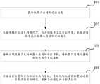
为实现上述目的,本申请实施例提供了一种机器人导航脱困方法,应用于机器人,方法包括:获取机器人当前的定位信息;在检测到定位丢失的情况下,向云端服务上报定位异常,触发云端服务获取机器人当前的定位坐标;接收云端服务下发的机器人当前的定位坐标,将机器人当前位置的坐标更新为定位坐标;根据当前位置的坐标和目标点的坐标,重新规划从当前位置运动到目标点的目标路径,根据目标路径向目标点运动。In order to achieve the above purpose, an embodiment of the present application provides a method for navigating and getting out of trouble for a robot, which is applied to a robot. The method includes: obtaining the current positioning information of the robot; when detecting that the positioning is lost, reporting the positioning abnormality to the cloud service, and triggering the cloud The service obtains the current positioning coordinates of the robot; receives the current positioning coordinates of the robot issued by the cloud service, and updates the coordinates of the current position of the robot to the positioning coordinates; according to the coordinates of the current position and the coordinates of the target point, re-plan the movement from the current position to the target The target path of the point, move to the target point according to the target path.
为实现上述目的,本申请实施例还提出了一种机器人,包括:获取模块,用于获取机器人当前的定位信息;上报模块,用于在检测到定位丢失的情况下,向云端服务上报定位异常,触发云端服务获取机器人当前的定位坐标;接收模块,用于接收云端服务下发的机器人当前的定位坐标,将机器人当前位置的坐标更新为定位坐标;运动模块,用于根据当前位置的坐标和目标点的坐标,重新规划从当前位置运动到目标点的目标路径,根据目标路径向目标点运动。In order to achieve the above purpose, an embodiment of the present application also proposes a robot, including: an acquisition module for acquiring the current positioning information of the robot; a reporting module for reporting the abnormal positioning to the cloud service when the positioning loss is detected , trigger the cloud service to obtain the current positioning coordinates of the robot; the receiving module is used to receive the current positioning coordinates of the robot issued by the cloud service, and update the coordinates of the current position of the robot to the positioning coordinates; the motion module is used according to the coordinates of the current position and The coordinates of the target point, re-plan the target path from the current position to the target point, and move to the target point according to the target path.
为实现上述目的,本申请实施例还提出了一种电子设备,设备包括:至少一个处理器;以及,与至少一个处理器通信连接的存储器;其中,存储器存储有可被至少一个处理器执行的指令,指令被至少一个处理器执行,以使至少一个处理器能够执行如上的机器人导航脱困方法。In order to achieve the above purpose, an embodiment of the present application further provides an electronic device, the device includes: at least one processor; and a memory communicatively connected to the at least one processor; wherein the memory stores an electronic device that can be executed by the at least one processor. Instructions, the instructions are executed by at least one processor, so that the at least one processor can execute the above method for robot navigation and escape.
为实现上述目的,本申请实施例还提出了一种计算机可读存储介质,存储有计算机程序,计算机程序被处理器执行时实现如上的机器人导航脱困方法。To achieve the above purpose, the embodiment of the present application also proposes a computer-readable storage medium storing a computer program, and when the computer program is executed by a processor, the above method for navigating and getting out of trouble for a robot is implemented.
本申请实施例提供的机器人导航脱困方法,在机器人运动过程中,实时获取机器人当前的定位信息,在检测到机器人出现定位异常的情况下,向云端服务上报定位异常,触发云端服务获取机器人当前的定位坐标。机器人接收到云端服务下发的当前的定位坐标后,对自身当前位置的坐标进行更新,并根据更新后的坐标,重新规划一条从当前位置达到目标点的目标路径,然后根据重新规划出的目标路径运动到目标点。通过对当前定位信息进行实时的检测,准确的获取机器人当前的位置,对机器人是否偏离规划路径进行准确的识别;通过在定位丢失的情况下向云端服务上报定位异常,接收到云端服务反馈的当前的定位坐标,根据接收到的定位坐标更新自身的位置,实现对机器人定位异常的准确高效矫正;通过根据更新后的坐标重新规划运动到目标点的目标路径,并根据目标路径向目标点运动,保证机器人能够准确的运动到指定目标点,避免由于定位丢失导致导航任务失败。In the method for navigating and getting out of trouble for a robot provided by the embodiment of the present application, during the movement of the robot, the current positioning information of the robot is obtained in real time, and when it is detected that the robot has a positioning abnormality, the positioning abnormality is reported to the cloud service, and the cloud service is triggered to obtain the current position of the robot. Positioning coordinates. After the robot receives the current positioning coordinates issued by the cloud service, it updates the coordinates of its current position, and according to the updated coordinates, re-plans a target path from the current position to the target point, and then according to the re-planned target The path moves to the target point. Through real-time detection of the current positioning information, the current position of the robot can be accurately obtained, and whether the robot deviates from the planned path can be accurately identified. The positioning coordinates of the robot are updated according to the received positioning coordinates to achieve accurate and efficient correction of the abnormal positioning of the robot; by re-planning the target path to the target point according to the updated coordinates, and moving to the target point according to the target path, Ensure that the robot can move to the specified target point accurately and avoid the failure of the navigation task due to the loss of positioning.
附图说明Description of drawings
一个或多个实施例通过与之对应的附图中的图片进行示例性说明,这些示例性说明并不构成对实施例的限定,附图中具有相同参考数字标号的元件表示为类似的元件,除非有特别申明,附图中的图不构成比例限制。One or more embodiments are exemplified by the pictures in the corresponding drawings, and these exemplifications do not constitute limitations of the embodiments, and elements with the same reference numerals in the drawings are denoted as similar elements, Unless otherwise stated, the figures in the accompanying drawings do not constitute a scale limitation.
图1是本申请实施例中的机器人导航脱困方法的流程图;Fig. 1 is the flow chart of the robot navigation escape method in the embodiment of the present application;
图2是本申请实施例中的机器人沿规划路径运动的状态示意图;2 is a schematic diagram of a state of a robot moving along a planned path in an embodiment of the present application;
图3是本申请实施例中的机器人定位丢失的状态示意图;Fig. 3 is the state schematic diagram of the robot positioning loss in the embodiment of the present application;
图4是本申请实施例中的机器人重定位当前位置后的状态示意图;Fig. 4 is the state schematic diagram after the robot in the embodiment of the present application relocates the current position;
图5是本申请实施例中的机器人导航脱困过程的时序示意图;5 is a schematic time sequence diagram of a robot navigation and escape process in an embodiment of the present application;
图6是本申请另一实施例中的机器人结构示意图;6 is a schematic structural diagram of a robot in another embodiment of the present application;
图7是本申请另一实施例中的电子设备的结构示意图。FIG. 7 is a schematic structural diagram of an electronic device in another embodiment of the present application.
具体实施方式Detailed ways
由背景技术可知,当前的应用场景中存在着大量相似或者近乎相同的环境,面对相似或者相同的环境,在定位丢失后机器人很难完成对当前位置的重定位,进而导致机器人无法准确的完成运动到目标点的任务。因此,如何使机器人能够准确高效的实现定位异常校正,并准确运动到目标点是一个迫切需要得到解决的问题。It can be seen from the background technology that there are a large number of similar or nearly identical environments in the current application scenarios. In the face of similar or identical environments, it is difficult for the robot to complete the repositioning of the current position after the positioning is lost, which in turn makes the robot unable to accurately complete the relocation. The task of moving to the target point. Therefore, how to make the robot can accurately and efficiently realize the correction of positioning anomalies and accurately move to the target point is an urgent problem that needs to be solved.
为了解决上述问题,本申请的部分实施例提供了一种机器人导航脱困方法,应用于机器人,方法包括:获取机器人当前的定位信息;在检测到定位丢失的情况下,向云端服务上报定位异常,触发云端服务获取机器人当前的定位坐标;接收云端服务下发的机器人当前的定位坐标,将机器人当前位置的坐标更新为定位坐标;根据当前位置的坐标和目标点的坐标,重新规划从当前位置运动到目标点的目标路径,根据目标路径向目标点运动。In order to solve the above problems, some embodiments of the present application provide a method for navigating and getting out of trouble for a robot, which is applied to a robot. The method includes: obtaining the current positioning information of the robot; when detecting that the positioning is lost, reporting the positioning abnormality to the cloud service, Trigger the cloud service to obtain the current positioning coordinates of the robot; receive the current positioning coordinates of the robot issued by the cloud service, and update the coordinates of the current position of the robot to the positioning coordinates; re-plan the movement from the current position according to the coordinates of the current position and the coordinates of the target point The target path to the target point, and move to the target point according to the target path.
本申请实施例提供的机器人导航脱困方法,在机器人运动过程中,实时获取机器人当前的定位信息,在检测到机器人出现定位异常的情况下,向云端服务上报定位异常,触发云端服务获取机器人当前的定位坐标。机器人接收到云端服务下发的当前的定位坐标后,对自身当前位置的坐标进行更新,并根据更新后的坐标,重新规划一条从当前位置达到目标点的目标路径,然后根据重新规划出的目标路径运动到目标点。通过对当前定位信息进行实时的检测,准确的获取机器人当前的位置,对机器人是否偏离规划路径进行准确的识别;通过在定位丢失的情况下向云端服务上报定位异常,接收到云端服务反馈的当前的定位坐标,根据接收到的定位坐标更新自身的位置,实现对机器人定位异常的准确高效矫正;通过根据更新后的坐标重新规划运动到目标点的目标路径,并根据目标路径向目标点运动,保证机器人能够准确的运动到指定目标点,避免由于定位丢失导致导航任务失败。In the method for navigating and getting out of trouble for a robot provided by the embodiment of the present application, during the movement of the robot, the current positioning information of the robot is obtained in real time, and when it is detected that the robot has a positioning abnormality, the positioning abnormality is reported to the cloud service, and the cloud service is triggered to obtain the current position of the robot. Positioning coordinates. After the robot receives the current positioning coordinates issued by the cloud service, it updates the coordinates of its current position, and according to the updated coordinates, re-plans a target path from the current position to the target point, and then according to the re-planned target The path moves to the target point. Through real-time detection of the current positioning information, the current position of the robot can be accurately obtained, and whether the robot deviates from the planned path can be accurately identified. The positioning coordinates of the robot are updated according to the received positioning coordinates to achieve accurate and efficient correction of the abnormal positioning of the robot; by re-planning the target path to the target point according to the updated coordinates, and moving to the target point according to the target path, Ensure that the robot can move to the specified target point accurately and avoid the failure of the navigation task due to the loss of positioning.
为使本申请实施例的目的、技术方案和优点更加清楚,下面将结合附图对本申请的各实施例进行详细的阐述。然而,本领域的普通技术人员可以理解,在本申请各实施例中,为了使读者更好地理解本申请而提出了许多技术细节。但是,即使没有这些技术细节和基于以下各实施例的种种变化和修改,也可以实现本申请所要求保护的技术方案。以下各个实施例的划分是为了描述方便,不应对本申请的具体实现方式构成任何限定,各个实施例在不矛盾的前提下可以相互结合相互引用。In order to make the objectives, technical solutions and advantages of the embodiments of the present application more clear, each embodiment of the present application will be described in detail below with reference to the accompanying drawings. However, those of ordinary skill in the art can understand that, in each embodiment of the present application, many technical details are provided for the reader to better understand the present application. However, even without these technical details and various changes and modifications based on the following embodiments, the technical solutions claimed in the present application can be realized. The following divisions of the various embodiments are for the convenience of description, and should not constitute any limitation on the specific implementation of the present application, and the various embodiments may be combined with each other and referred to each other on the premise of not contradicting each other.
下面将结合具体的实施例的对本申请记载的机器人导航脱困方法的实现细节进行具体的说明,以下内容仅为方便理解提供的实现细节,并非实施本方案的必须。The implementation details of the robot navigation and escape method described in the present application will be described in detail below with reference to specific embodiments. The following content is only provided for the convenience of understanding and is not necessary for implementing this solution.
本申请实施例的第一方面提供了一种机器人导航脱困方法,应用于具有导航运动到指定位置功能的多种机器人,机器人导航脱困方法的流程图参考图1,包括以下步骤:A first aspect of the embodiments of the present application provides a method for navigating and getting out of trouble for a robot, which is applied to a variety of robots with the function of navigating to a specified position. Refer to FIG. 1 for a flowchart of the method for navigating and getting out of trouble for a robot, including the following steps:
步骤101,获取机器人当前的定位信息。Step 101: Obtain the current positioning information of the robot.
具体地说,机器人在投入使用后,与负责机器人调度、管理、监控和信息存储的云端服务进行通信连接,接收云端任务为机器人分配的任务。机器人接收到云端服务的任务指令后,根据任务指令确定导航运动的目标点,然后对当前所处的场景进行扫描,构建当前场景的全局静态地图,地图中包含多种环境信息,例如,可行走路径(地面)、物理边界(墙壁、门、障碍物等)、虚拟边界(高危地区、非工作区等)、目标点(窗台、门口、办公室等)。在完成全局静态地图(第一地图)的构建后,机器人本地存储一份全局静态地图用于路径规划和行走过程中的实时匹配,另外,机器人还向云端服务上传扫描出的全局静态地图,对全局静态地图进行备份的同时,便于后续对机器人位置进行监控和管理。在完成全局静态地图的生成后,机器人根据自身当前的位置以及目标点的位置,在全局静态地图中对从当前位置运动到目标点的路径进行全局路径规划,生成到达目标点的规划路径,然后沿规划路径向目标点运动。在运动向目标点的过程中,机器人实时扫描当前场景,结合预先存储的全局静态地图,分析并获取自身当前的定位信息。通过对运动中的机器人进行位姿跟踪,对机器人是否偏离规划路径进行准确的检测。Specifically, after the robot is put into use, it communicates with the cloud service responsible for robot scheduling, management, monitoring and information storage, and receives tasks assigned to the robot by cloud tasks. After the robot receives the task command from the cloud service, it determines the target point of the navigation movement according to the task command, and then scans the current scene to build a global static map of the current scene. The map contains various environmental information, such as walking Paths (ground), physical boundaries (walls, doors, obstacles, etc.), virtual boundaries (high-risk areas, non-work areas, etc.), target points (windowsills, doorways, offices, etc.). After completing the construction of the global static map (the first map), the robot locally stores a global static map for real-time matching during path planning and walking. In addition, the robot also uploads the scanned global static map to the cloud service. While the global static map is backed up, it is convenient for subsequent monitoring and management of the robot position. After completing the generation of the global static map, the robot performs global path planning on the path from the current position to the target point in the global static map according to its current position and the position of the target point, and generates a planned path to the target point, and then Move to the target point along the planned path. In the process of moving to the target point, the robot scans the current scene in real time, and combines with the pre-stored global static map to analyze and obtain its current positioning information. By tracking the pose of the robot in motion, it can accurately detect whether the robot deviates from the planned path.
步骤102,在检测到定位丢失的情况下,向云端服务上报定位异常,触发云端服务获取机器人当前的定位坐标。
具体地说,机器人在根据规划路径向目标点运动的过程中,可以实时获取或者每间隔预设时长周期性的获取机器人当前的定位信息,对自身的定位情况进行检测。机器人在当前定位信息对应的当前坐标偏离出了规划路径的情况下,判定自身发生了定位丢失,在检测到定位丢失的情况下,向通信连接的云端服务上报定位异常,触发云端服务获取机器人当前的定位坐标。Specifically, in the process of moving to the target point according to the planned path, the robot can obtain the current positioning information of the robot in real time or periodically at preset time intervals, and detect its own positioning. When the current coordinate corresponding to the current positioning information deviates from the planned path, the robot determines that it has lost its positioning. When it detects that the positioning is lost, it reports the positioning abnormality to the cloud service connected to the communication, and triggers the cloud service to obtain the current position of the robot. the positioning coordinates.
在一个例子中,机器人获取当前的定位信息,包括:扫描当前场景,获取动态地图;根据预设算法对动态地图和预先获取的全局静态地图进行匹配,获取定位信息;在检测到定位丢失的情况下,向云端服务上报定位异常,包括:在根据动态地图和全局静态地图的匹配结果判定定位丢失的情况下,向云端服务上报定位异常。In one example, the robot obtains the current positioning information, including: scanning the current scene to obtain a dynamic map; matching the dynamic map with a pre-acquired global static map according to a preset algorithm to obtain the positioning information; when detecting that the positioning is lost Next, reporting the positioning abnormality to the cloud service includes: reporting the positioning abnormality to the cloud service when it is determined that the positioning is lost according to the matching result between the dynamic map and the global static map.
具体地说,机器人在根据规划路径向目标点运动的过程中,获取当前定位信息时,可以实时扫描当前场景,构建当前场景的动态地图,动态地图中可以包含场景中的环境信息,例如行走路径、物理边界、障碍物等。在获取到动态地图后,根据预设的地图匹配算法对获取到的动态地图和预先存储的全局静态地图进行匹配,获取当前动态地图属于全局静态地图中的哪一部分。进而确定动态地图的中心点坐标,将中心点坐标作为机器人当前位置的坐标,从而获取到机器人当前的定位信息。在根据动态地图和静态地图的匹配结果判定定位丢失的情况下,向云端服务上报定位异常。通过匹配动态地图和全局静态地图的关系,准确的对机器人当前的定位信息进行提取,实现对机器人当前位置的精确跟踪。Specifically, in the process of moving to the target point according to the planned path, when the robot obtains the current positioning information, it can scan the current scene in real time and build a dynamic map of the current scene. The dynamic map can contain environmental information in the scene, such as the walking path. , physical boundaries, obstacles, etc. After the dynamic map is acquired, the acquired dynamic map is matched with the pre-stored global static map according to a preset map matching algorithm, to obtain which part of the global static map the current dynamic map belongs to. Then, the coordinates of the center point of the dynamic map are determined, and the coordinates of the center point are used as the coordinates of the current position of the robot, so as to obtain the current positioning information of the robot. If it is determined that the positioning is lost according to the matching result between the dynamic map and the static map, the abnormal positioning is reported to the cloud service. By matching the relationship between the dynamic map and the global static map, the current positioning information of the robot is accurately extracted, and the precise tracking of the current position of the robot is realized.
进一步地,机器人在根据动态地图和全局静态地图的匹配结果判定定位丢失的情况下,向云端服务上报定位异常,包括:在动态地图和全局静态地图无法匹配,或动态地图和全局静态地图匹配结果的置信度低于预设门限的情况下,判定定位丢失,向云端服务上报定位异常。具体地说,机器人在根据地图匹配算法对动态地图和全局静态地图进行匹配后,可能无法计算出动态地图具体属于静态地图的哪一部分,此时机器人判定自身已经偏离了规划路径,向云端服务上报定位异常;在获取到动态地图的中心点坐标或者动态地图属于全局静态地图的哪一部分后,机器人还可以对匹配的结果或者中心点坐标进行置信度计算,在得到的置信度计算结果低于预设门限的情况下,判定匹配失败,向云端服务上报定位异常。通过在动态地图和全局静态地图无法匹配或者匹配程度不理想的情况下,判定定位丢失并上报定位异常,进一步提升机器人对自身是否发生定位丢失的判断能力,尽可能避免无法识别到发生定位丢失的情况。Further, when the robot determines that the positioning is lost according to the matching result of the dynamic map and the global static map, it reports the positioning abnormality to the cloud service, including: the dynamic map and the global static map cannot be matched, or the dynamic map and the global static map match results. When the confidence level of the data is lower than the preset threshold, it is determined that the positioning is lost, and the abnormal positioning is reported to the cloud service. Specifically, after the robot matches the dynamic map and the global static map according to the map matching algorithm, it may not be able to calculate which part of the static map the dynamic map belongs to. At this time, the robot determines that it has deviated from the planned path and reports to the cloud service. The positioning is abnormal; after obtaining the coordinates of the center point of the dynamic map or which part of the global static map the dynamic map belongs to, the robot can also perform confidence calculation on the matching result or the coordinates of the center point. If the threshold is set, it is determined that the matching fails, and the location abnormality is reported to the cloud service. When the dynamic map and the global static map cannot be matched or the degree of matching is not ideal, it can determine the loss of positioning and report the abnormal positioning, which further improves the robot's ability to judge whether the positioning loss has occurred, and try to avoid the failure to identify the loss of positioning. Happening.
另外,机器人在初次检测到定位丢失的情况下,还可以暂不上报定位异常,先根据动态地图和全局静态地图对机器人当前所处的位置进行全局定位。在无法获取机器人在全局静态地图中的位置或者获取到的定位坐标的置信度较低的时候,再向云端服务上报定位异常,从而尽可能地降低云端服务的负担。In addition, when the robot detects that the positioning is lost for the first time, it can temporarily not report the positioning abnormality, and first perform global positioning of the current position of the robot according to the dynamic map and the global static map. When the position of the robot in the global static map cannot be obtained or the confidence of the obtained positioning coordinates is low, the abnormal positioning is reported to the cloud service, thereby reducing the burden of the cloud service as much as possible.
在另一个例子中,机器人在向云端服务上报定位异常后,还包括:向云端服务上传动态地图和实时环境数据,供云端服务将预先获取的全局静态地图、动态地图和实时环境数据展示给运营人员,根据运营人员的输入指令获取机器人当前的定位坐标。具体地说,机器人在向云端服务上报定位异常,触发云端服务获取机器人当前的作为坐标后,云端服务通过机器人获取当前扫描出的动态地图和包含机器人周边环境信息的实时环境数据,然后云端服务向运营人员发起告警或者通知,指示运营人员对发生定位丢失的机器人进行人工辅助管理。运营人员在接收到云端服务的提示或者指令后,通过云端服务提供的管理平台,查看机器人预先上传的全局静态地图、当前的动态地图和机器人周边的实时环境数据,并对机器人当前所处的位置进行分析。根据人工分析的结果,确定出机器人当前的定位坐标,然后再云端服务的管理平台通过输入指令将分析出的定位坐标输入到云端服务中。云端服务获取管理人员的输入指令后,对输入指令进行解析,获取机器人当前的定位坐标。通过人工介入的方式,结合预先存储的全局静态地图和实时获取的动态地图以及环境数据,对机器人当前的定位坐标进行分析,高效准确的确定出发生定位丢失的机器人当前的定位坐标。进一步地,机器人在向云端服务上传动态地图和实时环境数据前,还包括:采集实时环境信息,生成包含环境信息的视频数据,将视频数据作为实时环境数据。具体地说,机器人在进行环境数据上传前,可以充当自身眼睛摄像机或者自身携带的视觉模块对周边的实时环境信息进行采集,生成包含周边环境信息的视频,然后将生成的视频作为实时环境数据上传到云端服务。通过视觉模块采集周边的环境信息并生成包含周边环境信息的视频,便于云端服务将实时环境数据生动有效的展示给运营人员,便于运营人员获取机器人周边环境信息,提高运营人员分析机器人当前定位坐标的效率。In another example, after the robot reports the positioning abnormality to the cloud service, the method further includes: uploading the dynamic map and real-time environment data to the cloud service, so that the cloud service can display the pre-acquired global static map, dynamic map and real-time environment data to the operation personnel, obtain the current positioning coordinates of the robot according to the input instructions of the operator. Specifically, after the robot reports the positioning anomaly to the cloud service and triggers the cloud service to obtain the current coordinates of the robot, the cloud service obtains the currently scanned dynamic map and real-time environment data containing information about the surrounding environment of the robot through the robot, and then the cloud service sends the robot to the cloud service. The operator initiates an alarm or notification, instructing the operator to manually assist the management of the robot that has lost its positioning. After receiving the prompts or instructions from the cloud service, the operator can view the global static map pre-uploaded by the robot, the current dynamic map and the real-time environmental data around the robot through the management platform provided by the cloud service, and have a good understanding of the current position of the robot. analysis. According to the results of manual analysis, the current positioning coordinates of the robot are determined, and then the management platform of the cloud service inputs the analyzed positioning coordinates into the cloud service by inputting instructions. After the cloud service obtains the input command from the administrator, it parses the input command to obtain the current positioning coordinates of the robot. Through manual intervention, combined with the pre-stored global static map and real-time acquired dynamic map and environmental data, the current positioning coordinates of the robot are analyzed, and the current positioning coordinates of the robot that has lost positioning can be determined efficiently and accurately. Further, before uploading the dynamic map and real-time environmental data to the cloud service, the robot further includes: collecting real-time environmental information, generating video data including the environmental information, and using the video data as the real-time environmental data. Specifically, before the robot uploads the environmental data, it can act as its own eye camera or its own vision module to collect the surrounding real-time environmental information, generate a video containing the surrounding environmental information, and then upload the generated video as real-time environmental data. to cloud services. The visual module collects the surrounding environment information and generates a video containing the surrounding environment information, so that the cloud service can vividly and effectively display the real-time environment data to the operators, so that the operators can obtain the information of the surrounding environment of the robot, and improve the ability of the operators to analyze the current positioning coordinates of the robot. efficiency.
更进一步地,机器人根据云端服务下发地指令获取到的当前的定位坐标为,运营人员根据实时环境数据获取机器人的初始定位坐标后,根据动态地图和静态地图的匹配程度,对初始定位坐标进行修正后得到的坐标。也就是说,机器人将包含自身周边实时环境数据的视频流上传到云端服务后,运营人员在云端服务的后台根据视频流确定机器人在静态地图中的大致位置,得到初始定位坐标。然后,运营人员再结合静态地图和动态地图的匹配程度,例如,动态地图是通过激光雷达扫描的方式获取的,则根据激光雷达点数据和静态地图信息的匹配程度,对初始定位坐标进行修正,得到更加精确的坐标,并将修正后的坐标作为机器人当前的定位坐标输入到云端服务,通过云端指令将当前的定位坐标下发给机器人。通过根据视频流进行粗略定位,再根据动态地图和静态地图的匹配程度进行精确定位,使得机器人能够接收到精确的当前定位坐标。Further, the current positioning coordinates obtained by the robot according to the instructions issued by the cloud service are: After the operator obtains the initial positioning coordinates of the robot according to the real-time environment data, the initial positioning coordinates are determined according to the matching degree between the dynamic map and the static map. Corrected coordinates. That is to say, after the robot uploads the video stream containing its surrounding real-time environment data to the cloud service, the operator determines the approximate position of the robot in the static map based on the video stream in the background of the cloud service, and obtains the initial positioning coordinates. Then, the operator combines the matching degree between the static map and the dynamic map. For example, if the dynamic map is obtained by lidar scanning, the initial positioning coordinates are corrected according to the matching degree between the lidar point data and the static map information. Get more accurate coordinates, and input the corrected coordinates as the current positioning coordinates of the robot to the cloud service, and send the current positioning coordinates to the robot through cloud commands. By performing rough positioning according to the video stream, and then performing precise positioning according to the matching degree between the dynamic map and the static map, the robot can receive the precise current positioning coordinates.
步骤103,接收云端服务下发的机器人当前的定位坐标,将机器人当前位置的坐标更新为定位坐标。Step 103: Receive the current positioning coordinates of the robot issued by the cloud service, and update the coordinates of the current position of the robot to the positioning coordinates.
具体地说,机器人在向云端服务上报定位异常后,触发云端服务获取机器人当前的定位坐标,云端服务在得到机器人当前的定位坐标后,会将定位坐标下发给机器人,供机器人根据接收到的定位坐标重新对自身所处位置进行定位。然后,机器人接收云端服务下发的机器人当前的定位坐标,然后重新将获取到的动态地图和定位坐标进行匹配,将机器人当前位置的坐标更新为定位坐标。Specifically, after the robot reports the positioning abnormality to the cloud service, it triggers the cloud service to obtain the current positioning coordinates of the robot. After the cloud service obtains the current positioning coordinates of the robot, it will send the positioning coordinates to the robot for the robot to receive The positioning coordinates re-position the position where it is. Then, the robot receives the current positioning coordinates of the robot issued by the cloud service, and then re-matches the obtained dynamic map with the positioning coordinates, and updates the coordinates of the current position of the robot to the positioning coordinates.
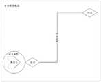
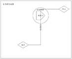
例如,机器人在沿规划路径向目标点运动的状态示意图如图2所示,机器人在全局静态地图中完成了从当前位置(起点)运动到目标点(终点)的路径规划,然后开始从当前位置向目标点运动,此时机器人根据动态地图和全局静态地图的匹配结果识别到自身处于规划路径的起点,则按照规划路径向目标点运动。机器人在运动过程中定位丢失的状态示意图如图3所示,机器人在沿规划路径向目标点运动的过程中,运动到规划路径上的某一位置后,根据动态地图和全局静态地图的匹配结果识别到自身处于规划路径之外,此时,机器人向云端服务上报定位异常,触发云端服务获取机器人当前的定位坐标。云端服务将机器人上传的动态地图、实时环境数据和预存的全局静态地图展示给运营人员,根据运营人员的指令获取机器人当前的定位坐标后,将机器人当前的定位坐标下发给机器人。机器人接收到定位坐标后,重新将第二地图和第一地图中的定位坐标进行匹配,然后将当前位置的坐标更新为定位坐标。机器人完成重定位当前位置后的状态示意图如图4所示,云端服务下发的定位坐标为一个在规划路径上的坐标,机器人将自身存储的当前位置更新为定位坐标对应的位置,准确的实现定位丢失后的重定位。For example, the state diagram of the robot moving to the target point along the planned path is shown in Figure 2. The robot completes the path planning from the current position (starting point) to the target point (end point) in the global static map, and then starts from the current position. Move to the target point. At this time, the robot recognizes that it is at the starting point of the planned path according to the matching results of the dynamic map and the global static map, and then moves to the target point according to the planned path. Figure 3 shows a schematic diagram of the state where the robot loses its positioning during the movement process. During the movement of the robot to the target point along the planned path, after moving to a certain position on the planned path, according to the matching results of the dynamic map and the global static map It recognizes that it is outside the planned path. At this time, the robot reports the positioning abnormality to the cloud service, and triggers the cloud service to obtain the current positioning coordinates of the robot. The cloud service displays the dynamic map, real-time environment data and pre-stored global static map uploaded by the robot to the operator. After obtaining the robot's current positioning coordinates according to the operator's instructions, it sends the robot's current positioning coordinates to the robot. After receiving the positioning coordinates, the robot re-matches the positioning coordinates in the second map and the first map, and then updates the coordinates of the current position to the positioning coordinates. The state diagram of the robot after relocating the current position is shown in Figure 4. The positioning coordinates issued by the cloud service are coordinates on the planned path, and the robot updates the current position stored by itself to the position corresponding to the positioning coordinates. Relocation after location loss.
另外,机器人在接收到云端服务下发的当前定位坐标后,还可以通过自身携带的传感器进一步获取自身周边的地图信息,然后结合控制模块中的最优化算法,对接收到的当前定位坐标进行进一步的修正,得到更加精确的定位位姿,然后还可以将得到的定位位姿上传到云端服务,实现云端服务和机器人端的超高精度重定位。In addition, after receiving the current positioning coordinates issued by the cloud service, the robot can further obtain map information around itself through its own sensors, and then combine the optimization algorithm in the control module to further the received current positioning coordinates. Then, the obtained positioning pose can be uploaded to the cloud service to realize ultra-high-precision relocation of the cloud service and the robot.
步骤104,根据当前位置的坐标和目标点的坐标,重新规划从当前位置运动到目标点的目标路径,根据目标路径向目标点运动。Step 104: According to the coordinates of the current position and the coordinates of the target point, re-plan the target path for moving from the current position to the target point, and move to the target point according to the target path.
具体地说,机器人根据云端服务下发的定位坐标对自身当前位置的坐标进行更新后,还可以检测自身是否处于最初规划的路径上,在检测到自身不处于最初规划的路径上时,结合当前位置的坐标和目标点的坐标,在预存的全局静态地图中重新规划从当前位置运动到目标点的目标路径,然后沿着目标路径向目标点运动,直到到达目标点;在检测到自身当前位置处于最初规划的路径上时,可以直接按照最初规划的路径继续向目标点运动,直到到达目标点。Specifically, after the robot updates the coordinates of its current position according to the positioning coordinates issued by the cloud service, it can also detect whether it is on the originally planned path. The coordinates of the position and the coordinates of the target point, re-plan the target path from the current position to the target point in the pre-stored global static map, and then move to the target point along the target path until reaching the target point; after detecting its current position When it is on the originally planned path, it can continue to move to the target point directly according to the originally planned path until it reaches the target point.
在一个例子中,机器人根据目标路径向目标点运动,包括:检测预设区域中是否存在障碍物;在预设区域中存在障碍物的情况下,进行局部路径规划,根据局部路径规划的结果绕过所碍物后,回到目标路径并移动至目标点。具体地说,机器人在沿规划好的目标路径向目标点运动的过程中,利用构建的动态地图,检测机器人前方预设区域或者周边预设区域内是否存在障碍物。在预设区域内存在障碍物的情况下,采用局部路径规划的方式,规划一条绕过障碍物并重新回到目标路径的局部路径,机器人根据局部路径规划的结果,沿局部路径绕过障碍物后回到目标路径,然后继续沿目标路径向目标点运动。通过局部路径规划的方式避免机器人受障碍物阻挡而无法运动到目标点,同时避免机器人撞向障碍物带来的安全隐患。In one example, the robot moves to the target point according to the target path, including: detecting whether there is an obstacle in the preset area; if there is an obstacle in the preset area, performing local path planning, and circling around according to the result of the local path planning After passing the obstacle, return to the target path and move to the target point. Specifically, in the process of moving toward the target point along the planned target path, the robot uses the constructed dynamic map to detect whether there are obstacles in the preset area in front of the robot or in the surrounding preset area. When there is an obstacle in the preset area, the local path planning method is used to plan a local path that bypasses the obstacle and returns to the target path. The robot bypasses the obstacle along the local path according to the result of the local path planning. Then return to the target path, and then continue to move along the target path to the target point. By means of local path planning, the robot is prevented from being blocked by obstacles and cannot move to the target point, and at the same time, the safety hazards caused by the robot hitting obstacles are avoided.
在另一个例子中,机器人在检测预设区域中是否存在障碍物后,还包括:在预设区域中存在障碍物的情况下,将障碍物所在区域标识为禁止通行区域,重新规划从当前位置到达目标点的目标路径。具体地说,机器人利用构建的动态地图检测到预设区域中存在障碍物的情况下,根据障碍物的轮廓和体积,在预先存储的全局静态地图中将障碍物所在的区域标识为禁止通行区域,然后在全局静态地图中重新规划出一条从当前位置到达目标点的新的目标路径,然后沿着新的目标路径向目标点运动。通过目标路径重规划的方式避免机器人受障碍物阻挡而无法运动到目标点,同时避免机器人撞向障碍物带来的安全隐患。In another example, after detecting whether there is an obstacle in the preset area, the robot further includes: if there is an obstacle in the preset area, marking the area where the obstacle is located as a prohibited area, and re-planning from the current position The target path to reach the target point. Specifically, when the robot detects that there is an obstacle in the preset area using the constructed dynamic map, according to the outline and volume of the obstacle, the area where the obstacle is located is marked as a prohibited area in the pre-stored global static map. , and then re-plan a new target path from the current position to the target point in the global static map, and then move to the target point along the new target path. The target path is re-planned to prevent the robot from being blocked by obstacles and unable to move to the target point, and to avoid potential safety hazards caused by the robot hitting obstacles.
综上,机器人根据云端服务下发的任务运动到目标点过程中,导航脱困过程的时序示意图如图5所示,机器人接受云端服务下发的任务,然后根据接收到的任务进行路径规划,根据规划路径向目标点运动,并对自身进行位姿跟踪。在检测到定位丢失并且重定位无效的情况下,向云端服务上报定位异常。云端服务接收到机器人上报的定位异常后,向运营人员发起告警通知。然后接收机器人上传的动态地图和实时环境信息,并将全局静态地图、动态地图和实时环境信息展示给运营人员,供运营人员分析出机器人当前的定位坐标。然后接收运营人员输入的定位坐标,并将定位坐标下发给机器人。机器人接收到新的定位坐标后,重新对自身在静态地图中的位置进行定位,并重新规划达到目标点的目标路径,沿目标路径向目标点运动。从而高效准确的解决定位丢失导致机器人无法运动到目标点的问题。To sum up, when the robot moves to the target point according to the task issued by the cloud service, the sequence diagram of the navigation and escape process is shown in Figure 5. The robot accepts the task issued by the cloud service, and then performs path planning according to the received task. The planned path moves to the target point and tracks the pose of itself. When it is detected that the location is lost and the relocation is invalid, the location exception is reported to the cloud service. After receiving the abnormal positioning reported by the robot, the cloud service sends an alarm notification to the operator. Then, it receives the dynamic map and real-time environmental information uploaded by the robot, and displays the global static map, dynamic map and real-time environmental information to the operator, so that the operator can analyze the current positioning coordinates of the robot. Then receive the positioning coordinates input by the operator, and send the positioning coordinates to the robot. After the robot receives the new positioning coordinates, it re-positions itself in the static map, re-plans the target path to reach the target point, and moves to the target point along the target path. Thereby, the problem that the robot cannot move to the target point due to the loss of positioning can be solved efficiently and accurately.
此外,应当理解的是,上面各种方法的步骤划分,只是为了描述清楚,实现时可以合并为一个步骤或者对某些步骤进行拆分,分解为多个步骤,只要包括相同的逻辑关系,都在本专利的保护范围内;对算法中或者流程中添加无关紧要的修改或者引入无关紧要的设计,但不改变其算法和流程的核心设计都在该专利的保护范围内。In addition, it should be understood that the division of steps of the various methods above is only for the purpose of describing clearly, and can be combined into one step or split into some steps during implementation, and decomposed into multiple steps, as long as the same logical relationship is included, all Within the protection scope of this patent; adding insignificant modifications to the algorithm or process or introducing insignificant designs, but not changing the core design of the algorithm and process are all within the protection scope of this patent.
本申请实施例的另一方面涉及一种机器人,机器人结构示意图如图6所示,包括:Another aspect of the embodiments of the present application relates to a robot, and a schematic structural diagram of the robot is shown in FIG. 6 , including:
获取模块601,用于获取机器人当前的定位信息。The obtaining
上报模块602,用于在检测到定位丢失的情况下,向云端服务上报定位异常,触发云端服务获取机器人当前的定位坐标。The
接收模块603,用于接收云端服务下发的机器人当前的定位坐标,将机器人当前位置的坐标更新为定位坐标。The receiving
运动模块604,用于根据当前位置的坐标和目标点的坐标,重新规划从当前位置运动到目标点的目标路径,根据目标路径向目标点运动。The
不难发现,本实施例为与方法实施例相对应的装置实施例,本实施例可与方法实施例互相配合实施。方法实施例中提到的相关技术细节在本实施例中依然有效,为了减少重复,这里不再赘述。相应地,本实施例中提到的相关技术细节也可应用在方法实施例中。It is not difficult to find that this embodiment is an apparatus embodiment corresponding to the method embodiment, and this embodiment can be implemented in cooperation with the method embodiment. The related technical details mentioned in the method embodiment are still valid in this embodiment, and are not repeated here in order to reduce repetition. Correspondingly, the relevant technical details mentioned in this embodiment can also be applied to the method embodiments.
值得一提的是,本实施例中所涉及到的各模块均为逻辑模块,在实际应用中,一个逻辑单元可以是一个物理单元,也可以是一个物理单元的一部分,还可以以多个物理单元的组合实现。此外,为了突出本申请的创新部分,本实施例中并没有将与解决本申请所提出的技术问题关系不太密切的单元引入,但这并不表明本实施例中不存在其它的单元。It is worth mentioning that all the modules involved in this embodiment are logical modules. In practical applications, a logical unit may be a physical unit, a part of a physical unit, or multiple physical units. A composite implementation of the unit. In addition, in order to highlight the innovative part of the present application, this embodiment does not introduce units that are not closely related to solving the technical problem raised by the present application, but this does not mean that there are no other units in this embodiment.
本申请实施例的另一方面还提供了一种电子设备,参考图7,包括:包括至少一个处理器701;以及,与至少一个处理器701通信连接的存储器702;其中,存储器702存储有可被至少一个处理器701执行的指令,指令被至少一个处理器701执行,以使至少一个处理器701能够执行上述任一方法实施例所描述的机器人导航脱困方法。Another aspect of the embodiments of the present application further provides an electronic device, referring to FIG. 7 , comprising: at least one
其中,存储器702和处理器701采用总线方式连接,总线可以包括任意数量的互联的总线和桥,总线将一个或多个处理器701和存储器702的各种电路连接在一起。总线还可以将诸如外围设备、稳压器和功率管理电路等之类的各种其他电路连接在一起,这些都是本领域所公知的,因此,本文不再对其进行进一步描述。总线接口在总线和收发机之间提供接口。收发机可以是一个元件,也可以是多个元件,比如多个接收器和发送器,提供用于在传输介质上与各种其他装置通信的单元。经处理器701处理的数据通过天线在无线介质上进行传输,进一步,天线还接收数据并将数据传输给处理器701。The
处理器701负责管理总线和通常的处理,还可以提供各种功能,包括定时,外围接口,电压调节、电源管理以及其他控制功能。而存储器702可以被用于存储处理器701在执行操作时所使用的数据。
本申请实施例的另一方面还提供了一种计算机可读存储介质,存储有计算机程序。计算机程序被处理器执行时实现上述方法实施例。Another aspect of the embodiments of the present application further provides a computer-readable storage medium storing a computer program. The above method embodiments are implemented when the computer program is executed by the processor.
即,本领域技术人员可以理解,实现上述实施例方法中的全部或部分步骤是可以通过程序来指令相关的硬件来完成,该程序存储在一个存储介质中,包括若干指令用以使得一个设备(可以是单片机,芯片等)或处理器(processor)执行本申请各个实施例所述方法的全部或部分步骤。而前述的存储介质包括:U盘、移动硬盘、只读存储器(ROM,Read-OnlyMemory)、随机存取存储器(RAM,Random Access Memory)、磁碟或者光盘等各种可以存储程序代码的介质。That is, those skilled in the art can understand that all or part of the steps in the method for implementing the above embodiments can be completed by instructing the relevant hardware through a program, and the program is stored in a storage medium and includes several instructions to make a device ( It may be a single chip microcomputer, a chip, etc.) or a processor (processor) to execute all or part of the steps of the methods described in the various embodiments of the present application. The aforementioned storage medium includes: U disk, removable hard disk, Read-Only Memory (ROM, Read-Only Memory), Random Access Memory (RAM, Random Access Memory), magnetic disk or optical disk and other media that can store program codes.
本领域的普通技术人员可以理解,上述各实施例是实现本申请的具体实施例,而在实际应用中,可以在形式上和细节上对其作各种改变,而不偏离本申请的精神和范围。Those of ordinary skill in the art can understand that the above-mentioned embodiments are specific embodiments for realizing the present application, and in practical applications, various changes in form and details can be made without departing from the spirit and the spirit of the present application. scope.
Claims (11)
Translated fromChinesePriority Applications (1)
| Application Number | Priority Date | Filing Date | Title |
|---|---|---|---|
| CN202111242277.1ACN115220438A (en) | 2021-10-25 | 2021-10-25 | Robot navigation escaping method, robot, electronic device and storage medium |
Applications Claiming Priority (1)
| Application Number | Priority Date | Filing Date | Title |
|---|---|---|---|
| CN202111242277.1ACN115220438A (en) | 2021-10-25 | 2021-10-25 | Robot navigation escaping method, robot, electronic device and storage medium |
Publications (1)
| Publication Number | Publication Date |
|---|---|
| CN115220438Atrue CN115220438A (en) | 2022-10-21 |
Family
ID=83606573
Family Applications (1)
| Application Number | Title | Priority Date | Filing Date |
|---|---|---|---|
| CN202111242277.1APendingCN115220438A (en) | 2021-10-25 | 2021-10-25 | Robot navigation escaping method, robot, electronic device and storage medium |
Country Status (1)
| Country | Link |
|---|---|
| CN (1) | CN115220438A (en) |
Cited By (3)
| Publication number | Priority date | Publication date | Assignee | Title |
|---|---|---|---|---|
| CN116125986A (en)* | 2023-01-12 | 2023-05-16 | 深圳拓邦股份有限公司 | Path display method and device of mobile robot, mobile robot and medium |
| CN116901072A (en)* | 2023-08-01 | 2023-10-20 | 星迈创新科技(苏州)有限公司 | Control method of pool robot, storage medium and pool robot |
| CN117589154A (en)* | 2024-01-19 | 2024-02-23 | 深圳竹芒科技有限公司 | Relocation method from mobile device, mobile device and readable storage medium |
Citations (15)
| Publication number | Priority date | Publication date | Assignee | Title |
|---|---|---|---|---|
| US20100324773A1 (en)* | 2007-06-28 | 2010-12-23 | Samsung Electronics Co., Ltd. | Method and apparatus for relocating mobile robot |
| CN103308047A (en)* | 2013-05-10 | 2013-09-18 | 杭州师范大学 | Mobile robot positioning method with artificial on-line modification function |
| CN107402567A (en)* | 2016-05-19 | 2017-11-28 | 科沃斯机器人股份有限公司 | Assembly robot and its cruise path generating method |
| CN107600067A (en)* | 2017-09-08 | 2018-01-19 | 中山大学 | A kind of autonomous parking system and method based on more vision inertial navigation fusions |
| CN108225362A (en)* | 2017-12-29 | 2018-06-29 | 驭势科技(北京)有限公司 | Intelligent driving vehicle positioning method and system, computer storage media and positioning device |
| CN108549385A (en)* | 2018-05-22 | 2018-09-18 | 东南大学 | A kind of Robotic Dynamic paths planning method of combination A* algorithms and VFH obstacle avoidance algorithms |
| CN109655075A (en)* | 2019-01-16 | 2019-04-19 | 北京百度网讯科技有限公司 | Unmanned vehicle localization method and equipment |
| WO2019190395A1 (en)* | 2018-03-28 | 2019-10-03 | Agency For Science, Technology And Research | Method and system for returning a displaced autonomous mobile robot to its navigational path |
| CN110986967A (en)* | 2019-12-20 | 2020-04-10 | 上海有个机器人有限公司 | Robot automatic repositioning method, medium, terminal and device |
| CN111077495A (en)* | 2019-12-10 | 2020-04-28 | 亿嘉和科技股份有限公司 | Positioning recovery method based on three-dimensional laser |
| CN111220164A (en)* | 2020-01-21 | 2020-06-02 | 北京百度网讯科技有限公司 | Positioning method, device, equipment and storage medium |
| CN111486849A (en)* | 2020-05-29 | 2020-08-04 | 北京大学 | A mobile visual navigation method and system based on two-dimensional code road signs |
| CN112650242A (en)* | 2020-12-22 | 2021-04-13 | 天津理工大学 | Mobile robot path planning method based on hybrid algorithm |
| CN113448327A (en)* | 2020-03-27 | 2021-09-28 | 南京苏美达智能技术有限公司 | Operation control method of automatic walking equipment and automatic walking equipment |
| CN113478488A (en)* | 2021-07-14 | 2021-10-08 | 上海擎朗智能科技有限公司 | Robot repositioning method and device, electronic equipment and storage medium |
- 2021
- 2021-10-25CNCN202111242277.1Apatent/CN115220438A/enactivePending
Patent Citations (15)
| Publication number | Priority date | Publication date | Assignee | Title |
|---|---|---|---|---|
| US20100324773A1 (en)* | 2007-06-28 | 2010-12-23 | Samsung Electronics Co., Ltd. | Method and apparatus for relocating mobile robot |
| CN103308047A (en)* | 2013-05-10 | 2013-09-18 | 杭州师范大学 | Mobile robot positioning method with artificial on-line modification function |
| CN107402567A (en)* | 2016-05-19 | 2017-11-28 | 科沃斯机器人股份有限公司 | Assembly robot and its cruise path generating method |
| CN107600067A (en)* | 2017-09-08 | 2018-01-19 | 中山大学 | A kind of autonomous parking system and method based on more vision inertial navigation fusions |
| CN108225362A (en)* | 2017-12-29 | 2018-06-29 | 驭势科技(北京)有限公司 | Intelligent driving vehicle positioning method and system, computer storage media and positioning device |
| WO2019190395A1 (en)* | 2018-03-28 | 2019-10-03 | Agency For Science, Technology And Research | Method and system for returning a displaced autonomous mobile robot to its navigational path |
| CN108549385A (en)* | 2018-05-22 | 2018-09-18 | 东南大学 | A kind of Robotic Dynamic paths planning method of combination A* algorithms and VFH obstacle avoidance algorithms |
| CN109655075A (en)* | 2019-01-16 | 2019-04-19 | 北京百度网讯科技有限公司 | Unmanned vehicle localization method and equipment |
| CN111077495A (en)* | 2019-12-10 | 2020-04-28 | 亿嘉和科技股份有限公司 | Positioning recovery method based on three-dimensional laser |
| CN110986967A (en)* | 2019-12-20 | 2020-04-10 | 上海有个机器人有限公司 | Robot automatic repositioning method, medium, terminal and device |
| CN111220164A (en)* | 2020-01-21 | 2020-06-02 | 北京百度网讯科技有限公司 | Positioning method, device, equipment and storage medium |
| CN113448327A (en)* | 2020-03-27 | 2021-09-28 | 南京苏美达智能技术有限公司 | Operation control method of automatic walking equipment and automatic walking equipment |
| CN111486849A (en)* | 2020-05-29 | 2020-08-04 | 北京大学 | A mobile visual navigation method and system based on two-dimensional code road signs |
| CN112650242A (en)* | 2020-12-22 | 2021-04-13 | 天津理工大学 | Mobile robot path planning method based on hybrid algorithm |
| CN113478488A (en)* | 2021-07-14 | 2021-10-08 | 上海擎朗智能科技有限公司 | Robot repositioning method and device, electronic equipment and storage medium |
Cited By (4)
| Publication number | Priority date | Publication date | Assignee | Title |
|---|---|---|---|---|
| CN116125986A (en)* | 2023-01-12 | 2023-05-16 | 深圳拓邦股份有限公司 | Path display method and device of mobile robot, mobile robot and medium |
| CN116901072A (en)* | 2023-08-01 | 2023-10-20 | 星迈创新科技(苏州)有限公司 | Control method of pool robot, storage medium and pool robot |
| CN117589154A (en)* | 2024-01-19 | 2024-02-23 | 深圳竹芒科技有限公司 | Relocation method from mobile device, mobile device and readable storage medium |
| CN117589154B (en)* | 2024-01-19 | 2024-05-24 | 深圳竹芒科技有限公司 | Relocation method of self-moving device, self-moving device and readable storage medium |
Similar Documents
| Publication | Publication Date | Title |
|---|---|---|
| CN115220438A (en) | Robot navigation escaping method, robot, electronic device and storage medium | |
| CN115597659B (en) | Intelligent safety management and control method for transformer substation | |
| US10278333B2 (en) | Pruning robot system | |
| CN111837083B (en) | Information processing apparatus, information processing method, and storage medium | |
| CN110254722B (en) | Aircraft system, aircraft system method and computer-readable storage medium | |
| CN113475977B (en) | Robot path planning method and device and robot | |
| CN111766862B (en) | Obstacle avoidance control method and device, electronic equipment and computer readable storage medium | |
| KR100933216B1 (en) | Defense Geographic Information System | |
| CN116755451B (en) | An intelligent patrol robot path planning method and system | |
| CN110567467A (en) | map construction method and device based on multiple sensors and storage medium | |
| WO2022222345A1 (en) | Positioning correction method and apparatus for mobile robot, storage medium, and electronic apparatus | |
| WO2024159749A1 (en) | Coal mining machine cutting planning method and device based on inspection vision perception | |
| CN112799389B (en) | Automatic walking area path planning method and automatic walking equipment | |
| CN119440085A (en) | A highway bridge slope maintenance drone inspection method and system | |
| CN116629106A (en) | Quasi-digital twin method, system, equipment and medium for mobile robot operation scene | |
| KR102236753B1 (en) | Method for setting ground control points using cluster RTK drones | |
| KR102546183B1 (en) | Method and system for managing smart farm | |
| US12306620B2 (en) | Object handling in an absolute coordinate system | |
| JP2025096413A (en) | Map correction system and map correction program | |
| CN115423961A (en) | Map construction method and device, self-moving equipment and computer readable storage medium | |
| Siddiqui | UWB RTLS for construction equipment localization: Experimental performance analysis and fusion with video data | |
| TW202449542A (en) | Control method and device for preventing falling of self-propelled equipment | |
| CN117077238A (en) | Method and system for accurately tracking fire-fighting points | |
| CN116501826A (en) | Autonomous generation method, system and device for satellite observation task | |
| CN112579423B (en) | Equipment monitoring method and device |
Legal Events
| Date | Code | Title | Description |
|---|---|---|---|
| PB01 | Publication | ||
| PB01 | Publication | ||
| SE01 | Entry into force of request for substantive examination | ||
| SE01 | Entry into force of request for substantive examination |