CN115088020A - Point cloud data processing device, point cloud data processing method, and program - Google Patents
Point cloud data processing device, point cloud data processing method, and programDownload PDFInfo
- Publication number
- CN115088020A CN115088020ACN202080096126.7ACN202080096126ACN115088020ACN 115088020 ACN115088020 ACN 115088020ACN 202080096126 ACN202080096126 ACN 202080096126ACN 115088020 ACN115088020 ACN 115088020A
- Authority
- CN
- China
- Prior art keywords
- point cloud
- cloud data
- image data
- point
- data processing
- Prior art date
- Legal status (The legal status is an assumption and is not a legal conclusion. Google has not performed a legal analysis and makes no representation as to the accuracy of the status listed.)
- Granted
Links
Images


Classifications
- G—PHYSICS
- G06—COMPUTING OR CALCULATING; COUNTING
- G06V—IMAGE OR VIDEO RECOGNITION OR UNDERSTANDING
- G06V10/00—Arrangements for image or video recognition or understanding
- G06V10/70—Arrangements for image or video recognition or understanding using pattern recognition or machine learning
- G06V10/77—Processing image or video features in feature spaces; using data integration or data reduction, e.g. principal component analysis [PCA] or independent component analysis [ICA] or self-organising maps [SOM]; Blind source separation
- G06V10/771—Feature selection, e.g. selecting representative features from a multi-dimensional feature space
- G—PHYSICS
- G06—COMPUTING OR CALCULATING; COUNTING
- G06T—IMAGE DATA PROCESSING OR GENERATION, IN GENERAL
- G06T19/00—Manipulating 3D models or images for computer graphics
- G06T19/20—Editing of 3D images, e.g. changing shapes or colours, aligning objects or positioning parts
- G—PHYSICS
- G06—COMPUTING OR CALCULATING; COUNTING
- G06T—IMAGE DATA PROCESSING OR GENERATION, IN GENERAL
- G06T19/00—Manipulating 3D models or images for computer graphics
- G—PHYSICS
- G06—COMPUTING OR CALCULATING; COUNTING
- G06T—IMAGE DATA PROCESSING OR GENERATION, IN GENERAL
- G06T7/00—Image analysis
- G—PHYSICS
- G06—COMPUTING OR CALCULATING; COUNTING
- G06T—IMAGE DATA PROCESSING OR GENERATION, IN GENERAL
- G06T7/00—Image analysis
- G06T7/10—Segmentation; Edge detection
- G06T7/11—Region-based segmentation
- G—PHYSICS
- G06—COMPUTING OR CALCULATING; COUNTING
- G06V—IMAGE OR VIDEO RECOGNITION OR UNDERSTANDING
- G06V10/00—Arrangements for image or video recognition or understanding
- G06V10/98—Detection or correction of errors, e.g. by rescanning the pattern or by human intervention; Evaluation of the quality of the acquired patterns
- G—PHYSICS
- G06—COMPUTING OR CALCULATING; COUNTING
- G06V—IMAGE OR VIDEO RECOGNITION OR UNDERSTANDING
- G06V20/00—Scenes; Scene-specific elements
- G06V20/60—Type of objects
- G06V20/64—Three-dimensional objects
- G06V20/647—Three-dimensional objects by matching two-dimensional images to three-dimensional objects
- G—PHYSICS
- G06—COMPUTING OR CALCULATING; COUNTING
- G06T—IMAGE DATA PROCESSING OR GENERATION, IN GENERAL
- G06T2200/00—Indexing scheme for image data processing or generation, in general
- G06T2200/24—Indexing scheme for image data processing or generation, in general involving graphical user interfaces [GUIs]
- G—PHYSICS
- G06—COMPUTING OR CALCULATING; COUNTING
- G06T—IMAGE DATA PROCESSING OR GENERATION, IN GENERAL
- G06T2210/00—Indexing scheme for image generation or computer graphics
- G06T2210/56—Particle system, point based geometry or rendering
- G—PHYSICS
- G06—COMPUTING OR CALCULATING; COUNTING
- G06T—IMAGE DATA PROCESSING OR GENERATION, IN GENERAL
- G06T2219/00—Indexing scheme for manipulating 3D models or images for computer graphics
- G06T2219/004—Annotating, labelling
- G—PHYSICS
- G06—COMPUTING OR CALCULATING; COUNTING
- G06T—IMAGE DATA PROCESSING OR GENERATION, IN GENERAL
- G06T2219/00—Indexing scheme for manipulating 3D models or images for computer graphics
- G06T2219/20—Indexing scheme for editing of 3D models
- G06T2219/2016—Rotation, translation, scaling
- G—PHYSICS
- G06—COMPUTING OR CALCULATING; COUNTING
- G06V—IMAGE OR VIDEO RECOGNITION OR UNDERSTANDING
- G06V10/00—Arrangements for image or video recognition or understanding
- G06V10/20—Image preprocessing
- G06V10/26—Segmentation of patterns in the image field; Cutting or merging of image elements to establish the pattern region, e.g. clustering-based techniques; Detection of occlusion
- G—PHYSICS
- G06—COMPUTING OR CALCULATING; COUNTING
- G06V—IMAGE OR VIDEO RECOGNITION OR UNDERSTANDING
- G06V10/00—Arrangements for image or video recognition or understanding
- G06V10/70—Arrangements for image or video recognition or understanding using pattern recognition or machine learning
- G06V10/82—Arrangements for image or video recognition or understanding using pattern recognition or machine learning using neural networks
Landscapes
- Engineering & Computer Science (AREA)
- Theoretical Computer Science (AREA)
- Physics & Mathematics (AREA)
- General Physics & Mathematics (AREA)
- Computer Vision & Pattern Recognition (AREA)
- Multimedia (AREA)
- Software Systems (AREA)
- General Engineering & Computer Science (AREA)
- Computer Hardware Design (AREA)
- Computer Graphics (AREA)
- Databases & Information Systems (AREA)
- Evolutionary Computation (AREA)
- General Health & Medical Sciences (AREA)
- Medical Informatics (AREA)
- Computing Systems (AREA)
- Artificial Intelligence (AREA)
- Health & Medical Sciences (AREA)
- Quality & Reliability (AREA)
- Architecture (AREA)
- Length Measuring Devices By Optical Means (AREA)
- Processing Or Creating Images (AREA)
- Image Analysis (AREA)
- Image Generation (AREA)
Abstract
Translated fromChinese
Description
Translated fromChinese技术领域technical field
本发明涉及一种点云数据处理装置、点云数据处理方法及程序,特别涉及一种对构成点云数据的各点赋予属性信息的技术。The invention relates to a point cloud data processing device, a point cloud data processing method and a program, in particular to a technology for assigning attribute information to each point constituting the point cloud data.
背景技术Background technique
已知一种通过激光扫描仪等利用在物体的表面的反射获取由表示物体的表面的三维信息的多个点(点云)构成的点云数据的技术。近年来,考虑以各种形式应用该点云数据。There is known a technique for acquiring point cloud data composed of a plurality of points (point clouds) representing three-dimensional information of the surface of the object by using reflection on the surface of the object by a laser scanner or the like. In recent years, application of this point cloud data in various forms has been considered.
另一方面,测量的点云数据本身容量大,在使用点云数据的情况下,从操作的观点来看成为问题。因此,通过将点云数据进行建模(例如实体模型、表面模型等),进行减小点云数据的容量的操作。On the other hand, the measured point cloud data itself has a large capacity, and when the point cloud data is used, it becomes a problem from the viewpoint of operation. Therefore, by modeling the point cloud data (eg, a solid model, a surface model, etc.), an operation to reduce the capacity of the point cloud data is performed.
在此,在将点云数据进行建模的情况下,需要对测量的每个物体的构成点云数据的各点云赋予(分组)属性信息。例如在测量多个物体的情况下,需要对每个该物体的点云赋予属性信息。Here, when modeling point cloud data, it is necessary to assign (group) attribute information to each point cloud constituting the point cloud data for each object to be measured. For example, when measuring a plurality of objects, it is necessary to assign attribute information to the point cloud of each object.
在这样对点云赋予属性信息的情况下,例如,用户通过手动选择各点,特定与物体对应的点云,对特定的点云赋予相同的属性信息。When assigning attribute information to the point cloud in this way, for example, the user manually selects each point to specify the point cloud corresponding to the object, and assigns the same attribute information to the specified point cloud.
另外,在专利文献1所记载的技术中,在图像数据上指定包含在对象物的区域内的一个点,基于指定的一个点确定对象物的区域,将与确定的对象物的区域对应的点云进行分组。In addition, in the technique described in
以往技术文献Previous technical literature
专利文献Patent Literature
专利文献1:日本特开2012-83157号公报Patent Document 1: Japanese Patent Laid-Open No. 2012-83157
发明内容SUMMARY OF THE INVENTION
发明要解决的技术课题The technical problem to be solved by the invention
在此,由激光扫描仪测量的测量对象不仅是简单形状的物体,而且是由多个物体复杂地构成,或物体彼此重叠而复杂地配置。例如,在测量配管的情况下,有时以多个管重叠的方式配置,即使在这样的情况下,也需要对每个管的点云赋予属性信息。Here, the measurement object to be measured by the laser scanner is not only a simple-shaped object, but also a complex configuration of a plurality of objects, or a complex arrangement of objects overlapping each other. For example, in the case of measuring pipes, a plurality of pipes may be arranged so as to overlap, and even in such a case, attribute information needs to be given to the point cloud of each pipe.
在这样的测量对象的情况下,当用户通过手动选择各点并赋予属性信息时,非常需要时间。另外,当用户选择点时,也有时发生错误选择等。因此,在测量对象由多个物体复杂地构成或物体彼此重叠而复杂地配置的情况下,在用户通过手动选择各点的方法中,无法进行高效的作业。In the case of such a measurement object, when a user manually selects each point and assigns attribute information, it takes a lot of time. In addition, when the user selects a point, an incorrect selection or the like may occur. Therefore, when the measurement target is complicatedly constituted by a plurality of objects or the objects are overlapped and arranged in a complicated manner, the method in which the user manually selects each point cannot perform efficient work.
另外,如专利文献1所记载的那样,在二维显示的图像数据中指定对象物来特定赋予属性信息的点云的技术中,在二维显示的图像数据中,重叠的对象物有时隐藏在其他对象物的背后,无法准确地进行选择。因此,在如专利文献1所记载的技术中,有时无法准确地对点云进行属性信息的赋予。In addition, as described in
本发明鉴于这样的情况而完成的,其目的在于提供一种能够高效、准确地对点云赋予属性信息的点云数据处理装置、点云数据处理方法及程序。The present invention has been made in view of such a situation, and an object thereof is to provide a point cloud data processing device, a point cloud data processing method, and a program capable of efficiently and accurately assigning attribute information to a point cloud.
用于解决技术课题的手段Means for solving technical problems
作为用于实现上述目的的本发明的一方式的点云数据处理装置具备存储器及处理器,所述存储器存储表示物体的表面上的多个点的三维信息的点云数据和拍摄物体所得的多张图像数据,且至少将多张图像数据中的任意一张图像数据的像素的位置和构成点云数据的点相关联,其中,处理器使点云数据以能够进行三维旋转、三维移动及放大缩小的方式显示于显示部,在显示于显示部的点云数据中接受指定点的指定,在图像数据中,选择包括与指定点对应的区域的对象物体的区域,在点云数据中,对与对象物体的区域对应的点赋予相同的属性信息。A point cloud data processing device according to an aspect of the present invention for achieving the above object includes a memory and a processor that store point cloud data representing three-dimensional information of a plurality of points on a surface of an object and data obtained by photographing the object. piece of image data, and at least associates the position of the pixel of any piece of image data among the plurality of pieces of image data with the points constituting the point cloud data, wherein the processor enables the point cloud data to perform three-dimensional rotation, three-dimensional movement and magnification The reduced form is displayed on the display unit, the designation of the designated point is accepted in the point cloud data displayed on the display unit, the area of the target object including the area corresponding to the designated point is selected in the image data, and in the point cloud data, the The same attribute information is assigned to a point corresponding to the area of the target object.
根据本方式,将点云数据以能够进行三维旋转、三维移动及放大缩小的方式显示于显示部,在该点云数据中接受指定点的指定。而且,本方式在图像数据中选择包括与指定点对应的区域的对象物体的区域,对与该区域对应的点赋予相同的属性信息。因此,本方式能够高效、准确地对点云数据赋予属性信息。According to this aspect, the point cloud data is displayed on the display unit so as to be capable of three-dimensional rotation, three-dimensional movement, and enlargement/reduction, and designation of a designated point is accepted in the point cloud data. Furthermore, in this aspect, an area of the target object including the area corresponding to the designated point is selected in the image data, and the same attribute information is given to the point corresponding to the area. Therefore, this method can efficiently and accurately assign attribute information to the point cloud data.
优选的是,处理器在图像数据中通过进行了机器学习的识别器选择对象物体的区域。Preferably, the processor selects the region of the target object in the image data by means of a machine-learned recognizer.
优选的是,处理器在接受到指定点的指定后,使与指定点对应的区域的图像数据显示于显示部。Preferably, after receiving the designation of the designated point, the processor causes the display unit to display the image data of the area corresponding to the designated point.
优选的是,处理器合成多张图像数据并显示于显示部。Preferably, the processor synthesizes a plurality of pieces of image data and displays them on the display unit.
优选的是,处理器在显示于显示部的图像数据中接受对象物体的区域的选择。Preferably, the processor accepts selection of a region of the target object in the image data displayed on the display unit.
优选的是,处理器通过进行了机器学习的识别器对被赋予了属性信息的点云数据施加属性信息的赋予的修正。Preferably, the processor applies the correction of the attribute information to the point cloud data to which the attribute information is assigned by the machine-learned recognizer.
优选的是,处理器将被赋予了属性信息的点云数据显示于显示部,接受与属性信息的赋予相关的修正,施加被赋予的属性信息的修正。Preferably, the processor displays the point cloud data to which the attribute information is assigned on the display unit, receives corrections related to the assignment of the attribute information, and applies corrections to the assigned attribute information.
优选的是,处理器获取由具有同一光轴的装置获取的图像数据及点云数据。Preferably, the processor acquires image data and point cloud data acquired by devices having the same optical axis.
作为本发明的另一方式的点云数据处理方法是点云数据处理装置的点云数据处理方法,所述点云数据处理装置具备存储器及处理器,所述存储器存储表示物体的表面上的多个点的三维信息的点云数据和拍摄物体所得的多张图像数据,且至少将多张图像数据中的任意一张图像数据的像素的位置和构成点云数据的点相关联,其中,处理器进行:使点云数据以能够进行三维旋转、三维移动及放大缩小的方式显示于显示部的步骤;在显示于显示部的点云数据中接受指定点的指定的步骤;在图像数据中选择包括与指定点对应的区域的对象物体的区域的步骤;以及在点云数据中对与对象物体的区域对应的点赋予相同的属性信息的步骤。A point cloud data processing method according to another aspect of the present invention is a point cloud data processing method of a point cloud data processing device including a memory and a processor, and the memory stores a plurality of data representing a surface of an object. Point cloud data of three-dimensional information of points and multiple pieces of image data obtained by photographing the object, and at least associate the position of the pixel of any piece of image data in the multiple pieces of image data with the points constituting the point cloud data, wherein the processing The controller performs: the step of displaying the point cloud data on the display unit in a manner capable of three-dimensional rotation, three-dimensional movement, and zooming in and out; the step of accepting the designation of the designated point in the point cloud data displayed on the display unit; the step of selecting the image data A step of including an area of the target object in an area corresponding to a designated point; and a step of assigning the same attribute information to a point corresponding to the area of the target object in the point cloud data.
作为本发明的另一方式的程序使点云数据处理装置执行点云数据处理方法,所述点云数据处理装置具备存储器及处理器,所述存储器存储表示物体的表面上的多个点的三维信息的点云数据和拍摄物体所得的多张图像数据,且至少将多张图像数据中的任意一张图像数据的像素的位置和构成点云数据的点相关联,其中,所述程序使处理器进行:使点云数据以能够进行三维旋转、三维移动及放大缩小的方式显示于显示部的步骤;在显示于显示部的点云数据中接受指定点的指定的步骤;在图像数据中选择包括与指定点对应的区域的对象物体的区域的步骤;以及在点云数据中对与对象物体的区域对应的点赋予相同的属性信息的步骤。As another aspect of the present invention, a program causes a point cloud data processing device to execute a point cloud data processing method, the point cloud data processing device including a memory and a processor, the memory storing three-dimensional data representing a plurality of points on a surface of an object point cloud data of the information and a plurality of pieces of image data obtained by photographing an object, and at least associate the position of the pixel of any piece of image data in the plurality of pieces of image data with the points constituting the point cloud data, wherein the program causes the processing The controller performs: the step of displaying the point cloud data on the display unit in a manner capable of three-dimensional rotation, three-dimensional movement, and zooming in and out; the step of accepting the designation of the designated point in the point cloud data displayed on the display unit; the step of selecting the image data A step of including an area of the target object in an area corresponding to a designated point; and a step of assigning the same attribute information to a point corresponding to the area of the target object in the point cloud data.
发明效果Invention effect
根据本发明,将点云数据以能够进行三维旋转、三维移动及放大缩小的方式显示于显示部,在该点云数据中接受指定点的指定,在图像数据中选择包括与指定点对应的区域的对象物体的区域,对与该区域对应的点赋予相同的属性信息,因此能够高效、准确地对点云赋予属性信息。According to the present invention, point cloud data is displayed on the display unit in a manner capable of three-dimensional rotation, three-dimensional movement, and enlargement and reduction, a designation of a designated point is accepted in the point cloud data, and an area including the designated point is selected in the image data. The same attribute information is assigned to the area of the target object corresponding to the area, so the attribute information can be assigned to the point cloud efficiently and accurately.
附图说明Description of drawings
图1是表示用三维测量仪获取图像数据及点云数据时的一方式的概念图。FIG. 1 is a conceptual diagram showing one form of acquiring image data and point cloud data with a three-dimensional measuring instrument.
图2是说明装设在三维测量仪上的激光扫描仪及摄影装置的概念图。FIG. 2 is a conceptual diagram illustrating a laser scanner and a photographing device installed in the three-dimensional measuring instrument.
图3是说明图像数据与点云数据具有对应的位置关系的情况的概念图。FIG. 3 is a conceptual diagram illustrating a case where image data and point cloud data have a corresponding positional relationship.
图4是表示点云数据处理装置的功能结构例的框图。4 is a block diagram showing an example of a functional configuration of a point cloud data processing device.
图5是表示使用点云数据处理装置进行的点云数据处理方法的流程图。FIG. 5 is a flowchart showing a point cloud data processing method performed by the point cloud data processing apparatus.
图6示意性地表示在监视器上显示的点云数据的图。FIG. 6 is a diagram schematically showing point cloud data displayed on a monitor.
图7是示意性地表示图像数据的图。FIG. 7 is a diagram schematically showing image data.
图8是表示在监视器上显示的图像数据的图。FIG. 8 is a diagram showing image data displayed on a monitor.
图9是说明赋予属性信息后的点云数据的图。FIG. 9 is a diagram illustrating point cloud data to which attribute information is added.
图10是表示监视器上所示的点云的图。FIG. 10 is a diagram showing a point cloud displayed on a monitor.
图11是表示监视器上所示的点云的图。FIG. 11 is a diagram showing a point cloud displayed on a monitor.
具体实施方式Detailed ways
下面,根据附图对本发明所涉及的点云数据处理装置、点云数据处理方法及程序的优选实施方式进行说明。Hereinafter, preferred embodiments of the point cloud data processing device, the point cloud data processing method, and the program according to the present invention will be described with reference to the accompanying drawings.
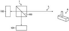
图1是表示用三维测量仪1获取输入到点云数据处理装置11(参照图4)的图像数据5及点云数据7时的一方式的概念图。FIG. 1 is a conceptual diagram showing an aspect of acquiring
如图1所示,三维测量仪1获取作为测量对象的物体A的点云数据及以物体A为被摄体的图像数据5。此外,物体A由物体D及物体E构成。As shown in FIG. 1 , the three-dimensional
搭载在三维测量仪1上的激光扫描仪101(参照图2)是出射激光脉冲、并根据直到激光脉冲在作为测量对象的物体A的表面反射并返回为止的时间来测量距离的飞行时间方式的激光扫描仪。另外,激光扫描仪101获取以激光扫描仪101的旋转中心为基准的激光脉冲的出射方向的角度信息(在图1中,记载了水平方向α和垂直方向β)。然后,根据测量的距离和激光脉冲的出射方向的角度信息来获取激光脉冲的反射点的三维信息。激光扫描仪101通过以规定的间距变更激光脉冲的出射方向的水平方向α及垂直方向β,获取多个点的三维信息。在此,点云数据是表示作为测量对象的物体的表面上的多个点的三维信息的数据,而且构成点云数据的各点分别具有三维信息(三维坐标)。激光扫描仪101不限于基于飞行时间方式的激光扫描仪,也可以是通过相位差方式、三角法方式获取点云数据的激光扫描仪。The laser scanner 101 (refer to FIG. 2 ) mounted on the three-
三维测量仪1通过搭载的具有光轴L的摄影装置102(参照图2)获取图像数据5。摄影装置102包括CCD(Charge Coupled Device)等(未图示)摄像元件。摄像元件具有由在x方向(水平方向)及y方向(垂直方向)上二维排列的光电转换元件构成的多个像素,在多个像素的上表面上具备例如R(红)、G(绿)及B(蓝)的滤光片二维拜耳排列的彩色滤光片(未图示)。而且,通过摄影装置102获取彩色图像的图像数据5。此外,由摄影装置102获取的图像数据不限于彩色图像,也可以是单色图像。The three-
图2是说明搭载在三维测量仪1上的激光扫描仪101及摄影装置(摄像头)102的概念图。FIG. 2 is a conceptual diagram illustrating a
在图2所示的例子中,使用半反射镜103,将光轴L设为相同而配置激光扫描仪101及摄影装置102。此外,激光扫描仪101与摄影装置102的位置关系只要为已知即可,没有特别限制。例如,也可以不将光轴设为相同而在激光扫描仪101之上设置摄影装置102。另外,三维测量仪1能够同时或依次获取点云数据7及图像数据5。In the example shown in FIG. 2 , the
此外,在三维测量仪1中,由激光扫描仪101获取点云数据,但获取点云数据的单元不限于激光扫描仪101。例如点云数据也可以使用ToF(Time-of-Flight)摄像装置或立体摄像装置来获取。In addition, in the three-
图3是说明图像数据5与点云数据7具有对应的位置关系的情况的概念图。在图3所示的例子中,获取多张图像数据5(图像数据5A~5D)。例如,通过三维测量仪1沿平移方向旋转,分别获取不同摄影方向的多个图像数据5A~5D。此外,在以下的说明中对图像数据5A进行说明。FIG. 3 is a conceptual diagram illustrating a case where the
图像数据5A是像素P二维排列的图像数据。像素P具有关于R、G、B的每一个的值。在图3中,示出了图像数据5A中的坐标(Px,Py)的像素P,并示出了具有与像素P对应的位置关系的点Q。点Q构成点云数据7,具有作为位置信息的三维坐标(x,y,z)、对应的像素P的R、G、B的值及反射强度(I)的信息。此外,由于图像数据5A与点云数据7具有对应的位置关系,因此能够获取像素P与点Q的对应关系。此外,关于图像数据5B~5D,也如上所述具有像素与点的对应位置关系。The
接下来,对输入如上所述获取的图像数据(图像数据5A~5D)5及点云数据7的点云数据处理装置11进行说明。Next, the point cloud
图4是表示点云数据处理装置11的功能结构例的框图。点云数据处理装置11例如由计算机构成。点云数据处理装置11可以搭载在三维测量仪1上,也可以由与三维测量仪1分体的计算机构成。FIG. 4 is a block diagram showing an example of the functional configuration of the point cloud
点云数据处理装置11具备图像数据获取部13、点云数据获取部15、控制部17、显示控制部19及存储部(存储器)21。The point cloud
图像数据获取部13获取拍摄物体A而获得的多个图像数据5A~5D作为图像数据。图像数据获取部13可以分别获取多个图像数据5A~5D,也可以获取图像数据5A~5D合成的合成图像数据。The image
点云数据获取部15获取点云数据7。获取与图像数据5A~5D分别对应的点云数据7。此外,也可以与图像数据5A~5D同样地将与图像数据5A~5D分别对应的点云数据7合成而获取。The point cloud
图像数据获取部13及点云数据获取部15通过有线或无线进行获取。此外,由图像数据获取部13及点云数据获取部15获得的图像数据5A~5D和点云数据7由上述的三维测量仪1获取,具有对应的位置关系。The image
控制部17通过由搭载在计算机上的CPU(Central Processing Unit)(处理器)(未图示)执行存储于存储部21的程序来实现。控制部17具备指定接受部23、区域选择部25及属性赋予部27。另外,显示控制部19也通过由CPU执行存储于存储部21的程序来实现其功能。The control unit 17 is realized by executing a program stored in the
存储部21将像素的位置和点相关联地存储点云数据7和图像数据5A~5D。The
图5是表示使用点云数据处理装置11进行的点云数据处理方法的流程图。此外,点云数据处理方法通过执行存储于存储部21的程序来进行。FIG. 5 is a flowchart showing a point cloud data processing method performed by the point cloud
首先,显示控制部19将存储于存储部21的点云数据7显示在监视器(显示部)9上(步骤S10:点云数据显示步骤)。之后,指定接受部23接受在监视器9上显示的点云数据7中的指定点的指定(步骤S11:指定步骤)。接下来,区域选择部25在图像数据中选择包括与指定点对应的区域的对象物体的区域(步骤S12:选择步骤)。然后,属性赋予部27对与在图像数据中选择的对象物体的区域对应的点云数据7赋予相同的属性信息(步骤S13:属性赋予步骤)。First, the
下面,对各步骤进行详细的说明。Hereinafter, each step will be described in detail.
<点云数据显示步骤及指定步骤><Point cloud data display procedure and specification procedure>
点云数据显示步骤(步骤S10)由显示控制部19进行。另外,指定步骤(步骤S11)由指定接受部23进行。显示控制部19将存储于存储部21的点云数据7显示在监视器9上。The point cloud data display step (step S10 ) is performed by the
图6是示意性地表示在监视器9上显示的点云数据7的图。此外,图示的点示意性地表示点云数据7的各点,用虚线(想像线)表示物体A的轮廓。FIG. 6 is a diagram schematically showing the
显示控制部19使点云数据7显示在监视器9上。由于构成点云数据7的各点具有三维坐标,因此基于该三维坐标将各点显示在图示的XYZ坐标上。在监视器9上显示的点云数据7以能够进行三维旋转、三维移动及放大缩小的方式显示。用户可使用定点设备使点云数据7三维旋转及移动、放大缩小。这样,点云数据7进行三维旋转、三维移动、及放大缩小,由此用户能够准确地进行指定点F的指定。在测量对象由多个物体复杂地构成或物体彼此重叠而复杂地配置的情况下,用户通过使点云数据7三维旋转及移动、放大缩小,能够准确地指定指定点。用户通过定点设备指定点F。指定接受部23接受点F的坐标值并接受指定。The
<选择步骤><Selection step>
选择步骤(步骤S12)由区域选择部25进行。区域选择部25在图像数据5中选择包括与指定点F对应的区域的对象物体的区域。The selection step (step S12 ) is performed by the
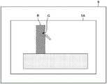
图7是示意性地表示图像数据5A的图。图像数据5A具有与点云数据7中的指定点F对应的区域G。区域G由图像数据5A的一个或多个像素构成。如上所述,构成点云数据7的各点与图像数据5A的各像素具有对应的位置关系。因此,在图像数据5A中,通过选择包括区域G的对象物的区域,能够特定在反射指定点F的物体D的表面反射而获得的点云。下面对包括区域G的对象物的区域的选择进行说明。FIG. 7 is a diagram schematically showing
首先,对图像数据5A通过手动选择对象物的区域的情况进行说明。图8是表示在监视器9上显示的图像数据5A的图。在图8中,对显示图像数据5A的情况进行说明,但也可以显示图像数据5A~5D的合成图像。First, the case where the
显示控制部19在监视器9上显示图像数据5A。显示控制部19显示图像数据5A中的区域G,以便用户能够确认。例如,显示控制部19将区域G的颜色设为与周边的颜色不同的颜色,或者仅使区域G闪烁来进行显示,以向用户通知区域G的位置。用户观察在监视器9上显示的图像数据5A,并用定点设备选择对象物的区域R。区域选择部25接受用户对区域R的选择,进行区域R的选择。此外,区域R是物体D的区域,由于用户能够在图像数据5A中确认物体D,因此能够容易地进行区域R的选择。The
此外,在图8中,对用户通过手动选择区域R的情况进行了说明,但本发明不限于此。例如,区域选择部25由实施了机器学习的识别器构成,能够通过利用该识别器分割图像数据5A来进行区域R的选择。In addition, in FIG. 8, the case where the user manually selects the area|region R was demonstrated, but this invention is not limited to this. For example, the
识别器基于图像数据5A识别物体D,选择物体D的区域R。识别器由实施了机器学习或深度学习的识别器构成,通过对图像数据5A进行分割而特定物体的区域。此外,在分割中可以使用FCN(Full Convolutional Network)、SegNet、Pix2Pix等已有的模型,也可以单独构建与由识别器进行的物体D的识别方式匹配的模型。另外,识别器的学习可以使用深度学习,也可以在广义上使用机器学习。The recognizer recognizes the object D based on the
<属性赋予步骤><attribute assignment step>
属性赋予步骤(步骤S13)由属性赋予部27进行。属性赋予部27在点云数据7中对与区域R对应的点赋予相同的属性信息。在此,属性信息是指表示各点是在哪个物体的表面反射的点的信息,换言之,是指表示各点是与哪个物体对应的点的信息。由于图像数据5A的各像素与点云数据7的各点处于对应关系,因此属性赋予部27能够特定与图像数据5A的区域R对应的点云,并赋予属性信息(D)。在此,由于区域R是与图像数据5A中的物体D对应的区域,因此被赋予了属性信息(D)的点云成为在物体D的表面反射的点云。The attribute assigning step (step S13 ) is performed by the
图9是说明赋予属性信息(D)后的点云数据7的图。FIG. 9 is a diagram illustrating the
在图9所示的点云数据7中,对与区域R对应的点云U赋予相同的属性信息(D)。被赋予了属性信息(D)的点用黑色圆圈显示。点云U由被赋予了属性信息(D)的点云构成。In the
这样,通过对与物体D对应的点云U赋予属性信息(D),当创建与物体D对应的实体模型或表面模型等时,能够简便地使用点云U。具体而言,能够使用属性信息(D),从点云数据7中仅提取点云U而生成实体模型或表面模型。In this way, by assigning the attribute information (D) to the point cloud U corresponding to the object D, the point cloud U can be easily used when creating a solid model or a surface model corresponding to the object D or the like. Specifically, it is possible to generate a solid model or a surface model by extracting only the point cloud U from the
如上所述,在本实施方式中,在点云数据7中指定指定点,在图像数据上选择包括与指定点对应的区域G的区域R。然后,在点云数据7中特定与在图像数据上选择的区域R对应的点云U,对点云U赋予属性信息(D)。被赋予了该属性信息(D)的点云U是在物体D的表面反射的点云。由此,本方式能够高效、准确地赋予构成点云数据7的点中与物体D对应的属性信息(D)。As described above, in the present embodiment, the designated point is designated in the
<其他><Other>
在上述的说明中,对将点云数据7的一部分点云U分组的情况进行了说明。但是,点云U的分组并不一定总是做得很好。例如,在上述说明中的图像数据5A中的区域R的选择中,在边界部分的选择稍有偏离等的情况下,有时无法准确地进行属性信息的赋予。在本实施方式中,在这样的情况下,施加属性信息的修正。本实施方式在控制部17具备修正部(未图示),对被赋予的属性信息施加修正。In the above description, the case where a part of the point clouds U of the
图10是监视器9所示的被赋予了属性信息W的点云的图。在图10所示的情况下,是对与物体D对应的点云U赋予属性信息W的情况,但对与物体D对应的点云以外(点云UE)也赋予了属性信息W。FIG. 10 is a diagram of a point cloud to which attribute information W is assigned and shown on the
显示控制部19将被赋予了属性信息W的点云(点云U及点云UE)显示在监视器9上。用户确认所显示的点云,判定为点云UE不与物体D对应,用定点设备选择点云UE,修正赋予点云UE的属性信息W。修正部接受用户的修正,修正赋予点云UE的属性信息W。The
图11是表示监视器9所示的被赋予了属性信息W的点云的图。在图11所示的情况下,是对与物体D对应的点云U赋予属性信息W的情况,但在被赋予了属性信息W的点云中存在遗漏的区域(区域UH)。FIG. 11 is a diagram showing a point cloud to which attribute information W displayed on the
显示控制部19使被赋予了属性信息W的点云U显示在监视器9上。用户确认所显示的区域UH,并用定点设备追加点云以填充区域UH。由此,修正部对区域UH追加具有属性信息W的点云。The
此外,在上述的例子中,对用户通过手动来修正所赋予的属性信息的例子进行了说明,但本发明不限于该例。例如,也可以使用进行了机器学习的识别器对临时赋予的属性信息进行修正。In addition, in the above-mentioned example, the example where the user corrects the attribute information provided by manual was demonstrated, but this invention is not limited to this example. For example, the temporarily assigned attribute information may be corrected using a machine-learned recognizer.
这样,在本实施方式中,由于是在临时赋予的属性信息中施加修正,因此能够更准确地对点云赋予属性信息。In this way, in the present embodiment, since the correction is applied to the temporarily assigned attribute information, the attribute information can be more accurately assigned to the point cloud.
在上述实施方式中,执行各种处理的处理部(processing unit)的硬件结构是如下所示的各种处理器(processor)。在各种处理器中,包括执行软件(程序)并作为各种处理部发挥功能的通用处理器即CPU、FPGA(Field Programmable Gate Array)等在制造后可改变电路结构的处理器即可编程逻辑器件(Programmable Logic Device:PLD)、ASIC(Application Specific Integrated Circuit)等具有为了执行特定的处理而专门设计的电路结构的处理器即专用电路等。In the above-described embodiments, the hardware configuration of the processing unit (processing unit) that executes various kinds of processing is various processors (processors) as shown below. Among various processors, there are processors whose circuit structure can be changed after manufacture, such as a general-purpose processor that executes software (programs) and functions as various processing units, such as a CPU and an FPGA (Field Programmable Gate Array). A device (Programmable Logic Device: PLD), an ASIC (Application Specific Integrated Circuit), or the like is a processor, ie, a dedicated circuit or the like having a circuit structure specially designed to execute a specific process.
一个处理部可以由这些各种处理器中的一个构成,也可以由同种或异种的两个以上的处理器(例如,多个FPGA、或者CPU与FPGA的组合)构成。另外,还可以用一个处理器来构成多个处理部。作为用一个处理器构成多个处理部的例子,首先,有诸如以用户端或服务器等计算机为代表,使用一个以上的CPU与软件的组合构成一个处理器、并将该处理器作为多个处理部发挥功能的形态。其次,有诸如以片上系统(System On Chip:SoC)等为代表,使用以一个IC(Integrated Circuit)芯片实现包括多个处理部的系统整体的功能的处理器的形态。像这样,使用一个以上的上述各种处理器作为硬件结构来构成各种处理部。One processing unit may be constituted by one of these various processors, or may be constituted by two or more processors of the same or different species (for example, a plurality of FPGAs, or a combination of a CPU and an FPGA). In addition, a plurality of processing units may be constituted by one processor. As an example of configuring a plurality of processing units with a single processor, firstly, there is a computer represented by a client or a server, one processor is configured by a combination of one or more CPUs and software, and the processor is used as a plurality of processing units. The form in which the part functions. Next, there is a form of using a processor that realizes the functions of the entire system including a plurality of processing units by one IC (Integrated Circuit) chip, represented by a System On Chip (SoC). As described above, various processing units are configured using one or more of the above-mentioned various processors as a hardware configuration.
而且,更具体而言,这些各种处理器的硬件结构是组合了半导体元件等电路元件的电路(circuitry)。And more specifically, the hardware structure of these various processors is a circuit (circuitry) combining circuit elements, such as a semiconductor element.
上述各结构及功能可以通过任意的硬件、软件、或者两者的组合适当地实现。例如,对于使计算机执行上述处理步骤(处理过程)的程序、记录这样的程序的计算机可读取的记录介质(非临时性记录介质)、或者可安装这样的程序的计算机,也可以应用本发明。Each of the above-described structures and functions can be appropriately realized by arbitrary hardware, software, or a combination of both. For example, the present invention can also be applied to a program for causing a computer to execute the above-described processing steps (processing procedures), a computer-readable recording medium (non-transitory recording medium) that records such a program, or a computer that can install such a program .
以上对本发明的例子进行了说明,但本发明不限于上述的实施方式,不用说,在不脱离本发明的精神的范围内可以进行各种变形。The examples of the present invention have been described above, but the present invention is not limited to the above-described embodiments, and it goes without saying that various modifications can be made without departing from the spirit of the present invention.
符号说明Symbol Description
1:三维测量仪1: 3D measuring instrument
5:图像数据5: Image data
7:点云数据7: Point cloud data
9:监视器9: Monitor
11:点云数据处理装置11: Point cloud data processing device
13:图像数据获取部13: Image data acquisition section
15:点云数据获取部15: Point cloud data acquisition department
17:控制部17: Control Department
19:显示控制部19: Display control part
21:存储部21: Storage Department
23:指定接受部23: Designate the receiving department
25:区域选择部25: Region Selection Section
27:属性赋予部27: Attribute Granting Department
101:激光扫描仪101: Laser Scanner
102:摄影装置102: Photographic installations
103:半反射镜103: Half mirror
Claims (10)
Translated fromChineseApplications Claiming Priority (3)
| Application Number | Priority Date | Filing Date | Title |
|---|---|---|---|
| JP2020-025448 | 2020-02-18 | ||
| JP2020025448 | 2020-02-18 | ||
| PCT/JP2020/045365WO2021166381A1 (en) | 2020-02-18 | 2020-12-07 | Point cloud data processing device, point cloud data processing method, and program |
Publications (2)
| Publication Number | Publication Date |
|---|---|
| CN115088020Atrue CN115088020A (en) | 2022-09-20 |
| CN115088020B CN115088020B (en) | 2024-12-17 |
Family
ID=77390649
Family Applications (1)
| Application Number | Title | Priority Date | Filing Date |
|---|---|---|---|
| CN202080096126.7AActiveCN115088020B (en) | 2020-02-18 | 2020-12-07 | Point cloud data processing device, point cloud data processing method, and computer-readable recording medium |
Country Status (5)
| Country | Link |
|---|---|
| US (1) | US20220366673A1 (en) |
| EP (1) | EP4109413B1 (en) |
| JP (1) | JP7392101B2 (en) |
| CN (1) | CN115088020B (en) |
| WO (1) | WO2021166381A1 (en) |
Families Citing this family (3)
| Publication number | Priority date | Publication date | Assignee | Title |
|---|---|---|---|---|
| JP6874197B1 (en)* | 2020-08-27 | 2021-05-19 | パシフィックコンサルタンツ株式会社 | Equipment management program, equipment management method, and equipment management system |
| JPWO2024047782A1 (en)* | 2022-08-31 | 2024-03-07 | ||
| US20250292489A1 (en)* | 2024-01-29 | 2025-09-18 | Naoki MOTOHASHI | Information processing apparatus, screen generation method, non-transitory recording medium, and information processing system |
Citations (5)
| Publication number | Priority date | Publication date | Assignee | Title |
|---|---|---|---|---|
| JP2012083157A (en)* | 2010-10-08 | 2012-04-26 | Mitsubishi Electric Corp | Outdoor feature detection system, program for the same, and record media of program for the same |
| JP2017130146A (en)* | 2016-01-22 | 2017-07-27 | キヤノン株式会社 | Image management apparatus, image management method, and program |
| CN109472852A (en)* | 2018-10-29 | 2019-03-15 | 百度在线网络技术(北京)有限公司 | Display methods and device, the equipment and storage medium of point cloud chart picture |
| WO2019098318A1 (en)* | 2017-11-20 | 2019-05-23 | パナソニック インテレクチュアル プロパティ コーポレーション オブ アメリカ | Three-dimensional point group data generation method, position estimation method, three-dimensional point group data generation device, and position estimation device |
| CN110751090A (en)* | 2019-10-18 | 2020-02-04 | 宁波博登智能科技有限责任公司 | Three-dimensional point cloud labeling method and device and electronic equipment |
Family Cites Families (6)
| Publication number | Priority date | Publication date | Assignee | Title |
|---|---|---|---|---|
| CN101617197B (en) | 2007-02-16 | 2011-06-22 | 三菱电机株式会社 | Measuring device, measuring method and ground feature recognition device |
| US10139985B2 (en)* | 2012-06-22 | 2018-11-27 | Matterport, Inc. | Defining, displaying and interacting with tags in a three-dimensional model |
| JP6906916B2 (en)* | 2016-09-06 | 2021-07-21 | 株式会社トプコン | Image processing device, image processing method, image processing program |
| US20190096135A1 (en)* | 2017-09-26 | 2019-03-28 | Aquifi, Inc. | Systems and methods for visual inspection based on augmented reality |
| WO2019245865A1 (en)* | 2018-06-19 | 2019-12-26 | Tornier, Inc. | Mixed reality indication of points at which 3d bone and implant models collide |
| EP3970122A1 (en)* | 2019-07-19 | 2022-03-23 | Five AI Limited | Structure modelling |
- 2020
- 2020-12-07CNCN202080096126.7Apatent/CN115088020B/enactiveActive
- 2020-12-07JPJP2022501647Apatent/JP7392101B2/enactiveActive
- 2020-12-07EPEP20919406.7Apatent/EP4109413B1/enactiveActive
- 2020-12-07WOPCT/JP2020/045365patent/WO2021166381A1/ennot_activeCeased
- 2022
- 2022-07-29USUS17/816,235patent/US20220366673A1/enactivePending
Patent Citations (5)
| Publication number | Priority date | Publication date | Assignee | Title |
|---|---|---|---|---|
| JP2012083157A (en)* | 2010-10-08 | 2012-04-26 | Mitsubishi Electric Corp | Outdoor feature detection system, program for the same, and record media of program for the same |
| JP2017130146A (en)* | 2016-01-22 | 2017-07-27 | キヤノン株式会社 | Image management apparatus, image management method, and program |
| WO2019098318A1 (en)* | 2017-11-20 | 2019-05-23 | パナソニック インテレクチュアル プロパティ コーポレーション オブ アメリカ | Three-dimensional point group data generation method, position estimation method, three-dimensional point group data generation device, and position estimation device |
| CN109472852A (en)* | 2018-10-29 | 2019-03-15 | 百度在线网络技术(北京)有限公司 | Display methods and device, the equipment and storage medium of point cloud chart picture |
| CN110751090A (en)* | 2019-10-18 | 2020-02-04 | 宁波博登智能科技有限责任公司 | Three-dimensional point cloud labeling method and device and electronic equipment |
Non-Patent Citations (1)
| Title |
|---|
| SCANNER2GO GMBH: ""09-Leica CloudWorx TruSpace-Scanner2Go"", Retrieved from the Internet <URL:https://www.youtube.com/watch?v=s6QVHPSgSKk>* |
Also Published As
| Publication number | Publication date |
|---|---|
| JPWO2021166381A1 (en) | 2021-08-26 |
| US20220366673A1 (en) | 2022-11-17 |
| EP4109413A1 (en) | 2022-12-28 |
| EP4109413B1 (en) | 2024-05-15 |
| EP4109413A4 (en) | 2023-07-19 |
| CN115088020B (en) | 2024-12-17 |
| WO2021166381A1 (en) | 2021-08-26 |
| JP7392101B2 (en) | 2023-12-05 |
Similar Documents
| Publication | Publication Date | Title |
|---|---|---|
| JP6236118B2 (en) | 3D data processing apparatus, 3D data processing system, 3D data processing method and program | |
| JP5465128B2 (en) | Point cloud position data processing device, point cloud position data processing system, point cloud position data processing method, and point cloud position data processing program | |
| CN113785331B (en) | Point cloud data processing device, point cloud data processing method and computer readable recording medium | |
| JP5620200B2 (en) | Point cloud position data processing device, point cloud position data processing method, point cloud position data processing system, and point cloud position data processing program | |
| JP5711039B2 (en) | 3D point cloud position data processing apparatus, 3D point cloud position data processing method, 3D point cloud position data processing system, and program | |
| JP5593177B2 (en) | Point cloud position data processing device, point cloud position data processing method, point cloud position data processing system, and point cloud position data processing program | |
| JP5343042B2 (en) | Point cloud data processing apparatus and point cloud data processing program | |
| JP5580164B2 (en) | Optical information processing apparatus, optical information processing method, optical information processing system, and optical information processing program | |
| US11290704B2 (en) | Three dimensional scanning system and framework | |
| JP5462093B2 (en) | Point cloud data processing device, point cloud data processing system, point cloud data processing method, and point cloud data processing program | |
| CN115088020A (en) | Point cloud data processing device, point cloud data processing method, and program | |
| JP6344050B2 (en) | Image processing system, image processing apparatus, and program | |
| JP6541920B1 (en) | INFORMATION PROCESSING APPARATUS, PROGRAM, AND INFORMATION PROCESSING METHOD | |
| CN108286945A (en) | The 3 D scanning system and method for view-based access control model feedback | |
| US20210201522A1 (en) | System and method of selecting a complementary image from a plurality of images for 3d geometry extraction | |
| KR20070092006A (en) | Recording medium containing 3D image processing method and program for realizing the same | |
| JP6838912B2 (en) | Image processing equipment, image processing methods and programs | |
| CN113287151B (en) | Information processing device, computer-readable recording medium, and information processing method | |
| WO2020179438A1 (en) | Object amount calculation device and object amount calculation method | |
| JP2016003886A (en) | Shape extraction apparatus and shape extraction method | |
| EP3441789A1 (en) | System and method for processing data and a user device for pre-processing data | |
| CN115035174A (en) | Geometric point cloud model construction method, workpiece grabbing method and device and electronic equipment | |
| JPH08122030A (en) | Three-dimensional image forming method and apparatus |
Legal Events
| Date | Code | Title | Description |
|---|---|---|---|
| PB01 | Publication | ||
| PB01 | Publication | ||
| SE01 | Entry into force of request for substantive examination | ||
| SE01 | Entry into force of request for substantive examination | ||
| GR01 | Patent grant | ||
| GR01 | Patent grant |