CN114972989A - Single remote sensing image height information estimation method based on deep learning algorithm - Google Patents
Single remote sensing image height information estimation method based on deep learning algorithmDownload PDFInfo
- Publication number
- CN114972989A CN114972989ACN202210547696.4ACN202210547696ACN114972989ACN 114972989 ACN114972989 ACN 114972989ACN 202210547696 ACN202210547696 ACN 202210547696ACN 114972989 ACN114972989 ACN 114972989A
- Authority
- CN
- China
- Prior art keywords
- module
- feature
- height information
- feature map
- output
- Prior art date
- Legal status (The legal status is an assumption and is not a legal conclusion. Google has not performed a legal analysis and makes no representation as to the accuracy of the status listed.)
- Granted
Links
Images


Classifications
- G—PHYSICS
- G06—COMPUTING OR CALCULATING; COUNTING
- G06V—IMAGE OR VIDEO RECOGNITION OR UNDERSTANDING
- G06V20/00—Scenes; Scene-specific elements
- G06V20/10—Terrestrial scenes
- G—PHYSICS
- G06—COMPUTING OR CALCULATING; COUNTING
- G06N—COMPUTING ARRANGEMENTS BASED ON SPECIFIC COMPUTATIONAL MODELS
- G06N3/00—Computing arrangements based on biological models
- G06N3/02—Neural networks
- G06N3/04—Architecture, e.g. interconnection topology
- G06N3/045—Combinations of networks
- G—PHYSICS
- G06—COMPUTING OR CALCULATING; COUNTING
- G06V—IMAGE OR VIDEO RECOGNITION OR UNDERSTANDING
- G06V10/00—Arrangements for image or video recognition or understanding
- G06V10/40—Extraction of image or video features
- G—PHYSICS
- G06—COMPUTING OR CALCULATING; COUNTING
- G06V—IMAGE OR VIDEO RECOGNITION OR UNDERSTANDING
- G06V10/00—Arrangements for image or video recognition or understanding
- G06V10/70—Arrangements for image or video recognition or understanding using pattern recognition or machine learning
- G06V10/77—Processing image or video features in feature spaces; using data integration or data reduction, e.g. principal component analysis [PCA] or independent component analysis [ICA] or self-organising maps [SOM]; Blind source separation
- G06V10/774—Generating sets of training patterns; Bootstrap methods, e.g. bagging or boosting
- G—PHYSICS
- G06—COMPUTING OR CALCULATING; COUNTING
- G06V—IMAGE OR VIDEO RECOGNITION OR UNDERSTANDING
- G06V10/00—Arrangements for image or video recognition or understanding
- G06V10/70—Arrangements for image or video recognition or understanding using pattern recognition or machine learning
- G06V10/77—Processing image or video features in feature spaces; using data integration or data reduction, e.g. principal component analysis [PCA] or independent component analysis [ICA] or self-organising maps [SOM]; Blind source separation
- G06V10/80—Fusion, i.e. combining data from various sources at the sensor level, preprocessing level, feature extraction level or classification level
- G06V10/806—Fusion, i.e. combining data from various sources at the sensor level, preprocessing level, feature extraction level or classification level of extracted features
- Y—GENERAL TAGGING OF NEW TECHNOLOGICAL DEVELOPMENTS; GENERAL TAGGING OF CROSS-SECTIONAL TECHNOLOGIES SPANNING OVER SEVERAL SECTIONS OF THE IPC; TECHNICAL SUBJECTS COVERED BY FORMER USPC CROSS-REFERENCE ART COLLECTIONS [XRACs] AND DIGESTS
- Y02—TECHNOLOGIES OR APPLICATIONS FOR MITIGATION OR ADAPTATION AGAINST CLIMATE CHANGE
- Y02A—TECHNOLOGIES FOR ADAPTATION TO CLIMATE CHANGE
- Y02A30/00—Adapting or protecting infrastructure or their operation
- Y02A30/60—Planning or developing urban green infrastructure
Landscapes
- Engineering & Computer Science (AREA)
- Theoretical Computer Science (AREA)
- Physics & Mathematics (AREA)
- General Physics & Mathematics (AREA)
- Multimedia (AREA)
- Computing Systems (AREA)
- Health & Medical Sciences (AREA)
- Artificial Intelligence (AREA)
- Computer Vision & Pattern Recognition (AREA)
- Software Systems (AREA)
- Evolutionary Computation (AREA)
- General Health & Medical Sciences (AREA)
- Medical Informatics (AREA)
- Databases & Information Systems (AREA)
- Computational Linguistics (AREA)
- Molecular Biology (AREA)
- General Engineering & Computer Science (AREA)
- Mathematical Physics (AREA)
- Data Mining & Analysis (AREA)
- Life Sciences & Earth Sciences (AREA)
- Biophysics (AREA)
- Biomedical Technology (AREA)
- Image Analysis (AREA)
Abstract
Translated fromChinese
Description
Translated fromChinese技术领域technical field
本发明涉及遥感影像处理、深度学习语义分割领域,尤其涉及一种基于深度学习算法的单幅遥感影像高度信息估算方法。The invention relates to the fields of remote sensing image processing and deep learning semantic segmentation, in particular to a method for estimating height information of a single remote sensing image based on a deep learning algorithm.
背景技术Background technique
城市三维垂直信息作为城市化垂直空间的体现,其在城市化研究中具有重要的参考价值及研究意义,其与能源消耗、碳排放和城市热岛效应等密切相关,同时,对于城市规划、城市可持续发展至关重要。如何实现快速精确的高度信息提取成为近年来三维城市信息提取研究的热点之一。但是,可用的大范围城市垂直维信息数据仍然缺乏。针对高度信息提取,目前可以通过三种数据来获取:①LiDAR;②SAR数据;③高分辨率光学影像。LiDAR可以高精度测量地物三维信息,然而LiDAR的采集成本高而且覆盖范围仍然有限。SAR图像在建筑物高度估算方面具有很大的潜力,然而由于采用侧视几何,SAR图像通常记录来自不同微波散射机制的混合信号,导致高度估算的不确定性相对较高。随着立体/多视角影像的可用性增加,高度信息可以通过立体匹配方法进行计算;但是,由于建筑物的遮挡或者影像质量差异,通常存在匹配失败的问题。对于单幅遥感影像,可以从相邻的阴影中估算建筑物的高度,但在很大程度上依赖于阴影检测的准确性。最近,有研究开始探索利用深度学习技术从单幅遥感影像预测高度信息的可行性。在此背景下,深度学习为高度估算开辟了一条新的途径;虽然单幅遥感影像的高度估算在一定程度上取得了成功,但它仍然是一个不适定和具有挑战性的问题。综上,采用单幅遥感影像进行高度信息估算具有低成本、高效率等优势,目前还没有被有效解决,也是高度信息未来研究的重要方向。As the embodiment of urbanization vertical space, urban three-dimensional vertical information has important reference value and research significance in urbanization research. It is closely related to energy consumption, carbon emissions and urban heat island effect. Sustained development is critical. How to achieve fast and accurate height information extraction has become one of the hotspots in the research of 3D city information extraction in recent years. However, available large-scale urban vertical dimension information data is still lacking. For height information extraction, three kinds of data can be obtained at present: ①LiDAR; ②SAR data; ③High-resolution optical image. LiDAR can measure the three-dimensional information of ground objects with high precision, but the acquisition cost of LiDAR is high and the coverage is still limited. SAR images have great potential for building height estimation, however, due to the side-looking geometry, SAR images usually record mixed signals from different microwave scattering mechanisms, resulting in relatively high uncertainty in height estimation. As the availability of stereo/multi-view images increases, the height information can be calculated by the stereo matching method; however, due to the occlusion of buildings or differences in image quality, there is usually a problem of matching failure. For a single remote sensing image, the height of buildings can be estimated from adjacent shadows, but depends heavily on the accuracy of shadow detection. Recently, studies have begun to explore the feasibility of using deep learning techniques to predict height information from a single remote sensing image. In this context, deep learning has opened up a new avenue for height estimation; although height estimation from a single remote sensing image has been successful to some extent, it is still an ill-posed and challenging problem. To sum up, the use of a single remote sensing image for altitude information estimation has the advantages of low cost and high efficiency.
发明内容SUMMARY OF THE INVENTION
针对现有技术存在的不足之处,本发明的目的在于提供一种基于深度学习算法的单幅遥感影像高度信息估算方法,高度信息估算网络模型首先通过ResNet提取低层和高层特征以解决梯度消失的问题;其次由于城市场景复杂,地物尺度各异,通过DenseASPP有效聚合多尺度的空间信息覆盖大范围的语义信息,从而有利于高度信息的估算预测;然后,在解码阶段构建跳跃连接和空间注意力机制聚合ResNet低层特征与多尺度高层特征逐渐恢复影像的大小,通过空间注意力机制学习低层特征图不同位置的信息,从而可以恢复精确的地物边缘信息;最后利用可变形卷积来增加对于城市场景中地物形状和尺度差异的敏感性,进而得到精度高、获取成本低且高效的高度估算结果。In view of the shortcomings of the prior art, the purpose of the present invention is to provide a method for estimating height information of a single remote sensing image based on a deep learning algorithm. The height information estimation network model first extracts low-level and high-level features through ResNet to solve the problem of gradient disappearance. Secondly, due to the complexity of urban scenes and different scales of ground objects, DenseASPP effectively aggregates multi-scale spatial information to cover a wide range of semantic information, which is conducive to the estimation and prediction of height information; then, in the decoding stage, skip connections and spatial attention are constructed. The force mechanism aggregates ResNet low-level features and multi-scale high-level features to gradually restore the size of the image, and learns the information of different positions of the low-level feature map through the spatial attention mechanism, so that accurate feature edge information can be recovered; finally, deformable convolution is used to increase the image size. Sensitivity to shape and scale differences of objects in urban scenes, resulting in highly accurate, low-cost, and efficient height estimation results.
本发明的目的通过下述技术方案实现:The object of the present invention is achieved through the following technical solutions:
一种基于深度学习算法的单幅遥感影像高度信息估算方法,其方法如下:A method for estimating height information of a single remote sensing image based on a deep learning algorithm, the method is as follows:
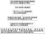
A、制作高度信息估算网络模型的训练样本数据集,方法如下:A. Create a training sample data set for the height information estimation network model, the method is as follows:
A1、将遥感影像数据和遥感影像数据所对应的nDSM数据进行配准作为高度信息估算网络模型的数据源;A1. Register the remote sensing image data and the nDSM data corresponding to the remote sensing image data as the data source of the height information estimation network model;
A1、将配准后的遥感影像数据、nDSM数据对应裁剪为500×500的影像块作为样本数据集,将样本数据集分为训练集和测试集,对训练集的影像块分别进行数据增强处理,数据增强处理包括翻转、平移、尺度变化、对比度变化、高斯噪声处理;A1. Cut the registered remote sensing image data and nDSM data into 500×500 image blocks as a sample data set, divide the sample data set into a training set and a test set, and perform data enhancement processing on the image blocks of the training set respectively , data enhancement processing includes flip, translation, scale change, contrast change, Gaussian noise processing;
B、基于TensorFlow搭建高度信息估算网络模型,高度信息估算网络模型采用ResNet为基础网络架构,高度信息估算网络模型包括ResNet特征提取模块、DenseASPP模块、通道注意力机制模块、空间注意力机制跳跃连接模块和可变形卷积模块;高度信息估算网络模型利用训练样本数据集进行模型训练,高度信息估算网络模型的训练方法如下:B. Build a height information estimation network model based on TensorFlow. The height information estimation network model adopts ResNet as the basic network architecture. The height information estimation network model includes ResNet feature extraction module, DenseASPP module, channel attention mechanism module, and spatial attention mechanism skip connection module and deformable convolution module; the height information estimation network model uses the training sample data set for model training, and the training method of the height information estimation network model is as follows:
B1、高度信息估算网络模型利用训练样本数据集进行模型训练,高度信息估算网络模型中具有损失函数L约束训练,损失函数L由berHu函数、坡度值差异Lslope和高度波动Lroughness联合构建,其损失函数L公式如下;B1. The height information estimation network model uses the training sample data set for model training. The height information estimation network model has a loss function L to constrain training. The loss function L is jointly constructed by the berHu function, the slope value difference Lslope and the height fluctuation Lroughness . The loss function L formula is as follows;
L=αLberHu+βLslope+γLroughness,其中LberHu为berHuL=αLberHu+βLslope+γLroughness, where LberHu is berHu
函数,Lslope为坡度值差异,Lroughness为高度波动,α,β,γ为权重系数;function, Lslope is the slope value difference, Lroughness is the height fluctuation, α, β, γ are the weight coefficients;
C、采集研究区的遥感影像数据,将遥感影像数据对应裁剪为500×500的影像块输入到高度信息估算网络模型(本发明高度信息估算网络模型在训练时对于训练集的影像块处理也采用如下方法)中进行如下处理:C. Collect the remote sensing image data of the research area, and input the remote sensing image data correspondingly cut into 500×500 image blocks into the height information estimation network model (the height information estimation network model of the present invention also uses the image block processing of the training set during training. The following methods are processed as follows:
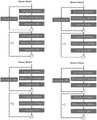
C1、将影像块输入到高度信息估算网络模型中,通过卷积层和ResNet提取影像块的低层特征和高层特征;C1. Input the image block into the height information estimation network model, and extract the low-level and high-level features of the image block through the convolutional layer and ResNet;
C2、将ResNet提取影像块的高层特征输入到DenseASPP模块中捕获不同尺度的语义特征、聚合多尺度的空间信息输出特征图G1;C2. Input the high-level features of the image block extracted by ResNet into the DenseASPP module to capture semantic features of different scales, aggregate multi-scale spatial information and output feature map G1;
C3、将特征图G1输入到通道注意力机制模块中捕获通道维度上的全局依赖关系并得到通道注意力权重,将特征图G1与通道注意力权重进行乘积运算并输出结果,对输出结果使用1×1卷积进行通道压缩输出得到特征图G2;C3. Input the feature map G1 into the channel attention mechanism module to capture the global dependency on the channel dimension and obtain the channel attention weight, multiply the feature map G1 and the channel attention weight and output the result,
C4、通过空间注意力机制跳跃连接模块将特征图G2与影像块的低层特征融合叠加输出特征图R1;C4. The feature map G2 is fused and superposed with the low-level features of the image block through the skip connection module of the spatial attention mechanism to output the feature map R1;
C5、可变形卷积模块包括3×3卷积和卷积核,将特征图R1输入到可变形卷积模块中,可变形卷积模块通过3×3卷积输出得到可变形卷积所需的九个偏移量,然后将九个偏移量作用于卷积核上输出高度估算结果。C5. The deformable convolution module includes a 3×3 convolution and a convolution kernel. The feature map R1 is input into the deformable convolution module. The deformable convolution module obtains the required deformable convolution through the 3×3 convolution output. The nine offsets are then applied to the convolution kernel to output the height estimation result.
优选地,本发明在步骤B1中,berHu函数的公式如下:Preferably, in step B1 of the present invention, the formula of the berHu function is as follows:

优选地,本发明在步骤C2中,DenseASPP模块包括五个不同扩张率的空洞卷积,五个空洞卷积的空洞率分别为3、8、12、18、24,DenseASPP模块的处理方法包括:Preferably, in step C2 of the present invention, the DenseASPP module includes five hole convolutions with different expansion rates, and the hole rates of the five hole convolutions are respectively 3, 8, 12, 18, and 24. The processing method of the DenseASPP module includes:
C21、ResNet提取影像块的高层特征经过五个空洞卷积分别进行密集卷积计算得到五个大小相同的特征图并将五个特征图与原始高层特征叠加输出特征图G1。C21 and ResNet extract the high-level features of the image block through five atrous convolutions, respectively, perform dense convolution calculations to obtain five feature maps of the same size, and superimpose the five feature maps with the original high-level features to output feature map G1.
优选地,本发明在步骤C3中,通道注意力机制模块包括自适应最大池化层、自适应平均池化层、两层共享连接层、元素相加及Sigmoid激活模块,自适应最大池化层、自适应平均池化层相互并行组成,通道注意力机制模块处理方法包括:Preferably, in step C3 of the present invention, the channel attention mechanism module includes an adaptive maximum pooling layer, an adaptive average pooling layer, a two-layer shared connection layer, element addition and sigmoid activation modules, and an adaptive maximum pooling layer. , and the adaptive average pooling layers are formed in parallel with each other. The processing methods of the channel attention mechanism module include:
C31、将特征图G1输入到通道注意力机制模块的自适应最大池化层、自适应平均池化层分别得到两个特征图G11,然后将两个特征图G11分别输入到两层共享连接层的神经网络输出两个特征图G12,并对两个特征图G12通过元素相加及Sigmoid激活模块进行对应元素相加与Sigmoid激活处理得到通道注意力权重,将特征图G1与通道注意力权重进行乘积运算并输出结果,对输出结果使用1×1卷积进行通道压缩输出得到特征图G2。C31. Input the feature map G1 to the adaptive maximum pooling layer and the adaptive average pooling layer of the channel attention mechanism module to obtain two feature maps G11, respectively, and then input the two feature maps G11 to the two-layer shared connection layer respectively The neural network outputs two feature maps G12, and the channel attention weights are obtained by element addition and Sigmoid activation module for the two feature maps G12, and the channel attention weights are obtained by adding corresponding elements and Sigmoid activation processing. The product is operated and the result is output, and the output result is compressed and output by 1×1 convolution to obtain the feature map G2.
优选地,本发明在步骤C1中,通过卷积层和ResNet提取影像块的四个低层特征和一个高层特征,其中高层特征按照C2、C3依序处理得到特征图G2,四个低层特征分别为第一低层特征、第二低层特征、第三低层特征、第四低层特征;在步骤C4中,特征图G2与影像块的低层特征融合叠加输出特征图R1处理方法如下:Preferably, in step C1 of the present invention, four low-level features and one high-level feature of the image block are extracted through the convolutional layer and ResNet, wherein the high-level features are processed in sequence according to C2 and C3 to obtain a feature map G2, and the four low-level features are respectively The first low-level feature, the second low-level feature, the third low-level feature, and the fourth low-level feature; in step C4, the feature map G2 and the low-level feature of the image block are fused and superimposed to output the feature map R1 The processing method is as follows:
C41、通过空间注意力机制跳跃连接模块将特征图G2与高层特征融合叠加输出特征图G21;C41. The feature map G2 is fused and superposed with the high-level features through the skip connection module of the spatial attention mechanism to output the feature map G21;
C42、通过空间注意力机制跳跃连接模块将特征图G21与第四低层特征融合叠加输出特征图G22;C42. The feature map G21 is fused and superimposed with the fourth low-level feature through the skip connection module of the spatial attention mechanism to output the feature map G22;
C43、通过空间注意力机制跳跃连接模块将特征图G22与第三低层特征融合叠加输出特征图G23;C43. The feature map G22 is fused and superposed with the third low-level feature through the skip connection module of the spatial attention mechanism to output the feature map G23;
C44、通过空间注意力机制跳跃连接模块将特征图G23与第二低层特征融合叠加输出特征图G24;C44. The feature map G23 is fused and superposed with the second low-level feature through the skip connection module of the spatial attention mechanism to output the feature map G24;
C45、通过空间注意力机制跳跃连接模块将特征图G24与第一低层特征融合叠加输出特征图R1。C45. The feature map G24 is fused and superposed with the first low-level feature through the skip connection module of the spatial attention mechanism to output the feature map R1.
本发明优选的空间注意力机制跳跃连接模块包括自适应最大池化层、自适应平均池化层,空间注意力机制跳跃连接模块经过自适应最大池化层、自适应平均池化层对输入特征数据进行依次处理,然后进行通道拼接和7×7卷积得到特征数据,再进行Sigmoid激活处理得到空间注意力权重,然后将特征数据与空间注意力权重进行乘积计算得到空间注意力输出结果,经过上采样并在解码阶段得到融合后的特征数据。The preferred spatial attention mechanism skip connection module of the present invention includes an adaptive maximum pooling layer and an adaptive average pooling layer. The spatial attention mechanism skip connection module passes through the adaptive maximum pooling layer and the adaptive average pooling layer to input features The data is processed in sequence, then channel splicing and 7×7 convolution are performed to obtain feature data, and then Sigmoid activation processing is performed to obtain the spatial attention weight, and then the product of the feature data and the spatial attention weight is calculated to obtain the spatial attention output result. Upsampling and fused feature data are obtained in the decoding stage.
优选地,所述高度信息估算网络模型采用边缘信息舍弃方法将研究区的影像块进行拼接,以获取研究区的高度估算结果。Preferably, the height information estimation network model adopts the edge information discarding method to splicing the image blocks of the study area, so as to obtain the height estimation result of the study area.
本发明较现有技术相比,具有以下优点及有益效果:Compared with the prior art, the present invention has the following advantages and beneficial effects:
(1)本发明主要包括高度信息估算网络模型、损失函数和预测估算原理等三个方面技术创新,高度信息估算网络模型首先通过卷积层和ResNet提取低层和高层特征以解决梯度消失的问题;其次由于城市场景复杂,地物尺度各异,通过DenseASPP有效聚合多尺度的空间信息覆盖大范围的语义信息,从而有利于高度信息的估算预测;然后,在解码阶段构建跳跃连接和空间注意力机制聚合ResNet低层特征与多尺度高层特征逐渐恢复影像的大小,通过空间注意力机制学习低层特征图不同位置的信息,从而可以恢复精确的地物边缘信息;最后利用可变形卷积来增加对于城市场景中地物形状和尺度差异的敏感性,进而得到精度高、获取成本低、高效且信息可靠全面的高度估算结果。(1) The present invention mainly includes technical innovations in three aspects: height information estimation network model, loss function and prediction estimation principle. The height information estimation network model first extracts low-level and high-level features through convolution layer and ResNet to solve the problem of gradient disappearance; Secondly, due to the complexity of urban scenes and different scales of objects, DenseASPP effectively aggregates multi-scale spatial information to cover a wide range of semantic information, which is conducive to the estimation and prediction of height information; then, a skip connection and spatial attention mechanism are constructed in the decoding stage. Aggregate ResNet low-level features and multi-scale high-level features to gradually restore the size of the image, and learn the information of different positions of the low-level feature map through the spatial attention mechanism, so that accurate edge information of objects can be recovered; finally, deformable convolution is used to increase the urban scene. Sensitivity to shape and scale differences of ground objects, and then obtain height estimation results with high accuracy, low acquisition cost, high efficiency, and reliable and comprehensive information.
(2)本发明高度信息估算网络模型在模型训练时采用联合berHu函数、坡度值和粗糙度构建损失函数,可以快速、高效地得到更好的训练效果;对于较大区域的研究区可以采用边缘信息舍弃方法将预测结果影像块拼接为大的预测结果影像,采用边缘信息舍弃的方法能够将网络模型输出的影像块拼接成大的影像结果,可以减小边缘拼接处高度估算的差异,提高了遥感影像地物高度信息估算精度。(2) The height information estimation network model of the present invention adopts the joint berHu function, slope value and roughness to construct a loss function during model training, which can quickly and efficiently obtain better training effects; The information discarding method splices the prediction result image blocks into a large prediction result image, and the edge information discarding method can splicing the image blocks output by the network model into a large image result, which can reduce the difference in height estimation at the edge splicing. Estimation accuracy of ground object height information from remote sensing images.
(3)本发明使用密集空洞空间金字塔池化模块提取多尺度地物信息,有助于在城市场景下,通过更大的范围聚合多尺度语义信息来提取地物高度信息估算的精度;使用通道注意力机制学习密集空洞空间金字塔池化模块中得到的各个特征图各个波段的重要性权重,从而增强有用特征;在解码阶段通过引入空间注意力机制跳跃连接模块构建跳跃连接,将低层特征与高层语义特征进行融合,两个特征融合可以保留更多重要特征细节信息,减少网络逐层卷积池化导致的边缘信息损失,提高地物边缘位置地物高度估算精度;使用可变形卷积以产生不同尺寸和形状的卷积核来增加对城市场景下不同尺度和形状地物的敏感性;同时,空间注意力机制跳跃连接模块可以筛选低层特征中更有用的语义信息,抑制干扰信息,增强了高度信息估算网络模型的估算能力。(3) The present invention uses the dense void space pyramid pooling module to extract multi-scale ground object information, which is helpful for extracting the accuracy of ground object height information estimation by aggregating multi-scale semantic information in a larger range in urban scenes; using channel The attention mechanism learns the importance weights of each band of each feature map obtained in the dense hole spatial pyramid pooling module, thereby enhancing the useful features; in the decoding stage, the skip connection module is introduced by the spatial attention mechanism to construct a skip connection, which combines the low-level features with the high-level features. Semantic features are fused, and the fusion of two features can retain more important feature details, reduce the loss of edge information caused by layer-by-layer convolution pooling of the network, and improve the accuracy of feature height estimation at the edge of features; deformable convolution is used to generate Convolution kernels of different sizes and shapes are used to increase the sensitivity to objects of different scales and shapes in urban scenes; at the same time, the spatial attention mechanism skip connection module can filter more useful semantic information in low-level features, suppress interference information, and enhance the Height information estimates the estimation power of the network model.
(4)本发明利用单幅遥感影像实现高度信息估算,相较于LiDAR、SAR以及立体影像,是一种低成本、高效的技术手段,能够普遍满足实际需求。(4) The present invention utilizes a single remote sensing image to realize height information estimation. Compared with LiDAR, SAR and stereo images, the present invention is a low-cost and efficient technical means, which can generally meet actual needs.
附图说明Description of drawings
图1为实施例中单幅遥感影像高度信息估算方法的流程示意图;1 is a schematic flowchart of a method for estimating height information of a single remote sensing image in an embodiment;
图2为实施例中高度信息估算网络模型的原理示意简图;2 is a schematic diagram of the principle of the height information estimation network model in the embodiment;
图3为实施例中ResNet基础网络架构中残差网络结构的原理示意图;3 is a schematic diagram of the principle of the residual network structure in the ResNet basic network architecture in the embodiment;
图4为实施例中DenseASPP模块的原理示意图;Fig. 4 is the principle schematic diagram of DenseASPP module in the embodiment;
图5为实施例中通道注意力机制模块的原理示意图;5 is a schematic diagram of the principle of a channel attention mechanism module in an embodiment;
图6为实施例中空间注意力机制跳跃连接模块的原理示意图;6 is a schematic diagram of the principle of the skip connection module of the spatial attention mechanism in the embodiment;
图7为实施例中可变形卷积模块的原理示意图;7 is a schematic diagram of the principle of a deformable convolution module in an embodiment;
具体实施方式Detailed ways
下面结合实施例对本发明作进一步地详细说明:Below in conjunction with embodiment, the present invention is described in further detail:
实施例Example
如图1~图7所示,一种基于深度学习算法的单幅遥感影像高度信息估算方法,其方法如下:As shown in Figures 1 to 7, a method for estimating height information of a single remote sensing image based on a deep learning algorithm, the method is as follows:
A、制作高度信息估算网络模型的训练样本数据集,方法如下:A. Create a training sample data set for the height information estimation network model, the method is as follows:
A1、将遥感影像数据和遥感影像数据所对应的nDSM数据进行配准作为高度信息估算网络模型的数据源,nDSM数据为归一化数字表面数据(normalized Digital SurfaceModel,缩写nDSM),归一化数字表面模型是一种反映地物到地面的垂直高度的高程模型。A1. Register the remote sensing image data and the nDSM data corresponding to the remote sensing image data as the data source of the height information estimation network model. A surface model is an elevation model that reflects the vertical height of a feature to the ground.
A2、将配准后的遥感影像数据、nDSM数据对应裁剪为500×500的影像块作为样本数据集,将样本数据集分为训练集和测试集,对训练集影像块分别进行数据增强处理并得到训练样本数据集,数据增强处理包括翻转、平移、尺度变化、对比度变化、高斯噪声处理,可以在高度信息估算网络模型训练时增强模型的泛化能力。本实施例通过训练集的影像块进行高度信息估算网络模型训练,通过测试集进行高度信息估算网络模型的测试。A2. Cut the registered remote sensing image data and nDSM data into 500×500 image blocks as a sample data set, divide the sample data set into a training set and a test set, and perform data enhancement processing on the image blocks of the training set respectively. The training sample data set is obtained, and the data enhancement processing includes flipping, translation, scale change, contrast change, and Gaussian noise processing, which can enhance the generalization ability of the model during the training of the height information estimation network model. In this embodiment, the height information estimation network model is trained through the image blocks of the training set, and the height information estimation network model is tested through the test set.
B、基于TensorFlow搭建高度信息估算网络模型,高度信息估算网络模型采用ResNet为基础网络架构,高度信息估算网络模型包括ResNet特征提取模块(ResNet特征提取模块为ResNet基础网络架构下的特征提取模块)、DenseASPP模块(中文名称为密集空洞空间金字塔池化结构模块)、通道注意力机制模块、空间注意力机制跳跃连接模块和可变形卷积模块。B. Build a height information estimation network model based on TensorFlow. The height information estimation network model adopts ResNet as the basic network architecture. The height information estimation network model includes the ResNet feature extraction module (the ResNet feature extraction module is the feature extraction module under the ResNet basic network architecture), DenseASPP module (Chinese name is dense hole spatial pyramid pooling structure module), channel attention mechanism module, spatial attention mechanism skip connection module and deformable convolution module.
B1、高度信息估算网络模型利用训练样本数据集进行模型训练,高度信息估算网络模型中具有损失函数L(即联合损失函数)约束训练,损失函数L由berHu函数、坡度值差异Lslope和高度波动Lroughness联合构建,其损失函数L公式如下;B1. The height information estimation network model uses the training sample data set for model training. The height information estimation network model has a loss function L (that is, a joint loss function) to constrain the training. The loss function L is determined by the berHu function, the slope value difference Lslope and the height fluctuation. Lroughness is jointly constructed, and the loss function L formula is as follows;
L=αLberHU+βLslope+γLroughness,其中LberHU为berHu函数,Lslope为坡度值差异(可以采用相邻像素进行计算像素的坡度值差异,坡度值含有物体结构信息,特别是建筑物和裸地之间的高度跳跃),Lroughness为高度波动(高度波动有助于提高估算高度值的性能),α,β,γ为权重系数。L=αLberHU +βLslope +γLroughness , where LberHU is the berHu function, and Lslope is the difference in slope value (adjacent pixels can be used to calculate the difference in slope value of pixels, and the slope value contains object structure information, especially buildings and height jump between bare ground), Lroughness is height fluctuation (height fluctuation helps to improve the performance of estimating height value), α, β, γ are weight coefficients.
本发明联合berHu函数、坡度值差异和高度波动(又称粗糙度)构建损失函数,berHu损失是L1和L2两个范数之间很好的平衡,因为有L2项,可以提高同一个像素中有高的残差项的权重,对于小的残差项L1项比L2项有更大影响,因此可以得到更好的训练效果。坡度值含有物体结构信息,特别是建筑物和裸地之间的高度跳跃;高度波动(又称粗糙度)有助于提高估算高度值的性能。The present invention combines the berHu function, the slope value difference and the height fluctuation (also known as roughness) to construct a loss function. The berHu loss is a good balance between the two norms of L1 and L2. With a high weight of the residual item, the L1 item has a greater impact on the small residual item than the L2 item, so a better training effect can be obtained. Slope values contain information about object structure, especially height jumps between buildings and bare ground; height fluctuations (aka roughness) help improve the performance of estimating height values.
LberHU为berHu函数,为估算高度值与参考数据之间的偏移,其公式可以表示为:LberHU is the berHu function. To estimate the offset between the height value and the reference data, its formula can be expressed as:


C、参见图2,采集研究区的遥感影像数据,将遥感影像数据对应裁剪为500×500的影像块,将研究区的影像块输入高度信息估算网络模型进行如下处理(本发明高度信息估算网络模型在训练时对于训练集的影像块处理也采用同样处理过程):C. Referring to Fig. 2, the remote sensing image data of the research area is collected, and the remote sensing image data is correspondingly cut into image blocks of 500 × 500, and the image blocks of the research area are input into the height information estimation network model and processed as follows (height information estimation network of the present invention The model also uses the same process for the image block processing of the training set during training):
C1、将影像块输入到高度信息估算网络模型中,通过卷积层和ResNet(ResNet为残差网络结构,残差网络结构如图2、图3所示,ResNet能够缓解梯度消失的问题并有助于提取深层次特征)提取影像块的低层特征和高层特征,影像块会经过一个卷积层以及ResNet基础网络架构中残差网络结构的四次残差卷积处理(四次残差卷积处理详见图3所示),分别得到四个低层特征和一个高层特征。其中高层特征按照如下步骤C2、C3依序处理得到特征图G2,四个低层特征分别为第一低层特征、第二低层特征、第三低层特征、第四低层特征。C1. Input the image block into the height information estimation network model, through the convolution layer and ResNet (ResNet is the residual network structure, the residual network structure is shown in Figure 2 and Figure 3, ResNet can alleviate the problem of gradient disappearance and has It helps to extract deep-level features) to extract the low-level features and high-level features of the image block. The image block will go through a convolutional layer and four residual convolution processing of the residual network structure in the ResNet basic network architecture (four residual convolutions). The processing is shown in Figure 3), and four low-level features and one high-level feature are obtained respectively. The high-level features are sequentially processed according to the following steps C2 and C3 to obtain a feature map G2, and the four low-level features are the first low-level feature, the second low-level feature, the third low-level feature, and the fourth low-level feature.
C2、将ResNet提取影像块的高层特征输入到DenseASPP模块(即密集空洞空间金字塔池化结构模块)中捕获不同尺度的语义特征、聚合多尺度的空间信息输出特征图G1。C2. Input the high-level features of the image blocks extracted by ResNet into the DenseASPP module (ie, the dense hole spatial pyramid pooling structure module) to capture semantic features of different scales, and aggregate multi-scale spatial information to output feature map G1.
在步骤C2中,本实施例优选的技术方案如下:DenseASPP模块包括五个不同扩张率的空洞卷积(可以在不增加参数前提下增大感受野并提升网络对多形状和多尺度的地物感知的敏感性、增强局部模糊特征的感知能力,其结构原理如图4所示),五个空洞卷积的空洞率分别为3、8、12、18、24,DenseASPP模块的处理方法包括:In step C2, the preferred technical solution of this embodiment is as follows: the DenseASPP module includes five atrous convolutions with different expansion rates (which can increase the receptive field and improve the network's ability to respond to multi-shape and multi-scale ground objects without increasing parameters). The sensitivity of perception and the ability to enhance the perception of local fuzzy features are shown in Figure 4). The hole rates of the five hole convolutions are 3, 8, 12, 18, and 24, respectively. The processing methods of the DenseASPP module include:
C21、ResNet提取影像块的高层特征经过五个空洞卷积分别进行密集卷积计算得到五个大小相同的特征图并将五个特征图与原始高层特征叠加输出特征图G1(本实施例特征图G1尺寸大小为2048×32×32)。C21. ResNet extracts the high-level features of the image block and performs dense convolution calculations through five hole convolutions to obtain five feature maps of the same size, and superimpose the five feature maps with the original high-level features to output the feature map G1 (the feature map of this embodiment). G1 size is 2048×32×32).
C3、将特征图G1输入到通道注意力机制模块中捕获通道维度上的全局依赖关系并得到通道注意力权重(本实施例通道注意力机制模块学习各个特征图各个波段的权重,以解决特征图存在异质高维问题,本实施例通道注意力机制模块的通道注意力机制对于与任务相关性较大的通道赋予较大权值以增强有用特征,而对于任务无关的通道将赋予较小权值以抑制无关特征),将特征图G1与通道注意力权重进行乘积运算并输出结果,对输出结果使用1×1卷积进行通道压缩输出得到特征图G2。C3. Input the feature map G1 into the channel attention mechanism module to capture the global dependency on the channel dimension and obtain the channel attention weight (in this embodiment, the channel attention mechanism module learns the weights of each band of each feature map to solve the feature map There is a heterogeneous high-dimensional problem. The channel attention mechanism of the channel attention mechanism module in this embodiment assigns a larger weight to the channel that is more relevant to the task to enhance the useful features, and assigns a smaller weight to the channel unrelated to the task. value to suppress irrelevant features), multiply the feature map G1 with the channel attention weight and output the result, and use 1×1 convolution to perform channel compression on the output result to obtain the feature map G2.
在步骤C3中,本实施例优选的技术方案如下:通道注意力机制模块包括自适应最大池化层、自适应平均池化层、两层共享连接层、元素相加及Sigmoid激活模块(本实施例通道注意力机制模块结构原理如图5所示),自适应最大池化层、自适应平均池化层相互并行组成,通道注意力机制模块处理方法包括:In step C3, the preferred technical solution of this embodiment is as follows: the channel attention mechanism module includes an adaptive maximum pooling layer, an adaptive average pooling layer, a two-layer shared connection layer, an element addition and a sigmoid activation module (this implementation For example, the structure principle of the channel attention mechanism module is shown in Figure 5). The adaptive maximum pooling layer and the adaptive average pooling layer are formed in parallel with each other. The processing methods of the channel attention mechanism module include:
C31、将特征图G1(本实施例特征图G1尺寸大小为2048×32×32)输入到通道注意力机制模块的自适应最大池化层、自适应平均池化层分别得到两个特征图G11(本实施例的两个特征图G11尺寸大小为2048×1×1),然后将两个特征图G11分别输入到两层共享连接层的神经网络输出两个特征图G12(本实施例的两个特征图G12尺寸大小均为2048×1×1),并对两个特征图G12通过元素相加及Sigmoid激活模块进行对应元素相加与Sigmoid激活操作处理得到通道注意力权重,将特征图G1与通道注意力权重进行乘积运算并输出结果,对输出结果使用1×1卷积进行通道压缩输出得到1024×32×32大小的特征图G2。C31. Input the feature map G1 (the size of the feature map G1 in this embodiment is 2048×32×32) into the adaptive max pooling layer and the adaptive average pooling layer of the channel attention mechanism module to obtain two feature maps G11 respectively (The size of the two feature maps G11 in this embodiment is 2048×1×1), and then the two feature maps G11 are respectively input into the neural network of the two shared connection layers to output two feature maps G12 (the two feature maps G12 in this embodiment are The size of each feature map G12 is 2048 × 1 × 1), and the channel attention weights are obtained by adding elements to the two feature maps G12 and performing the corresponding element addition and Sigmoid activation operation by the Sigmoid activation module. Multiply with the channel attention weight and output the result, and use 1×1 convolution to compress the output result to obtain a feature map G2 of
C4、通过空间注意力机制跳跃连接模块将特征图G2与影像块的低层特征融合叠加输出特征图R1。如图6所示,本发明优选的空间注意力机制跳跃连接模块包括自适应最大池化层、自适应平均池化层,空间注意力机制跳跃连接模块经过自适应最大池化层、自适应平均池化层对输入特征数据(以尺寸大小为128×256×256的特征图为例进行处理原理介绍)进行依次处理,然后进行通道拼接和7×7卷积得到1×256×256的特征数据,再进行Sigmoid激活处理得到空间注意力权重,然后将特征数据与空间注意力权重进行乘积计算得到空间注意力输出结果(尺寸大小为128×512×512的特征图),经过上采样并在解码阶段得到融合后的特征数据。由于不同深度的网络层中包含的原始影像信息有所不同,高层特征包含更多全局信息但是缺乏局部细节信息,而低层特征包含更多局部细节信息却拥有较小的感受野,因此在每次进行上采样操作之前将高层特征与编码阶段得到的对应低层特征进行叠加,以融合两种数据的信息;同时为了学习低层特征局部位置的不同高度信息,本发明在进行低层特征与高层特征叠加之前,对低层特征跳跃连接过程中加入空间注意力机制(如图6所示),用于学习低层特征图不同位置的权重信息。C4. The feature map G2 is fused and superposed with the low-level features of the image block through the skip connection module of the spatial attention mechanism to output the feature map R1. As shown in Figure 6, the preferred spatial attention mechanism skip connection module of the present invention includes an adaptive maximum pooling layer and an adaptive average pooling layer. The spatial attention mechanism skip connection module undergoes an adaptive maximum pooling layer, an adaptive average The pooling layer processes the input feature data (taking a feature map with a size of 128×256×256 as an example to introduce the processing principle) in turn, and then performs channel splicing and 7×7 convolution to obtain 1×256×256 feature data , and then perform Sigmoid activation processing to obtain the spatial attention weight, and then multiply the feature data and the spatial attention weight to obtain the spatial attention output result (feature map with a size of 128×512×512), after upsampling and decoding In this stage, the fused feature data is obtained. Because the original image information contained in the network layers of different depths is different, the high-level features contain more global information but lack local detail information, while the low-level features contain more local detail information but have a smaller receptive field. Before performing the upsampling operation, the high-level features and the corresponding low-level features obtained in the coding stage are superimposed to fuse the information of the two kinds of data; at the same time, in order to learn the different height information of the local positions of the low-level features, the present invention performs the low-level features and high-level features before superimposing , adding a spatial attention mechanism (as shown in Figure 6) to the low-level feature skip connection process, which is used to learn the weight information of different positions of the low-level feature map.
根据本发明的一个优选实施例,在步骤C1中,通过卷积层(本实施例卷积层包含卷积、归一化、RELU激活处理)和ResNet提取影像块的四个低层特征和一个高层特征(如图2所示上部的前四个低层特征图与最后一个特征图),其中高层特征按照C2、C3依序处理得到特征图G2,四个低层特征分别为第一低层特征、第二低层特征、第三低层特征、第四低层特征,如图2所示,第一低层特征为经过卷积层包含卷积、归一化、RELU激活依次处理得到,第二低层特征、第三低层特征、第四低层特征分别通过ResNet提取得到;在步骤C4中,特征图G2与影像块的低层特征融合叠加输出特征图R1处理方法如下:According to a preferred embodiment of the present invention, in step C1, four low-level features and one high-level feature of the image block are extracted through a convolution layer (the convolution layer in this embodiment includes convolution, normalization, and RELU activation processing) and ResNet. Features (the first four low-level feature maps and the last feature map in the upper part as shown in Figure 2), in which high-level features are processed in sequence according to C2 and C3 to obtain feature map G2, and the four low-level features are the first low-level feature and the second low-level feature respectively. The low-level feature, the third low-level feature, and the fourth low-level feature, as shown in Figure 2, the first low-level feature is obtained through the convolutional layer including convolution, normalization, and RELU activation in turn. The second low-level feature, the third low-level feature The feature and the fourth low-level feature are extracted by ResNet respectively; in step C4, the feature map G2 and the low-level feature of the image block are fused and superimposed to output the feature map R1 The processing method is as follows:
C41、通过空间注意力机制跳跃连接模块(采用跳跃连接与空间注意力机制)将特征图G2与高层特征融合叠加输出特征图G21,参见图2。C41. The feature map G2 and the high-level features are fused and superposed to output the feature map G21 through the skip connection module of the spatial attention mechanism (using the skip connection and the spatial attention mechanism), as shown in FIG. 2 .
C42、通过空间注意力机制跳跃连接模块将特征图G21与第四低层特征融合叠加输出特征图G22,参见图2。C42. The feature map G21 is fused and superposed with the fourth low-level feature through the skip connection module of the spatial attention mechanism, and the output feature map G22 is output, see FIG. 2 .
C43、通过空间注意力机制跳跃连接模块将特征图G22与第三低层特征融合叠加输出特征图G23,参见图2。C43. The feature map G22 is fused and superimposed with the third low-level feature through the skip connection module of the spatial attention mechanism, and the output feature map G23 is output, see FIG. 2 .
C44、通过空间注意力机制跳跃连接模块将特征图G23与第二低层特征融合叠加输出特征图G24,参见图2。C44. The feature map G23 is fused and superimposed with the second low-level feature through the skip connection module of the spatial attention mechanism, and the output feature map G24 is output, see FIG. 2 .
C45、通过空间注意力机制跳跃连接模块将特征图G24与第一低层特征融合叠加输出特征图R1。C45. The feature map G24 is fused and superposed with the first low-level feature through the skip connection module of the spatial attention mechanism to output the feature map R1.
C5、可变形卷积模块(可变形卷积模块能够增强对于地物形状和尺度差异的敏感程度,从而恢复输入图像的大小,能够更好的提取多尺度异质地物的DSM信息,本实施例可变形卷积模块的结构原理如图7所示)包括3×3卷积和卷积核,将特征图R1输入到可变形卷积模块中,可变形卷积模块通过3×3卷积输出得到可变形卷积所需的九个偏移量,然后将九个偏移量作用于卷积核上输出1×512×512的高度估算结果。C5. Deformable convolution module (deformable convolution module can enhance the sensitivity to the difference in shape and scale of ground objects, so as to restore the size of the input image, and can better extract the DSM information of multi-scale heterogeneous objects, this implementation For example, the structural principle of the deformable convolution module is shown in Figure 7) including 3 × 3 convolution and convolution kernel, and the feature map R1 is input into the deformable convolution module, and the deformable convolution module passes 3 × 3 convolution. The output obtains the nine offsets required by the deformable convolution, and then the nine offsets are applied to the convolution kernel to output a height estimate of 1 × 512 × 512.
根据本发明的一个优选实施例,本发明高度信息估算网络模型可以采用边缘信息舍弃方法将研究区的影像块进行拼接,以获取研究区的高度估算结果。通常研究区域将会对应较大的遥感影像,由于内存限制,并不能将影像数据直接输入到高度信息估算网络模型中,因此需要对预测影像采用裁剪影像块的方式进行预测,高度信息估算网络模型处理完之后将影像块进行拼接,但是拼接后的影像块往往有明显的拼接线存在。针对这种情况,本发明采用边缘信息舍弃的策略,采用矩形框选择每一个预测结果的有效区域,矩形框外的区域被舍弃,矩形框的大小为w;也就是说,预测一幅较大的影像时,将会对其进行均匀裁剪(而实际裁剪区域大小包括有效区域与矩形框外舍弃区域),保留大小为w的高度估算结果,这个区域将会被输入到高度信息估算网络模型中进行估算,最后将预测结果矩形框中的区域进行拼接,得到最后研究区的高度估算结果。According to a preferred embodiment of the present invention, the height information estimation network model of the present invention can use the edge information discarding method to splicing the image blocks of the study area to obtain the height estimation result of the study area. Usually, the research area will correspond to a large remote sensing image. Due to the limitation of memory, the image data cannot be directly input into the height information estimation network model. Therefore, the prediction image needs to be predicted by cropping image blocks, and the height information estimation network model After processing, the image blocks are spliced, but the spliced image blocks often have obvious splicing lines. In view of this situation, the present invention adopts the strategy of discarding edge information, using a rectangular frame to select the effective area of each prediction result, the area outside the rectangular frame is discarded, and the size of the rectangular frame is w; When the image is obtained, it will be uniformly cropped (and the actual cropped area size includes the effective area and the discarded area outside the rectangular frame), and the height estimation result of size w will be retained, and this area will be input into the height information estimation network model. Perform estimation, and finally splicing the areas in the rectangular box of the prediction result to obtain the final height estimation result of the study area.
以上所述仅为本发明的较佳实施例而已,并不用以限制本发明,凡在本发明的精神和原则之内所作的任何修改、等同替换和改进等,均应包含在本发明的保护范围之内。The above descriptions are only preferred embodiments of the present invention and are not intended to limit the present invention. Any modifications, equivalent replacements and improvements made within the spirit and principles of the present invention shall be included in the protection of the present invention. within the range.
Claims (7)
Translated fromChinese
Priority Applications (1)
| Application Number | Priority Date | Filing Date | Title |
|---|---|---|---|
| CN202210547696.4ACN114972989B (en) | 2022-05-18 | 2022-05-18 | A method for estimating the height information of a single remote sensing image based on a deep learning algorithm |
Applications Claiming Priority (1)
| Application Number | Priority Date | Filing Date | Title |
|---|---|---|---|
| CN202210547696.4ACN114972989B (en) | 2022-05-18 | 2022-05-18 | A method for estimating the height information of a single remote sensing image based on a deep learning algorithm |
Publications (2)
| Publication Number | Publication Date |
|---|---|
| CN114972989Atrue CN114972989A (en) | 2022-08-30 |
| CN114972989B CN114972989B (en) | 2023-01-10 |
Family
ID=82985850
Family Applications (1)
| Application Number | Title | Priority Date | Filing Date |
|---|---|---|---|
| CN202210547696.4AActiveCN114972989B (en) | 2022-05-18 | 2022-05-18 | A method for estimating the height information of a single remote sensing image based on a deep learning algorithm |
Country Status (1)
| Country | Link |
|---|---|
| CN (1) | CN114972989B (en) |
Cited By (9)
| Publication number | Priority date | Publication date | Assignee | Title |
|---|---|---|---|---|
| CN115457390A (en)* | 2022-09-13 | 2022-12-09 | 中国人民解放军国防科技大学 | Remote sensing image change detection method, device, computer equipment and storage medium |
| CN115546649A (en)* | 2022-10-24 | 2022-12-30 | 中国矿业大学(北京) | A multi-task prediction method for single-view remote sensing image height estimation and semantic segmentation |
| CN116503744A (en)* | 2023-06-28 | 2023-07-28 | 航天宏图信息技术股份有限公司 | Height grade-guided single-view remote sensing image building height estimation method and device |
| CN116503464A (en)* | 2023-06-25 | 2023-07-28 | 武汉理工大学三亚科教创新园 | Farmland building height prediction method based on remote sensing image |
| CN117671437A (en)* | 2023-10-19 | 2024-03-08 | 中国矿业大学(北京) | Open-pit stope identification and change detection method based on multi-task convolutional neural network |
| CN117975167A (en)* | 2024-03-27 | 2024-05-03 | 华东交通大学 | Weak spot ore separation method, device, readable storage medium and equipment |
| CN118397259A (en)* | 2024-03-04 | 2024-07-26 | 中国科学院空天信息创新研究院 | Semantic segmentation method, device, equipment and storage medium for SAR image |
| CN120107330A (en)* | 2025-01-21 | 2025-06-06 | 河北师范大学 | Monocular remote sensing image height data estimation method, device, equipment and storage medium |
| CN120355939A (en)* | 2025-06-23 | 2025-07-22 | 自然资源部第一海洋研究所 | Method for estimating ship height based on single SAR image |
Citations (6)
| Publication number | Priority date | Publication date | Assignee | Title |
|---|---|---|---|---|
| CN110070488A (en)* | 2019-04-25 | 2019-07-30 | 北京工业大学 | A kind of multiple-angle thinking image forest height extracting method based on convolutional neural networks |
| CN111401436A (en)* | 2020-03-13 | 2020-07-10 | 北京工商大学 | A Street View Image Segmentation Method Fusion Network and Two-Channel Attention Mechanism |
| CN113378897A (en)* | 2021-05-27 | 2021-09-10 | 浙江省气候中心 | Neural network-based remote sensing image classification method, computing device and storage medium |
| CN113706482A (en)* | 2021-08-16 | 2021-11-26 | 武汉大学 | High-resolution remote sensing image change detection method |
| CN113887459A (en)* | 2021-10-12 | 2022-01-04 | 中国矿业大学(北京) | A detection method of stope change area in open pit mine based on improved Unet++ |
| CN114092824A (en)* | 2020-08-23 | 2022-02-25 | 西南科技大学 | Remote sensing image road segmentation method combining intensive attention and parallel up-sampling |
- 2022
- 2022-05-18CNCN202210547696.4Apatent/CN114972989B/enactiveActive
Patent Citations (6)
| Publication number | Priority date | Publication date | Assignee | Title |
|---|---|---|---|---|
| CN110070488A (en)* | 2019-04-25 | 2019-07-30 | 北京工业大学 | A kind of multiple-angle thinking image forest height extracting method based on convolutional neural networks |
| CN111401436A (en)* | 2020-03-13 | 2020-07-10 | 北京工商大学 | A Street View Image Segmentation Method Fusion Network and Two-Channel Attention Mechanism |
| CN114092824A (en)* | 2020-08-23 | 2022-02-25 | 西南科技大学 | Remote sensing image road segmentation method combining intensive attention and parallel up-sampling |
| CN113378897A (en)* | 2021-05-27 | 2021-09-10 | 浙江省气候中心 | Neural network-based remote sensing image classification method, computing device and storage medium |
| CN113706482A (en)* | 2021-08-16 | 2021-11-26 | 武汉大学 | High-resolution remote sensing image change detection method |
| CN113887459A (en)* | 2021-10-12 | 2022-01-04 | 中国矿业大学(北京) | A detection method of stope change area in open pit mine based on improved Unet++ |
Non-Patent Citations (6)
| Title |
|---|
| KUN YU 等: "DenseASPP for Semantic Segmentation in Street Scenes", 《2018 IEEE/CVF CONFERENCE ON COMPUTER VISION AND PATTERN RECOGNITION》* |
| SU CAO 等: "Functional Classification of Urban Parks Based on Urban Functional Zone and Crowd-Sourced Geographical Data", 《ISPRS INTERNATIONAL OF GEO-INFORMATION》* |
| 张成业 等: "基于DeepLab v3+与GF-2高分辨率影像的露天煤矿区土地利用分类", 《煤田地质与勘探》* |
| 张斌 等: "一种改进的DenseASPP网络在遥感图像分割中的应用", 《计算机应用于软件》* |
| 潘建平 等: "基于注意力密集连接金字塔网络的新增建设用地变化检测", 《测绘通报》* |
| 王囡: "基于深度学习的图像语义分割算法研究", 《中国优秀硕士学位论文全文数据库信息科技辑》* |
Cited By (11)
| Publication number | Priority date | Publication date | Assignee | Title |
|---|---|---|---|---|
| CN115457390A (en)* | 2022-09-13 | 2022-12-09 | 中国人民解放军国防科技大学 | Remote sensing image change detection method, device, computer equipment and storage medium |
| CN115546649A (en)* | 2022-10-24 | 2022-12-30 | 中国矿业大学(北京) | A multi-task prediction method for single-view remote sensing image height estimation and semantic segmentation |
| CN116503464A (en)* | 2023-06-25 | 2023-07-28 | 武汉理工大学三亚科教创新园 | Farmland building height prediction method based on remote sensing image |
| CN116503464B (en)* | 2023-06-25 | 2023-10-03 | 武汉理工大学三亚科教创新园 | Height prediction method of farmland buildings based on remote sensing images |
| CN116503744A (en)* | 2023-06-28 | 2023-07-28 | 航天宏图信息技术股份有限公司 | Height grade-guided single-view remote sensing image building height estimation method and device |
| CN116503744B (en)* | 2023-06-28 | 2023-09-29 | 航天宏图信息技术股份有限公司 | Height grade-guided single-view remote sensing image building height estimation method and device |
| CN117671437A (en)* | 2023-10-19 | 2024-03-08 | 中国矿业大学(北京) | Open-pit stope identification and change detection method based on multi-task convolutional neural network |
| CN118397259A (en)* | 2024-03-04 | 2024-07-26 | 中国科学院空天信息创新研究院 | Semantic segmentation method, device, equipment and storage medium for SAR image |
| CN117975167A (en)* | 2024-03-27 | 2024-05-03 | 华东交通大学 | Weak spot ore separation method, device, readable storage medium and equipment |
| CN120107330A (en)* | 2025-01-21 | 2025-06-06 | 河北师范大学 | Monocular remote sensing image height data estimation method, device, equipment and storage medium |
| CN120355939A (en)* | 2025-06-23 | 2025-07-22 | 自然资源部第一海洋研究所 | Method for estimating ship height based on single SAR image |
Also Published As
| Publication number | Publication date |
|---|---|
| CN114972989B (en) | 2023-01-10 |
Similar Documents
| Publication | Publication Date | Title |
|---|---|---|
| CN114972989B (en) | A method for estimating the height information of a single remote sensing image based on a deep learning algorithm | |
| CN111738110A (en) | Vehicle target detection method in remote sensing images based on multi-scale attention mechanism | |
| CN111126472A (en) | Improved target detection method based on SSD | |
| CN110070025B (en) | Monocular image-based three-dimensional target detection system and method | |
| CN114022408B (en) | Cloud Detection Method in Remote Sensing Images Based on Multi-scale Convolutional Neural Network | |
| WO2021249255A1 (en) | Grabbing detection method based on rp-resnet | |
| CN114820579A (en) | Semantic segmentation based image composite defect detection method and system | |
| CN112150521A (en) | PSmNet optimization-based image stereo matching method | |
| CN113449691A (en) | Human shape recognition system and method based on non-local attention mechanism | |
| CN115049676A (en) | Binocular vision stereo matching method based on dense grouping cavity convolution and multi-scale cost aggregation | |
| CN114519819A (en) | Remote sensing image target detection method based on global context awareness | |
| CN115100545A (en) | Object Detection Method for Failed Satellite Widgets in Low Illumination | |
| CN117496319A (en) | All-weather target detection system and method based on unregistered bimodal image fusion | |
| CN116228626A (en) | Surface defect detection method of magnetic inductance element based on improved YOLOv5 | |
| CN120125617B (en) | Target tracking method based on fusion of RGB data and event data of vision Mamba | |
| CN118334330A (en) | RGB-D dam defect image semantic segmentation method based on bidirectional cross-modal attention mechanism | |
| CN117152630A (en) | A deep learning-based optical remote sensing image change detection method | |
| CN118887378A (en) | A target detection method based on fine-grained features | |
| CN115063691B (en) | Feature enhancement-based small target detection method in complex scene | |
| CN119417995B (en) | Unsupervised multi-view stereo reconstruction method for occlusion-resistant regions | |
| CN120388334A (en) | Road image detection method, device and storage medium | |
| CN115620141A (en) | A method and device for target detection based on weighted deformable convolution | |
| CN118822876B (en) | Ship hyperspectral image generation method, terminal equipment and storage medium | |
| CN118762264B (en) | Construction method of road crack segmentation system integrating infrared and visible light images | |
| CN118537714B (en) | Underwater target detection method based on cross-scale attention |
Legal Events
| Date | Code | Title | Description |
|---|---|---|---|
| PB01 | Publication | ||
| PB01 | Publication | ||
| SE01 | Entry into force of request for substantive examination | ||
| SE01 | Entry into force of request for substantive examination | ||
| GR01 | Patent grant | ||
| GR01 | Patent grant |