CN114821288A - Image recognition method and unmanned aerial vehicle system - Google Patents
Image recognition method and unmanned aerial vehicle systemDownload PDFInfo
- Publication number
- CN114821288A CN114821288ACN202110123677.4ACN202110123677ACN114821288ACN 114821288 ACN114821288 ACN 114821288ACN 202110123677 ACN202110123677 ACN 202110123677ACN 114821288 ACN114821288 ACN 114821288A
- Authority
- CN
- China
- Prior art keywords
- image
- recognition method
- training
- unmanned aerial
- aerial vehicle
- Prior art date
- Legal status (The legal status is an assumption and is not a legal conclusion. Google has not performed a legal analysis and makes no representation as to the accuracy of the status listed.)
- Pending
Links
Images


Classifications
- G—PHYSICS
- G06—COMPUTING OR CALCULATING; COUNTING
- G06F—ELECTRIC DIGITAL DATA PROCESSING
- G06F18/00—Pattern recognition
- G06F18/20—Analysing
- G06F18/21—Design or setup of recognition systems or techniques; Extraction of features in feature space; Blind source separation
- G06F18/214—Generating training patterns; Bootstrap methods, e.g. bagging or boosting
- G—PHYSICS
- G06—COMPUTING OR CALCULATING; COUNTING
- G06V—IMAGE OR VIDEO RECOGNITION OR UNDERSTANDING
- G06V20/00—Scenes; Scene-specific elements
- G06V20/10—Terrestrial scenes
- G06V20/17—Terrestrial scenes taken from planes or by drones
- G—PHYSICS
- G06—COMPUTING OR CALCULATING; COUNTING
- G06F—ELECTRIC DIGITAL DATA PROCESSING
- G06F18/00—Pattern recognition
- G06F18/20—Analysing
- G06F18/24—Classification techniques
- G06F18/241—Classification techniques relating to the classification model, e.g. parametric or non-parametric approaches
- G—PHYSICS
- G06—COMPUTING OR CALCULATING; COUNTING
- G06N—COMPUTING ARRANGEMENTS BASED ON SPECIFIC COMPUTATIONAL MODELS
- G06N20/00—Machine learning
- G—PHYSICS
- G06—COMPUTING OR CALCULATING; COUNTING
- G06T—IMAGE DATA PROCESSING OR GENERATION, IN GENERAL
- G06T3/00—Geometric image transformations in the plane of the image
- G06T3/40—Scaling of whole images or parts thereof, e.g. expanding or contracting
- G—PHYSICS
- G06—COMPUTING OR CALCULATING; COUNTING
- G06V—IMAGE OR VIDEO RECOGNITION OR UNDERSTANDING
- G06V10/00—Arrangements for image or video recognition or understanding
- G06V10/70—Arrangements for image or video recognition or understanding using pattern recognition or machine learning
- G06V10/764—Arrangements for image or video recognition or understanding using pattern recognition or machine learning using classification, e.g. of video objects
- G—PHYSICS
- G06—COMPUTING OR CALCULATING; COUNTING
- G06V—IMAGE OR VIDEO RECOGNITION OR UNDERSTANDING
- G06V10/00—Arrangements for image or video recognition or understanding
- G06V10/70—Arrangements for image or video recognition or understanding using pattern recognition or machine learning
- G06V10/77—Processing image or video features in feature spaces; using data integration or data reduction, e.g. principal component analysis [PCA] or independent component analysis [ICA] or self-organising maps [SOM]; Blind source separation
- G06V10/771—Feature selection, e.g. selecting representative features from a multi-dimensional feature space
- G—PHYSICS
- G06—COMPUTING OR CALCULATING; COUNTING
- G06V—IMAGE OR VIDEO RECOGNITION OR UNDERSTANDING
- G06V10/00—Arrangements for image or video recognition or understanding
- G06V10/70—Arrangements for image or video recognition or understanding using pattern recognition or machine learning
- G06V10/77—Processing image or video features in feature spaces; using data integration or data reduction, e.g. principal component analysis [PCA] or independent component analysis [ICA] or self-organising maps [SOM]; Blind source separation
- G06V10/7715—Feature extraction, e.g. by transforming the feature space, e.g. multi-dimensional scaling [MDS]; Mappings, e.g. subspace methods
- G—PHYSICS
- G06—COMPUTING OR CALCULATING; COUNTING
- G06V—IMAGE OR VIDEO RECOGNITION OR UNDERSTANDING
- G06V10/00—Arrangements for image or video recognition or understanding
- G06V10/70—Arrangements for image or video recognition or understanding using pattern recognition or machine learning
- G06V10/77—Processing image or video features in feature spaces; using data integration or data reduction, e.g. principal component analysis [PCA] or independent component analysis [ICA] or self-organising maps [SOM]; Blind source separation
- G06V10/774—Generating sets of training patterns; Bootstrap methods, e.g. bagging or boosting
- G—PHYSICS
- G06—COMPUTING OR CALCULATING; COUNTING
- G06V—IMAGE OR VIDEO RECOGNITION OR UNDERSTANDING
- G06V10/00—Arrangements for image or video recognition or understanding
- G06V10/70—Arrangements for image or video recognition or understanding using pattern recognition or machine learning
- G06V10/77—Processing image or video features in feature spaces; using data integration or data reduction, e.g. principal component analysis [PCA] or independent component analysis [ICA] or self-organising maps [SOM]; Blind source separation
- G06V10/776—Validation; Performance evaluation
- G—PHYSICS
- G06—COMPUTING OR CALCULATING; COUNTING
- G06V—IMAGE OR VIDEO RECOGNITION OR UNDERSTANDING
- G06V20/00—Scenes; Scene-specific elements
- G06V20/10—Terrestrial scenes
- G06V20/182—Network patterns, e.g. roads or rivers
- B—PERFORMING OPERATIONS; TRANSPORTING
- B64—AIRCRAFT; AVIATION; COSMONAUTICS
- B64U—UNMANNED AERIAL VEHICLES [UAV]; EQUIPMENT THEREFOR
- B64U2101/00—UAVs specially adapted for particular uses or applications
- B64U2101/25—UAVs specially adapted for particular uses or applications for manufacturing or servicing
- B64U2101/26—UAVs specially adapted for particular uses or applications for manufacturing or servicing for manufacturing, inspections or repairs
- B—PERFORMING OPERATIONS; TRANSPORTING
- B64—AIRCRAFT; AVIATION; COSMONAUTICS
- B64U—UNMANNED AERIAL VEHICLES [UAV]; EQUIPMENT THEREFOR
- B64U2101/00—UAVs specially adapted for particular uses or applications
- B64U2101/30—UAVs specially adapted for particular uses or applications for imaging, photography or videography
Landscapes
- Engineering & Computer Science (AREA)
- Theoretical Computer Science (AREA)
- General Physics & Mathematics (AREA)
- Physics & Mathematics (AREA)
- Computer Vision & Pattern Recognition (AREA)
- Multimedia (AREA)
- Evolutionary Computation (AREA)
- Artificial Intelligence (AREA)
- Software Systems (AREA)
- Medical Informatics (AREA)
- Computing Systems (AREA)
- Health & Medical Sciences (AREA)
- Databases & Information Systems (AREA)
- General Health & Medical Sciences (AREA)
- Data Mining & Analysis (AREA)
- General Engineering & Computer Science (AREA)
- Remote Sensing (AREA)
- Bioinformatics & Computational Biology (AREA)
- Life Sciences & Earth Sciences (AREA)
- Evolutionary Biology (AREA)
- Bioinformatics & Cheminformatics (AREA)
- Mathematical Physics (AREA)
- Image Processing (AREA)
- Image Analysis (AREA)
- Aviation & Aerospace Engineering (AREA)
Abstract
Description
Translated fromChinese【技术领域】【Technical field】
本发明是有关于一种图像识别技术,且特别是有关于一种利用无人机 的图像辨识方法以及无人机系统。The present invention relates to an image recognition technology, and in particular, to an image recognition method using an unmanned aerial vehicle and an unmanned aerial vehicle system.
【背景技术】【Background technique】
随着科技的进步,有越来越多的先进科技应用到天然灾害的侦测和预 防上。滑坡检测(land slide detection)一直是防灾的重要议题,大体可以 分为事前预防和事后勘查,事前预防是利用各种传感器去预测可能发生崩 塌的区域,并事先发出警告。检测方式会随着使用的传感器不同而不同。 所述传感器大约可以分成测距仪、无线传感器和取像器三种。测距仪例如 为激光雷达(LiDAR)或红外线等。无线传感器例如是包括加速规、陀螺仪之类的运动量测传感器。With the advancement of science and technology, more and more advanced technologies are applied to the detection and prevention of natural disasters. Landslide detection has always been an important topic in disaster prevention. It can be roughly divided into pre-prevention and post-exploration. Pre-prevention is to use various sensors to predict areas that may collapse and issue warnings in advance. The detection method will vary depending on the sensor used. The sensors can be roughly divided into three types: rangefinders, wireless sensors and image finder. The rangefinder is, for example, a lidar radar (LiDAR) or infrared light or the like. The wireless sensor is, for example, a motion measurement sensor including an accelerometer, a gyroscope, and the like.
在使用测距仪进行滑坡检测时,需要先建立三维模型,再依照崩塌前 和崩塌后的地貌改变去推估是否发生崩塌。虽然测距仪比较不会受到植被 的干扰,但在建立模型需要比较久的时间,且需要在测距仪的量测范围内 收集数据,即,需要对目标区域做地毯式的建图。故,在建置上需要花费 较多时间。When using a rangefinder for landslide detection, it is necessary to establish a three-dimensional model first, and then estimate whether a collapse has occurred according to the changes in the landform before and after the collapse. Although the rangefinder is relatively undisturbed by vegetation, it takes a long time to build the model, and data needs to be collected within the range of the rangefinder, that is, the target area needs to be mapped in a carpet. Therefore, it takes more time to build.
而在使用无线传感器来进行滑坡检测的情况下,其是通过无线网络来 发送地表是否有位移的信号,因此需要大规模的建置才能够达到侦测的效 果。也就是说,在大范围的量测下需要设置大量的传感器,对于建置和维 护都需要很多的工夫。In the case of using wireless sensors to detect landslides, it sends a signal of whether there is displacement on the ground surface through a wireless network, so large-scale construction is required to achieve the effect of detection. That is to say, a large number of sensors need to be installed under a large-scale measurement, which requires a lot of time for construction and maintenance.
而利用取像器进行滑坡检测,一般会使用的图像为遥测(remote sensing)图片。遥测可分为机载(airborne)遥测和星载(satellite-borne) 遥测。机载遥测是飞机携带感光耦合元件(Charge-coupled Device,CCD) 相机或非数字相机等,对地面的观测。星载遥测是指传感器被放置在大气 层外的卫星上。目前一般的图像滑坡检测会使用高精度的卫星图像,由于 拍摄的高度相当高,取得数据的解析度会有限制。例如,假设解析度为五 公尺,则卫星图像上的一个像素(pixel)代表实际上的25平方公尺(5公 尺×5公尺)。卫星图像可以提供几种不同波长所拍摄的相片,由于不同波 长的光线对于不同物质的反光程度不同,可以通过交叉对比不同图像得到 想要观察的目标。许多研究也会利用卫星图片,配合机器学习的方法來做 滑坡的检测。然而,使用卫星图像目前最大的缺点就是取像会受限于卫星 的运行,且卫星图像的解析度也还不够高。目前虽然许多卫星图像都宣称 同一个地点的取像频率为一天,就是间隔一天卫星就可以回到原位置,但 要拿到拍摄的图像还需要经过数据传输和图像处理。另外,通常拿到当前 的卫星图像会有几天的时间差距,在天灾过后没有办法很实时的评估滑坡 情况。而且目前卫星图像的解析度也有限,对于滑坡检测的准确度也还有 提升的空间。For landslide detection using an imager, the images generally used are remote sensing pictures. Telemetry can be divided into airborne telemetry and satellite-borne telemetry. Airborne telemetry is the observation of the ground by an aircraft carrying a Charge-coupled Device (CCD) camera or a non-digital camera. Spaceborne telemetry refers to sensors placed on satellites outside the atmosphere. At present, the general image landslide detection uses high-precision satellite images. Due to the high shooting height, the resolution of the obtained data will be limited. For example, assuming a resolution of five meters, one pixel on a satellite image represents an actual 25 square meters (5 meters x 5 meters). Satellite images can provide photos taken with several different wavelengths. Since light of different wavelengths reflects different materials differently, the target you want to observe can be obtained by cross-comparing different images. Many studies also use satellite images and machine learning methods to detect landslides. However, the biggest disadvantage of using satellite imagery is that the image acquisition is limited by the operation of the satellite, and the resolution of the satellite image is not high enough. At present, although many satellite images claim that the image frequency of the same location is one day, that is, the satellite can return to the original position every one day, but data transmission and image processing are required to obtain the captured images. In addition, there is usually a time lag of several days when the current satellite images are obtained, and there is no way to assess the landslide situation in real time after a natural disaster. Moreover, the resolution of satellite images is limited at present, and there is still room for improvement in the accuracy of landslide detection.
“背景技术”段落只是用来帮助了解本发明内容,因此在“背景技术”段 落所公开的内容可能包含一些没有构成所属技术领域中普通技术人员所知 道的已知技术。在“背景技术”段落所公开的内容,不代表该内容或者本发 明一个或多个实施例所要解决的问题,在本发明申请前已被所属技术领域 中普通技术人员所知晓或认知。The "Background Art" paragraph is only used to assist understanding of the present disclosure, therefore the content disclosed in the "Background Art" paragraph may contain some that do not form the known art that is known to a person of ordinary skill in the art. The content disclosed in the "Background Art" paragraph does not represent the content or the problem to be solved by one or more embodiments of the present invention, and has been known or recognized by those of ordinary skill in the art before the application of the present invention.
【发明内容】[Content of the invention]
本发明提供一种图像辨识方法以及无人机系统,可运用于滑坡检测上 来提升辨识的精确度。The present invention provides an image recognition method and an unmanned aerial vehicle system, which can be applied to landslide detection to improve the recognition accuracy.
本发明的图像辨识方法,包括:接收训练图像,其中训练图像中标注 有指定范围;通过基础模型自训练图像撷取多个特征而获得特征图;对特 征图上的每一个点进行框选,从而获得多个初始检测框,并基于指定范围 在所述初始检测框中选出多个候选区域;对所获得的所述候选区域进行分 类,以获得目标区块;自特征图中取出目标区块对应的特征数据;以及基 于被取出的特征数据来调整基础模型的参数。The image recognition method of the present invention includes: receiving a training image, wherein a specified range is marked in the training image; obtaining a feature map by extracting multiple features from the training image through a basic model; performing frame selection on each point on the feature map, Thereby, a plurality of initial detection frames are obtained, and a plurality of candidate regions are selected in the initial detection frame based on the specified range; the obtained candidate regions are classified to obtain a target block; the target region is taken out from the feature map feature data corresponding to the block; and adjusting the parameters of the basic model based on the extracted feature data.
本发明的无人机系统,包括:图像撷取设备、用以搭载所述图像撷取 设备的无人机以及运算装置。所述运算装置经配置以:训练基础模型,经 由一传输方式自图像撷取设备接收待识别图像,而利用基础模型来预测待 识别图像中的目标区域,其中训练基础模型包括:自图像撷取设备接收训 练图像,其中训练图像中标注有指定范围;通过基础模型自训练图像撷取 多个特征而获得特征图;对特征图上的每一个点进行框选,从而获得多个初始检测框,并基于指定范围在所述初始检测框中选出多个候选区域;对 所获得的所述候选区域进行分类,以获得目标区块;自特征图中取出目标 区块对应的特征数据;以及基于被取出的特征数据来调整基础模型的参数。The unmanned aerial vehicle system of the present invention includes: an image capture device, an unmanned aerial vehicle for carrying the image capture device, and a computing device. The computing device is configured to: train a basic model, receive an image to be recognized from an image capture device via a transmission, and use the basic model to predict a target area in the to-be-recognized image, wherein the training of the basic model includes: capturing from the image The device receives a training image, where the training image is marked with a specified range; a feature map is obtained by extracting multiple features from the training image through the basic model; each point on the feature map is frame-selected to obtain multiple initial detection frames, and select multiple candidate regions in the initial detection frame based on the specified range; classify the obtained candidate regions to obtain the target block; take out the feature data corresponding to the target block from the feature map; and based on The extracted feature data is used to adjust the parameters of the underlying model.
基于上述,本公开利用无人机来搭配图像辨识的深度学习技术,其优 点是弹性大,在灾害发生的前后可以随时让无人机起飞去做滑坡的巡检, 并且,由于使用无人机拍照能提供较高解析度的相片,进而提升辨识的精 确度。Based on the above, the present disclosure uses drones to match the deep learning technology for image recognition, which has the advantage of being flexible, and can be used to take off drones for landslide inspections at any time before and after a disaster occurs. Taking pictures can provide higher-resolution photos, thereby improving the accuracy of identification.
【附图说明】【Description of drawings】
图1是依照本发明一实施例的无人机系统的方框图。1 is a block diagram of an unmanned aerial vehicle system in accordance with an embodiment of the present invention.
图2是依照本发明一实施例的图像辨识方法的流程图。FIG. 2 is a flowchart of an image recognition method according to an embodiment of the present invention.
图3A及图3B是依照本发明一实施例的训练图像的示意图。3A and 3B are schematic diagrams of training images according to an embodiment of the present invention.
【符号说明】【Symbol Description】
100:无人机系统100: Unmanned Aerial Systems
110:图像撷取设备110: Image capture equipment
120:无人机120: Drone
130:运算装置130: Computing device
S205~S230:步骤S205~S230: Steps
301~303:范围。301 to 303: Range.
【具体实施方式】【Detailed ways】
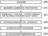
图1是依照本发明一实施例的无人机系统的方框图。请参照图1,无人 机系统100包括图像撷取设备110、无人机120以及运算装置130。无人机 120上搭载图像撷取设备110。图像撷取设备110例如是采用电荷耦合元件 (Charge coupled device,CCD)镜头、互补式金属氧化物半导体晶体管(Complementary metal oxide semiconductor transistors,CMOS)镜头的摄影 机、照相机等,用以获得图像。1 is a block diagram of an unmanned aerial vehicle system in accordance with an embodiment of the present invention. Referring to FIG. 1 , the
运算装置130为例如为服务器、个人计算机、平板计算机、智能型手 机等具有运算功能的电子装置,其具有处理器及存储装置。运算装置130 借由无线传输的方式,接收来自无人机120的图像信息。无线传输的方式 为此技术领域的技术人员熟知的方式,在此不赘述。处理器例如为中央处 理单元(Central Processing Unit,CPU)、图像处理单元(Graphic Processing Unit,GPU)、物理处理单元(Physics Processing Unit,PPU)、可编程的微 处理器(Microprocessor)、嵌入式控制芯片、数字信号处理器(Digital SignalProcessor,DSP)、专用集成电路(Application Specific Integrated Circuits, ASIC)或其他类似装置。而存储装置可由任意型式的固定式或可移动式随 机存取存储器、只读存储器、闪存、安全数字卡、硬盘或其他类似装置或 这些装置的组合来实现。在存储装置中存储一或多个代码段,而由处理器 来执行所述代码段来完成下述图像辨识方法。下述实施例采用快速区域卷 积神经网络(Faster Region-based Convolutional Neural Network,Faster R-CNN)框架并且利用两段侦测来进行图像辨识,即,先侦测出物体位置 再进行分类。The
图2是依照本发明一实施例的图像辨识方法的流程图。请同时参照图1 及图2,在步骤S205中,接收训练图像。在此,训练图像中标注有指定范 围。在数据收集部分,先使用无人机120在可能发生滑坡的区域做巡航, 并使用搭载的图像撷取设备110对环境拍照。在数据收集完后,先进行边 坡的标注。训练图像中还包括与所标注的指定范围对应的指定类别。指定 类别包括滑坡、河流以及道路其中一个。FIG. 2 is a flowchart of an image recognition method according to an embodiment of the present invention. Please refer to FIG. 1 and FIG. 2 at the same time, in step S205, a training image is received. Here, the training image is annotated with the specified range. In the data collection part, the
另外,还可利用数据扩增的方式来获得训练图像。并且,在图像撷取 设备110进行空拍所获得的输入图像的分辨率较高的情况下,倘若直接将 输入图像输入至基础模型则需要很大的内存空间,因此可先将输入图像的 尺寸等比例缩小后,再将缩小后的输入图像执行数据扩增(data augmentation),从而获得多个训练图像。数据扩增包括不同的策略,如旋 转、色彩调整、镜像、对目标区域的平移或形变等等。In addition, data augmentation can also be used to obtain training images. In addition, in the case where the resolution of the input image obtained by the
而在获得训练图像之后,处理器还可通过输入设备来接收操作,以在 训练图像上对欲标注的范围进行框选,并且将范围调整为规则形状的指定 范围。在此,规则形状例如为方形。After the training image is obtained, the processor can also receive an operation through the input device, so as to frame the range to be marked on the training image, and adjust the range to a specified range of a regular shape. Here, the regular shape is, for example, a square.
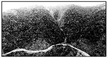
图3A及图3B是依照本发明一实施例的训练图像的示意图。图3A为 尚未进行标注的原始图像,图3B为进行标注后的训练图像。如图3B所示, 由人工进行标注而获得范围301、302、303。并且,在本实施例中,范围 301、302两者对应的指定类别皆为滑坡,而范围303对应的指定类别为道 路。而在获得范围301、302、303之后,处理器会基于范围301、302、303 来产生具有规则形状的指定范围。例如,以范围301而言,以其最长宽度 与最长高度来分别作为对应的指定范围的长与宽。在此,多个指定范围之 间可能会有重叠的情形。3A and 3B are schematic diagrams of training images according to an embodiment of the present invention. Fig. 3A is the original image that has not been labeled, and Fig. 3B is the training image after labeling. As shown in FIG. 3B, the
接着,在步骤S210中,通过基础模型自训练图像撷取多个特征而获得 特征图(feature map)。基础模型的选择会影响模型特征撷取的能力。在此, 基础模型的部分采用起始残差网络(Inception Resnet)的架构。将训练图像 输入至基础模型来进行特征撷取,进而获得特征图。例如,在Faster R-CNN 框架中,在训练图像中萃取出各区域的特征值作为输入,接着在卷积层中 经由卷积核(kernel)的运算来萃取出其相对应的特征图。特征图上的每一 点皆可视为原始的训练图像中对应的区域的特征。Next, in step S210, a feature map is obtained by extracting a plurality of features from the training image through the basic model. The choice of the base model affects the ability of the model to extract features. Here, the part of the basic model adopts the architecture of Inception Resnet. The training image is input to the base model for feature extraction, and then the feature map is obtained. For example, in the Faster R-CNN framework, the feature values of each region are extracted from the training image as input, and then the corresponding feature maps are extracted through the convolution kernel operation in the convolution layer. Each point on the feature map can be regarded as the feature of the corresponding region in the original training image.
之后,在步骤S215中,对特征图上的每一个点进行框选,从而获得多 个初始检测框,并基于指定范围在所述初始检测框中选出多个候选区域。 在此,在Faster R-CNN框架中,以特征图上的每一个点作为中心点来提取 形状与多个筛选窗格对应的多个初始检测框。假设筛选窗格包括9种样式 (anchor)的基本区域,其是由三种大小和三种长宽组合而获得,其是为了 对应不同形状的指定范围。以所述9种筛选窗格对特征图上的每一个点提取9个初始检测框,在获得全部点的初始检测框之后,在这些初始检测框 中选出与训练图像中所标注的每一个指定范围最相符的一个初始检测框作 为候选区域。在选出候选区域之后,再利用非极大值抑制(non-maximum suppress)算法来筛选候选区域,以被保留的候选区域进行后续的分类。After that, in step S215, frame selection is performed on each point on the feature map, thereby obtaining multiple initial detection frames, and selecting multiple candidate regions in the initial detection frames based on the specified range. Here, in the Faster R-CNN framework, each point on the feature map is taken as the center point to extract multiple initial detection boxes with shapes corresponding to multiple screening panes. It is assumed that the filter pane includes basic regions of 9 styles (anchors), which are obtained by combining three sizes and three lengths and widths, which are to correspond to specified ranges of different shapes. Extract 9 initial detection frames for each point on the feature map with the 9 screening panes, and after obtaining the initial detection frames of all points, select each of the initial detection frames and those marked in the training image. An initial detection box with the most matching range is specified as a candidate region. After the candidate regions are selected, a non-maximum suppress algorithm is used to screen the candidate regions, and the reserved candidate regions are used for subsequent classification.
本实施例采用两阶段式(two stage)侦测,先侦测物体位置(候选区 域)再做分类,是筛选出可能有滑坡区域的候选区域,接着再依照这些候 选区域从原本的特征图来分类其是否为滑坡区域,其优点是较准确。In this embodiment, two-stage detection is adopted. The position of the object (candidate area) is detected first and then the classification is performed, which is to filter out the candidate areas that may have landslide areas, and then according to these candidate areas from the original feature map. The advantage of classifying whether it is a landslide area is more accurate.
之后,在步骤S220中,对所获得的所述候选区域进行分类,以获得目 标区块。有了筛选出的候选区域,再从原始的特征图中取出各候选区域相 应的特征,从而对这些候选区域做最后的区域修正和分类,以在候选区域 中选出目标区块。以滑坡检测而言,由于滑坡和道路、河流有比较相似的 特征,虽然目的是做滑坡的辨识,但实验上发现加入了道路和河流的区域 一起做多种类的分类,最后再只选出滑坡位置,整体准确度会有所提升。Then, in step S220, the obtained candidate regions are classified to obtain a target block. With the selected candidate regions, the corresponding features of each candidate region are extracted from the original feature map, so that the final region correction and classification are performed on these candidate regions to select the target block in the candidate region. As far as landslide detection is concerned, since landslides have similar characteristics to roads and rivers, although the purpose is to identify landslides, it is found in experiments that areas with roads and rivers are added together to do multiple types of classification, and finally only landslides are selected. position, the overall accuracy will be improved.
而后,在步骤S225中,自特征图中取出目标区块对应的特征数据。并 且,在步骤S230中,基于被取出的特征数据来调整基础模型的参数。以滑 坡检测而言,找到属于滑坡的目标区域并自特征图来获得对应滑坡的特征 数据,从而来调整基础模型的参数。所述参数包括卷积层的参数、全连接 层的参数、输出层的参数至少其中一个。Then, in step S225, the feature data corresponding to the target block is extracted from the feature map. Then, in step S230, the parameters of the base model are adjusted based on the extracted feature data. In terms of landslide detection, find the target area belonging to the landslide and obtain the characteristic data of the corresponding landslide from the feature map, so as to adjust the parameters of the basic model. The parameters include at least one of the parameters of the convolution layer, the parameters of the fully connected layer, and the parameters of the output layer.
训练基础模型的目的是希望输入一张图像,基础模型能够预测滑坡的 位置在哪里,而这个预测需要和人工标注的数据越像越好。在此,可进一 步采用动量优化器(Momentum optimizer)来帮助参数调整,一直训练到模 型收敛为止。The purpose of training the basic model is to input an image, and the basic model can predict the location of the landslide, and this prediction needs to be as similar to the manually labeled data as possible. Here, a Momentum optimizer can be further used to help the parameter adjustment, and the training will continue until the model converges.
另外,在调整完参数之后,还可进一步验证基础模型的辨识率。即, 分别输入多张测试图像至基础模型而获得多个输出结果,并分别判断所述 输出结果与测试图像中所标注的指定范围的交集率是否大于默认值。接着, 将交集率大于默认值的输出结果判定为辨识正确,从而来获得辨识率。In addition, after adjusting the parameters, the identification rate of the basic model can be further verified. That is, multiple test images are respectively input to the basic model to obtain multiple output results, and it is judged whether the intersection ratio of the output results and the specified range marked in the test image is greater than the default value. Next, the output result whose intersection rate is greater than the default value is determined as correct identification, so as to obtain the identification rate.
在一实施例中,假设图像撷取设备110所空拍获得的图像共有968,将 774张做为训练图像,194张做为测试图像。先行对194张测试图像分别进 行人工标注来获得对应滑坡区域的指定范围,之后逐一将194张测试图像 输入至基础模型,从而来获得最后的输出结果。之后,将输出结果和标注 的指定范围进行对比。由于需要对比输出结果中滑坡位置是否正确,设定 为每一个输出结果和标注的指定范围50%以上的交集率(intersectionover union,IOU)才算是辨识正确。并且,由于每一张测试图像里面都会有不 同数量的滑坡区域,故,进一步定义正确检出是将测试图像上的所有滑坡 都检到即判定为正确检出,即便是有多检测到的滑坡也算是正确,而只要 有一个滑坡漏检就算是错误。验证结果如表1所示。In one embodiment, it is assumed that there are a total of 968 images obtained by the
表1Table 1

综上所述,在上述实施例中,利用图像撷取设备配合无人机来做滑坡 检测,其优点是弹性大,在灾害发生的前后可以随时让无人机起飞去做滑 坡的巡检,且无人机自身就有全球定位系统(Global Positioning System, GPS)可以记录拍照的地点,当检测到滑坡时就可以知道滑坡发生的区域, 由此建立预警地图。而使用无人机拍照能提供较高解析度的图像以及具有 时间弹性的优点,提升图像辨识的精确度。此外,通过上述实施例,可在崩塌发生了以后,尽快知道滑坡区域,进而做出应变措施。To sum up, in the above-mentioned embodiments, the use of image capture equipment and drones for landslide detection has the advantage of being flexible, and the drones can be taken off at any time to perform landslide inspections before and after a disaster occurs. Moreover, the drone itself has a Global Positioning System (GPS) that can record the location where the photo was taken. When a landslide is detected, it can know the area where the landslide occurred, and thus establish an early warning map. Using drones to take pictures can provide higher-resolution images and the advantages of time flexibility, improving the accuracy of image recognition. In addition, through the above-mentioned embodiment, after the collapse occurs, the landslide area can be known as soon as possible, and then the response measures can be taken.
以上所述内容仅为本发明的较佳实施例而已,当不能以此限定本发明 实施的范围,即大凡依本发明权利要求书及说明书内容所作的简单的等效 变化与修饰,皆仍属本发明专利涵盖范围内。另外本发明的任一实施例或 权利要求不须达成本发明所公开的全部目的或优点或特点。此外,摘要部 分和标题仅是用来辅助专利文件搜寻之用,并非用来限制本发明的权利范 围。此外,本说明书或权利要求书中提及的“第一”、“第二”等用语仅用以 命名元件(element)的名称或区别不同实施例或范围,而并非用来限制元 件数量上的上限或下限。The above contents are only preferred embodiments of the present invention, and should not limit the scope of implementation of the present invention, that is, any simple equivalent changes and modifications made according to the claims of the present invention and the contents of the description are still within the scope of the present invention. This invention is covered by the patent. Furthermore, it is not necessary for any embodiment or claim of the present invention to achieve all of the objects or advantages or features disclosed herein. In addition, the abstract section and headings are only used to aid the search of patent documents and are not intended to limit the scope of the present invention. In addition, the terms such as "first" and "second" mentioned in this specification or the claims are only used to name the elements or to distinguish different embodiments or ranges, and are not used to limit the number of elements. upper or lower limit.
Claims (18)
Translated fromChinesePriority Applications (3)
| Application Number | Priority Date | Filing Date | Title |
|---|---|---|---|
| CN202110123677.4ACN114821288A (en) | 2021-01-29 | 2021-01-29 | Image recognition method and unmanned aerial vehicle system |
| TW110106646ATWI773154B (en) | 2021-01-29 | 2021-02-25 | Image recognition method and unmanned aerial vehicle system |
| US17/585,580US20220245938A1 (en) | 2021-01-29 | 2022-01-27 | Image recognition method and unmanned aerial vehicle system |
Applications Claiming Priority (1)
| Application Number | Priority Date | Filing Date | Title |
|---|---|---|---|
| CN202110123677.4ACN114821288A (en) | 2021-01-29 | 2021-01-29 | Image recognition method and unmanned aerial vehicle system |
Publications (1)
| Publication Number | Publication Date |
|---|---|
| CN114821288Atrue CN114821288A (en) | 2022-07-29 |
Family
ID=82526747
Family Applications (1)
| Application Number | Title | Priority Date | Filing Date |
|---|---|---|---|
| CN202110123677.4APendingCN114821288A (en) | 2021-01-29 | 2021-01-29 | Image recognition method and unmanned aerial vehicle system |
Country Status (3)
| Country | Link |
|---|---|
| US (1) | US20220245938A1 (en) |
| CN (1) | CN114821288A (en) |
| TW (1) | TWI773154B (en) |
Citations (5)
| Publication number | Priority date | Publication date | Assignee | Title |
|---|---|---|---|---|
| CN108305214A (en)* | 2017-12-28 | 2018-07-20 | 腾讯科技(深圳)有限公司 | Image processing method, device, storage medium and computer equipment |
| CN109635726A (en)* | 2018-12-11 | 2019-04-16 | 陕西科技大学 | A kind of landslide identification method based on the symmetrical multiple dimensioned pond of depth network integration |
| WO2020164282A1 (en)* | 2019-02-14 | 2020-08-20 | 平安科技(深圳)有限公司 | Yolo-based image target recognition method and apparatus, electronic device, and storage medium |
| WO2020164270A1 (en)* | 2019-02-15 | 2020-08-20 | 平安科技(深圳)有限公司 | Deep-learning-based pedestrian detection method, system and apparatus, and storage medium |
| CN111563408A (en)* | 2020-03-09 | 2020-08-21 | 浙江中海达空间信息技术有限公司 | High-resolution image landslide automatic detection method with multi-level perception characteristics and progressive self-learning |
Family Cites Families (10)
| Publication number | Priority date | Publication date | Assignee | Title |
|---|---|---|---|---|
| US10140719B2 (en)* | 2016-12-22 | 2018-11-27 | TCL Research America Inc. | System and method for enhancing target tracking via detector and tracker fusion for unmanned aerial vehicles |
| WO2019068141A1 (en)* | 2017-10-02 | 2019-04-11 | Sensen Networks Group Pty Ltd | System and method for machine learning-driven object detection |
| CN109241902B (en)* | 2018-08-30 | 2022-05-10 | 北京航空航天大学 | A landslide detection method based on multi-scale feature fusion |
| CN109658352B (en)* | 2018-12-14 | 2021-09-14 | 深圳市商汤科技有限公司 | Image information optimization method and device, electronic equipment and storage medium |
| WO2020179438A1 (en)* | 2019-03-04 | 2020-09-10 | パナソニックIpマネジメント株式会社 | Object amount calculation device and object amount calculation method |
| CN110008854B (en)* | 2019-03-18 | 2021-04-30 | 中交第二公路勘察设计研究院有限公司 | Unmanned aerial vehicle image highway geological disaster identification method based on pre-training DCNN |
| KR102316960B1 (en)* | 2019-11-28 | 2021-10-22 | 광운대학교 산학협력단 | Method and apparatus for realtime object detection in unmanned aerial vehicle image |
| US11244188B2 (en)* | 2020-04-10 | 2022-02-08 | Inception Institute of Artificial Intelligence, Ltd. | Dense and discriminative neural network architectures for improved object detection and instance segmentation |
| CN111898419B (en)* | 2020-06-17 | 2022-10-25 | 西安交通大学 | Partition landslide detection system and method based on cascaded deep convolutional neural network |
| US11521324B2 (en)* | 2020-06-18 | 2022-12-06 | International Business Machines Corporation | Terrain-based automated detection of well pads and their surroundings |
- 2021
- 2021-01-29CNCN202110123677.4Apatent/CN114821288A/enactivePending
- 2021-02-25TWTW110106646Apatent/TWI773154B/enactive
- 2022
- 2022-01-27USUS17/585,580patent/US20220245938A1/enactivePending
Patent Citations (5)
| Publication number | Priority date | Publication date | Assignee | Title |
|---|---|---|---|---|
| CN108305214A (en)* | 2017-12-28 | 2018-07-20 | 腾讯科技(深圳)有限公司 | Image processing method, device, storage medium and computer equipment |
| CN109635726A (en)* | 2018-12-11 | 2019-04-16 | 陕西科技大学 | A kind of landslide identification method based on the symmetrical multiple dimensioned pond of depth network integration |
| WO2020164282A1 (en)* | 2019-02-14 | 2020-08-20 | 平安科技(深圳)有限公司 | Yolo-based image target recognition method and apparatus, electronic device, and storage medium |
| WO2020164270A1 (en)* | 2019-02-15 | 2020-08-20 | 平安科技(深圳)有限公司 | Deep-learning-based pedestrian detection method, system and apparatus, and storage medium |
| CN111563408A (en)* | 2020-03-09 | 2020-08-21 | 浙江中海达空间信息技术有限公司 | High-resolution image landslide automatic detection method with multi-level perception characteristics and progressive self-learning |
Non-Patent Citations (1)
| Title |
|---|
| HSUAN-CHUNG WANG: "General Deep Learning Segmentation Process Used in Remote Sensing Images", THE INTERNATIONAL ARCHIVES OF THE PHOTOGRAMMETRY, REMOTE SENSING AND SPATIAL INFORMATION SCIENCES, 14 August 2020 (2020-08-14), pages 2 - 4* |
Also Published As
| Publication number | Publication date |
|---|---|
| TW202230283A (en) | 2022-08-01 |
| US20220245938A1 (en) | 2022-08-04 |
| TWI773154B (en) | 2022-08-01 |
Similar Documents
| Publication | Publication Date | Title |
|---|---|---|
| US11144786B2 (en) | Information processing apparatus, method for controlling information processing apparatus, and storage medium | |
| JP7190842B2 (en) | Information processing device, control method and program for information processing device | |
| CN108121764B (en) | Image processing device, image processing method, computer program, and computer-readable recording medium | |
| TWI483215B (en) | Augmenting image data based on related 3d point cloud data | |
| US8798378B1 (en) | Scene classification for place recognition | |
| US7733342B2 (en) | Method of extracting 3D building information using shadow analysis | |
| ES2533265T3 (en) | A stereo image register and change detection system and procedure | |
| Zheng et al. | A novel vehicle detection method with high resolution highway aerial image | |
| CN108548539B (en) | Navigation method and device based on image recognition, terminal and readable storage medium | |
| CN112766108B (en) | SAR image target detection method based on context information | |
| CN106529538A (en) | Method and device for positioning aircraft | |
| US11157735B2 (en) | Cloud detection in aerial imagery | |
| CN109214254B (en) | Method and device for determining displacement of robot | |
| CN113012215A (en) | Method, system and equipment for space positioning | |
| Awad | Toward robust segmentation results based on fusion methods for very high resolution optical image and lidar data | |
| US9799123B2 (en) | Information identification system, method of identifying information, and program for identifying information | |
| CN119151889A (en) | Method, device and computer program product for identifying surface cracks in mining areas | |
| Koc-San et al. | A model-based approach for automatic building database updating from high-resolution space imagery | |
| TWI773154B (en) | Image recognition method and unmanned aerial vehicle system | |
| Ch et al. | Pothole detection and dimension estimation by deep learning | |
| WO2022217075A1 (en) | Computer vision systems and methods for determining roof shapes from imagery using segmentation networks | |
| CN111666959A (en) | Vector image matching method and device | |
| KR102816225B1 (en) | A method of constructing training data for estimating a change in a time series image. | |
| CN110617800A (en) | Emergency remote sensing monitoring method, system and storage medium based on civil aircraft | |
| Sadjadi et al. | Combining Hyperspectral and LiDAR Data for Building Extraction using Machine Learning Technique. |
Legal Events
| Date | Code | Title | Description |
|---|---|---|---|
| PB01 | Publication | ||
| PB01 | Publication | ||
| SE01 | Entry into force of request for substantive examination | ||
| SE01 | Entry into force of request for substantive examination | ||
| WD01 | Invention patent application deemed withdrawn after publication | Application publication date:20220729 | |
| WD01 | Invention patent application deemed withdrawn after publication |