CN114814970A - Unmanned aerial vehicle discovery device for airport and disposal method thereof - Google Patents
Unmanned aerial vehicle discovery device for airport and disposal method thereofDownload PDFInfo
- Publication number
- CN114814970A CN114814970ACN202210392137.0ACN202210392137ACN114814970ACN 114814970 ACN114814970 ACN 114814970ACN 202210392137 ACN202210392137 ACN 202210392137ACN 114814970 ACN114814970 ACN 114814970A
- Authority
- CN
- China
- Prior art keywords
- target
- unit
- uav
- image
- airport
- Prior art date
- Legal status (The legal status is an assumption and is not a legal conclusion. Google has not performed a legal analysis and makes no representation as to the accuracy of the status listed.)
- Pending
Links
Images


Classifications
- G—PHYSICS
- G01—MEASURING; TESTING
- G01V—GEOPHYSICS; GRAVITATIONAL MEASUREMENTS; DETECTING MASSES OR OBJECTS; TAGS
- G01V8/00—Prospecting or detecting by optical means
- G01V8/10—Detecting, e.g. by using light barriers
- G—PHYSICS
- G01—MEASURING; TESTING
- G01S—RADIO DIRECTION-FINDING; RADIO NAVIGATION; DETERMINING DISTANCE OR VELOCITY BY USE OF RADIO WAVES; LOCATING OR PRESENCE-DETECTING BY USE OF THE REFLECTION OR RERADIATION OF RADIO WAVES; ANALOGOUS ARRANGEMENTS USING OTHER WAVES
- G01S17/00—Systems using the reflection or reradiation of electromagnetic waves other than radio waves, e.g. lidar systems
- G01S17/02—Systems using the reflection of electromagnetic waves other than radio waves
- G01S17/50—Systems of measurement based on relative movement of target
- G01S17/58—Velocity or trajectory determination systems; Sense-of-movement determination systems
- G—PHYSICS
- G01—MEASURING; TESTING
- G01S—RADIO DIRECTION-FINDING; RADIO NAVIGATION; DETERMINING DISTANCE OR VELOCITY BY USE OF RADIO WAVES; LOCATING OR PRESENCE-DETECTING BY USE OF THE REFLECTION OR RERADIATION OF RADIO WAVES; ANALOGOUS ARRANGEMENTS USING OTHER WAVES
- G01S17/00—Systems using the reflection or reradiation of electromagnetic waves other than radio waves, e.g. lidar systems
- G01S17/88—Lidar systems specially adapted for specific applications
- G01S17/89—Lidar systems specially adapted for specific applications for mapping or imaging
- G—PHYSICS
- G01—MEASURING; TESTING
- G01S—RADIO DIRECTION-FINDING; RADIO NAVIGATION; DETERMINING DISTANCE OR VELOCITY BY USE OF RADIO WAVES; LOCATING OR PRESENCE-DETECTING BY USE OF THE REFLECTION OR RERADIATION OF RADIO WAVES; ANALOGOUS ARRANGEMENTS USING OTHER WAVES
- G01S17/00—Systems using the reflection or reradiation of electromagnetic waves other than radio waves, e.g. lidar systems
- G01S17/88—Lidar systems specially adapted for specific applications
- G01S17/93—Lidar systems specially adapted for specific applications for anti-collision purposes
- G01S17/933—Lidar systems specially adapted for specific applications for anti-collision purposes of aircraft or spacecraft
Landscapes
- Physics & Mathematics (AREA)
- Engineering & Computer Science (AREA)
- General Physics & Mathematics (AREA)
- Electromagnetism (AREA)
- Computer Networks & Wireless Communication (AREA)
- Radar, Positioning & Navigation (AREA)
- Remote Sensing (AREA)
- Life Sciences & Earth Sciences (AREA)
- General Life Sciences & Earth Sciences (AREA)
- Geophysics (AREA)
- Aviation & Aerospace Engineering (AREA)
- Closed-Circuit Television Systems (AREA)
Abstract
Translated fromChinese
Description
Translated fromChinese技术领域technical field
本发明涉及一种机场用无人机发现装置,具体是一种机场用无人机发现装置及其处置方法。The invention relates to an unmanned aerial vehicle discovery device for airports, in particular to an unmanned aerial vehicle discovery device for airports and a disposal method thereof.
背景技术Background technique
无人机具有隐蔽性好,抗干扰能力强,体积小重量轻以及对起落环境要求低等特点,最初被研制用于侦察监视和作为靶机等军事用途。近年来,随着无人机研发技术日趋成熟和生产成本逐步降低,无人机作为一项新兴的消费级产品进入人们的视野,并广泛应用于安防监控、光伏勘测、电力巡检、农业植保、物资配送以及智能航拍等民用领域。UAV has the characteristics of good concealment, strong anti-jamming ability, small size and light weight, and low requirements for the landing environment. It was originally developed for military purposes such as reconnaissance and surveillance and as a target drone. In recent years, with the maturity of UAV research and development technology and the gradual reduction of production costs, UAVs have entered people's field of vision as an emerging consumer product, and are widely used in security monitoring, photovoltaic survey, power inspection, agricultural plant protection , material distribution and intelligent aerial photography and other civil fields.
现代智能化战场需求来看,无人机作为典型的情报、预警和侦察装备已成为国家和军队的重要组成部分,并逐渐向作战型转变,无人机能够飞到雷达管控范围之外,这使得小型无人机很难被准确地探测到。与此同时,随着无人机消费市场的不断拓宽,给人们的日常生活带来便利的同时也会被居心叵测之人用于非法领域,日前涌现出了许多安全和隐私方面的忧患。From the perspective of the needs of modern intelligent battlefields, UAVs, as typical intelligence, early warning and reconnaissance equipment, have become an important part of the country and the army, and are gradually transforming into combat-oriented ones. UAVs can fly beyond the range of radar control. It makes it difficult for small drones to be accurately detected. At the same time, with the continuous expansion of the consumer market of drones, while bringing convenience to people's daily lives, they will also be used in illegal fields by people with ulterior motives. Many security and privacy concerns have emerged recently.
早在2015年,一架遥控无人机在飞行过程中失控,摔落在美国白宫附近的草坪上;2017年5月,昆明长水国际机场遭遇无人机干扰,造成35架航班被迫降落,机场跑道持续关闭45分钟,给机场的安全运行带来巨大威胁;2018年3月,深圳海关破获了一起利用无人机走私手机案件,初估案值高达5亿元人民币;同年8月4日,委内瑞拉总统马杜罗在出席军队纪念活动电视讲话时,突然遭遇几架装有炸药的无人机袭击现场,引发民众恐慌。近年来诸如此类的无人机事件频繁发生,已经对隐私保护、安全出行等生活领域造成直接或间接的危害。As early as 2015, a remote-controlled drone lost control during flight and fell on the lawn near the White House in the United States; in May 2017, Kunming Changshui International Airport encountered drone interference, causing 35 flights to be forced to land. , the airport runway continued to be closed for 45 minutes, posing a huge threat to the safe operation of the airport; in March 2018, Shenzhen Customs cracked a case of using drones to smuggle mobile phones, with an initial estimate of 500 million yuan; on August 4 of the same year , Venezuelan President Nicolas Maduro was suddenly attacked by several drones equipped with explosives while attending a televised speech at a military commemorative event, causing panic among the people. In recent years, such drone incidents have occurred frequently, which have caused direct or indirect harm to privacy protection, safe travel and other areas of life.
发明内容SUMMARY OF THE INVENTION
发明目的:一种机场用无人机发现装置及其处置方法,以解决现有技术存在的上述问题。The purpose of the invention is to solve the above-mentioned problems existing in the prior art by an unmanned aerial vehicle (UAV) discovery device for airports and a disposal method thereof.
技术方案:一种机场用无人机发现装置,包括可见光成像单元,与所述可见光成像单元连接的图像探测器,与所述图像探测器连接的图像采集单元,与所述图像采集系统连接的无人机目标识别单元,与所述无人机目标识别单元连接的无人机轨迹预测单元,与所述无人机轨迹预测单元连接的数据传输接口单元,与所述数据传输接口单元连接的攻击单元;Technical solution: A drone discovery device for airports, comprising a visible light imaging unit, an image detector connected to the visible light imaging unit, an image acquisition unit connected to the image detector, and an image acquisition system connected to the image acquisition system. The UAV target identification unit, the UAV trajectory prediction unit connected with the UAV target identification unit, the data transmission interface unit connected with the UAV trajectory prediction unit, the UAV trajectory prediction unit connected with the data transmission interface unit attack unit;
所述可见光成像单元用于低空采集到运动目标和背景图像,完成无人机视频序列的铺获工作;The visible light imaging unit is used to collect moving targets and background images at low altitudes, and complete the paving work of UAV video sequences;
所述攻击单元用攻击或者干扰飞入机场安全范围内的非执行任务的无人机。The attack unit is used to attack or interfere with non-mission UAVs flying into the safe area of the airport.
在进一步实施例中,所述图像探测器均布在设置在机场的周向;In a further embodiment, the image detectors are evenly distributed in the circumferential direction of the airport;
所述图像探测器用于探测无人的探测距离、时间距离和分辨距离;The image detector is used for detecting unmanned detection distance, time distance and resolution distance;
探测距离指发现目标,但是不确定目标的具体类型;The detection distance refers to the discovery of the target, but the specific type of the target is uncertain;
识别距离指发现目标,且识别目标类型。The recognition distance refers to finding the target and identifying the target type.
在进一步实施例中,所述图像探测器的成像素数、探测距离与分辨率的关系为:In a further embodiment, the relationship between the number of pixels, the detection distance and the resolution of the image detector is:

式中:S为成像距离,H为最小可探测目标的高度尺寸,f代表系统焦距,h表示目标在探测器成像平面上的尺寸;where S is the imaging distance, H is the height of the smallest detectable target, f is the focal length of the system, and h is the size of the target on the imaging plane of the detector;
式中:where:

其中;in;

式中d为探测器单个像元尺寸、
垂直方向上的像素数
其中,探测器的角分辨率与像元尺寸和系统焦距之间的关系为:a0=d/f。Among them, the relationship between the angular resolution of the detector, the pixel size and the system focal length is: a0 =d/f.

式中θ为目标运动方向与光学系统主轴的夹角。where θ is the angle between the moving direction of the target and the main axis of the optical system.
在进一步实施例中,所述图像采集单元包括视频拍摄器,与所述视频拍摄器连接的图像接收器,与所述图像接收器连接的图像控制器。In a further embodiment, the image acquisition unit includes a video camera, an image receiver connected to the video camera, and an image controller connected to the image receiver.
所述视频拍摄器选用180°全景相机共计多组。The video camera selects a total of multiple groups of 180° panoramic cameras.
在进一步实施例中,所述无人机目标识别单元包括数据库,所述图像探测器上设置有天线,所述天线与攻击单元连接。In a further embodiment, the UAV target identification unit includes a database, and the image detector is provided with an antenna, and the antenna is connected to the attack unit.
在进一步实施例中,所述数据库包括标准单元,与所述标准单元连接的对比单元,与所述对比单元连接的学习单元;In a further embodiment, the database includes a standard unit, a comparison unit connected to the standard unit, and a learning unit connected to the comparison unit;
所述标准单元用于存储现有市面所有无人机机型。The standard unit is used to store all UAV models currently on the market.
在进一步实施例中,所述攻击单元通过无线入侵建立通信,并且篡改无人机的巡航时的起点,使得无人机朝着攻击者期望的轨迹飞行或攻击者入侵设备与无人机建立通信,并且发送悬停指令,使得无人机在任务中被迫悬停,从而终止无人机任务的正常执行。In a further embodiment, the attack unit establishes communication through wireless intrusion, and tampers with the starting point of the UAV's cruise, so that the UAV flies toward the trajectory desired by the attacker or the attacker intrudes the device to establish communication with the UAV , and send a hovering command, so that the UAV is forced to hover during the mission, thereby terminating the normal execution of the UAV mission.
在进一步实施例中,包括如下步骤;In a further embodiment, the following steps are included;
步骤1、将装置设置在预设的位置;Step 1. Set the device to the preset position;
步骤2、可见光成像单元采集机场低空场景中的运动目标和背景图像;Step 2. The visible light imaging unit collects moving objects and background images in the low-altitude scene of the airport;
步骤3、可见光成像单元将采集的图像实时传送至图像探测器中,图像探测器将图像传送至图像采集单元,经过调整图像的大小和图像数据,提取目标信息特征对经过运动目标进行判断;Step 3, the visible light imaging unit transmits the collected image to the image detector in real time, the image detector transmits the image to the image acquisition unit, and after adjusting the size and image data of the image, extracts the target information feature to judge the passing moving target;
步骤4、判断运动目标是否为无人机,并且提取数据库中的目标特性进行对比;Step 4. Determine whether the moving target is a UAV, and extract the target characteristics in the database for comparison;
步骤5、通过计算目标模型,采集的运动轨迹预算运动的精确位置、飞行速度和运动轨迹信息;Step 5. By calculating the target model, the collected motion trajectory estimates the accurate position, flight speed and motion trajectory information of the motion;
步骤6、当判断非我方无人机时,攻击单元启动;Step 6. When it is judged that it is not our drone, the attack unit starts;
步骤7、攻击单元通过通信入侵建立通训,选择跟踪、悬停或者击落方式;Step 7. The attack unit establishes general training through communication intrusion, and selects the method of tracking, hovering or shooting down;
步骤8、当选择跟踪目标时,攻击单元通过数据传输接口单元将无人机跟踪数据实施发送给后台,实现对目标无人机跟踪结果的实时显示。
有益效果:本发明公开了一种机场用无人机发现装置,通过可见成像单元探测跟踪运动目标,同时对探测器的工作距离、像元尺寸与分辨率关系、目标成型进行分析,提高了装置的稳定性,通过攻击单元对运动目标进行通信入侵进行不同方式的攻击,攻击方式多样化,同时设置有数据库,数据库中的特性信息与运动目标进行分析,判断目标与数据连接的地面连接,分析运动目标从而截获运动目标的位置等状态信息。Beneficial effects: The present invention discloses an unmanned aerial vehicle (UAV) discovery device for airports, which detects and tracks a moving target through a visible imaging unit, and at the same time analyzes the working distance of the detector, the relationship between the pixel size and resolution, and the shape of the target, thereby improving the performance of the device. The communication intrusion of the moving target is carried out by the attack unit, and the attack methods are diversified. At the same time, a database is set up. The characteristic information in the database is analyzed with the moving target, and the ground connection between the target and the data connection is judged and analyzed. The moving target thus intercepts state information such as the position of the moving target.
附图说明Description of drawings
图1为本发明的流程图;Fig. 1 is the flow chart of the present invention;
图2为本发明光学系统的成像示意图;Fig. 2 is the imaging schematic diagram of the optical system of the present invention;
图3为本发明目标距离与成像尺寸关系图;Fig. 3 is the relation diagram of target distance and imaging size of the present invention;
具体实施方式Detailed ways
本发明通过一种机场用无人机发现装置,现有技术随着无人机消费市场的不断拓宽,给人们的日常生活带来便利的同时也会被居心叵测之人用于非法领域,日前涌现出了许多安全和隐私方面的忧患。早在2015年,一架遥控无人机在飞行过程中失控,摔落在美国白宫附近的草坪上;2017年5月,昆明长水国际机场遭遇无人机干扰,造成35架航班被迫降落,机场跑道持续关闭45分钟,给机场的安全运行带来巨大威胁;2018年3月,深圳海关破获了一起利用无人机走私手机案件,初估案值高达5亿元人民币;同年8月4日,委内瑞拉总统马杜罗在出席军队纪念活动电视讲话时,突然遭遇几架装有炸药的无人机袭击现场,引发民众恐慌。近年来诸如此类的无人机事件频繁发生,已经对隐私保护、安全出行等生活领域造成直接或间接的危害。下面通过实施例,并结合附图对本方案做进一步具体说明。The present invention uses an unmanned aerial vehicle (UAV) discovery device for airports. With the continuous expansion of the UAV consumer market, the existing technology brings convenience to people's daily life and is also used in illegal fields by people with ulterior motives. There are many security and privacy concerns. As early as 2015, a remote-controlled drone lost control during flight and fell on the lawn near the White House in the United States; in May 2017, Kunming Changshui International Airport encountered drone interference, causing 35 flights to be forced to land. , the airport runway continued to be closed for 45 minutes, posing a huge threat to the safe operation of the airport; in March 2018, Shenzhen Customs cracked a case of using drones to smuggle mobile phones, with an initial estimate of 500 million yuan; on August 4 of the same year , Venezuelan President Nicolas Maduro was suddenly attacked by several drones equipped with explosives while attending a televised speech at a military commemorative event, causing panic among the people. In recent years, such drone incidents have occurred frequently, which have caused direct or indirect harm to privacy protection, safe travel and other areas of life. The present scheme will be further described in detail below through examples and in conjunction with the accompanying drawings.
具体的,包括可见光成像单元,与所述可见光成像单元连接的图像探测器,其特征在于;与所述图像探测器连接的图像采集单元,与所述图像采集系统连接的无人机目标识别单元,与所述无人机目标识别单元连接的无人机轨迹预测单元,与所述无人机轨迹预测单元连接的数据传输接口单元,与所述数据传输接口单元连接的攻击单元;所述可见光成像单元用于低空采集到运动目标和背景图像,完成无人机视频序列的铺获工作;所述攻击单元用攻击或者干扰飞入机场安全范围内的非执行任务的无人机。通过对机场运动目标和背景图像,完成对运动目标的捕获工作,利用图像采集单元调整采集运动目标图像的大小,获取运动目标的数据信息,结合轨迹运算算法算出运动目标的精确位置、飞行速度和运动轨迹等信息,完成目标的跟踪任务,另外还设置有数据传输接口将运动目标跟踪数据发送到攻击单元,攻击目标实时将反馈至地面,实现对运动目标的跟踪结果的实时显示。Specifically, it includes a visible light imaging unit, an image detector connected to the visible light imaging unit, and characterized in that: an image acquisition unit connected to the image detector, and an unmanned aerial vehicle target recognition unit connected to the image acquisition system , the UAV trajectory prediction unit connected with the UAV target identification unit, the data transmission interface unit connected with the UAV trajectory prediction unit, the attack unit connected with the data transmission interface unit; the visible light The imaging unit is used to collect moving targets and background images at low altitudes, and complete the paving work of UAV video sequences; the attack unit is used to attack or interfere with UAVs that fly into the airport safety range and are not performing tasks. Through the airport moving target and background image, the capture of the moving target is completed, the image acquisition unit is used to adjust the size of the collected moving target image, the data information of the moving target is obtained, and the precise position, flight speed and In addition, a data transmission interface is set to send the tracking data of the moving target to the attack unit, and the attack target will be fed back to the ground in real time, so as to realize the real-time display of the tracking result of the moving target.
具体的,所述图像探测器均布在设置在机场的周向;所述图像探测器用于探测无人的探测距离、时间距离和分辨距离;探测距离指发现目标,但是不确定目标的具体类型;识别距离指发现目标,且识别目标类型。Specifically, the image detectors are evenly distributed in the circumferential direction of the airport; the image detectors are used to detect the detection distance, time distance and resolution distance of unmanned persons; the detection distance refers to finding the target, but the specific type of the target is uncertain ; Recognition distance refers to finding the target and identifying the target type.
作为一个优先案例,一般来讲,当目标相对于探测器的张角小于其瞬时视场角时,可将目标近似为点源模型;相反地,若目标对探测器的张角大于瞬时视场角,则可将目标视为面源模型,运动目标经过光学系统在探测器成像平面上所占像素数的多少与探测距离和系统的角分辨率有关,其几何关系如图2所示,所述图像探测器的成像素数、探测距离与分辨率的关系为:As a priority case, in general, when the opening angle of the target relative to the detector is smaller than its instantaneous field of view, the target can be approximated as a point source model; on the contrary, if the target's opening angle to the detector is greater than the instantaneous field of view angle, the target can be regarded as a surface source model. The number of pixels occupied by the moving target on the detector imaging plane through the optical system is related to the detection distance and the angular resolution of the system. The geometric relationship is shown in Figure 2. The relationship between the number of pixels, the detection distance and the resolution of the image detector is:

式中:S为成像距离,H为最小可探测目标的高度尺寸,f代表系统焦距,h表示目标在探测器成像平面上的尺寸;where S is the imaging distance, H is the height of the smallest detectable target, f is the focal length of the system, and h is the size of the target on the imaging plane of the detector;
式中:where:

其中;in;

式中d为探测器单个像元尺寸、
垂直方向上的像素数
其中,探测器的角分辨率与像元尺寸和系统焦距之间的关系为:a0=d/f。Among them, the relationship between the angular resolution of the detector, the pixel size and the system focal length is: a0 =d/f.

式中θ为目标运动方向与光学系统主轴的夹角。where θ is the angle between the moving direction of the target and the main axis of the optical system.
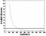
具体的,在不同的光电设备上成像时,可通过像元尺寸估算该设备的作用距离指标。基本的估算方法是:在已知目标尺寸和参数的前提下,首先通过图像处理技术,将所拍摄图像中的目标尺寸计算出来,然后由公式计算出目标相对于探测器的距离,即为光电系统的作用距离。假设图像传感器选用分辨率为640×480,像元大小为4.65μm的CCD,当探测器的视场角为0.3mrad×0.3mrad时,选定系统的成像系统焦距为f'=155mm,采用上述理论进行分析计算,目标在成像面上仅占一个像素时,此时所对应的探测器极限作用距离为1Km,根据光学系统的几何关系,在低空范围(100m-1000m)运动目标在探测器上的成像尺寸与目标距离之间的关系如图3所示。由图3可以看出,运动目标在由近到远的飞行过程中,在探测器成像面上的像素数呈对数关系减少,在大概600米以内均表现为扩展目标。经过前面的分析,选用10个像元作为运动目标的感光像元数,在目标与探测器之间的距离约为330米,可以将无人机目标从背景中检测出来所述图像采集单元包括视频拍摄器,与所述视频拍摄器连接的图像接收器,与所述图像接收器连接的图像控制器。所述视频拍摄器选用180°全景相机共计多组。Specifically, when imaging on different optoelectronic devices, the working distance index of the device can be estimated through the pixel size. The basic estimation method is: on the premise of known target size and parameters, first calculate the target size in the captured image through image processing technology, and then calculate the distance of the target relative to the detector by the formula, which is photoelectric. The operating distance of the system. Assuming that the image sensor uses a CCD with a resolution of 640×480 and a pixel size of 4.65μm, when the field of view of the detector is 0.3mrad×0.3mrad, the focal length of the imaging system of the selected system is f'=155mm. According to the theoretical analysis and calculation, when the target occupies only one pixel on the imaging surface, the corresponding detector limit action distance is 1Km. According to the geometric relationship of the optical system, the moving target in the low altitude range (100m-1000m) is on the detector. The relationship between the imaging size and the target distance is shown in Figure 3. It can be seen from Figure 3 that during the flight from near to far, the number of pixels on the imaging surface of the detector decreases in a logarithmic relationship, and it appears as an extended target within about 600 meters. After the previous analysis, 10 pixels are selected as the number of photosensitive pixels of the moving target, and the distance between the target and the detector is about 330 meters, and the drone target can be detected from the background. The image acquisition unit includes: A video camera, an image receiver connected with the video camera, and an image controller connected with the image receiver. The video camera selects a total of multiple groups of 180° panoramic cameras.
具体的,所述无人机目标识别单元包括数据库,所述图像探测器上设置有天线,所述天线与攻击单元连接。Specifically, the UAV target identification unit includes a database, the image detector is provided with an antenna, and the antenna is connected to the attack unit.
具体的,所述数据库包括标准单元,与所述标准单元连接的对比单元,与所述对比单元连接的学习单元;Specifically, the database includes a standard unit, a comparison unit connected with the standard unit, and a learning unit connected with the comparison unit;
所述标准单元用于存储现有市面所有无人机机型。The standard unit is used to store all UAV models currently on the market.
具体的,所述攻击单元通过无线入侵建立通信,并且篡改无人机的巡航时的起点,使得无人机朝着攻击者期望的轨迹飞行或攻击者入侵设备与无人机建立通信,并且发送悬停指令,使得无人机在任务中被迫悬停,从而终止无人机任务的正常执行。Specifically, the attack unit establishes communication through wireless intrusion, and tampers with the starting point of the drone's cruising, so that the drone flies toward the trajectory expected by the attacker or the attacker's intrusion device establishes communication with the drone, and sends a message to the drone. The hovering command makes the UAV forced to hover during the mission, thereby terminating the normal execution of the UAV mission.
具体的,包括如下步骤;Specifically, it includes the following steps;
步骤1、将装置设置在预设的位置;Step 1. Set the device to the preset position;
步骤2、可见光成像单元采集机场低空场景中的运动目标和背景图像;Step 2. The visible light imaging unit collects moving objects and background images in the low-altitude scene of the airport;
步骤3、可见光成像单元将采集的图像实时传送至图像探测器中,图像探测器将图像传送至图像采集单元,经过调整图像的大小和图像数据,提取目标信息特征对经过运动目标进行判断;Step 3, the visible light imaging unit transmits the collected image to the image detector in real time, the image detector transmits the image to the image acquisition unit, and after adjusting the size and image data of the image, extracts the target information feature to judge the passing moving target;
步骤4、判断运动目标是否为无人机,并且提取数据库中的目标特性进行对比;Step 4. Determine whether the moving target is a UAV, and extract the target characteristics in the database for comparison;
步骤5、通过计算目标模型,采集的运动轨迹预算运动的精确位置、飞行速度和运动轨迹信息;Step 5. By calculating the target model, the collected motion trajectory estimates the accurate position, flight speed and motion trajectory information of the motion;
步骤6、当判断非我方无人机时,攻击单元启动;Step 6. When it is judged that it is not our drone, the attack unit starts;
步骤7、攻击单元通过通信入侵建立通训,选择跟踪、悬停或者击落方式;Step 7. The attack unit establishes general training through communication intrusion, and selects the method of tracking, hovering or shooting down;
步骤8、当选择跟踪目标时,攻击单元通过数据传输接口单元将无人机跟踪数据实施发送给后台,实现对目标无人机跟踪结果的实时显示。
以上结合附图详细描述了本发明的优选实施方式,但是,本发明并不限于上述实施方式中的具体细节,在本发明的技术构思范围内,可以对本发明的技术方案进行多种等同变换,这些等同变换均属于本发明的保护范围。The preferred embodiments of the present invention have been described in detail above with reference to the accompanying drawings. However, the present invention is not limited to the specific details in the above-mentioned embodiments. Within the scope of the technical concept of the present invention, various equivalent transformations can be made to the technical solutions of the present invention, These equivalent transformations all belong to the protection scope of the present invention.
Claims (8)
Translated fromChinese


Priority Applications (1)
| Application Number | Priority Date | Filing Date | Title |
|---|---|---|---|
| CN202210392137.0ACN114814970A (en) | 2022-04-14 | 2022-04-14 | Unmanned aerial vehicle discovery device for airport and disposal method thereof |
Applications Claiming Priority (1)
| Application Number | Priority Date | Filing Date | Title |
|---|---|---|---|
| CN202210392137.0ACN114814970A (en) | 2022-04-14 | 2022-04-14 | Unmanned aerial vehicle discovery device for airport and disposal method thereof |
Publications (1)
| Publication Number | Publication Date |
|---|---|
| CN114814970Atrue CN114814970A (en) | 2022-07-29 |
Family
ID=82535759
Family Applications (1)
| Application Number | Title | Priority Date | Filing Date |
|---|---|---|---|
| CN202210392137.0APendingCN114814970A (en) | 2022-04-14 | 2022-04-14 | Unmanned aerial vehicle discovery device for airport and disposal method thereof |
Country Status (1)
| Country | Link |
|---|---|
| CN (1) | CN114814970A (en) |
Cited By (1)
| Publication number | Priority date | Publication date | Assignee | Title |
|---|---|---|---|---|
| CN118870208A (en)* | 2024-07-02 | 2024-10-29 | 中国人民解放军国防科技大学 | A multi-modal image data acquisition system |
Citations (7)
| Publication number | Priority date | Publication date | Assignee | Title |
|---|---|---|---|---|
| WO2017020856A1 (en)* | 2015-08-05 | 2017-02-09 | 普宙飞行器科技(深圳)有限公司 | Photographing device and method using drone to automatically track and photograph moving object |
| CN107561593A (en)* | 2017-05-12 | 2018-01-09 | 广州联通控股有限公司 | A kind of small-sized unmanned aircraft composite detecting device |
| CN109061621A (en)* | 2018-05-03 | 2018-12-21 | 中国船舶重工集团公司第七�三研究所 | A kind of novel airfield runway exotic photoelectric detecting method and detection system |
| CN110597264A (en)* | 2019-09-25 | 2019-12-20 | 中国人民解放军陆军工程大学 | drone countermeasure system |
| CN111652067A (en)* | 2020-04-30 | 2020-09-11 | 南京理工大学 | A UAV recognition method based on image detection |
| CN112422895A (en)* | 2020-10-22 | 2021-02-26 | 华能阜新风力发电有限责任公司 | Image analysis tracking and positioning system and method based on unmanned aerial vehicle |
| KR102292117B1 (en)* | 2021-02-23 | 2021-08-20 | (주)필라넷 | Drone control system and method for detecting and identifying of drone using the same |
- 2022
- 2022-04-14CNCN202210392137.0Apatent/CN114814970A/enactivePending
Patent Citations (7)
| Publication number | Priority date | Publication date | Assignee | Title |
|---|---|---|---|---|
| WO2017020856A1 (en)* | 2015-08-05 | 2017-02-09 | 普宙飞行器科技(深圳)有限公司 | Photographing device and method using drone to automatically track and photograph moving object |
| CN107561593A (en)* | 2017-05-12 | 2018-01-09 | 广州联通控股有限公司 | A kind of small-sized unmanned aircraft composite detecting device |
| CN109061621A (en)* | 2018-05-03 | 2018-12-21 | 中国船舶重工集团公司第七�三研究所 | A kind of novel airfield runway exotic photoelectric detecting method and detection system |
| CN110597264A (en)* | 2019-09-25 | 2019-12-20 | 中国人民解放军陆军工程大学 | drone countermeasure system |
| CN111652067A (en)* | 2020-04-30 | 2020-09-11 | 南京理工大学 | A UAV recognition method based on image detection |
| CN112422895A (en)* | 2020-10-22 | 2021-02-26 | 华能阜新风力发电有限责任公司 | Image analysis tracking and positioning system and method based on unmanned aerial vehicle |
| KR102292117B1 (en)* | 2021-02-23 | 2021-08-20 | (주)필라넷 | Drone control system and method for detecting and identifying of drone using the same |
Cited By (1)
| Publication number | Priority date | Publication date | Assignee | Title |
|---|---|---|---|---|
| CN118870208A (en)* | 2024-07-02 | 2024-10-29 | 中国人民解放军国防科技大学 | A multi-modal image data acquisition system |
Similar Documents
| Publication | Publication Date | Title |
|---|---|---|
| CN105759834B (en) | A kind of system and method actively capturing low latitude small-sized unmanned aircraft | |
| CN112068111A (en) | A UAV target detection method based on multi-sensor information fusion | |
| Ganti et al. | Implementation of detection and tracking mechanism for small UAS | |
| EP3943746B1 (en) | Automated system for tracking an airborne object | |
| CN110619276B (en) | Anomaly and violence detection system and method based on unmanned aerial vehicle mobile monitoring | |
| CN102436738B (en) | A drone-based traffic monitoring device | |
| CN114373138A (en) | Full-automatic unmanned aerial vehicle inspection method and system for high-speed railway | |
| CN105303748B (en) | Fire Alarm System Based on Aerial Photography | |
| CN111580425A (en) | System and method suitable for forest fire danger monitoring | |
| CN109255286A (en) | A kind of quick detection recognition method of unmanned plane optics based on YOLO deep learning network frame | |
| CN108710126A (en) | Automation detection expulsion goal approach and its system | |
| CN109613934A (en) | A method for drones to capture black flying drones | |
| CN104168455A (en) | Air-based large-scene photographing system and method | |
| CN115035470A (en) | A method and system for low, small and slow target recognition and localization based on hybrid vision | |
| CN104715556A (en) | Fire alarm method based on aerial photography | |
| CN110132060A (en) | A method of intercepting drones based on visual navigation | |
| CN109708659B (en) | Distributed intelligent photoelectric low-altitude protection system | |
| CN116109950A (en) | Low-airspace anti-unmanned aerial vehicle visual detection, identification and tracking method | |
| CN112530207A (en) | Airport bird condition monitoring method and system | |
| CN107943084A (en) | A kind of trailing type electromagnetic interference system and method for civilian multi-rotor unmanned aerial vehicle | |
| CN112802058A (en) | Method and device for tracking illegal moving target | |
| CN114814970A (en) | Unmanned aerial vehicle discovery device for airport and disposal method thereof | |
| Wang et al. | Building smart city drone for graffiti detection and clean-up | |
| CN119625633A (en) | A method and device for identifying drones based on high-point camera gimbal motion characteristics | |
| CN111681399A (en) | Multi-dimensional three-dimensional safety prevention and control method, device and system |
Legal Events
| Date | Code | Title | Description |
|---|---|---|---|
| PB01 | Publication | ||
| PB01 | Publication | ||
| SE01 | Entry into force of request for substantive examination | ||
| SE01 | Entry into force of request for substantive examination | ||
| RJ01 | Rejection of invention patent application after publication | ||
| RJ01 | Rejection of invention patent application after publication | Application publication date:20220729 |