CN114779206A - Method and device for identifying road boundary, storage medium and equipment - Google Patents
Method and device for identifying road boundary, storage medium and equipmentDownload PDFInfo
- Publication number
- CN114779206A CN114779206ACN202210231649.9ACN202210231649ACN114779206ACN 114779206 ACN114779206 ACN 114779206ACN 202210231649 ACN202210231649 ACN 202210231649ACN 114779206 ACN114779206 ACN 114779206A
- Authority
- CN
- China
- Prior art keywords
- road boundary
- grid
- point
- height value
- cloud data
- Prior art date
- Legal status (The legal status is an assumption and is not a legal conclusion. Google has not performed a legal analysis and makes no representation as to the accuracy of the status listed.)
- Granted
Links
Images


Classifications
- G—PHYSICS
- G01—MEASURING; TESTING
- G01S—RADIO DIRECTION-FINDING; RADIO NAVIGATION; DETERMINING DISTANCE OR VELOCITY BY USE OF RADIO WAVES; LOCATING OR PRESENCE-DETECTING BY USE OF THE REFLECTION OR RERADIATION OF RADIO WAVES; ANALOGOUS ARRANGEMENTS USING OTHER WAVES
- G01S7/00—Details of systems according to groups G01S13/00, G01S15/00, G01S17/00
- G01S7/48—Details of systems according to groups G01S13/00, G01S15/00, G01S17/00 of systems according to group G01S17/00
- G01S7/4802—Details of systems according to groups G01S13/00, G01S15/00, G01S17/00 of systems according to group G01S17/00 using analysis of echo signal for target characterisation; Target signature; Target cross-section
- G—PHYSICS
- G01—MEASURING; TESTING
- G01S—RADIO DIRECTION-FINDING; RADIO NAVIGATION; DETERMINING DISTANCE OR VELOCITY BY USE OF RADIO WAVES; LOCATING OR PRESENCE-DETECTING BY USE OF THE REFLECTION OR RERADIATION OF RADIO WAVES; ANALOGOUS ARRANGEMENTS USING OTHER WAVES
- G01S17/00—Systems using the reflection or reradiation of electromagnetic waves other than radio waves, e.g. lidar systems
- G01S17/88—Lidar systems specially adapted for specific applications
- G01S17/89—Lidar systems specially adapted for specific applications for mapping or imaging
- G—PHYSICS
- G06—COMPUTING OR CALCULATING; COUNTING
- G06F—ELECTRIC DIGITAL DATA PROCESSING
- G06F18/00—Pattern recognition
- G06F18/20—Analysing
- G06F18/23—Clustering techniques
Landscapes
- Engineering & Computer Science (AREA)
- Physics & Mathematics (AREA)
- Data Mining & Analysis (AREA)
- General Physics & Mathematics (AREA)
- Remote Sensing (AREA)
- Radar, Positioning & Navigation (AREA)
- Computer Networks & Wireless Communication (AREA)
- Theoretical Computer Science (AREA)
- Bioinformatics & Cheminformatics (AREA)
- Evolutionary Computation (AREA)
- General Engineering & Computer Science (AREA)
- Evolutionary Biology (AREA)
- Computer Vision & Pattern Recognition (AREA)
- Bioinformatics & Computational Biology (AREA)
- Electromagnetism (AREA)
- Artificial Intelligence (AREA)
- Life Sciences & Earth Sciences (AREA)
- Traffic Control Systems (AREA)
Abstract
Translated fromChinese
Description
Translated fromChinese技术领域technical field
本申请涉及自动驾驶技术领域,特别是涉及一种道路边界的识别方法及装置、存储介质、设备。The present application relates to the technical field of automatic driving, and in particular, to a road boundary identification method and device, storage medium, and device.
背景技术Background technique
在车辆自动驾驶技术中,道路边界识别算法是车辆感知模块的重要组成部分,可以通过去除车道线以外的区域实现降低算法计算量,同时减少潜在干扰因素的目的。在城市中,道路边界通常是通过在道路上绘制不同颜色、不同形状的线段,以进行车道划分;在矿区中,由于道路受重载车辆反复碾压,且车辆的行驶路线也会频繁变化,因此通常是通过在车道两侧堆砌挡墙以进行车道划分。通常情况下,挡墙与地面的高度差变化不大,因此可以使用激光雷达采集点云并基于高度等参数对挡墙进行识别。In the vehicle autonomous driving technology, the road boundary recognition algorithm is an important part of the vehicle perception module. It can reduce the calculation amount of the algorithm and reduce the potential interference factors by removing the area other than the lane line. In the city, the road boundary is usually divided by drawing lines of different colors and shapes on the road to divide the lanes; in the mining area, since the road is repeatedly rolled by heavy-duty vehicles, and the driving route of the vehicles will change frequently, Therefore, lane division is usually performed by stacking retaining walls on both sides of the lane. Usually, the height difference between the retaining wall and the ground does not change much, so lidar can be used to collect point clouds and identify the retaining wall based on parameters such as height.
目前,现有技术是根据点云数据求取相邻采样点的斜率,将存在斜率突变的点作为地面与挡墙的临界点,以实现对挡墙的识别。At present, in the prior art, the slope of adjacent sampling points is obtained according to point cloud data, and the point with a sudden change in the slope is used as the critical point between the ground and the retaining wall, so as to realize the identification of the retaining wall.
然而,在道路崎岖不平或存在车辆和扬尘等干扰的复杂路况下,车辙和坑洼的位置以及车辆和扬尘与地面之间也存在斜率突变的情况,因此,亟需一种道路边界的识别方法,以在复杂地面及存在干扰因素的情况下,进行道路边界识别。However, in complex road conditions such as rough roads or interference from vehicles and dust, the locations of ruts and potholes, as well as the slope between vehicles, dust and the ground, also have abrupt changes. Therefore, there is an urgent need for a road boundary identification method. , to identify road boundaries in the presence of complex ground and interference factors.
发明内容SUMMARY OF THE INVENTION
有鉴于此,本申请提供一种道路边界的识别方法及装置,主要目的在于改善现有在道路崎岖不平或存在车辆和扬尘等干扰的复杂路况下无法准确识别道路边界的技术问题。In view of this, the present application provides a road boundary identification method and device, the main purpose of which is to improve the existing technical problem that road boundaries cannot be accurately identified under complex road conditions such as rough roads or interference from vehicles and dust.
依据本申请一个方面,提供了一种道路边界的识别方法,包括:According to one aspect of the present application, a method for identifying a road boundary is provided, comprising:
获取目标区域的点云数据,并将所述点云数据按照预设规则进行网格划分,得到所述目标区域的点云数据网格;Acquire the point cloud data of the target area, and divide the point cloud data into grids according to preset rules to obtain the point cloud data grid of the target area;
遍历所述点云数据网格,识别最高点所对应的最高高度值与最低点所对应的最低高度值之间的差值大于最小道路边界高度值且小于最大道路边界高度值所对应的网格,将所述网格标记为待定道路边界位置点,并对多个所述待定道路边界位置点进行筛选,得到道路边界位置点集合,所述最高点与所述最低点位于同一个预设遍历步长单位内;Traverse the point cloud data grid, identify the difference between the highest height value corresponding to the highest point and the lowest height value corresponding to the lowest point greater than the minimum road boundary height value and less than the grid corresponding to the maximum road boundary height value , mark the grid as undetermined road boundary position points, and screen a plurality of the undetermined road boundary position points to obtain a set of road boundary position points, the highest point and the lowest point are located in the same preset traversal within the step unit;
对所述道路边界位置点集合进行拟合操作,并生成所述目标区域的道路边界。A fitting operation is performed on the set of road boundary position points, and a road boundary of the target area is generated.
优选的,所述遍历所述点云数据网格,识别最高点所对应的最高高度值与最低点所对应的最低高度值之间的差值大于最小道路边界高度值且小于最大道路边界高度值所对应的网格,将所述网格标记为待定道路边界位置点,并对多个所述待定道路边界位置点进行去误点操作,得到道路边界位置点集合,具体包括:Preferably, by traversing the point cloud data grid, identifying the difference between the highest height value corresponding to the highest point and the lowest height value corresponding to the lowest point is greater than the minimum road boundary height value and less than the maximum road boundary height value For the corresponding grid, the grid is marked as the undetermined road boundary position point, and a plurality of the undetermined road boundary position points are subjected to the error-removing operation to obtain a set of road boundary position points, which specifically includes:
标记所述点云数据网格中各个网格内的最高点所对应的最高高度值以及最低点所对应的最低高度值;Mark the highest height value corresponding to the highest point in each grid in the point cloud data grid and the lowest height value corresponding to the lowest point;
按照所述预设遍历步长单位,遍历所述点云数据网格,计算各个所述预设遍历步长单位内最高点所对应的最高高度值与最低点所对应的最低高度值之间的差值;According to the preset traversal step unit, the point cloud data grid is traversed, and the difference between the highest height value corresponding to the highest point and the lowest height value corresponding to the lowest point in each preset traversal step unit is calculated. difference;
将所述差值大于最小道路边界高度值且小于最大道路边界高度值所对应的网格标记为待定道路边界位置点;marking the grid corresponding to the difference value greater than the minimum road boundary height value and less than the maximum road boundary height value as the road boundary position point to be determined;
搜索所述待定道路边界位置点的邻近位置点,并基于欧式聚类将多个所述邻近位置点划分为多个聚类簇;Searching for the adjacent position points of the pending road boundary position points, and dividing a plurality of the adjacent position points into a plurality of clusters based on Euclidean clustering;
计算各个聚类簇在以点云数据采集设备为原点的坐标系的x轴的投影数据以及所述坐标系的y轴的投影数据,若所述x轴的投影数据大于预设x轴投影数据阈值,和/或所述y轴的投影数据大于预设y轴投影数据阈值,则判定所述聚类簇内的邻近位置点为道路边界位置点,并基于所述道路边界位置点生成道路边界位置点集合。Calculate the projection data of each cluster on the x-axis of the coordinate system with the point cloud data acquisition device as the origin and the projection data of the y-axis of the coordinate system, if the projection data of the x-axis is greater than the preset x-axis projection data Threshold, and/or the projection data of the y-axis is greater than the preset y-axis projection data threshold, then determine that the adjacent position points in the cluster are road boundary position points, and generate road boundaries based on the road boundary position points A collection of location points.
优选的,所述对所述道路边界位置点集合进行拟合操作,并生成所述目标区域的道路边界,具体包括:Preferably, the fitting operation is performed on the set of road boundary position points, and the road boundary of the target area is generated, which specifically includes:
对所述道路边界位置点集合进行拟合操作,生成拟合后的道路边界位置点曲线;performing a fitting operation on the set of road boundary position points to generate a fitted road boundary position point curve;
基于所述道路边界位置点曲线,根据所述道路边界位置点集合在所述坐标系y轴的投影数据,按照预设距离间隔计算拟合后的道路边界位置点,生成所述目标区域的道路边界。Based on the road boundary position point curve, according to the projection data of the road boundary position point set on the y-axis of the coordinate system, calculate the fitted road boundary position points according to the preset distance interval, and generate the road of the target area. boundary.
优选的,所述遍历所述点云数据网格,识别最高点所对应的最高高度值与最低点所对应的最低高度值之间的差值大于最小道路边界高度值且小于最大道路边界高度值所对应的网格,将所述网格标记为待定道路边界位置点之前,所述方法还包括:Preferably, by traversing the point cloud data grid, identifying the difference between the highest height value corresponding to the highest point and the lowest height value corresponding to the lowest point is greater than the minimum road boundary height value and less than the maximum road boundary height value The corresponding grid, before marking the grid as a road boundary position point to be determined, the method further includes:
计算所述点云数据网格中各个网格内的最高点所对应的最高高度值以及最低点所对应的最低高度值之间的差值;Calculate the difference between the highest height value corresponding to the highest point in each grid in the point cloud data grid and the lowest height value corresponding to the lowest point;
若所述差值大于预设干扰因素高度阈值,则将所述差值所对应的网格以及沿所述坐标系y轴干扰因素长度内的网格标记为干扰因素。If the difference value is greater than the preset interference factor height threshold, the grid corresponding to the difference value and the grid within the length of the interference factor along the y-axis of the coordinate system are marked as interference factors.
优选的,所述生成所述目标区域的道路边界之后,所述方法还包括:Preferably, after generating the road boundary of the target area, the method further includes:
基于所述目标区域的道路边界,将所述道路边界内的网格标记为地面,将所述道路边界外的网格标记为非行驶区域。Based on the road boundary of the target area, the meshes within the road boundary are marked as ground, and the meshes outside the road boundary are marked as non-driving areas.
优选的,所述获取目标区域的点云数据之后,所述方法还包括:Preferably, after obtaining the point cloud data of the target area, the method further includes:
以点云数据采集设备为原点,前进方向为y轴正向建立坐标系,以基于所述坐标系对所述点云数据进行网格划分。A coordinate system is established with the point cloud data acquisition device as the origin, and the forward direction is the positive y-axis, so as to perform grid division on the point cloud data based on the coordinate system.
优选的,所述方法还包括:Preferably, the method further includes:
基于所述目标区域的道路边界,为待进入所述目标区域的车辆规划路径,并控制所述车辆按照所述规划路径行驶。Based on the road boundary of the target area, a route is planned for the vehicle to enter the target area, and the vehicle is controlled to travel according to the planned route.
依据本申请另一个方面,提供了一种道路边界的识别装置,包括:According to another aspect of the present application, a device for identifying a road boundary is provided, comprising:
划分模块,用于获取目标区域的点云数据,并将所述点云数据按照预设规则进行网格划分,得到所述目标区域的点云数据网格;a dividing module, configured to obtain point cloud data of the target area, and divide the point cloud data into grids according to preset rules to obtain the point cloud data grid of the target area;
识别模块,用于遍历所述点云数据网格,识别最高点所对应的最高高度值与最低点所对应的最低高度值之间的差值大于最小道路边界高度值且小于最大道路边界高度值所对应的网格,将所述网格标记为待定道路边界位置点,并对多个所述待定道路边界位置点进行筛选,得到道路边界位置点集合,所述最高点与所述最低点位于同一个预设遍历步长单位内;The identification module is used to traverse the point cloud data grid, and identify the difference between the highest height value corresponding to the highest point and the lowest height value corresponding to the lowest point greater than the minimum road boundary height value and less than the maximum road boundary height value For the corresponding grid, mark the grid as an undetermined road boundary position point, and screen a plurality of the undetermined road boundary position points to obtain a set of road boundary position points, where the highest point and the lowest point are located at Within the same preset traversal step unit;
拟合模块,用于对所述道路边界位置点集合进行拟合操作,并生成所述目标区域的道路边界。The fitting module is configured to perform a fitting operation on the set of road boundary position points, and generate a road boundary of the target area.
优选的,所述识别模块,具体包括:Preferably, the identification module specifically includes:
标记单元,用于标记所述点云数据网格中各个网格内的最高点所对应的最高高度值以及最低点所对应的最低高度值;A marking unit for marking the highest height value corresponding to the highest point in each grid in the point cloud data grid and the lowest height value corresponding to the lowest point;
计算单元,用于按照所述预设遍历步长单位,遍历所述点云数据网格,计算各个所述预设遍历步长单位内最高点所对应的最高高度值与最低点所对应的最低高度值之间的差值;A computing unit, configured to traverse the point cloud data grid according to the preset traversal step unit, and calculate the highest height value corresponding to the highest point and the lowest value corresponding to the lowest point in each of the preset traversal step units the difference between the height values;
标记单元,用于将所述差值大于最小道路边界高度值且小于最大道路边界高度值所对应的网格标记为待定道路边界位置点;a marking unit, configured to mark the grid corresponding to the difference value greater than the minimum road boundary height value and less than the maximum road boundary height value as the undetermined road boundary position point;
划分单元,用于搜索所述待定道路边界位置点的邻近位置点,并基于欧式聚类将多个所述邻近位置点划分为多个聚类簇;a dividing unit, configured to search for adjacent position points of the pending road boundary position points, and divide a plurality of the adjacent position points into a plurality of clusters based on Euclidean clustering;
判定单元,用于计算各个聚类簇在以点云数据采集设备为原点的坐标系的x轴的投影数据以及所述坐标系的y轴的投影数据,若所述x轴的投影数据大于预设x轴投影数据阈值,和/或所述y轴的投影数据大于预设y轴投影数据阈值,则判定所述聚类簇内的邻近位置点为道路边界位置点,并基于所述道路边界位置点生成道路边界位置点集合。The determination unit is used to calculate the projection data of each cluster on the x-axis of the coordinate system with the point cloud data acquisition device as the origin and the projection data of the y-axis of the coordinate system, if the projection data of the x-axis is greater than the predetermined value. Set the x-axis projection data threshold, and/or the y-axis projection data is greater than the preset y-axis projection data threshold, then determine that the adjacent position points in the cluster are road boundary position points, and based on the road boundary The location points generate a collection of road boundary location points.
优选的,所述拟合模块,具体包括:Preferably, the fitting module specifically includes:
拟合单元,用于对所述道路边界位置点集合进行拟合操作,生成拟合后的道路边界位置点曲线;a fitting unit, configured to perform a fitting operation on the set of road boundary position points to generate a fitted curve of road boundary position points;
生成单元,用于基于所述道路边界位置点曲线,根据所述道路边界位置点集合在所述坐标系y轴的投影数据,按照预设距离间隔计算拟合后的道路边界位置点,生成所述目标区域的道路边界。The generating unit is configured to calculate the fitted road boundary position points according to the preset distance interval according to the projection data of the road boundary position point set on the y-axis of the coordinate system based on the road boundary position point curve, and generate all the road boundary position points. Describe the road boundary of the target area.
优选的,所述识别模块之前,所述装置还包括:Preferably, before the identification module, the device further includes:
计算模块,用于计算所述点云数据网格中各个网格内的最高点所对应的最高高度值以及最低点所对应的最低高度值之间的差值;a calculation module, used for calculating the difference between the highest height value corresponding to the highest point in each grid in the point cloud data grid and the lowest height value corresponding to the lowest point;
第一标记模块,用于若所述差值大于预设干扰因素高度阈值,则将所述差值所对应的网格以及沿所述坐标系y轴干扰因素长度内的网格标记为干扰因素。A first marking module, configured to mark the grid corresponding to the difference and the grid within the length of the interference factor along the y-axis of the coordinate system as interference factors if the difference value is greater than a preset interference factor height threshold .
优选的,所述拟合模块之后,所述装置还包括:Preferably, after the fitting module, the device further includes:
第二标记模块,用于基于所述目标区域的道路边界,将所述道路边界内的网格标记为地面,将所述道路边界外的网格标记为非行驶区域。The second marking module is configured to mark the grids within the road boundary as ground based on the road boundary of the target area, and mark the grids outside the road boundary as a non-driving area.
优选的,所述划分模块之后,所述方装置还包括:Preferably, after the dividing module, the square device further includes:
建立模块,用于以点云数据采集设备为原点,前进方向为y轴正向建立坐标系,以基于所述坐标系对所述点云数据进行网格划分。The establishment module is used for establishing a coordinate system with the point cloud data acquisition device as the origin and the forward direction as the positive y-axis, so as to perform grid division on the point cloud data based on the coordinate system.
优选的,所述装置还包括:Preferably, the device further includes:
规划模块,用于基于所述目标区域的道路边界,为待进入所述目标区域的车辆规划路径,并控制所述车辆按照所述规划路径行驶。The planning module is configured to plan a route for the vehicle to enter the target area based on the road boundary of the target area, and control the vehicle to travel according to the planned route.
根据本申请的又一方面,提供了一种存储介质,所述存储介质中存储有至少一条可执行指令,所述可执行指令使处理器执行如上述道路边界的识别方法对应的操作。According to yet another aspect of the present application, a storage medium is provided, wherein at least one executable instruction is stored in the storage medium, and the executable instruction enables a processor to perform operations corresponding to the above-mentioned road boundary identification method.
根据本申请的再一方面,提供了一种终端,包括:处理器、存储器、通信接口和通信总线,所述处理器、所述存储器和所述通信接口通过所述通信总线完成相互间的通信;According to yet another aspect of the present application, a terminal is provided, including: a processor, a memory, a communication interface, and a communication bus, wherein the processor, the memory, and the communication interface communicate with each other through the communication bus ;
所述存储器用于存放至少一条可执行指令,所述可执行指令使所述处理器执行上述道路边界的识别方法对应的操作。The memory is used for storing at least one executable instruction, and the executable instruction enables the processor to perform an operation corresponding to the above-mentioned road boundary identification method.
借由上述技术方案,本申请实施例提供的技术方案至少具有下列优点:By means of the above technical solutions, the technical solutions provided by the embodiments of the present application have at least the following advantages:
本申请提供了一种道路边界的识别方法及装置,首先获取目标区域的点云数据,并将所述点云数据按照预设规则进行网格划分,得到所述目标区域的点云数据网格;其次遍历所述点云数据网格,识别最高点所对应的最高高度值与最低点所对应的最低高度值之间的差值大于最小道路边界高度值且小于最大道路边界高度值所对应的网格,将所述网格标记为待定道路边界位置点,并对多个所述待定道路边界位置点进行筛选,得到道路边界位置点集合,所述最高点与所述最低点位于同一个预设遍历步长单位内;最后对所述道路边界位置点集合进行拟合操作,并生成所述目标区域的道路边界。与现有技术相比,本申请实施例通过将点云数据进行网格划分,并识别同一个预设遍历步长单位内高度差处于道路边界高度范围内的网格,将其标记为待定道路边界位置点,再经过筛选以及拟合操作,得到目标区域的道路边界,实现了对复杂路况下道路边界的识别,提高了道路边界识别的准确性。The present application provides a method and device for identifying a road boundary. First, the point cloud data of a target area is obtained, and the point cloud data is divided into grids according to preset rules to obtain the point cloud data grid of the target area. Second, traverse the point cloud data grid, identify the difference between the highest height value corresponding to the highest point and the lowest height value corresponding to the lowest point greater than the minimum road boundary height value and less than the maximum road boundary height value. Grid, marking the grid as undetermined road boundary position points, and screening a plurality of the undetermined road boundary position points to obtain a set of road boundary position points, wherein the highest point and the lowest point are located in the same predetermined point. It is assumed that the traversal step is within the unit; finally, the fitting operation is performed on the set of road boundary position points, and the road boundary of the target area is generated. Compared with the prior art, the embodiment of the present application divides the point cloud data into a grid, and identifies grids whose height difference is within the range of the road boundary height within the same preset traversal step unit, and marks them as undetermined roads. The boundary position points are then screened and fitted to obtain the road boundary of the target area, which realizes the recognition of road boundaries under complex road conditions and improves the accuracy of road boundary recognition.
上述说明仅是本申请技术方案的概述,为了能够更清楚了解本申请的技术手段,而可依照说明书的内容予以实施,并且为了让本申请的上述和其它目的、特征和优点能够更明显易懂,以下特举本申请的具体实施方式。The above description is only an overview of the technical solution of the present application. In order to be able to understand the technical means of the present application more clearly, it can be implemented according to the content of the description, and in order to make the above-mentioned and other purposes, features and advantages of the present application more obvious and easy to understand , and the specific embodiments of the present application are listed below.
附图说明Description of drawings
通过阅读下文优选实施方式的详细描述,各种其他的优点和益处对于本领域普通技术人员将变得清楚明了。附图仅用于示出优选实施方式的目的,而并不认为是对本申请的限制。而且在整个附图中,用相同的参考符号表示相同的部件。在附图中:Various other advantages and benefits will become apparent to those of ordinary skill in the art upon reading the following detailed description of the preferred embodiments. The drawings are for purposes of illustrating preferred embodiments only and are not to be considered limiting of the application. Also, the same components are denoted by the same reference numerals throughout the drawings. In the attached image:
图1示出了本申请实施例提供的一种道路边界的识别方法流程图;FIG. 1 shows a flowchart of a method for identifying a road boundary provided by an embodiment of the present application;
图2示出了本申请实施例提供的网格划分示意图;FIG. 2 shows a schematic diagram of grid division provided by an embodiment of the present application;
图3示出了本申请实施例提供的遍历流程示意图;FIG. 3 shows a schematic diagram of a traversal flow provided by an embodiment of the present application;
图4示出了本申请实施例提供的另一种道路边界的识别方法流程图;FIG. 4 shows a flowchart of another road boundary identification method provided by an embodiment of the present application;
图5示出了本申请实施例提供的区域划分示意图;FIG. 5 shows a schematic diagram of area division provided by an embodiment of the present application;
图6示出了本申请实施例提供的具体场景中的道路边界识别流程图;FIG. 6 shows a flowchart of road boundary recognition in a specific scenario provided by an embodiment of the present application;
图7示出了本申请实施例提供的一种道路边界的识别装置组成框图;FIG. 7 shows a block diagram of the composition of a device for identifying a road boundary provided by an embodiment of the present application;
图8示出了本申请实施例提供的一种终端的结构示意图。FIG. 8 shows a schematic structural diagram of a terminal provided by an embodiment of the present application.
具体实施方式Detailed ways
下面将参照附图更详细地描述本公开的示例性实施例。虽然附图中显示了本公开的示例性实施例,然而应当理解,可以以各种形式实现本公开而不应被这里阐述的实施例所限制。相反,提供这些实施例是为了能够更透彻地理解本公开,并且能够将本公开的范围完整的传达给本领域的技术人员。Exemplary embodiments of the present disclosure will be described in more detail below with reference to the accompanying drawings. While exemplary embodiments of the present disclosure are shown in the drawings, it should be understood that the present disclosure may be embodied in various forms and should not be limited by the embodiments set forth herein. Rather, these embodiments are provided so that the present disclosure will be more thoroughly understood, and will fully convey the scope of the present disclosure to those skilled in the art.
同时,应当明白,为了便于描述,附图中所示出的各个部分的尺寸并不是按照实际的比例关系绘制的。Meanwhile, it should be understood that, for the convenience of description, the dimensions of various parts shown in the accompanying drawings are not drawn in an actual proportional relationship.
以下对至少一个示例性实施例的描述实际上仅仅是说明性的,决不作为对本申请及其应用或使用的任何限制。The following description of at least one exemplary embodiment is merely illustrative in nature and is in no way intended to limit the application, its application, or uses.
对于相关领域普通技术人员已知的技术、方法和设备可能不作详细讨论,但在适当情况下,所述技术、方法和设备应当被视为说明书的一部分。Techniques, methods, and apparatus known to those of ordinary skill in the relevant art may not be discussed in detail, but where appropriate, such techniques, methods, and apparatus should be considered part of the specification.
应注意到:相似的标号和字母在下面的附图中表示类似项,因此,一旦某一项在一个附图中被定义,则在随后的附图中不需要对其进行进一步讨论。It should be noted that like numerals and letters refer to like items in the following figures, so once an item is defined in one figure, it does not require further discussion in subsequent figures.
本申请实施例可以应用于计算机系统/服务器,其可与众多其它通用或专用计算系统环境或配置一起操作。适于与计算机系统/服务器一起使用的众所周知的计算系统、环境和/或配置的例子包括但不限于:个人计算机系统、服务器计算机系统、瘦客户机、厚客户机、手持或膝上设备、基于微处理器的系统、机顶盒、可编程消费电子产品、网络个人电脑、小型计算机系统﹑大型计算机系统和包括上述任何系统的分布式云计算技术环境,等等。Embodiments of the present application may be applied to computer systems/servers that are operable with numerous other general purpose or special purpose computing system environments or configurations. Examples of well-known computing systems, environments and/or configurations suitable for use with computer systems/servers include, but are not limited to: personal computer systems, server computer systems, thin clients, thick clients, handheld or laptop devices, Microprocessor-based systems, set-top boxes, programmable consumer electronics, network personal computers, minicomputer systems, mainframe computer systems, and distributed cloud computing technology environments including any of the above, among others.
计算机系统/服务器可以在由计算机系统执行的计算机系统可执行指令(诸如程序模块)的一般语境下描述。通常,程序模块可以包括例程、程序、目标程序、组件、逻辑、数据结构等等,它们执行特定的任务或者实现特定的抽象数据类型。计算机系统/服务器可以在分布式云计算环境中实施,分布式云计算环境中,任务是由通过通信网络链接的远程处理设备执行的。在分布式云计算环境中,程序模块可以位于包括存储设备的本地或远程计算系统存储介质上。A computer system/server may be described in the general context of computer system-executable instructions, such as program modules, being executed by the computer system. Generally, program modules may include routines, programs, object programs, components, logic, data structures, etc. that perform particular tasks or implement particular abstract data types. Computer systems/servers may be implemented in distributed cloud computing environments where tasks are performed by remote processing devices that are linked through a communications network. In a distributed cloud computing environment, program modules may be located on local or remote computing system storage media including storage devices.
本申请实施例提供了一种道路边界的识别方法,如图1所示,该方法包括:An embodiment of the present application provides a method for identifying a road boundary, as shown in FIG. 1 , the method includes:
101、获取目标区域的点云数据,并将点云数据按照预设规则进行网格划分,得到目标区域的点云数据网格。101. Acquire point cloud data of the target area, and divide the point cloud data into a grid according to a preset rule to obtain a point cloud data grid of the target area.
本申请实施例中,当前执行端可以用与自动驾驶系统中对道路边界进行自动识别,例如自动驾驶系统中的感知模块等。首先可以通过采集设备(如车载激光雷达采集设备)对当前目标区域的路况进行数据采集,获得点云数据;再按照预设规则对点云数据进行网格划分,得到目标区域的点云数据网格,还可以将点云数据网格映射到坐标系中,如图2所示。其中,目标区域用于表征采集设备前方预设面积的区域,具体可以根据采集设备的采集范围,或前方区域的面积具体设定。预设规则用于表征进行网格划分时的预设尺寸,例如将点云数据划分为20x20的网格等,具体可根据实际路况进行设定。In the embodiment of the present application, the current execution end can be used in the automatic driving system to automatically identify the road boundary, for example, the perception module in the automatic driving system. First, data collection can be carried out on the road conditions of the current target area through collection equipment (such as vehicle-mounted lidar collection equipment) to obtain point cloud data; then the point cloud data can be meshed according to preset rules to obtain the point cloud data network of the target area. It is also possible to map the point cloud data grid into the coordinate system, as shown in Figure 2. The target area is used to represent the area of the preset area in front of the collection device, which may be specifically set according to the collection range of the collection device or the area of the front area. The preset rule is used to represent the preset size during grid division, for example, dividing the point cloud data into a 20×20 grid, etc., which can be specifically set according to actual road conditions.
需要说明的是,点云数据中每个点的空间坐标可以表示为(x,y,z),将点云数据划分为如图2所示的网格后,x-y平面的尺寸可以表示为(Sx,Sy),每个网格的尺寸可以表示为(Mx,My)。It should be noted that the spatial coordinates of each point in the point cloud data can be expressed as (x, y, z). After dividing the point cloud data into grids as shown in Figure 2, the size of the x-y plane can be expressed as ( Sx, Sy), the size of each grid can be expressed as (Mx, My).
102、遍历点云数据网格,识别最高点所对应的最高高度值与最低点所对应的最低高度值之间的差值大于最小道路边界高度值且小于最大道路边界高度值所对应的网格,将该网格标记为待定道路边界位置点,并对多个待定道路边界位置点进行筛选,得到道路边界位置点集合。102. Traverse the point cloud data grid to identify the grid where the difference between the highest height value corresponding to the highest point and the lowest height value corresponding to the lowest point is greater than the minimum road boundary height value and smaller than the maximum road boundary height value , mark the grid as the undetermined road boundary position point, and screen a plurality of undetermined road boundary position points to obtain a set of road boundary position points.
其中,最高点与最低点位于同一个预设遍历步长单位内,遍历步长单位用于表征遍历网格时从头网格到尾网格的距离。示例性的,如图3所示,标记“head”为头网格,标记“tail”为尾网格,头网格与尾网格之间的距离即为一个遍历步长单位,可以根据识别精度或实际路况预先设定。本申请实施例中,在遍历步骤101中得到的点云数据网格时,首先计算处于一个遍历步长单位内的最高点所对应的最高高度值与最低点所对应的最低高度值之间的差值,将差值大于最小道路边界高度值且小于最大道路边界高度值所对应的网格标记为待定道路边界位置点;再对所有待定道路边界位置点进行筛选,得到道路边界位置点的集合。The highest point and the lowest point are located within the same preset traversal step unit, and the traversal step unit is used to represent the distance from the head grid to the end grid when traversing the grid. Exemplarily, as shown in Figure 3, the label "head" is the head grid, the label "tail" is the tail grid, and the distance between the head grid and the tail grid is a traversal step unit, which can be identified according to the Accuracy or actual road conditions are preset. In the embodiment of the present application, when traversing the point cloud data grid obtained in
需要说明的是,在待定道路边界位置点中会存在判断误点的情况,可以通过判断其连续性的方式进行筛选,以提高道路边界识别的准确性。It should be noted that there may be errors in judgment among the pending road boundary position points, which can be screened by judging their continuity to improve the accuracy of road boundary recognition.
103、对道路边界位置点集合进行拟合操作,并生成目标区域的道路边界。103. Perform a fitting operation on the set of road boundary position points, and generate a road boundary of the target area.
本申请实施例中,当目标区域的路况较为复杂时,由于直接识别出的路边界位置点相对离散,得到的道路边界相对不规整,为了更准确的识别复杂路况的道路边界,对步骤103中得到的道路边界位置点集合进行拟合操作,并进一步生成目标区域的道路边界,以使得识别生成的道路边界更为平滑。In the embodiment of the present application, when the road conditions in the target area are relatively complex, since the directly identified road boundary position points are relatively discrete, the obtained road boundary is relatively irregular. The obtained road boundary position point set is subjected to a fitting operation, and the road boundary of the target area is further generated, so that the road boundary generated by the identification is smoother.
与现有技术相比,本申请实施例通过将点云数据进行网格划分,并识别同一个预设遍历步长单位内高度差处于道路边界高度范围内的网格,将其标记为待定道路边界位置点,再经过筛选以及拟合操作,得到目标区域的道路边界,实现了对复杂路况下道路边界的识别,提高了道路边界识别的准确性。Compared with the prior art, the embodiment of the present application divides the point cloud data into a grid, and identifies grids whose height difference is within the range of the road boundary height within the same preset traversal step unit, and marks them as undetermined roads. The boundary position points are then screened and fitted to obtain the road boundary of the target area, which realizes the recognition of road boundaries under complex road conditions and improves the accuracy of road boundary recognition.
本申请实施例提供了另一种道路边界的识别方法,如图4所示,该方法包括:The embodiment of the present application provides another road boundary identification method, as shown in FIG. 4 , the method includes:
201、标记点云数据网格中各个网格内的最高点所对应的最高高度值以及最低点所对应的最低高度值。201. Mark the highest height value corresponding to the highest point and the lowest height value corresponding to the lowest point in each grid in the point cloud data grid.
本申请实施例中,遍历点云数据网格中所有的网格,将每个网格中最高点所对应的最高高度值以及最低点所对应的最低高度值进行标记,其中每个网格中最高点所对应的最高高度值可以表示为Hmax(x,y),最低点所对应的最低高度值可以表示为Hmin(x,y)。可以理解的是,若地面存在坑洼的情况,则最低点为地面凹陷的最低处;最高点可以为车辙等凸起的最高点,也可以为道路边界点。In the embodiment of the present application, all grids in the point cloud data grid are traversed, and the highest height value corresponding to the highest point and the lowest height value corresponding to the lowest point in each grid are marked. The highest height value corresponding to the highest point can be expressed as Hmax(x, y), and the lowest height value corresponding to the lowest point can be expressed as Hmin(x, y). It can be understood that, if there are potholes on the ground, the lowest point is the lowest point of the depression on the ground; the highest point can be the highest point of a rut or other convexity, or it can be a road boundary point.
202、计算点云数据网格中各个网格内的最高点所对应的最高高度值以及最低点所对应的最低高度值之间的差值。202. Calculate the difference between the highest height value corresponding to the highest point in each grid in the point cloud data grid and the lowest height value corresponding to the lowest point.
本申请实施例中,基于步骤201标记的每个网格中最高点所对应的最高高度值以及最低点所对应的最低高度值,计算每个网格内的高度差值。例如,第x行y列的网格内的高度差值可以表示为H(x,y)=Hmax(x,y)-Hmin(x,y)。In the embodiment of the present application, the height difference value in each grid is calculated based on the highest height value corresponding to the highest point and the lowest height value corresponding to the lowest point in each grid marked in
203、若差值大于预设干扰因素高度阈值,则将差值所对应的网格以及沿坐标系y轴干扰因素长度内的网格标记为干扰因素。203. If the difference value is greater than the preset interference factor height threshold, mark the grid corresponding to the difference value and the grid within the length of the interference factor along the y-axis of the coordinate system as interference factors.
其中,干扰因素可以为扬尘或者干扰车辆;预设干扰因素高度阈值用于表征干扰因素的最低高度阈值,例如,干扰车辆高度值与扬尘高度值中的最小值。本申请实施例中,若目标区域为存在扬尘或干扰车辆的矿区时,为了提高道路边界的识别精度,可以先将干扰因素进行排除。具体的,将步骤202中计算的到的每个网格内的高度差值与预设干扰因素高度阈值进行比较,若每个网格内的高度差值大于预设干扰因素高度阈值,则将当前网格以及沿坐标系y轴干扰因素长度内的网格标记为干扰因素。Wherein, the interference factor may be dust or interfering vehicles; the preset interference factor height threshold is used to represent the minimum height threshold of the interference factor, for example, the minimum value of the height of the interference vehicle and the height of the dust. In the embodiment of the present application, if the target area is a mining area where there is dust or interference with vehicles, in order to improve the identification accuracy of the road boundary, the interference factors may be eliminated first. Specifically, the height difference in each grid calculated in
需要说明的是,通常情况下,干扰车辆的最低高度或者扬尘的最低高度为3米和2米,而道路边界的高度一般为1.5米,因此,以干扰车辆或扬尘的最低高度作为预设干扰因素高度阈值,将超过这一阈值的网格标记为干扰因素可以有效地筛除掉干扰因素。It should be noted that, under normal circumstances, the minimum height of interfering vehicles or dust is 3 meters and 2 meters, while the height of road boundary is generally 1.5 meters. Therefore, the minimum height of interfering vehicles or dust is used as the preset interference. Factor height threshold, marking grids exceeding this threshold as interference factors can effectively filter out interference factors.
204、按照预设遍历步长单位,遍历点云数据网格,计算各个预设遍历步长单位内最高点所对应的最高高度值与最低点所对应的最低高度值之间的差值。204. Traverse the point cloud data grid according to the preset traversal step unit, and calculate the difference between the highest height value corresponding to the highest point and the lowest height value corresponding to the lowest point in each preset traversal step unit.
本申请实施例中,示例性的,如图3所示,预设遍历步长单位为由“head”网格到“tail”网格,“head”网格中的最大高度值表示为Hmax1和最大高度值表示为Hmin1,“tail”网格中的最大高度值表示为Hmax2和最大高度值表示为Hmin2,计算最高点所对应的最高高度值与最低点所对应的最低高度值之间的差值,可以表示为H1=|Hmax1-Hmin2|,H2=|Hmax2-Hmin1|。In the embodiment of the present application, exemplarily, as shown in FIG. 3 , the preset traversal step unit is from the “head” grid to the “tail” grid, and the maximum height value in the “head” grid is expressed as Hmax1 and The maximum height value is denoted as Hmin1, the maximum height value in the "tail" grid is denoted as Hmax2 and the maximum height value is denoted as Hmin2, and the difference between the highest height value corresponding to the highest point and the lowest height value corresponding to the lowest point is calculated value, which can be expressed as H1=|Hmax1-Hmin2|, H2=|Hmax2-Hmin1|.
205、将差值大于最小道路边界高度值且小于最大道路边界高度值所对应的网格标记为待定道路边界位置点。205. Mark the grid corresponding to the difference value greater than the minimum road boundary height value and less than the maximum road boundary height value as the road boundary position point to be determined.
本申请实施例中,由于道路边界的高度并不完全一致,因此,将差值处于道路边界高度范围内的网格标记为待定道路边界位置点。In the embodiment of the present application, since the heights of the road boundaries are not completely consistent, the grids whose difference values are within the range of the road boundary heights are marked as road boundary position points to be determined.
206、搜索待定道路边界位置点的邻近位置点,并基于欧式聚类将多个邻近位置点划分为多个聚类簇。206. Search for adjacent position points of the undetermined road boundary position point, and divide the plurality of adjacent position points into a plurality of clusters based on Euclidean clustering.
由于步骤205得到的待定道路边界位置点中可能存在误点,优选的,本申请实施例中,可以基于待定道路边界位置点建立kd-tree,并基于待定道路边界位置点kd-tree搜索邻近位置点,进一步基于欧式聚类将搜索到的邻近位置点划分为多的聚类簇。Since there may be errors in the pending road boundary position points obtained in
具体的,首先基于基于待定道路边界位置点建立待定道路边界位置点kd-tree,假设待定道路边界位置点A为道路边界位置点,通过待定道路边界位置点kd-tree搜索得到多个邻近位置点;进一步将距离小于预设距离R的邻近位置点聚类于聚类簇Q中,直到聚类簇Q中的元素不再增加,则完成搜索,否则,在聚类簇Q中选取其他位置点继续聚类。Specifically, first, based on the undetermined road boundary position point kd-tree is established, assuming that the undetermined road boundary position point A is the road boundary position point, and search through the undetermined road boundary position point kd-tree to obtain a plurality of adjacent position points ; Further, the adjacent position points whose distance is less than the preset distance R are clustered in the cluster cluster Q, until the elements in the cluster cluster Q no longer increase, then the search is completed, otherwise, other position points are selected in the cluster cluster Q Continue clustering.
207、计算各个聚类簇在以点云数据采集设备为原点的坐标系的x轴的投影数据以及坐标系的y轴的投影数据,若x轴的投影数据大于预设x轴投影数据阈值,和/或所述y轴的投影数据大于预设y轴投影数据阈值,则判定聚类簇内的邻近位置点为道路边界位置点,并基于道路边界位置点生成道路边界位置点集合。207. Calculate the projection data of each cluster on the x-axis of the coordinate system with the point cloud data collection device as the origin and the projection data of the y-axis of the coordinate system, if the projection data of the x-axis is greater than the preset x-axis projection data threshold, And/or the projection data of the y-axis is greater than the preset y-axis projection data threshold, then it is determined that the adjacent location points in the cluster are road boundary location points, and a road boundary location point set is generated based on the road boundary location points.
为了去除待定道路边界位置点中的误点,本申请实施例中,将各个聚类簇投影到以点云数据采集设备为原点的坐标系中,计算各个聚类簇在x轴和y轴上的投影长度,并与预设x轴投影数据阈值以及预设y轴投影数据阈值比较,若两个投影长度中至少一个大于投影阈值,则判定该聚类簇内的邻近位置点为道路边界位置点,进一步生成道路边界位置点集合。In order to remove the wrong points in the undetermined road boundary position points, in the embodiment of the present application, each cluster is projected into a coordinate system with the point cloud data acquisition device as the origin, and the x-axis and y-axis of each cluster are calculated. The projection length is compared with the preset x-axis projection data threshold and the preset y-axis projection data threshold. If at least one of the two projection lengths is greater than the projection threshold, it is determined that the adjacent position points in the cluster are road boundary position points , and further generate a set of road boundary location points.
需要说明的是,由于道路边界为连续的形式,因此以投影长度应超过预设投影阈值作为筛除误点的依据,可以有效地提高道路边界的识别精度。It should be noted that since the road boundary is in a continuous form, the identification accuracy of the road boundary can be effectively improved based on the fact that the projection length should exceed the preset projection threshold as the basis for screening out error points.
208、对道路边界位置点集合进行拟合操作,生成拟合后的道路边界位置点曲线。208. Perform a fitting operation on the road boundary position point set to generate a fitted road boundary position point curve.
由于步骤207得到的道路边界位置点集合是有一系列离散的位置点组成,识别结果易引起抖动,为了使识别出的道路边界更为平滑,本申请实施例中,对道路边界位置点集合进行拟合操作,生成拟合后的道路边界位置点曲线。示例性的,可以基于最小二乘法对道路边界位置点集合进行三次多项式拟合,得到的拟合方程即为道路边界位置点曲线。Since the road boundary position point set obtained in
209、基于道路边界位置点曲线,根据道路边界位置点集合在坐标系y轴的投影数据,按照预设距离间隔计算拟合后的道路边界位置点,生成目标区域的道路边界。209. Based on the road boundary position point curve, according to the projection data of the road boundary position point set on the y-axis of the coordinate system, calculate the fitted road boundary position points according to the preset distance interval, and generate the road boundary of the target area.
本申请实施例中,基于拟合后的道路边界位置点曲线,根据道路边界位置点集合在坐标系y轴的投影数据,按照预设距离间隔计算道路边界位置点,以生成目标区域的道路边界。其中,预设距离间隔可以根据实际情况具体设定,如50厘米等。In the embodiment of the present application, based on the fitted road boundary position point curve, and according to the projection data of the road boundary position point collection on the y-axis of the coordinate system, the road boundary position points are calculated according to preset distance intervals, so as to generate the road boundary of the target area. . The preset distance interval can be specifically set according to the actual situation, such as 50 cm.
本申请实施例中,生成所述目标区域的道路边界之后,实施例方法还包括:基于目标区域的道路边界,将道路边界内的网格标记为地面,将道路边界外的网格标记为非行驶区域。In the embodiment of the present application, after generating the road boundary of the target area, the method of the embodiment further includes: marking the grid within the road boundary as ground based on the road boundary of the target area, and marking the grid outside the road boundary as non- driving area.
示例性的,如图5所示,标记“1”的网格为道路边界,标记“2”的网格为干扰因素,标记“-1”的网格为非行驶区域,标记“0”的网格为地面。Exemplarily, as shown in Figure 5, the grid marked "1" is the road boundary, the grid marked "2" is the interference factor, the grid marked "-1" is the non-driving area, and the grid marked "0" is the road boundary. The grid is the ground.
本申请实施例中,为了进一步说明以及限定,获取目标区域的点云数据之后,实施例方法还包括:以点云数据采集设备为原点,前进方向为y轴正向建立坐标系,以基于坐标系对点云数据进行网格划分。In the embodiment of the present application, for further explanation and limitation, after acquiring the point cloud data of the target area, the embodiment method further includes: establishing a coordinate system with the point cloud data acquisition device as the origin, and the forward direction as the y-axis positive direction, and based on the coordinate system The system meshes the point cloud data.
具体的,如图2所示,图中方框位置为点云数据采集设备,以其为原点,前进方向为y轴,左右方向为x轴建立坐标系,并基于此坐标系对点云数据进行网格划分。Specifically, as shown in Figure 2, the position of the box in the figure is the point cloud data acquisition equipment, which is the origin, the forward direction is the y-axis, and the left-right direction is the x-axis to establish a coordinate system, and based on this coordinate system, the point cloud data is processed. mesh division.
本申请实施例中,可选的,实施例方法还包括:基于所述目标区域的道路边界,为待进入所述目标区域的车辆规划路径,并控制所述车辆按照所述规划路径行驶。In the embodiment of the present application, optionally, the embodiment method further includes: planning a path for a vehicle to enter the target area based on the road boundary of the target area, and controlling the vehicle to travel according to the planned path.
具体的,当前执行端在完成道路边界的识别后,可以将其作为路径规划的依据,为进入目标区域内的车辆进行路径规划,并控制其按照规划路径行驶,以避免发生碰撞,既保证了自动驾驶车辆的安全性,同时又提高了自动驾驶车辆的作业效率。Specifically, after the current execution end completes the identification of the road boundary, it can be used as the basis for path planning to plan the path for the vehicle entering the target area, and control it to travel according to the planned path to avoid collision, which not only ensures the The safety of self-driving vehicles, while improving the operational efficiency of self-driving vehicles.
在具体的应用场景中,如图6所示,通过采集设备采集点云数据,将其进行网格划分并投影到以采集设备为原点的坐标系中;通过遍历点云数据网格,首先去除车辆及灰尘等干扰因素,再进行道路边界候选点的提取;进一步通过聚类提取以及多项式拟合得到道路边界;最后基于道路边界进行可行驶区域的划分。In a specific application scenario, as shown in Figure 6, the point cloud data is collected by the acquisition device, meshed and projected into the coordinate system with the acquisition device as the origin; by traversing the point cloud data grid, first remove the Interfering factors such as vehicles and dust are used to extract road boundary candidate points. The road boundary is further obtained through cluster extraction and polynomial fitting. Finally, the drivable area is divided based on the road boundary.
本申请提供了一种道路边界的识别方法,首先获取目标区域的点云数据,并将所述点云数据按照预设规则进行网格划分,得到所述目标区域的点云数据网格;其次遍历所述点云数据网格,识别最高点所对应的最高高度值与最低点所对应的最低高度值之间的差值大于最小道路边界高度值且小于最大道路边界高度值所对应的网格,将所述网格标记为待定道路边界位置点,并对多个所述待定道路边界位置点进行筛选,得到道路边界位置点集合,遍历步长单位用于表征遍历网格时从头网格到尾网格的距离;最后对所述道路边界位置点集合进行拟合操作,并生成所述目标区域的道路边界。与现有技术相比,本申请实施例通过将点云数据进行网格划分,并识别同一个预设遍历步长单位内高度差处于道路边界高度范围内的网格,将其标记为待定道路边界位置点,再经过筛选以及拟合操作,得到目标区域的道路边界,实现了对复杂路况下道路边界的识别,提高了道路边界识别的准确性。The present application provides a method for identifying road boundaries. First, the point cloud data of a target area is obtained, and the point cloud data is divided into grids according to preset rules to obtain the point cloud data grid of the target area; secondly Traverse the point cloud data grid, identify the difference between the highest height value corresponding to the highest point and the lowest height value corresponding to the lowest point greater than the minimum road boundary height value and less than the grid corresponding to the maximum road boundary height value , mark the grid as undetermined road boundary position points, and screen a plurality of the undetermined road boundary position points to obtain a set of road boundary position points, and the traversal step unit is used to characterize the time from the beginning grid to the grid when traversing the grid. The distance of the tail grid; finally, the fitting operation is performed on the set of road boundary position points, and the road boundary of the target area is generated. Compared with the prior art, the embodiment of the present application divides the point cloud data into a grid, and identifies grids whose height difference is within the range of the road boundary height within the same preset traversal step unit, and marks them as undetermined roads. The boundary position points are then screened and fitted to obtain the road boundary of the target area, which realizes the recognition of road boundaries under complex road conditions and improves the accuracy of road boundary recognition.
进一步的,作为对上述图1所示方法的实现,本申请实施例提供了一种道路边界的识别装置,如图7所示,该装置包括:Further, as an implementation of the method shown in FIG. 1 , an embodiment of the present application provides a device for identifying road boundaries, as shown in FIG. 7 , the device includes:
划分模块31,识别模块32,拟合模块33。A
划分模块31,用于获取目标区域的点云数据,并将所述点云数据按照预设规则进行网格划分,得到所述目标区域的点云数据网格;The dividing
识别模块32,用于遍历所述点云数据网格,识别最高点所对应的最高高度值与最低点所对应的最低高度值之间的差值大于最小道路边界高度值且小于最大道路边界高度值所对应的网格,将所述网格标记为待定道路边界位置点,并对多个所述待定道路边界位置点进行筛选,得到道路边界位置点集合,遍历步长单位用于表征遍历网格时从头网格到尾网格的距离;The
拟合模块33,用于对所述道路边界位置点集合进行拟合操作,并生成所述目标区域的道路边界。The
在具体的应用场景中,所述识别模块,具体包括:In a specific application scenario, the identification module specifically includes:
标记单元,用于标记所述点云数据网格中各个网格内的最高点所对应的最高高度值以及最低点所对应的最低高度值;A marking unit for marking the highest height value corresponding to the highest point in each grid in the point cloud data grid and the lowest height value corresponding to the lowest point;
计算单元,用于按照所述预设遍历步长单位,遍历所述点云数据网格,计算各个所述预设遍历步长单位内最高点所对应的最高高度值与最低点所对应的最低高度值之间的差值;A computing unit, configured to traverse the point cloud data grid according to the preset traversal step unit, and calculate the highest height value corresponding to the highest point and the lowest value corresponding to the lowest point in each of the preset traversal step units the difference between the height values;
标记单元,用于将所述差值大于最小道路边界高度值且小于最大道路边界高度值所对应的网格标记为待定道路边界位置点;a marking unit, configured to mark the grid corresponding to the difference value greater than the minimum road boundary height value and less than the maximum road boundary height value as the undetermined road boundary position point;
划分单元,用于搜索所述待定道路边界位置点的邻近位置点,并基于欧式聚类将多个所述邻近位置点划分为多个聚类簇;a dividing unit, configured to search for adjacent position points of the pending road boundary position points, and divide a plurality of the adjacent position points into a plurality of clusters based on Euclidean clustering;
判定单元,用于计算各个聚类簇在以点云数据采集设备为原点的坐标系的x轴的投影数据以及所述坐标系的y轴的投影数据,若所述x轴的投影数据大于预设x轴投影数据阈值,和/或所述y轴的投影数据大于预设y轴投影数据阈值,则判定所述聚类簇内的邻近位置点为道路边界位置点,并基于所述道路边界位置点生成道路边界位置点集合。The determination unit is used to calculate the projection data of each cluster on the x-axis of the coordinate system with the point cloud data acquisition device as the origin and the projection data of the y-axis of the coordinate system, if the projection data of the x-axis is greater than the predetermined value. Set the x-axis projection data threshold, and/or the y-axis projection data is greater than the preset y-axis projection data threshold, then determine that the adjacent position points in the cluster are road boundary position points, and based on the road boundary The location points generate a collection of road boundary location points.
在具体的应用场景中,所述拟合模块,具体包括:In a specific application scenario, the fitting module specifically includes:
拟合单元,用于对所述道路边界位置点集合进行拟合操作,生成拟合后的道路边界位置点曲线;a fitting unit, configured to perform a fitting operation on the set of road boundary position points to generate a fitted curve of road boundary position points;
生成单元,用于基于所述道路边界位置点曲线,根据所述道路边界位置点集合在所述坐标系y轴的投影数据,按照预设距离间隔计算拟合后的道路边界位置点,生成所述目标区域的道路边界。The generating unit is configured to calculate the fitted road boundary position points according to the preset distance interval according to the projection data of the road boundary position point set on the y-axis of the coordinate system based on the road boundary position point curve, and generate all the road boundary position points. Describe the road boundary of the target area.
在具体的应用场景中,所述识别模块之前,所述装置还包括:In a specific application scenario, before the identification module, the device further includes:
计算模块,用于计算所述点云数据网格中各个网格内的最高点所对应的最高高度值以及最低点所对应的最低高度值之间的差值;a calculation module, used for calculating the difference between the highest height value corresponding to the highest point in each grid in the point cloud data grid and the lowest height value corresponding to the lowest point;
第一标记模块,用于若所述差值大于预设干扰因素高度阈值,则将所述差值所对应的网格以及沿所述坐标系y轴干扰因素长度内的网格标记为干扰因素。A first marking module, configured to mark the grid corresponding to the difference and the grid within the length of the interference factor along the y-axis of the coordinate system as interference factors if the difference value is greater than a preset interference factor height threshold .
在具体的应用场景中,所述拟合模块之后,所述装置还包括:In a specific application scenario, after the fitting module, the device further includes:
第二标记模块,用于基于所述目标区域的道路边界,将所述道路边界内的网格标记为地面,将所述道路边界外的网格标记为非行驶区域。The second marking module is configured to mark the grids within the road boundary as ground based on the road boundary of the target area, and mark the grids outside the road boundary as a non-driving area.
在具体的应用场景中,所述划分模块之后,所述方装置还包括:In a specific application scenario, after the dividing module, the square device further includes:
建立模块,用于以点云数据采集设备为原点,前进方向为y轴正向建立坐标系,以基于所述坐标系对所述点云数据进行网格划分。The establishment module is used for establishing a coordinate system with the point cloud data acquisition device as the origin and the forward direction as the positive y-axis, so as to perform grid division on the point cloud data based on the coordinate system.
在具体的应用场景中,所述装置还包括:In a specific application scenario, the device further includes:
规划模块,用于基于所述目标区域的道路边界,为待进入所述目标区域的车辆规划路径,并控制所述车辆按照所述规划路径行驶。The planning module is configured to plan a route for the vehicle to enter the target area based on the road boundary of the target area, and control the vehicle to travel according to the planned route.
本申请提供了一种道路边界的识别装置,首先获取目标区域的点云数据,并将所述点云数据按照预设规则进行网格划分,得到所述目标区域的点云数据网格;其次遍历所述点云数据网格,识别最高点所对应的最高高度值与最低点所对应的最低高度值之间的差值大于最小道路边界高度值且小于最大道路边界高度值所对应的网格,将所述网格标记为待定道路边界位置点,并对多个所述待定道路边界位置点进行筛选,得到道路边界位置点集合,遍历步长单位用于表征遍历网格时从头网格到尾网格的距离;最后对所述道路边界位置点集合进行拟合操作,并生成所述目标区域的道路边界。与现有技术相比,本申请实施例通过将点云数据进行网格划分,并识别同一个预设遍历步长单位内高度差处于道路边界高度范围内的网格,将其标记为待定道路边界位置点,再经过筛选以及拟合操作,得到目标区域的道路边界,实现了对复杂路况下道路边界的识别,提高了道路边界识别的准确性。The present application provides a road boundary identification device, which first obtains point cloud data of a target area, and divides the point cloud data into a grid according to preset rules to obtain a point cloud data grid of the target area; secondly Traverse the point cloud data grid, identify the difference between the highest height value corresponding to the highest point and the lowest height value corresponding to the lowest point greater than the minimum road boundary height value and less than the grid corresponding to the maximum road boundary height value , mark the grid as undetermined road boundary position points, and screen a plurality of the undetermined road boundary position points to obtain a set of road boundary position points, and the traversal step unit is used to characterize the time from the beginning grid to the grid when traversing the grid. The distance of the tail grid; finally, the fitting operation is performed on the set of road boundary position points, and the road boundary of the target area is generated. Compared with the prior art, the embodiment of the present application divides the point cloud data into a grid, and identifies grids whose height difference is within the range of the road boundary height within the same preset traversal step unit, and marks them as undetermined roads. The boundary position points are then screened and fitted to obtain the road boundary of the target area, which realizes the recognition of road boundaries under complex road conditions and improves the accuracy of road boundary recognition.
根据本申请一个实施例提供了一种存储介质,所述存储介质存储有至少一条可执行指令,该计算机可执行指令可执行上述任意方法实施例中的道路边界的识别方法。According to an embodiment of the present application, a storage medium is provided, where the storage medium stores at least one executable instruction, and the computer-executable instruction can execute the road boundary identification method in any of the foregoing method embodiments.
基于这样的理解,本申请的技术方案可以以软件产品的形式体现出来,该软件产品可以存储在一个非易失性存储介质(可以是CD-ROM,U盘,移动硬盘等)中,包括若干指令用以使得一台计算机设备(可以是个人计算机,服务器,或者网络设备等)执行本申请各个实施场景所述的方法。Based on this understanding, the technical solution of the present application can be embodied in the form of a software product, and the software product can be stored in a non-volatile storage medium (which may be CD-ROM, U disk, mobile hard disk, etc.), including several The instructions are used to cause a computer device (which may be a personal computer, a server, or a network device, etc.) to execute the methods described in various implementation scenarios of this application.
图8示出了根据本申请一个实施例提供的一种终端的结构示意图,本申请具体实施例并不对终端的具体实现做限定。FIG. 8 shows a schematic structural diagram of a terminal according to an embodiment of the present application. The specific embodiment of the present application does not limit the specific implementation of the terminal.
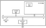
如图8所示,该终端可以包括:处理器(processor)402、通信接口(CommunicationsInterface)404、存储器(memory)406、以及通信总线408。As shown in FIG. 8 , the terminal may include: a processor (processor) 402 , a communication interface (CommunicationsInterface) 404 , a memory (memory) 406 , and a
其中:处理器402、通信接口404、以及存储器406通过通信总线408完成相互间的通信。The processor 402 , the
通信接口404,用于与其它设备比如客户端或其它服务器等的网元通信。The
处理器402,用于执行程序410,具体可以执行上述道路边界的识别方法实施例中的相关步骤。The processor 402 is configured to execute the program 410, and specifically may execute the relevant steps in the above embodiments of the road boundary identification method.
具体地,程序410可以包括程序代码,该程序代码包括计算机操作指令。Specifically, the program 410 may include program code including computer operation instructions.
处理器402可能是中央处理器CPU,或者是特定集成电路ASIC(ApplicationSpecific Integrated Circuit),或者是被配置成实施本申请实施例的一个或多个集成电路。终端包括的一个或多个处理器,可以是同一类型的处理器,如一个或多个CPU;也可以是不同类型的处理器,如一个或多个CPU以及一个或多个ASIC。The processor 402 may be a central processing unit (CPU), or an application specific integrated circuit (ASIC), or one or more integrated circuits configured to implement the embodiments of the present application. One or more processors included in the terminal may be the same type of processors, such as one or more CPUs; or may be different types of processors, such as one or more CPUs and one or more ASICs.
存储器406,用于存放程序410。存储器406可能包含高速RAM存储器,也可能还包括非易失性存储器(non-volatile memory),例如至少一个磁盘存储器。The memory 406 is used to store the program 410 . Memory 406 may include high-speed RAM memory, and may also include non-volatile memory, such as at least one disk memory.
程序410具体可以用于使得处理器402执行以下操作:The program 410 can specifically be used to cause the processor 402 to perform the following operations:
获取目标区域的点云数据,并将所述点云数据按照预设规则进行网格划分,得到所述目标区域的点云数据网格;Acquire the point cloud data of the target area, and divide the point cloud data into grids according to preset rules to obtain the point cloud data grid of the target area;
遍历所述点云数据网格,识别最高点所对应的最高高度值与最低点所对应的最低高度值之间的差值大于最小道路边界高度值且小于最大道路边界高度值所对应的网格,将所述网格标记为待定道路边界位置点,并对多个所述待定道路边界位置点进行筛选,得到道路边界位置点集合,所述最高点与所述最低点位于同一个预设遍历步长单位内;Traverse the point cloud data grid, identify the difference between the highest height value corresponding to the highest point and the lowest height value corresponding to the lowest point greater than the minimum road boundary height value and less than the grid corresponding to the maximum road boundary height value , mark the grid as undetermined road boundary position points, and screen a plurality of the undetermined road boundary position points to obtain a set of road boundary position points, the highest point and the lowest point are located in the same preset traversal within the step unit;
对所述道路边界位置点集合进行拟合操作,并生成所述目标区域的道路边界。A fitting operation is performed on the set of road boundary position points, and a road boundary of the target area is generated.
存储介质中还可以包括操作系统、网络通信模块。操作系统是管理上述道路边界的识别的实体设备硬件和软件资源的程序,支持信息处理程序以及其它软件和/或程序的运行。网络通信模块用于实现存储介质内部各组件之间的通信,以及与信息处理实体设备中其它硬件和软件之间通信。The storage medium may also include an operating system and a network communication module. The operating system is a program that manages the hardware and software resources of the identified physical device of the road boundary, and supports the operation of information processing programs and other software and/or programs. The network communication module is used to realize the communication between various components in the storage medium, as well as the communication with other hardware and software in the information processing entity device.
本说明书中各个实施例均采用递进的方式描述,每个实施例重点说明的都是与其它实施例的不同之处,各个实施例之间相同或相似的部分相互参见即可。对于系统实施例而言,由于其与方法实施例基本对应,所以描述的比较简单,相关之处参见方法实施例的部分说明即可。The various embodiments in this specification are described in a progressive manner, and each embodiment focuses on the differences from other embodiments, and the same or similar parts between the various embodiments may be referred to each other. As for the system embodiment, since it basically corresponds to the method embodiment, the description is relatively simple, and for related parts, please refer to the partial description of the method embodiment.
可能以许多方式来实现本申请的方法和系统。例如,可通过软件、硬件、固件或者软件、硬件、固件的任何组合来实现本申请的方法和系统。用于所述方法的步骤的上述顺序仅是为了进行说明,本申请的方法的步骤不限于以上具体描述的顺序,除非以其它方式特别说明。此外,在一些实施例中,还可将本申请实施为记录在记录介质中的程序,这些程序包括用于实现根据本申请的方法的机器可读指令。因而,本申请还覆盖存储用于执行根据本申请的方法的程序的记录介质。The methods and systems of the present application may be implemented in many ways. For example, the methods and systems of the present application may be implemented in software, hardware, firmware, or any combination of software, hardware, and firmware. The above-described sequence of steps for the method is for illustration only, and the steps of the method of the present application are not limited to the sequence specifically described above unless specifically stated otherwise. Furthermore, in some embodiments, the present application can also be implemented as programs recorded in a recording medium, the programs comprising machine-readable instructions for implementing methods according to the present application. Thus, the present application also covers a recording medium storing a program for executing the method according to the present application.
显然,本领域的技术人员应该明白,上述的本申请的各模块或各步骤可以用通用的计算装置来实现,它们可以集中在单个的计算装置上,或者分布在多个计算装置所组成的网络上,可选地,它们可以用计算装置可执行的程序代码来实现,从而,可以将它们存储在存储装置中由计算装置来执行,并且在某些情况下,可以以不同于此处的顺序执行所示出或描述的步骤,或者将它们分别制作成各个集成电路模块,或者将它们中的多个模块或步骤制作成单个集成电路模块来实现。这样,本申请不限制于任何特定的硬件和软件结合。Obviously, those skilled in the art should understand that the above-mentioned modules or steps of the present application can be implemented by a general-purpose computing device, and they can be centralized on a single computing device, or distributed in a network composed of multiple computing devices Alternatively, they may be implemented in program code executable by a computing device, such that they may be stored in a storage device and executed by the computing device, and in some cases, in a different order than here The steps shown or described are performed either by fabricating them separately into individual integrated circuit modules, or by fabricating multiple modules or steps of them into a single integrated circuit module. As such, the present application is not limited to any particular combination of hardware and software.
以上所述仅为本申请的优选实施例而已,并不用于限制本申请,对于本领域的技术人员来说,本申请可以有各种更改和变化。凡在本申请的精神和原则之内,所作的任何修改、等同替换、改进等,均应包括在本申请的保护范围之内。The above descriptions are only preferred embodiments of the present application, and are not intended to limit the present application. For those skilled in the art, the present application may have various modifications and changes. Any modification, equivalent replacement, improvement, etc. made within the spirit and principle of this application shall be included within the protection scope of this application.
Claims (10)
Translated fromChinesePriority Applications (1)
| Application Number | Priority Date | Filing Date | Title |
|---|---|---|---|
| CN202210231649.9ACN114779206B (en) | 2022-03-09 | 2022-03-09 | Road boundary recognition method, device, storage medium, and equipment |
Applications Claiming Priority (1)
| Application Number | Priority Date | Filing Date | Title |
|---|---|---|---|
| CN202210231649.9ACN114779206B (en) | 2022-03-09 | 2022-03-09 | Road boundary recognition method, device, storage medium, and equipment |
Publications (2)
| Publication Number | Publication Date |
|---|---|
| CN114779206Atrue CN114779206A (en) | 2022-07-22 |
| CN114779206B CN114779206B (en) | 2025-05-27 |
Family
ID=82424069
Family Applications (1)
| Application Number | Title | Priority Date | Filing Date |
|---|---|---|---|
| CN202210231649.9AActiveCN114779206B (en) | 2022-03-09 | 2022-03-09 | Road boundary recognition method, device, storage medium, and equipment |
Country Status (1)
| Country | Link |
|---|---|
| CN (1) | CN114779206B (en) |
Cited By (7)
| Publication number | Priority date | Publication date | Assignee | Title |
|---|---|---|---|---|
| CN115406457A (en)* | 2022-08-30 | 2022-11-29 | 重庆长安汽车股份有限公司 | A drivable region detection method, system, device and storage medium |
| CN115861959A (en)* | 2023-02-24 | 2023-03-28 | 中国第一汽车股份有限公司 | Lane line identification method and device, electronic equipment and storage medium |
| CN116310380A (en)* | 2023-02-27 | 2023-06-23 | 重庆长安汽车股份有限公司 | Road edge detection method, device, vehicle and storage medium |
| CN116990832A (en)* | 2023-08-04 | 2023-11-03 | 长沙行深智能科技有限公司 | Dangerous road edge perception method, dangerous road edge perception device, terminal equipment and storage medium |
| CN117689832A (en)* | 2024-02-04 | 2024-03-12 | 腾讯科技(深圳)有限公司 | Traffic sign generation method, device, equipment and storage medium |
| CN117953451A (en)* | 2023-12-26 | 2024-04-30 | 中国第一汽车股份有限公司 | Road boundary detection method, device, equipment and medium |
| CN118928420A (en)* | 2024-08-23 | 2024-11-12 | 长安大学 | A method, system, device and medium for vehicles to pass on gravel roads |
Citations (6)
| Publication number | Priority date | Publication date | Assignee | Title |
|---|---|---|---|---|
| CN109017780A (en)* | 2018-04-12 | 2018-12-18 | 深圳市布谷鸟科技有限公司 | A kind of Vehicular intelligent driving control method |
| CN110378175A (en)* | 2018-08-16 | 2019-10-25 | 北京京东尚科信息技术有限公司 | The recognition methods of road edge and device |
| CN111985322A (en)* | 2020-07-14 | 2020-11-24 | 西安理工大学 | A Lidar-based Road Environment Element Perception Method |
| US20210263135A1 (en)* | 2018-11-09 | 2021-08-26 | Alibaba Group Holding Limited | Positioning data generation method, apparatus, and electronic device |
| CN113379776A (en)* | 2021-05-14 | 2021-09-10 | 北京踏歌智行科技有限公司 | Road boundary detection method |
| CN113759391A (en)* | 2021-08-27 | 2021-12-07 | 武汉大学 | Passable area detection method based on laser radar |
- 2022
- 2022-03-09CNCN202210231649.9Apatent/CN114779206B/enactiveActive
Patent Citations (6)
| Publication number | Priority date | Publication date | Assignee | Title |
|---|---|---|---|---|
| CN109017780A (en)* | 2018-04-12 | 2018-12-18 | 深圳市布谷鸟科技有限公司 | A kind of Vehicular intelligent driving control method |
| CN110378175A (en)* | 2018-08-16 | 2019-10-25 | 北京京东尚科信息技术有限公司 | The recognition methods of road edge and device |
| US20210263135A1 (en)* | 2018-11-09 | 2021-08-26 | Alibaba Group Holding Limited | Positioning data generation method, apparatus, and electronic device |
| CN111985322A (en)* | 2020-07-14 | 2020-11-24 | 西安理工大学 | A Lidar-based Road Environment Element Perception Method |
| CN113379776A (en)* | 2021-05-14 | 2021-09-10 | 北京踏歌智行科技有限公司 | Road boundary detection method |
| CN113759391A (en)* | 2021-08-27 | 2021-12-07 | 武汉大学 | Passable area detection method based on laser radar |
Non-Patent Citations (2)
| Title |
|---|
| 马新江;刘如飞;蔡永宁;王鹏;: "一种基于路缘特征的点云道路边界提取方法", 遥感信息, no. 02, 20 April 2019 (2019-04-20)* |
| 鲁小伟: "矿山道路边界线实时检测与跟踪", 中国优秀博士学位论文全文数据库工程科技Ⅰ辑, no. 01, 15 January 2021 (2021-01-15), pages 21 - 27* |
Cited By (9)
| Publication number | Priority date | Publication date | Assignee | Title |
|---|---|---|---|---|
| CN115406457A (en)* | 2022-08-30 | 2022-11-29 | 重庆长安汽车股份有限公司 | A drivable region detection method, system, device and storage medium |
| CN115861959A (en)* | 2023-02-24 | 2023-03-28 | 中国第一汽车股份有限公司 | Lane line identification method and device, electronic equipment and storage medium |
| CN116310380A (en)* | 2023-02-27 | 2023-06-23 | 重庆长安汽车股份有限公司 | Road edge detection method, device, vehicle and storage medium |
| CN116990832A (en)* | 2023-08-04 | 2023-11-03 | 长沙行深智能科技有限公司 | Dangerous road edge perception method, dangerous road edge perception device, terminal equipment and storage medium |
| CN117953451A (en)* | 2023-12-26 | 2024-04-30 | 中国第一汽车股份有限公司 | Road boundary detection method, device, equipment and medium |
| CN117953451B (en)* | 2023-12-26 | 2025-09-09 | 中国第一汽车股份有限公司 | Road boundary detection method, device, equipment and medium |
| CN117689832A (en)* | 2024-02-04 | 2024-03-12 | 腾讯科技(深圳)有限公司 | Traffic sign generation method, device, equipment and storage medium |
| CN117689832B (en)* | 2024-02-04 | 2024-05-17 | 腾讯科技(深圳)有限公司 | Traffic sign generation method, device, equipment and storage medium |
| CN118928420A (en)* | 2024-08-23 | 2024-11-12 | 长安大学 | A method, system, device and medium for vehicles to pass on gravel roads |
Also Published As
| Publication number | Publication date |
|---|---|
| CN114779206B (en) | 2025-05-27 |
Similar Documents
| Publication | Publication Date | Title |
|---|---|---|
| CN114779206A (en) | Method and device for identifying road boundary, storage medium and equipment | |
| JP6561199B2 (en) | Urban road recognition method, apparatus, storage medium and equipment based on laser point cloud | |
| CN112154303B (en) | High-precision map positioning method, system, platform and computer readable storage medium | |
| JP6595182B2 (en) | Systems and methods for mapping, locating, and attitude correction | |
| CN107657637B (en) | A method for obtaining the working area of agricultural machinery | |
| US10614324B2 (en) | Method and apparatus for identifying static obstacle | |
| CN108519094B (en) | Local path planning method and cloud processing terminal | |
| US20190086543A1 (en) | Method And Apparatus For Tracking Obstacle | |
| CN103390169B (en) | A kind of city terrain classification method of Vehicle-borne Laser Scanning cloud data | |
| CN115451983B (en) | Dynamic environment mapping and path planning method and device under complex scene | |
| CN113593017A (en) | Method, device and equipment for constructing surface three-dimensional model of strip mine and storage medium | |
| CN114842450A (en) | Driving region detection method, device and equipment | |
| JP2019512668A (en) | Root deviation recognition method, terminal, and storage medium | |
| CN111553946A (en) | Method and device for removing ground point cloud and obstacle detection method and device | |
| WO2024149060A1 (en) | Free space and road edge detection method and apparatus, and related device | |
| CN109839119B (en) | Method and device for acquiring bridge floor area of bridge of cross-road bridge | |
| CN110674705A (en) | Small-sized obstacle detection method and device based on multi-line laser radar | |
| CN115176288A (en) | Method for reconstructing features in an environmental scene of a road | |
| CN106372255A (en) | Street view image recognition method and device | |
| CN115638787A (en) | A digital map generation method, computer readable storage medium and electronic equipment | |
| JP6874987B2 (en) | Feature shape extraction device, feature shape extraction method, and program | |
| CN112269848A (en) | Crowdsourcing trajectory data fusion method and device | |
| CN114998855A (en) | Road edge line generation method and device, storage medium and computer equipment | |
| CN113189610B (en) | Map-enhanced autopilot multi-target tracking method and related equipment | |
| CN113935946A (en) | Method and device for real-time detection of underground obstacles |
Legal Events
| Date | Code | Title | Description |
|---|---|---|---|
| PB01 | Publication | ||
| PB01 | Publication | ||
| SE01 | Entry into force of request for substantive examination | ||
| SE01 | Entry into force of request for substantive examination | ||
| GR01 | Patent grant | ||
| GR01 | Patent grant |