CN114625170B - Mountain fire helicopter rescue flight path dynamic planning method - Google Patents
Mountain fire helicopter rescue flight path dynamic planning methodDownload PDFInfo
- Publication number
- CN114625170B CN114625170BCN202210297051.XACN202210297051ACN114625170BCN 114625170 BCN114625170 BCN 114625170BCN 202210297051 ACN202210297051 ACN 202210297051ACN 114625170 BCN114625170 BCN 114625170B
- Authority
- CN
- China
- Prior art keywords
- flight
- helicopter
- grid
- fire
- path
- Prior art date
- Legal status (The legal status is an assumption and is not a legal conclusion. Google has not performed a legal analysis and makes no representation as to the accuracy of the status listed.)
- Active
Links
- 238000000034methodMethods0.000titleclaimsabstractdescription48
- 238000004422calculation algorithmMethods0.000claimsabstractdescription42
- 238000011161developmentMethods0.000claimsabstractdescription11
- 230000001413cellular effectEffects0.000claimsabstractdescription10
- 230000008569processEffects0.000claimsdescription23
- 238000004590computer programMethods0.000claimsdescription3
- 230000008676importEffects0.000claimsdescription3
- 238000013507mappingMethods0.000claimsdescription2
- 238000004891communicationMethods0.000claims1
- 238000004364calculation methodMethods0.000abstractdescription7
- 238000010586diagramMethods0.000description9
- 230000018109developmental processEffects0.000description7
- 238000005516engineering processMethods0.000description3
- 238000005070samplingMethods0.000description3
- XLYOFNOQVPJJNP-UHFFFAOYSA-NwaterSubstancesOXLYOFNOQVPJJNP-UHFFFAOYSA-N0.000description3
- 241000191291Abies albaSpecies0.000description1
- 230000009286beneficial effectEffects0.000description1
- 230000001419dependent effectEffects0.000description1
- 238000001514detection methodMethods0.000description1
- 238000009792diffusion processMethods0.000description1
- 238000012986modificationMethods0.000description1
- 230000004048modificationEffects0.000description1
- 238000011160researchMethods0.000description1
- 230000011218segmentationEffects0.000description1
- 230000007480spreadingEffects0.000description1
- 230000003068static effectEffects0.000description1
- 239000002699waste materialSubstances0.000description1
Images


Classifications
- G—PHYSICS
- G05—CONTROLLING; REGULATING
- G05D—SYSTEMS FOR CONTROLLING OR REGULATING NON-ELECTRIC VARIABLES
- G05D1/00—Control of position, course, altitude or attitude of land, water, air or space vehicles, e.g. using automatic pilots
- G05D1/10—Simultaneous control of position or course in three dimensions
- G05D1/101—Simultaneous control of position or course in three dimensions specially adapted for aircraft
- Y—GENERAL TAGGING OF NEW TECHNOLOGICAL DEVELOPMENTS; GENERAL TAGGING OF CROSS-SECTIONAL TECHNOLOGIES SPANNING OVER SEVERAL SECTIONS OF THE IPC; TECHNICAL SUBJECTS COVERED BY FORMER USPC CROSS-REFERENCE ART COLLECTIONS [XRACs] AND DIGESTS
- Y02—TECHNOLOGIES OR APPLICATIONS FOR MITIGATION OR ADAPTATION AGAINST CLIMATE CHANGE
- Y02A—TECHNOLOGIES FOR ADAPTATION TO CLIMATE CHANGE
- Y02A40/00—Adaptation technologies in agriculture, forestry, livestock or agroalimentary production
- Y02A40/10—Adaptation technologies in agriculture, forestry, livestock or agroalimentary production in agriculture
- Y02A40/28—Adaptation technologies in agriculture, forestry, livestock or agroalimentary production in agriculture specially adapted for farming
Landscapes
- Engineering & Computer Science (AREA)
- Aviation & Aerospace Engineering (AREA)
- Radar, Positioning & Navigation (AREA)
- Remote Sensing (AREA)
- Physics & Mathematics (AREA)
- General Physics & Mathematics (AREA)
- Automation & Control Theory (AREA)
- Navigation (AREA)
- Management, Administration, Business Operations System, And Electronic Commerce (AREA)
Abstract
Translated fromChinese
Description
Translated fromChinese技术领域technical field
本发明属于路径规划领域,具体涉及一种山区火灾直升机救援飞行路径动态规划方法。The invention belongs to the field of path planning, and in particular relates to a dynamic planning method for a mountain fire helicopter rescue flight path.
背景技术Background technique
我国是一个多山和多林的区域,山地约占国土面积的69%,常见的火灾是一种最主要的危险。森林一旦发生大面积火灾,将带来财产和生命损失。例如在1987年,大兴安岭的大火造成了87万公顷的森林面积受到不同程度的火灾损害,受灾群众约50000人。由于森林火灾的突发性,这给生命救援工作带来巨大的挑战,仅仅依靠传统的救援方式常常难以满足要求。随着科技的日益进步,直升机在救援抢险工作中常扮演不可或缺的角色,因此针对救援直升机的飞行路径动态规划十分必要。my country is a mountainous and forested area, and mountains account for about 69% of the country's land area. Common fires are a major danger. Once a large-scale forest fire occurs, property and life losses will be brought. For example, in 1987, the Daxinganling fire caused 870,000 hectares of forest area to be damaged to varying degrees, and about 50,000 people were affected. Due to the suddenness of forest fires, this brings huge challenges to life rescue work, and it is often difficult to meet the requirements only by relying on traditional rescue methods. With the advancement of science and technology, helicopters often play an indispensable role in rescue and rescue work, so the dynamic planning of flight paths for rescue helicopters is very necessary.
目前针对直升机山区火灾救援的路径动态规划的研究尚不完善。目前大多数的针对直升机山区火灾救援的路径规化,都是人工参照卫星图片结合火情讯息得到合理直升机路径,但是这种方法因为卫星照片的更新和火情讯息的更新均存在较大的延迟,因此在规划时会留有很大的安全余量,使得人工规划的路径在路程上存在很大程度的浪费。目前有些人通过一般的路径规划算法例如A*类算法和D*类算法进行直升机山区火灾救援的路径规划。但是,A*和D*类算法常适用于室内和小区域的静态场景,在山区火灾这种室外大区域的动态场景并不能很完美的适用。目前现有的快速探索随机树(rapidly-exploringrandom tree,RRT)算法,在非精确建模的复杂环境中可以进行有效的路径搜索。但由于目前RRT算法的所有节点基于自由空间随机采样得到;随着环境复杂程度和孤立障碍物数量的增加,该算法花费在碰撞检测等操作上的时间也随之急速增加,同时,高度依赖环境信息的更新周期;并不能考虑动态演变的火情场景。因此在面对山区火灾救援这种大区域、复杂程度高、火情动态演变的场景时,现有的RRT算法并不能很好的适用。综上,现有技术中在难面对火情信息更新的真空期时很难做到合理的规划,以及在面对大空间的山区火灾环境时,现有的路径规划算法计算周期长算法复杂。At present, the research on path dynamic planning for helicopter mountain fire rescue is not perfect. At present, most of the path planning for helicopter mountain fire rescue is to manually refer to satellite images combined with fire information to obtain a reasonable helicopter path, but this method has a large delay due to the update of satellite images and fire information. , so there will be a large safety margin in planning, which will cause a large degree of waste in the route of manual planning. At present, some people use general path planning algorithms such as A* type algorithm and D* type algorithm to carry out path planning for helicopter mountain fire rescue. However, A* and D* algorithms are often suitable for static scenes in indoor and small areas, and cannot be perfectly applied in dynamic scenes in large outdoor areas such as mountain fires. Currently, the existing rapidly-exploring random tree (RRT) algorithm can perform effective path search in complex environments with inaccurate modeling. However, since all nodes of the current RRT algorithm are randomly sampled based on free space; as the complexity of the environment and the number of isolated obstacles increase, the time spent by the algorithm on operations such as collision detection also increases rapidly. At the same time, it is highly dependent on the environment. Update cycle of information; does not take into account dynamically evolving fire scenarios. Therefore, the existing RRT algorithm is not very suitable for mountainous fire rescue scenarios with large areas, high complexity, and dynamic fire evolution. To sum up, in the existing technology, it is difficult to achieve reasonable planning when it is difficult to face the vacuum period of fire information update, and in the face of a large space mountainous fire environment, the existing path planning algorithm has a long calculation period and a complex algorithm .
发明内容Contents of the invention
本发明的目的在于:针对现有技术中在处理山区火灾路径规划的问题上,并不能考虑动态演变的火情场景,提供一种山区火灾直升机救援飞行路径动态规划方法。The purpose of the present invention is to provide a dynamic planning method for mountain fire helicopter rescue flight path in view of the problem of mountain fire path planning in the prior art, which cannot consider the dynamically evolving fire scene.
为了实现上述目的,本发明采用的技术方案为:In order to achieve the above object, the technical scheme adopted in the present invention is:
一种山区火灾直升机救援飞行路径动态规划方法,包括如下步骤:A method for dynamic planning of flight paths for helicopter rescue in mountainous areas, comprising the following steps:
S100.获取飞行区域以及所述飞行区域的GIS数据,并建立栅格化的飞行区域,所述栅格化的飞行区域依据栅格内的GIS数据分为森林栅格、不可燃烧栅格、直升机绕飞栅格和边界;S100. Obtain the flight area and the GIS data of the flight area, and establish a gridded flight area, and the gridded flight area is divided into forest grid, non-combustible grid, and helicopter according to the GIS data in the grid Fly around grids and borders;
S200.获取火情航拍照片,识别火情航拍照片中的燃烧区域后导入所述栅格化的飞行区域,以及获取火灾山区的气象参数,并使用元胞自动机预测火情的发展,得到正在燃烧的森林栅格;以及将所述栅格化的飞行区域内的栅格分为:可飞行栅格和不可飞行栅格;可飞行栅格包括:不可燃烧栅格和未燃烧的森林栅格;不可飞行的栅格包括:正在燃烧的森林栅格,直升机绕飞栅格和边界;S200. Obtain the aerial photos of the fire situation, identify the burning area in the aerial photography photos of the fire situation, and then import the rasterized flight area, and obtain the meteorological parameters of the fire area, and use the cellular automaton to predict the development of the fire situation, and obtain the current situation A burning forest grid; and dividing the grids in the gridded flight area into: flyable grids and non-flyable grids; the flyable grids include: non-burnable grids and unburned forest grids ; Non-flyable grids include: burning forest grids, helicopter flying grids and borders;
S300.获取直升飞机的飞行起点、飞行终点,并将所述飞行起点作为Ceil-RRT算法拓展树的起始节点,将飞行终点作为Ceil-RRT算法拓展树的结束节点;采用Ceil-RRT算法在所述可飞行栅格内搜索,生成从起点到终点的直升机飞行路径。S300. Obtain the flight starting point and the flight end point of the helicopter, and use the flight starting point as the starting node of the Ceil-RRT algorithm expansion tree, and use the flight end point as the end node of the Ceil-RRT algorithm expansion tree; adopt the Ceil-RRT algorithm Searching within the flyable grid generates a flight path of the helicopter from the origin to the destination.
作为本发明的优选实施方式,在所述S200中,还包括,将所述不可燃烧栅格设置为第一优先级,将所述未燃烧的森林栅格设置为第二优先级;As a preferred embodiment of the present invention, in the S200, it also includes setting the non-burnable grid as the first priority, and setting the unburned forest grid as the second priority;
在所述S300中,在Ceil-RRT算法的搜索过程中,按照优先级在所述可飞行栅格内搜索,生成从起点到终点的直升机飞行路径。In said S300, during the search process of the Ceil-RRT algorithm, search within the flyable grid according to the priority, and generate a flight path of the helicopter from the starting point to the ending point.
进一步的是,考虑到直升机实际的飞行路径并不会完全精准的按照规划的路径飞行;在所述S300,在Ceil-RRT算法搜索过程中,基于曼哈顿距离搜索待拓展节点;Furthermore, considering that the actual flight path of the helicopter does not fly exactly according to the planned path; in the S300, during the search process of the Ceil-RRT algorithm, the node to be expanded is searched based on the Manhattan distance;
所述曼哈顿距离的计算方法包括:在平面上,坐标(x1,y1)的i点与坐标(x2,y2)的j点的曼哈顿距离为:The calculation method of the Manhattan distance includes: on a plane, the Manhattan distance between point i of coordinates (x1 , y1 ) and point j of coordinates (x2 , y2 ) is:
d(i,j)=|x1-x2|+|y1-y2|。d(i,j)=|x1 -x2 |+|y1 -y2 |.
作为本发明的优选实施方式,在所述S100中,获取遥感卫星拍摄的飞行区域的GIS数据中的海拔数据,以及直升飞机的飞行高度和安全裕度;并根据所述海拔数据、所述飞行高度和所述安全裕度得到直升机绕飞栅格。As a preferred embodiment of the present invention, in said S100, the altitude data in the GIS data of the flight area captured by remote sensing satellites, as well as the flight altitude and safety margin of the helicopter are obtained; and according to the altitude data, the The flight altitude and the safety margin are obtained by the helicopter flying around the grid.
作为本发明的优选实施方式,本方法还包括S400,周期性的获取实时更新的火情,得到燃烧区域,当燃烧区域与直升机飞行路径重合时,执行步骤S200,重新生成直升机飞行路径。As a preferred embodiment of the present invention, the method further includes S400, periodically acquiring real-time updated fire conditions to obtain the burning area, and when the burning area coincides with the flight path of the helicopter, perform step S200 to regenerate the flight path of the helicopter.
本发明第二方面提供一种电子设备,包括至少一个处理器,以及与所述至少一个处理器通信连接的存储器;所述存储器存储有可被所述至少一个处理器执行的指令,所述指令被所述至少一个处理器执行,以使所述至少一个处理器能够执行上述的一种山区火灾直升飞机救援飞行路径动态规划方法。The second aspect of the present invention provides an electronic device, including at least one processor, and a memory communicatively connected to the at least one processor; the memory stores instructions executable by the at least one processor, and the instructions Executed by the at least one processor, so that the at least one processor can execute the above-mentioned dynamic planning method for a helicopter rescue flight path for mountain fires.
本发明第三方面提供一种可读存储介质,其上存储有计算机程序,所述程序被处理器执行实现上述一种山区火灾直升飞机救援飞行路径动态规划方法。综上所述,由于采用了上述技术方案,本发明的有益效果是:The third aspect of the present invention provides a readable storage medium on which a computer program is stored, and the program is executed by a processor to implement the above-mentioned method for dynamic planning of a helicopter rescue flight path for mountain fires. In summary, owing to adopting above-mentioned technical scheme, the beneficial effect of the present invention is:
1、本发明提出的山区火灾直升飞机救援飞行路径动态规划方法,通过栅格化的飞行区域,合理的缩小了RRT算法的随机选取的样本量,减小了RRT算法的计算量,提高计算效率;同时并基于栅格化后的飞行区域使用元胞自动机模拟火情的发展;可以很好的预测山区火情的发展,可以解决火情信息更新不及时的情况,填补火情信息的“真空期”;综上,本发明通过卫星GIS信息将地图栅格化,并基于元胞自动机预测的山火发展后进行路径规划;本发明可以很好的适应山区火灾救援这种大区域、复杂程度高、火情动态演变的场景;同时路径规划的速度快,更加合理;1, the mountain fire helicopter rescue flight path dynamic planning method that the present invention proposes, by the flight area of rasterization, the sample size of the random selection of RRT algorithm has been reasonably reduced, has reduced the calculation amount of RRT algorithm, improves calculation Efficiency; at the same time, based on the gridded flight area, use cellular automaton to simulate the development of fire; it can predict the development of fire in mountainous areas well, and can solve the situation that fire information is not updated in time, and fill in the gaps in fire information "Vacuum period"; in summary, the present invention rasterizes the map through satellite GIS information, and performs path planning based on the development of mountain fires predicted by cellular automata; the present invention can be well adapted to large areas such as mountain fire rescue , high complexity and dynamic fire scene; at the same time, the speed of path planning is fast and more reasonable;
2.在本发明的一些优选实施例中,可以使规划的路径优先经过那些不可燃烧的区域,可以进一步的提升直升飞机在路径中的飞行安全。2. In some preferred embodiments of the present invention, the planned path can be given priority to pass through those non-combustible areas, which can further improve the flight safety of the helicopter in the path.
附图说明Description of drawings
图1是本发明示例性实施例中提出的一种山区火灾直升机救援飞行路径动态规划方法整体流程图;Fig. 1 is the overall flowchart of a kind of mountain fire helicopter rescue flight path dynamic planning method proposed in the exemplary embodiment of the present invention;
图2是本发明示例性实施例中提出的一种山区火灾直升机救援飞行路径动态规划方法中随机采样的示意图;Fig. 2 is the schematic diagram of random sampling in a kind of mountain fire helicopter rescue flight path dynamic planning method proposed in the exemplary embodiment of the present invention;
图3是本发明示例性实施例中使用的Bresenham算法流程图;Fig. 3 is the Bresenham algorithm flowchart used in the exemplary embodiment of the present invention;
图4a是本发明示例性实施例中使用Bresenham算法生成栅格路径的示意图;Figure 4a is a schematic diagram of using the Bresenham algorithm to generate a grid path in an exemplary embodiment of the present invention;
图4b是本发明示例性实施例中使用Bresenham算法的示意图;Figure 4b is a schematic diagram of using the Bresenham algorithm in an exemplary embodiment of the present invention;
图5a是本发明示例性实施例中栅格化后的飞行区域示意图;Fig. 5a is a schematic diagram of a gridded flight area in an exemplary embodiment of the present invention;
图5b是本发明示例性实施例中提供的一条飞行路径示意图;Fig. 5b is a schematic diagram of a flight path provided in an exemplary embodiment of the present invention;
图5c是本发明示例性实施例中提供的另一条飞行路径示意图;Fig. 5c is a schematic diagram of another flight path provided in an exemplary embodiment of the present invention;
图5d是本发明示例性实施例中提供的另一条飞行路径示意图;Figure 5d is a schematic diagram of another flight path provided in an exemplary embodiment of the present invention;
图5e是本发明示例性实施例中提供的另一条飞行路径示意图。Fig. 5e is a schematic diagram of another flight path provided in an exemplary embodiment of the present invention.
具体实施方式Detailed ways
下面结合附图,对本发明作详细的说明。Below in conjunction with accompanying drawing, the present invention is described in detail.
为了使本发明的目的、技术方案及优点更加清楚明白,以下结合附图及实施例,对本发明进行进一步详细说明。应当理解,此处所描述的具体实施例仅用以解释本发明,并不用于限定本发明。In order to make the object, technical solution and advantages of the present invention clearer, the present invention will be further described in detail below in conjunction with the accompanying drawings and embodiments. It should be understood that the specific embodiments described here are only used to explain the present invention, not to limit the present invention.
实施例1Example 1
如图1所示,一种山区火灾直升机救援飞行路径动态规划方法,包括如下步骤:As shown in Figure 1, a method for dynamic planning of flight paths for helicopter rescue in mountainous areas, including the following steps:
S100.获取遥感卫星拍摄的飞行区域的GIS数据,建立栅格化的飞行区域,所述栅格化的飞行区域依据栅格内的GIS数据分为森林栅格、不可燃烧栅格、直升机绕飞栅格和边界;GIS数据包括:海拔数据、经纬度信息、植被信息等。S100. Obtain the GIS data of the flight area captured by remote sensing satellites, and establish a gridded flight area. The gridded flight area is divided into forest grids, non-combustible grids, and helicopters flying around according to the GIS data in the grid. Grid and boundary; GIS data includes: elevation data, latitude and longitude information, vegetation information, etc.
在建立栅格化的飞行区域时,本实施例优选的采用正方形栅格;需要说明的是,在另一些实施情况时为了更精确的对飞行区域进行区分;也可以采用正三角形,正五边形等正多边形栅格。图2示出了本实施例中使用的正方形栅格,的尺寸,图中L为正方形的边长,在一些优选的实施方式中,栅格的边长L可以与Ceil-RRT算法搜索步长l相等,是一个可以根据实际情况得出的预设值。When establishing a gridded flight area, this embodiment preferably adopts a square grid; it should be noted that, in other implementation situations, in order to more accurately distinguish the flight area; A grid of regular polygons. Fig. 2 shows the size of the square grid used in the present embodiment, L among the figure is the side length of square, in some preferred embodiments, the side length L of grid can be with Ceil-RRT algorithm search step size l is equal, which is a preset value that can be obtained according to the actual situation.
在进行栅格划分时本实施例中优选的根据执飞的直升飞机的安全飞行高度以及合理的安全裕度确定限飞海拔高度。例如某次任务中所使用的直升飞机安全飞行高度为3000m,安全裕度为200m;则限飞海拔高度为2800m,当栅格存在高于海拔2800的山体时则将该栅格设定为直升机绕飞栅格。优选的,当栅格内全部为河流、湖泊时该栅格为不可燃烧栅格,当栅格内的元素存在森林时,将该栅格划分为森林栅格。When performing grid division, in this embodiment, it is preferable to determine the flight-restricted altitude according to the safe flight altitude of the flying helicopter and a reasonable safety margin. For example, the safe flight altitude of the helicopter used in a certain mission is 3000m, and the safety margin is 200m; the restricted flight altitude is 2800m. Helicopter flies around the grid. Preferably, when there are all rivers and lakes in the grid, the grid is an incombustible grid, and when there are forest elements in the grid, the grid is classified as a forest grid.
S200.获取火情航拍照片,识别火情航拍照片中的燃烧区域后导入所述栅格化的飞行区域,得到正在燃烧的森林栅格;获取火灾山区的气象参数,基于所述栅格化的飞行区域使用元胞自动机预测火情的发展,并根据火情发展将栅格化的飞行区域内的栅格分为:可飞行栅格和不可飞行栅格;可飞行栅格包括:不可燃烧栅格和未燃烧的森林栅格;不可飞行的栅格包括:正在燃烧的森林栅格,直升机绕飞栅格和边界;其中建立的栅格化飞行区域如图3所示。S200. Obtain the aerial photos of the fire situation, identify the burning area in the aerial photography photos of the fire situation, and then import the gridded flight area to obtain the burning forest grid; obtain the meteorological parameters of the fire area, based on the gridded The flight area uses cellular automaton to predict the development of the fire, and according to the development of the fire, the grids in the rasterized flight area are divided into: flyable grids and non-flyable grids; flyable grids include: non-combustible The grid and the unburned forest grid; the non-flyable grid includes: the burning forest grid, the helicopter flying around the grid and the boundary; the grid flying area established in it is shown in Figure 3.
其中,火情的航拍照片可以是卫星的遥感照片,也可以为大型无人机或者测量飞机的航拍照片。火情的航拍照片可以通过图片识别及分割算法,将正在燃烧的森林区域提取出来;并与步骤S100中建立的栅格化飞行区域匹配,将森林栅格赋予燃烧中,未燃烧两种状态。Among them, the aerial photos of the fire can be remote sensing photos of satellites, or aerial photos of large drones or surveying aircraft. The aerial photos of the fire situation can be used to extract the burning forest area through image recognition and segmentation algorithms; and match it with the gridded flight area established in step S100, and assign the forest grid to two states of burning and unburning.
本实施例中认为山区火势蔓延是一种扩散传染过程,火势只能从燃烧的细胞蔓延到邻近的植被细胞。因此,给定两个相邻的单元格,一个燃烧单元格和另一个植被单元格,在每个时间步长中,燃烧单元格点燃相邻植被一旦点燃,在每个时间步中将持续保持燃烧状态。然而,燃烧单元格相邻为水体等单元格时,水体不会被点燃。随着离散时间的进展,每个单元格的状态根据其自身状态和相邻单元格的状态而变化,遵循火蔓延规则演化,本实施例中使用元胞自动机预测火情的发展为现有技术;例如公开号为CN113344250 A的中国发明专利,其公开了一种使用元胞自动机得到预测的火情,并基于预测的火情灭火的方法,在此不再赘述。In this embodiment, it is considered that the spread of fire in mountainous areas is a diffusion process, and the fire can only spread from burning cells to adjacent vegetation cells. Thus, given two adjacent cells, one burning cell and the other vegetative cell, at each time step the burning cell ignites the adjacent vegetation, and once ignited, will continue to be maintained at each time step burning state. However, if the burning cell is adjacent to a cell such as a water body, the water body will not be ignited. With the progress of discrete time, the state of each cell changes according to its own state and the state of adjacent cells, and evolves according to the rules of fire spread. In this embodiment, cellular automata are used to predict the development of fire as the existing Technology; For example, the Chinese invention patent whose publication number is CN113344250 A discloses a method of using a cellular automaton to obtain a predicted fire and extinguishing a fire based on the predicted fire, which will not be repeated here.
S300.获取直升飞机的飞行起点、飞行终点,并将所述飞行起点作为Ceil-RRT算法拓展树的起始节点,将飞行终点作为Ceil-RRT算法拓展树的结束节点;采用Ceil-RRT算法在所述可飞行栅格内搜索,生成从起点到终点的直升机飞行路径。S300. Obtain the flight starting point and the flight end point of the helicopter, and use the flight starting point as the starting node of the Ceil-RRT algorithm expansion tree, and use the flight end point as the end node of the Ceil-RRT algorithm expansion tree; adopt the Ceil-RRT algorithm Searching within the flyable grid generates a flight path of the helicopter from the origin to the destination.
在Ceil-RRT算法中,未栅格化的原始地图的点称为自由空间点(m,n)∈X,原始地图经栅格化后的位置称为栅格空间位置(x,y)∈G,两者因单位栅格大小L存在映射关系如下:In the Ceil-RRT algorithm, the point of the unrasterized original map is called the free space point (m, n) ∈ X, and the position of the original map after rasterization is called the grid space position (x, y) ∈ G, the mapping relationship between the two due to the unit grid size L is as follows:
(x,y)=(m/L,n/L)(x,y)=(m/ L,n/ L)
其中,所述Ceil-RRT算法包括:初始化过程、搜索过程和判断过程。Wherein, the Ceil-RRT algorithm includes: an initialization process, a search process and a judgment process.
初始化过程:初始化Ceil-RRT算法拓展树数据结构。为了简化模型,本专利将起飞和目标点所属的栅格空间位置(Gstart,Gend)就是整个拓展树的初始和结束节点。获取直升飞机飞行起点、飞行终点和飞行区域和栅格化后的飞行区域,并将所述飞行起点和飞行终点加入拓展树;Initialization process: Initialize the Ceil-RRT algorithm expansion tree data structure. In order to simplify the model, in this patent, the grid space positions (Gstart , Gend ) to which the take-off and target points belong are the initial and end nodes of the entire extended tree. Obtain the helicopter's flight start point, flight end point, flight area and gridded flight area, and add the flight start point and flight end point to the expansion tree;
搜索过程:可飞行栅格所对应的飞行区域中选取一个随机点Xrand;将随机点Xrand映射到栅格化空间为Grand,在所述拓展树中搜索与Grand曼哈顿距离最近的栅格节点Gnearest;Gnearest经过反向映射到自由空间后为Xnearest,在Xrand与Xnearest的连线上求解出离Xnearest曼哈顿距离为l的新生点Xnew,然后找到Xnew(自由空间点)所属的元胞网格位置作为待拓展节点Gnew;其中Xnew、Gnew为待拓展节点,Xnearest、Gnearest为拓展树中与待拓展节点最近的节点。Search process: select a random point Xrand in the flight area corresponding to the flyable grid; map the random point Xrand to the grid space as Grand , and search for the grid with the closest Manhattan distance to Grand in the expanded tree Lattice node Gnearest ; Gnearest is Xnearest after being reversely mapped to free space, on the connection line between Xrand and Xnearest , the newborn point Xnew whose Manhattan distance from Xnearest is l is obtained, and then Xnew (free Spatial point) belongs to the cell grid position as the node Gnew to be expanded; Xnew and Gnew are the nodes to be expanded, and Xnearest and Gnearest are the nodes closest to the node to be expanded in the expansion tree.
作为本实施例中的一种优选情况,曼哈顿距离的计算公式为:As a preferred situation in this embodiment, the formula for calculating the Manhattan distance is:
在平面上,坐标(x1,y1)的i点与坐标(x2,y2)的j点的曼哈顿距离为:On the plane, the Manhattan distance between point i at coordinates (x1 , y1 ) and point j at coordinates (x2 , y2 ) is:
d(i,j)=x1-x2+y1-y2d(i,j)=x1 -x2 +y1 -y2
因为直升飞机在实际飞行的过程中不能严格的按照规划的两点之间的直线距离去飞行,因此本发明使用曼哈顿距离来进行考量。可以使生成的直升机路径的距离,更加贴合实际的飞行距离,便于飞行员对飞行进行合理的规划。Because the helicopter cannot fly strictly according to the planned straight-line distance between two points during the actual flight, the present invention uses the Manhattan distance for consideration. The distance of the generated helicopter path can be more in line with the actual flight distance, which is convenient for the pilot to plan the flight reasonably.
判断过程包括:使用Bresenham算法在生成Gnew与Gnearest之间的栅格路径,判断Gnew与Gnearest之间的栅格路径是否包含不可飞行栅格,如是则返回搜索过程重新执行,如不是将Gnew保存到扩展树当中;通过此判断过程用于判断生成的路径是否合理,即是否生成了直升机不能飞行的路径。具体的,本实施例中使用的Bresenham算法的流程图如图4b所示;例如,如图4a所示,直线的起始网格为(3,3),终点网格点为(11,6)。则使用Bresenham算法在起点和目的地点生成的路径为PATH为:The judgment process includes: using the Bresenham algorithm to generate the grid path between Gnew and Gnearest , judging whether the grid path between Gnew and Gnearest contains non-flyable grids, if so, return to the search process and execute again, if not Save Gnew into the extended tree; through this judgment process, it is used to judge whether the generated path is reasonable, that is, whether a path that the helicopter cannot fly is generated. Specifically, the flow chart of the Bresenham algorithm used in this embodiment is as shown in Figure 4b; for example, as shown in Figure 4a, the starting grid of the straight line is (3,3), and the end grid point is (11,6 ). Then the path generated by using the Bresenham algorithm at the starting point and the destination point is PATH:
PATH=[(3,3),(4,3),(5,4),(6,4),(7,5),(8,5),(9,5),(10,6),(11,6)]PATH=[(3,3),(4,3),(5,4),(6,4),(7,5),(8,5),(9,5),(10,6) ,(11,6)]
判断过程还包括:判断待拓展节点Gnew是否为扩展树的结束节点,如不是则返回搜索过程,如是则生成直升机飞行路径。此判断过程用于决定搜索过程的结束。The judging process also includes: judging whether the node Gnew to be expanded is the end node of the expanded tree, if not, returning to the search process, and if so, generating the flight path of the helicopter. This judgment process is used to decide the end of the search process.
优选的,判断过程还包括:判断子节点的转弯半径是否小于直升机的最小转弯半径,优选的,在本实施例中,考虑到直升机的实际飞行过程中,因为直升机的飞行特性,直升机并不能进行无限制的转弯,所述直升机的最小转弯半径r的计算公式为:Preferably, the judging process also includes: judging whether the turning radius of the child node is smaller than the minimum turning radius of the helicopter. Preferably, in this embodiment, considering the actual flight process of the helicopter, the helicopter cannot perform Unrestricted turning, the calculation formula of the minimum turning radius r of the helicopter is:


其中,当R超过3°/s,则用3°/s代替R来计算,v是直升机空速和β为转弯坡度。Wherein, when R exceeds 3°/s, use 3°/s instead of R to calculate, v is the airspeed of the helicopter and β is the turning bank.
其中,在所述步骤S200中,将所述不可燃烧栅格设置为第一优先级,将所述未燃烧的森林栅格设置为第二优先级。Wherein, in the step S200, the unburnable grid is set as the first priority, and the unburned forest grid is set as the second priority.
在Ceil-RRT算法的搜索过程,优先在处于第一优先级的不可燃烧栅格内选取一随机点Xrand,实际使用中可以通过次数控制方式进行优选选取,例如在处于第一优先级的不可燃烧栅格内先随机选取20次,当算法没有结束,继续处于循环状态时,再从处于第二优先级的未燃烧的森林栅格中随机选取;同样,可以理解的是,也可以使用遍历的模式随机选取。In the search process of the Ceil-RRT algorithm, a random point Xrand is firstly selected in the non-combustible grid at the first priority. First randomly select 20 times in the burning grid, and when the algorithm is not over and continues to be in a loop state, then randomly select from the unburned forest grid with the second priority; similarly, it is understandable that you can also use traversal The mode is randomly selected.
同时,本实施例还提供一种可读存储介质,其上存储有计算机程序,所述程序被处理器执行实现上述一种山区火灾直升飞机救援飞行路径动态规划方法。At the same time, this embodiment also provides a readable storage medium on which a computer program is stored, and the program is executed by a processor to implement the above-mentioned method for dynamically planning a flight path of a helicopter rescue in mountainous areas.
实施例2Example 2
在实施例1的基础上,本实施例在Windows10操作系统下进行,计算平台硬件为Dell T640工作平台进行,平台的处理器为Intel(R)Xeon(R)GOLD5218,内存为32GB。On the basis of
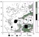
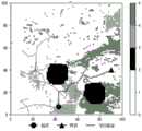
在本实施例中使用高程遥感卫星,直升机起点位置为元胞单元(1,1),目的终点为(200,200)。着火点一和二分别在(42,36)和(75,19)网格。每一个元胞单元的长度设为1km。其栅格化后的飞行区域如图5a所示。In this embodiment, the altitude remote sensing satellite is used, the starting point of the helicopter is the cell unit (1, 1), and the destination end point is (200, 200). The ignition points 1 and 2 are in grids (42, 36) and (75, 19) respectively. The length of each cellular unit is set to 1 km. The gridded flight area is shown in Figure 5a.
火的蔓延传播速度主要受风速影响,考虑地面为大风(地面风速为11m/s)场景,因此设置火蔓延速度为6.48km/h。算法中的节点扩展步长L设置为700m。为防止扩展节点时无限采样,设置路径规划时Ceil-RRT算法采样迭代次数最大为1000次。其它详细参数见表1。The speed of fire spread is mainly affected by wind speed. Considering the scene of strong wind on the ground (ground wind speed is 11m/s), the fire spread speed is set to 6.48km/h. The node expansion step length L in the algorithm is set to 700m. In order to prevent infinite sampling when expanding nodes, the maximum number of sampling iterations of the Ceil-RRT algorithm during path planning is set to 1000. See Table 1 for other detailed parameters.

表1Table 1
在实际运行过程中,T=0min时,规划出的直升机飞行线路如图5b所示,在T=2.6min时,火情状态更新,原有规划的路径与火点一的实际蔓延区域产生冲突,从而本发明重新规划出如图5c中另一条新路径。当T=19min,火情状态再次更新,火点二的实际蔓延区域与路径又产生了冲突,然后本发明重新规划了一条经过水源区域的路径图5d;在直升机的飞行过程中,直升机驾驶员发现直升机距离燃烧区域距离过近,手动更新火情状态,使用本发明所提出的方法再次重新规划路线如图5e所示,并安全飞行到终点。In the actual operation process, when T=0min, the planned flight route of the helicopter is shown in Figure 5b. When T=2.6min, the fire status is updated, and the original planned path conflicts with the actual spread area of
以上所述仅为本发明的较佳实施例而已,并不用以限制本发明,凡在本发明的精神和原则之内所作的任何修改、等同替换和改进等,均应包含在本发明的保护范围之内。The above descriptions are only preferred embodiments of the present invention, and are not intended to limit the present invention. Any modifications, equivalent replacements and improvements made within the spirit and principles of the present invention should be included in the protection of the present invention. within range.
Claims (6)
Translated fromChinesePriority Applications (1)
| Application Number | Priority Date | Filing Date | Title |
|---|---|---|---|
| CN202210297051.XACN114625170B (en) | 2022-03-24 | 2022-03-24 | Mountain fire helicopter rescue flight path dynamic planning method |
Applications Claiming Priority (1)
| Application Number | Priority Date | Filing Date | Title |
|---|---|---|---|
| CN202210297051.XACN114625170B (en) | 2022-03-24 | 2022-03-24 | Mountain fire helicopter rescue flight path dynamic planning method |
Publications (2)
| Publication Number | Publication Date |
|---|---|
| CN114625170A CN114625170A (en) | 2022-06-14 |
| CN114625170Btrue CN114625170B (en) | 2023-05-12 |
Family
ID=81903463
Family Applications (1)
| Application Number | Title | Priority Date | Filing Date |
|---|---|---|---|
| CN202210297051.XAActiveCN114625170B (en) | 2022-03-24 | 2022-03-24 | Mountain fire helicopter rescue flight path dynamic planning method |
Country Status (1)
| Country | Link |
|---|---|
| CN (1) | CN114625170B (en) |
Families Citing this family (2)
| Publication number | Priority date | Publication date | Assignee | Title |
|---|---|---|---|---|
| CN115097868B (en)* | 2022-08-24 | 2022-11-22 | 深圳市瓴鹰智能科技有限公司 | Flight control method and related device |
| CN118280167B (en)* | 2024-05-31 | 2024-09-06 | 北京智网易联科技有限公司 | Airspace management method and platform based on grid codes and three-dimensional cellular automaton |
Citations (4)
| Publication number | Priority date | Publication date | Assignee | Title |
|---|---|---|---|---|
| CN102929285A (en)* | 2012-11-16 | 2013-02-13 | 中国民用航空飞行学院 | Multi-target distribution and flight path planning method for multiple rescue helicopters |
| CN111258309A (en)* | 2020-01-15 | 2020-06-09 | 上海锵玫人工智能科技有限公司 | Fire extinguishing method for urban fire-fighting robot |
| CN113220008A (en)* | 2021-05-21 | 2021-08-06 | 南京航空航天大学 | Collaborative dynamic path planning method for multi-Mars aircraft |
| CN113342046A (en)* | 2021-06-22 | 2021-09-03 | 国网湖北省电力有限公司宜昌供电公司 | Power transmission line unmanned aerial vehicle routing inspection path optimization method based on ant colony algorithm |
Family Cites Families (19)
| Publication number | Priority date | Publication date | Assignee | Title |
|---|---|---|---|---|
| KR101667031B1 (en)* | 2009-11-02 | 2016-10-17 | 삼성전자 주식회사 | Path planning apparatus of robot and method thereof |
| WO2016050274A1 (en)* | 2014-09-30 | 2016-04-07 | Nec Europe Ltd. | Method and system for determining a path of an object for moving from a starting state to an end state set avoiding one or more obstacles |
| CN107209854A (en)* | 2015-09-15 | 2017-09-26 | 深圳市大疆创新科技有限公司 | Systems and methods for supporting smooth object following |
| JP6606442B2 (en)* | 2016-02-24 | 2019-11-13 | 本田技研工業株式会社 | Mobile route plan generation device |
| CN108613676B (en)* | 2018-03-27 | 2019-07-12 | 中国民用航空飞行学院 | An emergency search and rescue trajectory planning method under the cooperative mechanism of unmanned aerial vehicle and man-machine |
| CN108958292B (en)* | 2018-08-23 | 2020-07-07 | 北京理工大学 | Aircraft penetration trajectory planning method based on RRT (rapid return) algorithm |
| CN109635991B (en)* | 2018-10-19 | 2021-04-13 | 北京邮电大学 | An optimization method and system for planning UAV swarm rescue in forest fire |
| CN110243359B (en)* | 2019-05-31 | 2023-03-24 | 南京航空航天大学 | Safe track planning method based on low-altitude wind prediction model |
| CN111427358B (en)* | 2020-04-16 | 2021-07-13 | 武汉理工大学 | Navigation trajectory control method, system and storage medium for ship formation |
| CN111783352B (en)* | 2020-05-15 | 2023-10-27 | 北京邮电大学 | Forest fire oriented heterogeneous machine crowd rescue plan auxiliary decision-making method |
| CN111639825B (en)* | 2020-07-01 | 2024-02-23 | 广东工业大学 | Forest fire indication escape path method and system based on A-Star algorithm |
| CN111678524B (en)* | 2020-07-31 | 2023-05-16 | 中国民用航空飞行学院 | A method and system for path planning of rescue aircraft based on flight safety |
| CN112254733B (en)* | 2020-10-21 | 2023-03-24 | 中国人民解放军战略支援部队信息工程大学 | Fire escape path planning method and system based on extended A-x algorithm |
| CN112327914B (en)* | 2020-10-30 | 2023-08-22 | 广东工业大学 | Indoor collaborative path planning method and system for high-rise fire-fighting multiple unmanned aerial vehicles |
| CN113110592B (en)* | 2021-04-23 | 2022-09-23 | 南京大学 | Unmanned aerial vehicle obstacle avoidance and path planning method |
| CN113344250A (en)* | 2021-05-17 | 2021-09-03 | 武汉烽火信息集成技术有限公司 | Fire extinguishing method, device and equipment based on fire prediction and readable storage medium |
| CN113405552B (en)* | 2021-06-17 | 2024-06-14 | 北京理工大学 | Aircraft path planning method and device |
| CN113534844B (en)* | 2021-08-18 | 2024-02-27 | 广东电网有限责任公司 | Method and device for inspecting transmission line of rotorcraft in unknown environment |
| CN114115362B (en)* | 2021-11-30 | 2023-12-26 | 沈阳航空航天大学 | Unmanned aerial vehicle track planning method based on bidirectional APF-RRT algorithm |
- 2022
- 2022-03-24CNCN202210297051.XApatent/CN114625170B/enactiveActive
Patent Citations (4)
| Publication number | Priority date | Publication date | Assignee | Title |
|---|---|---|---|---|
| CN102929285A (en)* | 2012-11-16 | 2013-02-13 | 中国民用航空飞行学院 | Multi-target distribution and flight path planning method for multiple rescue helicopters |
| CN111258309A (en)* | 2020-01-15 | 2020-06-09 | 上海锵玫人工智能科技有限公司 | Fire extinguishing method for urban fire-fighting robot |
| CN113220008A (en)* | 2021-05-21 | 2021-08-06 | 南京航空航天大学 | Collaborative dynamic path planning method for multi-Mars aircraft |
| CN113342046A (en)* | 2021-06-22 | 2021-09-03 | 国网湖北省电力有限公司宜昌供电公司 | Power transmission line unmanned aerial vehicle routing inspection path optimization method based on ant colony algorithm |
Also Published As
| Publication number | Publication date |
|---|---|
| CN114625170A (en) | 2022-06-14 |
Similar Documents
| Publication | Publication Date | Title |
|---|---|---|
| CN114625170B (en) | Mountain fire helicopter rescue flight path dynamic planning method | |
| CN109814598B (en) | Unmanned aerial vehicle low-altitude public navigation network design method | |
| KR102099136B1 (en) | Apparatus and method for generating 3D flight Paths network for UAVs | |
| CN110782708A (en) | Unmanned aerial vehicle flight network modeling method based on low-altitude airspace limiting conditions | |
| CN108831116B (en) | Multi-level correction method, system and storage medium for wildfire spread behavior of transmission line | |
| CN110162090A (en) | A kind of unmanned plane flight course planning system and method based on GIS data | |
| CN102929285A (en) | Multi-target distribution and flight path planning method for multiple rescue helicopters | |
| CN108805327A (en) | The method and system of robot path planning and environment rebuilt based on virtual reality | |
| CN106845032A (en) | The construction method of multimode navigation three-dimensional dynamic visual simulation platform | |
| CN109948834B (en) | Unmanned aerial vehicle low-altitude public route design method | |
| CN107816999A (en) | A kind of unmanned boat navigation path contexture by self method based on ant group algorithm | |
| Xu et al. | Iterative construction of low-altitude UAV air route network in urban areas: Case planning and assessment | |
| CN113066160A (en) | Indoor mobile robot scene data and its test case generation method | |
| CN118838392A (en) | Power transmission line unmanned aerial vehicle inspection method and system based on positioning communication | |
| CN110825105B (en) | Satellite film pattern spot inspection method and device based on unmanned aerial vehicle | |
| CN110456785A (en) | An Indoor Autonomous Exploration Method Based on Tracked Robot | |
| CN116661502A (en) | Intelligent agricultural unmanned aerial vehicle path planning method | |
| CN112037330A (en) | Unmanned aerial vehicle operation scene simulation method based on AirSim | |
| CN116820121A (en) | Unmanned aerial vehicle group joint investigation strategy generation method and terminal | |
| CN118627714A (en) | A method and system for simulating fire and planning evacuation routes | |
| CN116305832A (en) | A real-time simulation method of forest fire spread, fire extinguishing decision method and early warning system | |
| CN104298858A (en) | Method for partitioning map in RoboCup rescue platform based on cluster and convex hull | |
| CN118862734B (en) | Forest fire spreading simulation method, equipment and medium based on combustion probability | |
| CN117521424B (en) | Simulation training scene generation method and device | |
| CN118838381A (en) | Unmanned aerial vehicle mapping method and system for geographic information acquisition |
Legal Events
| Date | Code | Title | Description |
|---|---|---|---|
| PB01 | Publication | ||
| PB01 | Publication | ||
| SE01 | Entry into force of request for substantive examination | ||
| SE01 | Entry into force of request for substantive examination | ||
| GR01 | Patent grant | ||
| GR01 | Patent grant |