CN114596502B - Arable land information extraction method based on edge-enhanced high-resolution remote sensing image - Google Patents
Arable land information extraction method based on edge-enhanced high-resolution remote sensing imageDownload PDFInfo
- Publication number
- CN114596502B CN114596502BCN202210201357.0ACN202210201357ACN114596502BCN 114596502 BCN114596502 BCN 114596502BCN 202210201357 ACN202210201357 ACN 202210201357ACN 114596502 BCN114596502 BCN 114596502B
- Authority
- CN
- China
- Prior art keywords
- module
- edge
- network
- enhancement
- loss
- Prior art date
- Legal status (The legal status is an assumption and is not a legal conclusion. Google has not performed a legal analysis and makes no representation as to the accuracy of the status listed.)
- Active
Links
Images


Classifications
- G—PHYSICS
- G06—COMPUTING OR CALCULATING; COUNTING
- G06F—ELECTRIC DIGITAL DATA PROCESSING
- G06F18/00—Pattern recognition
- G06F18/20—Analysing
- G06F18/21—Design or setup of recognition systems or techniques; Extraction of features in feature space; Blind source separation
- G06F18/214—Generating training patterns; Bootstrap methods, e.g. bagging or boosting
- G—PHYSICS
- G06—COMPUTING OR CALCULATING; COUNTING
- G06F—ELECTRIC DIGITAL DATA PROCESSING
- G06F18/00—Pattern recognition
- G06F18/20—Analysing
- G06F18/24—Classification techniques
- G—PHYSICS
- G06—COMPUTING OR CALCULATING; COUNTING
- G06N—COMPUTING ARRANGEMENTS BASED ON SPECIFIC COMPUTATIONAL MODELS
- G06N3/00—Computing arrangements based on biological models
- G06N3/02—Neural networks
- G06N3/04—Architecture, e.g. interconnection topology
- G—PHYSICS
- G06—COMPUTING OR CALCULATING; COUNTING
- G06N—COMPUTING ARRANGEMENTS BASED ON SPECIFIC COMPUTATIONAL MODELS
- G06N3/00—Computing arrangements based on biological models
- G06N3/02—Neural networks
- G06N3/08—Learning methods
- Y—GENERAL TAGGING OF NEW TECHNOLOGICAL DEVELOPMENTS; GENERAL TAGGING OF CROSS-SECTIONAL TECHNOLOGIES SPANNING OVER SEVERAL SECTIONS OF THE IPC; TECHNICAL SUBJECTS COVERED BY FORMER USPC CROSS-REFERENCE ART COLLECTIONS [XRACs] AND DIGESTS
- Y02—TECHNOLOGIES OR APPLICATIONS FOR MITIGATION OR ADAPTATION AGAINST CLIMATE CHANGE
- Y02A—TECHNOLOGIES FOR ADAPTATION TO CLIMATE CHANGE
- Y02A40/00—Adaptation technologies in agriculture, forestry, livestock or agroalimentary production
- Y02A40/10—Adaptation technologies in agriculture, forestry, livestock or agroalimentary production in agriculture
Landscapes
- Engineering & Computer Science (AREA)
- Theoretical Computer Science (AREA)
- Physics & Mathematics (AREA)
- Data Mining & Analysis (AREA)
- Life Sciences & Earth Sciences (AREA)
- Artificial Intelligence (AREA)
- General Physics & Mathematics (AREA)
- General Engineering & Computer Science (AREA)
- Evolutionary Computation (AREA)
- Computer Vision & Pattern Recognition (AREA)
- Computational Linguistics (AREA)
- Bioinformatics & Computational Biology (AREA)
- Bioinformatics & Cheminformatics (AREA)
- Health & Medical Sciences (AREA)
- Biomedical Technology (AREA)
- Biophysics (AREA)
- Evolutionary Biology (AREA)
- General Health & Medical Sciences (AREA)
- Molecular Biology (AREA)
- Computing Systems (AREA)
- Mathematical Physics (AREA)
- Software Systems (AREA)
- Image Analysis (AREA)
- Image Processing (AREA)
Abstract
Description
Translated fromChinese技术领域Technical Field
本发明涉及遥感影像耕地信息提取技术领域,尤其涉及一种基于边缘增强的高分辨率遥感影像的耕地信息提取方法。The invention relates to the technical field of farmland information extraction from remote sensing images, and in particular to a farmland information extraction method based on edge enhancement of high-resolution remote sensing images.
背景技术Background Art
对于遥感图像中耕地类别的提取任务,在以往传统的非监督分类、监督分类、面向对象分类方法不断发展的同时,利用深度学习算法进行耕地信息提取显示出应用优势和潜力。语义分割网络如U-Net、DeeplabV3+等,对耕地提取效果显著,但这些算法在提取耕地时,易发生边缘模糊、边界错分。边缘特征对于耕地地块的分割具有重要意义,有必要对耕地及其边缘区域进行更准确的识别。因此,本发明提出基于边缘增强函数BE-Loss的BEC-UNet语义分割网络,应用边缘增强损失函数,实现高分辨率遥感图像的耕地提任务。For the task of extracting cultivated land categories in remote sensing images, while the traditional unsupervised classification, supervised classification, and object-oriented classification methods are constantly developing, the use of deep learning algorithms to extract cultivated land information shows application advantages and potential. Semantic segmentation networks such as U-Net and DeeplabV3+ have significant effects on cultivated land extraction, but these algorithms are prone to edge blur and boundary misclassification when extracting cultivated land. Edge features are of great significance for the segmentation of cultivated land plots, and it is necessary to identify cultivated land and its edge areas more accurately. Therefore, the present invention proposes a BEC-UNet semantic segmentation network based on the edge enhancement function BE-Loss, and applies the edge enhancement loss function to achieve the task of extracting cultivated land from high-resolution remote sensing images.
发明内容Summary of the invention
本发明目的就是为了弥补已有技术的缺陷,提供一种基于边缘增强的高分辨率遥感影像的耕地信息提取方法。The purpose of the present invention is to remedy the defects of the prior art and provide a method for extracting cultivated land information from high-resolution remote sensing images based on edge enhancement.
本发明是通过以下技术方案实现的:The present invention is achieved through the following technical solutions:
一种基于边缘增强的高分辨率遥感影像的耕地信息提取方法,具体包括如下步骤:A method for extracting cultivated land information from high-resolution remote sensing images based on edge enhancement specifically comprises the following steps:
(1)构建联合型边界增强损失函数BE-Loss;(1) Construct a joint boundary enhancement loss function BE-Loss;
(2)设计构建BEC-UNet网络模型;(2) Design and build the BEC-UNet network model;
(3)使用GID高分辨率多光谱标签数据作为实验数据;(3) Use GID high-resolution multispectral label data as experimental data;
(4)将实验数据融合NDVI指数后得到的5波段数据输入到基于构建的边界增强损失函数BE-Loss的网络架构中,在BEC-UNet中,使用EfficientNet为骨干网络的UNet网络作为语义分割模块,在边界增强模块中通过融入scSE双通道注意力机制、Cot模块、门控卷积等提升训练精度。最后结合余弦退火衰减算法更新学习率,由一个Efficient特征监督模块融合后得出经边缘增强的分类结果。(4) The five-band data obtained by fusing the experimental data with the NDVI index is input into the network architecture based on the constructed boundary enhancement loss function BE-Loss. In BEC-UNet, the UNet network with EfficientNet as the backbone network is used as the semantic segmentation module. The training accuracy is improved by integrating the scSE dual-channel attention mechanism, Cot module, gated convolution, etc. in the boundary enhancement module. Finally, the learning rate is updated in combination with the cosine annealing decay algorithm, and the edge-enhanced classification result is obtained after fusion by an Efficient feature supervision module.
所述的联合型边界增强损失函数BE-Loss(Boundary enhanced Loss);其具体内容如下:The joint boundary enhancement loss function BE-Loss (Boundary enhanced Loss); its specific content is as follows:
BE-Loss=α1LDICE(X1,Y1)+β1ΩHuber(reg(ξ))+α2LDICE(X2,Y2)+β2ΩL1(ω)BE-Loss=α1 LDICE (X1 , Y1 )+β1 ΩHuber (reg(ξ))+α2 LDICE (X2 , Y2 )+β2 ΩL1 (ω)
其中,α1LDICE(X1,Y1)和α2LDICE(X2,Y2)分别为边缘强化模块加权损失和分类模块的加权损失,α1和α2分别是耕地提取、边缘增强DICE损失的对应权重,β1和β2分别为耕地提取、边缘增强的正则项,X1、Y1分别表示网络耕地地块识别情况、实际耕地地块情况,X2、Y2分别表示图像边缘识别情况和实际耕地边缘情况;因耕地提取任务为二分类,故两损失均采用DICE损失函数,具体计算公式如下:Among them, α1 LDICE (X1 , Y1 ) and α2 LDICE (X2 , Y2 ) are the weighted losses of the edge enhancement module and the classification module, respectively. α1 and α2 are the corresponding weights of the DICE losses of farmland extraction and edge enhancement, respectively. β1 and β2 are the regularization terms of farmland extraction and edge enhancement, respectively. X1 and Y1 represent the network farmland plot recognition and the actual farmland plot situation, respectively. X2 and Y2 represent the image edge recognition and the actual farmland edge situation, respectively. Since the farmland extraction task is a binary classification, both losses use the DICE loss function. The specific calculation formula is as follows:

上述公式中X为分类结果类别情况,Y为实际地物分类情况。另外,β1ΩHuber(reg(ξ))为针对边缘强化功能的正则项,具体计算公式如下:In the above formula, X is the classification result category, and Y is the actual object classification. In addition, β1 ΩHuber (reg(ξ)) is the regularization term for the edge enhancement function, and the specific calculation formula is as follows:


TH为迭代阈值,t为参数方程自变量;使用Huber算子可有效抑制遥感图像中的伪影,惩罚获取精准边缘结果;此外,β2ΩL1(ω)为针对语义分类功能的L1正则项,用于防止分类结果过拟合,其具体计算公式如下:TH is the iteration threshold, t is the independent variable of the parameter equation; the Huber operator can effectively suppress artifacts in remote sensing images and obtain accurate edge results by penalty; in addition, β2 ΩL1 (ω) is the L1 regularization term for the semantic classification function, which is used to prevent overfitting of the classification results. The specific calculation formula is as follows:

上述公式中,对参数模型ω引入拉普拉斯先验,即Ω~Laplace(μ,b),则有:In the above formula, the Laplace prior is introduced for the parameter model ω, that is, Ω~Laplace(μ, b), then:

其中ω*表示最优的目标解,α∈[0,+∞]是用来调整参数范数惩罚与经验损失的相对贡献的超参数,当α=0时表示没有正则化,α越大对应该的正则化惩罚就越大。H是关于ω的Hessian矩阵,且H=diag([H1,1,H2,2,...,Hn,n])。Where ω* represents the optimal target solution, α∈[0,+∞] is a hyperparameter used to adjust the relative contribution of parameter norm penalty and empirical loss. When α=0, it means no regularization. The larger α is, the larger the regularization penalty will be. H is the Hessian matrix with respect to ω, and H=diag([H1,1 ,H2,2 ,...,Hn,n ]).
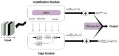
所述的由语义分割模块和边界增强模块为主体共同构成的BEC-UNet(BoundaryEnhancement Classificarion UNet)架构,其特征在于:语义分割模块与边界增强模块相对独立并协同完成精准分类任务,具体内容如下:The BEC-UNet (Boundary Enhancement Classificarion UNet) architecture, which is mainly composed of a semantic segmentation module and a boundary enhancement module, is characterized in that the semantic segmentation module and the boundary enhancement module are relatively independent and work together to complete the precise classification task. The specific contents are as follows:
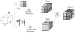
以EfficientNet为骨干网络的UNet编码-解码网络作为语义分割模块,EfficientNet作为UNet网络的编码器,UNet的解码器由EfficientNet结构对称产生。与语义分割模块并行的边界增强模块由若干scSE双通道注意力机制、Cot残差模块、门控卷积按一定流程顺序逐层构成,其中,scSE双通道注意力机制由cSE模块和sSE模块并行加权而成,在通道上和空间上都建立了注意力机制,其公式如下:The UNet encoder-decoder network with EfficientNet as the backbone network is used as the semantic segmentation module. EfficientNet is used as the encoder of the UNet network, and the decoder of UNet is generated symmetrically by the EfficientNet structure. The boundary enhancement module parallel to the semantic segmentation module is composed of several scSE dual-channel attention mechanisms, Cot residual modules, and gated convolutions layer by layer in a certain process sequence. Among them, the scSE dual-channel attention mechanism is formed by the parallel weighting of the cSE module and the sSE module. The attention mechanism is established in both channels and space. The formula is as follows:

其中

门控卷积计算公式如下:The gated convolution calculation formula is as follows:

上式中,en表示使用门控处理的相应边缘增强模块中的每个的中间过程图像,若语义分割过程涉及m步骤,则n∈m。wn表示对应的通道权重,i,j表示参与处理的各像素。[*]符号表示门控卷积。In the above formula,en represents the intermediate process image of each of the corresponding edge enhancement modules using gated processing. If the semantic segmentation process involves m steps, then n∈m.wn represents the corresponding channel weight, and i, j represent the pixels involved in the processing. The [*] symbol represents gated convolution.
输出语义分割模块与边界增强模块的中间结果经含正则化项的联合型边界增强损失函数加权后,又通过一个Efficient特征监督模块完成融合,此EfficientNet各项参数等设置与语义分割模块中的编码器保持一致。The intermediate results of the output semantic segmentation module and the boundary enhancement module are weighted by a joint boundary enhancement loss function containing a regularization term, and then fused through an Efficient feature supervision module. The settings of various parameters of this EfficientNet are consistent with the encoder in the semantic segmentation module.
最后结合余弦退火衰减算法更新学习率,得出经边缘增强的分类结果。余弦退火的原理公式如下:Finally, the learning rate is updated by combining the cosine annealing decay algorithm to obtain the edge-enhanced classification result. The principle formula of cosine annealing is as follows:

其中

所述的NDVI指数为近红外波段的反射值与红光波段的反射值之差与两者之和的比值,通过计算近红外光和红光之间的差异大小来量化植被分布的情况,其公式如下:The NDVI index is the ratio of the difference between the reflectance value of the near-infrared band and the reflectance value of the red light band to the sum of the two. The difference between near-infrared light and red light is calculated to quantify the distribution of vegetation. The formula is as follows:

式中,NIR为近红外波段的反射值,Red为红光波段的反射值。Where NIR is the reflection value of the near infrared band, and Red is the reflection value of the red light band.
本发明的优点是:本发明使用GID高分辨率多光谱标签数据集作为实验数据,针对边缘欠拟合等问题提出新的联合型边缘增强损失函数BE-Loss,并构建针对性处理遥感耕地图像的BEC-UNet网络。使用EfficientNet为骨干网络的UNet网络作为语义分割模块,在边界增强模块中通过融入scSE双通道注意力机制、Cot模块、门控卷积等提升训练精度。此外,结合余弦退火衰减算法更新学习率使训练结果更具全面性。最后经边缘增强的分类结果IoU达到0.90,F1-Score达到0.95,较其他模型精度有明显提高。The advantages of the present invention are: the present invention uses the GID high-resolution multispectral label data set as experimental data, proposes a new joint edge enhancement loss function BE-Loss for problems such as edge underfitting, and constructs a BEC-UNet network for targeted processing of remote sensing cultivated land images. The UNet network using EfficientNet as the backbone network is used as a semantic segmentation module, and the training accuracy is improved by integrating the scSE dual-channel attention mechanism, Cot module, gated convolution, etc. into the boundary enhancement module. In addition, the learning rate is updated in combination with the cosine annealing decay algorithm to make the training results more comprehensive. Finally, the edge-enhanced classification results IoU reached 0.90, and the F1-Score reached 0.95, which was significantly improved compared with other models.
本发明提出的边缘增强的改进方向为深度学习提取耕地时的精度提高提供新思路。即,不仅可以通过对整个网络框架的调整实现模型的优化;相对于地块的纹理信息,区别性处理边界相关信息、利用高效的浅层结构专注于处理边缘语义,对于地块提取精度的提升具有同等重要的意义。The improvement direction of edge enhancement proposed in this invention provides a new idea for improving the accuracy of deep learning in extracting cultivated land. That is, not only can the model be optimized by adjusting the entire network framework; compared with the texture information of the plot, the boundary-related information is processed differently, and the efficient shallow structure is used to focus on processing edge semantics, which is equally important for improving the accuracy of plot extraction.
附图说明BRIEF DESCRIPTION OF THE DRAWINGS
图1为BEC-UNet结构框图和BE-Loss损失函数的构造细节;Figure 1 shows the block diagram of the BEC-UNet structure and the construction details of the BE-Loss loss function;
图2为scSE注意力机制原理框图;Figure 2 is a block diagram of the scSE attention mechanism;
图3为Cot残差模块程序流程图;Fig. 3 is a flow chart of the Cot residual module program;
图4为预处理后的四波段原图和对应标签文件示例;Figure 4 is an example of the preprocessed four-band original image and the corresponding label file;
图5为各损失函数的精度效果对比图;Figure 5 is a comparison chart of the accuracy effects of various loss functions;
图6为不同网络模型的精度结果对比图。Figure 6 is a comparison of the accuracy results of different network models.
具体实施方式DETAILED DESCRIPTION
一种基于边缘增强的高分辨率遥感影像的耕地信息提取方法,具体包括如下步骤:A method for extracting cultivated land information from high-resolution remote sensing images based on edge enhancement specifically comprises the following steps:
(1)构建联合型边界增强损失函数BE-Loss;(1) Construct a joint boundary enhancement loss function BE-Loss;
(2)设计构建BEC-UNet网络模型;(2) Design and build the BEC-UNet network model;
(3)使用GID高分辨率多光谱标签数据作为实验数据;(3) Use GID high-resolution multispectral label data as experimental data;
(4)将实验数据融合NDVI指数后得到的5波段数据输入到基于构建的边界增强损失函数BE-Loss的网络架构中,在BEC-UNet中,使用EfficientNet为骨干网络的UNet网络作为语义分割模块,在边界增强模块中通过融入scSE双通道注意力机制、Cot模块、门控卷积等提升训练精度。最后结合余弦退火衰减算法更新学习率,由一个Efficient特征监督模块融合后得出经边缘增强的分类结果。(4) The five-band data obtained by fusing the experimental data with the NDVI index is input into the network architecture based on the constructed boundary enhancement loss function BE-Loss. In BEC-UNet, the UNet network with EfficientNet as the backbone network is used as the semantic segmentation module. The training accuracy is improved by integrating the scSE dual-channel attention mechanism, Cot module, gated convolution, etc. in the boundary enhancement module. Finally, the learning rate is updated in combination with the cosine annealing decay algorithm, and the edge-enhanced classification result is obtained after fusion by an Efficient feature supervision module.
1、改进的边界增强损失函数BE-Loss1. Improved boundary enhancement loss function BE-Loss
语义分割一般使用交叉熵函数计算损失,而由于耕地分类任务和边界增强任务均为二分类任务,采用DICE系数计算损失更为合理。DICE损失广泛应用于医学影像分割,此处用DICE作为耕地分类模块、边缘增强模块的损失。L1正则化鲁棒性佳,作为惩罚项可有效避免模型发生过拟合,提高泛化能力,L1正则项更易产生稀疏解。Huber损失是一种平滑的平均绝对误差,结合了MSE、MAE正则化的优点,对图像的伪影可有效去除。Semantic segmentation generally uses the cross entropy function to calculate the loss. However, since both the farmland classification task and the boundary enhancement task are binary classification tasks, it is more reasonable to use the DICE coefficient to calculate the loss. DICE loss is widely used in medical image segmentation. Here, DICE is used as the loss of the farmland classification module and the edge enhancement module. L1 regularization has good robustness. As a penalty term, it can effectively avoid overfitting of the model and improve generalization ability. The L1 regularization term is more likely to produce sparse solutions. Huber loss is a smooth mean absolute error that combines the advantages of MSE and MAE regularization and can effectively remove image artifacts.
故针对现存的问题,本发明设计联合型边界增强损失函数BE-Loss(Boundaryenhanced Loss);其具体内容如下:Therefore, in view of the existing problems, the present invention designs a joint boundary enhancement loss function BE-Loss (Boundaryenhanced Loss); the specific contents are as follows:
BE-Loss=α1LDICE(X1,Y1)+β1ΩHuber(reg(ξ))+α2LDICE(X2,Y2)+β2ΩL1(ω)BE-Loss=α1 LDICE (X1 , Y1 )+β1 ΩHuber (reg(ξ))+α2 LDICE (X2 , Y2 )+β2 ΩL1 (ω)
其中,α1LDICE(X1,Y1)和β1ΩHuber(reg(ξ))分别为边缘强化模块加权损失和分类模块的加权损失,α1和α2分别是耕地提取、边缘增强DICE损失的对应权重,β1和β2分别为耕地提取、边缘增强的正则项,X1、Y1分别表示网络耕地地块识别情况、实际耕地地块情况,X2、Y2分别表示图像边缘识别情况和实际耕地边缘情况;因耕地提取任务为二分类,故两损失均采用DICE损失函数,具体计算公式如下:Among them, α1 LDICE (X1 , Y1 ) and β1 ΩHuber (reg(ξ)) are the weighted loss of the edge enhancement module and the weighted loss of the classification module, respectively. α1 and α2 are the corresponding weights of the DICE loss of farmland extraction and edge enhancement, respectively. β1 and β2 are the regularization terms of farmland extraction and edge enhancement, respectively. X1 and Y1 represent the network farmland plot recognition and the actual farmland plot situation, respectively. X2 and Y2 represent the image edge recognition and the actual farmland edge situation, respectively. Since the farmland extraction task is a binary classification, the two losses both use the DICE loss function. The specific calculation formula is as follows:

上述公式中X为分类结果类别情况,Y为实际地物分类情况。另外,β1ΩHuber(reg(ξ))为针对边缘强化功能的正则项,具体计算公式如下:In the above formula, X is the classification result category, and Y is the actual object classification. In addition, β1 ΩHuber (reg(ξ)) is the regularization term for the edge enhancement function, and the specific calculation formula is as follows:

上述公式中权重ω(i,j)表明像素i与像素j的相关系数,为对称正值,在本文中设置为两像素间举例的反比;Nj表示二维空间中像素j点的邻域;ξ=(ξ1,ξ2,...,ξm)T,为输入图像的衰减系数;

TH为迭代阈值,t为参数方程自变量;使用Huber算子可有效抑制遥感图像中的伪影,惩罚获取精准边缘结果;此外,β2ΩL1(ω)为针对语义分类功能的L1正则项,用于防止分类结果过拟合,其具体计算公式如下:TH is the iteration threshold, t is the independent variable of the parameter equation; the Huber operator can effectively suppress artifacts in remote sensing images and obtain accurate edge results by penalty; in addition, β2 ΩL1 (ω) is the L1 regularization term for the semantic classification function, which is used to prevent overfitting of the classification results. The specific calculation formula is as follows:

上述公式中,对参数模型ω引入拉普拉斯先验,即Ω~Laplace(μ,b),则有:In the above formula, the Laplace prior is introduced for the parameter model ω, that is, Ω~Laplace(μ, b), then:

其中ω*表示最优的目标解,α∈[0,+∞]是用来调整参数范数惩罚与经验损失的相对贡献的超参数,当α=0时表示没有正则化,α越大对应该的正则化惩罚就越大;H是关于ω的Hessian矩阵,且H=diag([H1,1,H2,2,...,Hn,n]);Where ω* represents the optimal target solution, α∈[0,+∞] is a hyperparameter used to adjust the relative contribution of parameter norm penalty and empirical loss. When α=0, it means no regularization. The larger α is, the larger the regularization penalty will be. H is the Hessian matrix with respect to ω, and H=diag([H1,1 ,H2,2 ,...,Hn,n ]);
这种方法的优势在于使用两个模块分别处理语义分割任务和边缘增强任务,边缘语义对耕地地块信息的影像被有效规避,从而有效的去除噪声,令边缘增强模块更专注处理边界信息,以此高级架构产生可更清晰的预测对象边界,并显著提高对细小对象的识别能力。针对边缘增强模块的损失我们加入Huber正则项,兼有MSE和MAE代价函数的优点。本设计更合适于我们的高分辨率的遥感影像数据处理。The advantage of this method is that it uses two modules to process semantic segmentation tasks and edge enhancement tasks respectively. The image of cultivated land plot information is effectively avoided by edge semantics, thereby effectively removing noise, allowing the edge enhancement module to focus more on processing boundary information. This advanced architecture produces clearer predicted object boundaries and significantly improves the recognition ability of small objects. We add the Huber regularization term to the loss of the edge enhancement module, which has the advantages of both MSE and MAE cost functions. This design is more suitable for our high-resolution remote sensing image data processing.
2、BEC-UNet2. BEC-UNet
单纯的语义分割网络如UNet往往容易遗漏或错判边缘信息,因为全局判断时,形状等边缘语义易对整幅图像的其他语义信息造成影响,所以本发明的思路是设计两个模块分别处理分类问题和边界问题,在结果处特征监督,从而达到更好的分类效果,尤其是对边缘特征明显的遥感影像耕地地块具有良好效果。Simple semantic segmentation networks such as UNet often easily miss or misjudge edge information, because edge semantics such as shape can easily affect other semantic information of the entire image during global judgment. Therefore, the idea of the present invention is to design two modules to deal with classification problems and boundary problems respectively, and perform feature supervision at the result to achieve better classification effect, especially for cultivated land plots in remote sensing images with obvious edge features.
EMEUnet以EfficientNet为骨干网络的UNet编码-解码网络作为语义分割模块,EfficientNet作为UNet网络的编码器,UNet的解码器由EfficientNet结构对称产生。与语义分割模块并行的边界增强模块由若干scSE双通道注意力机制、Cot残差模块、门控卷积按一定流程顺序逐层构成,如附图1中所示。EMEUnet uses the UNet encoder-decoder network with EfficientNet as the backbone network as the semantic segmentation module. EfficientNet is used as the encoder of the UNet network, and the decoder of UNet is generated symmetrically by the EfficientNet structure. The boundary enhancement module parallel to the semantic segmentation module is composed of several scSE dual-channel attention mechanisms, Cot residual modules, and gated convolutions layer by layer in a certain process order, as shown in Figure 1.
UNet网络是一种经典的编码-解码网络,其网络结构完全对称,这种结构在医学影像分割、图像压缩和信号去噪中被广泛使用,因其简洁高效的拓扑结构也在遥感图像的语义分割中被广泛使用。对比其他网络,UNet网络的亮点主要在于,与编码器完全对称的解码器结构,并在跳跃连接模块部分使用叠操作,而不是加操作。The UNet network is a classic encoder-decoder network with a completely symmetrical network structure. This structure is widely used in medical image segmentation, image compression, and signal denoising. It is also widely used in semantic segmentation of remote sensing images due to its simple and efficient topological structure. Compared with other networks, the highlight of the UNet network is that the decoder structure is completely symmetrical with the encoder, and the stacking operation is used in the jump connection module instead of the addition operation.
本发明中的UNet采用五层深度,编码网络使用EfficientNet,EfficientNet使用高效的复合系数,从长度、宽度、分辨率三个维度有选择地缩放网络,使其相不仅高速而且精度更高,针对高分辨率的大幅遥感影像适应性高。且EfficientNet可作为网络模块构建其他网络架构,可作为UNet的骨干编码网络。EfficientNet以运算效率高为主要特点,鲁棒性佳。The UNet in the present invention uses five layers of depth, and the encoding network uses EfficientNet. EfficientNet uses efficient composite coefficients to selectively scale the network from three dimensions: length, width, and resolution, so that it is not only high-speed but also more accurate, and has high adaptability to high-resolution large remote sensing images. And EfficientNet can be used as a network module to build other network architectures, and can be used as the backbone encoding network of UNet. EfficientNet is mainly characterized by high computational efficiency and good robustness.
scSE双通道注意力机制由cSE模块和sSE模块并行加权而成,在通道上和空间上都建立了注意力机制,其公式如下:The scSE dual-channel attention mechanism is composed of the cSE module and the sSE module weighted in parallel. The attention mechanism is established both in the channel and in the space. The formula is as follows:

其中

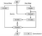
Cot残差模块计算流程图如附图3所示。Cot充分挖掘邻近上下文信息,从而高效提升学习效果和表达输出特征的效果。The calculation flow chart of the Cot residual module is shown in Figure 3. Cot fully exploits the neighboring context information, thereby efficiently improving the learning effect and the effect of expressing output features.
门控卷积计算公式如下:The gated convolution calculation formula is as follows:

上式中,en表示使用门控处理的相应边缘增强模块中的每个的中间过程图像,若语义分割过程涉及m步骤,则n∈m。wn表示对应的通道权重,i,j表示参与处理的各像素。[*]符号表示门控卷积。In the above formula,en represents the intermediate process image of each of the corresponding edge enhancement modules using gated processing. If the semantic segmentation process involves m steps, then n∈m.wn represents the corresponding channel weight, and i, j represent the pixels involved in the processing. The [*] symbol represents gated convolution.
输出语义分割模块与边界增强模块的中间结果经含正则化项的联合型边界增强损失函数加权后,在最后的融合计算模块中,本发明使用与UNet编码器一致的EfficientNet实现特征监督。将分类模块和边界增强模块处理结果融合计算得出最终精准分类的结果。After the intermediate results of the output semantic segmentation module and the boundary enhancement module are weighted by the joint boundary enhancement loss function containing a regularization term, in the final fusion calculation module, the present invention uses EfficientNet consistent with the UNet encoder to implement feature supervision. The processing results of the classification module and the boundary enhancement module are fused and calculated to obtain the final accurate classification result.
最后结合余弦退火衰减算法更新学习率,得出经边缘增强的分类结果。整个程序的总体网络框架图如附图1所示。余弦退火的原理公式如下:Finally, the learning rate is updated by combining the cosine annealing decay algorithm to obtain the edge-enhanced classification result. The overall network framework diagram of the entire program is shown in Figure 1. The principle formula of cosine annealing is as follows:

其中

3、归一化植被指数NDVI3. Normalized Difference Vegetation Index NDVI
归一化植被指数NDVI为近红外波段的反射值与红光波段的反射值之差与两者之和的比值,这样操作的好处就是可以通过计算近红外光和红光之间的差异大小来量化植被分布的情况。其公式如下:The Normalized Difference Vegetation Index (NDVI) is the ratio of the difference between the reflectance value of the near-infrared band and the reflectance value of the red light band to the sum of the two. The advantage of this operation is that the distribution of vegetation can be quantified by calculating the difference between near-infrared light and red light. The formula is as follows:

由于农田区域中植被特征较为明显,增加植被指数NDVI的优势在于从遥感理论层面为语义分割网络提供重要参考性的学习特征信息。在后文的实验结果中我们可以看到,从地理信息的理论层面增加归一化植被指数这一特征信息使得农田提取的精度确有有效提升。Since the vegetation characteristics in the farmland area are more obvious, the advantage of adding the vegetation index NDVI is that it provides important reference learning feature information for the semantic segmentation network from the perspective of remote sensing theory. In the experimental results below, we can see that adding the feature information of the normalized vegetation index from the theoretical perspective of geographic information has effectively improved the accuracy of farmland extraction.
4、实验及结果分析4. Experiment and result analysis
4.1数据源预处理及参数设置4.1 Data source preprocessing and parameter setting
4.1.1数据源的预处理4.1.1 Preprocessing of data sources
如图4所示,在此次实验中,我们从GID-GF2数据集的150张7200像素x6800像素的带标签大图数据中选取7张农田与非农田分布均衡、标签清晰的四波段(近红外、红、绿、蓝)原图tif和7张对应的标签tif图。将选取出的每张大图均分别裁剪成728张256像素x256像素的小图。最后一共得到5096组裁剪完毕的原图及对应标签,对这分别进行亮度变换、垂直翻转、水平翻转、0.5%的线性拉伸、旋转90°、平移、尺度加旋转变换、增加模糊、随机擦除等操作,以实现数据的随机增强,使实验结果精度更高。由于此次分类只针对耕地提取,故对标签文件要进行其他类的合并处理。该数据集本身有建筑用地、耕地、森林、草地、水体五类,经python类别合并处理之后,这5096组样本的标签文件只具有耕地、非耕地两个类别。其中4368组影像及标签在作为训练集输入BEC-UNet网络,为了更充分利用光谱信息,在其输入网络前分别为每张图加入归一化植被指数NDVI这一特征以供网络进行学习;剩余728组作为测试集测试生成的权重文件的提取精度效果。在标签文件中,灰色为耕地标签,黑色为非耕地标签。As shown in Figure 4, in this experiment, we selected 7 original tif images with four bands (near infrared, red, green, and blue) with balanced distribution of farmland and non-farmland and clear labels and 7 corresponding label tif images from 150 large labeled images of 7200 pixels x 6800 pixels in the GID-GF2 dataset. Each selected large image was cropped into 728 small images of 256 pixels x 256 pixels. Finally, a total of 5096 groups of cropped original images and corresponding labels were obtained, and brightness transformation, vertical flipping, horizontal flipping, 0.5% linear stretching, 90° rotation, translation, scale plus rotation transformation, blurring, random erasing and other operations were performed on them to achieve random data enhancement and make the experimental results more accurate. Since this classification is only for cultivated land extraction, the label file needs to be merged with other categories. The dataset itself has five categories: building land, cultivated land, forest, grassland, and water body. After the python category merging process, the label files of these 5096 groups of samples only have two categories: cultivated land and non-cultivated land. Among them, 4368 groups of images and labels are input into the BEC-UNet network as training sets. In order to make full use of spectral information, the normalized vegetation index NDVI feature is added to each image before it is input into the network for network learning; the remaining 728 groups are used as test sets to test the extraction accuracy of the generated weight files. In the label file, gray is the cultivated land label and black is the non-cultivated land label.
4.1.2训练参数及相关软硬件配置4.1.2 Training parameters and related software and hardware configuration
本发明的实验平台采用64位英特尔i7的10代CPU,GPU型号为3080ti,基于开源的tython机器学习库pytorch1.7,配置cuda版本11.1,nvidia对应3080ti。The experimental platform of the present invention adopts the 10th generation CPU of Intel i7 with 64-bit, the GPU model is 3080ti, based on the open source tython machine learning library pytorch1.7, configured with cuda version 11.1, and nvidia corresponds to 3080ti.
表1.耕地信息提取工作所使用的相关库及其版本Table 1. Related libraries and versions used in farmland information extraction


在深度学习Pytorch框架中使用的各库包版本分别如上表1所示,GDAL版本为2.1,Segmentation-models-pytorch版本0.3,torch为1.7,Pytorch-toolbelt版本0.2.1。The versions of the libraries used in the deep learning Pytorch framework are shown in Table 1 above: GDAL version 2.1, Segmentation-models-pytorch version 0.3, torch version 1.7, and Pytorch-toolbelt version 0.2.1.
4.2实验结果与效果分析4.2 Experimental results and effect analysis
我们得到的效果最佳的输入模式和网络结构,是以近红外、红、绿、蓝四波段合成的假彩色影像融合NDVI指数输入,基于BE-Loss边界增强损失,将实验数据融合NDVI指数后得到的5波段数据输入到基于构建的边界增强损失函数BE-Loss的BEC-UNet网络架构中,使用EfficientNet为骨干网络的UNet网络作为语义分割模块,在边界增强模块中通过融入scSE双通道注意力机制、Cot模块、门控卷积等提升训练精度。最后结合余弦退火衰减算法更新学习率,由一个Efficient特征监督模块融合后得出经边缘增强的分类结果。此方案最终得到的混淆矩阵如下表2,可以看出,通过此边缘增强手段正确预测的概率和错误检测的精度均达到较高水平。The best input mode and network structure we obtained is to use the false color image synthesized from the four bands of near infrared, red, green, and blue, fused with the NDVI index input. Based on the BE-Loss boundary enhancement loss, the five-band data obtained by fusing the experimental data with the NDVI index is input into the BEC-UNet network architecture based on the constructed boundary enhancement loss function BE-Loss. The UNet network with EfficientNet as the backbone network is used as the semantic segmentation module. In the boundary enhancement module, the training accuracy is improved by integrating the scSE dual-channel attention mechanism, Cot module, gated convolution, etc. Finally, the learning rate is updated in combination with the cosine annealing decay algorithm, and the edge-enhanced classification result is obtained after fusion by an Efficient feature supervision module. The final confusion matrix obtained by this scheme is shown in Table 2. It can be seen that the probability of correct prediction and the accuracy of error detection through this edge enhancement method have reached a high level.
表2.边缘增强的改进型UNet的混淆矩阵Table 2. Confusion matrix of edge-enhanced improved UNet
最后得到的结果展示,IOU为90.641304%,F1-score为95.09094%,Precision为92.36848537738507%,Recall为94.896784%,Kappa为0.7795805198427863。相较于以往的耕地提取手段获得的精度结果,我们提出的技术路线精度有大幅提高。The final results show that IOU is 90.641304%, F1-score is 95.09094%, Precision is 92.36848537738507%, Recall is 94.896784%, and Kappa is 0.7795805198427863. Compared with the accuracy results obtained by previous farmland extraction methods, the accuracy of the technical route we proposed has been greatly improved.
4.2.1提出的BE-Loss对分类的提升效果4.2.1 The improvement effect of BE-Loss on classification
为了研究我们设计的BE-Loss对于遥感图像的耕地分类效果的提升情况,我们设计对照试验进行定量分析。试验结果如下表3所示。In order to study the improvement of the BE-Loss we designed for the farmland classification effect of remote sensing images, we designed a control experiment for quantitative analysis. The test results are shown in Table 3 below.
表3.边缘增强对提取精度的提高的效果Table 3. Effect of edge enhancement on the improvement of extraction accuracy

我们将我们所构建的边缘增强损失函数BE-Loss分别与DICE、BCE、DICE联合BCE的损失函数进行对比。可以看出,相比于其他损失函数,对于GID-2数据集,边缘增强损失函数精度有显著提高,IOU可达到91.84%,F1-score可达到95.53%。针对每一种损失函数的使用情况,我们分别就网络结构和网络方法的差异进行讨论,从实验结果表中可以看出,增加scSE注意力机制后,使用边缘增强损失函数的网络模型精度均有所提高,可以验证增加此项注意力机制对网络优化具有积极作用;对于学习率的更新策略,使用余弦退火对比于传统方式,精度均有有效提高,这种优化方式有效处理了学习过程中陷入局部最优点的困境问题。各种损失函数之间的精度结果对比图如图5所示。We compare the edge enhancement loss function BE-Loss we constructed with the loss functions of DICE, BCE, and DICE combined with BCE. It can be seen that compared with other loss functions, for the GID-2 dataset, the edge enhancement loss function has significantly improved accuracy, with IOU reaching 91.84% and F1-score reaching 95.53%. For the use of each loss function, we discuss the differences in network structure and network methods. From the experimental results table, it can be seen that after adding the scSE attention mechanism, the accuracy of the network model using the edge enhancement loss function has been improved, which can verify that adding this attention mechanism has a positive effect on network optimization; for the learning rate update strategy, the use of cosine annealing is compared with the traditional method, and the accuracy is effectively improved. This optimization method effectively handles the problem of falling into the local optimal point during the learning process. The accuracy comparison chart between various loss functions is shown in Figure 5.
由图5可见,DICE和BCE联合的损失函数有时可以相互纠正起到校正边缘和分类的作用,但有时会因误差的相互干扰而导致精度和分类效果不升反降。而基于边缘增强手段的提取精度和输出效果相比于传统手段,边缘处的模糊、错分问题有明显改善。As shown in Figure 5, the loss function of DICE and BCE can sometimes correct each other and play a role in correcting edges and classification, but sometimes the mutual interference of errors will cause the accuracy and classification effect to decrease instead of increase. Compared with traditional methods, the extraction accuracy and output effect based on edge enhancement have significantly improved the blur and misclassification problems at the edges.
4.2.2相较于其他网络的效果4.2.2 Effects Compared to Other Networks
表4.各网络的提取精度对比Table 4. Comparison of extraction accuracy of each network


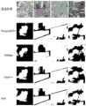
我们设计的BEC-UNet网络与其他耕地信息提取任务中使用的主流网络进行对比,如表4所示,可以看出,基于边缘增强的双模块协同网络相对于其他各网络的各项精度表现均有显著提升,尤其是相比于UNet网络的另一改进型的UNet++网络,基于边缘增强的双模块网络对于耕地的识别IOU达到91.84%,F1-score达到95.53%,分别较UNet++提升14.81%和8.51%。各网络的精度结果对比如图6所示。The BEC-UNet network we designed is compared with the mainstream networks used in other farmland information extraction tasks. As shown in Table 4, it can be seen that the dual-module collaborative network based on edge enhancement has significantly improved the accuracy performance of each other network, especially compared with the UNet++ network, another improved version of the UNet network. The dual-module network based on edge enhancement has an IOU of 91.84% and an F1-score of 95.53% for farmland recognition, which are 14.81% and 8.51% higher than UNet++, respectively. The accuracy results of each network are compared in Figure 6.
图6中的白色地块即为耕地部分,黑色地块就是非耕地的部分即耕地地块的边缘。根据结果图中各网络测试结果的对比可以明显看出,我们的基于边缘增强的语义分割网络具有显著的边缘明确作用,特别是相比于DeepLabV3+和PSPNet这样的主流网络时,其边缘模糊、提取不明的现象得到明显改善,在图像中我们可以清晰看到耕地地块的边缘呈线形分割,符合耕地的实际分布情况,相比于其他提取模型的圆形、杂乱散点形分布,我们的提出的基于边缘的改进思路在耕地识别尤其是边缘的识别上取得显著成效。The white plots in Figure 6 are the cultivated land, and the black plots are the non-cultivated land, i.e., the edges of the cultivated land. According to the comparison of the test results of each network in the result figure, it can be clearly seen that our semantic segmentation network based on edge enhancement has a significant edge clarification effect, especially compared with mainstream networks such as DeepLabV3+ and PSPNet, the edge blur and unclear extraction phenomenon are significantly improved. In the image, we can clearly see that the edges of the cultivated land are segmented in a linear manner, which is consistent with the actual distribution of cultivated land. Compared with the circular and messy scattered distribution of other extraction models, our proposed edge-based improvement ideas have achieved remarkable results in cultivated land recognition, especially edge recognition.
Claims (1)
Translated fromChinese


Priority Applications (1)
| Application Number | Priority Date | Filing Date | Title |
|---|---|---|---|
| CN202210201357.0ACN114596502B (en) | 2022-03-03 | 2022-03-03 | Arable land information extraction method based on edge-enhanced high-resolution remote sensing image |
Applications Claiming Priority (1)
| Application Number | Priority Date | Filing Date | Title |
|---|---|---|---|
| CN202210201357.0ACN114596502B (en) | 2022-03-03 | 2022-03-03 | Arable land information extraction method based on edge-enhanced high-resolution remote sensing image |
Publications (2)
| Publication Number | Publication Date |
|---|---|
| CN114596502A CN114596502A (en) | 2022-06-07 |
| CN114596502Btrue CN114596502B (en) | 2023-04-07 |
Family
ID=81814815
Family Applications (1)
| Application Number | Title | Priority Date | Filing Date |
|---|---|---|---|
| CN202210201357.0AActiveCN114596502B (en) | 2022-03-03 | 2022-03-03 | Arable land information extraction method based on edge-enhanced high-resolution remote sensing image |
Country Status (1)
| Country | Link |
|---|---|
| CN (1) | CN114596502B (en) |
Families Citing this family (3)
| Publication number | Priority date | Publication date | Assignee | Title |
|---|---|---|---|---|
| CN116188993B (en)* | 2023-03-23 | 2025-08-08 | 安徽大学 | Remote sensing image cultivated land block segmentation method based on multitask learning |
| CN116052006B (en)* | 2023-03-29 | 2023-06-16 | 山东建筑大学 | Building edge optimization method based on multitask learning and dual lottery hypothesis |
| CN116563709B (en)* | 2023-05-12 | 2025-08-15 | 湘江实验室 | Multi-time-phase remote sensing data oriented intelligent farmland resource monitoring method |
Citations (2)
| Publication number | Priority date | Publication date | Assignee | Title |
|---|---|---|---|---|
| CN113343789A (en)* | 2021-05-20 | 2021-09-03 | 武汉大学 | High-resolution remote sensing image land cover classification method based on local detail enhancement and edge constraint |
| CN113989271A (en)* | 2021-11-25 | 2022-01-28 | 江苏科技大学 | Paint image segmentation system and method based on double-attention mechanism and U-net network |
Family Cites Families (5)
| Publication number | Priority date | Publication date | Assignee | Title |
|---|---|---|---|---|
| CN108509843B (en)* | 2018-02-06 | 2022-01-28 | 重庆邮电大学 | Face recognition method based on weighted Huber constraint sparse coding |
| US10984532B2 (en)* | 2018-08-24 | 2021-04-20 | Ordnance Survey Limited | Joint deep learning for land cover and land use classification |
| CN111462126B (en)* | 2020-04-08 | 2022-10-11 | 武汉大学 | Semantic image segmentation method and system based on edge enhancement |
| CN113012172B (en)* | 2021-04-09 | 2023-10-03 | 杭州师范大学 | AS-UNet-based medical image segmentation method and system |
| CN113591614B (en)* | 2021-07-14 | 2024-05-28 | 西北工业大学 | Remote sensing image road extraction method based on close-proximity spatial feature learning |
- 2022
- 2022-03-03CNCN202210201357.0Apatent/CN114596502B/enactiveActive
Patent Citations (2)
| Publication number | Priority date | Publication date | Assignee | Title |
|---|---|---|---|---|
| CN113343789A (en)* | 2021-05-20 | 2021-09-03 | 武汉大学 | High-resolution remote sensing image land cover classification method based on local detail enhancement and edge constraint |
| CN113989271A (en)* | 2021-11-25 | 2022-01-28 | 江苏科技大学 | Paint image segmentation system and method based on double-attention mechanism and U-net network |
Also Published As
| Publication number | Publication date |
|---|---|
| CN114596502A (en) | 2022-06-07 |
Similar Documents
| Publication | Publication Date | Title |
|---|---|---|
| CN114596502B (en) | Arable land information extraction method based on edge-enhanced high-resolution remote sensing image | |
| CN113901900B (en) | Unsupervised change detection method and system for remote sensing images of the same or different sources | |
| CN111738124A (en) | Remote sensing image cloud detection method based on Gabor transform and attention | |
| CN111325750B (en) | Medical image segmentation method based on multi-scale fusion U-shaped chain neural network | |
| CN107169535A (en) | The deep learning sorting technique and device of biological multispectral image | |
| CN111462012A (en) | SAR image simulation method for generating countermeasure network based on conditions | |
| CN112819910A (en) | Hyperspectral image reconstruction method based on double-ghost attention machine mechanism network | |
| CN109993137A (en) | A fast face correction method based on convolutional neural network | |
| CN111914909B (en) | Hyperspectral change detection method based on space-spectrum combined three-direction convolution network | |
| CN116664892A (en) | Multi-temporal remote sensing image registration method based on cross attention and deformable convolution | |
| CN113627481A (en) | Multi-model combined unmanned aerial vehicle garbage classification method for smart gardens | |
| CN116486273B (en) | A Method for Extracting Water Body Information from Small Sample Remote Sensing Images | |
| CN114299382A (en) | Hyperspectral remote sensing image classification method and system | |
| CN117576473A (en) | Hyperspectral image classification method based on mixed covariance attention and cross-layer fusion transducer | |
| Deb et al. | LS-Net: A convolutional neural network for leaf segmentation of rosette plants | |
| CN118865142B (en) | Statistical analysis method for wild plant classified remote sensing image data | |
| CN117152600A (en) | An underwater image processing method based on lightweight diffusion model | |
| CN111340698A (en) | A method for enhancing spectral resolution of multispectral images based on neural network | |
| Li et al. | CSDFormer: A cloud and shadow detection method for landsat images based on transformer | |
| CN117314738A (en) | Image conversion method, system, electronic equipment and computer storage medium | |
| CN115496950A (en) | Image classification method based on semi-supervised discriminative dictionary pair learning with neighborhood information embedding | |
| Kumar et al. | Support vector neural network based fuzzy hybrid filter for impulse noise identification and removal from gray-scale image | |
| CN110363221A (en) | An ensemble learning classification method for hyperspectral remote sensing collaborative representation based on bagging | |
| Ning et al. | MABDT: Multi-scale attention boosted deformable transformer for remote sensing image dehazing | |
| CN115731135A (en) | Hyperspectral image denoising method and system based on low-rank tensor decomposition and adaptive graph total variation |
Legal Events
| Date | Code | Title | Description |
|---|---|---|---|
| PB01 | Publication | ||
| PB01 | Publication | ||
| SE01 | Entry into force of request for substantive examination | ||
| SE01 | Entry into force of request for substantive examination | ||
| GR01 | Patent grant | ||
| GR01 | Patent grant |