CN114594489A - A mining three-dimensional color point cloud reconstruction system and method - Google Patents
A mining three-dimensional color point cloud reconstruction system and methodDownload PDFInfo
- Publication number
- CN114594489A CN114594489ACN202210142832.1ACN202210142832ACN114594489ACN 114594489 ACN114594489 ACN 114594489ACN 202210142832 ACN202210142832 ACN 202210142832ACN 114594489 ACN114594489 ACN 114594489A
- Authority
- CN
- China
- Prior art keywords
- point cloud
- information
- lidar
- line
- laser radar
- Prior art date
- Legal status (The legal status is an assumption and is not a legal conclusion. Google has not performed a legal analysis and makes no representation as to the accuracy of the status listed.)
- Pending
Links
Images

Classifications
- G—PHYSICS
- G01—MEASURING; TESTING
- G01S—RADIO DIRECTION-FINDING; RADIO NAVIGATION; DETERMINING DISTANCE OR VELOCITY BY USE OF RADIO WAVES; LOCATING OR PRESENCE-DETECTING BY USE OF THE REFLECTION OR RERADIATION OF RADIO WAVES; ANALOGOUS ARRANGEMENTS USING OTHER WAVES
- G01S17/00—Systems using the reflection or reradiation of electromagnetic waves other than radio waves, e.g. lidar systems
- G01S17/87—Combinations of systems using electromagnetic waves other than radio waves
- G—PHYSICS
- G01—MEASURING; TESTING
- G01C—MEASURING DISTANCES, LEVELS OR BEARINGS; SURVEYING; NAVIGATION; GYROSCOPIC INSTRUMENTS; PHOTOGRAMMETRY OR VIDEOGRAMMETRY
- G01C21/00—Navigation; Navigational instruments not provided for in groups G01C1/00 - G01C19/00
- G01C21/10—Navigation; Navigational instruments not provided for in groups G01C1/00 - G01C19/00 by using measurements of speed or acceleration
- G01C21/12—Navigation; Navigational instruments not provided for in groups G01C1/00 - G01C19/00 by using measurements of speed or acceleration executed aboard the object being navigated; Dead reckoning
- G01C21/16—Navigation; Navigational instruments not provided for in groups G01C1/00 - G01C19/00 by using measurements of speed or acceleration executed aboard the object being navigated; Dead reckoning by integrating acceleration or speed, i.e. inertial navigation
- G—PHYSICS
- G01—MEASURING; TESTING
- G01S—RADIO DIRECTION-FINDING; RADIO NAVIGATION; DETERMINING DISTANCE OR VELOCITY BY USE OF RADIO WAVES; LOCATING OR PRESENCE-DETECTING BY USE OF THE REFLECTION OR RERADIATION OF RADIO WAVES; ANALOGOUS ARRANGEMENTS USING OTHER WAVES
- G01S17/00—Systems using the reflection or reradiation of electromagnetic waves other than radio waves, e.g. lidar systems
- G01S17/86—Combinations of lidar systems with systems other than lidar, radar or sonar, e.g. with direction finders
- G—PHYSICS
- G06—COMPUTING OR CALCULATING; COUNTING
- G06T—IMAGE DATA PROCESSING OR GENERATION, IN GENERAL
- G06T17/00—Three dimensional [3D] modelling, e.g. data description of 3D objects
- G—PHYSICS
- G06—COMPUTING OR CALCULATING; COUNTING
- G06T—IMAGE DATA PROCESSING OR GENERATION, IN GENERAL
- G06T5/00—Image enhancement or restoration
- G06T5/80—Geometric correction
- G—PHYSICS
- G06—COMPUTING OR CALCULATING; COUNTING
- G06T—IMAGE DATA PROCESSING OR GENERATION, IN GENERAL
- G06T7/00—Image analysis
- G06T7/70—Determining position or orientation of objects or cameras
- G06T7/73—Determining position or orientation of objects or cameras using feature-based methods
- G—PHYSICS
- G06—COMPUTING OR CALCULATING; COUNTING
- G06T—IMAGE DATA PROCESSING OR GENERATION, IN GENERAL
- G06T2207/00—Indexing scheme for image analysis or image enhancement
- G06T2207/10—Image acquisition modality
- G06T2207/10028—Range image; Depth image; 3D point clouds
Landscapes
- Engineering & Computer Science (AREA)
- Physics & Mathematics (AREA)
- Radar, Positioning & Navigation (AREA)
- General Physics & Mathematics (AREA)
- Remote Sensing (AREA)
- Theoretical Computer Science (AREA)
- Electromagnetism (AREA)
- Computer Networks & Wireless Communication (AREA)
- Geometry (AREA)
- Software Systems (AREA)
- Computer Graphics (AREA)
- Computer Vision & Pattern Recognition (AREA)
- Automation & Control Theory (AREA)
- Optical Radar Systems And Details Thereof (AREA)
- Navigation (AREA)
Abstract
Description
Translated fromChinese技术领域technical field
本申请涉及煤矿三维重建技术领域,尤其涉及一种矿用三维彩色点云重建系统及方法。The present application relates to the technical field of three-dimensional reconstruction of coal mines, and in particular, to a system and method for reconstructing three-dimensional color point clouds for mines.
背景技术Background technique
当前对于煤矿井下环境的三位重建,主要采用激光雷达或深度相机装置对环境信息进行采集,并结合惯性导航装置,建立点云地图,完成三维重建。At present, for the three-dimensional reconstruction of the underground environment of coal mines, lidar or depth camera devices are mainly used to collect environmental information, and combined with inertial navigation devices, point cloud maps are established to complete three-dimensional reconstruction.
但是,仅采用激光雷达测量获取到的信息是被扫描物体的位置信息,没有物体表面纹理的彩色RGB信息,即利用激光雷达对环境扫描只能建立含有位置信息的点云地图,人眼很难通过观察点云地图对目标进行识别,尤其在煤矿环境中,除了需要利用深度信息构建点云地图,实现实时观察环境物体也非常重要。而采用深度相机装置进行三位重建,虽然可以生成彩色的深度图像,但光线对其影响较大,采集到的点云数据精度容易收到环境干扰,最终造成生成的图像与实际相差较大。However, the information obtained only by lidar measurement is the position information of the scanned object, and there is no color RGB information of the surface texture of the object, that is, the use of lidar to scan the environment can only create a point cloud map containing position information, which is difficult for the human eye. To identify the target by observing the point cloud map, especially in the coal mine environment, in addition to the need to use the depth information to construct the point cloud map, it is also very important to realize the real-time observation of environmental objects. For three-dimensional reconstruction using a depth camera device, although a color depth image can be generated, the light has a great influence on it, and the accuracy of the collected point cloud data is easily disturbed by the environment, resulting in a large difference between the generated image and the actual image.
发明内容SUMMARY OF THE INVENTION
本申请提供一种矿用三维彩色点云重建系统及方法,以至少解决相关技术中的不能够准确还原被扫描的煤矿工作面环境的真实景象的技术问题。The present application provides a mining three-dimensional color point cloud reconstruction system and method to at least solve the technical problem in the related art that the real scene of the scanned coal mine working face environment cannot be accurately restored.
本申请第一方面实施例提出一种矿用三维彩色点云重建系统,包括:The embodiment of the first aspect of the present application proposes a mining three-dimensional color point cloud reconstruction system, including:
第一多线激光雷达、第二多线激光雷达、激光雷达支架、全景相机、惯性导航装置和数据处理电脑;The first multi-line laser radar, the second multi-line laser radar, the laser radar bracket, the panoramic camera, the inertial navigation device and the data processing computer;
所述第一多线激光雷达设置在所述激光雷达支架上且呈水平方向,所述第二多线激光雷达设置在所述激光雷达支架且其设置的位置与所述第一多线激光雷达呈直角互补结构;The first multi-line lidar is arranged on the lidar bracket and is in a horizontal direction, and the second multi-line lidar is arranged on the lidar bracket and its setting position is the same as that of the first multi-line lidar. Complementary structure at right angles;
所述全景相机设置在所述第一多线激光雷达的上方;the panoramic camera is arranged above the first multi-line lidar;
所述惯性导航装置设置在所述第一多线激光雷达所在位置的激光雷达支架的下方;The inertial navigation device is arranged below the lidar bracket where the first multi-line lidar is located;
所述数据处理电脑设置在所述激光雷达支架的下方且分别与第一多线激光雷达、第二多线激光雷达、全景相机和惯性导航装置相连。The data processing computer is arranged below the lidar bracket and is respectively connected with the first multi-line lidar, the second multi-line lidar, the panoramic camera and the inertial navigation device.
优选的,所述矿用三维彩色点云重建系统还包括:全景相机底座、惯性导航装置支架和数据处理电脑支架;Preferably, the mining three-dimensional color point cloud reconstruction system further includes: a panoramic camera base, an inertial navigation device support and a data processing computer support;
所述全景相机通过所述全景相机底座设置在所述第一多线激光雷达的上方;The panoramic camera is arranged above the first multi-line laser radar through the panoramic camera base;
所述惯性导航装置通过惯性导航装置支架设置在所述第一多线激光雷达所在位置的激光雷达支架的下方;The inertial navigation device is arranged below the lidar bracket where the first multi-line lidar is located through the inertial navigation device bracket;
所述数据处理电脑通过数据处理电脑支架设置在所述激光雷达支架的下方。The data processing computer is arranged below the lidar support through a data processing computer support.
优选的,所述第一多线激光雷达及第二多线激光雷达的垂直视角为±15°,水平视角为360°。Preferably, the vertical viewing angle of the first multi-line laser radar and the second multi-line laser radar is ±15°, and the horizontal viewing angle is 360°.
优选的,所述第一多线激光雷达与第二多线激光雷达均用于采集煤矿工作面的三维地质信息,并将采集的所述煤矿工作面的三维地质信息发送到数据处理电脑;Preferably, both the first multi-line laser radar and the second multi-line laser radar are used to collect the three-dimensional geological information of the coal mine working face, and send the collected three-dimensional geological information of the coal mine working face to a data processing computer;
所述全景相机为360°球形视角的全景相机,用于采集煤矿工作面的色彩信息,并将采集的所述煤矿工作面的色彩信息发送到数据处理电脑;The panoramic camera is a panoramic camera with a 360° spherical viewing angle, used for collecting color information of the coal mine working face, and sending the collected color information of the coal mine working face to a data processing computer;
所述惯性导航装置,用于实时采集所述激光雷达支架自由度的位姿信息,并将采集的所述激光雷达支架自由度的位姿信息发送到数据处理电脑;The inertial navigation device is used to collect the position and attitude information of the degree of freedom of the lidar bracket in real time, and send the collected position and attitude information of the degree of freedom of the lidar bracket to a data processing computer;
所述数据处理电脑,用于接收所述煤矿工作面的三维地质信息、色彩信息和所述激光雷达支架自由度的位姿信息,并基于所述接收到的信息对所述煤矿工作面的三维激光点云信息进行重建。The data processing computer is used to receive the three-dimensional geological information, color information and the position and attitude information of the degree of freedom of the lidar support of the coal mine working face, and based on the received information, the three-dimensional Laser point cloud information for reconstruction.
进一步的,所述基于所述接收到的信息对所述煤矿工作面的三维激光点云信息进行重建,包括:Further, the reconstructing the three-dimensional laser point cloud information of the coal mine working face based on the received information includes:
获取第一多线激光雷达与第二多线激光雷达间的外参矩阵、第一多线激光雷达与惯性导航装置间的外参矩阵,并基于所述外参矩阵确定所述煤矿工作面对应的三维激光点云信息;Obtain the extrinsic parameter matrix between the first multi-line laser radar and the second multi-line laser radar, and the extrinsic parameter matrix between the first multi-line laser radar and the inertial navigation device, and determine the coal mine working face based on the extrinsic parameter matrix Corresponding 3D laser point cloud information;
基于惯性导航装置采集的所述激光雷达支架自由度的位姿信息对所述煤矿工作面对应的三维激光点云信息进行畸变补偿处理,得到畸变补偿处理后的所述点云信息;Perform distortion compensation processing on the three-dimensional laser point cloud information corresponding to the coal mine working face based on the pose information of the degrees of freedom of the lidar support collected by the inertial navigation device, to obtain the point cloud information after the distortion compensation processing;
将所述畸变补偿处理后的所述点云信息与采集得到的色彩信息变换到同一坐标系下,然后在对应的点云位置增加色彩信息,得到重建后的所述煤矿工作面对应的三维激光点云信息。Transform the point cloud information after the distortion compensation processing and the collected color information into the same coordinate system, and then add color information at the corresponding point cloud position to obtain the reconstructed three-dimensional corresponding to the coal mine working face. Laser point cloud information.
进一步的,所述基于所述外参矩阵确定所述煤矿工作面对应的三维激光点云信息,包括:Further, determining the three-dimensional laser point cloud information corresponding to the coal mine working face based on the external parameter matrix includes:
基于第一多线激光雷达与第二多线激光雷达间的外参矩阵,将第二多线激光雷达采集的所述煤矿工作面的三维地质信息变换到第一多线激光雷达对应的坐标系上;Based on the external parameter matrix between the first multi-line lidar and the second multi-line lidar, transform the three-dimensional geological information of the coal mine working face collected by the second multi-line lidar into the coordinate system corresponding to the first multi-line lidar superior;
基于第一多线激光雷达与惯性导航装置间的外参矩阵,将采集的所述激光雷达支架自由度的位姿信息变换到第一多线激光雷达对应的坐标系上;Based on the extrinsic parameter matrix between the first multi-line lidar and the inertial navigation device, transform the collected pose information of the lidar bracket degrees of freedom to the coordinate system corresponding to the first multi-line lidar;
将进行变换后的第一多线激光雷达对应的坐标系上的点云信息作为所述煤矿工作面对应的三维激光点云信息。The point cloud information on the coordinate system corresponding to the transformed first multi-line laser radar is used as the three-dimensional laser point cloud information corresponding to the coal mine working face.
进一步的,所述基于惯性导航装置采集的所述激光雷达支架自由度的位姿信息对所述煤矿工作面对应的三维激光点云信息进行畸变补偿处理,包括:Further, performing distortion compensation processing on the three-dimensional laser point cloud information corresponding to the coal mine working face based on the position and attitude information of the degrees of freedom of the lidar support collected by the inertial navigation device, including:
利用扩展卡尔曼滤波算法对采集的所述激光雷达支架自由度的位姿信息进行姿态解算,得到所述姿态解算结果;Using the extended Kalman filter algorithm to perform attitude calculation on the collected position and attitude information of the lidar support degrees of freedom, to obtain the attitude calculation result;
利用所述姿态解算结果将所述煤矿工作面对应的三维激光点云信息中的各帧点云中的点分别变换到所述帧点云的第一个点所在时刻的坐标系上。Using the attitude calculation result, the points in each frame of point cloud in the three-dimensional laser point cloud information corresponding to the coal mine face are respectively transformed to the coordinate system at the moment of the first point of the frame point cloud.
本申请第二方面实施例提出一种矿用三维彩色点云重建方法,包括:The embodiment of the second aspect of the present application proposes a method for reconstructing a 3D color point cloud for mining, including:
采集煤矿工作面的三维地质信息、色彩信息、所述激光雷达支架自由度的位姿信息,并获取所述第一多线激光雷达与第二多线激光雷达间的外参矩阵、第一多线激光雷达与惯性导航装置间的外参矩阵;Collect three-dimensional geological information, color information, and position and attitude information of the lidar support degrees of freedom of the coal mine working face, and obtain the extrinsic parameter matrix between the first multi-line lidar and the second multi-line lidar, the first multi-line lidar External parameter matrix between line lidar and inertial navigation device;
基于采集的所述煤矿工作面的三维地质信息、色彩信息和获取的所述第一多线激光雷达与第二多线激光雷达间的外参矩阵、第一多线激光雷达与惯性导航装置间的外参矩阵确定所述煤矿工作面对应的三维激光点云信息;Based on the collected three-dimensional geological information and color information of the coal mine face, and the acquired extrinsic matrix between the first multi-line laser radar and the second multi-line laser radar, and the relationship between the first multi-line laser radar and the inertial navigation device The extrinsic parameter matrix to determine the three-dimensional laser point cloud information corresponding to the coal mine face;
利用采集的所述激光雷达支架自由度的位姿信息对所述煤矿工作面对应的三维激光点云信息进行畸变补偿处理,得到畸变补偿处理后的所述点云信息;Perform distortion compensation processing on the three-dimensional laser point cloud information corresponding to the coal mine working face by using the collected pose information of the degree of freedom of the lidar support, to obtain the point cloud information after the distortion compensation processing;
将所述畸变补偿处理后的所述点云信息与采集得到的色彩信息变换到同一坐标系下,然后在对应的点云位置增加色彩信息,得到重建后的所述煤矿工作面对应的三维激光点云信息。Transform the point cloud information after the distortion compensation processing and the collected color information into the same coordinate system, and then add color information at the corresponding point cloud position to obtain the reconstructed three-dimensional corresponding to the coal mine working face. Laser point cloud information.
优选的,所述基于采集的所述煤矿工作面的三维地质信息、色彩信息和获取的所述第一多线激光雷达与第二多线激光雷达间的外参矩阵、第一多线激光雷达与惯性导航装置间的外参矩阵确定所述煤矿工作面对应的三维激光点云信息,包括:Preferably, based on the collected three-dimensional geological information and color information of the coal mine working face and the acquired extrinsic parameter matrix between the first multi-line laser radar and the second multi-line laser radar, the first multi-line laser radar The three-dimensional laser point cloud information corresponding to the coal mine working face is determined by the external parameter matrix between the inertial navigation devices, including:
基于第一多线激光雷达与第二多线激光雷达间的外参矩阵,将第二多线激光雷达采集的所述煤矿工作面的三维地质信息变换到第一多线激光雷达对应的坐标系上;Based on the external parameter matrix between the first multi-line lidar and the second multi-line lidar, transform the three-dimensional geological information of the coal mine working face collected by the second multi-line lidar into the coordinate system corresponding to the first multi-line lidar superior;
基于第一多线激光雷达与惯性导航装置间的外参矩阵,将采集的所述激光雷达支架自由度的位姿信息变换到第一多线激光雷达对应的坐标系上;Based on the extrinsic parameter matrix between the first multi-line lidar and the inertial navigation device, transform the collected pose information of the lidar bracket degrees of freedom to the coordinate system corresponding to the first multi-line lidar;
将进行变换后的第一多线激光雷达对应的坐标系上的点云信息作为所述煤矿工作面对应的三维激光点云信息。The point cloud information on the coordinate system corresponding to the transformed first multi-line laser radar is used as the three-dimensional laser point cloud information corresponding to the coal mine working face.
优选的,所述利用采集的所述激光雷达支架自由度的位姿信息对所述煤矿工作面对应的三维激光点云信息进行畸变补偿处理,包括:Preferably, performing distortion compensation processing on the three-dimensional laser point cloud information corresponding to the coal mine working face by using the collected pose information of the degree of freedom of the lidar support, including:
利用扩展卡尔曼滤波算法对采集的所述激光雷达支架自由度的位姿信息进行姿态解算,得到所述姿态解算结果;Using the extended Kalman filter algorithm to perform attitude calculation on the collected position and attitude information of the lidar support degrees of freedom, to obtain the attitude calculation result;
利用所述姿态解算结果将所述煤矿工作面对应的三维激光点云信息中的各帧点云中的点分别变换到所述帧点云的第一个点所在时刻的坐标系上。Using the attitude calculation result, the points in each frame of point cloud in the three-dimensional laser point cloud information corresponding to the coal mine face are respectively transformed to the coordinate system at the moment of the first point of the frame point cloud.
本申请的实施例提供的技术方案至少带来以下有益效果:The technical solutions provided by the embodiments of the present application bring at least the following beneficial effects:
本申请提供了一种矿用三维彩色点云重建系统及方法,其中,所述系统包括:第一多线激光雷达、第二多线激光雷达、激光雷达支架、全景相机、全景相机底座、惯性导航装置和数据处理电脑;所述第一多线激光雷达设置在所述激光雷达支架上且呈水平方向,所述第二多线激光雷达设置在所述激光雷达支架且其设置的位置与所述第一多线激光雷达呈直角互补结构;所述全景相机通过所述全景相机底座设置在所述第一多线激光雷达的上方;所述惯性导航装置设置在所述第一多线激光雷达所在位置的激光雷达支架的下方;所述数据处理电脑设置在所述激光雷达支架的下方且分别与第一多线激光雷达、第二多线激光雷达、全景相机和惯性导航装置相连。本申请提供的技术方案,使得构建点云的同时为点云增加RGB信息,还原被扫描环境的真实景象,解决了难以对煤矿工作面进行物体识别的问题。The application provides a mining three-dimensional color point cloud reconstruction system and method, wherein the system includes: a first multi-line laser radar, a second multi-line laser radar, a laser radar bracket, a panoramic camera, a panoramic camera base, an inertial Navigation device and data processing computer; the first multi-line laser radar is arranged on the lidar bracket and is in a horizontal direction, and the second multi-line laser radar is arranged on the lidar bracket and its setting position is the same as that of the laser radar bracket. The first multi-line laser radar has a right-angle complementary structure; the panoramic camera is arranged above the first multi-line laser radar through the panoramic camera base; the inertial navigation device is arranged on the first multi-line laser radar The data processing computer is arranged below the lidar support and is respectively connected with the first multi-line laser radar, the second multi-line laser radar, the panoramic camera and the inertial navigation device. The technical solution provided by the present application makes it possible to add RGB information to the point cloud while constructing the point cloud, restore the real scene of the scanned environment, and solve the problem of difficulty in object recognition on the coal mine working face.
本申请附加的方面以及优点将在下面的描述中部分给出,部分将从下面的描述中变得明显,或通过本申请的实践了解到。Additional aspects and advantages of the present application will be set forth, in part, from the following description, and in part will become apparent from the following description, or may be learned by practice of the present application.
附图说明Description of drawings
本申请上述的和/或附加的方面以及优点从下面结合附图对实施例的描述中将变得明显和容易理解,其中:The above and/or additional aspects and advantages of the present application will become apparent and readily understood from the following description of embodiments taken in conjunction with the accompanying drawings, wherein:
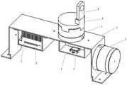
图1为根据本申请一个实施例提供的一种矿用三维彩色点云重建系统的结构图;1 is a structural diagram of a mining three-dimensional color point cloud reconstruction system provided according to an embodiment of the present application;
图2为根据本申请一个实施例提供的一种矿用三维彩色点云重建系统中含有惯性导航装置支架的系统结构图;2 is a system structure diagram including an inertial navigation device bracket in a mining three-dimensional color point cloud reconstruction system provided according to an embodiment of the present application;
图3为根据本申请一个实施例提供的一种矿用三维彩色点云重建方法的流程图。FIG. 3 is a flowchart of a method for reconstructing a three-dimensional color point cloud for mining according to an embodiment of the present application.
附图标记说明:Description of reference numbers:
第一多线激光雷达1、第二多线激光雷达2、激光雷达支架3、全景相机4、全景相机底座5、惯性导航装置6、数据处理电脑7、惯性导航装置支架8和数据处理电脑支架9。The first
具体实施方式Detailed ways
下面详细描述本申请的实施例,所述实施例的示例在附图中示出,其中自始至终相同或类似的标号表示相同或类似的元件或具有相同或类似功能的元件。下面通过参考附图描述的实施例是示例性的,旨在用于解释本申请,而不能理解为对本申请的限制。The following describes in detail the embodiments of the present application, examples of which are illustrated in the accompanying drawings, wherein the same or similar reference numerals refer to the same or similar elements or elements having the same or similar functions throughout. The embodiments described below with reference to the accompanying drawings are exemplary, and are intended to be used to explain the present application, but should not be construed as a limitation to the present application.
本申请提出的一种矿用三维彩色点云重建系统及方法,其中,所述系统包括:第一多线激光雷达1、第二多线激光雷达2、激光雷达支架3、全景相机4、惯性导航装置6和数据处理电脑7;所述第一多线激光雷达1设置在所述激光雷达支架上且呈水平方向,所述第二多线激光雷2达设置在所述激光雷达支架3且其设置的位置与所述第一多线激光雷达1呈直角互补结构;所述全景相机4设置在所述第一多线激光雷达1的上方;所述惯性导航装置设置6在所述第一多线激光雷达1所在位置的激光雷达支架3的下方;所述数据处理电脑7设置在所述激光雷达支架3的下方且分别与第一多线激光雷达1、第二多线激光雷达2、全景相机4和惯性导航装置6相连。本申请提供的技术方案,使得构建点云的同时为点云增加RGB信息即色彩信息,还原被扫描环境的真实景象,解决了难以对煤矿工作面进行物体识别的问题。A mining three-dimensional color point cloud reconstruction system and method proposed in this application, wherein the system includes: a first
下面参考附图描述本申请实施例的矿用三维彩色点云重建系统及方法。The following describes the three-dimensional color point cloud reconstruction system and method for mining according to the embodiments of the present application with reference to the accompanying drawings.
实施例1Example 1
图1为根据本申请一个实施例提供的一种矿用三维彩色点云重建系统的结构图,如图1所示,所述矿用三维彩色点云重建系统包括:至少一个第一多线激光雷达1、至少一个第二多线激光雷达2、至少一个激光雷达支架3、至少一个全景相机4、至少一个惯性导航装置6和数据处理电脑7;Fig. 1 is a structural diagram of a mining 3D color point cloud reconstruction system provided according to an embodiment of the present application. As shown in Fig. 1 , the mining 3D color point cloud reconstruction system includes: at least one first
需要注意的是,图1示出的是一种一个第一多线激光雷达1、一个第二多线激光雷达2、一个激光雷达支架3、一个全景相机4、一个惯性导航装置6和一个数据处理电脑7系统结构图,图1仅作示例,并不作为对本申请实施例的限制。It should be noted that FIG. 1 shows a
在本公开实施例中,所述第一多线激光雷达1设置在所述激光雷达支架3上且呈水平方向,所述第二多线激光雷达2设置在所述激光雷达支架3且其设置的位置与所述第一多线激光雷达1呈直角互补结构;In the embodiment of the present disclosure, the
所述第一多线激光雷达及第二多线激光雷达的垂直视角为±15°,水平视角为360°;The vertical viewing angle of the first multi-line laser radar and the second multi-line laser radar is ±15°, and the horizontal viewing angle is 360°;
其中,所述第一多线激光雷达1与第二多线激光雷达2均用于采集煤矿工作面的三维地质信息,并将采集的所述煤矿工作面的三维地质信息发送到数据处理电脑7。Wherein, the first
在本公开实施例中,所述全景相机4设置在所述第一多线激光雷达1的上方;In the embodiment of the present disclosure, the
其中,所述全景相机4为360°球形视角的全景相机,用于采集煤矿工作面的色彩信息即RGB信息,并将采集的所述煤矿工作面的色彩信息发送到数据处理电脑7。The
在本公开实施例中,所述惯性导航装置6设置在所述第一多线激光雷达1所在位置的激光雷达支架3的下方;In the embodiment of the present disclosure, the
其中,所述惯性导航装置6,用于实时采集所述激光雷达支架自由度的位姿信息,并将采集的所述激光雷达支架自由度的位姿信息发送到数据处理电脑。Wherein, the
在本公开实施例中,所述数据处理电脑7设置在所述激光雷达支架3的下方且分别与第一多线激光雷达1、第二多线激光雷达2、全景相机4和惯性导航装置相连6;In the embodiment of the present disclosure, the
其中,所述数据处理电脑,用于接收所述煤矿工作面的三维地质信息、色彩信息和所述激光雷达支架自由度的位姿信息,并基于所述接收到的信息对所述煤矿工作面的三维激光点云信息进行重建;Wherein, the data processing computer is used to receive the three-dimensional geological information and color information of the coal mine working face and the pose information of the degree of freedom of the lidar support, and based on the received information, analyze the coal mine working face 3D laser point cloud information for reconstruction;
所述数据处理电脑7可以采用8核处理器,且电脑的功耗可根据需要设定为10w或15w或30w。The
需要说明的是,所述数据处理电脑7设置在所述激光雷达支架3的下方仅作一个示例,还可以固定在激光雷达支架3的其他部分或单独放置。It should be noted that the arrangement of the
在本公开实施例中,如图2所示,In the embodiment of the present disclosure, as shown in FIG. 2 ,
所述矿用三维彩色点云重建系统还包括:全景相机底座5、惯性导航装置支架8和数据处理电脑支架9;The mining three-dimensional color point cloud reconstruction system further includes: a panoramic camera base 5, an inertial
所述全景相机4通过所述全景相机底座5设置在所述第一多线激光雷达1的上方;The
所述惯性导航装置6通过惯性导航装置支架8设置在所述第一多线激光雷达1所在位置的激光雷达支架3的下方;The
所述数据处理电脑7通过数据处理电脑支架9设置在所述激光雷达支架3的下方。The
需要说明的是,所述基于所述接收到的信息对所述煤矿工作面的三维激光点云信息进行重建,包括:It should be noted that the reconstruction of the three-dimensional laser point cloud information of the coal mine working face based on the received information includes:
获取第一多线激光雷达1与第二多线激光雷达1间的外参矩阵、第一多线激光雷达1与惯性导航装置6间的外参矩阵,并基于所述外参矩阵确定所述煤矿工作面对应的三维激光点云信息;Obtain the extrinsic parameter matrix between the first
基于惯性导航装置6采集的所述激光雷达支架3自由度的位姿信息对所述煤矿工作面对应的三维激光点云信息进行畸变补偿处理,得到畸变补偿处理后的所述点云信息;Distortion compensation processing is performed on the three-dimensional laser point cloud information corresponding to the coal mine working face based on the pose information of the lidar support with 3 degrees of freedom collected by the
将所述畸变补偿处理后的所述点云信息与采集得到的色彩信息变换到同一坐标系下,然后在对应的点云位置增加色彩信息,得到重建后的所述煤矿工作面对应的三维激光点云信息。Transform the point cloud information after the distortion compensation processing and the collected color information into the same coordinate system, and then add color information at the corresponding point cloud position to obtain the reconstructed three-dimensional corresponding to the coal mine working face. Laser point cloud information.
进一步的,所述基于所述外参矩阵确定所述煤矿工作面对应的三维激光点云信息,包括:Further, determining the three-dimensional laser point cloud information corresponding to the coal mine working face based on the external parameter matrix includes:
基于第一多线激光雷达1与第二多线激光雷达2间的外参矩阵,将第二多线激光雷达2采集的所述煤矿工作面的三维地质信息变换到第一多线激光雷达1对应的坐标系上;Based on the extrinsic parameter matrix between the first
基于第一多线激光雷达1与惯性导航装置6间的外参矩阵,将采集的所述激光雷达支架3自由度的位姿信息变换到第一多线激光雷达1对应的坐标系上;Based on the extrinsic parameter matrix between the
将进行变换后的第一多线激光雷达1对应的坐标系上的点云信息作为所述煤矿工作面对应的三维激光点云信息。The point cloud information on the coordinate system corresponding to the first
其中,所述基于惯性导航装置6采集的所述激光雷达支架3自由度的位姿信息对所述煤矿工作面对应的三维激光点云信息进行畸变补偿处理,包括:Wherein, performing distortion compensation processing on the three-dimensional laser point cloud information corresponding to the coal mine working face based on the position and attitude information of the
利用扩展卡尔曼滤波算法对采集的所述激光雷达支架3自由度的位姿信息进行姿态解算,得到所述姿态解算结果;Use the extended Kalman filter algorithm to perform attitude calculation on the collected pose information of the lidar support with 3 degrees of freedom, and obtain the attitude calculation result;
利用所述姿态解算结果将所述煤矿工作面对应的三维激光点云信息中的各帧点云中的点分别变换到所述帧点云的第一个点所在时刻的坐标系上。Using the attitude calculation result, the points in each frame of point cloud in the three-dimensional laser point cloud information corresponding to the coal mine face are respectively transformed to the coordinate system at the moment of the first point of the frame point cloud.
综上所示,本申请提出的一种矿用三维彩色点云重建系统,通过使用两颗多线激光雷达,呈直角结构布置,可扩大激光雷达的扫描范围,采集更多的点云信息,同时通过使用全景相机,采集当前位置的色彩信息即RGB信息,利用外参矩阵,将点云信息与色彩信息变换到同一坐标系,将位于同一位置的点的信息与色彩信息融合,使得构建点云的同时为点云增加RGB信息即色彩信息,还原被扫描环境的真实景象,解决了难以对煤矿工作面进行物体识别的问题。To sum up, a 3D color point cloud reconstruction system for mining proposed in this application can expand the scanning range of the laser radar and collect more point cloud information by using two multi-line laser radars arranged in a right-angle structure. At the same time, by using the panoramic camera, the color information of the current position, that is, the RGB information, is collected, and the point cloud information and the color information are transformed into the same coordinate system by using the external parameter matrix, and the information of the point at the same position is fused with the color information, so that the construction point At the same time, RGB information, that is, color information, is added to the point cloud, which restores the real scene of the scanned environment and solves the problem of difficult object recognition on the coal mine face.
实施例2Example 2
图3为根据本申请一个实施例提供的矿用三维彩色点云重建方法的流程图,如图3所示,所述方法可以包括:FIG. 3 is a flowchart of a method for reconstructing a 3D color point cloud for mining according to an embodiment of the present application. As shown in FIG. 3 , the method may include:
步骤1:采集煤矿工作面的三维地质信息、色彩信息、所述激光雷达支架自由度的位姿信息,并获取所述第一多线激光雷达与第二多线激光雷达间的外参矩阵、第一多线激光雷达与惯性导航装置间的外参矩阵;Step 1: Collect the three-dimensional geological information, color information, and pose information of the lidar support degrees of freedom of the coal mine working face, and obtain the external parameter matrix between the first multi-line lidar and the second multi-line lidar, The external parameter matrix between the first multi-line lidar and the inertial navigation device;
步骤2:基于采集的所述煤矿工作面的三维地质信息、色彩信息和获取的所述第一多线激光雷达与第二多线激光雷达间的外参矩阵、第一多线激光雷达与惯性导航装置间的外参矩阵确定所述煤矿工作面对应的三维激光点云信息;Step 2: Based on the collected three-dimensional geological information and color information of the coal mine working face and the acquired extrinsic parameter matrix between the first multi-line laser radar and the second multi-line laser radar, the first multi-line laser radar and inertial The external parameter matrix between the navigation devices determines the three-dimensional laser point cloud information corresponding to the coal mine working face;
步骤3:利用采集的所述激光雷达支架自由度的位姿信息对所述煤矿工作面对应的三维激光点云信息进行畸变补偿处理,得到畸变补偿处理后的所述点云信息;Step 3: Perform distortion compensation processing on the three-dimensional laser point cloud information corresponding to the coal mine working face by using the collected pose information of the degree of freedom of the lidar support, to obtain the point cloud information after the distortion compensation processing;
步骤4:将所述畸变补偿处理后的所述点云信息与采集得到的色彩信息变换到同一坐标系下,然后在对应的点云位置增加色彩信息,得到重建后的所述煤矿工作面对应的三维激光点云信息。Step 4: Transform the point cloud information after the distortion compensation processing and the collected color information into the same coordinate system, and then add color information at the corresponding point cloud position to obtain the reconstructed coal mine working face. The corresponding 3D laser point cloud information.
在本公开实施例中,所述基于采集的所述煤矿工作面的三维地质信息、色彩信息和获取的所述第一多线激光雷达与第二多线激光雷达间的外参矩阵、第一多线激光雷达与惯性导航装置间的外参矩阵确定所述煤矿工作面对应的三维激光点云信息,包括:In the embodiment of the present disclosure, the acquired three-dimensional geological information and color information of the coal mine working face and the acquired extrinsic parameter matrix between the first multi-line laser radar and the second multi-line laser radar, the first The external parameter matrix between the multi-line laser radar and the inertial navigation device determines the three-dimensional laser point cloud information corresponding to the coal mine working face, including:
基于第一多线激光雷达与第二多线激光雷达间的外参矩阵,将第二多线激光雷达采集的所述煤矿工作面的三维地质信息变换到第一多线激光雷达对应的坐标系上;Based on the external parameter matrix between the first multi-line lidar and the second multi-line lidar, transform the three-dimensional geological information of the coal mine working face collected by the second multi-line lidar into the coordinate system corresponding to the first multi-line lidar superior;
基于第一多线激光雷达与惯性导航装置间的外参矩阵,将采集的所述激光雷达支架自由度的位姿信息变换到第一多线激光雷达对应的坐标系上;Based on the extrinsic parameter matrix between the first multi-line lidar and the inertial navigation device, transform the collected pose information of the lidar bracket degrees of freedom to the coordinate system corresponding to the first multi-line lidar;
将进行变换后的第一多线激光雷达对应的坐标系上的点云信息作为所述煤矿工作面对应的三维激光点云信息。The point cloud information on the coordinate system corresponding to the transformed first multi-line laser radar is used as the three-dimensional laser point cloud information corresponding to the coal mine working face.
在本公开实施例中,所述利用采集的所述激光雷达支架自由度的位姿信息对所述煤矿工作面对应的三维激光点云信息进行畸变补偿处理,包括:In the embodiment of the present disclosure, performing distortion compensation processing on the three-dimensional laser point cloud information corresponding to the coal mine working face by using the collected pose information of the degree of freedom of the lidar support includes:
利用扩展卡尔曼滤波算法对采集的所述激光雷达支架自由度的位姿信息进行姿态解算,得到所述姿态解算结果;Using the extended Kalman filter algorithm to perform attitude calculation on the collected position and attitude information of the lidar support degrees of freedom, to obtain the attitude calculation result;
利用所述姿态解算结果将所述煤矿工作面对应的三维激光点云信息中的各帧点云中的点分别变换到所述帧点云的第一个点所在时刻的坐标系上。Using the attitude calculation result, the points in each frame of point cloud in the three-dimensional laser point cloud information corresponding to the coal mine face are respectively transformed to the coordinate system at the moment of the first point of the frame point cloud.
综上所示,本申请提出的一种矿用三维彩色点云重建方法,通过采集煤矿工作面的三维地质信息、色彩信息、所述激光雷达支架自由度的位姿信息,并获取所述第一多线激光雷达与第二多线激光雷达间的外参矩阵、第一多线激光雷达与惯性导航装置间的外参矩阵;基于采集的所述煤矿工作面的三维地质信息、色彩信息和获取的所述第一多线激光雷达与第二多线激光雷达间的外参矩阵、第一多线激光雷达与惯性导航装置间的外参矩阵确定所述煤矿工作面对应的三维激光点云信息;利用采集的所述激光雷达支架自由度的位姿信息对所述煤矿工作面对应的三维激光点云信息进行畸变补偿处理,得到畸变补偿处理后的所述点云信息;将所述畸变补偿处理后的所述点云信息与采集得到的色彩信息变换到同一坐标系下,然后在对应的点云位置增加色彩信息,得到重建后的所述煤矿工作面对应的三维激光点云信息。使得构建点云的同时为点云增加RGB信息即色彩信息,还原被扫描环境的真实景象,解决了难以对煤矿工作面进行物体识别的问题。To sum up, the method for reconstructing a 3D color point cloud for mines proposed in this application is obtained by collecting the 3D geological information, color information, and position and attitude information of the degree of freedom of the lidar support of the coal mine working face, and obtaining the first method. The external parameter matrix between the first multi-line laser radar and the second multi-line laser radar, the external parameter matrix between the first multi-line laser radar and the inertial navigation device; based on the collected three-dimensional geological information, color information and The acquired extrinsic parameter matrix between the first multi-line laser radar and the second multi-line laser radar, and the extrinsic parameter matrix between the first multi-line laser radar and the inertial navigation device determine the three-dimensional laser point corresponding to the coal mine working face cloud information; perform distortion compensation processing on the three-dimensional laser point cloud information corresponding to the coal mine working face by using the collected pose information of the degree of freedom of the lidar support to obtain the point cloud information after the distortion compensation processing; The point cloud information after the distortion compensation process and the collected color information are transformed into the same coordinate system, and then the color information is added to the corresponding point cloud position to obtain the reconstructed three-dimensional laser point corresponding to the coal mine face. cloud information. This makes it possible to add RGB information, that is, color information, to the point cloud while constructing the point cloud, restore the real scene of the scanned environment, and solve the problem that it is difficult to recognize objects on the coal mine working face.
在本说明书的描述中,参考术语“一个实施例”、“一些实施例”、“示例”、“具体示例”、或“一些示例”等的描述意指结合该实施例或示例描述的具体特征、结构、材料或者特点包含于本申请的至少一个实施例或示例中。在本说明书中,对上述术语的示意性表述不必须针对的是相同的实施例或示例。而且,描述的具体特征、结构、材料或者特点可以在任一个或多个实施例或示例中以合适的方式结合。此外,在不相互矛盾的情况下,本领域的技术人员可以将本说明书中描述的不同实施例或示例以及不同实施例或示例的特征进行结合和组合。In the description of this specification, description with reference to the terms "one embodiment," "some embodiments," "example," "specific example," or "some examples", etc., mean specific features described in connection with the embodiment or example , structure, material or feature is included in at least one embodiment or example of the present application. In this specification, schematic representations of the above terms are not necessarily directed to the same embodiment or example. Furthermore, the particular features, structures, materials or characteristics described may be combined in any suitable manner in any one or more embodiments or examples. Furthermore, those skilled in the art may combine and combine the different embodiments or examples described in this specification, as well as the features of the different embodiments or examples, without conflicting each other.
流程图中或在此以其他方式描述的任何过程或方法描述可以被理解为,表示包括一个或更多个用于实现定制逻辑功能或过程的步骤的可执行指令的代码的模块、片段或部分,并且本申请的优选实施方式的范围包括另外的实现,其中可以不按所示出或讨论的顺序,包括根据所涉及的功能按基本同时的方式或按相反的顺序,来执行功能,这应被本申请的实施例所属技术领域的技术人员所理解。Any process or method description in the flowcharts or otherwise described herein may be understood to represent a module, segment or portion of code comprising one or more executable instructions for implementing custom logical functions or steps of the process , and the scope of the preferred embodiments of the present application includes alternative implementations in which the functions may be performed out of the order shown or discussed, including performing the functions substantially concurrently or in the reverse order depending upon the functions involved, which should It is understood by those skilled in the art to which the embodiments of the present application belong.
尽管上面已经示出和描述了本申请的实施例,可以理解的是,上述实施例是示例性的,不能理解为对本申请的限制,本领域的普通技术人员在本申请的范围内可以对上述实施例进行变化、修改、替换和变型。Although the embodiments of the present application have been shown and described above, it should be understood that the above embodiments are exemplary and should not be construed as limitations to the present application. Embodiments are subject to variations, modifications, substitutions and variations.
Claims (10)
Translated fromChinesePriority Applications (3)
| Application Number | Priority Date | Filing Date | Title |
|---|---|---|---|
| CN202210142832.1ACN114594489A (en) | 2022-02-16 | 2022-02-16 | A mining three-dimensional color point cloud reconstruction system and method |
| AU2022442056AAU2022442056B2 (en) | 2022-02-16 | 2022-02-24 | Mining three-dimensional color point cloud reconstruction system and method |
| PCT/CN2022/077777WO2023155228A1 (en) | 2022-02-16 | 2022-02-24 | Mining three-dimensional color point cloud reconstruction system and method |
Applications Claiming Priority (1)
| Application Number | Priority Date | Filing Date | Title |
|---|---|---|---|
| CN202210142832.1ACN114594489A (en) | 2022-02-16 | 2022-02-16 | A mining three-dimensional color point cloud reconstruction system and method |
Publications (1)
| Publication Number | Publication Date |
|---|---|
| CN114594489Atrue CN114594489A (en) | 2022-06-07 |
Family
ID=81804413
Family Applications (1)
| Application Number | Title | Priority Date | Filing Date |
|---|---|---|---|
| CN202210142832.1APendingCN114594489A (en) | 2022-02-16 | 2022-02-16 | A mining three-dimensional color point cloud reconstruction system and method |
Country Status (3)
| Country | Link |
|---|---|
| CN (1) | CN114594489A (en) |
| AU (1) | AU2022442056B2 (en) |
| WO (1) | WO2023155228A1 (en) |
Cited By (1)
| Publication number | Priority date | Publication date | Assignee | Title |
|---|---|---|---|---|
| CN116243275A (en)* | 2022-12-21 | 2023-06-09 | 北京天玛智控科技股份有限公司 | Panoramic 3D inspection system |
Citations (6)
| Publication number | Priority date | Publication date | Assignee | Title |
|---|---|---|---|---|
| CN108401461A (en)* | 2017-12-29 | 2018-08-14 | 深圳前海达闼云端智能科技有限公司 | Three-dimensional mapping method, device and system, cloud platform, electronic equipment and computer program product |
| CN110864725A (en)* | 2019-10-24 | 2020-03-06 | 大连理工大学 | Panoramic three-dimensional color laser scanning system and method based on lifting motion |
| CN111693043A (en)* | 2020-06-18 | 2020-09-22 | 北京四维图新科技股份有限公司 | Map data processing method and apparatus |
| KR20210022016A (en)* | 2019-08-02 | 2021-03-02 | 네이버랩스 주식회사 | Method and system for improving depth information of feature points using camera and lidar |
| CN113379910A (en)* | 2021-06-09 | 2021-09-10 | 山东大学 | Mobile robot mine scene reconstruction method and system based on SLAM |
| CN113643382A (en)* | 2021-08-22 | 2021-11-12 | 浙江大学 | A method and device for obtaining dense colored point cloud based on rotating laser fusion camera |
Family Cites Families (8)
| Publication number | Priority date | Publication date | Assignee | Title |
|---|---|---|---|---|
| CN105006021B (en)* | 2015-06-30 | 2016-10-12 | 南京大学 | A kind of Color Mapping Approach and device being applicable to quickly put cloud three-dimensional reconstruction |
| CN106443687B (en)* | 2016-08-31 | 2019-04-16 | 欧思徕(北京)智能科技有限公司 | A kind of backpack mobile mapping system based on laser radar and panorama camera |
| US11105905B2 (en)* | 2018-11-30 | 2021-08-31 | Lyft, Inc. | LiDAR and camera rotational position calibration using multiple point cloud comparisons |
| CA3130198C (en)* | 2019-05-16 | 2022-05-17 | Darel Mesher | System and method for generating and interpreting point clouds of a rail corridor along a survey path |
| CN110456328A (en)* | 2019-07-24 | 2019-11-15 | 佛山市云展智能科技有限公司 | Multi-line laser radar calibration system and scaling method |
| US11624835B2 (en)* | 2019-09-06 | 2023-04-11 | Ouster, Inc. | Processing of LIDAR images |
| CN113239726B (en)* | 2021-04-06 | 2022-11-08 | 北京航空航天大学杭州创新研究院 | Target detection method and device based on coloring point cloud and electronic equipment |
| CN113504544A (en)* | 2021-08-11 | 2021-10-15 | 上海维智卓新信息科技有限公司 | Digital twin map acquisition equipment |
- 2022
- 2022-02-16CNCN202210142832.1Apatent/CN114594489A/enactivePending
- 2022-02-24WOPCT/CN2022/077777patent/WO2023155228A1/ennot_activeCeased
- 2022-02-24AUAU2022442056Apatent/AU2022442056B2/enactiveActive
Patent Citations (6)
| Publication number | Priority date | Publication date | Assignee | Title |
|---|---|---|---|---|
| CN108401461A (en)* | 2017-12-29 | 2018-08-14 | 深圳前海达闼云端智能科技有限公司 | Three-dimensional mapping method, device and system, cloud platform, electronic equipment and computer program product |
| KR20210022016A (en)* | 2019-08-02 | 2021-03-02 | 네이버랩스 주식회사 | Method and system for improving depth information of feature points using camera and lidar |
| CN110864725A (en)* | 2019-10-24 | 2020-03-06 | 大连理工大学 | Panoramic three-dimensional color laser scanning system and method based on lifting motion |
| CN111693043A (en)* | 2020-06-18 | 2020-09-22 | 北京四维图新科技股份有限公司 | Map data processing method and apparatus |
| CN113379910A (en)* | 2021-06-09 | 2021-09-10 | 山东大学 | Mobile robot mine scene reconstruction method and system based on SLAM |
| CN113643382A (en)* | 2021-08-22 | 2021-11-12 | 浙江大学 | A method and device for obtaining dense colored point cloud based on rotating laser fusion camera |
Cited By (2)
| Publication number | Priority date | Publication date | Assignee | Title |
|---|---|---|---|---|
| CN116243275A (en)* | 2022-12-21 | 2023-06-09 | 北京天玛智控科技股份有限公司 | Panoramic 3D inspection system |
| WO2024131218A1 (en)* | 2022-12-21 | 2024-06-27 | 北京天玛智控科技股份有限公司 | Panoramic three-dimensional inspection system |
Also Published As
| Publication number | Publication date |
|---|---|
| AU2022442056B2 (en) | 2025-06-26 |
| AU2022442056A1 (en) | 2024-07-04 |
| WO2023155228A1 (en) | 2023-08-24 |
Similar Documents
| Publication | Publication Date | Title |
|---|---|---|
| CN108665536B (en) | Three-dimensional and live-action data visualization method and device and computer readable storage medium | |
| Beall et al. | 3D reconstruction of underwater structures | |
| US20130010074A1 (en) | Measurement apparatus, measurement method, and feature identification apparatus | |
| quan Li et al. | Construction and accuracy test of a 3D model of non-metric camera images using Agisoft PhotoScan | |
| Chen et al. | Building reconstruction from LIDAR data and aerial imagery | |
| KR101759798B1 (en) | Method, device and system for generating an indoor two dimensional plan view image | |
| CN111696199A (en) | Ground-air fusion precise three-dimensional modeling method for synchronous positioning and mapping | |
| CN111721281B (en) | Position identification method and device and electronic equipment | |
| CN113706594B (en) | Three-dimensional scene information generation system, method and electronic equipment | |
| CN113496503B (en) | Point cloud data generation and real-time display method, device, equipment and medium | |
| CN118758225A (en) | Multi-source data fusion slope monitoring and early warning method, system, equipment and medium | |
| JP5311465B2 (en) | Stereo matching processing system, stereo matching processing method, and program | |
| Gao et al. | Multi-source data-based 3D digital preservation of largescale ancient Chinese architecture: A case report | |
| CN114594489A (en) | A mining three-dimensional color point cloud reconstruction system and method | |
| CN111914790B (en) | Real-time human rotation angle recognition method in different scenarios based on dual cameras | |
| CN111145095B (en) | VR (virtual reality) graph generation method with scale measurement and data acquisition device | |
| Verhoeven | Getting computer vision airborne: using structure from motion for accurate orthophoto production | |
| US9811889B2 (en) | Method, apparatus and computer program product for generating unobstructed object views | |
| CN104680520A (en) | Field three-dimensional information investigation method and system | |
| Mikrut et al. | Integration of image and laser scanning data based on selected example | |
| CN113066188A (en) | Three-dimensional simulation method and equipment for outdoor construction operation | |
| CN114387532A (en) | Boundary identification method and device, terminal, electronic equipment and unmanned equipment | |
| CN118334263B (en) | High-precision modeling method for fusion laser point cloud based on truncated symbol distance function | |
| RU2836167C2 (en) | System and method for three-dimensional reproduction of cloud of coloured points for purposes of mining | |
| Kim et al. | Integration of Photogrammetric and LIDAR data for realistic 3D model generation |
Legal Events
| Date | Code | Title | Description |
|---|---|---|---|
| PB01 | Publication | ||
| PB01 | Publication | ||
| SE01 | Entry into force of request for substantive examination | ||
| SE01 | Entry into force of request for substantive examination |