CN114578845A - Unmanned aerial vehicle flight path planning method based on improved ant colony algorithm - Google Patents
Unmanned aerial vehicle flight path planning method based on improved ant colony algorithmDownload PDFInfo
- Publication number
- CN114578845A CN114578845ACN202111031276.2ACN202111031276ACN114578845ACN 114578845 ACN114578845 ACN 114578845ACN 202111031276 ACN202111031276 ACN 202111031276ACN 114578845 ACN114578845 ACN 114578845A
- Authority
- CN
- China
- Prior art keywords
- state
- aerial vehicle
- unmanned aerial
- track
- algorithm
- Prior art date
- Legal status (The legal status is an assumption and is not a legal conclusion. Google has not performed a legal analysis and makes no representation as to the accuracy of the status listed.)
- Granted
Links
- 238000004422calculation algorithmMethods0.000titleclaimsabstractdescription54
- 238000000034methodMethods0.000titleclaimsabstractdescription27
- 238000010586diagramMethods0.000claimsabstractdescription9
- 238000004088simulationMethods0.000claimsabstractdescription6
- 239000003016pheromoneSubstances0.000claimsdescription23
- 230000008569processEffects0.000claimsdescription12
- 241000257303HymenopteraSpecies0.000claimsdescription11
- 230000006872improvementEffects0.000claimsdescription4
- 238000004364calculation methodMethods0.000claimsdescription3
- 239000003795chemical substances by applicationSubstances0.000claimsdescription3
- 230000000694effectsEffects0.000claimsdescription3
- 230000008020evaporationEffects0.000claimsdescription3
- 238000001704evaporationMethods0.000claimsdescription3
- 230000007246mechanismEffects0.000claimsdescription3
- 238000009499grossingMethods0.000claimsdescription2
- 238000009825accumulationMethods0.000description3
- 230000007613environmental effectEffects0.000description3
- RZVHIXYEVGDQDX-UHFFFAOYSA-N9,10-anthraquinoneChemical compoundC1=CC=C2C(=O)C3=CC=CC=C3C(=O)C2=C1RZVHIXYEVGDQDX-UHFFFAOYSA-N0.000description2
- 239000005556hormoneSubstances0.000description2
- 229940088597hormoneDrugs0.000description2
- 230000003044adaptive effectEffects0.000description1
- 238000005516engineering processMethods0.000description1
- 230000002431foraging effectEffects0.000description1
- 230000002068genetic effectEffects0.000description1
- 230000003993interactionEffects0.000description1
- 238000005457optimizationMethods0.000description1
- 238000004904shorteningMethods0.000description1
- 238000002922simulated annealingMethods0.000description1
Images

Classifications
- G—PHYSICS
- G05—CONTROLLING; REGULATING
- G05D—SYSTEMS FOR CONTROLLING OR REGULATING NON-ELECTRIC VARIABLES
- G05D1/00—Control of position, course, altitude or attitude of land, water, air or space vehicles, e.g. using automatic pilots
- G05D1/10—Simultaneous control of position or course in three dimensions
- G05D1/101—Simultaneous control of position or course in three dimensions specially adapted for aircraft
- G05D1/106—Change initiated in response to external conditions, e.g. avoidance of elevated terrain or of no-fly zones
- Y—GENERAL TAGGING OF NEW TECHNOLOGICAL DEVELOPMENTS; GENERAL TAGGING OF CROSS-SECTIONAL TECHNOLOGIES SPANNING OVER SEVERAL SECTIONS OF THE IPC; TECHNICAL SUBJECTS COVERED BY FORMER USPC CROSS-REFERENCE ART COLLECTIONS [XRACs] AND DIGESTS
- Y02—TECHNOLOGIES OR APPLICATIONS FOR MITIGATION OR ADAPTATION AGAINST CLIMATE CHANGE
- Y02T—CLIMATE CHANGE MITIGATION TECHNOLOGIES RELATED TO TRANSPORTATION
- Y02T10/00—Road transport of goods or passengers
- Y02T10/10—Internal combustion engine [ICE] based vehicles
- Y02T10/40—Engine management systems
Landscapes
- Engineering & Computer Science (AREA)
- Aviation & Aerospace Engineering (AREA)
- Radar, Positioning & Navigation (AREA)
- Remote Sensing (AREA)
- Physics & Mathematics (AREA)
- General Physics & Mathematics (AREA)
- Automation & Control Theory (AREA)
- Control Of Position, Course, Altitude, Or Attitude Of Moving Bodies (AREA)
Abstract
Description
Translated fromChinese技术领域technical field
本发明提出一种基于改进蚁群算法的无人机航迹规划算法研究,在保证无人机飞行中安全避障的前提下,提出借鉴“卒”的走法规则,引入状态参数方程阈值,进行航迹点的选择,最后通过连接备选的航迹点确定航迹,从而进一步缩短实际运动轨迹长度的目的。The invention proposes a research on the UAV track planning algorithm based on the improved ant colony algorithm. On the premise of ensuring the safety and obstacle avoidance of the UAV in flight, it proposes to draw lessons from the walking rules of "pawn" and introduce the threshold value of the state parameter equation. Select the track points, and finally determine the track by connecting the candidate track points, so as to further shorten the length of the actual motion track.
背景技术Background technique
近年来,随着相关技术的不断发展,无人机越来越广泛的应用于各行各业。其中,绝大部分应用场所都要求无人机有自主导航能力,并且在完成任务的同时能够安全的规避障碍物。无人机能够自主正常运行主要由两部分组成:一是飞控系统,二是航迹规划系统。飞控系统用来给无人机提供动力输出,使无人机在运行中有充足的动力,而航迹规划系统用来规划无人机可执行任务需求的路径,规划路径的优劣直接影响到无人机的工作效率。In recent years, with the continuous development of related technologies, drones have become more and more widely used in all walks of life. Among them, most of the application places require UAVs to have autonomous navigation capabilities and be able to safely avoid obstacles while completing tasks. The autonomous and normal operation of the UAV is mainly composed of two parts: one is the flight control system, and the other is the trajectory planning system. The flight control system is used to provide power output to the UAV, so that the UAV has sufficient power in operation, while the trajectory planning system is used to plan the path for the UAV to perform the task requirements. The quality of the planned path directly affects the to the efficiency of the drone.
航迹规划算法有A*算法,D*算法,模拟退火算法,遗传算法等。其中蚁群算法具有信息正反馈的优点,但在搜索航迹路径时容易陷入局部最优的特点,因此,近年来被许多学者通过改进应用到航迹规划问题上,其中提出的“零威胁-单因子”方法不仅提高了算法的收敛速度,还降低了优化时的难度;引入偏航角对启发函数进行调整改进,建立优先搜索集,加快了搜索到最优航迹的时间;通过引入去交叉禁忌搜索策略,解决在收敛后期陷入局部最优的问题;通过利用自适应调节参数方法提高蚁群搜索能力与个体之间交互能力,解决局部陷入最优的情况。Track planning algorithms include A* algorithm, D* algorithm, simulated annealing algorithm, genetic algorithm, etc. Among them, the ant colony algorithm has the advantages of positive information feedback, but it is easy to fall into the local optimum when searching the track path. Therefore, in recent years, many scholars have improved it and applied it to the problem of track planning. The proposed "zero threat- The single-factor" method not only improves the convergence speed of the algorithm, but also reduces the difficulty of optimization; the yaw angle is introduced to adjust and improve the heuristic function, and the priority search set is established, which speeds up the time to search for the optimal track; The cross tabu search strategy solves the problem of falling into the local optimum in the late convergence stage; by using the adaptive adjustment parameter method to improve the ant colony search ability and the interaction ability between individuals, it solves the situation of falling into the local optimum.
发明内容SUMMARY OF THE INVENTION
本发明的目的是为了解决无人机在航迹规划过程中使用蚁群算法易陷入局部最优而导致不能得到全局的最短航迹的问题,通过在算法中加入状态参数方程,并设置状态方程的阈值,通过比较求解值与阈值的大小等操作来减少实际运动轨迹长度,为了实现上述目的,本发明的步骤如下:The purpose of the present invention is to solve the problem that the ant colony algorithm is easy to fall into the local optimum and cannot obtain the global shortest track in the course planning process of the UAV. By adding the state parameter equation to the algorithm, and setting the state equation The threshold value, by comparing the size of the solution value and the threshold value to reduce the actual motion trajectory length, in order to achieve the above purpose, the steps of the present invention are as follows:
步骤一:生成环境模拟地图,根据无人机要执行任务的环境信息进行建模,生成可执行区域的环境地图。Step 1: Generate an environmental simulation map, model according to the environmental information of the task to be performed by the UAV, and generate an environmental map of the executable area.
步骤二:确定已知条件中的无人机要执行任务的起始状态点与目标状态点,以及随机生成的随机障碍物在模拟地图中的体现。Step 2: Determine the starting state point and target state point of the UAV to perform the task under known conditions, and the representation of the randomly generated random obstacles in the simulated map.
步骤三:引入状态参数方程以及阈值,并进行状态点与周围状态点一起的三个状态点的参数方程特征值进行比较,确定可供选择的航迹状态点作为备选状态点。Step 3: Introduce state parameter equations and thresholds, and compare the eigenvalues of the parameter equations of the three state points together with the surrounding state points, and determine the available track state points as candidate state points.
步骤四:顺次连接备选状态点,得到规划的航迹线路,得到改进后的无人机轨迹线路图,并进行圆滑处理。Step 4: Connect the candidate state points in sequence to obtain the planned track line, obtain the improved UAV track line map, and perform smooth processing.
所述步骤一中的具体情况如下:The specific situation in the step 1 is as follows:
根据无人机的活动任务建立合适的位置参考系,将模拟的地图在二维平面上满足无人机可到达的最远航行位置,并且在二维平面内用有效的坐标组
所述步骤二中的具体情况如下:The specific situation in the second step is as follows:
(1)确定无人机可执行任务的运动状态起点与状态终点:模拟地图环境中要尽可能的将无人机的轨迹布满整个环境地图,可将运动状态起始点(xstart,ystart)与运动状态目标点(xgoal,ygoal)选择在地图的上下对角线上;(1) Determine the starting point and end point of the motion state of the UAV's executable task: In the simulated map environment, the trajectory of the UAV should be covered as much as possible in the entire environment map, and the starting point of the motion state (xstart , ystart ) and the motion state target point (xgoal , ygoal ) are selected on the upper and lower diagonals of the map;
(2)在随机障碍生成的过程中,可设置生成random函数,使障碍物在模拟地图的环境中要保持相对独立且不相关,而且在环境地图上无规律的显示出来。(2) In the process of random obstacle generation, the random function can be set to make the obstacles relatively independent and irrelevant in the environment of the simulated map, and displayed irregularly on the environment map.
所述步骤三中的具体情况如下:The specific situation in the third step is as follows:
(1)选择路径概率,每个蚂蚁都会随机的选择下一状态点,并且存储已经走过的路径状态点。蚂蚁在构建路径时的每一步中,都会按照一定的概率选择下一个到达的状态点,其中概率

其中表示节点i到节点j上信息素的积累量;是节点i,j之间的导数距离,也是蚁群算法中的启发因子ηij(t)为:where represents the accumulation of pheromone from node i to node j; is the derivative distance between nodes i and j, and is also the heuristic factor ηij (t) in the ant colony algorithm:
ηij(t)=1/dijηij (t)=1/dij
表示从节点i到节点j的期望程度,Pijk(t)表示第k只蚂蚁在时刻t通过两个相邻节点i到节点j的概率;表示蚂蚁未走过的节点集合;α为信息素启发因子,在算法中表征所释放信息的重要程度;β为期望启发因子,其表征能见度的重要程度;Represents the degree of expectation from node i to node j, Pijk (t) represents the probability that the kth ant passes through two adjacent nodes i to node j at time t; represents the set of nodes that the ant has not walked through; α is the information Prime heuristic factor, which represents the importance of the information released in the algorithm; β is the expected heuristic factor, which represents the importance of visibility;
(2)信息素更新函数,其中蚁群算法中的信息素更新函数为:(2) The pheromone update function, where the pheromone update function in the ant colony algorithm is:
τij(t+n)=(1-ρ)τij(t)+Δτij(t)τij (t+n)=(1-ρ)τij (t)+Δτij (t)


而

其中是
(3)迭代与停止,算法中的每一次迭代表示的是每次迭代的只蚂蚁在完成自己的路径规程,回到原点后的整个过程。迭代停止的条件是选择合适的迭代次数停止,输出寻找的最佳路径,或者是满足算法要求的迭代次数;在迭代结束后找到规划的路径,看是否是最佳路径;(3) Iteration and stop, each iteration in the algorithm represents the entire process after the ants in each iteration complete their own path rules and return to the origin. The condition for iterative stop is to select the appropriate number of iterations to stop, and output the best path to find, or the number of iterations that meets the requirements of the algorithm; find the planned path after the iteration to see if it is the best path;
(4)改进算法局部最佳,针对蚁群算法易陷入局部最佳路径,借鉴象棋中“卒”的走法,设置状态参数方程进行阈值比较,假设蚂蚁的下一状态点可供选择的节点A(xa,ya),与B(xb,yb),设状态起始点为Q(xq,yq),当前状态点为S(xs,ys)与目标状态点为G(xg,yg),就可确定阈值的大小为:(4) The improved algorithm is locally optimal. For the ant colony algorithm that is prone to fall into the local optimal path, learn from the "pawn" move in chess, set the state parameter equation to compare the thresholds, and assume that the next state point of the ant is an optional node A(xa , ya ), and B(xb , yb ), set the state starting point as Q(xq , yq ), the current state point as S(xs , ys ) and the target state point as G(xg , yg ), the size of the threshold can be determined as:

可供选择的下一状态节点到目标节点的的距离为:The distance from the next state node that can be selected to the target node is:


只要通过比较参数方程得到的LAG、LBG特征值与阈值Lyu之间进行比较,就可得到航迹规划的选用节点。As long as the eigenvalues of LAG and LBG obtained by comparing the parametric equations are compared with the threshold value Lyu , the selected nodes for track planning can be obtained.
所述步骤四中的具体情况如下:The specific situation in the fourth step is as follows:
(1)检查无人机可选择的航迹状态节点,首先确定起始状态点与目标状态点的合理性,然后依次顺着起始节点根据改进机制进行选择节点的连接,得到航迹线路图;(1) Check the selectable track status nodes of the UAV, first determine the rationality of the starting state point and the target state point, and then follow the starting node to connect the selected nodes according to the improvement mechanism in turn, and obtain the track circuit diagram ;
(2)将改进后的轨迹线路图进行满足实际运动规律的平滑处理,处理后得到新的轨迹LQG。(2) Smoothing the improved trajectory circuit diagram to satisfy the actual motion law, and obtain a new trajectory LQG after processing.
本发明还包括这样一些特征:The present invention also includes such features:
相比较传统的蚁群算法在进行航迹规划时,易于早期陷入局部最优从而在得到完整的航迹段时不能保持良好的规划特性轨迹,本发明针对蚁群算法易陷入局部最优问题进行了算法上的改进,改进后的轨迹长度相较于传统的路径长度减少,从而间接的减少了无人机的实际运动时间。Compared with the traditional ant colony algorithm, it is easy to fall into the local optimum in the early stage and cannot maintain a good planning characteristic trajectory when the complete track segment is obtained. With the improvement of the algorithm, the improved trajectory length is reduced compared with the traditional path length, which indirectly reduces the actual movement time of the UAV.
相比较其它的关于改进蚁群算法上,本发明所提出的基于改进蚁群算法的无人机航迹规划方法上,将生活中的常识应用到算法中,得到的轨迹长度相较于传统轨迹长度更短,更有助于仿真应用与实际工程需求。Compared with other improved ant colony algorithms, the UAV trajectory planning method based on the improved ant colony algorithm proposed by the present invention applies common sense in life to the algorithm, and the obtained trajectory length is compared with the traditional trajectory. The shorter length is more helpful for simulation applications and actual engineering needs.
附图说明Description of drawings
图1为本发明的方法流程图;Fig. 1 is the method flow chart of the present invention;
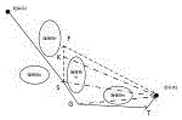
图2为状态节点选择图。Figure 2 is a state node selection diagram.
具体实施方式Detailed ways
对于本领域技术人员来说,附图说明中某些公知结构及其说明可能省略是可以理解的。下面结合附图和实现步骤对本发明作进一步的描述。For those skilled in the art, it will be understood that certain well-known structures and their descriptions may be omitted in the accompanying drawings. The present invention will be further described below in conjunction with the accompanying drawings and implementation steps.
本发明提出基于改进蚁群算法的无人机航迹规划算法对运动轨迹进行优化,通过引入状态参数方程阈值,进行航迹点的选择,最后通过连接备选的航迹点确定航迹,从而进一步缩短实际运动轨迹长度的目的。The invention proposes a UAV track planning algorithm based on the improved ant colony algorithm to optimize the motion track, select the track point by introducing the threshold value of the state parameter equation, and finally determine the track by connecting the candidate track points, thereby The purpose of further shortening the actual motion trajectory length.
图1为本发明的方法流程图,首先是生成无人机要执行任务的环境模拟地图;然后是确定无人机执行任务的起始状态点与目标状态点,以及随机生成的障碍物区域;接下来在算法中加入状态参数方程以及阈值,进行相应的特征值比较,确定状态点与周围相邻两个状态点之间到目标状态点的轨迹长度值,得到规划的航迹状态点;最后通过连接已确定的航迹轨迹点,得到改进后的无人机航迹线路图。Fig. 1 is the method flow chart of the present invention, first is to generate the environment simulation map of the task to be performed by the UAV; then it is to determine the initial state point and the target state point of the UAV to perform the task, and the randomly generated obstacle area; Next, the state parameter equation and threshold are added to the algorithm, and the corresponding eigenvalues are compared to determine the trajectory length value between the state point and the two adjacent state points to the target state point, and obtain the planned track state point; By connecting the determined track points, the improved UAV track map is obtained.
具体的实现步骤为:The specific implementation steps are:
Step1 根据无人机的活动任务建立合适的位置参考系,将模拟的地图在二维平面上满足无人机可到达的最远航行位置,并且在二维平面内用有效的坐标组
Step2.1 确定无人机可执行任务的运动状态起点与状态终点:模拟地图环境中要尽可能的将无人机的轨迹布满整个环境地图,可将运动状态起始点(xstart,ystart)与运动状态目标点(xgoal,ygoal)选择在地图的上下对角线上;Step2.1 Determine the starting point and end point of the motion state of the UAV's executable task: In the simulated map environment, the trajectory of the UAV should be covered as much as possible in the entire environment map, and the starting point of the motion state (xstart , ystart ) and the motion state target point (xgoal , ygoal ) are selected on the upper and lower diagonals of the map;
Step2.2 在随机障碍生成的过程中,可设置生成random函数,使障碍物在模拟地图的环境中要保持相对独立且不相关,而且在环境地图上无规律的显示出来。Step2.2 In the process of random obstacle generation, the random function can be set to make the obstacles remain relatively independent and irrelevant in the environment of the simulated map, and display them irregularly on the environment map.
Step3.1 选择路径概率,每个蚂蚁都会随机的选择下一状态点,并且存储已经走过的路径状态点。蚂蚁在构建路径时的每一步中,都会按照一定的概率选择下一个到达的状态点,其中概率

其中表示节点i到节点j上信息素的积累量;是节点i,j之间的导数距离,也是蚁群算法中的启发因子ηij(t)为:where represents the accumulation of pheromone from node i to node j; is the derivative distance between nodes i and j, and is also the heuristic factor ηij (t) in the ant colony algorithm:
ηij(t)=1/dijηij (t)=1/dij
表示从节点


Step3.2 信息素更新函数。其中蚁群算法中的信息素更新函数为:Step3.2 Pheromone update function. The pheromone update function in the ant colony algorithm is:
τij(t+n)=(1-ρ)τij(t)+Δτij(t)τij (t+n)=(1-ρ)τij (t)+Δτij (t)


而

其中是
Step3.3 迭代与停止。算法中的每一次迭代表示的是每次迭代的只蚂蚁在完成自己的路径规程,回到原点后的整个过程。迭代停止的条件是选择合适的迭代次数停止,输出寻找的最佳路径,或者是满足算法要求的迭代次数。在迭代结束后找到规划的路径,看是否是最佳路径;Step3.3 Iterate and stop. Each iteration in the algorithm represents the entire process after the ants in each iteration complete their own path rules and return to the origin. The condition for iterative stop is to select an appropriate number of iterations to stop, and output the best path to find, or the number of iterations to meet the requirements of the algorithm. Find the planned path after the iteration to see if it is the best path;
Step3.4 改进算法局部最佳。针对蚁群算法易陷入局部最佳路径,借鉴象棋中“卒”的走法,设置状态参数方程进行阈值比较,假设蚂蚁的下一状态点可供选择的节点A(xa,ya),与B(xb,yb),设状态起始点为Q(xq,yq),当前状态点为S(xs,ys)与目标状态点为G(xg,yg),就可确定阈值的大小为:Step3.4 Improve the local optimum of the algorithm. Aiming at the ant colony algorithm is easy to fall into the local optimal path, learn from the "pawn" move in chess, set the state parameter equation for threshold comparison, assuming that the next state point of the ant can be selected node A (xa , ya ), With B(xb , yb ), set the state starting point as Q(xq , yq ), the current state point as S(xs , ys ) and the target state point as G(xg , yg ), The size of the threshold can be determined as:

可供选择的下一状态节点到目标节点的的距离为:The distance from the next state node that can be selected to the target node is:


只要通过比较参数方程得到的LAG、LBG特征值与阈值Lyu之间进行比较,就可得到航迹规划的选用节点。As long as the eigenvalues of LAG and LBG obtained by comparing the parametric equations are compared with the threshold value Lyu , the selected nodes for track planning can be obtained.
Step4.1 检查无人机可选择的航迹状态节点,首先确定起始状态点与目标状态点的合理性,然后依次顺着起始节点根据改进机制进行选择节点的连接,得到航迹线路图;Step4.1 Check the path status nodes that can be selected by the UAV, first determine the rationality of the starting status point and the target status point, and then follow the starting node to connect the selected nodes according to the improvement mechanism in turn, and obtain the track circuit diagram ;
Step4.2 将改进后的轨迹线路图进行满足实际运动规律的平滑处理,处理后得到新的轨迹LQG。Step 4.2 Perform smooth processing on the improved trajectory diagram to meet the actual motion law, and obtain a new trajectory LQG after processing.
图2为状态节点选择图。蚁群算法在进行航迹规划时是仿照蚂蚁进行觅食所释放的激素寻找路径的,会导致在某些节点出现激素积累高而失去选择最优路径的机会,通过引入状态参数方程与阈值,进行特征值比较,选择合理的状态节点,能够很好的克服局部最优解问题,从而得到实际运动距离更短的轨迹线路。Figure 2 is a state node selection diagram. The ant colony algorithm uses the hormones released by the ants for foraging to find the path when planning the trajectory, which will lead to high accumulation of hormones in some nodes and lose the opportunity to choose the optimal path. By introducing the state parameter equation and threshold, Comparing eigenvalues and selecting a reasonable state node can overcome the local optimal solution problem well, thereby obtaining a trajectory with a shorter actual moving distance.
Claims (5)


Priority Applications (1)
| Application Number | Priority Date | Filing Date | Title |
|---|---|---|---|
| CN202111031276.2ACN114578845B (en) | 2021-09-03 | 2021-09-03 | A UAV trajectory planning method based on improved ant colony algorithm |
Applications Claiming Priority (1)
| Application Number | Priority Date | Filing Date | Title |
|---|---|---|---|
| CN202111031276.2ACN114578845B (en) | 2021-09-03 | 2021-09-03 | A UAV trajectory planning method based on improved ant colony algorithm |
Publications (2)
| Publication Number | Publication Date |
|---|---|
| CN114578845Atrue CN114578845A (en) | 2022-06-03 |
| CN114578845B CN114578845B (en) | 2024-05-17 |
Family
ID=81768376
Family Applications (1)
| Application Number | Title | Priority Date | Filing Date |
|---|---|---|---|
| CN202111031276.2AActiveCN114578845B (en) | 2021-09-03 | 2021-09-03 | A UAV trajectory planning method based on improved ant colony algorithm |
Country Status (1)
| Country | Link |
|---|---|
| CN (1) | CN114578845B (en) |
Cited By (3)
| Publication number | Priority date | Publication date | Assignee | Title |
|---|---|---|---|---|
| CN115562308A (en)* | 2022-11-03 | 2023-01-03 | 浙江工业大学 | AGV cooperative scheduling path planning method based on ecosystem optimization algorithm |
| CN117452583A (en)* | 2023-12-25 | 2024-01-26 | 国网浙江省电力有限公司宁波供电公司 | Optical cable line planning method, system, storage medium and computing equipment |
| CN119273103A (en)* | 2024-12-09 | 2025-01-07 | 北京理工大学 | A method and device for allocating unmanned aerial vehicle tasks based on ant colony algorithm |
Citations (6)
| Publication number | Priority date | Publication date | Assignee | Title |
|---|---|---|---|---|
| CN106372766A (en)* | 2016-12-06 | 2017-02-01 | 国网四川省电力公司检修公司 | UAV (Unmanned Aerial Vehicle) path planning method for electromagnetic interference environment |
| CN108459503A (en)* | 2018-02-28 | 2018-08-28 | 哈尔滨工程大学 | A kind of unmanned water surface ship path planning method based on quantum ant colony algorithm |
| CN108563239A (en)* | 2018-06-29 | 2018-09-21 | 电子科技大学 | A kind of unmanned aerial vehicle flight path planing method based on potential field ant group algorithm |
| WO2018176595A1 (en)* | 2017-03-31 | 2018-10-04 | 深圳市靖洲科技有限公司 | Unmanned bicycle path planning method based on ant colony algorithm and polar coordinate transformation |
| CN111998858A (en)* | 2020-09-15 | 2020-11-27 | 长春工业大学 | A UAV Route Planning Method Based on Improved A* Algorithm |
| CN112462805A (en)* | 2020-11-19 | 2021-03-09 | 西安理工大学 | 5G networked unmanned aerial vehicle flight path planning method based on improved ant colony algorithm |
- 2021
- 2021-09-03CNCN202111031276.2Apatent/CN114578845B/enactiveActive
Patent Citations (6)
| Publication number | Priority date | Publication date | Assignee | Title |
|---|---|---|---|---|
| CN106372766A (en)* | 2016-12-06 | 2017-02-01 | 国网四川省电力公司检修公司 | UAV (Unmanned Aerial Vehicle) path planning method for electromagnetic interference environment |
| WO2018176595A1 (en)* | 2017-03-31 | 2018-10-04 | 深圳市靖洲科技有限公司 | Unmanned bicycle path planning method based on ant colony algorithm and polar coordinate transformation |
| CN108459503A (en)* | 2018-02-28 | 2018-08-28 | 哈尔滨工程大学 | A kind of unmanned water surface ship path planning method based on quantum ant colony algorithm |
| CN108563239A (en)* | 2018-06-29 | 2018-09-21 | 电子科技大学 | A kind of unmanned aerial vehicle flight path planing method based on potential field ant group algorithm |
| CN111998858A (en)* | 2020-09-15 | 2020-11-27 | 长春工业大学 | A UAV Route Planning Method Based on Improved A* Algorithm |
| CN112462805A (en)* | 2020-11-19 | 2021-03-09 | 西安理工大学 | 5G networked unmanned aerial vehicle flight path planning method based on improved ant colony algorithm |
Non-Patent Citations (2)
| Title |
|---|
| 宋宇;顾海蛟: "基于改进A*算法的无人机航路规划", 长春工业大学学报, vol. 41, no. 006, 31 December 2020 (2020-12-31)* |
| 张浩森;高东阳;白羽;王恒友;: "基于蚁群算法的多无人机协同任务规划研究", 北京建筑大学学报, no. 02, 30 June 2017 (2017-06-30)* |
Cited By (6)
| Publication number | Priority date | Publication date | Assignee | Title |
|---|---|---|---|---|
| CN115562308A (en)* | 2022-11-03 | 2023-01-03 | 浙江工业大学 | AGV cooperative scheduling path planning method based on ecosystem optimization algorithm |
| CN115562308B (en)* | 2022-11-03 | 2024-10-15 | 浙江工业大学 | AGV cooperative scheduling path planning method based on ecosystem optimization algorithm |
| CN117452583A (en)* | 2023-12-25 | 2024-01-26 | 国网浙江省电力有限公司宁波供电公司 | Optical cable line planning method, system, storage medium and computing equipment |
| CN117452583B (en)* | 2023-12-25 | 2024-04-16 | 国网浙江省电力有限公司宁波供电公司 | Optical cable line planning method, system, storage medium and computing device |
| CN119273103A (en)* | 2024-12-09 | 2025-01-07 | 北京理工大学 | A method and device for allocating unmanned aerial vehicle tasks based on ant colony algorithm |
| CN119273103B (en)* | 2024-12-09 | 2025-03-21 | 北京理工大学 | A method and device for allocating unmanned aerial vehicle tasks based on ant colony algorithm |
Also Published As
| Publication number | Publication date |
|---|---|
| CN114578845B (en) | 2024-05-17 |
Similar Documents
| Publication | Publication Date | Title |
|---|---|---|
| Wu et al. | An adaptive conversion speed Q-learning algorithm for search and rescue UAV path planning in unknown environments | |
| CN110703766B (en) | Unmanned aerial vehicle path planning method based on transfer learning strategy deep Q network | |
| Xia et al. | Cooperative task assignment and track planning for multi-UAV attack mobile targets | |
| CN114578845A (en) | Unmanned aerial vehicle flight path planning method based on improved ant colony algorithm | |
| WO2023197092A1 (en) | Unmanned aerial vehicle path planning method based on improved rrt algorithm | |
| CN110244733A (en) | A Path Planning Method for Mobile Robots Based on Improved Ant Colony Algorithm | |
| CN114089776B (en) | Unmanned aerial vehicle obstacle avoidance method based on deep reinforcement learning | |
| CN110375761A (en) | Automatic driving vehicle paths planning method based on enhancing ant colony optimization algorithm | |
| CN114020045A (en) | A UAV track planning method based on improved ant colony algorithm | |
| CN110377055A (en) | No-manned plane three-dimensional formation method based on modified Artificial Potential Field Method | |
| CN114967680B (en) | Mobile robot path planning method based on ant colony algorithm and convolutional neural network | |
| CN115657721A (en) | A UAV Trajectory Planning Method Based on Improved Ant Colony Algorithm in Space Environment | |
| CN117387635B (en) | A UAV navigation method based on deep reinforcement learning and PID controller | |
| CN116578116A (en) | Unmanned aerial vehicle three-dimensional path planning method based on improved ant colony algorithm | |
| CN116449846A (en) | An Optimization Method of Ant Colony Algorithm | |
| CN113848911A (en) | Mobile robot global path planning method based on Q-learning and RRT | |
| CN116360437A (en) | Intelligent robot path planning method, device, equipment and storage medium | |
| CN114637331A (en) | A method and system for multi-task path planning of UAV based on ant colony algorithm | |
| CN117848370A (en) | A robot path planning method based on knowledge learning artificial bee colony algorithm | |
| CN115268500B (en) | Aircraft low altitude outburst prevention route planning method based on improved ant colony algorithm | |
| CN113687657A (en) | Method and storage medium for dynamic path planning of multi-agent formations | |
| CN120371013A (en) | Autonomous obstacle avoidance and path optimization control method under complex environment of unmanned aerial vehicle | |
| CN110849385A (en) | Trajectory planning method and system for searching conjugate gradient descent based on double-layer heuristic search | |
| CN113219991B (en) | Mobile robot path planning method based on improved ACS algorithm | |
| CN118051063B (en) | Training method for obstacle avoidance flight of low-altitude unmanned aerial vehicle |
Legal Events
| Date | Code | Title | Description |
|---|---|---|---|
| PB01 | Publication | ||
| PB01 | Publication | ||
| SE01 | Entry into force of request for substantive examination | ||
| SE01 | Entry into force of request for substantive examination | ||
| GR01 | Patent grant | ||
| GR01 | Patent grant |