CN114556139A - System and method for sensor calibration - Google Patents
System and method for sensor calibrationDownload PDFInfo
- Publication number
- CN114556139A CN114556139ACN201980091614.6ACN201980091614ACN114556139ACN 114556139 ACN114556139 ACN 114556139ACN 201980091614 ACN201980091614 ACN 201980091614ACN 114556139 ACN114556139 ACN 114556139A
- Authority
- CN
- China
- Prior art keywords
- sensor
- sensors
- calibration
- data
- location
- Prior art date
- Legal status (The legal status is an assumption and is not a legal conclusion. Google has not performed a legal analysis and makes no representation as to the accuracy of the status listed.)
- Granted
Links
Images


Classifications
- G—PHYSICS
- G01—MEASURING; TESTING
- G01S—RADIO DIRECTION-FINDING; RADIO NAVIGATION; DETERMINING DISTANCE OR VELOCITY BY USE OF RADIO WAVES; LOCATING OR PRESENCE-DETECTING BY USE OF THE REFLECTION OR RERADIATION OF RADIO WAVES; ANALOGOUS ARRANGEMENTS USING OTHER WAVES
- G01S7/00—Details of systems according to groups G01S13/00, G01S15/00, G01S17/00
- G01S7/48—Details of systems according to groups G01S13/00, G01S15/00, G01S17/00 of systems according to group G01S17/00
- G01S7/497—Means for monitoring or calibrating
- G01S7/4972—Alignment of sensor
- G—PHYSICS
- G06—COMPUTING OR CALCULATING; COUNTING
- G06V—IMAGE OR VIDEO RECOGNITION OR UNDERSTANDING
- G06V20/00—Scenes; Scene-specific elements
- G06V20/50—Context or environment of the image
- G06V20/56—Context or environment of the image exterior to a vehicle by using sensors mounted on the vehicle
- G06V20/58—Recognition of moving objects or obstacles, e.g. vehicles or pedestrians; Recognition of traffic objects, e.g. traffic signs, traffic lights or roads
- G—PHYSICS
- G01—MEASURING; TESTING
- G01S—RADIO DIRECTION-FINDING; RADIO NAVIGATION; DETERMINING DISTANCE OR VELOCITY BY USE OF RADIO WAVES; LOCATING OR PRESENCE-DETECTING BY USE OF THE REFLECTION OR RERADIATION OF RADIO WAVES; ANALOGOUS ARRANGEMENTS USING OTHER WAVES
- G01S17/00—Systems using the reflection or reradiation of electromagnetic waves other than radio waves, e.g. lidar systems
- G01S17/86—Combinations of lidar systems with systems other than lidar, radar or sonar, e.g. with direction finders
- G—PHYSICS
- G01—MEASURING; TESTING
- G01S—RADIO DIRECTION-FINDING; RADIO NAVIGATION; DETERMINING DISTANCE OR VELOCITY BY USE OF RADIO WAVES; LOCATING OR PRESENCE-DETECTING BY USE OF THE REFLECTION OR RERADIATION OF RADIO WAVES; ANALOGOUS ARRANGEMENTS USING OTHER WAVES
- G01S17/00—Systems using the reflection or reradiation of electromagnetic waves other than radio waves, e.g. lidar systems
- G01S17/88—Lidar systems specially adapted for specific applications
- G01S17/89—Lidar systems specially adapted for specific applications for mapping or imaging
- G—PHYSICS
- G01—MEASURING; TESTING
- G01S—RADIO DIRECTION-FINDING; RADIO NAVIGATION; DETERMINING DISTANCE OR VELOCITY BY USE OF RADIO WAVES; LOCATING OR PRESENCE-DETECTING BY USE OF THE REFLECTION OR RERADIATION OF RADIO WAVES; ANALOGOUS ARRANGEMENTS USING OTHER WAVES
- G01S7/00—Details of systems according to groups G01S13/00, G01S15/00, G01S17/00
- G01S7/48—Details of systems according to groups G01S13/00, G01S15/00, G01S17/00 of systems according to group G01S17/00
- G01S7/4802—Details of systems according to groups G01S13/00, G01S15/00, G01S17/00 of systems according to group G01S17/00 using analysis of echo signal for target characterisation; Target signature; Target cross-section
- G—PHYSICS
- G02—OPTICS
- G02B—OPTICAL ELEMENTS, SYSTEMS OR APPARATUS
- G02B6/00—Light guides; Structural details of arrangements comprising light guides and other optical elements, e.g. couplings
- G02B6/0001—Light guides; Structural details of arrangements comprising light guides and other optical elements, e.g. couplings specially adapted for lighting devices or systems
- G02B6/0011—Light guides; Structural details of arrangements comprising light guides and other optical elements, e.g. couplings specially adapted for lighting devices or systems the light guides being planar or of plate-like form
- G02B6/0033—Means for improving the coupling-out of light from the light guide
- G02B6/005—Means for improving the coupling-out of light from the light guide provided by one optical element, or plurality thereof, placed on the light output side of the light guide
- G02B6/0055—Reflecting element, sheet or layer
- G—PHYSICS
- G05—CONTROLLING; REGULATING
- G05D—SYSTEMS FOR CONTROLLING OR REGULATING NON-ELECTRIC VARIABLES
- G05D1/00—Control of position, course, altitude or attitude of land, water, air or space vehicles, e.g. using automatic pilots
- G05D1/0088—Control of position, course, altitude or attitude of land, water, air or space vehicles, e.g. using automatic pilots characterized by the autonomous decision making process, e.g. artificial intelligence, predefined behaviours
- G—PHYSICS
- G05—CONTROLLING; REGULATING
- G05D—SYSTEMS FOR CONTROLLING OR REGULATING NON-ELECTRIC VARIABLES
- G05D1/00—Control of position, course, altitude or attitude of land, water, air or space vehicles, e.g. using automatic pilots
- G05D1/80—Arrangements for reacting to or preventing system or operator failure
- G05D1/81—Handing over between on-board automatic and on-board manual control
- G—PHYSICS
- G06—COMPUTING OR CALCULATING; COUNTING
- G06T—IMAGE DATA PROCESSING OR GENERATION, IN GENERAL
- G06T7/00—Image analysis
- G06T7/80—Analysis of captured images to determine intrinsic or extrinsic camera parameters, i.e. camera calibration
Landscapes
- Engineering & Computer Science (AREA)
- Physics & Mathematics (AREA)
- General Physics & Mathematics (AREA)
- Radar, Positioning & Navigation (AREA)
- Remote Sensing (AREA)
- Computer Networks & Wireless Communication (AREA)
- Electromagnetism (AREA)
- Theoretical Computer Science (AREA)
- Computer Vision & Pattern Recognition (AREA)
- Automation & Control Theory (AREA)
- Aviation & Aerospace Engineering (AREA)
- Health & Medical Sciences (AREA)
- Optics & Photonics (AREA)
- Business, Economics & Management (AREA)
- Artificial Intelligence (AREA)
- Evolutionary Computation (AREA)
- Game Theory and Decision Science (AREA)
- Medical Informatics (AREA)
- Multimedia (AREA)
- Traffic Control Systems (AREA)
- Optical Radar Systems And Details Thereof (AREA)
- Measurement Of Optical Distance (AREA)
- Radar Systems Or Details Thereof (AREA)
Abstract
Translated fromChinese
Description
Translated fromChinese相关申请的交叉引用CROSS-REFERENCE TO RELATED APPLICATIONS
本申请要求于2018年10月10日提交的美国临时申请62/777,637的权益。This application claims the benefit of US Provisional Application 62/777,637, filed October 10, 2018.
技术领域technical field
本发明通常涉及验证传感器校准。特别地,本说明书涉及用于提供传感器校准的自动验证的系统和方法。The present invention generally relates to verifying sensor calibration. In particular, the present specification relates to systems and methods for providing automatic verification of sensor calibration.
背景技术Background technique
对运载工具进行配置使得该运载工具具有自主导航能力正变得越来越流行。例如,无人机和自动驾驶小汽车可被配置为在整个环境中自主地导航。这些运载工具可以依赖于诸如光检测和测距传感器、RADAR(雷达)和基于视觉的传感器等的传感器来辅助这些运载工具在环境内导航。这些自主运载工具中的许多自主运载工具同时使用多个传感器类型。此外,这些传感器在它们安装在自主运载工具上时的位置可能由于例如在运载工具正穿过道路时的运载工具的振动而略微改变。这可能对传感器的校准产生负面影响。It is becoming increasingly popular to configure a vehicle so that the vehicle has autonomous navigation capabilities. For example, drones and self-driving cars can be configured to navigate autonomously throughout an environment. These vehicles may rely on sensors such as light detection and ranging sensors, RADAR (radar) and vision-based sensors to assist these vehicles in navigating the environment. Many of these autonomous vehicles use multiple sensor types simultaneously. Furthermore, the positions of these sensors when they are mounted on the autonomous vehicle may change slightly due to vibration of the vehicle, eg as the vehicle is crossing the road. This can negatively affect the calibration of the sensor.
发明内容SUMMARY OF THE INVENTION
在本发明的至少一方面,提供用于验证传感器校准的系统。所述系统包括至少一个对象,其被配置为具有基本反射部分。所述系统包括至少一个光检测和测距传感器,其被配置为检测到与所述至少一个对象的所述基本反射部分相关联的至少一个位置的距离。所述系统包括至少一个摄像传感器,其被配置为检测与所述至少一个对象的所述基本反射部分的所述至少一个位置相关联的光强度值。所述系统包括计算机可读介质,其存储计算机可执行指令;以及至少一个处理器,其通信地耦接至所述至少一个光检测和测距传感器和所述至少一个摄像传感器,并且被配置为执行所述计算机可读介质上所存储的计算机可执行指令。当所述至少一个处理器执行所述计算机可读介质上所存储的所述计算机可执行指令时,所述至少一个处理器执行操作以:接收与所检测到的到所述至少一个位置的距离相关联的传感器数据;基于与所检测到的到所述至少一个位置的距离相关联的传感器数据来生成与所述基本反射部分相关联的第一预测聚合位置;接收与所检测到的所述至少一个位置的强度值相关联的传感器数据;基于与所检测到的所述至少一个位置的强度值相关联的传感器数据来生成与所述基本反射部分相关联的第二预测聚合位置;以及基于所述第一预测聚合位置和所述第二预测聚合位置来确定对齐误差值。In at least one aspect of the present invention, a system for verifying sensor calibration is provided. The system includes at least one object configured to have a substantially reflective portion. The system includes at least one light detection and ranging sensor configured to detect a distance to at least one location associated with the substantially reflective portion of the at least one object. The system includes at least one camera sensor configured to detect light intensity values associated with the at least one location of the substantially reflective portion of the at least one object. The system includes a computer-readable medium storing computer-executable instructions; and at least one processor communicatively coupled to the at least one light detection and ranging sensor and the at least one camera sensor and configured to The computer-executable instructions stored on the computer-readable medium are executed. When the at least one processor executes the computer-executable instructions stored on the computer-readable medium, the at least one processor performs operations to: receive and the detected distance to the at least one location associated sensor data; generating a first predicted aggregated location associated with the substantially reflective portion based on sensor data associated with the detected distance to the at least one location; receiving the detected sensor data associated with intensity values of at least one location; generating a second predicted aggregate location associated with the substantially reflective portion based on the sensor data associated with the detected intensity values of the at least one location; and based on The first predicted aggregation position and the second predicted aggregation position determine an alignment error value.
所述计算机可执行指令可以包括用于生成所述第一预测聚合位置的第一算法和用于生成所述第二预测聚合位置的第二算法。所述第二算法可以不同于所述第一算法。在所述对齐误差值大于第一对齐误差阈值的情况下,可以修改所述第一算法和所述第二算法其中至少之一。可以修改所述第一算法和所述第二算法其中至少之一,使得所生成的第一预测聚合位置和所生成的第二预测聚合位置基本上对齐。当所述至少一个处理器执行所述指令时,所述至少一个处理器可以执行操作,以在所述对齐误差值大于第二对齐误差阈值的情况下,启动所述至少一个摄像传感器或所述至少一个光检测和测距传感器的校准处理。The computer-executable instructions may include a first algorithm for generating the first predicted aggregation position and a second algorithm for generating the second predicted aggregation position. The second algorithm may be different from the first algorithm. In the case that the alignment error value is greater than a first alignment error threshold, at least one of the first algorithm and the second algorithm may be modified. At least one of the first algorithm and the second algorithm may be modified such that the generated first predicted aggregation position and the generated second predicted aggregation position are substantially aligned. When the at least one processor executes the instructions, the at least one processor may perform operations to activate the at least one camera sensor or the at least one camera sensor if the alignment error value is greater than a second alignment error threshold Calibration process of at least one light detection and ranging sensor.
所述基本非反射部分可以包括黑色面。所述基本反射部分可以包括基本白色面。The substantially non-reflective portion may comprise a black face. The substantially reflective portion may comprise a substantially white face.
在本发明的另一方面,提供用于验证传感器校准的方法。所述方法包括:将至少一个对象配置为具有基本反射部分。所述方法包括:利用第一传感器来检测到与所述至少一个对象的所述基本反射部分相关联的至少一个位置的距离。所述方法包括:利用第二传感器来检测与所述至少一个对象的所述基本反射部分相关联的一个或多个位置的光强度值。所述方法包括:接收与所检测到的到所述至少一个位置的距离相关联的传感器数据。所述方法包括:基于与所检测到的到所述至少一个位置的距离相关联的传感器数据来生成与所述基本反射部分相关联的第一预测聚合位置。所述方法包括:接收与所检测到的所述至少一个位置的强度值相关联的传感器数据。所述方法包括:基于与所检测到的所述至少一个位置的强度值相关联的传感器数据来生成与所述基本反射部分相关联的第二预测聚合位置;以及基于所述第一预测聚合位置和所述第二预测聚合位置来确定对齐误差值。In another aspect of the invention, a method for verifying sensor calibration is provided. The method includes configuring at least one object to have a substantially reflective portion. The method includes detecting, using a first sensor, a distance to at least one location associated with the substantially reflective portion of the at least one object. The method includes utilizing a second sensor to detect light intensity values at one or more locations associated with the substantially reflective portion of the at least one object. The method includes receiving sensor data associated with the detected distance to the at least one location. The method includes generating a first predicted aggregated location associated with the base reflective portion based on sensor data associated with the detected distance to the at least one location. The method includes receiving sensor data associated with the detected intensity value of the at least one location. The method includes generating a second predicted aggregated location associated with the substantially reflective portion based on sensor data associated with the detected intensity value of the at least one location; and based on the first predicted aggregated location and the second predicted aggregation position to determine an alignment error value.
所述第一预测聚合位置可以是使用第一算法生成的,并且所述第二预测聚合位置可以是使用第二算法生成的。所述方法还可以包括:在所述对齐误差值大于第一对齐误差阈值的情况下,修改所述第一算法和所述第二算法其中至少之一。所述方法还可以包括:修改所述第一算法和所述第二算法其中至少之一,使得所生成的第一预测聚合位置和所生成的第二预测聚合位置基本上对齐。所述方法还可以包括:在所述对齐误差值大于第二对齐阈值的情况下,校准至少一个摄像传感器和至少一个光检测和测距传感器其中至少之一。The first predicted aggregation position may be generated using a first algorithm, and the second predicted aggregation position may be generated using a second algorithm. The method may further include modifying at least one of the first algorithm and the second algorithm if the alignment error value is greater than a first alignment error threshold. The method may also include modifying at least one of the first algorithm and the second algorithm such that the generated first predicted aggregation position and the generated second predicted aggregation position are substantially aligned. The method may further include calibrating at least one of the at least one camera sensor and the at least one light detection and ranging sensor if the alignment error value is greater than a second alignment threshold.
在本发明的另一方面,提供用于验证传感器的系统。所述系统包括:至少一个对象,其包括至少一个校准特征;以及运载工具。所述运载工具包括多个传感器,其被配置为在所述至少一个对象和所述运载工具相对于彼此移动时,检测所述至少一个对象的所述至少一个校准特征。所述多个传感器中的各个传感器具有多个参数,其中所述多个参数包括多个内部参数和多个外部参数。所述运载工具包括:计算机可读介质,其存储计算机可执行指令;以及至少一个处理器,其被配置为通信地耦接至所述多个传感器,并且执行所述计算机可读介质上所存储的指令。当所述至少一个处理器执行所述指令时,所述至少一个处理器执行操作以:接收与所述至少一个校准特征相关联的已知校准特征数据;从所述多个传感器中的各个传感器接收与所述至少一个校准特征相关联的检测特征数据;将所接收到的已知特征数据与所接收到的检测特征数据进行比较;针对所述多个传感器中的各个传感器,基于所接收到的已知特征数据与所接收到的检测特征数据的比较来生成校准误差值;以及在与所述多个传感器中的至少一个传感器相对应的校准误差值大于第一校准误差阈值的情况下,确定为所述至少一个传感器被不正确地校准。In another aspect of the invention, a system for validating a sensor is provided. The system includes: at least one object including at least one calibration feature; and a vehicle. The vehicle includes a plurality of sensors configured to detect the at least one calibration feature of the at least one object as the at least one object and the vehicle move relative to each other. Each sensor of the plurality of sensors has a plurality of parameters, wherein the plurality of parameters includes a plurality of internal parameters and a plurality of external parameters. The vehicle includes: a computer-readable medium storing computer-executable instructions; and at least one processor configured to be communicatively coupled to the plurality of sensors and execute data stored on the computer-readable medium instruction. When the at least one processor executes the instructions, the at least one processor operates to: receive known calibration feature data associated with the at least one calibration feature; from each of the plurality of sensors receiving detected feature data associated with the at least one calibration feature; comparing the received known feature data with the received detected feature data; for each sensor of the plurality of sensors, based on the received a comparison of the known feature data of the plurality of sensors with the received detected feature data to generate a calibration error value; and in the case where the calibration error value corresponding to at least one of the plurality of sensors is greater than a first calibration error threshold, It is determined that the at least one sensor is incorrectly calibrated.
当所述至少一个处理器执行所述指令时,所述至少一个处理器可以进一步执行操作,以针对与确定为被不正确地校准的所述至少一个传感器相关联的至少一个内部参数来计算校正参数。计算所述校正参数可以至少部分地基于确定为所述至少一个传感器被不正确地校准。当所述至少一个处理器执行所述指令时,所述至少一个处理器可以进一步执行操作,以基于所述校正参数来修改所述至少一个内部参数。When the at least one processor executes the instructions, the at least one processor may further perform operations to calculate a correction for at least one internal parameter associated with the at least one sensor determined to be incorrectly calibrated parameter. Computing the correction parameter may be based, at least in part, on a determination that the at least one sensor is incorrectly calibrated. When the at least one processor executes the instructions, the at least one processor may further perform operations to modify the at least one internal parameter based on the correction parameter.
所述多个传感器中的各传感器可以具有至少一个内部参数。当所述至少一个处理器执行所述指令时,所述至少一个处理器可以进一步执行操作,以接收与所述至少一个内部参数相对应的内部数据,以及针对与确定为被不正确地校准的所述至少一个传感器相关联的所述至少一个内部参数来计算校正参数。针对所述至少一个内部参数对所述校正参数的计算至少部分地基于所接收到的内部数据。所述内部参数可以包括以下项其中至少之一:操作频率、视场、束宽度、束功率和信噪比。Each sensor of the plurality of sensors may have at least one internal parameter. When the at least one processor executes the instructions, the at least one processor may further perform operations to receive internal data corresponding to the at least one internal parameter, and to receive internal data corresponding to the at least one internal parameter Correction parameters are calculated from the at least one internal parameter associated with the at least one sensor. The calculation of the correction parameter for the at least one internal parameter is based at least in part on the received internal data. The internal parameters may include at least one of: operating frequency, field of view, beam width, beam power, and signal-to-noise ratio.
当所述至少一个处理器执行所述指令时,所述至少一个处理器可以进一步执行操作,以在与确定为被不正确地校准的所述至少一个传感器相对应的校准误差值大于第二校准误差阈值的情况下,确定为所述至少一个传感器处于故障状态。当所述至少一个处理器执行所述指令时,所述至少一个处理器可以执行操作,以针对与确定为处于故障状态的所述至少一个传感器相关联的至少一个外部参数来计算校正参数。针对所述至少一个外部参数对所述校正参数的计算可以至少部分地基于确定为所述至少一个传感器处于故障状态。所述至少一个外部参数可以包括以下项其中至少之一:在传感器安装在所述运载工具上时的传感器的位置、传感器相对于其它传感器的距离、传感器的角度、由环境引起的噪声级和所述环境的周围亮度。When the at least one processor executes the instructions, the at least one processor may further perform operations to provide a calibration error value corresponding to the at least one sensor determined to be incorrectly calibrated that is greater than a second calibration when the calibration error value is greater than the second calibration In the case of the error threshold, it is determined that the at least one sensor is in a fault state. When the at least one processor executes the instructions, the at least one processor may perform operations to calculate a correction parameter for at least one external parameter associated with the at least one sensor determined to be in a faulty state. The calculation of the correction parameter for the at least one external parameter may be based, at least in part, on a determination that the at least one sensor is in a faulty state. The at least one external parameter may include at least one of the following: the position of the sensor when the sensor is mounted on the vehicle, the distance of the sensor relative to other sensors, the angle of the sensor, the noise level caused by the environment, and the the ambient brightness of the environment.
所述至少一个对象可以包括限定了三个相互垂直的平面的三个面,所述三个面中的各面包括至少一个校准特征。所述至少一个对象可以包括固定的道路特征。The at least one object may include three faces defining three mutually perpendicular planes, each of the three faces including at least one calibration feature. The at least one object may comprise fixed road features.
所述多个传感器可以包括具有第一类型的第一传感器和具有第二类型的第二传感器。所述多个传感器可以包括至少一个RADAR传感器,并且所述至少一个对象可以包括可由所述至少一个RADAR传感器检测的内部金属芯。所述多个传感器可以包括至少一个光检测和测距传感器以及至少一个RADAR传感器,并且所述至少一个对象可以包括增强部分。所述增强部分基本上可由所述至少一个光检测和测距传感器检测,并且基本上不可由所述至少一个RADAR传感器检测。The plurality of sensors may include a first sensor of a first type and a second sensor of a second type. The plurality of sensors may include at least one RADAR sensor, and the at least one object may include an internal metal core detectable by the at least one RADAR sensor. The plurality of sensors may include at least one light detection and ranging sensor and at least one RADAR sensor, and the at least one object may include enhancements. The enhanced portion is substantially detectable by the at least one light detection and ranging sensor, and substantially undetectable by the at least one RADAR sensor.
所述已知特征数据可以包括以下项其中至少之一:从远程传感器接收到的信息、在先前时间从一个或多个传感器接收到的信息、以及由所述一个或多个传感器中的预校准传感器所确定的信息。所述已知特征数据可以包括从安装在第二运载工具上的远程传感器接收到的信息。所述已知特征数据可以包括从第一类型的传感器接收到的信息,并且所述多个传感器可以包括不同于所述第一类型的第二类型的至少一个传感器。The known characteristic data may include at least one of: information received from a remote sensor, information received from one or more sensors at a previous time, and pre-calibration by one of the one or more sensors Information determined by the sensor. The known characteristic data may include information received from remote sensors mounted on the second vehicle. The known characteristic data may include information received from sensors of a first type, and the plurality of sensors may include at least one sensor of a second type different from the first type.
当所述至少一个处理器执行所述指令时,所述至少一个处理器可以执行操作,以在与确定为被不正确地校准的所述至少一个传感器相对应的校准误差值大于校准误差阈值的情况下,使得所述运载工具停止操作。当所述至少一个处理器执行所述指令时,所述至少一个处理器可以执行操作,以在与确定为被不正确地校准的所述至少一个传感器相对应的校准误差值大于校准误差阈值的情况下,通知远程技术人员。当所述至少一个处理器执行所述指令时,所述至少一个处理器执行操作,以在与确定为被不正确地校准的所述至少一个传感器相对应的校准误差值大于校准误差阈值的情况下,将所述运载工具导航到服务地点。当所述至少一个处理器执行所述指令时,所述至少一个处理器可以执行操作,以在与被确定为被不正确地校准的所述至少一个传感器相对应的校准误差值大于校准误差阈值的情况下,禁用所述至少一个传感器。When the at least one processor executes the instructions, the at least one processor may perform operations to cause a calibration error value corresponding to the at least one sensor that is determined to be incorrectly calibrated to be greater than a calibration error threshold case, the vehicle is brought out of operation. When the at least one processor executes the instructions, the at least one processor may perform operations to cause a calibration error value corresponding to the at least one sensor that is determined to be incorrectly calibrated to be greater than a calibration error threshold case, notify the remote technician. When the at least one processor executes the instructions, the at least one processor performs operations to, if the calibration error value corresponding to the at least one sensor determined to be incorrectly calibrated, is greater than a calibration error threshold Next, navigate the vehicle to the service location. When the at least one processor executes the instructions, the at least one processor may perform operations to cause a calibration error value corresponding to the at least one sensor determined to be incorrectly calibrated to be greater than a calibration error threshold is disabled, the at least one sensor is disabled.
在本发明的另一方面,提供用于校准传感器的方法。所述方法包括:使运载工具和至少一个对象相对于彼此移动,所述运载工具包括多个传感器,并且所述至少一个对象包括至少一个校准特征。所述方法包括:利用所述多个传感器,在所述至少一个对象和所述运载工具正彼此相对移动时,检测所述至少一个对象的所述至少一个校准特征,所述多个传感器各自具有多个参数,所述多个参数包括多个内部参数和多个外部参数。所述方法包括:接收与所述至少一个校准特征相关联的已知校准特征数据。所述方法包括:从所述多个传感器中的各个传感器接收与所述至少一个校准特征相关联的检测特征数据。所述方法包括:将所接收到的已知特征数据与所接收到的检测特征数据进行比较。所述方法包括:针对所述多个传感器中的各个传感器,基于所接收到的已知特征数据与所接收到的检测特征数据的比较来生成校准误差值。所述方法包括:在与所述多个传感器中的至少一个传感器相对应的校准误差值大于第一校准误差阈值的情况下,确定为所述至少一个传感器被不正确地校准。In another aspect of the invention, a method for calibrating a sensor is provided. The method includes moving a vehicle and at least one object relative to each other, the vehicle including a plurality of sensors, and the at least one object including at least one calibration feature. The method includes detecting, using the plurality of sensors, the at least one calibration feature of the at least one object while the at least one object and the vehicle are moving relative to each other, the plurality of sensors each having A plurality of parameters, the plurality of parameters including a plurality of internal parameters and a plurality of external parameters. The method includes receiving known calibration feature data associated with the at least one calibration feature. The method includes receiving detected feature data associated with the at least one calibration feature from each of the plurality of sensors. The method includes comparing the received known characteristic data with the received detected characteristic data. The method includes generating, for each of the plurality of sensors, a calibration error value based on a comparison of the received known characteristic data with the received detected characteristic data. The method includes determining that the at least one sensor is incorrectly calibrated if the calibration error value corresponding to the at least one sensor of the plurality of sensors is greater than a first calibration error threshold.
所述方法还可以包括:针对与被确定为被不正确地校准的所述至少一个传感器相关联的至少一个内部参数来计算校正参数。计算所述校正参数可以至少部分地基于确定为所述至少一个传感器被不正确地校准。所述方法还可以包括:基于所述校正参数来修改所述至少一个内部参数。The method may also include calculating a correction parameter for at least one internal parameter associated with the at least one sensor determined to be incorrectly calibrated. Computing the correction parameter may be based, at least in part, on a determination that the at least one sensor is incorrectly calibrated. The method may further include modifying the at least one internal parameter based on the correction parameter.
所述多个传感器各自可以包括被配置为检测与至少一个内部参数相对应的内部数据的一个或多个监测装置。所述方法还可以包括:接收与所述至少一个内部参数相关联的内部数据;以及至少部分地基于所接收到的内部数据,针对被确定为被不正确地校准的所述至少一个传感器的所述至少一个内部参数来计算校正参数。所述方法还可以包括:在与确定为被不正确地校准的所述至少一个传感器相对应的校准误差值大于第二校准误差阈值的情况下,确定为所述至少一个传感器处于故障状态。所述方法还可以包括:针对与被确定为被不正确地校准的所述至少一个传感器相关联的至少一个外部参数来计算校正参数。针对所述至少一个外部参数对所述校正参数的计算可以至少部分地基于确定为所述至少一个传感器处于故障状态。Each of the plurality of sensors may include one or more monitoring devices configured to detect internal data corresponding to at least one internal parameter. The method may further include: receiving internal data associated with the at least one internal parameter; and based at least in part on the received internal data, all of the at least one sensor determined to be incorrectly calibrated. The at least one internal parameter is used to calculate the correction parameter. The method may further include determining that the at least one sensor is in a faulty state if the calibration error value corresponding to the at least one sensor determined to be incorrectly calibrated is greater than a second calibration error threshold. The method may also include calculating a correction parameter for at least one external parameter associated with the at least one sensor determined to be incorrectly calibrated. The calculation of the correction parameter for the at least one external parameter may be based, at least in part, on a determination that the at least one sensor is in a faulty state.
所述至少一个对象可以包括限定了三个相互垂直的平面的三个面,所述三个面的各面包括至少一个校准特征。所述至少一个对象可以包括固定的道路特征。The at least one object may include three faces defining three mutually perpendicular planes, each of the three faces including at least one calibration feature. The at least one object may comprise fixed road features.
所述多个传感器可以包括至少一个RADAR传感器,并且所述至少一个对象可以包括可由所述至少一个RADAR传感器检测的内部金属芯。所述多个传感器可以包括至少一个光检测和测距传感器以及至少一个RADAR传感器。所述至少一个对象可以包括增强部分,所述增强部分基本上可由所述至少一个光检测和测距传感器检测,并且基本上不可由所述至少一个RADAR传感器检测。所述已知特征数据可以包括从远程传感器接收到的信息、在先前时间从一个或多个传感器接收到的信息、由所述一个或多个传感器的预校准传感器所确定的信息。所述已知特征数据可以包括从安装在第二运载工具上的远程传感器接收到的信息。所述已知特征数据可以包括从第一类型的传感器接收到的信息,并且所述多个传感器可以包括不同于所述第一类型不同的第二类型的至少一个传感器。The plurality of sensors may include at least one RADAR sensor, and the at least one object may include an internal metal core detectable by the at least one RADAR sensor. The plurality of sensors may include at least one light detection and ranging sensor and at least one RADAR sensor. The at least one object may include enhancements that are substantially detectable by the at least one light detection and ranging sensor and substantially undetectable by the at least one RADAR sensor. The known characteristic data may include information received from remote sensors, information received from one or more sensors at previous times, and information determined by pre-calibrated sensors of the one or more sensors. The known characteristic data may include information received from remote sensors mounted on the second vehicle. The known characteristic data may include information received from sensors of a first type, and the plurality of sensors may include at least one sensor of a second type different from the first type.
所述方法可以包括:在与确定为被不正确地校准的所述至少一个传感器相对应的校准误差值大于校准误差阈值的情况下,使得所述运载工具停止操作。所述方法可以包括:在与确定为被不正确地校准的所述至少一个传感器相对应的校准误差值大于校准误差阈值的情况下,通知远程技术人员。所述方法可以包括:在与确定为被不正确地校准的所述至少一个传感器相对应的校准误差值大于校准误差阈值的情况下,将所述运载工具导航到服务地点。所述方法可以包括:在与确定为被不正确地校准的所述至少一个传感器相对应的校准误差值大于校准误差阈值的情况下,禁用所述至少一个传感器。The method may include causing the vehicle to cease operation if the calibration error value corresponding to the at least one sensor determined to be incorrectly calibrated is greater than a calibration error threshold. The method may include notifying a remote technician if the calibration error value corresponding to the at least one sensor determined to be incorrectly calibrated is greater than a calibration error threshold. The method may include navigating the vehicle to a service location if the calibration error value corresponding to the at least one sensor determined to be incorrectly calibrated is greater than a calibration error threshold. The method may include disabling the at least one sensor if the calibration error value corresponding to the at least one sensor determined to be incorrectly calibrated is greater than a calibration error threshold.
这些和其它方面、特征和实现可被表示为方法、设备、系统、组件、程序产品、用于进行功能的方法或步骤以及其它方式。These and other aspects, features, and implementations may be represented as methods, apparatus, systems, components, program products, methods or steps for performing functions, and other means.
从以下包括权利要求书的描述,这些和其它方面、特征和实现将变得清楚。These and other aspects, features and implementations will become apparent from the following description, including the claims.
附图说明Description of drawings
图1例示具有自主能力的自主运载工具的示例。Figure 1 illustrates an example of an autonomous vehicle with autonomous capabilities.
图2例示示例“云”计算环境。Figure 2 illustrates an example "cloud" computing environment.
图3例示计算机系统。Figure 3 illustrates a computer system.
图4例示自主运载工具的示例架构。4 illustrates an example architecture of an autonomous vehicle.
图5例示感知模块可以使用的输入和输出的示例。Figure 5 illustrates examples of inputs and outputs that the perception module may use.
图6例示LiDAR系统的示例。FIG. 6 illustrates an example of a LiDAR system.
图7例示操作中的LiDAR系统。Figure 7 illustrates the LiDAR system in operation.
图8例示LiDAR系统的操作的附加细节。Figure 8 illustrates additional details of the operation of the LiDAR system.
图9例示规划模块的输入和输出之间的关系的框图。Figure 9 illustrates a block diagram of the relationship between the inputs and outputs of the planning module.
图10例示路径规划中所使用的有向图。Figure 10 illustrates a directed graph used in path planning.
图11例示控制模块的输入和输出的框图。Figure 11 illustrates a block diagram of the inputs and outputs of the control module.
图12例示控制器的输入、输出和组件的框图。Figure 12 illustrates a block diagram of the inputs, outputs and components of the controller.
图13是示出根据本发明的一个或多个实施例的、用于验证传感器校准的系统的图示。13 is a diagram illustrating a system for verifying sensor calibration in accordance with one or more embodiments of the present invention.
图14是根据本发明的一个或多个实施例的、生成第一预测聚合位置和第二预测聚合位置的例示示例。14 is an illustrative example of generating a first predicted aggregation position and a second predicted aggregation position in accordance with one or more embodiments of the present invention.
图15是描述根据本发明的一个或多个实施例的、用于验证传感器校准的方法的流程图。15 is a flowchart describing a method for verifying sensor calibration in accordance with one or more embodiments of the present invention.
图16是示出根据本发明的一个或多个实施例的、用于校准传感器的系统的图示。16 is a diagram illustrating a system for calibrating a sensor in accordance with one or more embodiments of the present invention.
图17是描述根据本发明的一个或多个实施例的、用于校准传感器的方法的流程图。17 is a flowchart describing a method for calibrating a sensor in accordance with one or more embodiments of the present invention.
图18是描述根据本发明的一个或多个实施例的、用于基于校准误差来修改内部参数的方法的流程图。18 is a flowchart describing a method for modifying an internal parameter based on calibration error, in accordance with one or more embodiments of the present invention.
图19是描述根据本发明的一个或多个实施例的、用于基于校准误差来确定传感器故障的方法的流程图。19 is a flowchart describing a method for determining sensor failure based on calibration error, in accordance with one or more embodiments of the present invention.
具体实施方式Detailed ways
在以下描述中,为了解释的目的,阐述了许多具体细节,以便提供对本发明的透彻理解。然而,本发明可以在没有这些具体细节的情况下实施将是明显的。在其它实例中,众所周知的构造和装置是以框图形式示出的,以避免不必要地使本发明模糊。In the following description, for the purposes of explanation, numerous specific details are set forth in order to provide a thorough understanding of the present invention. It will be apparent, however, that the present invention may be practiced without these specific details. In other instances, well-known structures and devices are shown in block diagram form in order to avoid unnecessarily obscuring the present invention.
在附图中,为了便于描述,示出了示意要素(诸如表示装置、模块、指令块和数据要素的那些要素)的具体排列或次序。然而,本领域技术人员应当理解,附图中示意要素的具体次序或排列并不意在意味着要求特定的处理次序或序列、或处理过程的分离。此外,在附图中包含示意要素并不意在意味着在所有实施例中都需要这种要素,也不意在意味着由这种要素表示的特征不能包括在一些实施例中或不能在一些实施例中与其它要素结合。In the drawings, specific arrangements or orders of schematic elements, such as those representing devices, modules, instruction blocks, and data elements, are shown for ease of description. Those skilled in the art will understand, however, that the specific order or arrangement of elements illustrated in the figures is not intended to imply that a particular order or sequence of processing, or separation of processing, is required. Furthermore, the inclusion of schematic elements in the figures is not intended to imply that such elements are required in all embodiments, nor is it intended to imply that the features represented by such elements cannot be included or cannot be used in some embodiments in combination with other elements.
此外,在附图中,连接要素、诸如实线或虚线或箭头用于例示两个或更多个其它示意要素之间的连接、关系或关联,没有任何此类连接要素并不意在意味着不能存在连接、关系或关联。换句话说,一些要素之间的连接、关系或关联未在附图中示出,以便不使本发明内容模糊。此外,为了便于例示,使用单个连接要素来表示要素之间的多个连接、关系或关联。例如,如果连接要素表示信号、数据或指令的通信,本领域技术人员应理解,这种要素表示影响通信可能需要的一个或多个信号路径(例如,总线)。Furthermore, in the figures, connecting elements, such as solid or dashed lines or arrows, are used to illustrate connections, relationships or associations between two or more other schematic elements, the absence of any such connecting elements is not intended to imply that There is a connection, relationship or association. In other words, the connections, relationships or associations between some elements are not shown in the figures so as not to obscure the present invention. Furthermore, for ease of illustration, a single connection element is used to represent multiple connections, relationships, or associations between elements. For example, if a connection element represents the communication of signals, data, or instructions, those skilled in the art will understand that such element represents one or more signal paths (eg, buses) that may be required to effect the communication.
现在将详细参考实施例,其示例在附图中例示出。在以下的详细描述中,阐述了许多具体细节,以便提供对所描述的各种实施例的透彻理解。然而,对于本领域的普通技术人员来说将明显的是,可以在没有这些具体细节的情况下实施所描述的各种实施例。在其它情况下,没有详细描述众所周知的方法、程序、组件、电路和网络,以便不会不必要地使实施例的方面模糊。Reference will now be made in detail to the embodiments, examples of which are illustrated in the accompanying drawings. In the following detailed description, numerous specific details are set forth in order to provide a thorough understanding of the various embodiments described. However, it will be apparent to one of ordinary skill in the art that the various embodiments described may be practiced without these specific details. In other instances, well-known methods, procedures, components, circuits, and networks have not been described in detail so as not to unnecessarily obscure aspects of the embodiments.
下面描述的若干特征各自可以彼此独立地使用,也可以与其它特征的任何组合一起使用。然而,任何个别特征可能不能解决以上所讨论的任何问题,或者只能解决以上所讨论的问题之一。以上所讨论的一些问题可能不能通过本文所描述的任何一个特征得到充分解决。虽然提供了标题,但在本说明书的其它地方也可以找到与具体标题有关但在具有该标题的部分中未找到的信息。本文根据以下概要描述实施例:Several of the features described below can each be used independently of each other or with any combination of other features. However, any individual feature may not solve any of the problems discussed above, or only one of the problems discussed above. Some of the issues discussed above may not be adequately addressed by any of the features described herein. Although headings are provided, information related to a specific heading, but not found in the section with that heading, can also be found elsewhere in this specification. Embodiments are described herein in terms of the following summaries:
1.总体概述1. General overview
2.系统概述2. System overview
3.自主运载工具架构3. Autonomous Vehicle Architecture
4.自主运载工具输入4. Autonomous Vehicle Input
5.自主运载工具规划5. Autonomous Vehicle Planning
6.自主运载工具控制6. Autonomous Vehicle Control
7.用于验证传感器校准的系统和方法7. System and method for verifying sensor calibration
8.用于验证传感器校准的系统和方法8. System and method for verifying sensor calibration
总体概述General overview
本发明描述用于传感器校准的自动验证的技术等。传感器校准的自动验证可以减少确保自主运载工具的传感器准确以促进安全导航所需的时间。系统和方法利用各种传感器类型的固有性质,以提供各传感器校准自身所用的高效且准确的技术。This disclosure describes techniques and the like for automatic verification of sensor calibration. Automatic verification of sensor calibration can reduce the time required to ensure that an autonomous vehicle's sensors are accurate to facilitate safe navigation. The systems and methods exploit the inherent properties of various sensor types to provide efficient and accurate techniques by which each sensor calibrates itself.
运载工具(例如,无人机、自动驾驶小汽车等)可被配置为在整个环境中自主地导航。这些运载工具可以依赖于诸如光检测和测距传感器、RADAR和基于视觉的传感器等的传感器来辅助这些运载工具在环境内导航。这些自主运载工具中的许多自主运载工具同时使用多个传感器类型。此外,这些传感器在它们安装在自主运载工具上时的位置可能由于例如在运载工具正穿过道路时的运载工具的振动而略微改变。这可能对传感器的校准产生负面影响。Vehicles (eg, drones, self-driving cars, etc.) can be configured to navigate autonomously throughout the environment. These vehicles may rely on sensors such as light detection and ranging sensors, RADAR and vision-based sensors to assist these vehicles in navigating within the environment. Many of these autonomous vehicles use multiple sensor types simultaneously. Furthermore, the positions of these sensors when they are mounted on the autonomous vehicle may change slightly due to vibration of the vehicle, eg as the vehicle is crossing the road. This can negatively affect the calibration of the sensor.
由于这些运载工具同时使用多个传感器类型,因此可能需要进行校准过程以将来自不同传感器的数据组合在共同的参考系中。传统校准方法可能需要手动测量和输入。这些方法可能费力且耗时,并且要求运载工具在延长的时间段内停止操作。因此,可能期望提供用于使运载工具以及时且高效的方式自校准其传感器的技术。还可能期望提供用于使运载工具在环境中导航时校准其传感器的技术。Since these vehicles use multiple sensor types simultaneously, a calibration process may be required to combine data from different sensors in a common frame of reference. Traditional calibration methods may require manual measurement and input. These methods can be laborious and time-consuming, and require the vehicle to be out of operation for extended periods of time. Accordingly, it may be desirable to provide techniques for enabling vehicles to self-calibrate their sensors in a timely and efficient manner. It may also be desirable to provide techniques for calibrating a vehicle's sensors as it navigates the environment.
系统概述System Overview
图1例示具有自主能力的自主运载工具100的示例。FIG. 1 illustrates an example of an
如本文所使用的,术语“自主能力”是指一种功能、特征或设施,该功能、特征或设施使运载工具能够部分地或完全地操作,而无需实时的人类干预,包括但不限于完全自主运载工具、高度自主运载工具和有条件自主运载工具。As used herein, the term "autonomous capability" refers to a function, feature, or facility that enables a vehicle to operate partially or fully without real-time human intervention, including but not limited to complete Autonomous vehicles, highly autonomous vehicles and conditionally autonomous vehicles.
如本文所使用的,自主运载工具(AV)是一种具有自主能力的运载工具。As used herein, an autonomous vehicle (AV) is a vehicle with autonomous capabilities.
如本文所使用的,“运载工具”包括货物或人员的运输方式。例如,小汽车、公共汽车、火车、飞机、无人机、卡车、船只、舰艇、潜水器、飞船等。无人驾驶的小汽车是运载工具的示例。As used herein, "vehicle" includes the means of transport of goods or persons. For example, cars, buses, trains, airplanes, drones, trucks, boats, ships, submersibles, spaceships, etc. A driverless car is an example of a delivery vehicle.
如本文所使用的,“轨迹”是指将AV从第一时空地点导航到第二时空地点的路径或路线。在实施例中,第一时空地点被称为初始地点或起始地点,第二时空地点被称为目的地、最终地点、目标、目标位置或目标地点。在一些示例中,轨迹由一个或多个路段(例如,道路的数段)组成,并且各路段由一个或多个块(例如,车道或交叉口的一部分)组成。在实施例中,时空地点对应于真实世界地点。例如,时空地点是上车或下车地点,以使人员或货物上车或下车。As used herein, a "trajectory" refers to a path or route that navigates an AV from a first spatiotemporal location to a second spatiotemporal location. In an embodiment, the first spatiotemporal location is referred to as an initial location or a starting location, and the second spatiotemporal location is referred to as a destination, final location, target, target location or target location. In some examples, a trajectory consists of one or more segments (eg, segments of a road), and each segment consists of one or more blocks (eg, a portion of a lane or intersection). In an embodiment, the spatiotemporal locations correspond to real world locations. For example, a spatiotemporal location is a pick-up or drop-off location to get people or goods on or off.
如本文所使用的,“(一个或多个)传感器”包括一个或多个硬件组件,用于检测与传感器周围环境有关的信息。一些硬件组件可以包括感测组件(例如,图像传感器、生物特征传感器)、传输和/或接收组件(例如,激光或射频波发射器和接收器)、电子组件(诸如,模数转换器)、数据存储装置(诸如,RAM和/或非易失性存储器)、软件或固件组件和数据处理组件(诸如,专用集成电路)、微处理器和/或微控制器。As used herein, "sensor(s)" includes one or more hardware components for detecting information about the environment surrounding the sensor. Some hardware components may include sensing components (eg, image sensors, biometric sensors), transmitting and/or receiving components (eg, laser or radio frequency wave transmitters and receivers), electronic components (such as analog-to-digital converters), Data storage devices (such as RAM and/or non-volatile memory), software or firmware components and data processing components (such as application specific integrated circuits), microprocessors and/or microcontrollers.
如本文所使用的,“场景描述”是一种数据结构(例如,列表)或数据流,其包括由AV运载工具上的一个或多个传感器检测到的一个或多个分类或标记的对象,或由AV外部的源提供的一个或多个分类或标记的对象。As used herein, a "scene description" is a data structure (eg, a list) or data stream that includes one or more classified or tagged objects detected by one or more sensors on an AV vehicle, Or one or more classified or tagged objects provided by a source external to the AV.
如本文所使用的,“道路”是一个可以被运载工具穿过的物理区域,并且可以对应于已命名的通道(例如,城市街道、州际高速公路等)或可对应于未命名的通道(例如,房屋或办公楼内的行车道、停车场的一段、空置停车场的一段、乡村区域的污物通道等)。由于有些运载工具(例如,四轮驱动的小卡车、越野车(SUV)等)能够穿过各种不特别适合运载工具行驶的物理区域,因此“道路”可以是任何市政当局或其它政府或行政机构没有正式定义为一条通道的物理区域。As used herein, a "road" is a physical area that may be traversed by a vehicle, and may correspond to a named passageway (eg, city street, interstate highway, etc.) or may correspond to an unnamed passageway ( For example, a driveway in a house or office building, a section of a car park, a section of a vacant car park, a dirt path in a rural area, etc.). Since some vehicles (eg, four-wheel drive pickup trucks, off-road vehicles (SUVs), etc.) are capable of traversing various physical areas that are not particularly suitable for vehicles, a "road" can be any municipality or other governmental or administrative An institution is not formally defined as a physical area of a corridor.
如本文所使用的,“车道”是道路的可被运载工具穿越的部分,并且可对应于车道标记之间的大部分或全部空间,或仅对应于车道标记之间的部分空间(例如,小于50%)。例如,具有相距很远的车道标记的道路可能容纳两个或两个以上的运载工具,使得一个运载工具可以在不穿过车道标记的情况下超过另一个运载工具,因此可被解释为车道比车道标记之间的空间窄,或车道之间有两个车道。在没有车道标记的情况下,也可以对车道进行解释。例如,可以基于环境的物理特征(例如,农村地区的岩石和沿着大道的树木)来定义车道。As used herein, a "lane" is a portion of a road that can be traversed by a vehicle, and can correspond to most or all of the space between lane markings, or only a portion of the space between lane markings (eg, less than 50%). For example, a road with lane markings that are far apart may accommodate two or more vehicles, such that one vehicle can pass the other without crossing the lane marking, and thus can be interpreted as a lane ratio Narrow spaces between lane markings, or two lanes between lanes. Lanes can also be interpreted in the absence of lane markings. For example, lanes may be defined based on physical features of the environment (eg, rocks in rural areas and trees along avenues).
“一个或多个”包括由一个要素执行的功能、由多个要素例如以分布式的方式执行的功能、由一个要素执行的若干功能、由若干要素执行的若干功能、或上述的任何组合。"One or more" includes a function performed by one element, a function performed by multiple elements, eg, in a distributed fashion, several functions performed by one element, several functions performed by several elements, or any combination of the foregoing.
还将理解的是,尽管在一些情况下,术语“第一”、“第二”等在本文中是用来描述各种要素的,但这些要素不应受到这些术语的限制。这些术语仅用于区分一个要素与另一个要素。例如,在未背离各种所描述的实施例的范围的情况下,第一触点可被称为第二触点,并且类似地,第二触点可被称为第一触点。第一触点和第二触点两者都是触点,但它们不是相同触点。It will also be understood that, although in some instances the terms "first," "second," etc. are used herein to describe various elements, these elements should not be limited by these terms. These terms are only used to distinguish one element from another. For example, a first contact could be termed a second contact, and, similarly, a second contact could be termed a first contact, without departing from the scope of the various described embodiments. Both the first contact and the second contact are contacts, but they are not the same contact.
在本文所描述的各种实施例的说明书中使用的术语仅用于描述特定实施例的目的,而不是意在限制。如在所描述的各种实施例的说明书和所附权利要求书中所使用的,单数形式“a”、“an”和“the”也意在包括复数形式,除非上下文另有明确说明。还将理解的是,如本文所使用的“和/或”是指并且包括一个或多个相关清单项目的任何和所有可能的组合。还将理解的是,当在本说明书中使用术语“包括”、“包含”、“具备”和/或“具有”时,具体说明存在所陈述的特征、整数、步骤、操作、要素和/或组件,但并不排除存在或添加一个或多个其它特征、整数、步骤、操作、要素、组件、和/或其群组。The terminology used in the specification of the various embodiments described herein is for the purpose of describing particular embodiments only and is not intended to be limiting. As used in the description of the various embodiments and the appended claims, the singular forms "a," "an," and "the" are intended to include the plural forms as well, unless the context clearly dictates otherwise. It will also be understood that "and/or" as used herein refers to and includes any and all possible combinations of one or more of the associated list items. It will also be understood that when the terms "comprising", "comprising", "having" and/or "having" are used in this specification, it is specified that the stated features, integers, steps, operations, elements and/or components, but does not preclude the presence or addition of one or more other features, integers, steps, operations, elements, components, and/or groups thereof.
如本文所使用的,取决于上下文,术语“如果”可选地被理解为意指“当”或“在当时”或“响应于确定为”或“响应于检测到”。类似地,取决于上下文,短语“如果已确定”或“如果[所陈述的条件或事件]已被检测到”可选地被理解为意指“在确定时”或“响应于确定为“或”在检测到[所陈述的条件或事件]时”或“响应于检测到[所陈述的条件或事件]”。As used herein, the term "if" is alternatively understood to mean "when" or "at the time" or "in response to determining as" or "in response to detecting," depending on the context. Similarly, depending on the context, the phrases "if it has been determined" or "if [the stated condition or event] has been detected" are alternatively understood to mean "when determined" or "in response to determining as" or "in the detection of [the stated condition or event]" or "in response to the detection of [the stated condition or event]".
如本文所使用的,AV系统是指AV以及支持AV操作的硬件、软件、存储的数据和实时生成的数据的阵列。在实施例中,AV系统并入在AV内。在实施例中,AV系统跨若干地点分布。例如,AV系统的一些软件是在类似于下面关于图2描述的云计算环境200的云计算环境上实现的。As used herein, an AV system refers to an AV and an array of hardware, software, stored data, and real-time generated data that supports AV operation. In an embodiment, the AV system is incorporated within the AV. In an embodiment, the AV system is distributed across several locations. For example, some software of the AV system is implemented on a cloud computing environment similar to
一般而言,本文件描述了适用于任何具有一种或多种自主能力的运载工具的技术,包括完全自主运载工具、高度自主运载工具和有条件自主运载工具,诸如分别为所谓的第5级、第4级和第3级运载工具(见SAE国际标准J3016:道路上机动车自动驾驶系统相关术语的分类和定义,通过引用将其全部内容并入本文件,用于了解运载工具自主权等级的更多详细信息)。本文件所描述的技术也适用于部分自主运载工具和驾驶员辅助运载工具,诸如所谓的第2级和第1级运载工具(见SAE国际标准J3016:道路上机动车自动驾驶系统相关术语的分类和定义)。在实施例中,一个或多个第1级、第2级、第3级、第4级和第5级运载工具系统可基于对传感器输入的处理,在某些操作条件下自动执行某些运载工具操作(例如,转向、制动和使用地图)。本文件中所描述的技术可以使从完全自主运载工具到人类操作的运载工具范围内的任何级别的运载工具受益。In general, this document describes technologies applicable to any vehicle with one or more autonomous capabilities, including fully autonomous vehicles, highly autonomous vehicles, and conditionally autonomous vehicles, such as so-called Level 5, respectively , Tier 4 and Tier 3 vehicles (see SAE International Standard J3016: Classification and Definitions of Terms Related to Automated Driving Systems for Motor Vehicles on the Road, which is incorporated by reference in its entirety into this document for the purpose of understanding vehicle autonomy levels for more details). The techniques described in this document are also applicable to partially autonomous and driver-assisted vehicles, such as the so-called Level 2 and Level 1 vehicles (see SAE International Standard J3016: Classification of Terms Related to Automated Driving Systems for Motor Vehicles on Roads) and definitions). In an embodiment, one or more of the Tier 1, Tier 2, Tier 3, Tier 4, and Tier 5 vehicle systems may automatically perform certain deliveries under certain operating conditions based on processing sensor inputs Tool operations (eg, steering, braking, and using maps). The technology described in this document can benefit vehicles of any class ranging from fully autonomous vehicles to human-operated vehicles.
参考图1,AV系统120使AV 100沿着轨迹198操作,穿过环境190至目的地199(有时称为最终地点),同时避开对象(例如,自然障碍物191、运载工具193、行人192、骑车者和其它障碍物)和遵守道路规则(例如,操作规则或驾驶偏好)。Referring to FIG. 1 ,
在实施例中,AV系统120包括用于从计算机处理器146接收操作命令并对其进行操作的装置101。在实施例中,计算机处理器146与下面参考图3描述的处理器304相似。装置101的示例包括转向控制器102、制动器103、挡位、加速踏板或其它加速控制机构、挡风玻璃雨刮器、侧门锁、窗控器和转向指示器。In an embodiment,
在实施例中,AV系统120包括用于测量或推断AV 100的状态或条件的属性的传感器121,这些属性诸如是AV的位置、线速度和角速度及线加速度和角加速度、以及航向(例如,AV 100的前端的方向)。传感器121的示例是GPS、测量运载工具线加速度和角速率两者的惯性测量单元(IMU)、用于测量或估计轮滑移率的轮速率传感器、轮制动压力或制动扭矩传感器、引擎扭矩或轮扭矩传感器以及转向角度和角速率传感器。In an embodiment, the
在实施例中,传感器121还包括用于感测或测量AV的环境的属性的传感器。例如,可见光、红外或热(或两者兼有)光谱的单目或立体摄像机122,LiDAR 123,RADAR,超声波传感器,飞行时间(TOF)深度传感器,速率传感器,温度传感器,湿度传感器和降水传感器。In an embodiment, the
在实施例中,AV系统120包括数据存储单元142和存储器144,用于存储与计算机处理器146相关联的机器指令或由传感器121收集的数据。在实施例中,数据存储单元142与以下关于图3描述的ROM 308或存储装置310类似。在实施例中,存储器144与下面描述的主存储器306类似。在实施例中,数据存储单元142和存储器144存储有关环境190的历史、实时和/或预测性信息。在实施例中,存储的信息包括地图、驾驶性能、交通拥堵更新或天气条件。在实施例中,与环境190有关的数据从远程数据库134通过通信信道传输到AV 100。In an embodiment, the
在实施例中,AV系统120包括通信装置140,用于将对其它运载工具的状态和条件(诸如位置、线速度和角速度、线加速度和角加速度、以及线航向和角航向)测量或推断的属性传送到AV 100。这些装置包括运载工具到运载工具(V2V)和运载工具到基础设施(V2I)通信装置以及用于通过点对点或自组织(ad hoc)网络或两者进行无线通信的装置。在实施例中,通信装置140跨电磁频谱(包括无线电和光通信)或其它介质(例如,空气和声介质)进行通信。运载工具对运载工具(V2V)、运载工具对基础设施(V2I)通信(以及在一些实施例中为一种或多种其它类型的通信)的组合有时被称为运载工具对所有事物(V2X)通信。V2X通信通常符合一个或多个通信标准,用于与自主运载工具进行的和在自主运载工具之间的通信。In an embodiment, the
在实施例中,通信装置140包括通信接口。例如,有线、无线、WiMAX、Wi-Fi、蓝牙、卫星、蜂窝、光、近场、红外或无线电接口。通信接口将数据从远程数据库134传输到AV系统120。在实施例中,远程数据库134嵌入在如图2中所描述的云计算环境200中。通信接口140将从传感器121收集的数据或与AV 100操作有关的其它数据传输到远程数据库134。在实施例中,通信接口140向AV 100传输与遥操作有关的信息。在一些实施例中,AV 100与其它远程(例如,“云”)服务器136通信。In an embodiment, the
在实施例中,远程数据库134还存储和传输数字数据(例如,存储诸如道路和街道地点的数据)。这些数据存储在AV 100上的存储器144中,或者通过通信信道从远程数据库134传输到AV 100。In an embodiment, the
在实施例中,远程数据库134存储和传输与以前在一天中类似时间沿着轨迹198行驶的运载工具的驾驶属性有关的历史信息(例如,速率和加速度分布)。在一个实现中,这种数据可以存储在AV 100上的存储器144中,或者通过通信信道从远程数据库134传输到AV100。In an embodiment, the
位于AV 100上的计算装置146基于实时传感器数据和先验信息两者以算法方式生成控制动作,允许AV系统120执行其自主驾驶能力。
在实施例中,AV系统120包括耦接至计算装置146的计算机外围设备132,用于向AV100的用户(例如,乘员或远程用户)提供信息和提醒并接收来自该用户的输入。在实施例中,外围设备132类似于下面参考图3讨论的显示器312、输入装置314和光标控制器316。耦接是无线的或有线的。任意两个或更多个的接口装置可以集成到单个装置中。In an embodiment,
图2例示示例“云”计算环境。云计算是一种服务交付模式,用于使得能够方便、按需地在网络上访问可配置计算资源(例如网络、网络带宽、服务器、处理、内存、存储、应用程序、虚拟机和服务)的共享池。在典型的云计算系统中,一个或多个大型云数据中心容纳用于交付云所提供的服务的机器。现在参考图2,云计算环境200包括通过云202互连的云数据中心204a、204b和204c。数据中心204a、204b和204c为连接到云202的计算机系统206a、206b、206c、206d、206e和206f提供云计算服务。Figure 2 illustrates an example "cloud" computing environment. Cloud computing is a service delivery model for enabling convenient, on-demand access to configurable computing resources (eg, network, network bandwidth, servers, processing, memory, storage, applications, virtual machines, and services) over a network Shared pool. In a typical cloud computing system, one or more large cloud data centers house the machines used to deliver the services provided by the cloud. Referring now to FIG. 2 , a
云计算环境200包括一个或多个云数据中心。一般而言,云数据中心(例如图2中所示的云数据中心204a)是指构成云(例如图2中所示的云202或云的特定部分)的服务器的物理排列。例如,服务器在云数据中心中物理排列成房间、组、行和机架。云数据中心有一个或多个区域,其中包括一个或多个服务器房间。每个房间有一行或多行服务器,并且每行包括一个或多个机架。每个机架包括一个或多个单独的服务器节点。在一些实现中,区域、房间、机架和/或行中的服务器基于数据中心设施的物理基础设施要求(包括电力、能源、热力、热源和/或其它要求)被排列成若干组。在实施例中,服务器节点类似于图3中描述的计算机系统。数据中心204a具有许多分布在多个机架上的计算系统。
云202包括云数据中心204a、204b和204c以及用于连接云数据中心204a、204b和204c并有助于促进计算系统206a-f对云计算服务的访问的网络和网络资源(例如,网络设备、节点、路由器、交换机和网络电缆)。在实施例中,该网络表示一个或多个本地网络、广域网或通过使用地面或卫星连接部署的有线或无线链路耦接的网际网络的任意组合。通过网络交换的数据使用多种网络层协议(诸如,因特网协议(IP)、多协议标签交换(MPLS)、异步传输模式(ATM)、帧中继(Frame Relay)等)进行传输。此外,在网络表示多个子网络的组合的实施例中,在每个底层子网络上使用不同的网络层协议。在一些实施例中,网络表示一个或多个互连网际网络(诸如公共因特网等)。
计算系统206a-f或云计算服务消费者通过网络链路和网络适配器连接到云202。在实施例中,计算系统206a-f被实现为各种计算装置,例如服务器、台式机、膝上型计算机、平板电脑、智能手机、物联网(IoT)装置、自主运载工具(包括小汽车、无人机、航天飞机、火车、公共汽车等)和消费电子产品。在实施例中,计算系统206a-f在其它系统中实现或作为其它系统的一部分实现。
图3例示计算机系统300。在实现中,计算机系统300是一种专用计算装置。专用计算装置被硬连线以执行这些技术,或包括诸如一个或多个专用集成电路(ASIC)或现场可编程门阵列(FPGA)的被持久编程为执行上述技术的数字电子装置,或可以包括一个或多个通用硬件处理器,这些硬件处理器经编程以根据固件、存储器、其它存储器、或者组合中的程序指令执行这些技术。这种专用的计算装置还可以将定制的硬线逻辑、ASIC或FPGA与定制的编程相结合来完成这些技术。在各种实施例中,专用计算装置是台式计算机系统、便携式计算机系统、手持装置、网络装置或包含硬线和/或程序逻辑以实现这些技术的任何其它装置。FIG. 3 illustrates
在实施例中,计算机系统300包括总线302或用于传达信息的其它通信机制、以及与总线302耦接以处理信息的硬件处理器304。硬件处理器304是例如通用微处理器。计算机系统300还包括主存储器306,诸如随机存取存储器(RAM)或其它动态存储装置,该主存储器306耦接至总线302以存储信息和指令,该信息和指令由处理器304执行。在一个实现中,主存储器306用于在执行要由处理器304执行的指令期间存储临时变量或其它中间信息。当这些指令存储在处理器304可访问的非暂时性存储介质中时,使计算机系统300变成一个专用机器,该机器被定制以执行指令中指定的操作。In an embodiment,
在实施例中,计算机系统300还包括只读存储器(ROM)308或耦接至总线302的其它静态存储装置,用于存储处理器304的静态信息和指令。提供诸如磁盘、光盘、固态驱动器或三维交叉点存储器的存储装置310,并且该存储装置310耦接至总线302以存储信息和指令。In an embodiment,
在实施例中,计算机系统300通过总线302耦接至诸如阴极射线管(CRT)、液晶显示器(LCD)、等离子体显示器、发光二极管(LED)显示器或用于向计算机用户显示信息的有机发光二极管(OLED)显示器的显示器312。包括字母数字键和其它键的输入装置314耦接至总线302,用于向处理器304传送信息和命令选择。另一种类型的用户输入装置是光标控制器316,诸如鼠标、轨迹球、触控显示器或光标方向键,用于将方向信息和命令选择传送到处理器304,并用于控制光标在显示器312上的移动。这种输入装置通常具有两个轴(第一轴(例如,x轴)和第二轴(例如,y轴))上的两个自由度,这两个轴允许装置指定平面上的位置。In an embodiment,
根据一个实施例,本文的技术由计算机系统300响应于处理器304执行主存储器306中包含的一个或多个指令的一个或多个序列而执行。这些指令从诸如存储装置310的另一存储介质读入主存储器306。执行主存储器306中包含的指令序列使处理器304执行本文所描述的过程步骤。在替代实施例中,使用硬连线电路代替或与软件指令结合使用。According to one embodiment, the techniques herein are performed by
如本文所使用的术语“存储介质”是指存储数据和/或指令的任何非暂时性介质,这些数据和/或指令使机器以特定方式操作。这种存储介质包括非易失性介质和/或易失性介质。非易失性介质例如包括诸如存储装置310的光盘、磁盘、固态驱动器或三维交叉点存储器。易失性介质包括动态存储器,诸如主存储器306。存储介质的常见形式包括例如软盘、软磁盘、硬盘、固态驱动器、磁带或任何其它磁数据存储介质、CD-ROM、任何其它光数据存储介质、任何具有孔型的物理介质、RAM、PROM、EPROM、FLASH-EPROM、NV-RAM、或任何其它存储芯片或存储盒。The term "storage medium" as used herein refers to any non-transitory medium that stores data and/or instructions that cause a machine to operate in a particular manner. Such storage media include non-volatile media and/or volatile media. Non-volatile media include, for example, optical disks such as
存储介质有别于传输介质,但可以与传输介质相结合使用。传输介质参与存储介质之间的信息传输。例如,传输介质包括同轴电缆、铜线和光纤,其包括具备总线302的电线。传输介质也可以采取声波或光波的形式,诸如在无线电波和红外数据通信过程中产生的声波或光波。Storage media are distinct from transmission media, but may be used in conjunction with transmission media. Transmission media participate in the transmission of information between storage media. For example, transmission media includes coaxial cables, copper wire, and fiber optics, including the wires that provide bus 302 . Transmission media can also take the form of acoustic or light waves, such as those generated during radio wave and infrared data communications.
在实施例中,各种形式的介质涉及将一个或多个指令的一个或多个序列承载到处理器304以供执行。例如,这些指令最初是在远程计算机的磁盘或固态驱动器上执行的。远程计算机将指令加载到其动态存储器中,并使用调制解调器通过电话线路发送指令。计算机系统300的本地调制解调器接收电话线路上的数据,并使用红外发射器将数据转换为红外信号。红外检测器接收红外信号中承载的数据,并且适当的电路将数据放置在总线302上。总线302将数据承载到主存储器306,处理器304从主存储器306检索并执行指令。主存储器306接收的指令可以可选地在处理器304执行之前或之后存储在存储装置310上。In embodiments, various forms of media are involved in carrying one or more sequences of one or more instructions to
计算机系统300还包括耦接至总线302的通信接口318。通信接口318提供耦接至连接至本地网络322的网络链路320的双向数据通信。例如,通信接口318是综合业务数字网(ISDN)卡、电缆调制解调器、卫星调制解调器或用以提供与相应类型电话线路的数据通信连接的调制解调器。作为另一示例,通信接口318是局域网(LAN)卡,用于提供与兼容LAN的数据通信连接。在一些实现中,无线链路也被实现。在任何这种实现中,通信接口318发送和接收承载表示各种类型的信息的数字数据流的电、电磁或光信号。
网络链路320通常通过一个或多个网络向其它数据装置提供数据通信。例如,网络链路320通过本地网络322提供与主计算机324或与由因特网服务提供商(ISP)326运营的云数据中心或设备的连接。ISP 326又通过现在通常称为“因特网”328的世界范围分组数据通信网络来提供数据通信服务。本地网络322和因特网328两者都使用承载数字数据流的电、电磁或光信号。通过各种网络的信号以及网络链路320上并通过通信接口318的信号是传输介质的示例形式,其中这些信号承载了进出计算机系统300的数字数据。在实施例中,网络320包含上述云202或云202的一部分。Network link 320 typically provides data communications to other data devices through one or more networks. For example, network link 320 provides a connection to
计算机系统300通过(一个或多个)网络、网络链路320和通信接口318发送消息和接收包括程序代码的数据。在实施例中,计算机系统300接收用于处理的代码。接收到的代码在接收到时由处理器304执行,和/或存储在存储装置310中,或存储在其它非易失性存储装置中以便以后执行。
自主运载工具架构Autonomous Vehicle Architecture
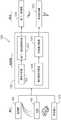
图4例示用于自主运载工具(例如,图1所示的AV 100)的示例架构400。架构400包括感知模块402(有时称为感知电路)、规划模块404(有时称为规划电路)、控制模块406(有时称为控制电路)、定位模块408(有时称为定位电路)和数据库模块410(有时称为数据库电路)。各模块在AV 100的操作中发挥作用。共同地,模块402、404、406、408和410可以是图1所示的AV系统120的一部分。在一些实施例中,模块402、404、406、408和410中的任何模块是计算机软件(例如,计算机可读介质上所存储的可执行代码)和计算机硬件(例如,一个或多个微处理器、微控制器、专用集成电路[ASIC]、硬件存储器装置、其它类型的集成电路、其它类型的计算机硬件、或者这些硬件中的任何或所有的组合)的组合。FIG. 4 illustrates an
在使用中,规划模块404接收表示目的地412的数据,并且确定表示AV 100为了到达(例如,抵达)目的地412而可以行驶的轨迹414(有时称为路线)的数据。为了使规划模块404确定表示轨迹414的数据,规划模块404从感知模块402、定位模块408和数据库模块410接收数据。In use,
感知模块402使用例如也如图1所示的一个或多个传感器121来识别附近的物理对象。将对象分类(例如,分组成诸如行人、自行车、汽车、交通标志等的类型),并且将包括经分类的对象416的场景描述提供至规划模块404。The
规划模块404还从定位模块408接收表示AV位置418的数据。定位模块408通过使用来自传感器121的数据和来自数据库模块410的数据(例如,地理数据)以计算位置来确定AV位置。例如,定位模块408使用来自GNSS(全球导航卫星系统)传感器的数据和地理数据来计算AV的经度和纬度。在实施例中,定位模块408所使用的数据包括具有行车道几何属性的高精度地图、描述道路网络连接属性的地图、描述行车道物理属性(诸如交通速率、交通量、运载工具和自行车车道的数量、车道宽度、车道交通方向、或车道标记类型和地点,或者它们的组合)的地图、以及描述道路特征(诸如十字路口、交通标志或各种类型的其它行驶信号等)的空间地点的地图。
控制模块406接收表示轨迹414的数据和表示AV位置418的数据,并且以将使得AV100行驶轨迹414到达目的地412的方式来操作AV的控制功能420a~420c(例如,转向、油门、制动、点火)。例如,如果轨迹414包括左转,则控制模块406将以如下方式操作控制功能420a~420c:转向功能的转向角度将使得AV 100左转,并且油门和制动将使得AV 100在进行转弯之前暂停并等待经过的行人或运载工具。The
自主运载工具输入Autonomous Vehicle Input
图5例示感知模块402(图4)所使用的输入502a-502d(例如,图1中所示的传感器121)和输出504a-504d(例如,传感器数据)的示例。一个输入502a是LiDAR(光检测和测距)系统(例如,图1所示的LiDAR 123)。LiDAR是使用光(例如,诸如红外光等的一道光)来获得与其视线中的物理对象有关的数据的技术。LiDAR系统产生LiDAR数据作为输出504a。例如,LiDAR数据是用于构造环境190的表示的3D或2D点(也称为点云)的集合。5 illustrates examples of
另一输入502b是RADAR(雷达)系统。RADAR是使用无线电波来获得与附近的物理对象有关的数据的技术。RADAR可以获得与不在LiDAR系统的视线内的对象有关的数据。RADAR系统502b产生RADAR数据作为输出504b。例如,RADAR数据是用于构造环境190的表示的一个或多个射频电磁信号。Another
另一输入502c是照相机系统。照相机系统使用一个或多个照相机(例如,使用诸如电荷耦接器件[CCD]等的光传感器的数字照相机)来获取与附近的物理对象有关的信息。照相机系统产生照相机数据作为输出504c。照相机数据通常采用图像数据(例如,诸如RAW、JPEG、PNG等的图像数据格式的数据)的形式。在一些示例中,照相机系统具有例如为了立体影像(立体视觉)的目的的多个独立照相机,这使得照相机系统能够感知深度。尽管照相机系统所感知的对象在这里被描述为“附近”,但这是相对于AV而言的。在使用中,照相机系统可被配置为“看见”远处的(例如,AV前方的远至1公里或更远的)对象。因此,照相机系统可以具有为了感知遥远的对象而优化的诸如传感器和镜头等的特征。Another
另一输入502d是交通灯检测(TLD)系统。TLD系统使用一个或多个照相机来获得与交通灯、街道标志和提供视觉导航信息的其它物理对象有关的信息。TLD系统产生TLD数据作为输出504d。TLD数据经常采用图像数据(例如,诸如RAW、JPEG、PNG等的图像数据格式的数据)的形式。TLD系统与包含照相机的系统的不同之处在于:TLD系统使用具有宽视场(例如,使用广角镜头或鱼眼镜头)的照相机,以获得与尽可能多的提供视觉导航信息的物理对象有关的信息,使得AV 100能够访问这些对象所提供的所有相关导航信息。例如,TLD系统的视角可以为约120度或更大。Another
在一些实施例中,使用传感器融合技术来组合输出504a-504d。因而,将个体输出504a-504d提供至AV 100的其它系统(例如,提供至如图4所示的规划模块404),或者可以采用相同类型的单个组合输出或多个组合输出(例如,使用相同组合技术或组合相同输出或者这两者)或不同类型的单个组合输出或多个组合输出(例如,使用不同的各个组合技术或组合不同的各个输出或者这两者)的形式,将组合输出提供至其它系统。在一些实施例中,使用早期融合技术。早期融合技术的特征在于:在将一个或多个数据处理步骤应用到组合输出之前,将输出组合。在一些实施例中,使用后期融合技术。后期融合技术的特征在于:在将一个或多个数据处理步骤应用到个体输出之后,将输出组合。In some embodiments, the
图6例示LiDAR系统602的示例(例如,图5所示的输入502a)。LiDAR系统602从发光器606(例如,激光发射器)发射光604a-604c。LiDAR系统所发射的光通常不在可见光谱中;例如,经常使用红外光。所发射的光604b中的一些光遇到物理对象608(例如,运载工具)并且反射回到LiDAR系统602。(从LiDAR系统发射的光通常不会穿透物理对象,例如,实心形式的物理对象。)LiDAR系统602还具有用于检测反射光的一个或多个光检测器610。在实施例中,与LiDAR系统相关联的一个或多个数据处理系统生成表示LiDAR系统的视场614的图像612。图像612包括表示物理对象608的边界616的信息。这样,图像612用于确定AV附近的一个或多个物理对象的边界616。Figure 6 illustrates an example of a LiDAR system 602 (eg,
图7例示操作中的LiDAR系统602。在该图所示的情境中,AV 100接收采用图像702的形式的照相机系统输出504c和采用LiDAR数据点704的形式的LiDAR系统输出504a两者。在使用中,AV 100的数据处理系统将图像702与数据点704进行比较。特别地,在数据点704中也识别在图像702中识别出的物理对象706。这样,AV 100基于数据点704的轮廓和密度来感知物理对象的边界。FIG. 7 illustrates the
图8例示LiDAR系统602的操作的附加细节。如上所述,AV 100基于LiDAR系统602所检测到的数据点的特性来检测物理对象的边界。如图8所示,诸如地面802等的平坦对象将以一致的方式反射从LiDAR系统602发射的光804a-804d。换句话说,由于LiDAR系统602使用一致的间隔发射光,因此地面802将以相同的一致间隔将光反射回到LiDAR系统602。在AV100在地面802上行驶时,在没有东西阻挡道路的情况下,LiDAR系统602将继续检测到由下一个有效地面点806反射的光。然而,如果对象808阻挡道路,则LiDAR系统602所发射的光804e-804f将以与预期一致方式不一致的方式从点810a-810b反射。根据该信息,AV 100可以确定存在对象808。FIG. 8 illustrates additional details of the operation of
路径规划route plan
图9例示(例如,如图4所示的)规划模块404的输入和输出之间的关系的框图900。一般而言,规划模块404的输出是从起点904(例如,源地点或初始地点)到终点906(例如,目的地或最终地点)的路线902。路线902通常由一个或多个路段定义。例如,路段是指要在街道、道路、公路、行车道或适合汽车行驶的其它物理区域的至少一部分上行驶的距离。在一些示例中,例如,如果AV 100是诸如四轮驱动(4WD)或全轮驱动(AWD)小汽车、SUV或小卡车等的能够越野的运载工具,则路线902包括诸如未铺面路径或开阔田野等的“越野”路段。FIG. 9 illustrates a block diagram 900 of the relationship between the inputs and outputs of the planning module 404 (eg, as shown in FIG. 4 ). Generally speaking, the output of the
除路线902之外,规划模块还输出车道级路线规划数据908。车道级路线规划数据908用于在特定时间基于路线902的路段的条件来驶过这些路段。例如,如果路线902包括多车道公路,则车道级路线规划数据908包括轨迹规划数据910,其中AV 100可以使用该轨迹规划数据910以例如基于出口是否临近、多个车道中的一个或多个车道是否存在其它运载工具、或者在几分钟或更少时间的过程中变化的其它因素来从这多个车道中选择某车道。类似地,在一些实现中,车道级路线规划数据908包括路线902的某路段特有的速率约束912。例如,如果该路段包括行人或非预期交通,则速率约束912可以将AV 100限制到比预期速率慢的行驶速率,例如基于该路段的限速数据的速率。In addition to
在实施例中,向规划模块404的输入包括(例如,来自图4所示的数据库模块410的)数据库数据914、当前地点数据916(例如,图4所示的AV位置418)、(例如,用于图4所示的目的地412的)目的地数据918和对象数据920(例如,如图4所示的感知模块402所感知的经分类的对象416)。在一些实施例中,数据库数据914包括规划时所使用的规则。规则是使用形式语言(例如,使用布尔逻辑)指定的。在AV 100所遇到的任何给定情形中,这些规则中的至少一些规则将适用于该情形。如果规则具有基于AV 100可用的信息(例如,与周围环境有关的信息)所满足的条件,则该规则适用于给定情形。规则可以具有优先级。例如,“如果公路是高速公路,则移动到最左侧车道”这一规则与“如果出口在一英里内临近,则移动到最右侧车道”相比可以具有更低的优先级。In an embodiment, inputs to
图10例示在路径规划中(例如,由规划模块404(图4))使用的有向图1000。一般而言,如图10所示的有向图那样的有向图1000用于确定任何起点1002和终点1004之间的路径。在现实世界中,分隔起点1002和终点1004的距离可能相对较大(例如,在两个不同的都市区域中),或者可能相对较小(例如,毗邻城市街区的两个十字路口或多车道道路的两条车道)。10 illustrates a directed
在实施例中,有向图1000具有表示起点1002和终点1004之间的AV 100可能占用的不同地点的节点1006a-1006d。在一些示例中,例如,在起点1002和终点1004表示不同的都市区域时,节点1006a-1006d表示道路的路段。在一些示例中,例如,在起点1002和终点1004表示相同道路上的不同地点时,节点1006a-1006d表示该道路上的不同位置。这样,有向图1000包括不同粒度级别的信息。在实施例中,具有高粒度的有向图也是具有更大规模的另一有向图的子图。例如,起点1002和终点1004相距远(例如,相距许多英里)的有向图的大部分信息处于低粒度,并且该有向图是基于所存储的数据,但该有向图还包括用于该有向图中的表示AV 100的视场中的物理地点的一部分的一些高粒度信息。In an embodiment, directed
节点1006a-1006d不同于无法与节点重叠的对象1008a-1008b。在实施例中,在粒度低时,对象1008a-1008b表示汽车不能穿过的地区,例如无街道或道路的区域。在粒度高时,对象1008a-1008b表示AV 100的视场中的物理对象,例如其它汽车、行人、或AV 100不能与之共用物理空间的其它实体。在实施例中,对象1008a-1008b的一部分或全部是静态对象(例如,不改变位置的对象,诸如街灯或电线杆等)或动态对象(例如,能够改变位置的对象,诸如行人或其它小汽车等)。
节点1006a-1006d通过边1010a-1010c连接。如果两个节点1006a-1006b通过边1010a连接,则AV 100可以在一个节点1006a和另一节点1006b之间行驶,例如,而不必在到达另一节点1006b之前行驶到中间节点。(当提到AV 100在节点之间行驶时,意味着AV 100在由相应节点表示的两个物理位置之间行驶。)边1010a-1010c通常是双向的,从某种意义上,AV 100从第一节点行驶到第二节点,或者从第二节点行驶到第一节点。在实施例中,边1010a-1010c是单向的,从某种意义上,AV 100可以从第一节点行驶到第二节点,然而AV100不能从第二节点行驶到第一节点。在边1010a-1010c表示例如单向街道,街道、道路或公路的单独车道,或者由于法律或物理约束因而仅能沿一个方向穿过的其它特征的情况下,边1010a-1010c是单向的。
在实施例中,规划模块404使用有向图1000来识别由起点1002和终点1004之间的节点和边组成的路径1012。In an embodiment, the
边1010a-1010c具有关联成本1014a-1014b。成本1014a-1014b是表示在AV 100选择该边的情况下将花费的资源的值。典型的资源是时间。例如,如果一个边1010a所表示的物理距离是另一边1010b所表示的物理距离的两倍,则第一边1010a的关联成本1014a可以是第二边1010b的关联成本1014b的两倍。影响时间的其它因素包括预期交通、十字路口的数量、限速等。另一典型的资源是燃料经济性。两个边1010a-1010b可以表示相同的物理距离,但例如由于道路条件、预期天气等,因此一个边1010a与另一边1010b相比需要更多的燃料。
在规划模块404识别起点1002和终点1004之间的路径1012时,规划模块404通常选择针对成本优化的路径,例如,在将边的个体成本相加到一起时具有最小总成本的路径。When the
用于验证传感器系统的校准的系统和方法System and method for verifying calibration of a sensor system
图13例示根据本发明的一个或多个实施例的用于验证传感器校准的系统。图13中的系统包括第一传感器1301、第二传感器1302、对象1303和计算机处理器1304。计算机处理器1304包括计算机可读介质1305。计算机可读介质1305包括存储在其上的计算机可执行指令1306。对象1303被配置为具有基本非反射部分1303a,并且在一些实施例中具有基本反射部分1303b。13 illustrates a system for verifying sensor calibration in accordance with one or more embodiments of the present invention. The system in FIG. 13 includes a
对象1303可被配置为具有数个类型的形状其中之一。例如,在例示的实施例中,对象1303具有球形形状。在实施例中,对象1303具有立方体形状。在实施例中,对象1303具有立方形形状。在实施例中,对象1303具有圆锥形状。对象1303还可以具有环形形状、三角形形状、圆柱形形状、金字塔形状或多个形状基元中的任一个。在实施例中,对象1303是球。在实施例中,对象1303是圆锥体。在实施例中,对象1303是立方体。在实施例中,对象1303位于建筑物中。在实施例中,对象1303是固定的路侧特征(例如,街道标志、电话杆、广告牌和桥梁支撑柱等)。例如,对象可以是结合了作为适合于校准的先验或后验的专用代码、文本、图像或图形的广告牌。
如前面所示,对象1303可被配置为具有基本非反射部分1303a和基本反射部分1303b。基本非反射部分1303a包括吸收不限于可见光谱的大部分或全部入射光(例如,给出小于5%的反射率)的诸如玻璃、涂料、织物、涂层等的材料。例如,在实施例中,基本非反射部分1303a包括黑涂料。在实施例中,基本非反射部分1303a包括黑织物。在实施例中,基本非反射部分1303a包括抗反射涂层,该抗反射涂层可以包括具有使折射率形成对比的交替层的透明薄膜结构。基本反射部分1303b包括反射大部分或全部入射光(例如,给出大于70%的反射率)的诸如涂料、镜、织物和金属等的材料。材料和对象不仅仅限于镜面或朗伯(或这两者的组成)。例如,在实施例中,基本反射部分1303b包括玻璃镜。在实施例中,基本反射部分1303b包括亚克力(acrylic)镜。在实施例中,基本反射部分1303b包括反射带。在实施例中,基本反射部分1303b包括双向拉伸聚对苯二甲酸乙二醇酯(“聚酯薄膜”(Mylar))。As previously indicated, the
传感器1301、1302各自可以是数个类型的感测装置其中之一。例如,在实施例中,各传感器1301、1302是先前参考图1所论述的传感器121其中之一。在实施例中,各传感器1301、1302是如先前参考图5所论述的输入502a-502c中的一个或多个。在所示实施例中,第一传感器1301是LiDAR并且第二传感器1302是照相机。照相机可以是被配置为捕获可见、红外、紫外和/或热光谱中的光的单目或立体摄像机。在实施例中,传感器1301、1302中的至少一个是超声波传感器。在实施例中,第一传感器1301是RADAR。传感器1301、1302中的至少一个还可以包括感测装置的组合。例如,在实施例中,传感器1301、1302中的至少一个包括照相机和RADAR。在实施例中,传感器1301、1302中的至少一个还包括用于感测或测量AV(例如,AV 100)的环境的性质的附加传感器。例如,能够感知可见光、红外和/或热光谱的单目或立体摄像机122、LiDAR 123、RADAR、超声波传感器、飞行时间(TOF)深度传感器、速率传感器、温度传感器、湿度传感器和降水传感器。尽管所例示的实施例包括第一传感器1301和第二传感器1302,但图13中的系统可以包括一个或多个附加传感器。例如,在实施例中,图13中的系统包括第三传感器。在实施例中,图13中的系统包括第三、第四和第五传感器。Each of the
在实施例中,第一传感器1301被配置为检测到与基本反射部分1303b相关联的(例如,一个或多个)位置的距离。例如,在实施例中,第一传感器1301在与基本反射部分1303b相关联的数个位置处发送激光(或无线电波、红外光等)的快速脉冲,并且针对与基本反射部分1303b相关联的数个位置中的各位置,第一传感器1301测量各脉冲从各位置反射所需的时间量。因此,第一传感器1301可以通过使用光的已知固有性质(例如,速率)来测量到与基本反射部分1303b相关联的各位置的距离。在实施例中,由于例如基本非反射部分1303a没有反射足以供第一传感器1301检测的光,因此第一传感器1301没有检测到与基本非反射部分1303a相关联的位置的距离。In an embodiment, the
在实施例中,第二传感器1302是摄像传感器(例如,照相机),其被配置为检测与对象1303的基本反射部分1303b相关联的(例如,一个或多个)位置的光强度值。例如,在实施例中,第二传感器1302包括具有像素的CCD和/或CMOS传感器,其中各像素可以检测来自与基本反射部分1303b相关联的位置的入射光子,并且生成具有与该入射光子的功率(并且由此与强度)相对应的能量的电子。由于像素的空间布置,第二传感器1302还可以检测强度值的空间位置。在实施例中,第二传感器1302被配置为还检测与对象1303的基本非反射部分1303a相关联的(例如,一个或多个)位置的光强度值。通常,与基本非反射部分1303a相关联的位置的光强度值小于基本反射部分1303b的光强度值。In an embodiment, the
计算机可读介质1306(或计算机可读存储器)可以包括适合于本地技术环境的任意数据存储技术类型,其包括但不限于基于半导体的存储器装置、磁存储器装置和系统、光存储器装置和系统、固定存储器、可移除存储器、盘存储器、闪速存储器、动态随机存取存储器(DRAM)、静态随机存取存储器(SRAM)、以及电子可擦除可编程只读存储器(EEPROM)等。在实施例中,计算机可读介质1306存储具有计算机可执行指令1306的代码段。Computer-readable media 1306 (or computer-readable storage) may include any type of data storage technology suitable for the local technology environment, including but not limited to semiconductor-based memory devices, magnetic memory devices and systems, optical memory devices and systems, fixed Memory, Removable Memory, Disk Memory, Flash Memory, Dynamic Random Access Memory (DRAM), Static Random Access Memory (SRAM), and Electronically Erasable Programmable Read Only Memory (EEPROM), among others. In an embodiment, computer-readable medium 1306 stores code segments having computer-
在实施例中,计算机处理器1304包括与前面参考图3所论述的处理器304类似的一个或多个计算机处理器(例如,微处理器、微控制器或这两者)。计算机处理器1304被配置为执行诸如计算机可执行指令1306等的程序代码。计算机处理器1304被配置为通信地耦接至第一传感器1301和第二传感器1302。当计算机处理器1304执行计算机可执行指令1306时,使计算机处理器1304执行数个操作。In an embodiment,
在实施例中,当计算机处理器1304正在执行计算机可执行指令1306时,计算机处理器1304执行操作,以从第一传感器1301接收与所检测到的到同对象1303的基本反射部分1303b相关联的位置的距离相关联的传感器数据。基于所接收到的传感器数据,计算机处理器1304还执行操作,以生成与基本反射部分1303b相关联的第一预测聚合位置。例如,图14是根据本发明的一个或多个实施例的、生成第一预测聚合位置1403a和第二预测聚合位置1403b的例示示例。参考图14,在接收到与所检测到的到同基本反射部分1303b相关联的位置的距离相关联的传感器数据之后,计算机处理器1304基于该传感器数据来生成针对基本反射部分1303b的第一预测聚合位置1403a。在实施例中,计算机处理器1304使用体现在计算机可执行指令1306中的第一算法来确定第一预测聚合位置1403a。通常,由于第一传感器1301没有检测到基本非反射部分1303a的位置的距离,因此计算机处理器1304能够确定基本反射部分1303b的位置,这可以促进第一预测聚合位置1403a的生成。In an embodiment, when the
返回参考图13,在执行计算机可执行指令1306时,计算机处理器执行操作,以从第二传感器1302接收与所检测到的同基本反射部分1303b相关联的位置的强度值相关联的传感器数据。基于从第二传感器1302接收到的传感器数据,计算机处理器1304还执行操作,以生成与基本反射部分1303b相关联的第二预测聚合位置。例如,再次参考图14,在接收到与同基本反射部分1303b相关联的位置的强度值相关联的传感器数据之后,计算机处理器1304基于该传感器数据来生成针对基本反射部分1303b的第二预测聚合位置1403b。在实施例中,计算机处理器1304使用存储在计算机可执行指令1306中的第二算法来确定第二预测聚合位置1403b。在实施例中,第一算法和第二算法是不同的。第一算法通常可以基于所检测到的距离,并且第二算法可以基于所检测到的强度值。例如,第一算法可以基于二项回归。第二算法可以包括连续自适应均值漂移(Camshift)函数。通常,由于第二传感器1301没有检测与基本非反射部分1303a相关联的位置的强度值(或者由于与基本非反射部分1303a相关联的位置的强度值将基本上小于与基本反射部分1303b相关联的位置的强度值),因此计算机处理器1304可以分离出基本反射部分1303b的位置,这可以促进第二预测聚合位置1403b的生成。尽管为了说明的目的、第一预测聚合位置1403a和第二预测聚合位置1403b被示出为相对于彼此略微未对齐,但是实际上,第一预测聚合位置1403a和第二预测聚合位置1403b可以比所示的对齐得更多、比所示的对齐得更少、或者完全对齐。Referring back to Figure 13, upon execution of the computer-
返回参考图13,在执行计算机可执行指令1306时,计算机处理器1304基于第一预测聚合位置和第二预测聚合位置来确定对齐误差值。如前面所示,基本反射部分1303b的第一预测聚合位置和第二预测聚合位置可以相对于彼此对齐或不对齐。基于该对齐(或不对齐),计算机处理器1304确定对齐误差。例如,参考图14,如果第一预测聚合位置1403a和第二预测聚合位置1403b完全重叠(并且因此基本上对齐),则计算机处理器1304可以确定为相对于第一预测聚合位置1403a和第二预测聚合位置1403b的对齐误差为0%。通常,第一预测聚合位置1403a和第二预测聚合位置1403b重叠得越少,对齐误差将越大。Referring back to FIG. 13, upon execution of the computer-
如前面所示,可以使用第一算法来确定第一预测聚合位置1403a,并且可以使用第二算法来确定第二预测聚合位置1403b。在实施例中,在对齐误差值大于第一对齐误差阈值的情况下,计算机处理器1304调整第一算法和/或第二算法。可以基于安全、期望准确度和/或计算效率考虑来选择第一对齐误差阈值。在实施例中,第一对齐误差阈值是1%。在实施例中,第一对齐误差阈值是5%。在实施例中,在对齐误差大于第一对齐误差阈值的情况下,计算机处理器1304调整第一算法和/或第二算法,使得第一预测聚合位置和第二预测聚合位置基本上对齐(例如,对齐误差为0%或明显接近于0%)。在实施例中,在对齐误差值大于第一对齐误差阈值的情况下,调整第一算法和/或第二算法,直到对齐误差值低于对齐误差阈值为止。在实施例中,在对齐误差大于第二对齐误差阈值的情况下,计算机处理器1304启动针对第一传感器1301和/或第二传感器1302的校准处理。在实施例中,第二对齐误差阈值大于第一对齐误差阈值。可以选择第二对齐误差阈值,以反映第一预测聚合位置1403a和第二预测聚合位置1403b不够对齐而使得更新算法由于安全和/或计算考虑而可能不可行的情形。以下参考图17至19来详述校准处理的示例。As previously indicated, the first predicted
图15是描述根据本发明的一个或多个实施例的用于验证传感器校准的方法的流程图。为了说明的目的,图15中的方法将被描述为通过图13中的用于验证传感器校准的系统来进行。然而,图15中的方法可以通过用于验证传感器校准的其它系统来进行。图15中的方法包括:将对象配置为具有反射部分和非反射部分(块1510);检测到与该反射部分相关联的一个或多个位置的距离(块1511);检测与该反射部分相关联的一个或多个位置的强度值(块1512);接收与到同该反射部分相关联的一个或多个位置的距离相关联的数据(块1513);生成第一预测聚合位置(块1514);接收与同该反射部分相关联的一个或多个位置的强度值相关联的数据(块1515);生成第二预测聚合位置(块1516);以及确定对齐误差(块1517)。在实施例中,图15中的方法包括调整算法(块1518)。在实施例中,图15中的方法包括校准传感器(块1519)。15 is a flowchart describing a method for verifying sensor calibration in accordance with one or more embodiments of the present invention. For illustrative purposes, the method in FIG. 15 will be described as being performed by the system for verifying sensor calibration in FIG. 13 . However, the method in Figure 15 may be performed by other systems for verifying sensor calibration. The method of FIG. 15 includes: configuring an object to have a reflective portion and a non-reflective portion (block 1510); detecting a distance to one or more locations associated with the reflective portion (block 1511); detecting an association with the reflective portion intensity values for one or more locations associated with the reflective portion (block 1512); receive data associated with distances to one or more locations associated with the reflective portion (block 1513); generate a first predicted aggregate location (block 1514) ); receiving data associated with intensity values for one or more locations associated with the reflected portion (block 1515); generating a second predicted aggregate location (block 1516); and determining an alignment error (block 1517). In an embodiment, the method in Figure 15 includes an adjustment algorithm (block 1518). In an embodiment, the method in Figure 15 includes calibrating the sensor (block 1519).
在块1510处,对象1303被配置为具有基本非反射部分1303a和基本反射部分1303b。如前面参考图13所示,基本非反射部分1303a可以由吸收大部分或全部入射光(例如,给出小于5%的反射率)的诸如玻璃、涂料、织物、涂层等的材料组成。例如,在实施例中,基本非反射部分1303a包括黑涂料。在实施例中,基本非反射部分1303a包括黑织物。基本非反射部分1303a也可以由抗反射涂层组成,该抗反射涂层可以包括具有使折射率形成对比的交替层的透明薄膜结构。基本反射部分1303b可以由反射大部分或全部入射光(例如,给出大于70%的反射率)的诸如涂料、镜、织物、金属等的材料组成。例如,在实施例中,基本反射部分1303b包括玻璃镜。在实施例中,基本反射部分1303b包括亚克力镜。在实施例中,基本反射部分1303b包括反射带。在实施例中,基本反射部分1303b包括双向拉伸聚对苯二甲酸乙二醇酯(“聚酯薄膜(Mylar)”)。At block 1510, the
在块1511处,第一传感器1301检测到与基本反射部分1303b相关联的(例如,一个或多个)位置的距离。例如,在实施例中,第一传感器1301是LiDAR并在与基本反射部分1303b相关联的数个位置处发送激光的快速脉冲,并且针对与基本反射部分1303b相关联的数个位置中的各位置,第一传感器1301测量各脉冲从各位置反射所需的时间量。因此,第一传感器1301可以通过使用光的固有性质(例如,速率)来测量到与基本反射部分1303b相关联的各位置的距离。在实施例中,由于例如基本非反射部分1303a没有反射足以供第一传感器1301检测的光,因此第一传感器1301没有检测到与基本非反射部分1303a相关联的位置的距离。At block 1511, the
在块1512处,第二传感器1302检测与对象1303的基本反射部分1303b相关联的(例如,一个或多个)位置的光强度值。例如,在实施例中,第二传感器1302包括具有空间对齐像素的CCD和/或CMOS传感器,其中各像素可以检测来自与基本反射部分1303b相关联的位置的入射光子并且生成具有与该入射光子的功率(并由此与强度)相对应的能量的电子。由于像素的空间布置,第二传感器1302还可以检测强度值的空间位置。在实施例中,第二传感器1302还检测与对象1303的基本非反射部分1303b相关联的(例如,一个或多个)位置的光强度值。At block 1512, the
在块1513处,计算机处理器1304从第一传感器1301接收与所检测到的到同基本反射部分1303b相关联的一个或多个位置的距离相关联的传感器数据。At block 1513, the
在块1514处,计算机处理器1304基于从第一传感器1301接收到的传感器数据来生成针对基本反射部分1303b的第一预测聚合位置1403a。在实施例中,计算机处理器1304使用存储在计算机可执行指令1306中的第一算法来确定第一预测聚合位置1403a。通常,由于第一传感器1301没有检测到基本非反射部分1303a的位置的距离,因此计算机处理器1304能够分离出基本反射部分1303b的位置,这可以促进第一预测聚合位置1403a的生成。At block 1514, the
在块1515处,计算机处理器1304从第二传感器1302接收与所检测到的同基本反射部分1303b相关联的位置的强度值相关联的传感器数据。At block 1515, the
在块1516处,计算机处理器1304基于从第二传感器1302接收到的传感器数据来生成针对基本反射部分1303b的第二预测聚合位置1403b。在实施例中,计算机处理器1304使用存储在计算机可执行指令1306中的第二算法来确定第二预测聚合位置1403b。在实施例中,第一算法和第二算法是不同的。例如,第一算法通常可以基于所检测到的距离,并且第二算法可以基于所检测到的强度值。通常,由于第二传感器1301没有检测与基本非反射部分1303a相关联的位置的强度值(或者由于与基本非反射部分1303a相关联的位置的强度值将基本上小于与基本反射部分1303b相关联的位置的强度值),因此计算机处理器1304可以分离出基本反射部分1303b的位置,这可以促进第二预测聚合位置1403b的生成。如前面参考图13所示,第一预测聚合位置1403a和第二预测聚合位置1403b可以部分对齐、完全对齐或完全不对齐。At
在块1517处,计算机处理器1304基于第一预测聚合位置1403a和第二预测聚合位置1403b来确定对齐误差值。如前面所示,基本反射部分1303b的第一预测聚合位置1403a和第二预测聚合位置1403b可以相对于彼此对齐或不对齐。基于该对齐(或不对齐),计算机处理器1304确定对齐误差。例如,如果第一预测聚合位置1403a和第二预测聚合位置1403b完全重叠(并且因此基本上对齐),则计算机处理器1304可以确定为相对于第一预测聚合位置1403a和第二预测聚合位置1403b的对齐误差为0%。通常,第一预测聚合位置1403a和第二预测聚合位置1403b重叠得越少,对齐误差将越大。At
在块1518处,在对齐误差值大于第一对齐误差阈值的情况下,计算机处理器1304对计算机处理器1304用来分别确定第一预测聚合位置1403a和第二预测聚合位置1403b的第一算法和/或第二算法进行调整。可以基于安全、期望准确度和/或计算效率考虑来选择第一对齐误差阈值。在实施例中,第一对齐误差阈值是1%。在实施例中,第一对齐误差阈值是5%。在实施例中,在对齐误差大于第一对齐误差阈值的情况下,调整第一算法和/或第二算法,使得第一预测聚合位置和第二预测聚合位置基本上对齐(例如,对齐误差为0%或明显接近于0%)。在实施例中,在对齐误差值大于第一对齐误差阈值的情况下,调整第一算法和/或第二算法,直到对齐误差值低于对齐误差阈值为止。At
在块1519处,在对齐误差大于第二对齐误差阈值的情况下,计算机处理器1304启动针对第一传感器1301和/或第二传感器1302的校准处理。在实施例中,第二对齐误差阈值大于第一对齐误差阈值。可以选择第二对齐误差阈值,以反映第一预测聚合位置1403a和第二预测聚合位置1403b不够对齐而使得更新算法由于安全和/或计算考虑而可能不可行的情形。以下参考图17至19来详述校准处理的示例。At
用于校准传感器系统的系统和方法System and method for calibrating sensor systems
图16例示根据本发明的一个或多个实施例的用于校准传感器的系统。该系统包括AV 1610、第一传感器1611a、第二传感器1611b、第三传感器1611c、对象1620和计算机处理器1630。计算机处理器1630包括计算机可读介质1631。计算机可读介质1631包括存储在其上的计算机可执行指令1632。16 illustrates a system for calibrating a sensor in accordance with one or more embodiments of the present invention. The system includes an
对象1620可被配置为具有数个类型的形状其中之一。例如,在例示实施例中,对象1620具有球形形状。在实施例中,对象1620具有立方体形状。在实施例中,对象1620具有立方形形状。在实施例中,对象1620具有圆锥形状。对象1620还可以具有环形形状、三角形形状、圆柱形形状和金字塔形状等。在实施例中,对象1620是球。在实施例中,对象1620是圆锥体。在实施例中,对象1620是立方体。在实施例中,对象1620包括限定了相互垂直的平面的三个面。对象1620还可以是在AV 1610的环境中的固定道路或建筑物结构。例如,在实施例中,对象1620是街道标志。在实施例中,对象1620是广告牌。在实施例中,对象1620是建筑物支撑梁(例如,停车场支撑梁)。对象1620也可以自然地存在于AV 1610的环境中。例如,在实施例中,对象1620是树。在实施例中,对象1620是巨石。尽管为了说明的目的而仅示出一个对象1620,但图16中的系统可以包括附加对象,各附加对象是数个类型(即,立方体、支撑梁、树等)其中之一。
对象1620具有至少一个校准特征。例如,在实施例中,对象1620具有可由传感器1611a、1611b、1611c检测的至少一个固定印刷图案。在实施例中,对象1620具有固定地点。在实施例中,对象1620具有距另一对象的固定距离。在实施例中,对象1620具有多个边。在实施例中,对象1620具有大小针对RADAR检测而被优化(例如,为了减少不确定性而被优化)的内部金属芯、以及可由LiDAR检测但基本上不可由RADAR检测的增强部分(例如,不可见的RADAR泡沫、硬纸板等)。因此,可以在降低来自RADAR检测的测量的不确定性的同时,通过RADAR和LiDAR来检测对象1620。
在该实施例中,第一传感器1611a、第二传感器1611b和第三传感器1611c安装在AV1610上。AV 1610可以包括与第一传感器1611a、第二传感器1611b和第三传感器1611c相比更多或更少的传感器。例如,在实施例中,AV 1610仅包括第一传感器1611a和第二传感器1611b。在实施例中,AV 1610包括第四传感器(或第五传感器和第六传感器等)。In this embodiment, the
传感器1611a、1611b、1611c各自可以是数个类型的感测装置其中之一。例如,在实施例中,传感器1611a、1611b、1611c各自是先前参考图1所论述的传感器121其中之一。在实施例中,传感器1611a、1611b、1611c各自是如先前参考图5所论述的输入502a-502c中的一个或多个。在所示实施例中,第一传感器1611a是LiDAR,第二传感器1611b是照相机,并且第三传感器1611c是RADAR。照相机可以是被配置为捕获可见、红外和/或热光谱中的光的单目或立体摄像机。在实施例中,传感器1611a、1611b、1611c中的至少一个是超声波传感器。传感器1611a、1611b、1611c中的至少一个还可以包括感测装置的组合。例如,在实施例中,传感器1611a、1611b、1611c中的至少一个包括照相机和RADAR。在实施例中,传感器1611a、1611b、1611c中的至少一个还包括用于感测或测量AV 1610的环境的性质的附加传感器。例如,可见光、红外或热(或这两者)光谱中的单目或立体摄像机122、LiDAR 123、RADAR、超声波传感器、飞行时间(TOF)深度传感器、速率传感器、温度传感器、湿度传感器和降水传感器。Each of the
传感器1611a、1611b、1611c各自具有多个内部参数。内部参数例如可以包括操作频率(例如,信号频率)、束宽度、信噪比、内部噪声、束强度级、操作温度、焦距和视场等。传感器1611a、1611b、1611c各自具有多个外部参数。外部参数例如可以包括传感器1611a、1611b、1611c在它们安装在AV 1610上时的位置、传感器1611a、1611b、1611c相对于彼此的距离、AV 1610的环境(例如,雾、烟、雨等)的噪声级、AV 1610的环境的周围亮度和传感器1611a、1611b、1611c的角度/倾斜度等。在实施例中,传感器1611a、1611b、1611c中的一个或多个包括被配置为检测相应传感器的内部参数的至少一个监测装置。例如,在实施例中,传感器1611a、1611b、1611c中的至少一个包括被配置为测量操作温度的温度传感器。在实施例中,传感器1611a、1611b、1611c中的至少一个包括能够测量电磁功率的电磁波传感器。
传感器1611a、1611b、1611c各自被配置为在对象1620和AV 1610相对于彼此移动时检测对象1620的至少一个校准特征。例如,在实施例中,第一传感器1611a是LiDAR,第二传感器1611b是立体照相机,第三传感器1611c是RADAR,并且对象1620是在其各个面上具有印刷图案(即,校准特征)的立方形结构。传感器1611a、1611b、1611c各自被配置为在(例如,由人或机器)使对象1620围绕AV 1610旋转时检测对象1620的各印刷图案的位置。在对象1620和AV 1610相对于彼此旋转时,传感器1611a、1611b、1611c各自生成与印刷图案相关联的数个点云。在实施例中,对象1620是静止的道路标志,并且传感器1611a、1611b、1611c各自被配置为在当AV 1610和道路标志相对于彼此移动时生成与该静止的道路标志的中心和/或边相关联的数个点云的同时,检测道路标志的中心和/或边(即,校准特征)。
计算机可读介质1631(或计算机可读存储器)可以包括适合于本地技术环境的任意数据存储技术类型,其包括但不限于基于半导体的存储器装置、磁存储器装置和系统、光存储器装置和系统、固定存储器、可移除存储器、盘存储器、闪速存储器、动态随机存取存储器(DRAM)、静态随机存取存储器(SRAM)、以及电子可擦除可编程只读存储器(EEPROM)等。在实施例中,计算机可读介质1631存储具有计算机可执行指令1632的代码段。Computer readable medium 1631 (or computer readable memory) may include any type of data storage technology suitable for the local technological environment, including but not limited to semiconductor-based memory devices, magnetic memory devices and systems, optical memory devices and systems, fixed Memory, Removable Memory, Disk Memory, Flash Memory, Dynamic Random Access Memory (DRAM), Static Random Access Memory (SRAM), and Electronically Erasable Programmable Read Only Memory (EEPROM), among others. In an embodiment, computer-readable medium 1631 stores code segments having computer-
在实施例中,计算机处理器1630包括与前面参考图3所论述的处理器304类似的一个或多个计算机处理器(例如,微处理器、微控制器或这两者)。计算机处理器1630被配置为执行诸如计算机可执行指令1632等的程序代码。计算机处理器1630被配置为通信地耦接至第一传感器1611a、第二传感器1611b和第三传感器1611c。在实施例中,计算机处理器1630通信地耦接至远程数据库134。当计算机处理器1630执行计算机可执行指令1632时,使计算机处理器1630执行数个操作。In an embodiment,
在实施例中,当计算机处理器1630正在执行计算机可执行指令1632时,计算机处理器1630执行操作,以接收与对象1620的至少一个校准特征相关联的已知校准特征数据。可以从数个源接收已知校准特征数据。例如,在实施例中,已知校准特征数据是从用户输入接收的。在实施例中,已知校准特征数据是从远程数据库134接收的,并且与来自远离AV1610的经校准的传感器的传感器数据相对应。例如,假定对象1620是沿着道路的街道标志。计算机处理器1630可以从远程数据库134接收由一个或多个远程传感器(例如,安装在第二AV上的传感器)生成的与街道标志的中心(或街道标志的角部)的位置相关联的点云数据。In an embodiment, when
在实施例中,从AV 1610的传感器1611a、1611b、1611c中的已知为最准确的一个传感器接收已知校准特征数据。例如,假定对象1620是具有印刷图案的立方形结构,并且已知第一传感器1611a是最准确的。在实施例中,传感器1611a、1611b、1611c其中之一已被预校准,并且从该经预校准的传感器接收已知校准特征数据。在实施例中,基于传感器的类型来从传感器1611a、1611b、1611c其中之一接收已知校准特征数据。例如,如果第一传感器1611a是LiDAR,则由于第一传感器1611a在检测定位在较长距离处的对象时可能更加准确,因此可以选择第一传感器1611a来表示已知校准特征数据。计算机处理器1630可以从第一传感器1611a接收与印刷图案的位置相关联的点云数据。在实施例中,已知校准数据从远程数据库134接收,并且与根据先前校准处理的来自传感器1611a、1611b、1611c中的至少一个的传感器数据相对应。例如,假定传感器1611a、1611b、1611c其中之一是使用具有印刷图案的立方形结构在较早时间校准的。在先前校准处理期间所生成的点云数据存储在远程数据库134(或计算机可读介质1631)中,并且计算机处理器1630从远程数据库134(或计算机可读介质1631)接收该先前生成的点云数据。In an embodiment, known calibration characteristic data is received from one of the
当计算机处理器1630正在执行计算机可执行指令1632时,计算机处理器1630进一步执行操作,以从传感器1611a、1611b、1611c中的各个传感器接收与对象1620的至少一个校准特征相关联的检测特征数据。例如,在实施例中,对象1620是具有印刷图案的立方形结构,并且计算机处理器1630从传感器1611a、1611b、1611c中的各个传感器接收与在对象1620和AV 1610相对于彼此移动时的印刷图案的位置相关联的点云数据。在实施例中,对象1620是街道标志,并且计算机处理器1630从传感器1611a、1611b、1611c中的各个传感器接收与在街道标志和AV 1610相对于彼此移动时的街道标志的中心和/或角部的位置相关联的点云数据。When
当计算机处理器1630正在执行计算机可执行指令1632时,计算机处理器1630进一步执行操作,以将所接收到的已知特征数据与从传感器1611a、1611b、1611c中的各个传感器接收到的检测特征数据进行比较。例如,在实施例中,所接收到的已知特征数据是由远程传感器在第二AV相对于街道标志移动时检测到的与街道标志的中心的位置相关联的点云数据(远程传感器安装在AV上)。所接收到的检测特征数据是由传感器1611a、1611b、1611c各自在AV 1610相对于街道标志移动时检测到的与相同街道标志的中心的位置相关联的点云数据。计算机处理器1630将来自远程传感器的点云数据与来自传感器1611a、1611b、1611c中的各个传感器的点云数据进行比较。在另一实施例中,所接收到的已知特征数据是由作为被预先确定为三个传感器中的最准确传感器的第一传感器1611a在立方形结构和AV1610相对于彼此移动时生成的、与该立方形结构上的印刷图案的位置相关联的点云数据。所接收到的检测特征数据是由第二传感器1611b和第三传感器1611c在立方形结构和AV1610相对于彼此移动时生成的、与同一立方形结构上的印刷图案的位置相关联的点云数据。计算机处理器1630将第一传感器1611a所生成的点云数据与其它传感器1611b、1611c所生成的点云数据进行比较。While the
当计算机处理器1630正在执行计算机可执行指令1632时,计算机处理器1630进一步执行操作,以针对传感器1611a、1611b、1611c中的各个传感器基于所接收到的已知特征数据与从传感器1611a、1611b、1611c接收到的检测特征数据的比较来生成校准误差值。例如,在实施例中,计算机处理器1630使用已知特征数据(例如,作为三个传感器1611a、1611b、1611c中的最准确的传感器的远程传感器所生成的点云数据等)作为参考,并且比较由传感器1611a、1611b、1611c生成的检测特征数据(例如,点云数据)。在实施例中,计算机处理器将来自传感器1611a、1611b、1611c的点云中的各点与基准点云中的相应点进行比较,并且基于这两者之间的距离来针对各传感器1611a、1611b、1611c计算误差。通常,传感器1611a、1611b、1611c中的各个传感器所生成的点云中的各点与基准点云中的相应点之间的距离较小将导致所计算出的误差较小。如果基准点云比与检测特征数据相关联的点云涵盖更多的点,则也可能存在误差。例如,在对象1620位于可由LiDAR完全检测但可能无法由照相机以其当前焦距设置完全检测的距离处的情况下,LiDAR可以比照相机生成更多的点云中的点。When the
当计算机处理器1630正在执行计算机可执行指令1632时,计算机处理器1630进一步执行操作,以在传感器1611a、1611b、1611c的相应校准误差值超过第一校准误差阈值的情况下,确定为传感器1611a、1611b、1611c被不正确地校准。可以基于例如准确度、安全性和效率考虑来选择第一校准误差阈值。例如,在实施例中,在传感器1611a、1611b、1611c中的一个或多个传感器的相应校准误差值超过5%误差的情况下,计算机处理器1630确定为该一个或多个传感器被不正确地校准。在实施例中,在传感器1611a、1611b、1611c中的一个或多个传感器的相应点云中的各点与基准点云中的相应点分开了超过0.5m的距离的情况下,计算机处理器1630确定为该一个或多个传感器被不正确地校准。When the
在实施例中,当计算机处理器1630正在执行计算机可执行指令1632时,计算机处理器1630进一步执行操作,以针对与确定为被不正确地校准的一个或多个传感器1611a、1611b、1611c相关联的至少一个内部参数来计算校正参数。例如,在实施例中,计算机处理器1630基于校准误差值来确定为被不正确地校准的传感器应当增加其束功率,使得检测准确度将增加。在实施例中,第一传感器1611a是基准传感器且是LiDAR,并且第二传感器1611b是照相机。如果计算机处理器1630确定为校准误差是由于对象1620太远而使得第二传感器1611b以其当前状态无法检测、并且因此导致相对于第一传感器1611a的点云而言点云中的点较少而引起的,则计算机处理器1630确定为需要调整第二传感器1611b的焦距,使得该焦距与第一传感器1611a的检测范围对齐。In an embodiment, when the
如先前所示,传感器1611a、1611b、1611c可以包括被配置为检测传感器1611a、1611b、1611c的一个或多个内部参数的监测装置。在实施例中,计算机处理器1630接收与传感器1611a、1611b、1611c的一个或多个内部参数相关联的内部数据,并基于所接收到的内部数据来计算校正参数。例如,在实施例中,第二传感器1611b是LiDAR,并且包括温度传感器和电磁波传感器。计算机处理器1630从第二传感器1611b的监测装置接收当前操作温度和当前束功率设置。如果计算机处理器1630确定为第二传感器1611b被不正确地校准并且需要增加其束功率(这可以增加第二传感器1611b的操作温度),则计算机处理器1630可以基于所接收到的内部数据来计算增加的束功率,使得束功率的增加不会使第二传感器1611b过热。As previously indicated,
在实施例中,一旦计算机处理器1630计算出校正参数,计算机处理器1630就根据所计算出的校正参数来修改确定为被不正确地校准的一个或多个传感器1611a、1611b、1611c。例如,如果计算机处理器1630计算针对第二传感器1611b的增加的束功率,则计算机处理器1630可以通过使用例如第二传感器1611b的束功率调整系统来修改第二传感器1611b的束功率。如果计算机处理器1630计算针对第三传感器1611c的增加的焦距,则计算机处理器1630可以通过例如调整第三传感器1611c的至少一个透镜来修改第三传感器1611c的焦距。In an embodiment, once the
在实施例中,当计算机处理器1630正在执行计算机可执行指令1632时,计算机处理器1630进一步执行操作,以在传感器1611a、1611b、1611c中的确定为被不正确地校准的一个或多个传感器的相应校准误差值超过第二校准误差阈值的情况下,确定为该一个或多个传感器处于故障状态。例如,假定与从第二传感器1611b接收到的检测特征数据相关联的点云中的各点与基准点云中的相应点分开了5米的距离。在实施例中,第二校准误差阈值是4米,并且计算机处理器1630确定为第二传感器1611b处于故障状态。作为另一示例,第三传感器1611c可能未相对于对象1620在其点云中生成与基准点云相同量的点,从而造成20%的误差。如果第二校准误差阈值是15%,则计算机处理器1630可以确定为第三传感器1611c处于故障状态。故障状态可以指示:传感器已物理地失去对齐,传感器正在不利于检测的环境条件下操作(例如,照相机正在高度模糊的条件下操作),以及传感器的孔径已经变得太脏而无法检测,等等。在实施例中,第二校准阈值大于第一校准误差阈值。可以基于例如准确度、安全性和效率考虑来选择第二校准误差阈值。在实施例中,选择第二校准误差阈值,以通过微调内部参数来反映相对于安全性考虑而不能充分固定的误差。In an embodiment, when
在实施例中,当计算机处理器1630正在执行计算机可执行指令1632时,计算机处理器1630进一步执行操作,以针对与被确定为处于故障状态的传感器1611a、1611b、1611c相关联的至少一个外部参数来计算校正参数。例如,假定:由于第一传感器1611a的点云与基准点云不对齐、从而使得计算出20%的校准误差值,因此第一传感器1611a被确定为处于故障状态。在实施例中,计算机处理器1630基于校准误差值确定为应当调整第一传感器1611a的倾斜角度,以将其点云与基准点云对齐。In an embodiment, when the
在实施例中,当计算机处理器1630正在执行计算机可执行指令1632时,计算机处理器1630进一步执行操作,以在传感器1611a、1611b、1611c其中至少之一的校准误差值超过校准误差阈值时,使得一个或多个运载工具进行操作。例如,在实施例中,如果传感器1611a、1611b、1611c其中至少之一的校准误差值超过第二校准误差阈值,则计算机处理器1630(例如,通过关闭发动机和/或使得AV 1610停止)使得AV 1610停止操作。在实施例中,如果传感器1611a、1611b、1611c其中至少之一的校准误差值超过第一校准误差阈值,则计算机处理器1630执行操作以通知远程技术人员。在实施例中,如果传感器1611a、1611b、1611c其中至少之一的校准误差值超过第三校准误差阈值,则计算机处理器1630执行操作,以(例如,通过更新前面参考图4所论述的规划模块404)将运载工具导航到服务地点。在实施例中,如果传感器1611a、1611b、1611c其中至少之一的校准误差值超过第一校准误差阈值,则计算机处理器1630执行操作,以禁用(例如,断电)校准误差值超过第一校准误差阈值的传感器。可以基于安全、准确度和效率考虑来选择与各运载工具操作相关联的校准误差阈值。In an embodiment, when the
图17是描述根据本发明的一个或多个实施例的用于校准传感器的方法的流程图。为了说明的目的,该方法被描述为由先前参考图16所论述的图16中的用于校准传感器的系统来进行。然而,该方法可以由用于校准传感器的其它系统来进行。该方法包括:使运载工具和对象相对于彼此移动(块1701);检测校准特征(块1702);接收已知校准特征数据(块1703);接收检测特征数据(块1704);以及生成校准误差(块1705)。17 is a flowchart describing a method for calibrating a sensor in accordance with one or more embodiments of the present invention. For illustrative purposes, the method is described as being performed by the system for calibrating a sensor in FIG. 16 , previously discussed with reference to FIG. 16 . However, this method can be performed by other systems for calibrating sensors. The method includes: moving the vehicle and the object relative to each other (block 1701 ); detecting a calibration feature (block 1702 ); receiving known calibration feature data (block 1703 ); receiving detected feature data (block 1704 ); and generating a calibration error (Block 1705).
在块1701处,对象1620和AV 1610相对于彼此移动。在实施例中,在AV 1610保持静止时,对象1620围绕AV 1610旋转。在实施例中,对象1620是静止的,并且AV 1610围绕对象1620旋转。在实施例中,对象1620是静止的道路固定件(fixture),并且AV 1610行驶通过对象1620。在实施例中,对象1620具有球形形状。在实施例中,对象1620具有立方体形状。在实施例中,对象1620具有立方形形状。在实施例中,对象1620具有圆锥形状。对象1620还可以具有环形形状、三角形形状、圆柱形形状和金字塔形状等。在实施例中,对象1620是球。在实施例中,对象1620是圆锥体。在实施例中,对象1620是立方体。在实施例中,对象1620包括限定了相互垂直的平面的三个面。对象1620还可以是在AV 1610的环境中的道路或建筑物结构。例如,在实施例中,对象1620是街道标志。在实施例中,对象1620是广告牌。在实施例中,对象1620是建筑物支撑梁(例如,停车场支撑梁)。对象1620也可以自然地存在于AV 1610的环境中。例如,在实施例中,对象1620是树。在实施例中,对象1620是巨石。尽管为了说明的目的而仅示出一个对象1620,但图16中的系统可以包括附加对象,各附加对象是数个类型(即,立方体、支撑梁、树等)其中之一。At block 1701,
在块1702处,在对象1620和AV 1610相对于彼此移动时,传感器1611a、1611b、1611c检测对象1620的至少一个校准特征。如先前参考图16所示,对象1620可以具有至少一个校准特征。例如,在实施例中,对象1620具有可由传感器1611a、1611b、1611c检测的至少一个固定印刷图案。在实施例中,对象1620具有固定位置。在实施例中,对象1620具有距另一对象的固定距离。在实施例中,对象1620具有多个边。在实施例中,对象1620具有大小针对RADAR检测而被优化(例如,为了减少不确定性而被优化)的内部金属芯、以及可由LiDAR检测但基本上不可由RADAR检测的增强部分(例如,不可见的RADAR泡沫、硬纸板等)。因此,可以在降低来自RADAR检测的测量的不确定性的同时,通过RADAR和LiDAR来检测对象1620。At block 1702, the
在实施例中,第一传感器1611a是LiDAR,第二传感器1611b是立体照相机,第三传感器1611c是RADAR,并且对象1610是在其各个面上具有印刷图案(即,校准特征)的立方形结构。传感器1611a、1611b、1611c各自被配置为在(例如,由人或机器)使对象1620围绕AV1610旋转时检测对象1620的各印刷图案的位置。在对象1620和AV 1610相对于彼此旋转时,传感器1611a、1611b、1611c各自生成与印刷图案相关联的数个点云。在实施例中,对象1610是静止的道路标志,并且传感器1611a、1611b、1611c各自被配置为在当AV 1610和道路标志相对于彼此移动时生成与静止的道路标志的中心和/或边相关联的数个点云的同时,检测道路标志的中心和/或边(即,校准特征)。In an embodiment, the
在块1703处,计算机处理器1630接收与对象1620的校准特征相关联的已知校准特征数据。可以从数个源接收已知校准特征数据。例如,在实施例中,已知校准特征数据是从用户输入接收的。在实施例中,已知校准特征数据是从远程数据库134接收的,并且与来自远离AV 1610的经校准的传感器的传感器数据相对应。例如,假定对象1620是沿着道路的街道标志。计算机处理器1630可以从远程数据库134接收由一个或多个远程传感器(例如,安装在第二AV上的传感器)所生成的与街道标志的中心(或街道标志的角部)的位置相关联的点云数据。At
在实施例中,从AV 1610的传感器1611a、1611b、1611c中的已知为最准确的传感器接收已知校准特征数据。例如,假定对象1620是具有印刷图案的立方形结构,并且已知第一传感器1611a是最准确的。在实施例中,传感器1611a、1611b、1611c其中之一已被预校准,并且从该经预校准的传感器接收已知校准特征数据。在实施例中,基于传感器的类型来从传感器1611a、1611b、1611c其中之一接收已知校准特征数据。例如,如果第一传感器1611a是LiDAR,则由于第一传感器1611a在检测定位在较长距离处的对象时可能更加准确,因此可以选择第一传感器1611a来表示已知校准特征数据。计算机处理器1630可以从第一传感器1611a接收与印刷图案的位置相关联的点云数据。在实施例中,已知校准数据是从远程数据库134接收的,并且与根据先前校准处理的来自传感器1611a、1611b、1611c至少之一的传感器数据相对应。例如,假定传感器1611a、1611b、1611c其中之一是使用具有印刷图案的立方形结构在较早时间校准的。在先前校准处理期间所生成的点云数据存储在远程数据库134(或计算机可读介质1631)中,并且计算机处理器1630从远程数据库134(或计算机可读介质1631)接收该先前生成的点云数据。In an embodiment, known calibration characteristic data is received from the
在块1704处,计算机处理器1630从传感器1611a、1611b、1611c接收与对象1620的校准特征相关联的检测特征数据。例如,在实施例中,对象1620是具有印刷图案的立方形结构,并且计算机处理器1630从传感器1611a、1611b、1611c中的各个传感器接收与在对象1620和AV 1610相对于彼此移动时的印刷图案的位置相关联的点云数据。在实施例中,对象1620是街道标志,并且计算机处理器1630从传感器1611a、1611b、1611c中的各个传感器接收与在街道标志和AV 1610相对于彼此移动时的街道标志的中心和/或角部的位置相关联的点云数据。At
在块1705处,计算机处理器通过将已知校准特征数据与从传感器1611a、1611b、1611c中的各个传感器接收到的检测特征数据进行比较来生成校准误差。例如,在实施例中,所接收到的已知特征数据是由远程传感器在第二AV相对于街道标志移动时检测到的与街道标志的中心和/或角部的位置相关联的点云数据(远程传感器安装在AV上)。所接收到的检测特征数据是由传感器1611a、1611b、1611c各自在AV 1610相对于街道标志移动时检测到的与相同街道标志的中心和/或角部的位置相关联的点云数据。计算机处理器1630将来自远程传感器的点云数据与来自传感器1611a、1611b、1611c中的各个传感器的点云数据进行比较。在另一实施例中,所接收到的已知特征数据是由作为被预先确定为三个传感器中的最准确的传感器的第一传感器1611a在立方形结构和AV 1610相对于彼此移动时生成的、与该立方形结构上的印刷图案的位置相关联的点云数据。所接收到的检测特征数据是由第二传感器1611b和第三传感器1611c在立方形结构和AV 1610相对于彼此移动时生成的、与同一立方形结构上的印刷图案的位置相关联的点云数据。计算机处理器1630将第一传感器1611a所生成的点云数据与其它传感器1611b、1611c所生成的点云数据进行比较。At
在将已知校准特征数据与所接收到的检测特征数据进行比较之后,计算机处理器1630针对传感器1611a、1611b、1611c中的各个传感器基于所接收到的已知特征数据与从传感器1611a、1611b、1611c接收到的检测特征数据的比较来生成校准误差值。例如,在实施例中,计算机处理器1630将来自传感器1611a、1611b、1611c的点云中的各点与基准点云中的相应点进行比较,并基于这两者之间的距离来针对各传感器1611a、1611b、1611c计算误差。通常,由传感器1611a、1611b、1611c中的各个传感器所生成的点云中的各点与基准点云的相应点之间的距离较小将导致所计算出的误差较小。如果基准点云比与检测特征数据相关联的点云涵盖更多的点,则也可能存在误差。例如,在对象1620位于可由LiDAR完全检测但可能无法由照相机以其当前焦距设置完全检测的距离处的情况下,LiDAR可以比照相机生成更多的点云中的点。After comparing the known calibration characteristic data to the received detected characteristic data, the
在块1706处,在传感器1611a、1611b、1611c中的一个或多个传感器的相应校准误差值超过第一校准误差阈值的情况下,计算机处理器1630确定为该一个或多个传感器被不正确地校准。可以基于例如准确度、安全性和效率考虑来选择第一校准误差阈值。例如,在实施例中,在传感器1611a、1611b、1611c中的一个或多个传感器的相应校准误差值超过5%误差的情况下,计算机处理器1630确定为该一个或多个传感器被不正确地校准。在实施例中,在传感器1611a、1611b、1611c中的一个或多个传感器的相应点云中的各点与基准点云中的相应点分开了超过0.5m的距离的情况下,计算机处理器1630确定为该一个或多个传感器被不正确地校准。At block 1706, the
图18是描述根据本发明的一个或多个实施例的、用于基于校准误差来修改内部参数的方法的流程图。为了说明的目的,该方法被描述为由先前参考图16所论述的图16中的用于校准传感器的系统来进行。然而,该方法可以由用于校准传感器的其它系统来进行。该方法包括:进行如先前参考图17所论述的图17中的用于校准传感器的方法(块1801)。该方法还包括:计算校正参数(块1802)以及修改内部参数(块1803)。18 is a flowchart describing a method for modifying an internal parameter based on calibration error, in accordance with one or more embodiments of the present invention. For illustrative purposes, the method is described as being performed by the system for calibrating a sensor in FIG. 16 , previously discussed with reference to FIG. 16 . However, this method can be performed by other systems for calibrating sensors. The method includes performing the method for calibrating a sensor in FIG. 17 as previously discussed with reference to FIG. 17 (block 1801 ). The method also includes calculating correction parameters (block 1802) and modifying internal parameters (block 1803).
在块1801处,进行图17中的用于校准传感器的方法,以确定传感器1611a、1611b、1611c中的一个或多个传感器是否被不正确地校准。At
在块1802处,计算机处理器1630针对确定为被不正确地校准的传感器1611a、1611b、1611c中的各个传感器的至少一个内部参数来计算校正参数。例如,在实施例中,计算机处理器1630基于校准误差值来确定为被不正确地校准的传感器应当增加其束功率,使得检测准确度将增加。在实施例中,第一传感器1611a是基准传感器且是LiDAR,并且第二传感器1611b是照相机。如果计算机处理器1630确定为校准误差是由于对象1620太远而使得第二传感器1611b以其当前状态无法检测、并且因此导致相对于第一传感器1611a的点云而言点云中的点较少而引起的,则计算机处理器1630确定为需要调整第二传感器1611b的焦距,使得该焦距与第一传感器1611a的检测范围对齐。At
如先前所示,传感器1611a、1611b、1611c可以包括被配置为检测传感器1611a、1611b、1611c的一个或多个内部参数的监测装置。在实施例中,计算机处理器1630接收与传感器1611a、1611b、1611c的一个或多个内部参数相关联的内部数据,并基于所接收到的内部数据来计算校正参数。例如,在实施例中,第二传感器1611b是LiDAR,并且包括温度传感器和电磁波传感器。计算机处理器1630从第二传感器1611b的监测装置接收当前操作温度和当前束功率设置。如果计算机处理器1630确定为第二传感器1611b被不正确地校准并且需要增加其束功率(这可以增加第二传感器1611b的操作温度),则计算机处理器1630可以基于所接收到的内部数据来计算增加的束功率,使得束功率的增加不会使第二传感器1611b过热。As previously indicated,
在块1803中,计算机处理器1630根据所计算出的校正参数来修改确定为被不正确地校准的一个或多个传感器1611a、1611b、1611c。例如,如果计算机处理器1630计算针对第二传感器1611b的增加的束功率,则计算机处理器1630可以通过使用例如第二传感器1611b的束功率调整系统来修改第二传感器1611b的束功率。如果计算机处理器1630计算针对第三传感器1611c的增加的焦距,则计算机处理器1630可以通过例如调整第三传感器1611c的至少一个透镜来修改第二传感器1611c的焦距。In
图19是描述根据本发明的一个或多个实施例的、用于基于校准误差来确定传感器故障的方法的流程图。为了说明的目的,该方法被描述为由先前参考图16所论述的图16中的用于校准传感器的系统来进行。然而,该方法可以由用于校准传感器的其它系统来进行。该方法包括:进行如前面参考图17所论述的图17中的用于校准传感器的方法(块1901)。该方法还包括:基于校准误差来确定传感器故障(块1902);基于校准误差来进行运载工具操作(块1903);以及针对外部参数来计算校正参数(块1904)。19 is a flowchart describing a method for determining sensor failure based on calibration error, in accordance with one or more embodiments of the present invention. For illustrative purposes, the method is described as being performed by the system for calibrating a sensor in FIG. 16 , previously discussed with reference to FIG. 16 . However, this method can be performed by other systems for calibrating sensors. The method includes performing the method for calibrating a sensor in FIG. 17 as previously discussed with reference to FIG. 17 (block 1901 ). The method also includes: determining sensor failure based on the calibration error (block 1902 ); operating the vehicle based on the calibration error (block 1903 ); and calculating correction parameters for the external parameters (block 1904 ).
在块1901处,进行用于校准传感器的方法,以确定传感器1611a、1611b、1611c中的一个或多个传感器是否被不正确地校准。At
在块1902处,计算机处理器1630进一步执行操作,以在传感器1611a、1611b、1611c中的被确定为被不正确地校准的一个或多个传感器的相应校准误差值超过第二校准误差阈值的情况下,确定为该一个或多个传感器处于故障状态。例如,假定与从第二传感器1611b接收到的检测特征数据相关联的点云中的各点与基准点云中的相应点分开了5米的距离。在实施例中,第二校准误差阈值是4米,并且计算机处理器1630确定为第二传感器1611b处于故障状态。作为另一示例,第三传感器1611b可能未相对于对象1620在其点云中生成与基准点云相同量的点,从而造成20%的误差。如果第二校准误差阈值是15%,则计算机处理器1630可以确定为第三传感器1611b处于故障状态。故障状态可以指示:传感器已物理地失去对齐,传感器正在不利于检测的环境条件下操作(例如,照相机正在高度模糊的条件下操作),以及传感器的孔径已经变得太脏而无法检测,等等。在实施例中,第二校准阈值大于第一校准误差阈值。可以基于例如准确度、安全性和效率考虑来选择第二校准误差阈值。在实施例中,选择第二校准误差阈值,以通过微调内部参数来反映相对于安全性考虑而不能充分固定的误差。At block 1902, the
在块1903处,计算机处理器1630进一步执行操作,以在传感器1611a、1611b、1611c其中至少之一的校准误差值超过校准误差阈值的情况下,使一个或多个运载工具进行操作。例如,在实施例中,如果传感器1611a、1611b、1611c其中至少之一的校准误差值超过第二校准误差阈值,则计算机处理器1630(例如,通过关闭发动机和/或使得AV 1610停止)使得AV 1610停止操作。在实施例中,如果传感器1611a、1611b、1611c其中至少之一的校准误差值超过第一校准误差阈值,则计算机处理器1630执行操作以通知远程技术人员。在实施例中,如果传感器1611a、1611b、1611c其中至少之一的校准误差值超过第三校准误差阈值,则计算机处理器1630执行操作,以(例如,通过更新前面参考图4所论述的规划模块404)将运载工具导航到服务地点。在实施例中,如果传感器1611a、1611b、1611c其中至少之一的校准误差值超过第一校准误差阈值,则计算机处理器1630执行操作,以禁用(例如,断电)校准误差值超过第一校准误差阈值的传感器。可以基于安全性、准确度和效率考虑来选择与各运载工具操作相关联的校准误差阈值。At
在块1904处,计算机处理器1630执行操作,以针对与被确定为处于故障状态的传感器1611a、1611b、1611c相关联的至少一个外部参数来计算校正参数。例如,假定:由于第一传感器1611a的点云与基准点云不对齐、使得计算出20%的校准误差值,因此第一传感器1611a被确定为处于故障状态。在实施例中,计算机处理器1630基于校准误差值来确定为应当调整第一传感器1611a的倾斜角度,以将其点云与基准点云对齐。At block 1904, the
附加实施例Additional Embodiments
在实施例中,一种系统,包括:运载工具;以及至少一个对象,其包括至少一个校准特征。所述运载工具包括传感器,所述传感器被配置为在所述至少一个对象和所述运载工具相对于彼此移动时,检测所述至少一个对象的所述至少一个校准特征。各传感器具有多个参数。所述参数包括内部参数和外部参数。计算机可读介质存储计算机可执行指令。至少一个处理器被配置为通信地耦接至所述传感器并执行所述计算机可读介质上所存储的指令。所述至少一个处理器执行所述指令并执行操作,以接收与所述至少一个校准特征相关联的已知校准特征数据。从各传感器接收与所述至少一个校准特征相关联的检测特征数据。将所接收到的已知特征数据与所接收到的检测特征数据进行比较。针对各传感器,基于所接收到的已知特征数据与所接收到的检测特征数据的比较来生成校准误差值。在与至少一个传感器相对应的校准误差值大于第一校准误差阈值的情况下,确定为所述至少一个传感器被不正确地校准。In an embodiment, a system includes: a vehicle; and at least one object including at least one calibration feature. The vehicle includes a sensor configured to detect the at least one calibration feature of the at least one object as the at least one object and the vehicle move relative to each other. Each sensor has multiple parameters. The parameters include internal parameters and external parameters. The computer-readable medium stores computer-executable instructions. At least one processor is configured to be communicatively coupled to the sensor and execute instructions stored on the computer-readable medium. The at least one processor executes the instructions and performs operations to receive known calibration feature data associated with the at least one calibration feature. Detected feature data associated with the at least one calibration feature is received from each sensor. The received known feature data is compared with the received detected feature data. For each sensor, a calibration error value is generated based on a comparison of the received known characteristic data with the received detected characteristic data. In the case where the calibration error value corresponding to the at least one sensor is greater than the first calibration error threshold, it is determined that the at least one sensor is incorrectly calibrated.
在实施例中,所述传感器包括具有第一类型的第一传感器和具有第二类型的第二传感器。In an embodiment, the sensors include a first sensor of a first type and a second sensor of a second type.
在实施例中,所述传感器包括至少一个RADAR传感器,并且所述至少一个对象包括可由至少一个RADAR传感器检测的内部金属芯。In an embodiment, the sensor comprises at least one RADAR sensor and the at least one object comprises an internal metal core detectable by the at least one RADAR sensor.
在实施例中,所述传感器包括至少一个光检测和测距传感器和至少一个RADAR传感器。所述至少一个对象包括增强部分。所述增强部分基本上可由所述至少一个光检测和测距传感器检测,并且基本上不可由所述至少一个RADAR传感器检测。In an embodiment, the sensors include at least one light detection and ranging sensor and at least one RADAR sensor. The at least one object includes an enhancement portion. The enhanced portion is substantially detectable by the at least one light detection and ranging sensor and substantially undetectable by the at least one RADAR sensor.
在实施例中,所述已知特征数据包括以下项其中至少之一:从远程传感器接收到的信息、从另一运载工具接收到的信息、在先前时间从一个或多个传感器接收到的信息、以及由所述一个或多个传感器中的预校准传感器所确定的信息。In an embodiment, the known characteristic data includes at least one of: information received from a remote sensor, information received from another vehicle, information received from one or more sensors at a previous time , and information determined by a pre-calibrated sensor of the one or more sensors.
在实施例中,所述已知特征数据包括从安装在第二运载工具上的远程传感器接收到的信息。In an embodiment, the known characteristic data includes information received from a remote sensor mounted on the second vehicle.
在实施例中,所述已知特征数据包括从第一类型的传感器接收到的信息,并且所述传感器包括不同于第一类型的第二类型的至少一个传感器。In an embodiment, the known characteristic data comprises information received from a sensor of a first type, and the sensor comprises at least one sensor of a second type different from the first type.
在实施例中,所述至少一个处理器执行所述指令。所述至少一个处理器执行操作,以在与确定为被不正确地校准的至少一个传感器相对应的校准误差值大于校准误差阈值的情况下,使得所述运载工具停止操作。In an embodiment, the at least one processor executes the instructions. The at least one processor operates to cause the vehicle to cease operation if a calibration error value corresponding to at least one sensor determined to be incorrectly calibrated is greater than a calibration error threshold.
在实施例中,所述至少一个处理器执行所述指令。所述至少一个处理器执行操作,以在与确定为被不正确地校准的至少一个传感器相对应的校准误差值大于校准误差阈值的情况下,通知远程技术人员。In an embodiment, the at least one processor executes the instructions. The at least one processor is operative to notify a remote technician if a calibration error value corresponding to at least one sensor determined to be incorrectly calibrated is greater than a calibration error threshold.
在实施例中,所述至少一个处理器执行所述指令。所述至少一个处理器执行操作,以在与确定为被不正确地校准的至少一个传感器相对应的校准误差值大于校准误差阈值的情况下,将所述运载工具导航到服务地点。In an embodiment, the at least one processor executes the instructions. The at least one processor is operative to navigate the vehicle to a service location if a calibration error value corresponding to at least one sensor determined to be incorrectly calibrated is greater than a calibration error threshold.
在实施例中,所述至少一个处理器执行所述指令。所述至少一个处理器执行操作,以在与确定为被不正确地校准的至少一个传感器相对应的校准误差值大于校准误差阈值的情况下,禁用该至少一个传感器。In an embodiment, the at least one processor executes the instructions. The at least one processor is operative to disable at least one sensor determined to be incorrectly calibrated if a calibration error value corresponding to the at least one sensor is greater than a calibration error threshold.
在实施例中,一种方法,包括:使运载工具和至少一个对象相对于彼此移动。所述运载工具包括传感器,并且所述至少一个对象包括至少一个校准特征。在所述至少一个对象和所述运载工具正彼此相对移动时,所述传感器检测所述至少一个对象的所述至少一个校准特征。各传感器包括包含内部参数和外部参数的参数。接收与所述至少一个校准特征相关联的已知校准特征数据。从各传感器接收与所述至少一个校准特征相关联的检测特征数据。将所接收到的已知特征数据与所接收到的检测特征数据进行比较。针对各传感器,基于所接收到的已知特征数据与所接收到的检测特征数据的比较来生成校准误差值。在与至少一个传感器相对应的校准误差值大于第一校准误差阈值的情况下,确定为该至少一个传感器被不正确地校准。In an embodiment, a method includes moving a vehicle and at least one object relative to each other. The vehicle includes a sensor and the at least one object includes at least one calibration feature. The sensor detects the at least one calibration feature of the at least one object while the at least one object and the vehicle are moving relative to each other. Each sensor includes parameters including internal parameters and external parameters. Known calibration feature data associated with the at least one calibration feature is received. Detected feature data associated with the at least one calibration feature is received from each sensor. The received known feature data is compared with the received detected feature data. For each sensor, a calibration error value is generated based on a comparison of the received known characteristic data with the received detected characteristic data. In the case where the calibration error value corresponding to the at least one sensor is greater than the first calibration error threshold, it is determined that the at least one sensor is incorrectly calibrated.
在实施例中,针对与确定为被不正确地校准的至少一个传感器相关联的至少一个内部参数来计算校正参数。计算所述校正参数至少部分地基于确定为所述至少一个传感器被不正确地校准。In an embodiment, the correction parameter is calculated for at least one internal parameter associated with at least one sensor determined to be incorrectly calibrated. Computing the correction parameter is based, at least in part, on a determination that the at least one sensor is incorrectly calibrated.
在实施例中,基于所述校正参数来修改所述至少一个内部参数。In an embodiment, the at least one internal parameter is modified based on the correction parameter.
在实施例中,传感器中的各个传感器包括被配置为检测与至少一个内部参数相对应的内部数据的一个或多个监测装置。接收与所述至少一个内部参数相关联的内部数据。至少部分地基于所接收到的内部数据,针对确定为被不正确地校准的至少一个传感器的至少一个内部参数来计算校正参数。In an embodiment, each of the sensors includes one or more monitoring devices configured to detect internal data corresponding to at least one internal parameter. Internal data associated with the at least one internal parameter is received. Correction parameters are calculated for at least one internal parameter of the at least one sensor determined to be incorrectly calibrated based at least in part on the received internal data.
在实施例中,在与确定为被不正确地校准的至少一个传感器相对应的校准误差值大于第二校准误差阈值的情况下,确定为该至少一个传感器处于故障状态。In an embodiment, the at least one sensor is determined to be in a faulty state if the calibration error value corresponding to the at least one sensor determined to be incorrectly calibrated is greater than a second calibration error threshold.
在实施例中,针对与确定为被不正确地校准的至少一个传感器相关联的至少一个外部参数来计算校正参数。针对所述至少一个外部参数计算校正参数至少部分地基于确定为所述至少一个传感器处于故障状态。In an embodiment, the correction parameter is calculated for at least one external parameter associated with the at least one sensor determined to be incorrectly calibrated. Computing a correction parameter for the at least one external parameter is based, at least in part, on a determination that the at least one sensor is in a faulty state.
在实施例中,所述至少一个对象包括限定了三个相互垂直的平面的三个面。所述三个面中的各面包括至少一个校准特征。In an embodiment, the at least one object includes three faces that define three mutually perpendicular planes. Each of the three faces includes at least one calibration feature.
在实施例中,所述至少一个对象包括固定的道路特征。In an embodiment, the at least one object comprises a fixed road feature.
在实施例中,所述传感器包括至少一个RADAR传感器,并且至少一个对象包括可由所述至少一个RADAR传感器检测的内部金属芯。In an embodiment, the sensor comprises at least one RADAR sensor and the at least one object comprises an internal metal core detectable by the at least one RADAR sensor.
在实施例中,所述传感器包括至少一个光检测和测距传感器和至少一个RADAR传感器。所述至少一个对象包括增强部分。所述增强部分基本上可由所述至少一个光检测和测距传感器检测,并且基本上不可由所述至少一个RADAR传感器检测。In an embodiment, the sensors include at least one light detection and ranging sensor and at least one RADAR sensor. The at least one object includes an enhancement portion. The enhanced portion is substantially detectable by the at least one light detection and ranging sensor, and substantially undetectable by the at least one RADAR sensor.
在实施例中,所述已知特征数据包括以下项其中至少之一:从远程传感器接收到的信息、从另一运载工具接收到的信息、在先前时间从一个或多个传感器接收到的信息、以及由所述一个或多个传感器中的预校准传感器所确定的信息。In an embodiment, the known characteristic data includes at least one of: information received from a remote sensor, information received from another vehicle, information received from one or more sensors at a previous time , and information determined by a pre-calibrated sensor of the one or more sensors.
在实施例中,如果与确定为被不正确地校准的至少一个传感器相对应的校准误差值大于校准误差阈值,则使得所述运载工具停止操作。In an embodiment, the vehicle is caused to cease operation if the calibration error value corresponding to at least one sensor determined to be incorrectly calibrated is greater than a calibration error threshold.
在实施例中,如果与确定为被不正确地校准的至少一个传感器相对应的校准误差值大于校准误差阈值,则通知远程技术人员。In an embodiment, a remote technician is notified if the calibration error value corresponding to at least one sensor determined to be incorrectly calibrated is greater than a calibration error threshold.
在实施例中,如果与确定为被不正确地校准的至少一个传感器相对应的校准误差值大于校准误差阈值,则将所述运载工具导航到服务地点。In an embodiment, the vehicle is navigated to a service location if the calibration error value corresponding to the at least one sensor determined to be incorrectly calibrated is greater than a calibration error threshold.
在实施例中,如果与确定为被不正确地校准的至少一个传感器相对应的校准误差值大于校准误差阈值,则禁用所述至少一个传感器。In an embodiment, the at least one sensor is disabled if the calibration error value corresponding to the at least one sensor determined to be incorrectly calibrated is greater than a calibration error threshold.
在实施例中,所述已知特征数据包括从安装在第二运载工具上的远程传感器接收到的信息。In an embodiment, the known characteristic data includes information received from a remote sensor mounted on the second vehicle.
在实施例中,所述已知特征数据包括从第一类型的传感器接收到的信息,并且所述传感器包括不同于第一类型的第二类型的至少一个传感器。In an embodiment, the known characteristic data comprises information received from a sensor of a first type, and the sensor comprises at least one sensor of a second type different from the first type.
在先前描述中,已经参考许多具体细节描述了本发明的实施例,这些具体细节可因实现而不同。因此,说明书和附图应被视为说明性的,而非限制性意义的。本发明范围的唯一且排他的指示、以及申请人期望是本发明范围的内容是以授权公告权利要求书的具体形式从本申请公告的权利要求书的字面和等同范围,包括任何后续修正。本文中明确阐述的用于被包括在此类权利要求中的术语的任何定义应当以此类术语如在权利要求书中所使用的意义为准。另外,当在先前的说明书或所附权利要求书使用术语“还包括”时,该短语的下文可以是附加的步骤或实体、或先前所述的步骤或实体的子步骤/子实体。In the foregoing description, embodiments of the invention have been described with reference to numerous specific details that may vary from implementation to implementation. Accordingly, the specification and drawings are to be regarded in an illustrative rather than a restrictive sense. The sole and exclusive indicator of the scope of the invention, and the applicant's expectation is that the content of the scope of the invention, is to be taken in the specific form of the claims issued from this application, from the literal and equivalent scope of the claims issued from this application, including any subsequent amendments. Any definitions expressly set forth herein for terms included in such claims shall govern the meaning of such terms as used in the claims. Additionally, when the term "further comprises" is used in the preceding specification or the appended claims, the following may be additional steps or entities, or sub-steps/sub-entities of the previously described steps or entities.
Claims (20)
Translated fromChineseApplications Claiming Priority (3)
| Application Number | Priority Date | Filing Date | Title |
|---|---|---|---|
| US201862777637P | 2018-12-10 | 2018-12-10 | |
| US62/777,637 | 2018-12-10 | ||
| PCT/IB2019/060180WO2020121096A1 (en) | 2018-12-10 | 2019-11-26 | Systems and methods for sensor calibration |
Publications (2)
| Publication Number | Publication Date |
|---|---|
| CN114556139Atrue CN114556139A (en) | 2022-05-27 |
| CN114556139B CN114556139B (en) | 2025-10-10 |
Family
ID=
Cited By (1)
| Publication number | Priority date | Publication date | Assignee | Title |
|---|---|---|---|---|
| US20220032955A1 (en)* | 2020-07-28 | 2022-02-03 | Denso Corporation | Vehicle control device and vehicle control method |
Citations (7)
| Publication number | Priority date | Publication date | Assignee | Title |
|---|---|---|---|---|
| CN105324287A (en)* | 2013-04-11 | 2016-02-10 | 谷歌公司 | Methods and systems for detecting weather conditions using vehicle onboard sensors |
| US20160124089A1 (en)* | 2014-10-31 | 2016-05-05 | Cedes Safety & Automation Ag | Absolute distance measurement for time-of-flight sensors |
| US20170124781A1 (en)* | 2015-11-04 | 2017-05-04 | Zoox, Inc. | Calibration for autonomous vehicle operation |
| WO2017079229A1 (en)* | 2015-11-04 | 2017-05-11 | Zoox, Inc. | Simulation system and methods for autonomous vehicles |
| CN107316122A (en)* | 2016-04-27 | 2017-11-03 | 西格玛空间公司 | The method and apparatus analyzed and assembled for adaptive multisensor |
| CN108020839A (en)* | 2016-10-28 | 2018-05-11 | 福特全球技术公司 | The vehicle detection of external object |
| DE102017205727A1 (en)* | 2017-04-04 | 2018-10-04 | Siemens Aktiengesellschaft | Method for calibrating a sensor system |
Patent Citations (8)
| Publication number | Priority date | Publication date | Assignee | Title |
|---|---|---|---|---|
| CN105324287A (en)* | 2013-04-11 | 2016-02-10 | 谷歌公司 | Methods and systems for detecting weather conditions using vehicle onboard sensors |
| US20160124089A1 (en)* | 2014-10-31 | 2016-05-05 | Cedes Safety & Automation Ag | Absolute distance measurement for time-of-flight sensors |
| CN105572681A (en)* | 2014-10-31 | 2016-05-11 | 洛克威尔自动控制安全公司 | Absolute distance measurement for time-of-flight sensors |
| US20170124781A1 (en)* | 2015-11-04 | 2017-05-04 | Zoox, Inc. | Calibration for autonomous vehicle operation |
| WO2017079229A1 (en)* | 2015-11-04 | 2017-05-11 | Zoox, Inc. | Simulation system and methods for autonomous vehicles |
| CN107316122A (en)* | 2016-04-27 | 2017-11-03 | 西格玛空间公司 | The method and apparatus analyzed and assembled for adaptive multisensor |
| CN108020839A (en)* | 2016-10-28 | 2018-05-11 | 福特全球技术公司 | The vehicle detection of external object |
| DE102017205727A1 (en)* | 2017-04-04 | 2018-10-04 | Siemens Aktiengesellschaft | Method for calibrating a sensor system |
Cited By (2)
| Publication number | Priority date | Publication date | Assignee | Title |
|---|---|---|---|---|
| US20220032955A1 (en)* | 2020-07-28 | 2022-02-03 | Denso Corporation | Vehicle control device and vehicle control method |
| US12037015B2 (en)* | 2020-07-28 | 2024-07-16 | Denso Corporation | Vehicle control device and vehicle control method |
Also Published As
| Publication number | Publication date |
|---|---|
| US20220392232A1 (en) | 2022-12-08 |
| WO2020121096A1 (en) | 2020-06-18 |
| US12067786B2 (en) | 2024-08-20 |
| GB2598462B (en) | 2024-02-21 |
| DK180555B1 (en) | 2021-06-17 |
| US20200184236A1 (en) | 2020-06-11 |
| GB2614986A (en) | 2023-07-26 |
| DK201970164A1 (en) | 2020-07-07 |
| DE112019006128T5 (en) | 2022-02-24 |
| GB2598462A (en) | 2022-03-02 |
| GB202304526D0 (en) | 2023-05-10 |
| US11443524B2 (en) | 2022-09-13 |
| GB202109856D0 (en) | 2021-08-25 |
Similar Documents
| Publication | Publication Date | Title |
|---|---|---|
| US12067786B2 (en) | Systems and methods for validating sensor calibration | |
| US11634155B2 (en) | Sequential fusion for 3D object detection | |
| US12061266B2 (en) | Deep learning for object detection using pillars | |
| US11333762B2 (en) | Merging data from multiple LiDAR devices | |
| US11835948B2 (en) | Systems and methods for improving vehicle operations using movable sensors | |
| US20250029397A1 (en) | Systems and methods for traffic light detection | |
| US11970183B2 (en) | AV path planning with calibration information | |
| US11861784B2 (en) | Determination of an optimal spatiotemporal sensor configuration for navigation of a vehicle using simulation of virtual sensors | |
| CN113970924B (en) | Methods and systems for vehicles | |
| CN114387322A (en) | Method, vehicle and storage medium for a vehicle | |
| US11885893B2 (en) | Localization based on predefined features of the environment | |
| CN115201854B (en) | Method for a vehicle, a vehicle, and a storage medium | |
| GB2601024A (en) | Identifying background features using LIDAR | |
| US20220258761A1 (en) | Controlling an autonomous vehicle using variable time periods | |
| CN114556139B (en) | System and method for sensor calibration | |
| US20230064232A1 (en) | Universal calibration targets and calibration spaces |
Legal Events
| Date | Code | Title | Description |
|---|---|---|---|
| PB01 | Publication | ||
| PB01 | Publication | ||
| SE01 | Entry into force of request for substantive examination | ||
| SE01 | Entry into force of request for substantive examination | ||
| TA01 | Transfer of patent application right | ||
| TA01 | Transfer of patent application right | Effective date of registration:20250218 Address after:Massachusetts, USA Applicant after:Motional AD LLC Country or region after:U.S.A. Address before:Babado J San Michaele Applicant before:Delphi Technologies, Inc. Country or region before:Barbados | |
| GR01 | Patent grant |