CN114494904A - Antarctic bird population number remote sensing estimation method and device based on dung color - Google Patents
Antarctic bird population number remote sensing estimation method and device based on dung colorDownload PDFInfo
- Publication number
- CN114494904A CN114494904ACN202210088306.1ACN202210088306ACN114494904ACN 114494904 ACN114494904 ACN 114494904ACN 202210088306 ACN202210088306 ACN 202210088306ACN 114494904 ACN114494904 ACN 114494904A
- Authority
- CN
- China
- Prior art keywords
- area
- sampling
- new
- grade
- old
- Prior art date
- Legal status (The legal status is an assumption and is not a legal conclusion. Google has not performed a legal analysis and makes no representation as to the accuracy of the status listed.)
- Granted
Links
Images


Classifications
- G—PHYSICS
- G06—COMPUTING OR CALCULATING; COUNTING
- G06V—IMAGE OR VIDEO RECOGNITION OR UNDERSTANDING
- G06V20/00—Scenes; Scene-specific elements
- G06V20/10—Terrestrial scenes
- G06V20/17—Terrestrial scenes taken from planes or by drones
- G—PHYSICS
- G06—COMPUTING OR CALCULATING; COUNTING
- G06T—IMAGE DATA PROCESSING OR GENERATION, IN GENERAL
- G06T7/00—Image analysis
- G06T7/60—Analysis of geometric attributes
- G06T7/62—Analysis of geometric attributes of area, perimeter, diameter or volume
- G—PHYSICS
- G06—COMPUTING OR CALCULATING; COUNTING
- G06T—IMAGE DATA PROCESSING OR GENERATION, IN GENERAL
- G06T7/00—Image analysis
- G06T7/90—Determination of colour characteristics
- G—PHYSICS
- G06—COMPUTING OR CALCULATING; COUNTING
- G06V—IMAGE OR VIDEO RECOGNITION OR UNDERSTANDING
- G06V10/00—Arrangements for image or video recognition or understanding
- G06V10/20—Image preprocessing
- G06V10/25—Determination of region of interest [ROI] or a volume of interest [VOI]
- G—PHYSICS
- G06—COMPUTING OR CALCULATING; COUNTING
- G06V—IMAGE OR VIDEO RECOGNITION OR UNDERSTANDING
- G06V10/00—Arrangements for image or video recognition or understanding
- G06V10/40—Extraction of image or video features
- G06V10/60—Extraction of image or video features relating to illumination properties, e.g. using a reflectance or lighting model
- G—PHYSICS
- G06—COMPUTING OR CALCULATING; COUNTING
- G06V—IMAGE OR VIDEO RECOGNITION OR UNDERSTANDING
- G06V10/00—Arrangements for image or video recognition or understanding
- G06V10/70—Arrangements for image or video recognition or understanding using pattern recognition or machine learning
- G06V10/74—Image or video pattern matching; Proximity measures in feature spaces
- G06V10/761—Proximity, similarity or dissimilarity measures
- G—PHYSICS
- G06—COMPUTING OR CALCULATING; COUNTING
- G06V—IMAGE OR VIDEO RECOGNITION OR UNDERSTANDING
- G06V10/00—Arrangements for image or video recognition or understanding
- G06V10/70—Arrangements for image or video recognition or understanding using pattern recognition or machine learning
- G06V10/764—Arrangements for image or video recognition or understanding using pattern recognition or machine learning using classification, e.g. of video objects
- G—PHYSICS
- G06—COMPUTING OR CALCULATING; COUNTING
- G06T—IMAGE DATA PROCESSING OR GENERATION, IN GENERAL
- G06T2207/00—Indexing scheme for image analysis or image enhancement
- G06T2207/10—Image acquisition modality
- G06T2207/10024—Color image
- G—PHYSICS
- G06—COMPUTING OR CALCULATING; COUNTING
- G06T—IMAGE DATA PROCESSING OR GENERATION, IN GENERAL
- G06T2207/00—Indexing scheme for image analysis or image enhancement
- G06T2207/10—Image acquisition modality
- G06T2207/10032—Satellite or aerial image; Remote sensing
- G—PHYSICS
- G06—COMPUTING OR CALCULATING; COUNTING
- G06T—IMAGE DATA PROCESSING OR GENERATION, IN GENERAL
- G06T2207/00—Indexing scheme for image analysis or image enhancement
- G06T2207/30—Subject of image; Context of image processing
- G06T2207/30242—Counting objects in image
Landscapes
- Engineering & Computer Science (AREA)
- Theoretical Computer Science (AREA)
- Physics & Mathematics (AREA)
- General Physics & Mathematics (AREA)
- Computer Vision & Pattern Recognition (AREA)
- Multimedia (AREA)
- Software Systems (AREA)
- Health & Medical Sciences (AREA)
- Artificial Intelligence (AREA)
- Computing Systems (AREA)
- Databases & Information Systems (AREA)
- Evolutionary Computation (AREA)
- General Health & Medical Sciences (AREA)
- Medical Informatics (AREA)
- Geometry (AREA)
- Remote Sensing (AREA)
- Investigating Or Analysing Materials By Optical Means (AREA)
Abstract
Description
Translated fromChinese技术领域technical field
本发明涉及动物遥感技术领域,具体而言,涉及基于粪土颜色的南极鸟类种群数目遥感估算方法及装置。The invention relates to the technical field of animal remote sensing, in particular, to a method and device for remote sensing estimation of Antarctic bird population numbers based on soil color.
背景技术Background technique
南极作为世界上最后一块“净土”,因其丰富的自然资源和内在的科研、美学等价值,近年来受到了越来越多国家的关注。然而南极的生态环境是极其脆弱的,研究南极鸟类种群的数量对揭示近年来南极生态环境具有重要作用。As the last "pure land" in the world, Antarctica has attracted more and more countries' attention in recent years because of its rich natural resources and inherent scientific research, aesthetics and other values. However, the ecological environment of Antarctica is extremely fragile, and studying the number of Antarctic bird populations plays an important role in revealing the Antarctic ecological environment in recent years.
目前,可以通过人工计数的方式获取南极鸟类种群数量,但是,该方法经常受到时间、距离、危险性等不良因素的影响,导致计算结果误差较大,且人工进入南极实地考察也会对南极的生态造成破坏。At present, the number of Antarctic bird populations can be obtained by manual counting. However, this method is often affected by adverse factors such as time, distance, and risk, resulting in large errors in the calculation results, and manual entry into the Antarctic field survey will also affect the Antarctic. ecological damage.
发明内容SUMMARY OF THE INVENTION
本发明提供基于粪土颜色的南极鸟类种群数目遥感估算方法及装置,用以克服现有技术中存在的至少一个技术问题。The present invention provides a method and device for remote sensing estimation of Antarctic bird population numbers based on soil color, so as to overcome at least one technical problem existing in the prior art.
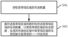
根据本发明实施例的第一方面,提供基于粪土颜色的南极鸟类种群数目遥感估算方法,包括:在遥感影像中,确定新旧粪土的混合物的反射率值区间;根据所述混合物的反射率值区间,在所述遥感影像中确定所述混合物所在的采样混合区域;根据获取到的所述采样混合区域的反射率值,将所述采样混合区域划分为多个等级,并确定各等级区域的面积;根据所述各等级区域的面积和获取到的各等级区域的鸟类数量,生成采样混合区域中各等级区域的鸟类密度与各等级的一一对应关系。According to a first aspect of the embodiments of the present invention, there is provided a method for estimating the number of Antarctic bird populations by remote sensing based on the color of the dung, including: in the remote sensing image, determining the reflectance value interval of the mixture of old and new dung; according to the reflectance value of the mixture In the remote sensing image, determine the sampling mixing area where the mixture is located; according to the acquired reflectivity value of the sampling mixing area, divide the sampling mixing area into multiple levels, and determine the Area; according to the area of each grade area and the acquired number of birds in each grade area, generate a one-to-one correspondence between the bird density of each grade area in the sampling mixed area and each grade.
可选的,从遥感影像中,确定新旧粪土两类感兴趣区域;根据获取到的所述新旧粪土两类感兴趣区域的反射率值,确定新旧粪土的混合物的反射率值区间。Optionally, from the remote sensing image, two types of interest areas of old and new manure are determined; according to the acquired reflectance values of the two types of areas of interest of new and old manure, the reflectance value interval of the mixture of new and old manure is determined.
可选的,根据南极鸟类新旧粪土颜色的差异,对研究区域的采样遥感影像进行图像增强处理,生成具有新旧粪土颜色特征的图像;从具有新旧粪土颜色特征的图像中,确定新旧粪土两类感兴趣区域。Optionally, image enhancement processing is performed on the sampled remote sensing images of the study area according to the difference in the color of the old and new manure of Antarctic birds to generate images with the color characteristics of the new and old manure; from the images with the color characteristics of the new and old manure, two types of old and new manure are determined. area of interest.
可选的,根据获取到的所述采样混合区域的反射率值,确定所述采样混合区域中的新粪土占比;根据所述新粪土占比,将所述采样混合区域划分为多个等级,并确定各等级区域的面积。Optionally, according to the acquired reflectivity value of the sampling mixed area, determine the proportion of new manure in the sampling mixed area; according to the proportion of the new manure, divide the sampling mixed area into multiple levels , and determine the area of each grade area.
可选的,获取各等级区域的鸟类数量;根据所述各等级区域的面积和所述各等级区域的鸟类数量,计算各等级区域的鸟类密度,生成采样混合区域中各等级区域的鸟类密度与各等级的一一对应关系。Optionally, obtain the number of birds in each level area; according to the area of each level area and the number of birds in each level area, calculate the bird density in each level area, and generate a sample mixed area for each level area. One-to-one correspondence between bird density and each level.
根据本发明实施例的第二方面,提供基于粪土颜色的南极鸟类种群数目遥感估算装置,包括:采样模块,用于在遥感影像中,确定新旧粪土的混合物的反射率值区间;比对模块,用于根据所述混合物的反射率值区间,在所述遥感影像中确定所述混合物所在的采样混合区域;划分模块,用于根据获取到的所述采样混合区域的反射率值,将所述采样混合区域划分为多个等级,并确定各等级区域的面积;生成模块,用于根据所述各等级区域的面积和获取到的各等级区域的鸟类数量,生成采样混合区域中各等级区域的鸟类密度与各等级的一一对应关系。According to a second aspect of the embodiments of the present invention, there is provided an apparatus for estimating the number of Antarctic bird populations by remote sensing based on the color of dung, including: a sampling module for determining, in a remote sensing image, a reflectance value interval of a mixture of old and new dung; a comparison module , which is used to determine the sampling mixing area where the mixture is located in the remote sensing image according to the reflectivity value interval of the mixture; the dividing module is used to divide the sampling mixing area according to the acquired reflectivity value of the sampling mixing area. The sampling mixed area is divided into multiple grades, and the area of each grade area is determined; the generating module is used to generate each grade in the sampling mixed area according to the area of each grade area and the acquired number of birds in each grade area. There is a one-to-one correspondence between the density of birds in the area and each level.
可选的,所述采样模块,具体包括第一采样子模块和第二采样子模块;所述第一采样子模块,用于根据从遥感影像中,确定新旧粪土两类感兴趣区域;所述第二采样子模块,用于根据获取到的所述新旧粪土两类感兴趣区域的反射率值,确定新旧粪土的混合物的反射率值区间。Optionally, the sampling module specifically includes a first sampling sub-module and a second sampling sub-module; the first sampling sub-module is used to determine two types of interest areas of old and new manure from remote sensing images; the The second sampling sub-module is configured to determine the reflectance value interval of the mixture of new and old manure according to the acquired reflectivity values of the two types of interest areas of the old and new manure.
可选的,所述第一采样子模块,具体包括第三采样子模块和第四采样子模块;所述第三采样子模块,用于根据南极鸟类新旧粪土颜色的差异,对研究区域的采样遥感影像进行图像增强处理,生成具有新旧粪土颜色特征的采样图像;所述第四采样子模块,用于从具有新旧粪土颜色特征的采样图像中,确定新旧粪土两类感兴趣区域。Optionally, the first sampling sub-module specifically includes a third sampling sub-module and a fourth sampling sub-module; the third sampling sub-module is used for collecting samples in the research area according to the difference in the color of the old and new dung of Antarctic birds. The remote sensing image is sampled for image enhancement processing to generate a sampled image with color features of new and old manure; the fourth sampling sub-module is used to determine two types of interest areas of old and new manure from the sampled images with color characteristics of new and old manure.
可选的,所述划分模块,具体包括第一划分子模块和第二划分子模块;所述第一划分子模块,用于根据获取到的所述采样混合区域的反射率值,确定所述采样混合区域中的新粪土占比;所述第二划分子模块,用于根据所述新粪土占比,将所述采样混合区域划分为多个等级,并确定各等级区域的面积。Optionally, the division module specifically includes a first division sub-module and a second division sub-module; the first division sub-module is configured to determine the The proportion of new manure in the sampling mixed area; the second dividing sub-module is used to divide the sampling mixed area into multiple levels according to the proportion of the new manure, and determine the area of each grade area.
可选的,所述生成模块,具体包括第一生成子模块和第二生成子模块;所述第一生成子模块,用于获取各等级区域的鸟类数量;所述第二生成子模块,用于根据所述各等级区域的面积和所述各等级区域的鸟类数量,计算各等级区域的鸟类密度,生成采样混合区域中各等级区域的鸟类密度与各等级的一一对应关系。Optionally, the generation module specifically includes a first generation sub-module and a second generation sub-module; the first generation sub-module is used to obtain the number of birds in each grade area; the second generation sub-module, It is used to calculate the bird density of each grade area according to the area of each grade area and the number of birds in each grade area, and generate a one-to-one correspondence between the bird density of each grade area and each grade in the sampling mixed area .
本发明实施例的创新点包括:The innovative points of the embodiments of the present invention include:
1、本发明可以通过遥感影像提取所需数据,避免人工进入实地考察,且能做到整个过程不受时间、距离以及危险性等不良因素的影响,从而避免以上不良因素对观测结果造成的误差,以及避免人工进入南极实地考察对南极生态造成的破坏,是本发明实施例的创新点之一。1. The present invention can extract the required data through remote sensing images, avoid manual entry into the field inspection, and can achieve that the entire process is not affected by adverse factors such as time, distance, and risk, thereby avoiding the errors caused by the above adverse factors to the observation results. , and avoiding the damage to the Antarctic ecology caused by artificial entry into the Antarctic field investigation is one of the innovative points of the embodiments of the present invention.
2、本发明可以通过新鲜和陈旧粪土的颜色差异将粪土划分为多个等级,并建立各等级与相对应的鸟类密度的相关关系,利用所述关系估算鸟类的数量,提高估算结果的精确性,是本发明实施例的创新点之一。2. The present invention can divide the manure into multiple grades by the color difference between the fresh and old manure, and establish the correlation between each grade and the corresponding bird density, and use the relationship to estimate the number of birds and improve the accuracy of the estimation result. Accuracy is one of the innovative points of the embodiments of the present invention.
3、本发明可以通过卫星或者无人机进行观测,能做到观测活动持续时间更短、频度更大,观测范围更广,是本发明实施例的创新点之一。3. The present invention can be observed by satellites or unmanned aerial vehicles, and can achieve shorter duration of observation activities, greater frequency, and wider observation range, which is one of the innovative points of the embodiments of the present invention.
4、本发明可以通过遥感技术观测南极鸟类种群,避免干扰和破坏野生动物种群及其栖息地,保护南极的生态环境,是本发明实施例的创新点之一。4. The present invention can observe Antarctic bird populations through remote sensing technology, avoid disturbing and destroying wild animal populations and their habitats, and protect the Antarctic ecological environment, which is one of the innovative points of the embodiments of the present invention.
附图说明Description of drawings
为了更清楚地说明本发明实施例或现有技术中的技术方案,下面将对实施例或现有技术描述中所需要使用的附图作简单地介绍,显而易见地,下面描述中的附图仅仅是本发明的一些实施例,对于本领域普通技术人员来讲,在不付出创造性劳动的前提下,还可以根据这些附图获得其他的附图。In order to explain the embodiments of the present invention or the technical solutions in the prior art more clearly, the following briefly introduces the accompanying drawings that need to be used in the description of the embodiments or the prior art. Obviously, the accompanying drawings in the following description are only These are some embodiments of the present invention. For those of ordinary skill in the art, other drawings can also be obtained according to these drawings without creative efforts.
图1为本发明的基于粪土颜色的南极鸟类种群数量遥感估算方法流程图;Fig. 1 is the flow chart of the remote sensing estimation method of Antarctic bird population quantity based on dung soil color of the present invention;
图2为本发明中步骤101的具体处理流程图;Fig. 2 is the specific processing flow chart of step 101 in the present invention;
图3为本发明中步骤103的具体处理流程图;Fig. 3 is the specific processing flow chart of step 103 in the present invention;
图4为本发明中步骤104的具体处理流程图;Fig. 4 is the specific processing flow chart of step 104 in the present invention;
图5为本发明的基于粪土颜色的南极鸟类种群数目遥感估算方法应用流程图;Fig. 5 is the application flow chart of the remote sensing estimation method of Antarctic bird population number based on dung color of the present invention;
图6为本发明的基于粪土颜色的南极鸟类种群数目遥感估算装置的结构示意图。6 is a schematic structural diagram of the device for remote sensing estimation of Antarctic bird population numbers based on dung soil color according to the present invention.
图7为本发明提出的采样模块的结构示意图。FIG. 7 is a schematic structural diagram of a sampling module proposed by the present invention.
图8为本发明提出的划分模块的结构示意图。FIG. 8 is a schematic structural diagram of a division module proposed by the present invention.
图9为本发明提出的生成模块的结构示意图。FIG. 9 is a schematic structural diagram of a generation module proposed by the present invention.
具体实施方式Detailed ways
下面将结合本发明实施例中的附图,对本发明实施例中的技术方案进行清楚、完整地描述,显然,所描述的实施例仅仅是本发明一部分实施例,而不是全部的实施例。基于本发明中的实施例,本领域普通技术人员在没有付出创造性劳动前提下所获得的所有其他实施例,都属于本发明保护的范围。The technical solutions in the embodiments of the present invention will be clearly and completely described below with reference to the accompanying drawings in the embodiments of the present invention. Obviously, the described embodiments are only a part of the embodiments of the present invention, but not all of the embodiments. Based on the embodiments of the present invention, all other embodiments obtained by those of ordinary skill in the art without creative efforts shall fall within the protection scope of the present invention.
需要说明的是,本发明实施例及附图中的术语“包括”和“具有”以及它们任何变形,意图在于覆盖不排他的包含。例如包含了一系列步骤或单元的过程、方法、系统、产品或设备没有限定于已列出的步骤或单元,而是可选地还包括没有列出的步骤或单元,或可选地还包括对于这些过程、方法、产品或设备固有的其它步骤或单元。It should be noted that the terms "comprising" and "having" and any modifications thereof in the embodiments of the present invention and the accompanying drawings are intended to cover non-exclusive inclusion. For example, a process, method, system, product or device comprising a series of steps or units is not limited to the listed steps or units, but optionally also includes unlisted steps or units, or optionally also includes For other steps or units inherent to these processes, methods, products or devices.
实施例1:Example 1:
本实施例提出了基于粪土颜色的南极鸟类种群数目遥感估算方法。在本实施例中,可以先通过遥感影像,计算出新旧粪土的混合物的反射率值区间,以及新旧粪土的采样混合区域中各等级与鸟类密度的一一对应关系,这样,在实际应用中,对于待统计的南极鸟类的大面积的遥感影像,可以先对遥感影像中的待统计混合区域进行等级区域划分,进而根据各等级区域的面积,以及事先计算出的新旧粪土的混合物的反射率值区间,以及采样混合区域中的各等级与鸟类密度的一一对应关系,计算得到待统计的南极鸟类的大面积的遥感影像中,各等级区域对应的鸟类数量,最终得到待统计的南极鸟类的大面积的遥感影像中的鸟类数量总和。This embodiment proposes a remote sensing estimation method for the population of Antarctic birds based on soil color. In this embodiment, the reflectance value interval of the mixture of old and new manure and the one-to-one correspondence between each grade and the density of birds in the sampling mixed area of old and new manure can be calculated first through remote sensing images. In this way, in practical applications , for the large-area remote sensing images of Antarctic birds to be counted, the mixed areas to be counted in the remote sensing images can be classified into graded areas, and then based on the area of each graded area and the pre-calculated reflection of the mixture of old and new manure The ratio value interval, and the one-to-one correspondence between each grade and bird density in the sampling mixed area, calculate the number of birds corresponding to each grade area in the large-area remote sensing image of Antarctic birds to be counted, and finally get the number of birds to be counted. Statistical sum of bird populations in large-scale remote sensing images of Antarctic birds.
在本实施例中,对上述先通过遥感影像,计算出新旧粪土的混合物的反射率值区间,以及新旧粪土的采样混合区域中各等级与鸟类密度的一一对应关系的过程进行详细说明。In this embodiment, the process of calculating the reflectance value interval of the mixture of new and old manure and the one-to-one correspondence between each grade and the density of birds in the sampling mixed area of the new and old manure is described in detail.
参考图1,图1为本发明的基于粪土颜色的南极鸟类种群数量遥感估算方法流程图。如图1所示,基于粪土颜色的南极鸟类种群数量遥感估算方法:Referring to FIG. 1, FIG. 1 is a flow chart of the method for remote sensing estimation of Antarctic bird population based on soil color according to the present invention. As shown in Figure 1, the remote sensing estimation method of Antarctic bird population based on soil color:
步骤101,在遥感影像中,确定新旧粪土的混合物的反射率值区间。Step 101 , in the remote sensing image, determine the reflectance value interval of the mixture of old and new manure.
具体的,通过遥感技术从所述遥感影像提取地物光谱数据,对地物光谱数据进行处理获取到所述新旧粪土的混合物的信息,进而确定所述新旧粪土的混合物的反射率值区间。Specifically, the spectral data of ground objects is extracted from the remote sensing image by remote sensing technology, the spectral data of ground objects is processed to obtain the information of the mixture of new and old manure, and then the reflectance value interval of the mixture of new and old manure is determined.
需要说明的是,确定新旧粪土的混合物的反射率值区间,在后续实际应用中,可以用于计算待统计遥感影像中的鸟类的总数量。It should be noted that determining the reflectance value range of the mixture of old and new manure can be used to calculate the total number of birds in the remote sensing image to be counted in subsequent practical applications.
可选的,参考图2,图2为本发明中步骤101的具体处理流程图,如图2所示,步骤101具体可以包括:Optionally, referring to FIG. 2, FIG. 2 is a specific processing flowchart of step 101 in the present invention. As shown in FIG. 2, step 101 may specifically include:
子步骤11,可以基于所述遥感影像,获取新旧粪土两类感兴趣区域。In sub-step 11, two types of interest areas of old and new manure may be acquired based on the remote sensing image.
具体的,所述遥感影像是通过遥感技术获取所述研究区域的采样遥感影像,根据南极鸟类新旧粪土的地物光谱数据的特征差异,对所述采样遥感影像进行图像处理,生成具有新旧粪土特征信息的图像,所述具有新旧粪土特征信息的图像即为所述遥感影像,进而基于所述遥感影像,获取新旧粪土两类感兴趣区域。Specifically, the remote sensing image is a sampled remote sensing image of the study area obtained by remote sensing technology, and image processing is performed on the sampled remote sensing image according to the feature difference of the ground object spectral data of the old and new dung of Antarctic birds to generate a new and old dung soil. The image with the feature information, the image with the feature information of the old and new manure is the remote sensing image, and then based on the remote sensing image, two types of interest areas of the old and new manure are obtained.
需要说明的是,所述研究区域的采样遥感影像可以通过高分辨率卫星或者高精度无人机获取。It should be noted that the sampled remote sensing images of the research area can be acquired by high-resolution satellites or high-precision UAVs.
子步骤12,根据获取到的新旧粪土两类感兴趣区域的反射率值,确定所述新旧粪土的混合物的反射率值区间。Sub-step 12, according to the acquired reflectance values of the two types of areas of interest of the new and old manure, determine the reflectance value interval of the mixture of the new and old manure.
在具体实施过程中,所述新旧粪土两类感兴趣区域的反射率值,可以通过对所述采样遥感影像提取出来的地物光谱数据进行分析所得到。In the specific implementation process, the reflectance values of the two types of interest areas of the old and new manure can be obtained by analyzing the spectral data of the ground objects extracted from the sampled remote sensing images.
具体的,所述新旧粪土的混合物的反射率值区间可以通过如下步骤得到:首先,可以统计所述新旧粪土两类感兴趣区域的反射率值,然后,结合新粪土和旧粪土的反射率值的正态分布曲线,取两条正态分布曲线的重合区域对应的反射率值区间,作为新旧粪土的混合物的反射率值区间。Specifically, the reflectance value interval of the mixture of the new and old manure can be obtained by the following steps: first, the reflectance values of the two types of interest areas of the new and old manure can be counted, and then the reflectance values of the new manure and the old manure can be combined. The normal distribution curve of , and the reflectance value interval corresponding to the overlapping area of the two normal distribution curves is taken as the reflectance value interval of the mixture of new and old manure.
进一步的,实际应用中,为了排除无效数据,例如,噪点,增强被测参数的可信度,通常所述统计新旧粪土两类感兴趣区域的反射率值,结合新粪土和旧粪土的反射率值的正态分布曲线,取两条正态分布曲线的重合区域的95%置信区间的反射率值区间,作为新旧粪土的混合物的反射率值区间。Further, in practical applications, in order to exclude invalid data, such as noise points, and enhance the reliability of the measured parameters, usually the reflectance values of the two types of interest areas of the new and old manure are counted, and the reflectivity of the new manure and the old manure are combined. For the normal distribution curve of the value, the reflectance value interval of the 95% confidence interval of the overlapping area of the two normal distribution curves is taken as the reflectance value interval of the mixture of new and old manure.
具体的,统计新旧两类感兴趣区域95%置信区间内的反射率值,取端点[c1新,c2新],[c1旧、c2旧]。以[c1新,c1旧]范围内的反射率值表征新粪土,以[c2新、c2旧]范围内的反射率值表征旧粪土;得到以[c1旧、c2新]范围内的反射率值作为新旧粪土的混合物的反射率值区间。Specifically, the reflectance values within the 95% confidence interval of the new and old two types of interest regions are counted, and the endpoints [c1 new , c2 new ], [c1 old , c2 old ] are taken. Characterize new manure by reflectance values in the range [c1 new , c1 old ] and old manure by reflectance values in the range [c2 new , c2 old ]; get the values in [c1 old , c2 new ] ] The reflectance value in the range is taken as the reflectance value interval of the mixture of new and old manure.
可选的,如图2所示,子步骤11具体可以包括:Optionally, as shown in FIG. 2 , sub-step 11 may specifically include:
子步骤111,根据南极鸟类新旧粪土颜色的差异,对研究区域的采样遥感影像进行图像增强处理,生成具有新旧粪土颜色特征的图像。In sub-step 111, image enhancement processing is performed on the sampled remote sensing images of the research area according to the difference in the color of the old and new manure of Antarctic birds, to generate an image with the color characteristics of the old and new manure.
具体的,由于所述南极鸟类特有的饮食习惯,其粪便颜色会有明显的区分,而粪土经过时间的变化,新粪土与旧粪土的颜色也存在明显的区别,例如,企鹅为南极鸟类的一种,企鹅主要以磷虾为食,所以新鲜的粪土呈红棕色而陈旧的粪土呈灰色。在实际应用中,可以根据待确定数量的鸟类的饮食习惯,调整图像增强处理中的相关参数,以更精确的分辨新粪土和旧粪土。Specifically, due to the unique eating habits of the Antarctic birds, the color of their feces will be clearly distinguished, and the color of the new dung and the old dung will also be significantly different over time. For example, penguins are Antarctic birds. A type of penguin that feeds primarily on krill, so fresh manure is reddish-brown and old manure is grey. In practical applications, the relevant parameters in the image enhancement process can be adjusted according to the eating habits of the number of birds to be determined, so as to more accurately distinguish between new and old manure.
子步骤112,从具有新旧粪土颜色特征的图像中,确定新旧粪土两类感兴趣区域。In sub-step 112, two types of interest regions of the old and new manure are determined from the images with the color characteristics of the old and new manure.
需要说明的是,确定所述新旧粪土两类感兴趣区域,是为了以便后续步骤通过从所述新旧粪土的混合物中区分新粪土的采样混合物区域。It should be noted that the two types of interest areas of the old and new manure are determined so that the following steps can distinguish the sampling mixture area of the new manure from the mixture of the new manure and the old manure.
还需要说明的是,新粪土可以反映所述南极鸟类种群的现有分布范围,旧粪土可以反应关于所述南极鸟类种群历史分布范围、融水对栖息地的侵蚀、以及所述南极鸟类种群空间格局变化的信息。It should also be noted that the new manure can reflect the existing distribution range of the Antarctic bird population, and the old manure can reflect the historical distribution range of the Antarctic bird population, the erosion of the habitat by meltwater, and the Antarctic bird population. Information on changes in the spatial pattern of species populations.
步骤102,根据所述混合物的反射率值区间,在所述遥感影像中确定所述混合物所在的采样混合区域。Step 102 , according to the reflectivity value interval of the mixture, determine the sampling mixing area where the mixture is located in the remote sensing image.
在本步骤中,通过对所述遥感影像的地物光谱数据进行分析,获得所述遥感影像中区域的反射率值,再根据所述反射率值与所述混合物的反射率值区间进行比对,即可确定所述混合物所在的采样混合区域。In this step, the reflectance value of the region in the remote sensing image is obtained by analyzing the spectral data of the ground objects in the remote sensing image, and then the reflectance value is compared with the reflectance value range of the mixture according to the reflectance value. , the sampling mixing area where the mixture is located can be determined.
步骤103,根据获取到的所述采样混合区域的反射率值,将所述采样混合区域划分为多个等级,并确定各等级区域的面积。Step 103 , according to the acquired reflectivity value of the sampling mixed region, divide the sampling mixed region into multiple levels, and determine the area of each level region.
具体的,首先,获取所述采样混合区域的遥感图像,然后,从遥感图像中获取所述采样混合区域的地物光谱数据,最后,对所述采样混合区域的地物光谱数据进行处理,得到所述采样混合区域的反射率值。Specifically, first, the remote sensing image of the sampling mixed area is obtained, then the spectral data of the ground objects in the sampling mixed area is obtained from the remote sensing image, and finally, the spectral data of the ground object in the sampling mixed area is processed to obtain The reflectivity value of the sampled mixed region.
需要说明的是,所述采样混合区域的反射率值的大小一定程度上反映当前区域南极鸟类种群的数量,因此,以反射率值为依据,对所述采样混合区域进行等级划分,进而对各等级区域分别进行研究,从而获得各等级区域的鸟类密度,可以使后续估算鸟类数量结果更精确。可以理解的,等级划分越细,精确度越高。It should be noted that the size of the reflectivity value of the sampling mixed area reflects the number of Antarctic bird populations in the current area to a certain extent. Therefore, based on the reflectivity value, the sampling mixed area is graded, and then Each grade area is studied separately to obtain the bird density of each grade area, which can make the subsequent estimation of bird population more accurate. It can be understood that the finer the level division, the higher the accuracy.
可选的,参考图3,为本发明中步骤103的具体处理流程图,如图3所示,步骤103具体可以包括:Optionally, referring to FIG. 3 , it is a specific processing flowchart of step 103 in the present invention. As shown in FIG. 3 , step 103 may specifically include:
子步骤31,根据获取到的所述采样混合区域的反射率值,确定所述采样混合区域中的新粪土占比。Sub-step 31: Determine the proportion of new manure in the sampling mixed area according to the acquired reflectivity value of the sampling mixed area.
在具体实施过程中,可以提前通过实地采样混合粪土,在已知实地采样混合粪土的新粪土占比的情况下,测量实地采样混合区域的反射率值,确定实地采样混合区域的不同子区域与新粪土占比的对应关系,以便在实际应用中,根据采样混合区域的反射率值,确定采样混合区域中的新粪土占比。In the specific implementation process, the mixed manure can be sampled on-site in advance. When the proportion of new manure in the field sampled mixed manure is known, the reflectance value of the field sampled mixed area can be measured, and the different sub-areas of the field sampled mixed area can be determined. The corresponding relationship of the proportion of new manure, so that in practical applications, the proportion of new manure in the sampling mixed area can be determined according to the reflectivity value of the sampling mixed area.
子步骤32,根据所述新粪土占比,将所述采样混合区域划分为多个等级,并确定各等级区域的面积。In sub-step 32, according to the proportion of the new manure, the sampling mixed area is divided into multiple levels, and the area of each level area is determined.
具体的,首先,在已确定新粪土占比的采样混合区域中,可以根据新粪土占比,将所述采样混合区域划分为多个等级,每个等级的新粪土占比不同,最后,确定各等级的等级区域。Specifically, first, in the sampling mixed area where the proportion of new manure has been determined, the sampling mixed area can be divided into multiple levels according to the proportion of new manure, and the proportion of new manure of each grade is different. Finally, determine Level area for each level.
其中,各等级区域的面积可以通过所述采样遥感影像获取各等级区域的像元数量和像元大小,各等级区域的像元数量与像元大小之积即为所述各等级区域的面积,Wherein, the area of each grade area can be obtained from the sampled remote sensing image by the pixel number and pixel size of each grade area, and the product of the pixel number and pixel size of each grade area is the area of each grade area,
还需要说明的是,由于新粪土占比会直接影响采样混合区域的反射率值,因此,可从遥感影像中提取采样混合区域的光谱数据,根据光谱数据,统计采样混合区域中各子区域的反射率值与新粪土占比的对应关系,最终将采样混合区域划为具有不同反射率值范围的子区域,反射率值越低,新粪土占比越低,一个子区域即为一个等级区域。It should also be noted that since the proportion of new manure will directly affect the reflectance value of the sampling mixed area, the spectral data of the sampling mixed area can be extracted from the remote sensing image, and the statistical data of each sub-area in the sampling mixed area can be calculated according to the spectral data. The corresponding relationship between the reflectivity value and the proportion of new manure, and finally divide the sampling mixed area into sub-areas with different reflectivity value ranges. The lower the reflectivity value, the lower the proportion of new manure, and a sub-area is a grade area. .
在实际应用中,可以根据以下计算方法将采样混合区域分n个等级,[100%,100×(1-1/n)%]、[100×(1-1/n)%,100×(1-2/n)%]...、[100×(1-(n-1)/n)%,0],n值越大,采样混合区域的划分精确度越高。In practical applications, the sampling mixed area can be divided into n levels according to the following calculation methods, [100%, 100×(1-1/n)%], [100×(1-1/n)%, 100×( 1-2/n)%]..., [100×(1-(n-1)/n)%, 0], the larger the n value, the higher the division accuracy of the sampling mixed region.
比如,可以取n=5,基于上述计算方法,按照新粪土占比100%-80%、80%-60%、60%-40%、40%-20%和20%-0,将采样混合区域均分为5个等级。For example, n=5 can be taken. Based on the above calculation method, the samples are mixed according to the proportion of new manure of 100%-80%, 80%-60%, 60%-40%, 40%-20% and 20%-0. Areas are divided into 5 levels.
步骤104,根据所述各等级区域的面积和获取到的各等级区域的鸟类数量,生成采样混合区域中各等级区域的鸟类密度与各等级的一一对应关系。Step 104: Generate a one-to-one correspondence between the density of birds in each grade area and each grade in the sampling mixed area according to the area of each grade area and the acquired number of birds in each grade area.
具体的,鸟类数量与等级区域的面积存在着一一对应关系,通过获取采样混合区域中各等级区域的鸟类密度与各等级的一一对应关系可以应用于后续计算得到待统计的南极鸟类的大面积的遥感影像中,各等级区域对应的鸟类数量。Specifically, there is a one-to-one correspondence between the number of birds and the area of the graded area. Obtaining the one-to-one correspondence between the density of birds in each graded area in the sampling mixed area and each grade can be applied to subsequent calculations to obtain the Antarctic birds to be counted. In the large-area remote sensing image of the class, the number of birds corresponding to each level area.
可选的,参考图4,图4为本发明中步骤104的具体处理流程图,如图4所示,步骤104具体可以包括:Optionally, referring to FIG. 4 , FIG. 4 is a specific processing flowchart of step 104 in the present invention. As shown in FIG. 4 , step 104 may specifically include:
子步骤41,获取各等级区域的鸟类数量。In sub-step 41, the number of birds in each grade area is obtained.
在具体实施过程中,可以通过采样遥感影像对各等级区域的南极鸟类数量直接统计,从而获取各等级区域的鸟类数量。In the specific implementation process, the number of Antarctic birds in each level area can be directly counted by sampling remote sensing images, so as to obtain the number of birds in each level area.
子步骤42,根据所述各等级区域的面积和所述各等级区域的鸟类数量,计算各等级区域的鸟类密度,生成采样混合区域中各等级区域的鸟类密度与各等级的一一对应关系。Sub-step 42, according to the area of each grade area and the number of birds in each grade area, calculate the bird density of each grade area, and generate a one-to-one ratio of the bird density of each grade area and each grade in the sampling mixed area. Correspondence.
具体的,各等级区域的鸟类数量与对应所述各等级区域的面积之比,即为各等级区域的鸟类密度。Specifically, the ratio of the number of birds in each grade area to the area corresponding to each grade area is the bird density in each grade area.
需要说明的是,由于不同等级区域其中鸟类密度存在明显差异,可以设置鸟类密度与等级区域的一一对应关系,使各等级与各等级区域中的鸟类密度关联起来。这样,在具体操作中,可以应用本实施例已经计算出的采样混合区域的等级区域与鸟类密度的一一对应关系,计算得到待统计的南极鸟类的大面积的遥感影像中,各等级区域对应的鸟类数量。It should be noted that since there are obvious differences in bird density in different grade areas, a one-to-one correspondence between bird densities and grade areas can be set to associate each grade with the bird density in each grade area. In this way, in the specific operation, the one-to-one correspondence between the grade area of the sampling mixed area and the bird density that has been calculated in this embodiment can be used to calculate the large-area remote sensing image of Antarctic birds to be counted. The number of birds corresponding to the area.
可以理解的是,本实施例计算出的采样混合区域的等级区域与鸟类密度的一一对应关系,具有地域性,在实际应用中,需要根据实际情况确定应用范围。It can be understood that the one-to-one correspondence between the grade area of the sampling mixed area and the bird density calculated in this embodiment is regional, and in practical application, the application scope needs to be determined according to the actual situation.
可见,本实施例计算出的新旧粪土的采样混合区域中各等级与鸟类密度的一一对应关系,为后续利用所述关系统计大面积的遥感影像的南极鸟类的数量奠定了高精确度统计的基础;其中,本实施例描述的整个过程,其数据的提取都是基于卫星或者无人机的遥感影像,可以理解的,本发明能做到观测频度更大,观测范围更广;且整个过程中不需要人工进入实地考察,做到观测不受距离的限制、安全性高、持续时间更短。It can be seen that the one-to-one correspondence between each grade and the density of birds in the sampling mixed area of new and old manure calculated in this example lays a high level of accuracy for the subsequent use of the relationship to count the number of Antarctic birds in large-area remote sensing images. The basis of statistics; wherein, the data extraction of the entire process described in this embodiment is based on remote sensing images of satellites or unmanned aerial vehicles. It can be understood that the present invention can achieve a larger observation frequency and a wider observation range; In the whole process, there is no need to manually enter the field inspection, so that the observation is not limited by distance, has high safety, and has a shorter duration.
实施例2:Example 2:
本实施例提出了基于粪土颜色的南极鸟类种群数目遥感估算方法应用。已经由实施例1通过南极鸟类的小面积的采样遥感影像,计算得到新旧粪土的混合物的反射率值区间,以及新旧粪土的采样混合区域中各等级与鸟类密度的一一对应关系,那么,在本实施例中,对于大面积的南极鸟类的待统计遥感影像,可以使用实施例1已计算出的新旧粪土的混合物的反射率值区间,以及采样混合区域中各等级与鸟类密度的一一对应关系,实现对待统计遥感影像中鸟类数量的计算。This embodiment proposes the application of a remote sensing estimation method for Antarctic bird populations based on soil color. The reflectance value interval of the mixture of new and old manure, and the one-to-one correspondence between each grade and the density of birds in the sampled mixed area of new and old manure have been calculated from the sampled remote sensing images of Antarctic birds in a small area, then , in this embodiment, for the large-area remote sensing images of Antarctic birds to be counted, the reflectance value interval of the mixture of old and new dung that has been calculated in Embodiment 1, and the density of each grade and bird density in the sampling mixed area can be used The one-to-one correspondence is realized to realize the calculation of the number of birds in the statistical remote sensing images.
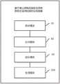
需要说明的是,本实施例中研究区域与实施例1所述研究区域所属同一地域,且本实施例中新旧粪土的混合区域的划分是以实施例1所述表征为新旧粪土的混合物的反射率值区间为依据,且本实施例中新旧粪土的混合区域中各等级区域的划分标准与实施例1所描述的一致。It should be noted that the research area in this example and the research area described in Example 1 belong to the same region, and the division of the mixed area of new and old manure in this embodiment is based on the reflection of the mixture of new and old manure described in Example 1. The rate value interval is the basis, and the division standard of each grade area in the mixed area of new and old manure in this embodiment is consistent with that described in Embodiment 1.
参考图5,图5为本发明的基于粪土颜色的南极鸟类种群数目遥感估算方法应用流程图。如图5所示,基于粪土颜色的南极鸟类种群数目遥感估算方法应用包括如下步骤:Referring to FIG. 5 , FIG. 5 is a flowchart of the application of the method for remote sensing estimation of Antarctic bird populations based on soil color according to the present invention. As shown in Figure 5, the application of the remote sensing estimation method for Antarctic bird populations based on soil color includes the following steps:
步骤201,根据南极鸟类新旧粪土颜色的差异,对研究区域的待统计遥感影像进行图像增强处理,生成具有新旧粪土颜色特征的待统计图像。Step 201: Perform image enhancement processing on the remote sensing images of the research area to be counted according to the difference in the color of the old and new dung of Antarctic birds, to generate an image to be counted with the color characteristics of the old and new dung.
在本步骤中,可以基于南极鸟类新粪土和旧粪土的颜色,对所述研究区域的待统计遥感影像进行图像增强处理,以强化新粪土和旧粪土的颜色差异,生成包括新旧粪土颜色特征的待统计图像,以便通过后续步骤确定所述研究区的鸟类数量。In this step, based on the colors of the new and old manure of Antarctic birds, image enhancement processing can be performed on the remote sensing images of the research area to be counted, so as to strengthen the color difference between the new manure and the old manure, and generate a color feature including the new and old manure. The images to be counted in order to determine the number of birds in the study area through subsequent steps.
具体的,可选择合适的波段或者波段组合对所述研究区域的待统计遥感影像进行图像增强处理,其中,所述波段是通过高分辨率卫星或者高精度无人机影像提取出来的地物光谱数据进行分析所得到的,使模糊的图像中有用信息变得更加清晰,加强图像判读和可识别效果;经过处理的图像中新旧粪土的区分度更高,以用于后续对所述待统计图像中划分研究区域更精确。Specifically, an appropriate waveband or waveband combination can be selected to perform image enhancement processing on the remote sensing images of the research area to be counted, wherein the waveband is the spectrum of ground objects extracted from high-resolution satellite or high-precision UAV images The data obtained from the analysis of the data can make the useful information in the blurred image clearer, and enhance the image interpretation and identification effect; the difference between old and new manure in the processed image is higher, which can be used for the subsequent analysis of the image to be counted. It is more precise to divide the study area in
需要说明的是,由于所述南极鸟类特有的饮食习惯,其粪便颜色会有明显的区分,而粪土经过时间的变化,新粪土与旧粪土的颜色也存在明显的区别,例如,企鹅为南极鸟类的一种,企鹅主要以磷虾为食,所以新鲜的粪土呈红棕色而陈旧的粪土呈灰色。在实际应用中,可以根据待确定数量的鸟类的饮食习惯,调整图像增强处理中的相关参数,以更精确的分辨新粪土和旧粪土。It should be noted that due to the unique eating habits of the Antarctic birds, the color of their dung will be clearly distinguished, and the color of the new dung and the old dung will also be significantly different over time. For example, the penguin is Antarctic. A species of bird, penguins feed mainly on krill, so fresh manure is reddish-brown and old manure is grey. In practical applications, the relevant parameters in the image enhancement process can be adjusted according to the eating habits of the number of birds to be determined, so as to more accurately distinguish between new and old manure.
在具体实施中,所述研究区域的待统计遥感影像可以通过高分辨率卫星或者高精度无人机获取。In a specific implementation, the remote sensing images of the study area to be counted may be acquired by high-resolution satellites or high-precision UAVs.
步骤202,从具有新旧粪土颜色特征的待统计图像中,获取研究区域的反射率值;根据预设的混合物的反射率值区间,在所述待统计图像中确定新旧粪土的混合物所在的待统计混合区域。Step 202: Obtain the reflectance value of the research area from the images to be counted with the color characteristics of old and new manure; according to the preset reflectivity value interval of the mixture, determine the image to be counted where the mixture of old and new manure is located in the image to be counted. mixed area.
其中,预设的混合物的反射率值区间是事先计算出的,具体的,可以从实施例1中的步骤101计算得到。Wherein, the preset reflectivity value interval of the mixture is calculated in advance, and specifically, it can be calculated from step 101 in Embodiment 1.
在本步骤中,首先,可以统计研究区域的反射率值;接下来,由于粪土中的新粪土的占比会直接影响粪土的反射率值,因此可以根据实施例1中步骤101计算得到的新旧粪土的混合物的反射率值区间,筛选待统计图像中新旧粪土的混合物所在的待统计混合区域。In this step, first, the reflectance value of the research area can be counted; next, since the proportion of new manure in the manure will directly affect the reflectance value of the manure, the old and new values calculated in step 101 in Example 1 can be calculated according to The reflectance value range of the mixture of manure and soil is used to screen the mixing area to be counted where the mixture of old and new manure is located in the image to be counted.
其中,所述反射率值可以通过对高精度无人机影像提取出来的地物光谱数据进行分析所得到。The reflectance value can be obtained by analyzing the spectral data of ground objects extracted from high-precision drone images.
步骤203,根据所述待统计混合区域的反射率值,确定所述待统计混合区域中的新粪土占比;根据所述新粪土占比,将所述待统计混合区域划分为n个等级,并确定各等级区域。Step 203, according to the reflectivity value of the mixed area to be counted, determine the proportion of new manure in the mixed area to be counted; according to the proportion of the new manure, divide the mixed area to be counted into n levels, and determine each grade area.
在本步骤中,首先,在已确定的待统计混合区域中,确定新粪土占比,具体过程可以参考实施例1中的步骤103;接下来,可以根据新粪土占比,将待统计混合区域划分为多个等级,每个等级的新粪土占比不同,进而确定各等级的等级区域。In this step, first, in the determined mixed area to be counted, the proportion of new manure is determined. For the specific process, please refer to step 103 in Embodiment 1; next, according to the proportion of new manure, the mixed area to be counted Divided into multiple grades, each grade has a different proportion of new manure, and then determines the grade area of each grade.
在具体实施过程中,可以提前通过实地采样混合粪土,在已知采样混合粪土的新粪土占比的情况下,测量采样混合区域的反射率值,确定采样混合区域的不同子区域与新粪土占比的对应关系,以便在实际应用中,根据待统计混合区域的反射率值,确定待统计混合区域中的新粪土占比。In the specific implementation process, the mixed manure can be sampled on the spot in advance. When the proportion of new manure in the sampled mixed manure is known, the reflectance value of the sampled mixed area can be measured, and the different sub-areas of the sampled mixed area and the proportion of new manure can be determined. The corresponding relationship of the ratio, so that in practical application, the proportion of new manure in the mixed area to be counted can be determined according to the reflectivity value of the mixed area to be counted.
在实际应用中,可以根据以下计算方法将待统计混合区域分n个等级,[100%,100×(1-1/n)%]、[100×(1-1/n)%,100×(1-2/n)%]...、[100×(1-(n-1)/n)%,0],n值越大,待统计混合区域的划分精确度越高。In practical applications, the mixed area to be counted can be divided into n levels according to the following calculation methods, [100%, 100×(1-1/n)%], [100×(1-1/n)%, 100× (1-2/n)%]..., [100×(1-(n-1)/n)%, 0], the larger the n value, the higher the division accuracy of the mixed region to be counted.
还需要说明的是,本步骤中所述n值与实施例1中所述n值完全一致;It should also be noted that the n value described in this step is completely consistent with the n value described in Example 1;
步骤204,确定待统计混合区域中各等级区域的面积;根据预设的采样混合区域中各等级与鸟类密度的一一对应关系,计算待统计混合区域中各等级区域的鸟类数量。Step 204: Determine the area of each grade area in the mixed area to be counted; calculate the number of birds in each grade area in the mixed area to be counted according to the preset one-to-one correspondence between each grade and the density of birds in the mixed area to be counted.
在本步骤中,可以通过研究区域中待统计遥感影像获取各等级区域的像元数量和像元大小,各等级区域的像元数量与像元大小之积即为所述各等级区域的面积。In this step, the number of pixels and the size of each level area can be obtained from the remote sensing images to be counted in the research area, and the product of the number of pixels and the size of each level area is the area of each level area.
步骤205,将研究区域中待统计遥感影像中各等级区域的南极鸟类数量求和,生成研究区域中待统计遥感影像南极鸟类总数量。Step 205, summing the numbers of Antarctic birds in the remote sensing images to be counted in the study area at each level, to generate the total number of Antarctic birds in the study area to be counted in the remote sensing images.
可见,本实施例中根据不同的等级计算得到各等级区域对应的鸟类数量,最终获得研究区域待统计遥感影像里南极鸟类数量,能提高估算结果的精确性;其中,本实施例描述的整个过程,其数据的提取都是基于卫星或者无人机的遥感影像,可以理解的,本发明能做到观测频度更大,观测范围更广;且整个过程中不需要人工进入实地考察,做到观测不受距离的限制、安全性高、持续时间更短。It can be seen that in this embodiment, the number of birds corresponding to each grade area is calculated according to different grades, and finally the number of Antarctic birds in the remote sensing image to be counted in the research area can be obtained, which can improve the accuracy of the estimation result; In the whole process, the data extraction is based on remote sensing images of satellites or unmanned aerial vehicles. It is understandable that the present invention can achieve a larger observation frequency and a wider observation range; The observation is not limited by distance, with high safety and shorter duration.
需要说明的是,在具体实施过程中,通常先根据高度、距海远近等差异,将所述研究区域在空间上划分成为若干部分,再对划分部分分别进行计算;可以避免由于高度、湿度等因素对观测结果造成影响。It should be noted that, in the specific implementation process, the research area is usually divided into several parts in space according to differences in height, distance from the sea, etc., and then the divided parts are calculated separately; factors affect the observed results.
实施例3:Example 3:
本发明提出了基于粪土颜色的南极鸟类种群数目遥感估算装置,参考图6,图6为本发明的基于粪土颜色的南极鸟类种群数目遥感估算装置的结构示意图。如图6所示,基于粪土颜色的南极鸟类种群数目遥感估算装置包括:The present invention proposes a remote sensing device for estimating the population of Antarctic birds based on dung color. Referring to FIG. 6, FIG. 6 is a schematic structural diagram of the device for estimating the number of Antarctic bird populations by remote sensing based on soil color. As shown in Figure 6, the remote sensing estimation device of Antarctic bird population based on soil color includes:
采样模块30,用于在遥感影像中,确定新旧粪土的混合物的反射率值区间;The
比对模块40,用于根据所述混合物的反射率值区间,在所述遥感影像中确定所述混合物所在的采样混合区域;A
划分模块50,用于根据获取到的所述采样混合区域的反射率值,将所述采样混合区域划分为多个等级,并确定各等级区域的面积。The dividing
生成模块60,用于根据所述各等级区域的面积和获取到的各等级区域的鸟类数量,生成采样混合区域中各等级区域的鸟类密度与各等级的一一对应关系。The generating module 60 is configured to generate a one-to-one correspondence between the density of birds in each grade area in the sampling mixed area and each grade according to the area of each grade area and the acquired number of birds in each grade area.
可选的,如图7所示,采样模块30,具体包括第一采样子模块301和第二采样子模块302;Optionally, as shown in FIG. 7 , the
所述第一采样子模块301,用于根据从获取到的采样图像中,确定新旧粪土两类感兴趣区域;The
所述第二采样子模块302,用于根据获取到的所述新旧粪土两类感兴趣区域的反射率值,确定新旧粪土的混合物的反射率值区间。The
可选的,如图7所示,所述第一采样子模块301,具体包括第三采样子模块3011和第四采样子模块3012;Optionally, as shown in FIG. 7 , the
所述第三采样子模块3011,用于根据南极鸟类新旧粪土颜色的差异,对研究区域的采样遥感影像进行图像增强处理,生成具有新旧粪土颜色特征的图像;The
所述第四采样子模块3012,用于从具有新旧粪土颜色特征的图像中,确定新旧粪土两类感兴趣区域。The
可选的,如图8所示,划分模块50,具体包括第一划分子模块501和第二划分子模块502;Optionally, as shown in FIG. 8 , the
所述第一划分子模块501,用于根据获取到的所述采样混合区域的反射率值,确定所述采样混合区域中的新粪土占比;The
所述第二划分子模块502,用于根据所述新粪土占比,将所述采样混合区域划分为多个等级,并确定各等级区域的面积。The
可选的,如图9所示,生成模块60,具体包括第一生成子模块601和第二生成子模块602;Optionally, as shown in FIG. 9 , the generation module 60 specifically includes a
所述第一生成子模块601,用于获取各等级区域的鸟类数量;The
所述第二生成子模块602,用于根据所述各等级区域的面积和所述各等级区域的鸟类数量,计算各等级区域的鸟类密度,生成采样混合区域中各等级区域的鸟类密度与各等级的一一对应关系。The
可见,本发明提出的基于粪土颜色的南极鸟类种群数目遥感估算的处理装置,能够计算得到各等级区域的鸟类密度,且根据所述鸟类密度计算得到各等级区域对应的鸟类数量,最终获得研究区域遥感影像里南极鸟类数量,能提高估算结果的精确性;整个过程,数据的提取都是基于卫星或者无人机的遥感影像,可以理解的,本发明能做到观测频度更大,观测范围更广;且整个过程中不需要人工进入实地考察,做到观测不受距离的限制、安全性高、持续时间更短。It can be seen that the processing device for remote sensing estimation of the number of Antarctic bird populations based on dung color proposed by the present invention can calculate the bird density in each grade area, and calculate the number of birds corresponding to each grade area according to the bird density, Finally, the number of Antarctic birds in the remote sensing images of the study area can be obtained, which can improve the accuracy of the estimation results; in the whole process, the data extraction is based on the remote sensing images of satellites or unmanned aerial vehicles. It is understandable that the present invention can achieve the frequency of observation. It is larger and has a wider observation range; and there is no need to manually enter the field inspection during the whole process, so that the observation is not limited by distance, has high safety, and has a shorter duration.
本领域普通技术人员可以理解:附图只是一个实施例的示意图,附图中的模块或流程并不一定是实施本发明所必须的。Those of ordinary skill in the art can understand that the accompanying drawing is only a schematic diagram of an embodiment, and the modules or processes in the accompanying drawing are not necessarily necessary to implement the present invention.
以上结合具体实施例描述了本申请的基本原理,但是,需要指出的是,在本申请中提及的优点、优势、效果等仅是示例而非限制,不能认为这些优点、优势、效果等是本申请的各个实施例必须具备的。另外,上述公开的具体细节仅是为了示例的作用和便于理解的作用,而非限制,上述细节并不限制本申请为必须采用上述具体的细节来实现。The basic principles of the present application have been described above in conjunction with specific embodiments. However, it should be pointed out that the advantages, advantages, effects, etc. mentioned in the present application are only examples rather than limitations, and these advantages, advantages, effects, etc., are not considered to be Required for each embodiment of this application. In addition, the specific details disclosed above are only for the purpose of example and easy understanding, rather than limiting, and the above-mentioned details do not limit the application to be implemented by using the above-mentioned specific details.
本申请中涉及的器件、装置、设备、系统的方框图仅作为例示性的例子并且不意图要求或暗示必须按照方框图示出的方式进行连接、布置、配置。如本领域技术人员将认识到的,可以按任意方式连接、布置、配置这些器件、装置、设备、系统。诸如“包括”、“包含”、“具有”等等的词语是开放性词汇,指“包括但不限于”,且可与其互换使用。这里所使用的词汇“或”和“和”指词汇“和/或”,且可与其互换使用,除非上下文明确指示不是如此。这里所使用的词汇“诸如”指词组“如但不限于”,且可与其互换使用。The block diagrams of devices, apparatus, apparatuses, and systems referred to in this application are merely illustrative examples and are not intended to require or imply that the connections, arrangements, or configurations must be in the manner shown in the block diagrams. As those skilled in the art will appreciate, these means, apparatuses, apparatuses, systems may be connected, arranged, configured in any manner. Words such as "including", "including", "having" and the like are open-ended words meaning "including but not limited to" and are used interchangeably therewith. As used herein, the words "or" and "and" refer to and are used interchangeably with the word "and/or" unless the context clearly dictates otherwise. As used herein, the word "such as" refers to and is used interchangeably with the phrase "such as but not limited to".
最后应说明的是:以上实施例仅用以说明本发明的技术方案,而非对其限制;尽管参照前述实施例对本发明进行了详细的说明,本领域的普通技术人员应当理解:其依然可以对前述实施例所记载的技术方案进行修改,或者对其中部分技术特征进行等同替换;而这些修改或者替换,并不使相应技术方案的本质脱离本发明实施例技术方案的精神和范围。Finally, it should be noted that: the above embodiments are only used to illustrate the technical solutions of the present invention, but not to limit them; although the present invention has been described in detail with reference to the foregoing embodiments, those of ordinary skill in the art should understand: it can still be Modifications are made to the technical solutions described in the foregoing embodiments, or some technical features thereof are equivalently replaced; and these modifications or replacements do not make the essence of the corresponding technical solutions depart from the spirit and scope of the technical solutions of the embodiments of the present invention.
Claims (10)
Translated fromChinesePriority Applications (2)
| Application Number | Priority Date | Filing Date | Title |
|---|---|---|---|
| CN202210088306.1ACN114494904B (en) | 2022-01-25 | 2022-01-25 | Remote sensing estimation method and device for number of antarctic birds population based on fecal soil color |
| US18/098,108US20230260248A1 (en) | 2022-01-25 | 2023-01-17 | Feces color-based remote sensing estimation method and apparatus for antarctic bird population size |
Applications Claiming Priority (1)
| Application Number | Priority Date | Filing Date | Title |
|---|---|---|---|
| CN202210088306.1ACN114494904B (en) | 2022-01-25 | 2022-01-25 | Remote sensing estimation method and device for number of antarctic birds population based on fecal soil color |
Publications (2)
| Publication Number | Publication Date |
|---|---|
| CN114494904Atrue CN114494904A (en) | 2022-05-13 |
| CN114494904B CN114494904B (en) | 2024-07-26 |
Family
ID=81475246
Family Applications (1)
| Application Number | Title | Priority Date | Filing Date |
|---|---|---|---|
| CN202210088306.1AActiveCN114494904B (en) | 2022-01-25 | 2022-01-25 | Remote sensing estimation method and device for number of antarctic birds population based on fecal soil color |
Country Status (2)
| Country | Link |
|---|---|
| US (1) | US20230260248A1 (en) |
| CN (1) | CN114494904B (en) |
Citations (3)
| Publication number | Priority date | Publication date | Assignee | Title |
|---|---|---|---|---|
| US20160232621A1 (en)* | 2015-02-06 | 2016-08-11 | The Climate Corporation | Methods and systems for recommending agricultural activities |
| CN106022457A (en)* | 2016-05-09 | 2016-10-12 | 南京大学 | Emperor penguin population quantity remote sensing estimation method |
| CN107077650A (en)* | 2014-09-12 | 2017-08-18 | 克莱米特公司 | Method and system for managing agricultural activities |
- 2022
- 2022-01-25CNCN202210088306.1Apatent/CN114494904B/enactiveActive
- 2023
- 2023-01-17USUS18/098,108patent/US20230260248A1/enactivePending
Patent Citations (3)
| Publication number | Priority date | Publication date | Assignee | Title |
|---|---|---|---|---|
| CN107077650A (en)* | 2014-09-12 | 2017-08-18 | 克莱米特公司 | Method and system for managing agricultural activities |
| US20160232621A1 (en)* | 2015-02-06 | 2016-08-11 | The Climate Corporation | Methods and systems for recommending agricultural activities |
| CN106022457A (en)* | 2016-05-09 | 2016-10-12 | 南京大学 | Emperor penguin population quantity remote sensing estimation method |
Non-Patent Citations (2)
| Title |
|---|
| PENG ZHAO 等: "Estimating animal population size with very high-resolution satellite imagery", 《CONSERVATION BIOLOGY》, vol. 35, no. 1, 24 February 2021 (2021-02-24), pages 316 - 324* |
| 沈校熠 等: "南极帝企鹅种群栖息地动态变化遥感分析", 《地球信息科学学报》, vol. 19, no. 8, 31 August 2017 (2017-08-31), pages 1132 - 1140* |
Also Published As
| Publication number | Publication date |
|---|---|
| US20230260248A1 (en) | 2023-08-17 |
| CN114494904B (en) | 2024-07-26 |
Similar Documents
| Publication | Publication Date | Title |
|---|---|---|
| CN109472304B (en) | Tree species classification method, device and equipment based on SAR and optical remote sensing time sequence data | |
| Lenney et al. | The status of agricultural lands in Egypt: the use of multitemporal NDVI features derived from Landsat TM | |
| CN109389049A (en) | Crop Classification in Remote Sensing Image method based on multidate SAR data and multispectral data | |
| Nag et al. | Recent evolution of the US National lightning detection network | |
| Zhang et al. | Continuation of long-term global SO 2 pollution monitoring from OMI to OMPS | |
| WO2015157643A1 (en) | Solar energy forecasting | |
| CN110988909B (en) | Vegetation Coverage Measurement Method of Sandy Land Vegetation in Alpine Vulnerable Area Based on TLS | |
| CN116645603A (en) | A method for identification and area calculation of soybean planting area | |
| Chen et al. | Rain-contaminated region segmentation of X-band marine radar images with an ensemble of SegNets | |
| CN112528555B (en) | Soil moisture map drawing method and device | |
| Gourrion et al. | Improved statistical method for quality control of hydrographic observations | |
| CN102621075B (en) | Method for automatically detecting rice heading stage | |
| CN118918457A (en) | X-band weather radar insect and bird identification method based on multi-scale information fusion | |
| Clements et al. | Applying multiple testing procedures to detect change in East African vegetation | |
| Wang et al. | Identify and map coastal aquaculture ponds and their drainage and impoundment dynamics | |
| Dubroca et al. | Seamounts and tuna fisheries: tuna hotspots or fishermen habits? | |
| CN114494904A (en) | Antarctic bird population number remote sensing estimation method and device based on dung color | |
| CN118094397B (en) | Canopy base height prediction method, device, electronic device and storage medium | |
| CN117115669B (en) | Object-level ground object sample self-adaptive generation method and system with double-condition quality constraint | |
| CN115953684B (en) | Method, system, electronic equipment and medium for evaluating disaster damage of aquaculture area | |
| CN105184234B (en) | A method and device for measuring and calculating pollutant emissions from winter wheat straw incineration | |
| Ouyed et al. | Two-stage artificial intelligence algorithm for calculating moisture-tracking atmospheric motion vectors | |
| Collier et al. | High-definition bird and marine mammal aerial survey image collection in Borssele | |
| CN113240340A (en) | Soybean planting area analysis method, device, equipment and medium based on fuzzy classification | |
| CN113686301A (en) | Building height extraction method and device |
Legal Events
| Date | Code | Title | Description |
|---|---|---|---|
| PB01 | Publication | ||
| PB01 | Publication | ||
| SE01 | Entry into force of request for substantive examination | ||
| SE01 | Entry into force of request for substantive examination | ||
| GR01 | Patent grant | ||
| GR01 | Patent grant |