CN114358416A - Public transport road network partitioning method, system, equipment and medium based on multi-source traffic data - Google Patents
Public transport road network partitioning method, system, equipment and medium based on multi-source traffic dataDownload PDFInfo
- Publication number
- CN114358416A CN114358416ACN202111671486.8ACN202111671486ACN114358416ACN 114358416 ACN114358416 ACN 114358416ACN 202111671486 ACN202111671486 ACN 202111671486ACN 114358416 ACN114358416 ACN 114358416A
- Authority
- CN
- China
- Prior art keywords
- bus
- road
- section
- speed
- network
- Prior art date
- Legal status (The legal status is an assumption and is not a legal conclusion. Google has not performed a legal analysis and makes no representation as to the accuracy of the status listed.)
- Granted
Links
Images


Classifications
- Y—GENERAL TAGGING OF NEW TECHNOLOGICAL DEVELOPMENTS; GENERAL TAGGING OF CROSS-SECTIONAL TECHNOLOGIES SPANNING OVER SEVERAL SECTIONS OF THE IPC; TECHNICAL SUBJECTS COVERED BY FORMER USPC CROSS-REFERENCE ART COLLECTIONS [XRACs] AND DIGESTS
- Y02—TECHNOLOGIES OR APPLICATIONS FOR MITIGATION OR ADAPTATION AGAINST CLIMATE CHANGE
- Y02T—CLIMATE CHANGE MITIGATION TECHNOLOGIES RELATED TO TRANSPORTATION
- Y02T10/00—Road transport of goods or passengers
- Y02T10/10—Internal combustion engine [ICE] based vehicles
- Y02T10/40—Engine management systems
Landscapes
- Traffic Control Systems (AREA)
Abstract
Translated fromChinese
Description
Translated fromChinese技术领域technical field
本发明涉及智能交通技术领域,特别是涉及一种基于多源交通数据的公交路网分区方法、系统、计算机设备和存储介质。The invention relates to the technical field of intelligent transportation, in particular to a method, system, computer equipment and storage medium for partitioning a bus road network based on multi-source traffic data.
背景技术Background technique
当前城市道路公交系统已形成以常规公交为主体、以定制公交等需求响应型公交为有效补充的发展局面,对提升公交服务品质、缓解部分乘客出行难等起到了重要作用。然而,在常规公交服务中,道路交通状态和乘客需求等外部因素变化时常导致车辆无法按既定运营方案发挥其核定运输效率;即便需求响应型公交服务强调以灵活的运营方案满足乘客个性化出行需求,其实际服务效果(如准时性、系统可靠性等)仍然受道路交通状态影响而存在不确定性。公交车辆在行驶过程中,与路网交通状态、乘客出行需求间存在复杂的交互关系,公交资源优化配置及公交效能的提高依赖于对这种交互关系的识别。宏观基本图可揭示出同质路网中车辆平均流量、密度、速度之间的规律,为识别上述交互关系提供了可行途径。然而,对路网宏观交通规律(宏观基本图)的识别以路网的同质性划分为前提,目前虽然已有针对社会车和多模式交通的路网分区研究,但还未有专门针对公交路网分区的研究。由于公交车具有与私家车不同的运行特性,公交路网有其自身运行规律,因而有必要专门针对公交路网分区进行研究。The current urban road public transport system has formed a development situation in which conventional public transport is the main body, and demand-responsive public transport such as customized public transport is effectively supplemented, which has played an important role in improving the quality of public transport services and alleviating travel difficulties for some passengers. However, in conventional bus services, changes in external factors such as road traffic conditions and passenger demand often result in vehicles not being able to exert their approved transportation efficiency according to the established operation plan; even demand-responsive bus services emphasize flexible operation plans to meet the individual travel needs of passengers , its actual service effect (such as punctuality, system reliability, etc.) is still affected by road traffic conditions and there is uncertainty. During the driving process of public transport vehicles, there is a complex interactive relationship between the traffic state of the road network and the travel demand of passengers. The optimal allocation of public transport resources and the improvement of public transport efficiency depend on the identification of this interactive relationship. The macroscopic basic map can reveal the law among the average flow, density, and speed of vehicles in a homogeneous road network, which provides a feasible way to identify the above interaction. However, the identification of the macroscopic traffic law (macroscopic basic map) of the road network is premised on the homogeneity of the road network. Although there have been researches on road network zoning for social vehicles and multi-modal traffic, there is no specific research on public transport. Research on road network zoning. Because buses have different operating characteristics from private cars, and the public transport network has its own operating rules, it is necessary to conduct research on the division of the bus network.
当前已有的路网分区方法大多是针对社会车运行路网和多模式交通路网,前者以社会车交通数据为依据开展,可揭示社会车路网运行规律,但由于研究对象及数据特点不同,并不适用于公交路网分区;后者综合社会车和公交车路段速度(或密度)进行路网划分,然而,由于公交线路在路网中的覆盖面有限,对于同时存在社会车和公交车交通数据的路段,在多模式交通子区划分中综合考虑社会车和公交车路段速度(或密度)确定路段的归属子区,而对于只有社会车交通数据的路段,则只能以社会车路段速度(或密度)为依据确定其归属子区,这意味着这些路段的子区归属完全无法基于公交车运营数据做出划分,因此,基于其分区结果所识别的公交路网宏观基本图(公交路网运行规律)无疑会存在偏差,不利于对公交运行规律的认识。Most of the existing road network partitioning methods are aimed at the social vehicle operation road network and the multi-mode traffic road network. The former is based on the social vehicle traffic data and can reveal the operation law of the social vehicle road network. However, due to the different research objects and data characteristics , is not suitable for bus network partitioning; the latter combines the speed (or density) of social vehicles and bus sections to divide the road network. However, due to the limited coverage of bus lines in the road network, for the existence of social vehicles and buses at the same time. For the road section with traffic data, the speed (or density) of the social vehicle and bus section is comprehensively considered in the multi-modal traffic sub-area division to determine the attributable sub-area of the road section, while for the road section with only social vehicle traffic data, only the social vehicle road section can be used. Speed (or density) is the basis to determine the sub-area to which it belongs, which means that the sub-area of these sections cannot be divided based on the bus operation data. There will undoubtedly be deviations in the operation law of the road network, which is not conducive to the understanding of the operation law of public transportation.
发明内容SUMMARY OF THE INVENTION
为了解决上述现有技术问题的不足,本发明提供了一种基于多源交通数据的公交路网分区方法、系统、计算机设备和存储介质,该方法融合实际路网中的公交车进出站GPS数据、出租车GPS数据以及道路结构数据等进行路网交通参数计算;采用神经网络模型对数据缺失路段进行公交路段速度补齐;以公交车路段速度和路段邻接关系为依据,采用初始小区生成、子区合并和边界调整三步法将异质公交路网划分为子区内部速度均匀、子区间速度差异显著的多个子区,从而能够准确识别大规模路网中公交系统在与外部环境交互作用下所具有的运行规律,为公交系统资源优化配置提供决策依据。In order to solve the deficiencies of the above problems in the prior art, the present invention provides a method, system, computer equipment and storage medium for partitioning a bus road network based on multi-source traffic data, which integrates the GPS data of bus entry and exit in the actual road network. Calculation of road network traffic parameters based on GPS data, taxi GPS data, and road structure data; using neural network model to fill in the speed of bus sections on missing data sections; The three-step method of district merging and boundary adjustment divides the heterogeneous public transport network into multiple sub-districts with uniform speeds inside the sub-districts and significant differences in sub-interval speeds, so that the public transport system in the large-scale road network can be accurately identified under the interaction with the external environment. The operating rules provided by the system provide decision-making basis for the optimal allocation of public transportation system resources.
本发明的第一个目的在于提供一种基于多源交通数据的公交路网分区方法。The first object of the present invention is to provide a method for partitioning a bus network based on multi-source traffic data.
本发明的第二个目的在于提供一种基于多源交通数据的公交路网分区系统。The second object of the present invention is to provide a bus network partition system based on multi-source traffic data.
本发明的第三个目的在于提供一种计算机设备。A third object of the present invention is to provide a computer device.
本发明的第四个目的在于提供一种存储介质。A fourth object of the present invention is to provide a storage medium.
本发明的第一个目的可以通过采取如下技术方案达到:The first purpose of the present invention can be achieved by adopting the following technical solutions:
一种基于多源交通数据的公交路网分区方法,所述方法包括:A method for partitioning a public transport network based on multi-source traffic data, the method comprising:
在研究区域内,根据出租车GPS数据和公交车进出站GPS数据,计算公交车路段速度;其中包括对仅有出租车数据的路段,采用神经网络模型预测公交车路段速度;In the study area, the speed of the bus section is calculated according to the GPS data of taxis and the GPS data of the bus entering and leaving the station; including the section with only taxi data, the neural network model is used to predict the speed of the bus section;
根据所述公交车路段速度和路段邻接关系,实现公交路网分区;According to the speed of the bus section and the adjacent relationship of the section, the bus network partition is realized;
对公交路网分区得到的子区,根据公交车进出站GPS数据以及路网数据,计算公交车路网交通参数,从而得到公交路网宏观基本图。For the sub-districts obtained by partitioning the bus network, calculate the traffic parameters of the bus network according to the GPS data of the bus entering and leaving the station and the road network data, so as to obtain the macro basic map of the bus network.
进一步的,对所有同时有公交车进出站和出租车数据的路段:对于任意路段i,分别根据公交车进出站GPS数据和出租车GPS数据,计算路段i的公交车的路段速度和社会车的路段速度;对于任意路段i,以社会车路段速度和路段起/终点经纬度、路段长度、车道数、有无公交车专用道作为输入参数,使用皮尔逊相关系数描述所述输入参数与公交车路段速度间的相关性,选择相关系数绝对值大的输入参数作为路段i的输入参数;将所有路段的输入参数作为样本集;Further, for all road sections with both bus entry and exit data and taxi data: for any road section i, according to the bus entry and exit GPS data and taxi GPS data, respectively, calculate the section speed of the bus in section i and the speed of the social car. Section speed; for any section i, take the speed of the social vehicle section and the latitude and longitude of the start/end point of the section, the length of the section, the number of lanes, and the presence or absence of dedicated bus lanes as input parameters, and use the Pearson correlation coefficient to describe the input parameters and the bus section. The correlation between speeds, select the input parameter with the larger absolute value of the correlation coefficient as the input parameter of the road segment i; take the input parameters of all road segments as the sample set;
根据路段,将样本集划分为训练集和测试集;According to the road segment, the sample set is divided into training set and test set;
利用训练集对神经网络模型进行训练,得到最终的预测模型;Use the training set to train the neural network model to obtain the final prediction model;
对仅有出租车GPS数据的路段,将该路段的输入参数输入最终的预测模型,得到公交车路段速度。For the road section with only taxi GPS data, the input parameters of the road section are input into the final prediction model to obtain the speed of the bus section.
进一步的,所述利用训练集对神经网络模型进行训练,得到最终的预测模型,具体包括:Further, the neural network model is trained using the training set to obtain the final prediction model, which specifically includes:
对于训练集中的任意路段i,以路段i的输入参数作为神经网络模型的输入数据;For any road segment i in the training set, the input parameters of road segment i are used as the input data of the neural network model;
对所述输入数据进行数据归一化;performing data normalization on the input data;
将归一化的数据分别输入所述神经网络模型中的循环神经网络和卷积神经网络,分别得到对应的路段i的预测公交车路段速度;Input the normalized data into the cyclic neural network and the convolutional neural network in the neural network model, respectively, to obtain the predicted bus section speed of the corresponding section i;
根据路段i的公交车路段速度和路段i的预测公交车路段速度,采用均方根误差和平均绝对误差计算出公交车路段速度预测误差,将精度最高的神经网络模型作为最终的预测模型。According to the speed of the bus segment i and the predicted bus segment speed of the segment i, the root mean square error and the mean absolute error are used to calculate the speed prediction error of the bus segment, and the neural network model with the highest accuracy is used as the final prediction model.
进一步的,所述根据出租车GPS数据和公交车进出站GPS数据,计算公交车路段速度,还包括:Further, calculating the speed of the bus section according to the GPS data of the taxi and the GPS data of the bus entering and leaving the station, also includes:
对有公交车进出站数据的路段,结合公交车进出站GPS数据和公交线路的路网分布信息,计算公交车路段速度,具体为:For the sections with bus entry and exit data, the speed of the bus section is calculated by combining the GPS data of bus entry and exit and the road network distribution information of bus lines, specifically:
利用公交线路在路网的分布信息和路网拓扑结构将路网中的道路细分为若干路段;根据路段上不同线路的公交车速度,计算所述路段的公交车平均路段速度。Using the distribution information of bus lines in the road network and the road network topology structure, the roads in the road network are subdivided into several sections; according to the bus speeds of different lines on the section, the average section speed of buses in the section is calculated.
进一步的,所述根据所述公交车路段速度和路段邻接关系,实现公交路网分区,具体包括:Further, according to the speed of the bus section and the adjacency relationship between the sections, the partition of the bus network is realized, which specifically includes:
根据路网中不同路段的邻接关系以及所述公交车路段速度,采用密度峰值聚类法和区域生长法生成初始小区;According to the adjacency relationship of different road sections in the road network and the speed of the bus section, the density peak clustering method and the region growing method are used to generate the initial cell;
对所述初始小区进行合并,得到合并子区;combining the initial cells to obtain a combined sub-region;
对所述合并子区的边界进行调整,从而实现公交路网分区。The boundaries of the merged sub-areas are adjusted to realize the partition of the bus network.
进一步的,所述根据路网中不同路段的邻接关系以及所述公交车路段速度,采用密度峰值聚类法和区域生长法生成初始小区,具体包括:Further, according to the adjacency relationship of different road sections in the road network and the speed of the bus section, the density peak clustering method and the regional growing method are used to generate the initial cell, which specifically includes:
计算任意路段i与其他路段的曼哈顿距离之和Si,并将Si降序排列;Calculate the sum Si of the Manhattan distance between any road segmenti and other road segments, and arrange Si in descending order;
对排序后的Si,计算相邻两数间的差值,差值最大处之前的所有Si对应的路段作为初始小区中心;若在差值最大处之前有N个路段,则意味着生成了N个初始小区;For the sorted Si , calculate the difference between two adjacent numbers, and all the road sections corresponding to Si before the maximum difference value are used as the initial cell center; if there are N road sections before the maximum difference value, it means that the generation N initial cells;
选择任意初始小区中心,识别与该小区内路段相邻的路段;根据初始小区加入各邻接路段之后的公交车速度方差和各邻接路段到小区中心的距离,选取最优路段加入初始小区;重复此步骤,直至所有路段全部聚类进入初始子区。Select any initial cell center to identify the road sections adjacent to the road sections in the cell; select the optimal road section to join the initial cell according to the variance of the bus speed after adding each adjacent road section to the initial cell and the distance from each adjacent road section to the cell center; repeat this process Steps until all road segments are clustered into the initial sub-area.
进一步的,所述对所述初始小区进行合并,得到合并子区,具体包括:Further, the combination of the initial cells to obtain a combined sub-region specifically includes:
设定分区数量为P,在保证初始小区间相互邻接的前提下,以合并子区公交车路段速度总方差最小为目标,采用遗传算法对所述初始小区进行合并,得到合并子区;The number of partitions is set as P, and on the premise of ensuring that the initial cells are adjacent to each other, with the goal of minimizing the total variance of the speed of the bus sections in the merged sub-regions, the genetic algorithm is used to merge the initial cells to obtain a merged sub-region;
所述采用遗传算法对所述初始小区进行合并,得到合并子区,具体包括:The genetic algorithm is used to merge the initial cells to obtain a merged sub-region, which specifically includes:
染色体为1×N的向量,N为初始小区数量;采用实数进行编码,染色体每个基因位上的数字代表该初始小区被划入的子区;The chromosome is a 1×N vector, and N is the number of initial cells; it is coded by real numbers, and the number on each locus of the chromosome represents the sub-region into which the initial cell is divided;
以小区间邻接关系为依据,随机将相邻小区合并为一个子区,生成染色体;对染色体进行合法性检查,只有子区内部连通且每个子区不为空的染色体才能成为合法染色体;重复此步骤直至生成初始种群;Based on the adjacency relationship between the cells, the adjacent cells are randomly merged into a sub-region to generate chromosomes; the legality of the chromosomes is checked, only the chromosomes that are connected within the sub-regions and each sub-region is not empty can become legal chromosomes; repeat this steps until the initial population is generated;
采用轮盘赌原则随机选择一个染色体作为父代染色体,基于子区的邻接关系进行交叉操作,具体为:针对选择出的父代染色体,在可交叉的位置中随机选择两个基因位进行交叉,检查交叉后染色体的合法性,只有合法的染色体才能进行下一步操作;The roulette principle is used to randomly select a chromosome as the parent chromosome, and the crossover operation is performed based on the adjacency relationship of the child regions. Check the legitimacy of the chromosomes after crossover, only the legitimate chromosomes can proceed to the next step;
采用轮盘赌原则随机选择一个染色体作为父代染色体,基于子区的邻接关系进行变异操作,具体为:采用轮盘赌原则随机选择一个染色体,随机选择变异点,对染色体进行变异并检查变异后染色体合法性;重复此步骤,直至变异后的染色体通过合法性检查;The roulette principle is used to randomly select a chromosome as the parent chromosome, and the mutation operation is performed based on the adjacency relationship of the sub-region. Chromosome legitimacy; repeat this step until the mutated chromosome passes the legitimacy check;
用上一代种群中的最优染色体替代当前种群中的最差染色体;Replace the worst chromosome in the current population with the best chromosome in the previous generation population;
若达到规定的迭代次数,则得到P个合并子区;否则,返回采用轮盘赌原则随机选择一个染色体作为父代染色体,基于子区的邻接关系进行交叉操作,并执行后续操作。If the specified number of iterations is reached, P merged subregions are obtained; otherwise, a chromosome is randomly selected as the parent chromosome using the roulette principle, and the crossover operation is performed based on the adjacency relationship of the subregions, and subsequent operations are performed.
进一步的,所述对所述合并子区的边界进行调整,从而实现公交路网分区,具体包括:Further, the adjustment of the boundaries of the merged sub-areas to realize the partition of the bus network specifically includes:
识别位于合并子区边界且与所述合并子区仅有较少邻接路段的路段;identifying road segments that are located at the boundaries of the merged sub-area and have fewer adjacent road segments to the merged sub-area;
将所述路段划入与所述合并子区相邻的合并子区,若相邻的合并子区的公交路段速度总方差降低,则将所述路段调整进入相邻合并子区;The road section is divided into a merged sub-area adjacent to the merged sub-area, and if the total variance of the bus segment speed in the adjacent merged sub-area decreases, the road section is adjusted into the adjacent merged sub-area;
返回识别位于合并子区边界且与所述合并子区仅有较少邻接路段的路段,并执行后续操作,直至公交路段速度总方差不再下降,从而实现公交路网分区。Return to identify the road segment that is located at the boundary of the merged sub-area and has fewer adjacent road segments with the merged sub-area, and perform subsequent operations until the total variance of the speed of the bus segment does not decrease, so as to realize the bus road network partition.
本发明的第二个目的可以通过采取如下技术方案达到:The second object of the present invention can be achieved by adopting the following technical solutions:
一种基于多源交通数据的公交路网分区系统,所述系统包括:A bus network partition system based on multi-source traffic data, the system includes:
公交车路段速度计算模块,用于在研究区域内,根据出租车GPS数据和公交车进出站GPS数据,计算公交车路段速度;其中包括对仅有出租车数据的路段,采用神经网络模型预测公交车路段速度;The bus section speed calculation module is used to calculate the bus section speed according to the taxi GPS data and the bus entry and exit GPS data in the study area; including the section with only taxi data, the neural network model is used to predict the bus section vehicle speed;
公交路网分区模块,用于根据所述公交车路段速度和路段邻接关系,实现公交路网分区;A bus network partition module, configured to realize the bus network partition according to the speed of the bus section and the adjacency relationship between the sections;
公交路网宏观基本图生成模块,用于对公交路网分区得到的子区,根据公交车进出站GPS数据以及路网数据,计算公交车路网交通参数,从而得到公交路网宏观基本图。The macro basic map generation module of the bus network is used to divide the sub-areas obtained by the bus network, and calculate the traffic parameters of the bus network according to the GPS data of the bus entering and leaving the station and the road network data, so as to obtain the macro basic map of the bus network.
本发明的第三个目的可以通过采取如下技术方案达到:The third object of the present invention can be achieved by adopting the following technical solutions:
一种计算机设备,包括处理器以及用于存储处理器可执行程序的存储器,所述处理器执行存储器存储的程序时,实现上述的公交路网分区方法。A computer device includes a processor and a memory for storing a program executable by the processor. When the processor executes the program stored in the memory, the above-mentioned method for partitioning a public transport network is implemented.
本发明的第四个目的可以通过采取如下技术方案达到:The fourth object of the present invention can be achieved by adopting the following technical solutions:
一种存储介质,存储有程序,所述程序被处理器执行时,实现上述的公交路网分区方法。A storage medium stores a program, and when the program is executed by a processor, the above-mentioned method for partitioning a public transport network is realized.
本发明相对于现有技术具有如下的有益效果:The present invention has the following beneficial effects with respect to the prior art:
1、本发明针对部分道路缺乏公交运营数据的情况,融合实际路网中的公交车进出站GPS数据、出租车GPS数据以及道路结构数据,提出了采用神经网络预测模型对数据缺失路段进行公交路段速度补齐。1. In view of the lack of bus operation data on some roads, the present invention integrates the GPS data of bus entry and exit in the actual road network, the GPS data of taxis and the road structure data, and proposes a neural network prediction model for bus sections with missing data. Speed up.
2、本发明在初始小区生成过程中先采用密度峰值聚类法确定初始小区中心,再将周边速度相似路段聚类形成初始小区,有利于降低初始子区内的公交路段速度方差,保证了初始小区内部速度的均匀性,从而使得最终划分出的公交路网子区内部均质度更高且子区间的差异性更显著,能更好地满足公交路网子区划分的要求。2. In the process of initial cell generation, the present invention first uses the density peak clustering method to determine the initial cell center, and then clusters the surrounding speed-similar road sections to form the initial cell, which is conducive to reducing the speed variance of the bus sections in the initial sub-region and ensures the initial The uniformity of the speed within the community makes the final divided sub-regions of the bus network have higher internal homogeneity and more significant differences in the sub-regions, which can better meet the requirements of sub-region division of the bus network.
3、本发明经过后续的子区合并和边界调整,可得到子区内部速度更均匀、子区间差异更明显的公交路网划分结果,从而提高公交路网划分质量。3. After the subsequent sub-area merging and boundary adjustment, the present invention can obtain a bus road network division result with more uniform speed in the sub-area and more obvious sub-interval differences, thereby improving the quality of the bus road network division.
4、本发明提供的方法可对大规模异质公交路网进行分区并识别公交路网宏观基本图,所得结果可以为公交管理与控制决策提供参考依据。4. The method provided by the present invention can partition a large-scale heterogeneous public transport network and identify the macroscopic basic diagram of the public transport network, and the obtained results can provide a reference basis for public transport management and control decisions.
附图说明Description of drawings
为了更清楚地说明本发明实施例或现有技术中的技术方案,下面将对实施例或现有技术描述中所需要使用的附图作简单地介绍,显而易见地,下面描述中的附图仅仅是本发明的一些实施例,对于本领域普通技术人员来讲,在不付出创造性劳动的前提下,还可以根据这些附图示出的结构获得其他的附图。In order to explain the embodiments of the present invention or the technical solutions in the prior art more clearly, the following briefly introduces the accompanying drawings that need to be used in the description of the embodiments or the prior art. Obviously, the accompanying drawings in the following description are only These are some embodiments of the present invention, and for those of ordinary skill in the art, other drawings can also be obtained according to the structures shown in these drawings without creative efforts.
图1为本发明实施例1的基于多源交通数据的公交路网分区方法的流程图。FIG. 1 is a flowchart of a method for partitioning a bus network based on multi-source traffic data according to
图2为本发明实施例1的路段划分示意图。FIG. 2 is a schematic diagram of road section division according to
图3为本发明实施例1的基于数据融合的公交车路段速度补齐的流程图。FIG. 3 is a flow chart of the speed compensation of a bus section based on data fusion according to
图4为本发明实施例1的皮尔逊相关系数示意图。FIG. 4 is a schematic diagram of the Pearson correlation coefficient in Example 1 of the present invention.
图5(a)为本发明实施例1的循环神经网络预测流程。Fig. 5(a) is the prediction flow of the cyclic neural network according to the first embodiment of the present invention.
图5(b)为本发明实施例1的卷积神经网络预测流程Fig. 5(b) is the prediction flow of the convolutional neural network according to the first embodiment of the present invention
图6为本发明实施例1的公交路网分区的流程图。FIG. 6 is a flowchart of the bus network partition according to
图7为本发明实施例1的染色体编码示意图。FIG. 7 is a schematic diagram of chromosome coding in Example 1 of the present invention.
图8为本发明实施例1的交叉操作示意图。FIG. 8 is a schematic diagram of a crossover operation in
图9为本发明实施例1的变异操作示意图。FIG. 9 is a schematic diagram of the mutation operation in
图10为本发明实施例2的16子区的公交路网分区。FIG. 10 is the bus network partition of 16 sub-districts according to
图11(a)为本发明实施例2的不同分区方法的子区均质度。FIG. 11( a ) is the sub-region homogeneity of different partitioning methods according to
图11(b)为本发明实施例2的不同分区方法的子区间相似性。FIG. 11( b ) is the similarity of sub-intervals of different partitioning methods according to
图12(a)为本发明实施例2的本发明分区与多模式交通路网分区的子区均质度。FIG. 12( a ) shows the homogeneity of the sub-regions of the sub-region of the sub-region of the invention and the multi-mode traffic road network partition according to
图12(b)为本发明实施例2的本发明分区与多模式交通路网分区的子区间相似性。FIG. 12( b ) shows the similarity of sub-intervals between the inventive partition and the multi-mode traffic road network partition in
图13为本发明实施例2的16子区的公交子区平均流量-密度。FIG. 13 is the average flow-density of the bus sub-districts of the 16 sub-districts in
图14为本发明实施例3的基于多源交通数据的公交路网分区系统的结构框图。FIG. 14 is a structural block diagram of a bus road network partition system based on multi-source traffic data according to
图15为本发明实施例4的计算机设备的结构框图。FIG. 15 is a structural block diagram of a computer device according to
具体实施方式Detailed ways
为使本发明实施例的目的、技术方案和优点更加清楚,下面将结合本发明实施例中的附图,对本发明实施例中的技术方案进行清楚、完整地描述,显然,所描述的实施例是本发明的一部分实施例,而不是全部的实施例,基于本发明中的实施例,本领域普通技术人员在没有作出创造性劳动前提下所获得的所有其他实施例,都属于本发明保护的范围。应当理解,描述的具体实施例仅仅用以解释本申请,并不用于限定本申请。In order to make the purposes, technical solutions and advantages of the embodiments of the present invention clearer, the technical solutions in the embodiments of the present invention will be clearly and completely described below with reference to the accompanying drawings in the embodiments of the present invention. Obviously, the described embodiments It is a part of the embodiments of the present invention, not all of the embodiments. Based on the embodiments of the present invention, all other embodiments obtained by those of ordinary skill in the art without creative work fall within the protection scope of the present invention. . It should be understood that the described specific embodiments are only used to explain the present application, but not to limit the present application.
实施例1:Example 1:
如图1所示,本实施例提供了一种基于多源交通数据的公交路网分区方法,该方法包括以下步骤:As shown in FIG. 1 , this embodiment provides a method for partitioning a public transport network based on multi-source traffic data, and the method includes the following steps:
S101、在研究区域内,根据出租车GPS数据和公交车进出站GPS数据,计算公交车路段速度。S101 , in the study area, calculate the speed of the bus section according to the GPS data of taxis and the GPS data of entering and leaving the bus station.
(1)计算社会车路段速度。(1) Calculate the speed of the social vehicle section.
假定载客出租车行驶行为与社会车行驶行为类似,可通过载客出租车GPS数据计算社会车路段平均速度,如公式(1)所示:Assuming that the driving behavior of passenger taxis is similar to that of social vehicles, the average speed of social vehicles can be calculated from the GPS data of passenger taxis, as shown in formula (1):

式中,v(c)(j,m)为在j路段、m时段的社会车平均速度(m/s),c代表社会车;r为在j路段、m时段的社会车行程编号;R为在j路段、m时段的社会车行程总数量;t(c)(r,m)和d(c)(r,m)分别为社会车行程r在j路段、m时段的行驶时间(s)和行驶距离(m);T(c)(j,m)和D(c)(j,m)分别为在j路段、m时段社会车的总行驶时间和行驶距离。In the formula, v(c) (j,m) is the average speed (m/s) of the social vehicle in the j road section and m period, c represents the social vehicle; r is the social vehicle itinerary number in the j road section and m period; R is the total number of social car trips in the j road section and m period; t(c) (r,m) and d(c) (r,m) are the travel time (s) of the social car trip r in the j road section and m period respectively. ) and travel distance (m); T(c) (j,m) and D(c) (j,m) are the total travel time and travel distance of social vehicles in section j and period m, respectively.
(2)计算公交车路段速度。(2) Calculate the speed of the bus section.
与传统公交相比,除停站行为外,按需服务公交车辆与传统公交车辆的路上行驶行为非常相似,剔除停站行为后的传统公交车路上行驶状态也可代表按需服务公交车的路上行驶状态,故可通过现有公交车GPS数据还原两类公交车的行驶状态并估计公交车路网的路段速度:Compared with the traditional bus, except for the stopping behavior, the on-road driving behavior of the on-demand bus vehicle is very similar to that of the traditional bus. Therefore, the driving status of the two types of buses can be restored through the existing bus GPS data and the speed of the road section of the bus network can be estimated:

式中,v(b)(j,m)为在j路段、m时段的公交车平均速度(m/s),b代表公交车;r为在j路段、m时段的公交车行程编号;R为在j路段、m时段的公交车行程总数量;t(c)(r,m)和d(c)(r,m)分别为公交车行程r在j路段、m时段的行驶时间(s)和行驶距离(m);T(b)(j,m)和D(b)(j,m)分别为所有公交车在j路段、m时段的总行驶时间和行驶距离。In the formula, v(b) (j,m) is the average speed (m/s) of the bus in the j road section and m period, b represents the bus; r is the bus trip number in the j road section and m period; R is the total number of bus trips in section j and period m; t(c) (r,m) and d(c) (r,m) are the travel time of bus trip r in section j and period m, respectively (s ) and travel distance (m); T(b) (j,m) and D(b) (j,m) are the total travel time and travel distance of all buses in section j and period m, respectively.
由于可采用的公交运行数据为公交车进出站GPS数据,只能计算出公交车在公交站间的平均速度,精度不足,故需采用适当方法减少由于数据原因导致的估计误差;此外,路网中部分道路无公交车线路覆盖,需要对该类路段进行公交速度补齐。Since the bus operation data that can be used is the bus entry and exit GPS data, only the average speed of the bus between bus stops can be calculated, and the accuracy is insufficient, so appropriate methods should be used to reduce the estimation error caused by the data; in addition, the road network Some roads in the middle are not covered by bus lines, and the bus speed needs to be supplemented for these sections.
进一步的,步骤S101包括:Further, step S101 includes:
S1011、对有公交车进出站数据的路段,结合公交车进出站GPS数据和公交线路的路网分布信息,计算公交车路段速度。S1011 , for a road section with bus entry and exit data, the speed of the bus section is calculated in combination with the bus entry and exit GPS data and the road network distribution information of the bus route.
单独采用公交车进出站GPS数据仅能计算出每辆公交车在公交车站间道路上的平均速度,无法反映出公交车在站间道路的不同区段的速度差别,不利于掌握公交车在路网不同道路上的速度规律。Using the GPS data of bus entering and leaving stations alone can only calculate the average speed of each bus on the road between bus stops, and cannot reflect the speed difference of buses in different sections of the road between stations, which is not conducive to grasping the speed of buses. Speed patterns on different roads of the road network.
在实际公交路网中,公交线路在部分道路上会有重叠,因此可以利用公交线路在路网的分布信息和路网拓扑结构将路网中的道路细分为若干路段,然后,根据每个路段上不同线路的公交车速度去计算该路段上的公交车平均路段速度。该方法可以在更小的路段长度内估计公交车路段速度,更好地反映出公交车在不同路段上的速度差异。公交车站间道路的路段划分如图2所示,路段划分完成以后,利用公式(2)可计算出公交车路段速度。In the actual bus network, bus lines will overlap on some roads, so the distribution information of bus lines in the road network and the road network topology structure can be used to subdivide the roads in the road network into several road segments, and then, according to each The bus speed of different lines on the road segment is used to calculate the average segment speed of the bus on the road segment. This method can estimate the bus segment speed within a smaller segment length and better reflect the speed difference of buses on different segments. The section division of the road between bus stations is shown in Figure 2. After the section division is completed, the speed of the bus section can be calculated by using the formula (2).
S1012、对仅有出租车数据的路段,采用神经网络模型预测其公交车路段速度。S1012 , for a road section with only taxi data, use a neural network model to predict the speed of the bus section.
对仅有出租车数据的路段,需要进行公交车路段速度补齐。由于路网中公交车速度受交通总流量(以社会车为主体)、道路条件等因素影响,故可依据社会车路段速度、道路结构等因素与公交车路段速度间的关系进行速度补齐,如图3所示。For sections with only taxi data, the speed of the bus section needs to be supplemented. Since the speed of buses in the road network is affected by factors such as the total traffic flow (mainly based on social vehicles), road conditions, etc., the speed can be supplemented according to the relationship between the speed of social vehicles, road structure and other factors and the speed of bus sections. As shown in Figure 3.
(1)针对所有同时有公交车进出站GPS和出租车GPS(因为载客出租车的行驶行为与社会车相似,故在社会车GPS数据采集受限的情况下,可采用出租车GPS数据分析社会车路段速度)数据覆盖的路段:(1) For all buses entering and leaving the station with GPS and taxi GPS at the same time (because the driving behavior of passenger taxis is similar to that of social vehicles, the GPS data analysis of taxis can be used when the collection of GPS data of social vehicles is limited. Sections covered by the data of social vehicle section speed):
(1-1)对于任意路段i,根据公式(1)计算出社会车的路段速度,根据步骤S1011提供的方法计算出公交车的路段速度。(1-1) For any road segment i, calculate the segment speed of the social vehicle according to formula (1), and calculate the segment speed of the bus according to the method provided in step S1011.
(1-2)对于任意路段i,以社会车路段速度和路段起/终点经纬度、路段长度、车道数、有无公交车专用道等道路结构数据作为输入参数;使用皮尔逊相关系数描述输入参数与公交车路段速度间的相关性,从而得到路段i的输入参数。(1-2) For any road segment i, the road structure data such as the speed of the social vehicle segment and the start/end latitude and longitude of the road segment, the length of the road segment, the number of lanes, and the presence or absence of bus lanes are used as input parameters; the input parameters are described by the Pearson correlation coefficient and the correlation between the speed of the bus segment, so as to obtain the input parameters of the segment i.
相关系数绝对值越大(接近1或-1)表示输入参数和输出参数之间的相关性越强;反之,说明相关性越弱。选择相关系数绝对值大的输入参数作为路段i的输入参数,即为神经网络预测模型的输入数据(输入矩阵)。例如,假设皮尔逊相关系数如图4所示,则选择出租车(社会车)路段速度、路段i的起点和终点的经度作为神经网络预测模型的输入矩阵。The larger the absolute value of the correlation coefficient (closer to 1 or -1), the stronger the correlation between the input parameter and the output parameter; on the contrary, the weaker the correlation. The input parameter with a large absolute value of the correlation coefficient is selected as the input parameter of the road segment i, which is the input data (input matrix) of the neural network prediction model. For example, assuming that the Pearson correlation coefficient is shown in Figure 4, the speed of the taxi (social car) segment, and the longitude of the start and end points of segment i are selected as the input matrix of the neural network prediction model.
(1-3)样本集包括所有路段的输入参数。根据路段,将样本集划分为训练集和测试集。本实施例划分的比例是7:3。例如,有1000个路段同时有出租车和公交车GPS数据,那么选择700条路段的输入参数作为训练集,300条路段的输入参数作为测试集。(1-3) The sample set includes input parameters of all road segments. According to the road segment, the sample set is divided into training set and test set. The division ratio in this embodiment is 7:3. For example, if there are 1000 road segments with both taxi and bus GPS data, then the input parameters of 700 road segments are selected as the training set, and the input parameters of 300 road segments are selected as the test set.
(2)利用训练集对神经网络模型进行训练,得到最终的预测模型。(2) Use the training set to train the neural network model to obtain the final prediction model.
对于训练集中的任意路段i,以路段i的输入参数作为神经网络模型的输入数据,采用神经网络模型预测公交车GPS数据缺失路段的公交车路段速度。其中,采用的神经网络模型包括循环神经网络(RNN、LSTM、GRU)和卷积神经网络(CONV2D)。For any road segment i in the training set, the input parameters of road segment i are used as the input data of the neural network model, and the neural network model is used to predict the speed of the bus segment in the segment where the GPS data of the bus is missing. Among them, the adopted neural network model includes recurrent neural network (RNN, LSTM, GRU) and convolutional neural network (CONV2D).
进一步的,步骤(2)具体包括:Further, step (2) specifically includes:
(2-1)对输入数据归一化。(2-1) Normalize the input data.
神经网络中的sigmoid函数和tanh函数对0到1之间的数字最敏感,故将模型所有的输入数据和输出值都转换为Z-score分值,如下所示:The sigmoid function and tanh function in the neural network are most sensitive to numbers between 0 and 1, so all the input data and output values of the model are converted into Z-score scores, as follows:

其中,Z(x)为变量x的Z-score分值,μ为总体均值,σ为总体标准差。Among them, Z(x) is the Z-score of the variable x, μ is the population mean, and σ is the population standard deviation.
(2-2)公交路段速度预测。(2-2) Prediction of the speed of a bus section.
采用循环神经网络(RNN、LSTM、GRU)和卷积神经网络(CONV2D)对公交车速度进行预测,即采用RNN、LSTM、GRU和CONV2D四种神经网络模型对公交车路段速度进行预测。The cyclic neural network (RNN, LSTM, GRU) and convolutional neural network (CONV2D) are used to predict the speed of the bus, that is, the four neural network models of RNN, LSTM, GRU and CONV2D are used to predict the speed of the bus section.
RNN、LSTM、GRU循环神经网络预测流程如图5(a)所示,经归一化后的输入特征矩阵被放入输入层,首先在全连接层中进行计算,将数据映射到更高维度,接着进入激活函数ReLU层以增加数据的非线性特征,然后数据被传递到循环神经网络模型的内核(RNN或LSTM或GRU),再进入激活函数ReLU层,最后经线性函数层整合数据,输出路段i的公交车路段速度预测矩阵。The prediction process of RNN, LSTM, and GRU recurrent neural network is shown in Figure 5(a). The normalized input feature matrix is put into the input layer, and the calculation is first performed in the fully connected layer to map the data to a higher dimension , and then enter the activation function ReLU layer to increase the nonlinear characteristics of the data, and then the data is passed to the kernel (RNN or LSTM or GRU) of the recurrent neural network model, then enters the activation function ReLU layer, and finally integrates the data through the linear function layer. The bus segment speed prediction matrix for segment i.
CONV2D卷积神经网络预测流程如图5(b)所示,经归一化后的输入特征矩阵被放入输入层,首先进入卷积层,再进入激活函数ReLU层,接着经过最大池化层以凸显有用的特征值,然后进入全连接层,最后输出路段i的公交车路段速度预测矩阵。The prediction process of the CONV2D convolutional neural network is shown in Figure 5(b). The normalized input feature matrix is put into the input layer, first into the convolution layer, then into the activation function ReLU layer, and then through the maximum pooling layer In order to highlight useful eigenvalues, then enter the fully connected layer, and finally output the bus segment speed prediction matrix of segment i.
(2-3)公交车路段速度预测结果评价。(2-3) Evaluation of the speed prediction result of the bus section.
采用均方根误差(RMSE)和平均绝对误差(MAE)分别对循环神经网络和卷积神经网络得到的公交车路段速度预测矩阵进行评估,如公式(4)-(5)所示。根据均方根误差和平均绝对误差计算出路段i的公交车路段速度预测误差,选择预测精度最高的神经网络模型作为最终的预测模型。Root mean square error (RMSE) and mean absolute error (MAE) are used to evaluate the bus segment speed prediction matrix obtained by recurrent neural network and convolutional neural network, respectively, as shown in equations (4)-(5). According to the root mean square error and the mean absolute error, the speed prediction error of the bus segment i is calculated, and the neural network model with the highest prediction accuracy is selected as the final prediction model.


其中,Yi指任意路段i的实际公交车路段速度(m/s);
本实施例选择均方根误差和平均绝对误差两个指标同时最小的神经网络模型(LSTM)作为最终的预测模型。In this embodiment, a neural network model (LSTM) with the smallest two indexes of root mean square error and mean absolute error at the same time is selected as the final prediction model.
(3)对仅有出租车GPS数据的路段,将该路段的输入参数输入最终预测模型,得到预测公交车路段速度。(3) For the road section with only taxi GPS data, input the input parameters of the road section into the final prediction model to obtain the predicted bus section speed.
根据步骤(1-2)可知,本实施例中仅有出租车GPS数据的路段i的输入参数为路段i的出租车(社会车)速度、路段i的起点和终点的经度。According to step (1-2), in this embodiment, the input parameters of the road segment i with only taxi GPS data are the taxi (social car) speed of the road segment i, and the longitude of the start and end points of the road segment i.
S102、根据公交车路段速度和路段邻接关系,实现公交路网分区。S102 , realizing the division of the bus network according to the speed of the bus section and the adjacency relationship of the section.
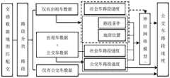
公交路网划分的目的是将在公交速度(或密度)上具有强相似性和高关联度的路段聚类成子区,以便发掘子区交通规律。公交路网划分需满足以下基本要求:(1)同一子区内路段速度(或密度)差异尽量小、不同子区之间的差异尽可能大;(2)在空间上确保子区路网的连通性和紧凑性。为减少分区算法在大规模路网划分时的计算工作量,本文采用初始小区生成、子区合并和边界调整三步法划分公交路网,算法流程如图6所示。The purpose of the bus network division is to cluster the sections with strong similarity and high correlation in bus speed (or density) into sub-districts, so as to discover the traffic laws of the sub-districts. The division of the bus network should meet the following basic requirements: (1) The difference in speed (or density) of the road sections in the same sub-region should be as small as possible, and the difference between different sub-regions should be as large as possible; (2) The road network in the sub-region should be ensured spatially. Connectivity and compactness. In order to reduce the computational workload of the partition algorithm in large-scale road network division, this paper adopts the three-step method of initial cell generation, sub-area merging and boundary adjustment to divide the bus network. The algorithm flow is shown in Figure 6.
进一步的,步骤S102具体包括:Further, step S102 specifically includes:
S1021、根据路网中不同路段的邻接关系以及公交车路段速度,生成初始小区。S1021 , generating an initial cell according to the adjacency relationship of different road sections in the road network and the speed of the bus section.
初始小区由彼此连通且公交车路段速度非常相近的若干路段组成,初始小区生成就是将具有上述特征的路段进行聚类的过程。初始小区的规模一般较小(即初始小区所包含的路段数量不会太多)。本方法采用密度峰值聚类法和区域生长法生成路网初始小区。密度峰值聚类算法可识别出任意形状数据,能直观地找到类数量和类中心,具有较好的鲁棒性;区域生长法可基于邻接关系将初始小区中心周围满足条件的路段聚类到初始小区中,二者结合可很好地满足初始小区生成的要求。生成初始小区的目的是便于以初始小区作为基础单元,进一步对初始小区进行合并,最终形成路网子区。与直接以单个路段为基础单元去划分路网子区相比,可以极大地减少路网分区的计算工作量。The initial cell consists of several road segments that are connected to each other and have very similar bus speeds. The initial cell generation is the process of clustering the road segments with the above characteristics. The scale of the initial cell is generally small (that is, the number of road segments included in the initial cell will not be too many). In this method, the density peak clustering method and the region growing method are used to generate the initial community of the road network. The density peak clustering algorithm can identify data of any shape, can intuitively find the number of classes and class centers, and has good robustness; the region growing method can cluster the road segments that meet the conditions around the center of the initial cell to the initial cluster based on the adjacency relationship. In a cell, the combination of the two can well meet the requirements of initial cell generation. The purpose of generating the initial cell is to further combine the initial cells with the initial cell as a basic unit, and finally form a road network sub-area. Compared with directly dividing the road network sub-areas with a single road segment as the basic unit, the computational workload of road network partitioning can be greatly reduced.
初始小区生成的步骤为:The steps of initial cell generation are:
(1)计算路段局部密度ρi和相对距离δi,如公式(6)-(7)所示:(1) Calculate the local density ρi and relative distance δi of the road section, as shown in formulas (6)-(7):


其中,dij为路段i与j的距离,本实施例从公交车路段速度和路段起始位置两个方面来衡量不同路段间的距离。各路段间的距离可以构成一个距离矩阵,dc为截断距离,本实施例取位于距离矩阵行数2%处的值作为截断距离;I为路段序号集;Ii是I的子集,其由满足Ii={k,k∈I,ρk>ρi}的路段序号组成。Wherein, dij is the distance between road segments i and j. In this embodiment, the distance between different road segments is measured from two aspects of the speed of the bus segment and the starting position of the road segment. The distance between each road segment can form a distance matrix,dc is the cut-off distance, in this embodiment, the value located at 2% of the number of rows of the distance matrix is taken as the cut-off distance; I is the set of road segment serial numbers; Ii is a subset of I, which It consists of road segment numbers satisfying Ii ={k,k∈I,ρk >ρi }.
dij的计算如公式(8)所示:The calculation of dij is shown in formula (8):

其中,vi表示路段i的公交车路段速度经标准化以后的值,Lati和Loni分别表示路段i起始位置的经纬度经标准化以后的值。Among them, vi represents the normalized value of the bus segment speed of the segment i, and Lati and Loni represent the normalized longitude and latitude of the starting position of the segment i respectively.
(2)根据路段局部密度和相对距离,选择初始小区中心。(2) According to the local density and relative distance of the road section, select the initial cell center.
首先,计算路段i与路段j之间相对密度ρ和相对距离δ的曼哈顿距离,如公式(9)所示:First, calculate the Manhattan distance of the relative density ρ and the relative distance δ between road segment i and road segment j, as shown in formula (9):
Mij=|ρi-ρj|+|δi-δj| (9)Mij =|ρi -ρj |+|δi -δj | (9)
式中,Mij为路段i与路段j的曼哈顿距离,||表示取绝对值。In the formula, Mij is the Manhattan distance between road segment i and road segment j, and || represents the absolute value.
然后,计算各路段与其他路段的曼哈顿距离之和
(3)选择任意初始小区中心,识别与该小区相邻的路段;分别计算初始小区加入各邻接路段之后的公交车速度方差和各邻接路段到小区中心的距离,基于TOPSIS算法选取一个最优路段加入初始小区。通过该方式形成初始小区可以降低初始小区内部路段间的公交车路段速度差异,同时保证初始小区的紧凑性和内部的连通性,从而更好地满足路网分区的基本要求。(3) Select any initial cell center, identify the road sections adjacent to the cell; calculate the variance of the bus speed after the initial cell is added to each adjacent road section and the distance from each adjacent road section to the cell center, and select an optimal road section based on the TOPSIS algorithm Join the initial cell. Forming the initial cell in this way can reduce the speed difference between the internal sections of the initial cell and ensure the compactness and internal connectivity of the initial cell, so as to better meet the basic requirements of road network partitioning.
TOPSIS算法如下;The TOPSIS algorithm is as follows;
对每个初始小区n,构建规范决策矩阵如下:For each initial cell n, construct the normative decision matrix as follows:

其中,An矩阵为备选路段集合的规范决策矩阵,

在此基础上,构造加权规范矩阵并计算各备选路段到正理想解和负理想解的距离,如公式(10)、(11)所示:On this basis, construct a weighted norm matrix and calculate the distances from each candidate road segment to the positive ideal solution and the negative ideal solution, as shown in formulas (10) and (11):


其中,aje是加权规范矩阵中的元素,we是属性e的权重,U是备选路段集合中的路段数,


根据各路段的综合评价指标选取最优的路段j*并入初始子区n,j*的选择如公式(12)所示:According to the comprehensive evaluation index of each road section, the optimal road section j* is selected and merged into the initial sub-area n, and the selection of j* is shown in formula (12):

(4)每次选取一条路段加入到小区中,不断迭代直至所有路段全部聚类进入初始小区。初始小区的生成过程可以看成是以小区中心为起点的一个不断生长的过程。(4) Each time a road section is selected to be added to the cell, and iteratively iterates until all the road sections are clustered into the initial cell. The generation process of the initial cell can be regarded as a continuous growing process starting from the center of the cell.
S1022、对初始小区进行合并,得到合并子区。S1022. Merge the initial cells to obtain a merged sub-cell.
根据初始小区划分结果,计算初始小区间的邻接关系,如果初始小区i和初始小区j之间有道路连通,则认为这两个小区相邻。邻接关系可用逻辑变量表示,当两个初始小区相邻时取值为1,否则,取值为0。According to the initial cell division result, the adjacency relationship between the initial cells is calculated. If there is road connection between the initial cell i and the initial cell j, the two cells are considered to be adjacent. The adjacency relationship can be represented by a logical variable, which takes a value of 1 when two initial cells are adjacent, and a value of 0 otherwise.
设定分区数量为P,在保证子区内部连通(即构成子区的初始小区间相互邻接)的前提下,以子区公交车路段速度总方差最小为目标(目标函数如公式(13)所示),寻找初始小区间的最优合并方式。Set the number of partitions as P, and under the premise of ensuring the internal connectivity of the sub-regions (that is, the initial cells that constitute the sub-regions are adjacent to each other), the goal is to minimize the total variance of the speed of the bus sections in the sub-region (the objective function is shown in formula (13). shown) to find the optimal merging mode among the initial cells.

式中,


本实施例采用遗传算法寻求最优子区合并方案,具体过程如下:In this embodiment, the genetic algorithm is used to seek the optimal sub-region merging scheme, and the specific process is as follows:
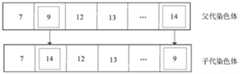
(1)编码规则。染色体为1×N的向量,N为初始小区数量;采用实数进行编码,染色体每个基因位上的数字代表该初始小区被划入的子区,如图7所示。(1) Coding rules. The chromosome is a 1×N vector, where N is the number of initial cells; it is encoded by real numbers, and the number on each locus of the chromosome represents the sub-region into which the initial cell is divided, as shown in Figure 7.
(2)初始化种群。以小区间邻接关系为依据,随机将相邻小区合并为一个子区,生成染色体;对染色体进行合法性检查,只有子区内部连通且每个子区不为空的染色体才能成为合法染色体;重复以上步骤直至生成初始种群。(2) Initialize the population. Based on the adjacency relationship between the cells, the adjacent cells are randomly merged into a sub-region to generate chromosomes; the legality of the chromosomes is checked, only the chromosomes that are connected within the sub-regions and each sub-region is not empty can become legal chromosomes; repeat the above steps until the initial population is generated.
计算染色体的虚拟适应度,在染色体的分区方案下计算得到的公交车路段速度总方差越小则染色体的虚拟适应度越高,虚拟适应度值越高的染色体在种群生存的优势越大。Calculate the virtual fitness of the chromosome. The smaller the total variance of the bus speed calculated under the chromosome partition scheme, the higher the virtual fitness of the chromosome. The higher the virtual fitness value of the chromosome, the greater the advantage of population survival.
(3)采用轮盘赌原则随机选择染色体作为父代染色体,基于子区的邻接关系进行交叉操作,交叉操作规则如下:(3) The roulette principle is used to randomly select the chromosome as the parent chromosome, and perform the crossover operation based on the adjacency relationship of the child regions. The crossover operation rules are as follows:
针对选择出的父代染色体,在可交叉的位置中随机选择两个基因位进行交叉,检查交叉后染色体的合法性(子区内部必须连通)。交叉操作如图8所示,该图表示经过交叉操作以后,第2个初始小区的归属子区由9更改为14,而第N个初始小区的归属子区由14更改为9,当然进行交叉操作后的染色体须满足同一个子区内部连通的要求,只有合法的染色体才能进行下一步遗传操作。For the selected parent chromosome, randomly select two loci in the crossover position for crossover, and check the legitimacy of the chromosome after crossover (the interior of the subregion must be connected). The crossover operation is shown in Figure 8, which shows that after the crossover operation, the home sub-region of the second initial cell is changed from 9 to 14, and the home sub-region of the N-th initial cell is changed from 14 to 9. Of course, the crossover is performed. The manipulated chromosomes must meet the requirements of internal connectivity within the same sub-region, and only legitimate chromosomes can carry out the next step of genetic manipulation.
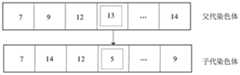
(4)采用轮盘赌原则随机选择一个染色体作为父代染色体,基于子区的邻接关系进行变异操作。随机选择一个染色体,随机选择变异点,对染色体进行变异并检查变异后染色体合法性;重复变异操作,直至变异后的染色体通过合法性检查。变异操作如图9所示,该图表示经过变异操作以后,第4个初始小区的归属子区由13更改为5,同样,进行变异操作后的染色体须满足同一个子区内部连通的要求(即合法性),只有合法的染色体才能进行下一步遗传操作。(4) The roulette principle is used to randomly select a chromosome as the parent chromosome, and the mutation operation is performed based on the adjacency relationship of the child regions. Randomly select a chromosome, randomly select a mutation point, mutate the chromosome and check the legitimacy of the mutated chromosome; repeat the mutation operation until the mutated chromosome passes the legitimacy check. The mutation operation is shown in Figure 9, which shows that after the mutation operation, the attributable sub-region of the fourth initial cell is changed from 13 to 5. Similarly, the chromosomes after the mutation operation must meet the requirements of internal connectivity in the same sub-region (ie Legality), only legal chromosomes can carry out the next step of genetic manipulation.
(5)精英保留策略。(5) Elite retention strategy.
为提高遗传算法的求解效果,采用精英保留策略,即用上一代种群中的最优染色体替代当前种群中的最差染色体。In order to improve the solution effect of the genetic algorithm, an elite retention strategy is adopted, that is, the optimal chromosome in the previous generation population is used to replace the worst chromosome in the current population.
(6)重复执行步骤(3)-(5),直至达到规定的迭代次数(即终止条件),结束计算,得到P个子区的合并结果。(6) Steps (3)-(5) are repeatedly executed until a specified number of iterations (ie, termination conditions) are reached, the calculation is ended, and the combined result of the P sub-regions is obtained.
S1023、对子区的边界进行调整,从而最终实现公交路网分区。S1023: Adjust the boundaries of the sub-areas, so as to finally realize the partition of the bus network.
边界调整的目的是为子区边界上的路段搜寻更适宜的子区,进一步降低公交车路段速度总方差(即公式(10)所示的目标函数)。边界调整的步骤为:The purpose of boundary adjustment is to search for more suitable sub-areas for the road segments on the sub-area boundary, and further reduce the total variance of the bus segment speed (ie, the objective function shown in formula (10)). The steps of boundary adjustment are:
(1)识别位于子区边界且与本子区仅有较少邻接路段的路段;(1) Identify the road segments located at the border of the sub-area and have only a few adjacent road segments with this sub-area;
(2)尝试将该路段划入与其相邻的子区,若该路段划入该相邻子区后,公交路段速度总方差降低,则将该路段调整进入相邻子区;否则,不对该路段进行任何操作。(2) Try to divide the road segment into the adjacent sub-area. If the total variance of the speed of the bus segment decreases after the road segment is divided into the adjacent sub-area, adjust the road segment into the adjacent sub-area; otherwise, do not any action on the road segment.
(3)遍历子区边界上所有符合条件的路段,直至公交路段速度总方差不再下降。(3) Traverse all the road segments that meet the conditions on the boundary of the sub-area until the total variance of the speed of the bus segment no longer decreases.
(4)输出P个子区的划分结果。(4) Output the division results of the P sub-regions.
S103、对公交路网分区得到的子区,根据公交车进出站GPS数据以及路网数据,计算公交车路网交通参数,得到公交路网宏观基本图。S103 , for the sub-areas obtained by partitioning the bus road network, calculate the traffic parameters of the bus road network according to the GPS data of the bus entering and leaving the station and the road network data, and obtain a macroscopic basic diagram of the bus road network.
其中,公交车路网交通参数包括公交路网平均流量、平均密度。Among them, the traffic parameters of the bus network include the average flow and average density of the bus network.
根据如下公式计算出各子区的公交车平均密度和公交车平均流量:Calculate the average density of buses and the average flow of buses in each sub-district according to the following formulas:


其中,k(b)(j,m)为在j路段、m时段的公交车平均密度(veh/km);b代表公交车;t(b)(r,m)和d(b)(r,m)分别为公交车行程r在j路段、m时段的行驶时间(s)和行驶距离(m);T(b)(j,m)和D(b)(j,m)分别为所有公交车在j路段、m时段的总行驶时间和行驶距离;l(j)是j路段的长度(m);τ为交通数据集计时段长度(s);k(b)(m)是子区区域路网按路段长度加权的平均公交车密度;J是子区区域内公交车路段数量;L为子区区域路网内的总车道长度;q(b)(m)是子区区域内公交车平均流量(veh/km);s(j)是j路段的车道数;T(b)(m)和D(b)(m)分别为在j路段、m时段公交车的总行驶时间和总行驶距离。Among them, k(b) (j,m) is the average density of buses (veh/km) in the j road section and m period; b is the bus; t(b) (r,m) and d(b) (r ,m) are the travel time (s) and travel distance (m) of the bus trip r in section j and period m, respectively; T(b) (j,m) and D(b) (j,m) are all The total travel time and travel distance of the bus in the j road section and m period; l(j) is the length of the j road section (m); τ is the length of the traffic data set time period (s); k(b) (m) is the sub-section The average bus density of the regional road network weighted by the length of the section; J is the number of bus sections in the sub-region; L is the total lane length in the sub-regional road network; q(b) (m) is the sub-region Average bus flow (veh/km); s(j) is the number of lanes in section j; T(b) (m) and D(b) (m) are the total travel time of buses in section j and period m, respectively and total driving distance.
本领域技术人员可以理解,实现上述实施例的方法中的全部或部分步骤可以通过程序来指令相关的硬件来完成,相应的程序可以存储于计算机可读存储介质中。Those skilled in the art can understand that all or part of the steps in the method for implementing the above embodiments can be completed by instructing relevant hardware through a program, and the corresponding program can be stored in a computer-readable storage medium.
应当注意,尽管在附图中以特定顺序描述了上述实施例的方法操作,但是这并非要求或者暗示必须按照该特定顺序来执行这些操作,或是必须执行全部所示的操作才能实现期望的结果。相反,描绘的步骤可以改变执行顺序。附加地或备选地,可以省略某些步骤,将多个步骤合并为一个步骤执行,和/或将一个步骤分解为多个步骤执行。It should be noted that although the method operations of the above-described embodiments are depicted in a particular order in the drawings, this does not require or imply that the operations must be performed in that particular order, or that all illustrated operations must be performed to achieve the desired results . Conversely, the depicted steps may change the order of execution. Additionally or alternatively, certain steps may be omitted, multiple steps may be combined to be performed as one step, and/or one step may be decomposed into multiple steps to be performed.
实施例2:Example 2:
本实施例采用深圳市南山区、福田区和罗湖区的公交路网,以及2016年5月24日该区域内的公交车进出站GPS数据和出租车GPS数据进行公交路网划分实验,路网交通参数计算时间间隔为10min,在不同分区数量下分别进行30次划分实验。In this embodiment, the bus network of Nanshan District, Futian District and Luohu District of Shenzhen City, as well as the GPS data of buses entering and leaving the station and the GPS data of taxis in this area on May 24, 2016, are used for the bus network division experiment. The time interval for calculating traffic parameters is 10 minutes, and 30 division experiments are carried out under different numbers of divisions.
以子区均质度(ASV)和子区间相似性(NSK)为评价指标,其计算公式如下所示:The sub-region homogeneity (ASV) and sub-region similarity (NSK ) are used as evaluation indicators, and the calculation formula is as follows:


其中,k,kn为不同子区,Neighbor(k)为与子区k相邻的子区;size[Neighbor(k)]为与子区k相邻的子区数量;vi为路段i的公交路段速度;Nk是子区k的路段数;K是子区数量;Var(vk)是子区k的公交路段速度方差;u(vk)、
子区均质度以所有子区的子区内公交车路段速度方差均值来表示,数值越小说明子区内部同质性越高,越能满足公交路网划分的要求;子区间相似性反映子区与其相邻子区间的相似程度,数值越小,说明子区与其相邻子区的差异越大,越能满足路网划分中对子区间差异的要求。The degree of homogeneity of sub-districts is represented by the mean value of the speed variance of the bus sections in all sub-districts. The degree of similarity between a sub-area and its adjacent sub-areas, the smaller the value, the greater the difference between the sub-area and its adjacent sub-areas, and the better it can meet the requirements of sub-area differences in road network division.
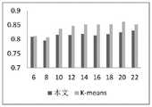
分区实验后,计算ASV和NSK均值,结果如表1所示。在分区数量P为16时,实际分区效果如图10所示。After the partition experiment, the ASV andNSK mean values were calculated, and the results are shown in Table 1. When the number of partitions P is 16, the actual partition effect is shown in Figure 10.
表1各分区数量下的评价指标值(这个表的行数调整了一下)Table 1 Evaluation index values under the number of partitions (the number of rows in this table has been adjusted)

与采用K-means方法进行公交路网分区相比,采用本发明所得到的ASV和NSK更优,如图11所示。这说明本发明能获得子区内部均质度更高且子区间差异更明显的分区方案;加之,本发明的分区方法保证了子区内部的连通性和紧凑性,故认为本发明提供的方法能够很好地满足公交路网划分的要求。Compared with using theK -means method to partition the bus network, the ASV and NSK obtained by using the present invention are better, as shown in FIG. 11 . This shows that the present invention can obtain a partition scheme with higher homogeneity in the sub-regions and more obvious differences in the sub-regions; in addition, the partition method of the present invention ensures the connectivity and compactness of the sub-regions, so it is considered that the method provided by the present invention It can well meet the requirements of bus network division.
与多模式交通路网分区方式相比,本发明提供的方法所得到的ASV和NSK明显更优,如图12所示,说明本发明方法能够更好地进行公交路网分区,从而更好的识别公交路网运行规律。Compared with the multi-mode traffic road network partitioning method, theASV and NSK obtained by the method provided by the present invention are obviously better, as shown in FIG. The identification of public transport network operation rules.
本发明提供的方法可有效识别公交路网宏观基本图(公交路网运行规律),利用深圳市同区域2016年5月24日-26日的公交车进出站GPS数据、出租车GPS数据以及路网数据等计算公交路网交通参数,以16子区为例,可识别出子区公交平均流量(以每公里计)-密度关系,如图13所示。The method provided by the present invention can effectively identify the macroscopic basic map of the bus road network (the operation rule of the bus road network), and use the GPS data of bus entry and exit from May 24 to 26, 2016 in the same area of Shenzhen, taxi GPS data and road Network data, etc. to calculate the traffic parameters of the bus network. Taking 16 sub-districts as an example, the relationship between the average bus flow (per kilometer) and the density of the sub-districts can be identified, as shown in Figure 13.
采用二次多项式函数对各子区宏观基本图进行拟合,在95%置信区间下,平均拟合优度R2为0.8853,均方根误差均值为0.1238;而多模式交通路网分区后,对其观测到的公交宏观基本图进行拟合,平均拟合优度R2为0.8585,均方根误差均值为0.1338。通过对比可知,与多模式交通路网分区相比,通过本发明进行公交路网分区后,可以观测到拟合优度较好地宏观基本图,这为将公交路网宏观基本图应用于公交管理和控制提供了良好的基础。A quadratic polynomial function is used to fit the macroscopic basic map of each sub-region. Under the 95% confidence interval, the average goodness of fit R2 is 0.8853, and the mean root mean square error is 0.1238; Fitting the observed macro basic map of public transport, the average goodness of fit R2 is 0.8585, and the mean root mean square error is 0.1338. It can be seen from the comparison that, compared with the multi-mode traffic road network partitioning, after the public transportation road network partitioning is carried out by the present invention, a macroscopic basic map with better goodness of fit can be observed. Management and control provide a good foundation.
实施例3:Example 3:
如图14所示,本实施例提供了一种基于多源交通数据的公交路网分区系统,该系统包括公交车路段速度计算模块1401、公交路网分区模块1402和公交路网宏观基本图生成模块1403,其中:As shown in FIG. 14 , this embodiment provides a bus road network partition system based on multi-source traffic data. The system includes a bus road segment
公交车路段速度计算模块1401,用于在研究区域内,根据出租车GPS数据和公交车进出站GPS数据,计算公交车路段速度;其中包括对仅有出租车数据的路段,采用神经网络模型预测公交车路段速度;The bus section
公交路网分区模块1402,用于根据所述公交车路段速度和路段邻接关系,实现公交路网分区;The bus road
公交路网宏观基本图生成模块1403,用于对公交路网分区得到的子区,根据公交车进出站GPS数据以及路网数据,计算公交车路网交通参数,从而得到公交路网宏观基本图。The macro basic map generation module 1403 of the bus road network is used to divide the sub-areas obtained by the bus road network, and calculate the traffic parameters of the bus road network according to the GPS data of the bus entering and leaving the station and the road network data, so as to obtain the macro basic map of the bus road network. .
本实施例中各个模块的具体实现可以参见上述实施例1,在此不再一一赘述;需要说明的是,本实施例提供的系统仅以上述各功能模块的划分进行举例说明,在实际应用中,可以根据需要而将上述功能分配由不同的功能模块完成,即将内部结构划分成不同的功能模块,以完成以上描述的全部或者部分功能。For the specific implementation of each module in this embodiment, reference may be made to the above-mentioned
实施例4:Example 4:
本实施例提供了一种计算机设备,该计算机设备可以为计算机,如图15所示,其通过系统总线1501连接的处理器1502、存储器、输入系统1503、显示器1504和网络接口1505,该处理器用于提供计算和控制能力,该存储器包括非易失性存储介质1506和内存储器1507,该非易失性存储介质1506存储有操作系统、计算机程序和数据库,该内存储器1507为非易失性存储介质中的操作系统和计算机程序的运行提供环境,处理器1502执行存储器存储的计算机程序时,实现上述实施例1的公交路网分区方法,如下:This embodiment provides a computer device, which can be a computer. As shown in FIG. 15 , the
在研究区域内,根据出租车GPS数据和公交车进出站GPS数据,计算公交车路段速度;其中包括对仅有出租车数据的路段,采用神经网络模型预测公交车路段速度;In the study area, the speed of the bus section is calculated according to the GPS data of taxis and the GPS data of the bus entering and leaving the station; including the section with only taxi data, the neural network model is used to predict the speed of the bus section;
根据所述公交车路段速度和路段邻接关系,实现公交路网分区;According to the speed of the bus section and the adjacent relationship of the section, the bus network partition is realized;
对公交路网分区得到的子区,根据公交车进出站GPS数据以及路网数据,计算公交车路网交通参数,从而得到公交路网宏观基本图。For the sub-districts obtained by partitioning the bus network, calculate the traffic parameters of the bus network according to the GPS data of the bus entering and leaving the station and the road network data, so as to obtain the macro basic map of the bus network.
实施例5:Example 5:
本实施例提供了一种存储介质,该存储介质为计算机可读存储介质,其存储有计算机程序,所述计算机程序被处理器执行时,实现上述实施例1的公交路网分区方法,如下:This embodiment provides a storage medium, where the storage medium is a computer-readable storage medium, and stores a computer program. When the computer program is executed by a processor, the method for partitioning a public transport network in the above-mentioned
在研究区域内,根据出租车GPS数据和公交车进出站GPS数据,计算公交车路段速度;其中包括对仅有出租车数据的路段,采用神经网络模型预测公交车路段速度;In the study area, the speed of the bus section is calculated according to the GPS data of taxis and the GPS data of the bus entering and leaving the station; including the section with only taxi data, the neural network model is used to predict the speed of the bus section;
根据所述公交车路段速度和路段邻接关系,实现公交路网分区;According to the speed of the bus section and the adjacent relationship of the section, the bus network partition is realized;
对公交路网分区得到的子区,根据公交车进出站GPS数据以及路网数据,计算公交车路网交通参数,从而得到公交路网宏观基本图。For the sub-districts obtained by partitioning the bus network, calculate the traffic parameters of the bus network according to the GPS data of the bus entering and leaving the station and the road network data, so as to obtain the macro basic map of the bus network.
综上所述,本发明通过融合实际路网中的公交车进出站GPS数据、出租车GPS数据以及道路结构数据等进行路网交通参数计算;采用神经网络模型对数据缺失路段进行公交路段速度补齐;以公交车路段速度和路段邻接关系为依据,采用初始小区生成、子区合并和边界调整三步法将异质公交路网划分为子区内部速度均匀、子区间速度差异显著的多个子区,从而为识别公交路网运行规律奠定基础,并为公交资源优化配置提供决策依据。To sum up, the present invention calculates the traffic parameters of the road network by integrating the GPS data of bus entering and leaving stations, the GPS data of taxis, and the road structure data in the actual road network; the neural network model is used to perform the speed compensation of the bus section for the data-missing sections. Based on the speed of the bus section and the adjacency relationship between the sections, the heterogeneous bus network is divided into multiple sub-regions with uniform speed within the sub-region and significant differences in speed between the sub-regions using the three-step method of initial cell generation, sub-region merging and boundary adjustment. District, thus laying a foundation for identifying the operation law of the public transport network, and providing a decision-making basis for the optimal allocation of public transport resources.
需要说明的是,本实施例的计算机可读存储介质可以是计算机可读信号介质或者计算机可读存储介质或者是上述两者的任意组合。计算机可读存储介质例如可以是但不限于电、磁、光、电磁、红外线、或半导体的系统、系统或器件,或者任意以上的组合。计算机可读存储介质的更具体的例子可以包括但不限于:具有一个或多个导线的电连接、便携式计算机磁盘、硬盘、随机访问存储器(RAM)、只读存储器(ROM)、可擦式可编程只读存储器(EPROM或闪存)、光纤、便携式紧凑磁盘只读存储器(CD-ROM)、光存储器件、磁存储器件、或者上述的任意合适的组合。It should be noted that the computer-readable storage medium in this embodiment may be a computer-readable signal medium or a computer-readable storage medium, or any combination of the above two. The computer-readable storage medium may be, for example, but not limited to, an electrical, magnetic, optical, electromagnetic, infrared, or semiconductor system, system or device, or a combination of any of the above. More specific examples of computer readable storage media may include, but are not limited to, electrical connections with one or more wires, portable computer disks, hard disks, random access memory (RAM), read only memory (ROM), erasable Programmable read only memory (EPROM or flash memory), fiber optics, portable compact disk read only memory (CD-ROM), optical storage devices, magnetic storage devices, or any suitable combination of the foregoing.
综上所述,本发明以公交路网划分为研究对象,融合实际路网中的公交车进出站GPS数据、出租车GPS数据以及道路结构数据,提出了采用神经网络预测模型对数据缺失路段进行公交路段速度补齐,然后以公交车路段速度及路段邻接关系为依据对公交路网进行划分,并且采用密度峰值聚类法确定初始小区中心,然后将速度相近的相邻路段聚类形成初始小区,有利于降低初始子区内的公交路段速度方差,经过后续的子区合并和边界调整后,可得到子区内部速度更均匀、子区间差异更明显的公交路网划分结果,从而提高公交路网划分质量。本发明提供的方法可将异质公交路网进行同质性划分,为识别公交运行规律奠定基础。To sum up, the present invention divides the bus network as the research object, integrates the GPS data of bus entry and exit, taxi GPS data and road structure data in the actual road network, and proposes a neural network prediction model for data missing road sections. The speed of the bus section is supplemented, and then the bus network is divided according to the speed of the bus section and the adjacent relationship between the sections, and the density peak clustering method is used to determine the initial cell center, and then the adjacent sections with similar speeds are clustered to form the initial cell. , which is beneficial to reduce the variance of the speed of the bus sections in the initial sub-region. After the subsequent sub-region merging and boundary adjustment, the bus network division results with more uniform speed within the sub-region and more obvious sub-region differences can be obtained, thereby improving the bus speed. Networking quality. The method provided by the invention can divide the heterogeneous public transport network by homogeneity, and lay a foundation for identifying the public transport operation law.
以上所述,仅为本发明专利较佳的实施例,但本发明专利的保护范围并不局限于此,任何熟悉本技术领域的技术人员在本发明专利所公开的范围内,根据本发明专利的技术方案及其发明构思加以等同替换或改变,都属于本发明专利的保护范围。The above is only a preferred embodiment of the patent of the present invention, but the protection scope of the patent of the present invention is not limited to this. The technical solution and the inventive concept of the invention are equivalently replaced or changed, all belong to the protection scope of the patent of the present invention.
Claims (10)
Translated fromChinesePriority Applications (1)
| Application Number | Priority Date | Filing Date | Title |
|---|---|---|---|
| CN202111671486.8ACN114358416B (en) | 2021-12-31 | 2021-12-31 | Public road network partitioning method, system, equipment and medium based on multi-source traffic data |
Applications Claiming Priority (1)
| Application Number | Priority Date | Filing Date | Title |
|---|---|---|---|
| CN202111671486.8ACN114358416B (en) | 2021-12-31 | 2021-12-31 | Public road network partitioning method, system, equipment and medium based on multi-source traffic data |
Publications (2)
| Publication Number | Publication Date |
|---|---|
| CN114358416Atrue CN114358416A (en) | 2022-04-15 |
| CN114358416B CN114358416B (en) | 2024-09-06 |
Family
ID=81105016
Family Applications (1)
| Application Number | Title | Priority Date | Filing Date |
|---|---|---|---|
| CN202111671486.8AActiveCN114358416B (en) | 2021-12-31 | 2021-12-31 | Public road network partitioning method, system, equipment and medium based on multi-source traffic data |
Country Status (1)
| Country | Link |
|---|---|
| CN (1) | CN114358416B (en) |
Citations (10)
| Publication number | Priority date | Publication date | Assignee | Title |
|---|---|---|---|---|
| CN104318766A (en)* | 2014-10-22 | 2015-01-28 | 北京建筑大学 | Bus GPS track data road network matching method |
| CN107403550A (en)* | 2016-05-20 | 2017-11-28 | 高德信息技术有限公司 | Transit network collecting method, device and terminal device |
| CN108364465A (en)* | 2018-02-09 | 2018-08-03 | 太原理工大学 | The method for dynamically partitioning of city road network control work zone based on macroscopical parent map |
| CN109272746A (en)* | 2018-08-20 | 2019-01-25 | 广东交通职业技术学院 | A kind of MFD estimating and measuring method based on BP neural network data fusion |
| CN109308805A (en)* | 2018-08-20 | 2019-02-05 | 广东交通职业技术学院 | A kind of road network MFD estimating and measuring method based on self-adaptive weighted average data fusion |
| CN109816984A (en)* | 2019-03-19 | 2019-05-28 | 太原理工大学 | A traffic road network area division and dynamic adjustment method |
| CN110363990A (en)* | 2019-07-15 | 2019-10-22 | 广东工业大学 | A method, system and device for obtaining public transport smooth flow index |
| CN111160465A (en)* | 2019-12-30 | 2020-05-15 | 广东工业大学 | Multi-mode traffic network partitioning method oriented to macroscopic basic graph |
| CN111753030A (en)* | 2019-03-28 | 2020-10-09 | 北京交研智慧科技有限公司 | Method and device for constructing joint topology of public traffic network and road network and upper computer |
| CN113326972A (en)* | 2021-05-06 | 2021-08-31 | 大连海事大学 | Method for predicting short-time speed of bus lane based on real-time bus speed statistical data |
- 2021
- 2021-12-31CNCN202111671486.8Apatent/CN114358416B/enactiveActive
Patent Citations (10)
| Publication number | Priority date | Publication date | Assignee | Title |
|---|---|---|---|---|
| CN104318766A (en)* | 2014-10-22 | 2015-01-28 | 北京建筑大学 | Bus GPS track data road network matching method |
| CN107403550A (en)* | 2016-05-20 | 2017-11-28 | 高德信息技术有限公司 | Transit network collecting method, device and terminal device |
| CN108364465A (en)* | 2018-02-09 | 2018-08-03 | 太原理工大学 | The method for dynamically partitioning of city road network control work zone based on macroscopical parent map |
| CN109272746A (en)* | 2018-08-20 | 2019-01-25 | 广东交通职业技术学院 | A kind of MFD estimating and measuring method based on BP neural network data fusion |
| CN109308805A (en)* | 2018-08-20 | 2019-02-05 | 广东交通职业技术学院 | A kind of road network MFD estimating and measuring method based on self-adaptive weighted average data fusion |
| CN109816984A (en)* | 2019-03-19 | 2019-05-28 | 太原理工大学 | A traffic road network area division and dynamic adjustment method |
| CN111753030A (en)* | 2019-03-28 | 2020-10-09 | 北京交研智慧科技有限公司 | Method and device for constructing joint topology of public traffic network and road network and upper computer |
| CN110363990A (en)* | 2019-07-15 | 2019-10-22 | 广东工业大学 | A method, system and device for obtaining public transport smooth flow index |
| CN111160465A (en)* | 2019-12-30 | 2020-05-15 | 广东工业大学 | Multi-mode traffic network partitioning method oriented to macroscopic basic graph |
| CN113326972A (en)* | 2021-05-06 | 2021-08-31 | 大连海事大学 | Method for predicting short-time speed of bus lane based on real-time bus speed statistical data |
Also Published As
| Publication number | Publication date |
|---|---|
| CN114358416B (en) | 2024-09-06 |
Similar Documents
| Publication | Publication Date | Title |
|---|---|---|
| CN110298500B (en) | Urban traffic track data set generation method based on taxi data and urban road network | |
| CN115063184B (en) | Electric vehicle charging demand modeling method, system, medium, equipment and terminal | |
| CN110836675B (en) | Decision tree-based automatic driving search decision method | |
| Hu et al. | Optimization design of electric vehicle charging stations based on the forecasting data with service balance consideration | |
| WO2017028333A1 (en) | Planning method for highway electric vehicle fast charging stations | |
| CN110288212A (en) | Site selection method for new charging stations for electric taxis based on improved MOPSO | |
| Chen et al. | A convolutional neural network-based driving cycle prediction method for plug-in hybrid electric vehicles with bus route | |
| CN110807552A (en) | A construction method of urban electric bus driving conditions based on improved K-means | |
| Su et al. | Forecast of electric vehicle charging demand based on traffic flow model and optimal path planning | |
| CN117350519A (en) | Charging station planning method and system based on new energy passenger vehicle charging demand prediction | |
| CN114492919A (en) | A system and method for predicting electric vehicle charging load based on traffic flow | |
| Shen et al. | Prediction of entering percentage into expressway service areas based on wavelet neural networks and genetic algorithms | |
| Liu et al. | A distributed Markovian parking assist system | |
| CN111861527A (en) | A method, device and storage medium for determining an electric vehicle charging station | |
| CN113343358B (en) | Electric vehicle charging load space-time distribution modeling method considering road information | |
| CN114169608A (en) | Vehicle dynamic ride sharing matching method, system, medium, equipment and terminal | |
| CN113268709B (en) | Urban electric vehicle charging demand prediction method and system based on intelligent agent simulation | |
| Duan et al. | Planning of plug‐in electric vehicle fast‐charging stations considering charging queuing impacts | |
| Qin et al. | Analysis on cruising process for on‐street parking using an spectral clustering method | |
| Li et al. | A vehicle path planning and prediction algorithm based on attention mechanism for complex traffic intersection collaboration in intelligent transportation | |
| CN112036602A (en) | A 5G electric vehicle charging prediction method and system integrating human-machine intelligence | |
| Liu et al. | Random Scenario-Based Dynamic Location Optimization for EV Fast-Charging Station | |
| CN114638434A (en) | Method, device and computer storage medium for station optimization in variable transit area | |
| CN114358416B (en) | Public road network partitioning method, system, equipment and medium based on multi-source traffic data | |
| Pang et al. | Transit route planning for megacities based on demand density of complex networks |
Legal Events
| Date | Code | Title | Description |
|---|---|---|---|
| PB01 | Publication | ||
| PB01 | Publication | ||
| SE01 | Entry into force of request for substantive examination | ||
| SE01 | Entry into force of request for substantive examination | ||
| GR01 | Patent grant | ||
| GR01 | Patent grant |