CN114323014A - Indoor and outdoor integrated navigation method, electronic equipment, storage medium, program product and system - Google Patents
Indoor and outdoor integrated navigation method, electronic equipment, storage medium, program product and systemDownload PDFInfo
- Publication number
- CN114323014A CN114323014ACN202111087214.3ACN202111087214ACN114323014ACN 114323014 ACN114323014 ACN 114323014ACN 202111087214 ACN202111087214 ACN 202111087214ACN 114323014 ACN114323014 ACN 114323014A
- Authority
- CN
- China
- Prior art keywords
- positioning
- indoor
- uwb
- module
- bds
- Prior art date
- Legal status (The legal status is an assumption and is not a legal conclusion. Google has not performed a legal analysis and makes no representation as to the accuracy of the status listed.)
- Pending
Links
Images


Landscapes
- Position Fixing By Use Of Radio Waves (AREA)
Abstract
Description
Translated fromChinese技术领域technical field
本发明涉及组合定位技术领域,尤其涉及一种室内外组合导航方法、电子设备、存储介质、程序产品及系统。The present invention relates to the technical field of combined positioning, in particular to an indoor and outdoor combined navigation method, electronic device, storage medium, program product and system.
背景技术Background technique
目前,定位技术主要有GNSS定位、基站定位、UWB定位、蓝牙定位、WIFI定位、地磁定位。每种定位技术的定位精度各有不同,其中GNSS定位和UWB定位精度高,5G基站定位精度次之,都适用于高精度应用场景。每种定位技术应用场景各不相同,GNSS定位主要适用户外遮挡不严重场景,不适用于室内,该技术成熟且成本较低,实现简单,UWB定位技术适用于室内定位,由于需要布设基站,实施相对复杂,基站成本高,不利于大面积部署。目前多数产品都仅具备其中一种导航能力,不适用室内外一体应用场景。故对于室内外同时要求高精度定位的场所,如电力场所,需要研究一种室内外组合导航方法。目前组合导航算法采用最多的是UWB定位和北斗(BDS)定位组合导航算法,这种组合导航算法最大的难点是何时何地由北斗(BDS)定位切换为UWB定位,并且切换区域的精度、准确性和实时性偏低。At present, the positioning technologies mainly include GNSS positioning, base station positioning, UWB positioning, Bluetooth positioning, WIFI positioning, and geomagnetic positioning. The positioning accuracy of each positioning technology is different. Among them, GNSS positioning and UWB positioning have high positioning accuracy, followed by 5G base station positioning accuracy, which are suitable for high-precision application scenarios. The application scenarios of each positioning technology are different. GNSS positioning is mainly suitable for outdoor scenes with no serious occlusion, and is not suitable for indoor use. This technology is mature, low-cost, and simple to implement. UWB positioning technology is suitable for indoor positioning. Due to the need to deploy base stations, implementation It is relatively complex, and the base station cost is high, which is not conducive to large-scale deployment. At present, most products only have one of the navigation capabilities, and are not suitable for indoor and outdoor integrated application scenarios. Therefore, for indoor and outdoor places that require high-precision positioning at the same time, such as electric places, it is necessary to study an indoor and outdoor combined navigation method. At present, the most used integrated navigation algorithms are UWB positioning and Beidou (BDS) positioning. Accuracy and real-time performance are low.
发明内容SUMMARY OF THE INVENTION
为了克服现有技术的不足,本发明的目的在于提供一种室内外组合导航方法,解决了定位技术切换问题,并提高了切换区域的精度、准确性和实时性。In order to overcome the deficiencies of the prior art, the purpose of the present invention is to provide an indoor and outdoor combined navigation method, which solves the problem of positioning technology switching and improves the precision, accuracy and real-time performance of the switching area.
本发明提供一种室内外组合导航方法,包括以下步骤:The present invention provides an indoor and outdoor combined navigation method, comprising the following steps:
设置卫星截止高度角,通过5G手持终端软件设置BDS高精度模块的卫星截止高度角;Set the satellite cut-off altitude angle, and set the satellite cut-off altitude angle of the BDS high-precision module through the 5G handheld terminal software;
参数监测,实时监测卫星数量和信号载噪比平均值,通过所述卫星数量和所述信号载噪比平均值判断设备有无单点定位;Parameter monitoring, real-time monitoring of the number of satellites and the average value of the signal carrier-to-noise ratio, to determine whether the device has single-point positioning by the number of satellites and the average value of the signal carrier-to-noise ratio;
切换定位,若判定设备无单点定位,且监测到室内有UWB信号,则将BDS定位切换为UWB定位;若判定设备有单点定位,且监测到室内无UWB信号,则将UWB定位切换为BDS定位。Switch positioning, if it is determined that the device has no single-point positioning and UWB signals are detected indoors, then the BDS positioning is switched to UWB positioning; if it is determined that the device has single-point positioning and no UWB signals are detected indoors, the UWB positioning is switched to BDS positioning.
进一步地,所述卫星截止高度角为15°~30°。Further, the cut-off altitude angle of the satellite is 15°˜30°.
进一步地,所述参数监测步骤中,若所述卫星数量≥4颗,所述信号载噪比平均值≥35dB,则判定设备有单点定位;若所述卫星数量≤3颗,所述信号载噪比平均值≤34dB,则判定设备无单点定位。Further, in the parameter monitoring step, if the number of satellites ≥ 4 and the average value of the signal carrier-to-noise ratio ≥ 35dB, it is determined that the device has single-point positioning; if the number of satellites ≤ 3, the signal If the average carrier-to-noise ratio is less than or equal to 34dB, it is determined that the device has no single-point positioning.
一种电子设备,包括:处理器;An electronic device, comprising: a processor;
存储器;以及程序,其中所述程序被存储在所述存储器中,并且被配置成由处理器执行,所述程序包括用于执行一种室内外组合导航方法。a memory; and a program, wherein the program is stored in the memory and configured to be executed by a processor, the program comprising for performing an indoor and outdoor integrated navigation method.
一种计算机可读存储介质,其上存储有计算机程序,所述计算机程序被处理器执行一种室内外组合导航方法。A computer-readable storage medium on which a computer program is stored, the computer program being executed by a processor for an indoor and outdoor integrated navigation method.
一种计算机程序产品,包括计算机程序/指令,该计算机程序/指令被处理器执行时实现一种室内外组合导航方法。A computer program product includes computer programs/instructions that, when executed by a processor, implement an indoor and outdoor integrated navigation method.
一种室内外组合导航系统,包括集成UWB定位模块、BDS高精度模块、5G功能模块的手持终端、定位引擎服务器、室内外组合导航模块,所述室内外组合导航模块用于实施一种室内外组合导航方法,所述UWB定位模块用于室内定位,所述BDS高精度模块通过载波相位差分GNSS技术实时高精度定位,所述5G功能模块用于提供网络环境,所述UWB定位模块的定位标签利用UWB脉冲信号发射位置数据,UWB基站的接收机接收并放大所述位置数据,经同步分配器校准接收机时钟,计算出定位标签信号到达不同接收机的时间差,所述定位引擎服务器采用时间差定位算法对标签位置进行解算,将解算结果传输到信息处理平台,获取区域内人员的位置信息、时间信息、轨迹信息。An indoor and outdoor combined navigation system, comprising a handheld terminal integrating a UWB positioning module, a BDS high-precision module, a 5G functional module, a positioning engine server, and an indoor and outdoor combined navigation module, the indoor and outdoor combined navigation module is used to implement an indoor and outdoor combined navigation module. The integrated navigation method, the UWB positioning module is used for indoor positioning, the BDS high-precision module is used for real-time high-precision positioning through carrier phase difference GNSS technology, the 5G function module is used to provide a network environment, and the positioning label of the UWB positioning module UWB pulse signal is used to transmit the position data, the receiver of the UWB base station receives and amplifies the position data, calibrates the receiver clock through the synchronization distributor, and calculates the time difference between the positioning tag signal reaching different receivers, and the positioning engine server adopts the time difference positioning The algorithm calculates the position of the tag, and transmits the calculation result to the information processing platform to obtain the position information, time information, and trajectory information of the people in the area.
进一步地,所述BDS高精度模块通过差分改正与载波相位测距两种测量方法进行动态定位。Further, the BDS high-precision module performs dynamic positioning through two measurement methods, differential correction and carrier phase ranging.
进一步地,所述BDS高精度模块利用基准站和流动站的空间相关性进行差分改正,将基准站和移动站之间的差分改正数据通过5G网络传输。Further, the BDS high-precision module uses the spatial correlation between the base station and the rover to perform differential correction, and transmits the differential correction data between the base station and the mobile station through the 5G network.
进一步地,所述BDS高精度模块通过差分改正与载波相位测距两种测量方法进行动态定位的精度达到厘米级。Further, the precision of the dynamic positioning performed by the BDS high-precision module through differential correction and carrier phase ranging can reach centimeter-level accuracy.
相比现有技术,本发明的有益效果在于:Compared with the prior art, the beneficial effects of the present invention are:
本发明提供一种室内外组合导航方法,包括以下步骤:设置卫星截止高度角,通过5G手持终端软件设置BDS高精度模块的卫星截止高度角;参数监测,实时监测卫星数量和信号载噪比平均值,通过卫星数量和信号载噪比平均值判断设备有无单点定位;切换定位,若判定设备无单点定位,且监测到室内有UWB信号,则将BDS定位切换为UWB定位;若判定设备有单点定位,且监测到室内无UWB信号,则将UWB定位切换为BDS定位。本发明涉及一种电子设备、存储介质和程序产品。本发明还涉及一种室内外组合导航系统。本发明融合UWB、北斗(BDS)定位两种数据源的组合导航算法,很好地解决了现有组合导航算法中定位技术切换不明确的问题,并提高了切换区域的精度、准确性和实时性。The invention provides an indoor and outdoor combined navigation method, comprising the following steps: setting a satellite cut-off altitude angle, setting the satellite cut-off altitude angle of a BDS high-precision module through 5G handheld terminal software; parameter monitoring, real-time monitoring of the number of satellites and the average signal carrier-to-noise ratio value, determine whether the device has single-point positioning by the number of satellites and the average value of signal carrier-to-noise ratio; switch positioning, if it is determined that the device has no single-point positioning and UWB signals are detected indoors, then switch BDS positioning to UWB positioning; If the device has single-point positioning and no UWB signal is detected indoors, switch the UWB positioning to BDS positioning. The present invention relates to an electronic device, a storage medium and a program product. The invention also relates to an indoor and outdoor combined navigation system. The present invention integrates the combined navigation algorithm of UWB and Beidou (BDS) positioning data sources, which well solves the problem of unclear positioning technology switching in the existing combined navigation algorithm, and improves the precision, accuracy and real-time switching area. sex.
上述说明仅是本发明技术方案的概述,为了能够更清楚了解本发明的技术手段,并可依照说明书的内容予以实施,以下以本发明的较佳实施例并配合附图详细说明如后。本发明的具体实施方式由以下实施例及其附图详细给出。The above description is only an overview of the technical solution of the present invention. In order to understand the technical means of the present invention more clearly, and implement it according to the content of the description, the preferred embodiments of the present invention are described in detail below with the accompanying drawings. Specific embodiments of the present invention are given in detail by the following examples and the accompanying drawings.
附图说明Description of drawings
此处所说明的附图用来提供对本发明的进一步理解,构成本申请的一部分,本发明的示意性实施例及其说明用于解释本发明,并不构成对本发明的不当限定。在附图中:The accompanying drawings described herein are used to provide a further understanding of the present invention and constitute a part of the present application. The exemplary embodiments of the present invention and their descriptions are used to explain the present invention and do not constitute an improper limitation of the present invention. In the attached image:
图1为本发明的一种室内外组合导航方法流程图;Fig. 1 is a flow chart of an indoor and outdoor combined navigation method of the present invention;
图2为本发明实施例的UWB定位流程图;Fig. 2 is the UWB positioning flow chart of the embodiment of the present invention;
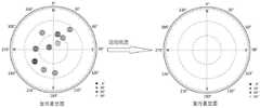
图3为本发明实施例的星空图;3 is a star chart of an embodiment of the present invention;
图4为本发明实施例的室外星空图和室内星空图示意图。FIG. 4 is a schematic diagram of an outdoor starry sky map and an indoor starry sky map according to an embodiment of the present invention.
具体实施方式Detailed ways
下面,结合附图以及具体实施方式,对本发明做进一步描述,需要说明的是,在不相冲突的前提下,以下描述的各实施例之间或各技术特征之间可以任意组合形成新的实施例。The present invention will be further described below with reference to the accompanying drawings and specific embodiments. It should be noted that, on the premise of no conflict, the embodiments or technical features described below can be combined arbitrarily to form new embodiments. .
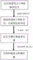
一种室内外组合导航方法,如图1所示,包括以下步骤:An indoor and outdoor combined navigation method, as shown in Figure 1, includes the following steps:
设置卫星截止高度角,通过5G手持终端软件设置BDS(BeiDouNavigationSatellite System,简称BDS,北斗卫星导航系统)高精度模块的卫星截止高度角。图3为卫星的方位角和俯仰角在圆面上的投影,方位角为0°~360°,以正北为0度方向。俯仰角为0°~90°,从外向内分别是0°、30°、60°、90°,俯仰角是卫星从大地切面到天顶的角度。所以方位角决定了卫星在圆面的角度,俯仰角决定了卫星在半径的位置。优选的,卫星截止高度角为15°~30°。本实施例中,将卫星截止高度角设置为30°,保证手持终端≤30°的卫星无法接收,仅仅接收大于30°的卫星。Set the satellite cut-off altitude angle, and set the satellite cut-off altitude angle of the BDS (BeiDou Navigation Satellite System, BDS for short, Beidou Satellite Navigation System) high-precision module through the 5G handheld terminal software. Figure 3 shows the projection of the azimuth and elevation angles of the satellite on the circular surface. The azimuth angle is 0° to 360°, and the true north is the direction of 0°. The pitch angle is from 0° to 90°, from outside to inside, it is 0°, 30°, 60°, and 90°, respectively. The pitch angle is the angle of the satellite from the earth section to the zenith. So the azimuth angle determines the angle of the satellite on the circular surface, and the pitch angle determines the position of the satellite in the radius. Preferably, the cut-off altitude angle of the satellite is 15°˜30°. In this embodiment, the cut-off altitude angle of the satellite is set to 30°, to ensure that the handheld terminal cannot receive the satellites of ≤30°, and only receive the satellites greater than 30°.
参数监测,实时监测卫星数量和信号载噪比平均值,通过卫星数量和信号载噪比平均值判断设备有无单点定位;Parameter monitoring, real-time monitoring of the number of satellites and the average signal carrier-to-noise ratio, to determine whether the device has single-point positioning through the number of satellites and the average signal-to-noise ratio;
切换定位,若判定设备无单点定位,且监测到室内有UWB(Ultra Wide Band,UWB,超宽带)信号,则将BDS定位切换为UWB定位;若判定设备有单点定位,且监测到室内无UWB信号,则将UWB定位切换为BDS定位。Switch positioning. If it is determined that the device has no single-point positioning and UWB (Ultra Wide Band, UWB, ultra-wideband) signals are detected indoors, the BDS positioning will be switched to UWB positioning; if it is determined that the device has single-point positioning, and the indoor monitoring is performed. If there is no UWB signal, switch from UWB positioning to BDS positioning.
如图3所示,手持终端在室外无遮挡时,卫星收星良好,卫星数量≥4颗,信号载噪比平均值S/N≥35dB以上,单点定位。当终端逐渐向室内运动时,终端卫星收星数量≤3颗,信号载噪比平均值S/N≤34dB,设备无单点定位,如图4所示,且终端监测到室内UWB信号,终端将BDS定位切换为UWB定位,反之由UWB信号切换为BDS定位。As shown in Figure 3, when the handheld terminal is not blocked outdoors, the satellites are well received, the number of satellites is greater than or equal to 4, and the average signal carrier-to-noise ratio S/N is greater than or equal to 35dB. Single-point positioning. When the terminal gradually moves indoors, the number of satellites received by the terminal is less than or equal to 3, the average signal carrier-to-noise ratio S/N is less than or equal to 34dB, the device has no single point positioning, as shown in Figure 4, and the terminal monitors the indoor UWB signal, the terminal Switch BDS positioning to UWB positioning, and vice versa, switch from UWB signal to BDS positioning.
一种电子设备,包括:处理器;An electronic device, comprising: a processor;
存储器;以及程序,其中程序被存储在存储器中,并且被配置成由处理器执行,程序包括用于执行一种室内外组合导航方法。a memory; and a program, wherein the program is stored in the memory and configured to be executed by the processor, the program comprising for performing an indoor-outdoor integrated navigation method.
一种计算机可读存储介质,其上存储有计算机程序,计算机程序被处理器执行一种室内外组合导航方法。A computer-readable storage medium on which a computer program is stored, and the computer program is executed by a processor for an indoor and outdoor integrated navigation method.
一种计算机程序产品,包括计算机程序/指令,该计算机程序/指令被处理器执行时实现一种室内外组合导航方法。A computer program product includes computer programs/instructions that, when executed by a processor, implement an indoor and outdoor integrated navigation method.
一种室内外组合导航系统,包括集成UWB定位模块、BDS高精度模块、5G功能模块的手持终端、定位引擎服务器、室内外组合导航模块,手持终端提供硬件一体化组合定位,室内外组合导航模块用于实施一种室内外组合导航方法,UWB定位模块用于室内定位,BDS高精度模块通过载波相位差分GNSS技术实时高精度定位,通过差分改正与载波相位测距两种测量方法进行动态定位,动态定位的精度达到厘米级。差分改正就是利用基准站和流动站(本实施例中,BDS高精度模块就是流动站)空间相关性进行差分改正,从而将定位误差削弱,实现厘米级别高精度定位,基准站和移动站之间的差分改正数据通过5G网络实现传输,5G功能模块用于提供网络环境。An indoor and outdoor combined navigation system, comprising a handheld terminal integrating a UWB positioning module, a BDS high-precision module, and a 5G functional module, a positioning engine server, and an indoor and outdoor combined navigation module. The handheld terminal provides hardware integrated combined positioning, and an indoor and outdoor combined navigation module. It is used to implement an indoor and outdoor combined navigation method. The UWB positioning module is used for indoor positioning. The BDS high-precision module uses the carrier phase differential GNSS technology for real-time high-precision positioning, and performs dynamic positioning through two measurement methods of differential correction and carrier phase ranging. The accuracy of dynamic positioning reaches centimeter level. The differential correction is to use the spatial correlation between the base station and the rover (in this embodiment, the BDS high-precision module is the rover) to perform differential correction, so as to weaken the positioning error and achieve centimeter-level high-precision positioning. The differential correction data is transmitted through the 5G network, and the 5G functional module is used to provide the network environment.
如图2所示,UWB定位模块的定位标签利用UWB脉冲信号发射位置数据,UWB基站的接收机接收并放大位置数据,经同步分配器校准接收机时钟,计算出定位标签信号到达不同接收机的时间差(TDOA),定位引擎服务器采用时间差定位算法对标签位置进行解算,将解算结果通过有线的方式传输到信息处理平台,有效获取区域内人员的位置信息、时间信息、轨迹信息。As shown in Figure 2, the positioning tag of the UWB positioning module transmits the position data by using the UWB pulse signal, the receiver of the UWB base station receives and amplifies the position data, calibrates the receiver clock through the synchronous distributor, and calculates the time when the positioning tag signal reaches different receivers. Time difference (TDOA), the positioning engine server uses the time difference positioning algorithm to calculate the position of the tag, and transmits the calculation result to the information processing platform by wired means, so as to effectively obtain the position information, time information and trajectory information of the people in the area.
以上,仅为本发明的较佳实施例而已,并非对本发明作任何形式上的限制;凡本行业的普通技术人员均可按说明书附图所示和以上而顺畅地实施本发明;但是,凡熟悉本专业的技术人员在不脱离本发明技术方案范围内,利用以上所揭示的技术内容而做出的些许更动、修饰与演变的等同变化,均为本发明的等效实施例;同时,凡依据本发明的实质技术对以上实施例所作的任何等同变化的更动、修饰与演变等,均仍属于本发明的技术方案的保护范围之内。The above are only preferred embodiments of the present invention, and do not limit the present invention in any form; any person of ordinary skill in the industry can smoothly implement the present invention as shown in the accompanying drawings and above; however, any Those skilled in the art, without departing from the scope of the technical solution of the present invention, make use of the above-disclosed technical content to make some changes, modifications and equivalent changes of evolution are equivalent embodiments of the present invention; at the same time, Any alteration, modification and evolution of any equivalent changes made to the above embodiments according to the essential technology of the present invention still fall within the protection scope of the technical solution of the present invention.
Claims (10)
Priority Applications (1)
| Application Number | Priority Date | Filing Date | Title |
|---|---|---|---|
| CN202111087214.3ACN114323014A (en) | 2021-09-16 | 2021-09-16 | Indoor and outdoor integrated navigation method, electronic equipment, storage medium, program product and system |
Applications Claiming Priority (1)
| Application Number | Priority Date | Filing Date | Title |
|---|---|---|---|
| CN202111087214.3ACN114323014A (en) | 2021-09-16 | 2021-09-16 | Indoor and outdoor integrated navigation method, electronic equipment, storage medium, program product and system |
Publications (1)
| Publication Number | Publication Date |
|---|---|
| CN114323014Atrue CN114323014A (en) | 2022-04-12 |
Family
ID=81045021
Family Applications (1)
| Application Number | Title | Priority Date | Filing Date |
|---|---|---|---|
| CN202111087214.3APendingCN114323014A (en) | 2021-09-16 | 2021-09-16 | Indoor and outdoor integrated navigation method, electronic equipment, storage medium, program product and system |
Country Status (1)
| Country | Link |
|---|---|
| CN (1) | CN114323014A (en) |
Cited By (6)
| Publication number | Priority date | Publication date | Assignee | Title |
|---|---|---|---|---|
| CN115980665A (en)* | 2023-01-30 | 2023-04-18 | 广州广哈通信股份有限公司 | An indoor and outdoor positioning method, medium and system |
| CN116660937A (en)* | 2023-07-28 | 2023-08-29 | 齐鲁空天信息研究院 | Multi-source fusion indoor and outdoor space-time reference transmission method and system |
| CN117607906A (en)* | 2023-11-24 | 2024-02-27 | 中交一公局厦门工程有限公司 | Quick static measurement lofting system based on Beidou/UWB cloud data processing |
| CN117890948A (en)* | 2023-12-06 | 2024-04-16 | 国家能源集团华北电力有限公司廊坊热电厂 | Positioning method, positioning device, storage medium and electronic equipment |
| CN119355635A (en)* | 2024-10-23 | 2025-01-24 | 江苏蓝策电子科技有限公司 | An intelligent positioning method and system based on the Internet of Things |
| CN119653310A (en)* | 2025-02-18 | 2025-03-18 | 温州职业技术学院 | High-precision positioning method and device based on UWB ultra-wideband technology in IoT devices |
Citations (9)
| Publication number | Priority date | Publication date | Assignee | Title |
|---|---|---|---|---|
| CN101943749A (en)* | 2010-09-10 | 2011-01-12 | 东南大学 | Method for positioning network RTK based on star-shaped virtual reference station |
| US20130335233A1 (en)* | 2012-06-11 | 2013-12-19 | Anthony Kamar | Systems and methods for portable device communications and interaction |
| CN106842267A (en)* | 2017-01-19 | 2017-06-13 | 湖南北云科技有限公司 | Outside fix seamless handover method and system in a kind of low-power consumption room |
| CN106908821A (en)* | 2017-02-28 | 2017-06-30 | 北京交通大学 | A kind of indoor and outdoor seamless positioning changing method |
| CN107024709A (en)* | 2017-05-27 | 2017-08-08 | 北京国泰星云科技有限公司 | A kind of indoor and outdoor seamless positioning system and method |
| CN107135484A (en)* | 2017-06-30 | 2017-09-05 | 成都智建新业建筑设计咨询有限公司 | It is a kind of to be applied to arenas and the indoor positioning device in library |
| CN206740990U (en)* | 2017-05-27 | 2017-12-12 | 北京国泰星云科技有限公司 | A kind of indoor and outdoor seamless positioning system |
| CN110174640A (en)* | 2019-05-24 | 2019-08-27 | 上海物联网有限公司 | A kind of indoor and outdoor seamless positioning system intelligently switched |
| CN113259839A (en)* | 2021-05-13 | 2021-08-13 | 江苏南工科技集团有限公司 | Personnel positioning method based on UWB and 5G technologies |
- 2021
- 2021-09-16CNCN202111087214.3Apatent/CN114323014A/enactivePending
Patent Citations (9)
| Publication number | Priority date | Publication date | Assignee | Title |
|---|---|---|---|---|
| CN101943749A (en)* | 2010-09-10 | 2011-01-12 | 东南大学 | Method for positioning network RTK based on star-shaped virtual reference station |
| US20130335233A1 (en)* | 2012-06-11 | 2013-12-19 | Anthony Kamar | Systems and methods for portable device communications and interaction |
| CN106842267A (en)* | 2017-01-19 | 2017-06-13 | 湖南北云科技有限公司 | Outside fix seamless handover method and system in a kind of low-power consumption room |
| CN106908821A (en)* | 2017-02-28 | 2017-06-30 | 北京交通大学 | A kind of indoor and outdoor seamless positioning changing method |
| CN107024709A (en)* | 2017-05-27 | 2017-08-08 | 北京国泰星云科技有限公司 | A kind of indoor and outdoor seamless positioning system and method |
| CN206740990U (en)* | 2017-05-27 | 2017-12-12 | 北京国泰星云科技有限公司 | A kind of indoor and outdoor seamless positioning system |
| CN107135484A (en)* | 2017-06-30 | 2017-09-05 | 成都智建新业建筑设计咨询有限公司 | It is a kind of to be applied to arenas and the indoor positioning device in library |
| CN110174640A (en)* | 2019-05-24 | 2019-08-27 | 上海物联网有限公司 | A kind of indoor and outdoor seamless positioning system intelligently switched |
| CN113259839A (en)* | 2021-05-13 | 2021-08-13 | 江苏南工科技集团有限公司 | Personnel positioning method based on UWB and 5G technologies |
Non-Patent Citations (1)
| Title |
|---|
| 毕京学;汪云甲;甄杰;: "一种基于手机端的室内外场景识别方法及其初步实验", 地理与地理信息科学, no. 03, 15 May 2017 (2017-05-15), pages 52 - 55* |
Cited By (8)
| Publication number | Priority date | Publication date | Assignee | Title |
|---|---|---|---|---|
| CN115980665A (en)* | 2023-01-30 | 2023-04-18 | 广州广哈通信股份有限公司 | An indoor and outdoor positioning method, medium and system |
| CN116660937A (en)* | 2023-07-28 | 2023-08-29 | 齐鲁空天信息研究院 | Multi-source fusion indoor and outdoor space-time reference transmission method and system |
| CN117607906A (en)* | 2023-11-24 | 2024-02-27 | 中交一公局厦门工程有限公司 | Quick static measurement lofting system based on Beidou/UWB cloud data processing |
| CN117607906B (en)* | 2023-11-24 | 2024-05-31 | 中交一公局厦门工程有限公司 | Quick static measurement lofting system based on Beidou/UWB cloud data processing |
| CN117890948A (en)* | 2023-12-06 | 2024-04-16 | 国家能源集团华北电力有限公司廊坊热电厂 | Positioning method, positioning device, storage medium and electronic equipment |
| CN119355635A (en)* | 2024-10-23 | 2025-01-24 | 江苏蓝策电子科技有限公司 | An intelligent positioning method and system based on the Internet of Things |
| CN119355635B (en)* | 2024-10-23 | 2025-07-11 | 深圳市宏科特电子科技有限公司 | An intelligent positioning method and system based on the Internet of Things |
| CN119653310A (en)* | 2025-02-18 | 2025-03-18 | 温州职业技术学院 | High-precision positioning method and device based on UWB ultra-wideband technology in IoT devices |
Similar Documents
| Publication | Publication Date | Title |
|---|---|---|
| CN114323014A (en) | Indoor and outdoor integrated navigation method, electronic equipment, storage medium, program product and system | |
| CN104849740B (en) | Integrated satellite navigation and the indoor and outdoor seamless positioning system and method for Bluetooth technology | |
| CN109195099B (en) | An indoor positioning method based on the fusion of iBeacon and PDR | |
| CN104655137B (en) | The Wi Fi received signals fingerprint location algorithms of pedestrian's flying track conjecture auxiliary | |
| CN105091911B (en) | A kind of POS system dynamic locating accuracy detecting system and method | |
| CN109951795A (en) | A UWB three-dimensional indoor positioning system and positioning method | |
| CN102547982B (en) | Method for smoothening and stabilizing WLAN (Wireless Local Area Network) positioning in indoor environment based on weight spanning tree | |
| CN111741431B (en) | Indoor positioning method and device, terminal and storage medium | |
| CN111741432B (en) | Indoor positioning method and device, terminal and storage medium | |
| CN106556854A (en) | A kind of indoor and outdoor navigation system and method | |
| CN114501300A (en) | A Distributed Localization Algorithm Based on Spatial Environment Error Model | |
| CN106455046B (en) | satellite-WiFi flight time combined positioning system and method thereof | |
| CN104181500A (en) | Real-time locating method based on inertia information and chance wireless signal characteristics | |
| CN106886039B (en) | Hybrid particle filter positioning method based on terrestrial digital TV broadcasting and navigation satellite based on three-dimensional city map | |
| KR20080027564A (en) | Mobile communication terminal for providing location information and method | |
| CN114758364B (en) | Industrial Internet of things scene fusion positioning method and system based on deep learning | |
| CN105979579A (en) | Application of TOA/AOA mixed positioning method in LTE system | |
| CN106941703A (en) | Indoor and outdoor seamless positioning apparatus and method based on Situation Awareness | |
| CN113848573B (en) | Indoor and outdoor seamless positioning method and system based on pseudolite technology | |
| CN105783920A (en) | Indoor and outdoor positioning method, positioning system, and positioning foot rings | |
| CN115586490A (en) | UWB technology-based area positioning method and system | |
| CN113568021A (en) | Indoor and outdoor integrated accurate positioning method and system | |
| CN113993069B (en) | Indoor positioning method and device and electronic equipment | |
| CN111796311B (en) | Method and device for monitoring state of target object and computer readable medium | |
| CN115826025B (en) | Indoor and outdoor integrated positioning system and method |
Legal Events
| Date | Code | Title | Description |
|---|---|---|---|
| PB01 | Publication | ||
| PB01 | Publication | ||
| SE01 | Entry into force of request for substantive examination | ||
| SE01 | Entry into force of request for substantive examination | ||
| WD01 | Invention patent application deemed withdrawn after publication | Application publication date:20220412 | |
| WD01 | Invention patent application deemed withdrawn after publication |