CN114283343A - Map updating method, training method and equipment based on remote sensing satellite image - Google Patents
Map updating method, training method and equipment based on remote sensing satellite imageDownload PDFInfo
- Publication number
- CN114283343A CN114283343ACN202111567400.7ACN202111567400ACN114283343ACN 114283343 ACN114283343 ACN 114283343ACN 202111567400 ACN202111567400 ACN 202111567400ACN 114283343 ACN114283343 ACN 114283343A
- Authority
- CN
- China
- Prior art keywords
- road
- map
- remote sensing
- sensing satellite
- feature map
- Prior art date
- Legal status (The legal status is an assumption and is not a legal conclusion. Google has not performed a legal analysis and makes no representation as to the accuracy of the status listed.)
- Granted
Links
Images


Landscapes
- Image Processing (AREA)
- Image Analysis (AREA)
Abstract
Translated fromChinese
Description
Translated fromChinese技术领域technical field
本公开涉及数据处理领域中的路网技术领域,尤其涉及一种基于遥感卫星图像的地图更新方法、训练方法和设备。The present disclosure relates to the technical field of road networks in the field of data processing, and in particular, to a map update method, training method and device based on remote sensing satellite images.
背景技术Background technique
随着移动互联网和智能设备的发展,地图已经成为人们出行的重要依据。路网中的道路会发生变化,进而需要对地图进行更新。With the development of mobile Internet and smart devices, maps have become an important basis for people to travel. The roads in the road network change, which in turn requires an update to the map.
现有技术中,可以人工的根据采集设备采集道路的数据,然后基于道路的数据对地图进行更新。In the prior art, the road data can be collected manually according to the collecting device, and then the map can be updated based on the road data.
然而现有技术中,人工采集道路的数据需要耗费大量的人力和物力,进而导致更新地图的成本较高;并且,上述方式的作业效率较低且容易出现错误,导致地图更新不及时、地图更新错误。However, in the prior art, manual collection of road data requires a lot of manpower and material resources, which in turn leads to high cost of updating the map; in addition, the operation efficiency of the above method is low and errors are prone to occur, resulting in untimely map update and map update. mistake.
发明内容SUMMARY OF THE INVENTION
本公开提供了一种基于遥感卫星图像的地图更新方法、训练方法和设备。The present disclosure provides a map update method, training method and device based on remote sensing satellite images.
根据本公开的第一方面,提供了一种基于遥感卫星图像的地图更新方法,包括:According to a first aspect of the present disclosure, a map update method based on remote sensing satellite images is provided, comprising:
获取遥感卫星图像;Obtain remote sensing satellite images;
对所述遥感卫星图像进行语义分割处理,得到第一拓扑图,所述第一拓扑图包括所述遥感卫星图像所对应的位置上的道路;并根据所述遥感卫星图像,确定三维张量图,所述三维张量图表征所述遥感卫星图像所对应的位置上的道路的编码信息;Semantic segmentation is performed on the remote sensing satellite image to obtain a first topology map, where the first topology map includes a road at a position corresponding to the remote sensing satellite image; and a three-dimensional tensor map is determined according to the remote sensing satellite image , the three-dimensional tensor map represents the encoded information of the road at the position corresponding to the remote sensing satellite image;
对所述三维张量图进行解码处理,得到第二拓扑图,其中,所述第二拓扑图包括所述遥感卫星图像所对应的位置上的道路;Decoding the three-dimensional tensor map to obtain a second topology map, wherein the second topology map includes a road at a position corresponding to the remote sensing satellite image;
根据所述第一拓扑图和所述第二拓扑图,确定道路拓扑图,并根据所述道路拓扑图更新地图。According to the first topology map and the second topology map, a road topology map is determined, and the map is updated according to the road topology map.
根据本公开的第二方面,提供了一种应用于地图更新的图编码模型的训练方法,包括:According to a second aspect of the present disclosure, a training method for a graph coding model applied to map update is provided, including:
获取多个待训练的遥感卫星图像,所述待训练的遥感卫星图像具有标准的三维张量图;Acquiring a plurality of remote sensing satellite images to be trained, the remote sensing satellite images to be trained have standard three-dimensional tensor maps;
重复以下各步骤,直至达到预设条件:将所述待训练的遥感卫星图像输入至图编码模型中,得到预测的三维张量图,所述预测的三维张量图表征所述待训练的遥感卫星图像所对应的位置上的道路的编码信息;根据所述预测的三维张量图和所述标准的三维张量图对所述图编码模型进行参数调整;The following steps are repeated until a preset condition is reached: the remote sensing satellite image to be trained is input into the image coding model to obtain a predicted 3D tensor map, and the predicted 3D tensor map represents the remote sensing to be trained. The encoding information of the road at the position corresponding to the satellite image; the parameter adjustment of the image encoding model is performed according to the predicted three-dimensional tensor map and the standard three-dimensional tensor map;
其中,达到预设条件所得到的图编码模型,用于确定本公开的第一方面所述方法中的遥感卫星图像的三维张量图。Wherein, the image coding model obtained by reaching the preset condition is used to determine the three-dimensional tensor image of the remote sensing satellite image in the method described in the first aspect of the present disclosure.
根据本公开的第三方面,提供了一种基于遥感卫星图像的地图更新装置,包括:According to a third aspect of the present disclosure, a map updating device based on remote sensing satellite images is provided, comprising:
获取单元,用于获取遥感卫星图像;an acquisition unit for acquiring remote sensing satellite images;
第一确定单元,用于对所述遥感卫星图像进行语义分割处理,得到第一拓扑图,所述第一拓扑图包括所述遥感卫星图像所对应的位置上的道路;并根据所述遥感卫星图像,确定三维张量图,所述三维张量图表征所述遥感卫星图像所对应的位置上的道路的编码信息;a first determining unit, configured to perform semantic segmentation processing on the remote sensing satellite image to obtain a first topology map, where the first topology map includes a road at a position corresponding to the remote sensing satellite image; and according to the remote sensing satellite image an image, and a three-dimensional tensor map is determined, and the three-dimensional tensor map represents the encoded information of the road at the position corresponding to the remote sensing satellite image;
第二确定单元,用于对所述三维张量图进行解码处理,得到第二拓扑图,其中,所述第二拓扑图包括所述遥感卫星图像所对应的位置上的道路;a second determining unit, configured to decode the three-dimensional tensor map to obtain a second topology map, wherein the second topology map includes a road at a position corresponding to the remote sensing satellite image;
第三确定单元,用于根据所述第一拓扑图和所述第二拓扑图,确定道路拓扑图,并根据所述道路拓扑图更新地图。A third determining unit, configured to determine a road topology map according to the first topology map and the second topology map, and update the map according to the road topology map.
根据本公开的第四方面,提供了一种应用于地图更新的图编码模型的训练装置,包括:According to a fourth aspect of the present disclosure, there is provided a training apparatus for a graph coding model applied to map update, including:
第一获取单元,用于获取多个待训练的遥感卫星图像,所述待训练的遥感卫星图像具有标准的三维张量图;The first acquisition unit is used to acquire a plurality of remote sensing satellite images to be trained, and the remote sensing satellite images to be trained have standard three-dimensional tensor maps;
第一确定单元,用于重复以下各步骤,直至达到预设条件:将所述待训练的遥感卫星图像输入至图编码模型中,得到预测的三维张量图,所述预测的三维张量图表征所述待训练的遥感卫星图像所对应的位置上的道路的编码信息;根据所述预测的三维张量图和所述标准的三维张量图对所述图编码模型进行参数调整;The first determination unit is configured to repeat the following steps until a preset condition is reached: input the remote sensing satellite image to be trained into the image coding model to obtain a predicted three-dimensional tensor map, the predicted three-dimensional tensor map Characterizing the encoding information of the road at the position corresponding to the remote sensing satellite image to be trained; adjusting the parameters of the image encoding model according to the predicted three-dimensional tensor map and the standard three-dimensional tensor map;
其中,达到预设条件所得到的图编码模型,用于确定本公开的第三方面所述装置中的遥感卫星图像的三维张量图。Wherein, the image coding model obtained by reaching the preset condition is used to determine the three-dimensional tensor image of the remote sensing satellite image in the apparatus according to the third aspect of the present disclosure.
根据本公开的第五方面,提供了一种计算机设备,包括:至少一个处理器;以及According to a fifth aspect of the present disclosure, there is provided a computer device comprising: at least one processor; and
与所述至少一个处理器通信连接的存储器;其中,a memory communicatively coupled to the at least one processor; wherein,
所述存储器存储有可被所述至少一个处理器执行的指令,所述指令被所述至少一个处理器执行,以使所述至少一个处理器能够执行第一方面或者第二方面所述的方法。The memory stores instructions executable by the at least one processor, the instructions being executed by the at least one processor to enable the at least one processor to perform the method of the first aspect or the second aspect .
根据本公开的第六方面,提供了一种存储有计算机指令的非瞬时计算机可读存储介质,其中,所述计算机指令用于使所述计算机执行第一方面或者第二方面所述的方法。According to a sixth aspect of the present disclosure, there is provided a non-transitory computer-readable storage medium storing computer instructions, wherein the computer instructions are used to cause the computer to perform the method of the first aspect or the second aspect.
根据本公开的第七方面,提供了一种计算机程序产品,所述计算机程序产品包括:计算机程序,所述计算机程序存储在可读存储介质中,计算机设备的至少一个处理器可以从所述可读存储介质读取所述计算机程序,所述至少一个处理器执行所述计算机程序使得计算机设备执行第一方面或者第二方面所述的方法。According to a seventh aspect of the present disclosure, there is provided a computer program product, the computer program product comprising: a computer program, the computer program being stored in a readable storage medium, and at least one processor of a computer device can download the computer program from the computer program. The computer program is read from the storage medium, and the computer program is executed by the at least one processor to cause the computer device to perform the method of the first aspect or the second aspect.
根据本公开的技术解决了由于人工采集道路数据导致的更新地图成本较高以及地图更新错误的问题。The technology according to the present disclosure solves the problems of high map update cost and map update errors caused by manually collecting road data.
应当理解,本部分所描述的内容并非旨在标识本公开的实施例的关键或重要特征,也不用于限制本公开的范围。本公开的其它特征将通过以下的说明书而变得容易理解。It should be understood that what is described in this section is not intended to identify key or critical features of embodiments of the disclosure, nor is it intended to limit the scope of the disclosure. Other features of the present disclosure will become readily understood from the following description.
附图说明Description of drawings
附图用于更好地理解本方案,不构成对本公开的限定。其中:The accompanying drawings are used for better understanding of the present solution, and do not constitute a limitation to the present disclosure. in:
图1是根据本公开第一实施例的示意图;1 is a schematic diagram according to a first embodiment of the present disclosure;
图2是根据本公开第一实施例的一种遥感卫星图像的示意图;2 is a schematic diagram of a remote sensing satellite image according to the first embodiment of the present disclosure;
图3是根据本公开第二实施例的示意图;3 is a schematic diagram according to a second embodiment of the present disclosure;
图4是根据本公开第二实施例的一种局部特征图生成过程的示意图;4 is a schematic diagram of a process of generating a local feature map according to a second embodiment of the present disclosure;
图5是根据本公开第三实施例的示意图;5 is a schematic diagram according to a third embodiment of the present disclosure;
图6是根据本公开第四实施例的示意图;6 is a schematic diagram according to a fourth embodiment of the present disclosure;
图7是根据本公开第四实施例的一种用户对待训练的遥感卫星图像中的道路关键点进行标注后的示意图;7 is a schematic diagram of a user marking a road key point in a remote sensing satellite image to be trained according to a fourth embodiment of the present disclosure;
图8是根据本公开第四实施例的一种道路关键点的像素点的相邻的其他道路关键点的个数统计示意图;8 is a schematic diagram of statistics of the number of other road key points adjacent to a pixel point of a road key point according to the fourth embodiment of the present disclosure;
图9是根据本公开第四实施例的一种待训练的遥感卫星图像的每一像素点的编码数据以及三维张量图;9 is a coded data and a three-dimensional tensor map of each pixel of a remote sensing satellite image to be trained according to a fourth embodiment of the present disclosure;
图10是根据本公开第五实施例的示意图;10 is a schematic diagram according to a fifth embodiment of the present disclosure;
图11是根据本公开第六实施例的示意图;11 is a schematic diagram of a sixth embodiment according to the present disclosure;
图12是根据本公开第七实施例的示意图;12 is a schematic diagram of a seventh embodiment according to the present disclosure;
图13是根据本公开第八实施例的示意图;13 is a schematic diagram according to an eighth embodiment of the present disclosure;
图14是根据本公开第九实施例的示意图;14 is a schematic diagram of a ninth embodiment according to the present disclosure;
图15是根据本公开第十实施例的示意图;15 is a schematic diagram of a tenth embodiment according to the present disclosure;
图16是用来实现本公开实施例的基于遥感卫星图像的地图更新方法的计算机设备的框图;16 is a block diagram of a computer device used to implement the method for updating a map based on a remote sensing satellite image according to an embodiment of the present disclosure;
图17是用来实现本公开实施例的应用于地图更新的图编码模型的训练方法的计算机设备的框图。FIG. 17 is a block diagram of a computer device used to implement the training method of a graph coding model applied to map updating according to an embodiment of the present disclosure.
具体实施方式Detailed ways
以下结合附图对本公开的示范性实施例做出说明,其中包括本公开实施例的各种细节以助于理解,应当将它们认为仅仅是示范性的。因此,本领域普通技术人员应当认识到,可以对这里描述的实施例做出各种改变和修改,而不会背离本公开的范围和精神。同样,为了清楚和简明,以下的描述中省略了对公知功能和结构的描述。Exemplary embodiments of the present disclosure are described below with reference to the accompanying drawings, which include various details of the embodiments of the present disclosure to facilitate understanding and should be considered as exemplary only. Accordingly, those of ordinary skill in the art will recognize that various changes and modifications of the embodiments described herein can be made without departing from the scope and spirit of the present disclosure. Also, descriptions of well-known functions and constructions are omitted from the following description for clarity and conciseness.
本公开适用于采集地图信息的场景下,当前的地图信息中可能会缺失一些道路信息,尤其是内部道路,即小区内的一些道路。若单独采用语义分割处理遥感卫星图像,或者单独采用图编码处理遥感卫星图像,均会出现召回的地图信息不全面的问题。The present disclosure is applicable to a scenario where map information is collected, and some road information may be missing from the current map information, especially internal roads, that is, some roads in a cell. If semantic segmentation is used to process remote sensing satellite images alone, or image coding is used to process remote sensing satellite images alone, there will be a problem that the recalled map information is not comprehensive.
本公开提供一种基于遥感卫星图像的地图更新方法、训练方法和设备,应用于数据处理领域中的路网技术领域,以解决由于人工采集道路数据导致的更新地图成本较高以及地图更新错误的问题。The present disclosure provides a map update method, training method and device based on remote sensing satellite images, which are applied to the field of road network technology in the field of data processing, so as to solve the problems of high map update cost and map update errors caused by manual collection of road data. question.
图1是根据本公开第一实施例的示意图,如图1所示,图1示出的是一种基于遥感卫星图像的地图更新方法,该方法包括:Fig. 1 is a schematic diagram according to a first embodiment of the present disclosure, as shown in Fig. 1, Fig. 1 shows a map update method based on a remote sensing satellite image, and the method includes:
S101、获取遥感卫星图像。S101. Obtain remote sensing satellite images.
示例性地,遥感卫星图像是指记录各种地物电磁波大小的胶片或照片,具有很高的分辨率,其中,分辨率包括空间分辨率、光谱分辨率、辐射分辨率和时间分辨率。其中,空间分辨率是遥感卫星图像上能够详细区分的最小单元的尺寸或大小,或指遥感器区分两个目标的最小角度或线性距离的度量。光谱分辨率是指遥感器接收目标辐射时能分辨的最小波间隔。辐射分辨率是遥感器感测元件在接收光谱信号时能分辨的最小辐射度差。时间分辨率是关于遥感卫星图像间隔时间的一项性能指标。Exemplarily, remote sensing satellite images refer to films or photographs that record the magnitude of electromagnetic waves of various ground objects, and have very high resolution, wherein the resolution includes spatial resolution, spectral resolution, radiometric resolution and temporal resolution. Among them, spatial resolution is the size or size of the smallest unit that can be distinguished in detail on remote sensing satellite images, or refers to a measure of the minimum angle or linear distance at which a remote sensor can distinguish two targets. Spectral resolution refers to the minimum wave interval that a remote sensor can resolve when receiving target radiation. Radiometric resolution is the smallest radiometric difference that a remote sensor sensing element can resolve when receiving a spectral signal. Temporal resolution is a performance indicator of the interval time between remote sensing satellite images.
S102、对遥感卫星图像进行语义分割处理,得到第一拓扑图,第一拓扑图包括遥感卫星图像所对应的位置上的道路;并根据遥感卫星图像,确定三维张量图,三维张量图表征遥感卫星图像所对应的位置上的道路的编码信息。S102. Perform semantic segmentation on the remote sensing satellite image to obtain a first topology map, where the first topology map includes roads at positions corresponding to the remote sensing satellite image; and determine a three-dimensional tensor map according to the remote sensing satellite image, and the three-dimensional tensor map represents The encoded information of the road at the location corresponding to the remote sensing satellite image.
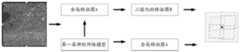
示例性地,语义分割处理是指对遥感卫星图像按照区域进行分割,每一个区域由具备同一个属性的像素点组成。其中,语义分割处理可以分为编码器网络和解码器网络,编码器网络是一个预先训练的分类网络,解码器网络是将编码器学习到的识别特征语义投影到像素空间上,得到密集的分类。进一步地,语音分割处理不仅需要在像素级别上进行区分,还需要一种机制将编码器不同阶段学习到的区分特征投影到像素空间上。例如,图2示出了一种遥感卫星图像的示意图。分析图2的遥感卫星图像可以看到地面的道路结构。Exemplarily, the semantic segmentation process refers to segmenting the remote sensing satellite image according to regions, and each region is composed of pixels with the same attribute. Among them, semantic segmentation processing can be divided into encoder network and decoder network. The encoder network is a pre-trained classification network, and the decoder network semantically projects the recognition features learned by the encoder onto the pixel space to obtain dense classification. . Further, speech segmentation processing requires not only discrimination at the pixel level, but also a mechanism to project the discriminative features learned at different stages of the encoder onto the pixel space. For example, Figure 2 shows a schematic diagram of a remote sensing satellite image. The road structure on the ground can be seen by analyzing the remote sensing satellite image in Figure 2.
图2中所示出的遥感卫星图像经过语义分割处理后,可以得到第一拓扑图。其中,第一拓扑图能够表征遥感卫星图像中道路和背景的界限。After the remote sensing satellite image shown in FIG. 2 is processed by semantic segmentation, a first topology map can be obtained. Among them, the first topology map can represent the boundary between the road and the background in the remote sensing satellite image.
本实施例中,三维张量图表征遥感卫星图像所对应的位置上的道路的编码信息。三维张量图是指由三个部分组成的图像,可以表征遥感卫星图像的参数。第一个部分可以表征当前的像素点是否为道路关键点,第二个部分可以表征当前的像素点是否存在相邻的道路关键点,第三个部分可以表征当前的像素点与其他像素点之间的位置关系,其中,位置关系可以是当前的像素点与其他像素点的位置偏移量。In this embodiment, the three-dimensional tensor map represents the encoded information of the road at the position corresponding to the remote sensing satellite image. A 3D tensor map refers to an image composed of three parts, which can characterize the parameters of a remote sensing satellite image. The first part can represent whether the current pixel is a road key point, the second part can represent whether the current pixel has adjacent road key points, and the third part can represent the difference between the current pixel and other pixels The positional relationship between the pixel points, where the positional relationship can be the positional offset between the current pixel point and other pixel points.
S103、对三维张量图进行解码处理,得到第二拓扑图,其中,第二拓扑图包括遥感卫星图像所对应的位置上的道路。S103. Decode the three-dimensional tensor map to obtain a second topology map, where the second topology map includes roads at positions corresponding to remote sensing satellite images.
示例性地,对三维张量图进行解码处理的过程为将三维张量图的三个部分的编码数据位按照每一个部分的编码数据位的含义进行反向解释,得到第二拓扑图。其中,第二拓扑图也能够表征遥感卫星图像中道路和背景的界限。Exemplarily, the process of decoding the three-dimensional tensor map is to reversely interpret the encoded data bits of the three parts of the three-dimensional tensor map according to the meaning of the encoded data bits of each part to obtain the second topology map. Among them, the second topology map can also characterize the boundaries of roads and backgrounds in remote sensing satellite images.
S104、根据第一拓扑图和第二拓扑图,确定道路拓扑图,并根据道路拓扑图更新地图。S104. Determine a road topology map according to the first topology map and the second topology map, and update the map according to the road topology map.
示例性地,将第一拓扑图和第二拓扑图进行比较,确定两者之间的差异,根据两者的差异,得到道路拓扑图。在得到道路拓扑图后,将最新的道路拓扑图更新地图。Exemplarily, the first topology map and the second topology map are compared, the difference between the two is determined, and the road topology map is obtained according to the difference between the two. After obtaining the road topology map, update the map with the latest road topology map.
本公开提供一种基于遥感卫星图像的地图更新方法,包括:获取车辆在历史轨迹上的历史定位信息,根据帧的全局定位信息所指示的与帧对应的定位信号的强度,确定帧的权重信息,根据帧的全局定位信息、帧间定位信息以及权重信息,确定帧的优化定位信息。通过该技术方案,能够解决由于人工采集道路数据导致的更新地图成本较高以及地图更新错误的问题。The present disclosure provides a map update method based on remote sensing satellite images, comprising: acquiring historical positioning information of a vehicle on a historical trajectory, and determining weight information of a frame according to the strength of a positioning signal corresponding to the frame indicated by the global positioning information of the frame , and determine the optimal positioning information of the frame according to the global positioning information, inter-frame positioning information and weight information of the frame. Through the technical solution, the problems of high map update cost and map update errors caused by manual collection of road data can be solved.
图3是根据本公开第二实施例的示意图,如图3所示,图3示出的是一种基于遥感卫星图像的地图更新方法,该方法包括:Fig. 3 is a schematic diagram according to a second embodiment of the present disclosure, as shown in Fig. 3, Fig. 3 shows a map update method based on remote sensing satellite images, and the method includes:
S301、获取遥感卫星图像。S301. Obtain remote sensing satellite images.
示例性地,本步骤可以参见步骤S101,在此不再赘述。Exemplarily, for this step, reference may be made to step S101, which will not be repeated here.
S302、对遥感卫星图像进行语义分割处理,得到第一拓扑图,第一拓扑图包括遥感卫星图像所对应的位置上的道路。S302. Perform semantic segmentation processing on the remote sensing satellite image to obtain a first topology map, where the first topology map includes a road at a position corresponding to the remote sensing satellite image.
示例性地,本步骤可以参见步骤S102,在此不再赘述。Exemplarily, for this step, reference may be made to step S102, which will not be repeated here.
S303、将遥感卫星图像输入至图编码模型中,得到三维张量图;其中,图编码模型为基于具有标准的三维张量图的遥感卫星图像进行训练所得到的。S303. Input the remote sensing satellite image into the image coding model to obtain a three-dimensional tensor map; wherein, the image coding model is obtained by training based on the remote sensing satellite image with a standard three-dimensional tensor map.
示例性地,图编码模型是用于输出三维张量图的模型,将多张待识别的遥感卫星图像输入至图编码模型中,可以分别得到与每一张待识别的遥感卫星图像对应的三维张量图。其中,图编码模型是预先进行训练得到的。这样设置的好处是能够使用图编码模型实现端对端的输入和输出,能够快速地输出与遥感卫星图像对应的三维张量图。Exemplarily, the image coding model is a model for outputting a three-dimensional tensor image, and a plurality of remote sensing satellite images to be identified are input into the image coding model, and a three-dimensional image corresponding to each remote sensing satellite image to be identified can be obtained respectively. Tensor graph. Among them, the graph coding model is obtained by pre-training. The advantage of this setting is that the graph coding model can be used to achieve end-to-end input and output, and the 3D tensor graph corresponding to the remote sensing satellite image can be quickly output.
示例性地,将遥感卫星图像输入至图编码模型中,得到三维张量图,包括:Exemplarily, the remote sensing satellite image is input into the image coding model to obtain a three-dimensional tensor image, including:
基于图编码模型对遥感卫星图像进行特征提取,得到全局特征图和局部特征图;其中,全局特征图表征遥感卫星图像的全局特征,局部特征图表征遥感卫星图像的道路特征;Extracting features from remote sensing satellite images based on the graph coding model to obtain a global feature map and a local feature map; wherein, the global feature map represents the global feature of the remote sensing satellite image, and the local feature map represents the road feature of the remote sensing satellite image;
基于图编码模型对全局特征图和局部特征图进行特征融合,得到融合后的特征图;Based on the graph coding model, feature fusion is performed on the global feature map and the local feature map, and the fused feature map is obtained;
根据融合后的特征图,生成三维张量图。According to the fused feature map, a 3D tensor map is generated.
示例性地,全局特征图是用于描述遥感卫星图像的颜色特征、纹理特征和/或形状特征的整体特征。局部特征图是用于描述遥感卫星图像局部的特征,具体的,可以是从遥感卫星图像中提取的特征,包括边缘、角点、线、曲线和特殊属性的区域等。局部特征图具备特征间相关度小,遮挡情况下不会因为部分局部特征的消失而影响其他局部特征的检测和匹配。将全局特征图和局部特征图通过图编码模型进行融合,融合后的特征图是由全局特征图和局部特征图组成的,融合后的特征图并未对全局特征图和局部特征图进行修改,只是将两者作为一个整体。根据融合后的特征图,将该张遥感卫星图像生成对应的三维张量图。这样设置的好处是能够充分结合遥感卫星图像的全局特征和局部特征,使得生成的三维张量图的信息更加准确和丰富。Exemplarily, the global feature map is an overall feature used to describe color features, texture features and/or shape features of remote sensing satellite images. The local feature map is used to describe the local features of remote sensing satellite images. Specifically, it can be features extracted from remote sensing satellite images, including edges, corners, lines, curves, and areas with special attributes. The local feature map has a small correlation between features, and in the case of occlusion, the disappearance of some local features will not affect the detection and matching of other local features. The global feature map and the local feature map are fused through the graph coding model. The fused feature map is composed of the global feature map and the local feature map. The fused feature map does not modify the global feature map and the local feature map. Just take the two as a whole. According to the fused feature map, the corresponding 3D tensor map is generated from the remote sensing satellite image. The advantage of this setting is that it can fully combine the global features and local features of remote sensing satellite images, so that the information of the generated 3D tensor map is more accurate and rich.
示例性地,基于图编码模型对遥感卫星图像进行特征提取,得到全局特征图和局部特征图,包括:Exemplarily, feature extraction is performed on the remote sensing satellite image based on the image coding model to obtain a global feature map and a local feature map, including:
基于图编码模型对遥感卫星图像进行特征提取,得到全局特征图;Extract features from remote sensing satellite images based on the graph coding model to obtain a global feature map;
对全局特征图进行二值化处理,得到二值化的特征图,二值化的特征图中包括道路的特征;Binarize the global feature map to obtain a binarized feature map, and the binarized feature map includes road features;
基于二值化的特征图中的道路点,在全局特征图中确定与道路点对应的道路位置区域;并根据与道路点对应的道路位置区域,生成局部特征图。Based on the road points in the binarized feature map, a road location area corresponding to the road point is determined in the global feature map; and a local feature map is generated according to the road location area corresponding to the road point.
示例性地,在获取到全局特征图后,对全局特征图进行二值化处理,将全局特征图中道路点取为1,将全局特征图中非道路点取为0,得到二值化的特征图,并在二值化的特征图中任意选取一个道路点,在全局特征图找到对应的道路点,以该道路点确定道路位置区域,其中,道路位置区域的数量和形状不进行限制。例如,道路位置区域可以是以该道路点为圆心,以预设的距离为半径确定的圆,将这个圆作为该道路点的道路位置区域。还可以是以该道路点为质心,以预设的范围作4个矩形,将上述4个矩形作为该道路点的道路位置区域。值得注意的是,道路位置区域是包含该道路点的一个范围,该范围的划分标准并不进行限制。具体的,可以参见图4中示出的一种局部特征图生成过程的示意图。可以从图中看出,将遥感卫星图像A通过图编码模型的第一层神经网络模型输出全局特征图A后,对该全局特征图A进行二值化处理,得到二值化的特征图B,在二值化的特征图B中选取一个道路点C,在该全局特征图A确定道路位置区域,图示中的道路位置区域为4个矩形。Exemplarily, after the global feature map is obtained, the global feature map is binarized, the road points in the global feature map are taken as 1, and the non-road points in the global feature map are taken as 0, to obtain a binarized feature map, and arbitrarily select a road point in the binarized feature map, find the corresponding road point in the global feature map, and use the road point to determine the road location area, wherein the number and shape of the road location area are not limited. For example, the road location area may be a circle determined with the road point as the center and the preset distance as the radius, and this circle is used as the road location area of the road point. It is also possible to use the road point as the centroid, and use a preset range to make four rectangles, and use the above four rectangles as the road location area of the road point. It is worth noting that the road location area is a range including the road point, and the division standard of this range is not limited. Specifically, reference may be made to a schematic diagram of a process of generating a local feature map shown in FIG. 4 . It can be seen from the figure that after the remote sensing satellite image A is outputted through the first-layer neural network model of the image coding model to output the global feature map A, the global feature map A is binarized to obtain the binarized feature map B. , select a road point C in the binarized feature map B, determine the road location area in the global feature map A, and the road location area in the illustration is 4 rectangles.
这样设置的好处是通过图编码模型中的两层神经网络模型结构,分别获取全局特征图和局部特征图,这样比单一的一层神经网络模型获取到的信息更全面。The advantage of this setting is that the global feature map and the local feature map are obtained respectively through the two-layer neural network model structure in the graph coding model, which is more comprehensive than the information obtained by a single layer neural network model.
示例性地,基于图编码模型对全局特征图和局部特征图进行特征融合,得到融合后的特征图,包括:Exemplarily, feature fusion is performed on the global feature map and the local feature map based on the graph coding model to obtain a fused feature map, including:
对局部特征图进行上采样处理,得到上采样后的局部特征图;上采样后的局部特征图的尺寸与全局特征图的尺寸相同;Upsampling the local feature map to obtain the upsampled local feature map; the size of the upsampled local feature map is the same as the size of the global feature map;
基于图编码模型对全局特征图和上采样后的局部特征图进行特征融合,得到融合后的特征图。Based on the graph coding model, feature fusion is performed on the global feature map and the up-sampled local feature map, and the fused feature map is obtained.
示例性地,上采样处理是以数据量较多的样本数量为标准,将数据量少的样本数量生成与数据量较多的样本数量相同的样本数量。例如,在本实施例中,局部特征图可以为4*4*n,全局特征图可以为8*8*N,则局部特征图以全局特征图为标准进行上采样后得到的上采样后的局部特征图为8*8*n。将上采样后的局部特征图8*8*n与全局特征图8*8*N,基于图编码模型得到融合后的特征图8*8*(N+n)。这样设置的好处是能够使得全局特征图与局部特征图是在同一个维度下进行比较,是更加合理的一种方式。Exemplarily, the up-sampling process is based on the number of samples with a large amount of data, and the number of samples with a small amount of data is generated to the same number of samples as the number of samples with a large amount of data. For example, in this embodiment, the local feature map may be 4*4*n, and the global feature map may be 8*8*N, then the local feature map is upsampled with the global feature map as the standard to obtain the upsampled The local feature map is 8*8*n. The upsampled local feature map 8*8*n and the global feature map 8*8*N are obtained based on the graph coding model to obtain the fused feature map 8*8*(N+n). The advantage of this setting is that the global feature map and the local feature map can be compared in the same dimension, which is a more reasonable way.
S304、对三维张量图进行解码处理,得到第二拓扑图,其中,第二拓扑图包括遥感卫星图像所对应的位置上的道路。S304. Decode the three-dimensional tensor map to obtain a second topology map, where the second topology map includes roads at positions corresponding to the remote sensing satellite images.
示例性地,本步骤可以参见步骤S103,在此不再赘述。Exemplarily, for this step, reference may be made to step S103, which will not be repeated here.
S305、若确定第一拓扑图中的道路像素点,不存在于第二拓扑图中,则将第一拓扑图中的道路像素点,加入到第二拓扑图中,以生成道路拓扑图。S305. If it is determined that the road pixels in the first topology map do not exist in the second topology map, add the road pixels in the first topology map to the second topology map to generate a road topology map.
示例性地,按照第一拓扑图中的坐标信息查找第一拓扑图中的道路像素点,若该坐标信息在第二拓扑图为非道路像素点,则将第一拓扑图中的该道路像素点加入到第二拓扑图中,并将修改后的第二拓扑图作为道路拓扑图。Exemplarily, the road pixel in the first topology map is searched according to the coordinate information in the first topology map, and if the coordinate information is a non-road pixel in the second topology map, the road pixel in the first topology map is The points are added to the second topology map, and the modified second topology map is used as the road topology map.
例如,第一拓扑图中的坐标信息A(a,b)为一个道路像素点,则在第二拓扑图中查找坐标信息A(a,b)的像素点是否为道路像素点,若是,则不对第二拓扑图做任何处理,若不是,则将第二拓扑图中坐标信息A(a,b)的像素点添加为道路像素点。值得注意的是,第二拓扑图和第一拓扑图中坐标信息的划分标准是相同的,例如,第一拓扑图和第二拓扑图左下角均为原点,以第一拓扑图和第二拓扑图最下面的水平边为x轴,以第一拓扑图和第二拓扑图最左面的垂直边为y轴。这样设置的好处是能够结合两张拓扑图综合确定道路拓扑图,能够弥补一张拓扑图对道路召回不足的问题。For example, the coordinate information A(a, b) in the first topology map is a road pixel, then in the second topology map, find out whether the pixel of the coordinate information A(a, b) is a road pixel, and if so, then Do not do any processing on the second topology map, if not, add the pixels of the coordinate information A(a, b) in the second topology map as road pixels. It is worth noting that the division standard of the coordinate information in the second topology map and the first topology map is the same. The bottommost horizontal edge of the graph is the x-axis, and the leftmost vertical edge of the first and second topological graphs is the y-axis. The advantage of this setting is that the road topology map can be comprehensively determined by combining the two topology maps, which can make up for the problem of insufficient road recall of one topology map.
进一步地,其中,第一拓扑图为二值图,第二拓扑图为二值图。这样设置的好处是在能够提高第一拓扑图和第二拓扑图的比对效率。Further, wherein, the first topology graph is a binary graph, and the second topology graph is a binary graph. The advantage of this setting is that the comparison efficiency of the first topology map and the second topology map can be improved.
S306、对道路拓扑图进行图像增强处理,得到增强处理后的道路拓扑图。S306 , performing image enhancement processing on the road topology map to obtain an enhanced road topology map.
示例性地,图像增强处理可根据过程所在的空间不同,可分为基于空域和频域的方法。基于空域的方法直接对道路拓扑图进行处理;基于频域的方法是在道路拓扑图的某种变换域内对道路拓扑图的变换系数进行修正,然后再反变换到原来的空域,得到增强处理后的道路拓扑图。这样设置的好处是为了改善道路拓扑图的视觉效果,提高道路拓扑图的清晰度;或者是针对道路拓扑图的应用场合,突出某些感兴趣的特征,抑制不感兴趣的特征,以扩大道路拓扑图中不同物体特征之间的差别。Exemplarily, image enhancement processing can be divided into methods based on spatial domain and frequency domain according to the space where the process is located. The method based on the air domain directly processes the road topology map; the method based on the frequency domain modifies the transformation coefficients of the road topology map in a certain transform domain of the road topology map, and then inversely transforms it to the original spatial domain to obtain enhanced processing. road topology map. The advantage of this setting is to improve the visual effect of the road topology map and improve the clarity of the road topology map; or for the application of the road topology map, highlight some interesting features and suppress the uninteresting features to expand the road topology Differences between the features of different objects in the figure.
图5是根据本公开第三实施例的示意图,如图5所示,图5示出的是一种应用于地图更新的图编码模型的训练方法,该方法包括:Fig. 5 is a schematic diagram according to a third embodiment of the present disclosure, as shown in Fig. 5, Fig. 5 shows a training method of a graph coding model applied to map update, the method comprising:
S501、获取多个待训练的遥感卫星图像,待训练的遥感卫星图像具有标准的三维张量图。S501. Acquire a plurality of remote sensing satellite images to be trained, and the remote sensing satellite images to be trained have a standard three-dimensional tensor map.
示例性地,每一个待训练的遥感卫星图像均具有唯一的标准的三维张量图,多个待训练的遥感卫星图像则对应多个标准的三维张量图。Exemplarily, each remote sensing satellite image to be trained has a unique standard three-dimensional tensor map, and multiple remote sensing satellite images to be trained correspond to multiple standard three-dimensional tensor maps.
S502、重复以下各步骤,直至达到预设条件:将待训练的遥感卫星图像输入至图编码模型中,得到预测的三维张量图,预测的三维张量图表征待训练的遥感卫星图像所对应的位置上的道路的编码信息;根据预测的三维张量图和标准的三维张量图对图编码模型进行参数调整;其中,达到预设条件所得到的图编码模型,用于确定上述实施例方法中的遥感卫星图像的三维张量图。S502. Repeat the following steps until a preset condition is reached: input the remote sensing satellite image to be trained into the image coding model to obtain a predicted 3D tensor map, and the predicted 3D tensor map represents the corresponding remote sensing satellite image to be trained. The coding information of the road at the location of the tensor; the parameters of the graph coding model are adjusted according to the predicted 3D tensor graph and the standard 3D tensor graph; wherein, the graph coding model obtained by reaching the preset conditions is used to determine the above embodiment. 3D tensor maps of remote sensing satellite images in Methods.
示例性地,图编码模型是由两层神经网络构成的模型,将待训练的遥感卫星图像输入至图编码模型中,由图编码模型输出预测的三维张量图,然后将预测的三维张量图与标准的三维张量图通过损失函数进行比较,得到图编码模型中每一层神经网络的参数,直到将待训练的遥感卫星图像输入至图编码模型,能够输出标准的三维张量图,则将此时达到预设条件的图编码模型确定待识别的遥感卫星图像的三维张量图。Exemplarily, the graph coding model is a model composed of a two-layer neural network, the remote sensing satellite images to be trained are input into the graph coding model, the graph coding model outputs the predicted 3D tensor graph, and then the predicted 3D tensor The graph is compared with the standard 3D tensor graph through the loss function, and the parameters of each layer of the neural network in the graph coding model are obtained, until the remote sensing satellite image to be trained is input into the graph coding model, and the standard 3D tensor graph can be output. Then, the image coding model that reaches the preset condition at this time is used to determine the three-dimensional tensor image of the remote sensing satellite image to be identified.
本公开提供一种应用于地图更新的图编码模型的训练方法,通过多个待训练的遥感卫星图像与多个待训练的遥感卫星图像对应的多个标准的三维张量图训练图编码模型,将待识别的遥感卫星图像输入到得到的图编码模型中确定待识别的遥感卫星图像的三维张量图。采用上述技术手段,能够得到比较准确的图编码模型,进而可以将待识别的遥感卫星图像输入至准确的图编码模型,得到比较准确的待识别的遥感卫星图像的三维张量图。The present disclosure provides a training method for a graph coding model applied to map update. The graph coding model is trained by using a plurality of remote sensing satellite images to be trained and a plurality of standard three-dimensional tensor graphs corresponding to the plurality of remote sensing satellite images to be trained, The remote sensing satellite image to be recognized is input into the obtained image coding model to determine the three-dimensional tensor map of the remote sensing satellite image to be recognized. By using the above technical means, a relatively accurate image coding model can be obtained, and then the remote sensing satellite image to be recognized can be input into the accurate image coding model to obtain a relatively accurate 3D tensor map of the remote sensing satellite image to be recognized.
图6是根据本公开第四实施例的示意图,如图6所示,图6示出的是一种应用于地图更新的图编码模型的训练方法,该方法包括:FIG. 6 is a schematic diagram according to a fourth embodiment of the present disclosure. As shown in FIG. 6 , FIG. 6 shows a training method of a graph coding model applied to map update, and the method includes:
S601、获取多个待训练的遥感卫星图像,待训练的遥感卫星图像具有标准的三维张量图。S601. Acquire a plurality of remote sensing satellite images to be trained, and the remote sensing satellite images to be trained have a standard three-dimensional tensor map.
示例性地,本步骤可以参见步骤S501,在此不再赘述。Exemplarily, for this step, reference may be made to step S501, which will not be repeated here.
S602、基于图编码模型对待训练的遥感卫星图像进行特征提取,得到全局特征图和局部特征图;其中,全局特征图表征待训练的遥感卫星图像的全局特征,局部特征图表征待训练的遥感卫星图像的道路特征。S602. Perform feature extraction on the remote sensing satellite image to be trained based on the image coding model to obtain a global feature map and a local feature map; wherein the global feature map represents the global feature of the remote sensing satellite image to be trained, and the local feature map represents the remote sensing satellite image to be trained. Image road features.
示例性地,基于图编码模型对待训练的遥感卫星图像进行特征提取,得到全局特征图和局部特征图,包括:Exemplarily, feature extraction is performed on the remote sensing satellite image to be trained based on the image coding model to obtain a global feature map and a local feature map, including:
基于图编码模型对待训练的遥感卫星图像进行特征提取,得到全局特征图;Extract features from remote sensing satellite images to be trained based on the graph coding model to obtain a global feature map;
对全局特征图进行二值化处理,得到二值化的特征图,二值化的特征图中包括道路的特征;Binarize the global feature map to obtain a binarized feature map, and the binarized feature map includes road features;
基于二值化的特征图中的道路点,在全局特征图中确定与道路点对应的道路位置区域;并根据与道路点对应的道路位置区域,生成局部特征图。Based on the road points in the binarized feature map, a road location area corresponding to the road point is determined in the global feature map; and a local feature map is generated according to the road location area corresponding to the road point.
示例性地,本步骤可以参见步骤S303,在此不再赘述。Exemplarily, for this step, reference may be made to step S303, which will not be repeated here.
S603、基于图编码模型对全局特征图和局部特征图进行特征融合,得到融合后的特征图。S603. Perform feature fusion on the global feature map and the local feature map based on the graph coding model to obtain a fused feature map.
示例性地,本步骤可以参见步骤S303,在此不再赘述。Exemplarily, for this step, reference may be made to step S303, which will not be repeated here.
本实施例中,基于图编码模型对全局特征图和局部特征图进行特征融合,得到融合后的特征图,包括:In this embodiment, feature fusion is performed on the global feature map and the local feature map based on the graph coding model to obtain a fused feature map, including:
对局部特征图进行上采样处理,得到上采样后的局部特征图;上采样后的局部特征图的尺寸与全局特征图的尺寸相同;Perform up-sampling processing on the local feature map to obtain the up-sampled local feature map; the size of the up-sampled local feature map is the same as the size of the global feature map;
基于图编码模型对全局特征图和上采样后的局部特征图进行特征融合,得到融合后的特征图。Based on the graph coding model, feature fusion is performed on the global feature map and the up-sampled local feature map, and the fused feature map is obtained.
示例性地,本步骤可以参见步骤S303,在此不再赘述。Exemplarily, for this step, reference may be made to step S303, which will not be repeated here.
S604、根据融合后的特征图,生成三维张量图。S604. Generate a three-dimensional tensor map according to the fused feature map.
示例性地,本步骤可以参见步骤S303,在此不再赘述。Exemplarily, for this step, reference may be made to step S303, which will not be repeated here.
S605、根据预测的三维张量图和标准的三维张量图对图编码模型进行参数调整;其中,达到预设条件所得到的图编码模型,用于确定本实施例方法中的遥感卫星图像的三维张量图。S605. Adjust the parameters of the image coding model according to the predicted three-dimensional tensor map and the standard three-dimensional tensor map; wherein, the image coding model obtained by reaching a preset condition is used to determine the remote sensing satellite image in the method of this embodiment. 3D tensor graph.
示例性的,响应于用户的标注操作,获取待训练的遥感卫星图像中的道路关键点;根据待训练的遥感卫星图像中的道路关键点,以及与道路关键点相邻的其他道路关键点,生成待训练的遥感卫星图像的道路编码信息;其中,道路编码信息包括待训练的遥感卫星图像的每一像素点的编码数据;根据待训练的遥感卫星图像的道路编码信息,生成待训练的遥感卫星图像的标准的三维张量图。Exemplarily, in response to the user's labeling operation, the road key points in the remote sensing satellite image to be trained are obtained; according to the road key points in the remote sensing satellite image to be trained, and other road key points adjacent to the road key points, Generate the road coding information of the remote sensing satellite image to be trained; wherein, the road coding information includes the coding data of each pixel of the remote sensing satellite image to be trained; according to the road coding information of the remote sensing satellite image to be trained, generate the remote sensing satellite image to be trained. A standard 3D tensor map of satellite imagery.
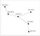
本实施例中,用户对待训练的遥感卫星图像中的道路关键点进行标注,其中,待训练的遥感卫星图像中的道路关键点为不同道路转接处以及不同道路的端点。例如,图7为用户对待训练的遥感卫星图像中的道路关键点进行标注后的示意图,可以从图7中看出,道路关键点为A、B、C、D、E和F,从道路关键点A连接道路关键点B,由道路关键点B连接道路关键点C,道路关键点C同时连接道路关键点D和道路关键点E。道路关键点E连接道路关键点F。In this embodiment, the user marks the road key points in the remote sensing satellite image to be trained, wherein the road key points in the remote sensing satellite image to be trained are different road transitions and endpoints of different roads. For example, Figure 7 is a schematic diagram of the key points of the road in the remote sensing satellite image to be trained by the user. It can be seen from Figure 7 that the key points of the road are A, B, C, D, E and F. Point A is connected to road key point B, road key point B is connected to road key point C, and road key point C is connected to road key point D and road key point E at the same time. The road key point E connects the road key point F.
进一步地,本实施例中,在确定了待训练的遥感卫星图像中的道路关键点后,能够确定与该道路关键点相邻的其他道路关键点。例如,初步确定的待训练的遥感卫星图像中的道路关键点为道路关键点C,则与该道路关键点相邻的其他道路关键点为道路关键点B、道路关键点D和道路关键点E。根据道路关键点C以及与该道路关键点相邻的其他道路关键点为道路关键点B、道路关键点D和道路关键点E生成道路关键点C的编码数据。这样设置的好处是用户标注操作后的遥感卫星图像不能够直接用于训练图编码模型,因此,需要将用户标注操作后的遥感卫星图像转化为能够训练图编码模型的数据形式。Further, in this embodiment, after the road key point in the remote sensing satellite image to be trained is determined, other road key points adjacent to the road key point can be determined. For example, the road key point in the remote sensing satellite image to be trained is initially determined as road key point C, and other road key points adjacent to the road key point are road key point B, road key point D and road key point E . The encoded data of the road key point C is generated for the road key point B, the road key point D and the road key point E according to the road key point C and other road key points adjacent to the road key point. The advantage of this setting is that the remote sensing satellite images after the user's annotation operation cannot be directly used to train the image coding model. Therefore, the remote sensing satellite images after the user's annotation operation need to be converted into a data form that can train the image coding model.
其中,待训练的遥感卫星图像的每一像素点的编码数据包括以下信息中的一种或多种:Wherein, the encoded data of each pixel of the remote sensing satellite image to be trained includes one or more of the following information:
待训练的遥感卫星图像中的每一像素点是否为道路关键点;Whether each pixel in the remote sensing satellite image to be trained is a road key point;
与作为道路关键点的像素点的相邻的其他道路关键点的个数;The number of other road key points adjacent to the pixel point as the road key point;
作为道路关键点的像素点、与作为道路关键点的像素点的相邻的其他道路关键点两者之间的距离信息。Distance information between a pixel point serving as a road key point and other road key points adjacent to the pixel point serving as a road key point.
本实施例中,编码数据包括待训练的遥感卫星图像中的每一像素点是否为道路关键点,或者与作为道路关键点的像素点的相邻的其他道路关键点的个数,或者作为道路关键点的像素点、与作为道路关键点的像素点的相邻的其他道路关键点两者之间的距离信息。In this embodiment, the encoded data includes whether each pixel point in the remote sensing satellite image to be trained is a road key point, or the number of other road key points adjacent to the pixel point as a road key point, or as a road key point The distance information between the pixel point of the key point and other road key points adjacent to the pixel point serving as the road key point.
编码数据还包括:待训练的遥感卫星图像中的每一像素点是否为道路关键点和与作为道路关键点的像素点的相邻的其他道路关键点的个数;与作为道路关键点的像素点的相邻的其他道路关键点的个数和作为道路关键点的像素点、与作为道路关键点的像素点的相邻的其他道路关键点两者之间的距离信息;待训练的遥感卫星图像中的每一像素点是否为道路关键点与作为道路关键点的像素点、与作为道路关键点的像素点的相邻的其他道路关键点两者之间的距离信息。The encoded data also includes: whether each pixel in the remote sensing satellite image to be trained is a road key point and the number of other road key points adjacent to the pixel point as a road key point; The number of other road key points adjacent to the point and the distance information between the pixel point as a road key point and other road key points adjacent to the pixel point as a road key point; remote sensing satellites to be trained Whether each pixel point in the image is the distance information between the road key point and the pixel point serving as the road key point and other road key points adjacent to the pixel point serving as the road key point.
编码数据还包括:待训练的遥感卫星图像中的每一像素点是否为道路关键点、与作为道路关键点的像素点的相邻的其他道路关键点的个数和作为道路关键点的像素点、与作为道路关键点的像素点的相邻的其他道路关键点两者之间的距离信息。The encoded data also includes: whether each pixel in the remote sensing satellite image to be trained is a road key point, the number of other road key points adjacent to the pixel point serving as a road key point, and the pixel point serving as a road key point , and the distance information between other road key points adjacent to the pixel point serving as the road key point.
本实施例中,待训练的遥感卫星图像中的每一像素点是否为道路关键点可以用两位编码数据位进行表示。例如,该像素点为道路关键点时的编码数据位为10,该像素点不为道路关键点时的编码数据位为01。图7中的道路关键点A、道路关键点B、道路关键点C、道路关键点D和道路关键点E以及道路关键点F的其中两位编码数据位均可为10。In this embodiment, whether each pixel point in the remote sensing satellite image to be trained is a road key point can be represented by two encoded data bits. For example, when the pixel is a road key point, the encoded data bit is 10, and when the pixel is not a road key point, the encoded data bit is 01. Two of the encoded data bits of the road key point A, the road key point B, the road key point C, the road key point D, the road key point E and the road key point F in FIG. 7 can all be 10.
本实施例中,与作为道路关键点的像素点的相邻的其他道路关键点的个数的编码数据位为12位,这样设置的原因是道路关键点的像素点的相邻的其他道路关键点的个数一般最多是6个。本实施例中,与作为道路关键点的像素点的相邻的其他道路关键点的个数的编码数据位为12位仅是示例说明,该编码数据位是可以自行设置的,例如,还可以为20位。从图7中看出,与道路关键点A的像素点的相邻的其他道路关键点的个数为1,与道路关键点B的像素点的相邻的其他道路关键点的个数为2,与道路关键点C的像素点的相邻的其他道路关键点的个数为3,与道路关键点D的像素点的相邻的其他道路关键点的个数为1,与道路关键点E的像素点的相邻的其他道路关键点的个数为2,与道路关键点F的像素点的相邻的其他道路关键点的个数为1。在确定了道路关键点的像素点的相邻的其他道路关键点的个数,在以道路关键点的像素点为中心划分六个区域,具体的划分方式可以参见图8中示出的一种道路关键点的像素点的相邻的其他道路关键点的个数统计示意图。则可以在图8中的六个区域中依次确认,若第一个区域中存在道路关键点,则将编码数据位12位的前两位确认为10,若第二个区域中存在道路关键点,则将编码数据位12位的第三四位确认为10,依次类推。In this embodiment, the encoded data bits of the number of other road key points adjacent to the pixel point serving as the road key point are 12 bits, and the reason for this setting is that the adjacent other road key points of the road key point pixel point The number of points is generally up to 6. In this embodiment, the number of encoded data bits of the number of other road key points adjacent to the pixel point serving as the road key point is 12 bits is only an example, and the encoded data bits can be set by yourself, for example, you can also for 20 bits. It can be seen from Figure 7 that the number of other road key points adjacent to the pixel point of road key point A is 1, and the number of other road key points adjacent to the pixel point of road key point B is 2 , the number of other road key points adjacent to the pixel point of road key point C is 3, the number of other road key points adjacent to the pixel point of road key point D is 1, and the number of other road key points adjacent to the pixel point of road key point D is 1, and the number of other road key points adjacent to the pixel point of road key point D is 1. The number of other road key points adjacent to the pixel point of F is 2, and the number of other road key points adjacent to the pixel point of the road key point F is 1. After determining the number of other road key points adjacent to the pixel point of the road key point, six areas are divided with the pixel point of the road key point as the center. The specific division method can refer to the one shown in FIG. 8 . A schematic diagram of the statistics of the number of other road key points adjacent to the pixel point of the road key point. Then it can be confirmed in the six areas in Figure 8 in turn. If there is a road key point in the first area, the first two bits of the 12-bit encoded data bits are confirmed as 10. If there is a road key point in the second area. , then confirm the third and fourth bits of the 12-bit encoded data bits as 10, and so on.
作为道路关键点的像素点、与作为道路关键点的像素点的相邻的其他道路关键点两者之间的距离信息,具体为将待训练的遥感卫星图像按照坐标信息划分,确认每一个道路关键点的像素点的坐标信息,由每一个道路关键点的像素点的坐标信息与相邻的其他道路关键点的坐标信息确定两者之间的距离信息。其中,该编码数据位为12位,其中,每两位为一个相邻的其他道路关键点的距离信息。其中,该编码数据位的距离信息与道路关键点的个数的编码数据位是对应关系。The distance information between the pixel point as the key point of the road and the other key points of the road adjacent to the pixel point as the key point of the road. Specifically, the remote sensing satellite image to be trained is divided according to the coordinate information, and each road is confirmed. The coordinate information of the pixel point of the key point, the distance information between the two is determined by the coordinate information of the pixel point of each road key point and the coordinate information of other adjacent road key points. Wherein, the encoded data bits are 12 bits, and each two bits are the distance information of an adjacent other road key point. Wherein, the distance information of the encoded data bits is in a corresponding relationship with the encoded data bits of the number of road key points.
具体的,图9中示出了一种待训练的遥感卫星图像的每一像素点的编码数据以及三维张量图。从图9中可以看出,假设从三维张量图中确定一个像素点的编码数据,其中,该像素点为道路关键点C的像素点,该编码数据是由三个部分组成的,第一个部分为待训练的遥感卫星图像中的像素点是否为道路关键点的编码数据位,由于该像素点为道路关键点C的像素点,则第一个部分的编码数据位为10;第二个部分为与作为道路关键点的像素点的相邻的其他道路关键点的个数,由于该像素点为道路关键点C的像素点,与道路关键点C的像素点的相邻的其他道路关键点的个数为3,从图8中可以看出,道路关键点C在一个区域、第三个区域和第四个区域存在道路关键点,则第二个部分的编码数据位为100110100101;第三个部分为作为道路关键点的像素点、与作为道路关键点的像素点的相邻的其他道路关键点两者之间的距离信息,由于该像素点为道路关键点C的像素点,则计算道路关键点B、道路关键点D和道路关键点E分别与道路关键点C的距离信息。Specifically, Fig. 9 shows the encoded data of each pixel of a remote sensing satellite image to be trained and a three-dimensional tensor map. As can be seen from Figure 9, it is assumed that the encoded data of a pixel is determined from the three-dimensional tensor graph, where the pixel is the pixel of the road key point C, and the encoded data is composed of three parts. The first is The first part is the encoded data bit of whether the pixel in the remote sensing satellite image to be trained is the road key point. Since the pixel is the pixel point of the road key point C, the encoded data bit of the first part is 10; The part is the number of other road key points adjacent to the pixel point of the road key point. Since this pixel point is the pixel point of the road key point C, other roads adjacent to the pixel point of the road key point C The number of key points is 3. It can be seen from Figure 8 that the road key point C has road key points in one area, the third area and the fourth area, and the encoded data bits of the second part are 100110100101; The third part is the distance information between the pixel point as the road key point and the other road key points adjacent to the pixel point as the road key point. Since the pixel point is the pixel point of the road key point C, Then calculate the distance information between the road key point B, the road key point D and the road key point E and the road key point C respectively.
这样设置的好处是能够通过准确的数据形式准确地表征待训练的遥感卫星图像的道路关键点信息。The advantage of this setting is that the road key point information of the remote sensing satellite image to be trained can be accurately represented in an accurate data form.
本公开提供一种应用于地图更新的图编码模型的训练方法,包括:获取多个待训练的遥感卫星图像,待训练的遥感卫星图像具有标准的三维张量图,响应于用户的标注操作,获取待训练的遥感卫星图像中的道路关键点;根据待训练的遥感卫星图像中的道路关键点,以及与道路关键点相邻的其他道路关键点,生成待训练的遥感卫星图像的道路编码信息;其中,道路编码信息包括待训练的遥感卫星图像的每一像素点的编码数据;根据待训练的遥感卫星图像的道路编码信息,生成待训练的遥感卫星图像的标准的三维张量图。采用本技术方案,能够得到准确的图编码模型,进而输出比较准确的三维张量图,使得得到的第二拓扑图的召回率较高,保证地图的更新速度,优化作业过程。The present disclosure provides a training method for a graph coding model applied to map update, including: acquiring a plurality of remote sensing satellite images to be trained, the remote sensing satellite images to be trained have a standard three-dimensional tensor map, and in response to a user's labeling operation, Obtain the road key points in the remote sensing satellite image to be trained; generate road coding information of the remote sensing satellite image to be trained according to the road key points in the remote sensing satellite image to be trained and other road key points adjacent to the road key points wherein, the road coding information includes the coding data of each pixel of the remote sensing satellite image to be trained; according to the road coding information of the remote sensing satellite image to be trained, a standard three-dimensional tensor map of the remote sensing satellite image to be trained is generated. By adopting the technical solution, an accurate graph coding model can be obtained, and then a relatively accurate three-dimensional tensor graph can be output, so that the obtained second topology graph has a higher recall rate, ensures the update speed of the map, and optimizes the operation process.
图10是根据本公开第五实施例的示意图,如图10所示,图10示出的是一种基于遥感卫星图像的地图更新装置,该装置10包括:Fig. 10 is a schematic diagram according to a fifth embodiment of the present disclosure, as shown in Fig. 10, Fig. 10 shows a map updating apparatus based on remote sensing satellite images, the
获取单元1001,用于获取遥感卫星图像。The acquiring
第一确定单元1002,用于对遥感卫星图像进行语义分割处理,得到第一拓扑图,第一拓扑图包括遥感卫星图像所对应的位置上的道路;并根据遥感卫星图像,确定三维张量图,三维张量图表征遥感卫星图像所对应的位置上的道路的编码信息。The first determining
第二确定单元1003,用于对三维张量图进行解码处理,得到第二拓扑图,其中,第二拓扑图包括遥感卫星图像所对应的位置上的道路;The second determining
第三确定单元1004,用于根据第一拓扑图和第二拓扑图,确定道路拓扑图,并根据道路拓扑图更新地图。The third determining
所属领域的技术人员可以清楚地了解到,为描述的方便和简洁,上述描述装置的具体工作过程,可以参考前述方法实施例中的对应过程,在此不再赘述。Those skilled in the art can clearly understand that, for the convenience and brevity of description, for the specific working process of the device described above, reference may be made to the corresponding process in the foregoing method embodiments, which will not be repeated here.
图11是根据本公开第六实施例的示意图,如图11所示,图11示出的是一种基于遥感卫星图像的地图更新装置,该装置11包括:Fig. 11 is a schematic diagram according to a sixth embodiment of the present disclosure, as shown in Fig. 11, Fig. 11 shows a map updating apparatus based on remote sensing satellite images, the
获取单元1101,用于获取遥感卫星图像;an
第一确定单元1102,用于对遥感卫星图像进行语义分割处理,得到第一拓扑图,第一拓扑图包括遥感卫星图像所对应的位置上的道路;并根据遥感卫星图像,确定三维张量图,三维张量图表征遥感卫星图像所对应的位置上的道路的编码信息。The first determining
第二确定单元1103,用于对三维张量图进行解码处理,得到第二拓扑图,其中,第二拓扑图包括遥感卫星图像所对应的位置上的道路。The second determining
第三确定单元1104,用于根据第一拓扑图和第二拓扑图,确定道路拓扑图,并根据道路拓扑图更新地图。The third determining
示例性地,其中,第一确定单元1102,包括:Exemplarily, the first determining
第一确定模块11021,用于将遥感卫星图像输入至图编码模型中,得到三维张量图;其中,图编码模型为基于具有标准的三维张量图的遥感卫星图像进行训练所得到的。The
示例性地,其中,第一确定模块11021,包括:Exemplarily, the first determining
提取子模块110211,用于基于图编码模型对遥感卫星图像进行特征提取,得到全局特征图和局部特征图;其中,全局特征图表征遥感卫星图像的全局特征,局部特征图表征遥感卫星图像的道路特征。The
融合子模块110212,用于基于图编码模型对全局特征图和局部特征图进行特征融合,得到融合后的特征图。The
生成子模块110213,用于根据融合后的特征图,生成三维张量图。The generating
示例性地,其中,提取子模块110211,包括:Exemplarily, wherein, the
基于图编码模型对遥感卫星图像进行特征提取,得到全局特征图;Extract features from remote sensing satellite images based on the graph coding model to obtain a global feature map;
对全局特征图进行二值化处理,得到二值化的特征图,二值化的特征图中包括道路的特征。The global feature map is binarized to obtain a binarized feature map, and the binarized feature map includes road features.
基于二值化的特征图中的道路点,在全局特征图中确定与道路点对应的道路位置区域;并根据与道路点对应的道路位置区域,生成局部特征图。Based on the road points in the binarized feature map, a road location area corresponding to the road point is determined in the global feature map; and a local feature map is generated according to the road location area corresponding to the road point.
示例性地,其中,融合子模块110212,包括:Exemplarily, wherein the
对局部特征图进行上采样处理,得到上采样后的局部特征图;上采样后的局部特征图的尺寸与全局特征图的尺寸相同。The local feature map is up-sampled to obtain the up-sampled local feature map; the size of the up-sampled local feature map is the same as the size of the global feature map.
基于图编码模型对全局特征图和上采样后的局部特征图进行特征融合,得到融合后的特征图。Based on the graph coding model, feature fusion is performed on the global feature map and the up-sampled local feature map, and the fused feature map is obtained.
示例性地,其中,第三确定单元1104,包括:Exemplarily, the third determining
加入模块11041,用于若确定第一拓扑图中的道路像素点,不存在于第二拓扑图中,则将第一拓扑图中的道路像素点,加入到第二拓扑图中,以生成道路拓扑图。The adding
示例性地,其中,装置还包括:Exemplarily, wherein, the apparatus further includes:
处理单元1105,用于对道路拓扑图进行图像增强处理,得到增强处理后的道路拓扑图。The
示例性地,其中,第一拓扑图为二值图,第二拓扑图为二值图。Exemplarily, the first topological graph is a binary graph, and the second topological graph is a binary graph.
所属领域的技术人员可以清楚地了解到,为描述的方便和简洁,上述描述装置的具体工作过程,可以参考前述方法实施例中的对应过程,在此不再赘述。Those skilled in the art can clearly understand that, for the convenience and brevity of description, for the specific working process of the device described above, reference may be made to the corresponding process in the foregoing method embodiments, which will not be repeated here.
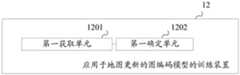
图12是根据本公开第七实施例的示意图,如图12所示,图12示出的是一种应用于地图更新的图编码模型的训练装置,该装置12包括:Fig. 12 is a schematic diagram according to a seventh embodiment of the present disclosure, as shown in Fig. 12, Fig. 12 shows a training apparatus for a graph coding model applied to map update, the
第一获取单元1201,用于获取多个待训练的遥感卫星图像,待训练的遥感卫星图像具有标准的三维张量图;The
第一确定单元1202,用于重复以下各步骤,直至达到预设条件:将待训练的遥感卫星图像输入至图编码模型中,得到预测的三维张量图,预测的三维张量图表征待训练的遥感卫星图像所对应的位置上的道路的编码信息;根据预测的三维张量图和标准的三维张量图对图编码模型进行参数调整;The
其中,达到预设条件所得到的图编码模型,用于确定权利要求15-22任一项装置中的遥感卫星图像的三维张量图。Wherein, the image coding model obtained by reaching the preset condition is used to determine the three-dimensional tensor image of the remote sensing satellite image in any one of the devices of claims 15-22.
所属领域的技术人员可以清楚地了解到,为描述的方便和简洁,上述描述装置的具体工作过程,可以参考前述方法实施例中的对应过程,在此不再赘述。Those skilled in the art can clearly understand that, for the convenience and brevity of description, for the specific working process of the device described above, reference may be made to the corresponding process in the foregoing method embodiments, which will not be repeated here.
图13是根据本公开第八实施例的示意图,如图13所示,图13示出的是一种应用于地图更新的图编码模型的训练装置,该装置13包括:Fig. 13 is a schematic diagram according to the eighth embodiment of the present disclosure, as shown in Fig. 13, Fig. 13 shows a training apparatus for a graph coding model applied to map update, the
第一获取单元1301,用于获取多个待训练的遥感卫星图像,待训练的遥感卫星图像具有标准的三维张量图。The first acquiring
第一确定单元1302,用于重复以下各步骤,直至达到预设条件:将待训练的遥感卫星图像输入至图编码模型中,得到预测的三维张量图,预测的三维张量图表征待训练的遥感卫星图像所对应的位置上的道路的编码信息;根据预测的三维张量图和标准的三维张量图对图编码模型进行参数调整。The
其中,达到预设条件所得到的图编码模型,用于确定本实施例中装置中的遥感卫星图像的三维张量图。The image coding model obtained by reaching the preset condition is used to determine the three-dimensional tensor image of the remote sensing satellite image in the device in this embodiment.
示例性地,其中,第一确定单元1302,包括:Exemplarily, the first determining
提取模块13021,用于基于图编码模型对待训练的遥感卫星图像进行特征提取,得到全局特征图和局部特征图;其中,全局特征图表征待训练的遥感卫星图像的全局特征,局部特征图表征待训练的遥感卫星图像的道路特征。The
确定模块13022,用于基于图编码模型对全局特征图和局部特征图进行特征融合,得到融合后的特征图。The determining
生成模块13023,用于根据融合后的特征图,生成三维张量图。The
示例性地,其中,提取模块13021,包括:Exemplarily, wherein, the
提取子模块130211,用于基于图编码模型对待训练的遥感卫星图像进行特征提取,得到全局特征图。The
处理子模块130212,用于对全局特征图进行二值化处理,得到二值化的特征图,二值化的特征图中包括道路的特征。The
生成子模块130213,用于基于二值化的特征图中的道路点,在全局特征图中确定与道路点对应的道路位置区域;并根据与道路点对应的道路位置区域,生成局部特征图。The generating
示例性地,其中,确定模块13022,包括:Exemplarily, wherein the determining
处理子模块130221,用于对局部特征图进行上采样处理,得到上采样后的局部特征图;上采样后的局部特征图的尺寸与全局特征图的尺寸相同。The
融合子模块130222,用于基于图编码模型对全局特征图和上采样后的局部特征图进行特征融合,得到融合后的特征图。The
示例性地,还包括:Illustratively, also include:
第二获取单元1303,用于响应于用户的标注操作,获取待训练的遥感卫星图像中的道路关键点。The second obtaining
第一生成单元1304,用于根据待训练的遥感卫星图像中的道路关键点,以及与道路关键点相邻的其他道路关键点,生成待训练的遥感卫星图像的道路编码信息;其中,道路编码信息包括待训练的遥感卫星图像的每一像素点的编码数据。The
第二生成单元1305,用于根据待训练的遥感卫星图像的道路编码信息,生成待训练的遥感卫星图像的标准的三维张量图。The
示例性地,还包括:其中,待训练的遥感卫星图像的每一像素点的编码数据包括以下信息中的一种或多种:待训练的遥感卫星图像中的每一像素点是否为道路关键点;与作为道路关键点的像素点的相邻的其他道路关键点的个数;作为道路关键点的像素点、与作为道路关键点的像素点的相邻的其他道路关键点两者之间的距离信息。Exemplarily, it also includes: wherein the encoded data of each pixel of the remote sensing satellite image to be trained includes one or more of the following information: whether each pixel in the remote sensing satellite image to be trained is a road key point; the number of other road key points adjacent to the pixel point as the road key point; between the pixel point as the road key point and the other road key points adjacent to the pixel point as the road key point distance information.
所属领域的技术人员可以清楚地了解到,为描述的方便和简洁,上述描述装置的具体工作过程,可以参考前述方法实施例中的对应过程,在此不再赘述。Those skilled in the art can clearly understand that, for the convenience and brevity of description, for the specific working process of the device described above, reference may be made to the corresponding process in the foregoing method embodiments, which will not be repeated here.
根据本公开的实施例,本公开还提供了一种计算机设备、一种可读存储介质和一种计算机程序产品。According to embodiments of the present disclosure, the present disclosure also provides a computer device, a readable storage medium, and a computer program product.
根据本公开的实施例,本公开还提供了一种计算机程序产品,计算机程序产品包括:计算机程序,计算机程序存储在可读存储介质中,计算机设备的至少一个处理器可以从可读存储介质读取计算机程序,至少一个处理器执行计算机程序使得计算机设备执行上述任一实施例提供的方案。According to an embodiment of the present disclosure, the present disclosure also provides a computer program product, the computer program product includes: a computer program, the computer program is stored in a readable storage medium, and at least one processor of the computer device can read from the readable storage medium Take a computer program, and at least one processor executes the computer program so that the computer device executes the solution provided by any of the above embodiments.
图14是根据本公开第九实施例的示意图,如图14所示,本公开中的服务器1400可以包括:处理器1401和存储器1402。FIG. 14 is a schematic diagram according to a ninth embodiment of the present disclosure. As shown in FIG. 14 , a
存储器1402,用于存储程序;存储器1402,可以包括易失性存储器(英文:volatilememory),例如随机存取存储器(英文:random-access memory,缩写:RAM),如静态随机存取存储器(英文:static random-access memory,缩写:SRAM),双倍数据率同步动态随机存取存储器(英文:Double Data Rate Synchronous Dynamic Random Access Memory,缩写:DDR SDRAM)等;存储器也可以包括非易失性存储器(英文:non-volatile memory),例如快闪存储器(英文:flash memory)。存储器1402用于存储计算机程序(如实现上述方法的应用程序、功能模块等)、计算机指令等,上述的计算机程序、计算机指令等可以分区存储在一个或多个存储器1402中。并且上述的计算机程序、计算机指令、数据等可以被处理器1401调用。The
上述的计算机程序、计算机指令等可以分区存储在一个或多个存储器1402中。并且上述的计算机程序、计算机指据等可以被处理器1401调用。The computer programs, computer instructions, etc. described above may be partitioned and stored in one or
处理器1401,用于执行存储器1402存储的计算机程序,以实现上述实施例涉及的基于遥感卫星图像的地图更新方法中的各个步骤。The
具体可以参见前面方法实施例中的相关描述。For details, refer to the relevant descriptions in the foregoing method embodiments.
处理器1401和存储器1402可以是独立结构,也可以是集成在一起的集成结构。当处理器1401和存储器1402是独立结构时,存储器1402、处理器1401可以通过总线1403耦合连接。The
本实施例的服务器可以执行上述方法中的技术方案,其具体实现过程和技术原理相同,此处不再赘述。The server in this embodiment may execute the technical solutions in the foregoing methods, and the specific implementation process and technical principles are the same, and details are not repeated here.
根据本公开的实施例,本公开还提供了一种存储有计算机指令的非瞬时计算机可读存储介质,其中,计算机指令用于使计算机执行上述相应的实施例提供的方案。According to an embodiment of the present disclosure, the present disclosure also provides a non-transitory computer-readable storage medium storing computer instructions, wherein the computer instructions are used to cause a computer to execute the solutions provided by the above-mentioned corresponding embodiments.
根据本公开的实施例,本公开还提供了一种计算机程序产品,计算机程序产品包括:计算机程序,计算机程序存储在可读存储介质中,服务器的至少一个处理器可以从可读存储介质读取计算机程序,至少一个处理器执行计算机程序使得服务器执行上述相应的实施例提供的方案。According to an embodiment of the present disclosure, the present disclosure also provides a computer program product, the computer program product includes: a computer program, the computer program is stored in a readable storage medium, and at least one processor of the server can be read from the readable storage medium A computer program, where at least one processor executes the computer program to cause the server to execute the solutions provided by the above-mentioned corresponding embodiments.
根据本公开的实施例,本公开还提供了一种计算机程序产品,计算机程序产品包括:计算机程序,计算机程序存储在可读存储介质中,车辆的控制设备的至少一个处理器可以从可读存储介质读取计算机程序,至少一个处理器执行计算机程序使得车辆的控制设备执行上述相应的实施例提供的方案。According to an embodiment of the present disclosure, the present disclosure also provides a computer program product, the computer program product includes: a computer program, the computer program is stored in a readable storage medium, and at least one processor of a control device of a vehicle can be stored from the readable storage medium The medium reads the computer program, and at least one processor executes the computer program to cause the control device of the vehicle to execute the solutions provided by the above-mentioned corresponding embodiments.
图15是根据本公开第十实施例的示意图,如图15所示,本公开中的服务器1500可以包括:处理器1501和存储器1502。FIG. 15 is a schematic diagram according to a tenth embodiment of the present disclosure. As shown in FIG. 15 , a
存储器1502,用于存储程序;存储器1502,可以包括易失性存储器(英文:volatilememory),例如随机存取存储器(英文:random-access memory,缩写:RAM),如静态随机存取存储器(英文:static random-access memory,缩写:SRAM),双倍数据率同步动态随机存取存储器(英文:Double Data Rate Synchronous Dynamic Random Access Memory,缩写:DDR SDRAM)等;存储器也可以包括非易失性存储器(英文:non-volatile memory),例如快闪存储器(英文:flash memory)。存储器1502用于存储计算机程序(如实现上述方法的应用程序、功能模块等)、计算机指令等,上述的计算机程序、计算机指令等可以分区存储在一个或多个存储器1502中。并且上述的计算机程序、计算机指令、数据等可以被处理器1501调用。The
上述的计算机程序、计算机指令等可以分区存储在一个或多个存储器1502中。并且上述的计算机程序、计算机指据等可以被处理器1501调用。The computer programs, computer instructions, etc. described above may be partitioned and stored in one or
处理器1501,用于执行存储器1502存储的计算机程序,以实现上述实施例涉及的应用于地图更新的图编码模型的训练方法中的各个步骤。The
具体可以参见前面方法实施例中的相关描述。For details, refer to the relevant descriptions in the foregoing method embodiments.
处理器1501和存储器1502可以是独立结构,也可以是集成在一起的集成结构。当处理器1501和存储器1502是独立结构时,存储器1502、处理器1501可以通过总线1503耦合连接。The
本实施例的服务器可以执行上述方法中的技术方案,其具体实现过程和技术原理相同,此处不再赘述。The server in this embodiment may execute the technical solutions in the foregoing methods, and the specific implementation process and technical principles are the same, and details are not repeated here.
根据本公开的实施例,本公开还提供了一种存储有计算机指令的非瞬时计算机可读存储介质,其中,计算机指令用于使计算机执行上述相应的实施例提供的方案。According to an embodiment of the present disclosure, the present disclosure also provides a non-transitory computer-readable storage medium storing computer instructions, wherein the computer instructions are used to cause a computer to execute the solutions provided by the above-mentioned corresponding embodiments.
根据本公开的实施例,本公开还提供了一种计算机程序产品,计算机程序产品包括:计算机程序,计算机程序存储在可读存储介质中,服务器的至少一个处理器可以从可读存储介质读取计算机程序,至少一个处理器执行计算机程序使得服务器执行上述相应的实施例提供的方案。According to an embodiment of the present disclosure, the present disclosure also provides a computer program product, the computer program product includes: a computer program, the computer program is stored in a readable storage medium, and at least one processor of the server can be read from the readable storage medium A computer program, where at least one processor executes the computer program to cause the server to execute the solutions provided by the above-mentioned corresponding embodiments.
根据本公开的实施例,本公开还提供了一种计算机程序产品,计算机程序产品包括:计算机程序,计算机程序存储在可读存储介质中,车辆的控制设备的至少一个处理器可以从可读存储介质读取计算机程序,至少一个处理器执行计算机程序使得车辆的控制设备执行上述相应的实施例提供的方案。According to an embodiment of the present disclosure, the present disclosure also provides a computer program product, the computer program product includes: a computer program, the computer program is stored in a readable storage medium, and at least one processor of a control device of a vehicle can be stored from the readable storage medium The medium reads the computer program, and at least one processor executes the computer program to cause the control device of the vehicle to execute the solutions provided by the above-mentioned corresponding embodiments.
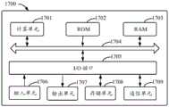
图16示出了可以用来实施本公开的实施例的示例计算机设备1600的示意性框图。计算机设备旨在表示各种形式的数字计算机,诸如,膝上型计算机、台式计算机、工作台、个人数字助理、计算机设备、刀片式计算机设备、大型计算机、和其它适合的计算机。计算机设备还可以表示各种形式的移动装置,诸如,个人数字处理、蜂窝电话、智能电话、可穿戴设备和其它类似的计算装置。本文所示的部件、它们的连接和关系、以及它们的功能仅仅作为示例,并且不意在限制本文中描述的和/或者要求的本公开的实现。16 shows a schematic block diagram of an
如图16所示,计算机设备1600包括计算单元1601,其可以根据存储在只读存储器(ROM)1602中的计算机程序或者从存储单元1608加载到随机访问存储器(RAM)1603中的计算机程序,来执行各种适当的动作和处理。在RAM 1603中,还可存储设备1600操作所需的各种程序和数据。计算单元1601、ROM 1602以及RAM 1603通过总线1604彼此相连。输入/输出(I/O)接口1605也连接至总线1604。As shown in FIG. 16 , the
计算机设备1600中的多个部件连接至I/O接口1605,包括:输入单元1606,例如键盘、鼠标等;输出单元1607,例如各种类型的显示器、扬声器等;存储单元1608,例如磁盘、光盘等;以及通信单元1609,例如网卡、调制解调器、无线通信收发机等。通信单元1609允许计算机设备1600通过诸如因特网的计算机网络和/或各种电信网络与其他设备交换信息/数据。Various components in the
计算单元1601可以是各种具有处理和计算能力的通用和/或专用处理组件。计算单元1601的一些示例包括但不限于中央处理单元(CPU)、图形处理单元(GPU)、各种专用的人工智能(AI)计算芯片、各种运行机器学习模型算法的计算单元、数字信号处理器(DSP)、以及任何适当的处理器、控制器、微控制器等。计算单元1601执行上文所描述的各个方法和处理,例如用于生成高精地图的定位信息的处理方法。例如,在一些实施例中,方法用于图像处理的模型训练可被实现为计算机软件程序,其被有形地包含于机器可读介质,例如存储单元1608。在一些实施例中,计算机程序的部分或者全部可以经由ROM 1602和/或通信单元1609而被载入和/或安装到计算机设备1600上。当计算机程序加载到RAM 1603并由计算单元1601执行时,可以执行上文描述的基于遥感卫星图像的地图更新方法的一个或多个步骤。备选地,在其他实施例中,计算单元1601可以通过其他任何适当的方式(例如,借助于固件)而被配置为执行方法用于图像处理的模型训练。
本文中以上描述的系统和技术的各种实施方式可以在数字电子电路系统、集成电路系统、场可编程门阵列(FPGA)、专用集成电路(ASIC)、专用标准产品(ASSP)、芯片上系统的系统(SOC)、负载可编程逻辑设备(CPLD)、计算机硬件、固件、软件、和/或它们的组合中实现。这些各种实施方式可以包括:实施在一个或者多个计算机程序中,该一个或者多个计算机程序可在包括至少一个可编程处理器的可编程系统上执行和/或解释,该可编程处理器可以是专用或者通用可编程处理器,可以从存储系统、至少一个输入装置、和至少一个输出装置接收数据和指令,并且将数据和指令传输至该存储系统、该至少一个输入装置、和该至少一个输出装置。Various implementations of the systems and techniques described herein above may be implemented in digital electronic circuitry, integrated circuit systems, field programmable gate arrays (FPGAs), application specific integrated circuits (ASICs), application specific standard products (ASSPs), systems on chips system (SOC), load programmable logic device (CPLD), computer hardware, firmware, software, and/or combinations thereof. These various embodiments may include being implemented in one or more computer programs executable and/or interpretable on a programmable system including at least one programmable processor that The processor, which may be a special purpose or general-purpose programmable processor, may receive data and instructions from a storage system, at least one input device, and at least one output device, and transmit data and instructions to the storage system, the at least one input device, and the at least one output device an output device.
用于实施本公开的方法的程序代码可以采用一个或多个编程语言的任何组合来编写。这些程序代码可以提供给通用计算机、专用计算机或其他可编程数据处理装置的处理器或控制器,使得程序代码当由处理器或控制器执行时使流程图和/或框图中所规定的功能/操作被实施。程序代码可以完全在机器上执行、部分地在机器上执行,作为独立软件包部分地在机器上执行且部分地在远程机器上执行或完全在远程机器或计算机设备上执行。Program code for implementing the methods of the present disclosure may be written in any combination of one or more programming languages. These program codes may be provided to a processor or controller of a general purpose computer, special purpose computer or other programmable data processing apparatus, such that the program code, when executed by the processor or controller, performs the functions/functions specified in the flowcharts and/or block diagrams. Action is implemented. The program code may execute entirely on the machine, partly on the machine, partly on the machine and partly on a remote machine as a stand-alone software package or entirely on the remote machine or computer device.
在本公开的上下文中,机器可读介质可以是有形的介质,其可以包含或存储以供指令执行系统、装置或设备使用或与指令执行系统、装置或设备结合地使用的程序。机器可读介质可以是机器可读信号介质或机器可读储存介质。机器可读介质可以包括但不限于电子的、磁性的、光学的、电磁的、红外的、或半导体系统、装置或设备,或者上述内容的任何合适组合。机器可读存储介质的更具体示例会包括基于一个或多个线的电气连接、便携式计算机盘、硬盘、随机存取存储器(RAM)、只读存储器(ROM)、可擦除可编程只读存储器(EPROM或快闪存储器)、光纤、便捷式紧凑盘只读存储器(CD-ROM)、光学储存设备、磁储存设备、或上述内容的任何合适组合。In the context of the present disclosure, a machine-readable medium may be a tangible medium that may contain or store a program for use by or in connection with the instruction execution system, apparatus or device. The machine-readable medium may be a machine-readable signal medium or a machine-readable storage medium. Machine-readable media may include, but are not limited to, electronic, magnetic, optical, electromagnetic, infrared, or semiconductor systems, devices, or devices, or any suitable combination of the foregoing. More specific examples of machine-readable storage media would include one or more wire-based electrical connections, portable computer disks, hard disks, random access memory (RAM), read only memory (ROM), erasable programmable read only memory (EPROM or flash memory), fiber optics, compact disk read only memory (CD-ROM), optical storage, magnetic storage, or any suitable combination of the foregoing.
为了提供与用户的交互,可以在计算机上实施此处描述的系统和技术,该计算机具有:用于向用户显示信息的显示装置(例如,CRT(阴极射线管)或者LCD(液晶显示器)监视器);以及键盘和指向装置(例如,鼠标或者轨迹球),用户可以通过该键盘和该指向装置来将输入提供给计算机。其它种类的装置还可以用于提供与用户的交互;例如,提供给用户的反馈可以是任何形式的传感反馈(例如,视觉反馈、听觉反馈、或者触觉反馈);并且可以用任何形式(包括声输入、语音输入或者、触觉输入)来接收来自用户的输入。To provide interaction with a user, the systems and techniques described herein may be implemented on a computer having a display device (eg, a CRT (cathode ray tube) or LCD (liquid crystal display) monitor) for displaying information to the user ); and a keyboard and pointing device (eg, a mouse or trackball) through which a user can provide input to the computer. Other kinds of devices can also be used to provide interaction with the user; for example, the feedback provided to the user can be any form of sensory feedback (eg, visual feedback, auditory feedback, or tactile feedback); and can be in any form (including acoustic input, voice input, or tactile input) to receive input from the user.
可以将此处描述的系统和技术实施在包括后台部件的计算系统(例如,作为数据计算机设备)、或者包括中间件部件的计算系统(例如,应用计算机设备)、或者包括前端部件的计算系统(例如,具有图形用户界面或者网络浏览器的用户计算机,用户可以通过该图形用户界面或者该网络浏览器来与此处描述的系统和技术的实施方式交互)、或者包括这种后台部件、中间件部件、或者前端部件的任何组合的计算系统中。可以通过任何形式或者介质的数字数据通信(例如,通信网络)来将系统的部件相互连接。通信网络的示例包括:局域网(LAN)、广域网(WAN)和互联网。The systems and techniques described herein can be implemented on a computing system that includes back-end components (eg, as a data computing device), or a computing system that includes middleware components (eg, an application computing device), or a computing system that includes front-end components (eg, as a data computing device). For example, a user computer having a graphical user interface or web browser through which a user may interact with implementations of the systems and techniques described herein), or including such backend components, middleware components, or any combination of front-end components in a computing system. The components of the system may be interconnected by any form or medium of digital data communication (eg, a communication network). Examples of communication networks include: Local Area Networks (LANs), Wide Area Networks (WANs), and the Internet.
计算机系统可以包括客户端和计算机设备。客户端和计算机设备一般远离彼此并且通常通过通信网络进行交互。通过在相应的计算机上运行并且彼此具有客户端-计算机设备关系的计算机程序来产生客户端和计算机设备的关系。计算机设备可以是云计算机设备,又称为云计算计算机设备或云主机,是云计算服务体系中的一项主机产品,以解决了传统物理主机与VPS服务("Virtual Private Server",或简称"VPS")中,存在的管理难度大,业务扩展性弱的缺陷。计算机设备也可以为分布式系统的计算机设备,或者是结合了区块链的计算机设备。A computer system may include clients and computer devices. Clients and computer devices are generally remote from each other and typically interact through a communication network. The relationship of client and computer devices arises by computer programs running on the respective computers and having a client-computer device relationship to each other. Computer equipment can be cloud computer equipment, also known as cloud computing computer equipment or cloud host, is a host product in the cloud computing service system, to solve the traditional physical host and VPS service ("Virtual Private VPS"), there are the defects of difficult management and weak business expansion. The computer equipment can also be a computer equipment of a distributed system, or a computer equipment combined with a blockchain.
图17示出了可以用来实施本公开的实施例的示例计算机设备1700的示意性框图。计算机设备旨在表示各种形式的数字计算机,诸如,膝上型计算机、台式计算机、工作台、个人数字助理、计算机设备、刀片式计算机设备、大型计算机、和其它适合的计算机。计算机设备还可以表示各种形式的移动装置,诸如,个人数字处理、蜂窝电话、智能电话、可穿戴设备和其它类似的计算装置。本文所示的部件、它们的连接和关系、以及它们的功能仅仅作为示例,并且不意在限制本文中描述的和/或者要求的本公开的实现。17 shows a schematic block diagram of an
如图17所示,计算机设备1700包括计算单元1701,其可以根据存储在只读存储器(ROM)1702中的计算机程序或者从存储单元1708加载到随机访问存储器(RAM)1703中的计算机程序,来执行各种适当的动作和处理。在RAM 1703中,还可存储设备1700操作所需的各种程序和数据。计算单元1701、ROM 1702以及RAM 1703通过总线1704彼此相连。输入/输出(I/O)接口1705也连接至总线1704。As shown in FIG. 17 , the
计算机设备1700中的多个部件连接至I/O接口1705,包括:输入单元1706,例如键盘、鼠标等;输出单元1707,例如各种类型的显示器、扬声器等;存储单元1708,例如磁盘、光盘等;以及通信单元1709,例如网卡、调制解调器、无线通信收发机等。通信单元1709允许计算机设备1700通过诸如因特网的计算机网络和/或各种电信网络与其他设备交换信息/数据。Various components in the
计算单元1701可以是各种具有处理和计算能力的通用和/或专用处理组件。计算单元1701的一些示例包括但不限于中央处理单元(CPU)、图形处理单元(GPU)、各种专用的人工智能(AI)计算芯片、各种运行机器学习模型算法的计算单元、数字信号处理器(DSP)、以及任何适当的处理器、控制器、微控制器等。计算单元1701执行上文所描述的各个方法和处理,例如用于生成高精地图的定位信息的处理方法。例如,在一些实施例中,方法用于图像处理的模型训练可被实现为计算机软件程序,其被有形地包含于机器可读介质,例如存储单元1708。在一些实施例中,计算机程序的部分或者全部可以经由ROM 1702和/或通信单元1709而被载入和/或安装到计算机设备1700上。当计算机程序加载到RAM 1703并由计算单元1701执行时,可以执行上文描述的应用于地图更新的图编码模型的训练方法的一个或多个步骤。备选地,在其他实施例中,计算单元1701可以通过其他任何适当的方式(例如,借助于固件)而被配置为执行方法用于图像处理的模型训练。
本文中以上描述的系统和技术的各种实施方式可以在数字电子电路系统、集成电路系统、场可编程门阵列(FPGA)、专用集成电路(ASIC)、专用标准产品(ASSP)、芯片上系统的系统(SOC)、复杂可编程逻辑设备(CPLD)、计算机硬件、固件、软件、和/或它们的组合中实现。这些各种实施方式可以包括:实施在一个或者多个计算机程序中,该一个或者多个计算机程序可在包括至少一个可编程处理器的可编程系统上执行和/或解释,该可编程处理器可以是专用或者通用可编程处理器,可以从存储系统、至少一个输入装置、和至少一个输出装置接收数据和指令,并且将数据和指令传输至该存储系统、该至少一个输入装置、和该至少一个输出装置。Various implementations of the systems and techniques described herein above may be implemented in digital electronic circuitry, integrated circuit systems, field programmable gate arrays (FPGAs), application specific integrated circuits (ASICs), application specific standard products (ASSPs), systems on chips system (SOC), complex programmable logic device (CPLD), computer hardware, firmware, software, and/or combinations thereof. These various embodiments may include being implemented in one or more computer programs executable and/or interpretable on a programmable system including at least one programmable processor that The processor, which may be a special purpose or general-purpose programmable processor, may receive data and instructions from a storage system, at least one input device, and at least one output device, and transmit data and instructions to the storage system, the at least one input device, and the at least one output device an output device.
用于实施本公开的方法的程序代码可以采用一个或多个编程语言的任何组合来编写。这些程序代码可以提供给通用计算机、专用计算机或其他可编程数据处理装置的处理器或控制器,使得程序代码当由处理器或控制器执行时使流程图和/或框图中所规定的功能/操作被实施。程序代码可以完全在机器上执行、部分地在机器上执行,作为独立软件包部分地在机器上执行且部分地在远程机器上执行或完全在远程机器或计算机设备上执行。Program code for implementing the methods of the present disclosure may be written in any combination of one or more programming languages. These program codes may be provided to a processor or controller of a general purpose computer, special purpose computer or other programmable data processing apparatus, such that the program code, when executed by the processor or controller, performs the functions/functions specified in the flowcharts and/or block diagrams. Action is implemented. The program code may execute entirely on the machine, partly on the machine, partly on the machine and partly on a remote machine as a stand-alone software package or entirely on the remote machine or computer device.
在本公开的上下文中,机器可读介质可以是有形的介质,其可以包含或存储以供指令执行系统、装置或设备使用或与指令执行系统、装置或设备结合地使用的程序。机器可读介质可以是机器可读信号介质或机器可读储存介质。机器可读介质可以包括但不限于电子的、磁性的、光学的、电磁的、红外的、或半导体系统、装置或设备,或者上述内容的任何合适组合。机器可读存储介质的更具体示例会包括基于一个或多个线的电气连接、便携式计算机盘、硬盘、随机存取存储器(RAM)、只读存储器(ROM)、可擦除可编程只读存储器(EPROM或快闪存储器)、光纤、便捷式紧凑盘只读存储器(CD-ROM)、光学储存设备、磁储存设备、或上述内容的任何合适组合。In the context of the present disclosure, a machine-readable medium may be a tangible medium that may contain or store a program for use by or in connection with the instruction execution system, apparatus or device. The machine-readable medium may be a machine-readable signal medium or a machine-readable storage medium. Machine-readable media may include, but are not limited to, electronic, magnetic, optical, electromagnetic, infrared, or semiconductor systems, devices, or devices, or any suitable combination of the foregoing. More specific examples of machine-readable storage media would include one or more wire-based electrical connections, portable computer disks, hard disks, random access memory (RAM), read only memory (ROM), erasable programmable read only memory (EPROM or flash memory), fiber optics, compact disk read only memory (CD-ROM), optical storage, magnetic storage, or any suitable combination of the foregoing.
为了提供与用户的交互,可以在计算机上实施此处描述的系统和技术,该计算机具有:用于向用户显示信息的显示装置(例如,CRT(阴极射线管)或者LCD(液晶显示器)监视器);以及键盘和指向装置(例如,鼠标或者轨迹球),用户可以通过该键盘和该指向装置来将输入提供给计算机。其它种类的装置还可以用于提供与用户的交互;例如,提供给用户的反馈可以是任何形式的传感反馈(例如,视觉反馈、听觉反馈、或者触觉反馈);并且可以用任何形式(包括声输入、语音输入或者、触觉输入)来接收来自用户的输入。To provide interaction with a user, the systems and techniques described herein may be implemented on a computer having a display device (eg, a CRT (cathode ray tube) or LCD (liquid crystal display) monitor) for displaying information to the user ); and a keyboard and pointing device (eg, a mouse or trackball) through which a user can provide input to the computer. Other kinds of devices can also be used to provide interaction with the user; for example, the feedback provided to the user can be any form of sensory feedback (eg, visual feedback, auditory feedback, or tactile feedback); and can be in any form (including acoustic input, voice input, or tactile input) to receive input from the user.
可以将此处描述的系统和技术实施在包括后台部件的计算系统(例如,作为数据计算机设备)、或者包括中间件部件的计算系统(例如,应用计算机设备)、或者包括前端部件的计算系统(例如,具有图形用户界面或者网络浏览器的用户计算机,用户可以通过该图形用户界面或者该网络浏览器来与此处描述的系统和技术的实施方式交互)、或者包括这种后台部件、中间件部件、或者前端部件的任何组合的计算系统中。可以通过任何形式或者介质的数字数据通信(例如,通信网络)来将系统的部件相互连接。通信网络的示例包括:局域网(LAN)、广域网(WAN)和互联网。The systems and techniques described herein can be implemented on a computing system that includes back-end components (eg, as a data computing device), or a computing system that includes middleware components (eg, an application computing device), or a computing system that includes front-end components (eg, as a data computing device). For example, a user computer having a graphical user interface or web browser through which a user may interact with implementations of the systems and techniques described herein), or including such backend components, middleware components, or any combination of front-end components in a computing system. The components of the system may be interconnected by any form or medium of digital data communication (eg, a communication network). Examples of communication networks include: Local Area Networks (LANs), Wide Area Networks (WANs), and the Internet.
计算机系统可以包括客户端和计算机设备。客户端和计算机设备一般远离彼此并且通常通过通信网络进行交互。通过在相应的计算机上运行并且彼此具有客户端-计算机设备关系的计算机程序来产生客户端和计算机设备的关系。计算机设备可以是云计算机设备,又称为云计算计算机设备或云主机,是云计算服务体系中的一项主机产品,以解决了传统物理主机与VPS服务("Virtual Private Server",或简称"VPS")中,存在的管理难度大,业务扩展性弱的缺陷。计算机设备也可以为分布式系统的计算机设备,或者是结合了区块链的计算机设备。A computer system may include clients and computer devices. Clients and computer devices are generally remote from each other and typically interact through a communication network. The relationship of client and computer devices arises by computer programs running on the respective computers and having a client-computer device relationship to each other. Computer equipment can be cloud computer equipment, also known as cloud computing computer equipment or cloud host, is a host product in the cloud computing service system, to solve the traditional physical host and VPS service ("Virtual Private VPS"), there are the defects of difficult management and weak business expansion. The computer equipment can also be a computer equipment of a distributed system, or a computer equipment combined with a blockchain.
应该理解,可以使用上面所示的各种形式的流程,重新排序、增加或删除步骤。例如,本发公开中记载的各步骤可以并行地执行也可以顺序地执行也可以不同的次序执行,只要能够实现本公开公开的技术方案所期望的结果,本文在此不进行限制。It should be understood that steps may be reordered, added or deleted using the various forms of flow shown above. For example, the steps described in the present disclosure can be executed in parallel, sequentially, or in different orders. As long as the desired results of the technical solutions disclosed in the present disclosure can be achieved, there is no limitation herein.
上述具体实施方式,并不构成对本公开保护范围的限制。本领域技术人员应该明白的是,根据设计要求和其他因素,可以进行各种修改、组合、子组合和替代。任何在本公开的精神和原则之内所作的修改、等同替换和改进等,均应包含在本公开保护范围之内。The above-mentioned specific embodiments do not constitute a limitation on the protection scope of the present disclosure. It should be understood by those skilled in the art that various modifications, combinations, sub-combinations and substitutions may occur depending on design requirements and other factors. Any modifications, equivalent replacements, and improvements made within the spirit and principles of the present disclosure should be included within the protection scope of the present disclosure.
Claims (34)
Priority Applications (1)
| Application Number | Priority Date | Filing Date | Title |
|---|---|---|---|
| CN202111567400.7ACN114283343B (en) | 2021-12-20 | 2021-12-20 | Map updating method, training method and device based on remote sensing satellite image |
Applications Claiming Priority (1)
| Application Number | Priority Date | Filing Date | Title |
|---|---|---|---|
| CN202111567400.7ACN114283343B (en) | 2021-12-20 | 2021-12-20 | Map updating method, training method and device based on remote sensing satellite image |
Publications (2)
| Publication Number | Publication Date |
|---|---|
| CN114283343Atrue CN114283343A (en) | 2022-04-05 |
| CN114283343B CN114283343B (en) | 2023-09-26 |
Family
ID=80873351
Family Applications (1)
| Application Number | Title | Priority Date | Filing Date |
|---|---|---|---|
| CN202111567400.7AActiveCN114283343B (en) | 2021-12-20 | 2021-12-20 | Map updating method, training method and device based on remote sensing satellite image |
Country Status (1)
| Country | Link |
|---|---|
| CN (1) | CN114283343B (en) |
Cited By (4)
| Publication number | Priority date | Publication date | Assignee | Title |
|---|---|---|---|---|
| CN114842107A (en)* | 2022-04-06 | 2022-08-02 | 山东新一代信息产业技术研究院有限公司 | High-precision map generation method based on satellite map |
| CN117440135A (en)* | 2023-12-20 | 2024-01-23 | 深圳市宇隆移动互联网有限公司 | Image transmission method and system based on Beidou satellite communication |
| CN117612026A (en)* | 2023-11-24 | 2024-02-27 | 北京邮电大学 | A path prediction method and system based on road extraction from remote sensing images |
| CN120597993A (en)* | 2025-08-11 | 2025-09-05 | 上海博礼智能科技有限公司 | Cross-modal large model fine-tuning training system based on prompt word embedding |
Citations (10)
| Publication number | Priority date | Publication date | Assignee | Title |
|---|---|---|---|---|
| CN109919051A (en)* | 2019-02-22 | 2019-06-21 | 同济大学 | A Convolutional Neural Network Acceleration Method for Video Image Processing |
| CN109991984A (en)* | 2019-04-22 | 2019-07-09 | 上海蔚来汽车有限公司 | For generating the method, apparatus and computer storage medium of fine map |
| CN110376594A (en)* | 2018-08-17 | 2019-10-25 | 北京京东尚科信息技术有限公司 | A kind of method and system of the intelligent navigation based on topological diagram |
| CN111126166A (en)* | 2019-11-30 | 2020-05-08 | 武汉汉达瑞科技有限公司 | Remote sensing image road extraction method and system |
| CN111815776A (en)* | 2020-02-04 | 2020-10-23 | 山东水利技师学院 | Three-dimensional building fine geometric reconstruction method integrating airborne and vehicle-mounted three-dimensional laser point clouds and streetscape images |
| US20210067848A1 (en)* | 2017-09-27 | 2021-03-04 | Google Llc | End to End Network Model for High Resolution Image Segmentation |
| CN112749578A (en)* | 2019-10-29 | 2021-05-04 | 中科星图股份有限公司 | Remote sensing image automatic road extraction method based on deep convolutional neural network |
| CN113008247A (en)* | 2020-03-24 | 2021-06-22 | 青岛慧拓智能机器有限公司 | High-precision map construction method and device for mining area |
| CN113642585A (en)* | 2021-10-14 | 2021-11-12 | 腾讯科技(深圳)有限公司 | Image processing method, apparatus, device, storage medium, and computer program product |
| WO2021238283A1 (en)* | 2020-05-25 | 2021-12-02 | 华为技术有限公司 | Positioning method and positioning apparatus |
- 2021
- 2021-12-20CNCN202111567400.7Apatent/CN114283343B/enactiveActive
Patent Citations (10)
| Publication number | Priority date | Publication date | Assignee | Title |
|---|---|---|---|---|
| US20210067848A1 (en)* | 2017-09-27 | 2021-03-04 | Google Llc | End to End Network Model for High Resolution Image Segmentation |
| CN110376594A (en)* | 2018-08-17 | 2019-10-25 | 北京京东尚科信息技术有限公司 | A kind of method and system of the intelligent navigation based on topological diagram |
| CN109919051A (en)* | 2019-02-22 | 2019-06-21 | 同济大学 | A Convolutional Neural Network Acceleration Method for Video Image Processing |
| CN109991984A (en)* | 2019-04-22 | 2019-07-09 | 上海蔚来汽车有限公司 | For generating the method, apparatus and computer storage medium of fine map |
| CN112749578A (en)* | 2019-10-29 | 2021-05-04 | 中科星图股份有限公司 | Remote sensing image automatic road extraction method based on deep convolutional neural network |
| CN111126166A (en)* | 2019-11-30 | 2020-05-08 | 武汉汉达瑞科技有限公司 | Remote sensing image road extraction method and system |
| CN111815776A (en)* | 2020-02-04 | 2020-10-23 | 山东水利技师学院 | Three-dimensional building fine geometric reconstruction method integrating airborne and vehicle-mounted three-dimensional laser point clouds and streetscape images |
| CN113008247A (en)* | 2020-03-24 | 2021-06-22 | 青岛慧拓智能机器有限公司 | High-precision map construction method and device for mining area |
| WO2021238283A1 (en)* | 2020-05-25 | 2021-12-02 | 华为技术有限公司 | Positioning method and positioning apparatus |
| CN113642585A (en)* | 2021-10-14 | 2021-11-12 | 腾讯科技(深圳)有限公司 | Image processing method, apparatus, device, storage medium, and computer program product |
Non-Patent Citations (3)
| Title |
|---|
| FOIVOS I.DIAKOGIANNIS等: "ResUNet-a:A deep learning framework for semantic segmentation of remotely sensed data", ISPRS JOURNAL OF PHOTOGRAMMETRY AND REMOTE SENSING* |
| 张静 等: "多尺度信息融合的遥感图像语义分割模型", 计算机辅助设计与图形学学报* |
| 王鑫 等: "基于U-Net优化的SAR遥感图像语义分割", 计算机科学* |
Cited By (6)
| Publication number | Priority date | Publication date | Assignee | Title |
|---|---|---|---|---|
| CN114842107A (en)* | 2022-04-06 | 2022-08-02 | 山东新一代信息产业技术研究院有限公司 | High-precision map generation method based on satellite map |
| CN117612026A (en)* | 2023-11-24 | 2024-02-27 | 北京邮电大学 | A path prediction method and system based on road extraction from remote sensing images |
| CN117612026B (en)* | 2023-11-24 | 2024-06-07 | 北京邮电大学 | Path prediction method and system based on remote sensing image road extraction |
| CN117440135A (en)* | 2023-12-20 | 2024-01-23 | 深圳市宇隆移动互联网有限公司 | Image transmission method and system based on Beidou satellite communication |
| CN117440135B (en)* | 2023-12-20 | 2024-03-08 | 深圳市宇隆移动互联网有限公司 | Image transmission method and system based on Beidou satellite communication |
| CN120597993A (en)* | 2025-08-11 | 2025-09-05 | 上海博礼智能科技有限公司 | Cross-modal large model fine-tuning training system based on prompt word embedding |
Also Published As
| Publication number | Publication date |
|---|---|
| CN114283343B (en) | 2023-09-26 |
Similar Documents
| Publication | Publication Date | Title |
|---|---|---|
| CN113139543B (en) | Training method of target object detection model, target object detection method and equipment | |
| CN114283343B (en) | Map updating method, training method and device based on remote sensing satellite image | |
| WO2023015941A1 (en) | Text detection model training method and apparatus, text detection method, and device | |
| KR20220125712A (en) | Image processing method, text recognition method and device | |
| CN112560862A (en) | Text recognition method, device and electronic device | |
| US20230222733A1 (en) | Landform map building method and apparatus, electronic device and readable storage medium | |
| CN112509126B (en) | Method, device, equipment and storage medium for detecting three-dimensional object | |
| CN114677596A (en) | Remote sensing image ship detection method and device based on attention model | |
| CN114581876B (en) | Method for constructing lane detection model and lane line detection method in complex scenes | |
| CN112989995B (en) | Text detection method and device and electronic equipment | |
| CN114359932B (en) | Text detection method, text recognition method and device | |
| CN114627257A (en) | Construction method, device, electronic device and storage medium of three-dimensional road network map | |
| CN113762397A (en) | Detection model training, high-precision map update method, equipment, medium and product | |
| CN114596188A (en) | Watermark detection method, model training method, device and electronic equipment | |
| CN115937546A (en) | Image matching, three-dimensional image reconstruction method, device, electronic device and medium | |
| CN114926849A (en) | Text detection method, device, equipment and storage medium | |
| CN115760878A (en) | Three-dimensional image entity segmentation method, device, equipment, storage medium and vehicle | |
| CN116189162A (en) | A ship plate detection and recognition method, device, electronic equipment and storage medium | |
| CN115115793A (en) | Image processing method, device, device and storage medium | |
| CN116740498B (en) | Model pre-training method, model training method, object processing method and device | |
| CN114596431A (en) | Information determination method, device and electronic device | |
| CN116524372B (en) | Method, system, electronic equipment and storage medium for acquiring ground object information | |
| US20250052591A1 (en) | System and method for detecting information about road relating to digital geographical map data | |
| CN116244447A (en) | Multi-mode map construction and information processing method and device, electronic equipment and medium | |
| CN116386049A (en) | Formula identification method, device, equipment and storage medium |
Legal Events
| Date | Code | Title | Description |
|---|---|---|---|
| PB01 | Publication | ||
| PB01 | Publication | ||
| SE01 | Entry into force of request for substantive examination | ||
| SE01 | Entry into force of request for substantive examination | ||
| GR01 | Patent grant | ||
| GR01 | Patent grant |