CN114187533B - GB-InSAR (GB-InSAR) atmospheric correction method based on random forest time sequence classification - Google Patents
GB-InSAR (GB-InSAR) atmospheric correction method based on random forest time sequence classificationDownload PDFInfo
- Publication number
- CN114187533B CN114187533BCN202210135116.0ACN202210135116ACN114187533BCN 114187533 BCN114187533 BCN 114187533BCN 202210135116 ACN202210135116 ACN 202210135116ACN 114187533 BCN114187533 BCN 114187533B
- Authority
- CN
- China
- Prior art keywords
- random forest
- training
- attribute
- time sequence
- atmospheric
- Prior art date
- Legal status (The legal status is an assumption and is not a legal conclusion. Google has not performed a legal analysis and makes no representation as to the accuracy of the status listed.)
- Active
Links
Images


Classifications
- G—PHYSICS
- G06—COMPUTING OR CALCULATING; COUNTING
- G06F—ELECTRIC DIGITAL DATA PROCESSING
- G06F18/00—Pattern recognition
- G06F18/20—Analysing
- G06F18/21—Design or setup of recognition systems or techniques; Extraction of features in feature space; Blind source separation
- G06F18/214—Generating training patterns; Bootstrap methods, e.g. bagging or boosting
- G—PHYSICS
- G06—COMPUTING OR CALCULATING; COUNTING
- G06F—ELECTRIC DIGITAL DATA PROCESSING
- G06F18/00—Pattern recognition
- G06F18/20—Analysing
- G06F18/24—Classification techniques
- G06F18/243—Classification techniques relating to the number of classes
- G06F18/24323—Tree-organised classifiers
- G—PHYSICS
- G06—COMPUTING OR CALCULATING; COUNTING
- G06N—COMPUTING ARRANGEMENTS BASED ON SPECIFIC COMPUTATIONAL MODELS
- G06N3/00—Computing arrangements based on biological models
- G06N3/02—Neural networks
- G06N3/08—Learning methods
Landscapes
- Engineering & Computer Science (AREA)
- Theoretical Computer Science (AREA)
- Data Mining & Analysis (AREA)
- Physics & Mathematics (AREA)
- Life Sciences & Earth Sciences (AREA)
- Artificial Intelligence (AREA)
- General Physics & Mathematics (AREA)
- General Engineering & Computer Science (AREA)
- Evolutionary Computation (AREA)
- Bioinformatics & Computational Biology (AREA)
- Evolutionary Biology (AREA)
- Computer Vision & Pattern Recognition (AREA)
- Bioinformatics & Cheminformatics (AREA)
- Computational Linguistics (AREA)
- Biomedical Technology (AREA)
- Biophysics (AREA)
- Health & Medical Sciences (AREA)
- General Health & Medical Sciences (AREA)
- Molecular Biology (AREA)
- Computing Systems (AREA)
- Mathematical Physics (AREA)
- Software Systems (AREA)
- Radar Systems Or Details Thereof (AREA)
Abstract
Translated fromChinese
Description
Translated fromChinese技术领域technical field
本发明属于GB-InSAR大气延迟误差改正领域,具体涉及基于随机森林时序分类的GB-InSAR大气改正方法。The invention belongs to the field of GB-InSAR atmospheric delay error correction, in particular to a GB-InSAR atmospheric correction method based on random forest time series classification.
背景技术Background technique
在GB-InSAR(地基雷达干涉测量)大气延迟误差改正领域,GB-InSAR系统通过发射和接收电磁波信号对地表形变物体进行探测。电磁波在大气中传播的过程中,因大气介质不均匀,导致电磁波传播路径和方向发生改变,从而产生附加相位,即大气延迟相位。为使精度达到亚毫米,地基雷达所使用的波段波长较短,因此对大气变化非常敏感,这就要求可靠的大气延迟改正方法来对时序差分干涉相位进行改正,从而获得高精度时序形变场。特别地,大气延迟相位在时序差分干涉相位中表现为时间域上的低频性,即存在大气延迟相位的像元点在某些时间差分干涉图中会出现,而在另一时间突然消失。而滑坡蠕变过程中的时序形变信号在时序差分干涉相位图中表现为高频性,即形变相位是连续存在的。In the field of GB-InSAR (Ground-Based Radar Interferometry) atmospheric delay error correction, the GB-InSAR system detects surface deformation objects by transmitting and receiving electromagnetic wave signals. During the propagation of electromagnetic waves in the atmosphere, due to the unevenness of the atmospheric medium, the propagation path and direction of electromagnetic waves are changed, resulting in an additional phase, that is, the atmospheric delay phase. In order to achieve sub-millimeter accuracy, ground-based radars use short wavelength bands, so they are very sensitive to atmospheric changes. This requires a reliable atmospheric delay correction method to correct the time series differential interference phase, so as to obtain high-precision time series deformation fields. In particular, the atmospheric delay phase appears as a low frequency in the time domain in the time-series differential interferometric phase, that is, the pixel points with the atmospheric delay phase appear in some time differential interferograms, but suddenly disappear at another time. However, the time-series deformation signal in the process of landslide creep shows high frequency in the time-series differential interference phase diagram, that is, the deformation phase exists continuously.
现有大气改正方法主要包括气象数据校正法、永久散射体技术、距离函数拟合方法这三大类。The existing atmospheric correction methods mainly include three categories: meteorological data correction method, permanent scatterer technology, and distance function fitting method.
上述三类方法的特点分析:The characteristics of the above three types of methods are analyzed:
因地基SAR的观测距离可达数千米,且过远观测距离导致气象数据变化给大气扰动改正引入误差;大气折射经验模型仅考虑了大气扰动对距离向的影响,而忽略在方位向上所存在的误差。Because the observation distance of ground-based SAR can reach several thousand meters, and the change of meteorological data leads to errors in atmospheric disturbance correction due to the long observation distance; the atmospheric refraction empirical model only considers the influence of atmospheric disturbance on the range direction, while ignoring the existence of the atmospheric disturbance in the azimuth direction. error.
永久散射体技术利用一组时间序列的SAR数据,找出持久稳定的雷达目标点,得出其相位变化。通过稳定目标点的相位变化来估计大气扰动对整个观测区域的影响,从而在差分相位中去除因大气扰动带来的延迟相位。但是该技术存在如下缺点:对SAR影像数据需求量大和数据处理难度大;必须有足够数量的永久散射体;永久散射体在监测过程中形变量较小。Permanent scatterer technology uses a set of time series SAR data to find persistent and stable radar target points and obtain their phase changes. By estimating the influence of atmospheric disturbance on the entire observation area by stabilizing the phase change of the target point, the delayed phase caused by atmospheric disturbance is removed from the differential phase. However, this technology has the following shortcomings: the demand for SAR image data is large and the data processing is difficult; there must be a sufficient number of permanent scatterers; the deformation of permanent scatterers during the monitoring process is small.
距离函数拟合方法是在监测区域选取稳定点或布设角反射器,利用稳定点与地基SAR之间的距离和相位变化获取观测区域内大气变化的改正值。由于滑坡区域存在危险性,不适宜人工布设角反射器,稳定点不宜发现等原因,导致该方法存在一定局限。The distance function fitting method is to select a stable point or set up a corner reflector in the monitoring area, and use the distance and phase changes between the stable point and the ground-based SAR to obtain the correction value of atmospheric changes in the observation area. Due to the dangers in the landslide area, it is not suitable to manually lay the corner reflector, and the stable point should not be found, which leads to certain limitations of this method.
发明内容SUMMARY OF THE INVENTION
针对现有技术中的上述不足,本发明提供的一种基于随机森林时序分类的GB-InSAR大气改正方法解决了在温度和水汽变化较快的日间连续监测过程中,不能有效减弱大气延迟误差的问题。In view of the above deficiencies in the prior art, the GB-InSAR atmospheric correction method based on random forest time series classification provided by the present invention solves the problem that the atmospheric delay error cannot be effectively reduced during the daytime continuous monitoring process with rapid changes in temperature and water vapor. The problem.
为了达到上述发明目的,本发明采用的技术方案为:一种基于随机森林时序分类的GB-InSAR大气改正方法,包括以下步骤:In order to achieve the above-mentioned purpose of the invention, the technical solution adopted in the present invention is: a GB-InSAR atmospheric correction method based on random forest time series classification, comprising the following steps:
S1、采集若干时序差分干涉相位图,得到第一训练样本;S1. Collect several time-series differential interference phase maps to obtain a first training sample;
S2、根据第一训练样本,得到训练好的随机森林;S2. Obtain a trained random forest according to the first training sample;
S3、通过训练好的随机森林对所有的时序差分干涉相位图进行分类,得到最优分类结果;S3. Classify all time series differential interferometric phase maps through the trained random forest to obtain the optimal classification result;
S4、根据最优分类结果,得到各时间点的高精度形变相位,完成大气的改正。S4. According to the optimal classification result, the high-precision deformation phase at each time point is obtained, and the atmospheric correction is completed.
进一步地:所述步骤S1具体为:Further: the step S1 is specifically:
S11、从GB-InSAR系统连续观测处理得到的所有时序差分干涉相位图中选取M幅时序差分干涉相位图,并分别从M幅时序差分干涉相位图中选取N个位置相同的像元;S11. Select M time-series differential interferometric phase maps from all time-series differential interferometric phase maps obtained by continuous observation and processing of the GB-InSAR system, and select N pixels with the same position from the M time-series differential interferometric phase maps respectively;
S12、提取每个像元时间序列上的差分干涉相位,并将每个像元的差分干涉相位作为一个数据集,进而将得到的N个数据集作为第一训练样本;S12, extracting the differential interference phase on the time series of each pixel, and using the differential interference phase of each pixel as a data set, and then using the obtained N data sets as the first training samples;
其中,每个数据集包含M个时序差分干涉相位。Among them, each data set contains M time-series differential interference phases.
上述进一步方案的有益效果为:从大量连续观测处理得到的时序差分干涉相位图中选取M幅时序差分干涉相位图作为第一训练样本,可以更全面训练随机森林。The beneficial effects of the above-mentioned further scheme are: selecting M time-series differential interferometric phase images from a large number of time-series differential interferometric phase images obtained by processing a large number of continuous observations as the first training samples, so that the random forest can be trained more comprehensively.
进一步地:所述步骤S2包括以下分步骤:Further: the step S2 includes the following sub-steps:
S21、根据第一训练样本通过随机抽样形成第二训练样本;S21, forming a second training sample by random sampling according to the first training sample;
S22、根据第二训练样本得到训练好的随机森林。S22. Obtain a trained random forest according to the second training sample.
进一步地:所述步骤S21包括以下分步骤:Further: the step S21 includes the following sub-steps:
S21-1、从第一训练样本中随机抽取一个数据集,通过所述数据集训练第一棵决策树,训练完成后将数据集放回第一训练样本;S21-1, randomly extracting a data set from the first training sample, training the first decision tree through the data set, and returning the data set to the first training sample after the training is completed;
S21-2、重复N次步骤S21-1,得到第一棵决策树的训练集1;S21-2, repeating step S21-1 N times to obtain the training set 1 of the first decision tree;
S21-3、重复n次步骤S21-2,得到n棵决策树对应的训练集1~训练集n,并将所有的训练集作为第二训练样本。S21-3. Repeat step S21-2 n times to obtain
上述进一步方案的有益效果为:随机抽样法可以完成n棵决策树对应的训练集的生成,可以用于训练更好的分类模型。The beneficial effects of the above-mentioned further scheme are: the random sampling method can complete the generation of the training set corresponding to the n decision trees, which can be used to train a better classification model.
进一步地:所述步骤S22包括以下分步骤:Further: the step S22 includes the following sub-steps:
S22-1、将第二训练样本中每个训练集的M个时序差分干涉相位作为样本特征属性;S22-1, using the M time series differential interference phases of each training set in the second training sample as the sample feature attribute;
S22-2、随机从每个所述训练集的样本特征属性中抽取m个属性子集,并从属性子集中选择最优分裂属性作为所述训练集对应决策树的节点分裂特征属性;S22-2, randomly extract m attribute subsets from the sample feature attributes of each described training set, and select the optimal splitting attribute from the attribute subsets as the node splitting feature attribute of the corresponding decision tree of the training set;
S22-3、根据确定的n棵决策树的属性子集和节点分裂特征属性,并通过n棵决策树构建随机森林,得到训练好的随机森林。S22-3. According to the determined attribute subsets and node splitting feature attributes of the n decision trees, a random forest is constructed through the n decision trees, and a trained random forest is obtained.
上述进一步方案的有益效果为:训练好的随机森林作为所有时序差分干涉相位图的分类模型,可以生成准确的大气延迟相位。The beneficial effect of the above-mentioned further scheme is that the trained random forest can be used as a classification model of all time-series differential interferometric phase maps, and can generate accurate atmospheric delay phases.
进一步地:所述步骤S22-2中,选择最优分裂属性的方法具体为:Further: in the step S22-2, the method for selecting the optimal splitting attribute is specifically:
通过弱学习器算法中的基尼系数法计算属性子集中的各个特征属性的基尼值,选择基尼值最小的特征属性作为最优分裂属性;The Gini value of each feature attribute in the attribute subset is calculated by the Gini coefficient method in the weak learner algorithm, and the feature attribute with the smallest Gini value is selected as the optimal splitting attribute;
其中,基尼值Gini(D)的表达式具体为:Among them, the expression of Gini valueGini (D) is specifically:

式中,D为属性子集中的特征属性,pi为属性子集中第i类属性所占比例,k为属性子集中属性的总数。In the formula, D is the characteristic attribute in the attribute subset,pi is the proportion of thei -th type of attribute in the attribute subset, andk is the total number of attributes in the attribute subset.
上述进一步方案的有益效果为:基尼系数法可以确定最优的特征属性,并将其分到同一类别决策树的节点分裂特征属性。The beneficial effect of the above-mentioned further scheme is that the Gini coefficient method can determine the optimal feature attribute and assign it to the node-splitting feature attribute of the decision tree of the same category.
进一步地:所述步骤S3包括以下分步骤:Further: the step S3 includes the following sub-steps:
S31、将所有的时序差分干涉相位图以像元为单位构建时序分类集合;S31, constructing a time-series classification set in units of pixels for all time-series differential interferometric phase images;
S32、将时序分类集合输入随机森林,通过随机森林中各决策树投票结果确定最优分类结果;S32, input the time series classification set into the random forest, and determine the optimal classification result through the voting results of each decision tree in the random forest;
其中,所述最优分类结果具体为大气延迟相位。Wherein, the optimal classification result is specifically the atmospheric delay phase.
进一步地:所述步骤S4具体为:Further: the step S4 is specifically:
根据得到的大气延迟相位,将所有时序差分干涉相位图分别与其对应时间点的大气延迟相位做差,得到各时间点的最终高精度时序形变相位,从而减弱大气延迟误差,完成大气的改正。According to the obtained atmospheric delay phase, all the time series differential interferometric phase diagrams are respectively different from the atmospheric delay phase at the corresponding time point to obtain the final high-precision time series deformation phase at each time point, thereby reducing the atmospheric delay error and completing the atmospheric correction.
上述进一步方案的有益效果为:将所有时序差分干涉相位图的大气延迟相位分离,可在温度和水汽变化较快的日间连续监测过程中有效减弱大气延迟误差。The beneficial effect of the above-mentioned further scheme is that the atmospheric delay phase of all time-series differential interferometric phase maps is separated, which can effectively reduce the atmospheric delay error during the daytime continuous monitoring process with rapid temperature and water vapor changes.
本发明的有益效果为:本发明采用基于随机森林时序分类的GB-InSAR大气改正方法对原始时序差分干涉相位图进行大气延迟改正,在温度和水汽变化较快的日间连续监测过程中,与同期高精度全站仪地面观测数据交叉验证总体精度误差控制在0.7mm以内,表明基于随机森林时序分类的GB-InSAR大气改正方法有效减弱了大气延迟误差并对复杂环境和气候条件具有较好的适应性。The beneficial effects of the present invention are as follows: the present invention adopts the GB-InSAR atmospheric correction method based on random forest time series classification to perform atmospheric delay correction on the original time series differential interferometric phase map, and in the daytime continuous monitoring process with rapid temperature and water vapor changes, and The overall accuracy error of the cross-validation of the ground observation data of the high-precision total station in the same period is controlled within 0.7mm, which shows that the GB-InSAR atmospheric correction method based on random forest time series classification can effectively reduce the atmospheric delay error and has a better performance in complex environment and climate conditions. adaptability.
附图说明Description of drawings
图1为一种基于随机森林时序分类的GB-InSAR大气改正方法的流程图。Figure 1 is a flowchart of a GB-InSAR atmospheric correction method based on random forest time series classification.
图2为本发明中为验证大气延迟改正的精度,选取一滑坡区域作为监测对象,利用地基InSAR开展监测的成像图。Fig. 2 is an imaging diagram of a landslide area selected as a monitoring object and monitored by ground-based InSAR in order to verify the accuracy of atmospheric delay correction in the present invention.
图3为本发明中未经大气改正沿LOS向位移时间序列。Fig. 3 is a time series of displacement along the LOS direction without atmospheric correction in the present invention.
图4为本发明中利用随机森林大气扰动改正后沿LOS向位移时间序列。FIG. 4 is a time series of displacement along the LOS direction after the atmospheric disturbance correction using random forest in the present invention.
图5为本发明中基于随机森林大气改正后沿LOS向位移时间序列与全站仪监测P1点的时序结果对比。FIG. 5 is a comparison between the time series of the displacement time series along the LOS direction after atmospheric correction based on the random forest in the present invention and the time series results of monitoring the P1 point by the total station.
图6为本发明中基于随机森林大气改正后沿LOS向位移时间序列与全站仪监测P2点的时序结果对比。FIG. 6 is a comparison of the time series of the displacement time series along the LOS direction after atmospheric correction based on the random forest in the present invention and the time series results of monitoring the P2 point by the total station.
具体实施方式Detailed ways
下面对本发明的具体实施方式进行描述,以便于本技术领域的技术人员理解本发明,但应该清楚,本发明不限于具体实施方式的范围,对本技术领域的普通技术人员来讲,只要各种变化在所附的权利要求限定和确定的本发明的精神和范围内,这些变化是显而易见的,一切利用本发明构思的发明创造均在保护之列。The specific embodiments of the present invention are described below to facilitate those skilled in the art to understand the present invention, but it should be clear that the present invention is not limited to the scope of the specific embodiments. For those skilled in the art, as long as various changes Such changes are obvious within the spirit and scope of the present invention as defined and determined by the appended claims, and all inventions and creations utilizing the inventive concept are within the scope of protection.
实施例1:Example 1:
如图1所示,在本发明的一个实施例中,一种基于随机森林时序分类的GB-InSAR大气改正方法,包括以下步骤:As shown in Figure 1, in one embodiment of the present invention, a GB-InSAR atmospheric correction method based on random forest time series classification includes the following steps:
S1、采集若干时序差分干涉相位图,得到第一训练样本;S1. Collect several time-series differential interference phase maps to obtain a first training sample;
S2、根据第一训练样本,得到训练好的随机森林;S2. Obtain a trained random forest according to the first training sample;
S3、通过训练好的随机森林对所有的时序差分干涉相位图进行分类,得到最优分类结果;S3. Classify all time series differential interferometric phase maps through the trained random forest to obtain the optimal classification result;
S4、根据最优分类结果,得到各时间点的高精度形变相位,完成大气的改正。S4. According to the optimal classification result, the high-precision deformation phase at each time point is obtained, and the atmospheric correction is completed.
在本实施例中,步骤S1主要是从大量连续观测处理得到的时序差分干涉相位图中选取M幅时序差分干涉相位图作为第一训练样本,所述第一训练样本用于训练随机森林。In this embodiment, step S1 mainly selects M time-series differential interferometric phase maps from a large number of time-series differential interferometric phase maps obtained by processing a large number of continuous observations as first training samples, and the first training samples are used for training random forests.
所述步骤S1具体为:The step S1 is specifically:
S11、从GB-InSAR系统连续观测处理得到的所有时序差分干涉相位图中选取M幅时序差分干涉相位图,并分别从M幅时序差分干涉相位图中选取N个位置相同的像元;S11. Select M time-series differential interferometric phase maps from all time-series differential interferometric phase maps obtained by continuous observation and processing of the GB-InSAR system, and select N pixels with the same position from the M time-series differential interferometric phase maps respectively;
S12、提取每个像元时间序列上的差分干涉相位,并将每个像元的差分干涉相位作为一个数据集,进而将得到的N个数据集作为第一训练样本;S12, extracting the differential interference phase on the time series of each pixel, and using the differential interference phase of each pixel as a data set, and then using the obtained N data sets as the first training samples;
其中,每个数据集包含M个时序差分干涉相位。Among them, each data set contains M time-series differential interference phases.
所述步骤S2包括以下分步骤:The step S2 includes the following sub-steps:
S21、根据第一训练样本通过随机抽样形成第二训练样本;S21, forming a second training sample by random sampling according to the first training sample;
S22、根据第二训练样本得到训练好的随机森林。S22. Obtain a trained random forest according to the second training sample.
在本实施例中,步骤S21对所选定第一训练样本中时序差分干涉相位数据集通过Bagging算法进行随机抽样形成第二训练样本;In this embodiment, step S21 performs random sampling on the time series differential interference phase data set in the selected first training sample through the Bagging algorithm to form a second training sample;
其中,Bagging算法随机抽取输入为第一训练样本时序差分干涉相位图D={(x1,y1), (x2,y2), ..., (xN,yN)},其中(xi,yi)表示所述时序差分干涉相位图像元点的坐标。Among them, the random sampling input of the Bagging algorithm is the first training sample time series differential interferometric phase mapD ={(x1 ,y1 ), (x2 ,y2 ), ..., (xN ,yN )}, where (xi ,yi ) represents the coordinates of the time-series differential interference phase image element point.
所述步骤S21包括以下分步骤:The step S21 includes the following sub-steps:
S21-1、从第一训练样本中随机抽取一个数据集,通过所述数据集训练第一棵决策树,训练完成后将数据集放回第一训练样本;S21-1, randomly extracting a data set from the first training sample, training the first decision tree through the data set, and returning the data set to the first training sample after the training is completed;
S21-2、重复N次步骤S21-1,得到第一棵决策树的训练集1;S21-2, repeating step S21-1 N times to obtain the training set 1 of the first decision tree;
S21-3、重复n次步骤S21-2,得到n棵决策树对应的训练集1~训练集n,并将所有的训练集作为第二训练样本。S21-3. Repeat step S21-2 n times to obtain
在本实施例中,步骤S22主要是根据第二训练样本中每个训练集的时序特征,对每个训练集随机选取属性子集,进而得到每个训练集对应决策树的节点分裂特征属性。In this embodiment, step S22 is mainly to randomly select attribute subsets for each training set according to the time sequence characteristics of each training set in the second training sample, and then obtain the node splitting feature attribute of the decision tree corresponding to each training set.
所述步骤S22包括以下分步骤:The step S22 includes the following sub-steps:
S22-1、将第二训练样本中每个训练集的M个时序差分干涉相位作为样本特征属性;S22-1, using the M time series differential interference phases of each training set in the second training sample as the sample feature attribute;
S22-2、随机从每个所述训练集的样本特征属性中抽取m个属性子集,并从属性子集中选择最优分裂属性作为所述训练集对应决策树的节点分裂特征属性;S22-2, randomly extract m attribute subsets from the sample feature attributes of each described training set, and select the optimal splitting attribute from the attribute subsets as the node splitting feature attribute of the corresponding decision tree of the training set;
S22-3、根据确定的n棵决策树的属性子集和节点分裂特征属性,并通过n棵决策树构建随机森林,得到训练好的随机森林。S22-3. According to the determined attribute subsets and node splitting feature attributes of the n decision trees, a random forest is constructed through the n decision trees, and a trained random forest is obtained.
所述步骤S22-2中,选择最优分裂属性的方法具体为:In the step S22-2, the method for selecting the optimal splitting attribute is specifically:
通过弱学习器算法中的基尼系数法计算属性子集中的各个特征属性的基尼值,选择基尼值最小的特征属性作为最优分裂属性;The Gini value of each feature attribute in the attribute subset is calculated by the Gini coefficient method in the weak learner algorithm, and the feature attribute with the smallest Gini value is selected as the optimal splitting attribute;
其中,基尼值Gini(D)的表达式具体为:Among them, the expression of Gini valueGini (D) is specifically:

式中,D为属性子集中的特征属性,pi为属性子集中第i类属性所占比例,k为属性子集中属性的总数。In the formula, D is the characteristic attribute in the attribute subset,pi is the proportion of thei -th type of attribute in the attribute subset, andk is the total number of attributes in the attribute subset.
所述步骤S3包括以下分步骤:The step S3 includes the following sub-steps:
S31、将所有的时序差分干涉相位图以像元为单位构建时序分类集合;S31, constructing a time-series classification set in units of pixels for all time-series differential interferometric phase images;
S32、将时序分类集合输入随机森林,通过随机森林中各决策树投票结果确定最优分类结果;S32, input the time series classification set into the random forest, and determine the optimal classification result through the voting results of each decision tree in the random forest;
其中,所述最优分类结果具体为大气延迟相位。Wherein, the optimal classification result is specifically the atmospheric delay phase.
在本实施例中,对大量连续观测的时序差分干涉相位图数据集采用随机森林进行分类提取,得到分类为大气延迟相位的数据集。In this embodiment, a random forest is used to classify and extract a large number of consecutively observed time series differential interferometric phase map data sets to obtain a data set classified as atmospheric delay phase.
所述步骤S4具体为:The step S4 is specifically:
根据得到的大气延迟相位,将所有时序差分干涉相位图分别与其对应时间点的大气延迟相位做差,得到各时间点的最终高精度时序形变相位,从而减弱大气延迟误差,完成大气的改正。According to the obtained atmospheric delay phase, all the time series differential interferometric phase diagrams are respectively different from the atmospheric delay phase at the corresponding time point to obtain the final high-precision time series deformation phase at each time point, thereby reducing the atmospheric delay error and completing the atmospheric correction.
在本实施例中,将所有时序差分干涉相位图分别与其对应时间点的大气延迟相位做差,获取高精度形变相位。In this embodiment, all time-series differential interferometric phase diagrams are respectively differentiated from the atmospheric delay phases at their corresponding time points to obtain high-precision deformation phases.
实施例2:Example 2:
本实施例为以某一滑坡区域作为研究对象,通过本发明的方法进行实验,并将本发明方法的结果与高精度全站仪同期观测的结果进行对比。In this example, a landslide area is taken as the research object, experiments are carried out by the method of the present invention, and the results of the method of the present invention are compared with the results of simultaneous observation by a high-precision total station.
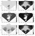
将一滑坡区域的地基SAR影像数据预处理后,获取图2所示滑坡体监测区域雷达强度、相位稳定性、时间相干性、空间相干性。可以看出监测区域内大部分雷达强度较高,相位稳定性好,时空相干性高,且研究区域影像清晰,图2中X/Y坐标为0/0的地方表示地基雷达的架站位置,其它点为相对于地基雷达架站点的相对坐标或相对距离。After preprocessing the ground-based SAR image data of a landslide area, the radar intensity, phase stability, temporal coherence and spatial coherence of the landslide monitoring area shown in Figure 2 are obtained. It can be seen that most of the radars in the monitoring area have high intensity, good phase stability, high space-time coherence, and the image of the study area is clear. In Figure 2, the location where the X/Y coordinate is 0/0 indicates the location of the ground-based radar. Other points are relative coordinates or relative distances to the ground-based radar mount site.
如图3所示,在本实施例中,由于是连续观测排除基线不为零的情况,滑坡点形变结果受大气扰动的影响。首先通过常规时序差分干涉处理获得研究区的时序形变场,然后随机提取了研究区P1、P2、P3位置大气改正前沿LOS向的形变位移量。As shown in FIG. 3 , in this embodiment, since the continuous observation excludes the case where the baseline is not zero, the deformation result of the landslide point is affected by the atmospheric disturbance. Firstly, the time series deformation field of the study area is obtained by conventional time series differential interference processing, and then the deformation displacement in the LOS direction of the atmospheric correction front at the P1, P2, and P3 positions of the study area is randomly extracted.
如图4所示,在本实施例中,采用随机森林时序分类方法对原始差分干涉相位图进行学习训练,最终获取得到该区域大气延迟相位,并将P1、P2、P3点的原始差分干涉相位与最优分类得到的大气延迟相位做差,获得了经随机森林时序分类方法大气延迟改正后的沿LOS向形变位移时间序列。As shown in Figure 4, in this embodiment, the random forest time series classification method is used to learn and train the original differential interference phase map, and finally the atmospheric delay phase of the region is obtained, and the original differential interference phase of points P1, P2, and P3 is obtained. By making a difference with the atmospheric delay phase obtained by the optimal classification, the time series of the deformation displacement along the LOS direction after the atmospheric delay corrected by the random forest time series classification method is obtained.
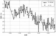
在实验过程中利用全站仪以30min时间间隔监测P1、P2两点的位移量,结果如图5和图6所示,图5为P1点大气改正后沿LOS向位移时间序列与全站仪监测结果对比,其中,P1-GBSAR表示P1点的地基雷达观测结果,P1-TS表示P1点的全站仪观测结果,最大位移误差0.32mm、最小位移误差0.03mm、位移误差标准差0.129mm。图6为P2点大气改正后沿LOS向位移时间序列与全站仪监测结果对比,其中,P2-GBSAR表示P2点的地基雷达观测结果,P2-TS表示P2点的全站仪观测结果,最大位移误差0.63mm、最小位移误差0.05mm、位移误差标准差0.156mm。分析图5可以得到,利用随机森林时序分类的大气改正方法可使地基InSAR监测精度误差小于0.7mm,从而验证了随机森林时序分类的大气改正方法在地基InSAR野外监测中的可靠性和可行性。During the experiment, the total station was used to monitor the displacement of P1 and P2 at a time interval of 30 minutes. The results are shown in Figures 5 and 6. Figure 5 shows the time series of the displacement along the LOS direction at P1 after atmospheric correction and the total station. Comparison of monitoring results, among which, P1-GBSAR represents the ground-based radar observation results of point P1, and P1-TS represents the observation results of total station at point P1. The maximum displacement error is 0.32mm, the minimum displacement error is 0.03mm, and the standard deviation of displacement error is 0.129mm. Figure 6 shows the comparison of the displacement time series along the LOS direction at the P2 point after atmospheric correction and the total station monitoring results. Among them, P2-GBSAR represents the ground-based radar observation results of the P2 point, P2-TS represents the total station observation results of the P2 point, and the maximum The displacement error is 0.63mm, the minimum displacement error is 0.05mm, and the standard deviation of the displacement error is 0.156mm. Analysis of Figure 5 shows that the atmospheric correction method using random forest time series classification can make the accuracy error of ground-based InSAR monitoring less than 0.7 mm, which verifies the reliability and feasibility of the atmospheric correction method based on random forest time series classification in ground-based InSAR field monitoring.
综上所述,本方案提出的方法对原始时序差分干涉相位图进行大气延迟改正,在温度和水汽变化较快的日间连续监测过程中,与同期高精度全站仪地面观测数据交叉验证总体精度误差控制在0.7mm以内,表明基于随机森林时序分类的GB-InSAR大气改正方法有效减弱了大气延迟误差并对复杂环境和气候条件具有较好的适应性。To sum up, the method proposed in this scheme performs atmospheric delay correction on the original time-series differential interferometric phase map, and in the process of daytime continuous monitoring with rapid temperature and water vapor changes, cross-validates the overall data with the ground observation data of the high-precision total station in the same period. The accuracy error is controlled within 0.7mm, indicating that the GB-InSAR atmospheric correction method based on random forest time series classification can effectively reduce the atmospheric delay error and has better adaptability to complex environments and climatic conditions.
本发明方法的实施过程为:从多个时序差分干涉相位图中选取M幅时序差分干涉相位图作为第一训练样本,对所选定的第一训练样本进行随机抽样,形成第二训练样本,通过第二训练样本完成对n棵决策树的属性子集选取和节点分裂特征属性的确定,得到训练好的随机森林;根据随机森林分别对所有时序差分干涉相位图进行分类,得到所有时序差分干涉相位图中大气延迟相位像元点位置,将所有时序差分干涉相位图分别与其对应时间点的大气延迟相位做差,最终获取高精度时序形变相位,完成所有时序差分干涉相位的大气延迟相位分离,有效减弱大气延迟误差。The implementation process of the method of the present invention is as follows: selecting M time-series differential interferometric phase maps from a plurality of time-series differential interferometric phase maps as the first training samples, randomly sampling the selected first training samples to form the second training samples, Through the second training sample, the attribute subset selection of n decision trees and the determination of node splitting feature attributes are completed, and a trained random forest is obtained; all time series differential interference phase maps are classified according to the random forest, and all time series differential interference Atmospheric delay phase pixel position in the phase map, make the difference between all time series differential interference phase maps and the atmospheric delay phase at their corresponding time points, and finally obtain high-precision time series deformation phase, and complete the atmospheric delay phase separation of all time series differential interference phases , effectively reducing the atmospheric delay error.
本发明的有益效果为:本发明采用基于随机森林时序分类的GB-InSAR大气改正方法对原始时序差分干涉相位图进行大气延迟改正,利用大气延迟相位在时间域的低频性特征,在温度和水汽变化较快的日间连续监测过程中,与同期高精度全站仪地面观测数据交叉验证总体精度误差控制在0.7mm以内,表明基于随机森林时序分类的GB-InSAR大气改正方法有效减弱了大气延迟误差并对复杂环境和气候条件具有较好的适应性。The beneficial effects of the present invention are as follows: the present invention adopts the GB-InSAR atmospheric correction method based on random forest time series classification to perform atmospheric delay correction on the original time series differential interferometric phase map, and utilizes the low-frequency characteristics of the atmospheric delay phase in the time domain. During the fast-changing daytime continuous monitoring process, the overall accuracy error of the cross-validation with the ground observation data of the high-precision total station in the same period is controlled within 0.7mm, indicating that the GB-InSAR atmospheric correction method based on random forest time series classification can effectively reduce the atmospheric delay. It has better adaptability to complex environment and climatic conditions.
在本发明的描述中,需要理解的是,术语“中心”、“厚度”、“上”、“下”、“水平”、“顶”、“底”、“内”、“外”、“径向”等指示的方位或位置关系为基于附图所示的方位或位置关系,仅是为了便于描述本发明和简化描述,而不是指示或暗示所指的设备或元件必须具有特定的方位、以特定的方位构造和操作,因此不能理解为对本发明的限制。此外,术语“第一”、“第二”、“第三”仅用于描述目的,而不能理解为指示或暗示相对重要性或隐含指明的技术特征的数量。因此,限定由“第一”、“第二”、“第三”的特征可以明示或隐含地包括一个或者更多个该特征。In the description of the present invention, it should be understood that the terms "center", "thickness", "upper", "lower", "horizontal", "top", "bottom", "inner", "outer", " The orientation or positional relationship indicated such as "radial" is based on the orientation or positional relationship shown in the accompanying drawings, which is only for the convenience of describing the present invention and simplifying the description, rather than indicating or implying that the device or element referred to must have a specific orientation, It is constructed and operated in a particular orientation and is therefore not to be construed as a limitation of the present invention. In addition, the terms "first", "second" and "third" are used for descriptive purposes only, and should not be construed as indicating or implying relative importance or the number of an impliedly indicated technical feature. Thus, a feature defined by "first", "second", "third" may expressly or implicitly include one or more of that feature.
Claims (4)

Priority Applications (1)
| Application Number | Priority Date | Filing Date | Title |
|---|---|---|---|
| CN202210135116.0ACN114187533B (en) | 2022-02-15 | 2022-02-15 | GB-InSAR (GB-InSAR) atmospheric correction method based on random forest time sequence classification |
Applications Claiming Priority (1)
| Application Number | Priority Date | Filing Date | Title |
|---|---|---|---|
| CN202210135116.0ACN114187533B (en) | 2022-02-15 | 2022-02-15 | GB-InSAR (GB-InSAR) atmospheric correction method based on random forest time sequence classification |
Publications (2)
| Publication Number | Publication Date |
|---|---|
| CN114187533A CN114187533A (en) | 2022-03-15 |
| CN114187533Btrue CN114187533B (en) | 2022-05-03 |
Family
ID=80545940
Family Applications (1)
| Application Number | Title | Priority Date | Filing Date |
|---|---|---|---|
| CN202210135116.0AActiveCN114187533B (en) | 2022-02-15 | 2022-02-15 | GB-InSAR (GB-InSAR) atmospheric correction method based on random forest time sequence classification |
Country Status (1)
| Country | Link |
|---|---|
| CN (1) | CN114187533B (en) |
Families Citing this family (2)
| Publication number | Priority date | Publication date | Assignee | Title |
|---|---|---|---|---|
| CN114966601B (en)* | 2022-08-01 | 2022-10-21 | 南京隼眼电子科技有限公司 | Mountain landslide prediction method based on millimeter wave radar and electronic equipment |
| CN116051620B (en)* | 2023-04-03 | 2023-07-21 | 之江实验室 | Method and system for estimating active layer thickness in permafrost region based on InSAR technology |
Citations (4)
| Publication number | Priority date | Publication date | Assignee | Title |
|---|---|---|---|---|
| CN108152059A (en)* | 2017-12-20 | 2018-06-12 | 西南交通大学 | High-speed train bogie fault detection method based on Fusion |
| CN111046931A (en)* | 2019-12-02 | 2020-04-21 | 北京交通大学 | A Random Forest-based Switch Fault Diagnosis Method |
| CN113281749A (en)* | 2021-06-02 | 2021-08-20 | 西南交通大学 | Time sequence InSAR high-coherence point selection method considering homogeneity |
| CN113792450A (en)* | 2021-08-16 | 2021-12-14 | 中国空间技术研究院 | Method for improving land water reserve inversion accuracy based on machine learning load model |
Family Cites Families (12)
| Publication number | Priority date | Publication date | Assignee | Title |
|---|---|---|---|---|
| CN106778836A (en)* | 2016-11-29 | 2017-05-31 | 天津大学 | A kind of random forest proposed algorithm based on constraints |
| CN108052978A (en)* | 2017-10-17 | 2018-05-18 | 桂林电子科技大学 | A kind of UKF phase-unwrapping algorithms based on support vector machines |
| CN107817481B (en)* | 2017-12-01 | 2020-12-08 | 南京市测绘勘察研究院股份有限公司 | RF method for atmospheric noise correction in InSAR deformation monitoring |
| CN108846338B (en)* | 2018-05-29 | 2022-04-15 | 南京林业大学 | Object-Oriented Random Forest-Based Polarization Feature Selection and Classification |
| CN110059745B (en)* | 2019-04-17 | 2022-07-05 | 武汉大学 | Basin rainfall product correction method and system based on satellite-ground fusion |
| CN110174673B (en)* | 2019-06-24 | 2020-12-01 | 首都师范大学 | A method to effectively reduce the influence of atmospheric phase by using time series relay interferogram stacking |
| CN110334771B (en)* | 2019-07-09 | 2023-02-28 | 东北大学 | A Method for Error Correction of GB-SAR Monitoring Data in Open Pit Mine Based on Four Threshold PS Points |
| US12012127B2 (en)* | 2019-10-26 | 2024-06-18 | Zoox, Inc. | Top-down view object detection and tracking |
| CN113205475B (en)* | 2020-01-16 | 2022-07-12 | 吉林大学 | Forest height inversion method based on multi-source satellite remote sensing data |
| CN112711021B (en)* | 2020-12-08 | 2021-10-22 | 中国自然资源航空物探遥感中心 | Multi-resolution InSAR (interferometric synthetic Aperture Radar) interactive interference time sequence analysis method |
| CN113420489B (en)* | 2021-05-25 | 2023-05-09 | 南京信息工程大学 | An Optimal Retrieval Method for Dual-polarization Radar Precipitation |
| CN113408547B (en)* | 2021-07-12 | 2023-05-23 | 西南交通大学 | Multi-temporal multi-polarization SAR landslide extraction method |
- 2022
- 2022-02-15CNCN202210135116.0Apatent/CN114187533B/enactiveActive
Patent Citations (4)
| Publication number | Priority date | Publication date | Assignee | Title |
|---|---|---|---|---|
| CN108152059A (en)* | 2017-12-20 | 2018-06-12 | 西南交通大学 | High-speed train bogie fault detection method based on Fusion |
| CN111046931A (en)* | 2019-12-02 | 2020-04-21 | 北京交通大学 | A Random Forest-based Switch Fault Diagnosis Method |
| CN113281749A (en)* | 2021-06-02 | 2021-08-20 | 西南交通大学 | Time sequence InSAR high-coherence point selection method considering homogeneity |
| CN113792450A (en)* | 2021-08-16 | 2021-12-14 | 中国空间技术研究院 | Method for improving land water reserve inversion accuracy based on machine learning load model |
Also Published As
| Publication number | Publication date |
|---|---|
| CN114187533A (en) | 2022-03-15 |
Similar Documents
| Publication | Publication Date | Title |
|---|---|---|
| CN107038717B (en) | A Method for Automatically Analyzing 3D Point Cloud Registration Errors Based on Stereo Grid | |
| CN105512665B (en) | A kind of airborne laser radar point cloud data edge extracting method | |
| CN106599808B (en) | A Hidden Target Extraction Method Based on Full Waveform Lidar Data | |
| CN114187533B (en) | GB-InSAR (GB-InSAR) atmospheric correction method based on random forest time sequence classification | |
| CN110763187B (en) | Robust ground subsidence monitoring method based on radar distributed targets | |
| CN109061646B (en) | A Doppler Weather Radar Quantitative Precipitation Estimation Method Based on Precipitation Cloud Recognition | |
| CN111650570B (en) | Three-dimensional atmospheric correction method and system for ground-based interference radar | |
| CN109031300B (en) | Method and system for monitoring deformation of dangerous rock mass by synthetic aperture radar | |
| Xie et al. | A density-based adaptive ground and canopy detecting method for ICESat-2 photon-counting data | |
| CN114239379B (en) | A method and system for analyzing geological hazards of power transmission lines based on deformation detection | |
| CN117075138A (en) | A method, system and medium for remote sensing calculation of regional 30-meter forest canopy height | |
| JP2019211342A (en) | Weather analyzer, weather analysis method, and program | |
| CN109061774A (en) | A kind of thunderstorm core relevance processing method | |
| CN117077547B (en) | Forest aboveground biomass estimation method and system | |
| CN105866776A (en) | Method for selecting high quality dynamic PS point of ground based SAR | |
| CN117310705B (en) | Flood disaster rapid detection method based on dual-polarized SAR image | |
| CN112800664B (en) | Method for estimating tree root diameter based on ground penetrating radar A-scan data | |
| CN107358214A (en) | Polarization SAR terrain classification method based on convolutional neural networks | |
| CN113065467A (en) | Satellite image low-coherence region identification method and device based on deep learning | |
| CN116821694A (en) | Soil moisture inversion method based on multi-branch neural network and segmented model | |
| CN119355719B (en) | A high-precision soil three-dimensional mapping method based on radar detection | |
| Zhu et al. | A synthetic algorithm on the skew-normal decomposition for satellite LiDAR waveforms | |
| Wang et al. | Interference image registration combined by enhanced scale-invariant feature transform characteristics and correlation coefficient | |
| CN115902794A (en) | Ground wave radar channel correction method based on AIS and Canopy-Kmeans algorithm | |
| CN106934797A (en) | A kind of SAR remote sensing imagery change detection methods based on neighborhood relative entropy |
Legal Events
| Date | Code | Title | Description |
|---|---|---|---|
| PB01 | Publication | ||
| PB01 | Publication | ||
| SE01 | Entry into force of request for substantive examination | ||
| SE01 | Entry into force of request for substantive examination | ||
| GR01 | Patent grant | ||
| GR01 | Patent grant |