CN113850909B - Point cloud data processing method and device, electronic equipment and automatic driving equipment - Google Patents
Point cloud data processing method and device, electronic equipment and automatic driving equipmentDownload PDFInfo
- Publication number
- CN113850909B CN113850909BCN202111124138.9ACN202111124138ACN113850909BCN 113850909 BCN113850909 BCN 113850909BCN 202111124138 ACN202111124138 ACN 202111124138ACN 113850909 BCN113850909 BCN 113850909B
- Authority
- CN
- China
- Prior art keywords
- point cloud
- cloud data
- geographic
- point
- adjacent
- Prior art date
- Legal status (The legal status is an assumption and is not a legal conclusion. Google has not performed a legal analysis and makes no representation as to the accuracy of the status listed.)
- Active
Links
Images


Classifications
- G—PHYSICS
- G06—COMPUTING OR CALCULATING; COUNTING
- G06T—IMAGE DATA PROCESSING OR GENERATION, IN GENERAL
- G06T17/00—Three dimensional [3D] modelling, e.g. data description of 3D objects
- G06T17/05—Geographic models
- G—PHYSICS
- G06—COMPUTING OR CALCULATING; COUNTING
- G06T—IMAGE DATA PROCESSING OR GENERATION, IN GENERAL
- G06T7/00—Image analysis
- G06T7/60—Analysis of geometric attributes
- G06T7/62—Analysis of geometric attributes of area, perimeter, diameter or volume
- G—PHYSICS
- G06—COMPUTING OR CALCULATING; COUNTING
- G06T—IMAGE DATA PROCESSING OR GENERATION, IN GENERAL
- G06T7/00—Image analysis
- G06T7/70—Determining position or orientation of objects or cameras
- G06T7/73—Determining position or orientation of objects or cameras using feature-based methods
- G—PHYSICS
- G06—COMPUTING OR CALCULATING; COUNTING
- G06T—IMAGE DATA PROCESSING OR GENERATION, IN GENERAL
- G06T2207/00—Indexing scheme for image analysis or image enhancement
- G06T2207/10—Image acquisition modality
- G06T2207/10028—Range image; Depth image; 3D point clouds
Landscapes
- Engineering & Computer Science (AREA)
- Physics & Mathematics (AREA)
- Geometry (AREA)
- General Physics & Mathematics (AREA)
- Theoretical Computer Science (AREA)
- Software Systems (AREA)
- Computer Vision & Pattern Recognition (AREA)
- Remote Sensing (AREA)
- Computer Graphics (AREA)
- Instructional Devices (AREA)
- Traffic Control Systems (AREA)
Abstract
Description
Translated fromChinese技术领域technical field
本公开涉及自动驾驶技术领域,尤其涉及点云定位技术,具体涉及一种点云数据处理方法、装置、电子设备、计算机可读存储介质、计算机程序产品以及自动驾驶设备。The present disclosure relates to the technical field of automatic driving, in particular to point cloud positioning technology, and in particular to a point cloud data processing method, apparatus, electronic device, computer-readable storage medium, computer program product, and automatic driving device.
背景技术Background technique
在自动驾驶技术中,由于道路场景是复杂多样的,将多种传感器定位手段进行融合的定位方式是重要的。在这些传感器定位手段之中,基于点云的定位在精度和鲁棒性上具有独特的优势,因此已被广泛使用。In autonomous driving technology, because the road scene is complex and diverse, a positioning method that integrates multiple sensor positioning methods is important. Among these sensor localization methods, point cloud-based localization has unique advantages in accuracy and robustness, so it has been widely used.
点云一般是指通过例如激光雷达扫描目标物所获取的数据,点云中的每个点可以包含目标物表面的三维坐标信息。基于点云的定位通常需要预先制作或生成用于进行定位的点云定位地图,即离线生产的点云定位地图。在无人驾驶设备运行期间,通过激光雷达实时获取与道路相关的点云,即在线点云,并将该在线点云与离线生产的点云定位地图进行匹配,由此可实现基于点云的定位。The point cloud generally refers to the data obtained by scanning the target object by, for example, lidar, and each point in the point cloud can contain the three-dimensional coordinate information of the surface of the target object. Point cloud-based localization usually requires pre-production or generation of point cloud localization maps for localization, that is, point cloud localization maps produced offline. During the operation of the unmanned equipment, the point cloud related to the road, that is, the online point cloud, is obtained in real time through lidar, and the online point cloud is matched with the point cloud positioning map produced offline, so that the point cloud-based point cloud can be realized. position.
在此部分中描述的方法不一定是之前已经设想到或采用的方法。除非另有指明,否则不应假定此部分中描述的任何方法仅因其包括在此部分中就被认为是现有技术。类似地,除非另有指明,否则此部分中提及的问题不应认为在任何现有技术中已被公认。The approaches described in this section are not necessarily approaches that have been previously conceived or employed. Unless otherwise indicated, it should not be assumed that any of the approaches described in this section qualify as prior art merely by virtue of their inclusion in this section. Similarly, unless otherwise indicated, the issues raised in this section should not be considered to be recognized in any prior art.
发明内容SUMMARY OF THE INVENTION
本公开提供了一种点云数据处理方法、装置、电子设备、计算机可读存储介质、计算机程序产品以及自动驾驶设备。The present disclosure provides a point cloud data processing method, apparatus, electronic device, computer-readable storage medium, computer program product, and automatic driving device.
根据本公开的一方面,提供了一种点云数据处理方法,包括:获取用于生成点云地图的点云数据集,其中,所述点云数据集包括至少一个点云数据点,每个点云数据点具有在第一坐标系下的坐标;针对所述点云数据集中的每个点云数据点,基于所述点云数据点在所述第一坐标系下的坐标,确定所述点云数据点是否处于相邻地理分带的交界区域内;以及响应于确定所述点云数据点处于所述交界区域内,基于与所述相邻地理分带的划分相关联的第二坐标系,将所述点云数据点分别投影到所述相邻地理分带下以生成分别对应于所述相邻地理分带的相应地图数据。According to an aspect of the present disclosure, there is provided a point cloud data processing method, comprising: acquiring a point cloud data set for generating a point cloud map, wherein the point cloud data set includes at least one point cloud data point, each The point cloud data points have coordinates in the first coordinate system; for each point cloud data point in the point cloud data set, based on the coordinates of the point cloud data points in the first coordinate system, determine the whether a point cloud data point is within a boundary area of an adjacent geographic zone; and in response to determining that the point cloud data point is within the boundary area, based on second coordinates associated with the division of the adjacent geographical zone system, the point cloud data points are respectively projected under the adjacent geographic sub-bands to generate corresponding map data respectively corresponding to the adjacent geographical sub-bands.
根据本公开的一方面,提供了一种点云数据处理装置,包括:获取单元,被配置为获取用于生成点云地图的点云数据集,其中,所述点云数据集包括至少一个点云数据点,每个点云数据点具有在第一坐标系下的坐标;第一确定单元,被配置为针对所述点云数据集中的每个点云数据点,基于所述点云数据点在所述第一坐标系下的坐标,确定所述点云数据点是否处于相邻地理分带的交界区域内;以及第一处理单元,被配置为响应于确定所述点云数据点处于所述交界区域内,基于与所述相邻地理分带的划分相关联的第二坐标系,将所述点云数据点分别投影到所述相邻地理分带下以生成分别对应于所述相邻地理分带的相应地图数据。According to an aspect of the present disclosure, there is provided a point cloud data processing device, comprising: an acquisition unit configured to acquire a point cloud data set for generating a point cloud map, wherein the point cloud data set includes at least one point cloud data points, each point cloud data point has coordinates in a first coordinate system; a first determining unit is configured to, for each point cloud data point in the point cloud data set, based on the point cloud data point coordinates in the first coordinate system, determining whether the point cloud data point is within a boundary region of adjacent geographic zones; and a first processing unit configured to respond to determining that the point cloud data point is within the Within the boundary region, the point cloud data points are respectively projected under the adjacent geographic zoning based on a second coordinate system associated with the division of the adjacent geographic zoning to generate data corresponding to the adjacent geographic zoning. Corresponding map data for adjacent geographic zoning.
根据本公开的一方面,提供了一种电子设备,包括:至少一个处理器;以及与所述至少一个处理器通信连接的存储器,其中,所述存储器存储有能够被所述至少一个处理器执行的指令,所述指令在被所述至少一个处理器执行时,使所述至少一个处理器执行如上所述的方法。According to an aspect of the present disclosure, there is provided an electronic device comprising: at least one processor; and a memory communicatively connected to the at least one processor, wherein the memory stores a memory capable of being executed by the at least one processor The instructions, when executed by the at least one processor, cause the at least one processor to perform the method as described above.
根据本公开的一方面,提供了一种存储有计算机指令的非瞬时计算机可读存储介质,其中,所述计算机指令用于使所述计算机执行如上所述的方法。According to an aspect of the present disclosure, there is provided a non-transitory computer-readable storage medium storing computer instructions for causing the computer to perform the method as described above.
根据本公开的一方面,提供了一种计算机程序产品,包括计算机程序,其中,所述计算机程序在被处理器执行时实现如上所述的方法。According to an aspect of the present disclosure, there is provided a computer program product, comprising a computer program, wherein the computer program, when executed by a processor, implements the method as described above.
根据本公开的一方面,提供了一种自动驾驶设备,包括控制器,所述控制器被配置为实现如上所述的方法。According to an aspect of the present disclosure, there is provided an autonomous driving apparatus including a controller configured to implement the method as described above.
根据本公开的一个或多个实施例,可以确保自动驾驶设备能够不受限于地域因素所导致的定位问题而平稳运行。According to one or more embodiments of the present disclosure, it can be ensured that the automatic driving device can operate smoothly without being limited by the positioning problem caused by the geographical factor.
应当理解,本部分所描述的内容并非旨在标识本公开的实施例的关键或重要特征,也不用于限制本公开的范围。本公开的其它特征将通过以下的说明书而变得容易理解。It should be understood that what is described in this section is not intended to identify key or critical features of embodiments of the disclosure, nor is it intended to limit the scope of the disclosure. Other features of the present disclosure will become readily understood from the following description.
附图说明Description of drawings
附图示例性地示出了实施例并且构成说明书的一部分,与说明书的文字描述一起用于讲解实施例的示例性实施方式。所示出的实施例仅出于例示的目的,并不限制权利要求的范围。在所有附图中,相同的附图标记指代类似但不一定相同的要素。The accompanying drawings illustrate the embodiments by way of example and constitute a part of the specification, and together with the written description of the specification serve to explain exemplary implementations of the embodiments. The shown embodiments are for illustrative purposes only and do not limit the scope of the claims. Throughout the drawings, the same reference numbers refer to similar but not necessarily identical elements.
图1示出了根据本公开实施例的可以将本文描述的各种方法和装置在其中实施的示例性系统的示意图。1 shows a schematic diagram of an exemplary system in which the various methods and apparatuses described herein may be implemented, according to embodiments of the present disclosure.
图2示出了根据本公开一个实施例的点云数据处理方法的流程图。FIG. 2 shows a flowchart of a method for processing point cloud data according to an embodiment of the present disclosure.
图3示出了根据本公开另一个实施例的点云数据处理方法的流程图。FIG. 3 shows a flowchart of a method for processing point cloud data according to another embodiment of the present disclosure.
图4A和4B示出了用于解释根据本公开实施例的地图加载过程的示意图。4A and 4B show schematic diagrams for explaining a map loading process according to an embodiment of the present disclosure.
图5示出了用于解释根据本公开实施例的地图提取过程的示意图。FIG. 5 shows a schematic diagram for explaining a map extraction process according to an embodiment of the present disclosure.
图6示出了根据本公开一个实施例的点云数据处理装置的框图。FIG. 6 shows a block diagram of an apparatus for processing point cloud data according to an embodiment of the present disclosure.
图7示出了根据本公开另一个实施例的点云数据处理装置的框图。FIG. 7 shows a block diagram of a point cloud data processing apparatus according to another embodiment of the present disclosure.
图8示出了能够应用于本公开实施例的电子设备的结构框图。FIG. 8 shows a structural block diagram of an electronic device that can be applied to an embodiment of the present disclosure.
具体实施方式Detailed ways
以下结合附图对本公开的示范性实施例做出说明,其中包括本公开实施例的各种细节以助于理解,应当将它们认为仅仅是示范性的。因此,本领域普通技术人员应当认识到,可以对这里描述的实施例做出各种改变和修改,而不会背离本公开的范围。同样,为了清楚和简明,以下的描述中省略了对公知功能和结构的描述。Exemplary embodiments of the present disclosure are described below with reference to the accompanying drawings, which include various details of the embodiments of the present disclosure to facilitate understanding and should be considered as exemplary only. Accordingly, those of ordinary skill in the art will recognize that various changes and modifications of the embodiments described herein can be made without departing from the scope of the present disclosure. Also, descriptions of well-known functions and constructions are omitted from the following description for clarity and conciseness.
在本公开中,除非另有说明,否则使用术语“第一”、“第二”等来描述各种要素不意图限定这些要素的位置关系、时序关系或重要性关系,这种术语只是用于将一个元件与另一元件区分开。在一些示例中,第一要素和第二要素可以指向该要素的同一实例,而在某些情况下,基于上下文的描述,它们也可以指代不同实例。In the present disclosure, unless otherwise specified, the use of the terms "first", "second", etc. to describe various elements is not intended to limit the positional relationship, timing relationship or importance relationship of these elements, and such terms are only used for Distinguish one element from another. In some examples, the first element and the second element may refer to the same instance of the element, while in some cases they may refer to different instances based on the context of the description.
在本公开中对各种所述示例的描述中所使用的术语只是为了描述特定示例的目的,而并非旨在进行限制。除非上下文另外明确地表明,如果不特意限定要素的数量,则该要素可以是一个也可以是多个。此外,本公开中所使用的术语“和/或”涵盖所列出的项目中的任何一个以及全部可能的组合方式。The terminology used in the description of the various described examples in this disclosure is for the purpose of describing particular examples only and is not intended to be limiting. Unless the context clearly dictates otherwise, if the number of an element is not expressly limited, the element may be one or more. Furthermore, as used in this disclosure, the term "and/or" covers any and all possible combinations of the listed items.
相关技术中,为了使离线生产的点云定位地图便于分割和管理,通常在UTM(通用横墨卡托投影)坐标系下表示该离线生产的点云定位地图。UTM坐标系以分带(zone)的方式进行表示且每个分带具有相应的分带标识(zone ID),这意味着不同分带中的坐标不是连续的。当某些城市处于两个相邻分带之间的交界处时,可能涉及需要跨越分带进行定位的情况。现有的方法强制将坐标转换到同一分带下,而并未将不同分带进行区别处理,这可能最终导致出现定位不准确甚至无法定位的。In the related art, in order to facilitate segmentation and management of the point cloud localization map produced offline, the point cloud localization map produced offline is usually represented in a UTM (Universal Transverse Mercator) coordinate system. The UTM coordinate system is represented by zones and each zone has a corresponding zone ID, which means that the coordinates in different zones are not continuous. When certain cities are at the junction between two adjacent zonings, there may be cases where positioning across zoning is required. Existing methods force the coordinates to be converted into the same sub-band, but do not treat different sub-bands differently, which may eventually lead to inaccurate or even impossible positioning.
针对上述问题,根据本公开的一方面,提供了一种点云数据处理方法。下面将结合附图详细描述本公开的实施例。In view of the above problems, according to an aspect of the present disclosure, a point cloud data processing method is provided. Embodiments of the present disclosure will be described in detail below with reference to the accompanying drawings.
图1示出了根据本公开实施例的可以将本文描述的各种方法和装置在其中实施的示例性系统100的示意图。参考图1,该系统100包括机动车辆110、服务器120以及将机动车辆110耦接到服务器120的一个或多个通信网络130。1 shows a schematic diagram of an
在本公开的实施例中,机动车辆110可以包括根据本公开实施例的计算设备和/或被配置以用于执行根据本公开实施例的方法。In an embodiment of the present disclosure, the
服务器120可以运行使得能够实现根据公开实施例方法的一个或多个服务或软件应用。在某些实施例中,服务器120还可以提供可以包括非虚拟环境和虚拟环境的其他服务或软件应用。在图1所示的配置中,服务器120可以包括实现由服务器120执行的功能的一个或多个组件。这些组件可以包括可由一个或多个处理器执行的软件组件、硬件组件或其组合。机动车辆110的用户可以依次利用一个或多个客户端应用程序来与服务器120进行交互以利用这些组件提供的服务。应当理解,各种不同的系统配置是可能的,其可以与系统100不同。因此,图1是用于实施本文所描述的各种方法的系统的一个示例,并且不旨在进行限制。
服务器120可以包括一个或多个通用计算机、专用服务器计算机(例如PC(个人计算机)服务器、UNIX服务器、终端服务器)、刀片式服务器、大型计算机、服务器群集或任何其他适当的布置和/或组合。服务器120可以包括运行虚拟操作系统的一个或多个虚拟机,或者涉及虚拟化的其他计算架构(例如可以被虚拟化以维护服务器的虚拟存储设备的逻辑存储设备的一个或多个灵活池)。在各种实施例中,服务器120可以运行提供下文所描述的功能的一个或多个服务或软件应用。
服务器120中的计算单元可以运行包括上述任何操作系统以及任何商业上可用的服务器操作系统的一个或多个操作系统。服务器120还可以运行各种附加服务器应用程序和/或中间层应用程序中的任何一个,包括HTTP服务器、FTP服务器、CGI服务器、JAVA服务器、数据库服务器等。The computing units in
在一些实施方式中,服务器120可以包括一个或多个应用程序,以分析和合并从机动车辆110接收的数据馈送和/或事件更新。服务器120还可以包括一个或多个应用程序,以经由机动车辆110的一个或多个显示设备来显示数据馈送和/或实时事件。In some implementations,
网络130可以是本领域技术人员熟知的任何类型的网络,其可以使用多种可用协议中的任何一种(包括但不限于TCP/IP、SNA、IPX等)来支持数据通信。仅作为示例,一个或多个网络110可以是卫星通信网络、局域网(LAN)、基于以太网的网络、令牌环、广域网(WAN)、因特网、虚拟网络、虚拟专用网络(VPN)、内部网、外部网、公共交换电话网(PSTN)、红外网络、无线网络(包括例如蓝牙、WiFi)和/或这些与其他网络的任意组合。Network 130 may be any type of network known to those skilled in the art that may support data communications using any of a variety of available protocols, including but not limited to TCP/IP, SNA, IPX, and the like. By way of example only, the one or
系统100还可以包括一个或多个数据库150。在某些实施例中,这些数据库可以用于存储数据和其他信息。例如,数据库150中的一个或多个可用于存储诸如音频文件和视频文件的信息。数据库150可以驻留在各种位置。例如,由服务器120使用的数据库可以在服务器120本地,或者可以远离服务器120且可以经由基于网络或专用的连接与服务器120通信。数据库150可以是不同的类型。在某些实施例中,由服务器120使用的数据库可以是例如关系数据库。这些数据库中的一个或多个可以响应于命令而存储、更新和检索到数据库以及来自数据库的数据。
在某些实施例中,数据库150中的一个或多个还可以由应用程序使用来存储应用程序数据。由应用程序使用的数据库可以是不同类型的数据库,例如键值存储库,对象存储库或由文件系统支持的常规存储库。In some embodiments, one or more of the
机动车辆110可以包括传感器111用于感知周围环境。传感器111可以包括下列传感器中的一个或多个:视觉摄像头、红外摄像头、超声波传感器、毫米波雷达以及激光雷达(LiDAR)。不同的传感器可以提供不同的检测精度和范围。摄像头可以安装在车辆的前方、后方或其他位置。视觉摄像头可以实时捕获车辆内外的情况并呈现给驾驶员和/或乘客。此外,通过对视觉摄像头捕获的画面进行分析,可以获取诸如交通信号灯指示、交叉路口情况、其他车辆运行状态等信息。红外摄像头可以在夜视情况下捕捉物体。超声波传感器可以安装在车辆的四周,用于利用超声波方向性强等特点来测量车外物体距车辆的距离。毫米波雷达可以安装在车辆的前方、后方或其他位置,用于利用电磁波的特性测量车外物体距车辆的距离。激光雷达可以安装在车辆的前方、后方或其他位置,用于检测物体边缘、形状信息,从而进行物体识别和追踪。由于多普勒效应,雷达装置还可以测量车辆与移动物体的速度变化。
机动车辆110还可以包括通信装置112。通信装置112可以包括能够从卫星141接收卫星定位信号(例如,北斗、GPS、GLONASS以及GALILEO)并且基于这些信号产生坐标的卫星定位模块。通信装置112还可以包括与移动通信基站142进行通信的模块,移动通信网络可以实施任何适合的通信技术,例如GSM/GPRS、CDMA、LTE等当前或正在不断发展的无线通信技术(例如5G技术)。通信装置112还可以具有车联网或车联万物(Vehicle-to-Everything,V2X)模块,被配置用于实现例如与其它车辆143进行车对车(Vehicle-to-Vehicle,V2V)通信和与基础设施144进行车辆到基础设施(Vehicle-to-Infrastructure,V2I)通信的车与外界的通信。此外,通信装置112还可以具有被配置为例如通过使用IEEE802.11标准的无线局域网或蓝牙与用户终端145(包括但不限于智能手机、平板电脑或诸如手表等可佩戴装置)进行通信的模块。利用通信装置112,机动车辆110还可以经由网络130接入服务器120。The
机动车辆110还可以包括控制装置113。控制装置113可以包括与各种类型的计算机可读存储装置或介质通信的处理器,例如中央处理单元(CPU)或图形处理单元(GPU),或者其他的专用处理器等。控制装置113可以包括用于自动控制车辆中的各种致动器的自动驾驶系统。自动驾驶系统被配置为经由多个致动器响应于来自多个传感器111或者其他输入设备的输入而控制机动车辆110的动力总成、转向系统以及制动系统等以分别控制加速、转向和制动,而无需人为干预或者有限的人为干预。控制装置113的部分处理功能可以通过云计算实现。例如,可以使用车载处理器执行某一些处理,而同时可以利用云端的计算资源执行其他一些处理。控制装置113可以被配置以执行根据本公开的方法。此外,控制装置113可以被实现为根据本公开的机动车辆侧(客户端)的计算设备的一个示例。The
图1的系统100可以以各种方式配置和操作,以使得能够应用根据本公开所描述的各种方法和装置。The
图2示出了根据本公开实施例的点云数据处理方法200的流程图。如图2所示,方法200可以包括如下步骤:FIG. 2 shows a flowchart of a point cloud
S202,获取用于生成点云地图的点云数据集,其中,点云数据集包括至少一个点云数据点,每个点云数据点具有在第一坐标系下的坐标;S202, acquiring a point cloud data set for generating a point cloud map, wherein the point cloud data set includes at least one point cloud data point, and each point cloud data point has coordinates in the first coordinate system;
S204,针对点云数据集中的每个点云数据点,基于所述点云数据点在第一坐标系下的坐标,确定所述点云数据点是否处于相邻地理分带的交界区域内;以及S204, for each point cloud data point in the point cloud data set, based on the coordinates of the point cloud data point in the first coordinate system, determine whether the point cloud data point is in the junction area of adjacent geographic zones; as well as
S206,响应于确定所述点云数据点处于交界区域内,基于与相邻地理分带的划分相关联的第二坐标系,将所述点云数据点分别投影到相邻地理分带下以生成分别对应于相邻地理分带的地图数据。S206, in response to determining that the point cloud data points are within the boundary area, project the point cloud data points under the adjacent geographical zones respectively based on the second coordinate system associated with the division of adjacent geographical zones to Generate map data corresponding to adjacent geographic zones, respectively.
根据本公开的点云数据处理方法,通过在制作离线的点云定位地图期间即考虑可能涉及跨越地理分带进行定位的情况,针对处于相邻地理分带的交界处附近的点云数据,分别以相邻地理分带各自的视角进行地图数据存储,即,将其分别投影到相邻地理分带中以分别生成对应的地图数据,从而为后续所进行的在线点云定位期间中加载地图的过程提供了用于避免跨越地理分带定位而进行地图扩展的可能。According to the point cloud data processing method of the present disclosure, by considering the situation that may involve positioning across geographic sub-zones during the production of the offline point cloud positioning map, for the point cloud data near the junction of adjacent geographical sub-zones, respectively Map data storage is performed from the respective perspectives of adjacent geographic zones, that is, they are projected into adjacent geographic zones to generate corresponding map data respectively, so as to load the map during the subsequent online point cloud positioning. The process offers the possibility to avoid map expansion across geographic zoning.
由此,能够避免点云定位期间因跨越地理分带进行定位所造成的定位不准确甚至无法定位的问题,继而确保自动驾驶设备能够不受限于地域因素所导致的定位问题而平稳运行。In this way, the problem of inaccurate or even inaccurate positioning caused by positioning across geographic bands during point cloud positioning can be avoided, thereby ensuring that the automatic driving equipment can run smoothly without being limited by the positioning problems caused by geographical factors.
在步骤S202中,点云地图可以是指如前所述的离线生产的点云定位地图。为了生成点云定位地图,首先可以获取相应的源数据,即点云数据集。点云数据集可以是通过例如激光雷达(LiDAR)预先采集的,且点云数据集的大小可以根据实际应用情况而适当变化,例如点云数据集可以对应于一帧点云。由于点云是通过例如LiDAR获取的,因此点云数据集中的每个点云数据点可以具有世界坐标系下的坐标,例如经纬度,其能够反映地理位置信息。In step S202, the point cloud map may refer to the point cloud location map produced offline as described above. In order to generate a point cloud localization map, the corresponding source data, that is, a point cloud dataset, can be obtained first. The point cloud dataset may be pre-collected by, for example, LiDAR, and the size of the point cloud dataset may be appropriately changed according to the actual application, for example, the point cloud dataset may correspond to one frame of point cloud. Since the point cloud is acquired by, for example, LiDAR, each point cloud data point in the point cloud dataset may have coordinates in the world coordinate system, such as latitude and longitude, which can reflect geographic location information.
在步骤S204中,为了在制作离线的点云定位地图期间即考虑可能涉及跨越地理分带进行定位的情况,可以基于点云数据点的坐标确定该点云数据点是否处于相邻地理分带的交界区域内。In step S204, in order to consider the situation that may involve positioning across geographic zones during the production of the offline point cloud positioning map, it can be determined whether the point cloud data point is located in an adjacent geographic zone based on the coordinates of the point cloud data point. within the border area.
在本文中,相邻地理分带的划分可以是相对于不同于第一坐标系的第二坐标系而言的,例如UTM坐标系。相应地,相邻地理分带可以是指在横向上或经度上相邻的地理分带。换言之,相邻地理分带可以共享边界线,并且可以自边界线起形成一定的交界区域。In this context, the division of adjacent geographic zones may be relative to a second coordinate system different from the first coordinate system, such as a UTM coordinate system. Correspondingly, adjacent geographic sub-bands may refer to geographical sub-bands that are adjacent in lateral or longitude. In other words, adjacent geographic zones may share a boundary line and may form a certain boundary area from the boundary line.
为了在后续点云定位期间的地图加载过程中提供用于避免跨越地理分带定位而进行地图扩展的可能,该交界区域可以对应于需要进行地图扩展的区域来设置。这将在以下结合图3及图4A、4B描述地图加载过程时更详细地描述。In order to provide a possibility for avoiding map expansion during the map loading process during the subsequent point cloud positioning, the boundary area may be set corresponding to the area where map expansion is required. This will be described in more detail below when the map loading process is described in conjunction with Figure 3 and Figures 4A, 4B.
根据一些实施例,在步骤S202之后,还可以额外地确定与点云数据集相对应的位姿是否存在跨越相邻地理分带进行定位的可能性。According to some embodiments, after step S202, it may be additionally determined whether the pose corresponding to the point cloud data set has the possibility of being positioned across adjacent geographic zones.
如果确定与点云数据集相对应的位姿存在跨越相邻地理分带进行定位的可能性,可以继续执行步骤S204,其中针对点云数据集中的每个点云数据点,确定所述点云数据点是否处于相邻地理分带的交界区域内。If it is determined that the pose corresponding to the point cloud data set has the possibility of being positioned across adjacent geographic zones, step S204 may be continued, wherein for each point cloud data point in the point cloud data set, the point cloud is determined Whether the data point is within the boundary area of adjacent geographic zones.
如果确定与点云数据集相对应的位姿不存在跨越相邻地理分带进行定位的可能性,则意味着应当不会产生如前所述的因跨越相邻地理分带进行定位所导致的定位不准确甚至无法定位的问题。在此情况下,可以将点云数据集中的每个点云数据点从第一坐标系(例如世界坐标系)转换到第二坐标系(例如UTM坐标系),并将其投影在对应的地理分带下以生成对应的地图数据。If it is determined that the pose corresponding to the point cloud dataset does not have the possibility of positioning across adjacent geographic bands, it means that there should be no possibility of positioning across neighboring geographic bands as described above. The problem of inaccurate or even unlocated positioning. In this case, each point cloud data point in the point cloud dataset can be transformed from a first coordinate system (eg, world coordinate system) to a second coordinate system (eg, UTM coordinate system), and projected on the corresponding geographic Tape down to generate the corresponding map data.
以此方式,在制作离线的点云定位地图时,可以仅针对涉及跨越相邻地理分带进行定位的情形进行优化,由此不会为地图制作过程造成多余负担。In this way, when producing an offline point cloud localization map, it can only be optimized for situations involving localization across adjacent geographic sub-bands, thereby not creating an unnecessary burden on the map production process.
根据一些实施例,点云数据集中的所述至少一个点云数据点包括中心点云数据点。相应地,所述存在跨越相邻地理分带进行定位的可能性可以通过如下步骤确定:i)基于中心点云数据点在第一坐标系(例如世界坐标系)下的坐标,确定中心点云数据点与相邻地理分带之间的边界线的距离是否小于或等于阈值;以及ii)响应于确定中心点云数据点与相邻地理分带之间的边界线的距离小于或等于所述阈值,确定存在所述可能性。According to some embodiments, the at least one point cloud data point in the point cloud data set comprises a central point cloud data point. Correspondingly, the possibility of positioning across adjacent geographic zones may be determined by: i) determining the center point cloud based on the coordinates of the center point cloud data point in the first coordinate system (eg, the world coordinate system) whether the distance between the data point and the boundary line between the adjacent geographic bands is less than or equal to a threshold; and ii) in response to determining that the distance between the center point cloud data point and the boundary line between the adjacent geographic bands is less than or equal to the Threshold value to determine that the possibility exists.
简言之,可以利用点云数据集中的中心点云数据点,通过计算中心点云数据点与相邻地理分带之间的边界线的距离远近,来确定与该点云数据集相对应的位姿是否存在跨越相邻地理分带进行定位的可能性。上述用于判断距离远近的阈值可以根据实际应用情况而适当变化,例如可以根据本领域技术人员在实际应用中的经验值来选取。In short, the central point cloud data point in the point cloud data set can be used to determine the distance corresponding to the point cloud data set by calculating the distance between the central point cloud data point and the boundary line between the adjacent geographic zones. Whether the pose has the potential to be localized across adjacent geographic bands. The above-mentioned threshold for judging the distance can be appropriately changed according to the actual application situation, for example, it can be selected according to the experience value of those skilled in the art in practical application.
以此方式,通过点云数据集中的中心点云数据点即可简单并粗略判断与该点云数据集相对应的位姿是否存在跨越相邻地理分带进行定位的可能性,由此可以便利于在制作离线的点云定位地图时所进行的优化。In this way, the central point cloud data point in the point cloud data set can simply and roughly determine whether the pose corresponding to the point cloud data set has the possibility of being positioned across the adjacent geographic zones, which can facilitate Optimization for making offline point cloud localization maps.
在步骤S206中,如果在步骤S204中确定点云数据点处于交界区域内,则可以基于第二坐标系(例如UTM坐标系),将该点云数据点分别投影到相邻地理分带下以生成分别对应于所述相邻地理分带的相应地图数据。这意味着所制作的点云定位地图涵盖了处于交界区域内的点云数据点关于相邻地理分带的相应地图数据,使得能够为后续点云定位期间中加载地图的过程提供用于避免跨越地理分带定位而进行地图扩展的可能。In step S206, if it is determined in step S204 that the point cloud data points are within the boundary area, the point cloud data points may be projected under the adjacent geographic sub-bands based on the second coordinate system (such as the UTM coordinate system) Corresponding map data respectively corresponding to the adjacent geographic zones are generated. This means that the produced point cloud localization map covers the corresponding map data of the point cloud data points in the boundary area with respect to the adjacent geographic zones, so that the process of loading the map in the subsequent point cloud localization period can be used to avoid crossing Possibility of map expansion due to geographic zoning.
根据一些实施例,由于步骤S204及S206是针对点云数据集中的每个点云数据点而进行的,因此可能存在该点云数据集中的一些点云数据点处于交界区域内,而一些点云数据点在交界区域之外的情况。相应地,针对后者的情况,还可以包括如下步骤:响应于确定点云数据点在交界区域之外,基于第二坐标系(例如UTM坐标系),将点云数据点投影到与其对应的地理分带下以生成对应的地图数据。According to some embodiments, since steps S204 and S206 are performed for each point cloud data point in the point cloud data set, there may be some point cloud data points in the point cloud data set that are in the boundary area, and some point cloud data points The case where the data point is outside the junction area. Correspondingly, for the latter case, the following step may also be included: in response to determining that the point cloud data points are outside the boundary area, project the point cloud data points to their corresponding coordinates based on a second coordinate system (eg, a UTM coordinate system). Geographical zoning to generate the corresponding map data.
以此方式,可以针对点云数据集中的全部点云数据点分别进行判断以确定是否需要在制作离线的点云定位地图时进行用于避免跨越地理分带定位的优化。In this way, a judgment can be made separately for all point cloud data points in the point cloud data set to determine whether it is necessary to perform optimization for avoiding cross-geographical location location when making an offline point cloud location map.
根据本实施例,如前所述,通过在制作离线的点云定位地图期间即考虑可能涉及跨越地理分带进行定位的情况,针对处于相邻地理分带的交界处的点云数据,将其分别投影到相邻地理分带中以分别生成对应的地图数据,从而为后续所进行的在线点云定位期间中加载地图的过程提供用于避免跨越地理分带定位而进行地图扩展的可能。According to the present embodiment, as mentioned above, by considering the situation that may involve positioning across geographic zones during the production of the offline point cloud positioning map, for the point cloud data at the junction of adjacent geographic zones, the Projecting into adjacent geographic sub-bands to generate corresponding map data respectively, thereby providing the possibility of avoiding map expansion for positioning across geographic sub-bands for the subsequent process of loading the map during online point cloud positioning.
图3示出了根据本公开另一个实施例的点云数据处理方法300的流程图。FIG. 3 shows a flowchart of a point cloud
如图3所示的地图制作步骤S302可以对应于结合图2所述的步骤S202至S206,因此这里不再赘述其各个方面的细节。即,地图制作步骤S302可以对应于点云定位地图的离线生产。The map making step S302 shown in FIG. 3 may correspond to the steps S202 to S206 described in conjunction with FIG. 2 , so the details of its various aspects will not be repeated here. That is, the map making step S302 may correspond to offline production of the point cloud positioning map.
注意的是,根据本公开的方法,由于在地图制作过程中增加了是否存在跨越相邻地理分带进行定位的可能性的额外判断,所以此时所获得的离线生产的点云定位地图可以涵盖处于交界区域内的点云数据点关于相邻地理分带的相应地图数据,使得能够为后续点云定位期间中加载地图的过程提供用于避免跨越地理分带定位而进行地图扩展的可能。Note that, according to the method of the present disclosure, since an additional judgment of whether there is a possibility of positioning across adjacent geographic zones is added during the map making process, the point cloud positioning map obtained at this time produced offline can cover The corresponding map data of the point cloud data points in the boundary area with respect to the adjacent geographic zones makes it possible to provide the process of loading the map in the subsequent point cloud positioning period with the possibility to avoid map expansion for positioning across geographic zones.
在获得所述离线生产的点云定位地图之后,即,在地图制作步骤S302之后,可以进一步使用该点云定位地图以进行自动驾驶设备(诸如图1所述的机动车辆110)的定位。为此,可以执行地图加载步骤S304。After the offline-produced point cloud positioning map is obtained, that is, after the map making step S302, the point cloud positioning map can be further used for positioning the automatic driving device (such as the
根据一些实施例,可以基于在地图制作步骤S302中生成的地图数据(即,涵盖了处于交界区域内的点云数据点关于相邻地理分带的相应地图数据),构建与自动驾驶设备的预测位姿相关联的节点加载区域的扩展节点加载区域。扩展节点加载区域被分配为与节点加载区域相同的地理分带。According to some embodiments, a prediction with the autonomous driving device may be constructed based on the map data generated in the map making step S302 (ie, the corresponding map data covering the point cloud data points within the boundary area with respect to adjacent geographic zones) An extension of the node load area for the node load area associated with the pose. The extended node load area is assigned the same geographic zoning as the node load area.
在自动驾驶设备的预测位姿与相邻地理分带之间的边界线的距离相对较近时,可能将不能直接提取对应的地图数据,因为这样会发生跨越地理分带进行定位的情况。在此情况下,根据本公开的方法,可以构建与该预测位姿相关联的节点加载区域的扩展节点加载区域,并且扩展节点加载区域可以被分配为与节点加载区域相同的地理分带。由此,在自动驾驶设备的预测位姿与相邻地理分带之间的边界线的距离相对较近时,能够提取出属于同一地理分带的地图数据以进行定位,从而避免了跨越地理分带进行定位。When the distance between the predicted pose of the autonomous driving device and the boundary line between adjacent geographic sub-bands is relatively close, it may not be possible to directly extract the corresponding map data, because positioning across geographical sub-bands will occur. In this case, according to the method of the present disclosure, an extended node loading region of the node loading region associated with the predicted pose can be constructed, and the extended node loading region can be assigned as the same geographic partition as the node loading region. Therefore, when the distance between the predicted pose of the automatic driving device and the boundary line between adjacent geographical zones is relatively close, the map data belonging to the same geographical zone can be extracted for positioning, thereby avoiding the need to cross geographical zones. belt for positioning.
这样的地图加载方式正是得益于本公开独特的地图制作方式,即,通过在制作离线的点云定位地图期间即考虑可能涉及跨越地理分带进行定位的情况,针对处于相邻地理分带的交界处的点云数据,将其分别投影到相邻地理分带中以分别生成对应的地图数据,从而为后续所进行的在线点云定位期间中加载地图的过程提供了用于避免跨越地理分带定位而进行地图扩展的可能。Such a map loading method benefits from the unique map production method of the present disclosure, that is, by considering the situation that may involve positioning across geographical sub-bands during the production of an offline point cloud positioning map, for those located in adjacent geographical sub-bands The point cloud data at the junction of the point cloud data are projected into adjacent geographic bands to generate corresponding map data respectively, so as to provide a map for the subsequent process of loading the map during the online point cloud positioning period. Possibility of map expansion due to band positioning.
如前所述,为了在点云定位期间的地图加载过程中提供用于避免跨越地理分带定位而进行地图扩展的可能,步骤S302中的交界区域可以对应于步骤S304中的扩展节点加载区域来设置,即,二者可以设置为具有相同大小。As mentioned above, in order to provide the possibility of map expansion for avoiding cross-geographic band positioning during the map loading process during point cloud positioning, the boundary area in step S302 may correspond to the expansion node loading area in step S304. set, that is, both can be set to have the same size.
这里,自动驾驶设备的预测位姿可以是指例如通过LiDAR实时获取的初始位姿,即在线点云数据。定位过程可以是对该初始位姿进行校正以获得精确定位的过程。Here, the predicted pose of the automatic driving device may refer to, for example, the initial pose obtained in real time through LiDAR, that is, online point cloud data. The positioning process may be a process of correcting the initial pose to obtain precise positioning.
根据一些实施例,相邻地理分带可以包括在第二坐标系(例如UTM坐标系)下具有连续的分带标识的第一地理分带和第二地理分带,例如分带标识分别为49和50的两个地理分带。相应地,当预测位姿处于第一地理分带和第二地理分带之中的一个地理分带中时,例如处于第一地理分带,则扩展节点加载区域可以是第二地理分带中的与第一地理分带相邻的一部分,且被分配第一地理分带的分带标识。反之亦然。以此方式,能够提取出属于同一地理分带的地图数据以进行定位,从而避免了跨越地理分带进行定位。According to some embodiments, adjacent geographic bands may include a first geographic band and a second geographic band having continuous band identifiers in a second coordinate system (eg, UTM coordinate system), eg, band identifiers of 49, respectively and two geographic zonings of 50. Correspondingly, when the predicted pose is in one of the first geographical sub-band and the second geographical sub-band, for example in the first geographical sub-band, the extension node loading area may be in the second geographical sub-band. A portion of the first geographic band adjacent to the first geographic band and assigned the band identifier of the first geographic band. vice versa. In this way, map data belonging to the same geographic sub-segment can be extracted for positioning, thereby avoiding positioning across geographic sub-segments.
根据一些实施例,根据预测位姿相对于第一地理分带和第二地理分带之间的边界线的距离,从扩展节点加载区域中选择与节点加载区域互补的区域以构建更新的节点加载区域。由于与扩展节点加载区域相对应的地图数据已通过先前的地图制作步骤S302被保存,因此在自动驾驶设备的预测位姿与相邻地理分带之间的边界线的距离相对较近时,取决于该预测位姿的具体位置,可以从被保存的这部分地图数据中灵活地选择合适的区域来构建用于进行定位的更新的节点加载区域。According to some embodiments, a region complementary to the node loading region is selected from the extended node loading region to construct an updated node loading based on the distance of the predicted pose relative to the boundary line between the first and second geographic regions area. Since the map data corresponding to the expansion node loading area has been saved through the previous map making step S302, when the distance between the predicted pose of the automatic driving device and the boundary line between adjacent geographic zones is relatively close, it depends on Based on the specific position of the predicted pose, an appropriate region can be flexibly selected from the saved part of the map data to construct an updated node loading region for positioning.
以下将结合图4A、4B描述可与图3所示的地图加载步骤S304相对应的地图加载过程。A map loading process corresponding to the map loading step S304 shown in FIG. 3 will be described below with reference to FIGS. 4A and 4B .
如图4A所示,示出了第一地图数据401和第二地图数据402。第一地图数据401和第二地图数据402可以分别对应于两个相邻地理分带(例如分带标识分别为49和50)。第一地图数据401和第二地图数据402可以分别包括9个节点。节点可以是指地图数据的存储单元。每个节点例如可以对应于面积为128m*128m的地理区域。自动驾驶设备的预测位姿405示意性地示出为处于邻近两个相邻地理分带之间的边界线400的中间节点中。相应地,与预测位姿405相关联的节点加载区域403示意性地示出包括自边界线400起的6个节点。As shown in FIG. 4A ,
可以构建节点加载区域403的扩展节点加载区域404(例如,自边界线400起的6个节点,如图4A中的横向栅格所示)。扩展节点加载区域404被分配为与节点加载区域403相同的地理分带,即分带标识为49。如图4A所示,扩展节点加载区域404是分带标识为50的地理分带中的一部分,该部分与分带标识为49的地理分带相邻。然而,作为节点加载区域403的扩展节点加载区域404,该扩展节点加载区域404也被分配分带标识49。扩展节点加载区域404可以与节点加载区域403互补以构成包括9个节点的更新的节点加载区域406。An extended
类似地,如图4B所示,示出了第一地图数据411和第二地图数据412。第一地图数据411和第二地图数据412可以分别对应于两个相邻地理分带(例如分带标识分别为49和50)。第一地图数据411和第二地图数据412可以分别包括9个节点。自动驾驶设备的预测位姿415示意性地示出为处于邻近两个相邻地理分带之间的边界线400的中间节点中。相应地,与预测位姿415相关联的节点加载区域414示意性地示出包括自边界线400起的6个节点。Similarly, as shown in FIG. 4B,
可以构建节点加载区域414的扩展节点加载区域413(例如,自边界线400起的6个节点,如图4B中的横向栅格所示)。扩展节点加载区域413被分配为与节点加载区域414相同的地理分带,即分带标识为50。如图4B所示,扩展节点加载区域413是分带标识为49的地理分带中的一部分,该部分与分带标识为50的地理分带相邻。然而,作为节点加载区域414的扩展节点加载区域413,该扩展节点加载区域413也被分配分带标识50。扩展节点加载区域413可以与节点加载区域414互补以构成包括9个节点的更新的节点加载区域416。An extended
再次回到图3,在执行地图加载步骤S304之后,可以执行地图提取步骤S306以用于进行定位,从而校正自动驾驶设备的预测位姿。如前所述,由于预测位姿可以反映自动驾驶设备的初始位姿,因此可以执行用于进行定位的匹配过程,即,将在线点云与离线生产的点云定位点图进行匹配。Returning to FIG. 3 again, after the map loading step S304 is performed, the map extraction step S306 may be performed for positioning, so as to correct the predicted pose of the automatic driving device. As mentioned earlier, since the predicted pose can reflect the initial pose of the autonomous driving device, a matching process for localization can be performed, that is, matching the online point cloud with the offline produced point cloud localization point map.
根据一些实施例,如前所述,每个节点例如可以对应于128m*128m的地理面积,即第一地理面积。可以以所述预测位姿为中心,以大于第一地理面积的第二地理面积(例如,129m*129m)提取与所述预测位姿相对应的节点。然后,可以将所述预测位姿与对应于第二地理面积的地图数据进行匹配,以校正所述预测位姿。以此方式,可以扩大定位过程中的搜索空间以进行精确定位。According to some embodiments, each node may, for example, correspond to a geographic area of 128m*128m, ie, the first geographic area, as previously described. Nodes corresponding to the predicted pose may be extracted with a second geographic area (eg, 129m*129m) larger than the first geographic area, with the predicted pose as the center. The predicted pose may then be matched with map data corresponding to a second geographic area to correct the predicted pose. In this way, the search space in the positioning process can be enlarged for precise positioning.
以下将结合图5描述可与图3所示的地图提取步骤S306相对应的地图提取过程。A map extraction process that may correspond to the map extraction step S306 shown in FIG. 3 will be described below with reference to FIG. 5 .
如图5所示,示出了例如通过图3所述的步骤S304所生成的更新的节点加载区域510。此外,还示意性地示出了自动驾驶设备的预测位姿520位于9个节点之中的中间节点530中。这里,图5出于说明目的仅示出了一个示例,然而根据实际情况,预测位姿520也可以位于除中间节点530之外的其他节点中。As shown in FIG. 5 , an updated
可以以预测位姿520为中心,以比一个节点的面积(例如,128m*128m)更大的面积(例如,129m*129m),即对应于区域540的面积,提取相对应的地图数据。之后,可以将预测位姿520与对应于区域540的地图数据进行匹配,以校正预测位姿520。With the predicted pose 520 as the center, the corresponding map data may be extracted with an area (eg, 129m*129m) larger than that of a node (eg, 128m*128m), that is, the area corresponding to the
注意的是,由于本公开在制作离线的点云定位地图期间即考虑可能涉及跨越地理分带进行定位的情况,所生成的地图涵盖了处于交界区域内的点云数据点关于相邻地理分带的相应地图数据,因此即使预测位姿距离相邻地理分带之间的边界线较近时,也能够以大于一个节点的面积来提取对应的地图数据,而不会产生跨越地理分带进行地位的问题。Note that since the present disclosure takes into account situations that may involve positioning across geographic zoning during the production of the offline point cloud localization map, the generated map covers point cloud data points that lie within the boundary region with respect to adjacent geographic zoning Therefore, even when the predicted pose is close to the boundary line between adjacent geographic zones, the corresponding map data can be extracted with an area larger than one node without generating a position across geographic zones. The problem.
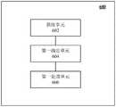
根据本公开的另一方面,还提供了一种点云数据处理装置。图6示出了根据本公开一个实施例的点云数据处理装置600的框图。如图6所示,该装置600可以包括:According to another aspect of the present disclosure, a point cloud data processing apparatus is also provided. FIG. 6 shows a block diagram of a point cloud
获取单元602,被配置为获取用于生成点云地图的点云数据集,其中,点云数据集包括至少一个点云数据点,每个点云数据点具有在第一坐标系下的坐标;The obtaining
第一确定单元604,被配置为针对点云数据集中的每个点云数据点,基于点云数据点在第一坐标系下的坐标,确定点云数据点是否处于相邻地理分带的交界区域内;以及The first determining
第一处理单元606,被配置为响应于确定点云数据点处于交界区域内,基于与相邻地理分带的划分相关联的第二坐标系,将点云数据点分别投影到相邻地理分带下以生成分别对应于相邻地理分带的相应地图数据。The
上述模块602、604及606所执行的操作与参考图2所描述的步骤S202、S204、S206相对应,因此不再赘述其各个方面的细节。The operations performed by the
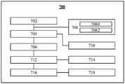
图7示出了根据本公开另一个实施例的点云数据处理装置700的框图。图7所示的模块702、704及706可以分别对应于图6所示的模块602、604及606。除此之外,装置700还可以包括进一步的功能模块708、710、712、714、716及718,且模块708还可以包括进一步的子功能模块,如下将具体说明。FIG. 7 shows a block diagram of a point cloud
根据一些实施例,装置700还可以包括第二确定单元708,被配置为连接至获取单元702,以在获取单元702获取点云数据集之后,响应于确定与点云数据集相对应的位姿存在跨越相邻地理分带进行定位的可能性,通知第一确定单元704执行所述确定步骤。According to some embodiments, the
根据一些实施例,所述至少一个点云数据点包括中心点云数据点,并且第二确定单元708可以包括:第一子单元7080,被配置为基于中心点云数据点在第一坐标系下的坐标,确定中心点云数据点与相邻地理分带之间的边界线的距离是否小于或等于阈值;以及第二子单元7082,被配置为响应于确定中心点云数据点与相邻地理分带之间的边界线的距离小于或等于所述阈值,确定存在所述可能性。According to some embodiments, the at least one point cloud data point includes a center point cloud data point, and the second determining
根据一些实施例,装置700还可以包括第二处理单元710,被配置为响应于确定点云数据点在交界区域之外,基于第二坐标系,将点云数据点投影到与其对应的地理分带下以生成对应的地图数据。According to some embodiments, the
根据一些实施例,装置700还可以包括第一构建单元712,被配置为基于生成的相应地图数据,构建与预测位姿相关联的节点加载区域的扩展节点加载区域,其中,扩展节点加载区域被分配为与节点加载区域相同的地理分带。According to some embodiments, the
根据一些实施例,相邻地理分带包括在第二坐标系下具有连续的分带标识的第一地理分带和第二地理分带,并且其中,预测位姿处于第一地理分带,并且扩展节点加载区域包括第二地理分带中的与第一地理分带相邻的一部分,且被分配第一地理分带的分带标识。According to some embodiments, the adjacent geographic bands include a first geographic band and a second geographic band having continuous band identifications in the second coordinate system, and wherein the predicted pose is in the first geographic band, and The extended node loading area includes a portion of the second geographic band adjacent to the first geographic band, and is assigned a band identifier of the first geographic band.
根据一些实施例,装置700还可以包括第二构建单元714,被配置为根据预测位姿相对于第一地理分带和第二地理分带之间的边界线的距离,从扩展节点加载区域中选择与节点加载区域互补的区域以构建更新的节点加载区域。According to some embodiments, the
根据一些实施例,更新的节点加载区域包括从生成的地图数据中加载的多个节点区域,所述多个节点区域中的每个节点区域具有第一地理面积,并且装置700还可以包括提取单元716,被配置为以预测位姿为中心,以大于所述第一地理面积的第二地理面积提取与预测位姿相对应的节点区域;以及匹配单元718,被配置为将预测位姿与对应于第二地理面积的地图数据进行匹配,以校正预测位姿。According to some embodiments, the updated node loading area includes a plurality of node areas loaded from the generated map data, each node area of the plurality of node areas has a first geographic area, and the
根据本公开的另一方面,还提供了一种存储有计算机指令的非瞬时计算机可读存储介质,其中,所述计算机指令用于使所述计算机执行如上所述的方法。According to another aspect of the present disclosure, there is also provided a non-transitory computer-readable storage medium storing computer instructions, wherein the computer instructions are used to cause the computer to perform the method as described above.
根据本公开的另一方面,还提供了一种计算机程序产品,包括计算机程序,其中,所述计算机程序在被处理器执行时实现如上所述的方法。According to another aspect of the present disclosure, there is also provided a computer program product, comprising a computer program, wherein the computer program, when executed by a processor, implements the method as described above.
根据本公开的另一方面,还提供了一种自动驾驶设备,包括控制器,所述控制器被配置为实现如上所述的方法。According to another aspect of the present disclosure, there is also provided an automatic driving apparatus including a controller configured to implement the method as described above.
根据本公开的另一方面,还提供了一种电子设备,包括至少一个处理器;以及与所述至少一个处理器通信连接的存储器,其中,所述存储器存储有能够被所述至少一个处理器执行的指令,所述指令在被所述至少一个处理器执行时,使所述至少一个处理器执行如上所述的方法。According to another aspect of the present disclosure, there is also provided an electronic device, comprising at least one processor; and a memory communicatively connected to the at least one processor, wherein the memory stores information that can be used by the at least one processor Executable instructions that, when executed by the at least one processor, cause the at least one processor to perform a method as described above.
参考图8,现将描述可以作为本公开的服务器或客户端的电子设备800的结构框图,其是可以应用于本公开的各方面的硬件设备的示例。电子设备旨在表示各种形式的数字电子的计算机设备,诸如,膝上型计算机、台式计算机、工作台、个人数字助理、服务器、刀片式服务器、大型计算机、和其它适合的计算机。电子设备还可以表示各种形式的移动装置,诸如,个人数字处理、蜂窝电话、智能电话、可穿戴设备和其它类似的计算装置。本文所示的部件、它们的连接和关系、以及它们的功能仅仅作为示例,并且不意在限制本文中描述的和/或者要求的本公开的实现。Referring to FIG. 8 , a structural block diagram of an
如图8所示,设备800包括计算单元801,其可以根据存储在只读存储器(ROM)802中的计算机程序或者从存储单元808加载到随机访问存储器(RAM)803中的计算机程序,来执行各种适当的动作和处理。在RAM 803中,还可存储设备800操作所需的各种程序和数据。计算单元801、ROM 802以及RAM 803通过总线804彼此相连。输入/输出(I/O)接口805也连接至总线804。As shown in FIG. 8 , the
设备800中的多个部件连接至I/O接口805,包括:输入单元806、输出单元807、存储单元808以及通信单元809。输入单元806可以是能向设备800输入信息的任何类型的设备,输入单元806可以接收输入的数字或字符信息,以及产生与电子设备的用户设置和/或功能控制有关的键信号输入,并且可以包括但不限于鼠标、键盘、触摸屏、轨迹板、轨迹球、操作杆、麦克风和/或遥控器。输出单元807可以是能呈现信息的任何类型的设备,并且可以包括但不限于显示器、扬声器、视频/音频输出终端、振动器和/或打印机。存储单元808可以包括但不限于磁盘、光盘。通信单元809允许设备800通过诸如因特网的计算机网络和/或各种电信网络与其他设备交换信息/数据,并且可以包括但不限于调制解调器、网卡、红外通信设备、无线通信收发机和/或芯片组,例如蓝牙TM设备、1302.11设备、WiFi设备、WiMax设备、蜂窝通信设备和/或类似物。Various components in the
计算单元801可以是各种具有处理和计算能力的通用和/或专用处理组件。计算单元801的一些示例包括但不限于中央处理单元(CPU)、图形处理单元(GPU)、各种专用的人工智能(AI)计算芯片、各种运行机器学习模型算法的计算单元、数字信号处理器(DSP)、以及任何适当的处理器、控制器、微控制器等。计算单元801执行上文所描述的各个方法和处理,例如点云数据处理方法。例如,在一些实施例中,点云数据处理方法可被实现为计算机软件程序,其被有形地包含于机器可读介质,例如存储单元808。在一些实施例中,计算机程序的部分或者全部可以经由ROM 802和/或通信单元809而被载入和/或安装到设备800上。当计算机程序加载到RAM 803并由计算单元801执行时,可以执行上文描述的点云数据处理方法的一个或多个步骤。备选地,在其他实施例中,计算单元801可以通过其他任何适当的方式(例如,借助于固件)而被配置为执行点云数据处理方法。
本文中以上描述的系统和技术的各种实施方式可以在数字电子电路系统、集成电路系统、场可编程门阵列(FPGA)、专用集成电路(ASIC)、专用标准产品(ASSP)、芯片上系统的系统(SOC)、负载可编程逻辑设备(CPLD)、计算机硬件、固件、软件、和/或它们的组合中实现。这些各种实施方式可以包括:实施在一个或者多个计算机程序中,该一个或者多个计算机程序可在包括至少一个可编程处理器的可编程系统上执行和/或解释,该可编程处理器可以是专用或者通用可编程处理器,可以从存储系统、至少一个输入装置、和至少一个输出装置接收数据和指令,并且将数据和指令传输至该存储系统、该至少一个输入装置、和该至少一个输出装置。Various implementations of the systems and techniques described herein above may be implemented in digital electronic circuitry, integrated circuit systems, field programmable gate arrays (FPGAs), application specific integrated circuits (ASICs), application specific standard products (ASSPs), systems on chips system (SOC), load programmable logic device (CPLD), computer hardware, firmware, software, and/or combinations thereof. These various embodiments may include being implemented in one or more computer programs executable and/or interpretable on a programmable system including at least one programmable processor that The processor, which may be a special purpose or general-purpose programmable processor, may receive data and instructions from a storage system, at least one input device, and at least one output device, and transmit data and instructions to the storage system, the at least one input device, and the at least one output device an output device.
用于实施本公开的方法的程序代码可以采用一个或多个编程语言的任何组合来编写。这些程序代码可以提供给通用计算机、专用计算机或其他可编程数据处理装置的处理器或控制器,使得程序代码当由处理器或控制器执行时使流程图和/或框图中所规定的功能/操作被实施。程序代码可以完全在机器上执行、部分地在机器上执行,作为独立软件包部分地在机器上执行且部分地在远程机器上执行或完全在远程机器或服务器上执行。Program code for implementing the methods of the present disclosure may be written in any combination of one or more programming languages. These program codes may be provided to a processor or controller of a general purpose computer, special purpose computer or other programmable data processing apparatus, such that the program code, when executed by the processor or controller, performs the functions/functions specified in the flowcharts and/or block diagrams. Action is implemented. The program code may execute entirely on the machine, partly on the machine, partly on the machine and partly on a remote machine as a stand-alone software package or entirely on the remote machine or server.
在本公开的上下文中,机器可读介质可以是有形的介质,其可以包含或存储以供指令执行系统、装置或设备使用或与指令执行系统、装置或设备结合地使用的程序。机器可读介质可以是机器可读信号介质或机器可读储存介质。机器可读介质可以包括但不限于电子的、磁性的、光学的、电磁的、红外的、或半导体系统、装置或设备,或者上述内容的任何合适组合。机器可读存储介质的更具体示例会包括基于一个或多个线的电气连接、便携式计算机盘、硬盘、随机存取存储器(RAM)、只读存储器(ROM)、可擦除可编程只读存储器(EPROM或快闪存储器)、光纤、便捷式紧凑盘只读存储器(CD-ROM)、光学储存设备、磁储存设备、或上述内容的任何合适组合。In the context of the present disclosure, a machine-readable medium may be a tangible medium that may contain or store a program for use by or in connection with the instruction execution system, apparatus or device. The machine-readable medium may be a machine-readable signal medium or a machine-readable storage medium. Machine-readable media may include, but are not limited to, electronic, magnetic, optical, electromagnetic, infrared, or semiconductor systems, devices, or devices, or any suitable combination of the foregoing. More specific examples of machine-readable storage media would include one or more wire-based electrical connections, portable computer disks, hard disks, random access memory (RAM), read only memory (ROM), erasable programmable read only memory (EPROM or flash memory), fiber optics, compact disk read only memory (CD-ROM), optical storage, magnetic storage, or any suitable combination of the foregoing.
为了提供与用户的交互,可以在计算机上实施此处描述的系统和技术,该计算机具有:用于向用户显示信息的显示装置(例如,CRT(阴极射线管)或者LCD(液晶显示器)监视器);以及键盘和指向装置(例如,鼠标或者轨迹球),用户可以通过该键盘和该指向装置来将输入提供给计算机。其它种类的装置还可以用于提供与用户的交互;例如,提供给用户的反馈可以是任何形式的传感反馈(例如,视觉反馈、听觉反馈、或者触觉反馈);并且可以用任何形式(包括声输入、语音输入或者、触觉输入)来接收来自用户的输入。To provide interaction with a user, the systems and techniques described herein may be implemented on a computer having a display device (eg, a CRT (cathode ray tube) or LCD (liquid crystal display) monitor) for displaying information to the user ); and a keyboard and pointing device (eg, a mouse or trackball) through which a user can provide input to the computer. Other kinds of devices can also be used to provide interaction with the user; for example, the feedback provided to the user can be any form of sensory feedback (eg, visual feedback, auditory feedback, or tactile feedback); and can be in any form (including acoustic input, voice input, or tactile input) to receive input from the user.
可以将此处描述的系统和技术实施在包括后台部件的计算系统(例如,作为数据服务器)、或者包括中间件部件的计算系统(例如,应用服务器)、或者包括前端部件的计算系统(例如,具有图形用户界面或者网络浏览器的用户计算机,用户可以通过该图形用户界面或者该网络浏览器来与此处描述的系统和技术的实施方式交互)、或者包括这种后台部件、中间件部件、或者前端部件的任何组合的计算系统中。可以通过任何形式或者介质的数字数据通信(例如,通信网络)来将系统的部件相互连接。通信网络的示例包括:局域网(LAN)、广域网(WAN)和互联网。The systems and techniques described herein may be implemented on a computing system that includes back-end components (eg, as a data server), or a computing system that includes middleware components (eg, an application server), or a computing system that includes front-end components (eg, a user computer having a graphical user interface or web browser through which a user may interact with implementations of the systems and techniques described herein), or including such backend components, middleware components, Or any combination of front-end components in a computing system. The components of the system may be interconnected by any form or medium of digital data communication (eg, a communication network). Examples of communication networks include: Local Area Networks (LANs), Wide Area Networks (WANs), and the Internet.
计算机系统可以包括客户端和服务器。客户端和服务器一般远离彼此并且通常通过通信网络进行交互。通过在相应的计算机上运行并且彼此具有客户端-服务器关系的计算机程序来产生客户端和服务器的关系。服务器可以是云服务器,也可以为分布式系统的服务器,或者是结合了区块链的服务器。A computer system can include clients and servers. Clients and servers are generally remote from each other and usually interact through a communication network. The relationship of client and server arises by computer programs running on the respective computers and having a client-server relationship to each other. The server can be a cloud server, a distributed system server, or a server combined with blockchain.
应该理解,可以使用上面所示的各种形式的流程,重新排序、增加或删除步骤。例如,本公开中记载的各步骤可以并行地执行、也可以顺序地或以不同的次序执行,只要能够实现本公开公开的技术方案所期望的结果,本文在此不进行限制。It should be understood that steps may be reordered, added or deleted using the various forms of flow shown above. For example, the steps described in the present disclosure can be performed in parallel, sequentially or in different orders, as long as the desired results of the technical solutions disclosed in the present disclosure can be achieved, which are not limited herein.
虽然已经参照附图描述了本公开的实施例或示例,但应理解,上述的方法、系统和设备仅仅是示例性的实施例或示例,本发明的范围并不由这些实施例或示例限制,而是仅由授权后的权利要求书及其等同范围来限定。实施例或示例中的各种要素可以被省略或者可由其等同要素替代。此外,可以通过不同于本公开中描述的次序来执行各步骤。进一步地,可以以各种方式组合实施例或示例中的各种要素。重要的是随着技术的演进,在此描述的很多要素可以由本公开之后出现的等同要素进行替换。Although the embodiments or examples of the present disclosure have been described with reference to the accompanying drawings, it should be understood that the above-described methods, systems and devices are merely exemplary embodiments or examples, and the scope of the present invention is not limited by these embodiments or examples, but is limited only by the appended claims and their equivalents. Various elements of the embodiments or examples may be omitted or replaced by equivalents thereof. Furthermore, the steps may be performed in an order different from that described in this disclosure. Further, various elements of the embodiments or examples may be combined in various ways. Importantly, as technology evolves, many of the elements described herein may be replaced by equivalent elements that appear later in this disclosure.
Claims (19)
Translated fromChinesePriority Applications (1)
| Application Number | Priority Date | Filing Date | Title |
|---|---|---|---|
| CN202111124138.9ACN113850909B (en) | 2021-09-24 | 2021-09-24 | Point cloud data processing method and device, electronic equipment and automatic driving equipment |
Applications Claiming Priority (1)
| Application Number | Priority Date | Filing Date | Title |
|---|---|---|---|
| CN202111124138.9ACN113850909B (en) | 2021-09-24 | 2021-09-24 | Point cloud data processing method and device, electronic equipment and automatic driving equipment |
Publications (2)
| Publication Number | Publication Date |
|---|---|
| CN113850909A CN113850909A (en) | 2021-12-28 |
| CN113850909Btrue CN113850909B (en) | 2022-08-30 |
Family
ID=78979415
Family Applications (1)
| Application Number | Title | Priority Date | Filing Date |
|---|---|---|---|
| CN202111124138.9AActiveCN113850909B (en) | 2021-09-24 | 2021-09-24 | Point cloud data processing method and device, electronic equipment and automatic driving equipment |
Country Status (1)
| Country | Link |
|---|---|
| CN (1) | CN113850909B (en) |
Families Citing this family (1)
| Publication number | Priority date | Publication date | Assignee | Title |
|---|---|---|---|---|
| CN114812447B (en)* | 2022-06-23 | 2022-09-20 | 质子汽车科技有限公司 | Topographic area metering method and electric vehicle |
Citations (2)
| Publication number | Priority date | Publication date | Assignee | Title |
|---|---|---|---|---|
| CN111771206A (en)* | 2019-01-30 | 2020-10-13 | 百度时代网络技术(北京)有限公司 | Map zoning system for autonomous vehicles |
| CN111819419A (en)* | 2017-12-27 | 2020-10-23 | 宝马股份公司 | Deformation correction of a digital map for a vehicle |
Family Cites Families (1)
| Publication number | Priority date | Publication date | Assignee | Title |
|---|---|---|---|---|
| US10712168B2 (en)* | 2017-12-28 | 2020-07-14 | Uatc, Llc | Submap geographic projections |
- 2021
- 2021-09-24CNCN202111124138.9Apatent/CN113850909B/enactiveActive
Patent Citations (2)
| Publication number | Priority date | Publication date | Assignee | Title |
|---|---|---|---|---|
| CN111819419A (en)* | 2017-12-27 | 2020-10-23 | 宝马股份公司 | Deformation correction of a digital map for a vehicle |
| CN111771206A (en)* | 2019-01-30 | 2020-10-13 | 百度时代网络技术(北京)有限公司 | Map zoning system for autonomous vehicles |
Also Published As
| Publication number | Publication date |
|---|---|
| CN113850909A (en) | 2021-12-28 |
Similar Documents
| Publication | Publication Date | Title |
|---|---|---|
| CN114179832B (en) | Lane changing method for automatic driving vehicle | |
| CN113887400B (en) | Obstacle detection method, model training method, device and autonomous vehicle | |
| CN113920174B (en) | Point cloud registration method, device, equipment, medium and automatic driving vehicle | |
| CN114970112B (en) | Method, device, electronic equipment and storage medium for automatic driving simulation | |
| CN115019060A (en) | Target recognition method, and training method and device of target recognition model | |
| CN116678424B (en) | High-precision vehicle positioning, vectorized map construction and positioning model training method | |
| CN115861953A (en) | Training method of scene coding model, and trajectory planning method and device | |
| JP2022088496A (en) | Methods, devices, devices and media to control data collection | |
| CN114689074A (en) | Information processing method and navigation method | |
| CN115235487B (en) | Data processing method, device, equipment and medium | |
| CN114047760B (en) | Path planning method, device, electronic device and autonomous driving vehicle | |
| CN115675528A (en) | Autonomous driving method and vehicle based on similar scene mining | |
| CN115082690B (en) | Target recognition method, target recognition model training method and device | |
| CN113850909B (en) | Point cloud data processing method and device, electronic equipment and automatic driving equipment | |
| CN117710939A (en) | Signal lamp detection method, device and system and automatic driving vehicle | |
| CN116469069B (en) | Scene coding model training method, device and medium for automatic driving | |
| CN117707172A (en) | Decision-making method and device for automatic driving vehicle, equipment and medium | |
| CN116580367A (en) | Data processing method, device, electronic equipment and storage medium | |
| CN114179834B (en) | Vehicle parking method, device, electronic equipment, medium and automatic driving vehicle | |
| CN116560377A (en) | An autonomous driving model and its training method for predicting position trajectories | |
| CN115046559A (en) | Information processing method and device | |
| CN114670839A (en) | Method and device for evaluating driving behavior of automatic driving vehicle and electronic equipment | |
| CN116844134B (en) | Target detection method and device, electronic equipment, storage medium and vehicle | |
| CN115019278B (en) | Lane line fitting method and device, electronic equipment and medium | |
| CN115952670A (en) | Automatic driving scene simulation method and device |
Legal Events
| Date | Code | Title | Description |
|---|---|---|---|
| PB01 | Publication | ||
| PB01 | Publication | ||
| SE01 | Entry into force of request for substantive examination | ||
| SE01 | Entry into force of request for substantive examination | ||
| GR01 | Patent grant | ||
| GR01 | Patent grant |