CN113432600B - Robot instant positioning and map construction method and system based on multiple information sources - Google Patents
Robot instant positioning and map construction method and system based on multiple information sourcesDownload PDFInfo
- Publication number
- CN113432600B CN113432600BCN202110644501.3ACN202110644501ACN113432600BCN 113432600 BCN113432600 BCN 113432600BCN 202110644501 ACN202110644501 ACN 202110644501ACN 113432600 BCN113432600 BCN 113432600B
- Authority
- CN
- China
- Prior art keywords
- point cloud
- laser
- points
- information
- cloud data
- Prior art date
- Legal status (The legal status is an assumption and is not a legal conclusion. Google has not performed a legal analysis and makes no representation as to the accuracy of the status listed.)
- Active
Links
- 238000010276constructionMethods0.000titleabstractdescription19
- 238000000034methodMethods0.000claimsabstractdescription79
- 238000001514detection methodMethods0.000claimsabstractdescription40
- 238000007781pre-processingMethods0.000claimsabstractdescription21
- 238000013507mappingMethods0.000claimsabstractdescription10
- 238000002310reflectometryMethods0.000claimsdescription22
- 230000008569processEffects0.000claimsdescription20
- 230000010354integrationEffects0.000claimsdescription16
- 238000005457optimizationMethods0.000claimsdescription15
- 238000000605extractionMethods0.000claimsdescription14
- 238000012545processingMethods0.000claimsdescription14
- 230000001133accelerationEffects0.000claimsdescription13
- 238000004422calculation algorithmMethods0.000claimsdescription11
- 238000013178mathematical modelMethods0.000claimsdescription11
- 239000013598vectorSubstances0.000claimsdescription7
- 238000012937correctionMethods0.000claimsdescription2
- 230000004807localizationEffects0.000claimsdescription2
- 238000010606normalizationMethods0.000claimsdescription2
- 230000011218segmentationEffects0.000claimsdescription2
- 238000009616inductively coupled plasmaMethods0.000claims1
- 230000017105transpositionEffects0.000claims1
- 238000010168coupling processMethods0.000abstract1
- 230000006870functionEffects0.000description23
- 238000010586diagramMethods0.000description12
- 239000011159matrix materialSubstances0.000description11
- 230000000875corresponding effectEffects0.000description8
- 230000015654memoryEffects0.000description8
- 238000004590computer programMethods0.000description7
- 238000003860storageMethods0.000description6
- 238000004364calculation methodMethods0.000description5
- 230000009466transformationEffects0.000description5
- 238000009795derivationMethods0.000description3
- 238000005259measurementMethods0.000description3
- 238000012986modificationMethods0.000description3
- 230000004048modificationEffects0.000description3
- 230000008859changeEffects0.000description2
- 238000005295random walkMethods0.000description2
- 238000013519translationMethods0.000description2
- 230000002776aggregationEffects0.000description1
- 238000004220aggregationMethods0.000description1
- 230000009286beneficial effectEffects0.000description1
- 230000002596correlated effectEffects0.000description1
- 230000001186cumulative effectEffects0.000description1
- 238000005520cutting processMethods0.000description1
- 238000013500data storageMethods0.000description1
- 230000007812deficiencyEffects0.000description1
- 239000006185dispersionSubstances0.000description1
- 230000007613environmental effectEffects0.000description1
- 230000004927fusionEffects0.000description1
- 230000005484gravityEffects0.000description1
- 238000009499grossingMethods0.000description1
- 238000004519manufacturing processMethods0.000description1
- 239000000463materialSubstances0.000description1
- 230000003287optical effectEffects0.000description1
- 230000004044responseEffects0.000description1
- 238000013077scoring methodMethods0.000description1
- 238000012216screeningMethods0.000description1
- 238000004088simulationMethods0.000description1
- 238000000844transformationMethods0.000description1
Images


Classifications
- G—PHYSICS
- G01—MEASURING; TESTING
- G01C—MEASURING DISTANCES, LEVELS OR BEARINGS; SURVEYING; NAVIGATION; GYROSCOPIC INSTRUMENTS; PHOTOGRAMMETRY OR VIDEOGRAMMETRY
- G01C21/00—Navigation; Navigational instruments not provided for in groups G01C1/00 - G01C19/00
- G01C21/10—Navigation; Navigational instruments not provided for in groups G01C1/00 - G01C19/00 by using measurements of speed or acceleration
- G01C21/12—Navigation; Navigational instruments not provided for in groups G01C1/00 - G01C19/00 by using measurements of speed or acceleration executed aboard the object being navigated; Dead reckoning
- G01C21/16—Navigation; Navigational instruments not provided for in groups G01C1/00 - G01C19/00 by using measurements of speed or acceleration executed aboard the object being navigated; Dead reckoning by integrating acceleration or speed, i.e. inertial navigation
- G01C21/165—Navigation; Navigational instruments not provided for in groups G01C1/00 - G01C19/00 by using measurements of speed or acceleration executed aboard the object being navigated; Dead reckoning by integrating acceleration or speed, i.e. inertial navigation combined with non-inertial navigation instruments
- G01C21/1652—Navigation; Navigational instruments not provided for in groups G01C1/00 - G01C19/00 by using measurements of speed or acceleration executed aboard the object being navigated; Dead reckoning by integrating acceleration or speed, i.e. inertial navigation combined with non-inertial navigation instruments with ranging devices, e.g. LIDAR or RADAR
- G—PHYSICS
- G01—MEASURING; TESTING
- G01C—MEASURING DISTANCES, LEVELS OR BEARINGS; SURVEYING; NAVIGATION; GYROSCOPIC INSTRUMENTS; PHOTOGRAMMETRY OR VIDEOGRAMMETRY
- G01C21/00—Navigation; Navigational instruments not provided for in groups G01C1/00 - G01C19/00
- G01C21/38—Electronic maps specially adapted for navigation; Updating thereof
- G01C21/3804—Creation or updating of map data
- G01C21/3833—Creation or updating of map data characterised by the source of data
- G01C21/3841—Data obtained from two or more sources, e.g. probe vehicles
- G—PHYSICS
- G01—MEASURING; TESTING
- G01S—RADIO DIRECTION-FINDING; RADIO NAVIGATION; DETERMINING DISTANCE OR VELOCITY BY USE OF RADIO WAVES; LOCATING OR PRESENCE-DETECTING BY USE OF THE REFLECTION OR RERADIATION OF RADIO WAVES; ANALOGOUS ARRANGEMENTS USING OTHER WAVES
- G01S17/00—Systems using the reflection or reradiation of electromagnetic waves other than radio waves, e.g. lidar systems
- G01S17/86—Combinations of lidar systems with systems other than lidar, radar or sonar, e.g. with direction finders
- G—PHYSICS
- G01—MEASURING; TESTING
- G01S—RADIO DIRECTION-FINDING; RADIO NAVIGATION; DETERMINING DISTANCE OR VELOCITY BY USE OF RADIO WAVES; LOCATING OR PRESENCE-DETECTING BY USE OF THE REFLECTION OR RERADIATION OF RADIO WAVES; ANALOGOUS ARRANGEMENTS USING OTHER WAVES
- G01S17/00—Systems using the reflection or reradiation of electromagnetic waves other than radio waves, e.g. lidar systems
- G01S17/88—Lidar systems specially adapted for specific applications
- G01S17/89—Lidar systems specially adapted for specific applications for mapping or imaging
Landscapes
- Engineering & Computer Science (AREA)
- Radar, Positioning & Navigation (AREA)
- Remote Sensing (AREA)
- Physics & Mathematics (AREA)
- General Physics & Mathematics (AREA)
- Automation & Control Theory (AREA)
- Computer Networks & Wireless Communication (AREA)
- Electromagnetism (AREA)
- Control Of Position, Course, Altitude, Or Attitude Of Moving Bodies (AREA)
- Length Measuring Devices By Optical Means (AREA)
Abstract
Translated fromChinese
Description
Translated fromChinese技术领域technical field
本发明涉及机器人技术领域,特别涉及一种基于多信息源的机器人即时定位与地图构建方法及系统。The invention relates to the technical field of robots, in particular to a method and system for real-time positioning and map construction of robots based on multiple information sources.
背景技术Background technique
SLAM(即时定位与地图构建)作为移动机器人的核心功能,在过去的几十年时间里得到了飞速的发展,引起了国际社会学者们的广泛兴趣。As the core function of mobile robots, SLAM (real-time localization and map construction) has developed rapidly in the past few decades, arousing extensive interest of scholars in the international society.
为了构建良好的激光惯导SLAM系统,人们也提出了诸如LOAM,Lego-loam,LIO-Mapping、LIO-SAM等算法,但是这些现有的算法都不可避免的采取单一的几何特征,信息源较为单一,并且这些现有的惯导系统大多没有对地面进行优化,缺少地平面这一有明显特征的几何约束,因此,需要改进。In order to build a good laser inertial navigation SLAM system, people have also proposed algorithms such as LOAM, Lego-loam, LIO-Mapping, LIO-SAM, etc. However, these existing algorithms inevitably adopt a single geometric feature, and the information source is relatively Single, and most of these existing inertial navigation systems are not optimized for the ground, and lack the geometric constraint with obvious characteristics of the ground plane. Therefore, it needs to be improved.
发明内容SUMMARY OF THE INVENTION
本发明提供了一种基于多信息源的机器人即时定位与地图构建方法及系统,以解决目前SLAM大多以3D激光雷达为主,信息源大多采取几何信息的特征,在一些场景下,如室外,发生纯旋转等情况下的鲁棒性不高的技术问题。The invention provides a method and system for real-time positioning and map construction of a robot based on multiple information sources, so as to solve the problem that most of the current SLAM is mainly based on 3D laser radar, and most of the information sources adopt the characteristics of geometric information. In some scenarios, such as outdoor, The technical problem of low robustness in the case of pure rotation, etc. occurs.
为解决上述技术问题,本发明提供了如下技术方案:In order to solve the above-mentioned technical problems, the present invention provides the following technical solutions:
一方面,本发明提供了一种基于多信息源的机器人即时定位与地图构建方法,该基于多信息源的机器人即时定位与地图构建方法包括:On the one hand, the present invention provides a method for real-time positioning and map construction of a robot based on multiple information sources, and the method for real-time positioning and map construction of a robot based on multiple information sources includes:
获取激光点云数据,并对获取的激光点云数据进行预处理,以去除激光点云数据中的杂点,并且获得激光点反射强度信息和激光点云数据的聚类标签;Obtain the laser point cloud data, and preprocess the obtained laser point cloud data to remove the noise in the laser point cloud data, and obtain the laser point reflection intensity information and the clustering label of the laser point cloud data;
基于激光点云数据的几何特征和激光点反射强度信息,对预处理后的激光点云数据中的每一帧的点云进行特征点提取,以获取每一帧点云的特征点;Based on the geometric features of the laser point cloud data and the laser point reflection intensity information, extract feature points from the point cloud of each frame in the preprocessed laser point cloud data to obtain the feature points of each frame of point cloud;
利用提取到的特征点进行点云配准;其中,在点云配准过程中,利用所述聚类标签和所述激光点反射强度信息作为联合的约束条件;Use the extracted feature points to perform point cloud registration; wherein, in the point cloud registration process, the cluster label and the laser point reflection intensity information are used as joint constraints;
基于点云配准结果,结合IMU数据和回环检测信息,得到全局位姿和地图。Based on the point cloud registration results, combined with IMU data and loop closure detection information, the global pose and map are obtained.
进一步地,所述对获取的激光点云数据进行预处理,包括:Further, the preprocessing of the acquired laser point cloud data includes:
根据反射强度的生成原理,建立数学模型,利用所述数学模型进行激光点反射强度的矫正和归一化处理,获得激光点反射强度信息,所述数学模型如下:According to the generation principle of the reflection intensity, a mathematical model is established, and the mathematical model is used to correct and normalize the reflection intensity of the laser point to obtain the reflection intensity information of the laser point. The mathematical model is as follows:

其中,ρ是反射率,即相当于反射强度消除外在因素干扰后的信息,I是测得的反射强度信息,R是激光点距离激光雷达的距离,可以直接测得,α是入射角度,可通过测量得到,经过推导,我们可以知道反射∝(正相关于)反射强度。Among them, ρ is the reflectivity, that is, the information equivalent to the reflection intensity after eliminating the interference of external factors, I is the measured reflection intensity information, R is the distance between the laser point and the lidar, which can be directly measured, α is the incident angle, It can be obtained by measurement, and after derivation, we can know the reflection ∝ (positive correlation) reflection intensity.
进一步地,所述对获取的激光点云数据进行预处理,还包括:Further, the preprocessing of the acquired laser point cloud data also includes:
利用激光点间的角度关系进行线束分割,以确定每个激光点属于哪个线束;Use the angular relationship between the laser points to segment the beam to determine which beam each laser point belongs to;
利用相邻点与地平线的夹角关系进行地面点与非地面点的点云分割;Use the angle relationship between adjacent points and the horizon to segment the point cloud between ground points and non-ground points;
利用惯性传感器IMU信息进行点云数据的运动畸变去除;Use inertial sensor IMU information to remove motion distortion from point cloud data;
对非地面点投影聚类,对每个聚类分配一个唯一的聚类标签并去除边缘点。Project clusters of non-ground points, assign each cluster a unique cluster label and remove edge points.
进一步地,所述利用惯性传感器IMU信息进行运动畸变去除,包括:Further, the motion distortion removal using the inertial sensor IMU information includes:
将IMU直接测得的角速度和线加速度进行积分;Integrate the angular velocity and linear acceleration directly measured by the IMU;
根据积分结果将速度补偿给激光点,以实现点云数据的运动畸变去除。According to the integral result, the speed is compensated to the laser point to realize the motion distortion removal of the point cloud data.
进一步地,所述基于激光点云数据的几何特征和激光点反射强度信息,对预处理后的激光点云数据中的每一帧的点云进行特征点提取,包括:Further, based on the geometric features of the laser point cloud data and the laser point reflection intensity information, feature point extraction is performed on the point cloud of each frame in the preprocessed laser point cloud data, including:
基于激光点云数据的几何特征和激光点反射强度信息,构建平滑度公式,设置特征点判断阈值,表达式如下:Based on the geometric features of the laser point cloud data and the reflection intensity information of the laser points, the smoothness formula is constructed, and the judgment threshold of the feature points is set. The expression is as follows:

其中,

将每一帧点云均匀的分为8个部分,每个部分的扫描范围均为45度;Divide each frame of point cloud into 8 parts evenly, and the scanning range of each part is 45 degrees;
在提取特征点时,在每一帧点云的每一部分分别提取2个特征点和4个平面点,从而构成每一帧点云的边缘点集合和平面点集合。When extracting feature points, 2 feature points and 4 plane points are extracted from each part of the point cloud of each frame, so as to constitute the edge point set and the plane point set of each frame of point cloud.
进一步地,在提取特征点时,所述方法还包括:Further, when extracting feature points, the method further includes:
去除点云中深度值小于预设深度值阈值的点;Remove points in the point cloud whose depth value is less than the preset depth value threshold;
去除点云中激光雷达视场边缘的点;Remove points at the edge of the lidar field of view in the point cloud;
去除点云中激光束和平面夹角小于预设夹角阈值的点;Remove the points in the point cloud where the angle between the laser beam and the plane is less than the preset angle threshold;
去除点云中在当前帧点云的前后N帧发现遮挡的点;其中,N为预设整数。Remove the occluded points in the point cloud N frames before and after the point cloud of the current frame; where N is a preset integer.
进一步地,所述利用提取到的特征点进行点云配准,包括:Further, the point cloud registration using the extracted feature points includes:
采用PL-ICP的方式,利用提取到的特征点进行点云配准,约束条件如下:Using the PL-ICP method, the extracted feature points are used for point cloud registration, and the constraints are as follows:
Lj=Ll|||ρj-ρl|<ρILj =Ll |||ρj -ρl |<ρI
其中,Ll和Lj分别代表两个激光点的聚类标签,ρj和ρl分别代表两个点的反射率,ρI是设定的反射率的阈值。Among them, Ll and Lj respectively represent the clustering labels of the two laser points, ρj and ρl respectively represent the reflectivity of the two points, and ρI is the set reflectivity threshold.
进一步地,所述基于点云配准结果,结合IMU数据和回环检测信息,得到全局位姿和地图,包括:Further, based on the point cloud registration result, combined with IMU data and loop closure detection information, the global pose and map are obtained, including:
基于点云配准结果,得到机器人的局部位姿并构建局部子图,同时将其转换为激光里程计因子;Based on the point cloud registration results, the local pose of the robot is obtained and a local subgraph is constructed, and at the same time, it is converted into a laser odometry factor;
对IMU测得的角速度和加速度信息进行预积分处理,构建预积分因子;Perform pre-integration processing on the angular velocity and acceleration information measured by the IMU to construct a pre-integration factor;
采用预设的回环检测算法进行回环检测,形成回环检测因子;Use a preset loopback detection algorithm to perform loopback detection to form a loopback detection factor;
将机器人位姿构建为变量节点,将所述回环检测因子,激光里程计因子和预积分因子构成相关变量节点间的因子节点,一起加入因子图中进行联合优化,得到全局一致的位姿轨迹,并经过地图的拼接后,得到全局一致性的地图。The robot pose is constructed as a variable node, and the loopback detection factor, the laser odometry factor and the pre-integration factor form factor nodes among the relevant variable nodes, and are added to the factor graph for joint optimization to obtain a globally consistent pose trajectory. And after map splicing, a globally consistent map is obtained.
进一步地,所述预设的回环检测算法为scan context回环描述符。Further, the preset loopback detection algorithm is a scan context loopback descriptor.
另一方面,本发明还提供了一种基于多信息源的机器人即时定位与地图构建系统,该基于多信息源的机器人即时定位与地图构建系统包括:On the other hand, the present invention also provides a real-time positioning and map construction system for robots based on multiple information sources, and the real-time positioning and map construction system for robots based on multiple information sources includes:
激光点云数据获取与预处理模块,用于获取激光点云数据,并对获取的激光点云数据进行预处理,以去除激光点云数据中的杂点,并且获得激光点反射强度信息和激光点云数据的聚类标签;Laser point cloud data acquisition and preprocessing module, used to acquire laser point cloud data, and preprocess the acquired laser point cloud data to remove noise in the laser point cloud data, and obtain laser point reflection intensity information and laser Cluster labels for point cloud data;
特征提取模块,用于基于激光点云数据的几何特征和激光点反射强度信息,对经过所述激光点云数据获取与预处理模块预处理后的激光点云数据中的每一帧的点云进行特征点提取,以获取每一帧点云的特征点;The feature extraction module is used for the point cloud of each frame in the laser point cloud data preprocessed by the laser point cloud data acquisition and preprocessing module based on the geometric features of the laser point cloud data and the laser point reflection intensity information Perform feature point extraction to obtain the feature points of each frame of point cloud;
点云配准模块,用于利用所述特征提取模块提取到的特征点进行点云配准;其中,在点云配准过程中,所述点云配准模块利用所述聚类标签和所述激光点反射强度信息作为联合的约束条件;The point cloud registration module is used for using the feature points extracted by the feature extraction module to perform point cloud registration; wherein, in the point cloud registration process, the point cloud registration module uses the cluster label and the The laser point reflection intensity information is used as a joint constraint;
全局位姿与地图构建模块,用于基于所述点云配准模块输出的点云配准结果,结合IMU数据和回环检测信息,得到全局位姿和地图。The global pose and map construction module is used to obtain the global pose and map based on the point cloud registration result output by the point cloud registration module, combined with IMU data and loop closure detection information.
再一方面,本发明还提供了一种电子设备,其包括处理器和存储器;其中,存储器中存储有至少一条指令,所述指令由处理器加载并执行以实现上述方法。In another aspect, the present invention also provides an electronic device, which includes a processor and a memory; wherein, the memory stores at least one instruction, and the instruction is loaded and executed by the processor to implement the above method.
又一方面,本发明还提供了一种计算机可读存储介质,所述存储介质中存储有至少一条指令,所述指令由处理器加载并执行以实现上述方法。In yet another aspect, the present invention also provides a computer-readable storage medium, wherein the storage medium stores at least one instruction, and the instruction is loaded and executed by a processor to implement the above method.
本发明提供的技术方案带来的有益效果至少包括:The beneficial effects brought by the technical solution provided by the present invention at least include:
本发明将激光雷达和IMU信息用因子图的方式融合在一起进行联合优化,除了使用几何信息外,还引入了反射强度信息,避免了单一几何信息的不足,通过增加新的约束,提高了点云匹配的效率和精度,相比于单传感器和单一信息源的系统,本发明具有更高的鲁棒性。同时本发明融合目前先进的scan context描述符进行回环检测,从而提升了定位和建图精度,提高了系统整体的鲁棒性。The invention fuses laser radar and IMU information together in the form of factor graph for joint optimization. In addition to using geometric information, it also introduces reflection intensity information to avoid the insufficiency of single geometric information. By adding new constraints, the point is improved. Compared with the system of single sensor and single information source, the present invention has higher robustness in the efficiency and accuracy of cloud matching. At the same time, the present invention integrates the current advanced scan context descriptors to perform loopback detection, thereby improving the accuracy of positioning and mapping, and improving the overall robustness of the system.
附图说明Description of drawings
为了更清楚地说明本发明实施例中的技术方案,下面将对实施例描述中所需要使用的附图作简单地介绍,显而易见地,下面描述中的附图仅仅是本发明的一些实施例,对于本领域普通技术人员来讲,在不付出创造性劳动的前提下,还可以根据这些附图获得其他的附图。In order to illustrate the technical solutions in the embodiments of the present invention more clearly, the following briefly introduces the accompanying drawings used in the description of the embodiments. Obviously, the accompanying drawings in the following description are only some embodiments of the present invention. For those of ordinary skill in the art, other drawings can also be obtained from these drawings without creative effort.
图1为本发明实施例提供的基于多信息源的机器人即时定位与地图构建方法的整体执行流程示意图;1 is a schematic diagram of an overall execution flow of a method for real-time positioning and map construction of a robot based on multiple information sources provided by an embodiment of the present invention;
图2为本发明实施例提供的激光点云数据预处理流程示意图;FIG. 2 is a schematic diagram of a preprocessing flow of laser point cloud data provided by an embodiment of the present invention;
图3为本发明实施例提供的点云配准的流程示意图;3 is a schematic flowchart of a point cloud registration provided by an embodiment of the present invention;
图4为本发明实施例提供的IMU预积分模型示意图;4 is a schematic diagram of an IMU pre-integration model provided by an embodiment of the present invention;
图5为本发明实施例提供的Scan Context描述符执行流程示意;FIG. 5 is a schematic diagram of the execution flow of the Scan Context descriptor provided by an embodiment of the present invention;
图6为本发明实施例提供的因子图优化的整体模型示意图。FIG. 6 is a schematic diagram of an overall model for factor graph optimization provided by an embodiment of the present invention.
具体实施方式Detailed ways
为使本发明的目的、技术方案和优点更加清楚,下面将结合附图对本发明实施方式作进一步地详细描述。In order to make the objectives, technical solutions and advantages of the present invention clearer, the embodiments of the present invention will be further described in detail below with reference to the accompanying drawings.
第一实施例first embodiment
本实施例提供了一种基于多信息源的机器人即时定位与地图构建方法,该方法可以由电子设备实现。具体地,本实施例的方法包括以下步骤:This embodiment provides a method for real-time positioning and map construction of a robot based on multiple information sources, and the method can be implemented by an electronic device. Specifically, the method of this embodiment includes the following steps:
S1,获取激光点云数据,并对获取的激光点云数据进行预处理,以去除激光点云数据中的杂点,并获得激光点反射强度信息和激光点云数据的聚类标签;S1, acquiring laser point cloud data, and preprocessing the acquired laser point cloud data to remove noise in the laser point cloud data, and obtaining laser point reflection intensity information and clustering labels of the laser point cloud data;
具体地,在本实施例中,对获取的激光点云数据进行预处理,包括:Specifically, in this embodiment, the acquired laser point cloud data is preprocessed, including:
根据反射强度的生成原理,建立数学模型,利用所述数学模型进行激光点反射强度的矫正和归一化处理,获得激光点反射强度信息,所述数学模型如下:According to the generation principle of the reflection intensity, a mathematical model is established, and the mathematical model is used to correct and normalize the reflection intensity of the laser point to obtain the reflection intensity information of the laser point. The mathematical model is as follows:

其中,ρ是反射率,即相当于反射强度消除外在因素干扰后的信息,I是测得的反射强度信息,R是激光点距离激光雷达的距离,可以直接测得,α是入射角度,可通过测量得到,经过推导,我们可以知道反射∝(正相关于)反射强度。Among them, ρ is the reflectivity, that is, the information equivalent to the reflection intensity after eliminating the interference of external factors, I is the measured reflection intensity information, R is the distance between the laser point and the lidar, which can be directly measured, α is the incident angle, It can be obtained by measurement, and after derivation, we can know the reflection ∝ (positive correlation) reflection intensity.
利用激光点间的角度关系进行线束分割,以确定每个激光点属于哪个线束;Use the angular relationship between the laser points to segment the beam to determine which beam each laser point belongs to;
利用相邻点与地平线的夹角关系进行地面点与非地面点的点云分割;Use the angle relationship between adjacent points and the horizon to segment the point cloud between ground points and non-ground points;
利用惯性传感器IMU信息进行点云数据的运动畸变去除;Use inertial sensor IMU information to remove motion distortion from point cloud data;
对非地面点投影聚类,对每个聚类分配一个唯一的聚类标签并去除边缘点。Project clusters of non-ground points, assign each cluster a unique cluster label and remove edge points.
进一步地,利用惯性传感器IMU信息进行运动畸变去除,实现原理为:Further, using the inertial sensor IMU information to remove motion distortion, the realization principle is:
将IMU直接测得的角速度和线加速度进行积分;Integrate the angular velocity and linear acceleration directly measured by the IMU;
根据积分结果将速度补偿给激光点,以实现点云数据的运动畸变去除。According to the integral result, the speed is compensated to the laser point to realize the motion distortion removal of the point cloud data.
S2,基于激光点云数据的几何特征和激光点反射强度信息,对预处理后的激光点云数据中的每一帧的点云进行特征点提取,以获取每一帧点云的特征点;S2, based on the geometric features of the laser point cloud data and the laser point reflection intensity information, extract feature points from the point cloud of each frame in the preprocessed laser point cloud data to obtain the feature points of each frame of point cloud;
具体地,在本实施例中,上述S2的实现过程如下:Specifically, in this embodiment, the implementation process of the above S2 is as follows:
基于激光点云数据的几何特征和激光点反射强度信息,构建平滑度公式,设置特征点判断阈值,表达式如下:Based on the geometric features of the laser point cloud data and the reflection intensity information of the laser points, the smoothness formula is constructed, and the judgment threshold of the feature points is set. The expression is as follows:

其中,

将每一帧点云均匀的分为8个部分,每个部分的扫描范围均为45度;Divide each frame of point cloud into 8 parts evenly, and the scanning range of each part is 45 degrees;
在提取特征点时,在每一帧点云的每一部分分别提取2个特征点和4个平面点,从而构成每一帧点云的边缘点集合和平面点集合。When extracting feature points, 2 feature points and 4 plane points are extracted from each part of the point cloud of each frame, so as to constitute the edge point set and the plane point set of each frame of point cloud.
进一步地,在提取特征点时,本实施例的方法还包括对不符合要求的点进行去除,包括:去除点云中深度值小于预设深度值阈值的点;去除点云中激光雷达视场边缘的点;去除点云中激光束和平面夹角小于预设夹角阈值的点;去除点云中在当前帧点云的前后N帧发现遮挡的点;其中,N为预设整数。Further, when extracting feature points, the method of this embodiment further includes removing points that do not meet the requirements, including: removing points in the point cloud whose depth value is less than a preset depth value threshold; removing the lidar field of view in the point cloud Edge points; remove points in the point cloud where the angle between the laser beam and the plane is less than the preset angle threshold; remove points in the point cloud that are occluded in N frames before and after the current frame point cloud; where N is a preset integer.
S3,利用提取到的特征点进行点云配准;其中,在点云配准过程中,利用所述聚类标签和所述激光点反射强度信息作为联合的约束条件;S3, using the extracted feature points to perform point cloud registration; wherein, in the point cloud registration process, the cluster label and the laser point reflection intensity information are used as joint constraints;
具体地,在本实施例中,上述S3的实现过程如下:Specifically, in this embodiment, the implementation process of the above S3 is as follows:
采用PL-ICP的方式,利用提取到的特征点进行点云配准,约束条件如下:Using the PL-ICP method, the extracted feature points are used for point cloud registration, and the constraints are as follows:
Lj=Ll|||ρj-ρl|<ρILj =Ll |||ρj -ρl |<ρI
其中,Ll和Lj分别代表两个激光点的标签,ρj和ρl分别代表两个点的反射率,ρI是设定的反射率的阈值。Among them, Ll and Lj respectively represent the labels of the two laser points, ρj and ρl respectively represent the reflectivity of the two points, and ρI is the set reflectivity threshold.
S4,基于点云配准结果,结合IMU和回环检测信息,得到全局位姿和地图。S4, based on the point cloud registration results, combined with the IMU and loop closure detection information, to obtain the global pose and map.
具体地,在本实施例中,上述S4的实现过程如下:Specifically, in this embodiment, the implementation process of the above S4 is as follows:
基于点云配准结果,得到机器人的局部位姿并构建局部子图,同时将其转换为激光里程计因子;Based on the point cloud registration results, the local pose of the robot is obtained and a local subgraph is constructed, and at the same time, it is converted into a laser odometry factor;
对IMU测得的角速度和加速度信息进行预积分处理,构建预积分因子;Perform pre-integration processing on the angular velocity and acceleration information measured by the IMU to construct a pre-integration factor;
采用预设的回环检测算法进行回环检测,形成回环检测因子;Use a preset loopback detection algorithm to perform loopback detection to form a loopback detection factor;
将机器人位姿构建为变量节点,将所述回环检测因子,激光里程计因子和预积分因子构成相关变量节点间的因子节点,一起加入因子图中进行联合优化,得到全局一致的位姿轨迹,并经过地图的拼接后,得到全局一致性的地图。The robot pose is constructed as a variable node, and the loopback detection factor, the laser odometry factor and the pre-integration factor form factor nodes among the relevant variable nodes, and are added to the factor graph for joint optimization to obtain a globally consistent pose trajectory. And after map splicing, a globally consistent map is obtained.
进一步地,本实施例采用的回环检测算法为scan context回环描述符。Further, the loopback detection algorithm adopted in this embodiment is the scan context loopback descriptor.
综上,本实施例的机器人SLAM方法主要有以下特点:1、本方法利用了激光点反射强度信息,丰富了系统信息源,目的在于提高系统整体的鲁棒性,其主要特点如下:(1)根据反射强度的生成原理,建立数学模型,利用该模型进行激光点反射强度的矫正和归一化处理,消除了距离,入射角度等信息的干扰;(2)本方法提出了一种新的特征提取方案,传统的三维激光SLAM系统单纯的使用几何信息提取平滑度,而本方法在此基础上融合了激光点反射强度信息;(3)本方法在匹配阶段利用聚类标签和激光点反射强度信息进行二次约束,缩小了配准搜索范围,提高了迭代效率。2、相比现有的LIO-SAM和LIO-MAPPING这些激光惯导系统,本方法增加了地面优化;3、传统的三维激光SLAM系统通常采用最近邻搜索的方式进行回环检测,这种方法的召回率和准确度都比较低,而本方法所采用的scan context回环描述符拥有更好的召回率和准确度。To sum up, the robot SLAM method of this embodiment mainly has the following characteristics: 1. This method utilizes the laser point reflection intensity information, enriches the system information source, and aims to improve the overall robustness of the system, and its main characteristics are as follows: (1 ) According to the generation principle of the reflection intensity, a mathematical model is established, and the model is used to correct and normalize the reflection intensity of the laser point, eliminating the interference of information such as distance and incident angle; (2) This method proposes a new Feature extraction scheme, the traditional 3D laser SLAM system simply uses geometric information to extract smoothness, and this method fuses laser point reflection intensity information on this basis; (3) This method uses cluster labels and laser point reflections in the matching stage The intensity information is constrained twice, which narrows the registration search range and improves the iterative efficiency. 2. Compared with the existing LIO-SAM and LIO-MAPPING laser inertial navigation systems, this method adds ground optimization; 3. The traditional 3D laser SLAM system usually uses the nearest neighbor search method for loop closure detection. The recall rate and accuracy are relatively low, while the scan context loop closure descriptor used in this method has better recall rate and accuracy.
第二实施例Second Embodiment
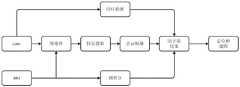
本实施例将结合相应的附图对本发明的基于多信息源的机器人即时定位与地图构建方法进行更详细的描述,如图1所示,该方法主要分为三个线程,一是激光里程计,其中主要包含传感器信息的预处理、点云特征提取、点云配准等内容;二是IMU(惯性传感器)信息的处理,一方面参与激光点云运动畸变的去除,另一方面经过预积分处理形成预积分因子,成为点云的帧间约束;三是采用Scan-Context描述符的方式做回环检测,形成回环检测因子,最后将激光里程计因子、回环检测因子和预积分因子用GTSAM库作因子图优化。其中,GTSAM是一个在机器人领域和计算机视觉领域用于平滑和建图的C++库。In this embodiment, the method for real-time positioning and map construction of a robot based on multiple information sources of the present invention will be described in more detail in conjunction with the corresponding drawings. As shown in FIG. 1 , the method is mainly divided into three threads. One is the laser odometer. , which mainly includes the preprocessing of sensor information, point cloud feature extraction, point cloud registration, etc.; the second is the processing of IMU (inertial sensor) information, on the one hand, it participates in the removal of laser point cloud motion distortion, and on the other hand, it undergoes pre-integration The processing forms the pre-integration factor, which becomes the inter-frame constraint of the point cloud; the third is to use the Scan-Context descriptor for loopback detection to form the loopback detection factor, and finally use the GTSAM library for the laser odometer factor, loopback detection factor and pre-integration factor. Make factor graph optimization. Among them, GTSAM is a C++ library for smoothing and mapping in robotics and computer vision.
具体地,本实施例的方法包括以下步骤:Specifically, the method of this embodiment includes the following steps:
步骤1:利用VPL-16线激光雷达采集激光点云数据并对数据进行预处理;Step 1: Use VPL-16 line lidar to collect laser point cloud data and preprocess the data;
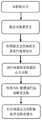
需要说明的是,由于激光雷达的扫描原理,得到的点云数据含有较多杂点,因此需要对点云数据进行预处理操作。而且不同于通常的预处理操作,本实施例的预处理操作主要包含两部分内容。一方面,由于本实施例使用了激光反射强度信息,因此需要对激光点反射强度信息进行矫正,另一方面,需要对激光点进行线束分割、运动补偿等操作。点云数据的预处理步骤如图2所示,包括:It should be noted that, due to the scanning principle of lidar, the obtained point cloud data contains many noise points, so the point cloud data needs to be preprocessed. Moreover, different from the usual preprocessing operations, the preprocessing operations in this embodiment mainly include two parts. On the one hand, since the laser reflection intensity information is used in this embodiment, it is necessary to correct the reflection intensity information of the laser spot; The preprocessing steps of point cloud data are shown in Figure 2, including:
由于激光反射强度受到距离,角度和物体表面材质的影响,因此为了消除这些因素的干扰,本实施例根据反射强度的生成原理,建立数学模型,进行激光点反射强度的矫正和归一化处理,以更好的利用反射强度信息,模型如下:Since the laser reflection intensity is affected by the distance, angle and surface material of the object, in order to eliminate the interference of these factors, this embodiment establishes a mathematical model according to the generation principle of the reflection intensity, and performs the correction and normalization of the reflection intensity of the laser point. In order to better utilize the reflection intensity information, the model is as follows:

其中,ρ是反射率,即相当于反射强度消除外在因素干扰后的信息,I是测得的反射强度信息,R是激光点距离激光雷达的距离,可以直接测得,α是入射角度,可通过测量得到,经过推导,我们可以知道反射∝(正相关于)反射强度。Among them, ρ is the reflectivity, that is, the information equivalent to the reflection intensity after eliminating the interference of external factors, I is the measured reflection intensity information, R is the distance between the laser point and the lidar, which can be directly measured, α is the incident angle, It can be obtained by measurement, and after derivation, we can know the reflection ∝ (positive correlation) reflection intensity.
利用激光点间的角度关系进行线束分割,以确定每个激光点属于哪一个线束,利用相邻点与地平线的夹角关系进行地面点与非地面点的点云分割,利用IMU信息进行运动畸变去除,最后对非地面点投影聚类并去除边缘点,在投影聚类的过程中,会对每个聚类分配唯一一个聚类标签,在之后的点云配准中,将利用其和反射强度作为联合的约束条件,对点进行预判断。Use the angle relationship between the laser points to segment the line beam to determine which line beam each laser point belongs to, use the angle relationship between the adjacent points and the horizon to segment the point cloud between the ground point and the non-ground point, and use the IMU information to perform motion distortion Remove, and finally project the clustering of the non-ground points and remove the edge points. In the process of projecting the clustering, each cluster will be assigned a unique clustering label. In the subsequent point cloud registration, it will be used and the reflection will be used. The strength is used as a joint constraint to pre-judgment points.
其中,需要说明的是,在上述步骤1的预处理过程中,本实施例仅利用IMU的数据完成了畸变去除的任务,实现了运动补偿的功能。其实现原理为:由于IMU和激光雷达的工作频率不同,前者在75HZ左右,而后者在10HZ左右,假设在一段时间内机器人是匀速运动,利用IMU直接测得角速度和线加速度,再将测得的值进行积分,然后将速度补偿给激光点,从而实现运动畸变的去除。It should be noted that, in the preprocessing process of the above step 1, this embodiment only uses the data of the IMU to complete the task of removing distortion, and realizes the function of motion compensation. The implementation principle is: due to the different operating frequencies of the IMU and the lidar, the former is around 75HZ, while the latter is around 10HZ. Assuming that the robot is moving at a uniform speed for a period of time, the angular velocity and linear acceleration are directly measured by the IMU, and then the measured The value of , is integrated, and then the speed is compensated to the laser point, so as to realize the removal of motion distortion.
步骤2:对每一帧的点云进行特征提取。Step 2: Perform feature extraction on the point cloud of each frame.
需要说明的是,激光点云经过预处理后,得到的点云信息杂点较少,就可以对每一帧的点云进行特征提取,其中,本实施例的特征仍然以平面点和边缘点为主,不同的是传统算法只是单纯采用几何特征去提取这些特征点,而本实施例则加入反射强度信息,去构建平滑度c的计算公式,设置阈值。It should be noted that, after the laser point cloud is preprocessed, the point cloud information obtained is less cluttered, and feature extraction can be performed on the point cloud of each frame. The features of this embodiment are still based on plane points and edge points. Mainly, the difference is that the traditional algorithm simply uses geometric features to extract these feature points, while this embodiment adds reflection intensity information to construct a calculation formula for smoothness c and set a threshold.

其中,

为了更好的区分特征,避免特征的聚集,将一帧点云均匀的分为8个部分,每个部分的扫描范围是45度,并且在提取特征时,在每一部分分别提取2个特征点和4个平面点,从而构成每一帧边缘点集合εk和平面点集合Hk。In order to better distinguish features and avoid feature aggregation, a frame of point cloud is evenly divided into 8 parts, the scanning range of each part is 45 degrees, and when extracting features, two feature points are extracted in each part. and 4 plane points, thus forming the edge point set εk and the plane point set Hk of each frame.
其中,在提取特征点的时候难免会有一些干扰,这些干扰主要来自遮挡点及相邻点都是特征点的问题,为了使特征点具有分散性,本实施例做以下处理:Among them, there will inevitably be some interference when extracting feature points. These interferences mainly come from the problem that occlusion points and adjacent points are both feature points. In order to make the feature points have dispersion, this embodiment does the following processing:
(1)由于飞行时间型(Time of Flight,TOF)机械激光雷达的工作特点,当飞行时间小于阈值时,返回的激光点会带有误差,因此需要去除深度值小的点;(2)由于激光雷达视场边缘的点存在变形,会产生大曲率现象,影响特征提取的质量,因此去掉视场边缘的点即深度值大的点;(3)去除激光束和平面夹角过小的点,即激光束和平面束接近平行的情况;(4)由于遮挡问题,如果选取遮挡点,不利于点云的配准,因此要去除前后几帧发现遮挡的点。(1) Due to the working characteristics of the Time of Flight (TOF) mechanical lidar, when the flight time is less than the threshold, the returned laser point will have errors, so it is necessary to remove the point with a small depth value; (2) Since The points at the edge of the lidar field of view are deformed, which will cause large curvature and affect the quality of feature extraction. Therefore, remove the points at the edge of the field of view, that is, the points with large depth values; (3) Remove the points where the angle between the laser beam and the plane is too small. , that is, the case where the laser beam and the plane beam are nearly parallel; (4) Due to the occlusion problem, if the occlusion point is selected, it is not conducive to the registration of the point cloud, so the occluded points found in the previous and subsequent frames should be removed.
步骤3:利用特征点进行点云的配准。Step 3: Use the feature points to register the point cloud.
需要说明的是,如图3所示,在提取特征点后,可利用特征点进行点云配准,这样可有效减少计算量,提高系统的运算效率,本实施例采用的点云配准方法主要是PL-ICP的方式。为了进一步提升计算效率,增加一个新的约束条件:It should be noted that, as shown in Figure 3, after the feature points are extracted, the feature points can be used to perform point cloud registration, which can effectively reduce the amount of calculation and improve the computing efficiency of the system. The point cloud registration method adopted in this embodiment Mainly the way of PL-ICP. To further improve computational efficiency, a new constraint is added:
Lj=Ll|||ρj-ρl|<ρILj =Ll |||ρj -ρl |<ρI
其中,Ll和Lj分别代表两个激光点的标签,ρj和ρl分别代表两个点的反射率,ρI是设定的反射率的阈值。Among them, Ll and Lj respectively represent the labels of the two laser points, ρj and ρl respectively represent the reflectivity of the two points, and ρI is the set reflectivity threshold.
通过上述约束条件的提前判断,可以更加快速的找到对应点。Through the advance judgment of the above constraints, the corresponding points can be found more quickly.
此外,由于进行了聚类分割的处理,可以分别得到分割后的点云和地面点,引入分层的思想对其进行分别的处理,对于分割的点云,提取边缘点和平面点,例如对于边缘点,在i+1时刻,对于当前第k扫描线上的一个边缘点


分割的点云:Segmented point cloud:


地面点云:Ground point cloud:

其中,de是指边缘点的误差函数,dp是指非地面点的平面点的误差函数,ddp是指非地面点的平面点的误差函数。


当给定一个点y,y∈Pk,t是它的时间戳。


在这里,m,i是指某一时刻。值得注意的是,


fε是指关于边缘点的函数,fH是指关于平面点的函数,

步骤4:对IMU信息进行处理。Step 4: Process the IMU information.
需要说明的是,为了弥补纯旋转及快速变化的不足,本实施例引入IMU信息。IMU主要可以测量得到角速度和加速度信息。具体形式如下公式所示:It should be noted that, in order to make up for the deficiency of pure rotation and rapid change, this embodiment introduces IMU information. The IMU can mainly measure the angular velocity and acceleration information. The specific form is shown in the following formula:


其中,


其中v,p,R分别代表了机器人的速度位置和旋转的信息,vt+Δt是指在时刻t到Δt变换时间内的速度变化,其他同理,Among them, v, p, and R represent the speed, position and rotation information of the robot, respectively. vt+Δt refers to the speed change in the transformation time from time t to Δt. The same is true for others.
步骤5:进行回环检测,形成回环检测因子。Step 5: Perform loopback detection to form a loopback detection factor.
需要说明的是,由于累计误差的存在,我们往往想得到全局一致地图,尤其是当经过相同地点,增加了约束信息,当检测出来,可以进一步优化得到的位姿和地图,这就是回环检测,为了防止直接利用scan-to-scan等暴力几何方式直接搜索,采用一种SCANContext描述符的方式进行回环检测。基本流程如图5所示,包括切割点云,生成scancontext、初步查找(采用向量最近邻搜索法)、精确查找(采用scan相似度评分法)、计算相对位姿等步骤。It should be noted that due to the existence of accumulated errors, we often want to obtain a globally consistent map, especially when passing through the same location, adding constraint information. When detected, the obtained pose and map can be further optimized. This is loopback detection. In order to Prevent direct search by violent geometric methods such as scan-to-scan, and use a SCANContext descriptor for loop closure detection. The basic process is shown in Figure 5, including cutting point cloud, generating scancontext, preliminary search (using vector nearest neighbor search method), precise search (using scan similarity scoring method), calculating relative pose and other steps.
沿半径增大方向,把点云空间等分成Nr个圆环。每个圆环宽度dr为In the direction of increasing radius, the point cloud space is equally divided into Nr rings. The width dr of each ring is

Lmax是激光的最远距离,Nr是指分割的圆环数;把分割后的点云对应到Nr×Ns(每个圆环分割的格子数)的矩阵II(scan context)中:a)矩阵的每一行代表一个圆环;b)矩阵的每一列代表一个扇形;c)矩阵中每个元素的值,该分割单元Pn中所有三维点的高度最大值。为了进行scan context间的匹配,两帧scan context的距离函数d(Iq,Ic)(其中Iq是指第q个scan contex的值,Ic同理)定义:Lmax is the farthest distance of the laser, and Nr refers to the number of divided rings; the divided point cloud is corresponding to the matrix II (scan context) of Nr ×Ns (the number of grids divided by each ring). : a) each row of the matrix represents a ring; b) each column of the matrix represents a sector; c) the value of each element in the matrix, the maximum height of all three-dimensional points in the division unit Pn . In order to match between scan contexts, the distance function d(Iq , Ic ) of the two frames of scan contexts (where Iq refers to the value of the qth scan context, and Ic is the same) is defined:

其中
假设距离最小时,对应的列的平移量n*(

则它代表两帧之间有旋转,旋转的角度φ:Then it represents a rotation between two frames, the angle of rotation φ:

以上旋转量则可作为ICP或NDT匹配的初始位姿,用于精确匹配得到闭环约束的相对位姿。The above rotation amount can be used as the initial pose for ICP or NDT matching, which can be used for accurate matching to obtain the relative pose of the closed-loop constraint.
scan context可以用矩阵对应列的相似度来计算两帧的相似性,但是遍历所有历史帧的相似度计算量较高,需要做一个快速初步筛选。相似帧之间,落在同等半径的圆环中点的数量应相似,可用来快速查找。这样可保证检测精度和效率,最后将回环检测得到得信息作为回环因子,放进因子图中,做联合优化。The scan context can use the similarity of the corresponding columns of the matrix to calculate the similarity of two frames, but the similarity calculation of traversing all historical frames is high, and a quick preliminary screening is required. Between similar frames, the number of points that fall in the middle of circles of the same radius should be similar, which can be used for quick search. In this way, the detection accuracy and efficiency can be guaranteed. Finally, the information obtained from the loop closure detection is used as the loop closure factor, and is put into the factor graph for joint optimization.
步骤6:将构建好的预积分因子与激光里程计因子、回环检测因子一起加入因子图中进行联合优化,得到最终的全局位姿和地图。Step 6: Add the constructed pre-integration factor, the laser odometry factor, and the loopback detection factor into the factor graph for joint optimization to obtain the final global pose and map.
需要说明的是,在多传感器融合的方案中,有基于滤波器法和基于图优化法,目前主流的方式是以批量处理的图优化方式,该算法不仅考虑相邻帧间的信息,而且对全局信息进行关联,可有效降低累计误差。关于本方法的因子图优化模型如图6所示。因子图是概率图的一种,能够在最大后验概率推断问题中表示为归一化后验概率的能力,因而成为概率机器人领域理想的图模型。主要内容就是构建因子图和对信息矩阵得增量优化,在因子图构建的过程中,主要有因子节点和变量节点,在SLAM问题里,把位姿X构建为变量节点,回环检测因子,激光里程计因子和预积分因子构成相关变量节点间的因子节点,最后通过GTSAM库进行优化,得到全局一致的位姿轨迹,由于准确的位姿也会使观测信息更加精准,经过地图的拼接后,从而得到全局一致性地图。It should be noted that in the multi-sensor fusion scheme, there are filter-based methods and graph-based optimization methods. The current mainstream method is the batch processing graph optimization method. This algorithm not only considers the information between adjacent frames, but also has a The global information is correlated, which can effectively reduce the cumulative error. The factor graph optimization model for this method is shown in Figure 6. Factor graph is a kind of probability graph, which can be expressed as the ability to normalize the posterior probability in the maximum posterior probability inference problem, so it becomes an ideal graphical model in the field of probabilistic robotics. The main content is to build a factor graph and incrementally optimize the information matrix. In the process of building the factor graph, there are mainly factor nodes and variable nodes. In the SLAM problem, the pose X is constructed as a variable node, a loopback detection factor, and a laser. The odometer factor and the pre-integration factor constitute the factor nodes between the relevant variable nodes. Finally, the GTSAM library is used for optimization to obtain a globally consistent pose trajectory. Since the accurate pose will also make the observation information more accurate, after the map is spliced, the Thereby a global consistency map is obtained.
综上,本发明将激光雷达和IMU信息用因子图的方式融合在一起进行联合优化,除了使用几何信息外,还引入了反射强度信息,避免了单一几何信息的不足,通过增加新的约束,提高了点云匹配的效率和精度,相比于单传感器和单一信息源的系统,本发明具有更高的鲁棒性。同时融合目前先进的scan context描述符进行回环检测,从而提升了定位和建图精度,提高了系统整体的鲁棒性。To sum up, the present invention fuses lidar and IMU information together in the form of factor graph for joint optimization. In addition to using geometric information, it also introduces reflection intensity information to avoid the insufficiency of single geometric information. By adding new constraints, The efficiency and accuracy of point cloud matching are improved, and the present invention has higher robustness than a system with a single sensor and a single information source. At the same time, it integrates the current advanced scan context descriptors for loop closure detection, thereby improving the accuracy of positioning and mapping, and improving the overall robustness of the system.
第三实施例Third Embodiment
本实施例提供了一种基于多信息源的机器人即时定位与地图构建系统,该基于多信息源的机器人即时定位与地图构建系统包括以下模块:This embodiment provides a real-time positioning and map construction system for robots based on multiple information sources, and the real-time positioning and map construction system for robots based on multiple information sources includes the following modules:
激光点云数据获取与预处理模块,用于获取激光点云数据,并对获取的激光点云数据进行预处理,以去除激光点云数据中的杂点,并且获得激光点反射强度信息和激光点云数据的聚类标签;Laser point cloud data acquisition and preprocessing module, used to acquire laser point cloud data, and preprocess the acquired laser point cloud data to remove noise in the laser point cloud data, and obtain laser point reflection intensity information and laser Cluster labels for point cloud data;
特征提取模块,用于基于激光点云数据的几何特征和激光点反射强度信息,对经过所述激光点云数据获取与预处理模块预处理后的激光点云数据中的每一帧的点云进行特征点提取,以获取每一帧点云的特征点;The feature extraction module is used for the point cloud of each frame in the laser point cloud data preprocessed by the laser point cloud data acquisition and preprocessing module based on the geometric features of the laser point cloud data and the laser point reflection intensity information Perform feature point extraction to obtain the feature points of each frame of point cloud;
点云配准模块,用于利用所述特征提取模块提取到的特征点进行点云配准;其中,在点云配准过程中,所述点云配准模块利用所述聚类标签和所述激光点反射强度信息作为联合的约束条件;The point cloud registration module is used for using the feature points extracted by the feature extraction module to perform point cloud registration; wherein, in the point cloud registration process, the point cloud registration module uses the cluster label and the The laser point reflection intensity information is used as a joint constraint;
全局位姿与地图构建模块,用于基于所述点云配准模块输出的点云配准结果,结合IMU数据和回环检测信息,得到全局位姿和地图。The global pose and map construction module is used to obtain the global pose and map based on the point cloud registration result output by the point cloud registration module, combined with IMU data and loop closure detection information.
本实施例的基于多信息源的机器人即时定位与地图构建系统与上述实施例的机器人即时定位与地图构建方法相对应;其中,本实施例的基于多信息源的机器人即时定位与地图构建系统中的各功能模块所实现的功能与上述实施例的机器人即时定位与地图构建方法中的各流程步骤一一对应;故,在此不再赘述。The real-time robot positioning and map construction system based on multiple information sources in this embodiment corresponds to the method for real-time robot positioning and map construction in the above-mentioned embodiment; The functions implemented by the functional modules in the above-mentioned embodiment correspond to the process steps in the real-time positioning and map construction method of the robot in the above-mentioned embodiment; therefore, the details are not repeated here.
第四实施例Fourth Embodiment
本实施例提供一种电子设备,其包括处理器和存储器;其中,存储器中存储有至少一条指令,所述指令由处理器加载并执行,以实现上述实施例的方法。This embodiment provides an electronic device, which includes a processor and a memory; wherein, at least one instruction is stored in the memory, and the instruction is loaded and executed by the processor to implement the methods of the foregoing embodiments.
该电子设备可因配置或性能不同而产生比较大的差异,可以包括一个或一个以上处理器(central processing units,CPU)和一个或一个以上的存储器,其中,存储器中存储有至少一条指令,所述指令由处理器加载并执行上述方法。The electronic device may vary greatly due to different configurations or performances, and may include one or more processors (central processing units, CPU) and one or more memories, wherein the memory stores at least one instruction, so The instructions are loaded by the processor and execute the above method.
第五实施例Fifth Embodiment
本实施例提供一种计算机可读存储介质,该存储介质中存储有至少一条指令,所述指令由处理器加载并执行,以实现上述实施例的方法。其中,该计算机可读存储介质可以是ROM、随机存取存储器、CD-ROM、磁带、软盘和光数据存储设备等。其内存储的指令可由终端中的处理器加载并执行上述方法。This embodiment provides a computer-readable storage medium, where at least one instruction is stored in the storage medium, and the instruction is loaded and executed by a processor to implement the method of the foregoing embodiment. Wherein, the computer-readable storage medium may be ROM, random access memory, CD-ROM, magnetic tape, floppy disk, optical data storage device, and the like. The instructions stored therein can be loaded by the processor in the terminal and execute the above method.
此外,需要说明的是,本发明可提供为方法、装置或计算机程序产品。因此,本发明实施例可采用完全硬件实施例、完全软件实施例或结合软件和硬件方面的实施例的形式。而且,本发明实施例可采用在一个或多个其中包含有计算机可用程序代码的计算机可用存储介质上实施的计算机程序产品的形式。Furthermore, it should be noted that the present invention may be provided as a method, an apparatus or a computer program product. Accordingly, embodiments of the present invention may take the form of an entirely hardware embodiment, an entirely software embodiment or an embodiment combining software and hardware aspects. Furthermore, embodiments of the present invention may take the form of a computer program product embodied on one or more computer-usable storage media having computer-usable program code embodied therein.
本发明实施例是参照根据本发明实施例的方法、终端设备(系统)、和计算机程序产品的流程图和/或方框图来描述的。应理解可由计算机程序指令实现流程图和/或方框图中的每一流程和/或方框、以及流程图和/或方框图中的流程和/或方框的结合。可提供这些计算机程序指令到通用计算机、嵌入式处理机或其他可编程数据处理终端设备的处理器以产生一个机器,使得通过计算机或其他可编程数据处理终端设备的处理器执行的指令产生用于实现在流程图一个流程或多个流程和/或方框图一个方框或多个方框中指定的功能的装置。Embodiments of the present invention are described with reference to flowcharts and/or block diagrams of methods, terminal devices (systems), and computer program products according to embodiments of the present invention. It will be understood that each flow and/or block in the flowchart illustrations and/or block diagrams, and combinations of flows and/or blocks in the flowchart illustrations and/or block diagrams, can be implemented by computer program instructions. These computer program instructions may be provided to the processor of a general purpose computer, embedded processor or other programmable data processing terminal to produce a machine such that the instructions executed by the processor of the computer or other programmable data processing terminal produce Means implementing the functions specified in one or more of the flowcharts and/or one or more blocks of the block diagrams.
这些计算机程序指令也可存储在能引导计算机或其他可编程数据处理终端设备以特定方式工作的计算机可读存储器中,使得存储在该计算机可读存储器中的指令产生包括指令装置的制造品,该指令装置实现在流程图一个流程或多个流程和/或方框图一个方框或多个方框中指定的功能。这些计算机程序指令也可装载到计算机或其他可编程数据处理终端设备上,使得在计算机或其他可编程终端设备上执行一系列操作步骤以产生计算机实现的处理,从而在计算机或其他可编程终端设备上执行的指令提供用于实现在流程图一个流程或多个流程和/或方框图一个方框或多个方框中指定的功能的步骤。These computer program instructions may also be stored in a computer readable memory capable of directing a computer or other programmable data processing terminal equipment to operate in a particular manner, such that the instructions stored in the computer readable memory result in an article of manufacture comprising instruction means, the The instruction means implement the functions specified in the flow or flow of the flowcharts and/or the block or blocks of the block diagrams. These computer program instructions can also be loaded on a computer or other programmable data processing terminal equipment, so that a series of operational steps are performed on the computer or other programmable terminal equipment to produce a computer-implemented process, thereby executing on the computer or other programmable terminal equipment The instructions executed on the above provide steps for implementing the functions specified in the flowchart or blocks and/or the block or blocks of the block diagrams.
还需要说明的是,在本文中,术语“包括”、“包含”或者其任何其他变体意在涵盖非排他性的包含,从而使得包括一系列要素的过程、方法、物品或者终端设备不仅包括那些要素,而且还包括没有明确列出的其他要素,或者是还包括为这种过程、方法、物品或者终端设备所固有的要素。在没有更多限制的情况下,由语句“包括一个……”限定的要素,并不排除在包括所述要素的过程、方法、物品或者终端设备中还存在另外的相同要素。It should also be noted that, herein, the terms "comprising", "comprising" or any other variation thereof are intended to encompass non-exclusive inclusion, such that a process, method, article or terminal device comprising a series of elements includes not only those elements, but also other elements not expressly listed or inherent to such process, method, article or terminal equipment. Without further limitation, an element defined by the phrase "comprises a..." does not preclude the presence of additional identical elements in the process, method, article or terminal device comprising said element.
最后需要说明的是,以上所述是本发明优选实施方式,应当指出,尽管已描述了本发明优选实施例,但对于本技术领域的技术人员来说,一旦得知了本发明的基本创造性概念,在不脱离本发明所述原理的前提下,还可以做出若干改进和润饰,这些改进和润饰也应视为本发明的保护范围。所以,所附权利要求意欲解释为包括优选实施例以及落入本发明实施例范围的所有变更和修改。Finally, it should be noted that the above are the preferred embodiments of the present invention. It should be pointed out that although the preferred embodiments of the present invention have been described, for those skilled in the art, once the basic inventive concept of the present invention is known , without departing from the principles of the present invention, several improvements and modifications can also be made, and these improvements and modifications should also be regarded as the protection scope of the present invention. Therefore, the appended claims are intended to be construed to include the preferred embodiments as well as all changes and modifications that fall within the scope of the embodiments of the present invention.
Claims (10)


Priority Applications (1)
| Application Number | Priority Date | Filing Date | Title |
|---|---|---|---|
| CN202110644501.3ACN113432600B (en) | 2021-06-09 | 2021-06-09 | Robot instant positioning and map construction method and system based on multiple information sources |
Applications Claiming Priority (1)
| Application Number | Priority Date | Filing Date | Title |
|---|---|---|---|
| CN202110644501.3ACN113432600B (en) | 2021-06-09 | 2021-06-09 | Robot instant positioning and map construction method and system based on multiple information sources |
Publications (2)
| Publication Number | Publication Date |
|---|---|
| CN113432600A CN113432600A (en) | 2021-09-24 |
| CN113432600Btrue CN113432600B (en) | 2022-08-16 |
Family
ID=77755515
Family Applications (1)
| Application Number | Title | Priority Date | Filing Date |
|---|---|---|---|
| CN202110644501.3AActiveCN113432600B (en) | 2021-06-09 | 2021-06-09 | Robot instant positioning and map construction method and system based on multiple information sources |
Country Status (1)
| Country | Link |
|---|---|
| CN (1) | CN113432600B (en) |
Families Citing this family (37)
| Publication number | Priority date | Publication date | Assignee | Title |
|---|---|---|---|---|
| CN113917483A (en)* | 2021-10-13 | 2022-01-11 | 国网山西省电力公司输电检修分公司 | A method, system and electronic device for constructing a robot drilling space model |
| CN114046790B (en)* | 2021-10-22 | 2025-02-11 | 南京航空航天大学 | A method for detecting double loops in factor graphs |
| CN113933861B (en)* | 2021-11-12 | 2022-06-07 | 成都航维智芯科技有限公司 | Airborne laser radar point cloud generation method and system |
| CN114063092B (en)* | 2021-11-17 | 2025-07-01 | 中国人民解放军陆军工程大学 | Unmanned vehicle positioning system, method, device and electronic equipment |
| CN114964204B (en)* | 2021-11-19 | 2025-07-11 | 丰疆智能(深圳)有限公司 | Map construction method, map use method, device, equipment and storage medium |
| CN116167908B (en)* | 2021-11-25 | 2025-07-08 | 北京机械设备研究所 | Two-dimensional grid map construction method and system based on three-dimensional laser SLAM point cloud map |
| CN114280626B (en)* | 2021-12-17 | 2025-08-01 | 成都朴为科技有限公司 | Laser radar SLAM method and system based on local structure information expansion |
| CN113970330B (en)* | 2021-12-22 | 2022-04-19 | 比亚迪股份有限公司 | Vehicle multi-sensor fusion positioning method, computer equipment and storage medium |
| CN114577198B (en)* | 2022-01-18 | 2024-02-02 | 辽宁华盾安全技术有限责任公司 | High-reflection object positioning method and device and terminal equipment |
| CN114371716B (en)* | 2022-01-20 | 2024-08-02 | 红骐科技(杭州)有限公司 | Automatic driving inspection method for fire-fighting robot |
| CN114608554B (en)* | 2022-02-22 | 2024-05-03 | 北京理工大学 | Handheld SLAM equipment and robot instant positioning and mapping method |
| CN114923494B (en)* | 2022-05-13 | 2024-11-29 | 东南大学 | High-precision synchronous positioning and mapping method for air-ground cooperation |
| CN115014371A (en)* | 2022-05-27 | 2022-09-06 | 河南工业大学 | A positioning and mapping method, device and storage medium for a grain transfer vehicle in a smart grain depot |
| CN115061143A (en)* | 2022-06-22 | 2022-09-16 | 上海西井信息科技有限公司 | Lidar-based positioning method, system, equipment and storage medium |
| CN115115658B (en)* | 2022-06-30 | 2024-07-23 | 武汉擎朗智能科技有限公司 | Map segmentation method, robot and computer readable storage medium |
| CN115183778B (en)* | 2022-07-01 | 2024-12-03 | 北京斯年智驾科技有限公司 | Picture construction method, device, equipment and medium based on wharf stone pier |
| CN115267723A (en)* | 2022-07-01 | 2022-11-01 | 广州小马智行科技有限公司 | Point cloud data processing method and device, computer equipment and storage medium |
| CN115014332B (en)* | 2022-07-01 | 2025-06-27 | 智道网联科技(北京)有限公司 | Laser SLAM mapping method, device, electronic device, and computer-readable storage medium |
| CN115131514A (en)* | 2022-07-12 | 2022-09-30 | 烟台艾睿光电科技有限公司 | A method, device, system and storage medium for simultaneous positioning and mapping |
| CN115248439B (en)* | 2022-07-26 | 2025-05-09 | 中山大学 | Laser radar SLAM method and system based on geometric information and intensity information |
| CN115409986A (en)* | 2022-08-29 | 2022-11-29 | 广州高新兴机器人有限公司 | Laser SLAM loop detection method and device based on point cloud semantics and robot |
| CN116229119A (en)* | 2022-08-30 | 2023-06-06 | 智瞰深鉴(北京)科技有限公司 | A substation inspection robot and its repositioning method |
| CN115639570A (en)* | 2022-10-24 | 2023-01-24 | 中国科学技术大学 | Robot positioning and mapping method integrating laser intensity and point cloud geometric features |
| CN115561776B (en)* | 2022-10-26 | 2025-05-23 | 中山大学 | High-precision laser point cloud map manufacturing method and system |
| CN115855082B (en)* | 2022-12-07 | 2023-10-20 | 北京理工大学 | Dual-mode rapid repositioning method based on point cloud priori map |
| CN116399344B (en)* | 2023-03-13 | 2025-07-01 | 华中科技大学 | Robot path planning method, system and storage medium based on slime mold algorithm |
| CN116449391B (en)* | 2023-04-17 | 2024-05-17 | 深圳直角设计工程有限公司 | Indoor panoramic imaging method and system based on 3D point cloud |
| CN116380935A (en)* | 2023-06-02 | 2023-07-04 | 中南大学 | High-speed railway box girder damage detection robot car and damage detection method |
| CN116449392B (en)* | 2023-06-14 | 2023-09-19 | 北京集度科技有限公司 | Map construction method, device, computer equipment and storage medium |
| CN117095061B (en)* | 2023-10-20 | 2024-02-09 | 山东大学 | Robot pose optimization method and system based on point cloud strength salient points |
| CN118089704B (en)* | 2024-04-25 | 2024-07-19 | 广汽埃安新能源汽车股份有限公司 | SLAM method and device based on self-adaptive feature extraction |
| CN118351177B (en)* | 2024-06-18 | 2024-10-01 | 深圳大学 | A posture optimization method and system integrating edge features of reflectivity projection images |
| CN118570335A (en)* | 2024-07-31 | 2024-08-30 | 南通沃太新能源有限公司 | Picture construction method and device for inspection vehicle of photovoltaic power plant, storage medium and terminal |
| CN118883102B (en)* | 2024-09-30 | 2025-02-07 | 山东港口烟台港集团有限公司 | Single-line laser radar tire detection method based on characteristic evaluation function |
| CN118962646A (en)* | 2024-10-17 | 2024-11-15 | 北京理工大学前沿技术研究院 | A loop detection method and system based on strength and position information |
| CN119152140B (en)* | 2024-11-12 | 2025-04-01 | 山东大学 | 3D laser SLAM method, system, medium and equipment based on full constraints |
| CN119354205B (en)* | 2024-12-25 | 2025-05-02 | 哈尔滨工业大学(威海) | Unmanned fire-extinguishing robot navigation method and device based on 4D millimeter wave radar |
Citations (11)
| Publication number | Priority date | Publication date | Assignee | Title |
|---|---|---|---|---|
| CN104298971A (en)* | 2014-09-28 | 2015-01-21 | 北京理工大学 | Method for identifying objects in 3D point cloud data |
| CN107918753A (en)* | 2016-10-10 | 2018-04-17 | 腾讯科技(深圳)有限公司 | Processing Method of Point-clouds and device |
| CN108332759A (en)* | 2018-01-12 | 2018-07-27 | 浙江国自机器人技术有限公司 | A kind of map constructing method and system based on 3D laser |
| CN108537844A (en)* | 2018-03-16 | 2018-09-14 | 上海交通大学 | A kind of vision SLAM winding detection methods of fusion geological information |
| CN110163900A (en)* | 2019-05-31 | 2019-08-23 | 北京百度网讯科技有限公司 | For adjusting point cloud data method and apparatus |
| CN110796714A (en)* | 2019-08-22 | 2020-02-14 | 腾讯科技(深圳)有限公司 | Map construction method, device, terminal and computer readable storage medium |
| CN111337947A (en)* | 2020-05-18 | 2020-06-26 | 深圳市智绘科技有限公司 | Instant mapping and positioning method, device, system and storage medium |
| CN111664842A (en)* | 2020-05-07 | 2020-09-15 | 苏州品坤智能科技有限公司 | Instant positioning and map building system of unmanned sweeper |
| CN111983639A (en)* | 2020-08-25 | 2020-11-24 | 浙江光珀智能科技有限公司 | Multi-sensor SLAM method based on Multi-Camera/Lidar/IMU |
| CN112258618A (en)* | 2020-11-04 | 2021-01-22 | 中国科学院空天信息创新研究院 | Semantic mapping and localization method based on fusion of prior laser point cloud and depth map |
| CN112304307A (en)* | 2020-09-15 | 2021-02-02 | 浙江大华技术股份有限公司 | Positioning method and device based on multi-sensor fusion and storage medium |
Family Cites Families (2)
| Publication number | Priority date | Publication date | Assignee | Title |
|---|---|---|---|---|
| CN109410735B (en)* | 2017-08-15 | 2021-06-29 | 百度在线网络技术(北京)有限公司 | Reflection value map construction method and device |
| CN109064506B (en)* | 2018-07-04 | 2020-03-13 | 百度在线网络技术(北京)有限公司 | High-precision map generation method and device and storage medium |
- 2021
- 2021-06-09CNCN202110644501.3Apatent/CN113432600B/enactiveActive
Patent Citations (11)
| Publication number | Priority date | Publication date | Assignee | Title |
|---|---|---|---|---|
| CN104298971A (en)* | 2014-09-28 | 2015-01-21 | 北京理工大学 | Method for identifying objects in 3D point cloud data |
| CN107918753A (en)* | 2016-10-10 | 2018-04-17 | 腾讯科技(深圳)有限公司 | Processing Method of Point-clouds and device |
| CN108332759A (en)* | 2018-01-12 | 2018-07-27 | 浙江国自机器人技术有限公司 | A kind of map constructing method and system based on 3D laser |
| CN108537844A (en)* | 2018-03-16 | 2018-09-14 | 上海交通大学 | A kind of vision SLAM winding detection methods of fusion geological information |
| CN110163900A (en)* | 2019-05-31 | 2019-08-23 | 北京百度网讯科技有限公司 | For adjusting point cloud data method and apparatus |
| CN110796714A (en)* | 2019-08-22 | 2020-02-14 | 腾讯科技(深圳)有限公司 | Map construction method, device, terminal and computer readable storage medium |
| CN111664842A (en)* | 2020-05-07 | 2020-09-15 | 苏州品坤智能科技有限公司 | Instant positioning and map building system of unmanned sweeper |
| CN111337947A (en)* | 2020-05-18 | 2020-06-26 | 深圳市智绘科技有限公司 | Instant mapping and positioning method, device, system and storage medium |
| CN111983639A (en)* | 2020-08-25 | 2020-11-24 | 浙江光珀智能科技有限公司 | Multi-sensor SLAM method based on Multi-Camera/Lidar/IMU |
| CN112304307A (en)* | 2020-09-15 | 2021-02-02 | 浙江大华技术股份有限公司 | Positioning method and device based on multi-sensor fusion and storage medium |
| CN112258618A (en)* | 2020-11-04 | 2021-01-22 | 中国科学院空天信息创新研究院 | Semantic mapping and localization method based on fusion of prior laser point cloud and depth map |
Non-Patent Citations (1)
| Title |
|---|
| 移动机器人三维激光SLAM算法研究;欧阳仕晗等;《微处理机》;20201015(第05期);全文* |
Also Published As
| Publication number | Publication date |
|---|---|
| CN113432600A (en) | 2021-09-24 |
Similar Documents
| Publication | Publication Date | Title |
|---|---|---|
| CN113432600B (en) | Robot instant positioning and map construction method and system based on multiple information sources | |
| Huang | Review on LiDAR-based SLAM techniques | |
| CN112634451B (en) | Outdoor large-scene three-dimensional mapping method integrating multiple sensors | |
| CN110009727B (en) | Automatic reconstruction method and system for indoor three-dimensional model with structural semantics | |
| CN108564616B (en) | Fast robust RGB-D indoor three-dimensional scene reconstruction method | |
| CN113168717A (en) | A point cloud matching method and device, navigation method and device, positioning method, and lidar | |
| CN107462897B (en) | Three-dimensional mapping method based on laser radar | |
| CN103268729A (en) | A method for creating cascaded maps for mobile robots based on hybrid features | |
| CN115953535A (en) | Three-dimensional reconstruction method, device, computing device and storage medium | |
| CN115639547A (en) | Multi-line laser radar and GNSS-INS combined calibration method, system and medium | |
| CN114648561A (en) | Point cloud matching method and system for rotary three-dimensional laser radar | |
| CN114563000A (en) | An indoor and outdoor SLAM method based on improved lidar odometer | |
| Guo et al. | Line-based 3d building abstraction and polygonal surface reconstruction from images | |
| CN105631939A (en) | Three-dimensional point cloud distortion correction method and system based on curvature filtering | |
| CN117036653A (en) | Point cloud segmentation method and system based on super voxel clustering | |
| CN115131514A (en) | A method, device, system and storage medium for simultaneous positioning and mapping | |
| CN115032648A (en) | Three-dimensional target identification and positioning method based on laser radar dense point cloud | |
| Adreani et al. | A photorealistic 3D city modeling framework for smart city digital twin | |
| Holzmann et al. | Plane-based surface regularization for urban 3d reconstruction | |
| CN117128970A (en) | Multi-sensor fusion automatic driving pose estimation method | |
| CN117197586A (en) | Tunnel guniting intelligent detection method and system based on neural network and point cloud processing | |
| Chen et al. | Densefusion: Large-scale online dense pointcloud and dsm mapping for uavs | |
| CN116429116A (en) | Robot positioning method and equipment | |
| CN115200601A (en) | Navigation method, device, wheeled robot and storage medium | |
| Alkhatib et al. | Camera pose estimation based on structure from motion |
Legal Events
| Date | Code | Title | Description |
|---|---|---|---|
| PB01 | Publication | ||
| PB01 | Publication | ||
| SE01 | Entry into force of request for substantive examination | ||
| SE01 | Entry into force of request for substantive examination | ||
| GR01 | Patent grant | ||
| GR01 | Patent grant |