CN113295173A - Map matching method for annular road section - Google Patents
Map matching method for annular road sectionDownload PDFInfo
- Publication number
- CN113295173A CN113295173ACN202110566207.5ACN202110566207ACN113295173ACN 113295173 ACN113295173 ACN 113295173ACN 202110566207 ACN202110566207 ACN 202110566207ACN 113295173 ACN113295173 ACN 113295173A
- Authority
- CN
- China
- Prior art keywords
- point
- candidate
- gps
- road segment
- road
- Prior art date
- Legal status (The legal status is an assumption and is not a legal conclusion. Google has not performed a legal analysis and makes no representation as to the accuracy of the status listed.)
- Granted
Links
- 238000000034methodMethods0.000titleclaimsabstractdescription45
- 238000004458analytical methodMethods0.000claimsabstractdescription57
- 238000005070samplingMethods0.000claimsdescription36
- 238000004364calculation methodMethods0.000claimsdescription11
- 238000012732spatial analysisMethods0.000claimsdescription9
- 238000001514detection methodMethods0.000claimsdescription4
- 238000010586diagramMethods0.000description11
- 230000007704transitionEffects0.000description7
- 238000002474experimental methodMethods0.000description6
- NAWXUBYGYWOOIX-SFHVURJKSA-N(2s)-2-[[4-[2-(2,4-diaminoquinazolin-6-yl)ethyl]benzoyl]amino]-4-methylidenepentanedioic acidChemical compoundC1=CC2=NC(N)=NC(N)=C2C=C1CCC1=CC=C(C(=O)N[C@@H](CC(=C)C(O)=O)C(O)=O)C=C1NAWXUBYGYWOOIX-SFHVURJKSA-N0.000description3
- 229920006068Minlon®Polymers0.000description2
- 230000008859changeEffects0.000description2
- 230000006872improvementEffects0.000description2
- 238000005265energy consumptionMethods0.000description1
- 230000008569processEffects0.000description1
- 238000012545processingMethods0.000description1
- 239000007787solidSubstances0.000description1
- 238000012360testing methodMethods0.000description1
- 230000000007visual effectEffects0.000description1
- 238000012800visualizationMethods0.000description1
Images


Classifications
- G—PHYSICS
- G01—MEASURING; TESTING
- G01C—MEASURING DISTANCES, LEVELS OR BEARINGS; SURVEYING; NAVIGATION; GYROSCOPIC INSTRUMENTS; PHOTOGRAMMETRY OR VIDEOGRAMMETRY
- G01C21/00—Navigation; Navigational instruments not provided for in groups G01C1/00 - G01C19/00
- G01C21/26—Navigation; Navigational instruments not provided for in groups G01C1/00 - G01C19/00 specially adapted for navigation in a road network
- G01C21/28—Navigation; Navigational instruments not provided for in groups G01C1/00 - G01C19/00 specially adapted for navigation in a road network with correlation of data from several navigational instruments
- G01C21/30—Map- or contour-matching
- G—PHYSICS
- G01—MEASURING; TESTING
- G01S—RADIO DIRECTION-FINDING; RADIO NAVIGATION; DETERMINING DISTANCE OR VELOCITY BY USE OF RADIO WAVES; LOCATING OR PRESENCE-DETECTING BY USE OF THE REFLECTION OR RERADIATION OF RADIO WAVES; ANALOGOUS ARRANGEMENTS USING OTHER WAVES
- G01S19/00—Satellite radio beacon positioning systems; Determining position, velocity or attitude using signals transmitted by such systems
- G01S19/38—Determining a navigation solution using signals transmitted by a satellite radio beacon positioning system
- G01S19/39—Determining a navigation solution using signals transmitted by a satellite radio beacon positioning system the satellite radio beacon positioning system transmitting time-stamped messages, e.g. GPS [Global Positioning System], GLONASS [Global Orbiting Navigation Satellite System] or GALILEO
- G01S19/42—Determining position
Landscapes
- Engineering & Computer Science (AREA)
- Radar, Positioning & Navigation (AREA)
- Remote Sensing (AREA)
- Physics & Mathematics (AREA)
- General Physics & Mathematics (AREA)
- Automation & Control Theory (AREA)
- Computer Networks & Wireless Communication (AREA)
- Navigation (AREA)
Abstract
Description
Translated fromChinese技术领域technical field
本发明属于地图匹配技术领域,更具体地,本发明涉及一种环形路段的地图匹配方法。The invention belongs to the technical field of map matching, and more particularly, the invention relates to a map matching method for circular road sections.
背景技术Background technique
GPS定位设备的普及产生大量的轨迹数据,成为智能交通系统、路线推荐及其相关应用的重要数据来源。精确的GPS轨迹数据能提高统计的可靠度,使得用户能获取到更高质量的服务。然而,由于设备能耗限制、信号干扰等因素导致部分GPS采样点与真实位置间有较大误差。The popularity of GPS positioning equipment generates a large amount of trajectory data, which has become an important data source for intelligent transportation systems, route recommendation and related applications. Accurate GPS trajectory data can improve statistical reliability and enable users to obtain higher quality services. However, due to factors such as equipment energy consumption limitations and signal interference, there is a large error between some GPS sampling points and the real location.
地图匹配是将轨迹中的每个GPS点映射到地图路段上的正确位置,是人们研究轨迹的重要处理步骤。现有的地图匹配面临环形路段、并行路段、交叉路段等复杂路网环境的挑战。由于结构复杂、路段密集或不同路段方向接近等原因,GPS点容易被匹配到错误路段。Map matching is to map each GPS point in the trajectory to the correct position on the map segment, and it is an important processing step for people to study the trajectory. Existing map matching faces the challenges of complex road network environments such as circular road segments, parallel road segments, and intersection road segments. Due to the complex structure, dense road sections, or the proximity of different road sections, GPS points are easily matched to wrong road sections.
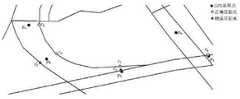
在环形路段处,现有的基于HMM的地图匹配方法产生匹配错误存在如下原因。其一,这些方法通常假设司机偏好最短的行驶路线,采用最短路径算法计算路段上的两个相邻候选点之间距离,该算法在简单路段处取得较好的效果,但在环形路段处最短路径并不总是正确。其二,为了减少误差,现有的HMM地图匹配方法考虑方向分析,计算起始与终止路网点连线的方向,求出路段方向,依靠行驶方向与路段方向间的角度差作为最佳路段选取的评判依据[5],但是在环形路段处,道路的方向不断变化,在每处都不同,因此,采用固定值代表环形路段的方向容易产生偏差,导致匹配错误。例如,图1中,GPS采样点p1→p2→p3的正确候选点为c1→c2→c3,但是由于p2到直行路段距离最近,因此被错误匹配到c′2,进而导致p3被匹配至c′3,所以最后错误的匹配结果为c1→c′2→c′3。而不是环形路段上。At the circular road section, the existing HMM-based map matching methods generate matching errors for the following reasons. First, these methods usually assume that the driver prefers the shortest driving route, and use the shortest path algorithm to calculate the distance between two adjacent candidate points on the road segment. The path is not always correct. Second, in order to reduce the error, the existing HMM map matching method considers the direction analysis, calculates the direction of the connecting line between the starting and ending road network points, obtains the direction of the road segment, and selects the optimal road segment based on the angle difference between the driving direction and the direction of the road segment. However, at the ring road section, the directionof the road is constantly changing, and it is different everywhere. Therefore, using a fixed value to represent the direction of the ring road section is prone to deviations, resulting in matching errors. For example, in Figure 1, the correct candidate point for GPS sampling point p1 →p2 →p3 is c1 →c2 →c3 , but since p2 is the closest to the straight road segment, it is incorrectly matched to c′2 , As a result, p3 is matched to c′3 , so the final wrong matching result is c1 →c′2 →c′3 . rather than on the ring road.
发明内容SUMMARY OF THE INVENTION
本发明提供一种环形路段的地图匹配方法,旨在改善上述问题。The present invention provides a map matching method for a circular road section, aiming at improving the above problems.
本发明是这样实现的,一种环形路段的地图匹配方法,所述方法具体如下:The present invention is implemented in this way, a map matching method for a circular road section, the method is specifically as follows:
检测GPS点是否处于环形路段,若检测结果为是,则基于空间分析、时间分析、方向分析及投票得分来匹配该GPS点对应的路段。Detect whether the GPS point is in a circular road section, and if the detection result is yes, match the road section corresponding to the GPS point based on spatial analysis, time analysis, direction analysis and voting scores.
进一步的,环形路段的检测方法具体如下:Further, the detection method of the ring road section is as follows:
获取该GPS点及其后(m-1)个GPS点,计算后一GPS点与前一GPS点的行驶方向角差值;Obtain the GPS point and the following (m-1) GPS points, and calculate the difference in the driving direction angle between the latter GPS point and the previous GPS point;
若存在指定数量的行驶方向角差值连续大于设定的正角度值或小于设定的负角度值,则判定该GPS点处于环形路段。If there is a specified number of driving direction angle differences that are continuously greater than the set positive angle value or less than the set negative angle value, it is determined that the GPS point is in a circular road segment.
进一步的,环形路段处的地图匹配公式具体如下:Further, the map matching formula at the ring road section is as follows:
Fstdv(ci-1,j,ci,k)=Fs(ci-1,j,ci,k)*Ft(ci-1,j,ci,k)*Fd(ci,k)*Fv(ci,k)Fstdv (ci-1,j ,ci,k )=Fs (ci-1,j ,ci,k )*Ft (ci-1,j ,ci,k )*Fd (ci,k )*Fv (ci,k )
其中,ci-1,j表示GPS采样点pi-1在第j条候选路段上的候选点,ci,k表示GPS采样点pi在第k条候选路段上的候选点,Fstdv(ci-1,j,ci,k)表示从候选点ci-1,j所在路径到候选点ci,k所在路径的概率,其中采样点pi-1与采样点pi相邻;Among them,ci-1,j represents the candidate point of GPS sampling point pi-1 on the jth candidate road segment, ci,k represents the candidate point of GPS sampling point pi on the kth candidate road segment, Fstdv (ci-1,j ,ci,k ) represents the probability from the path where the candidate point ci-1,j is located to the path where the candidate point ci,k is located, where the sampling point pi-1 is in phase with the sampling point pi adjacent;
Fs(ci-1,j,ci,k)表示基于空间函数计算所得从候选点ci-1,j到候选点ci,k的概率,Ft(ci-1,j,ci,k)表示基于时间分析函数计算所得从候选点ci-1,j到候选点ci,k的概率;Fd(ci,k)表示基于方向分析函数计算所得GPS采样点pi在第k条候选路段方向的概率,Fv(ci,k)表示GPS采样点pi对第k条候选路段的投票得分。Fs (ci-1,j ,ci,k ) represents the probability calculated based on the space function from the candidate pointci-1,j to the candidate pointci,k , Ft (ci-1,j , ci,k ) represents the probability from the candidate point ci-1,j to the candidate pointci,k calculated based on the time analysis function; Fd (ci,k ) represents the GPS sampling point p calculated based on the direction analysis function The probability ofi in the direction of the k-th candidate road segment, Fv (ci,k ) represents the voting score of the GPS sampling point pi on the k-th candidate road segment.
进一步的,Fv(ci,k)的计算公式具体如下:Further, the calculation formula of Fv (ci,k ) is as follows:

其中,ci,k表示第i个GPS点在第k条路段上的候选点,f(ej,k)表示在滑动窗内第j个GPS点对应候选路段集中的第k条路段的频率,f(ej,r)表示在滑动窗内第j个GPS点对应候选路段集中的第r条路段的频率,其中Rsj表示第j个GPS点的候选路段集合,|Rsj|表示候选路段集合Rsj内的路段数量,滑动窗由第i个至第i+3个GPS点的候选路段集组成。Among them, ci,k represents the candidate point of the i-th GPS point on the k-th road segment, and f(ej,k ) represents the frequency of the j-th GPS point corresponding to the k-th road segment in the candidate road segment set in the sliding window , f(ej,r ) represents the frequency of the jth GPS point corresponding to the rth road segment in the candidate road segment set in the sliding window, where Rsj represents the jth GPS point candidate road segment set, |Rsj | represents the candidate road segment The number of road segments in the road segment set Rsj , and the sliding window consists of the candidate road segment set from the ith to the ith+3 GPS point.
进一步的,若检测到GPS点处于非环形路段,则综合空间分析、时间分析及方向分析来匹配该GPS点对应的路段。Further, if it is detected that the GPS point is located in a non-circular road section, the space analysis, time analysis and direction analysis are integrated to match the road section corresponding to the GPS point.
进一步的,非环形路段处的地图匹配公式具体如下:Further, the map matching formula at the non-circular road section is as follows:
Fstd(ci-1,j,ci,k)=Fs(ci-1,j,ci,k)*Ft(ci-1,j,ci,k)*Fd(ci,k)Fstd (ci-1,j ,ci,k )=Fs (ci-1,j ,ci,k )*Ft (ci-1,j ,ci,k )*Fd (ci,k )
其中,ci-1,j表示GPS采样点pi-1在第j条候选路段上的候选点,ci,k表示GPS采样点pi在第k条候选路段上的候选点,Fstd(ci-1,j,ci,k)表示从候选点ci-1,j所在路径到候选点ci,k所在路径的概率,采样点pi-1与采样点pi相邻;Fs(ci-1,j,ci,k)表示基于空间函数计算所得从候选点ci-1,j到候选点ci,k的概率,Ft(ci-1,j,ci,k)表示基于时间分析函数计算所得从候选点ci-1,j到候选点ci,k的概率;Fd(ci,k)表示基于方向分析函数计算所得GPS采样点pi在第k条候选路段方向的概率。Among them,ci-1,j represents the candidate point of GPS sampling point pi-1 on the jth candidate road segment,ci,k represents the candidate point of GPS sampling point pi on the kth candidate road segment, Fstd (ci-1,j ,ci,k ) represents the probability from the path where the candidate point ci-1,j is located to the path where the candidate point ci,k is located, and the sampling point pi-1 is adjacent to the sampling point pi ; Fs (ci-1,j ,ci,k ) represents the probability calculated based on the space function from the candidate pointci-1,j to the candidate pointci,k , Ft (ci-1,j ,ci,k ) represents the probability from candidate pointci-1,j to candidate pointci,k calculated based on the time analysis function; Fd (ci,k ) represents the GPS sampling point calculated based on the direction analysis function The probability of pi in the direction of the kth candidate road segment.
本发明针对复杂路段路网环境下环形路段处的GPS轨迹数据的匹配,提出一种下文投票的地图匹配(STDV-matching)算法。该方法不仅结合了时间、空间以及方向三个分析函数,还通局部轨迹序列方向分析方法来判断是否处于环形路段,如果处于环形路段则通过研究环形路段处GPS点的后续若干点的候选路段集合,对集合中每条路段出现的频率进行投票分析,提高正确路段被选择的概率。The present invention proposes a map matching (STDV-matching) algorithm for voting below, aiming at the matching of GPS track data at a ring road section under a complex road network environment. This method not only combines the three analysis functions of time, space and direction, but also uses the local trajectory sequence direction analysis method to judge whether it is in a ring road section. , and perform voting analysis on the frequency of each road segment in the set to improve the probability of the correct road segment being selected.
附图说明Description of drawings
图1为本发明实施例提供的基于HMM的地图匹配方法产生匹配错误示例图;1 is an example diagram of a matching error generated by an HMM-based map matching method provided by an embodiment of the present invention;
图2为本发明实施例提供的环形路段的地图匹配方法框架图;2 is a framework diagram of a map matching method for a circular road segment provided by an embodiment of the present invention;
图3为本发明实施例提供的GPS点的候选路段及候选点选取实例图,其中,(a)为候选路段的选取,(b)为候选点的选取;3 is an example diagram of candidate road sections and candidate points selection of GPS points provided by an embodiment of the present invention, wherein (a) is the selection of candidate road sections, and (b) is the selection of candidate points;
图4为本发明实施例提供的路网拓扑信息示意图;4 is a schematic diagram of road network topology information provided by an embodiment of the present invention;
图5为本发明实施例提供的候选点的时间分析示例图;5 is an example diagram of time analysis of candidate points provided by an embodiment of the present invention;
图6为本发明实施例提供的环形路段判定示例图;FIG. 6 is an example diagram for determining a circular road segment provided by an embodiment of the present invention;
图7为本发明实施例提供的候选路段的滑动窗示意图;7 is a schematic diagram of a sliding window of a candidate road segment provided by an embodiment of the present invention;
图8为本发明实施例提供的候选路径选择示意图;FIG. 8 is a schematic diagram of candidate path selection provided by an embodiment of the present invention;
图9为本发明实施例提供的ST与STDV可视化实验结果对比图;9 is a comparison diagram of ST and STDV visualization experiment results provided by an embodiment of the present invention;
图10为本发明实施例提供的STDV-matching环形路段匹配结果示意图;FIG. 10 is a schematic diagram of a STDV-matching ring road segment matching result provided by an embodiment of the present invention;
图11为本发明实施例提供的不同算法精确度比较示意图。FIG. 11 is a schematic diagram of comparing the accuracy of different algorithms according to an embodiment of the present invention.
具体实施方式Detailed ways
下面对照附图,通过对实施例的描述,对本发明的具体实施方式作进一步详细的说明,以帮助本领域的技术人员对本发明的发明构思、技术方案有更完整、准确和深入的理解。The specific embodiments of the present invention will be described in further detail below with reference to the accompanying drawings, through the description of the embodiments, to help those skilled in the art to have a more complete, accurate and in-depth understanding of the inventive concept and technical solutions of the present invention.
本文地图匹配方法框架如图2所示。该匹配方法主要包括三个步骤:首先对每个GPS点构建候选路段集合,作为匹配算法的输入;其次执行位置环境分析和候选路段投票分析;最后构建候选路径集合,并计算每个候选路径的得分、投票,完成匹配。The framework of the map matching method in this paper is shown in Figure 2. The matching method mainly includes three steps: first, construct a candidate road segment set for each GPS point as the input of the matching algorithm; secondly, perform location environment analysis and candidate road segment voting analysis; finally, construct a candidate path set, and calculate the Score, vote, and complete matches.
(一)候选路段的选择(1) Selection of candidate road sections
为了缩小定位范围,减少候选路段的数量,缩短匹配时间,需要把不符合要求的路段提前筛除。以当前GPS点为中心,指定半径范围内的所有路段构成候选路段集合。如图3(a)所示,给定一个GPS点pi,首先在半径为r的圆形区域内选出候选路段e1,e2,e3,e4构成候选路段集合;其次,在候选集合中每条路段上找到当前GPS点在对应的投影点ci,j,如3(b)所示。若GPS点的投影不在路段上,则在该路段上选择距离该GPS点最近的道路起始点或终止点作为投影点。In order to narrow the positioning range, reduce the number of candidate road sections, and shorten the matching time, it is necessary to screen out the road sections that do not meet the requirements in advance. Taking the current GPS point as the center, all road segments within the specified radius constitute the candidate road segment set. As shown in Figure 3(a), given a GPS point pi , first select candidate road segments e1 , e2 , e3 , and e4 in a circular area with radius r to form a candidate road segment set; On each road segment in the candidate set, find the current GPS point at the corresponding projection point ci,j , as shown in 3(b). If the projection of the GPS point is not on the road segment, the start point or end point of the road closest to the GPS point is selected as the projection point on the road segment.
(二)STD-matching匹配模型(2) STD-matching matching model
空间分析函数:空间分析函数包括对路网几何信息的分析,拓扑结构的分析。几何信息主要考虑GPS点到候选路段距离,对应于HMM模型中的观测概率。考虑到GPS点总是在正确路段一定误差范围内的,并且距离GPS点越近的路段越有可能是正确路段。已有文献验证GPS点到候选路段距离总体上服从零均值的正态分布,观测概率

其中pi是整条轨迹的第i个GPS点,ci,k是GPS点pi在候选路段集合中第k条候选路段上的候选点,
在匹配时利用路网的拓扑信息可以降低GPS点被匹配到错误路段的概率。图4中,pi有两条候选路段e2,e4及候选点c2,c3,但是,pi到这两个候选点的距离比较接近,导致两个候选路段仅仅运用公式(1)计算出的观测概率比较接近,容易造成错误的匹配。因此在匹配过程中还须要考虑路网的拓扑信息来提高匹配结果的正确性。pi的前一个点pi-1若被匹配到路段e1上的c1,由于路段e1到e2规定了行驶方向,使这两条路段不具备可达性,即最短路径shortestpath(c1,c2)=∞,因此pi只能选择c3作为候选点。Using the topology information of the road network during matching can reduce the probability of GPS points being matched to wrong road segments. In Figure 4,pi has two candidate road segments e2 , e4 and candidate points c2 , c3 , but the distances frompi to these two candidate points are relatively close, resulting in two candidate road segments only using formula (1 ), the calculated observation probabilities are relatively close, which is likely to cause erroneous matching. Therefore, the topology information of the road network needs to be considered in the matching process to improve the correctness of the matching results. If the previous point pi-1 of p i is matched to c1 on the road segment e1 , since the road segments e1 to e2 specify the driving direction, these two road segments are not reachable, that is, the shortest path (shortestpath( c1 , c2 )=∞, so pi can only choose c3 as a candidate point.
在两个点之间进行转移时,默认司机偏好最短的路径行驶而非绕过一条或多条街区到达。因此转移概率定义如下:When transferring between two points, the default driver prefers the shortest route rather than bypassing one or more blocks to arrive. So the transition probability is defined as:

其中ci-1,j是GPS采样点pi-1在候选路段j上的候选点,ci,k是GPS采样点pi在候选路段k上的候选点,dis tan ce(pi-1,pi)表示两个相邻GPS采样点pi-1,pi之间的欧几里得距离,shortestpath(ci-1,j,ci,k)表示采用迪杰斯特拉算法计算的两个候选点ci-1,j,ci,k之间最短路径距离。由公式(2)可见,当两点之间欧式距离与最短路径距离越接近1则该候选点对应的候选路段是正确路段的可能性越大。where ci-1,j are the candidate points of the GPS sampling point pi-1 on the candidate road segment j,ci,k are the candidate points of the GPS sampling point pi on the candidate road segment k, distance(pi- 1 , pi ) represents the Euclidean distance between two adjacent GPS sampling points pi-1 ,pi , and shortestpath(ci-1,j, ci,k ) represents the use of Dijkstra The algorithm calculates the shortest path distance between two candidate points ci-1,j , ci ,k . It can be seen from formula (2) that the closer the Euclidean distance and the shortest path distance between two points are to 1, the greater the possibility that the candidate road segment corresponding to the candidate point is the correct road segment.
综合观测概率公式(1)和转移概率公式(2)定义两个相邻GPS点所对应候选点之间的空间分析函数为:The comprehensive observation probability formula (1) and transition probability formula (2) define the spatial analysis function between candidate points corresponding to two adjacent GPS points as:

计算完公式(3)后可以得到两个相邻GPS点的所有候选点所组成的路径,每条路径也对应不同的得分。After calculating the formula (3), the path composed of all candidate points of two adjacent GPS points can be obtained, and each path also corresponds to a different score.
(三)时间分析函数(3) Time analysis function
空间分析函数可以解决大多数几何结构和拓扑结构中存在的问题,但在路网分布复杂的情况下,例如在高速公路和普通小路距离接近时,仅通过空间分析函数无法确定车辆是在高速公路还是在普通小路上。如图5所示e1(highway)是一条限速为60km/h的高速公路,e2(lane)是一条限速为30km/h小路,若pi-1已经被匹配到e1上,pi到这两条候选路段的直线距离和到前一个pi-1的最短路径距离都很接近,导致pi在e1,e2这两条路上的空间分析不足以区分正确路段。因此通过路段限定速度与汽车行驶平均速度的差异来定义时间分析函数。计算公式如公式(4)所示:Spatial analysis functions can solve most problems in geometric structures and topological structures, but in the case of complex road network distribution, such as when highways and ordinary roads are close in distance, it is impossible to determine whether a vehicle is on a highway only through spatial analysis functions. Still on a normal road. As shown in Figure 5, e1 (highway) is a highway with a speed limit of 60km/h, and e2 (lane) is a road with a speed limit of 30km/h. If pi-1 has been matched to e1 , The straight-line distance ofpi to these two candidate road segments and the shortest path distance to the previous pi-1 are very close, resulting in that the spatial analysis ofpi on the two roads of e1 and e2 is not enough to distinguish the correct road segment. Therefore, the time analysis function is defined by the difference between the limited speed of the road segment and the average speed of the car. The calculation formula is shown in formula (4):

其中


其中Δt是两个候选点的时间差。whereΔt is the time difference between the two candidate points.
(四)方向分析函数(4) Direction analysis function
对于交叉路段和Y型路口,在时间分析函数和空间分析函数的基础上进一步考虑GPS点的实时方向与道路方向之间的关系,用角度差来判断每条路段被选择的可能性,如果角度差越小则分配的权重和概率越大。方向分析函数Fd(ci,k)计算如公式(6)所示。For intersections and Y-shaped intersections, based on the time analysis function and space analysis function, the relationship between the real-time direction of the GPS point and the road direction is further considered, and the angle difference is used to judge the possibility of each road segment being selected. If the angle The smaller the difference, the larger the assigned weight and probability. The direction analysis function Fd (ci,k ) is calculated as shown in formula (6).

其中,


其中,ei.end.lat、ei.start.lat分别表示路段ei起始点和终止点的纬度,ei.end.lng、ei.start.lng分别表示路段ei起始点和终止点之的经度,pi.lat、pi.lng分别表示第i个GPS点pi的纬度及经度,pi-1.lat、pi-1.lng分别表示第(i-1)个GPS点pi-1的纬度及经度。经过时间分析函数、空间分析函数、方向分析函数三个分析函数的计算,能为每条候选路段分配概率。Among them, ei .end.lat and ei .start.lat represent the latitude of the starting point and the ending point of the road segment ei respectively, and ei .end.lng and ei .start.lng represent the starting point and the ending point of the road segment ei respectively The longitude of the point, pi .lat and pi .lng represent the latitude and longitude of the i-th GPS point pi respectively, and pi-1 .lat and pi-1 .lng represent the (i-1)th GPS point respectively. Latitude and longitude of GPS point pi-1 . The probability can be assigned to each candidate road segment through the calculation of three analysis functions: time analysis function, space analysis function, and direction analysis function.
然而在环形路段处,路段的方向是不停变化的,仅仅利用公式(7)考虑路段整体的方向可能会造成错误的匹配。因此本文在STD-matching的基础上增加上下文投票分析函数以解决环形路段匹配错误的情况。However, at the ring road segment, the direction of the road segment is constantly changing, and only using the formula (7) to consider the overall direction of the road segment may cause erroneous matching. Therefore, this paper adds a contextual voting analysis function on the basis of STD-matching to solve the situation of incorrect matching of circular road segments.
(五)下文投票分析(5) Analysis of voting below
为了解决环形路段处GPS点被匹配至相切路段的问题,本发明局部轨迹序列方向分析方法,找出位于环形路段处的GPS点,并采用下文路段投票分析,提高匹配精确度。In order to solve the problem that the GPS points at the ring road section are matched to the tangent road sections, the local trajectory sequence direction analysis method of the present invention finds the GPS points located at the ring road section, and uses the following road section voting analysis to improve the matching accuracy.
(1)进入环形路段判定(1) Judgment of entering the ring road
直行路段上车辆的方向具有稳定性,而环形路段上行驶的车辆方向是时刻变化的。参考这一特性本文提出局部轨迹序列方向分析方法,通过计算后续若干点行驶方向的差值并与阈值进行比较,统计满足阈值条件的连续GPS点的数量,以确定是否进入环形路段,见公式(9),满足条件s1或条件s2的连续GPS点的数量达到设定数量,即认定进入环形路段。The direction of the vehicle on the straight section is stable, while the direction of the vehicle on the roundabout section changes all the time. Referring to this characteristic, this paper proposes a local trajectory sequence direction analysis method. By calculating the difference between the driving directions of several subsequent points and comparing with the threshold, the number of consecutive GPS points that meet the threshold condition is counted to determine whether to enter the ring road section, see the formula ( 9), when the number of continuous GPS points that satisfy the condition s1 or the condition s2 reaches the set number, it is determined that the ring road section is entered.


其中,在道路方向为逆时针的环形路段处pi+1的行驶方向角度大于pi的行驶方向角度,因此前后两点方向差值
(2)下文路段投票分析(2) Voting analysis of the following road sections
结合真实场景,车辆行驶进入环形路段时,一般不会频繁更换正在行驶的路段,但是存在匹配到其它路段的可能性,我们仿照人类思维方式,结合车辆后续若干个点分析,使得当前GPS点候选路段集合中正确路段的概率更高。因此,本文提出滑动窗口方法,统计后续若干点的候选路段集合中每条路段的出现频率,并根据统计频率,计算每条候选路段的匹配概率。Combined with the real scene, when the vehicle enters the ring road section, it generally does not frequently change the driving road section, but there is the possibility of matching other road sections. We imitate the way of human thinking and combine several subsequent point analysis of the vehicle to make the current GPS point candidate. The probability of correct road segments in the road segment set is higher. Therefore, this paper proposes a sliding window method to count the frequency of occurrence of each road segment in the candidate road segment set of several subsequent points, and calculate the matching probability of each candidate road segment according to the statistical frequency.
如图7所示,当滑动窗口的范围设置为4时,p1需要考虑p1,p2,p3及p4四个点的候选路段集合,同理,p2需要考虑p2,p3,p4及p5。因此p1、p2所对应的候选路段频率如图8所示。As shown in Figure 7, when the range of the sliding window is set to 4, p1 needs to consider the candidate road segment sets of four points p1 , p2 , p3 and p4. Similarly, p2 needs to consider p2 , p3 , p4 and p5 . Therefore, the frequencies of candidate road sections corresponding to p1 and p2 are shown in FIG. 8 .
由表1、表2可以看出,从p1到p2的候选路段统计中e3出现的频率最高,所以为e3分配更大权重以获取高的概率。It can be seen from Table 1 and Table 2 that e3 appears most frequently in the statistics of candidate road segments from p1 to p2 , so assign a greater weight to e3 to obtain a high probability.

本文的候选路段分析函数定义如公式(10)所示。The definition of the candidate road segment analysis function in this paper is shown in formula (10).

其中,ci,k表示第i个GPS点在第k条路段上的候选点,f(ej,k)表示在滑动窗内第j个GPS点对应候选路段集中的第k条路段的频率,f(ej,r)表示在滑动窗内第j个GPS点对应候选路段集中的第r条路段的频率,其中Rsj表示第j个GPS点的候选路段集合,|Rsj|表示候选路段集合Rsj内的路段数量,滑动窗由第i个至第i+3个GPS点的候选路段集组成。Among them, ci,k represents the candidate point of the i-th GPS point on the k-th road segment, and f(ej,k ) represents the frequency of the j-th GPS point corresponding to the k-th road segment in the candidate road segment set in the sliding window , f(ej,r ) represents the frequency of the jth GPS point corresponding to the rth road segment in the candidate road segment set in the sliding window, where Rsj represents the jth GPS point candidate road segment set, |Rsj | represents the candidate road segment The number of road segments in the road segment set Rsj , and the sliding window consists of the candidate road segment set from the ith to the ith+3 GPS point.
综合公式(3)、公式(4)、公式(6)、公式(10)可以得出最终的候选路段概率计算公式(11)。Combining formula (3), formula (4), formula (6), and formula (10), the final candidate link probability calculation formula (11) can be obtained.
Fstdv(ci-1,j,ci,k)=Fs(ci-1,j,ci,k)*Ft(ci-1,j,ci,k)*Fd(ci,k)*Fv(ci,k) (11)Fstdv (ci-1,j ,ci,k )=Fs (ci-1,j ,ci,k )*Ft (ci-1,j ,ci,k )*Fd (ci,k )*Fv (ci,k ) (11)
但是,整条轨迹的最后若干GPS点不适用于公式(10),因为滑动窗口内最后若干GPS采样点数量不足,频率统计结果不准确。这些点的概率计算仍采取STD-matching中的方法。However, formula (10) is not applicable to the last several GPS points of the entire trajectory, because the number of the last several GPS sampling points in the sliding window is insufficient, and the frequency statistics result is inaccurate. The probability calculation of these points still adopts the method in STD-matching.
路径匹配path matching
根据公式(11),可计算出GPS采样点候选路段的概率,再通过动态规划中的维特比算法计算整条轨迹候选路径集合中每条候选路径的概率,选取得分最高的路径作为最终匹配结果。从p1到p2之间有若干条路径,根据公式(1)可计算出每个GPS采样点的观测概率,相邻两个GPS采样点之间转移概率,见表3、4、5所示。According to formula (11), the probability of the candidate road segment of the GPS sampling point can be calculated, and then the probability of each candidate path in the entire trajectory candidate path set is calculated by the Viterbi algorithm in dynamic programming, and the path with the highest score is selected as the final match. result. There are several paths from p1 to p2. According to formula (1), the observation probability of each GPS sampling point can be calculated, and the transition probability between two adjacent GPS sampling points is shown in Tables 3, 4, and 5. Show.
表3观测概率表Table 3 Observation probability table

表3表示每个GPS采样点的观测概率,而观测概率在本文中仅通过距离决定,因此可以根据距离直接计算对应的概率。Table 3 shows the observation probability of each GPS sampling point, and the observation probability is only determined by the distance in this paper, so the corresponding probability can be directly calculated according to the distance.
表4转移概率表Ft*Fd*TTable 4 Transition probability table Ft *Fd *T

表5转移概率表FvTable 5. Transition probability table Fv

表4、5描述不同因素分析的转移概率表,由最短路径,速度相似性以及方向决定。根据公式(3)、(4)、(7)计算由第一个点到第二个点的匹配概率时可知,

候选路径集合如图8所示。p1没有前面的点可以参考,仅依据这个点在各条道路上的观测概率决定,剩下的n-4个点用公式(11)计算,最后的三个点采用STD匹配方法决定最佳匹配路径。最终,匹配概率最大的路径。The candidate path set is shown in Figure 8. p1 has no previous point to refer to. It is only determined according to the observation probability of this point on each road. The remaining n-4 points are calculated by formula (11), and the last three points are determined by STD matching method. match path. Finally, the path with the highest probability is matched.
本文在传统HMM简单路段匹配的基础上,引入环形路段判定方法,先判断这些GPS点所处的路网环境,再利用上下文投票分析,解决易匹配错的问题,提高匹配精确度。本文主要贡献总结如下。Based on the simple road segment matching of traditional HMM, this paper introduces the method of determining the circular road segment, firstly judging the road network environment where these GPS points are located, and then using the context voting analysis to solve the problem of easy matching and improve the matching accuracy. The main contributions of this paper are summarized as follows.
(1)提出局部轨迹序列方向分析方法判断进入环形路段。通过计算后续若干点行驶方向的差值并与阈值进行比较,统计满足条件的相邻GPS点数量,采用提出的STDV-matching匹配方法。否则采用传统STD-matching匹配方法。(1) A local trajectory sequence direction analysis method is proposed to judge the entry into the ring road section. By calculating the difference between the driving directions of several subsequent points and comparing with the threshold, the number of adjacent GPS points that meet the conditions is counted, and the proposed STDV-matching matching method is adopted. Otherwise, the traditional STD-matching matching method is used.
(2)提出上下文投票的环形路段匹配方法。考虑到真实场景中,车辆在环形路段行驶时,一般不会频繁改变道路,所以对当前GPS点的所有候选路段,在后续点的候选路段集合中按出现的频率进行投票,给票数高的路段分配更大的转移概率,从而解决进入环形路段时以及在环形路段上容易出现的错误匹配的问题。(2) Propose a ring road segment matching method based on context voting. Considering that in the real scene, when the vehicle is driving on the ring road, the road will not change frequently, so for all the candidate road segments of the current GPS point, vote according to the frequency of occurrence in the candidate road segment set of the subsequent points, and give the road segment with the highest number of votes. Assign larger transition probabilities, thereby solving the problem of false matches that are prone to occur when entering and on roundabouts.
(六)实验(6) Experiment
实验采用真实的出租车数据,并与传统的HMM算法、ST-matching、STD-matching方法比较,验证本文方法时间效率和匹配精度。The experiment uses real taxi data and compares it with the traditional HMM algorithm, ST-matching and STD-matching methods to verify the time efficiency and matching accuracy of the method in this paper.
数据集描述Dataset Description
实验选择北京市朝阳区双泉堡地图区域OSM路网数据,包含77个路网点,共11条路段,,包括高速公路、摩托车道、辅路、人行道等不同等级道路,含有环形路段。其中轨迹所覆盖地图区域经纬度为minlat="40.0073100",maxlat="40.0097600",minlon="116.3556900",maxlon="116.3598300";北京市丰台区菜户营桥部分路网数据,所选OSM文件包含85个路网点共17条路段其中轨迹覆盖地图区域经纬度为:minlat="39.8639000",maxlat="39.8695000",minlon="116.3393000",maxlon="116.3463000"。轨迹数据集:来源于T-driver轨迹数据,包含9个GPS观测点,平均每个GPS采样频率为13s,包括出租车id、行驶时间、以及实时位置所对应的经纬度信息。The OSM road network data of the Shuangquanbao map area in Chaoyang District, Beijing was selected for the experiment, including 77 road network points and a total of 11 road sections, including highways, motorcycle roads, side roads, sidewalks and other roads of different grades, including ring road sections. The latitude and longitude of the map area covered by the track is minlat="40.0073100", maxlat="40.0097600", minlon="116.3556900", maxlon="116.3598300"; some road network data of Caihuyingqiao, Fengtai District, Beijing, the selected OSM file contains There are 17 road sections in 85 road network points. The latitude and longitude of the track coverage map area are: minlat="39.8639000", maxlat="39.8695000", minlon="116.3393000", maxlon="116.3463000". Trajectory data set: derived from T-driver trajectory data, including 9 GPS observation points, the average sampling frequency of each GPS is 13s, including taxi id, travel time, and the latitude and longitude information corresponding to the real-time location.
本实验参数设定如表6所示。The experimental parameters are set as shown in Table 6.
表6实验参数Table 6 Experimental parameters

距离和方向与正确路段间的偏差总体上服从标准正态分布,因此参数中正态分布均值设定为0,即当GPS点方向与某条候选路段重合或到候选路段的距离为0,则概率为1,距离超过20m,角度差值超过30°不予考虑。环形路段的判定阈值根据采样频率设定,本文将其值设置为25°时能涵盖环形路段上的所有GPS点。若处理的GPS序号为最后三个点时则不采用本文提出的STDV-matching算法。The deviation between the distance and direction and the correct road segment generally obeys the standard normal distribution, so the mean value of the normal distribution in the parameters is set to 0, that is, when the GPS point direction coincides with a candidate road segment or the distance to the candidate road segment is 0, then The probability is 1, the distance exceeds 20m, and the angle difference exceeds 30° will not be considered. The determination threshold of the circular road segment is set according to the sampling frequency. When the value is set to 25° in this paper, it can cover all GPS points on the circular road segment. If the processed GPS sequence numbers are the last three points, the STDV-matching algorithm proposed in this paper is not used.
实验结果Experimental results
算法时间效率对比Algorithm Time Efficiency Comparison
为了减少由于机器原因所造成的运行时间误差,每个实验分别运行5次并选取平均运行时间作为最终结果。In order to reduce the running time error due to machine reasons, each experiment was run 5 times and the average running time was selected as the final result.
表7运行时间对比Table 7 Run time comparison

从表7可知本章所提方法比其他三种方法运行时间略高,原因在于在STD-matching的基础上增加了一项新的判定条件,因此会增加运行所需要的时间。但是,对于轨迹点的频度进行统计的算法运行时间是线性的,其独立的时间复杂度为O(n),因此不会耗费较多的运行时间。It can be seen from Table 7 that the running time of the method proposed in this chapter is slightly higher than that of the other three methods, because a new judgment condition is added on the basis of STD-matching, which will increase the running time. However, the running time of the algorithm for counting the frequency of trajectory points is linear, and its independent time complexity is O(n), so it does not consume much running time.
可视化匹配结果及精确度对比Visual matching results and accuracy comparison
本文将我们的方法与已有的方法就匹配精确度方面进行比较。匹配精确度计算公式如(13)所示。This paper compares our method with existing methods in terms of matching accuracy. The formula for calculating the matching accuracy is shown in (13).

其中ncorrect表示正确匹配到路段上的GPS点的个数,n表示整条轨迹中含有的GPS点数量。where ncorrect represents the number of GPS points correctly matched to the road segment, and n represents the number of GPS points contained in the entire track.
本节特别的将ST-matching与STDV-matching两种匹配算法在环形路段处的匹配结果作对比。如图9所示黑色实心点均为ST-matching匹配方法在环形路段错误的匹配结果,黑色白心点为ST-matching部分匹配正确的结果以及STDV-matching全部匹配正确的结果,黑色的点为原始GPS点。由图9可知,p1到p2无论是根据方向分析函数中的角度差或是空间分析函数最短路径都会优先将p2匹配至执行路段,从而导致p3也只能被匹配到c3′。但是车辆正确行驶的路段是环形路段,通过优先考虑后续点的候选路段投票分析的结果可以得出环形路段所占比重远大于p2点附近的直行路段,因此为环形路段分配更高的概率。This section specifically compares the matching results of the two matching algorithms ST-matching and STDV-matching at the roundabout. As shown in Figure 9, the black solid points are the wrong matching results of the ST-matching matching method in the circular road section, the black and white points are the correct results of ST-matching part and all the correct STDV-matching results, the black points are Raw GPS point. It can be seen from Fig. 9 that p1 to p2 will preferentially match p2 to the execution road segment according to the angle difference in the direction analysis function or the shortest path of the space analysis function, so that p3 can only be matched to c3 ′. . However, the road segment on which the vehicle travels correctly is a ring road segment. The result of voting analysis of candidate road segments that prioritize subsequent points can show that the proportion of ring road segments is much larger than that of straight road segments near p2 , so a higher probability is assigned to the ring road segment.
为了进一步验证本本所提方法在环形路段处的匹配精确度,我们另选了菜户营桥处的环形路段测试本实验,通过Arcgis将匹配结果进行展示。In order to further verify the matching accuracy of the proposed method at the ring road section, we also selected the ring road segment at the Caihuying Bridge to test this experiment, and displayed the matching results through ArcGIS.
图10中,在环形路段处,所有的GPS点均被匹配至正确的路段,且在非环形路段处也能正确匹配。In Figure 10, all GPS points are matched to the correct road segment at the circular road segment, and can also be correctly matched at the non-circular road segment.
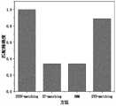
图11中,本文提出的方法在采样平均间隔为13秒时环形路段处的匹配正确率可以达到100%。传统HMM和ST-matching在环形路段处并未考虑方向和候选路段这一信息,仅依靠最短路径和点到直线距离来判断从而导致环形路段处匹配结果较差。STD-matching在计算路段方向时仅通过起始和终止节点来描述路段方向,但是环形路段不同位置的方向都不同,因此计算角度差时也会产生误差。In Fig. 11, the matching accuracy of the method proposed in this paper can reach 100% when the average sampling interval is 13 seconds. Traditional HMM and ST-matching do not consider the information of direction and candidate road segments at the ring road segment, and only rely on the shortest path and the point-to-line distance to judge, resulting in poor matching results at the ring road segment. STD-matching only describes the direction of the road segment by starting and ending nodes when calculating the direction of the road segment, but the directions of different positions of the ring road segment are different, so errors will also occur when calculating the angle difference.
综合表7以及图11可知,本章所提STDV-matching方法在环形路段处的精确度明显高于其他三种匹配方法,且也有较高的匹配性能。From Table 7 and Figure 11, it can be seen that the accuracy of the STDV-matching method proposed in this chapter is significantly higher than that of the other three matching methods at the ring road section, and it also has higher matching performance.
上面结合附图对本发明进行了示例性描述,显然本发明具体实现并不受上述方式的限制,只要采用了本发明的方法构思和技术方案进行的各种非实质性的改进,或未经改进将本发明的构思和技术方案直接应用于其它场合的,均在本发明的保护范围之内。The present invention has been exemplarily described above in conjunction with the accompanying drawings. Obviously, the specific implementation of the present invention is not limited by the above methods, as long as various insubstantial improvements made by the method concept and technical solutions of the present invention are adopted, or no improvement is made. It is within the protection scope of the present invention to directly apply the concepts and technical solutions of the present invention to other occasions.
Claims (6)
Translated fromChinese
Priority Applications (1)
| Application Number | Priority Date | Filing Date | Title |
|---|---|---|---|
| CN202110566207.5ACN113295173B (en) | 2021-05-24 | 2021-05-24 | Map Matching Method for Ring Road Section |
Applications Claiming Priority (1)
| Application Number | Priority Date | Filing Date | Title |
|---|---|---|---|
| CN202110566207.5ACN113295173B (en) | 2021-05-24 | 2021-05-24 | Map Matching Method for Ring Road Section |
Publications (2)
| Publication Number | Publication Date |
|---|---|
| CN113295173Atrue CN113295173A (en) | 2021-08-24 |
| CN113295173B CN113295173B (en) | 2023-08-29 |
Family
ID=77324338
Family Applications (1)
| Application Number | Title | Priority Date | Filing Date |
|---|---|---|---|
| CN202110566207.5AActiveCN113295173B (en) | 2021-05-24 | 2021-05-24 | Map Matching Method for Ring Road Section |
Country Status (1)
| Country | Link |
|---|---|
| CN (1) | CN113295173B (en) |
Cited By (4)
| Publication number | Priority date | Publication date | Assignee | Title |
|---|---|---|---|---|
| CN113932821A (en)* | 2021-11-03 | 2022-01-14 | 安徽师范大学 | Trajectory map matching method based on continuous window average direction feature |
| CN114485692A (en)* | 2022-03-08 | 2022-05-13 | 安徽师范大学 | High sampling rate trajectory data map matching method based on road network connectivity |
| CN114935773A (en)* | 2022-04-29 | 2022-08-23 | 交通运输通信信息集团有限公司 | Online road matching method, device, medium and equipment based on Beidou positioning |
| CN115841749A (en)* | 2022-10-28 | 2023-03-24 | 南京邮电大学 | Road optimal matching method for three-dimensional urban traffic network |
Citations (8)
| Publication number | Priority date | Publication date | Assignee | Title |
|---|---|---|---|---|
| JP2007139503A (en)* | 2005-11-16 | 2007-06-07 | Alpine Electronics Inc | Navigation device and vehicle position determining method |
| US20110208426A1 (en)* | 2010-02-25 | 2011-08-25 | Microsoft Corporation | Map-Matching for Low-Sampling-Rate GPS Trajectories |
| CN104197945A (en)* | 2014-08-27 | 2014-12-10 | 浙江工业大学 | Global voting map matching method based on low-sampling-rate floating vehicle data |
| US20150354973A1 (en)* | 2013-03-15 | 2015-12-10 | Hewlett-Packard Development Company, L.P. | Map matching |
| CN109459045A (en)* | 2018-09-29 | 2019-03-12 | 杭州电子科技大学 | A kind of improvement interactive polls matching process for low frequency GPS track |
| CN110686686A (en)* | 2019-06-04 | 2020-01-14 | 北京嘀嘀无限科技发展有限公司 | System and method for map matching |
| CN111121791A (en)* | 2019-11-29 | 2020-05-08 | 上饶市中科院云计算中心大数据研究院 | Optimization method of hidden Markov model in map matching and GPS positioning method |
| CN111189459A (en)* | 2020-01-10 | 2020-05-22 | 成都信息工程大学 | A method and device for matching positioning information with a road |
- 2021
- 2021-05-24CNCN202110566207.5Apatent/CN113295173B/enactiveActive
Patent Citations (9)
| Publication number | Priority date | Publication date | Assignee | Title |
|---|---|---|---|---|
| JP2007139503A (en)* | 2005-11-16 | 2007-06-07 | Alpine Electronics Inc | Navigation device and vehicle position determining method |
| US20110208426A1 (en)* | 2010-02-25 | 2011-08-25 | Microsoft Corporation | Map-Matching for Low-Sampling-Rate GPS Trajectories |
| US20150354973A1 (en)* | 2013-03-15 | 2015-12-10 | Hewlett-Packard Development Company, L.P. | Map matching |
| CN104197945A (en)* | 2014-08-27 | 2014-12-10 | 浙江工业大学 | Global voting map matching method based on low-sampling-rate floating vehicle data |
| CN109459045A (en)* | 2018-09-29 | 2019-03-12 | 杭州电子科技大学 | A kind of improvement interactive polls matching process for low frequency GPS track |
| CN110686686A (en)* | 2019-06-04 | 2020-01-14 | 北京嘀嘀无限科技发展有限公司 | System and method for map matching |
| WO2020243937A1 (en)* | 2019-06-04 | 2020-12-10 | Beijing Didi Infinity Technology And Development Co., Ltd. | Systems and methods for map-matching |
| CN111121791A (en)* | 2019-11-29 | 2020-05-08 | 上饶市中科院云计算中心大数据研究院 | Optimization method of hidden Markov model in map matching and GPS positioning method |
| CN111189459A (en)* | 2020-01-10 | 2020-05-22 | 成都信息工程大学 | A method and device for matching positioning information with a road |
Non-Patent Citations (4)
| Title |
|---|
| ASSAM ROLAND ET AL.: "Effective Map Matching using Curve Tangents and Hidden Markov Model", 《2014 10TH INTERNATIONAL CONFERENCE ON MOBILE AD-HOC AND SENSOR NETWORKS (MSN)》, pages 213 - 219* |
| 卢家品: "数据驱动的车辆轨迹数据地图匹配方法", 《中国优秀硕士学位论文全文数据库 (基础科学辑)》, pages 008 - 282* |
| 胡建超;王忠;张维;: "改进的地图匹配算法研究", 通信技术, no. 11, pages 174 - 175* |
| 郑林江;刘旭;易兵;: "考虑时空特性的动态权重实时地图匹配算法", 计算机应用, no. 08, pages 259 - 264* |
Cited By (6)
| Publication number | Priority date | Publication date | Assignee | Title |
|---|---|---|---|---|
| CN113932821A (en)* | 2021-11-03 | 2022-01-14 | 安徽师范大学 | Trajectory map matching method based on continuous window average direction feature |
| CN113932821B (en)* | 2021-11-03 | 2023-06-16 | 安徽师范大学 | Track map matching method based on continuous window average direction characteristics |
| CN114485692A (en)* | 2022-03-08 | 2022-05-13 | 安徽师范大学 | High sampling rate trajectory data map matching method based on road network connectivity |
| CN114485692B (en)* | 2022-03-08 | 2023-06-16 | 安徽师范大学 | High sampling rate track data map matching method based on road network connectivity |
| CN114935773A (en)* | 2022-04-29 | 2022-08-23 | 交通运输通信信息集团有限公司 | Online road matching method, device, medium and equipment based on Beidou positioning |
| CN115841749A (en)* | 2022-10-28 | 2023-03-24 | 南京邮电大学 | Road optimal matching method for three-dimensional urban traffic network |
Also Published As
| Publication number | Publication date |
|---|---|
| CN113295173B (en) | 2023-08-29 |
Similar Documents
| Publication | Publication Date | Title |
|---|---|---|
| CN113295173B (en) | Map Matching Method for Ring Road Section | |
| CN109410586B (en) | Traffic state detection method based on multi-metadata fusion | |
| CN113932821B (en) | Track map matching method based on continuous window average direction characteristics | |
| CN108492564B (en) | Method and system for measuring highway vehicle speed based on road network matching | |
| CN111949896B (en) | Track abnormality detection method based on track big data | |
| CN107766808B (en) | Method and system for clustering of moving trajectories of vehicle objects in road network space | |
| CN110176139B (en) | DBSCAN + -based road congestion identification visualization method | |
| CN105628033B (en) | A kind of map-matching method based on path connected relationship | |
| CN114005280B (en) | Vehicle track prediction method based on uncertainty estimation | |
| CN105206041B (en) | Smart-phone track chain-cluster identification method considering sequential DBSCAN | |
| CN111291790A (en) | Turning path extraction and road network topology change detection framework method based on track similarity | |
| CN110008872A (en) | A road network extraction method combining vehicle trajectories and remote sensing images | |
| CN104464375B (en) | It is a kind of to recognize the method that vehicle high-speed is turned | |
| CN109459045A (en) | A kind of improvement interactive polls matching process for low frequency GPS track | |
| CN108253976A (en) | It is a kind of fully by the three stage Online Map matching algorithms in vehicle course | |
| CN115265555B (en) | Map matching correction method and system based on hidden Markov multi-noise perception | |
| CN111123333B (en) | Vehicle track positioning method fusing bayonet and GPS data | |
| CN113959452A (en) | Map matching method, system and terminal based on urban road network | |
| CN109033239A (en) | A kind of road network structure generating algorithm based on Least-squares minimization | |
| CN107917716A (en) | Fixed circuit air navigation aid, device, terminal and computer-readable recording medium | |
| Rahmani et al. | Path inference of low-frequency GPS probes for urban networks | |
| CN114462609A (en) | A Trajectory Restoration Method for Floating Car Data Based on Hidden Markov Model | |
| Hsueh et al. | A hidden Markov model-based map-matching approach for low-sampling-rate GPS trajectories | |
| CN119555093A (en) | A high-frequency vehicle trajectory map matching method | |
| Xi et al. | Map matching algorithm and its application |
Legal Events
| Date | Code | Title | Description |
|---|---|---|---|
| PB01 | Publication | ||
| PB01 | Publication | ||
| SE01 | Entry into force of request for substantive examination | ||
| SE01 | Entry into force of request for substantive examination | ||
| GR01 | Patent grant | ||
| GR01 | Patent grant |