CN113141570B - Underground scene positioning method, device, computing equipment and computer storage medium - Google Patents
Underground scene positioning method, device, computing equipment and computer storage mediumDownload PDFInfo
- Publication number
- CN113141570B CN113141570BCN202010052897.8ACN202010052897ACN113141570BCN 113141570 BCN113141570 BCN 113141570BCN 202010052897 ACN202010052897 ACN 202010052897ACN 113141570 BCN113141570 BCN 113141570B
- Authority
- CN
- China
- Prior art keywords
- sampling point
- grid
- point
- points
- sampling
- Prior art date
- Legal status (The legal status is an assumption and is not a legal conclusion. Google has not performed a legal analysis and makes no representation as to the accuracy of the status listed.)
- Active
Links
Images


Classifications
- H—ELECTRICITY
- H04—ELECTRIC COMMUNICATION TECHNIQUE
- H04W—WIRELESS COMMUNICATION NETWORKS
- H04W4/00—Services specially adapted for wireless communication networks; Facilities therefor
- H04W4/02—Services making use of location information
- H04W4/021—Services related to particular areas, e.g. point of interest [POI] services, venue services or geofences
- G—PHYSICS
- G01—MEASURING; TESTING
- G01S—RADIO DIRECTION-FINDING; RADIO NAVIGATION; DETERMINING DISTANCE OR VELOCITY BY USE OF RADIO WAVES; LOCATING OR PRESENCE-DETECTING BY USE OF THE REFLECTION OR RERADIATION OF RADIO WAVES; ANALOGOUS ARRANGEMENTS USING OTHER WAVES
- G01S11/00—Systems for determining distance or velocity not using reflection or reradiation
- G01S11/02—Systems for determining distance or velocity not using reflection or reradiation using radio waves
- G01S11/06—Systems for determining distance or velocity not using reflection or reradiation using radio waves using intensity measurements
- G—PHYSICS
- G06—COMPUTING OR CALCULATING; COUNTING
- G06F—ELECTRIC DIGITAL DATA PROCESSING
- G06F16/00—Information retrieval; Database structures therefor; File system structures therefor
- G06F16/20—Information retrieval; Database structures therefor; File system structures therefor of structured data, e.g. relational data
- G06F16/28—Databases characterised by their database models, e.g. relational or object models
- G06F16/284—Relational databases
- G06F16/285—Clustering or classification
- G—PHYSICS
- G06—COMPUTING OR CALCULATING; COUNTING
- G06F—ELECTRIC DIGITAL DATA PROCESSING
- G06F16/00—Information retrieval; Database structures therefor; File system structures therefor
- G06F16/20—Information retrieval; Database structures therefor; File system structures therefor of structured data, e.g. relational data
- G06F16/29—Geographical information databases
- G—PHYSICS
- G06—COMPUTING OR CALCULATING; COUNTING
- G06T—IMAGE DATA PROCESSING OR GENERATION, IN GENERAL
- G06T17/00—Three dimensional [3D] modelling, e.g. data description of 3D objects
- H—ELECTRICITY
- H04—ELECTRIC COMMUNICATION TECHNIQUE
- H04W—WIRELESS COMMUNICATION NETWORKS
- H04W4/00—Services specially adapted for wireless communication networks; Facilities therefor
- H04W4/02—Services making use of location information
- H04W4/023—Services making use of location information using mutual or relative location information between multiple location based services [LBS] targets or of distance thresholds
- H—ELECTRICITY
- H04—ELECTRIC COMMUNICATION TECHNIQUE
- H04W—WIRELESS COMMUNICATION NETWORKS
- H04W4/00—Services specially adapted for wireless communication networks; Facilities therefor
- H04W4/02—Services making use of location information
- H04W4/029—Location-based management or tracking services
- H—ELECTRICITY
- H04—ELECTRIC COMMUNICATION TECHNIQUE
- H04W—WIRELESS COMMUNICATION NETWORKS
- H04W4/00—Services specially adapted for wireless communication networks; Facilities therefor
- H04W4/30—Services specially adapted for particular environments, situations or purposes
- H04W4/33—Services specially adapted for particular environments, situations or purposes for indoor environments, e.g. buildings
- H—ELECTRICITY
- H04—ELECTRIC COMMUNICATION TECHNIQUE
- H04W—WIRELESS COMMUNICATION NETWORKS
- H04W64/00—Locating users or terminals or network equipment for network management purposes, e.g. mobility management
- Y—GENERAL TAGGING OF NEW TECHNOLOGICAL DEVELOPMENTS; GENERAL TAGGING OF CROSS-SECTIONAL TECHNOLOGIES SPANNING OVER SEVERAL SECTIONS OF THE IPC; TECHNICAL SUBJECTS COVERED BY FORMER USPC CROSS-REFERENCE ART COLLECTIONS [XRACs] AND DIGESTS
- Y02—TECHNOLOGIES OR APPLICATIONS FOR MITIGATION OR ADAPTATION AGAINST CLIMATE CHANGE
- Y02D—CLIMATE CHANGE MITIGATION TECHNOLOGIES IN INFORMATION AND COMMUNICATION TECHNOLOGIES [ICT], I.E. INFORMATION AND COMMUNICATION TECHNOLOGIES AIMING AT THE REDUCTION OF THEIR OWN ENERGY USE
- Y02D30/00—Reducing energy consumption in communication networks
- Y02D30/70—Reducing energy consumption in communication networks in wireless communication networks
Landscapes
- Engineering & Computer Science (AREA)
- Computer Networks & Wireless Communication (AREA)
- Signal Processing (AREA)
- Databases & Information Systems (AREA)
- Theoretical Computer Science (AREA)
- Physics & Mathematics (AREA)
- General Physics & Mathematics (AREA)
- General Engineering & Computer Science (AREA)
- Data Mining & Analysis (AREA)
- Remote Sensing (AREA)
- Computer Graphics (AREA)
- Geometry (AREA)
- Software Systems (AREA)
- Radar, Positioning & Navigation (AREA)
- Position Fixing By Use Of Radio Waves (AREA)
Abstract
Translated fromChinese
Description
Translated fromChinese技术领域technical field
本发明实施例涉及无线通信技术领域,具体涉及一种地下场景定位方法、装置、计算设备及计算机存储介质。Embodiments of the present invention relate to the technical field of wireless communication, and in particular to an underground scene positioning method, device, computing device, and computer storage medium.
背景技术Background technique
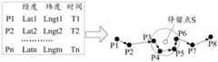
经济的快速发展,城市地下空间建设和维护成为保障城市和谐稳定的关键要素。现有的地下室定位技术主要有基于全球定位系统(Global Positioning System,GPS)的定位方式、利用基站测量报告(Measurement Report,MR)数据进行定位计算的技术、以及外部数据表示法(External Data Representation,XDR)数据和MR关联定位的方式。其中,利用全球定位系统(Global Positioning System,GPS)定位技术对手机进行定位的一种常见的定位技术。基于GPS的定位方式是利用手机上的GPS定位模块将自己的位置信号发送到定位后台来实现手机定位的。利用基站MR数据进行定位计算的技术是对定位数据进行栅格化处理,进行覆盖及建筑物渲染分析。利用XDR数据和MR关联定位的方式与基站定位方式类似,都需要采集XDR接入点的位置信息。将XDR中的时间信息等和MR时间点匹配(S1APID),进行MR位置信息写入,完成位置获取。With the rapid development of the economy, the construction and maintenance of urban underground space has become a key element to ensure the harmony and stability of the city. The existing basement positioning technologies mainly include the positioning method based on the Global Positioning System (GPS), the technology of using the base station measurement report (Measurement Report, MR) data for positioning calculation, and the external data representation (External Data Representation, XDR) data and MR correlation positioning. Among them, a common positioning technology for positioning a mobile phone using the Global Positioning System (Global Positioning System, GPS) positioning technology. The positioning method based on GPS is to use the GPS positioning module on the mobile phone to send its own position signal to the positioning background to realize the positioning of the mobile phone. The technology of using base station MR data for positioning calculation is to rasterize the positioning data and perform coverage and building rendering analysis. The method of using XDR data and MR correlation positioning is similar to the base station positioning method, and both need to collect the location information of the XDR access point. Match the time information in the XDR with the MR time point (S1APID), write the MR position information, and complete the position acquisition.
现有定位技术定位精度有限。传统通用GPS技术在室内场景因搜星进度慢及卫星定位难度大,误差极高。基站MR数据定位(指纹库)精度很大程度依赖于基站的密度,有时误差会超过一公里,定位精度较差。对于XDR数据和MR关联定位的方式,由于是通过时间等信息模糊匹配,所以采样点会存在偏差匹配情况,而匹配度不高导致定位精度比较低。The positioning accuracy of the existing positioning technology is limited. Due to the slow progress of satellite search and the difficulty of satellite positioning in indoor scenarios, the traditional general-purpose GPS technology has extremely high errors. The accuracy of base station MR data positioning (fingerprint library) largely depends on the density of the base station, sometimes the error will exceed one kilometer, and the positioning accuracy is poor. For the way of XDR data and MR correlation positioning, due to the fuzzy matching of time and other information, there will be deviation matching of sampling points, and the low matching degree leads to relatively low positioning accuracy.
发明内容Contents of the invention
鉴于上述问题,本发明实施例提供了一种地下场景定位方法、装置、计算设备及计算机存储介质,克服了上述问题或者至少部分地解决了上述问题。In view of the above problems, embodiments of the present invention provide an underground scene positioning method, device, computing equipment, and computer storage medium, which overcome the above problems or at least partially solve the above problems.
根据本发明实施例的一个方面,提供了一种地下场景定位方法,所述方法包括:获取最小化路测数据,并根据用户轨迹惯性创建地下室虚拟栅格图层,其中,所述最小化路测数据中的采样点包括带经纬度信息的第一采样点和无经纬度信息的第二采样点;应用所述第一采样点对所述第二采样点进行迭代定位;根据定位后的所述第一采样点以所述第二采样点进行3D建模,构造指纹库;根据所述地下室虚拟栅格图层对所述指纹库中的所述采样点进行场景栅格化聚类,识别出弱覆盖区域和盲覆盖区域以进行网络规划。According to an aspect of an embodiment of the present invention, a method for locating an underground scene is provided, the method comprising: acquiring the minimized drive test data, and creating a basement virtual grid layer according to the inertia of the user trajectory, wherein the minimized drive The sampling points in the measurement data include a first sampling point with longitude and latitude information and a second sampling point without longitude and latitude information; apply the first sampling point to iteratively locate the second sampling point; according to the positioned first sampling point A sampling point is modeled in 3D with the second sampling point to construct a fingerprint database; the sampling points in the fingerprint database are subjected to scene grid clustering according to the virtual grid layer of the basement, and weak points are identified. Coverage areas and blind coverage areas for network planning.
在一种可选的方式中,所述根据用户轨迹惯性创建地下室虚拟栅格图层,包括:根据所述最小化路测数据基于用户轨迹惯性获取每个用户的停留点;应用密度聚类算法对不同用户轨迹的所述停留点进行层次化聚类,形成地下室虚拟栅格图层。In an optional manner, the creation of the basement virtual grid layer according to the inertia of the user trajectory includes: obtaining the stay point of each user based on the inertia of the user trajectory according to the minimized drive test data; applying a density clustering algorithm Hierarchical clustering is performed on the stay points of different user trajectories to form a basement virtual grid layer.
在一种可选的方式中,所述应用所述第一采样点对所述第二采样点进行迭代定位,包括:根据所述第二采样点的接收信号强度以及所述第一采样点的经纬度信息应用RSSI定位算法对所述第二采样点进行定位,获取所述第二采样点的经纬度信息;将已定位的所述第二采样点作为新的第一采样点,对其他的所述第二采样点进行定位,直至完成所有的所述第二采样点的定位;应用传播模型和极限模拟算法对获取的所述第二采样点的经纬度信息进行矫正。In an optional manner, the applying the first sampling point to iteratively locate the second sampling point includes: according to the received signal strength of the second sampling point and the received signal strength of the first sampling point The longitude and latitude information applies the RSSI positioning algorithm to locate the second sampling point, and obtain the longitude and latitude information of the second sampling point; use the positioned second sampling point as a new first sampling point, and use the positioned second sampling point as a new first sampling point for other described The second sampling point is positioned until the positioning of all the second sampling points is completed; the obtained latitude and longitude information of the second sampling point is corrected by applying a propagation model and a limit simulation algorithm.
在一种可选的方式中,所述根据所述第二采样点的接收信号强度以及所述第一采样点的经纬度信息应用RSSI定位算法对所述第二采样点进行定位,获取所述第二采样点的经纬度信息,包括:以所述第一采样点为参考点,根据所述第二采样点的接收信号强度应用RSSI定位算法获取所述第二采样点与多个所述参考点的距离;根据所述第二采样点与多个所述参考点的距离以及所述参考点的经纬度信息获取所述第二采样点的经纬度信息。In an optional manner, the RSSI positioning algorithm is used to locate the second sampling point according to the received signal strength of the second sampling point and the latitude and longitude information of the first sampling point, and obtain the first sampling point The latitude and longitude information of the two sampling points includes: using the first sampling point as a reference point, applying the RSSI positioning algorithm according to the received signal strength of the second sampling point to obtain the distance between the second sampling point and a plurality of the reference points Distance: acquiring the latitude and longitude information of the second sampling point according to the distances between the second sampling point and multiple reference points and the latitude and longitude information of the reference points.
在一种可选的方式中,所述应用传播模型和数据极限模拟算法对获取的所述第二采样点的经纬度信息进行矫正,包括:根据测量报告数据应用训练后的所述传播模型和神经网络算法对所述第二采样点的经纬度信息进行训练矫正;根据用户轨迹的连续性应用极限模拟算法对所述第二采样点的经纬度信息进行纠偏。In an optional manner, the applying the propagation model and the data limit simulation algorithm to correct the obtained longitude and latitude information of the second sampling point includes: applying the trained propagation model and neural network according to the measurement report data. The network algorithm trains and corrects the latitude and longitude information of the second sampling point; and corrects the latitude and longitude information of the second sampling point by applying a limit simulation algorithm according to the continuity of the user trajectory.
在一种可选的方式中,所述根据所述地下室虚拟栅格图层对所述指纹库中的所述采样点进行场景栅格化聚类,识别出弱覆盖区域以进行网络规划,包括:将所述指纹库中的所述采样点撒入到所述地下室虚拟栅格图层内;应用密度聚类算法对栅格内的采样点进行聚簇,输出栅格化的覆盖结果,包括弱覆盖栅格及盲覆盖栅格;应用栅格聚类算法对所述弱覆盖栅格和所述盲覆盖栅格进行聚类,输出所述弱覆盖区域和所述盲覆盖区域。In an optional manner, performing scene grid clustering on the sampling points in the fingerprint library according to the basement virtual grid layer, identifying weak coverage areas for network planning, including : Scatter the sampling points in the fingerprint database into the virtual grid layer of the basement; apply a density clustering algorithm to cluster the sampling points in the grid, and output a gridded coverage result, including A weak coverage grid and a blind coverage grid; clustering the weak coverage grid and the blind coverage grid by applying a grid clustering algorithm, and outputting the weak coverage area and the blind coverage area.
在一种可选的方式中,所述应用栅格聚类算法对所述弱覆盖栅格和所述盲覆盖栅格进行聚类,输出所述弱覆盖区域和所述盲覆盖区域,包括:以每个栅格点为圆心,画一个预设半径的圆圈,作为所述栅格点的邻域;计算所述圆圈内栅格点的数量,如果所述数量超过预设密度阈值,则确定圆心对应的所述栅格点为核心点;对不同的核心点以及对应的邻域根据密度连接的传递性进行连接聚类,形成所述弱覆盖区域和所述盲覆盖区域,其中,所述密度连接的传递性包括:所述核心点与对应的邻域中的栅格点密度直达,所述核心点对应的邻域中不同的两个栅格点密度可达,与同一个栅格点密度可达的两个不同栅格点密度相连。In an optional manner, the applying a grid clustering algorithm to cluster the weak coverage grid and the blind coverage grid, and output the weak coverage area and the blind coverage area, including: With each grid point as the center, draw a circle with a preset radius as the neighborhood of the grid point; calculate the number of grid points in the circle, and if the number exceeds the preset density threshold, determine The grid point corresponding to the center of the circle is a core point; different core points and corresponding neighborhoods are connected and clustered according to the transitivity of the density connection to form the weak coverage area and the blind coverage area, wherein the The transitivity of the density connection includes: the core point is directly connected to the grid point density in the corresponding neighborhood, two different grid point densities in the neighborhood corresponding to the core point are reachable, and the same grid point Two different grid points with a density reachable density are connected.
根据本发明实施例的另一个方面,提供了一种地下场景定位装置,所述装置包括:栅格创建单元,用于获取最小化路测数据,并根据用户轨迹惯性创建地下室虚拟栅格图层,其中,所述最小化路测数据中的采样点包括带经纬度信息的第一采样点和无经纬度信息的第二采样点;迭代定位单元,用于应用所述第一采样点对所述第二采样点进行迭代定位;3D建模单元,用于根据定位后的所述第一采样点以所述第二采样点进行3D建模,构造指纹库;栅格聚类单元,用于根据所述地下室虚拟栅格图层对所述指纹库中的所述采样点进行场景栅格化聚类,识别出弱覆盖区域和盲覆盖区域以进行网络规划。According to another aspect of the embodiments of the present invention, there is provided an underground scene positioning device, the device includes: a grid creation unit, used to obtain the minimum drive test data, and create a basement virtual grid layer according to the inertia of the user trajectory , wherein the sampling points in the minimized drive test data include a first sampling point with latitude and longitude information and a second sampling point without latitude and longitude information; an iterative positioning unit is configured to apply the first sampling point to the first sampling point The two sampling points are iteratively positioned; the 3D modeling unit is used to perform 3D modeling with the second sampling point according to the positioned first sampling point to construct a fingerprint library; the grid clustering unit is used to according to the location. The basement virtual grid layer performs scene grid clustering on the sampling points in the fingerprint library, and identifies weak coverage areas and blind coverage areas for network planning.
根据本发明实施例的另一方面,提供了一种计算设备,包括:处理器、存储器、通信接口和通信总线,所述处理器、所述存储器和所述通信接口通过所述通信总线完成相互间的通信;According to another aspect of the embodiments of the present invention, a computing device is provided, including: a processor, a memory, a communication interface, and a communication bus, and the processor, the memory, and the communication interface complete the mutual communication via the communication bus. communication between
所述存储器用于存放至少一可执行指令,所述可执行指令使所述处理器执行上述地下场景定位方法的步骤。The memory is used to store at least one executable instruction, and the executable instruction causes the processor to execute the steps of the above-mentioned underground scene positioning method.
根据本发明实施例的又一方面,提供了一种计算机存储介质,所述存储介质中存储有至少一可执行指令,所述可执行指令使所述处理器执行上述地下场景定位方法的步骤。According to yet another aspect of the embodiments of the present invention, a computer storage medium is provided, wherein at least one executable instruction is stored in the storage medium, and the executable instruction causes the processor to execute the steps of the above-mentioned method for locating an underground scene.
本发明实施例通过获取最小化路测数据,并根据用户轨迹惯性创建地下室虚拟栅格图层,其中,所述最小化路测数据中的采样点包括带经纬度信息的第一采样点和无经纬度信息的第二采样点;应用所述第一采样点对所述第二采样点进行迭代定位;根据定位后的所述第一采样点以所述第二采样点进行3D建模,获取每个采样点的接收信号强度,构造指纹库;根据所述地下室虚拟栅格图层对所述指纹库中的所述采样点进行场景栅格化聚类,识别出弱覆盖区域和盲覆盖区域以进行网络规划,能够提高定位精度,促进对地下室的网络规划。In the embodiment of the present invention, the basement virtual grid layer is created by acquiring the minimized drive test data and according to the inertia of the user trajectory, wherein the sampling points in the minimized drive test data include the first sampling point with latitude and longitude information and the first sampling point without latitude and longitude The second sampling point of information; apply the first sampling point to iteratively locate the second sampling point; perform 3D modeling with the second sampling point according to the positioned first sampling point, and obtain each The received signal strength of the sampling point constructs a fingerprint library; the scene grid clustering is carried out to the sampling points in the fingerprint library according to the basement virtual grid layer, and the weak coverage area and the blind coverage area are identified to perform Network planning can improve positioning accuracy and promote network planning for basements.
上述说明仅是本发明实施例技术方案的概述,为了能够更清楚了解本发明实施例的技术手段,而可依照说明书的内容予以实施,并且为了让本发明实施例的上述和其它目的、特征和优点能够更明显易懂,以下特举本发明的具体实施方式。The above description is only an overview of the technical solutions of the embodiments of the present invention. In order to better understand the technical means of the embodiments of the present invention, it can be implemented according to the contents of the description, and in order to make the above and other purposes, features and The advantages can be more obvious and understandable, and the specific embodiments of the present invention are enumerated below.
附图说明Description of drawings
通过阅读下文优选实施方式的详细描述,各种其他的优点和益处对于本领域普通技术人员将变得清楚明了。附图仅用于示出优选实施方式的目的,而并不认为是对本发明的限制。而且在整个附图中,用相同的参考符号表示相同的部件。在附图中:Various other advantages and benefits will become apparent to those of ordinary skill in the art upon reading the following detailed description of the preferred embodiment. The drawings are only for the purpose of illustrating a preferred embodiment and are not to be considered as limiting the invention. Also throughout the drawings, the same reference numerals are used to designate the same parts. In the attached picture:
图1示出了本发明实施例提供的地下场景定位方法的流程示意图;FIG. 1 shows a schematic flowchart of an underground scene positioning method provided by an embodiment of the present invention;
图2示出了本发明实施例提供的地下场景定位方法的虚拟栅格图层创建流程示意图;Fig. 2 shows a schematic flow chart of creating a virtual grid layer of an underground scene positioning method provided by an embodiment of the present invention;
图3示出了本发明实施例提供的地下场景定位方法的单个用户轨迹示意图;Fig. 3 shows a schematic diagram of a single user trajectory of an underground scene positioning method provided by an embodiment of the present invention;
图4示出了本发明实施例提供的地下场景定位方法的虚拟栅格图层示意图;FIG. 4 shows a schematic diagram of a virtual grid layer of an underground scene positioning method provided by an embodiment of the present invention;
图5示出了本发明实施例提供的地下场景定位方法的迭代定位流程示意图;Fig. 5 shows a schematic diagram of the iterative positioning process of the underground scene positioning method provided by the embodiment of the present invention;
图6示出了本发明实施例提供的地下场景定位方法的多点定位示意图;FIG. 6 shows a schematic diagram of multipoint positioning of an underground scene positioning method provided by an embodiment of the present invention;
图7示出了本发明实施例提供的地下场景定位方法的极限模拟算法示意图;Fig. 7 shows a schematic diagram of the limit simulation algorithm of the underground scene positioning method provided by the embodiment of the present invention;
图8示出了本发明实施例提供的地下场景定位方法的栅格聚类流程示意图;Fig. 8 shows a schematic diagram of the grid clustering flow chart of the underground scene positioning method provided by the embodiment of the present invention;
图9示出了本发明实施例提供的地下场景定位方法的核心点示意图;Fig. 9 shows a schematic diagram of core points of an underground scene positioning method provided by an embodiment of the present invention;
图10示出了本发明实施例提供的地下场景定位装置的结构示意图;Fig. 10 shows a schematic structural diagram of an underground scene positioning device provided by an embodiment of the present invention;
图11示出了本发明实施例提供的计算设备的结构示意图。Fig. 11 shows a schematic structural diagram of a computing device provided by an embodiment of the present invention.
具体实施方式Detailed ways
下面将参照附图更详细地描述本发明的示例性实施例。虽然附图中显示了本发明的示例性实施例,然而应当理解,可以以各种形式实现本发明而不应被这里阐述的实施例所限制。相反,提供这些实施例是为了能够更透彻地理解本发明,并且能够将本发明的范围完整的传达给本领域的技术人员。Exemplary embodiments of the present invention will be described in more detail below with reference to the accompanying drawings. Although exemplary embodiments of the present invention are shown in the drawings, it should be understood that the invention may be embodied in various forms and should not be limited to the embodiments set forth herein. Rather, these embodiments are provided for more thorough understanding of the present invention and to fully convey the scope of the present invention to those skilled in the art.
图1示出了本发明实施例提供的地下场景定位方法的流程示意图。如图1所示,该地下场景定位方法应用在基站或服务器上,具体包括:Fig. 1 shows a schematic flowchart of a method for locating an underground scene provided by an embodiment of the present invention. As shown in Figure 1, the underground scene positioning method is applied on a base station or a server, and specifically includes:
步骤S11:获取最小化路测数据,并根据用户轨迹惯性创建地下室虚拟栅格图层,其中,所述最小化路测数据中的采样点包括带经纬度信息的第一采样点和无经纬度信息的第二采样点。Step S11: Acquire the minimized drive test data, and create a basement virtual grid layer according to the inertia of the user trajectory, wherein the sampling points in the minimized drive test data include the first sampling point with latitude and longitude information and the first sampling point without latitude and longitude information the second sampling point.
在本发明实施例中,接收终端发送的最小化路测(Minimization of Drive-Test,MDT)数据,根据MDT中高度信息轨迹判断出用户进入地下室中,并关联对应时间的MR数据信息。基于前期抽样调研数据统计来看,用户驱车或步行进入地下场景或地下室时,在地下室停留平均时长为5分钟。5分钟后,会通过电梯、楼梯方式离开地下室进入其他楼层。因此,依据客户轨迹惯性的特性,标记用户在地下室中5分钟内的所有采样点信息(后续作为地下室栅格化的主要采样点数据)。选取大量用户进入地下场景5分钟内的采样点数据建立用户轨迹惯性模型,以此模型清洗后的数据进行地下室场景建模,创建地下室虚拟栅格图层。本发明实施例应用智能管控系统,拥有较高的自动运行机制,可在设置采集时间、基站列表、采集服务器等信息后,自动进行数据处理工作。在本发明实施例中,MDT数据的获取可以为基站或服务器,而后续对MDT数据的处理以及各算法的应用可以为物理机(基站或服务器),或能够与物理机进行通信的云计算平台。In the embodiment of the present invention, the Minimization of Drive-Test (MDT) data sent by the terminal is received, and the user is determined to enter the basement according to the altitude information track in the MDT, and the MR data information corresponding to the time is associated. Based on the statistics of previous sampling survey data, when users drive or walk into underground scenes or basements, they stay in the basement for an average of 5 minutes. After 5 minutes, you will leave the basement and enter other floors through elevators and stairs. Therefore, according to the characteristics of the inertia of the customer trajectory, all the sampling point information of the user in the basement within 5 minutes is marked (subsequently used as the main sampling point data for rasterization of the basement). A large number of sampling point data within 5 minutes of users entering the underground scene are selected to establish a user trajectory inertial model, and the data cleaned by this model is used to model the basement scene and create a basement virtual grid layer. The embodiment of the present invention applies an intelligent management and control system, which has a relatively high automatic operation mechanism, and can automatically perform data processing after setting collection time, base station list, collection server and other information. In the embodiment of the present invention, the acquisition of MDT data can be a base station or a server, and the subsequent processing of the MDT data and the application of each algorithm can be a physical machine (base station or server), or a cloud computing platform capable of communicating with a physical machine .
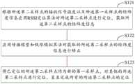
在步骤S11中,如图2所示,包括:In step S11, as shown in Figure 2, including:
步骤S111:根据所述最小化路测数据基于用户轨迹惯性获取每个用户的停留点。Step S111: Obtain the stay point of each user based on the inertia of the user trajectory according to the minimized drive test data.
MDT数据包含用户位置信息,利用MDT数据记录用户每次的位置信息轨迹,一条轨迹通常由一系列带有时间戳的坐标点组成。每个坐标点包含了经度、纬度等基本信息,在一条轨迹中,检测出一些用户停留过的地方。停留点并不是指速度为零的点,而是在任一区域内用户滞留时间超过预设时间范围的点的集合,由一组实际的GPS点构成。如图3为一个用户的轨迹示意图,图中P3、P4、P5、P6构成了一个停留点S,表示用户在虚线框所示的区域内滞留的时间超过了预设的时间范围。区域的大小以及预设时间范围都可以根据需要进行设置,在此不作限制。MDT data contains user location information. MDT data is used to record the user's location information track each time. A track usually consists of a series of coordinate points with time stamps. Each coordinate point contains basic information such as longitude and latitude. In a track, some places where users have stayed are detected. The stay point does not refer to the point where the speed is zero, but a collection of points where the user's stay time exceeds the preset time range in any area, consisting of a group of actual GPS points. Figure 3 is a schematic diagram of a user's trajectory. In the figure, P3, P4, P5, and P6 constitute a stay point S, indicating that the user stays in the area shown by the dotted line box for more than the preset time range. Both the size of the region and the preset time range can be set as required, and are not limited here.
步骤S112:应用密度聚类算法对不同用户轨迹的所述停留点进行层次化聚类,形成地下室虚拟栅格图层。Step S112: applying a density clustering algorithm to hierarchically cluster the stay points of different user trajectories to form a basement virtual grid layer.
如图4所示,从每个用户的每条线路中提取出停留点(在图中表示为黑色小点),并放在一个集合中。利用具有噪声的基于密度的聚类(Density-Based Spatial Clusteringof Applications with Noise,DBSCAN)算法对个停留点集合进行层次化聚类,在不同的地理尺度上,将相近的停留点划分到同一个聚类(图中白色节点),如此可以得到如图右半部分所示的一个层次树。树中的节点代表不同的停留点聚类,而不同层次表示不同的地理空间尺度。层次越深,粒度越细,代表的地理空间也越小,将不同用户的轨迹映射到该树的各个层次,并将不同的聚类连接起来,得到不同的图模型(参见图4左半部分)。As shown in Figure 4, the stay points (shown as small black dots in the figure) are extracted from each line of each user and placed in a set. Use the Density-Based Spatial Clustering of Applications with Noise (DBSCAN) algorithm to perform hierarchical clustering on a set of stay points, and divide similar stay points into the same cluster on different geographical scales. class (the white node in the figure), so that a hierarchical tree as shown in the right half of the figure can be obtained. Nodes in the tree represent different clusters of stay points, while different levels represent different geospatial scales. The deeper the level, the finer the granularity, and the smaller the geographical space it represents. Map the trajectories of different users to each level of the tree, and connect different clusters to obtain different graph models (see the left half of Figure 4 ).
步骤S12:应用所述第一采样点对所述第二采样点进行迭代定位。Step S12: Applying the first sampling point to iteratively locate the second sampling point.
在本发明实施例中,采用“基于RSSI测距多点定位算法”和“神经元网络定位技术”相结合方式,建立多维数据关联补充和迭代矫正模型,利用现有指纹库进行智能多点定位计算,利用传播模型训练算法对新指纹库进行智能矫正训练,提升采样点定位精准度。具体地,如图5所示,包括:In the embodiment of the present invention, a combination of "multi-point positioning algorithm based on RSSI distance measurement" and "neural network positioning technology" is adopted to establish a multi-dimensional data association supplement and iterative correction model, and use the existing fingerprint database to perform intelligent multi-point positioning Calculate, use the propagation model training algorithm to carry out intelligent correction training on the new fingerprint database, and improve the positioning accuracy of sampling points. Specifically, as shown in Figure 5, including:
步骤S121:根据所述第二采样点的接收信号强度以及所述第一采样点的经纬度信息应用RSSI定位算法对所述第二采样点进行定位,获取所述第二采样点的经纬度信息。Step S121: Apply the RSSI positioning algorithm to locate the second sampling point according to the received signal strength of the second sampling point and the latitude and longitude information of the first sampling point, and obtain the latitude and longitude information of the second sampling point.
RSSI定位算法的原理如下:通过大量工程实践可以发现,无线信号传播服从概率分布,并可归纳出无线信号传播的概率模型:Shadowing模型,其一般形式为Pr(d)=pr(d0)-10nlg(d/d0)+XdBm,其中,pr(d)为收发节点距离为d时的接收信号强度(单位为dBm),d0为收发节点的参考距离,n为由环境决定的路径损耗指数。The principle of RSSI positioning algorithm is as follows: Through a large number of engineering practices, it can be found that wireless signal propagation obeys probability distribution, and the probability model of wireless signal propagation can be summarized: Shadowing model, its general form is Pr(d)=pr(d0)-10nlg (d/d0)+XdBm, where pr(d) is the received signal strength (in dBm) when the distance between the transmitting and receiving nodes is d, d0 is the reference distance of the transmitting and receiving nodes, and n is the path loss index determined by the environment.
在实际应用中,可采用简化的Shadowing模型为:PRSSI=P0–10nlg(d/d0),式中,d0=1m,PRSSI为接收节点接收到的RSSI值(单位为dBm),P0为信号传输1m远处接收信号的功率。In practical applications, the simplified Shadowing model can be used as: PRSSI=P0–10nlg(d/d0), where d0=1m, PRSSI is the RSSI value (in dBm) received by the receiving node, and P0 is the signal transmission The power of the received signal at a distance of 1m.
为了便于表达和计算,通常取d0为1m。于是可得:RSSI=A–10nlg(d),其中,A为收发节点相距1m时接收节点接收到的无线信号强度RSSI值,d即为所要求的节点间的距离。A和n都是经验值,和具体使用的硬件节点、无线信号传播的环境密切相关。因此在不同的实际环境下A和n参数不同,其测距模型也不同。但在充分研究环境因素的影响后,RSSI可以用来进行室内和室外的测距及定位。For the convenience of expression and calculation, d0 is usually taken as 1m. Then it can be obtained: RSSI=A–10nlg(d), where A is the RSSI value of the wireless signal strength received by the receiving node when the transmitting and receiving nodes are 1m apart, and d is the required distance between nodes. Both A and n are empirical values, which are closely related to the specific hardware nodes used and the environment of wireless signal propagation. Therefore, the A and n parameters are different in different actual environments, and the ranging models are also different. However, after fully studying the influence of environmental factors, RSSI can be used for indoor and outdoor ranging and positioning.
在步骤S121中,以所述第一采样点为参考点,根据所述第二采样点的接收信号强度应用RSSI定位算法获取所述第二采样点与多个所述参考点的距离;根据所述第二采样点与多个所述参考点的距离以及所述参考点的经纬度信息获取所述第二采样点的经纬度信息。首先确定以上RSSI定位计算公式中的A和n的值,建立室内测距模型,根据该室内测距模型将第二采样点的接收信号强度转化为距离,分别计算第二采样点与多个不同所述参考点的距离。应用最小二乘法对计算得到的距离进行修正,然后根据第二采样点与多个不同的参考点的距离以及参考点的经纬度信息获取第二采样点的经纬度信息。如图6所示,根据第二采样点MS分别与参考点D1、D2、D3、D4、D5的距离以及参考点D1、D2、D3、D4、D5的坐标得到第二采样点MS的坐标(经纬度信息)。In step S121, using the first sampling point as a reference point, apply the RSSI positioning algorithm according to the received signal strength of the second sampling point to obtain the distance between the second sampling point and a plurality of the reference points; The latitude and longitude information of the second sampling point is obtained by using the distance between the second sampling point and the plurality of reference points and the latitude and longitude information of the reference points. First determine the values of A and n in the above RSSI positioning calculation formula, establish an indoor ranging model, convert the received signal strength of the second sampling point into a distance according to the indoor ranging model, and calculate the distance between the second sampling point and multiple different The distance from the reference point. The calculated distance is corrected by the least square method, and then the latitude and longitude information of the second sampling point is obtained according to the distances between the second sampling point and multiple different reference points and the latitude and longitude information of the reference points. As shown in Figure 6, obtain the coordinates of the second sampling point MS according to the distance between the second sampling point MS and the reference points D1, D2, D3, D4, D5 and the coordinates of the reference points D1, D2, D3, D4, D5 respectively ( latitude and longitude information).
步骤S122:将已定位的所述第二采样点作为新的第一采样点,对其他的所述第二采样点进行定位,直至完成所有的所述第二采样点的定位。Step S122: Use the located second sampling point as a new first sampling point, and locate other second sampling points until all the positioning of the second sampling points is completed.
在本发明实施例中,从地下场景的外围向里进行迭代定位,即地下场景最外围的采样点的经纬度信息是已知的,以这些采样点为第一采样点,对位于内侧的靠近这些采样点的第二采样点进行定位,如此逐步向里迭代,直至完成无经纬度信息的所有第二采样点的定位。In the embodiment of the present invention, iterative positioning is performed from the periphery of the underground scene to the inside, that is, the latitude and longitude information of the sampling points in the outermost part of the underground scene is known, and these sampling points are used as the first sampling points, and those located on the inner side near these The second sampling point of the sampling point is positioned, and iterates inwards step by step until the positioning of all the second sampling points without longitude and latitude information is completed.
步骤S123:应用传播模型和极限模拟算法对获取的所述第二采样点的经纬度信息进行矫正。Step S123: Correct the obtained latitude and longitude information of the second sampling point by applying the propagation model and the limit simulation algorithm.
在本发明实施例中,利用现有的指纹库数据进行神经网络和场强定位,同时结合用户的特点,切换关系对定位结果进行粗大误差剔除以及空间聚合,从而更加提高用户的定位精度。在步骤S123中,根据测量报告数据应用训练后的所述传播模型和神经网络算法对所述第二采样点的经纬度信息进行训练矫正;根据用户轨迹的连续性应用极限模拟算法对所述第二采样点的经纬度信息进行纠偏。具体地,应用数据处理技术(Data technology,DT)和自动路测工具(Auxiliary Test Unit,ATU)将第二采样点MS的经纬度信息调整成传播模型的输入数据格式,经传播模型处理后结合MR数据应用神经网络算法进行MR定位,实现对第二采样点的经纬度信息进行训练矫正。其中,传播模型和神经网络算法需要预先应用准备好的训练数据集进行训练,配置合适的模型参数,并保存训练结果。In the embodiment of the present invention, the existing fingerprint library data is used for neural network and field strength positioning, and at the same time combined with the user's characteristics, the switching relationship performs coarse error elimination and spatial aggregation on the positioning results, thereby further improving the user's positioning accuracy. In step S123, apply the trained propagation model and neural network algorithm according to the measurement report data to train and correct the latitude and longitude information of the second sampling point; The longitude and latitude information of the sampling point is used to correct the deviation. Specifically, apply data processing technology (Data technology, DT) and automatic drive test tool (Auxiliary Test Unit, ATU) to adjust the latitude and longitude information of the second sampling point MS into the input data format of the propagation model, and combine the MR The neural network algorithm is applied to the data for MR positioning, and the training and correction of the latitude and longitude information of the second sampling point is realized. Among them, the propagation model and the neural network algorithm need to apply the prepared training data set for training in advance, configure appropriate model parameters, and save the training results.
然后根据用户轨迹的连续性采用数据逼近原则利用极限模拟算法对所述第二采样点的经纬度信息进行纠偏。由于信号的波动或邻区缺失等等数据异常可能会导致结果偏差,考虑到同一个用户在同一个小区,在某段时间内其位置具有连续性,同时还可以通过切换关系等预知信息对定位结果进行更细致的纠正,从而使得定位误差最小。如图7所示,左图为调整前的第二采样点的样本定位结果,右图为调整后的第二采样点的样本定位结果。Then, according to the continuity of the user trajectory, the deviation of the latitude and longitude information of the second sampling point is corrected by using the principle of data approximation and using the limit simulation algorithm. Data anomalies such as signal fluctuations or lack of adjacent cells may lead to deviations in results. Considering that the same user is in the same cell, its location has continuity within a certain period of time, and at the same time, the location can be determined by predicting information such as switching relationships. As a result, finer corrections are made to minimize positioning errors. As shown in FIG. 7 , the left picture shows the sample positioning result of the second sampling point before adjustment, and the right picture shows the sample positioning result of the second sampling point after adjustment.
本发明实施例采用“RSSI多点定位算法”和“神经元网络定位算法”相结合方式,同时对现有定位数据进行传播模型训练矫正和传播极限模拟算法的双重矫正,提高定位精度。The embodiment of the present invention adopts the combination method of "RSSI multi-point positioning algorithm" and "neuron network positioning algorithm", and performs double correction of propagation model training correction and propagation limit simulation algorithm on the existing positioning data at the same time, so as to improve positioning accuracy.
步骤S13:根据定位后的所述第一采样点以所述第二采样点进行3D建模,构造指纹库。Step S13: Perform 3D modeling with the second sampling points according to the positioned first sampling points to construct a fingerprint library.
在本发明实施例中,利用射线跟踪法,基于三维地图、网络工参、天线特性、发射功率等实际网络数据,建立全网的立体覆盖指纹库。计算出三维空间中每一个地理采样点(bin)中,所有基站到达的接收信号强度,每个采样点,包括第一采样点和第二采样点,接收到的小区及其接收信号强度的集合都是独一无二的,相当于每个采样点都有独特的“指纹”。In the embodiment of the present invention, a three-dimensional coverage fingerprint library of the entire network is established based on actual network data such as 3D maps, network parameters, antenna characteristics, and transmission power by using ray tracing method. Calculate the received signal strength of all base stations in each geographical sampling point (bin) in the three-dimensional space, each sampling point, including the first sampling point and the second sampling point, the received cell and its received signal strength set All are unique, equivalent to each sampling point has a unique "fingerprint".
步骤S14:根据所述地下室虚拟栅格图层对所述指纹库中的所述采样点进行场景栅格化聚类,识别出弱覆盖区域和盲覆盖区域以进行网络规划。Step S14: Perform scene grid clustering on the sampling points in the fingerprint database according to the basement virtual grid layer, and identify weak coverage areas and blind coverage areas for network planning.
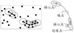
具体地,引入栅格化定位,降低“点”级定位复杂度。将所述指纹库中的所述采样点撒入到所述地下室虚拟栅格图层内;应用密度聚类算法对栅格内的采样点进行聚簇,输出栅格化的覆盖结果,包括弱覆盖栅格及盲覆盖栅格。具体根据栅格内采样点的接收信号强度确定该栅格为深度覆盖栅格、弱覆盖栅格、或者盲覆盖栅格。最后应用栅格聚类算法对所述弱覆盖栅格和所述盲覆盖栅格进行聚类,输出所述弱覆盖区域和所述盲覆盖区域。Specifically, grid positioning is introduced to reduce the complexity of "point" level positioning. Scatter the sampling points in the fingerprint database into the virtual grid layer of the basement; apply the density clustering algorithm to cluster the sampling points in the grid, and output the gridded coverage results, including weak Coverage grid and blind coverage grid. Specifically, the grid is determined to be a deep coverage grid, a weak coverage grid, or a blind coverage grid according to the received signal strength of the sampling points in the grid. Finally, a grid clustering algorithm is applied to cluster the weak coverage grid and the blind coverage grid, and output the weak coverage area and the blind coverage area.
在本发明实施例中,应用基于密度的栅格聚类DBSCAN算法对弱覆盖栅格和盲覆盖栅格进行聚类。DBSCAN算法通常用于对带有噪声的空间数据进行聚类。基于密度的聚类是根据样本的密度分布来进行聚类。通常情况下,密度聚类从样本密度的角度出来,来考查样本之间的可连接性,并基于可连接样本不断扩展聚类簇,以获得最终的聚类结果。DBSCAN算法有两个参数:半径eps和密度阈值MinPts。具体步骤如图8所示,包括:In the embodiment of the present invention, the density-based grid clustering DBSCAN algorithm is used to cluster weak coverage grids and blind coverage grids. The DBSCAN algorithm is usually used for clustering spatial data with noise. Density-based clustering is clustering based on the density distribution of samples. Usually, density clustering examines the connectivity between samples from the perspective of sample density, and continuously expands clusters based on connected samples to obtain the final clustering results. The DBSCAN algorithm has two parameters: radius eps and density threshold MinPts. The specific steps are shown in Figure 8, including:
步骤S141:以每个栅格点为圆心,画一个预设半径的圆圈,作为所述栅格点的邻域。Step S141: Taking each grid point as the center, draw a circle with a preset radius as the neighborhood of the grid point.
以每个栅格点

步骤S142:计算所述圆圈内栅格点的数量,如果所述数量超过预设密度阈值,则确定圆心对应的所述栅格点为核心点。Step S142: Calculate the number of grid points in the circle, and if the number exceeds a preset density threshold, determine the grid point corresponding to the center of the circle as a core point.
对圆圈内包含的栅格点进行计数。如图9所示,如果圆圈内的栅格点的数量超过了密度阈值MinPts,则将该圆圈的圆心记为核心点,又称核心对象。如果某个栅格点的eps邻域内点的数量小于密度阈值MinPts,但是落在该核心点的邻域内,则该栅格点称为边缘点。既不是核心点也不是边缘点的栅格点称为噪声点。Count the grid points contained within the circle. As shown in FIG. 9 , if the number of grid points in a circle exceeds the density threshold MinPts, the center of the circle is recorded as a core point, also called a core object. If the number of points in the eps neighborhood of a certain grid point is less than the density threshold MinPts, but falls within the neighborhood of the core point, the grid point is called an edge point. Grid points that are neither core points nor edge points are called noise points.
步骤S143:对不同的核心点以及对应的邻域根据密度连接的传递性进行连接聚类,形成所述弱覆盖区域和所述盲覆盖区域,其中,所述密度连接的传递性包括:所述核心点与对应的邻域中的栅格点密度直达,所述核心点对应的邻域中不同的两个栅格点密度可达,与同一个栅格点密度可达的两个不同栅格点密度相连。Step S143: Perform connection clustering on different core points and corresponding neighborhoods according to the transitivity of density connections to form the weak coverage area and the blind coverage area, wherein the transitivity of the density connections includes: the The core point is directly connected to the grid point density in the corresponding neighborhood, the two different grid point densities in the neighborhood corresponding to the core point are reachable, and the same grid point density is reachable to two different grid points point density.
具体地,例如,核心点


在本发明实施例中,还可以应用物理机(基站或服务器)或与物理机连接的显示器以栅格化方式呈现覆盖渲染聚类簇,对MR数据完成定位后的结果,根据MR中的信息,如参考信号接收功率(Reference Signal Receiving Power,RSRP)\参考信号接收质量(Reference Signal Receiving Quality,RSRQ)\SAMPLES\上行信噪比(SINRUL)\弱覆盖率\重叠度等,根据颜色分段设置进行渲染显示,地理信息系统(Geographic InformationSystem,GIS)渲染效果有利于直观显示网络规划优化工作中识别网络弱覆盖、室内深度覆盖、用户感知差区域。识别出弱覆盖区域和盲覆盖区域后,可以根据弱覆盖区域和盲覆盖区域的分布对地下室进行网络规划,例如,布置无线接入点等。In the embodiment of the present invention, a physical machine (base station or server) or a display connected to the physical machine can also be used to present the overlay rendering cluster in a rasterized manner, and the result of positioning the MR data is based on the information in the MR , such as Reference Signal Receiving Power (Reference Signal Receiving Power, RSRP)\Reference Signal Receiving Quality (Reference Signal Receiving Quality, RSRQ)\SAMPLES\Uplink Signal-to-Noise Ratio (SINRUL)\weak coverage\overlap, etc., segmented according to color Set up for rendering display, and the rendering effect of Geographic Information System (GIS) is conducive to intuitively displaying network planning and optimization work to identify weak network coverage, indoor deep coverage, and poor user perception areas. After the weak coverage area and the blind coverage area are identified, network planning can be performed on the basement according to the distribution of the weak coverage area and the blind coverage area, for example, wireless access points are arranged.
本发明实施例通过获取最小化路测数据,并根据用户轨迹惯性创建地下室虚拟栅格图层,其中,所述最小化路测数据中的采样点包括带经纬度信息的第一采样点和无经纬度信息的第二采样点;应用所述第一采样点对所述第二采样点进行迭代定位;根据定位后的所述第一采样点以所述第二采样点进行3D建模,获取每个采样点的接收信号强度,构造指纹库;根据所述地下室虚拟栅格图层对所述指纹库中的所述采样点进行场景栅格化聚类,识别出弱覆盖区域和盲覆盖区域以进行网络规划,能够提高定位精度,促进对地下室的网络规划。In the embodiment of the present invention, the basement virtual grid layer is created by acquiring the minimized drive test data and according to the inertia of the user trajectory, wherein the sampling points in the minimized drive test data include the first sampling point with latitude and longitude information and the first sampling point without latitude and longitude The second sampling point of information; apply the first sampling point to iteratively locate the second sampling point; perform 3D modeling with the second sampling point according to the positioned first sampling point, and obtain each The received signal strength of the sampling point constructs a fingerprint library; the scene grid clustering is carried out to the sampling points in the fingerprint library according to the basement virtual grid layer, and the weak coverage area and the blind coverage area are identified to perform Network planning can improve positioning accuracy and promote network planning for basements.
图10示出了本发明实施例的地下场景定位装置的结构示意图。如图10所示,该地下场景定位装置应用在基站或服务器上,包括:栅格创建单元101、迭代定位单元102、3D建模单元103以及栅格聚类单元104。其中:Fig. 10 shows a schematic structural diagram of an underground scene positioning device according to an embodiment of the present invention. As shown in FIG. 10 , the underground scene positioning device is applied on a base station or a server, and includes: a grid creation unit 101 , an iterative positioning unit 102 , a 3D modeling unit 103 and a grid clustering unit 104 . in:
栅格创建单元101用于获取最小化路测数据,并根据用户轨迹惯性创建地下室虚拟栅格图层,其中,所述最小化路测数据中的采样点包括带经纬度信息的第一采样点和无经纬度信息的第二采样点;迭代定位单元102用于应用所述第一采样点对所述第二采样点进行迭代定位;3D建模单元103用于根据定位后的所述第一采样点以所述第二采样点进行3D建模,构造指纹库;栅格聚类单元104用于根据所述地下室虚拟栅格图层对所述指纹库中的所述采样点进行场景栅格化聚类,识别出弱覆盖区域和盲覆盖区域以进行网络规划。The grid creation unit 101 is used to obtain the minimized drive test data, and create a basement virtual grid layer according to the inertia of the user trajectory, wherein the sampling points in the minimized drive test data include the first sampling point with latitude and longitude information and The second sampling point without longitude and latitude information; the iterative positioning unit 102 is used to apply the first sampling point to iteratively locate the second sampling point; the 3D modeling unit 103 is used to locate the first sampling point according to Perform 3D modeling with the second sampling points to construct a fingerprint library; the grid clustering unit 104 is used to perform scene grid clustering on the sampling points in the fingerprint library according to the basement virtual grid layer class to identify weak coverage areas and blind coverage areas for network planning.
在一种可选的方式中,栅格创建单元101用于:根据所述最小化路测数据基于用户轨迹惯性获取每个用户的停留点;应用密度聚类算法对不同用户轨迹的所述停留点进行层次化聚类,形成地下室虚拟栅格图层。In an optional manner, the grid creation unit 101 is configured to: obtain the stay point of each user based on the inertia of the user trajectory according to the minimized drive test data; apply a density clustering algorithm to the stay points of different user trajectories Points are hierarchically clustered to form a basement virtual raster layer.
在一种可选的方式中,迭代定位单元102用于:根据所述第二采样点的接收信号强度以及所述第一采样点的经纬度信息应用RSSI定位算法对所述第二采样点进行定位,获取所述第二采样点的经纬度信息;将已定位的所述第二采样点作为新的第一采样点,对其他的所述第二采样点进行定位,直至完成所有的所述第二采样点的定位;应用传播模型和极限模拟算法对获取的所述第二采样点的经纬度信息进行矫正。In an optional manner, the iterative positioning unit 102 is configured to: apply the RSSI positioning algorithm to locate the second sampling point according to the received signal strength of the second sampling point and the latitude and longitude information of the first sampling point , to obtain the latitude and longitude information of the second sampling point; use the positioned second sampling point as a new first sampling point, and locate the other second sampling points until all the second sampling points are completed. Locating the sampling point; correcting the obtained latitude and longitude information of the second sampling point by using a propagation model and a limit simulation algorithm.
在一种可选的方式中,迭代定位单元102用于:以所述第一采样点为参考点,根据所述第二采样点的接收信号强度应用RSSI定位算法获取所述第二采样点与多个所述参考点的距离;根据所述第二采样点与多个所述参考点的距离以及所述参考点的经纬度信息获取所述第二采样点的经纬度信息。In an optional manner, the iterative positioning unit 102 is configured to: use the first sampling point as a reference point, apply the RSSI positioning algorithm to obtain the second sampling point and Distances of multiple reference points: acquiring the latitude and longitude information of the second sampling point according to the distances between the second sampling point and the multiple reference points and the latitude and longitude information of the reference points.
在一种可选的方式中,迭代定位单元102用于:根据测量报告数据应用训练后的所述传播模型和神经网络算法对所述第二采样点的经纬度信息进行训练矫正;根据用户轨迹的连续性应用极限模拟算法对所述第二采样点的经纬度信息进行纠偏。In an optional manner, the iterative positioning unit 102 is configured to: apply the trained propagation model and neural network algorithm to train and correct the latitude and longitude information of the second sampling point according to the measurement report data; Continuity applies a limit simulation algorithm to correct the latitude and longitude information of the second sampling point.
在一种可选的方式中,栅格聚类单元104用于:将所述指纹库中的所述采样点撒入到所述地下室虚拟栅格图层内;应用密度聚类算法对栅格内的采样点进行聚簇,输出栅格化的覆盖结果,包括弱覆盖栅格及盲覆盖栅格;应用栅格聚类算法对所述弱覆盖栅格和所述盲覆盖栅格进行聚类,输出所述弱覆盖区域和所述盲覆盖区域。In an optional manner, the grid clustering unit 104 is configured to: sprinkle the sampling points in the fingerprint library into the basement virtual grid layer; apply a density clustering algorithm to the grid Cluster the sampling points in the grid, and output gridded coverage results, including weak coverage grids and blind coverage grids; apply a grid clustering algorithm to cluster the weak coverage grids and the blind coverage grids , outputting the weak coverage area and the blind coverage area.
在一种可选的方式中,栅格聚类单元104用于:以每个栅格点为圆心,画一个预设半径的圆圈,作为所述栅格点的邻域;计算所述圆圈内栅格点的数量,如果所述数量超过预设密度阈值,则确定圆心对应的所述栅格点为核心点;对不同的核心点以及对应的邻域根据密度连接的传递性进行连接聚类,形成所述弱覆盖区域和所述盲覆盖区域,其中,所述密度连接的传递性包括:所述核心点与对应的邻域中的栅格点密度直达,所述核心点对应的邻域中不同的两个栅格点密度可达,与同一个栅格点密度可达的两个不同栅格点密度相连。In an optional manner, the grid clustering unit 104 is configured to: take each grid point as the center, draw a circle with a preset radius as the neighborhood of the grid point; calculate The number of grid points, if the number exceeds the preset density threshold, determine the grid point corresponding to the center of the circle as the core point; perform connection clustering on different core points and corresponding neighborhoods according to the transitivity of the density connection , forming the weak coverage area and the blind coverage area, wherein the transitivity of the density connection includes: the core point is directly connected to the grid point density in the corresponding neighborhood, and the neighborhood corresponding to the core point Two different grid point densities in , are connected to two different grid point densities with the same grid point density reachable.
本发明实施例通过获取最小化路测数据,并根据用户轨迹惯性创建地下室虚拟栅格图层,其中,所述最小化路测数据中的采样点包括带经纬度信息的第一采样点和无经纬度信息的第二采样点;应用所述第一采样点对所述第二采样点进行迭代定位;根据定位后的所述第一采样点以所述第二采样点进行3D建模,获取每个采样点的接收信号强度,构造指纹库;根据所述地下室虚拟栅格图层对所述指纹库中的所述采样点进行场景栅格化聚类,识别出弱覆盖区域和盲覆盖区域以进行网络规划,能够提高定位精度,促进对地下室的网络规划。In the embodiment of the present invention, the basement virtual grid layer is created by acquiring the minimized drive test data and according to the inertia of the user trajectory, wherein the sampling points in the minimized drive test data include the first sampling point with latitude and longitude information and the first sampling point without latitude and longitude The second sampling point of information; apply the first sampling point to iteratively locate the second sampling point; perform 3D modeling with the second sampling point according to the positioned first sampling point, and obtain each The received signal strength of the sampling point constructs a fingerprint library; the scene grid clustering is carried out to the sampling points in the fingerprint library according to the basement virtual grid layer, and the weak coverage area and the blind coverage area are identified to perform Network planning can improve positioning accuracy and promote network planning for basements.
本发明实施例提供了一种非易失性计算机存储介质,所述计算机存储介质存储有至少一可执行指令,该计算机可执行指令可执行上述任意方法实施例中的地下场景定位方法。An embodiment of the present invention provides a non-volatile computer storage medium, the computer storage medium stores at least one executable instruction, and the computer executable instruction can execute the underground scene positioning method in any of the above method embodiments.
可执行指令具体可以用于使得处理器执行以下操作:Specifically, the executable instruction can be used to make the processor perform the following operations:
获取最小化路测数据,并根据用户轨迹惯性创建地下室虚拟栅格图层,其中,所述最小化路测数据中的采样点包括带经纬度信息的第一采样点和无经纬度信息的第二采样点;Obtain the minimized drive test data, and create a basement virtual grid layer according to the inertia of the user trajectory, wherein the sampling points in the minimized drive test data include the first sampling point with latitude and longitude information and the second sampling point without latitude and longitude information point;
应用所述第一采样点对所述第二采样点进行迭代定位;Iteratively positioning the second sampling point by using the first sampling point;
根据定位后的所述第一采样点以所述第二采样点进行3D建模,构造指纹库;Carrying out 3D modeling with the second sampling point according to the positioned first sampling point to construct a fingerprint library;
根据所述地下室虚拟栅格图层对所述指纹库中的所述采样点进行场景栅格化聚类,识别出弱覆盖区域和盲覆盖区域以进行网络规划。Scene grid clustering is performed on the sampling points in the fingerprint library according to the basement virtual grid layer, and weak coverage areas and blind coverage areas are identified for network planning.
在一种可选的方式中,所述可执行指令使所述处理器执行以下操作:In an optional manner, the executable instructions cause the processor to perform the following operations:
根据所述最小化路测数据基于用户轨迹惯性获取每个用户的停留点;Acquiring the stay point of each user based on the inertia of the user trajectory according to the minimized drive test data;
应用密度聚类算法对不同用户轨迹的所述停留点进行层次化聚类,形成地下室虚拟栅格图层。A density clustering algorithm is used to perform hierarchical clustering on the stay points of different user trajectories to form a basement virtual grid layer.
在一种可选的方式中,所述可执行指令使所述处理器执行以下操作:In an optional manner, the executable instructions cause the processor to perform the following operations:
根据所述第二采样点的接收信号强度以及所述第一采样点的经纬度信息应用RSSI定位算法对所述第二采样点进行定位,获取所述第二采样点的经纬度信息;Applying the RSSI positioning algorithm to locate the second sampling point according to the received signal strength of the second sampling point and the latitude and longitude information of the first sampling point, and acquiring the latitude and longitude information of the second sampling point;
将已定位的所述第二采样点作为新的第一采样点,对其他的所述第二采样点进行定位,直至完成所有的所述第二采样点的定位;Using the positioned second sampling point as a new first sampling point, positioning the other second sampling points until the positioning of all the second sampling points is completed;
应用传播模型和极限模拟算法对获取的所述第二采样点的经纬度信息进行矫正。The obtained latitude and longitude information of the second sampling point is corrected by applying a propagation model and a limit simulation algorithm.
在一种可选的方式中,所述可执行指令使所述处理器执行以下操作:In an optional manner, the executable instructions cause the processor to perform the following operations:
以所述第一采样点为参考点,根据所述第二采样点的接收信号强度应用RSSI定位算法获取所述第二采样点与多个所述参考点的距离;Using the first sampling point as a reference point, applying the RSSI positioning algorithm according to the received signal strength of the second sampling point to obtain the distance between the second sampling point and a plurality of the reference points;
根据所述第二采样点与多个所述参考点的距离以及所述参考点的经纬度信息获取所述第二采样点的经纬度信息。The latitude and longitude information of the second sampling point is acquired according to the distances between the second sampling point and multiple reference points and the latitude and longitude information of the reference points.
在一种可选的方式中,所述可执行指令使所述处理器执行以下操作:In an optional manner, the executable instructions cause the processor to perform the following operations:
根据测量报告数据应用训练后的所述传播模型和神经网络算法对所述第二采样点的经纬度信息进行训练矫正;Applying the trained propagation model and neural network algorithm according to the measurement report data to train and correct the latitude and longitude information of the second sampling point;
根据用户轨迹的连续性应用极限模拟算法对所述第二采样点的经纬度信息进行纠偏。The latitude and longitude information of the second sampling point is corrected by applying a limit simulation algorithm according to the continuity of the user trajectory.
在一种可选的方式中,所述可执行指令使所述处理器执行以下操作:In an optional manner, the executable instructions cause the processor to perform the following operations:
将所述指纹库中的所述采样点撒入到所述地下室虚拟栅格图层内;Sprinkling the sampling points in the fingerprint library into the virtual grid layer of the basement;
应用密度聚类算法对栅格内的采样点进行聚簇,输出栅格化的覆盖结果,包括弱覆盖栅格及盲覆盖栅格;Apply the density clustering algorithm to cluster the sampling points in the grid, and output the gridded coverage results, including weak coverage grids and blind coverage grids;
应用栅格聚类算法对所述弱覆盖栅格和所述盲覆盖栅格进行聚类,输出所述弱覆盖区域和所述盲覆盖区域。Applying a grid clustering algorithm to cluster the weak coverage grid and the blind coverage grid, and output the weak coverage area and the blind coverage area.
在一种可选的方式中,所述可执行指令使所述处理器执行以下操作:In an optional manner, the executable instructions cause the processor to perform the following operations:
以每个栅格点为圆心,画一个预设半径的圆圈,作为所述栅格点的邻域;With each grid point as the center, draw a circle with a preset radius as the neighborhood of the grid point;
计算所述圆圈内栅格点的数量,如果所述数量超过预设密度阈值,则确定圆心对应的所述栅格点为核心点;Calculate the number of grid points in the circle, and if the number exceeds a preset density threshold, determine the grid point corresponding to the center of the circle as a core point;
对不同的核心点以及对应的邻域根据密度连接的传递性进行连接聚类,形成所述弱覆盖区域和所述盲覆盖区域,其中,所述密度连接的传递性包括:所述核心点与对应的邻域中的栅格点密度直达,所述核心点对应的邻域中不同的两个栅格点密度可达,与同一个栅格点密度可达的两个不同栅格点密度相连。Perform connection clustering on different core points and corresponding neighborhoods according to the transitivity of the density connection to form the weak coverage area and the blind coverage area, wherein the transitivity of the density connection includes: the core point and The grid point density in the corresponding neighborhood is direct, two different grid point densities in the neighborhood corresponding to the core point are reachable, and are connected to two different grid point densities that are reachable by the same grid point density .
本发明实施例通过获取最小化路测数据,并根据用户轨迹惯性创建地下室虚拟栅格图层,其中,所述最小化路测数据中的采样点包括带经纬度信息的第一采样点和无经纬度信息的第二采样点;应用所述第一采样点对所述第二采样点进行迭代定位;根据定位后的所述第一采样点以所述第二采样点进行3D建模,获取每个采样点的接收信号强度,构造指纹库;根据所述地下室虚拟栅格图层对所述指纹库中的所述采样点进行场景栅格化聚类,识别出弱覆盖区域和盲覆盖区域以进行网络规划,能够提高定位精度,促进对地下室的网络规划。In the embodiment of the present invention, the basement virtual grid layer is created by acquiring the minimized drive test data and according to the inertia of the user trajectory, wherein the sampling points in the minimized drive test data include the first sampling point with latitude and longitude information and the first sampling point without latitude and longitude The second sampling point of information; apply the first sampling point to iteratively locate the second sampling point; perform 3D modeling with the second sampling point according to the positioned first sampling point, and obtain each The received signal strength of the sampling point constructs a fingerprint library; the scene grid clustering is carried out to the sampling points in the fingerprint library according to the basement virtual grid layer, and the weak coverage area and the blind coverage area are identified to perform Network planning can improve positioning accuracy and promote network planning for basements.
本发明实施例提供了一种计算机程序产品,所述计算机程序产品包括存储在计算机存储介质上的计算机程序,所述计算机程序包括程序指令,当所述程序指令被计算机执行时,使所述计算机执行上述任意方法实施例中的地下场景定位方法。An embodiment of the present invention provides a computer program product, the computer program product includes a computer program stored on a computer storage medium, the computer program includes program instructions, and when the program instructions are executed by a computer, the computer Execute the underground scene positioning method in any of the above method embodiments.
可执行指令具体可以用于使得处理器执行以下操作:Specifically, the executable instruction can be used to make the processor perform the following operations:
获取最小化路测数据,并根据用户轨迹惯性创建地下室虚拟栅格图层,其中,所述最小化路测数据中的采样点包括带经纬度信息的第一采样点和无经纬度信息的第二采样点;Obtain the minimized drive test data, and create a basement virtual grid layer according to the inertia of the user trajectory, wherein the sampling points in the minimized drive test data include the first sampling point with latitude and longitude information and the second sampling point without latitude and longitude information point;
应用所述第一采样点对所述第二采样点进行迭代定位;Iteratively positioning the second sampling point by using the first sampling point;
根据定位后的所述第一采样点以所述第二采样点进行3D建模,构造指纹库;Carrying out 3D modeling with the second sampling point according to the positioned first sampling point to construct a fingerprint library;
根据所述地下室虚拟栅格图层对所述指纹库中的所述采样点进行场景栅格化聚类,识别出弱覆盖区域和盲覆盖区域以进行网络规划。Scene grid clustering is performed on the sampling points in the fingerprint library according to the basement virtual grid layer, and weak coverage areas and blind coverage areas are identified for network planning.
在一种可选的方式中,所述可执行指令使所述处理器执行以下操作:In an optional manner, the executable instructions cause the processor to perform the following operations:
根据所述最小化路测数据基于用户轨迹惯性获取每个用户的停留点;Acquiring the stay point of each user based on the inertia of the user trajectory according to the minimized drive test data;
应用密度聚类算法对不同用户轨迹的所述停留点进行层次化聚类,形成地下室虚拟栅格图层。A density clustering algorithm is used to perform hierarchical clustering on the stay points of different user trajectories to form a basement virtual grid layer.
在一种可选的方式中,所述可执行指令使所述处理器执行以下操作:In an optional manner, the executable instructions cause the processor to perform the following operations:
根据所述第二采样点的接收信号强度以及所述第一采样点的经纬度信息应用RSSI定位算法对所述第二采样点进行定位,获取所述第二采样点的经纬度信息;Applying the RSSI positioning algorithm to locate the second sampling point according to the received signal strength of the second sampling point and the latitude and longitude information of the first sampling point, and acquiring the latitude and longitude information of the second sampling point;
将已定位的所述第二采样点作为新的第一采样点,对其他的所述第二采样点进行定位,直至完成所有的所述第二采样点的定位;Using the positioned second sampling point as a new first sampling point, positioning the other second sampling points until the positioning of all the second sampling points is completed;
应用传播模型和极限模拟算法对获取的所述第二采样点的经纬度信息进行矫正。The obtained latitude and longitude information of the second sampling point is corrected by applying a propagation model and a limit simulation algorithm.
在一种可选的方式中,所述可执行指令使所述处理器执行以下操作:In an optional manner, the executable instructions cause the processor to perform the following operations:
以所述第一采样点为参考点,根据所述第二采样点的接收信号强度应用RSSI定位算法获取所述第二采样点与多个所述参考点的距离;Using the first sampling point as a reference point, applying the RSSI positioning algorithm according to the received signal strength of the second sampling point to obtain the distance between the second sampling point and a plurality of the reference points;
根据所述第二采样点与多个所述参考点的距离以及所述参考点的经纬度信息获取所述第二采样点的经纬度信息。The latitude and longitude information of the second sampling point is acquired according to the distances between the second sampling point and multiple reference points and the latitude and longitude information of the reference points.
在一种可选的方式中,所述可执行指令使所述处理器执行以下操作:In an optional manner, the executable instructions cause the processor to perform the following operations:
根据测量报告数据应用训练后的所述传播模型和神经网络算法对所述第二采样点的经纬度信息进行训练矫正;Applying the trained propagation model and neural network algorithm according to the measurement report data to train and correct the latitude and longitude information of the second sampling point;
根据用户轨迹的连续性应用极限模拟算法对所述第二采样点的经纬度信息进行纠偏。The latitude and longitude information of the second sampling point is corrected by applying a limit simulation algorithm according to the continuity of the user trajectory.
在一种可选的方式中,所述可执行指令使所述处理器执行以下操作:In an optional manner, the executable instructions cause the processor to perform the following operations:
将所述指纹库中的所述采样点撒入到所述地下室虚拟栅格图层内;Sprinkling the sampling points in the fingerprint library into the virtual grid layer of the basement;
应用密度聚类算法对栅格内的采样点进行聚簇,输出栅格化的覆盖结果,包括弱覆盖栅格及盲覆盖栅格;Apply the density clustering algorithm to cluster the sampling points in the grid, and output the gridded coverage results, including weak coverage grids and blind coverage grids;
应用栅格聚类算法对所述弱覆盖栅格和所述盲覆盖栅格进行聚类,输出所述弱覆盖区域和所述盲覆盖区域。Applying a grid clustering algorithm to cluster the weak coverage grid and the blind coverage grid, and output the weak coverage area and the blind coverage area.
在一种可选的方式中,所述可执行指令使所述处理器执行以下操作:In an optional manner, the executable instructions cause the processor to perform the following operations:
以每个栅格点为圆心,画一个预设半径的圆圈,作为所述栅格点的邻域;With each grid point as the center, draw a circle with a preset radius as the neighborhood of the grid point;
计算所述圆圈内栅格点的数量,如果所述数量超过预设密度阈值,则确定圆心对应的所述栅格点为核心点;Calculate the number of grid points in the circle, and if the number exceeds a preset density threshold, determine the grid point corresponding to the center of the circle as a core point;
对不同的核心点以及对应的邻域根据密度连接的传递性进行连接聚类,形成所述弱覆盖区域和所述盲覆盖区域,其中,所述密度连接的传递性包括:所述核心点与对应的邻域中的栅格点密度直达,所述核心点对应的邻域中不同的两个栅格点密度可达,与同一个栅格点密度可达的两个不同栅格点密度相连。Perform connection clustering on different core points and corresponding neighborhoods according to the transitivity of the density connection to form the weak coverage area and the blind coverage area, wherein the transitivity of the density connection includes: the core point and The grid point density in the corresponding neighborhood is direct, two different grid point densities in the neighborhood corresponding to the core point are reachable, and are connected to two different grid point densities that are reachable by the same grid point density .
本发明实施例通过获取最小化路测数据,并根据用户轨迹惯性创建地下室虚拟栅格图层,其中,所述最小化路测数据中的采样点包括带经纬度信息的第一采样点和无经纬度信息的第二采样点;应用所述第一采样点对所述第二采样点进行迭代定位;根据定位后的所述第一采样点以所述第二采样点进行3D建模,获取每个采样点的接收信号强度,构造指纹库;根据所述地下室虚拟栅格图层对所述指纹库中的所述采样点进行场景栅格化聚类,识别出弱覆盖区域和盲覆盖区域以进行网络规划,能够提高定位精度,促进对地下室的网络规划。In the embodiment of the present invention, the basement virtual grid layer is created by acquiring the minimized drive test data and according to the inertia of the user trajectory, wherein the sampling points in the minimized drive test data include the first sampling point with latitude and longitude information and the first sampling point without latitude and longitude The second sampling point of information; apply the first sampling point to iteratively locate the second sampling point; perform 3D modeling with the second sampling point according to the positioned first sampling point, and obtain each The received signal strength of the sampling point constructs a fingerprint library; the scene grid clustering is carried out to the sampling points in the fingerprint library according to the basement virtual grid layer, and the weak coverage area and the blind coverage area are identified to perform Network planning can improve positioning accuracy and promote network planning for basements.
图11示出了本发明实施例提供的计算设备的结构示意图,本发明具体实施例并不对设备的具体实现做限定。FIG. 11 shows a schematic structural diagram of a computing device provided by an embodiment of the present invention, and the specific embodiment of the present invention does not limit the specific implementation of the device.
如图11所示,该计算设备可以包括:处理器(processor)1102、通信接口(Communications Interface)1104、存储器(memory)1106、以及通信总线1108。As shown in FIG. 11 , the computing device may include: a processor (processor) 1102, a communication interface (Communications Interface) 1104, a memory (memory) 1106, and a communication bus 1108.
其中:处理器1102、通信接口1104、以及存储器1106通过通信总线1108完成相互间的通信。通信接口1104,用于与其它设备比如客户端或其它服务器等的网元通信。处理器1102,用于执行程序1110,具体可以执行上述地下场景定位方法实施例中的相关步骤。Wherein: the processor 1102 , the communication interface 1104 , and the memory 1106 communicate with each other through the communication bus 1108 . The communication interface 1104 is used to communicate with network elements of other devices such as clients or other servers. The processor 1102 is configured to execute the
具体地,程序1110可以包括程序代码,该程序代码包括计算机操作指令。Specifically, the
处理器1102可能是中央处理器CPU,或者是特定集成电路ASIC(ApplicationSpecific Integrated Circuit),或者是被配置成实施本发明实施例的一个或各个集成电路。设备包括的一个或各个处理器,可以是同一类型的处理器,如一个或各个CPU;也可以是不同类型的处理器,如一个或各个CPU以及一个或各个ASIC。The processor 1102 may be a central processing unit CPU, or an ASIC (Application Specific Integrated Circuit), or one or each integrated circuit configured to implement the embodiments of the present invention. The one or each processor included in the device may be of the same type, such as one or each CPU, or may be of different types, such as one or each CPU and one or each ASIC.
存储器1106,用于存放程序1110。存储器1106可能包含高速RAM存储器,也可能还包括非易失性存储器(non-volatile memory),例如至少一个磁盘存储器。The memory 1106 is used to store the
程序1110具体可以用于使得处理器1102执行以下操作:The
获取最小化路测数据,并根据用户轨迹惯性创建地下室虚拟栅格图层,其中,所述最小化路测数据中的采样点包括带经纬度信息的第一采样点和无经纬度信息的第二采样点;Obtain the minimized drive test data, and create a basement virtual grid layer according to the inertia of the user trajectory, wherein the sampling points in the minimized drive test data include the first sampling point with latitude and longitude information and the second sampling point without latitude and longitude information point;
应用所述第一采样点对所述第二采样点进行迭代定位;Iteratively positioning the second sampling point by using the first sampling point;
根据定位后的所述第一采样点以所述第二采样点进行3D建模,构造指纹库;Carrying out 3D modeling with the second sampling point according to the positioned first sampling point to construct a fingerprint library;
根据所述地下室虚拟栅格图层对所述指纹库中的所述采样点进行场景栅格化聚类,识别出弱覆盖区域和盲覆盖区域以进行网络规划。Scene grid clustering is performed on the sampling points in the fingerprint library according to the basement virtual grid layer, and weak coverage areas and blind coverage areas are identified for network planning.
在一种可选的方式中,所述程序1110使所述处理器执行以下操作:In an optional manner, the
根据所述最小化路测数据基于用户轨迹惯性获取每个用户的停留点;Acquiring the stay point of each user based on the inertia of the user trajectory according to the minimized drive test data;
应用密度聚类算法对不同用户轨迹的所述停留点进行层次化聚类,形成地下室虚拟栅格图层。A density clustering algorithm is used to perform hierarchical clustering on the stay points of different user trajectories to form a basement virtual grid layer.
在一种可选的方式中,所述程序1110使所述处理器执行以下操作:In an optional manner, the
根据所述第二采样点的接收信号强度以及所述第一采样点的经纬度信息应用RSSI定位算法对所述第二采样点进行定位,获取所述第二采样点的经纬度信息;Applying the RSSI positioning algorithm to locate the second sampling point according to the received signal strength of the second sampling point and the latitude and longitude information of the first sampling point, and acquiring the latitude and longitude information of the second sampling point;
将已定位的所述第二采样点作为新的第一采样点,对其他的所述第二采样点进行定位,直至完成所有的所述第二采样点的定位;Using the positioned second sampling point as a new first sampling point, positioning the other second sampling points until the positioning of all the second sampling points is completed;
应用传播模型和极限模拟算法对获取的所述第二采样点的经纬度信息进行矫正。The obtained latitude and longitude information of the second sampling point is corrected by applying a propagation model and a limit simulation algorithm.
在一种可选的方式中,所述程序1110使所述处理器执行以下操作:In an optional manner, the
以所述第一采样点为参考点,根据所述第二采样点的接收信号强度应用RSSI定位算法获取所述第二采样点与多个所述参考点的距离;Using the first sampling point as a reference point, applying the RSSI positioning algorithm according to the received signal strength of the second sampling point to obtain the distance between the second sampling point and a plurality of the reference points;
根据所述第二采样点与多个所述参考点的距离以及所述参考点的经纬度信息获取所述第二采样点的经纬度信息。The latitude and longitude information of the second sampling point is acquired according to the distances between the second sampling point and multiple reference points and the latitude and longitude information of the reference points.
在一种可选的方式中,所述程序1110使所述处理器执行以下操作:In an optional manner, the
根据测量报告数据应用训练后的所述传播模型和神经网络算法对所述第二采样点的经纬度信息进行训练矫正;Applying the trained propagation model and neural network algorithm according to the measurement report data to train and correct the latitude and longitude information of the second sampling point;
根据用户轨迹的连续性应用极限模拟算法对所述第二采样点的经纬度信息进行纠偏。The latitude and longitude information of the second sampling point is corrected by applying a limit simulation algorithm according to the continuity of the user trajectory.
在一种可选的方式中,所述程序1110使所述处理器执行以下操作:In an optional manner, the
将所述指纹库中的所述采样点撒入到所述地下室虚拟栅格图层内;Sprinkling the sampling points in the fingerprint library into the virtual grid layer of the basement;
应用密度聚类算法对栅格内的采样点进行聚簇,输出栅格化的覆盖结果,包括弱覆盖栅格及盲覆盖栅格;Apply the density clustering algorithm to cluster the sampling points in the grid, and output the gridded coverage results, including weak coverage grids and blind coverage grids;
应用栅格聚类算法对所述弱覆盖栅格和所述盲覆盖栅格进行聚类,输出所述弱覆盖区域和所述盲覆盖区域。Applying a grid clustering algorithm to cluster the weak coverage grid and the blind coverage grid, and output the weak coverage area and the blind coverage area.
在一种可选的方式中,所述程序1110使所述处理器执行以下操作:In an optional manner, the
以每个栅格点为圆心,画一个预设半径的圆圈,作为所述栅格点的邻域;With each grid point as the center, draw a circle with a preset radius as the neighborhood of the grid point;
计算所述圆圈内栅格点的数量,如果所述数量超过预设密度阈值,则确定圆心对应的所述栅格点为核心点;Calculate the number of grid points in the circle, and if the number exceeds a preset density threshold, determine the grid point corresponding to the center of the circle as a core point;
对不同的核心点以及对应的邻域根据密度连接的传递性进行连接聚类,形成所述弱覆盖区域和所述盲覆盖区域,其中,所述密度连接的传递性包括:所述核心点与对应的邻域中的栅格点密度直达,所述核心点对应的邻域中不同的两个栅格点密度可达,与同一个栅格点密度可达的两个不同栅格点密度相连。Perform connection clustering on different core points and corresponding neighborhoods according to the transitivity of the density connection to form the weak coverage area and the blind coverage area, wherein the transitivity of the density connection includes: the core point and The grid point density in the corresponding neighborhood is direct, two different grid point densities in the neighborhood corresponding to the core point are reachable, and are connected to two different grid point densities that are reachable by the same grid point density .
本发明实施例通过获取最小化路测数据,并根据用户轨迹惯性创建地下室虚拟栅格图层,其中,所述最小化路测数据中的采样点包括带经纬度信息的第一采样点和无经纬度信息的第二采样点;应用所述第一采样点对所述第二采样点进行迭代定位;根据定位后的所述第一采样点以所述第二采样点进行3D建模,获取每个采样点的接收信号强度,构造指纹库;根据所述地下室虚拟栅格图层对所述指纹库中的所述采样点进行场景栅格化聚类,识别出弱覆盖区域和盲覆盖区域以进行网络规划,能够提高定位精度,促进对地下室的网络规划。In the embodiment of the present invention, the basement virtual grid layer is created by acquiring the minimized drive test data and according to the inertia of the user trajectory, wherein the sampling points in the minimized drive test data include the first sampling point with latitude and longitude information and the first sampling point without latitude and longitude The second sampling point of information; apply the first sampling point to iteratively locate the second sampling point; perform 3D modeling with the second sampling point according to the positioned first sampling point, and obtain each The received signal strength of the sampling point constructs a fingerprint library; the scene grid clustering is carried out to the sampling points in the fingerprint library according to the basement virtual grid layer, and the weak coverage area and the blind coverage area are identified to perform Network planning can improve positioning accuracy and promote network planning for basements.
在此提供的算法或显示不与任何特定计算机、虚拟系统或者其它设备固有相关。各种通用系统也可以与基于在此的示教一起使用。根据上面的描述,构造这类系统所要求的结构是显而易见的。此外,本发明实施例也不针对任何特定编程语言。应当明白,可以利用各种编程语言实现在此描述的本发明的内容,并且上面对特定语言所做的描述是为了披露本发明的最佳实施方式。The algorithms or displays presented herein are not inherently related to any particular computer, virtual system, or other device. Various generic systems can also be used with the teachings based on this. The structure required to construct such a system is apparent from the above description. Furthermore, embodiments of the present invention are not directed to any particular programming language. It should be understood that various programming languages can be used to implement the content of the present invention described herein, and the above description of specific languages is for disclosing the best mode of the present invention.
在此处所提供的说明书中,说明了大量具体细节。然而,能够理解,本发明的实施例可以在没有这些具体细节的情况下实践。在一些实例中,并未详细示出公知的方法、结构和技术,以便不模糊对本说明书的理解。In the description provided herein, numerous specific details are set forth. However, it is understood that embodiments of the invention may be practiced without these specific details. In some instances, well-known methods, structures and techniques have not been shown in detail in order not to obscure the understanding of this description.
类似地,应当理解,为了精简本发明并帮助理解各个发明方面中的一个或多个,在上面对本发明的示例性实施例的描述中,本发明实施例的各个特征有时被一起分组到单个实施例、图、或者对其的描述中。然而,并不应将该公开的方法解释成反映如下意图:即所要求保护的本发明要求比在每个权利要求中所明确记载的特征更多的特征。更确切地说,如下面的权利要求书所反映的那样,发明方面在于少于前面公开的单个实施例的所有特征。因此,遵循具体实施方式的权利要求书由此明确地并入该具体实施方式,其中每个权利要求本身都作为本发明的单独实施例。Similarly, it should be appreciated that in the foregoing description of exemplary embodiments of the invention, in order to streamline the present disclosure and to facilitate an understanding of one or more of the various inventive aspects, various features of the embodiments of the invention are sometimes grouped together into a single implementation examples, figures, or descriptions thereof. This method of disclosure, however, is not to be interpreted as reflecting an intention that the claimed invention requires more features than are expressly recited in each claim. Rather, as the following claims reflect, inventive aspects lie in less than all features of a single foregoing disclosed embodiment. Thus, the claims following the Detailed Description are hereby expressly incorporated into this Detailed Description, with each claim standing on its own as a separate embodiment of this invention.
本领域那些技术人员可以理解,可以对实施例中的设备中的模块进行自适应性地改变并且把它们设置在与该实施例不同的一个或多个设备中。可以把实施例中的模块或单元或组件组合成一个模块或单元或组件,以及此外可以把它们分成多个子模块或子单元或子组件。除了这样的特征和/或过程或者单元中的至少一些是相互排斥之外,可以采用任何组合对本说明书(包括伴随的权利要求、摘要和附图)中公开的所有特征以及如此公开的任何方法或者设备的所有过程或单元进行组合。除非另外明确陈述,本说明书(包括伴随的权利要求、摘要和附图)中公开的每个特征可以由提供相同、等同或相似目的的替代特征来代替。Those skilled in the art can understand that the modules in the device in the embodiment can be adaptively changed and arranged in one or more devices different from the embodiment. Modules or units or components in the embodiments may be combined into one module or unit or component, and furthermore may be divided into a plurality of sub-modules or sub-units or sub-assemblies. All features disclosed in this specification (including accompanying claims, abstract and drawings) and any method or method so disclosed may be used in any combination, except that at least some of such features and/or processes or units are mutually exclusive. All processes or units of equipment are combined. Each feature disclosed in this specification (including accompanying claims, abstract and drawings) may be replaced by alternative features serving the same, equivalent or similar purpose, unless expressly stated otherwise.
此外,本领域的技术人员能够理解,尽管在此的一些实施例包括其它实施例中所包括的某些特征而不是其它特征,但是不同实施例的特征的组合意味着处于本发明的范围之内并且形成不同的实施例。例如,在下面的权利要求书中,所要求保护的实施例的任意之一都可以以任意的组合方式来使用。Furthermore, those skilled in the art will understand that although some embodiments herein include some features included in other embodiments but not others, combinations of features from different embodiments are meant to be within the scope of the invention. And form different embodiments. For example, in the following claims, any of the claimed embodiments may be used in any combination.
应该注意的是上述实施例对本发明进行说明而不是对本发明进行限制,并且本领域技术人员在不脱离所附权利要求的范围的情况下可设计出替换实施例。在权利要求中,不应将位于括号之间的任何参考符号构造成对权利要求的限制。单词“包含”不排除存在未列在权利要求中的元件或步骤。位于元件之前的单词“一”或“一个”不排除存在多个这样的元件。本发明可以借助于包括有若干不同元件的硬件以及借助于适当编程的计算机来实现。在列举了若干装置的单元权利要求中,这些装置中的若干个可以是通过同一个硬件项来具体体现。单词第一、第二、以及第三等的使用不表示任何顺序。可将这些单词解释为名称。上述实施例中的步骤,除有特殊说明外,不应理解为对执行顺序的限定。It should be noted that the above-mentioned embodiments illustrate rather than limit the invention, and that those skilled in the art will be able to design alternative embodiments without departing from the scope of the appended claims. In the claims, any reference signs placed between parentheses shall not be construed as limiting the claim. The word "comprising" does not exclude the presence of elements or steps not listed in a claim. The word "a" or "an" preceding an element does not exclude the presence of a plurality of such elements. The invention can be implemented by means of hardware comprising several distinct elements, and by means of a suitably programmed computer. In a unit claim enumerating several means, several of these means can be embodied by one and the same item of hardware. The use of the words first, second, and third, etc. does not indicate any order. These words can be interpreted as names. The steps in the above embodiments, unless otherwise specified, should not be construed as limiting the execution order.
Claims (6)
Priority Applications (1)
| Application Number | Priority Date | Filing Date | Title |
|---|---|---|---|
| CN202010052897.8ACN113141570B (en) | 2020-01-17 | 2020-01-17 | Underground scene positioning method, device, computing equipment and computer storage medium |
Applications Claiming Priority (1)
| Application Number | Priority Date | Filing Date | Title |
|---|---|---|---|
| CN202010052897.8ACN113141570B (en) | 2020-01-17 | 2020-01-17 | Underground scene positioning method, device, computing equipment and computer storage medium |
Publications (2)
| Publication Number | Publication Date |
|---|---|
| CN113141570A CN113141570A (en) | 2021-07-20 |
| CN113141570Btrue CN113141570B (en) | 2023-04-28 |
Family
ID=76808609
Family Applications (1)
| Application Number | Title | Priority Date | Filing Date |
|---|---|---|---|
| CN202010052897.8AActiveCN113141570B (en) | 2020-01-17 | 2020-01-17 | Underground scene positioning method, device, computing equipment and computer storage medium |
Country Status (1)
| Country | Link |
|---|---|
| CN (1) | CN113141570B (en) |
Cited By (1)
| Publication number | Priority date | Publication date | Assignee | Title |
|---|---|---|---|---|
| US12078509B1 (en) | 2023-04-25 | 2024-09-03 | T-Mobile Usa, Inc. | Location clustering and routing for 5G drive testing |
Families Citing this family (2)
| Publication number | Priority date | Publication date | Assignee | Title |
|---|---|---|---|---|
| CN114257957B (en)* | 2021-12-09 | 2023-07-04 | 北京东土拓明科技有限公司 | Network planning method and device, computing equipment and computer readable storage medium |
| CN114786199B (en)* | 2022-04-21 | 2024-06-14 | 中国联合网络通信集团有限公司 | Method, device, equipment and storage medium for determining network problem point |
Citations (4)
| Publication number | Priority date | Publication date | Assignee | Title |
|---|---|---|---|---|
| WO2019037683A1 (en)* | 2017-08-23 | 2019-02-28 | 中兴通讯股份有限公司 | Base station deployment method and device |
| CN109548041A (en)* | 2017-09-22 | 2019-03-29 | 中国移动通信集团浙江有限公司 | A kind of wireless coverage analysis method and system |
| CN109996186A (en)* | 2017-12-29 | 2019-07-09 | 中国移动通信集团陕西有限公司 | A kind of network coverage problem identification method and device, read/write memory medium |
| CN110266412A (en)* | 2019-07-01 | 2019-09-20 | 中国电信股份有限公司 | The predictably method and apparatus of Tie Tong communication network SINR |
- 2020
- 2020-01-17CNCN202010052897.8Apatent/CN113141570B/enactiveActive
Patent Citations (4)
| Publication number | Priority date | Publication date | Assignee | Title |
|---|---|---|---|---|
| WO2019037683A1 (en)* | 2017-08-23 | 2019-02-28 | 中兴通讯股份有限公司 | Base station deployment method and device |
| CN109548041A (en)* | 2017-09-22 | 2019-03-29 | 中国移动通信集团浙江有限公司 | A kind of wireless coverage analysis method and system |
| CN109996186A (en)* | 2017-12-29 | 2019-07-09 | 中国移动通信集团陕西有限公司 | A kind of network coverage problem identification method and device, read/write memory medium |
| CN110266412A (en)* | 2019-07-01 | 2019-09-20 | 中国电信股份有限公司 | The predictably method and apparatus of Tie Tong communication network SINR |
Non-Patent Citations (1)
| Title |
|---|
| 基于MDT数据的地下场景覆盖问题识别系统设计;李逸龙等;《电信工程技术与标准化》;20200615(第06期);全文* |
Cited By (6)
| Publication number | Priority date | Publication date | Assignee | Title |
|---|---|---|---|---|
| US12078509B1 (en) | 2023-04-25 | 2024-09-03 | T-Mobile Usa, Inc. | Location clustering and routing for 5G drive testing |
| US12150008B1 (en) | 2023-04-25 | 2024-11-19 | T-Mobile Usa, Inc. | Location clustering and routing for 5G drive testing |
| US12167297B2 (en) | 2023-04-25 | 2024-12-10 | T-Mobile Usa, Inc. | Location clustering and routing for 5G drive testing |
| US12177696B2 (en) | 2023-04-25 | 2024-12-24 | T-Mobile Usa, Inc. | Location clustering and routing for 5G drive testing |
| US12323875B2 (en) | 2023-04-25 | 2025-06-03 | T-Mobile Usa, Inc. | Location clustering and routing for 5G drive testing |
| US12363501B2 (en) | 2023-04-25 | 2025-07-15 | T-Mobile Usa, Inc. | Location clustering and routing for 5G drive testing |
Also Published As
| Publication number | Publication date |
|---|---|
| CN113141570A (en) | 2021-07-20 |
Similar Documents
| Publication | Publication Date | Title |
|---|---|---|
| CN105163337B (en) | A method of the mobile network data geography mapping based on coverage prediction emulation | |
| CN106127857B (en) | The on-board LiDAR data modeling method of integrated data driving and model-driven | |
| CN113141570B (en) | Underground scene positioning method, device, computing equipment and computer storage medium | |
| CN107977992A (en) | A kind of building change detecting method and device based on unmanned plane laser radar | |
| CN112418245A (en) | Electromagnetic emission point location method based on physical model of urban environment | |
| CN112469066B (en) | 5G network coverage evaluation method and device | |
| CN112305559A (en) | Power transmission line distance measuring method, device and system based on ground fixed-point laser radar scanning and electronic equipment | |
| US12363580B2 (en) | Wireless signal propagation prediction method and apparatus | |
| CN113723715A (en) | Method, system, equipment and storage medium for automatically matching public transport network with road network | |
| CN106126816A (en) | Repeat the extensive ALS building point cloud modeling method building under automatic sensing | |
| CN110366188B (en) | Interference measurement point deployment method, interference measurement path planning method and system | |
| CN112528508A (en) | Electromagnetic visualization method and device | |
| CN111935732B (en) | Method, device, computer system and server for identifying network coverage structure holes | |
| CN111132181B (en) | Ray tracing technology method and device applied to wireless communication network | |
| CN118795473A (en) | A terrain surveying and mapping method and system based on aerial surveying and mapping technology | |
| CN119199731B (en) | Method and system for realizing interphone positioning in beacon mode | |
| CN119810635A (en) | A method for automatically identifying building roof structures based on airborne point clouds | |
| CN115942231A (en) | A 5G outdoor positioning method based on RSS | |
| CN113066161B (en) | A Modeling Method of Urban Radio Wave Propagation Model | |
| CN114115231B (en) | Space pose point cloud correction method and system for mobile robot | |
| CN115866623A (en) | A No-AOA Based Coverage Prediction Method for Planning Stations | |
| CN119063705B (en) | Roof actual measurement real quantity method and equipment based on three-dimensional scanning | |
| CN117191004B (en) | An outdoor 3D pedestrian navigation road network map generation method integrating crowd-source trajectory data | |
| CN120512681B (en) | Base station deployment method, system, computer equipment and medium based on spatial model | |
| Gómez et al. | Extraction and use of geometry data to obtain 3D buildings on a web map |
Legal Events
| Date | Code | Title | Description |
|---|---|---|---|
| PB01 | Publication | ||
| PB01 | Publication | ||
| SE01 | Entry into force of request for substantive examination | ||
| SE01 | Entry into force of request for substantive examination | ||
| GR01 | Patent grant | ||
| GR01 | Patent grant |