CN112991535B - Three-dimensional space situation representation method and device of height information enhanced ink cartoo map - Google Patents
Three-dimensional space situation representation method and device of height information enhanced ink cartoo mapDownload PDFInfo
- Publication number
- CN112991535B CN112991535BCN202110415744.XACN202110415744ACN112991535BCN 112991535 BCN112991535 BCN 112991535BCN 202110415744 ACN202110415744 ACN 202110415744ACN 112991535 BCN112991535 BCN 112991535B
- Authority
- CN
- China
- Prior art keywords
- value
- latitude
- longitude
- coordinate system
- projection
- Prior art date
- Legal status (The legal status is an assumption and is not a legal conclusion. Google has not performed a legal analysis and makes no representation as to the accuracy of the status listed.)
- Active
Links
Images


Classifications
- G—PHYSICS
- G06—COMPUTING OR CALCULATING; COUNTING
- G06T—IMAGE DATA PROCESSING OR GENERATION, IN GENERAL
- G06T17/00—Three dimensional [3D] modelling, e.g. data description of 3D objects
- G06T17/05—Geographic models
- G—PHYSICS
- G06—COMPUTING OR CALCULATING; COUNTING
- G06F—ELECTRIC DIGITAL DATA PROCESSING
- G06F16/00—Information retrieval; Database structures therefor; File system structures therefor
- G06F16/20—Information retrieval; Database structures therefor; File system structures therefor of structured data, e.g. relational data
- G06F16/29—Geographical information databases
- G—PHYSICS
- G06—COMPUTING OR CALCULATING; COUNTING
- G06T—IMAGE DATA PROCESSING OR GENERATION, IN GENERAL
- G06T3/00—Geometric image transformations in the plane of the image
- G06T3/08—Projecting images onto non-planar surfaces, e.g. geodetic screens
Landscapes
- Engineering & Computer Science (AREA)
- Physics & Mathematics (AREA)
- Theoretical Computer Science (AREA)
- General Physics & Mathematics (AREA)
- Databases & Information Systems (AREA)
- Remote Sensing (AREA)
- Geometry (AREA)
- Software Systems (AREA)
- Data Mining & Analysis (AREA)
- General Engineering & Computer Science (AREA)
- Computer Graphics (AREA)
- Processing Or Creating Images (AREA)
Abstract
Translated fromChinese
Description
Translated fromChinese技术领域technical field
本申请涉及空间态势三维表征技术领域,特别是涉及一种高度信息增强墨卡托地图的三维空间态势表征方法、装置、计算机设备和存储介质。The present application relates to the technical field of three-dimensional representation of space situation, and in particular to a method, device, computer equipment and storage medium for three-dimensional space situation representation of a highly information-enhanced Mercator map.
背景技术Background technique
空间态势涉及人造卫星、太阳、月球等空间运动实体,测控站、船、车等地面实体,飞机等空中运动实体,以及实体间的空间几何关系与变化情况。由于人造卫星、太阳、月球的运动尺度远大于人类肉眼观测的范畴,选择恰当的坐标系与投影关系,通过计算机可视化技术将空间态势涉及的实体及相互关系进行直观展示,是航天任务设计与运营人员获取空间态势表征的重要途径。The space situation involves space moving entities such as artificial satellites, the sun, and the moon, ground entities such as measurement and control stations, ships, and vehicles, and air moving entities such as airplanes, as well as the spatial geometric relationships and changes between entities. Since the motion scales of artificial satellites, the sun, and the moon are much larger than the scope of human naked eye observation, choosing an appropriate coordinate system and projection relationship, and visually displaying the entities and interrelationships involved in the space situation through computer visualization technology is an important part of space mission design and operation. It is an important way for personnel to obtain the representation of space situation.
传统空间态势三维表现方式往往以三维数字地球为背景,在地球固连直角坐标系或地球惯性直角坐标系中展示空间、地面实体的运行状态与相互关系。虽然该种表现形式,可以直观表示空间实体的三维空间运动情况,以及空间位置较近的实体间的相互关系,但是存在以下不足:由于地球位于视场中心并往往占有较大视场比例,视场中经常存在关注对象被地球遮挡的情况,需要频繁切换视角;无法在同一视场中直观地表现经度间隔较大的多个空间实体的关系;因为表示地面测控站、船、车位置的常用参数为经纬度,与空间直角坐标间是非线性关系,传统三维态势表现空间实体与地面实体间关系时,会带来观察者额外的思考与思维转换,表现直观性下降。The traditional three-dimensional representation of space situation often takes the three-dimensional digital earth as the background, and displays the operation status and interrelation of space and ground entities in the earth's fixed rectangular coordinate system or the earth's inertial rectangular coordinate system. Although this form of expression can intuitively represent the three-dimensional spatial motion of spatial entities and the relationship between entities with relatively close spatial positions, it has the following shortcomings: since the earth is located in the center of the field of view and often occupies a large proportion of the field of view, the In the field, the object of interest is often occluded by the earth, and it is necessary to switch the perspective frequently; it is impossible to intuitively express the relationship between multiple spatial entities with large longitude intervals in the same field of view; The parameters are latitude and longitude, and the relationship with the space rectangular coordinates is nonlinear. When the traditional three-dimensional situation expresses the relationship between the space entity and the ground entity, it will bring additional thinking and thinking conversion of the observer, and the intuitiveness of the performance will be reduced.
传统二维空间态势表现方式以墨卡托投影地图为背景,以图标与轨迹线结合的形式直观表现空间实体的星下点经纬度变化情况,以及星下点与地面实体的关系。由于该种表现形式没有引入高度信息,只能显示空间实体随经纬度的变化情况,在两空间实体经纬度相近但高度差较大时,给人以相距很近的错觉,不利于观察者准确把握空间态势信息。The traditional two-dimensional space situation representation method takes the Mercator projection map as the background, and intuitively expresses the changes of the latitude and longitude of the sub-satellite point of the space entity in the form of a combination of icons and trajectory lines, as well as the relationship between the sub-satellite point and the ground entity. Since this form of expression does not introduce height information, it can only display the change of spatial entities with latitude and longitude. When the latitude and longitude of two spatial entities are similar but the height difference is large, it gives the illusion that the distance is very close, which is not conducive to the observer to accurately grasp the space situational information.
因此,现有技术存在适用性不佳的问题。Therefore, the existing technology has the problem of poor applicability.
发明内容SUMMARY OF THE INVENTION
基于此,有必要针对上述技术问题,提供一种能够改进空间态势表征适用性的高度信息增强墨卡托地图的三维空间态势表征方法、装置、计算机设备和存储介质。Based on this, it is necessary to provide a three-dimensional space situation characterization method, device, computer equipment and storage medium for a highly information-enhanced Mercator map that can improve the applicability of space situation characterization.
一种高度信息增强墨卡托地图的三维空间态势表征方法,所述方法包括:A three-dimensional space situation characterization method for a height information-enhanced Mercator map, the method comprising:
获取墨卡托投影地图数据,以所述墨卡托投影地图为XY平面建立经纬高等距投影直角坐标系,形成空间态势三维表征空间;Acquiring the Mercator projection map data, and using the Mercator projection map as the XY plane to establish a high-longitude and latitude projection rectangular coordinate system, forming a three-dimensional representation space of the space situation;
获取所述待表征物在地理坐标系的经度值、纬度值和高度值,或根据所述待表征物在地固系的位置坐标通过预设公式计算得到所述待表征物在地理坐标系的经度值、纬度值和高度值;Obtain the longitude value, latitude value and height value of the object to be characterized in the geographic coordinate system, or calculate the position of the object to be characterized in the geographic coordinate system through a preset formula according to the position coordinates of the object to be characterized in the geographic coordinate system. longitude, latitude and altitude values;
根据所述地理坐标系的所述经度值、所述纬度值,通过预设的换算关系得到所述待表征物在所述经纬高等距投影直角坐标系的经度方向等距投影坐标值和纬度方向等距投影坐标值,判断所述高度值是否大于预设的经纬高等距投影直角坐标系高度上限,若大于所述高度上限,则将高度值设为所述高度上限;According to the longitude value and the latitude value of the geographic coordinate system, the equidistant projected coordinate value and latitude direction of the object to be characterized in the longitude and latitude high-distance projected rectangular coordinate system are obtained through a preset conversion relationship Equidistant projection coordinate value, determine whether the height value is greater than the preset height upper limit of the high-altitude projection Cartesian coordinate system, and if it is greater than the height upper limit, set the height value as the height upper limit;
根据所述经度方向等距投影坐标值、所述纬度方向等距投影坐标值和所述高度值,通过可视化技术在所述空间态势三维表征空间中绘制所述待表征物。According to the equidistant projection coordinate value in the longitude direction, the equidistant projection coordinate value in the latitude direction, and the height value, the object to be represented is drawn in the three-dimensional representation space of the space situation through a visualization technique.
在其中一个实施例中,还包括:获取墨卡托投影地图数据,以所述墨卡托投影地图为XY平面,以赤道上地面零经度点为坐标原点O,以经度方向为X轴方向,以纬度方向为Y轴方向,以高度方向为Z轴方向,建立经纬高等距投影直角坐标系,形成空间态势三维表征空间。In one of the embodiments, the method further includes: acquiring the Mercator projection map data, taking the Mercator projection map as the XY plane, taking the zero-longitude point on the ground on the equator as the coordinate origin O, and taking the longitude direction as the X-axis direction, Taking the latitude direction as the Y-axis direction and the height direction as the Z-axis direction, establish a rectangular coordinate system with high longitude and latitude projection to form a three-dimensional representation space of space situation.
在其中一个实施例中,还包括:当待表征物为太阳或月球时,通过查星历表插值得到所述待表征物在地理坐标系的经度值、纬度值和高度值;In one of the embodiments, the method further includes: when the object to be characterized is the sun or the moon, obtaining the longitude value, latitude value and altitude value of the object to be characterized in the geographic coordinate system by looking up the ephemeris and interpolating;
当待表征物为地面物体时,获取所述地面物体在地理坐标系的经度值、纬度值和高度值;When the object to be characterized is a ground object, obtain the longitude value, latitude value and height value of the ground object in the geographic coordinate system;
当待表征物为人造卫星时,根据所述人造卫星在地固系的位置坐标通过预设公式计算得到所述待表征物在地理坐标系的经度值、纬度值和高度值。When the object to be characterized is an artificial satellite, the longitude value, latitude value and altitude value of the object to be characterized in the geographic coordinate system are calculated by a preset formula according to the position coordinates of the artificial satellite in the ground-fixed system.
在其中一个实施例中,还包括:当待表征物为人造卫星时,获取所述人造卫星在地固系的位置坐标


其中,


通过简单迭代法求解方程组:Solve the system of equations by a simple iterative method:

得到所述待表征物在地理坐标系的纬度值

其中,


在其中一个实施例中,还包括:根据所述地理坐标系的所述经度值、所述纬度值,通过预设的换算关系得到所述待表征物在所述经纬高等距投影直角坐标系的经度方向等距投影坐标值和纬度方向等距投影坐标值;所述换算关系为:In one of the embodiments, the method further includes: obtaining, according to the longitude value and the latitude value of the geographic coordinate system, through a preset conversion relationship, the projected rectangular coordinate system of the object to be characterized in the high-longitude-latitude high-distance projected rectangular coordinate system. The equidistant projection coordinate value in the longitude direction and the equidistant projection coordinate value in the latitude direction; the conversion relationship is:

其中,


在其中一个实施例中,还包括:当待表征物为地基敏感器视场或天基敏感器视场时,在所述地基敏感器视场或所述天基敏感器视场锥形体的多条母线的每条母线上采集多个采样点;In one of the embodiments, the method further includes: when the object to be characterized is the field of view of the ground-based sensor or the field of view of the space-based sensor, in the field of view of the ground-based sensor or the field of view of the space-based sensor, the multiple Collect multiple sampling points on each bus of the bus;
根据所述采样点在地固系的位置坐标,得到所述采样点的经度方向等距投影坐标值、纬度方向等距投影坐标值和高度值构成的位置序列;According to the position coordinates of the sampling point in the ground-fixed system, obtain a position sequence composed of the equidistant projection coordinate value in the longitude direction, the equidistant projection coordinate value in the latitude direction and the height value of the sampling point;
根据所述位置序列通过可视化技术在所述空间态势三维表征空间中进行地基敏感器视场或天基敏感器视场的曲面绘制。According to the position sequence, the surface drawing of the field of view of the ground-based sensor or the field of view of the space-based sensor is performed in the three-dimensional representation space of the space situation by the visualization technology.
在其中一个实施例中,还包括:当待表征物为物体运动轨迹时,获取所述运动物体的位置序列;In one of the embodiments, the method further includes: when the object to be represented is a motion trajectory of an object, acquiring the position sequence of the moving object;
根据所述位置序列通过可视化技术在所述空间态势三维表征空间中进行运动物体的轨迹绘制。According to the position sequence, the trajectory of the moving object is drawn in the three-dimensional representation space of the space situation through visualization technology.
一种高度信息增强墨卡托地图的三维空间态势表征装置,所述装置包括:A three-dimensional space situation characterization device for height information-enhanced Mercator map, the device includes:
经纬高等距投影直角坐标系建立模块,获取墨卡托投影地图数据,以所述墨卡托投影地图为XY平面建立经纬高等距投影直角坐标系,形成空间态势三维表征空间;A high-longitude and latitude projection rectangular coordinate system establishment module, obtains the Mercator projection map data, and uses the Mercator projection map as the XY plane to establish a longitude and latitude high-altitude projection rectangular coordinate system, forming a three-dimensional representation space of space situation;
地理坐标值获取模块,获取所述待表征物在地理坐标系的经度值、纬度值和高度值,或根据所述待表征物在地固系的位置坐标通过预设公式计算得到所述待表征物在地理坐标系的经度值、纬度值和高度值;A geographic coordinate value acquisition module, which acquires the longitude value, latitude value and height value of the object to be characterized in the geographic coordinate system, or calculates the object to be characterized by a preset formula according to the position coordinates of the object to be characterized in the ground-fixed system The longitude, latitude and altitude of the object in the geographic coordinate system;
三维表征空间坐标获取模块,用于根据所述地理坐标系的所述经度值、所述纬度值,通过预设的换算关系得到所述待表征物在所述经纬高等距投影直角坐标系的经度方向等距投影坐标值和纬度方向等距投影坐标值,判断所述高度值是否大于预设的经纬高等距投影直角坐标系高度上限,若大于所述高度上限,则将高度值设为所述高度上限;A three-dimensional representation space coordinate acquisition module, configured to obtain the longitude of the object to be characterized in the longitude-latitude high-distance projected Cartesian coordinate system through a preset conversion relationship according to the longitude value and the latitude value of the geographic coordinate system The equidistant projection coordinate value in the direction and the equidistant projection coordinate value in the latitude direction are used to determine whether the height value is greater than the preset upper limit of the height of the rectangular coordinate system with high latitude and longitude projection. height limit;
可视化模块,用于根据所述经度方向等距投影坐标值、所述纬度方向等距投影坐标值和所述高度值,通过可视化技术在所述空间态势三维表征空间中绘制所述待表征物。The visualization module is configured to draw the object to be characterized in the three-dimensional representation space of the space situation through visualization technology according to the equidistant projection coordinate value in the longitude direction, the equidistant projection coordinate value in the latitude direction, and the height value.
一种计算机设备,包括存储器和处理器,所述存储器存储有计算机程序,所述处理器执行所述计算机程序时实现以下步骤:A computer device includes a memory and a processor, the memory stores a computer program, and the processor implements the following steps when executing the computer program:
获取墨卡托投影地图数据,以所述墨卡托投影地图为XY平面建立经纬高等距投影直角坐标系,形成空间态势三维表征空间;Acquiring the Mercator projection map data, and using the Mercator projection map as the XY plane to establish a high-longitude and latitude projection rectangular coordinate system, forming a three-dimensional representation space of the space situation;
获取所述待表征物在地理坐标系的经度值、纬度值和高度值,或根据所述待表征物在地固系的位置坐标通过预设公式计算得到所述待表征物在地理坐标系的经度值、纬度值和高度值;Obtain the longitude value, latitude value and height value of the object to be characterized in the geographic coordinate system, or calculate the position of the object to be characterized in the geographic coordinate system through a preset formula according to the position coordinates of the object to be characterized in the geographic coordinate system. longitude, latitude and altitude values;
根据所述地理坐标系的所述经度值、所述纬度值,通过预设的换算关系得到所述待表征物在所述经纬高等距投影直角坐标系的经度方向等距投影坐标值和纬度方向等距投影坐标值,判断所述高度值是否大于预设的经纬高等距投影直角坐标系高度上限,若大于所述高度上限,则将高度值设为所述高度上限;According to the longitude value and the latitude value of the geographic coordinate system, the equidistant projected coordinate value and latitude direction of the object to be characterized in the longitude and latitude high-distance projected rectangular coordinate system are obtained through a preset conversion relationship Equidistant projection coordinate value, determine whether the height value is greater than the preset height upper limit of the high-altitude projection Cartesian coordinate system, and if it is greater than the height upper limit, set the height value as the height upper limit;
根据所述经度方向等距投影坐标值、所述纬度方向等距投影坐标值和所述高度值,通过可视化技术在所述空间态势三维表征空间中绘制所述待表征物。According to the equidistant projection coordinate value in the longitude direction, the equidistant projection coordinate value in the latitude direction, and the height value, the object to be represented is drawn in the three-dimensional representation space of the space situation through a visualization technique.
一种计算机可读存储介质,其上存储有计算机程序,所述计算机程序被处理器执行时实现以下步骤:A computer-readable storage medium on which a computer program is stored, and when the computer program is executed by a processor, the following steps are implemented:
获取墨卡托投影地图数据,以所述墨卡托投影地图为XY平面建立经纬高等距投影直角坐标系,形成空间态势三维表征空间;Acquiring the Mercator projection map data, and using the Mercator projection map as the XY plane to establish a high-longitude and latitude projection rectangular coordinate system, forming a three-dimensional representation space of the space situation;
获取所述待表征物在地理坐标系的经度值、纬度值和高度值,或根据所述待表征物在地固系的位置坐标通过预设公式计算得到所述待表征物在地理坐标系的经度值、纬度值和高度值;Obtain the longitude value, latitude value and height value of the object to be characterized in the geographic coordinate system, or calculate the position of the object to be characterized in the geographic coordinate system through a preset formula according to the position coordinates of the object to be characterized in the geographic coordinate system. longitude, latitude and altitude values;
根据所述地理坐标系的所述经度值、所述纬度值,通过预设的换算关系得到所述待表征物在所述经纬高等距投影直角坐标系的经度方向等距投影坐标值和纬度方向等距投影坐标值,判断所述高度值是否大于预设的经纬高等距投影直角坐标系高度上限,若大于所述高度上限,则将高度值设为所述高度上限;According to the longitude value and the latitude value of the geographic coordinate system, the equidistant projected coordinate value and latitude direction of the object to be characterized in the longitude and latitude high-distance projected rectangular coordinate system are obtained through a preset conversion relationship Equidistant projection coordinate value, determine whether the height value is greater than the preset height upper limit of the high-altitude projection Cartesian coordinate system, and if it is greater than the height upper limit, set the height value as the height upper limit;
根据所述经度方向等距投影坐标值、所述纬度方向等距投影坐标值和所述高度值,通过可视化技术在所述空间态势三维表征空间中绘制所述待表征物。According to the equidistant projection coordinate value in the longitude direction, the equidistant projection coordinate value in the latitude direction, and the height value, the object to be represented is drawn in the three-dimensional representation space of the space situation through a visualization technique.
上述高度信息增强墨卡托地图的三维空间态势表征方法、装置、计算机设备和存储介质,通过获取墨卡托投影地图数据,以墨卡托投影地图为XY平面建立经纬高等距投影直角坐标系,形成空间态势三维表征空间,直接获取或通过预设公式计算得到待表征物在地理坐标系的经度值、纬度值和高度值,再通过预设的换算关系得到待表征物在经纬高等距投影直角坐标系的经度方向等距投影坐标值和纬度方向等距投影坐标值,并设置高度值,采用可视化技术在空间态势三维表征空间中绘制待表征物。本发明相对传统星下点与墨卡托地图结合的二维表征方式,补充了高程信息,直观清晰地表现空间实体的高度变化规律,可避免因高度缺失带来的航天器间远近关系错觉;将地球放在了空间底部,具有可提供无地球遮挡观察空间、地面实体间全局关系的全新视角的特点,特别是在表现同步轨道航天器间、航天器地面间关系方面具有很好的效果。The above-mentioned three-dimensional space situation representation method, device, computer equipment and storage medium of the height information-enhanced Mercator map, by acquiring the Mercator projection map data, and using the Mercator projection map as the XY plane to establish a longitude and latitude high-distance projection Cartesian coordinate system, Form a three-dimensional representation space of the spatial situation, directly obtain or calculate the longitude, latitude and height values of the object to be characterized in the geographic coordinate system through a preset formula, and then obtain the projected right angle of the object to be characterized at high latitude and longitude through the preset conversion relationship The equidistant projection coordinate value in the longitude direction and the equidistant projection coordinate value in the latitude direction of the coordinate system, and the height value is set, and visualization technology is used to draw the object to be represented in the three-dimensional representation space of the space situation. Compared with the two-dimensional representation method combining the traditional sub-satellite point and the Mercator map, the present invention supplements the elevation information, intuitively and clearly expresses the height variation law of the space entity, and can avoid the illusion of the distance relationship between the spacecraft due to the lack of height; The earth is placed at the bottom of the space, which has the characteristics of providing a new perspective of observing the space without the earth's occlusion and the global relationship between ground entities, especially in expressing the relationship between spacecraft in synchronous orbit and between spacecraft and the ground.
附图说明Description of drawings
图1为一个实施例中高度信息增强墨卡托地图的三维空间态势表征方法的应用场景图;Fig. 1 is the application scene diagram of the three-dimensional space situation characterization method of height information enhanced Mercator map in one embodiment;
图2为地球墨卡托投影地图;Figure 2 is the Earth Mercator projection map;
图3为一个实施例中以地球墨卡托投影地图作为底图,建立的经纬高等距投影三维表征空间示意图;3 is a schematic diagram of a three-dimensional representation space of longitude and latitude high-distance projection established by using the Earth Mercator projection map as a base map in one embodiment;
图4为一个实施例中在经纬高等距投影三维表征空间中绘制太阳和月球的示意图;4 is a schematic diagram of drawing the sun and the moon in a three-dimensional representation space of high-longitude and latitude projection in one embodiment;
图5为一个实施例中在经纬高等距投影三维表征空间中绘制航天器位置与轨迹线、地面站位置的示意图;5 is a schematic diagram of drawing the position and trajectory of the spacecraft and the position of the ground station in the three-dimensional representation space of high-longitude and latitude projection in one embodiment;
图6为一个实施例中在经纬高等距投影三维表征空间中绘制天基敏感器视场和地基敏感器视场的示意图;6 is a schematic diagram of drawing a field of view of a space-based sensor and a field of view of a ground-based sensor in a three-dimensional representation space of high-longitude and latitude projection in one embodiment;
图7为一个实施例中多颗地球同步轨道卫星与地面站场景的综合显示效果图;7 is a comprehensive display effect diagram of multiple geosynchronous orbit satellites and ground station scenarios in one embodiment;
图8为一个实施例中高度信息增强墨卡托地图的三维空间态势表征装置的结构框图;FIG. 8 is a structural block diagram of a three-dimensional space situational representation device for a height-information-enhanced Mercator map in one embodiment;
图9为一个实施例中计算机设备的内部结构图。Figure 9 is a diagram of the internal structure of a computer device in one embodiment.
具体实施方式Detailed ways
为了使本申请的目的、技术方案及优点更加清楚明白,以下结合附图及实施例,对本申请进行进一步详细说明。应当理解,此处描述的具体实施例仅仅用以解释本申请,并不用于限定本申请。In order to make the purpose, technical solutions and advantages of the present application more clearly understood, the present application will be described in further detail below with reference to the accompanying drawings and embodiments. It should be understood that the specific embodiments described herein are only used to explain the present application, but not to limit the present application.
本申请提供的高度信息增强墨卡托地图的三维空间态势表征方法,可以应用于如下应用环境中。通过终端执行一种高度信息增强墨卡托地图的三维空间态势表征方法,通过获取墨卡托投影地图数据,以墨卡托投影地图为XY平面建立经纬高等距投影直角坐标系,形成空间态势三维表征空间,再将待表征物在经纬高等距投影直角坐标系中表征,形成空间态势三维表征图像。其中,终端可以但不限于是各种个人计算机、笔记本电脑、智能手机和平板电脑。The three-dimensional space situation representation method of the height information-enhanced Mercator map provided by this application can be applied to the following application environments. Execute a three-dimensional spatial situation representation method of height information-enhanced Mercator map through the terminal, obtain the Mercator projection map data, and use the Mercator projection map as the XY plane to establish a high-longitude and latitude projection Cartesian coordinate system to form a three-dimensional spatial situation. Characterize the space, and then characterize the object to be characterized in the high-longitude and latitude projection rectangular coordinate system to form a three-dimensional representation image of the space situation. Wherein, the terminal may be, but not limited to, various personal computers, notebook computers, smart phones and tablet computers.
在一个实施例中,如图1所示,提供了一种高度信息增强墨卡托地图的三维空间态势表征方法,包括以下步骤:In one embodiment, as shown in FIG. 1 , a method for characterizing a three-dimensional space situation with a height-information-enhanced Mercator map is provided, including the following steps:
步骤102,获取墨卡托投影地图数据,以墨卡托投影地图为XY平面建立经纬高等距投影直角坐标系,形成空间态势三维表征空间。In
墨卡托投影地图,如图2所示,是正轴等角圆柱投影,假想一个与地轴方向一致的圆柱切或割于地球,按等角条件,将经纬网投影到圆柱面上,将圆柱面展为平面后,即得墨卡托投影地图。以墨卡托投影地图为背景用于二维空间态势表现时,以图标与轨迹线结合的形式直观表现空间实体的星下点经纬度变化情况,以及星下点与地面实体的关系。由于该种表现形式没有引入高度信息,只能显示空间实体随经纬度的变化情况,在两空间实体经纬度相近但高度差较大时,给人以相距很近的错觉,不利于观察者准确把握空间态势信息。本发明提出一种基于高度信息增强墨卡托投影地图的空间态势三维表征方法。The Mercator projection map, as shown in Figure 2, is a positive-axis equiangular cylindrical projection. Suppose a cylinder with the same direction as the earth's axis is cut or cut on the earth. According to the equiangular conditions, the warp and weft grid is projected onto the cylindrical surface, and the cylindrical surface After being flattened, the Mercator projection map is obtained. When the Mercator projection map is used as the background for the performance of two-dimensional space situation, the combination of icons and trajectory lines is used to intuitively express the changes of the latitude and longitude of the sub-satellite point of the space entity, as well as the relationship between the sub-satellite point and the ground entity. Since this form of expression does not introduce height information, it can only display the change of spatial entities with latitude and longitude. When the latitude and longitude of two spatial entities are similar but the height difference is large, it gives the illusion that the distance is very close, which is not conducive to the observer to accurately grasp the space situational information. The invention proposes a three-dimensional representation method of space situation based on height information enhanced Mercator projection map.
以赤道上地面零经度点为坐标原点O,以经度


步骤104,获取待表征物在地理坐标系的经度值、纬度值和高度值,或根据待表征物在地固系的位置坐标通过预设公式计算得到待表征物在地理坐标系的经度值、纬度值和高度值。Step 104: Obtain the longitude value, latitude value and height value of the object to be characterized in the geographic coordinate system, or calculate the longitude value of the object to be characterized in the geographic coordinate system through a preset formula according to the position coordinates of the object to be characterized in the ground fixed system, Latitude and altitude values.
太阳、月球等自然天体的地理坐标可以通过查星历表插值计算得到,地面物体的地理坐标也可以直接获取得到,地理坐标信息包括经度和纬度信息。而对于航天器、卫星等人造天体,通常可以得到其在地固系位置坐标序列

步骤106,根据地理坐标系的经度值、纬度值,通过预设的换算关系得到待表征物在经纬高等距投影直角坐标系的经度方向等距投影坐标值和纬度方向等距投影坐标值,判断高度值是否大于预设的经纬高等距投影直角坐标系高度上限,若大于高度上限,则将高度值设为高度上限。
太阳、月球等自然天体的距离值远远大于Z坐标的最大高度,精确表征天体的高度值在本发明中意义不大,因此在空间态势三维表征空间中表现天体时,将天体的高度信息设为经纬高等距投影直角坐标系的高度上限,在经纬高等距投影三维表征空间中绘制太阳和月球如图4所示。而地面物体位于地面,进行三维表征时,其高度设为0,在经纬高等距投影三维表征空间中绘制地面站位置如图5所示。The distance value of natural celestial bodies such as the sun and the moon is far greater than the maximum height of the Z coordinate, and the height value of accurately characterizing the celestial body is of little significance in the present invention. It is the upper limit of the height of the rectangular coordinate system of high-longitude and latitude projection, and the sun and the moon are drawn in the three-dimensional representation space of high-longitude and latitude projection, as shown in Figure 4. The ground object is located on the ground, and its height is set to 0 when performing 3D representation. The location of the ground station is drawn in the 3D representation space with high latitude and longitude projection as shown in Figure 5.
而对于航天器、卫星等人造天体,通常可以得到其在地固系位置坐标序列


步骤108,根据经度方向等距投影坐标值、纬度方向等距投影坐标值和高度值,通过可视化技术在空间态势三维表征空间中绘制待表征物。
通过三维渲染可视化技术绘制待表征物,视觉效果更好。The object to be represented is drawn through the 3D rendering visualization technology, and the visual effect is better.
上述高度信息增强墨卡托地图的三维空间态势表征方法中,通过获取墨卡托投影地图数据,以墨卡托投影地图为XY平面建立经纬高等距投影直角坐标系,形成空间态势三维表征空间,直接获取或通过预设公式计算得到待表征物在地理坐标系的经度值、纬度值和高度值,再通过预设的换算关系得到待表征物在经纬高等距投影直角坐标系的经度方向等距投影坐标值和纬度方向等距投影坐标值,并设置高度值,采用可视化技术在空间态势三维表征空间中绘制待表征物。本发明相对传统星下点与墨卡托地图结合的二维表征方式,补充了高程信息,直观清晰地表现空间实体的高度变化规律,可避免因高度缺失带来的航天器间远近关系错觉;将地球放在了空间底部,具有可提供无地球遮挡观察空间、地面实体间全局关系的全新视角的特点,特别是在表现同步轨道航天器间、航天器地面间关系方面具有很好的效果。In the above three-dimensional space situation representation method of height information enhanced Mercator map, by acquiring Mercator projection map data, the Mercator projection map is used as the XY plane to establish a rectangular coordinate system with high latitude and longitude projection to form a three-dimensional representation space of space situation, Obtain the longitude value, latitude value and height value of the object to be characterized in the geographic coordinate system directly or by calculating the preset formula, and then obtain the longitude direction equidistant of the object to be characterized in the longitude and latitude high-altitude projected rectangular coordinate system through the preset conversion relationship The projected coordinate value and the equidistant projected coordinate value in the latitude direction are set, and the height value is set, and visualization technology is used to draw the object to be characterized in the three-dimensional representation space of the space situation. Compared with the two-dimensional representation method combining the traditional sub-satellite point and the Mercator map, the present invention supplements the elevation information, intuitively and clearly expresses the height variation law of the space entity, and can avoid the illusion of the distance relationship between the spacecraft due to the lack of height; The earth is placed at the bottom of the space, which has the characteristics of providing a new perspective of observing the space without the earth's occlusion and the global relationship between ground entities, especially in expressing the relationship between spacecraft in synchronous orbit and between spacecraft and the ground.
在其中一个实施例中,还包括:获取墨卡托投影地图数据,以墨卡托投影地图为XY平面,以赤道上地面零经度点为坐标原点O,以经度方向为X轴方向,以纬度方向为Y轴方向,以高度方向为Z轴方向,建立经纬高等距投影直角坐标系,形成空间态势三维表征空间。In one of the embodiments, the method further includes: acquiring the Mercator projection map data, taking the Mercator projection map as the XY plane, taking the zero-longitude point on the ground on the equator as the coordinate origin O, taking the longitude direction as the X-axis direction, and taking the latitude direction as the X-axis direction. The direction is the Y-axis direction, and the height direction is the Z-axis direction, and a rectangular coordinate system with high latitude and longitude projections is established to form a three-dimensional representation space of the space situation.
在其中一个实施例中,还包括:当待表征物为太阳或月球时,通过查星历表插值得到待表征物在地理坐标系的经度值、纬度值和高度值;当待表征物为地面物体时,获取地面物体在地理坐标系的经度值、纬度值和高度值;当待表征物为人造卫星时,根据人造卫星在地固系的位置坐标通过预设公式计算得到待表征物在地理坐标系的经度值、纬度值和高度值。In one embodiment, the method further includes: when the object to be characterized is the sun or the moon, obtaining the longitude value, latitude value and height value of the object to be characterized in the geographic coordinate system by looking up the ephemeris and interpolating; when the object to be characterized is the ground When the object is an object, the longitude value, latitude value and altitude value of the ground object in the geographic coordinate system are obtained; when the object to be characterized is an artificial satellite, the position coordinates of the artificial satellite in the ground fixed system are calculated by a preset formula to obtain the geographic location of the object to be characterized. The longitude, latitude, and altitude values of the coordinate system.
在其中一个实施例中,还包括:当待表征物为人造卫星时,获取人造卫星在地固系的位置坐标


其中,


通过简单迭代法求解方程组:Solve the system of equations by a simple iterative method:

得到待表征物在地理坐标系的纬度值

其中,


在其中一个实施例中,还包括:根据地理坐标系的经度值、纬度值,通过预设的换算关系得到待表征物在经纬高等距投影直角坐标系的经度方向等距投影坐标值和纬度方向等距投影坐标值;换算关系为:In one of the embodiments, the method further includes: obtaining the equidistant projected coordinate values in the longitude direction and the latitude direction of the object to be characterized in the high-longitude-latitude projected rectangular coordinate system through a preset conversion relationship according to the longitude and latitude values of the geographic coordinate system. Equidistant projected coordinate value; the conversion relationship is:

其中,


在其中一个实施例中,还包括:当待表征物为地基敏感器视场或天基敏感器视场时,在地基敏感器视场或天基敏感器视场锥形体的多条母线的每条母线上采集多个采样点;根据采样点在地固系的位置坐标,得到采样点的经度方向等距投影坐标值、纬度方向等距投影坐标值和高度值构成的位置序列;根据位置序列通过可视化技术在空间态势三维表征空间中进行地基敏感器视场或天基敏感器视场的曲面绘制。In one of the embodiments, the method further includes: when the object to be characterized is the field of view of the ground-based sensor or the field of view of the space-based sensor, in each of the plurality of bus bars of the cone of the field of view of the ground-based sensor or the field of view of the space-based sensor Multiple sampling points are collected on the busbar; according to the position coordinates of the sampling points in the ground-fixed system, the position sequence composed of the equidistant projection coordinate value in the longitude direction, the equidistant projection coordinate value in the latitude direction and the height value of the sampling point is obtained; according to the position sequence The surface drawing of the field of view of the ground-based sensor or the field of view of the space-based sensor is carried out in the three-dimensional representation space of the space situation through visualization technology.
在其中一个实施例中,还包括:当待表征物为物体运动轨迹时,获取运动物体的位置序列;根据位置序列通过可视化技术在空间态势三维表征空间中进行运动物体的轨迹绘制。In one embodiment, the method further includes: when the object to be represented is an object motion trajectory, acquiring the position sequence of the moving object; and drawing the trajectory of the moving object in the three-dimensional representation space of the space situation through visualization technology according to the position sequence.
车、船、人造卫星的瞬时位置以坐标点表示,车、船、人造卫星的轨迹以坐标序列表示,通过本实施例的方法可以进行轨迹绘制。The instantaneous positions of vehicles, ships, and artificial satellites are represented by coordinate points, and the trajectories of vehicles, ships, and artificial satellites are represented by coordinate sequences. The method of this embodiment can perform trajectory drawing.
在一个具体实施例中,以多颗地球同步轨道卫星与地面站综合显示为例,进一步阐述本发明实施方式:In a specific embodiment, the implementation of the present invention is further described by taking the comprehensive display of multiple geosynchronous orbit satellites and ground stations as an example:
1、场景基本情况1. The basic situation of the scene
a)仿真时间:北京时间2021-01-01 12:00:00.00;a) Simulation time: 2021-01-01 12:00:00.00 Beijing time;
b) 同步轨道卫星1,地固系位置坐标为(-17820230.95, 38215608.59, 0.00),锥体的半张角30.00°;b) Geostationary orbit satellite 1, the position coordinates of the ground-fixed system are (-17820230.95, 38215608.59, 0.00), and the half angle of the cone is 30.00°;
c) 同步轨道卫星2,地固系位置坐标为(-37570411.59, 19143080.85, 0.00);c)
d)同步轨道卫星3,地固系位置坐标为(42166258.68, 0.00, 0.00);d)
e) 地面站1,部署位置东经30.00°、南纬15.00°,作用距离5000.00km,锥体的半张角45.00°。e) Ground station 1, the deployment position is 30.00° east longitude, 15.00° south latitude, the working distance is 5000.00km, and the half angle of the cone is 45.00°.
2、具体实施方式如下:2. The specific implementation is as follows:
1)以墨卡托投影地图为XY平面底图,赤道上地面零经度点为坐标原点O,东经方向为X轴正方向,北纬方向为Y轴正方向,按右手系法则建立三维空间经纬高等距投影直角坐标系;由于该场景表征的空间实体有地球同步轨道卫星,
2)根据北京时间2021-01-01 12:00:00.00,查星历表插值计算太阳位置为东经120.885°、南纬22.985°,月球位置为西经32.796°,北纬22.641°,采用公式
3)将4颗同步轨道卫星及轨迹线在经纬高等距投影直角坐标系中表征;将2个地面站XY平面底图上表征;3) Characterize the 4 geostationary orbit satellites and their trajectories in the high-longitude and latitude projection rectangular coordinate system; characterize the 2 ground stations on the XY plane base map;
4)将同步轨道卫星1敏感器在经纬高等距投影直角坐标系中表征;将地面站1敏感器视场在经纬高等距投影直角坐标系中表征。4) Characterize the geostationary orbit satellite 1 sensor in the high-longitude and latitude projection rectangular coordinate system; characterize the field of view of the ground station 1 sensor in the longitude and latitude high-distance projection rectangular coordinate system.
上述场景的总体效果如图7所示。The overall effect of the above scenario is shown in Figure 7.
应该理解的是,虽然图1的流程图中的各个步骤按照箭头的指示依次显示,但是这些步骤并不是必然按照箭头指示的顺序依次执行。除非本文中有明确的说明,这些步骤的执行并没有严格的顺序限制,这些步骤可以以其它的顺序执行。而且,图1中的至少一部分步骤可以包括多个子步骤或者多个阶段,这些子步骤或者阶段并不必然是在同一时刻执行完成,而是可以在不同的时刻执行,这些子步骤或者阶段的执行顺序也不必然是依次进行,而是可以与其它步骤或者其它步骤的子步骤或者阶段的至少一部分轮流或者交替地执行。It should be understood that although the various steps in the flowchart of FIG. 1 are shown in sequence according to the arrows, these steps are not necessarily executed in the sequence shown by the arrows. Unless explicitly stated herein, the execution of these steps is not strictly limited to the order, and these steps may be performed in other orders. Moreover, at least a part of the steps in FIG. 1 may include multiple sub-steps or multiple stages. These sub-steps or stages are not necessarily executed and completed at the same time, but may be executed at different times. The execution of these sub-steps or stages The sequence is also not necessarily sequential, but may be performed alternately or alternately with other steps or sub-steps of other steps or at least a portion of a phase.
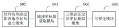
在一个实施例中,如图8所示,提供了一种高度信息增强墨卡托地图的三维空间态势表征装置,包括:经纬高等距投影直角坐标系建立模块802、地理坐标值获取模块804、三维表征空间坐标获取模块806和可视化模块808,其中:In one embodiment, as shown in FIG. 8 , a three-dimensional space situation characterization device for height information-enhanced Mercator map is provided, including: a longitude-latitude high-distance projection rectangular coordinate
经纬高等距投影直角坐标系建立模块802,用于获取墨卡托投影地图数据,以墨卡托投影地图为XY平面建立经纬高等距投影直角坐标系,形成空间态势三维表征空间;The high-latitude and longitude projection rectangular coordinate
地理坐标值获取模块804,用于获取待表征物在地理坐标系的经度值、纬度值和高度值,或根据待表征物在地固系的位置坐标通过预设公式计算得到待表征物在地理坐标系的经度值、纬度值和高度值;The geographic coordinate
三维表征空间坐标获取模块806,用于根据地理坐标系的经度值、纬度值,通过预设的换算关系得到待表征物在经纬高等距投影直角坐标系的经度方向等距投影坐标值和纬度方向等距投影坐标值,判断高度值是否大于预设的经纬高等距投影直角坐标系高度上限,若大于高度上限,则将高度值设为高度上限;The three-dimensional representation space coordinate
可视化模块808,用于根据经度方向等距投影坐标值、纬度方向等距投影坐标值和高度值,通过可视化技术在空间态势三维表征空间中绘制待表征物。The
经纬高等距投影直角坐标系建立模块802还用于获取墨卡托投影地图数据,以墨卡托投影地图为XY平面,以赤道上地面零经度点为坐标原点O,以经度方向为X轴方向,以纬度方向为Y轴方向,以高度方向为Z轴方向,建立经纬高等距投影直角坐标系,形成空间态势三维表征空间。The longitude and latitude high-distance projection rectangular coordinate
地理坐标值获取模块804还用于当待表征物为太阳或月球时,通过查星历表插值得到待表征物在地理坐标系的经度值、纬度值和高度值;当待表征物为地面物体时,获取地面物体在地理坐标系的经度值、纬度值和高度值;当待表征物为人造卫星时,根据人造卫星在地固系的位置坐标通过预设公式计算得到待表征物在地理坐标系的经度值、纬度值和高度值。The geographic coordinate
地理坐标值获取模块804还用于当待表征物为人造卫星时,获取人造卫星在地固系的位置坐标


其中,


通过简单迭代法求解方程组:Solve the system of equations by a simple iterative method:

得到待表征物在地理坐标系的纬度值

其中,


三维表征空间坐标获取模块806还用于The three-dimensional representation space coordinate
根据地理坐标系的经度值、纬度值,通过预设的换算关系得到待表征物在经纬高等距投影直角坐标系的经度方向等距投影坐标值和纬度方向等距投影坐标值;换算关系为:According to the longitude value and latitude value of the geographic coordinate system, through the preset conversion relationship, the equidistant projection coordinate value in the longitude direction and the equidistant projection coordinate value in the latitude direction of the object to be represented in the longitude and latitude high-distance projection Cartesian coordinate system are obtained; the conversion relationship is:

其中,


可视化模块808还用于当待表征物为地基敏感器视场或天基敏感器视场时,在地基敏感器视场或天基敏感器视场锥形体的多条母线的每条母线上采集多个采样点;根据采样点在地固系的位置坐标,得到采样点的经度方向等距投影坐标值、纬度方向等距投影坐标值和高度值构成的位置序列;根据位置序列通过可视化技术在空间态势三维表征空间中进行地基敏感器视场或天基敏感器视场的曲面绘制。The
可视化模块808还用于当待表征物为物体运动轨迹时,获取运动物体的位置序列;根据位置序列通过可视化技术在空间态势三维表征空间中进行运动物体的轨迹绘制。The
关于高度信息增强墨卡托地图的三维空间态势表征装置的具体限定可以参见上文中对于高度信息增强墨卡托地图的三维空间态势表征方法的限定,在此不再赘述。上述高度信息增强墨卡托地图的三维空间态势表征装置中的各个模块可全部或部分通过软件、硬件及其组合来实现。上述各模块可以硬件形式内嵌于或独立于计算机设备中的处理器中,也可以以软件形式存储于计算机设备中的存储器中,以便于处理器调用执行以上各个模块对应的操作。For the specific limitation of the apparatus for representing the three-dimensional space situation of the height information-enhanced Mercator map, please refer to the definition of the method for representing the three-dimensional space situation of the height information-enhanced Mercator map above, which will not be repeated here. Each module in the above-mentioned apparatus for characterizing the three-dimensional space situation of the height information-enhanced Mercator map can be implemented in whole or in part by software, hardware and combinations thereof. The above modules can be embedded in or independent of the processor in the computer device in the form of hardware, or stored in the memory in the computer device in the form of software, so that the processor can call and execute the operations corresponding to the above modules.
在一个实施例中,提供了一种计算机设备,该计算机设备可以是终端,其内部结构图可以如图9所示。该计算机设备包括通过系统总线连接的处理器、存储器、网络接口、显示屏和输入装置。其中,该计算机设备的处理器用于提供计算和控制能力。该计算机设备的存储器包括非易失性存储介质、内存储器。该非易失性存储介质存储有操作系统和计算机程序。该内存储器为非易失性存储介质中的操作系统和计算机程序的运行提供环境。该计算机设备的网络接口用于与外部的终端通过网络连接通信。该计算机程序被处理器执行时以实现一种高度信息增强墨卡托地图的三维空间态势表征方法。该计算机设备的显示屏可以是液晶显示屏或者电子墨水显示屏,该计算机设备的输入装置可以是显示屏上覆盖的触摸层,也可以是计算机设备外壳上设置的按键、轨迹球或触控板,还可以是外接的键盘、触控板或鼠标等。In one embodiment, a computer device is provided, and the computer device may be a terminal, and its internal structure diagram may be as shown in FIG. 9 . The computer equipment includes a processor, memory, a network interface, a display screen, and an input device connected by a system bus. Among them, the processor of the computer device is used to provide computing and control capabilities. The memory of the computer device includes a non-volatile storage medium, an internal memory. The nonvolatile storage medium stores an operating system and a computer program. The internal memory provides an environment for the execution of the operating system and computer programs in the non-volatile storage medium. The network interface of the computer device is used to communicate with an external terminal through a network connection. The computer program, when executed by the processor, implements a three-dimensional space situation characterization method for a highly information-enhanced Mercator map. The display screen of the computer equipment may be a liquid crystal display screen or an electronic ink display screen, and the input device of the computer equipment may be a touch layer covered on the display screen, or a button, a trackball or a touchpad set on the shell of the computer equipment , or an external keyboard, trackpad, or mouse.
本领域技术人员可以理解,图9中示出的结构,仅仅是与本申请方案相关的部分结构的框图,并不构成对本申请方案所应用于其上的计算机设备的限定,具体的计算机设备可以包括比图中所示更多或更少的部件,或者组合某些部件,或者具有不同的部件布置。Those skilled in the art can understand that the structure shown in FIG. 9 is only a block diagram of a part of the structure related to the solution of the present application, and does not constitute a limitation on the computer equipment to which the solution of the present application is applied. Include more or fewer components than shown in the figures, or combine certain components, or have a different arrangement of components.
在一个实施例中,提供了一种计算机设备,包括存储器和处理器,该存储器存储有计算机程序,该处理器执行计算机程序时实现上述方法实施例中的步骤。In one embodiment, a computer device is provided, including a memory and a processor, where the memory stores a computer program, and the processor implements the steps in the above method embodiments when the processor executes the computer program.
在一个实施例中,提供了一种计算机可读存储介质,其上存储有计算机程序,计算机程序被处理器执行时实现上述方法实施例中的步骤。In one embodiment, a computer-readable storage medium is provided, on which a computer program is stored, and when the computer program is executed by a processor, implements the steps in the above method embodiments.
本领域普通技术人员可以理解实现上述实施例方法中的全部或部分流程,是可以通过计算机程序来指令相关的硬件来完成,所述的计算机程序可存储于一非易失性计算机可读取存储介质中,该计算机程序在执行时,可包括如上述各方法的实施例的流程。其中,本申请所提供的各实施例中所使用的对存储器、存储、数据库或其它介质的任何引用,均可包括非易失性和/或易失性存储器。非易失性存储器可包括只读存储器(ROM)、可编程ROM(PROM)、电可编程ROM(EPROM)、电可擦除可编程ROM(EEPROM)或闪存。易失性存储器可包括随机存取存储器(RAM)或者外部高速缓冲存储器。作为说明而非局限,RAM以多种形式可得,诸如静态RAM(SRAM)、动态RAM(DRAM)、同步DRAM(SDRAM)、双数据率SDRAM(DDRSDRAM)、增强型SDRAM(ESDRAM)、同步链路(Synchlink) DRAM(SLDRAM)、存储器总线(Rambus)直接RAM(RDRAM)、直接存储器总线动态RAM(DRDRAM)、以及存储器总线动态RAM(RDRAM)等。Those of ordinary skill in the art can understand that all or part of the processes in the methods of the above embodiments can be implemented by instructing relevant hardware through a computer program, and the computer program can be stored in a non-volatile computer-readable storage In the medium, when the computer program is executed, it may include the processes of the above-mentioned method embodiments. Wherein, any reference to memory, storage, database or other medium used in the various embodiments provided in this application may include non-volatile and/or volatile memory. Nonvolatile memory may include read only memory (ROM), programmable ROM (PROM), electrically programmable ROM (EPROM), electrically erasable programmable ROM (EEPROM), or flash memory. Volatile memory may include random access memory (RAM) or external cache memory. By way of illustration and not limitation, RAM is available in various forms such as static RAM (SRAM), dynamic RAM (DRAM), synchronous DRAM (SDRAM), double data rate SDRAM (DDRSDRAM), enhanced SDRAM (ESDRAM), synchronous chain Road (Synchlink) DRAM (SLDRAM), memory bus (Rambus) direct RAM (RDRAM), direct memory bus dynamic RAM (DRDRAM), and memory bus dynamic RAM (RDRAM) and so on.
以上实施例的各技术特征可以进行任意的组合,为使描述简洁,未对上述实施例中的各个技术特征所有可能的组合都进行描述,然而,只要这些技术特征的组合不存在矛盾,都应当认为是本说明书记载的范围。The technical features of the above embodiments can be combined arbitrarily. In order to make the description simple, all possible combinations of the technical features in the above embodiments are not described. However, as long as there is no contradiction in the combination of these technical features It is considered to be the range described in this specification.
以上所述实施例仅表达了本申请的几种实施方式,其描述较为具体和详细,但并不能因此而理解为对发明专利范围的限制。应当指出的是,对于本领域的普通技术人员来说,在不脱离本申请构思的前提下,还可以做出若干变形和改进,这些都属于本申请的保护范围。因此,本申请专利的保护范围应以所附权利要求为准。The above-mentioned embodiments only represent several embodiments of the present application, and the descriptions thereof are specific and detailed, but should not be construed as a limitation on the scope of the invention patent. It should be pointed out that for those skilled in the art, without departing from the concept of the present application, several modifications and improvements can be made, which all belong to the protection scope of the present application. Therefore, the scope of protection of the patent of the present application shall be subject to the appended claims.
Claims (9)
Translated fromChinese


Priority Applications (1)
| Application Number | Priority Date | Filing Date | Title |
|---|---|---|---|
| CN202110415744.XACN112991535B (en) | 2021-04-19 | 2021-04-19 | Three-dimensional space situation representation method and device of height information enhanced ink cartoo map |
Applications Claiming Priority (1)
| Application Number | Priority Date | Filing Date | Title |
|---|---|---|---|
| CN202110415744.XACN112991535B (en) | 2021-04-19 | 2021-04-19 | Three-dimensional space situation representation method and device of height information enhanced ink cartoo map |
Publications (2)
| Publication Number | Publication Date |
|---|---|
| CN112991535A CN112991535A (en) | 2021-06-18 |
| CN112991535Btrue CN112991535B (en) | 2021-07-27 |
Family
ID=76340975
Family Applications (1)
| Application Number | Title | Priority Date | Filing Date |
|---|---|---|---|
| CN202110415744.XAActiveCN112991535B (en) | 2021-04-19 | 2021-04-19 | Three-dimensional space situation representation method and device of height information enhanced ink cartoo map |
Country Status (1)
| Country | Link |
|---|---|
| CN (1) | CN112991535B (en) |
Families Citing this family (5)
| Publication number | Priority date | Publication date | Assignee | Title |
|---|---|---|---|---|
| CN113535879B (en)* | 2021-07-28 | 2024-05-03 | 工银科技有限公司 | Map data processing method and device for administrative region |
| CN114299142B (en)* | 2021-12-24 | 2022-11-04 | 北京庚图科技有限公司 | Missile threat range determining method and device on two-dimensional world map |
| CN114741026A (en)* | 2022-03-15 | 2022-07-12 | 上海机电工程研究所 | Method, system and medium for calculating and using digital map of designated area |
| CN115880973B (en)* | 2023-02-02 | 2023-05-05 | 北京东方瑞丰航空技术有限公司 | Flight simulator view generation method, device and equipment of pseudo spherical coordinate system |
| CN117541204B (en)* | 2023-11-20 | 2024-08-02 | 科学城(广州)数字科技集团有限公司 | Global cross-domain talent guiding method and device based on three-dimensional virtual simulation technology |
Family Cites Families (6)
| Publication number | Priority date | Publication date | Assignee | Title |
|---|---|---|---|---|
| EP2819090B1 (en)* | 2012-02-23 | 2022-08-24 | Nissan Motor Co., Ltd. | Three-dimensional object detection device |
| US10482655B2 (en)* | 2017-11-20 | 2019-11-19 | Here Global B.V. | Method and apparatus for providing a tile-based digital elevation model |
| CN110059143B (en)* | 2019-03-04 | 2022-11-22 | 中国电子科技集团公司第二十七研究所 | A map drawing method based on remote sensing image tile data |
| CN110502595A (en)* | 2019-08-09 | 2019-11-26 | 柴日发 | A method of picking up longitude and latitude information from planning map |
| CN110617795B (en)* | 2019-08-27 | 2021-06-25 | 武汉新视野风险管理科技有限公司 | Method for realizing outdoor elevation measurement by using sensor of intelligent terminal |
| CN111429583A (en)* | 2020-03-23 | 2020-07-17 | 北京智汇云舟科技有限公司 | A spatiotemporal situational awareness method and system based on 3D geographic information |
- 2021
- 2021-04-19CNCN202110415744.XApatent/CN112991535B/enactiveActive
Also Published As
| Publication number | Publication date |
|---|---|
| CN112991535A (en) | 2021-06-18 |
Similar Documents
| Publication | Publication Date | Title |
|---|---|---|
| CN112991535B (en) | Three-dimensional space situation representation method and device of height information enhanced ink cartoo map | |
| CN113820735B (en) | Determination method of position information, position measurement device, terminal and storage medium | |
| Kneissl et al. | Map-projection-independent crater size-frequency determination in GIS environments—New software tool for ArcGIS | |
| CN113469896B (en) | Method for improving geometric correction precision of geosynchronous orbit satellite earth observation image | |
| CN107168516B (en) | Data visualization method of global climate vector field based on VR and gesture interaction technology | |
| CN115439528B (en) | Method and equipment for acquiring image position information of target object | |
| CN102346922A (en) | Space remote sensing load imaging geometric distortion three-dimensional visualization simulation method | |
| CN115932723B (en) | Positioning method, device, computer equipment, storage medium and program product | |
| CN115962760A (en) | Projection parameter determination method and device, computer equipment and storage medium | |
| CN116894870A (en) | An image target positioning method, system, electronic device and storage medium | |
| CN107391794B (en) | Typhoon continuous three-dimensional wind field inversion method | |
| CN108896038A (en) | Month base optical sensor imaging method | |
| Sefton-Nash et al. | Diviner lunar radiometer gridded brightness temperatures from geodesic binning of modeled fields of view | |
| WO2023092865A1 (en) | Area reconstruction method and system | |
| Zhou et al. | Real-time ortho-rectification for remote-sensing images | |
| CN110310370B (en) | Method for point-plane fusion of GPS (Global positioning System) and SRTM (short Range TM) | |
| CN103544677A (en) | Space-air-ground integration situational expression engine and shaking elimination method | |
| CN116961728A (en) | Satellite coverage information determining method and device, electronic equipment and storage medium | |
| Statella | Mapping Mars: Geodetic and cartographic aspects | |
| Liu et al. | A continuative variable resolution digital elevation model for ground-based photogrammetry | |
| Baker et al. | Limb-Based Shape Modeling: A Demonstration on Itokawa | |
| Zhu et al. | Research on the Principle of Multi-perspective Solar Magnetic Field Measurement | |
| CN118859265B (en) | Satellite remote sensing image on-board geometric positioning method and system based on ground elevation data | |
| CN117252921B (en) | Aerial thermal infrared image positioning method, device and equipment based on view synthesis | |
| Ye et al. | On the Observational Solid Angle in Estimating the Moon-based Disk-integrated Earth Outgoing Longwave Radiation |
Legal Events
| Date | Code | Title | Description |
|---|---|---|---|
| PB01 | Publication | ||
| PB01 | Publication | ||
| SE01 | Entry into force of request for substantive examination | ||
| SE01 | Entry into force of request for substantive examination | ||
| GR01 | Patent grant | ||
| GR01 | Patent grant |