CN112946624A - Multi-target tracking algorithm based on flight path management method - Google Patents
Multi-target tracking algorithm based on flight path management methodDownload PDFInfo
- Publication number
- CN112946624A CN112946624ACN202110224659.5ACN202110224659ACN112946624ACN 112946624 ACN112946624 ACN 112946624ACN 202110224659 ACN202110224659 ACN 202110224659ACN 112946624 ACN112946624 ACN 112946624A
- Authority
- CN
- China
- Prior art keywords
- track
- measurement
- time
- model
- target
- Prior art date
- Legal status (The legal status is an assumption and is not a legal conclusion. Google has not performed a legal analysis and makes no representation as to the accuracy of the status listed.)
- Granted
Links
Images


Classifications
- G—PHYSICS
- G01—MEASURING; TESTING
- G01S—RADIO DIRECTION-FINDING; RADIO NAVIGATION; DETERMINING DISTANCE OR VELOCITY BY USE OF RADIO WAVES; LOCATING OR PRESENCE-DETECTING BY USE OF THE REFLECTION OR RERADIATION OF RADIO WAVES; ANALOGOUS ARRANGEMENTS USING OTHER WAVES
- G01S13/00—Systems using the reflection or reradiation of radio waves, e.g. radar systems; Analogous systems using reflection or reradiation of waves whose nature or wavelength is irrelevant or unspecified
- G01S13/66—Radar-tracking systems; Analogous systems
- G—PHYSICS
- G01—MEASURING; TESTING
- G01C—MEASURING DISTANCES, LEVELS OR BEARINGS; SURVEYING; NAVIGATION; GYROSCOPIC INSTRUMENTS; PHOTOGRAMMETRY OR VIDEOGRAMMETRY
- G01C21/00—Navigation; Navigational instruments not provided for in groups G01C1/00 - G01C19/00
- G01C21/005—Navigation; Navigational instruments not provided for in groups G01C1/00 - G01C19/00 with correlation of navigation data from several sources, e.g. map or contour matching
- G—PHYSICS
- G01—MEASURING; TESTING
- G01C—MEASURING DISTANCES, LEVELS OR BEARINGS; SURVEYING; NAVIGATION; GYROSCOPIC INSTRUMENTS; PHOTOGRAMMETRY OR VIDEOGRAMMETRY
- G01C21/00—Navigation; Navigational instruments not provided for in groups G01C1/00 - G01C19/00
- G01C21/20—Instruments for performing navigational calculations
- G—PHYSICS
- G01—MEASURING; TESTING
- G01S—RADIO DIRECTION-FINDING; RADIO NAVIGATION; DETERMINING DISTANCE OR VELOCITY BY USE OF RADIO WAVES; LOCATING OR PRESENCE-DETECTING BY USE OF THE REFLECTION OR RERADIATION OF RADIO WAVES; ANALOGOUS ARRANGEMENTS USING OTHER WAVES
- G01S13/00—Systems using the reflection or reradiation of radio waves, e.g. radar systems; Analogous systems using reflection or reradiation of waves whose nature or wavelength is irrelevant or unspecified
- G01S13/66—Radar-tracking systems; Analogous systems
- G01S13/72—Radar-tracking systems; Analogous systems for two-dimensional tracking, e.g. combination of angle and range tracking, track-while-scan radar
- G01S13/723—Radar-tracking systems; Analogous systems for two-dimensional tracking, e.g. combination of angle and range tracking, track-while-scan radar by using numerical data
- G01S13/726—Multiple target tracking
- G—PHYSICS
- G01—MEASURING; TESTING
- G01S—RADIO DIRECTION-FINDING; RADIO NAVIGATION; DETERMINING DISTANCE OR VELOCITY BY USE OF RADIO WAVES; LOCATING OR PRESENCE-DETECTING BY USE OF THE REFLECTION OR RERADIATION OF RADIO WAVES; ANALOGOUS ARRANGEMENTS USING OTHER WAVES
- G01S13/00—Systems using the reflection or reradiation of radio waves, e.g. radar systems; Analogous systems using reflection or reradiation of waves whose nature or wavelength is irrelevant or unspecified
- G01S13/86—Combinations of radar systems with non-radar systems, e.g. sonar, direction finder
- G—PHYSICS
- G01—MEASURING; TESTING
- G01S—RADIO DIRECTION-FINDING; RADIO NAVIGATION; DETERMINING DISTANCE OR VELOCITY BY USE OF RADIO WAVES; LOCATING OR PRESENCE-DETECTING BY USE OF THE REFLECTION OR RERADIATION OF RADIO WAVES; ANALOGOUS ARRANGEMENTS USING OTHER WAVES
- G01S13/00—Systems using the reflection or reradiation of radio waves, e.g. radar systems; Analogous systems using reflection or reradiation of waves whose nature or wavelength is irrelevant or unspecified
- G01S13/88—Radar or analogous systems specially adapted for specific applications
- G01S13/89—Radar or analogous systems specially adapted for specific applications for mapping or imaging
- G—PHYSICS
- G06—COMPUTING OR CALCULATING; COUNTING
- G06F—ELECTRIC DIGITAL DATA PROCESSING
- G06F17/00—Digital computing or data processing equipment or methods, specially adapted for specific functions
- G06F17/10—Complex mathematical operations
- G06F17/16—Matrix or vector computation, e.g. matrix-matrix or matrix-vector multiplication, matrix factorization
- G—PHYSICS
- G06—COMPUTING OR CALCULATING; COUNTING
- G06F—ELECTRIC DIGITAL DATA PROCESSING
- G06F17/00—Digital computing or data processing equipment or methods, specially adapted for specific functions
- G06F17/10—Complex mathematical operations
- G06F17/18—Complex mathematical operations for evaluating statistical data, e.g. average values, frequency distributions, probability functions, regression analysis
- Y—GENERAL TAGGING OF NEW TECHNOLOGICAL DEVELOPMENTS; GENERAL TAGGING OF CROSS-SECTIONAL TECHNOLOGIES SPANNING OVER SEVERAL SECTIONS OF THE IPC; TECHNICAL SUBJECTS COVERED BY FORMER USPC CROSS-REFERENCE ART COLLECTIONS [XRACs] AND DIGESTS
- Y02—TECHNOLOGIES OR APPLICATIONS FOR MITIGATION OR ADAPTATION AGAINST CLIMATE CHANGE
- Y02D—CLIMATE CHANGE MITIGATION TECHNOLOGIES IN INFORMATION AND COMMUNICATION TECHNOLOGIES [ICT], I.E. INFORMATION AND COMMUNICATION TECHNOLOGIES AIMING AT THE REDUCTION OF THEIR OWN ENERGY USE
- Y02D30/00—Reducing energy consumption in communication networks
- Y02D30/70—Reducing energy consumption in communication networks in wireless communication networks
Landscapes
- Engineering & Computer Science (AREA)
- Remote Sensing (AREA)
- Radar, Positioning & Navigation (AREA)
- Physics & Mathematics (AREA)
- General Physics & Mathematics (AREA)
- Data Mining & Analysis (AREA)
- Mathematical Physics (AREA)
- Pure & Applied Mathematics (AREA)
- Theoretical Computer Science (AREA)
- Computational Mathematics (AREA)
- Mathematical Analysis (AREA)
- Mathematical Optimization (AREA)
- Computer Networks & Wireless Communication (AREA)
- General Engineering & Computer Science (AREA)
- Automation & Control Theory (AREA)
- Algebra (AREA)
- Databases & Information Systems (AREA)
- Software Systems (AREA)
- Operations Research (AREA)
- Evolutionary Biology (AREA)
- Computing Systems (AREA)
- Bioinformatics & Computational Biology (AREA)
- Bioinformatics & Cheminformatics (AREA)
- Probability & Statistics with Applications (AREA)
- Electromagnetism (AREA)
- Life Sciences & Earth Sciences (AREA)
- Radar Systems Or Details Thereof (AREA)
Abstract
Translated fromChinese
Description
Translated fromChinese技术领域technical field
本发明涉及基于多源异构传感器的多目标跟踪技术,特别是一种针对于多源异构传感器监测区域不同、传感器采样率相差较大、有机动目标、杂波环境下的多目标跟踪算法。The invention relates to a multi-target tracking technology based on multi-source heterogeneous sensors, in particular to a multi-target tracking algorithm under different monitoring areas of multi-source heterogeneous sensors, large differences in sensor sampling rates, moving targets, and clutter environments .
背景技术Background technique
随着传感器技术与通信技术的发展,越来越多的传感器被纳入到一体化网络中参与协同作战。信息融合技术能够解决不同平台上传感器所获信息的融合问题,针对多源传感器融合的多目标跟踪技术的研究越来越受到国内外的高度重视,已逐渐成为学术界和工程应用界的研究热点。With the development of sensor technology and communication technology, more and more sensors are incorporated into the integrated network to participate in coordinated operations. Information fusion technology can solve the problem of fusion of information obtained by sensors on different platforms. The research on multi-target tracking technology for multi-source sensor fusion has received more and more attention at home and abroad, and has gradually become a research hotspot in academia and engineering applications. .
在航空交通管制、航海交通管制以及现代战场等领域,都会涉及到多目标跟踪技术,随着传感器种类不断发展,多源信息融合技术运用到目标跟踪中来。而对于多目标跟踪,场景中目标数目未知且是可变的,同时传感器量测中除了对于目标的探测结果,还包含了个别杂波。因此在多目标跟踪过程中,不仅要根据量测数据判断出哪些是目标的量测,哪些是传感器产生的杂波,还需要区分出同一时刻的不同量测是对应哪个目标,这就需要利用数据关联技术进行解决,因此,进行有效的数据关联是多目标跟踪算法中最核心且重要的内容。In the fields of air traffic control, maritime traffic control and modern battlefield, multi-target tracking technology will be involved. With the continuous development of sensor types, multi-source information fusion technology is applied to target tracking. For multi-target tracking, the number of targets in the scene is unknown and variable, and in addition to the detection results of the targets, the sensor measurement also includes individual clutter. Therefore, in the process of multi-target tracking, it is not only necessary to judge which are the target measurements and which are the clutter generated by the sensor according to the measurement data, but also need to distinguish which target the different measurements at the same time correspond to. Therefore, effective data association is the core and important content of the multi-target tracking algorithm.
目前多目标跟踪算法很多,但适用的很少。本发明采用的多假设跟踪(MHT)算法是包括航迹起始、航迹关联、航迹合并、航迹删除等一整套跟踪功能的多目标跟踪算法,在理想假设条件下,多假设目标跟踪被认为是处理数据关联问题的最优方法。相比之下,其他算法如全局最近邻(GNN)算法虽然具有计算量小、易于实现的优点,但是在杂波密度较大的情况下,很容易出现目标跟踪错误、跟踪稳定性差的问题;概率数据关联(PDA)算法虽然计算量小、结构简单,但是只适用于杂波环境中的单目标的跟踪问题,JPDA算法虽然可以解决杂波密集环境下的多目标跟踪问题,但是当目标数量较大时,其计算量也会呈指数形式的爆炸式增长。At present, there are many multi-target tracking algorithms, but few of them are applicable. The multi-hypothesis tracking (MHT) algorithm adopted by the present invention is a multi-target tracking algorithm including a complete set of tracking functions such as track initiation, track association, track merging, track deletion, etc. Considered to be the best way to deal with data association problems. In contrast, other algorithms such as the Global Nearest Neighbor (GNN) algorithm have the advantages of small computational complexity and easy implementation, but in the case of high clutter density, it is easy to cause target tracking errors and poor tracking stability. Although the probabilistic data association (PDA) algorithm has a small amount of calculation and a simple structure, it is only suitable for the tracking problem of a single target in a clutter environment. When it is larger, its computational load will also explode exponentially.
现有的多目标跟踪算法在对多源传感器进行融合时,首先,由于战场环境中的目标机动状态的不确定性,用单个模型不足以描述目标的运动,尤其对于高机动目标,用单个模型进行跟踪时容易出现跟踪精度不高甚至跟踪丢失的情况。其次,若各传感器由于监测区域不同,导致各传感器探测到的目标部分重合或完全不重合,会使得在对传感器的量测进行处理时,对于没有被该传感器探测到的目标则没有量测与之关联,使得航迹的生命值和航迹分数受到影响,若各传感器之间的采样率相差较大,以及量测中含有杂波,则会使得原本用单个传感器可以跟踪到的目标,由于多传感器的融合处理而出现航迹断开或出现虚假航迹的情况。When the existing multi-target tracking algorithms fuse multi-source sensors, first, due to the uncertainty of the target maneuvering state in the battlefield environment, a single model is not enough to describe the motion of the target, especially for high maneuvering targets, a single model is used. When tracking, it is easy to have low tracking accuracy or even tracking loss. Secondly, if the targets detected by each sensor partially overlap or do not overlap at all due to the different monitoring areas of each sensor, when the measurement of the sensor is processed, the target that is not detected by the sensor will not be measured. If the difference between the sampling rates of each sensor is large, and the measurement contains clutter, the target that can be tracked by a single sensor will be affected. Due to multi-sensor fusion processing, the track is disconnected or a false track occurs.
因此,提供一种针对于多源异构传感器监测区域不同、传感器采样率相差较大、有机动目标、杂波环境下的多目标跟踪算法成为目前亟待解决的技术问题。Therefore, it has become an urgent technical problem to provide a multi-target tracking algorithm for multi-source heterogeneous sensors with different monitoring areas, large differences in sensor sampling rates, moving targets, and clutter environments.
发明内容SUMMARY OF THE INVENTION
本发明的目的在于解决现有多目标跟踪算法在进行多源传感器融合时存在航迹碎裂或出现虚假航迹以及无法很好地对机动目标进行跟踪等问题,而提出的一种在进行多源异构传感器融合处理时,采用多模型跟踪算法与多目标跟踪算法结合,并对原有的航迹管理方法进行改进,防止航迹碎裂并且抑制虚假航迹出现,最终实现对异构传感器监测区域不同、传感器采样率相差较大、有机动目标、杂波环境下的多个目标的多传感器多机动目标实时精确跟踪。The purpose of the present invention is to solve the problems of track fragmentation or false track and inability to track maneuvering targets well when the existing multi-target tracking algorithm performs multi-source sensor fusion. In the fusion processing of source heterogeneous sensors, the combination of multi-model tracking algorithm and multi-target tracking algorithm is used, and the original track management method is improved to prevent track fragmentation and suppress the appearance of false tracks, and finally realize the integration of heterogeneous sensors. Real-time accurate tracking of multi-sensor multi-maneuvering targets with different monitoring areas, large differences in sensor sampling rates, maneuvering targets, and multiple targets in clutter environments.
本发明是通过下述技术方案来实现的。The present invention is achieved through the following technical solutions.
本发明提供的一种基于航迹管理方法的多目标跟踪算法,包括以下步骤:A multi-target tracking algorithm based on the track management method provided by the present invention includes the following steps:
步骤一:接收同一时刻传来的多源传感器量测数据,第一次接收量测数据作为航迹起始;将各传感器平台的位置转换到同一东北天坐标系下;Step 1: Receive the multi-source sensor measurement data transmitted at the same time, and receive the measurement data for the first time as the start of the track; convert the position of each sensor platform to the same northeast sky coordinate system;
步骤二:对量测数据进行预处理,根据量测形式建立不同的量测方程;Step 2: Preprocess the measurement data, and establish different measurement equations according to the measurement form;
步骤三:利用多模型算法在各状态模型下对上一时刻的航迹进行一步预测;Step 3: Use the multi-model algorithm to predict the track of the previous moment under each state model;
步骤四:利用航迹管理方法将当前时刻的量测数据与上一时刻的航迹进行数据关联,并通过常用数据关联算法构建约束模型,优化求解得到最终关联结果;Step 4: Use the track management method to associate the measurement data at the current moment with the track at the previous moment, and construct a constraint model through a common data association algorithm, and optimize the solution to obtain the final association result;
步骤五:利用多模型跟踪算法对关联成功的航迹进行状态更新;Step 5: Use the multi-model tracking algorithm to update the status of the successfully associated tracks;
步骤六:利用航迹管理方法完成航迹生成、航迹删除及航迹维持,并输出航迹。Step 6: Use the track management method to complete track generation, track deletion and track maintenance, and output the track.
对于上述技术方案,本发明还有进一步优选的方案:For the above-mentioned technical scheme, the present invention also has a further preferred scheme:
优选的,所述步骤一包括如下步骤:Preferably, the
11)选定某个固定点为融合节点;11) Select a fixed point as a fusion node;
12)接收传感器量测数据,若为第一次接收量测数据,则由量测数据进行航迹起始,否则进行后续步骤对量测数据进行后续处理;12) Receive sensor measurement data, if it is the first time to receive measurement data, start the track from the measurement data, otherwise perform subsequent steps to perform subsequent processing on the measurement data;
13)将量测数据中的平台位置信息转换为以融合节点为原点的东北天坐标系下,将该平台位置信息存到量测信息中。13) Convert the platform position information in the measurement data to the northeast sky coordinate system with the fusion node as the origin, and store the platform position information in the measurement information.
优选的,所述步骤二包括如下步骤:Preferably, the second step includes the following steps:
21)若为同时包含距离、方位角和俯仰角的三维量测,则通过无偏量测转换方法将三维量测由极坐标转换到笛卡尔坐标系下,建立量测转换后的量测方程;21) If it is a three-dimensional measurement that includes distance, azimuth and pitch angle at the same time, the three-dimensional measurement is converted from polar coordinates to Cartesian coordinates by the unbiased measurement conversion method, and the measurement equation after measurement conversion is established. ;
22)若为距离、方位角和俯仰角中的两个组合或一个的二维或一维量测,则在以融合节点为原点的东北天坐标系下建立目标的量测方程。22) If it is a two-dimensional or one-dimensional measurement of two or one of the distance, azimuth and pitch angle, the measurement equation of the target is established in the northeast sky coordinate system with the fusion node as the origin.
优选的,所述步骤三包括如下步骤:Preferably, the step 3 includes the following steps:
31)根据k-1时刻的目标状态、协方差、模型概率和状态转移矩阵,计算k-1时刻目标处于模型的概率和k-1时刻从模型i转移到模型j的条件概率;31) According to the target state, covariance, model probability and state transition matrix at time k-1, calculate the probability that the target is in the model at time k-1 and the conditional probability of transferring from model i to model j at time k-1;
32)根据k时刻的量测信息计算k时刻与k-1时刻的时间差,进行航迹预测,得到航迹在模型i下的状态估计和估计误差协方差。32) Calculate the time difference between time k and time k-1 according to the measurement information at time k, perform track prediction, and obtain the state estimation and estimation error covariance of the track under model i.
优选的,所述步骤四包括如下步骤:Preferably, the
41)当第一次接收到三维量测时,为进行后续的航迹管理,建立航迹的节点信息,包括:航迹生命值L、航迹分数S、用于起始该航迹的传感器编号I、航迹更新时间戳T和航迹历史关联次数N;根据第一次接收到的三维量测,对航迹节点信息进行初始化。根据似然比准则设计打分函数,得出航迹初始化的打分函数;41) When the three-dimensional measurement is received for the first time, in order to carry out subsequent track management, the node information of the track is established, including: track life value L, track score S, and the sensor used to start the track Number I, track update timestamp T and track history association times N; initialize track node information according to the first received 3D measurement. According to the likelihood ratio criterion, the scoring function is designed, and the scoring function of track initialization is obtained;
42)当量测不是第一次接收时,对当前时刻的量测数据与上一时刻的航迹进行数据关联,对有量测关联的航迹进行航迹节点信息的更新;42) When the measurement is not received for the first time, perform data association between the measurement data at the current moment and the track at the previous moment, and update the track node information for the track associated with the measurement;
进一步,步骤42)中,航迹与量测间的数据关联算法步骤如下:Further, in step 42), the data association algorithm steps between the track and the measurement are as follows:
采用基于多模型的椭形门对航迹与量测进行关联,若量测进入某个模型下的波门,则认为量测与航迹关联上了。The multi-model-based ellipse gate is used to associate the track and the measurement. If the measurement enters the wave gate under a certain model, the measurement and the track are considered to be associated.
若航迹关联上第j个量测时,则对于关联上第j个量测的航迹生命值在k-1时刻的生命值若大于等于最大生命值,则k时刻的生命值继承k-1时刻的生命值,否则k时刻的生命值加1;k时刻的航迹分数按照航迹有量测关联时基于多模型加权求出的打分函数进行计算;k时刻航迹的航迹传感器编号继承k-1时刻航迹的;k时刻航迹的时间戳等于k时刻量测的时间戳;k时刻航迹的航迹历史关联次数加1。航迹有量测关联时,对目标处于各模型的分数进行加权求和得到航迹分数。If the jth measurement time is associated with the track, if the life value of the track life value associated with the jth measurement at time k-1 is greater than or equal to the maximum health value, the health value at time k inherits k- The life value at
43)当量测不是第一次接收时,对航迹做无量测关联的假设,并对航迹节点信息进行更新;43) When the measurement is not received for the first time, make the assumption that the track is not associated with the measurement, and update the track node information;
进一步,步骤43)中,航迹节点信息的更新步骤如下:Further, in step 43), the update steps of the track node information are as follows:
若航迹没有关联上k时刻量测时,且量测的传感器编号与航迹的传感器编号相同,则k时刻航迹的生命值减1;当生命值大于0时,航迹分数按照航迹无量测关联时的打分函数进行计算;当生命值小于等于0时,将航迹分数取成无穷小;k时刻航迹的传感器编号、航迹更新时间戳和航迹历史关联次数都继承k-1时刻航迹的。If the track is not associated with the measurement time at time k, and the measured sensor number is the same as the sensor number of the track, the health value of the track at time k is reduced by 1; when the health value is greater than 0, the track score is based on the track score. Calculate the score function when there is no measurement association; when the life value is less than or equal to 0, the track score is taken as infinitely small; the sensor number, track update timestamp and track history association times of the track at time k all inherit k- 1 time track.
若航迹没有关联上k时刻量测时,且量测的传感器编号与航迹的传感器编号Ik-1不同,则通过k时刻量测对应时间tk与航迹更新时间戳Tk-1得到时间差Δt=tk-Tk-1,若时间差Δt小于量测对应出传感器的周期,则k时刻航迹的生命值、航迹分数、航迹传感器编号、航迹更新时间戳和航迹历史关联次数都继承k-1时刻航迹的。If the track is not associated with the measurement time at time k, and the measured sensor number is different from the sensor number Ik-1 of the track, the corresponding time tk and the track update timestamp Tk-1 are measured at time k. The time difference Δt=tk -Tk-1 is obtained. If the time difference Δt is less than the period of the sensor corresponding to the measurement, then the life value of the track at time k, track score, track sensor number, track update timestamp and track The number of historical associations is inherited from the track at time k-1.
44)当量测不是第一次接收,且量测为三维量测时,将该量测假设为新生目标,并对航迹节点信息进行更新。44) When the measurement is not received for the first time and the measurement is a three-dimensional measurement, the measurement is assumed to be a new target, and the track node information is updated.
进一步,步骤44)中,航迹节点信息的更新步骤如下:Further, in step 44), the update steps of the track node information are as follows:
若k时刻量测属于新生航迹时,则k时刻的生命值等于最大生命值;k时刻的航迹分数按照航迹初始化的打分函数进行计算;k时刻航迹的传感器编号等于k时刻量测的传感器编号;k时刻航迹的时间戳等于k时刻量测的时间戳;k时刻航迹的航迹历史关联次数等于0。If the measurement at time k belongs to a new track, the life value at time k is equal to the maximum life value; the track score at time k is calculated according to the scoring function of the track initialization; the sensor number of the track at time k is equal to the measurement at time k The sensor number of ; the timestamp of the track at time k is equal to the time stamp of the measurement at time k;
45)得出最终的数据关联结果,并删除假设。45) Get the final data association results and remove the assumptions.
优选的,所述步骤五包括如下步骤:Preferably, the
51)对于没有关联上量测的航迹,直接使用k-1时刻的模型概率整合k时刻各模型的状态估计和协方差。51) For tracks that are not associated with measurements, directly use the model probability at time k-1 to integrate the state estimates and covariances of each model at time k.
52)对于关联上量测的航迹,在各模型i下进行滤波。当为三维量测时,按照卡尔曼滤波算法在各模型下进行滤波;当为二维或一维量测时,按照非线性滤波算法在各模型下进行滤波,计算在各模型i下的状态估计和估计误差协方差。然后根据k时刻的量测对模型概率进行更新,最后整合各模型的状态估计和协方差。52) For the associated measured tracks, perform filtering under each model i. When it is a three-dimensional measurement, filter under each model according to the Kalman filtering algorithm; when it is a two-dimensional or one-dimensional measurement, filter under each model according to a nonlinear filtering algorithm, and calculate the state under each model i Estimate and estimate error covariance. Then, the model probability is updated according to the measurement at time k, and finally the state estimates and covariances of each model are integrated.
优选的,所述步骤六包括如下步骤:Preferably, the step 6 includes the following steps:
61)遍历航迹,若航迹生命值为0或航迹分数为负,则将航迹终止标志置为1,否则将航迹终止标志置为0;61) Traverse the track, if the track life value is 0 or the track score is negative, set the track end flag to 1, otherwise set the track end flag to 0;
62)对于航迹终止标志为0的航迹删除,不再进行输出;62) For the deletion of the track whose track end flag is 0, no output will be performed;
63)对于航迹终止标志为1的航迹,若航迹历史关联次数小于3次,则暂时将航迹进行保留,但不输出;63) For the track whose track end flag is 1, if the number of historical associations of the track is less than 3 times, the track will be temporarily retained, but not output;
64)对于航迹终止标志为1的航迹,若航迹历史关联次数大于等于3次,则将航迹进行输出。64) For a track whose track termination flag is 1, if the number of track history associations is greater than or equal to 3 times, the track will be output.
本发明由于采取以上技术方案,其具有以下有益效果:The present invention has the following beneficial effects due to taking the above technical solutions:
本发明针对多源传感器融合中的多目标跟踪问题,提出了一种基于航迹管理方法的多目标跟踪算法。该技术为了实现多源传感器的融合处理,首先通过坐标系转换方式将各传感器的平台位置转换到同一坐标系下;其次根据异构传感器的量测组合方式,建立不同的量测方程,采用不同的滤波方案进行滤波,同时原来的MHT算法采用单个模型对目标进行跟踪,为了适用于对机动目标的跟踪,本发明将多模型跟踪算法与MHT算法进行结合,实现对机动目标的跟踪;之后针对多源传感器监测不同、采样率相差较大、含杂波导致的航迹断开或产生虚假航迹的问题。这是由于原来的航迹管理方法是以量测的批数来计算航迹的生命值和航迹分数的,这会导致在使用单传感器时不会断开的航迹在融合其他传感器期间,由于目标在该传感器下没有被监测到,被误以为消失而出现航迹断开。同时,原来的航迹管理方法中由于只根据航迹的生命值和航迹分数来决定航迹是否生成并输出,这会导致传感器的杂波在后续融合其他传感器量测时,杂波被误以为是目标而产生虚假航迹。本发明对原有的航迹管理方法进行改进,对航迹的节点信息增加时间戳、传感器编号、历史关联次数等信息,采取以时间及量测来源为依据的方式来计算航迹的生命值和分数,同时增加航迹历史关联次数的信息来决定航迹的输出。Aiming at the multi-target tracking problem in multi-source sensor fusion, the invention proposes a multi-target tracking algorithm based on a track management method. In order to realize the fusion processing of multi-source sensors, this technology firstly converts the platform position of each sensor to the same coordinate system by means of coordinate system conversion; At the same time, the original MHT algorithm uses a single model to track the target. In order to be suitable for the tracking of the maneuvering target, the present invention combines the multi-model tracking algorithm with the MHT algorithm to realize the tracking of the maneuvering target; Multi-source sensor monitoring is different, the sampling rate is quite different, the track is disconnected or the false track is generated due to clutter. This is because the original track management method calculates the health value and track score of the track in batches of measurements, which will result in the track that will not be disconnected when using a single sensor. During the fusion of other sensors, Since the target was not detected under the sensor, it was mistaken for disappearance and the track disconnection occurred. At the same time, in the original track management method, whether the track is generated and output is only determined according to the life value and track score of the track, which will cause the clutter of the sensor to be mistakenly measured when the clutter of the sensor is subsequently fused with other sensors. A false track is generated thinking it is a target. The invention improves the original track management method, adds time stamp, sensor number, historical association times and other information to the node information of the track, and calculates the life value of the track based on the time and measurement source. and score, while adding information about the number of times the track history is associated to determine the track output.
与现有方法相比,本发明将多模型跟踪算法与MHT算法进行结合,实现了对机动目标的跟踪。同时通过改进的航迹管理方法,采取以时间及量测来源为依据来计算航迹的生命值和分数,避免了由于各传感器监测区域不同,当融入了大量监测不到现有目标的传感器量测后,出现航迹断开的情况;在航迹生成并输出过程中,在航迹生命值和航迹分数判断标准基础上,增加航迹历史关联次数信息,将航迹状态变成:航迹终止、航迹未终止保持、航迹未终止输出三种状态,避免了由于杂波而产生的虚假航迹。Compared with the existing method, the present invention combines the multi-model tracking algorithm and the MHT algorithm to realize the tracking of the maneuvering target. At the same time, through the improved track management method, the life value and score of the track are calculated based on time and measurement sources, which avoids the need to integrate a large number of sensors that cannot monitor existing targets due to the different monitoring areas of each sensor. After the test, the track is disconnected; in the process of track generation and output, on the basis of the track health value and track score judgment criteria, the information on the number of track historical associations is added, and the track status is changed to: There are three states of track termination, track unterminated hold, and track unterminated output, avoiding false tracks due to clutter.
附图说明Description of drawings
此处所说明的附图用来提供对本发明的进一步理解,构成本申请的一部分,并不构成对本发明的不当限定,在附图中:The accompanying drawings described here are used to provide a further understanding of the present invention and constitute a part of this application, and do not constitute an improper limitation of the present invention. In the accompanying drawings:
图1为基于航迹管理方法的多目标跟踪算法流程图;Fig. 1 is the flow chart of the multi-target tracking algorithm based on the track management method;
图2为基于航迹管理方法的多目标跟踪算法中步骤四的流程图;Fig. 2 is the flow chart of
图3为基于航迹管理方法的多目标跟踪算法中步骤五的流程图;Fig. 3 is the flow chart of
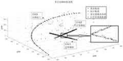
图4(a)-4(e)为将多模型算法与MHT算法结合前后的跟踪的结果进行比较示意图;Figures 4(a)-4(e) are schematic diagrams showing the comparison of the tracking results before and after combining the multi-model algorithm with the MHT algorithm;
其中图4(a)为使用单模型的MHT算法的跟踪结果,图4(b)使用多模型的MHT算法的跟踪结果,图4(c)、4(d)、4(e)为使用多模型前后OSPA距离、势误差和跟踪目标数的比较;Figure 4(a) is the tracking result of the MHT algorithm using a single model, Figure 4(b) is the tracking result of the MHT algorithm using multiple models, and Figures 4(c), 4(d), and 4(e) are the tracking results using the multi-model MHT algorithm. Comparison of OSPA distance, potential error and number of tracked targets before and after the model;
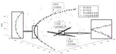
图5(a)-5(e)为将航迹管理方法改进前后的跟踪结果比较图;Figures 5(a)-5(e) are the comparison charts of the tracking results before and after the improvement of the track management method;
其中图5(a)为航迹管理方法改进前的跟踪结果,图5(b)航迹管理方法改进后的跟踪结果,图5(c)、5(d)、5(e)为航迹管理方法改进前后OSPA距离、势误差和跟踪目标数的比较。Figure 5(a) is the tracking result before the track management method is improved, Figure 5(b) is the tracking result after the track management method is improved, and Figures 5(c), 5(d), and 5(e) are the tracks Comparison of OSPA distance, potential error and number of tracked targets before and after management method improvement.
具体实施方式Detailed ways
下面将结合附图以及具体实施例来详细说明本发明,在此本发明的示意性实施例以及说明用来解释本发明,但并不作为对本发明的限定。The present invention will be described in detail below with reference to the accompanying drawings and specific embodiments. The exemplary embodiments and descriptions of the present invention are used to explain the present invention, but are not intended to limit the present invention.
如图1所示,本发明实施例提供一种基于航迹管理方法的多目标跟踪算法,包括以下步骤:As shown in FIG. 1 , an embodiment of the present invention provides a multi-target tracking algorithm based on a track management method, including the following steps:
步骤一:接收同一时刻传来的多源传感器量测数据,第一次接收量测数据作为航迹起始;将各传感器平台的位置转换到同一东北天坐标系下;Step 1: Receive the multi-source sensor measurement data transmitted at the same time, and receive the measurement data for the first time as the start of the track; convert the position of each sensor platform to the same northeast sky coordinate system;
具体包括如下步骤:Specifically include the following steps:
11)选定某个固定点为融合节点;11) Select a fixed point as a fusion node;
12)接收传感器量测数据,若为第一次接收量测数据,则由量测数据进行航迹起始,否则进入后续步骤对量测数据进行后续处理;12) Receive sensor measurement data, if it is the first time to receive measurement data, start the track from the measurement data, otherwise enter the subsequent steps to perform subsequent processing on the measurement data;
13)将量测数据中的平台位置转换到以融合节点为原点的东北天坐标系下,将该平台位置信息存到量测信息中。13) Convert the platform position in the measurement data to the northeast sky coordinate system with the fusion node as the origin, and store the platform position information in the measurement information.
步骤二:对量测数据进行预处理,并根据量测形式建立不同的量测方程。Step 2: Preprocess the measurement data, and establish different measurement equations according to the measurement form.
具体包括如下步骤:Specifically include the following steps:
21)若为同时包含距离、方位角和俯仰角的三维量测,则通过无偏量测转换方法将三维量测由极坐标转换到笛卡尔坐标系下,建立出量测转换后的量测方程。21) If it is a three-dimensional measurement that includes distance, azimuth and pitch angle at the same time, the three-dimensional measurement is converted from polar coordinates to Cartesian coordinate system by the unbiased measurement conversion method, and the measurement after measurement conversion is established. equation.
对于三维量测zm=[rm,θm,ηm]T经过无偏转换后的无偏量测

其中,[rm,θm,ηm]为量测的距离、方位角和俯仰角,距离、方位角和俯仰角的方差为

其中,


其中,
则目标的量测方程为:Then the measurement equation of the target is:

其中,
22)若为距离、方位角和俯仰角中的两个组合或一个的二维或一维量测,则在以融合节点为原点的东北天坐标系下建立目标的量测方程;22) If it is a two-dimensional or one-dimensional measurement of two combinations or one of the distance, azimuth and pitch angle, then the measurement equation of the target is established under the northeast sky coordinate system with the fusion node as the origin;
以量测为方位角和俯仰角两个角度的二维量测情况为例,在以融合节点为原点的东北天坐标系下,目标的量测方程可表示为:Taking the two-dimensional measurement situation of azimuth angle and pitch angle as an example, in the northeast sky coordinate system with the fusion node as the origin, the measurement equation of the target can be expressed as:

其中,(x,y,z)为目标在以融合节点为原点的东北天坐标系的坐标,(x0,y0,z0)为平台在以融合节点为原点的东北天坐标系的坐标,zk为k时刻的量测,h(·)为非线性的量测模型函数。Among them, (x, y, z) is the coordinates of the target in the northeast sky coordinate system with the fusion node as the origin, (x0 , y0 , z0 ) is the coordinates of the platform in the northeast sky coordinate system with the fusion node as the origin , zk is the measurement at time k, h(·) is the nonlinear measurement model function.
步骤三:利用多模型算法在各状态模型下对上一时刻的航迹进行一步预测。Step 3: Use the multi-model algorithm to predict the track of the previous moment under each state model.
具体包括如下步骤:Specifically include the following steps:
31)根据k-1时刻的目标状态


其中,r为模型个数,πj|i为从模型i转到模型j的先验概率;Among them, r is the number of models, and πj|i is the prior probability from model i to model j;
则得到k-1时刻交互后目标处于模型j的状态估计


其中,
32)根据k时刻的量测信息计算k时刻与k-1时刻的时间差,进行航迹预测,得到航迹在模型i下的状态估计


其中,


使用多模型的意义在于,在进行多目标跟踪过程中,由于目标的机动存在不确定性,或者当场景中即包括低速目标,又包括高速的机动目标时,用单个模型显然是无法实现对所有目标进行跟踪的,甚至会出现无法跟踪上机动目标的情况,因此需要与多模型跟踪算法进行结合,从而更适用于复杂场景中,多种目标的跟踪。The significance of using multiple models is that in the process of multi-target tracking, due to the uncertainty of the target's maneuvering, or when the scene includes both low-speed targets and high-speed maneuvering targets, it is obviously impossible to use a single model. If the target is tracked, it may even fail to track the maneuvering target. Therefore, it needs to be combined with the multi-model tracking algorithm, which is more suitable for the tracking of various targets in complex scenes.
步骤四:利用航迹管理方法将当前时刻的量测数据与上一时刻的航迹进行数据关联,并通过常用数据关联算法构建约束模型,优化求解得到最终关联结果。Step 4: Use the track management method to associate the measurement data at the current moment with the track at the previous moment, and construct a constraint model through a common data association algorithm, and optimize the solution to obtain the final association result.
如图2所示,具体包括如下步骤:As shown in Figure 2, it specifically includes the following steps:
41)当第一次接收到三维量测时,为进行后续的航迹管理,建立航迹的节点信息,包括:航迹生命值L、航迹分数S、用于起始该航迹的传感器编号I、航迹更新时间戳T和航迹历史关联次数N。根据第一次接收到的三维量测,对航迹节点信息进行初始化。41) When the three-dimensional measurement is received for the first time, in order to carry out subsequent track management, the node information of the track is established, including: track life value L, track score S, and the sensor used to start the track Number I, track update timestamp T and track history association times N. According to the first received 3D measurement, initialize the track node information.

其中,L0为航迹的初始生命值,Lmax为航迹的最大生命值,一般设为3~5;S0为航迹的初始分数,L(1)为利用航迹打分函数计算出的航迹分数初始值;I0为起始该航迹的初始编号,

其中,βNT表示新目标的密度,VC为量测容积,PD为对真实目标的探测概率,PF为虚警率。Among them, βNT represents the density of the new target,VC is the measurement volume,PD is the detection probability of the real target, andPF is the false alarm rate.
建立的航迹节点信息的意义在于,原来的航迹节点信息只包含了航迹生命值和航迹分数,根据航迹是否与量测关联上而对航迹生命值和航迹分数进行加减操作,通过航迹生命值来决定航迹是否终止,通过航迹分数来选择全局最优的数据关联结果。该做法对于单传感器而言是合理的,但是用于多传感器融合时,若传感器之间共视区域不同且传感器采样率相差较大时,就会在融合高帧率的传感器时,对没有被高帧率探测的目标就会出现跟丢或航迹断开的情况。因此在多传感器融合的多目标跟踪时,不再以量测的批数来衡量航迹的生命值和航迹分数,而应该以时间及量测来源为依据的方式来衡量航迹的生命值和分数。所以,添加航迹更新时间戳,可以通过计算它与量测的时间戳的差值,获得该航迹由多长时间没有相应的量测对其更新了,将时间差值已经大于航迹传感器编号对应的传感器周期了,则说明该航迹对应的目标确实没有被传感器探测到,则航迹对应的生命值和航迹分数就应该减小,否则航迹的生命值和航迹分数就不应该受到融合的影响。因此添加的航迹传感器编号和航迹更新时间是为了防止航迹断开与丢失,而添加航迹历史关联次数的目的在于防止虚假航迹的输出,通过该信息加强对航迹生成条件的限制,因为航迹生命值和航迹分数都大于0的航迹不一定就是目标,也有可能是杂波,规定只有航迹生命值和航迹分数都大于0,且航迹历史关联次数到达设置的指时,才被认为是目标。The significance of the established track node information is that the original track node information only contains the track health value and track score, and the track health value and track score are added or subtracted according to whether the track is associated with the measurement. Operation, the track life value is used to determine whether the track is terminated, and the globally optimal data association result is selected by the track score. This method is reasonable for a single sensor, but when it is used for multi-sensor fusion, if the common viewing area between the sensors is different and the sampling rate of the sensors is quite different, when the sensors with a high frame rate are fused, it will not be Targets detected at high frame rates will lose track or track disconnected. Therefore, in the multi-target tracking of multi-sensor fusion, the health value and track score of the track are no longer measured by the number of measured batches, but the health value of the track should be measured based on time and measurement source. and scores. Therefore, adding the track update timestamp, you can calculate the difference between it and the measured timestamp to get how long the track has been updated without corresponding measurement, and the time difference is already greater than the track sensor. If the sensor cycle corresponding to the number is reached, it means that the target corresponding to the track is indeed not detected by the sensor, then the health value and track score corresponding to the track should be reduced, otherwise the health value and track score of the track will not be should be affected by fusion. Therefore, the added track sensor number and track update time are to prevent track disconnection and loss, and the purpose of adding track history association times is to prevent the output of false tracks, and the restrictions on track generation conditions are strengthened through this information. , because the track whose health value and track score are both greater than 0 is not necessarily a target, but may also be clutter. It is stipulated that only the track health value and track score are greater than 0, and the number of track history associations reaches the set value. Pointing time is considered a target.
42)当量测不是第一次接收时,对当前时刻的量测数据与上一时刻的航迹进行关联,对有量测关联的航迹进行航迹节点信息的更新;42) When the measurement is not received for the first time, the measurement data at the current moment is associated with the track at the previous moment, and the track node information is updated for the track associated with the measurement;
其中,航迹与量测的数据关联算法步骤如下:Among them, the steps of the data association algorithm between the track and the measurement are as follows:
采用椭形门确定量测是否与航迹关联上,如果范数(di2)满足下列不等式,则允许这个量测数据关联航迹假设,跟踪门可以表示如下:The ellipse gate is used to determine whether the measurement is associated with the track. If the norm (di2 ) satisfies the following inequality, the measurement data is allowed to be associated with the track hypothesis. The tracking gate can be expressed as follows:


其中,

若量测进入某个模型下的波门,则认为量测与航迹关联上了。If a measurement enters a gate under a certain model, the measurement is considered to be associated with the track.
航迹关联上第j个量测时,则对于关联上第j个量测的航迹的节点信息处理如下:When the track is associated with the jth measurement, the node information processing for the track associated with the jth measurement is as follows:


Ik=Ik-1,Tk=tk,Nk=Nk-1+1Ik =Ik-1 , Tk =tk , Nk =Nk-1 +1
其中,Lk,Sk,Ik,Tk,tk,Nk分别为k时刻航迹的生命值、航迹分数、航迹传感器编号、航迹更新时间戳、量测时间戳和航迹的历史关联次数,Lk-1、Sk-1、Ik-1和Nk-1分别为k-1时刻航迹的生命值、航迹分数、航迹传感器编号和航迹的历史关联次数,M为量测的维度,
该情况说明航迹只要关联上量测,无论该量测是来自起始该航迹的传感器,还是来自其他的传感器,航迹节点信息转化,航迹的生命值和航迹分数都相应的增加,航迹传感器编号不变,航迹更新时间戳改为当前时刻量测的时间戳,航迹历史关联次数相应加1。This situation shows that as long as the track is associated with a measurement, no matter whether the measurement is from the sensor that started the track or from other sensors, the node information of the track is converted, and the health value and track score of the track are increased accordingly. , the track sensor number remains unchanged, the track update timestamp is changed to the timestamp measured at the current moment, and the number of track history associations is increased by 1 accordingly.
在使用多模型时,航迹分数Sk根据目标在k-1时刻的处于模型i概率
43)当量测不是第一次接收时,对航迹做无量测关联的假设,并对航迹节点信息进行更新。43) When the measurement is not received for the first time, make the assumption that the track is not associated with the measurement, and update the node information of the track.
其中,航迹节点信息的更新步骤如下:The update steps of the track node information are as follows:
若航迹没有关联上k时刻量测,且量测的传感器编号与航迹的传感器编号相同,则航迹的节点信息处理如下:If the track is not associated with the measurement at time k, and the measured sensor number is the same as the sensor number of the track, the node information of the track is processed as follows:
Lk=Lk-1-1Lk =Lk-1 -1

Ik=Ik-1,Tk=Tk-1,Nk=Nk-1Ik =Ik-1 , Tk =Tk-1 , Nk =Nk-1
其中,Pg为门限概率。Among them, Pg is the threshold probability.
该情况说明航迹对应的目标确实没有传来,则航迹节点信息中,航迹的生命值和航迹分数都相应的减少,航迹传感器编号、航迹更新时间戳、航迹历史关联次数均不变。This situation shows that the target corresponding to the track has not been transmitted, and in the track node information, the health value and track score of the track are reduced accordingly, the track sensor number, track update timestamp, track history association times are unchanged.
若航迹没有关联上k时刻量测,且量测的传感器编号与航迹的传感器编号Ik-1不同,则通过k时刻量测对应时间tk与航迹更新时间戳Tk-1得到时间差Δt=tk-Tk-1,若时间差Δt小于量测对应出传感器的周期,则航迹的节点信息处理如下:If the track is not associated with the measurement at time k, and the measured sensor number is different from the sensor number Ik-1 of the track, then the time tk corresponding to the measurement at time k and the track update timestamp Tk-1 are obtained. The time difference Δt=tk -Tk-1 . If the time difference Δt is less than the period of the sensor corresponding to the measurement, the node information processing of the track is as follows:
Lk=Lk-1,Sk=Sk-1,Ik=Ik-1,Tk=Tk-1,Nk=Nk-1Lk =Lk-1 ,Sk =Sk-1 ,Ik =Ik-1 ,Tk =Tk-1 ,Nk =Nk-1
该情况说明航迹对应的目标虽然没有量测关联上,但只是在起始该航迹的传感器周期内融合了其他传感器信息,因此航迹即使没有关联上量测也不会受到融合的影响,则航迹节点信息中,航迹的生命值、航迹分数、航迹传感器编号、航迹更新时间戳、航迹历史关联次数均不变。This situation shows that although the target corresponding to the track is not associated with measurement, it only fuses other sensor information in the sensor period that starts the track, so the track will not be affected by the fusion even if the track is not associated with measurement. In the track node information, the life value of the track, the track score, the track sensor number, the track update timestamp, and the number of track history associations remain unchanged.
反之,若时间差Δt大于量测对应出传感器的周期,则航迹的节点信息处理如下:Conversely, if the time difference Δt is greater than the period of the sensor corresponding to the measurement, the node information processing of the track is as follows:
Lk=Lk-1-1Lk =Lk-1 -1

Ik=Ik-1,Tk=tk,Nk=Nk-1Ik =Ik-1 , Tk =tk , Nk =Nk-1
该情况说明航迹对应的目标没有量测关联上,而且是在起始该航迹的传感器周期外融合了其他传感器信息,说明目标在传感器周期内确实没有对应的量测传来,则航迹节点信息中,航迹的生命值和航迹分数都相应减小,航迹传感器编号、航迹历史关联次数均不变,航迹更新时间戳该成当前量测的时间戳。This situation indicates that the target corresponding to the track has no measurement association, and other sensor information is fused outside the sensor period that started the track, indicating that the target does not have corresponding measurements within the sensor cycle, then the track In the node information, the life value and the track score of the track are reduced accordingly, the track sensor number and the number of track historical associations remain unchanged, and the track update timestamp should be the timestamp of the current measurement.
44)当量测不是第一次接收,且量测为三维量测时,将该量测假设为新生目标,并对航迹节点信息进行更新。44) When the measurement is not received for the first time and the measurement is a three-dimensional measurement, the measurement is assumed to be a new target, and the track node information is updated.
其中,由量测新生的航迹节点信息的更新步骤如下:Among them, the update steps of the new track node information by measurement are as follows:

其中,
该情况说明航迹是由量测起始的,则航迹节点信息中,航迹生命值和航迹分数进行初始化,航迹传感器编号即为该量测的传感器编号,航迹更新时间戳为该时刻量测的时间戳,航迹历史关联次数初始为0。This situation shows that the track is started by measurement, then in the track node information, the track life value and track score are initialized, the track sensor number is the sensor number of the measurement, and the track update timestamp is The timestamp measured at this moment, and the number of track history associations is initially 0.
45)将航迹与量测的关联和打分规则运用到SD分配或MHT框架中,并进行优化求解得出最终的关联结果。45) Apply the association and scoring rules between the track and the measurement to the SD allocation or MHT framework, and optimize the solution to obtain the final association result.
步骤五:利用多模型跟踪算法对关联成功的航迹进行状态更新。Step 5: Use the multi-model tracking algorithm to update the status of the successfully associated tracks.
如图3所示,具体包括如下步骤:As shown in Figure 3, it specifically includes the following steps:
51)对于没有关联上量测的航迹,直接使用k-1时刻的模型概率整合k时刻各模型的状态估计


其中,


52)对于关联上量测的航迹,在各模型i下进行滤波。当为三维量测时,实际量测与预测量测的误差计算如下:52) For the associated measured tracks, perform filtering under each model i. When it is a three-dimensional measurement, the error between the actual measurement and the predicted measurement is calculated as follows:

其中,zk为k时刻的量测,Hk为量测矩阵;Among them, zk is the measurement at time k, and Hk is the measurement matrix;
当为二维或一维量测时,新息的计算如下:When measuring in 2D or 1D, the innovation is calculated as follows:


其中,h(·)为非线性的量测模型函数;Among them, h( ) is a nonlinear measurement model function;
计算各模型i下的状态估计和估计误差协方差:Compute the state estimate and estimate error covariance for each model i:


其中,


根据贝叶斯概率公式,各模型概率更新如下:According to the Bayesian probability formula, the probability of each model is updated as follows:

整合各模型的状态估计和协方差:Integrate the state estimates and covariances for each model:


步骤六:利用航迹管理方法完成航迹生成、航迹删除操作,并输出航迹。Step 6: Use the track management method to complete the track generation and track deletion operations, and output the track.
具体包括如下步骤:Specifically include the following steps:
61)遍历航迹,若航迹生命值为0或航迹分数为负,则将航迹终止标志置为1,否则将航迹终止标志置为0;61) Traverse the track, if the track life value is 0 or the track score is negative, set the track end flag to 1, otherwise set the track end flag to 0;
62)对于航迹终止标志为0的航迹删除,不再进行输出;62) For the deletion of the track whose track end flag is 0, no output will be performed;
63)对于航迹终止标志为1的航迹,若航迹历史关联次数小于3次,则暂时将航迹进行保留,但不输出;63) For the track whose track end flag is 1, if the number of historical associations of the track is less than 3 times, the track will be temporarily retained, but not output;
64)对于航迹终止标志为1的航迹,若航迹历史关联次数大于等于3次,则将航迹进行输出。64) For a track whose track termination flag is 1, if the number of track history associations is greater than or equal to 3 times, the track will be output.
因此,添加航迹历史关联次数的目的在于防止虚假航迹的输出,通过该信息加强对航迹生成条件的限制,将原有航迹的两种状态:航迹终止与航迹未终止,改成三种状态:航迹未终止保持、航迹未终止输出。这是因为,对于由杂波假设的新生目标,在传感器周期内融合了其他传感器量测后,由于航迹传感器类型和量测传感器类型不同,且是在传感器周期内,所以由杂波假设的新生目标即使没有关联上量测,在周期内其生命值和分数都不会受到影响,若不增加历史关联次数这一信息,就会误将杂波视为新生目标,而产生虚假航迹,所以增加历史关联次数加强对航迹生成条件的限制后,可以很好地解决传感器融合过程中生成虚假航迹的问题。Therefore, the purpose of adding the number of track history associations is to prevent the output of false tracks, and to strengthen the restrictions on track generation conditions through this information. into three states: the track is not terminated to hold, the track is not terminated to output. This is because, for the newly-born target assumed by the clutter, after the measurement of other sensors is fused in the sensor period, since the type of the track sensor and the measurement sensor are different and are in the sensor period, the assumption by the clutter is Even if the new target is not associated with measurement, its health and score will not be affected during the cycle. If the information about the number of historical associations is not added, the clutter will be mistakenly regarded as a new target, and a false track will be generated. Therefore, after increasing the number of historical associations to strengthen the restrictions on the track generation conditions, the problem of generating false tracks in the process of sensor fusion can be well solved.
下面通过具体实施例来进一步说明本发明。The present invention will be further illustrated by specific embodiments below.
步骤一:接收k时刻传来的雷达量测或红外传感器量测数据,将红外传感器的平台位置进行坐标系转换,转换到以雷达节点为原点的东北天坐标系下,若为第一次接收量测数据,则由量测数据进行航迹起始,否则进入后续步骤对量测数据进行后续处理。Step 1: Receive the radar measurement or infrared sensor measurement data transmitted at time k, convert the platform position of the infrared sensor to the coordinate system, and convert it to the northeast sky coordinate system with the radar node as the origin. For measurement data, start the track from the measurement data, otherwise go to the next step to process the measurement data.
步骤二:对k时刻的量测数据进行预处理,若为雷达量测,则通过无偏量测转换将球坐标系下的量测转换成笛卡尔坐标系下的量测进行建模,若为红外传感器量测,则将量测方程表示成在以雷达节点为原点下的东北天坐标系进行建模。Step 2: Preprocess the measurement data at time k. If it is a radar measurement, convert the measurement in the spherical coordinate system into the measurement in the Cartesian coordinate system through unbiased measurement conversion for modeling. For infrared sensor measurement, the measurement equation is expressed as a model in the northeast sky coordinate system with the radar node as the origin.
步骤三:根据k时刻量测时间戳tk与上一时刻的时间戳tk-1求出时间差Δt,利用多模型跟踪算法,计算得到目标于模型i的状态估计


步骤四:利用航迹管理方法对当前时刻的量测数据与上一时刻的航迹进行数据关联,当第一次接收到雷达量测时,则直接根据量测信息对航迹信息进行初始化,不需要进行数据关联操作。后续量测再来时,进行数据关联时分别讨论三种假设:航迹没有关联上量测,航迹关联上了量测,量测属于新生航迹。对于没有关联上量测的假设,首先要判断量测的传感器编号是否与航迹的传感器编号相同,若相同,则按照航迹管理方法对航迹节点信息进行更新,若不同,则还需要判断量测时间戳与航迹更新时间戳的差值是否大于等于航迹传感器编号对于的传感器周期来采取不同的航迹管理方法对航迹节点信息进行更新。对于假设2,进行航迹与量测的关联时,椭形波门的设计规则是,若量测落入其中一个模型i的波门,则认为量测与航迹关联上了,然后航迹分数的计算则根据各模型下的分数进行加权求和获得,然后按照航迹管理方法对航迹节点信息进行更新。对于假设3,直接根据量测信息对航迹信息进行初始化。最后通过优化算法得出最终的关联结果,并删除假设。Step 4: Use the track management method to associate the measurement data at the current moment with the track at the previous moment. When the radar measurement is received for the first time, the track information is initialized directly according to the measurement information. No data association operation is required. When subsequent measurements come again, three assumptions are discussed when data association is performed: the track is not associated with the measurement, the track is associated with the measurement, and the measurement belongs to the new track. For the assumption that there is no associated measurement, it is first necessary to judge whether the measured sensor number is the same as the sensor number of the track. If it is the same, update the track node information according to the track management method. If it is different, it is also necessary to judge Whether the difference between the measurement time stamp and the track update time stamp is greater than or equal to the sensor period corresponding to the track sensor number, different track management methods are used to update the track node information. For Hypothesis 2, the design rule for elliptical gates when making track-measurement associations is that if a measurement falls into one of the gates of model i, the measurement is considered to be associated with the track, and then the track The calculation of the score is obtained by weighting and summing the scores under each model, and then the track node information is updated according to the track management method. For hypothesis 3, the track information is initialized directly according to the measurement information. Finally, the final association result is obtained through the optimization algorithm, and the hypothesis is deleted.
步骤五:利用多模型跟踪算法对关联成功的航迹进行状态更新。没有关联上量测的航迹,直接使用k-1时刻的模型概率整合k时刻的状态估计和协方差。对于关联上量测的航迹,若为雷达量测,则采用基于无偏量测转换的线性滤波算法,若为红外量测,则采用非线性滤波算法,得到航迹在各个模型下的滤波结果,然后通过k时刻的量测对模型概率进行更新,最后整合各模型的状态估计和协方差。Step 5: Use the multi-model tracking algorithm to update the status of the successfully associated tracks. Without being associated with the measured track, the model probability at time k-1 is directly used to integrate the state estimate and covariance at time k. For the track measured in association, if it is radar measurement, a linear filtering algorithm based on unbiased measurement conversion is used; if it is infrared measurement, a nonlinear filtering algorithm is used to obtain the filtering of the track under each model. As a result, the model probability is then updated through the measurement at time k, and the state estimates and covariances of each model are finally integrated.
步骤六:利用航迹管理方法完成航迹生成、航迹删除操作,并输出航迹。对于航迹终止标志为1的航迹可直接删除,对于航迹终止标志为0且历史关联次数不小于3次的航迹才进行输出处理,若航迹终止标志为0但历史关联次数小于3次,则对航迹进行保留但不输出。Step 6: Use the track management method to complete the track generation and track deletion operations, and output the track. The track with the track termination flag of 1 can be deleted directly, and the track with the track termination flag of 0 and the number of historical associations not less than 3 times can be output. If the track termination flag is 0 but the number of historical associations is less than 3 times, the track is retained but not output.
图4(a)-图4(e)显示了三个目标,其中一个目标做高速机动盘旋上升,另外两个目标在地面做低速运动,雷达同时对三个目标进行监测,红外传感器对其中高速机动上升的目标进行监测,将多模型算法与MHT算法结合前后的跟踪的结果进行比较。Figure 4(a)-Figure 4(e) show three targets, one of which is circling and rising at a high speed, and the other two are moving at a low speed on the ground. The radar monitors the three targets at the same time, and the infrared sensor monitors the high-speed The maneuvering ascent target is monitored, and the tracking results before and after the combination of the multi-model algorithm and the MHT algorithm are compared.
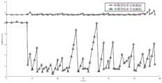
图4(a)和图4(b)显示了在含有高机动目标的场景下,使用单模型的多目标跟踪算法和使用多模型的多目标跟踪算法的跟踪结果比较。用跟踪轨迹图可以看出,使用单模型时,算法可以跟踪出地面上的两个低速直线运动的目标,但对于做高速机动盘旋上升的目标,单模型无法实现对它的跟踪。而使用多模型后,算法可以同时实现对地面低速目标和空中机动目标的跟踪。通过图4(c)、图4(d)和图4(e)对两种算法的跟踪性能进行比较,使用多模型的多目标跟踪算法OSPA距离、势误差、跟踪目标数均较使用单模型的有了很大提升,其中OSPA距离从原来的12m降低,多数时刻在6m以下,势误差比原来的近12m下降明显,在8s以后几乎维持为0,跟踪的目标数原来只能跟踪出2个目标,现在在8s之后准确地跟踪3个目标。Figures 4(a) and 4(b) show the comparison of the tracking results between the multi-target tracking algorithm using a single model and the multi-target tracking algorithm using multiple models in a scene with high maneuvering targets. It can be seen from the tracking trajectory diagram that when using a single model, the algorithm can track two low-speed linear targets on the ground, but for a target that is hovering at high speed, the single model cannot track it. After using multiple models, the algorithm can simultaneously track low-speed ground targets and air maneuvering targets. The tracking performance of the two algorithms is compared through Figure 4(c), Figure 4(d) and Figure 4(e). The OSPA distance, potential error and number of tracking targets of the multi-model multi-target tracking algorithm are better than those of the single-model multi-target tracking algorithm. The OSPA distance has been greatly improved. The OSPA distance has been reduced from the original 12m, and most of the time is below 6m. The potential error has dropped significantly compared with the original near 12m. 3 targets and now accurately track 3 targets after 8s.
图5(a)-图5(e)显示了三个地面目标,其中一个目标做机动,雷达同时对三个目标进行监测,红外传感器对其中一个目标进行监测,将航迹管理方法改进前后的跟踪结果进行比较。Figure 5(a)-Figure 5(e) show three ground targets, one of which is maneuvering, the radar monitors the three targets at the same time, and the infrared sensor monitors one of the targets. Track the results for comparison.
图5(a)和图5(b)显示了在传感器监测范围不一样、雷达量测周期为2s,红外传感器周期为0.3s,对地面三个低速目标进行监测的场景下,使用航迹管理方法改进前和航迹管理方法改进后的多目标跟踪结果比较。用跟踪轨迹图可以看出,航迹管理方法改进前,算法在前几个时刻可以跟踪出三个目标,但当加入高帧率的红外传感器量测后,由于红外传感器只能监测到其中的一个目标,于是出现了另外两个目标出现断航,且后续也不会再起始的情况。而对航迹管理方法改进后,即时连续多个时刻只接收到红外传感器的量测,另外两个不被红外传感器监测的目标也没有因此断航,可以持续对三个目标进行跟踪。通过图5(c)、图5(d)和图5(e)对两种算法的跟踪性能进行比较,航迹管理方法进行改进后的多目标跟踪算法OSPA距离、势误差、跟踪目标数均较使用单模型的有了全面提升,其中OSPA距离从原来的1.5m以上降低到1.5m以下,势误差比原来的在1.6m以上,现在下降几乎维持为0,跟踪的目标数原来在加入红外量测后由原来的跟踪三个目标变成跟踪一个目标,即雷达与红外的共视目标,航迹管理方法改进后,即使加入的红外传感器只能探测到其中的一个目标,但也能稳定地对3个目标进行跟踪。Figure 5(a) and Figure 5(b) show the use of track management in the scenarios where the monitoring ranges of the sensors are different, the radar measurement period is 2s, the infrared sensor period is 0.3s, and three low-speed targets on the ground are monitored. Comparison of multi-target tracking results before and after the improved track management method. It can be seen from the tracking trajectory diagram that before the improvement of the track management method, the algorithm can track three targets in the first few moments, but when the high frame rate infrared sensor is added for measurement, the infrared sensor can only monitor the One target, so there is a situation where the other two targets are disconnected and will not start again in the future. After the improvement of the track management method, only the measurement of the infrared sensor is received for several consecutive moments, and the other two targets that are not monitored by the infrared sensor have not been suspended due to this, and the three targets can be continuously tracked. The tracking performance of the two algorithms is compared through Figure 5(c), Figure 5(d) and Figure 5(e). Compared with the single model, the OSPA distance has been reduced from more than 1.5m to less than 1.5m, and the potential error is more than 1.6m. After the measurement, the original tracking of three targets has changed to tracking one target, that is, the radar and the infrared co-view target. After the track management method is improved, even if the added infrared sensor can only detect one of the targets, it can be stabilized. 3 targets are tracked.
以上仿真实验结果验证了本发明可以实现对高速机动目标以及低速目标的联合跟踪,同时基于航迹管理方法,可以实现对监测区域不同、采样率不同的多源传感器进行融合处理。The above simulation experiment results verify that the present invention can realize joint tracking of high-speed maneuvering targets and low-speed targets, and at the same time, based on the track management method, it can realize fusion processing of multi-source sensors with different monitoring areas and different sampling rates.
本发明并不局限于上述实施例,在本发明公开的技术方案的基础上,本领域的技术人员根据所公开的技术内容,不需要创造性的劳动就可以对其中的一些技术特征作出一些替换和变形,这些替换和变形均在本发明的保护范围内。The present invention is not limited to the above-mentioned embodiments. On the basis of the technical solutions disclosed in the present invention, those skilled in the art can make some substitutions and modifications to some of the technical features according to the disclosed technical contents without creative work. Modifications, replacements and modifications are all within the protection scope of the present invention.
Claims (10)
Translated fromChinese


Priority Applications (1)
| Application Number | Priority Date | Filing Date | Title |
|---|---|---|---|
| CN202110224659.5ACN112946624B (en) | 2021-03-01 | 2021-03-01 | Multi-target tracking method based on track management method |
Applications Claiming Priority (1)
| Application Number | Priority Date | Filing Date | Title |
|---|---|---|---|
| CN202110224659.5ACN112946624B (en) | 2021-03-01 | 2021-03-01 | Multi-target tracking method based on track management method |
Publications (2)
| Publication Number | Publication Date |
|---|---|
| CN112946624Atrue CN112946624A (en) | 2021-06-11 |
| CN112946624B CN112946624B (en) | 2023-06-27 |
Family
ID=76246872
Family Applications (1)
| Application Number | Title | Priority Date | Filing Date |
|---|---|---|---|
| CN202110224659.5AActiveCN112946624B (en) | 2021-03-01 | 2021-03-01 | Multi-target tracking method based on track management method |
Country Status (1)
| Country | Link |
|---|---|
| CN (1) | CN112946624B (en) |
Cited By (18)
| Publication number | Priority date | Publication date | Assignee | Title |
|---|---|---|---|---|
| CN113422847A (en)* | 2021-08-23 | 2021-09-21 | 中国电子科技集团公司第二十八研究所 | Aircraft identification number unified coding method based on airborne ADS-B |
| CN113484857A (en)* | 2021-06-29 | 2021-10-08 | 北京理工大学 | Tracking method, device, equipment and storage medium for multi-source heterogeneous point-trace fusion |
| CN113536057A (en)* | 2021-07-29 | 2021-10-22 | 中国第一汽车股份有限公司 | Flight path management method and device, computer equipment and storage medium |
| CN113744309A (en)* | 2021-08-11 | 2021-12-03 | 中国科学院空天信息创新研究院 | Maneuvering target tracking method based on motion state change perception |
| CN114002667A (en)* | 2021-10-29 | 2022-02-01 | 西安交通大学 | A Multi-Nearest Neighbor Extended Target Tracking Algorithm Based on Random Matrix Method |
| CN114046786A (en)* | 2021-11-11 | 2022-02-15 | 中国电子科技集团公司第二十九研究所 | Flight path prediction method, device, equipment and storage medium |
| CN114089363A (en)* | 2021-11-16 | 2022-02-25 | 哈尔滨工程大学 | Heterogeneous sensor information fusion and multi-target tracking method based on random finite set |
| CN114329120A (en)* | 2021-11-26 | 2022-04-12 | 中国航空无线电电子研究所 | Multi-platform track association and fusion method based on global track construction |
| CN114415168A (en)* | 2022-01-18 | 2022-04-29 | 舟山市质量技术监督检测研究院 | Unmanned surface vessel track fusion method and device |
| CN114537388A (en)* | 2022-02-23 | 2022-05-27 | 华域汽车系统股份有限公司 | Commercial vehicle ADAS system based on camera and radar fusion |
| CN114924264A (en)* | 2022-04-28 | 2022-08-19 | 西安交通大学 | Air target intention inference method based on target motion trajectory |
| CN115098609A (en)* | 2022-06-20 | 2022-09-23 | 哈尔滨工业大学 | Multi-sensor combined space-time deviation calibration and multi-target association fusion method and device |
| CN115420295A (en)* | 2022-09-30 | 2022-12-02 | 哈尔滨工业大学 | Battlefield Situation Consistency Processing System |
| CN115542307A (en)* | 2022-09-15 | 2022-12-30 | 河北省交通规划设计研究院有限公司 | High-speed scene multi-radar track fusion method based on high-precision map |
| CN116520302A (en)* | 2023-01-31 | 2023-08-01 | 新石器慧通(北京)科技有限公司 | A positioning method applied to an automatic driving system and a method for constructing a three-dimensional map |
| CN117214881A (en)* | 2023-07-21 | 2023-12-12 | 哈尔滨工程大学 | Multi-target tracking method based on Transformer network in complex scene |
| CN117233745A (en)* | 2023-11-15 | 2023-12-15 | 哈尔滨工业大学(威海) | Sea maneuvering target tracking method on non-stationary platform |
| CN120539691A (en)* | 2025-06-03 | 2025-08-26 | 中国人民解放军91977部队 | Method and device for associating space-time large-gap target information with radar situation |
Citations (10)
| Publication number | Priority date | Publication date | Assignee | Title |
|---|---|---|---|---|
| US20080169968A1 (en)* | 2005-03-08 | 2008-07-17 | Paul Easthope | Management of tracking models |
| CN106468771A (en)* | 2016-09-21 | 2017-03-01 | 电子科技大学 | A kind of multi-target detection and tracking method under the high clutter conditions of low Observable |
| WO2018154367A1 (en)* | 2017-02-23 | 2018-08-30 | Kpit Technologies Limited | System and method for target track management of an autonomous vehicle |
| CN108535713A (en)* | 2018-05-09 | 2018-09-14 | 深圳市华讯方舟雷达技术装备有限公司 | A kind of radar and the tracking of AIS joints and information fusion method |
| CN109508000A (en)* | 2018-12-16 | 2019-03-22 | 西南电子技术研究所(中国电子科技集团公司第十研究所) | Isomery multi-sensor multi-target tracking method |
| CN110031834A (en)* | 2018-01-12 | 2019-07-19 | 西安艾索信息技术有限公司 | A kind of improved multiple target radar track processing method |
| CN110781949A (en)* | 2019-10-23 | 2020-02-11 | 福建汉特云智能科技有限公司 | Asynchronous serial multi-sensor-based flight path data fusion method and storage medium |
| CN110988880A (en)* | 2019-12-12 | 2020-04-10 | 南京莱斯电子设备有限公司 | Geographic information extraction and target tracking method based on SMR target track |
| US20200292692A1 (en)* | 2019-03-12 | 2020-09-17 | Bae Systems Information And Electronic Systems Integration Inc. | Global nearest neighbor (gnn) based target tracking and data association |
| CN111812638A (en)* | 2020-07-17 | 2020-10-23 | 北京理工大学 | An IMM-MHT Multi-target Tracking Method |
- 2021
- 2021-03-01CNCN202110224659.5Apatent/CN112946624B/enactiveActive
Patent Citations (10)
| Publication number | Priority date | Publication date | Assignee | Title |
|---|---|---|---|---|
| US20080169968A1 (en)* | 2005-03-08 | 2008-07-17 | Paul Easthope | Management of tracking models |
| CN106468771A (en)* | 2016-09-21 | 2017-03-01 | 电子科技大学 | A kind of multi-target detection and tracking method under the high clutter conditions of low Observable |
| WO2018154367A1 (en)* | 2017-02-23 | 2018-08-30 | Kpit Technologies Limited | System and method for target track management of an autonomous vehicle |
| CN110031834A (en)* | 2018-01-12 | 2019-07-19 | 西安艾索信息技术有限公司 | A kind of improved multiple target radar track processing method |
| CN108535713A (en)* | 2018-05-09 | 2018-09-14 | 深圳市华讯方舟雷达技术装备有限公司 | A kind of radar and the tracking of AIS joints and information fusion method |
| CN109508000A (en)* | 2018-12-16 | 2019-03-22 | 西南电子技术研究所(中国电子科技集团公司第十研究所) | Isomery multi-sensor multi-target tracking method |
| US20200292692A1 (en)* | 2019-03-12 | 2020-09-17 | Bae Systems Information And Electronic Systems Integration Inc. | Global nearest neighbor (gnn) based target tracking and data association |
| CN110781949A (en)* | 2019-10-23 | 2020-02-11 | 福建汉特云智能科技有限公司 | Asynchronous serial multi-sensor-based flight path data fusion method and storage medium |
| CN110988880A (en)* | 2019-12-12 | 2020-04-10 | 南京莱斯电子设备有限公司 | Geographic information extraction and target tracking method based on SMR target track |
| CN111812638A (en)* | 2020-07-17 | 2020-10-23 | 北京理工大学 | An IMM-MHT Multi-target Tracking Method |
Non-Patent Citations (10)
| Title |
|---|
| ABDUL HADI ABD RAHMAN: "Tracking uncertain moving objects using dynamic track management in Multiple Hypothesis Tracking", 《2014 INTERNATIONAL CONFERENCE ON CONNECTED VEHICLES AND EXPO (ICCVE)》* |
| ABDUL HADI ABD RAHMAN: "Tracking uncertain moving objects using dynamic track management in Multiple Hypothesis Tracking", 《2014 INTERNATIONAL CONFERENCE ON CONNECTED VEHICLES AND EXPO (ICCVE)》, 15 October 2015 (2015-10-15)* |
| 廉杰: "航迹起始及机动目标跟踪方法的研究", 《中国硕士学位论文全文数据库 信息科技辑》* |
| 廉杰: "航迹起始及机动目标跟踪方法的研究", 《中国硕士学位论文全文数据库 信息科技辑》, 15 December 2006 (2006-12-15)* |
| 张静等: "基于多信息融合的多目标跟踪方法研究", 《计算机测量与控制》* |
| 张静等: "基于多信息融合的多目标跟踪方法研究", 《计算机测量与控制》, no. 09, 25 September 2020 (2020-09-25)* |
| 王静: "面向目标漏检与丢失的航迹管理算法研究", 《中国硕士学位论文全文数据库 信息科技辑》* |
| 王静: "面向目标漏检与丢失的航迹管理算法研究", 《中国硕士学位论文全文数据库 信息科技辑》, 15 June 2020 (2020-06-15)* |
| 赵艳丽等: "多目标跟踪中的数据关联和航迹管理", 《现代雷达》* |
| 赵艳丽等: "多目标跟踪中的数据关联和航迹管理", 《现代雷达》, no. 03, 15 March 2007 (2007-03-15)* |
Cited By (30)
| Publication number | Priority date | Publication date | Assignee | Title |
|---|---|---|---|---|
| CN113484857A (en)* | 2021-06-29 | 2021-10-08 | 北京理工大学 | Tracking method, device, equipment and storage medium for multi-source heterogeneous point-trace fusion |
| CN113484857B (en)* | 2021-06-29 | 2024-04-12 | 北京理工大学 | Multi-source heterogeneous point track fusion tracking method, device, equipment and storage medium |
| CN113536057A (en)* | 2021-07-29 | 2021-10-22 | 中国第一汽车股份有限公司 | Flight path management method and device, computer equipment and storage medium |
| CN113536057B (en)* | 2021-07-29 | 2023-03-07 | 中国第一汽车股份有限公司 | Flight path management method and device, computer equipment and storage medium |
| CN113744309A (en)* | 2021-08-11 | 2021-12-03 | 中国科学院空天信息创新研究院 | Maneuvering target tracking method based on motion state change perception |
| CN113744309B (en)* | 2021-08-11 | 2024-05-24 | 中国科学院空天信息创新研究院 | Maneuvering target tracking method based on motion state change perception |
| CN113422847A (en)* | 2021-08-23 | 2021-09-21 | 中国电子科技集团公司第二十八研究所 | Aircraft identification number unified coding method based on airborne ADS-B |
| CN113422847B (en)* | 2021-08-23 | 2021-11-02 | 中国电子科技集团公司第二十八研究所 | Aircraft identification number unified coding method based on airborne ADS-B |
| CN114002667A (en)* | 2021-10-29 | 2022-02-01 | 西安交通大学 | A Multi-Nearest Neighbor Extended Target Tracking Algorithm Based on Random Matrix Method |
| CN114046786B (en)* | 2021-11-11 | 2023-04-25 | 中国电子科技集团公司第二十九研究所 | Track prediction method, device, equipment and storage medium |
| CN114046786A (en)* | 2021-11-11 | 2022-02-15 | 中国电子科技集团公司第二十九研究所 | Flight path prediction method, device, equipment and storage medium |
| CN114089363A (en)* | 2021-11-16 | 2022-02-25 | 哈尔滨工程大学 | Heterogeneous sensor information fusion and multi-target tracking method based on random finite set |
| CN114329120A (en)* | 2021-11-26 | 2022-04-12 | 中国航空无线电电子研究所 | Multi-platform track association and fusion method based on global track construction |
| CN114329120B (en)* | 2021-11-26 | 2024-05-03 | 中国航空无线电电子研究所 | Multi-platform track association and fusion method based on global track construction |
| CN114415168A (en)* | 2022-01-18 | 2022-04-29 | 舟山市质量技术监督检测研究院 | Unmanned surface vessel track fusion method and device |
| CN114537388A (en)* | 2022-02-23 | 2022-05-27 | 华域汽车系统股份有限公司 | Commercial vehicle ADAS system based on camera and radar fusion |
| CN114924264A (en)* | 2022-04-28 | 2022-08-19 | 西安交通大学 | Air target intention inference method based on target motion trajectory |
| CN114924264B (en)* | 2022-04-28 | 2024-07-26 | 西安交通大学 | A method for inferring aerial target intention based on target motion trajectory |
| CN115098609A (en)* | 2022-06-20 | 2022-09-23 | 哈尔滨工业大学 | Multi-sensor combined space-time deviation calibration and multi-target association fusion method and device |
| CN115098609B (en)* | 2022-06-20 | 2025-04-08 | 哈尔滨工业大学 | Multi-sensor combined space-time deviation calibration and multi-target association fusion method and device |
| CN115542307A (en)* | 2022-09-15 | 2022-12-30 | 河北省交通规划设计研究院有限公司 | High-speed scene multi-radar track fusion method based on high-precision map |
| CN115542307B (en)* | 2022-09-15 | 2023-06-06 | 河北省交通规划设计研究院有限公司 | High-speed scene multi-radar track fusion method based on high-precision map |
| CN115420295A (en)* | 2022-09-30 | 2022-12-02 | 哈尔滨工业大学 | Battlefield Situation Consistency Processing System |
| CN115420295B (en)* | 2022-09-30 | 2025-07-08 | 哈尔滨工业大学 | Battlefield situation consistency processing system |
| CN116520302A (en)* | 2023-01-31 | 2023-08-01 | 新石器慧通(北京)科技有限公司 | A positioning method applied to an automatic driving system and a method for constructing a three-dimensional map |
| CN117214881B (en)* | 2023-07-21 | 2024-04-30 | 哈尔滨工程大学 | Multi-target tracking method based on Transformer network in complex scene |
| CN117214881A (en)* | 2023-07-21 | 2023-12-12 | 哈尔滨工程大学 | Multi-target tracking method based on Transformer network in complex scene |
| CN117233745B (en)* | 2023-11-15 | 2024-02-09 | 哈尔滨工业大学(威海) | Sea maneuvering target tracking method on non-stationary platform |
| CN117233745A (en)* | 2023-11-15 | 2023-12-15 | 哈尔滨工业大学(威海) | Sea maneuvering target tracking method on non-stationary platform |
| CN120539691A (en)* | 2025-06-03 | 2025-08-26 | 中国人民解放军91977部队 | Method and device for associating space-time large-gap target information with radar situation |
Also Published As
| Publication number | Publication date |
|---|---|
| CN112946624B (en) | 2023-06-27 |
Similar Documents
| Publication | Publication Date | Title |
|---|---|---|
| CN112946624B (en) | Multi-target tracking method based on track management method | |
| CN106443622B (en) | A kind of distributed object tracking based on improvement joint probability data association | |
| CN109633589A (en) | The Multi-target Data Associations assumed are optimized based on multi-model more in target following | |
| CN109116349A (en) | Multi-sensor cooperation tracks combined optimization decision-making technique | |
| Ma et al. | Target tracking system for multi-sensor data fusion | |
| CN110542885A (en) | A Millimeter Wave Radar Target Tracking Method in Complex Traffic Environment | |
| CN117169818B (en) | A radar waveform design method for sea surface maneuvering target tracking | |
| WO2012009947A1 (en) | Device and method of signature-driven multi-target tracking | |
| CN114002667B (en) | Multi-neighbor extended target tracking algorithm based on random matrix method | |
| CN112036471B (en) | Multi-person tracking method based on millimeter wave radar | |
| CN111883265B (en) | Target state estimation method applied to fire control system | |
| CN116630370A (en) | Multi-model PBP-TPMB maneuver expansion target tracking method | |
| CN117109588B (en) | Intelligent navigation-oriented multi-source detection multi-target information fusion method | |
| CN116028890A (en) | A distributed multi-sensor fusion tracking method and system | |
| Shi et al. | Autonomous multiframe point cloud fusion method for mmWave radar | |
| CN111257826B (en) | Multi-source heterogeneous sensor composite tracking method | |
| CN117433538A (en) | A multi-source heterogeneous sensor track fusion method | |
| WO2021078283A1 (en) | Data association method and device | |
| CN112083410B (en) | Maneuvering target tracking method | |
| CN116793366A (en) | A multi-AUV co-positioning method and system based on factor graph under dynamic topology | |
| CN115792887A (en) | Multi-radar maneuvering target tracking and asynchronous fusion method and device | |
| CN113971752A (en) | A Multi-vehicle Cooperative State Estimation Method Against Observation Data Interference | |
| CN112748416A (en) | First-order propagation multi-node distributed GM-PHD fusion method | |
| CN119471580B (en) | A Correlation Method for Adaptive Decision Making in Complex Environments Based on Error Propagation | |
| Shi et al. | An adaptive track fusion method with unscented kalman filter |
Legal Events
| Date | Code | Title | Description |
|---|---|---|---|
| PB01 | Publication | ||
| PB01 | Publication | ||
| SE01 | Entry into force of request for substantive examination | ||
| SE01 | Entry into force of request for substantive examination | ||
| CB03 | Change of inventor or designer information | Inventor after:LAN Jian Inventor after:Long Qiuming Inventor after:Zhang Le Inventor after:Guo Xiaoxiao Inventor after:Liu Shuang Inventor after:Xi Ruiqing Inventor after:Cao Xiaomeng Inventor before:LAN Jian Inventor before:Long Qiuming Inventor before:Zhang Le Inventor before:Guo Xiaoxiao Inventor before:Liu Shuang Inventor before:Xi Ruiqing | |
| CB03 | Change of inventor or designer information | ||
| GR01 | Patent grant | ||
| GR01 | Patent grant |