CN112902934A - Open caisson geometric attitude testing method based on GPS-EJA - Google Patents
Open caisson geometric attitude testing method based on GPS-EJADownload PDFInfo
- Publication number
- CN112902934A CN112902934ACN202110088048.2ACN202110088048ACN112902934ACN 112902934 ACN112902934 ACN 112902934ACN 202110088048 ACN202110088048 ACN 202110088048ACN 112902934 ACN112902934 ACN 112902934A
- Authority
- CN
- China
- Prior art keywords
- gps
- eja
- open caisson
- top surface
- caisson
- Prior art date
- Legal status (The legal status is an assumption and is not a legal conclusion. Google has not performed a legal analysis and makes no representation as to the accuracy of the status listed.)
- Granted
Links
Images


Classifications
- G—PHYSICS
- G01—MEASURING; TESTING
- G01C—MEASURING DISTANCES, LEVELS OR BEARINGS; SURVEYING; NAVIGATION; GYROSCOPIC INSTRUMENTS; PHOTOGRAMMETRY OR VIDEOGRAMMETRY
- G01C15/00—Surveying instruments or accessories not provided for in groups G01C1/00 - G01C13/00
- G—PHYSICS
- G01—MEASURING; TESTING
- G01C—MEASURING DISTANCES, LEVELS OR BEARINGS; SURVEYING; NAVIGATION; GYROSCOPIC INSTRUMENTS; PHOTOGRAMMETRY OR VIDEOGRAMMETRY
- G01C9/00—Measuring inclination, e.g. by clinometers, by levels
Landscapes
- Physics & Mathematics (AREA)
- Engineering & Computer Science (AREA)
- General Physics & Mathematics (AREA)
- Radar, Positioning & Navigation (AREA)
- Remote Sensing (AREA)
- Position Fixing By Use Of Radio Waves (AREA)
Abstract
Description
Translated fromChinese技术领域technical field
本申请涉及桥梁施工测试技术领域,具体涉及一种基于GPS-EJA的沉井几何姿态测试方法。The present application relates to the technical field of bridge construction testing, in particular to a GPS-EJA-based caisson geometry attitude testing method.
背景技术Background technique
目前,沉井被广泛用作大型桥梁的主塔及锚碇基础,在沉井取土下沉的过程中,下沉的几何姿态是施工质量控制的重要指标;因此,需要对沉井的几何姿态进行实时监测,才能实现较好的安装效果。At present, caisson is widely used as the main tower and anchor foundation of large bridges. During the process of caisson borrowing and sinking, the geometric posture of sinking is an important indicator of construction quality control; Only by monitoring the posture in real time can a better installation effect be achieved.
相关技术中,沉井下沉的几何姿态具有多种监测方法,其中最为新颖且有效的是使用GPS(Global Positioning System,定位系统)进行监测。采用GPS监测沉井施工,确定沉井几何姿态至少需要确定沉井顶面三个点的坐标值;但是GPS监测受现场施工条件的干扰影响,极易出现数据采集间断或大幅度异常跳动的现象。因此,开发一套能准确测试沉井几何姿态、受现场施工条件干扰小的监测系统是本领域技术人员亟待解决的技术问题。In the related art, there are various monitoring methods for the geometric posture of caisson sinking, among which the most novel and effective is to use GPS (Global Positioning System, positioning system) to monitor. Using GPS to monitor the caisson construction, to determine the geometric posture of the caisson, at least three coordinates of the top surface of the caisson need to be determined; however, GPS monitoring is affected by the interference of on-site construction conditions, and the phenomenon of intermittent data collection or large abnormal beating is very likely to occur. . Therefore, developing a monitoring system that can accurately test the geometric posture of the caisson and is less disturbed by on-site construction conditions is a technical problem to be solved urgently by those skilled in the art.
发明内容SUMMARY OF THE INVENTION
针对现有技术中存在的缺陷,本申请的目的在于提供一种基于GPS-EJA的沉井几何姿态测试方法,能够筛选去除GPS测站监测过程中的失真数据,对沉井施工进行精准监测。In view of the defects existing in the prior art, the purpose of the present application is to provide a GPS-EJA-based caisson geometric attitude testing method, which can screen and remove the distorted data in the monitoring process of the GPS station, and accurately monitor the caisson construction.
为达到以上目的,本申请采取的技术方案是一种基于GPS-EJA的沉井几何姿态测试方法,包括步骤:In order to achieve the above purpose, the technical solution adopted in this application is a GPS-EJA-based caisson geometric attitude testing method, comprising the steps:
S1:在沉井顶面标记四个以上监测点,在每个监测点处布置一个GPS测站和一个EJA变送器,所有GPS测站与已知坐标点的基站组网,所有EJA变送器通过水管相互连通;利用测量仪器确定任意两个监测点之间的距离;S1: Mark more than four monitoring points on the top surface of the caisson, arrange a GPS station and an EJA transmitter at each monitoring point, all GPS stations are networked with base stations with known coordinate points, and all EJA transmitters The monitors are connected to each other through water pipes; use measuring instruments to determine the distance between any two monitoring points;
S2:利用所有监测点对应位置的EJA变送器采集的相对水位,计算沉井顶面横向倾斜率和纵向倾斜率;S2: Calculate the lateral inclination rate and longitudinal inclination rate of the top surface of the caisson by using the relative water levels collected by the EJA transmitters at the corresponding positions of all monitoring points;
S3:在四个以上监测点中任意选取一组监测点,每组监测点包含三个监测点;S3: randomly select a group of monitoring points from more than four monitoring points, and each group of monitoring points includes three monitoring points;
S4:利用三个监测点对应位置的三个GPS测站采集到的三维坐标值,计算沉井顶面横向倾斜角、纵向倾斜角以及任意两个GPS测站之间的距离;S4: Use the three-dimensional coordinate values collected by the three GPS stations at the corresponding positions of the three monitoring points to calculate the lateral inclination angle, longitudinal inclination angle of the top surface of the caisson, and the distance between any two GPS stations;
利用EJA变送器采集数据计算的结果以及测量仪器确定的监测点之间的距离,对用GPS测站采集的三维坐标值计算的结果,进行合理性判断;Using the calculated results of the data collected by the EJA transmitter and the distance between the monitoring points determined by the measuring instrument, the rationality of the calculated results of the three-dimensional coordinate values collected by the GPS station is judged;
S5:选取另一组监测点,重复S4,直至每组监测点合理性判断完毕;用合理性判断合格的GPS测站采集的三维坐标值为基础进行计算,并输出沉井的几何姿态参数。S5: Select another group of monitoring points, and repeat S4 until the rationality judgment of each group of monitoring points is completed; calculate based on the three-dimensional coordinate values collected by the GPS stations that are qualified for the rationality judgment, and output the geometric attitude parameters of the caisson.
在一些实施例中,利用EJA变送器采集数据计算的结果以及测量仪器确定的任意两个监测点之间的距离,对用GPS测站采集的三维坐标值计算的结果,进行合理性判断,包括:In some embodiments, the calculation result of the data collected by the EJA transmitter and the distance between any two monitoring points determined by the measuring instrument are used to judge the rationality of the calculation result of the three-dimensional coordinate value collected by the GPS station, include:
将利用GPS测站采集的三维坐标值计算的沉井顶面横向倾斜角,换算成横向斜率,与利用EJA变送器采集的相对水位计算的相应的沉井顶面横向倾斜率进行比较,两者差的绝对值小于第一设定值;Convert the lateral inclination angle of the caisson top surface calculated by the three-dimensional coordinate values collected by the GPS station into the lateral slope, and compare it with the corresponding lateral inclination rate of the caisson top surface calculated by using the relative water level collected by the EJA transmitter. The absolute value of the difference is less than the first set value;
将利用GPS测站采集的三维坐标值计算的沉井顶面纵向倾斜角,换算成纵向斜率,与利用EJA变送器采集的相对水位计算的相应的沉井顶面纵向倾斜率进行比较,两者差的绝对值小于第二设定值;Convert the longitudinal inclination angle of the caisson top surface calculated by the three-dimensional coordinate values collected by the GPS station into the longitudinal slope, and compare it with the corresponding longitudinal inclination rate of the caisson top surface calculated by using the relative water level collected by the EJA transmitter. The absolute value of the difference is less than the second set value;
将利用GPS测站采集的三维坐标值计算的两个GPS测站之间的距离,与利用测量仪器确定的相应两个监测点之间的距离进行比较,两者差的绝对值小于第三设定值;Compare the distance between two GPS stations calculated by using the three-dimensional coordinate values collected by the GPS station with the distance between the corresponding two monitoring points determined by the measuring instrument, and the absolute value of the difference between the two is smaller than the third setting. Value;
若三者均成立,则判定合理。If all three are established, the judgment is reasonable.
在一些实施例中,所述沉井顶面的监测点为四个,分别为沉井顶面的两条中轴线的四个端点;In some embodiments, there are four monitoring points on the top surface of the caisson, which are the four end points of the two central axes of the top surface of the caisson;
在步骤S1中,利用测量仪器将GPS测站校准至沉井轴线的端点上,将EJA变送器校准至沉井顶面并确定其平面坐标。In step S1, the GPS station is calibrated to the end point of the caisson axis using the measuring instrument, the EJA transmitter is calibrated to the top surface of the caisson and its plane coordinates are determined.
在一些实施例中,在步骤S4中,利用EJA变送器采集的相对水位计算的结果,对用GPS测站采集的三维坐标值计算的结果,进行合理性判断的方法包含:In some embodiments, in step S4, the method for judging the rationality of the calculation result of the three-dimensional coordinate value collected by the GPS station using the result of the relative water level calculation collected by the EJA transmitter includes:
ABS(βijk·π/180°-Kx)≤MABS(βijk ·π/180°-Kx )≤M
ABS(γijk·π/180°-Ky)≤NABS(γijk ·π/180°-Ky )≤N
ABS(Dij-dij)≤QABS(Dij -dij )≤Q
若三个公式均成立,则判定为合理;若有一个不成立,则判定为不合理;其中,If all three formulas are established, it is judged to be reasonable; if one of the formulas is not established, it is judged to be unreasonable; among them,
Kx=(P3-P1)/L3-1Kx =(P3 -P1 )/L3-1
Ky=(P2-P4)/L2-4Ky =(P2 -P4 )/L2-4
式中:ABS为绝对值符号;M、N和Q为常数;i、j、k分别为监测点的标号;i、j和k均为1~4正整数且i≠j≠k;In the formula: ABS is the absolute value symbol; M, N and Q are constants; i, j, k are the labels of the monitoring points respectively; i, j and k are all positive integers from 1 to 4 and i≠j≠k;
βijk为根据GPS测站采集的三维坐标值计算得到的沉井顶面纵桥向倾斜角度;γijk为根据GPS测站采集的三维坐标值计算得到的沉井顶面横桥向倾斜角度;βijk is the longitudinal inclination angle of the caisson top surface calculated according to the three-dimensional coordinate value collected by the GPS station; γijk is the lateral inclination angle of the caisson top surface calculated according to the three-dimensional coordinate value collected by the GPS station;
dij为编号i和j的监测点处的GPS测站采集的三维坐标值计算得到的距离;dij is the distance calculated by the three-dimensional coordinate values collected by the GPS stations at the monitoring points numbered i and j;
Dij为编号i和j的监测点之间的实际距离;Dij is the actual distance between the monitoring points numbered i and j;
Kx为EJA变送器测得的沉井顶面纵桥向的倾斜率;Ky为EJA变送器测得的沉井顶面横桥向的倾斜率;Kx is the inclination rate of the longitudinal bridge direction of the caisson top surface measured by the EJA transmitter;Ky is the inclination rate of the transverse bridge direction of the caisson top surface measured by the EJA transmitter;
pm是标号为m的EJA变送器的相对水位,Lm-n是编号为m和n的EJA变送器之间的水平距离;其中,m和n分别为EJA变送器的标号,m和n均为1~4正整数且m≠n。pm is the relative water level of the EJA transmitter numbered m, Lmn is the horizontal distance between the EJA transmitters numbered m and n; where m and n are the labels of the EJA transmitters, m and n are respectively n is a positive integer from 1 to 4 and m≠n.
在一些实施例中,所述常数M、N为GPS测站采集高程精度误差的2倍与监测点连线距离的商,常数Q为GPS测站采集平面坐标精度误差值的2倍。In some embodiments, the constants M and N are the quotient of twice the height accuracy error collected by the GPS station and the distance connecting the monitoring points, and the constant Q is twice the accuracy error value of the plane coordinates collected by the GPS station.
在一些实施例中,在步骤S5中,所述沉井的几何姿态参数包含Kx、Ky、以及用合理性判断合格的GPS测站采集的三维坐标值为基础计算得到的沉井的平面扭转角α,以及沉井顶面中心的三维坐标(x0,y0,z0)。In some embodiments, in step S5, the geometric attitude parameters of the caisson include Kx ,Ky , and the plane of the caisson calculated on the basis of the three-dimensional coordinate values collected by a GPS station that is qualified for rationality judgment The torsion angle α, and the three-dimensional coordinates (x0 , y0 , z0 ) of the center of the top surface of the caisson.
在一些实施例中,所述α是由四个监测点组成的四组监测点计算得到四个平面扭转角的平均值。In some embodiments, the α is an average value of four plane twist angles calculated from four groups of monitoring points consisting of four monitoring points.
在一些实施例中,所述沉井顶面中心的坐标(x0,y0,z0)的计算方法包含:In some embodiments, the method for calculating the coordinates (x0 , y0 , z0 ) of the center of the top surface of the caisson includes:
xo,1=x1-W/2·cosγ·cosαxo,1 =x1 -W/2·cosγ·cosα
yo,1=y1-W/2·cosγ·sinαyo,1 =y1 -W/2·cosγ·sinα
xo,2=x2+B/2·cosβ·sinαxo,2 =x2 +B/2·cosβ·sinα
yo,2=y2+B/2·cosβ·cosαyo,2 =y2 +B/2·cosβ·cosα
xo,3=x3+W/2·cosγ·cosαxo,3 = x3 +W/2·cosγ·cosα
yo,3=y3+W/2·cosγ·sinαyo,3 =y3 +W/2·cosγ·sinα
xo,4=x4-B/2·cosβ·sinαxo,4 =x4 -B/2·cosβ·sinα
yo,4=y4-B/2·cosβ·cosαyo,4 =y4 -B/2·cosβ·cosα
x0=Avg(xo,i)(i为整数,i∈[1,4])x0 =Avg(xo,i ) (i is an integer, i∈[1,4])
y0=Avg(yo,i)(i为整数,i∈[1,4])y0 =Avg(yo,i ) (i is an integer, i∈[1,4])
式中:where:
xi、yi——分别为编号为i的GPS监测点得到的平面坐标值,单位为米;xo,i、yo,i——利用编号为i的GPS监测点数据计算得到沉井顶面中心坐标值,单位为米;xi , yi - the plane coordinate values obtained by the GPS monitoring point numbered i respectively, in meters; xo,i , yo,i - the caisson calculated using the GPS monitoring point data numbered i The coordinate value of the top center, in meters;
W/2、B/2——分别为沉井横桥向轴线与纵桥向轴线方向的长度,单W/2, B/2——respectively the lengths of the caisson lateral axis and longitudinal bridge axis, single
位为米;bits are meters;
β、γ——筛选后数据计算得到沉井平面扭转角度,单位为度;β, γ——the torsion angle of the caisson plane calculated from the filtered data, the unit is degree;
x0,y0——换算得到沉井顶面中心坐标值,单位为米。x0 , y0 ——The coordinate value of the center of the top surface of the caisson is obtained by conversion, and the unit is meters.
z0,1=z1-Kx·W/2z0,1 =z1 -Kx ·W/2
z0,3=z3+Kx·W/2z0,3 =z3 +Kx ·W/2
z0,2=z2+Ky·B/2z0,2 =z2 +Ky ·B/2
z0,4=z4-Ky·B/2z0,4 =z4 -Ky ·B/2
z0=Avg(z0,i)(i为整数,且i∈[1,4])z0 =Avg(z0,i ) (i is an integer, and i∈[1,4])
式中:where:
zi——编号为i的GPS测点的高程,单位为米;zi ——the elevation of the GPS measuring point numbered i, in meters;
zo,i——由编号为i的GPS监测点数据换算得到的沉井顶面中心高zo,i ——the center height of the top surface of the caisson converted from the GPS monitoring point data numbered i
程,单位为米;distance, in meters;
zo——沉井顶面中心高程,单位为米。zo ——The central elevation of the top surface of the caisson, in meters.
在一些实施例中,所述测量仪器为高精度的全站仪或水平仪。In some embodiments, the measuring instrument is a high-precision total station or spirit level.
在一些实施例中,所述GPS测站在测量时,需避开门吊和塔吊。In some embodiments, the GPS station needs to avoid door cranes and tower cranes when measuring.
本申请提供的技术方案带来的有益效果包括:The beneficial effects brought by the technical solution provided by this application include:
本申请的一种基于GPS-EJA的沉井几何姿态测试方法,本申请的沉井几何姿态测试方法先用测量仪器对监测点进行放样,测量得到任意两个监测点之间的距离,然后采用两套测量系统,除了采用GPS测站进行测量外,还采用EJA变送器进行测量;EJA变送器测量数据真实且稳定可靠,用EJA变送器的测量结果和测量仪器对监测点的放样结果,对极易出现数据采集间断或大幅度异常跳动的GPS测站采集的三维坐标值进行比对筛选,能够最大限度克服现场环境干扰造成GPS数据采集中断及数据异常跳动造成沉井几何姿态输出数据严重失真的问题,通过算法优化和数据筛选的方法提高了数据输出的稳定性和可靠性,使得在沉井下沉过程中,对沉井几何姿态的监测更加精准,更加有利于施工指导,提高施工效率。A method for testing the geometric attitude of a caisson based on GPS-EJA of the present application, the method for testing the geometric attitude of a caisson of the present application first uses a measuring instrument to stake out the monitoring points, measures the distance between any two monitoring points, and then adopts Two sets of measurement systems, in addition to using GPS station for measurement, also use EJA transmitter for measurement; EJA transmitter measurement data is true, stable and reliable, using EJA transmitter measurement results and measuring instruments to stake out monitoring points As a result, the comparison and screening of the three-dimensional coordinate values collected by GPS stations that are prone to intermittent data collection or large abnormal jumps can minimize the interruption of GPS data collection caused by on-site environmental interference and the output of caisson geometry and attitude caused by abnormal data jumps. For the problem of serious data distortion, the stability and reliability of data output are improved by algorithm optimization and data screening, which makes the monitoring of the geometric posture of the caisson more accurate during the sinking process of the caisson, which is more conducive to construction guidance and improves construction efficiency.
附图说明Description of drawings
为了更清楚地说明本申请实施例中的技术方案,下面将对实施例描述中所需要使用的附图作简单地介绍,显而易见地,下面描述中的附图仅仅是本申请的一些实施例,对于本领域普通技术人员来讲,在不付出创造性劳动的前提下,还可以根据这些附图获得其他的附图。In order to illustrate the technical solutions in the embodiments of the present application more clearly, the following briefly introduces the drawings that are used in the description of the embodiments. Obviously, the drawings in the following description are only some embodiments of the present application. For those of ordinary skill in the art, other drawings can also be obtained from these drawings without creative effort.
图1为本申请实施例提供的沉井顶面EJA变送器的平面布置图;Fig. 1 is the plan layout drawing of the EJA transmitter on the top surface of the caisson provided by the embodiment of the present application;
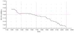
图2是数据筛选功能实施前输出的沉井底面中心标高数据变化曲线;Fig. 2 is the data change curve of the center elevation of the bottom surface of the caisson output before the implementation of the data screening function;
图3是数据筛选功能实施后输出的沉井底面中心标高数据变化曲线;Fig. 3 is the data change curve of the center elevation of the bottom surface of the caisson output after the data screening function is implemented;
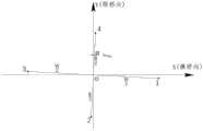
图4是沉井局部坐标系与GPS监测点之间的位置关系示意图。FIG. 4 is a schematic diagram of the positional relationship between the local coordinate system of the caisson and the GPS monitoring points.
具体实施方式Detailed ways
下面将结合具体实施例对本本申请的技术方案进行清楚、完整地描述。显然,所描述的实施例仅仅是本本申请的一部分实施例,而不是全部的实施例。基于本本申请的实施例,本领域普通技术人员在没有作出创造性劳动前提下所获得的所有其他实施例,都属于本本申请保护的范围。The technical solutions of the present application will be clearly and completely described below with reference to specific embodiments. Obviously, the described embodiments are only a part of the embodiments of the present application, but not all of the embodiments. Based on the embodiments of the present application, all other embodiments obtained by those of ordinary skill in the art without creative work fall within the protection scope of the present application.
本申请公开了一种基于GPS-EJA的沉井几何姿态测试方法的实施例,包括步骤:The present application discloses an embodiment of a GPS-EJA-based caisson geometry attitude testing method, comprising the steps of:
S1:在沉井顶面标记四个以上监测点,利用测量仪器确定任意两个监测点之间的距离,在每个监测点处布置一个GPS测站和一个EJA变送器,所有GPS测站与已知坐标点的基站组网,所有EJA变送器通过水管相互连通。S1: Mark more than four monitoring points on the top of the caisson, use measuring instruments to determine the distance between any two monitoring points, and arrange a GPS station and an EJA transmitter at each monitoring point. All GPS stations Networking with base stations with known coordinate points, all EJA transmitters are connected to each other through water pipes.
S2:利用所有监测点对应位置的EJA变送器采集的相对水位,计算沉井顶面横向倾斜率和纵向倾斜率,并利用测量仪器确定任意两个EJA变送器之间的距离。S2: Use the relative water level collected by the EJA transmitters at the corresponding positions of all monitoring points to calculate the lateral inclination rate and longitudinal inclination rate of the top surface of the caisson, and use the measuring instrument to determine the distance between any two EJA transmitters.
S3:在四个以上监测点中任意选取一组监测点,每组监测点包含三个监测点。例如,编号为1、2、3和4的四个监测点,可组合成四组监测点,编号分别为123、124、234和134。S3: A group of monitoring points is arbitrarily selected from more than four monitoring points, and each group of monitoring points includes three monitoring points. For example, four monitoring points numbered 1, 2, 3 and 4 can be combined into four groups of monitoring points, numbered 123, 124, 234 and 134 respectively.
S4:利用三个监测点对应位置的三个GPS测站采集三个监测点的坐标。具体地,已知坐标点的基站向GPS测站发射信号,并计算出GPS测站的坐标,即所在监测点的坐标。根据三个监测点的坐标计算沉井顶面横向倾斜角、纵向倾斜角以及任意两个GPS测站之间的距离。S4: The coordinates of the three monitoring points are collected by using three GPS stations corresponding to the positions of the three monitoring points. Specifically, a base station with a known coordinate point transmits a signal to a GPS station, and calculates the coordinates of the GPS station, that is, the coordinates of the monitoring point where it is located. According to the coordinates of the three monitoring points, the lateral inclination angle, longitudinal inclination angle of the top surface of the caisson and the distance between any two GPS stations are calculated.
用利用EJA变送器采集数据计算的结果(即沉井顶面横向倾斜率和纵向倾斜率)以及用测量仪器确定的任意两个监测点之间的距离,对用GPS测站采集的三维坐标值计算的结果(即沉井顶面横向倾斜角、纵向倾斜角以及任意两个GPS测站之间的距离),进行合理性判断。Using the results calculated by the data collected by the EJA transmitter (that is, the lateral inclination rate and the longitudinal inclination rate of the caisson top surface) and the distance between any two monitoring points determined by the measuring instrument, the three-dimensional coordinates collected by the GPS station are used. Based on the calculated results (ie, the lateral inclination angle of the top surface of the caisson, the vertical inclination angle, and the distance between any two GPS stations), the rationality is judged.
S5:选取另一组监测点,重复S4,直至每组监测点合理性判断完毕,即对所有组监测点进行合理性判断,若总共有4组,则将四组监测点合理性判断完毕。这样就筛选掉了不合理的GPS测站采集的三维坐标值,用合理性判断合格的GPS测站采集的三维坐标值为基础进行计算,并输出沉井的几何姿态参数。S5: Select another group of monitoring points, and repeat S4 until the rationality judgment of each group of monitoring points is completed, that is, the rationality judgment of all groups of monitoring points is carried out. In this way, the three-dimensional coordinate values collected by unreasonable GPS stations are screened out, and the three-dimensional coordinate values collected by the qualified GPS stations are used for calculation based on the rationality, and the geometric attitude parameters of the caisson are output.
在一个实施例中,在沉井外部设置一个计算系统,该计算系统与基站、所有GPS测站以及所有EJA变送器相连接,S1到S5的所有计算步骤均由该计算系统来完成。In one embodiment, a computing system is provided outside the caisson, the computing system is connected with the base station, all GPS stations and all EJA transmitters, and all computing steps S1 to S5 are completed by the computing system.
在一个实施例中,利用EJA变送器采集数据计算的结果以及测量仪器确定的任意两个监测点之间的距离,对用GPS测站采集的三维坐标值计算的结果,进行合理性判断,包括:In one embodiment, the calculation result of the data collected by the EJA transmitter and the distance between any two monitoring points determined by the measuring instrument are used to judge the rationality of the calculation result of the three-dimensional coordinate value collected by the GPS station, include:
将利用GPS测站采集的三维坐标值计算的沉井顶面横向倾斜角,换算成横向斜率,与利用EJA变送器采集的相对水位计算的相应的沉井顶面横向倾斜率进行比较,两者差的绝对值小于第一设定值;Convert the lateral inclination angle of the caisson top surface calculated by the three-dimensional coordinate values collected by the GPS station into the lateral slope, and compare it with the corresponding lateral inclination rate of the caisson top surface calculated by using the relative water level collected by the EJA transmitter. The absolute value of the difference is less than the first set value;
将利用GPS测站采集的三维坐标值计算的沉井顶面纵向倾斜角,换算成纵向斜率,与利用EJA变送器采集的相对水位计算相应的沉井顶面纵向倾斜率进行比较,两者差的绝对值小于第二设定值;Convert the longitudinal inclination angle of the caisson top surface calculated by the three-dimensional coordinate values collected by the GPS station into the longitudinal slope, and compare the corresponding longitudinal inclination rate of the caisson top surface calculated by using the relative water level collected by the EJA transmitter. The absolute value of the difference is less than the second set value;
将利用GPS测站采集的三维坐标值计算的两个GPS测站之间的距离,与利用测量仪器确定的相应两个监测点之间的距离进行比较,两者差的绝对值小于第三设定值;Compare the distance between two GPS stations calculated by using the three-dimensional coordinate values collected by the GPS station with the distance between the corresponding two monitoring points determined by the measuring instrument, and the absolute value of the difference between the two is smaller than the third setting. Value;
若三者均成立,则判定合理。If all three are established, the judgment is reasonable.
具体地,第一设定值为M,第二设定值为N,第三设定值为Q。Specifically, the first set value is M, the second set value is N, and the third set value is Q.
如图1所示,在一个实施例中,所述沉井顶面的监测点为四个,分别为沉井顶面的两条中轴线的四个端点。As shown in FIG. 1 , in one embodiment, there are four monitoring points on the top surface of the caisson, which are the four end points of the two central axes of the top surface of the caisson.
在实际安装的过程中,每个监测点处布置一个GPS测站和一个EJA变送器,但是GPS测站和EJA变送器由于具有一定体积,因此不可能准确地与监测点完全重合;因此在步骤S1中,利用测量仪器将GPS测站校准至沉井轴线的端点上,将EJA变送器校准至沉井顶面并确定其平面坐标,使得后续测量计算更加高效精准。In the actual installation process, a GPS station and an EJA transmitter are arranged at each monitoring point, but because the GPS station and EJA transmitter have a certain volume, it is impossible to exactly coincide with the monitoring point; therefore In step S1, the GPS station is calibrated to the end point of the caisson axis using the measuring instrument, the EJA transmitter is calibrated to the top surface of the caisson, and its plane coordinates are determined, so that subsequent measurement calculations are more efficient and accurate.
进一步地,沉井顶面的四个监测点为两条中轴线的四个端点,在步骤S4中,利用EJA变送器采集数据计算的结果,对用GPS测站采集的三维坐标值计算的结果,进行合理性判断的方法,包含:Further, the four monitoring points on the top surface of the caisson are the four end points of the two central axes. In step S4, the calculation results of the data collected by the EJA transmitter are used to calculate the three-dimensional coordinate values collected by the GPS station. As a result, methods for making reasonable judgments include:
ABS(βijk·π/180°-Kx)≤MABS(βijk ·π/180°-Kx )≤M
ABS(γijk·π/180°-Ky)≤NABS(γijk ·π/180°-Ky )≤N
ABS(Dij-dij)≤QABS(Dij -dij )≤Q
若三个公式均成立,则判定为合理;若有一个不成立,则判定为不合理,则需要过滤掉对应GPS测站采集的三维坐标值;其中,If all three formulas are established, it is judged to be reasonable; if one of the formulas is not established, it is judged to be unreasonable, and the three-dimensional coordinate values collected by the corresponding GPS station need to be filtered out; among them,
Kx=(P3-P1)/L3-1Kx =(P3 -P1 )/L3-1
Ky=(P2-P4)/L2-4Ky =(P2 -P4 )/L2-4
式中:ABS为绝对值符号;M、N和Q为常数;i、j、k分别为监测点的标号;i、j和k均为1~4正整数且i≠j≠k;In the formula: ABS is the absolute value symbol; M, N and Q are constants; i, j, k are the labels of the monitoring points respectively; i, j and k are all positive integers from 1 to 4 and i≠j≠k;
βijk为根据GPS测站采集的三维坐标值计算得到的沉井顶面纵桥向的倾斜角度;γijk为根据GPS测站采集的三维坐标值计算得到的沉井顶面横桥向的倾斜角度;βijk is the inclination angle of the longitudinal bridge direction of the caisson top surfacecalculated according to the three-dimensional coordinate values collected by the GPS station; angle;
dij为编号i和j监测点处的GPS测站采集的三维坐标值计算得到的距离;dij is the distance calculated from the three-dimensional coordinate values collected by the GPS stations at monitoring points number i and j;
Dij为编号i和j监测点之间的实际距离,由测量装置测量之后,为已知的确定数据;Dij is the actual distance between the monitoring points numbered i and j, after being measured by the measuring device, it is the known determined data;
具体地,当用如图1所示的标号为1~4的四个监测点进行计算时,先后令ijk等于123、124、234和134,进行合理性判断。Specifically, when using the four monitoring points labeled 1 to 4 as shown in FIG. 1 for calculation, set ijk to be equal to 123, 124, 234 and 134 successively, and make a rationality judgment.
Kx为EJA变送器测得的沉井顶面纵桥向的倾斜率;Ky为EJA变送器测得的沉井顶面横桥向的倾斜率;Kx和Ky都是唯一值。Kx is the inclination rate of the longitudinal bridge direction of the caisson top surface measured by the EJA transmitter;Ky is the inclination rate of the transverse bridge direction of the caisson top surface measured by the EJA transmitter; Kx andKy are unique value.
pm是标号为m的EJA变送器的相对水位,具体地,p1、p2、p2和p4分别为1~4的四个监测点相应位置的EJA变送器测得的相对水位。pm is the relative water level of the EJA transmitter marked m, specifically, the relative water level measured by the EJA transmitter at the corresponding positions of the four monitoring points where p1 , p2 , p2 and p4 are 1 to 4 respectively water level.
Lm-n是编号为m和n的EJA变送器之间的水平距离;其中,m和n分别为EJA变送器的标号,m和n均为1~4正整数且m≠n。具体地,L3-1为编号为1和3的EJA变送器之间的水平距离;L2-4为编号为2和4的EJA变送器之间的水平距离。Lmn is the horizontal distance between the EJA transmitters numbered m and n; where m and n are the labels of the EJA transmitters, respectively, m and n are both positive integers from 1 to 4 and m≠n. Specifically, L3-1 is the horizontal distance between the EJA transmitters numbered 1 and 3; L2-4 is the horizontal distance between the EJA transmitters numbered 2 and 4.
进一步地,常数M为GPS测站采集高程精度误差的2倍与编号为1、3号的监测点连线距离的商,N为GPS测站采集高程精度误差的2倍与编号为2、4号的监测点连线距离的商,常数Q为GPS测站采集平面坐标精度误差的2倍。Further, the constant M is the quotient of 2 times the height accuracy error collected by the GPS station and the distance between the monitoring points numbered 1 and 3, and N is 2 times the height accuracy error collected by the GPS station and the
在一个实施例中,在步骤S5中,沉井的几何姿态参数包含Kx、Ky、以及用合理性判断合格的GPS测站采集的三维坐标值为基础计算得到的沉井的平面扭转角α,以及沉井顶面中心的三维坐标(x0,y0,z0)。In one embodiment, in step S5, the geometric attitude parameters of the caisson include Kx ,Ky , and the plane torsion angle of the caisson calculated on the basis of the three-dimensional coordinate values collected by the GPS station that is qualified for rationality judgment α, and the three-dimensional coordinates (x0 , y0 , z0 ) of the center of the top surface of the caisson.
进一步地,α是由四个监测点组成的四组监测点(分别为123、124、234和134)计算得到四个平面扭转角的平均值,即先后用每组监测点计算得到一个平面扭转角,然后四个平面扭转角求平均值即为α。Further, α is the average value of the four plane torsion angles calculated by four groups of monitoring points (respectively 123, 124, 234 and 134) composed of four monitoring points, that is, a plane torsion angle is calculated by using each group of monitoring points successively. angle, and then the average of the four plane twist angles is α.
如图4所示,进一步地,沉井顶面中心的坐标(x0,y0,z0)的计算方法包含:As shown in Figure 4, further, the calculation method of the coordinates (x0 , y0 , z0 ) of the center of the top surface of the caisson includes:
xo,1=x1-W/2·cosγ·cosαxo,1 =x1 -W/2·cosγ·cosα
yo,1=y1-W/2·cosγ·sinαyo,1 =y1 -W/2·cosγ·sinα
xo,2=x2+B/2·cosβ·sinαxo,2 =x2 +B/2·cosβ·sinα
yo,2=y2+B/2·cosβ·cosαyo,2 =y2 +B/2·cosβ·cosα
xo,3=x3+W/2·cosγ·cosαxo,3 = x3 +W/2·cosγ·cosα
yo,3=y3+W/2·cosγ·sinαyo,3 =y3 +W/2·cosγ·sinα
xo,4=x4-B/2·cosβ·sinαxo,4 =x4 -B/2·cosβ·sinα
yo,4=y4-B/2·cosβ·cosαyo,4 =y4 -B/2·cosβ·cosα
x0=Avg(xo,i)(i为整数,i∈[1,4])x0 =Avg(xo,i ) (i is an integer, i∈[1,4])
y0=Avg(yo,i)(i为整数,i∈[1,4])y0 =Avg(yo,i ) (i is an integer, i∈[1,4])
式中:where:
(xi、yi)为编号为i的GPS监测点得到的平面坐标值,单位为米;(xo,i、yo,i)利用编号为i的GPS测站监测数据计算得到沉井顶面中心的平面坐标值,单位为米;(xi , yi ) are the plane coordinate values obtained by the GPS monitoring point numbered i, and the unit is meters; (xo,i , yo,i ) calculate the caisson using the monitoring data of the GPS station numbered i The plane coordinate value of the center of the top surface, in meters;
W/2为沉井顶面的横桥向中轴线的长度的一半,B/2为沉井顶面的顺桥向中轴线的长度的一半,单位为米;W/2 is half of the length of the horizontal bridge on the top of the caisson to the central axis, and B/2 is half of the length of the horizontal bridge on the top of the caisson, in meters;
β筛选后数据计算得到沉井顶面纵桥向倾斜角度,γ为筛选后数据计算得到沉井顶面的横桥向倾斜角度,此时用筛选后的真实的GPS坐标数据计算得到的是真实的沉井倾斜角度,单位为度;The longitudinal inclination angle of the caisson top surface is calculated from the data after β screening, and γ is the transverse inclination angle of the caisson top surface calculated from the filtered data. At this time, the real GPS coordinate data after screening is used to calculate the real The inclination angle of the caisson, in degrees;
(x0,y0)为沉井顶面中心的平面坐标值,单位为米。(x0 , y0 ) is the plane coordinate value of the center of the top surface of the caisson, in meters.
z0,1=z1-Kx·W/2z0,1 =z1 -Kx ·W/2
z0,3=z3+Kx·W/2z0,3 =z3 +Kx ·W/2
z0,2=z2+Ky·B/2z0,2 =z2 +Ky ·B/2
z0,4=z4-Ky·B/2z0,4 =z4 -Ky ·B/2
z0=Avg(z0,i)(i为整数,且i∈[1,4])z0 =Avg(z0,i ) (i is an integer, and i∈[1,4])
式中:where:
zi为编号为i的GPS测点的高程,单位为米;zo,i为编号为i的GPS监测点数据换算得到的沉井顶面中心的高程,单位为米;zo为沉井顶面中心的高程,单位为米。zi is the elevation of the GPS monitoring point numbered i, in meters; zo, i is the elevation of the center of the top surface of the caisson obtained by converting the GPS monitoring point data numbered i, in meters; zo is the caisson Elevation of the top center in meters.
在一个实施例中,测量仪器为高精度的全站仪或水平仪。In one embodiment, the measuring instrument is a high-precision total station or spirit level.
优选地,GPS测站在测量时,需避开门吊和塔吊;因为门吊和塔吊等高度较高的金属设备容易对GPS测站造成干扰。Preferably, when measuring the GPS station, it is necessary to avoid door cranes and tower cranes; because high-height metal devices such as door cranes and tower cranes are likely to interfere with the GPS station.
将本申请的沉井几何姿态测试方法,实际应用于某沉井施工监控,该沉井平面尺寸95.0×57.8m,总高度64.0m,为世界最大的水中沉井。在监测实施初期,沉井几何姿态数据受大型门吊、塔吊等设备的影响,数据异常跳动较为频繁,如图2所示,为“筛选前”的GPS测站采集的沉井顶口高程的坐标数据,数据跳动频繁,明显失真,无法有效指导施工。如图3所示,为使用本申请的沉井几何姿态测试方法,判定合理后,GPS测站采集并输出的沉井顶口高程的坐标数据,数据跳动大幅度减少,在精度范围内合理波动,准确度明显提高,可用于指导施工。The caisson geometric attitude testing method of the present application is actually applied to the construction monitoring of a caisson. The caisson has a plane size of 95.0×57.8m and a total height of 64.0m, which is the largest underwater caisson in the world. In the early stage of monitoring implementation, the caisson geometry and attitude data were affected by large gantry cranes, tower cranes and other equipment, and the abnormal data jumped more frequently. Coordinate data, the data jumps frequently and is obviously distorted, which cannot effectively guide the construction. As shown in Figure 3, in order to use the caisson geometric attitude testing method of the present application, after the determination is reasonable, the coordinate data of the caisson top elevation collected and output by the GPS station, the data jitter is greatly reduced, and the fluctuation is reasonable within the accuracy range , the accuracy is significantly improved, and it can be used to guide construction.
在一个实施例中,本申请的沉井几何姿态测试方法,包括以下步骤:In one embodiment, the caisson geometry attitude testing method of the present application comprises the following steps:
步骤一:对沉井顶面的两个中轴线进行放样测量,初步确定两个中轴线的四个端点,并得到两个中轴线的长度;Step 1: Stake out the two central axes on the top surface of the caisson, determine the four end points of the two central axes, and obtain the lengths of the two central axes;
步骤二:在沉井顶面的四个端点附近各布置1台GPS测站接收基站信号,并采用高精度的全站仪校准GPS测站与中轴线端点之间的坐标平移量,并将该坐标平移量修正到GPS监测系统的数据输出中。Step 2: Arrange one GPS station near each of the four end points on the top surface of the caisson to receive the base station signal, and use a high-precision total station to calibrate the coordinate translation between the GPS station and the end point of the central axis, and use the The coordinate translation is corrected to the data output of the GPS monitoring system.
步骤三:在沉井顶面的轴线端点附近各布置1台EJA变送器,并用水管将4台EJA变送器连通,在水管内注满水,保证水压力在EJA变送器量程的有效范围内。测量4台EJA变送器到同一平面(沉井顶面)内的高差值。Step 3: Arrange 1 EJA transmitter near the axis end of the top surface of the caisson, connect the 4 EJA transmitters with water pipes, and fill the water pipes with water to ensure that the water pressure is effective within the range of the EJA transmitter. within the range. Measure the height difference between 4 EJA transmitters to the same plane (the top surface of the caisson).
步骤四:设计一个计算系统,将GPS测站及压力变送器的监测数据采集并保存至计算系统的数据库中。Step 4: Design a computing system to collect and save monitoring data from GPS stations and pressure transmitters to the database of the computing system.
步骤五:在计算系统中,编制利用3个GPS监测点计算沉井顶面倾斜率、平面扭转角及任意两点之间水平距离的算法;Step 5: In the calculation system, formulate an algorithm for calculating the inclination rate of the top surface of the caisson, the plane torsion angle and the horizontal distance between any two points using 3 GPS monitoring points;
并根据本申请的数据合理性判断准则编写判断语句,对计算得到的沉井顶面倾斜率及任意两点之间的距离合理性进行判断;And write judgment sentences according to the data rationality judgment criteria of the present application, and judge the rationality of the calculated inclination rate of the top surface of the caisson and the distance between any two points;
将符合筛选要求的GPS采集数据作为计算沉井顶面标高和顶面中心平面坐标的基础数据,在计算系统中编制程序自动换算上述计算结果。The GPS acquisition data that meets the screening requirements are used as the basic data for calculating the elevation of the top surface of the caisson and the coordinates of the center plane of the top surface, and a program is programmed in the computing system to automatically convert the above calculation results.
本申请的沉井几何姿态测试方法先用测量仪器对监测点进行放样,测量得到任意两个监测点之间的距离,然后采用两套测量系统,分别为GPS测站测量和EJA变送器测量;EJA变送器测量数据真实且稳定可靠,用EJA变送器的测量结果和测量仪器对监测点的测量结果,对极易出现数据采集间断或大幅度异常跳动的GPS测站采集的三维坐标值进行比对筛选,能够最大限度克服现场环境干扰造成GPS数据采集中断及数据异常跳动造成沉井几何姿态输出数据严重失真的问题,通过算法优化和数据筛选的方法提高了数据输出的稳定性和可靠性,使得在沉井下沉过程中,对沉井几何姿态的监测更加精准,更加有利于施工指导,提高施工效率。The caisson geometry attitude testing method of the present application first uses measuring instruments to stake out the monitoring points, measures the distance between any two monitoring points, and then adopts two sets of measurement systems, namely GPS station measurement and EJA transmitter measurement. ; The measurement data of EJA transmitter is true, stable and reliable. Using the measurement results of the EJA transmitter and the measurement results of the measuring instrument on the monitoring point, the three-dimensional coordinates collected by the GPS station that are prone to intermittent data collection or large abnormal beating Comparing and screening the caisson values can minimize the problem of the interruption of GPS data acquisition caused by the disturbance of the field environment and the serious distortion of the geometric attitude output data of the caisson caused by abnormal data beating. The reliability makes the monitoring of the geometric posture of the caisson more accurate during the sinking process of the caisson, which is more conducive to the construction guidance and improves the construction efficiency.
在本申请的描述中,需要说明的是,术语“上”、“下”等指示的方位或位置关系为基于附图所示的方位或位置关系,仅是为了便于描述本申请和简化描述,而不是指示或暗示所指的装置或元件必须具有特定的方位、以特定的方位构造和操作,因此不能理解为对本申请的限制。除非另有明确的规定和限定,术语“安装”、“相连”、“连接”应做广义理解,例如,可以是固定连接,也可以是可拆卸连接,或一体地连接;可以是机械连接,也可以是电连接;可以是直接相连,也可以通过中间媒介间接相连,可以是两个元件内部的连通。对于本领域的普通技术人员而言,可以根据具体情况理解上述术语在本申请中的具体含义。In the description of this application, it should be noted that the orientation or positional relationship indicated by the terms "upper", "lower", etc. is based on the orientation or positional relationship shown in the accompanying drawings, and is only for the convenience of describing the application and simplifying the description, Rather than indicating or implying that the referred device or element must have a particular orientation, be constructed and operate in a particular orientation, it should not be construed as a limitation on the application. Unless otherwise expressly specified and limited, the terms "installed", "connected" and "connected" should be understood in a broad sense, for example, it may be a fixed connection, a detachable connection, or an integral connection; it may be a mechanical connection, It can also be an electrical connection; it can be a direct connection, an indirect connection through an intermediate medium, or an internal connection between two components. For those of ordinary skill in the art, the specific meanings of the above terms in this application can be understood according to specific situations.
需要说明的是,在本申请中,诸如“第一”和“第二”等之类的关系术语仅仅用来将一个实体或者操作与另一个实体或操作区分开来,而不一定要求或者暗示这些实体或操作之间存在任何这种实际的关系或者顺序。而且,术语“包括”、“包含”或者其任何其他变体意在涵盖非排他性的包含,从而使得包括一系列要素的过程、方法、物品或者设备不仅包括那些要素,而且还包括没有明确列出的其他要素,或者是还包括为这种过程、方法、物品或者设备所固有的要素。在没有更多限制的情况下,由语句“包括一个……”限定的要素,并不排除在包括所述要素的过程、方法、物品或者设备中还存在另外的相同要素。It should be noted that, in this application, relational terms such as "first" and "second" are only used to distinguish one entity or operation from another entity or operation, and do not necessarily require or imply Any such actual relationship or sequence exists between these entities or operations. Moreover, the terms "comprising", "comprising" or any other variation thereof are intended to encompass a non-exclusive inclusion such that a process, method, article or device that includes a list of elements includes not only those elements, but also includes not explicitly listed or other elements inherent to such a process, method, article or apparatus. Without further limitation, an element qualified by the phrase "comprising a..." does not preclude the presence of additional identical elements in a process, method, article or apparatus that includes the element.
以上所述仅是本申请的具体实施方式,使本领域技术人员能够理解或实现本申请。对这些实施例的多种修改对本领域的技术人员来说将是显而易见的,本文中所定义的一般原理可以在不脱离本申请的精神或范围的情况下,在其它实施例中实现。因此,本申请将不会被限制于本文所示的这些实施例,而要符合与本文所申请的原理和新颖特点相一致的最宽的范围。The above descriptions are only specific embodiments of the present application, so that those skilled in the art can understand or implement the present application. Various modifications to these embodiments will be readily apparent to those skilled in the art, and the generic principles defined herein may be implemented in other embodiments without departing from the spirit or scope of the present application. Therefore, the present application is not to be limited to the embodiments shown herein, but is to be accorded the widest scope consistent with the principles and novel features claimed herein.
Claims (9)
Priority Applications (1)
| Application Number | Priority Date | Filing Date | Title |
|---|---|---|---|
| CN202110088048.2ACN112902934B (en) | 2021-01-22 | 2021-01-22 | A GPS-EJA-based Geometrical Attitude Test Method for Caisson |
Applications Claiming Priority (1)
| Application Number | Priority Date | Filing Date | Title |
|---|---|---|---|
| CN202110088048.2ACN112902934B (en) | 2021-01-22 | 2021-01-22 | A GPS-EJA-based Geometrical Attitude Test Method for Caisson |
Publications (2)
| Publication Number | Publication Date |
|---|---|
| CN112902934Atrue CN112902934A (en) | 2021-06-04 |
| CN112902934B CN112902934B (en) | 2022-03-01 |
Family
ID=76117041
Family Applications (1)
| Application Number | Title | Priority Date | Filing Date |
|---|---|---|---|
| CN202110088048.2AActiveCN112902934B (en) | 2021-01-22 | 2021-01-22 | A GPS-EJA-based Geometrical Attitude Test Method for Caisson |
Country Status (1)
| Country | Link |
|---|---|
| CN (1) | CN112902934B (en) |
Cited By (4)
| Publication number | Priority date | Publication date | Assignee | Title |
|---|---|---|---|---|
| CN113484892A (en)* | 2021-06-30 | 2021-10-08 | 中国船舶重工集团公司第七一九研究所 | GNSS-based ship attitude calculation method and system |
| CN114252005A (en)* | 2021-12-22 | 2022-03-29 | 广东石油化工学院 | A convenient swing monitoring method and device for skyscrapers |
| CN115388867A (en)* | 2022-10-28 | 2022-11-25 | 天津港航工程有限公司 | Method for observing and broadcasting sinking attitude of open caisson in real time |
| CN116575514A (en)* | 2023-04-12 | 2023-08-11 | 中国建筑第八工程局有限公司 | Large open caisson posture monitoring system and excavation control system |
Citations (6)
| Publication number | Priority date | Publication date | Assignee | Title |
|---|---|---|---|---|
| CN103572769A (en)* | 2012-07-27 | 2014-02-12 | 中冶天工上海十三冶建设有限公司 | Inclination monitoring method for sinking process of open caisson |
| CN104153391A (en)* | 2014-09-17 | 2014-11-19 | 上海海事大学 | Open caisson geometrical shape monitoring method based on differential GPS |
| CN107893437A (en)* | 2017-11-28 | 2018-04-10 | 中交第二航务工程局有限公司 | Large-scale well-sinking foundation construction real-time monitoring system based on long range radio transmissions technology |
| CN207846495U (en)* | 2017-11-28 | 2018-09-11 | 中交第二航务工程局有限公司 | Large-scale well-sinking foundation construction real-time monitoring system based on long range radio transmissions technology |
| CN109000625A (en)* | 2018-05-24 | 2018-12-14 | 上海市基础工程集团有限公司 | For circular open caisson sinking posture automatic measurement system and method |
| CN110387898A (en)* | 2019-06-26 | 2019-10-29 | 中交第二航务工程局有限公司 | Water level management open caisson posture method in low-permeability soil layer cabin |
- 2021
- 2021-01-22CNCN202110088048.2Apatent/CN112902934B/enactiveActive
Patent Citations (6)
| Publication number | Priority date | Publication date | Assignee | Title |
|---|---|---|---|---|
| CN103572769A (en)* | 2012-07-27 | 2014-02-12 | 中冶天工上海十三冶建设有限公司 | Inclination monitoring method for sinking process of open caisson |
| CN104153391A (en)* | 2014-09-17 | 2014-11-19 | 上海海事大学 | Open caisson geometrical shape monitoring method based on differential GPS |
| CN107893437A (en)* | 2017-11-28 | 2018-04-10 | 中交第二航务工程局有限公司 | Large-scale well-sinking foundation construction real-time monitoring system based on long range radio transmissions technology |
| CN207846495U (en)* | 2017-11-28 | 2018-09-11 | 中交第二航务工程局有限公司 | Large-scale well-sinking foundation construction real-time monitoring system based on long range radio transmissions technology |
| CN109000625A (en)* | 2018-05-24 | 2018-12-14 | 上海市基础工程集团有限公司 | For circular open caisson sinking posture automatic measurement system and method |
| CN110387898A (en)* | 2019-06-26 | 2019-10-29 | 中交第二航务工程局有限公司 | Water level management open caisson posture method in low-permeability soil layer cabin |
Non-Patent Citations (2)
| Title |
|---|
| 肖旭红等: "大型沉井施工空间姿态实时监测中的GPS RTK技术应用", 《公路》* |
| 芶洁等: "GPS RTK 技术在深水大型沉井基础施工监测中的应用", 《武汉交通职业学院学报》* |
Cited By (7)
| Publication number | Priority date | Publication date | Assignee | Title |
|---|---|---|---|---|
| CN113484892A (en)* | 2021-06-30 | 2021-10-08 | 中国船舶重工集团公司第七一九研究所 | GNSS-based ship attitude calculation method and system |
| CN113484892B (en)* | 2021-06-30 | 2023-06-20 | 中国船舶重工集团公司第七一九研究所 | GNSS-based ship attitude calculation method and system |
| CN114252005A (en)* | 2021-12-22 | 2022-03-29 | 广东石油化工学院 | A convenient swing monitoring method and device for skyscrapers |
| CN114252005B (en)* | 2021-12-22 | 2023-06-13 | 广东石油化工学院 | Portable swing monitoring method and device for skyscraper |
| CN115388867A (en)* | 2022-10-28 | 2022-11-25 | 天津港航工程有限公司 | Method for observing and broadcasting sinking attitude of open caisson in real time |
| CN115388867B (en)* | 2022-10-28 | 2023-01-24 | 天津港航工程有限公司 | Method for observing and broadcasting sinking attitude of open caisson in real time |
| CN116575514A (en)* | 2023-04-12 | 2023-08-11 | 中国建筑第八工程局有限公司 | Large open caisson posture monitoring system and excavation control system |
Also Published As
| Publication number | Publication date |
|---|---|
| CN112902934B (en) | 2022-03-01 |
Similar Documents
| Publication | Publication Date | Title |
|---|---|---|
| CN112902934B (en) | A GPS-EJA-based Geometrical Attitude Test Method for Caisson | |
| CN109115147B (en) | Full-depth array inclinometer and deep displacement measurement method | |
| CN105320596B (en) | A kind of bridge deflection test method and its system based on inclinator | |
| CN110989012B (en) | Accurate electromagnetic measuring method for underground pipeline depth and pipeline instrument device | |
| CN109914492B (en) | System and method for monitoring verticality of single-pipe pile axis in real time | |
| CN208780164U (en) | Full depth array inclinometer | |
| CN106248044B (en) | A kind of bridge full-bridge Multi-point deflection real-time acquisition and display system | |
| CN111458737B (en) | Real-time monitoring system and real-time monitoring method for integral hoisting of steel tower | |
| CN110260840A (en) | The measurement method and system of long bridge bridge pier absolute settlement amount over strait | |
| CN110045340A (en) | The coordinate measurement and calculation method of beacon antenna in Planar Phased Array Antenna | |
| CN106338272B (en) | Test method for inclination angle measurement of members | |
| CN107063207A (en) | A kind of method that Multistage Control net measures power transmission cable tunnel axis | |
| CN111336985B (en) | Monitoring method and device for goaf iron tower, storage medium and electronic equipment | |
| CN107145633B (en) | A kind of Forecasting Methodology of rock fracture network occurrence three-dimensional statistical distribution | |
| CN103983239B (en) | Based on the distance-finding method of the wide line in track | |
| CN103175487A (en) | Method for expanding application of total-station instrument | |
| CN108645377A (en) | Sedimentation monitoring method for comprehensive pipe gallery | |
| CN115388867B (en) | Method for observing and broadcasting sinking attitude of open caisson in real time | |
| CN108592949B (en) | Azimuth drilling tool magnetic interference correction method and system | |
| CN112964234B (en) | Method for monitoring closure length of steel truss bridge | |
| CN116642458A (en) | Automatic monitoring system and method for layered settlement and horizontal displacement of dam through same holes | |
| CN206002103U (en) | A kind of hull measures auxiliary mould | |
| CN114384549A (en) | Layout method and optimization thought of engineering control network | |
| CN201867187U (en) | Vertical hypsometer | |
| CN102072719A (en) | Vertical height-transmitting instrument |
Legal Events
| Date | Code | Title | Description |
|---|---|---|---|
| PB01 | Publication | ||
| PB01 | Publication | ||
| SE01 | Entry into force of request for substantive examination | ||
| SE01 | Entry into force of request for substantive examination | ||
| GR01 | Patent grant | ||
| GR01 | Patent grant |