CN112884256A - Path planning method and device, computer equipment and storage medium - Google Patents
Path planning method and device, computer equipment and storage mediumDownload PDFInfo
- Publication number
- CN112884256A CN112884256ACN202110462795.8ACN202110462795ACN112884256ACN 112884256 ACN112884256 ACN 112884256ACN 202110462795 ACN202110462795 ACN 202110462795ACN 112884256 ACN112884256 ACN 112884256A
- Authority
- CN
- China
- Prior art keywords
- node
- path
- preset
- reconstruction
- degree
- Prior art date
- Legal status (The legal status is an assumption and is not a legal conclusion. Google has not performed a legal analysis and makes no representation as to the accuracy of the status listed.)
- Granted
Links
Images


Classifications
- G—PHYSICS
- G05—CONTROLLING; REGULATING
- G05D—SYSTEMS FOR CONTROLLING OR REGULATING NON-ELECTRIC VARIABLES
- G05D1/00—Control of position, course, altitude or attitude of land, water, air or space vehicles, e.g. using automatic pilots
- G05D1/02—Control of position or course in two dimensions
- G05D1/021—Control of position or course in two dimensions specially adapted to land vehicles
- G05D1/0212—Control of position or course in two dimensions specially adapted to land vehicles with means for defining a desired trajectory
- G—PHYSICS
- G06—COMPUTING OR CALCULATING; COUNTING
- G06Q—INFORMATION AND COMMUNICATION TECHNOLOGY [ICT] SPECIALLY ADAPTED FOR ADMINISTRATIVE, COMMERCIAL, FINANCIAL, MANAGERIAL OR SUPERVISORY PURPOSES; SYSTEMS OR METHODS SPECIALLY ADAPTED FOR ADMINISTRATIVE, COMMERCIAL, FINANCIAL, MANAGERIAL OR SUPERVISORY PURPOSES, NOT OTHERWISE PROVIDED FOR
- G06Q10/00—Administration; Management
- G06Q10/04—Forecasting or optimisation specially adapted for administrative or management purposes, e.g. linear programming or "cutting stock problem"
- G06Q10/047—Optimisation of routes or paths, e.g. travelling salesman problem
- G—PHYSICS
- G01—MEASURING; TESTING
- G01C—MEASURING DISTANCES, LEVELS OR BEARINGS; SURVEYING; NAVIGATION; GYROSCOPIC INSTRUMENTS; PHOTOGRAMMETRY OR VIDEOGRAMMETRY
- G01C21/00—Navigation; Navigational instruments not provided for in groups G01C1/00 - G01C19/00
- G01C21/38—Electronic maps specially adapted for navigation; Updating thereof
- G01C21/3804—Creation or updating of map data
- G01C21/3807—Creation or updating of map data characterised by the type of data
- G01C21/3811—Point data, e.g. Point of Interest [POI]
- G—PHYSICS
- G05—CONTROLLING; REGULATING
- G05D—SYSTEMS FOR CONTROLLING OR REGULATING NON-ELECTRIC VARIABLES
- G05D1/00—Control of position, course, altitude or attitude of land, water, air or space vehicles, e.g. using automatic pilots
- G05D1/60—Intended control result
- G05D1/644—Optimisation of travel parameters, e.g. of energy consumption, journey time or distance
- G—PHYSICS
- G06—COMPUTING OR CALCULATING; COUNTING
- G06N—COMPUTING ARRANGEMENTS BASED ON SPECIFIC COMPUTATIONAL MODELS
- G06N5/00—Computing arrangements using knowledge-based models
- G06N5/01—Dynamic search techniques; Heuristics; Dynamic trees; Branch-and-bound
- B—PERFORMING OPERATIONS; TRANSPORTING
- B64—AIRCRAFT; AVIATION; COSMONAUTICS
- B64U—UNMANNED AERIAL VEHICLES [UAV]; EQUIPMENT THEREFOR
- B64U20/00—Constructional aspects of UAVs
- B64U20/80—Arrangement of on-board electronics, e.g. avionics systems or wiring
- B64U20/87—Mounting of imaging devices, e.g. mounting of gimbals
- B—PERFORMING OPERATIONS; TRANSPORTING
- B64—AIRCRAFT; AVIATION; COSMONAUTICS
- B64U—UNMANNED AERIAL VEHICLES [UAV]; EQUIPMENT THEREFOR
- B64U2101/00—UAVs specially adapted for particular uses or applications
- B64U2101/30—UAVs specially adapted for particular uses or applications for imaging, photography or videography
- B64U2101/32—UAVs specially adapted for particular uses or applications for imaging, photography or videography for cartography or topography
- B—PERFORMING OPERATIONS; TRANSPORTING
- B64—AIRCRAFT; AVIATION; COSMONAUTICS
- B64U—UNMANNED AERIAL VEHICLES [UAV]; EQUIPMENT THEREFOR
- B64U2201/00—UAVs characterised by their flight controls
- B64U2201/10—UAVs characterised by their flight controls autonomous, i.e. by navigating independently from ground or air stations, e.g. by using inertial navigation systems [INS]
- G—PHYSICS
- G05—CONTROLLING; REGULATING
- G05D—SYSTEMS FOR CONTROLLING OR REGULATING NON-ELECTRIC VARIABLES
- G05D2105/00—Specific applications of the controlled vehicles
- G05D2105/80—Specific applications of the controlled vehicles for information gathering, e.g. for academic research
- G05D2105/87—Specific applications of the controlled vehicles for information gathering, e.g. for academic research for exploration, e.g. mapping of an area
Landscapes
- Engineering & Computer Science (AREA)
- Remote Sensing (AREA)
- Radar, Positioning & Navigation (AREA)
- Physics & Mathematics (AREA)
- General Physics & Mathematics (AREA)
- Business, Economics & Management (AREA)
- Automation & Control Theory (AREA)
- Theoretical Computer Science (AREA)
- Aviation & Aerospace Engineering (AREA)
- Human Resources & Organizations (AREA)
- Strategic Management (AREA)
- Economics (AREA)
- Evolutionary Computation (AREA)
- General Engineering & Computer Science (AREA)
- Computing Systems (AREA)
- Software Systems (AREA)
- Data Mining & Analysis (AREA)
- Computational Linguistics (AREA)
- Artificial Intelligence (AREA)
- Mathematical Physics (AREA)
- Entrepreneurship & Innovation (AREA)
- Game Theory and Decision Science (AREA)
- Development Economics (AREA)
- Marketing (AREA)
- Operations Research (AREA)
- Quality & Reliability (AREA)
- Tourism & Hospitality (AREA)
- General Business, Economics & Management (AREA)
- Management, Administration, Business Operations System, And Electronic Commerce (AREA)
- Studio Devices (AREA)
Abstract
Translated fromChinese
Description
Translated fromChinese技术领域technical field
本申请涉及路径规划技术领域,特别是涉及一种路径规划方法、装置、计算机设备和存储介质。The present application relates to the technical field of path planning, and in particular, to a path planning method, apparatus, computer equipment and storage medium.
背景技术Background technique
随着无人机技术的快速发展,基于无人机的照片采集技术趋近成熟,成为研究的焦点。With the rapid development of UAV technology, photo capture technology based on UAV is approaching maturity and has become the focus of research.
现有的面向目标场景重建的路径规划方法,均先基于目标场景的三维先验几何信息计算出最优的采集照片的视点集合,再用其他诸如旅行商人问题算法将优化的视点集合连接成路径,并最终得到规划出的、提供给无人机完成采集任务所使用的路径。这种采取先确定采集照片的视点再将其连接成路径的策略,使得规划出的路径忽视了从一个视点到下一个视点的路径中可能存在的、有助于提高重建质量的采集视点,造成资源浪费。且规划路径过程中的优化对象是视点,这也让路径的平滑性很难在规划过程中得到保障或者调整,存在规划出的路径过长,使得无人机的能耗较高,从而拉长了数据采集的时间,影响数据采集的高效性。The existing path planning methods for target scene reconstruction first calculate the optimal set of viewpoints for capturing photos based on the 3D prior geometric information of the target scene, and then use other algorithms such as the Traveling Merchant Problem to connect the optimized set of viewpoints into a path. , and finally get the planned path for the UAV to complete the acquisition task. This strategy of first determining the viewpoints from which the photos were collected and then connecting them into a path makes the planned path ignore the possible collection viewpoints in the path from one viewpoint to the next that can help improve the reconstruction quality, resulting in Waste of resources. Moreover, the optimization object in the process of planning the path is the viewpoint, which also makes it difficult to ensure or adjust the smoothness of the path in the planning process. The planned path is too long, which makes the UAV’s energy consumption high and thus elongates. This shortens the time of data collection and affects the efficiency of data collection.
由此可见,现有的路径规划方法存在数据采集效率太低的问题。It can be seen that the existing path planning method has the problem that the data collection efficiency is too low.
发明内容SUMMARY OF THE INVENTION
基于此,有必要针对上述技术问题,提供一种能够提高数据采集效率的路径规划方法、装置、计算机设备和存储介质。Based on this, it is necessary to provide a path planning method, device, computer equipment and storage medium that can improve the efficiency of data collection in response to the above technical problems.
一种路径规划方法,所述方法包括:A path planning method, the method comprising:
获取场景先验几何信息和随机树;Obtain scene prior geometric information and random tree;
判断场景先验几何信息上的预设采样点的重建度是否达到预设要求;Judging whether the reconstruction degree of the preset sampling points on the prior geometric information of the scene meets the preset requirements;
当预设采样点的重建度未达到预设要求时,则在预设无障碍区域随机生成新增节点;When the reconstruction degree of the preset sampling point does not meet the preset requirement, a new node is randomly generated in the preset barrier-free area;
在随机树中寻找位于新增节点的预设范围内的节点,得到节点集合;Find a node within the preset range of the newly added node in the random tree to obtain a node set;
当节点集合不为空时,从节点集合中筛选出目标节点,将新增节点连接至目标节点,目标节点为使以新增节点为终点的路径对应的预设目标函数达到最大值的节点;When the node set is not empty, filter out the target node from the node set, connect the newly added node to the target node, and the target node is the node that maximizes the preset objective function corresponding to the path with the newly added node as the end point;
对新增节点进行子树重连接操作,更新随机树,返回至判断场景先验几何信息上的预设采样点的重建度是否达到预设要求的步骤;Perform a subtree reconnection operation on the newly added node, update the random tree, and return to the step of judging whether the reconstruction degree of the preset sampling points on the scene prior geometric information meets the preset requirements;
当预设采样点的重建度达到预设要求时,则从最新的随机树中筛选出最优路径,最优路径为使预设目标函数达到最大值的路径;When the reconstruction degree of the preset sampling point reaches the preset requirement, the optimal path is selected from the latest random tree, and the optimal path is the path that makes the preset objective function reach the maximum value;
其中,预设目标函数包括重建完整性优化函数、路径有效性优化函数以及路径平滑性优化函数。The preset objective function includes a reconstruction integrity optimization function, a path validity optimization function, and a path smoothness optimization function.
在一个实施例中,从最新的随机树中筛选出最优路径包括:In one embodiment, filtering out the optimal path from the latest random tree includes:
针对最新的随机树中的可行路径,获取各可行路径的重建贡献度、行驶转向消耗值以及行驶距离消耗值,可行路径为对预设采样点的覆盖度达到预设要求的路径;For the feasible paths in the latest random tree, obtain the reconstruction contribution, the driving steering consumption value and the driving distance consumption value of each feasible path, and the feasible path is the path whose coverage of the preset sampling points meets the preset requirements;
基于重建贡献度、行驶转向消耗值以及行驶距离消耗值,结合重建完整性优化函数、路径有效性优化函数以及路径平滑性优化函数,得到各可行路径对应的目标函数值;Based on the reconstruction contribution, the driving steering consumption value and the driving distance consumption value, combined with the reconstruction integrity optimization function, the path validity optimization function and the path smoothness optimization function, the objective function value corresponding to each feasible path is obtained;
将目标函数值最大的可行路径确定为最优路径。The feasible path with the largest objective function value is determined as the optimal path.
在一个实施例中,获取各可行路径的重建贡献度包括:In one embodiment, obtaining the reconstruction contribution of each feasible path includes:
获取已知的重建贡献度集合;Obtain a set of known reconstruction contributions;
从重建贡献度集合中,查找与当前图像采集设备距离最近的图像采集设备所对应的重建贡献度,得到目标重建贡献度;From the reconstruction contribution degree set, find the reconstruction contribution degree corresponding to the image acquisition device closest to the current image acquisition device, and obtain the target reconstruction contribution degree;
将目标重建贡献度确定为当前图像采集设备的重建贡献度;Determining the target reconstruction contribution degree as the reconstruction contribution degree of the current image acquisition device;
基于各可行路径上的图像采集设备的重建贡献度,得到各可行路径的重建贡献度。Based on the reconstruction contribution of the image acquisition devices on each feasible path, the reconstruction contribution of each feasible path is obtained.
在一个实施例中,获取各可行路径的行驶转向消耗值包括:In one embodiment, acquiring the driving and steering consumption value of each feasible path includes:
确定各可行路径上的各节点的镜头朝向;Determine the camera orientation of each node on each feasible path;
根据各节点的镜头朝向,获取各可行路径的行驶转向消耗值。According to the lens orientation of each node, the driving and steering consumption value of each feasible path is obtained.
在一个实施例中,确定可行路径上各节点的镜头朝向包括:In one embodiment, determining the camera orientation of each node on the feasible path includes:
获取图像采集设备镜头参数和预设镜头朝向;Obtain the lens parameters and preset lens orientation of the image acquisition device;
当图像采集设备镜头参数表征为多镜头时,则将当前节点的镜头朝向确定为预设镜头朝向;When the lens parameters of the image acquisition device are represented as multiple lenses, the lens orientation of the current node is determined as the preset lens orientation;
当图像采集设备镜头参数表征为单镜头时,获取当前节点的位置信息以及当前节点的父节点的位置信息和镜头朝向,基于当前节点的位置信息以及当前节点的父节点的位置信息和镜头朝向,执行预设的镜头朝向计算策略,确定当前节点的镜头朝向,进而确定可行路径上各节点的镜头朝向。When the lens parameter of the image acquisition device is characterized as a single lens, the position information of the current node and the position information and lens orientation of the parent node of the current node are obtained. Based on the position information of the current node and the position information and lens orientation of the parent node of the current node, Execute the preset camera orientation calculation strategy, determine the camera orientation of the current node, and then determine the camera orientation of each node on the feasible path.
在一个实施例中,在随机树中寻找位于新增节点的预设范围内的节点,得到节点集合之后,还包括:In one embodiment, after searching for a node within a preset range of the newly added node in the random tree, and after obtaining the node set, the method further includes:
当节点集合为空时,则筛选出随机树中与新增节点的距离最近的节点,将新增节点连接至节点。When the node set is empty, the node with the closest distance to the new node in the random tree is filtered out, and the new node is connected to the node.
在一个实施例中,获取随机树包括:In one embodiment, obtaining the random tree includes:
获取起始航点以及起始航点对应的镜头朝向;Get the starting waypoint and the camera orientation corresponding to the starting waypoint;
将起始航点和起始航点对应的镜头朝向作为根节点,初始化随机树。Take the starting waypoint and the camera orientation corresponding to the starting waypoint as the root node, and initialize the random tree.
一种路径规划装置,所述装置包括:A path planning device, the device comprising:
数据获取模块,用于获取场景先验几何信息和随机树;The data acquisition module is used to acquire the prior geometric information and random tree of the scene;
重建度判断模块,用于判断场景先验几何信息上的预设采样点的重建度是否达到预设要求;The reconstruction degree judgment module is used for judging whether the reconstruction degree of the preset sampling points on the scene priori geometric information meets the preset requirements;
节点生成模块,用于当预设采样点的重建度未达到预设要求时,则在预设无障碍区域随机生成新增节点;The node generation module is used to randomly generate new nodes in the preset barrier-free area when the reconstruction degree of the preset sampling points does not meet the preset requirements;
节点查找模块,用于在随机树中寻找位于新增节点的预设范围内的节点,得到节点集合;The node search module is used to search for nodes within the preset range of the newly added nodes in the random tree to obtain a node set;
节点连接模块,用于根据预设目标函数从节点集合中筛选出目标节点,将新增节点连接至目标节点,目标节点为使以新增节点为终点的路径对应的预设目标函数达到最大值的节点;The node connection module is used to filter out the target node from the node set according to the preset objective function, and connect the new node to the target node. The target node is to make the preset objective function corresponding to the path ending with the new node reach the maximum value node;
子树重连模块,用于对新增节点进行子树重连接操作,更新随机树,唤醒判断模块执行判断场景先验几何信息上的预设采样点的重建度是否达到预设要求的操作;The subtree reconnection module is used to perform the subtree reconnection operation on the newly added node, update the random tree, and wake up the judgment module to perform the operation of judging whether the reconstruction degree of the preset sampling points on the scene prior geometric information meets the preset requirements;
路径筛选模块,用于当预设采样点的重建度达到预设要求时,则从最新的随机树中筛选出最优路径,最优路径为使预设目标函数达到最大值的路径;The path screening module is used to screen out the optimal path from the latest random tree when the reconstruction degree of the preset sampling point reaches the preset requirement, and the optimal path is the path that makes the preset objective function reach the maximum value;
其中,预设目标函数包括重建完整性优化函数、路径有效性优化函数以及路径平滑性优化函数。The preset objective function includes a reconstruction integrity optimization function, a path validity optimization function, and a path smoothness optimization function.
一种计算机设备,包括存储器和处理器,所述存储器存储有计算机程序,所述处理器执行所述计算机程序时实现以下步骤:A computer device includes a memory and a processor, the memory stores a computer program, and the processor implements the following steps when executing the computer program:
获取场景先验几何信息和随机树;Obtain scene prior geometric information and random tree;
判断场景先验几何信息上的预设采样点的重建度是否达到预设要求;Judging whether the reconstruction degree of the preset sampling points on the prior geometric information of the scene meets the preset requirements;
当预设采样点的重建度未达到预设要求时,则在预设无障碍区域随机生成新增节点;When the reconstruction degree of the preset sampling point does not meet the preset requirement, a new node is randomly generated in the preset barrier-free area;
在随机树中寻找位于新增节点的预设范围内的节点,得到节点集合;Find a node within the preset range of the newly added node in the random tree to obtain a node set;
从节点集合中筛选出目标节点,将新增节点连接至目标节点,目标节点为使以新增节点为终点的路径对应的预设目标函数达到最大值的节点;Filter out the target node from the node set, connect the new node to the target node, and the target node is the node that makes the preset objective function corresponding to the path ending with the new node reaches the maximum value;
对新增节点进行子树重连接操作,更新随机树,返回至判断场景先验几何信息上的预设采样点的重建度是否达到预设要求的步骤;Perform a subtree reconnection operation on the newly added node, update the random tree, and return to the step of judging whether the reconstruction degree of the preset sampling points on the scene prior geometric information meets the preset requirements;
当预设采样点的重建度达到预设要求时,则从最新的随机树中筛选出最优路径,最优路径为使预设目标函数达到最大值的路径;When the reconstruction degree of the preset sampling point reaches the preset requirement, the optimal path is selected from the latest random tree, and the optimal path is the path that makes the preset objective function reach the maximum value;
其中,预设目标函数包括重建完整性优化函数、路径有效性优化函数以及路径平滑性优化函数。The preset objective function includes a reconstruction integrity optimization function, a path validity optimization function, and a path smoothness optimization function.
一种计算机可读存储介质,其上存储有计算机程序,所述计算机程序被处理器执行时实现以下步骤:A computer-readable storage medium on which a computer program is stored, and when the computer program is executed by a processor, the following steps are implemented:
获取场景先验几何信息和随机树;Obtain scene prior geometric information and random tree;
判断场景先验几何信息上的预设采样点的重建度是否达到预设要求;Judging whether the reconstruction degree of the preset sampling points on the prior geometric information of the scene meets the preset requirements;
当预设采样点的重建度未达到预设要求时,则在预设无障碍区域随机生成新增节点;When the reconstruction degree of the preset sampling point does not meet the preset requirement, a new node is randomly generated in the preset barrier-free area;
在随机树中寻找位于新增节点的预设范围内的节点,得到节点集合;Find a node within the preset range of the newly added node in the random tree to obtain a node set;
从节点集合中筛选出目标节点,将新增节点连接至目标节点,目标节点为使以新增节点为终点的路径对应的预设目标函数达到最大值的节点;Filter out the target node from the node set, connect the new node to the target node, and the target node is the node that makes the preset objective function corresponding to the path ending with the new node reaches the maximum value;
对新增节点进行子树重连接操作,更新随机树,返回至判断场景先验几何信息上的预设采样点的重建度是否达到预设要求的步骤;Perform a subtree reconnection operation on the newly added node, update the random tree, and return to the step of judging whether the reconstruction degree of the preset sampling points on the scene prior geometric information meets the preset requirements;
当预设采样点的重建度达到预设要求时,则从最新的随机树中筛选出最优路径,最优路径为使预设目标函数达到最大值的路径;When the reconstruction degree of the preset sampling point reaches the preset requirement, the optimal path is selected from the latest random tree, and the optimal path is the path that makes the preset objective function reach the maximum value;
其中,预设目标函数包括重建完整性优化函数、路径有效性优化函数以及路径平滑性优化函数。The preset objective function includes a reconstruction integrity optimization function, a path validity optimization function, and a path smoothness optimization function.
上述路径规划方法、装置、计算机设备和存储介质,基于快速随机拓展树设计优化函数以规划路径,当判断预设采样点的重建度达到预设要求时,根据包括重建完整性优化函数、路径有效性优化函数和路径平滑函数的目标函数,从随机树中筛选出最优路径。上述方法,摒除了传统的以视点为优化对象的做法,以路径为优化对象,设计了路径平滑性优化函数,考虑了路径平滑程度对采集时间和能耗的影响,使得规划出的路径更短且更为平滑,进而节约数据采集的时间和能耗。同时,设计了路径有效性优化函数和重建完整性优化函数,能够进一步提高采集的数据的有效性和质量。综上所述,本申请提供的方法能够有效提高数据采集的效率。The above-mentioned path planning method, device, computer equipment and storage medium design an optimization function based on a fast random expansion tree to plan a path. The objective function of the performance optimization function and the path smoothing function is to filter out the optimal path from the random tree. The above method, instead of the traditional method of taking the viewpoint as the optimization object, takes the path as the optimization object, and designs the path smoothness optimization function, which takes into account the influence of the path smoothness on the acquisition time and energy consumption, so that the planned path is shorter. And it is smoother, thereby saving the time and energy consumption of data collection. At the same time, a path validity optimization function and a reconstruction integrity optimization function are designed, which can further improve the validity and quality of the collected data. To sum up, the method provided by the present application can effectively improve the efficiency of data collection.
附图说明Description of drawings
图1为一个实施例中路径规划方法的流程示意图;1 is a schematic flowchart of a path planning method in one embodiment;
图2为一个实施例中相机对采样点进行采样的示意图;2 is a schematic diagram of sampling points by a camera in one embodiment;
图3为另一个实施例中路径规划方法的详细流程示意图;3 is a detailed flowchart of a path planning method in another embodiment;
图4为一个实施例中从最新的随机树中筛选出最优路径步骤的流程示意图;4 is a schematic flowchart of steps of screening out the optimal path from the latest random tree in one embodiment;
图5(a)为一个实施例中仿真实验中本申请与现有技术规划出的路径和场景重建结果对比图;Figure 5(a) is a comparison diagram of the path and scene reconstruction results planned by the present application and the prior art in a simulation experiment in one embodiment;
图5(b)为一个实施例中真实实验中本申请与现有技术规划出的路径和场景重建结果对比图;Figure 5(b) is a comparison diagram of the path and scene reconstruction results planned by the present application and the prior art in a real experiment in one embodiment;
图6为一个实施例中场景重建数据采集装置的结构框图;6 is a structural block diagram of a scene reconstruction data collection apparatus in one embodiment;
图7为另一个实施例中场景重建数据采集装置的结构框图;7 is a structural block diagram of a scene reconstruction data acquisition apparatus in another embodiment;
图8为一个实施例中计算机设备的内部结构图。FIG. 8 is a diagram of the internal structure of a computer device in one embodiment.
具体实施方式Detailed ways
为了使本申请的目的、技术方案及优点更加清楚明白,以下结合附图及实施例,对本申请进行进一步详细说明。应当理解,此处描述的具体实施例仅仅用以解释本申请,并不用于限定本申请。In order to make the purpose, technical solutions and advantages of the present application more clearly understood, the present application will be described in further detail below with reference to the accompanying drawings and embodiments. It should be understood that the specific embodiments described herein are only used to explain the present application, but not to limit the present application.
在一个实施例中,如图1所示,提供了一种路径规划方法,本实施例以该方法应用于服务器为例进行说明。可以理解的是,该方法也可以应用于终端,还可以应用于包括终端和服务器的系统,并通过终端和服务器的交互实现。本申请提供的路径规划算法,基于无人机进行规划,也可基于地面机器人进行规划。主要以配备多镜头相机及单镜头相机的无人机为主要讨论对象,但同时也适用于搭载其他镜头数量、镜头类型的无人机。具体方法采用快速随机拓展树(RRT,rapidly exploring random tree)作为主要优化器,同时根据重建完整性、效率性、平滑性设计了三个优化项,三个优化项可根据不同的目的进行权重调度以达到任务目的。本实施例中,该方法包括以下步骤:In an embodiment, as shown in FIG. 1 , a path planning method is provided, and this embodiment is described by taking the method applied to a server as an example. It can be understood that the method can also be applied to a terminal, and can also be applied to a system including a terminal and a server, and is implemented through interaction between the terminal and the server. The path planning algorithm provided in this application can be planned based on a UAV, or can also be planned based on a ground robot. It mainly focuses on drones equipped with multi-lens cameras and single-lens cameras, but it is also applicable to drones equipped with other numbers and types of lenses. The specific method adopts rapidly exploring random tree (RRT) as the main optimizer, and designs three optimization items according to reconstruction integrity, efficiency and smoothness, and the three optimization items can be weighted according to different purposes. to achieve the purpose of the task. In this embodiment, the method includes the following steps:
步骤202,获取场景先验几何信息和随机树。Step 202: Obtain scene prior geometric information and random tree.
场景先验几何信息即指待重建的目标场景的先验几何信息,包括场景中的待重建目标的三维表示数据和采样点(即场景的局部区域)等。随机树记为G=<V,E>,其中,V←
如图1所示,在一个实施例中,获取随机树包括:获取起始航点以及起始航点对应的镜头朝向,将起始航点和起始航点对应的镜头朝向作为根节点,初始化随机树。As shown in Figure 1, in one embodiment, acquiring a random tree includes: acquiring a starting waypoint and a lens orientation corresponding to the starting waypoint, and using the starting waypoint and the lens orientation corresponding to the starting waypoint as a root node, Initialize the random tree.
本实施例中,可以是根据场景先验几何信息生成起始航点,或者随机生成一个起始航点,记为
步骤204,判断场景先验几何信息上的预设采样点的重建度是否达到预设要求。
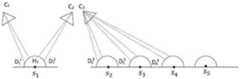
在已知需要重建的目标场景的先验粗糙几何信息的情况下,需要判断目标场景的每一个采样点(局部区域)是否可以被很好的重建。基于此目的,本实施例中,定义一个度量公式用以预测某一个特定的局部即预设采样点是否可以被已有的图片很好的重建。具体可参见图2,其中,


首先,定义每一个图像采集设备如相机

其中,


其中,


基于路径段对一个采样局部区域的重建贡献度,定义旨在让场景尽可能被重建的重建完整性优化函数

除此之外,为使得在规划过程中得到的路径尽量平滑、沿路径的采集效率尽量高,定义下列消耗函数:In addition, in order to make the path obtained in the planning process as smooth as possible and the collection efficiency along the path as high as possible, the following consumption functions are defined:


其中


最后,基于重建完整性优化函数


其中,
基于该优化函数,采用快速扩展随机树RRT作为优化器。其中,树中的节点表航点


本实施例中,可根据上述定义的相机的重建贡献度,计算路径段对预设采样点


步骤206,当预设采样点的重建度未达到预设要求时,则在预设无障碍区域随机生成新增节点。
预设无障碍区域即为安全区域。若预设采样点的重建度未达到预设要求时,则在无障碍的安全区域进行随机采样,随机生成一个随机树可到达的新增节点,记为
步骤208,在随机树中寻找位于新增节点的预设范围内的节点,得到节点集合。
当生成新增节点后,需要将新增节点连接至随机树中的节点,以扩展随机树,便于最优路径的输出。具体的,可以是在随机树中节点列表V中寻找位于新增节点的预设范围内的节点,得到节点集合N。After the new node is generated, it is necessary to connect the new node to the node in the random tree to expand the random tree and facilitate the output of the optimal path. Specifically, the node set N may be obtained by searching the node list V in the random tree for nodes located within the preset range of the newly added node.
步骤210,从节点集合中筛选出目标节点,将新增节点连接至目标节点,目标节点为使以新增节点为终点的路径对应的预设目标函数达到最大值的节点。Step 210: Screen out the target node from the node set, connect the newly added node to the target node, and the target node is the node that maximizes the preset objective function corresponding to the path ending at the newly added node.
为保证规划出的路径为最优路径,需从随机树的节点列表中选择出一个最佳节点与新增节点连接。可以是选择使得以起始航点


如图3所示,在一个实施例中,在随机树中寻找位于新增节点的预设范围内的节点,得到节点集合之后,还包括步骤220:As shown in FIG. 3 , in one embodiment, the random tree is searched for a node within the preset range of the newly added node, and after the node set is obtained,
当节点集合为空时,则筛选出随机树中与新增节点的距离最近的节点,将新增节点连接至节点。When the node set is empty, the node with the closest distance to the new node in the random tree is filtered out, and the new node is connected to the node.
在扩展随机树的过程中,若在随机树的节点列表中未查找到位于新增节点的预设范围内的节点,即节点集合N为空时,则在随机树的节点列表中选择离新增节点距离最近的节点作为目标节点,将新增节点连接至该目标节点,进入步骤212。In the process of expanding the random tree, if no node within the preset range of the newly added node is found in the node list of the random tree, that is, when the node set N is empty, select the new node from the node list of the random tree. The node with the closest distance to the added node is used as the target node, and the newly added node is connected to the target node, and the process goes to step 212 .
步骤212,对新增节点进行子树重连接操作,更新随机树,返回至步骤204。
新增节点连接至随机树中,同样的,将新增节点的子树进行重连接操作。具体的,获取随机树<V,E>及其中将待重连接的节点w,初始化队列Q={w},将Q中第一个元素取出,记作w*,初始化i=1,在V中寻找位于w*的预设r范围内但不是w*的祖先节点的节点,得到节点集合M={w_1,...,w_n},计算所有通过w_i(0<i<n)节点的路径所对应的目标函数E(T)值,将E(T)的最大值记作v_old,再计算若将w_i连接至w*后,所有通过w_i节点的路径所取得的E(T)的最大值记作v_new,若v_new大于v_old,则将w_i重连到w*上,否则i=i+1,返回至计算所有通过w_i(0<i<n)节点的路径所对应的目标函数E(T)值的步骤,直至完成重连接操作,更新随机树,再返回至步骤204。The newly added node is connected to the random tree. Similarly, the subtree of the newly added node is reconnected. Specifically, obtain the random tree <V, E> and the node w to be reconnected in it, initialize the queue Q={w}, take out the first element in Q, record it as w*, initialize i=1, and in V Find the nodes located in the preset r range of w* but not the ancestor nodes of w*, get the node set M={w_1,...,w_n}, and calculate all the paths through w_i(0<i<n) nodes The corresponding objective function E(T) value, record the maximum value of E(T) as v_old, and then calculate the maximum value of E(T) obtained by all paths passing through the w_i node after w_i is connected to w* Denoted as v_new, if v_new is greater than v_old, reconnect w_i to w*, otherwise i=i+1, return to the objective function E(T corresponding to all paths passing through w_i(0<i<n) nodes ) value, until the reconnection operation is completed, update the random tree, and then return to step 204.
步骤214,当预设采样点的重建度达到预设要求时,则从最新的随机树中筛选出最优路径,最优路径为使预设目标函数达到最大值的路径。
完成新增节点的子树重连接操作后,当预设采样点的重建度达到预设要求及预设采样点

上述路径规划方法,基于快速随机拓展树设计优化函数以规划路径,基于快速随机拓展树设计优化函数以规划路径,当判断预设采样点的重建度达到预设要求时,根据包括重建完整性优化函数、路径有效性优化函数和路径平滑函数的目标函数,从随机树中筛选出最优路径。上述方法,摒除了传统的以视点为优化对象的做法,以路径为优化对象,设计了路径平滑性优化函数,考虑了路径平滑程度对采集时间和能耗的影响,使得规划出的路径更短且更为平滑,进而节约数据采集的时间和能耗。同时,设计了路径有效性优化函数和重建完整性优化函数,能够进一步提高采集的数据的有效性和质量。综上所述,本申请提供的方法能够有效提高数据采集的效率。In the above path planning method, an optimization function is designed based on the fast random expansion tree to plan the path, and the optimization function is designed based on the fast random expansion tree to plan the path. The objective function of the function, the path validity optimization function and the path smoothing function, to filter out the optimal path from the random tree. The above method, instead of the traditional method of taking the viewpoint as the optimization object, takes the path as the optimization object, and designs the path smoothness optimization function, which takes into account the influence of the path smoothness on the acquisition time and energy consumption, so that the planned path is shorter. And it is smoother, thereby saving the time and energy consumption of data collection. At the same time, a path validity optimization function and a reconstruction integrity optimization function are designed, which can further improve the validity and quality of the collected data. To sum up, the method provided by the present application can effectively improve the efficiency of data collection.
如图4所示,在一个实施例中,从最新的随机树中筛选出最优路径包括:As shown in Figure 4, in one embodiment, selecting the optimal path from the latest random tree includes:
步骤224,针对最新的随机树中的可行路径,获取各可行路径的重建贡献度、行驶转向消耗值以及行驶距离消耗值,可行路径为对预设采样点的覆盖度达到预设要求的路径;
步骤244,基于重建贡献度、行驶转向消耗值以及行驶距离消耗值,结合重建完整性优化函数、路径有效性优化函数以及路径平滑性优化函数,得到各可行路径对应的目标函数值;
步骤264,将目标函数值最大的可行路径确定为最优路径。
以无人机为例,行驶转向消耗值则为飞行转向消耗值,行驶距离消耗值则为飞行距离消耗值。具体实施时,一条路径上有若干相机,筛选最优路径可以是将每条路径以航点为分割点,将该路径分为多个路径段,如


在一个实施例中,获取各可行路径的重建贡献度包括:获取已知的重建贡献度集合,从重建贡献度集合中,查找与当前图像采集设备距离最近的图像采集设备所对应的重建贡献度,得到目标重建贡献度;将目标重建贡献度确定为当前图像采集设备的重建贡献度;基于各可行路径上的图像采集设备的重建贡献度,得到各可行路径的重建贡献度。In one embodiment, acquiring the reconstruction contribution degree of each feasible path includes: acquiring a known reconstruction contribution degree set, and searching the reconstruction contribution degree corresponding to the image acquisition device closest to the current image acquisition device from the reconstruction contribution degree set , obtain the target reconstruction contribution degree; determine the target reconstruction contribution degree as the reconstruction contribution degree of the current image acquisition device; obtain the reconstruction contribution degree of each feasible path based on the reconstruction contribution degree of the image acquisition equipment on each feasible path.
重建贡献度集合亦可称为视野信息域字典(VIF,view information)。图像采集设备包括摄像头或相机等用于采集图像数据的设备,本实施例中以相机为例,在实际应用中,由于目标函数值的计算较为复杂,耗时较长,为了对计算进行加速,节约时间,设计了视野信息域字典。由此,在计算过程中,不再真实地去计算节点实际位置和朝向带来的重建贡献度。取而代之地,基于路径中的各相机,在信息域字典中查找与当前相机距离最近的相机点的重建贡献度,进而将查找出的重建贡献度作为当前相机的重建贡献度,以此方式,得到该路径中每一个相机点的重建贡献度,进而得到各可行路径的重建贡献度,提升算法速度。The reconstruction contribution set can also be called a view information field dictionary (VIF, view information). The image acquisition device includes a camera or a camera and other devices for collecting image data. In this embodiment, a camera is used as an example. In practical applications, since the calculation of the objective function value is relatively complex and takes a long time, in order to accelerate the calculation, To save time, a field dictionary of visual field information is designed. Therefore, in the calculation process, the reconstruction contribution caused by the actual position and orientation of the node is no longer truly calculated. Instead, based on each camera in the path, look up the reconstruction contribution of the camera point closest to the current camera in the information domain dictionary, and then use the found reconstruction contribution as the reconstruction contribution of the current camera. In this way, we get The reconstruction contribution of each camera point in the path, and then the reconstruction contribution of each feasible path is obtained, which improves the speed of the algorithm.
如图3所示,在一个实施例中,获取各可行路径的行驶转向消耗值包括:确定各可行路径上的各节点的镜头朝向;根据各节点的镜头朝向,获取各可行路径的行驶转向消耗值。As shown in FIG. 3 , in one embodiment, acquiring the driving and steering consumption value of each feasible path includes: determining the camera orientation of each node on each feasible path; acquiring the driving and steering consumption of each feasible path according to the camera orientation of each node value.
在实际应用中,无人机配备多镜头相机及单镜头相机,故路径规划可细分为多镜头路径规划算法和单镜头路径规划算法。其中,对于多镜头相机,由于镜头本身不移动,可以在规划过程中忽略它的镜头朝向,其镜头朝向默认为设置的镜头朝向值。而对于单镜头相机的路径规划中,无人机相机的镜头朝向需要被确定。此处,根节点的航点的镜头朝向是预先确定的,那么在每一次加入新节点(航点)时,需要确定新节点的镜头朝向,且每次当随机树中已存在的节点需要被重新连接到其他节点时,也需要更新该节点的镜头朝向。因此,在将新增节点连接至目标节点时,需要确定新增节点的镜头朝向。基于行驶转向消耗函数可知,要得到各路径的目标函数值,需知晓各节点上的镜头朝向,以便规划最优路径。In practical applications, UAVs are equipped with multi-lens cameras and single-lens cameras, so path planning can be subdivided into multi-lens path planning algorithms and single-lens path planning algorithms. Among them, for a multi-lens camera, since the lens itself does not move, its lens orientation can be ignored in the planning process, and its lens orientation defaults to the set lens orientation value. For the path planning of the single-lens camera, the lens orientation of the drone camera needs to be determined. Here, the camera orientation of the waypoint of the root node is predetermined, then each time a new node (waypoint) is added, the camera orientation of the new node needs to be determined, and each time an existing node in the random tree needs to be When reconnecting to another node, the camera orientation of that node will also need to be updated. Therefore, when connecting the newly added node to the target node, it is necessary to determine the camera orientation of the newly added node. Based on the driving and steering consumption function, to obtain the objective function value of each path, it is necessary to know the orientation of the lens on each node in order to plan the optimal path.
在一个实施例中,确定可行路径上各节点的镜头朝向包括:获取图像采集设备镜头参数和预设镜头朝向,当图像采集设备镜头参数表征为多镜头时,则将当前节点的镜头朝向确定为预设镜头朝向;当图像采集设备镜头参数表征为单镜头时,获取当前节点的位置信息以及当前节点的父节点的位置信息和镜头朝向,基于当前节点的位置信息以及当前节点的父节点的位置信息和镜头朝向,执行预设的镜头朝向计算策略,确定当前节点的镜头朝向,进而确定可行路径上各节点的镜头朝向。In one embodiment, determining the lens orientation of each node on the feasible path includes: acquiring the lens parameters of the image acquisition device and the preset lens orientation, and when the image acquisition device lens parameters are characterized as multiple shots, then determining the lens orientation of the current node as Preset lens orientation; when the lens parameters of the image acquisition device represent a single lens, obtain the position information of the current node and the position information and lens orientation of the parent node of the current node, based on the position information of the current node and the position of the parent node of the current node Information and camera orientation, execute the preset camera orientation calculation strategy, determine the camera orientation of the current node, and then determine the camera orientation of each node on the feasible path.
具体的,图像采集设备镜头参数包括相机镜头参数。镜头朝向计算策略如下:单镜头相机的航点之间的镜头朝向通过与前后航点的距离插值决定。具体的,获取父节点w_a的坐标及其镜头朝向水平角a_1与竖直角a_2,以及子节点w_b的坐标,初始化该路径段最大重建贡献度v_max=0,以及初始化对应子节点w_b的相机角度(b_1,b_2)=(0,90),初始化临时相机角度(b*_1,b*_2)=(0,90),将临时相机角度依次增加45度旋转,将路径段(w_a,w_b)以及无人机拍照距离分为视角点集合{ w_1,…,w_n },根据距离以及w_a的相机角度(a_1,a_2)和w_b的相机角度(b_1,b_2)插值出视角点集合中每个视角点的镜头角度,计算该路径段的重建贡献度v=
为了验证本申请中所提出的路径规划方法的有效性和优越性,对本申请提供的路径规划方法分别进行了仿真实验和真实实验。In order to verify the effectiveness and superiority of the path planning method proposed in this application, simulation experiments and real experiments are respectively carried out on the path planning method provided in this application.
仿真实验:在虚拟环境中针对给定的虚拟场景使用本算法进行路径规划,并使用商业软件对采集到的照片进行重建,重建结果如图5(a)所示。图5(a)中的第一行:本申请和现有方法规划出的路径的对比图;图5(a)中第二行:是本申请和现有方法对场景的重建结果的对比图;图5(a)中第三行:a部分展示的是本申请和现有方法对第二行中的细节A的对比放大图,其中,aa对应的是本申请对细节A的对比放大图,b部分展示的是本申请和现有方法对第二行中的细节B的对比放大图,其中,bb对应的是本申请对细节B的对比放大图。Simulation experiment: The algorithm is used for path planning for a given virtual scene in a virtual environment, and commercial software is used to reconstruct the collected photos. The reconstruction results are shown in Figure 5(a). The first row in Fig. 5(a): a comparison diagram of the paths planned by the present application and the existing method; the second row in Fig. 5(a): a comparison diagram of the scene reconstruction results of the present application and the existing method ; The third row in Fig. 5 (a): a part shows the application and the existing method to the contrast magnification of the detail A in the second row, wherein, aa corresponds to the application's contrast magnification of the detail A , and part b shows the comparative enlarged view of the detail B in the second row of the present application and the existing method, wherein, bb corresponds to the comparative enlarged view of the detail B of the present application.
真实实验:真实场景相较于模拟场景更加复杂,以某个真实区域为重建的目标区域进行路径规划,将采集到的照片用商业软件进行重建,得到重建结果如图5(b)所示。图5(b)中第一行:左为本申请的路径规划算法规划出的数据采集航线,右为倾斜摄影方法规划出的数据采集航线;图5(b)中第二行:基于本申请的路径规划算法采集的照片的重建结果;图5(b)中第二行:基于倾斜摄影方法采集的照片的重建结果。Real experiment: The real scene is more complex than the simulated scene. The path planning is carried out with a real area as the target area for reconstruction, and the collected photos are reconstructed with commercial software, and the reconstruction result is shown in Figure 5(b). The first row in Figure 5(b): the left is the data acquisition route planned by the path planning algorithm of the application, and the right is the data acquisition route planned by the oblique photography method; the second row in Figure 5(b): based on the application The reconstruction results of the photos collected by the path planning algorithm; the second row in Figure 5(b): the reconstruction results of the photos collected based on the oblique photography method.
由上述图5(a)和图5(b)可知,基于本申请提供的路径规划算法进行连续拍照,极少遗漏场景信息,因而采用本申请的路径规划方法可规划出一条高采集质量、高效率、低能耗的采集路径,进而使得依赖本申请提供的路径规划方法重建出的场景会比其他方法更加完整、可靠。It can be seen from the above-mentioned Figures 5(a) and 5(b) that continuous photographing based on the path planning algorithm provided by the present application rarely misses scene information. Therefore, the path planning method of the present application can plan a high-quality, high-quality image. The collection path with high efficiency and low energy consumption makes the reconstructed scene based on the path planning method provided by the present application more complete and reliable than other methods.
应该理解的是,虽然上述实施例涉及的各流程图中的各个步骤按照箭头的指示依次显示,但是这些步骤并不是必然按照箭头指示的顺序依次执行。除非本文中有明确的说明,这些步骤的执行并没有严格的顺序限制,这些步骤可以以其它的顺序执行。而且,上述实施例涉及的各流程图中的至少一部分步骤可以包括多个步骤或者多个阶段,这些步骤或者阶段并不必然是在同一时刻执行完成,而是可以在不同的时刻执行,这些步骤或者阶段的执行顺序也不必然是依次进行,而是可以与其它步骤或者其它步骤中的步骤或者阶段的至少一部分轮流或者交替地执行。It should be understood that, although the steps in the flowcharts involved in the above embodiments are sequentially displayed according to the arrows, these steps are not necessarily executed in the order indicated by the arrows. Unless explicitly stated herein, the execution of these steps is not strictly limited to the order, and these steps may be performed in other orders. Moreover, at least a part of the steps in the flowcharts involved in the above embodiments may include multiple steps or multiple stages. These steps or stages are not necessarily executed at the same time, but may be executed at different times. Alternatively, the order of execution of the stages is not necessarily sequential, but may be performed alternately or alternately with other steps or at least a portion of the steps or stages in the other steps.
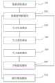
在一个实施例中,如图6所示,提供了一种路径规划装置,包括:数据获取模块510、重建度判断模块520、节点生成模块530、节点查找模块540、节点连接模块550、子树重连模块560和路径筛选模块570,其中:In one embodiment, as shown in FIG. 6, a path planning apparatus is provided, including: a
数据获取模块510,用于获取场景先验几何信息和随机树。The
重建度判断模块520,用于判断场景先验几何信息上的预设采样点的重建度是否达到预设要求。The reconstruction
节点生成模块530,用于当预设采样点的重建度未达到预设要求时,则在预设无障碍区域随机生成新增节点。The
节点查找模块540,用于在随机树中寻找位于新增节点的预设范围内的节点,得到节点集合。The
节点连接模块550,用于根据预设目标函数从节点集合中筛选出目标节点,将新增节点连接至目标节点,目标节点为使以新增节点为终点的路径对应的预设目标函数达到最大值的节点。The
子树重连模块560,用于对新增节点进行子树重连接操作,更新随机树,唤醒判断模块执行判断场景先验几何信息上的预设采样点的重建度是否达到预设要求的操作。The
路径筛选模块570,用于当预设采样点的重建度达到预设要求时,则从最新的随机树中筛选出最优路径,最优路径为使预设目标函数达到最大值的路径;The
其中,预设目标函数包括重建完整性优化函数、路径有效性优化函数以及路径平滑性优化函数。The preset objective function includes a reconstruction integrity optimization function, a path validity optimization function, and a path smoothness optimization function.
在一个实施例中,路径筛选模块570还用于针对最新的随机树中的可行路径,获取各可行路径的重建贡献度、行驶转向消耗值以及行驶距离消耗值,可行路径为对预设采样点的覆盖度达到预设要求的路径,基于重建贡献度、行驶转向消耗值以及行驶距离消耗值,结合重建完整性优化函数、路径有效性优化函数以及路径平滑性优化函数,得到各可行路径对应的目标函数值,将目标函数值最大的可行路径确定为最优路径。In one embodiment, the
在一个实施例中,路径筛选模块570还用于获取已知的重建贡献度集合,从重建贡献度集合中,查找与当前图像采集设备距离最近的图像采集设备所对应的重建贡献度,得到目标重建贡献度,将目标重建贡献度确定为当前图像采集设备的重建贡献度,基于各可行路径上的图像采集设备的重建贡献度,得到各可行路径的重建贡献度。。In one embodiment, the
如图7所示,在一个实施例中,所述装置还包括镜头朝向确定模块555,用于确定各可行路径上的各节点的镜头朝向,根据各节点的镜头朝向,获取各可行路径的行驶转向消耗值。As shown in FIG. 7 , in one embodiment, the apparatus further includes a camera
在一个实施例中,镜头朝向确定模块555还用于获取图像采集设备镜头参数和预设镜头朝向,当图像采集设备镜头参数表征为多镜头时,则将当前节点的镜头朝向确定为预设镜头朝向,当图像采集设备镜头参数表征为单镜头时,获取当前节点的位置信息以及当前节点的父节点的位置信息和镜头朝向,基于当前节点的位置信息以及当前节点的父节点的位置信息和镜头朝向,执行预设的镜头朝向计算策略,确定当前节点的镜头朝向,进而确定可行路径上各节点的镜头朝向。In one embodiment, the lens
在一个实施例中,节点连接模块550还用于当节点集合为空时,则筛选出随机树中与新增节点的距离最近的节点,将新增节点连接至节点。In one embodiment, the
如图7所示,在一个实施例中,所述装置还包括初始化模块500,用于获取起始航点以及起始航点对应的镜头朝向,将起始航点和起始航点对应的镜头朝向作为根节点,初始化随机树。As shown in FIG. 7 , in one embodiment, the apparatus further includes an
关于路径规划装置的具体实施例可以参见上文中对于路径规划方法的实施例,在此不再赘述。上述场景重建数据采集装置中的各个模块可全部或部分通过软件、硬件及其组合来实现。上述各模块可以硬件形式内嵌于或独立于计算机设备中的处理器中,也可以以软件形式存储于计算机设备中的存储器中,以便于处理器调用执行以上各个模块对应的操作。For specific embodiments of the path planning apparatus, reference may be made to the above embodiments of the path planning method, and details are not described herein again. Each module in the above-mentioned scene reconstruction data acquisition device may be implemented in whole or in part by software, hardware, and combinations thereof. The above modules can be embedded in or independent of the processor in the computer device in the form of hardware, or stored in the memory in the computer device in the form of software, so that the processor can call and execute the operations corresponding to the above modules.
在一个实施例中,提供了一种计算机设备,该计算机设备可以是服务器,其内部结构图可以如图8所示。该计算机设备包括通过系统总线连接的处理器、存储器和网络接口。其中,该计算机设备的处理器用于提供计算和控制能力。该计算机设备的存储器包括非易失性存储介质、内存储器。该非易失性存储介质存储有操作系统、计算机程序和数据库。该内存储器为非易失性存储介质中的操作系统和计算机程序的运行提供环境。该计算机设备的数据库用于存储场景先验几何信息和随机树等数据。该计算机设备的网络接口用于与外部的终端通过网络连接通信。该计算机程序被处理器执行时以实现一种路径规划方法。In one embodiment, a computer device is provided, and the computer device may be a server, and its internal structure diagram may be as shown in FIG. 8 . The computer device includes a processor, memory, and a network interface connected by a system bus. Among them, the processor of the computer device is used to provide computing and control capabilities. The memory of the computer device includes a non-volatile storage medium, an internal memory. The nonvolatile storage medium stores an operating system, a computer program, and a database. The internal memory provides an environment for the execution of the operating system and computer programs in the non-volatile storage medium. The database of the computer device is used to store data such as scene prior geometric information and random trees. The network interface of the computer device is used to communicate with an external terminal through a network connection. The computer program when executed by a processor implements a path planning method.
本领域技术人员可以理解,图8中示出的结构,仅仅是与本申请方案相关的部分结构的框图,并不构成对本申请方案所应用于其上的计算机设备的限定,具体的计算机设备可以包括比图中所示更多或更少的部件,或者组合某些部件,或者具有不同的部件布置。Those skilled in the art can understand that the structure shown in FIG. 8 is only a block diagram of a part of the structure related to the solution of the present application, and does not constitute a limitation on the computer equipment to which the solution of the present application is applied. Include more or fewer components than shown in the figures, or combine certain components, or have a different arrangement of components.
在一个实施例中,提供了一种计算机设备,包括存储器和处理器,存储器中存储有计算机程序,该处理器执行计算机程序时实现上述路径规划方法中的步骤。In one embodiment, a computer device is provided, including a memory and a processor, where a computer program is stored in the memory, and the processor implements the steps in the above path planning method when the processor executes the computer program.
在一个实施例中,提供了一种计算机可读存储介质,其上存储有计算机程序,计算机程序被处理器执行时实现上述路径规划方法中的步骤。In one embodiment, a computer-readable storage medium is provided, on which a computer program is stored, and when the computer program is executed by a processor, implements the steps in the above path planning method.
本领域普通技术人员可以理解实现上述实施例方法中的全部或部分流程,是可以通过计算机程序来指令相关的硬件来完成,所述的计算机程序可存储于一非易失性计算机可读取存储介质中,该计算机程序在执行时,可包括如上述各方法的实施例的流程。其中,本申请所提供的各实施例中所使用的对存储器、存储、数据库或其它介质的任何引用,均可包括非易失性和易失性存储器中的至少一种。非易失性存储器可包括只读存储器(Read-Only Memory,ROM)、磁带、软盘、闪存或光存储器等。易失性存储器可包括随机存取存储器(Random Access Memory,RAM)或外部高速缓冲存储器。作为说明而非局限,RAM可以是多种形式,比如静态随机存取存储器(Static Random Access Memory,SRAM)或动态随机存取存储器(Dynamic Random Access Memory,DRAM)等。Those of ordinary skill in the art can understand that all or part of the processes in the methods of the above embodiments can be implemented by instructing relevant hardware through a computer program, and the computer program can be stored in a non-volatile computer-readable storage In the medium, when the computer program is executed, it may include the processes of the above-mentioned method embodiments. Wherein, any reference to memory, storage, database or other media used in the various embodiments provided in this application may include at least one of non-volatile and volatile memory. Non-volatile memory may include read-only memory (Read-Only Memory, ROM), magnetic tape, floppy disk, flash memory, or optical memory, and the like. Volatile memory may include random access memory (RAM) or external cache memory. By way of illustration and not limitation, the RAM may be in various forms, such as static random access memory (Static Random Access Memory, SRAM) or dynamic random access memory (Dynamic Random Access Memory, DRAM).
以上实施例的各技术特征可以进行任意的组合,为使描述简洁,未对上述实施例中的各个技术特征所有可能的组合都进行描述,然而,只要这些技术特征的组合不存在矛盾,都应当认为是本说明书记载的范围。The technical features of the above embodiments can be combined arbitrarily. In order to make the description simple, all possible combinations of the technical features in the above embodiments are not described. However, as long as there is no contradiction in the combination of these technical features It is considered to be the range described in this specification.
以上所述实施例仅表达了本申请的几种实施方式,其描述较为具体和详细,但并不能因此而理解为对发明专利范围的限制。应当指出的是,对于本领域的普通技术人员来说,在不脱离本申请构思的前提下,还可以做出若干变形和改进,这些都属于本申请的保护范围。因此,本申请专利的保护范围应以所附权利要求为准。The above-mentioned embodiments only represent several embodiments of the present application, and the descriptions thereof are specific and detailed, but should not be construed as a limitation on the scope of the invention patent. It should be pointed out that for those skilled in the art, without departing from the concept of the present application, several modifications and improvements can be made, which all belong to the protection scope of the present application. Therefore, the scope of protection of the patent of the present application shall be subject to the appended claims.
Claims (10)
Priority Applications (2)
| Application Number | Priority Date | Filing Date | Title |
|---|---|---|---|
| CN202110462795.8ACN112884256B (en) | 2021-04-28 | 2021-04-28 | Path planning method and device, computer equipment and storage medium |
| US17/566,221US12320665B2 (en) | 2021-04-28 | 2021-12-30 | Method and apparatus for continuous path planning, computer device, and storage medium |
Applications Claiming Priority (1)
| Application Number | Priority Date | Filing Date | Title |
|---|---|---|---|
| CN202110462795.8ACN112884256B (en) | 2021-04-28 | 2021-04-28 | Path planning method and device, computer equipment and storage medium |
Publications (2)
| Publication Number | Publication Date |
|---|---|
| CN112884256Atrue CN112884256A (en) | 2021-06-01 |
| CN112884256B CN112884256B (en) | 2021-07-27 |
Family
ID=76040728
Family Applications (1)
| Application Number | Title | Priority Date | Filing Date |
|---|---|---|---|
| CN202110462795.8AActiveCN112884256B (en) | 2021-04-28 | 2021-04-28 | Path planning method and device, computer equipment and storage medium |
Country Status (2)
| Country | Link |
|---|---|
| US (1) | US12320665B2 (en) |
| CN (1) | CN112884256B (en) |
Cited By (4)
| Publication number | Priority date | Publication date | Assignee | Title |
|---|---|---|---|---|
| CN114723055A (en)* | 2022-03-03 | 2022-07-08 | 之江实验室 | Method for reasoning robot behavior link based on knowledge graph |
| CN116051776A (en)* | 2023-03-28 | 2023-05-02 | 广东广宇科技发展有限公司 | Oblique photography modeling system and method for unmanned aerial vehicle water conservancy information acquisition |
| CN118897555A (en)* | 2024-09-30 | 2024-11-05 | 江西五十铃汽车有限公司 | Path planning method, system, storage medium and device based on fusion algorithm |
| CN120524277A (en)* | 2025-07-24 | 2025-08-22 | 西北工业大学 | AI intelligent identification equipment of chemical plant |
Families Citing this family (5)
| Publication number | Priority date | Publication date | Assignee | Title |
|---|---|---|---|---|
| CN116050689B (en)* | 2023-01-18 | 2023-11-17 | 中南大学 | A wide-area space railway line intelligent search method, system, terminal and medium |
| CN118865750A (en)* | 2023-04-28 | 2024-10-29 | 台达电子工业股份有限公司 | UAV detection route generation device and method |
| CN116433853B (en)* | 2023-06-15 | 2023-11-17 | 深圳大学 | A method and device for generating aerial survey waypoints based on real-life models |
| CN116578121B (en)* | 2023-07-10 | 2023-11-03 | 广东电网有限责任公司云浮供电局 | Constraint sampling-based generation method and track planning method for extended random tree |
| CN117124335B (en)* | 2023-10-25 | 2024-01-05 | 山东工商学院 | Improved RRT path planning method based on path marking backtracking strategy |
Citations (9)
| Publication number | Priority date | Publication date | Assignee | Title |
|---|---|---|---|---|
| CN107063258A (en)* | 2017-03-07 | 2017-08-18 | 重庆邮电大学 | A kind of mobile robot indoor navigation method based on semantic information |
| CN108896052A (en)* | 2018-09-20 | 2018-11-27 | 鲁东大学 | A kind of mobile robot smooth paths planing method under the environment based on DYNAMIC COMPLEX |
| CN109764886A (en)* | 2019-01-15 | 2019-05-17 | 成都信息工程大学 | A path planning method |
| CN109807886A (en)* | 2019-01-15 | 2019-05-28 | 西北工业大学 | A prediction-based spatial non-cooperative target capture strategy |
| CN109990796A (en)* | 2019-04-23 | 2019-07-09 | 成都信息工程大学 | Intelligent vehicle path planning method based on bidirectional expanded random tree |
| US20190384304A1 (en)* | 2018-06-13 | 2019-12-19 | Nvidia Corporation | Path detection for autonomous machines using deep neural networks |
| CN110873565A (en)* | 2019-11-21 | 2020-03-10 | 北京航空航天大学 | UAV real-time path planning method for urban scene reconstruction |
| US20200249674A1 (en)* | 2019-02-05 | 2020-08-06 | Nvidia Corporation | Combined prediction and path planning for autonomous objects using neural networks |
| EP3746855A1 (en)* | 2018-02-28 | 2020-12-09 | Five AI Limited | Path planning in mobile robots |
Family Cites Families (10)
| Publication number | Priority date | Publication date | Assignee | Title |
|---|---|---|---|---|
| KR101554515B1 (en)* | 2009-01-07 | 2015-09-21 | 삼성전자 주식회사 | path planning apparatus of robot and method thereof |
| KR101691939B1 (en)* | 2009-08-10 | 2017-01-02 | 삼성전자주식회사 | Method and apparatus of path planing for a robot |
| KR101667029B1 (en)* | 2009-08-10 | 2016-10-17 | 삼성전자 주식회사 | Method and apparatus of path planing for a robot |
| KR101667031B1 (en)* | 2009-11-02 | 2016-10-17 | 삼성전자 주식회사 | Path planning apparatus of robot and method thereof |
| US9120485B1 (en)* | 2012-09-14 | 2015-09-01 | Google Inc. | Methods and systems for smooth trajectory generation for a self-driving vehicle |
| KR102009482B1 (en)* | 2012-10-30 | 2019-08-14 | 한화디펜스 주식회사 | Apparatus and method for planning path of robot, and the recording media storing the program for performing the said method |
| JP6606442B2 (en)* | 2016-02-24 | 2019-11-13 | 本田技研工業株式会社 | Mobile route plan generation device |
| JP7015377B2 (en)* | 2018-03-06 | 2022-02-02 | 富士フイルム株式会社 | Shooting equipment, shooting method and shooting program, and shooting system |
| WO2020014949A1 (en)* | 2018-07-20 | 2020-01-23 | 深圳大学 | Unmanned aerial vehicle aerial photography path generation method, computer device, and storage medium |
| CN114072870B (en)* | 2019-04-16 | 2024-04-26 | 移动品牌公司 | System and method for generating composite route planning map |
- 2021
- 2021-04-28CNCN202110462795.8Apatent/CN112884256B/enactiveActive
- 2021-12-30USUS17/566,221patent/US12320665B2/enactiveActive
Patent Citations (9)
| Publication number | Priority date | Publication date | Assignee | Title |
|---|---|---|---|---|
| CN107063258A (en)* | 2017-03-07 | 2017-08-18 | 重庆邮电大学 | A kind of mobile robot indoor navigation method based on semantic information |
| EP3746855A1 (en)* | 2018-02-28 | 2020-12-09 | Five AI Limited | Path planning in mobile robots |
| US20190384304A1 (en)* | 2018-06-13 | 2019-12-19 | Nvidia Corporation | Path detection for autonomous machines using deep neural networks |
| CN108896052A (en)* | 2018-09-20 | 2018-11-27 | 鲁东大学 | A kind of mobile robot smooth paths planing method under the environment based on DYNAMIC COMPLEX |
| CN109764886A (en)* | 2019-01-15 | 2019-05-17 | 成都信息工程大学 | A path planning method |
| CN109807886A (en)* | 2019-01-15 | 2019-05-28 | 西北工业大学 | A prediction-based spatial non-cooperative target capture strategy |
| US20200249674A1 (en)* | 2019-02-05 | 2020-08-06 | Nvidia Corporation | Combined prediction and path planning for autonomous objects using neural networks |
| CN109990796A (en)* | 2019-04-23 | 2019-07-09 | 成都信息工程大学 | Intelligent vehicle path planning method based on bidirectional expanded random tree |
| CN110873565A (en)* | 2019-11-21 | 2020-03-10 | 北京航空航天大学 | UAV real-time path planning method for urban scene reconstruction |
Non-Patent Citations (2)
| Title |
|---|
| WEI DONG: ""An Artificially Weighted Spanning Tree Coverage Algorithm for Decentralized Flying Robots"", 《IEEE TRANSACTIONS ON AUTOMATION SCIENCE AND ENGINEERING》* |
| 李朋: ""面向地图构建的移动机器人局部路径自主规划"", 《控制理论与应用》* |
Cited By (4)
| Publication number | Priority date | Publication date | Assignee | Title |
|---|---|---|---|---|
| CN114723055A (en)* | 2022-03-03 | 2022-07-08 | 之江实验室 | Method for reasoning robot behavior link based on knowledge graph |
| CN116051776A (en)* | 2023-03-28 | 2023-05-02 | 广东广宇科技发展有限公司 | Oblique photography modeling system and method for unmanned aerial vehicle water conservancy information acquisition |
| CN118897555A (en)* | 2024-09-30 | 2024-11-05 | 江西五十铃汽车有限公司 | Path planning method, system, storage medium and device based on fusion algorithm |
| CN120524277A (en)* | 2025-07-24 | 2025-08-22 | 西北工业大学 | AI intelligent identification equipment of chemical plant |
Also Published As
| Publication number | Publication date |
|---|---|
| US12320665B2 (en) | 2025-06-03 |
| CN112884256B (en) | 2021-07-27 |
| US20220350333A1 (en) | 2022-11-03 |
Similar Documents
| Publication | Publication Date | Title |
|---|---|---|
| CN112884256B (en) | Path planning method and device, computer equipment and storage medium | |
| CN113110482B (en) | Indoor environment robot exploration method and system based on priori information heuristic method | |
| CN107967457B (en) | A method and system for location recognition and relative positioning that adapts to changes in visual features | |
| US11313684B2 (en) | Collaborative navigation and mapping | |
| CN108335353B (en) | Three-dimensional reconstruction method, device and system, server and medium of dynamic scene | |
| Yan et al. | Tri-perspective view decomposition for geometry-aware depth completion | |
| CN109163722B (en) | Humanoid robot path planning method and device | |
| CN111709984B (en) | Pose depth prediction method, visual odometry method, device, equipment and media | |
| CN106599108A (en) | Method for constructing multi-mode environmental map in three-dimensional environment | |
| CN111951201A (en) | Unmanned aerial vehicle aerial image splicing method and device and storage medium | |
| CN110132242B (en) | Triangularization method for multi-camera instant positioning and map construction and moving body thereof | |
| CN114322994B (en) | Multipoint cloud map fusion method and device based on offline global optimization | |
| CN116105721A (en) | Loopback optimization method, device, equipment and storage medium for map construction | |
| WO2020042126A1 (en) | Focusing apparatus, method and related device | |
| CN111161334B (en) | Semantic map construction method based on deep learning | |
| CN111951158B (en) | Unmanned aerial vehicle aerial image splicing interruption recovery method, device and storage medium | |
| WO2020034086A1 (en) | Three-dimensional reconstruction method and apparatus for scene, and electronic device and storage medium | |
| CN118608692A (en) | A method for constructing a four-dimensional base for digital twin cities based on four-dimensional space-time increments | |
| CN116452629A (en) | Method and system for tracking cattle targets by unmanned aerial vehicle in pasture based on Siamese network | |
| CN116105742A (en) | Composite scene inspection navigation method, system and related equipment | |
| CN112819937B (en) | An adaptive multi-object light field three-dimensional reconstruction method, device and equipment | |
| CN117631690B (en) | Power distribution network routing planning method and system based on iterative adaptive point algorithm | |
| CN118521702A (en) | Point cloud rendering method and system based on nerve radiation field | |
| CN117029861A (en) | Global path planning method, device, system and storage medium | |
| Wei et al. | LPCC-net: RGB guided local point cloud completion for outdoor 3D object detection |
Legal Events
| Date | Code | Title | Description |
|---|---|---|---|
| PB01 | Publication | ||
| PB01 | Publication | ||
| SE01 | Entry into force of request for substantive examination | ||
| SE01 | Entry into force of request for substantive examination | ||
| GR01 | Patent grant | ||
| GR01 | Patent grant | ||
| TR01 | Transfer of patent right | ||
| TR01 | Transfer of patent right | Effective date of registration:20241202 Address after:2301 SZU Building, Phase I, Shenzhen University Science and Technology Park, No. 3688 Nanhai Avenue, Shenda Community, Yuehai Street, Nanshan District, Shenzhen City, Guangdong Province 518052 Patentee after:Shenzhen University Asset Management Co.,Ltd. Country or region after:China Patentee after:Shenzhen Bingtu Investment Enterprise (Limited Partnership) Address before:No.3688 Nanhai Avenue, Yuehai street, Nanshan District, Shenzhen City, Guangdong Province Patentee before:SHENZHEN University Country or region before:China | |
| TR01 | Transfer of patent right | ||
| TR01 | Transfer of patent right | Effective date of registration:20250716 Address after:518051 Guangdong Province Shenzhen City Nanshan District Nanshan Street Nan Guang Community Nanhai Avenue 2239 New Energy Building AB Block 10A1082 Patentee after:Shenzhen Bingtu Investment Enterprise (Limited Partnership) Country or region after:China Address before:2301 SZU Building, Phase I, Shenzhen University Science and Technology Park, No. 3688 Nanhai Avenue, Shenda Community, Yuehai Street, Nanshan District, Shenzhen City, Guangdong Province 518052 Patentee before:Shenzhen University Asset Management Co.,Ltd. Country or region before:China Patentee before:Shenzhen Bingtu Investment Enterprise (Limited Partnership) |