CN112859923B - A UAV visual formation flight control system - Google Patents
A UAV visual formation flight control systemDownload PDFInfo
- Publication number
- CN112859923B CN112859923BCN202110098294.6ACN202110098294ACN112859923BCN 112859923 BCN112859923 BCN 112859923BCN 202110098294 ACN202110098294 ACN 202110098294ACN 112859923 BCN112859923 BCN 112859923B
- Authority
- CN
- China
- Prior art keywords
- uav
- formation
- real
- control
- time
- Prior art date
- Legal status (The legal status is an assumption and is not a legal conclusion. Google has not performed a legal analysis and makes no representation as to the accuracy of the status listed.)
- Active
Links
Images


Classifications
- G—PHYSICS
- G05—CONTROLLING; REGULATING
- G05D—SYSTEMS FOR CONTROLLING OR REGULATING NON-ELECTRIC VARIABLES
- G05D1/00—Control of position, course, altitude or attitude of land, water, air or space vehicles, e.g. using automatic pilots
- G05D1/10—Simultaneous control of position or course in three dimensions
- G05D1/101—Simultaneous control of position or course in three dimensions specially adapted for aircraft
- G05D1/104—Simultaneous control of position or course in three dimensions specially adapted for aircraft involving a plurality of aircrafts, e.g. formation flying
Landscapes
- Engineering & Computer Science (AREA)
- Aviation & Aerospace Engineering (AREA)
- Radar, Positioning & Navigation (AREA)
- Remote Sensing (AREA)
- Physics & Mathematics (AREA)
- General Physics & Mathematics (AREA)
- Automation & Control Theory (AREA)
- Control Of Position, Course, Altitude, Or Attitude Of Moving Bodies (AREA)
Abstract
Translated fromChinese
Description
Translated fromChinese技术领域technical field
本发明属于无人机控制领域,尤其是一种无人机视觉编队飞行控制系统。The invention belongs to the field of UAV control, in particular to a UAV visual formation flight control system.
背景技术Background technique
受限于单架无人机的负载能力以及续航能力,完成复杂的飞行任务对于单架无人机尤其是微小型无人机而言是个巨大挑战,这也是无人机编队飞行越来越受到重视的原因。通常情况下,为了避免不必要的电量消耗以及增加无人机的飞行机动能力,无人机对载荷有着严格的要求。标准的无人机搭载的惯导单元是陀螺仪和加速度计,其中陀螺仪用于估计无人机实时的三轴角速度,而加速度计用于测量无人机实时的三轴加速度值,再配合GPS获取的位置信息使得无人机能够实时地获取到用于控制的所有必需状态信息。但是只有无人机处于室外且远离市区这些状态信息才是可靠的。对于无人机编队飞行控制而言,准确可靠的状态信息是非常重要的。Limited by the load capacity and endurance of a single UAV, completing complex flight tasks is a huge challenge for a single UAV, especially for micro and small UAVs. the reason for attention. Under normal circumstances, in order to avoid unnecessary power consumption and increase the flight maneuverability of the UAV, the UAV has strict requirements on the load. The inertial navigation unit carried by the standard drone is a gyroscope and an accelerometer. The gyroscope is used to estimate the real-time three-axis angular velocity of the drone, and the accelerometer is used to measure the real-time three-axis acceleration value of the drone. The location information acquired by GPS enables the UAV to acquire all necessary status information for control in real time. But the status information is only reliable if the drone is outdoors and away from urban areas. For UAV formation flight control, accurate and reliable status information is very important.
发明内容SUMMARY OF THE INVENTION
本发明的目的在于克服无人机处于室外且远离市区时状态信息才准确可靠的缺点,提供一种无人机视觉编队飞行控制系统。The purpose of the present invention is to overcome the shortcoming that the state information is only accurate and reliable when the UAV is outdoors and away from the urban area, and provides a UAV visual formation flight control system.
为达到上述目的,本发明采用以下技术方案予以实现:To achieve the above object, the present invention adopts the following technical solutions to realize:
一种无人机视觉编队飞行控制系统,包括硬件系统和软件系统;A UAV visual formation flight control system, including a hardware system and a software system;
硬件系统包括无人机系统、地面站系统和单目成像系统;The hardware system includes UAV system, ground station system and monocular imaging system;
无人机系统由n架无人机组成,每架无人机上均搭载有飞控电路板、惯性传感器、气压传感器、电池电压测量模块以及通信模块;The UAV system consists of n UAVs, and each UAV is equipped with a flight control circuit board, an inertial sensor, an air pressure sensor, a battery voltage measurement module and a communication module;
地面站系统由移动计算机、飞行操纵杆、无线电调制解调器和视频接收系统组成,用于向无人机发送指令并且实时监视飞机状态信息;The ground station system consists of a mobile computer, a flight joystick, a radio modem and a video receiving system, which are used to send commands to the UAV and monitor the aircraft status information in real time;
单目成像系统用于拍摄图像并将拍摄的每一帧图像发送给软件系统;The monocular imaging system is used to capture images and send each frame of images captured to the software system;
软件系统包括图像处理系统和编队飞行智能控制系统;The software system includes image processing system and formation flight intelligent control system;
图像处理系统,用于基于探测标志物体计算出每架无人机的实时三维位置,并推导出实时的移动速度;当标志物体探测失败时,基于搭载的光流传感器的光流数据,结合光流计算公式,实时估计平移速度;The image processing system is used to calculate the real-time three-dimensional position of each UAV based on the detected marker objects, and deduce the real-time moving speed; when the marker object detection fails, based on the optical flow data of the mounted optical flow sensor, combined with light Flow calculation formula, real-time estimation of translation velocity;
编队飞行智能控制系统,用于根据飞机的位置信息、速度和姿态信息,结合编队系统的运动学模型和分离饱和非线性控制方法,实时计算无人机所需的控制量,并将所述控制量发送给无人机的作动机构。The formation flight intelligent control system is used to calculate the control amount required by the UAV in real time according to the position information, speed and attitude information of the aircraft, combined with the kinematic model of the formation system and the separation saturation nonlinear control method, and control the control The amount is sent to the actuation mechanism of the drone.
进一步的,所述图像处理系统的工作流程为:Further, the workflow of the image processing system is:
采用适应性处理算法在每帧视觉图像的基础上对摄像头的外部参数进行处理;The adaptive processing algorithm is used to process the external parameters of the camera on the basis of each frame of visual image;
对标志性物体的检测,设标志性物体是四边形物体,以四边形物体的四个顶点为圆心构造半径不相同的虚拟圆,对每个虚拟圆进行探测,根据虚拟圆大小进行分类,从而辨识出标志性物体的地理方位;For the detection of iconic objects, suppose the iconic object is a quadrilateral object, construct virtual circles with different radii with the four vertices of the quadrilateral object as the center, detect each virtual circle, and classify according to the size of the virtual circle, so as to identify the geographic location of the iconic object;
基于四边形的对边斜率差在预设范围内,对标志性物体的检测结果进行检验,通过检验则为有效的标志性物体的地理方位;Based on the slope difference between the opposite sides of the quadrilateral being within the preset range, the detection result of the landmark object is tested, and the geographical orientation of the landmark object is valid if the test is passed;
利用初始时四个圆心的地理位置坐标和方位计算适应性矩阵,基于所述适应性矩阵和摄像矩阵计算出摄像头参数,由此计算得到无人机相对标志物体的位置;其中,摄像矩阵由摄像头的安装位置确定;The adaptability matrix is calculated by using the geographic coordinates and orientations of the four centers of circles at the initial stage, and the camera parameters are calculated based on the adaptability matrix and the camera matrix, thereby calculating the position of the UAV relative to the marked object; wherein, the camera matrix is determined by the camera. The installation location is determined;
基于视觉系统对无人机运动速度进行估计。Estimate the movement speed of the UAV based on the vision system.
进一步的,适应性处理算法的计算过程为:Further, the calculation process of the adaptive processing algorithm is as follows:

其中,

进一步的,对标志性物体的检测结果进行检验的过程为:Further, the process of checking the detection results of the iconic objects is as follows:

其中,i、f分别为初始和最终坐标;where i and f are the initial and final coordinates, respectively;
对边的斜率差在预设范围内,即:The slope difference of the opposite sides is within the preset range, namely:
|mup-mlo|<ε;|mle-mri|<ε。|mup -mlo |<ε; |mle -mri |<ε.
进一步的,基于视觉系统对无人机运动速度进行估计的过程为:Further, the process of estimating the movement speed of the UAV based on the vision system is as follows:
估计摄像头的速度,过程为:To estimate the speed of the camera, the process is:


其中,
通过对摄像头速度的估计值按照预定的比例因子推出无人机的速度。The speed of the drone is derived from an estimate of the speed of the camera with a predetermined scaling factor.
进一步的,当标志物体探测失败时,图像处理系统用于基于光流测量估计当前四个虚拟圆的圆心位置。Further, when the detection of the marked object fails, the image processing system is used for estimating the positions of the current centers of the four virtual circles based on the optical flow measurement.
进一步的,公式如下:Further, the formula is as follows:


其中,
进一步的,编队飞行智能控制系统的工作流程为:Further, the workflow of the formation flight intelligent control system is as follows:

其中,L为拉普拉斯算子矩阵;Among them, L is the Laplacian operator matrix;
利用强迫一致算法:Using the forced consensus algorithm:

其中,Ni为将自身信息传输给无人机i的无人机集合;Among them, Ni is the set of UAVs that transmit their own information to UAVi ;
之后进行如下的变量转化:Then do the following variable transformations:


其中,xi,yi,zi,ψi,xj,yj,zj,ψj分别为需要被协同控制的第i架和第j架无人机的三维位置和航向;Among them, xi , yi , zi , ψi , xj , yj , zj , ψj are the three-dimensional positions and headings of the i-th and j-th UAVs that need to be cooperatively controlled;
以一架无人机的临机位置为参考位置,每一架无人机的控制率如下:Taking the temporary position of a UAV as the reference position, the control rate of each UAV is as follows:


其中,θi为第i架无人机实时俯仰角度,
基于所述控制率实时计算无人机所需的控制量并传给作动机构,作动机构驱使无人机在编队队形不变的前提下规避碰撞。Based on the control rate, the required control amount of the UAV is calculated in real time and transmitted to the actuating mechanism, and the actuating mechanism drives the UAV to avoid collision under the premise of the formation and formation of the UAV.
与现有技术相比,本发明具有以下有益效果:Compared with the prior art, the present invention has the following beneficial effects:
本发明的无人机视觉编队飞行控制系统,图像处理系统基于适应性处理方法,能够通过探测标志物体计算出每架无人机的实时三维位置,并推导出实时的移动速度,在标志物体探测失败的情况下也能正常运行;编队飞行智能控制系统根据图像处理算法得到的飞机的位置信息、速度和姿态信息,结合编队系统的运动学模型和分离饱和非线性控制方法,实时计算无人机所需的控制量并传给作动机构,作动机构驱使无人机编队系统在编队队形不变的前提进行碰撞规避。本发明结合了机载视觉系统、传统的惯导单元以及先进的控制方法,能够在室内以及城市市中心这种复杂且干扰较多的环境下对无人机视觉编队飞行控制系统中的每一架无人机的状态信息进行准确的估计,显著提高了编队飞行控制系统的抗干扰能力,同时减少了系统的制造和运行成本;编队飞行控制系统中包括了大量的传感器,形成了高效完备的处理系统和闭环反馈机制,能够实现无人机集群的协同高效控制;编队飞行控制系统中的先进控制方法能够在保持编队队形不变的前提下实现碰撞规避,提高了编队飞行的安全性。The UAV visual formation flight control system of the present invention, the image processing system is based on the adaptive processing method, can calculate the real-time three-dimensional position of each UAV by detecting the marked object, and deduce the real-time moving speed, and detect the marked object in the real-time three-dimensional position. It can also operate normally in the event of failure; the formation flight intelligent control system calculates the UAV in real time according to the position information, speed and attitude information of the aircraft obtained by the image processing algorithm, combined with the kinematic model of the formation system and the separation saturation nonlinear control method. The required control amount is transmitted to the actuating mechanism, and the actuating mechanism drives the UAV formation system to perform collision avoidance on the premise that the formation formation remains unchanged. The invention combines the airborne vision system, the traditional inertial navigation unit and the advanced control method, and can control every part of the UAV visual formation flight control system in the complex and disturbed environment of indoor and urban center. It can accurately estimate the state information of UAVs, which significantly improves the anti-jamming capability of the formation flight control system and reduces the manufacturing and operation costs of the system; the formation flight control system includes a large number of sensors, forming an efficient and complete system. The processing system and closed-loop feedback mechanism can realize the coordinated and efficient control of UAV swarms; the advanced control method in the formation flight control system can achieve collision avoidance while keeping the formation and formation, and improve the safety of formation flight.
附图说明Description of drawings
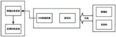
图1为无人机视觉编队飞行控制系统的框图;Figure 1 is a block diagram of the UAV visual formation flight control system;
图2为视觉系统的框图;Figure 2 is a block diagram of a vision system;
图3为基于视觉系统的位置稳定方案;Fig. 3 is the position stabilization scheme based on vision system;
图4为视觉系统对标志性物体的检测图像。Figure 4 shows the detection image of the landmark object by the vision system.
具体实施方式Detailed ways
为了使本技术领域的人员更好地理解本发明方案,下面将结合本发明实施例中的附图,对本发明实施例中的技术方案进行清楚、完整地描述,显然,所描述的实施例仅仅是本发明一部分的实施例,而不是全部的实施例。基于本发明中的实施例,本领域普通技术人员在没有做出创造性劳动前提下所获得的所有其他实施例,都应当属于本发明保护的范围。In order to make those skilled in the art better understand the solutions of the present invention, the technical solutions in the embodiments of the present invention will be clearly and completely described below with reference to the accompanying drawings in the embodiments of the present invention. Obviously, the described embodiments are only Embodiments are part of the present invention, but not all embodiments. Based on the embodiments of the present invention, all other embodiments obtained by persons of ordinary skill in the art without creative efforts shall fall within the protection scope of the present invention.
需要说明的是,本发明的说明书和权利要求书及上述附图中的术语“第一”、“第二”等是用于区别类似的对象,而不必用于描述特定的顺序或先后次序。应该理解这样使用的数据在适当情况下可以互换,以便这里描述的本发明的实施例能够以除了在这里图示或描述的那些以外的顺序实施。此外,术语“包括”和“具有”以及他们的任何变形,意图在于覆盖不排他的包含,例如,包含了一系列步骤或单元的过程、方法、系统、产品或设备不必限于清楚地列出的那些步骤或单元,而是可包括没有清楚地列出的或对于这些过程、方法、产品或设备固有的其它步骤或单元。It should be noted that the terms "first", "second" and the like in the description and claims of the present invention and the above drawings are used to distinguish similar objects, and are not necessarily used to describe a specific sequence or sequence. It is to be understood that the data so used may be interchanged under appropriate circumstances such that the embodiments of the invention described herein can be practiced in sequences other than those illustrated or described herein. Furthermore, the terms "comprising" and "having" and any variations thereof, are intended to cover non-exclusive inclusion, for example, a process, method, system, product or device comprising a series of steps or units is not necessarily limited to those expressly listed Rather, those steps or units may include other steps or units not expressly listed or inherent to these processes, methods, products or devices.
本发明提出了一种无人机编队飞行控制系统,该系统结合了机载视觉系统、传统的惯导单元以及先进的控制方法,无人机通过机载视觉系统获取状态信息,对标志性物体的探测,估计自身的相对位置,通过传统的惯导单元计算自身的姿态信息,并最后通智能控制方法实现在保持队形的前提下进行碰撞规避。The invention proposes an unmanned aerial vehicle formation flight control system, which combines an airborne vision system, a traditional inertial navigation unit and an advanced control method. , estimate its own relative position, calculate its own attitude information through the traditional inertial navigation unit, and finally realize the collision avoidance under the premise of maintaining the formation through the intelligent control method.
区别于以往的视觉编队飞行系统,本发明提出的视觉编队飞行系统不仅是机载的、重量轻,并且能够在参考物探测失效的情况下实现自身的飞行速度、位置的估计,并且能够和其他智能控制方法结合起来,提高可靠性和适应性,为接下来的编队控制打下坚实的基础。Different from the previous visual formation flight system, the visual formation flight system proposed by the present invention is not only airborne and light in weight, but also can realize its own flight speed and position estimation when the reference object detection fails, and can cooperate with others. The intelligent control methods are combined to improve reliability and adaptability, and lay a solid foundation for the subsequent formation control.
下面结合附图对本发明做进一步详细描述:Below in conjunction with accompanying drawing, the present invention is described in further detail:
参见图1,图1为本发明的无人机视觉编队飞行控制系统框图,一种无人机视觉编队飞行控制系统包括硬件系统和软件系统;其中,硬件系统包括无人机系统、地面站系统和单目成像系统;硬件系统中的无人机系统由n架重量仅为800g的无人机组成,每架无人机上均搭载有飞控电路板、惯性传感器、气压传感器、电池电压测量模块以及通信模块;硬件系统中的地面站系统由移动计算机、飞行操纵杆、无线电调制解调器和视频接收系统组成,利用地面站,操作者可实现向无人机发送指令并且实时监视飞机状态信息;参见图2,硬件系统中的单目成像系统由一个像素为640*480摄像机、一个无线PLL发射机、一台200mW的调压器和四组天线组成,单目成像系统搭载在无人机上。Referring to FIG. 1, FIG. 1 is a block diagram of the UAV visual formation flight control system of the present invention. A UAV visual formation flight control system includes a hardware system and a software system; wherein, the hardware system includes an UAV system and a ground station system. and monocular imaging system; the UAV system in the hardware system consists of n UAVs weighing only 800g, and each UAV is equipped with a flight control circuit board, inertial sensor, air pressure sensor, and battery voltage measurement module And the communication module; the ground station system in the hardware system consists of a mobile computer, a flight joystick, a radio modem and a video receiving system. Using the ground station, the operator can send instructions to the UAV and monitor the aircraft status information in real time; see Fig. 2. The monocular imaging system in the hardware system consists of a 640*480 pixel camera, a wireless PLL transmitter, a 200mW voltage regulator and four sets of antennas. The monocular imaging system is mounted on the UAV.
软件系统包括图像处理系统和编队飞行智能控制系统;图像处理系统是一种适应性处理算法,用于通过探测标志物体计算出每架无人机的实时三维位置,并推导出实时的移动速度,最重要的是,该图像处理系统在标志物体探测失败的情况下也能正常运行。The software system includes an image processing system and an intelligent control system for formation flight; the image processing system is an adaptive processing algorithm used to calculate the real-time three-dimensional position of each UAV by detecting marked objects, and deduce the real-time moving speed, Best of all, the image processing system works well even if the detection of a marker object fails.
图像处理系统的运行步骤如下:The operation steps of the image processing system are as follows:
步骤一:采用适应性处理算法在每帧视觉图像的基础上对摄像头的外部参数进行处理,适应性处理算法为:Step 1: Use an adaptive processing algorithm to process the external parameters of the camera on the basis of each frame of visual image. The adaptive processing algorithm is:

其中,

参见图3,图3所示为本发明设定的无人机和地面参考物的坐标系,无人机机头向前为Xh方向,向上的zh方向,由右手准则确定yh方向。而地面参考物的坐标系就以向北为xlp方向,向西为ylp方向;Referring to Fig. 3, Fig. 3 shows the coordinate system of the drone and the ground reference set by the present invention. The forward direction of the drone's nose is the Xh direction, and the upward zh direction is determined by the right-hand criterion. The coordinate system of the ground reference is the xlp direction to the north, and the ylp direction to the west;
步骤二:对标志性物体的检测,辨识出标志性物体的地理方位;Step 2: Detect the iconic objects, and identify the geographical orientation of the iconic objects;
参见图4,假设标志性物体是一个四边形物体,以四边形物体的四个顶点为圆心构造虚拟圆,虚拟圆的大小不一,计算机通过对每个虚拟圆进行探测,根据虚拟圆大小进行分类,从而辨识出标志性物体的地理方位;Referring to Figure 4, it is assumed that the iconic object is a quadrilateral object, and a virtual circle is constructed with the four vertices of the quadrilateral object as the center. The size of the virtual circle is different. Thereby identifying the geographic location of iconic objects;
步骤三:对标志性物体的检测结果进行检验Step 3: Check the detection results of the iconic objects
在步骤二中对假设标志性物体进行了检测,但是错误的检测结果需要放弃,因此需要对检测结果进行检验。理想情况下,四个圆布局形成一个矩形,上方的两个角之间的连线和右侧两个角之间的连线满足平行条件,对连接左侧两个角的直线和右侧两个角的连线也要满足相应的约束条件。平行性检验基于斜率方程:In step 2, the hypothetical landmark object is detected, but the wrong detection result needs to be discarded, so the detection result needs to be checked. Ideally, the layout of four circles forms a rectangle, and the line connecting the upper two corners and the connecting line between the right two corners satisfy the parallelism condition. The line connecting the corners must also satisfy the corresponding constraints. The parallelism test is based on the slope equation:

其中,i、f分别为初始和最终坐标。因此,上部直线的斜率应约等于下部直线的斜率,同时左边直线斜率应约等于右边直线斜率,即:where i and f are the initial and final coordinates, respectively. Therefore, the slope of the upper line should be approximately equal to the slope of the lower line, while the slope of the left line should be approximately equal to the slope of the right line, namely:
|mup-mlo|<ε;|mle-mri|<ε|mup -mlo |<ε; |mle -mri |<ε
只有满足这个条件的标志性物体的检测才是有效的。Only the detection of landmark objects that satisfy this condition is valid.
步骤四:每个时刻,当无人机处于盘旋状态时,利用四个圆心位置的先验信息计算适应性矩阵H=sK[r1 r2 T],利用估计得到的变换矩阵以及摄像矩阵,计算出摄像头参数,由此可计算得到无人机相对标志物体的位置(x,y,z)。Step 4: At each moment, when the UAV is in a hovering state, use the prior information of the four center positions to calculate the adaptability matrix H=sK[r1 r2 T], and use the estimated transformation matrix and camera matrix to calculate Camera parameters, from which the position (x, y, z) of the drone relative to the marked object can be calculated.
步骤五:基于视觉系统对无人机运动速度进行估计Step 5: Estimate the movement speed of the UAV based on the vision system
由于摄像机系统与无人机固定安装,因此摄像机系统与无人机有相同的速度。对摄像头的速度估计就是无人机速度的估计,摄像头的速度估计方法如下面的公式:Since the camera system is fixed to the drone, the camera system has the same speed as the drone. The speed estimation of the camera is the estimation of the speed of the drone. The speed estimation method of the camera is as follows:


其中,
步骤六:当标志物体探测失败时,利用光流测量估计当前四个虚拟圆的圆心位置,公式如下:Step 6: When the detection of the marked object fails, use the optical flow measurement to estimate the position of the center of the current four virtual circles. The formula is as follows:


其中,
编队飞行智能控制系统,用于根据图像处理系统得到的飞机的位置信息、速度和姿态信息,结合编队系统的运动学模型,利用强迫一致算法实现多无人机的一致,具体过程为:The formation flight intelligent control system is used for the position information, speed and attitude information of the aircraft obtained by the image processing system, combined with the kinematic model of the formation system, and uses the forced agreement algorithm to achieve the consistency of multiple UAVs. The specific process is as follows:

其中,L为拉普拉斯算子矩阵。Among them, L is the Laplacian operator matrix.
利用强迫一致算法:Using the forced consensus algorithm:

实现多无人机的一致,其中,Ni为将自身信息传输给无人机i的无人机集合;To achieve the consistency of multiple UAVs, where Ni is the set of UAVs that transmit their own information to UAVi ;
然后进行如下的变量转化:Then do the following variable transformations:


其中,xi,yi,zi,ψi,xj,yj,zj,ψj分别为需要被协同控制的第i架和第j架无人机的三维位置和航向。Among them, xi , yi , zi , ψi , xj , yj , zj , ψj are the three-dimensional positions and headings of the i-th and j-th UAVs that need to be cooperatively controlled, respectively.
以一架无人机的临机位置作为参考位置,利用本发明提出的分离饱和非线性控制方法对每一架无人机进行稳定控制,控制率如下:Taking the temporary position of an unmanned aerial vehicle as the reference position, the separation saturation nonlinear control method proposed by the present invention is used to stably control each unmanned aerial vehicle, and the control rate is as follows:


其中,θi为第i架无人机实时俯仰角度,
在该控制率作用下,实时计算无人机所需的控制量并传给作动机构,作动机构驱使无人机编队系统在编队队形不变的前提进行碰撞规避。Under the action of this control rate, the control amount required by the UAV is calculated in real time and transmitted to the actuating mechanism, and the actuating mechanism drives the UAV formation system to perform collision avoidance on the premise that the formation formation remains unchanged.
地面站向无人机编队系统发送定点模式指令;地面站接收和保存所有的编译信号,并对飞行实验和结果进行分析;利用地面站给无人机编队系统发送起飞指令,无人机编队系统所有无人机一键起飞,飞到设定好的相同高度。The ground station sends fixed-point mode commands to the UAV formation system; the ground station receives and saves all compiled signals, and analyzes the flight experiments and results; uses the ground station to send take-off instructions to the UAV formation system, and the UAV formation system All drones take off with one key and fly to the same set altitude.
在无人机编队飞行前,将无人机准确的放置在标志物体上,用于确认无人机编队系统的位置参考信号;用于参考的标志性物体可以是易于识别的飞行平台,也可以是某一个形状颜色突出的物体。Before the drones fly in formation, place the drones on the marked object accurately to confirm the position reference signal of the drone formation system; the landmark object for reference can be an easily identifiable flying platform, or It is an object with a prominent shape and color.
单目成像系统运行时,通过本发明适应性处理算法扫描参考物的每一帧图像,获从而取此飞机的实时三维位置。When the monocular imaging system is running, each frame of the image of the reference object is scanned through the adaptive processing algorithm of the present invention to obtain the real-time three-dimensional position of the aircraft.
无人机编队系统在获取的实时三维位置基础上,结合光流计算公式,实时估计平移速度。Based on the acquired real-time three-dimensional position, the UAV formation system combines the optical flow calculation formula to estimate the translation speed in real time.
通过每架无人机上的传统惯导单元,将测得的其他状态量实时反馈给智能控制器,如姿态信息,方位角信息。Through the traditional inertial navigation unit on each UAV, other measured state quantities are fed back to the intelligent controller in real time, such as attitude information and azimuth information.
无人机编队系统的每架无人机将自身的位置信息和速度信息通过无线电调制解调器传送给地面站,再由地面站发送给其他无人机,这样就实现了无人机编队系统的每架无人机的信息共享。Each UAV of the UAV formation system transmits its own position information and speed information to the ground station through the radio modem, and then the ground station sends it to other UAVs, thus realizing each UAV formation system. Information sharing by drones.
无人机编队系统依据每架无人机共享的位置信息,结合本发明提出的智能控制算法实现各无人机之间的三维位置协同控制;三维位置协同控制产生的效果就是无人机编队系统能够在保持队形不变的前提下实现碰撞规避;该三维位置协同控制算法可以扩展到n架无人机。The UAV formation system realizes the three-dimensional position cooperative control among the UAVs according to the position information shared by each UAV and the intelligent control algorithm proposed by the present invention; the effect produced by the three-dimensional position cooperative control is the UAV formation system The collision avoidance can be achieved on the premise of keeping the formation unchanged; the three-dimensional position cooperative control algorithm can be extended to n UAVs.
以上内容仅为说明本发明的技术思想,不能以此限定本发明的保护范围,凡是按照本发明提出的技术思想,在技术方案基础上所做的任何改动,均落入本发明权利要求书的保护范围之内。The above content is only to illustrate the technical idea of the present invention, and cannot limit the protection scope of the present invention. Any changes made on the basis of the technical solution according to the technical idea proposed by the present invention all fall within the scope of the claims of the present invention. within the scope of protection.
Claims (6)
Translated fromChinese


Priority Applications (1)
| Application Number | Priority Date | Filing Date | Title |
|---|---|---|---|
| CN202110098294.6ACN112859923B (en) | 2021-01-25 | 2021-01-25 | A UAV visual formation flight control system |
Applications Claiming Priority (1)
| Application Number | Priority Date | Filing Date | Title |
|---|---|---|---|
| CN202110098294.6ACN112859923B (en) | 2021-01-25 | 2021-01-25 | A UAV visual formation flight control system |
Publications (2)
| Publication Number | Publication Date |
|---|---|
| CN112859923A CN112859923A (en) | 2021-05-28 |
| CN112859923Btrue CN112859923B (en) | 2022-02-18 |
Family
ID=76008659
Family Applications (1)
| Application Number | Title | Priority Date | Filing Date |
|---|---|---|---|
| CN202110098294.6AActiveCN112859923B (en) | 2021-01-25 | 2021-01-25 | A UAV visual formation flight control system |
Country Status (1)
| Country | Link |
|---|---|
| CN (1) | CN112859923B (en) |
Families Citing this family (2)
| Publication number | Priority date | Publication date | Assignee | Title |
|---|---|---|---|---|
| CN114265406B (en)* | 2021-12-21 | 2024-04-12 | 南京理工大学 | Intelligent vehicle formation control system based on machine vision and control method thereof |
| CN115014279B (en)* | 2022-08-09 | 2022-10-28 | 湖南科天健光电技术有限公司 | Observation aircraft, observation system, calibration method and method for measuring target to be measured |
Family Cites Families (8)
| Publication number | Priority date | Publication date | Assignee | Title |
|---|---|---|---|---|
| CN106647814B (en)* | 2016-12-01 | 2019-08-13 | 华中科技大学 | A kind of unmanned plane vision auxiliary positioning and flight control system and method based on the identification of two dimensional code terrestrial reference |
| CN107144281B (en)* | 2017-06-30 | 2023-09-12 | 一飞智控(天津)科技有限公司 | Unmanned aerial vehicle indoor positioning system and positioning method based on cooperative targets and monocular vision |
| CN108196582A (en)* | 2018-02-12 | 2018-06-22 | 深圳技术大学(筹) | A kind of indoor Visual Navigation unmanned plane cluster flight control system and method |
| CN108459618A (en)* | 2018-03-15 | 2018-08-28 | 河南大学 | A kind of flight control system and method that unmanned plane automatically launches mobile platform |
| CN108508916B (en)* | 2018-04-02 | 2021-05-07 | 南方科技大学 | A control method, device, equipment and storage medium for unmanned aerial vehicle formation |
| CN109445432A (en)* | 2018-10-31 | 2019-03-08 | 中国科学技术大学 | Unmanned plane and ground mobile robot formation localization method based on image |
| CN109813311B (en)* | 2019-03-18 | 2020-09-15 | 南京航空航天大学 | Unmanned aerial vehicle formation collaborative navigation method |
| CN111176308A (en)* | 2019-12-27 | 2020-05-19 | 西安羚控电子科技有限公司 | Small-size many rotor unmanned aerial vehicle cluster control system of closed environment |
- 2021
- 2021-01-25CNCN202110098294.6Apatent/CN112859923B/enactiveActive
Also Published As
| Publication number | Publication date |
|---|---|
| CN112859923A (en) | 2021-05-28 |
Similar Documents
| Publication | Publication Date | Title |
|---|---|---|
| US10936869B2 (en) | Camera configuration on movable objects | |
| US11218689B2 (en) | Methods and systems for selective sensor fusion | |
| CN107014380B (en) | Combined Navigation Method of Visual Navigation and Inertial Navigation Based on Aircraft | |
| CN104062977B (en) | Full-autonomous flight control method for quadrotor unmanned aerial vehicle based on vision SLAM | |
| CN106774436B (en) | Control system and method for stably tracking target of rotor unmanned aerial vehicle based on vision | |
| CN104298248B (en) | Rotor wing unmanned aerial vehicle accurate vision positioning and orienting method | |
| CN103365297A (en) | Optical flow-based four-rotor unmanned aerial vehicle flight control method | |
| CN108873917A (en) | A kind of unmanned plane independent landing control system and method towards mobile platform | |
| CN110347186B (en) | An autonomous tracking system for ground moving targets based on bionic binocular linkage | |
| CN102190081B (en) | Vision-based fixed point robust control method for airship | |
| CN105182992A (en) | Unmanned aerial vehicle control method and device | |
| CN110333735B (en) | A system and method for realizing secondary positioning of unmanned aerial vehicle in water and land | |
| CN110231828B (en) | Four-rotor unmanned aerial vehicle visual servo control method based on nonsingular rapid terminal sliding mode | |
| CN111824406A (en) | A public safety autonomous inspection quadrotor UAV based on machine vision | |
| CN107515622A (en) | A control method for autonomous landing of a rotary-wing unmanned aerial vehicle on a moving target | |
| CN112859923B (en) | A UAV visual formation flight control system | |
| CN114581516A (en) | Multi-UAV intelligent identification and relative positioning method based on monocular vision | |
| WO2020133909A1 (en) | Flight control and navigation integrated machine | |
| CN107831776A (en) | Unmanned plane based on nine axle inertial sensors independently makes a return voyage method | |
| CN106708073A (en) | Four-rotor aircraft system of autonomous navigation power line inspection fault detection | |
| CN110456811A (en) | UAV selective obstacle avoidance system and method based on binocular vision and three-axis gimbal | |
| CN106155081A (en) | A kind of rotor wing unmanned aerial vehicle target monitoring on a large scale and accurate positioning method | |
| CN108848348A (en) | A kind of crowd's abnormal behaviour monitoring device and method based on unmanned plane | |
| CN108614572A (en) | A kind of target identification method for tracing, equipment and storage device based on aircraft | |
| US20250216858A1 (en) | Unmanned aerial vehicle control method and apparatus, and computer device and storge medium |
Legal Events
| Date | Code | Title | Description |
|---|---|---|---|
| PB01 | Publication | ||
| PB01 | Publication | ||
| SE01 | Entry into force of request for substantive examination | ||
| SE01 | Entry into force of request for substantive examination | ||
| GR01 | Patent grant | ||
| GR01 | Patent grant |