CN112419488A - Method for converting power grid information model GIM into point cloud - Google Patents
Method for converting power grid information model GIM into point cloudDownload PDFInfo
- Publication number
- CN112419488A CN112419488ACN202011423809.7ACN202011423809ACN112419488ACN 112419488 ACN112419488 ACN 112419488ACN 202011423809 ACN202011423809 ACN 202011423809ACN 112419488 ACN112419488 ACN 112419488A
- Authority
- CN
- China
- Prior art keywords
- point cloud
- file
- model
- cbm
- information
- Prior art date
- Legal status (The legal status is an assumption and is not a legal conclusion. Google has not performed a legal analysis and makes no representation as to the accuracy of the status listed.)
- Granted
Links
Images


Classifications
- G—PHYSICS
- G06—COMPUTING OR CALCULATING; COUNTING
- G06T—IMAGE DATA PROCESSING OR GENERATION, IN GENERAL
- G06T17/00—Three dimensional [3D] modelling, e.g. data description of 3D objects
- G—PHYSICS
- G06—COMPUTING OR CALCULATING; COUNTING
- G06F—ELECTRIC DIGITAL DATA PROCESSING
- G06F16/00—Information retrieval; Database structures therefor; File system structures therefor
- G06F16/10—File systems; File servers
- G06F16/11—File system administration, e.g. details of archiving or snapshots
- G06F16/116—Details of conversion of file system types or formats
- G—PHYSICS
- G06—COMPUTING OR CALCULATING; COUNTING
- G06Q—INFORMATION AND COMMUNICATION TECHNOLOGY [ICT] SPECIALLY ADAPTED FOR ADMINISTRATIVE, COMMERCIAL, FINANCIAL, MANAGERIAL OR SUPERVISORY PURPOSES; SYSTEMS OR METHODS SPECIALLY ADAPTED FOR ADMINISTRATIVE, COMMERCIAL, FINANCIAL, MANAGERIAL OR SUPERVISORY PURPOSES, NOT OTHERWISE PROVIDED FOR
- G06Q50/00—Information and communication technology [ICT] specially adapted for implementation of business processes of specific business sectors, e.g. utilities or tourism
- G06Q50/06—Energy or water supply
- G—PHYSICS
- G06—COMPUTING OR CALCULATING; COUNTING
- G06T—IMAGE DATA PROCESSING OR GENERATION, IN GENERAL
- G06T19/00—Manipulating 3D models or images for computer graphics
- G06T19/20—Editing of 3D images, e.g. changing shapes or colours, aligning objects or positioning parts
- Y—GENERAL TAGGING OF NEW TECHNOLOGICAL DEVELOPMENTS; GENERAL TAGGING OF CROSS-SECTIONAL TECHNOLOGIES SPANNING OVER SEVERAL SECTIONS OF THE IPC; TECHNICAL SUBJECTS COVERED BY FORMER USPC CROSS-REFERENCE ART COLLECTIONS [XRACs] AND DIGESTS
- Y04—INFORMATION OR COMMUNICATION TECHNOLOGIES HAVING AN IMPACT ON OTHER TECHNOLOGY AREAS
- Y04S—SYSTEMS INTEGRATING TECHNOLOGIES RELATED TO POWER NETWORK OPERATION, COMMUNICATION OR INFORMATION TECHNOLOGIES FOR IMPROVING THE ELECTRICAL POWER GENERATION, TRANSMISSION, DISTRIBUTION, MANAGEMENT OR USAGE, i.e. SMART GRIDS
- Y04S10/00—Systems supporting electrical power generation, transmission or distribution
- Y04S10/50—Systems or methods supporting the power network operation or management, involving a certain degree of interaction with the load-side end user applications
Landscapes
- Engineering & Computer Science (AREA)
- Physics & Mathematics (AREA)
- Theoretical Computer Science (AREA)
- General Physics & Mathematics (AREA)
- Business, Economics & Management (AREA)
- Computer Graphics (AREA)
- Software Systems (AREA)
- Economics (AREA)
- Health & Medical Sciences (AREA)
- General Engineering & Computer Science (AREA)
- Public Health (AREA)
- General Health & Medical Sciences (AREA)
- Data Mining & Analysis (AREA)
- Computer Hardware Design (AREA)
- Architecture (AREA)
- Geometry (AREA)
- Water Supply & Treatment (AREA)
- Databases & Information Systems (AREA)
- Human Resources & Organizations (AREA)
- Marketing (AREA)
- Primary Health Care (AREA)
- Strategic Management (AREA)
- Tourism & Hospitality (AREA)
- General Business, Economics & Management (AREA)
- Processing Or Creating Images (AREA)
Abstract
Translated fromChinese
Description
Translated fromChinese技术领域technical field
本发明涉及输变电工程三维模型可视化领域,具体为一种电网信息模型GIM转换为点云的方法。The invention relates to the field of visualization of three-dimensional models of power transmission and transformation projects, in particular to a method for converting a power grid information model GIM into a point cloud.
背景技术Background technique
为满足输变电工程三维设计的需要,统一模型构架和数据交互格式,实现工程全生命周期的数据共享,现有的输变电工程三维设计模型交互规范规定了输变电工程设计阶段三维模型文件的架构、存储结构等数据交互要求,并适用于110(66)kV及以上电压等级输变电工程的三维设计。在该规范下,输变电工程三维设计模型的标准格式为*.GIM。In order to meet the needs of 3D design of power transmission and transformation projects, unify the model framework and data interaction format, and realize the data sharing of the whole life cycle of the project, the existing three-dimensional design model interaction specification of power transmission and transformation projects stipulates the three-dimensional model of the design stage of power transmission and transformation projects. Data interaction requirements such as file structure and storage structure, and are suitable for 3D design of power transmission and transformation projects with voltage levels of 110(66)kV and above. Under this specification, the standard format of 3D design model of power transmission and transformation project is *.GIM.
由于GIM(Grid Information Model,电网信息模型)代表输变电工程的三维设计模型,三维激光点云模型代表输变电工程现场实景,因此现有研究常通过融合应用GIM模型和三维激光点云模型以实现输变电工程的质量管控和进度监测,且这些应用常涉及GIM模型和三维激光点云模型间的匹配和比对分析问题,但因GIM模型和三维激光点云模型数据结构各不相同,缺乏共性特征,所以难以直接对二者进行匹配或比对分析。Since GIM (Grid Information Model, power grid information model) represents the three-dimensional design model of power transmission and transformation projects, and the three-dimensional laser point cloud model represents the real scene of power transmission and transformation projects, existing research often integrates the application of GIM model and three-dimensional laser point cloud model. In order to realize the quality control and progress monitoring of power transmission and transformation projects, and these applications often involve the matching and comparison analysis between the GIM model and the 3D laser point cloud model, but the data structures of the GIM model and the 3D laser point cloud model are different. , lack of common features, so it is difficult to directly match or compare the two.
发明内容SUMMARY OF THE INVENTION
为解决现有技术中存在的问题,本发明目的是提供一种电网信息模型GIM转换为点云的方法,本发明能够有效地将电网信息模型GIM转化为多种格式的点云文件,为GIM模型提供了另一种三维可视化方法,能够使GIM模型和三维激光点云模型直接进行匹配或比对分析。In order to solve the problems existing in the prior art, the purpose of the present invention is to provide a method for converting the power grid information model GIM into a point cloud. The model provides another 3D visualization method, which can directly match or compare the GIM model and the 3D laser point cloud model.
为达到上述目的,本发明采用如下技术方案:To achieve the above object, the present invention adopts the following technical solutions:
一种电网信息模型GIM转换为点云的方法,包括如下步骤:A method for converting a power grid information model GIM into a point cloud, comprising the following steps:
S1,逐级读取GIM模型中的CBM文件、DEV文件、PHM文件和FAM文件,获取经纬度、海拔和变换矩阵信息;S1, read the CBM file, DEV file, PHM file and FAM file in the GIM model step by step, and obtain the latitude and longitude, altitude and transformation matrix information;
S2,解析PHM文件中的MOD文件或STL文件,将MOD文件对应模型信息或STL文件对应模型信息转换至点云模型;S2, parse the MOD file or STL file in the PHM file, and convert the model information corresponding to the MOD file or the model information corresponding to the STL file to the point cloud model;
S3,通过各级系统中CBM文件、DEV文件和PHM文件中的经纬度坐标和变换矩阵将S2中所得点云模型转换至同一参考坐标系下,构建得到PCD格式的完整工程点云模型;S3, convert the point cloud model obtained in S2 to the same reference coordinate system through the latitude and longitude coordinates and transformation matrix in the CBM file, DEV file and PHM file in the systems at all levels, and construct a complete engineering point cloud model in PCD format;
S4,将PCD格式的完整工程点云模型转换为TXT、XYZ或LAS格式的点云文件。S4, convert the complete engineering point cloud model in PCD format to point cloud file in TXT, XYZ or LAS format.
优选的,所述S1包括如下步骤:Preferably, the S1 includes the following steps:
S1-1,读取入口文件project.cbm,获取一级CBM文件名;S1-1, read the entry file project.cbm, and obtain the first-level CBM file name;
S1-2,获取一级CBM文件下的所有二级CBM文件,存入二级CBM文件队列;S1-2, obtain all the second-level CBM files under the first-level CBM file, and store them in the second-level CBM file queue;
S1-3,顺次取出二级CBM文件队列中的每个二级CBM文件,获取二级CBM文件下的所有三级CBM文件,存入三级CBM文件队列;S1-3, sequentially take out each secondary CBM file in the secondary CBM file queue, obtain all the tertiary CBM files under the secondary CBM file, and store them in the tertiary CBM file queue;
S1-4,顺次取出三级CBM文件队列中的每个三级CBM文件,获取三级CBM文件下的所有四级CBM文件,存入四级CBM文件队列;S1-4, sequentially take out each third-level CBM file in the third-level CBM file queue, obtain all fourth-level CBM files under the third-level CBM file, and store them in the fourth-level CBM file queue;
S1-5,顺次取出四级CBM文件队列中的每个四级CBM文件,获取四级CBM文件下的所有五级子设备CBM文件,并记录五级子设备CBM文件中的经纬度和海拔信息;S1-5, sequentially take out each fourth-level CBM file in the fourth-level CBM file queue, obtain all the fifth-level sub-device CBM files under the fourth-level CBM file, and record the longitude, latitude and altitude information in the fifth-level sub-device CBM file ;
S1-6,获取每个五级CBM文件中的DEV文件和FAM文件,并记录变换矩阵T1;S1-6, obtain the DEV file and the FAM file in each five-level CBM file, and record the transformation matrix T1 ;
S1-7,读取每个五级CBM文件对应的DEV文件,获取DEV文件中的PHM文件,并记录变换矩阵T2;S1-7, read the DEV file corresponding to each five-level CBM file, obtain the PHM file in the DEV file, and record the transformation matrix T2 ;
S1-8,读取PHM文件,获取PHM文件中的MOD文件或STL文件,并记录变换矩阵T3。S1-8, read the PHM file, obtain the MOD file or the STL file in the PHM file, and record the transformation matrix T3 .
优选的,所述S2包括如下步骤:Preferably, the S2 includes the following steps:
S2-1,判断S1-8中所读取文件的类型,若为MOD文件,进行S2-2至S2-3;若为STL文件,进行S2-4至S2-5;S2-1, judge the type of the file read in S1-8, if it is a MOD file, go to S2-2 to S2-3; if it is an STL file, go to S2-4 to S2-5;
S2-2,解析MOD文件,获得模型信息;S2-2, parse the MOD file to obtain model information;
S2-3,根据模型信息对模型进行填充;S2-3, fill the model according to the model information;
S2-4,解析STL文件,获取所有三角面片的顶点信息;S2-4, parse the STL file to obtain the vertex information of all triangular faces;
S2-5,将STL文件中的所有三角面片以均匀点集填充。S2-5, fill all triangular patches in the STL file with a uniform point set.
优选的,S2-2中,模型信息包括模型类型、模型形状、模型尺寸和节点信息;若是模型形状和尺寸信息,则对模型表面以均匀点云填充;若为节点信息,则节点间以均匀分布在同一直线上的点云填充。Preferably, in S2-2, the model information includes model type, model shape, model size, and node information; if it is model shape and size information, the model surface is filled with a uniform point cloud; if it is node information, the nodes are filled with uniform point clouds. Point cloud fills distributed on the same line.
优选的,所述模型形状包括长方体、球体和圆柱体,所述模型尺寸包括长方体的长、宽和高,球体的球半径以及圆柱体的高和底面半径。Preferably, the shape of the model includes a cuboid, a sphere and a cylinder, and the size of the model includes the length, width and height of the cuboid, the sphere radius of the sphere, and the height and base radius of the cylinder.
优选的,所述S3包括如下步骤:Preferably, the S3 includes the following steps:
S3-1,将在S1-5中读取的第一座杆塔的经纬度和海拔信息作为点云模型坐标系的原点;S3-1, take the longitude, latitude and altitude information of the first tower read in S1-5 as the origin of the point cloud model coordinate system;
S3-2,将其余设备的经纬度和海拔信息参照第一个设备计算其平移矩阵;利用平移矩阵将各设备点云平移至点云坐标系下获得点云;S3-2, refer to the latitude, longitude and altitude information of other devices to calculate its translation matrix with reference to the first device; use the translation matrix to translate the point cloud of each device to the point cloud coordinate system to obtain the point cloud;
S3-3,将各设备点云中的每个点qi,参照读取的对应变换矩阵T1、变换矩阵T2和变换矩阵T3,移动至点qi的正确位置,获得最终点云;S3-3 , move each point qi in the point cloud of each device to the correct position of the pointqi with reference to the read corresponding transformation matrix T1 , transformation matrix T2 and transformation matrix T3 to obtain the final point cloud ;
S3-4,在完成所有子设备点云的位置转换后,将完整点云和各子设备点云保存为PCD格式。S3-4, after completing the position conversion of all sub-equipment point clouds, save the complete point cloud and each sub-equipment point cloud in PCD format.
优选的,平移矩阵t(tx,ty,tz)的计算公式如下:Preferably, the calculation formula of the translation matrix t(tx , ty , tz ) is as follows:

其中,a、b分别为地球经线截面的半长轴和半短轴,Bc为其余设备的纬度信息,Bo为第一个设备的纬度信息,Lc为其余设备的经度信息,Lo为第一个设备的经度信息,Hc为其余设备的海拔信息,Ho为第一个设备的海拔信息,函数sgn()如下:Among them, a and b are the semi-major axis and semi-minor axis of the earth's meridian section, Bc is the latitude information of the other devices, Bo is the latitude information of the first device, Lc is the longitude information of the other devices, Lo is the longitude information of the first device, Hc is the altitude information of the other devices, Ho is the altitude information of the first device, and the function sgn() is as follows:

利用平移矩阵t(tx,ty,tz),将各设备点云P平移至点云坐标系下获得点云Q,计算公式如下:Using the translation matrix t(tx ,ty , tz ), translate the point cloud P of each device to the point cloud coordinate system to obtain the point cloud Q, and the calculation formula is as follows:

式中,qx,qy,qz分别为点云Q中点q的三维坐标,px,py,pz分别为点云P中点p的三维坐标;In the formula, qx , qy , and qz are the three-dimensional coordinates of the point q in the point cloud Q, respectively, and px , py , and pz are the three-dimensional coordinates of the point p in the point cloud P, respectively;
终点云S计算公式如下:The calculation formula of the destination cloud S is as follows:
s=T1T2T3qs=T1 T2 T3 q
式中s为点云S中的坐标点,q为点云Q中的坐标点。where s is the coordinate point in the point cloud S, and q is the coordinate point in the point cloud Q.
优选的,在S1-5中,将读取的第一座杆塔的经纬度和海拔信息转化为点云模型坐标系的原点。Preferably, in S1-5, the read longitude, latitude and altitude information of the first tower is converted into the origin of the point cloud model coordinate system.
优选的,S4中,将PCD格式的完整工程点云模型转换为TXT、XYZ或LAS格式的点云文件时,转换内容包括转换内容包括点云模型坐标系下的整体点云和构成整体点云的各子设备点云。Preferably, in S4, when converting a complete engineering point cloud model in PCD format to a point cloud file in TXT, XYZ or LAS format, the conversion content includes the conversion content including the overall point cloud in the coordinate system of the point cloud model and the point cloud that constitutes the overall point cloud The point cloud of each sub-device.
优选的,所述S4包括如下过程:Preferably, the S4 includes the following process:
将PCD格式转换为TXT格式点云文件,在TXT格式点云文件中的每一行写入各点的X坐标、Y坐标和Z坐标,坐标之间以空格分隔;转换内容包括点云模型坐标系下的整体点云和构成整体点云的各子设备点云;Convert PCD format to TXT format point cloud file, write the X coordinate, Y coordinate and Z coordinate of each point in each line in the TXT format point cloud file, and separate the coordinates with spaces; the conversion content includes the point cloud model coordinate system The overall point cloud and the sub-device point clouds that constitute the overall point cloud;
将PCD格式转换为XYZ格式点云文件,在XYZ格式点云文件中的每一行依次写入各点的X坐标、Y坐标、Z坐标、X方向法向量、Y方向法向量和Z方向法向量,各值之间以空格分隔;转换内容包括点云模型坐标系下的整体点云和构成整体点云的各子设备点云;Convert PCD format to XYZ format point cloud file, and write the X coordinate, Y coordinate, Z coordinate, X direction normal vector, Y direction normal vector and Z direction normal vector of each point in turn in each line in the XYZ format point cloud file , and each value is separated by a space; the conversion content includes the overall point cloud in the coordinate system of the point cloud model and the point cloud of each sub-device that constitutes the overall point cloud;
将PCD格式转换为LAS格式点云文件,利用liblas库函数创建LAS格式点云文件,写入信息包括分类号和三维坐标和颜色信息,分类号信息由LAS规范确定;转换内容包括点云模型坐标系下的整体点云和构成整体点云的各子设备点云。Convert PCD format to LAS format point cloud file, use liblas library function to create LAS format point cloud file, write information including classification number, 3D coordinates and color information, classification number information is determined by LAS specification; conversion content includes point cloud model coordinates The overall point cloud under the system and each sub-device point cloud that constitutes the overall point cloud.
本发明具有如下有益效果:The present invention has the following beneficial effects:
本发明首先通过逐级读取GIM模型中的CBM、DEV、PHM和FAM文件,获取相关信息;然后解析MOD、STL文件,实现MOD或STL模型至点云模型的转换;再通过各级系统中CBM、DEV和PHM文件中的经纬度坐标和变换矩阵将所得点云转换至同一参考坐标系下,构建完整工程点云模型,并以PCD点云文件格式保存;最后将PCD格式点云文件向TXT、XYZ和LAS等格式点云文件转换。本发明为电网信息模型GIM提供了以点云形式展示的方法,为GIM模型和三维激光点云模型间的匹配和比对分析提供了数据基础,促进了BIM技术和三维激光点云技术在输变电工程建设领域的融合应用。因此本发明解决了由于两种模型文件数据结构不同等原因,通常不能直接应用于模型间的匹配和比对分析等问题,也实现了GIM模型的另一种可视化方法---点云形式,并提供了向多种格式点云文件转换的方法,本发明的方法以点云的形式高精度展现GIM模型,具备自动化程度高的优点,促进了三维激光点云技术和BIM技术在输变电工程建设领域的融合应用,为输变电工程的质量管控和进度监测提供了基础数据。The invention firstly obtains relevant information by reading CBM, DEV, PHM and FAM files in the GIM model step by step; then parses the MOD and STL files to realize the conversion from the MOD or STL model to the point cloud model; The latitude and longitude coordinates and transformation matrices in the CBM, DEV and PHM files convert the obtained point cloud to the same reference coordinate system, build a complete engineering point cloud model, and save it in PCD point cloud file format; finally, transfer the PCD format point cloud file to TXT , XYZ and LAS format point cloud file conversion. The invention provides a point cloud display method for the power grid information model GIM, provides a data basis for the matching and comparison analysis between the GIM model and the three-dimensional laser point cloud model, and promotes the BIM technology and the three-dimensional laser point cloud technology in the transmission. Integrated application in the field of substation engineering construction. Therefore, the present invention solves the problems that due to the different data structures of the two model files, which cannot be directly applied to the matching and comparison analysis between the models, and also realizes another visualization method of the GIM model---the point cloud form, It also provides a method for converting point cloud files in various formats. The method of the present invention presents the GIM model with high precision in the form of point cloud, has the advantages of high automation, and promotes the application of 3D laser point cloud technology and BIM technology in power transmission and transformation. The integrated application in the field of engineering construction provides basic data for quality control and progress monitoring of power transmission and transformation projects.
附图说明Description of drawings
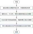
图1为本发明电网信息模型GIM转换为点云的方法的流程。FIG. 1 is a flowchart of a method for converting a power grid information model GIM into a point cloud according to the present invention.
图2为本发明中GIM标准文件数据结构图。FIG. 2 is a data structure diagram of a GIM standard file in the present invention.
图3为本发明步骤(1)实现流程图。FIG. 3 is a flow chart of the implementation of step (1) of the present invention.
图4为本发明中杆塔MOD模型转化为点云模型图。FIG. 4 is a diagram illustrating the transformation of a tower MOD model into a point cloud model in the present invention.
图5为本发明中绝缘子串STL模型转化为点云模型图。FIG. 5 is a diagram illustrating the transformation of the STL model of the insulator string into a point cloud model in the present invention.
图6(a)为本发明中整个架空输电线路工程的GIM模型转化为点云模型图(整段线路俯视图);Fig. 6(a) is the GIM model of the whole overhead transmission line project in the present invention converted into a point cloud model diagram (a top view of the entire line);
图6(b)为本发明中整个架空输电线路工程的GIM模型转化为点云模型图(一档距的线路图)。Fig. 6(b) is a diagram showing the transformation of the GIM model of the entire overhead transmission line project into a point cloud model diagram (a line diagram of one pitch) in the present invention.
具体实施方式Detailed ways
下面结合附图对本发明的具体实施例进行详细说明。The specific embodiments of the present invention will be described in detail below with reference to the accompanying drawings.
参照图1,本发明提出的一种电网信息模型GIM转换为点云的方法,包括以下步骤:1 , a method for converting a power grid information model GIM into a point cloud proposed by the present invention includes the following steps:
(1)逐级读取GIM模型中的CBM文件、DEV文件、PHM文件和FAM文件,获取经纬度、海拔、变换矩阵信息和各级设备的相应属性信息;(1) Read the CBM file, DEV file, PHM file and FAM file in the GIM model step by step, and obtain the latitude and longitude, altitude, transformation matrix information and the corresponding attribute information of the equipment at all levels;
(2)解析PHM文件中的MOD文件或STL文件,完成MOD或STL模型至点云模型的转换工作;(2) Parse the MOD file or STL file in the PHM file, and complete the conversion from the MOD or STL model to the point cloud model;
(3)通过各级系统中CBM文件、DEV文件和PHM文件中的经纬度坐标和变换矩阵,将步骤(2)中所得点云模型转换至同一参考坐标系下,构建PCD格式的完整工程点云模型;(3) Convert the point cloud model obtained in step (2) to the same reference coordinate system through the latitude and longitude coordinates and transformation matrices in the CBM file, DEV file and PHM file in the systems at all levels to construct a complete engineering point cloud in PCD format Model;
(4)将PCD格式点云文件向TXT、XYZ或LAS格式点云文件转换。(4) Convert PCD format point cloud files to TXT, XYZ or LAS format point cloud files.
其中,所述步骤(1)包括如下步骤:Wherein, described step (1) comprises the following steps:
1-1)读取入口文件“project.cbm”,获取其中一级CBM文件名;1-1) Read the entry file "project.cbm", and obtain one of the first-level CBM file names;
1-2)获取一级CBM文件下的所有二级CBM文件,存入二级CBM文件队列,并读取FAM文件获取属性信息;1-2) Obtain all the secondary CBM files under the primary CBM file, store them in the secondary CBM file queue, and read the FAM file to obtain attribute information;
1-3)顺次取出二级CBM文件队列中的每个二级CBM文件,获取其下的所有三级CBM文件,存入三级CBM文件队列,并读取FAM文件获取属性信息;1-3) successively take out each secondary CBM file in the secondary CBM file queue, obtain all the tertiary CBM files under it, store in the tertiary CBM file queue, and read the FAM file to obtain attribute information;
1-4)顺次取出三级CBM文件队列中的每个三级CBM文件,获取其下的所有四级CBM文件,存入四级CBM文件队列,并读取FAM文件获取属性信息;1-4) successively take out each third-level CBM file in the third-level CBM file queue, obtain all the fourth-level CBM files under it, store in the fourth-level CBM file queue, and read the FAM file to obtain attribute information;
1-5)顺次取出四级CBM文件队列中的每个四级CBM文件,获取其下的所有五级子设备CBM文件,并记录其中的经纬度和海拔信息;1-5) successively take out each level-4 CBM file in the level-4 CBM file queue, obtain all level-5 sub-equipment CBM files under it, and record the latitude, longitude and altitude information therein;
1-6)获取每个五级CBM文件中的DEV文件和FAM文件,并记录其中的变换矩阵T1;1-6) obtain the DEV file and the FAM file in each five-level CBM file, and record the transformation matrix T1 therein;
1-7)读取每个五级CBM文件对应的DEV文件,获取其中的PHM文件,并记录其中的变换矩阵T2;1-7) read the corresponding DEV file of each five-level CBM file, obtain the PHM file wherein, and record the transformation matrix T2 wherein;
1-8)读取PHM文件,获取其中的MOD文件或STL文件,并记录其中的变换矩阵T3。1-8) Read the PHM file, obtain the MOD file or STL file therein, and record the transformation matrix T3 therein.
所述步骤(2)包括如下步骤:Described step (2) comprises the steps:
2-1)判断步骤1-8)中所读取文件的类型,若为MOD文件,进行步骤2-2)至步骤2-3),若为STL文件,进行步骤2-4)至步骤2-5);2-1) Judge the type of the file read in step 1-8), if it is a MOD file, go to step 2-2) to step 2-3), if it is an STL file, go to step 2-4) to step 2 -5);
2-2)解析MOD文件,获得模型信息,模型信息包括模型类型、模型形状、模型尺寸和节点信息;2-2) Parse the MOD file to obtain model information, which includes model type, model shape, model size and node information;
2-3)根据上述模型形状、模型尺寸和节点信息构建点云模型;2-3) Construct a point cloud model according to the above-mentioned model shape, model size and node information;
2-4)解析STL文件,获取所有三角面片的顶点信息;2-4) Parse the STL file to obtain the vertex information of all triangular faces;
2-5)将STL文件中的所有三角面片以均匀点集填充,构建点云模型;2-5) Fill all triangular patches in the STL file with a uniform point set to build a point cloud model;
所述步骤(3)包括如下步骤:Described step (3) comprises the steps:
3-1)将在步骤1-5)中读取的第一座杆塔的经纬度和海拔信息作为点云模型坐标系的原点;3-1) The longitude, latitude and altitude information of the first pole tower read in step 1-5) are used as the origin of the point cloud model coordinate system;
3-2)将其余设备的经纬度和海拔信息参照第一个设备计算其平移矩阵t(tx,ty,tz),平移矩阵t(tx,ty,tz)的计算公式如下:3-2) Calculate the translation matrix t(tx , ty , tz ) by referring to the latitude, longitude and altitude information of other devices with reference to the first device. The calculation formula of the translation matrix t(tx , ty , tz ) is as follows :


tz=Hc-Hotz =Hc -Ho
其中,a、b分别为地球经线截面(椭圆)的半长轴和半短轴,Bc为其余设备的纬度信息,Bo为第一个设备的纬度信息,Lc为其余设备的经度信息,Lo为第一个设备的经度信息,Hc为其余设备的海拔信息,Ho为第一个设备的海拔信息,函数sgn()如下:Among them, a and b are the semi-major and semi-minor axes of the earth's longitude section (ellipse), respectively, Bc is the latitude information of the remaining devices, Bo is the latitude information of the first device, and Lc is the longitude information of the remaining devices. , Lo is the longitude information of the first device, Hc is the altitude information of other devices, Ho is the altitude information of the first device, the function sgn() is as follows:

利用平移矩阵t(tx,ty,tz),将各设备点云P平移至点云坐标系下获得点云Q,计算公式如下:Using the translation matrix t(tx ,ty , tz ), translate the point cloud P of each device to the point cloud coordinate system to obtain the point cloud Q, and the calculation formula is as follows:

式中,qx,qy,qz分别为点云Q中点q的三维坐标,px,py,pz分别为点云P中点p的三维坐标;In the formula, qx , qy , and qz are the three-dimensional coordinates of the point q in the point cloud Q, respectively, and px , py , and pz are the three-dimensional coordinates of the point p in the point cloud P, respectively;
3-3)将各设备点云Q中的每个点qi,i=1...N,参照在步骤(1)中读取的对应变换矩阵T1、变换矩阵T2和变换矩阵T3,移动至点qi,i=1...N正确位置,获得最终点云S,计算公式如下:3-3) Refer to the corresponding transformation matrix T1 , transformation matrix T2 and transformation matrix T read in step (1) for each point qi , i=1...N in the point cloud Q of each device3. Move to the correct position of point qi,i =1...N to obtain the final point cloud S. The calculation formula is as follows:
s=T1T2T3qs=T1 T2 T3 q
式中s为点云S中的坐标点,q为点云Q中的坐标点。where s is the coordinate point in the point cloud S, and q is the coordinate point in the point cloud Q.
3-4)在完成所有子设备点云的位置转换后,将完整点云和各子设备点云以PCD格式保存。3-4) After completing the position conversion of all sub-equipment point clouds, save the complete point cloud and each sub-equipment point cloud in PCD format.
所述步骤(4)包括如下步骤:Described step (4) comprises the steps:
4-1)将PCD格式转换为TXT格式点云文件,即创建TXT文件,并在TXT文件中的每一行写入各点的X,Y和Z坐标,坐标之间以空格分隔;转换内容包括点云模型坐标系下的整体点云和构成整体点云的各子设备点云;4-1) Convert the PCD format to the TXT format point cloud file, that is, create a TXT file, and write the X, Y and Z coordinates of each point in each line in the TXT file, and the coordinates are separated by spaces; the conversion content includes The overall point cloud in the point cloud model coordinate system and the point clouds of each sub-device that constitute the overall point cloud;
4-2)将PCD格式转换为XYZ格式点云文件,即在XYZ文件中的每一行依次写入各点的X坐标,Y坐标,Z坐标,X方向法向量,Y方向法向量和Z方向法向量,且各值之间以空格分隔;转换内容包括点云模型坐标系下的整体点云和构成整体点云的各子设备点云;4-2) Convert PCD format to XYZ format point cloud file, that is, write the X coordinate, Y coordinate, Z coordinate, X direction normal vector, Y direction normal vector and Z direction of each point in turn in each line in the XYZ file The normal vector, and the values are separated by spaces; the conversion content includes the overall point cloud in the coordinate system of the point cloud model and the point cloud of each sub-device that constitutes the overall point cloud;
4-3)将PCD格式转换为LAS格式点云文件,创建LAS格式点云文件时借助liblas库函数,写入信息包括分类号,三维坐标和颜色信息,其中分类号信息由美国摄影测量及遥感协会制定的LAS规范确定,如电力线分类号为14,杆塔设备分类号为15;转换内容包括点云模型坐标系下的整体点云和构成整体点云的各子设备点云。4-3) Convert PCD format to LAS format point cloud file, use liblas library function when creating LAS format point cloud file, write information including classification number, 3D coordinates and color information, among which classification number information is provided by American photogrammetry and remote sensing The LAS specification formulated by the association is determined, such as the power line classification number is 14, and the tower equipment classification number is 15; the conversion content includes the overall point cloud in the point cloud model coordinate system and the point cloud of each sub-equipment that constitutes the overall point cloud.
本发明在逐级读取GIM模型的CBM、DEV、PHM和FAM文件中的所有数据信息后,将MOD模型或STL模型以表面点云填充的方式转化成点云模型,然后将读取的第一座杆塔的经纬度和海拔信息作为坐标原点,其他设备则以此原点为基准,全部以点云的形式转换至此坐标系下,再将整体点云和各子设备点云以PCD格式保存,最后将PCD格式点云分别转化为TXT,XYZ和LAS格式。After reading all the data information in the CBM, DEV, PHM and FAM files of the GIM model step by step, the present invention converts the MOD model or STL model into a point cloud model by filling the surface point cloud, and then the read first The longitude, latitude and altitude information of a tower is used as the coordinate origin, and other devices are based on this origin, and all are converted to this coordinate system in the form of point clouds, and then the overall point cloud and each sub-device point cloud are saved in PCD format, and finally Convert PCD format point cloud to TXT, XYZ and LAS format respectively.
实施例Example
如图1所示,本实施例的电网信息模型GIM转换为点云的方法,包括以下步骤:As shown in FIG. 1 , the method for converting a power grid information model GIM into a point cloud in this embodiment includes the following steps:
(1)逐级读取GIM模型中的CBM文件、DEV文件、PHM文件和FAM文件(GIM模型的数据结构如图2所示),获取其中的经纬度、海拔、变换矩阵信息和各级设备的相应属性信息;步骤(1)包括如下步骤(流程如图3所示):(1) Read the CBM file, DEV file, PHM file and FAM file in the GIM model step by step (the data structure of the GIM model is shown in Figure 2), and obtain the latitude and longitude, altitude, transformation matrix information and the information of the equipment at all levels. Corresponding attribute information; step (1) includes the following steps (the process is shown in Figure 3):
1-1)读取入口文件“project.cbm”,获取入口文件“project.cbm”中一级CBM文件名;1-1) Read the entry file "project.cbm", and obtain the first-level CBM file name in the entry file "project.cbm";
1-2)获取一级CBM文件下的所有二级CBM文件,存入二级CBM文件队列,并读取FAM文件获取属性信息;1-2) Obtain all the secondary CBM files under the primary CBM file, store them in the secondary CBM file queue, and read the FAM file to obtain attribute information;
1-3)顺次取出二级CBM文件队列中的每个二级CBM文件,获取其下的所有三级CBM文件,存入三级CBM文件队列,并读取FAM文件获取属性信息;1-3) successively take out each secondary CBM file in the secondary CBM file queue, obtain all the tertiary CBM files under it, store in the tertiary CBM file queue, and read the FAM file to obtain attribute information;
1-4)顺次取出三级CBM文件队列中的每个三级CBM文件,获取其下的所有四级CBM文件,存入四级CBM文件队列,并读取FAM文件获取属性信息;1-4) successively take out each third-level CBM file in the third-level CBM file queue, obtain all the fourth-level CBM files under it, store in the fourth-level CBM file queue, and read the FAM file to obtain attribute information;
1-5)顺次取出四级CBM文件队列中的每个四级CBM文件,获取其下的所有五级子设备CBM文件,并记录其中的经纬度和海拔信息;1-5) successively take out each level-4 CBM file in the level-4 CBM file queue, obtain all level-5 sub-equipment CBM files under it, and record the latitude, longitude and altitude information therein;
1-6)获取每个五级CBM文件中的DEV文件和FAM文件,并记录其中的变换矩阵T1;1-6) obtain the DEV file and the FAM file in each five-level CBM file, and record the transformation matrix T1 therein;
1-7)读取每个五级CBM文件对应的DEV文件,获取其中的PHM文件,并记录其中的变换矩阵T2;1-7) read the corresponding DEV file of each five-level CBM file, obtain the PHM file wherein, and record the transformation matrix T2 wherein;
1-8)读取PHM文件,获取其中的MOD或STL文件,并记录其中的变换矩阵T3。1-8) Read the PHM file, obtain the MOD or STL file therein, and record the transformation matrix T3 therein.
(2)解析MOD文件、STL文件,完成MOD、STL模型至点云模型的转换工作,步骤(2)包括如下步骤:(2) Parse MOD files and STL files, and complete the conversion work from MOD and STL models to point cloud models. Step (2) includes the following steps:
2-1)判断步骤1-8)中所读取文件的类型,若为MOD文件,进行步骤2-2)至步骤2-3),若为STL文件,进行步骤2-4)至步骤2-5);2-1) Judge the type of the file read in step 1-8), if it is a MOD file, go to step 2-2) to step 2-3), if it is an STL file, go to step 2-4) to step 2 -5);
2-2)解析MOD文件,获得模型信息,模型信息包括模型类型、模型形状(如长方体、球体圆柱体)、模型尺寸(如长方体的长宽高、球半径以及圆柱体的底面半径和高)和节点信息;2-2) Parse the MOD file to obtain model information, which includes model type, model shape (such as cuboid, sphere and cylinder), model size (such as the length, width and height of the cuboid, the radius of the sphere, and the radius and height of the bottom surface of the cylinder) and node information;
2-3)若给出的是模型形状和尺寸信息,则对模型表面以均匀点云填充;若给出的为节点信息,则节点间以均匀分布在同一直线上的点云填充,如图4所示,为一杆塔的MOD模型转化为点云模型;2-3) If the model shape and size information is given, the model surface will be filled with a uniform point cloud; if the node information is given, the nodes will be filled with point clouds evenly distributed on the same straight line, as shown in the figure. 4, the MOD model of a tower is converted into a point cloud model;
2-4)解析STL文件,获取所有三角面片的顶点信息;2-4) Parse the STL file to obtain the vertex information of all triangular faces;
2-5)将STL文件中的所有三角面片以均匀点集填充,如图5所示,为一绝缘子串的STL模型转化为点云模型;2-5) Fill all triangular patches in the STL file with a uniform point set, as shown in Figure 5, to convert the STL model of an insulator string into a point cloud model;
(3)通过各级系统中CBM文件、DEV文件和PHM文件中的经纬度坐标和变换矩阵将步骤(2)中所得点云转换至同一参考坐标系下,构建完整工程点云模型;步骤(3)具体包括如下步骤:(3) Convert the point cloud obtained in step (2) to the same reference coordinate system through the latitude and longitude coordinates and transformation matrix in the CBM file, DEV file and PHM file in the systems at all levels to construct a complete engineering point cloud model; step (3) ) specifically includes the following steps:
3-1)将在步骤1-5)中读取的第一座杆塔的经纬度和海拔信息作为点云模型坐标系的原点;3-1) The longitude, latitude and altitude information of the first pole tower read in step 1-5) are used as the origin of the point cloud model coordinate system;
3-2)将其余设备的经纬度和海拔信息参照第一个设备计算其平移矩阵t(tx,ty,tz),平移矩阵t(tx,ty,tz)计算公式如下:3-2) Calculate the translation matrix t(tx , ty , tz ) by referring to the latitude, longitude and altitude information of other devices with reference to the first device. The calculation formula of the translation matrix t(tx , ty , tz ) is as follows:


tz=Hc-Hotz =Hc -Ho
其中,、b分别为地球经线截面(椭圆)的半长轴和半短轴,Bc为其余设备的纬度信息,Bo为第一个设备的纬度信息,Lc为其余设备的经度信息,Lo为第一个设备的经度信息,Hc为其余设备的海拔信息,Ho为第一个设备的海拔信息,函数sgn()如下:where, and b are the semi-major and semi-minor axes of the earth's longitude section (ellipse), respectively, Bc is the latitude information of the remaining devices, Bo is the latitude information of the first device, Lc is the longitude information of the remaining devices, Lo is the longitude information of the first device, Hc is the altitude information of the other devices, Ho is the altitude information of the first device, and the function sgn() is as follows:

利用平移矩阵t,将各设备点云P平移至点云坐标系下获得点云Q,计算公式如下:Using the translation matrix t, translate the point cloud P of each device to the point cloud coordinate system to obtain the point cloud Q. The calculation formula is as follows:

式中,qx,qy,qz分别为点云Q中点q的三维坐标,px,py,pz分别为点云P中点p的三维坐标;In the formula, qx , qy , and qz are the three-dimensional coordinates of the point q in the point cloud Q, respectively, and px , py , and pz are the three-dimensional coordinates of the point p in the point cloud P, respectively;
3-3)将各设备点云Q中的每个点qi,i=1...N,参照在步骤(1)中读取的对应变换矩阵T1、变换矩阵T2和变换矩阵T3,移动至点qi,i=1...N正确位置,获得最终点云S,计算公式如下:3-3) Refer to the corresponding transformation matrix T1 , transformation matrix T2 and transformation matrix T read in step (1) for each point qi , i=1...N in the point cloud Q of each device3. Move to the correct position of point qi,i =1...N to obtain the final point cloud S. The calculation formula is as follows:
s=T1T2T3qs=T1 T2 T3 q
式中s为点云S中的坐标点,q为点云Q中的坐标点。where s is the coordinate point in the point cloud S, and q is the coordinate point in the point cloud Q.
3-4)在完成所有子设备点云的位置转换后,将完整点云(以架空输电线路工程为例,如图6(a)和图6(b)所示,其中图6(a)为整段线路俯视图,图6(b)为一档距的线路图)和各子设备点云以PCD格式保存。3-4) After completing the position conversion of all sub-equipment point clouds, convert the complete point cloud (take the overhead transmission line project as an example, as shown in Figure 6(a) and Figure 6(b), in which Figure 6(a) It is a top view of the entire line, and Fig. 6(b) is a line diagram of one pitch) and the point cloud of each sub-equipment is saved in PCD format.
(4)将PCD格式点云文件向TXT、XYZ或LAS格式点云文件转换;步骤(4)包括如下步骤:(4) Convert the PCD format point cloud file to the TXT, XYZ or LAS format point cloud file; step (4) includes the following steps:
4-1)将PCD格式转换为TXT格式点云文件,即创建TXT文件,并在TXT文件中的每一行写入各点的X,Y和Z坐标,坐标之间以空格分隔;转换内容包括点云模型坐标系下的整体点云和构成整体点云的各子设备点云;4-1) Convert the PCD format to the TXT format point cloud file, that is, create a TXT file, and write the X, Y and Z coordinates of each point in each line in the TXT file, and the coordinates are separated by spaces; the conversion content includes The overall point cloud in the coordinate system of the point cloud model and the point cloud of each sub-device that constitutes the overall point cloud;
4-2)将PCD格式转换为XYZ格式点云文件,即在XYZ文件中的每一行依次写入各点的X坐标,Y坐标,Z坐标,X方向法向量,Y方向法向量和Z方向法向量,且各值之间以空格分隔;转换内容包括点云模型坐标系下的整体点云和构成整体点云的各子设备点云;4-2) Convert PCD format to XYZ format point cloud file, that is, write the X coordinate, Y coordinate, Z coordinate, X direction normal vector, Y direction normal vector and Z direction of each point in turn in each line in the XYZ file The normal vector, and the values are separated by spaces; the conversion content includes the overall point cloud in the coordinate system of the point cloud model and the point cloud of each sub-device that constitutes the overall point cloud;
4-3)将PCD格式转换为LAS格式点云文件,创建LAS格式点云文件时借助liblas库函数,写入信息包括分类号,三维坐标和颜色信息,其中分类号信息由美国摄影测量及遥感协会制定的LAS规范确定,如电力线分类号为14,杆塔设备分类号为15;转换内容包括点云模型坐标系下的整体点云和构成整体点云的各子设备点云。4-3) Convert PCD format to LAS format point cloud file, use liblas library function when creating LAS format point cloud file, write information including classification number, 3D coordinates and color information, among which classification number information is provided by American photogrammetry and remote sensing The LAS specification formulated by the association is determined, such as the power line classification number is 14, and the tower equipment classification number is 15; the conversion content includes the overall point cloud in the point cloud model coordinate system and the point cloud of each sub-equipment that constitutes the overall point cloud.
Claims (10)


Priority Applications (1)
| Application Number | Priority Date | Filing Date | Title |
|---|---|---|---|
| CN202011423809.7ACN112419488B (en) | 2020-12-08 | 2020-12-08 | Method for converting grid information model GIM into point cloud |
Applications Claiming Priority (1)
| Application Number | Priority Date | Filing Date | Title |
|---|---|---|---|
| CN202011423809.7ACN112419488B (en) | 2020-12-08 | 2020-12-08 | Method for converting grid information model GIM into point cloud |
Publications (2)
| Publication Number | Publication Date |
|---|---|
| CN112419488Atrue CN112419488A (en) | 2021-02-26 |
| CN112419488B CN112419488B (en) | 2023-08-29 |
Family
ID=74776413
Family Applications (1)
| Application Number | Title | Priority Date | Filing Date |
|---|---|---|---|
| CN202011423809.7AActiveCN112419488B (en) | 2020-12-08 | 2020-12-08 | Method for converting grid information model GIM into point cloud |
Country Status (1)
| Country | Link |
|---|---|
| CN (1) | CN112419488B (en) |
Cited By (5)
| Publication number | Priority date | Publication date | Assignee | Title |
|---|---|---|---|---|
| CN113469887A (en)* | 2021-09-02 | 2021-10-01 | 深圳市信润富联数字科技有限公司 | Object digital-to-analog conversion method, device, equipment and storage medium |
| CN115035253A (en)* | 2022-06-23 | 2022-09-09 | 国网山东省电力公司建设公司 | Three-dimensional display method and device for engineering progress and storage medium |
| CN115063540A (en)* | 2022-07-22 | 2022-09-16 | 国网江苏省电力工程咨询有限公司 | Construction method, system and related equipment of point cloud model for engineering stretch field |
| CN117372621A (en)* | 2023-11-02 | 2024-01-09 | 广东中科如铁技术有限公司 | Three-dimensional point cloud reconstruction method for overhead line system |
| CN118887333A (en)* | 2024-07-09 | 2024-11-01 | 国网经济技术研究院有限公司 | A three-dimensional modeling method, system and device based on GIM data |
Citations (10)
| Publication number | Priority date | Publication date | Assignee | Title |
|---|---|---|---|---|
| US20160071231A1 (en)* | 2014-09-05 | 2016-03-10 | Ge Aviation Systems Limited | Methods of integrity checking digitally displayed data and display system |
| KR101876499B1 (en)* | 2017-02-03 | 2018-08-02 | 주식회사 올포랜드 | Method for displaying building spatial infomration using augmented reality |
| KR20190005479A (en)* | 2017-07-07 | 2019-01-16 | 박대롱 | Cirsium setidens Nakai sheet and manufactring method thereof |
| CN110020391A (en)* | 2019-04-17 | 2019-07-16 | 华夏天信(北京)智能低碳技术研究院有限公司 | Coal mine work area designs the offline dissemination method of GIM mathematical model |
| CN110880200A (en)* | 2019-11-15 | 2020-03-13 | 国网福建省电力有限公司 | Intelligent checking and accepting method for GIM model engineering based on three-dimensional reconstruction technology |
| CN110928419A (en)* | 2019-12-25 | 2020-03-27 | 国网辽宁省电力有限公司鞍山供电公司 | A substation construction disclosure method based on virtual reality technology |
| WO2020065177A1 (en)* | 2018-09-25 | 2020-04-02 | iCOMMISSARIAT À L'ÉNERGIE ATOMIQUE ET AUX ÉNERGIES ALTERNATIVES | Method, computer program and system for object detection and location in a three-dimensional scene |
| CN111161406A (en)* | 2019-12-26 | 2020-05-15 | 江西博微新技术有限公司 | GIM file visualization processing method, system, readable storage medium and computer |
| CN111368363A (en)* | 2020-03-11 | 2020-07-03 | 福建积微科技有限公司 | Lightweight display method based on 3DTiles power transmission and transformation GIM model |
| CN111401862A (en)* | 2020-04-26 | 2020-07-10 | 国网江苏省电力有限公司 | Method and system for power grid engineering three-dimensional design review |
- 2020
- 2020-12-08CNCN202011423809.7Apatent/CN112419488B/enactiveActive
Patent Citations (10)
| Publication number | Priority date | Publication date | Assignee | Title |
|---|---|---|---|---|
| US20160071231A1 (en)* | 2014-09-05 | 2016-03-10 | Ge Aviation Systems Limited | Methods of integrity checking digitally displayed data and display system |
| KR101876499B1 (en)* | 2017-02-03 | 2018-08-02 | 주식회사 올포랜드 | Method for displaying building spatial infomration using augmented reality |
| KR20190005479A (en)* | 2017-07-07 | 2019-01-16 | 박대롱 | Cirsium setidens Nakai sheet and manufactring method thereof |
| WO2020065177A1 (en)* | 2018-09-25 | 2020-04-02 | iCOMMISSARIAT À L'ÉNERGIE ATOMIQUE ET AUX ÉNERGIES ALTERNATIVES | Method, computer program and system for object detection and location in a three-dimensional scene |
| CN110020391A (en)* | 2019-04-17 | 2019-07-16 | 华夏天信(北京)智能低碳技术研究院有限公司 | Coal mine work area designs the offline dissemination method of GIM mathematical model |
| CN110880200A (en)* | 2019-11-15 | 2020-03-13 | 国网福建省电力有限公司 | Intelligent checking and accepting method for GIM model engineering based on three-dimensional reconstruction technology |
| CN110928419A (en)* | 2019-12-25 | 2020-03-27 | 国网辽宁省电力有限公司鞍山供电公司 | A substation construction disclosure method based on virtual reality technology |
| CN111161406A (en)* | 2019-12-26 | 2020-05-15 | 江西博微新技术有限公司 | GIM file visualization processing method, system, readable storage medium and computer |
| CN111368363A (en)* | 2020-03-11 | 2020-07-03 | 福建积微科技有限公司 | Lightweight display method based on 3DTiles power transmission and transformation GIM model |
| CN111401862A (en)* | 2020-04-26 | 2020-07-10 | 国网江苏省电力有限公司 | Method and system for power grid engineering three-dimensional design review |
Cited By (8)
| Publication number | Priority date | Publication date | Assignee | Title |
|---|---|---|---|---|
| CN113469887A (en)* | 2021-09-02 | 2021-10-01 | 深圳市信润富联数字科技有限公司 | Object digital-to-analog conversion method, device, equipment and storage medium |
| CN113469887B (en)* | 2021-09-02 | 2022-01-07 | 深圳市信润富联数字科技有限公司 | Object digital-to-analog conversion method, device, equipment and storage medium |
| CN115035253A (en)* | 2022-06-23 | 2022-09-09 | 国网山东省电力公司建设公司 | Three-dimensional display method and device for engineering progress and storage medium |
| CN115035253B (en)* | 2022-06-23 | 2025-07-11 | 国网山东省电力公司建设公司 | A three-dimensional display method, device and storage medium for project progress |
| CN115063540A (en)* | 2022-07-22 | 2022-09-16 | 国网江苏省电力工程咨询有限公司 | Construction method, system and related equipment of point cloud model for engineering stretch field |
| CN115063540B (en)* | 2022-07-22 | 2025-09-16 | 国网江苏省电力工程咨询有限公司 | Point cloud model construction method, system and related equipment for engineering stretching field |
| CN117372621A (en)* | 2023-11-02 | 2024-01-09 | 广东中科如铁技术有限公司 | Three-dimensional point cloud reconstruction method for overhead line system |
| CN118887333A (en)* | 2024-07-09 | 2024-11-01 | 国网经济技术研究院有限公司 | A three-dimensional modeling method, system and device based on GIM data |
Also Published As
| Publication number | Publication date |
|---|---|
| CN112419488B (en) | 2023-08-29 |
Similar Documents
| Publication | Publication Date | Title |
|---|---|---|
| CN112419488B (en) | Method for converting grid information model GIM into point cloud | |
| CN113269870B (en) | Multi-resolution digital terrain integration method based on three-dimensional subdivision grids | |
| CN108629836B (en) | Method for converting CATIA BIM entity model into Supermap GIS standardized model | |
| CN111324683B (en) | A data management method of unified encoding of space-time and elements | |
| CN109741209A (en) | Multi-source data fusion method, system and storage medium for distribution network under typhoon disaster | |
| CN113628329B (en) | Zero-sample sketch three-dimensional point cloud retrieval method | |
| CN117351162A (en) | Live-action three-dimensional planning design method based on digital twin | |
| CN108573529A (en) | Method and system for constructing substation virtual reality scene | |
| CN116977549A (en) | Construction method and system of distribution network digital twin body | |
| CN115797568A (en) | Modeling method and device based on three-dimensional GIS and BIM integration | |
| CN113609556B (en) | A lossless conversion method between GIM format and XDB format based on C# | |
| CN110533764A (en) | Divide shape quaternary tree veining structure method towards groups of building | |
| CN117371949A (en) | Three-dimensional visual model-based power transmission line construction safety monitoring method and system | |
| CN117593459A (en) | A power three-dimensional circuit construction system based on multi-source heterogeneous data fusion | |
| CN116049501B (en) | A method for generating natural language description of spatial relations in spatial scenes | |
| CN117171375A (en) | Double-layer rapid indexing method and system for mass point cloud data of underground cavern | |
| CN107644139A (en) | A kind of attribute mapping method from CAD model to CAE models | |
| CN113112594B (en) | Lightweight method and device for three-dimensional model of power transmission and transformation engineering based on power GIM | |
| CN118445284A (en) | Beidou space-time traffic data recovery method based on transformation-induced low-rank tensor | |
| CN114612751B (en) | A downsampling method of point cloud data based on semantic learning | |
| CN114926596B (en) | Oblique photography terrain file loading method, device, equipment and storage medium | |
| CN115409238A (en) | Power grid planning system based on three-dimensional landform | |
| CN105468693B (en) | A kind of efficient topological relationship calculation method | |
| CN114494637A (en) | A Reconstruction Method of Sandstone 3D Real Model Based on Structure Matrix | |
| CN114020857A (en) | Rapid database building method and system for land survey |
Legal Events
| Date | Code | Title | Description |
|---|---|---|---|
| PB01 | Publication | ||
| PB01 | Publication | ||
| SE01 | Entry into force of request for substantive examination | ||
| SE01 | Entry into force of request for substantive examination | ||
| GR01 | Patent grant | ||
| GR01 | Patent grant |