CN112212872A - End-to-end automatic driving method and system based on laser radar and navigation map - Google Patents
End-to-end automatic driving method and system based on laser radar and navigation mapDownload PDFInfo
- Publication number
- CN112212872A CN112212872ACN202011118233.3ACN202011118233ACN112212872ACN 112212872 ACN112212872 ACN 112212872ACN 202011118233 ACN202011118233 ACN 202011118233ACN 112212872 ACN112212872 ACN 112212872A
- Authority
- CN
- China
- Prior art keywords
- vehicle
- navigation map
- information
- vector
- steering angle
- Prior art date
- Legal status (The legal status is an assumption and is not a legal conclusion. Google has not performed a legal analysis and makes no representation as to the accuracy of the status listed.)
- Granted
Links
Images


Classifications
- G—PHYSICS
- G01—MEASURING; TESTING
- G01C—MEASURING DISTANCES, LEVELS OR BEARINGS; SURVEYING; NAVIGATION; GYROSCOPIC INSTRUMENTS; PHOTOGRAMMETRY OR VIDEOGRAMMETRY
- G01C21/00—Navigation; Navigational instruments not provided for in groups G01C1/00 - G01C19/00
- G01C21/26—Navigation; Navigational instruments not provided for in groups G01C1/00 - G01C19/00 specially adapted for navigation in a road network
- G01C21/28—Navigation; Navigational instruments not provided for in groups G01C1/00 - G01C19/00 specially adapted for navigation in a road network with correlation of data from several navigational instruments
- G01C21/30—Map- or contour-matching
- G—PHYSICS
- G01—MEASURING; TESTING
- G01S—RADIO DIRECTION-FINDING; RADIO NAVIGATION; DETERMINING DISTANCE OR VELOCITY BY USE OF RADIO WAVES; LOCATING OR PRESENCE-DETECTING BY USE OF THE REFLECTION OR RERADIATION OF RADIO WAVES; ANALOGOUS ARRANGEMENTS USING OTHER WAVES
- G01S17/00—Systems using the reflection or reradiation of electromagnetic waves other than radio waves, e.g. lidar systems
- G01S17/88—Lidar systems specially adapted for specific applications
- G01S17/93—Lidar systems specially adapted for specific applications for anti-collision purposes
- G01S17/931—Lidar systems specially adapted for specific applications for anti-collision purposes of land vehicles
- G—PHYSICS
- G01—MEASURING; TESTING
- G01S—RADIO DIRECTION-FINDING; RADIO NAVIGATION; DETERMINING DISTANCE OR VELOCITY BY USE OF RADIO WAVES; LOCATING OR PRESENCE-DETECTING BY USE OF THE REFLECTION OR RERADIATION OF RADIO WAVES; ANALOGOUS ARRANGEMENTS USING OTHER WAVES
- G01S19/00—Satellite radio beacon positioning systems; Determining position, velocity or attitude using signals transmitted by such systems
- G01S19/38—Determining a navigation solution using signals transmitted by a satellite radio beacon positioning system
- G01S19/39—Determining a navigation solution using signals transmitted by a satellite radio beacon positioning system the satellite radio beacon positioning system transmitting time-stamped messages, e.g. GPS [Global Positioning System], GLONASS [Global Orbiting Navigation Satellite System] or GALILEO
- G01S19/393—Trajectory determination or predictive tracking, e.g. Kalman filtering
- G—PHYSICS
- G01—MEASURING; TESTING
- G01S—RADIO DIRECTION-FINDING; RADIO NAVIGATION; DETERMINING DISTANCE OR VELOCITY BY USE OF RADIO WAVES; LOCATING OR PRESENCE-DETECTING BY USE OF THE REFLECTION OR RERADIATION OF RADIO WAVES; ANALOGOUS ARRANGEMENTS USING OTHER WAVES
- G01S19/00—Satellite radio beacon positioning systems; Determining position, velocity or attitude using signals transmitted by such systems
- G01S19/38—Determining a navigation solution using signals transmitted by a satellite radio beacon positioning system
- G01S19/39—Determining a navigation solution using signals transmitted by a satellite radio beacon positioning system the satellite radio beacon positioning system transmitting time-stamped messages, e.g. GPS [Global Positioning System], GLONASS [Global Orbiting Navigation Satellite System] or GALILEO
- G01S19/40—Correcting position, velocity or attitude
- G01S19/41—Differential correction, e.g. DGPS [differential GPS]
- G—PHYSICS
- G01—MEASURING; TESTING
- G01S—RADIO DIRECTION-FINDING; RADIO NAVIGATION; DETERMINING DISTANCE OR VELOCITY BY USE OF RADIO WAVES; LOCATING OR PRESENCE-DETECTING BY USE OF THE REFLECTION OR RERADIATION OF RADIO WAVES; ANALOGOUS ARRANGEMENTS USING OTHER WAVES
- G01S19/00—Satellite radio beacon positioning systems; Determining position, velocity or attitude using signals transmitted by such systems
- G01S19/38—Determining a navigation solution using signals transmitted by a satellite radio beacon positioning system
- G01S19/39—Determining a navigation solution using signals transmitted by a satellite radio beacon positioning system the satellite radio beacon positioning system transmitting time-stamped messages, e.g. GPS [Global Positioning System], GLONASS [Global Orbiting Navigation Satellite System] or GALILEO
- G01S19/42—Determining position
- G01S19/45—Determining position by combining measurements of signals from the satellite radio beacon positioning system with a supplementary measurement
- G01S19/47—Determining position by combining measurements of signals from the satellite radio beacon positioning system with a supplementary measurement the supplementary measurement being an inertial measurement, e.g. tightly coupled inertial
- G—PHYSICS
- G06—COMPUTING OR CALCULATING; COUNTING
- G06N—COMPUTING ARRANGEMENTS BASED ON SPECIFIC COMPUTATIONAL MODELS
- G06N3/00—Computing arrangements based on biological models
- G06N3/02—Neural networks
- G06N3/04—Architecture, e.g. interconnection topology
- G06N3/045—Combinations of networks
- G—PHYSICS
- G06—COMPUTING OR CALCULATING; COUNTING
- G06N—COMPUTING ARRANGEMENTS BASED ON SPECIFIC COMPUTATIONAL MODELS
- G06N3/00—Computing arrangements based on biological models
- G06N3/02—Neural networks
- G06N3/04—Architecture, e.g. interconnection topology
- G06N3/049—Temporal neural networks, e.g. delay elements, oscillating neurons or pulsed inputs
- G—PHYSICS
- G06—COMPUTING OR CALCULATING; COUNTING
- G06N—COMPUTING ARRANGEMENTS BASED ON SPECIFIC COMPUTATIONAL MODELS
- G06N3/00—Computing arrangements based on biological models
- G06N3/02—Neural networks
- G06N3/08—Learning methods
Landscapes
- Engineering & Computer Science (AREA)
- Remote Sensing (AREA)
- Radar, Positioning & Navigation (AREA)
- Physics & Mathematics (AREA)
- General Physics & Mathematics (AREA)
- Theoretical Computer Science (AREA)
- Computer Networks & Wireless Communication (AREA)
- Biophysics (AREA)
- Software Systems (AREA)
- Evolutionary Computation (AREA)
- General Health & Medical Sciences (AREA)
- Molecular Biology (AREA)
- Computing Systems (AREA)
- General Engineering & Computer Science (AREA)
- Computational Linguistics (AREA)
- Mathematical Physics (AREA)
- Data Mining & Analysis (AREA)
- Biomedical Technology (AREA)
- Artificial Intelligence (AREA)
- Health & Medical Sciences (AREA)
- Life Sciences & Earth Sciences (AREA)
- Electromagnetism (AREA)
- Automation & Control Theory (AREA)
- Traffic Control Systems (AREA)
- Navigation (AREA)
Abstract
Translated fromChinese
Description
Translated fromChinese技术领域technical field
本发明涉及自动驾驶技术领域,尤其是一种基于激光雷达和导航地图的端到端自动驾驶方法及系统。The invention relates to the technical field of automatic driving, in particular to an end-to-end automatic driving method and system based on lidar and navigation maps.
背景技术Background technique
传统的基于规则的自动驾驶汽车通常将自动驾驶解决方案划分为感知、决策、控制三个部分。系统根据提前定义的逻辑规则,综合考虑感知系统的所有信息做出决策,控制车辆实现自动驾驶。这种方法的特点在于各模块之间分工明确,系统有明确的规则设定,可解释性强。但该方法也存在着系统复杂、硬件要求高、过渡依赖规则的缺点,同时在遇到设定之外的情形时,系统难以有效建模并快速做出决策。而基于深度神经网络的端到端自动驾驶系统,通过采用监督学习的方法学习人类驾驶动作,建立传感器输入与车辆控制之间的直接映射关系。经过训练后,系统能够直接获取摄像头、激光雷达、差分GPS等传感器信息,然后输出自动驾驶汽车控制所需要的方向盘转向角等决策信息。Traditional rule-based autonomous vehicles usually divide the autonomous driving solution into three parts: perception, decision-making, and control. The system makes decisions based on pre-defined logic rules, taking into account all the information of the perception system, and controls the vehicle to achieve autonomous driving. The characteristics of this method are that the division of labor among the modules is clear, the system has clear rules setting, and the interpretability is strong. However, this method also has the shortcomings of complex system, high hardware requirements, and over-reliance on rules. At the same time, when encountering situations other than the settings, it is difficult for the system to effectively model and make decisions quickly. The end-to-end autonomous driving system based on deep neural network learns human driving actions by adopting supervised learning method, and establishes a direct mapping relationship between sensor input and vehicle control. After training, the system can directly obtain sensor information such as cameras, lidars, and differential GPS, and then output decision-making information such as the steering wheel steering angle required for autonomous vehicle control.
目前,现有的端到端自动驾驶方法多以摄像头为主,受光照、雨水等天气影响较大,且由于RGB图像信息量较大,特征不易提取,导致神经网络层数较多,模型训练速度较慢,且占用较多的计算资源。此外,现有方法较多忽略了车辆历史运动信息对车辆自动驾驶的影响,转向角及车速的预测性能有限。更重要的是,现有方法仅解决了避免局部碰撞的问题,但没有解决目标导向的全球导航问题,只能沿着固定的路线行驶,无法达到任意目标,一旦遇到交叉口就会陷入混乱状态。At present, most of the existing end-to-end autonomous driving methods are mainly based on cameras, which are greatly affected by weather such as light and rain. Moreover, due to the large amount of information in RGB images, it is difficult to extract features, resulting in a large number of neural network layers and model training. It is slower and takes up more computing resources. In addition, most of the existing methods ignore the influence of the historical vehicle motion information on the automatic driving of the vehicle, and the prediction performance of steering angle and vehicle speed is limited. More importantly, the existing methods only solve the problem of avoiding local collisions, but do not solve the problem of goal-oriented global navigation. They can only drive along a fixed route and cannot reach arbitrary goals. Once they encounter an intersection, they will fall into chaos. state.
发明内容SUMMARY OF THE INVENTION
本发明的首要目的在于提供一种在准确地提供车辆可行驶区域的同时,减少图像内的冗余信息,降低计算资源的占用,提高训练速度和响应时间,实现以目的地为导向的端到端自动驾驶的基于激光雷达和导航地图的端到端自动驾驶方法。The primary purpose of the present invention is to provide a way to accurately provide the drivable area of the vehicle, reduce redundant information in the image, reduce the occupation of computing resources, improve the training speed and response time, and achieve destination-oriented end-to-end An end-to-end autonomous driving method based on lidar and navigation maps for end-to-end autonomous driving.
为实现上述目的,本发明采用了以下技术方案:一种基于激光雷达和导航地图的端到端自动驾驶方法,该方法包括下列顺序的步骤:In order to achieve the above object, the present invention adopts the following technical solutions: an end-to-end automatic driving method based on lidar and navigation map, the method includes the steps in the following order:
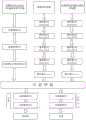
(1)获取车辆周围道路环境的多线激光雷达俯视图图像、局部导航地图、车辆历史运动信息,构成数据集;(1) Obtain the multi-line lidar top view image, local navigation map, and historical vehicle motion information of the road environment around the vehicle to form a data set;
(2)构建包括卷积层、全连接层、展开层以及长短期记忆网络层LSTM的端到端神经网络模型,并以最小化均方根误差RMSE为目标通过数据集进行训练,形成一个从激光雷达俯视图图像、局部导航地图、车辆历史运动信息到下一时刻车辆预期方向盘转向角与车速的映射,完成端到端神经网络模型的训练;(2) Construct an end-to-end neural network model including convolutional layer, fully connected layer, expansion layer and long short-term memory network layer LSTM, and train through the data set with the goal of minimizing the root mean square error RMSE to form a The mapping of the lidar top view image, local navigation map, and historical vehicle motion information to the expected steering angle and speed of the vehicle at the next moment to complete the training of the end-to-end neural network model;
(3)端到端神经网络在经过数据训练后,根据设定目标将所涉及的卷积层、全连接层、展开层以及长短期记忆网络层固定,用于提取输入数据中的有用特征,然后将其导入端到端自动驾驶控制器中,所述多线激光雷达俯视图图像通过已确定的2个卷积核为5×5的卷积层、2个卷积核为3×3的卷积层以及1个展开层进行图像特征提取,获取可行驶区域特征,输出一个一维度向量,即向量1;(3) After the end-to-end neural network is trained on the data, the involved convolutional layers, fully connected layers, expansion layers, and long-term and short-term memory network layers are fixed according to the set goals to extract useful features from the input data. Then it is imported into the end-to-end autonomous driving controller, and the multi-line lidar top view image is passed through the determined 2 convolution layers with 5×5 convolution kernels and 2 convolution kernels with 3×3 convolution kernels. The accumulation layer and an expansion layer are used to extract image features, obtain the characteristics of the drivable area, and output a one-dimensional vector, that is, vector 1;
(4)对所述局部导航地图通过已确定的2个卷积核为5×5的卷积层、2个卷积核为3×3的卷积层以及1个展开层进行图像特征提取,获取局部路径规划特征,输出向量2;(4) Perform image feature extraction on the local navigation map through two determined convolution layers with a convolution kernel of 5×5, two convolution layers with a convolution kernel of 3×3, and an expansion layer, Obtain local path planning features and output vector 2;
(5)对所得到的车辆历史运动信息通过已确定的2个全连接层、1个长短期记忆网络层LSTM进行数据特征提取,获取隐含的时间序列特征,输出向量3;(5) Perform data feature extraction on the obtained historical vehicle motion information through the determined 2 fully connected layers and 1 long short-term memory network layer LSTM, obtain the implicit time series features, and output vector 3;
(6)将向量1、向量2以及向量3通过向量拼接层实现信息拼接,得到含有两个维度的向量,即向量4;(6) The vector 1, the vector 2 and the vector 3 are used to realize the information splicing through the vector splicing layer to obtain a vector containing two dimensions, that is, the vector 4;
(7)将向量4输入由2个全连接层组成的第一分支进行方向盘转向角预测,得到车辆方向盘的预测转向角;(7) inputting vector 4 into the first branch composed of 2 fully connected layers to predict the steering wheel steering angle to obtain the predicted steering angle of the vehicle steering wheel;
(8)将向量4输入由2个全连接层组成的第二分支进行车速预测,得到车辆的预测车速信息;(8) Input the vector 4 into the second branch composed of 2 fully connected layers to predict the speed of the vehicle, and obtain the predicted speed information of the vehicle;
(9)将车辆方向盘的预测转向角和预测车速作为车辆控制信息,通过CAN总线输入到整车控制网络,实现对车辆的控制。(9) The predicted steering angle and predicted vehicle speed of the steering wheel of the vehicle are used as vehicle control information, and are input into the vehicle control network through the CAN bus to realize the control of the vehicle.
所述步骤(1)中的车辆历史运动信息是指过去及当前时刻的方向盘转向角与车速信息。The historical vehicle motion information in the step (1) refers to the steering angle and vehicle speed information of the past and current moments.
所述步骤(1)中多线激光雷达俯视图图像的获取方法如下:The acquisition method of the multi-line lidar top view image in the step (1) is as follows:
(3a)通过多线激光雷达获取车辆周围环境的点云数据;(3a) Obtain the point cloud data of the surrounding environment of the vehicle through multi-line lidar;
(3b)根据点云数据中的高度信息,识别出障碍物点和地面点,并剔除其中的地面点,将其余点云数据投影到指定图像中,实现地面分割;(3b) According to the height information in the point cloud data, identify obstacle points and ground points, and remove the ground points among them, and project the remaining point cloud data into the designated image to realize ground segmentation;
(3c)通过区域生成方法,将障碍物点所在区域生成为不可行驶区域,标注为交叉网格,非障碍物区域生成为可行驶区域,标注为白色,此时即可将车辆周围环境划分为可行驶区域和不可行驶区域,并使其以10帧/s的速率送至端到端神经网络,作为端到端自动驾驶的一个输入信息。(3c) Through the area generation method, the area where the obstacle points are located is generated as a non-drivable area, marked as a cross grid, and the non-obstacle area is generated as a drivable area, marked as white. At this time, the surrounding environment of the vehicle can be divided into The drivable area and the non-drivable area are sent to the end-to-end neural network at a rate of 10 frames/s as an input for end-to-end autonomous driving.
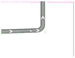
所述步骤(1)中局部导航地图的获取方法如下:The method for obtaining the local navigation map in the step (1) is as follows:
(4a)用户预先给出起点与终点,指定一条驾驶路径,地图中以灰色线条代表其规划路径,在端到端自动驾驶控制器内部形成一个全局导航地图;(4a) The user gives the starting point and the ending point in advance, and specifies a driving path. The gray line in the map represents the planned path, and a global navigation map is formed inside the end-to-end automatic driving controller;
(4b)差分GPS与惯性测量单元IMU通过卡尔曼滤波算法进行信息融合,实现车辆的精准定位,获取车辆即时定位信息;(4b) The differential GPS and the inertial measurement unit IMU perform information fusion through the Kalman filter algorithm to realize the precise positioning of the vehicle and obtain the real-time positioning information of the vehicle;
(4c)将车辆即时定位信息与全局导航地图匹配,获取车辆在导航地图中的所在位置,地图中以白色圆点代表所在位置,并以所在位置为中心截取素大小为50*50的局部导航地图,获取局部路径规划地图,将其送入端到端神经网络,指导车辆沿规划路径行驶。(4c) Match the vehicle's real-time positioning information with the global navigation map to obtain the location of the vehicle in the navigation map. In the map, the location is represented by a white dot, and the local navigation with a pixel size of 50*50 is intercepted with the location as the center. Map, obtain the local path planning map, and feed it into the end-to-end neural network to guide the vehicle to travel along the planned path.
在步骤(2)中,所述映射具体是指:用I表示俯视图图像,M表示局部导航地图,S和V分别表示车辆的转向角与车速,以下标p表示预测值,以下标t表示当前时刻t的真实值,以N表示长短期记忆网络层LSTM所选的帧数;In step (2), the mapping specifically refers to: I represent the top view image, M represents the local navigation map, S and V represent the steering angle and vehicle speed of the vehicle, respectively, the subscript p represents the predicted value, and the subscript t represents the current The real value at time t, and N represents the number of frames selected by the long short-term memory network layer LSTM;
预测下一时刻车辆驾驶行为的映射f,其定义如下:The mapping f that predicts the driving behavior of the vehicle at the next moment is defined as follows:
f(I,M,S,V)→(Sp,Vp) (1)f(I,M,S,V)→(Sp ,Vp ) (1)
其中,

RMSE的定义如下:RMSE is defined as follows:

其中,ytp和yt分别代表时刻t时车辆车速和方向盘转向角的预测值与真实值。Among them, ytp and yt represent the predicted and actual values of the vehicle speed and steering angle of the steering wheel at time t, respectively.
本发明的另一目的在于提供一种基于激光雷达和导航地图的端到端自动驾驶方法的系统,包括:Another object of the present invention is to provide an end-to-end automatic driving method system based on lidar and navigation map, including:
多线激光雷达,用于获取车辆周围环境的点云数据,经投影处理后,形成将附近区域划分为可行驶区域和不可行驶区域的俯视图;Multi-line lidar is used to obtain point cloud data of the surrounding environment of the vehicle. After projection processing, it forms a top view that divides the nearby area into drivable areas and non-drivable areas;
差分GPS,用于获取车辆的即时定位信息;Differential GPS, used to obtain real-time positioning information of the vehicle;
惯性测量单元IMU,用于获取车辆加速度、姿态信息,并通过卡尔曼滤波算法与差分GPS数据融合,减少定位误差,提高定位精准度;The inertial measurement unit IMU is used to obtain vehicle acceleration and attitude information, and fuse with differential GPS data through the Kalman filter algorithm to reduce positioning errors and improve positioning accuracy;
车辆CAN总线,用于双向传递车辆的方向盘转向角信息、车速信息;Vehicle CAN bus, which is used to transmit the steering wheel steering angle information and vehicle speed information of the vehicle in both directions;
端到端自动驾驶控制器,用于对收集信息的分析与处理,并对车辆的方向盘和车速进行控制。An end-to-end autonomous driving controller that analyzes and processes the collected information and controls the steering wheel and speed of the vehicle.
所述多线激光雷达安装于车辆顶部正中间的上方位置,所述差分GPS的接收器的个数为两个,分别安装于车辆顶部的前方和后方位置,所述惯性测量单元IMU安装于车内中央扶手箱的水平位置,所述端到端自动驾驶控制器安装于手套箱内部。The multi-line lidar is installed at the upper position in the middle of the top of the vehicle, the number of receivers of the differential GPS is two, and they are respectively installed in the front and rear positions of the top of the vehicle, and the inertial measurement unit IMU is installed in the vehicle. The horizontal position of the inner center console box, the end-to-end autopilot controller is installed inside the glove box.
由上述技术方案可知,本发明的有益效果为:第一,通过多线激光雷达点云数据投影处理后的俯视图,能在准确地提供车辆可行驶区域的同时,减少图像内的冗余信息,降低计算资源的占用;第二,由于多线激光雷达俯视图及局部导航地图层次分明,特征易于提取,故神经网络设计精简,降低了计算资源的占用,提高了训练速度和响应时间;第三,根据设定的起点和终点,能够自行依据投影的俯视图、截取的局部导航地图及车辆历史运动信息,导航至目标地点,实现以目的地为导向的端到端自动驾驶。It can be seen from the above technical solutions that the beneficial effects of the present invention are as follows: first, through the overhead view of the multi-line lidar point cloud data projection processing, while accurately providing the drivable area of the vehicle, the redundant information in the image can be reduced, Reduce the occupation of computing resources; second, because the multi-line lidar top view and local navigation map have distinct layers, and features are easy to extract, the neural network design is simplified, the occupation of computing resources is reduced, and the training speed and response time are improved; third, According to the set starting point and ending point, it can navigate to the target location according to the projected top view, the intercepted local navigation map and the historical vehicle motion information, and realize the destination-oriented end-to-end autonomous driving.
附图说明Description of drawings
图1为本系统的组成结构图;Fig. 1 is the composition structure diagram of this system;
图2为本发明中的局部导航地图示意图;2 is a schematic diagram of a local navigation map in the present invention;
图3为本发明中的多线激光雷达俯视图示意图;3 is a schematic top view of a multi-line laser radar in the present invention;
图4为本发明的端到端神经网络模型示意图。FIG. 4 is a schematic diagram of an end-to-end neural network model of the present invention.
具体实施方式Detailed ways
如图2、3、4所示,一种基于激光雷达和导航地图的端到端自动驾驶方法,该方法包括下列顺序的步骤:As shown in Figures 2, 3, and 4, an end-to-end autonomous driving method based on lidar and navigation maps, the method includes steps in the following sequence:
(1)获取车辆周围道路环境的多线激光雷达俯视图图像、局部导航地图、车辆历史运动信息,构成数据集;(1) Obtain the multi-line lidar top view image, local navigation map, and historical vehicle motion information of the road environment around the vehicle to form a data set;
(2)构建包括卷积层、全连接层、展开层以及长短期记忆网络层LSTM的端到端神经网络模型,并以最小化均方根误差RMSE为目标通过数据集进行训练,形成一个从激光雷达俯视图图像、局部导航地图、车辆历史运动信息到下一时刻车辆预期方向盘转向角与车速的映射,完成端到端神经网络模型的训练;(2) Construct an end-to-end neural network model including convolutional layer, fully connected layer, expansion layer and long short-term memory network layer LSTM, and train through the data set with the goal of minimizing the root mean square error RMSE to form a The mapping of the lidar top view image, local navigation map, and historical vehicle motion information to the expected steering angle and speed of the vehicle at the next moment to complete the training of the end-to-end neural network model;
(3)端到端神经网络在经过数据训练后,根据设定目标将所涉及的卷积层、全连接层、展开层以及长短期记忆网络层固定,用于提取输入数据中的有用特征,然后将其导入端到端自动驾驶控制器中,所述多线激光雷达俯视图图像通过已确定的2个卷积核为5×5的卷积层、2个卷积核为3×3的卷积层以及1个展开层进行图像特征提取,获取可行驶区域特征,输出一个一维度向量,即向量1;(3) After the end-to-end neural network is trained on the data, the involved convolutional layers, fully connected layers, expansion layers, and long-term and short-term memory network layers are fixed according to the set goals to extract useful features from the input data. Then it is imported into the end-to-end autonomous driving controller, and the multi-line lidar top view image is passed through the determined 2 convolution layers with 5×5 convolution kernels and 2 convolution kernels with 3×3 convolution kernels. The accumulation layer and an expansion layer are used to extract image features, obtain the characteristics of the drivable area, and output a one-dimensional vector, that is, vector 1;
(4)对所述局部导航地图通过已确定的2个卷积核为5×5的卷积层、2个卷积核为3×3的卷积层以及1个展开层进行图像特征提取,获取局部路径规划特征,输出向量2;(4) Perform image feature extraction on the local navigation map through two determined convolution layers with a convolution kernel of 5×5, two convolution layers with a convolution kernel of 3×3, and an expansion layer, Obtain local path planning features and output vector 2;
(5)对所得到的车辆历史运动信息通过已确定的2个全连接层、1个长短期记忆网络层LSTM进行数据特征提取,获取隐含的时间序列特征,输出向量3;(5) Perform data feature extraction on the obtained historical vehicle motion information through the determined 2 fully connected layers and 1 long short-term memory network layer LSTM, obtain the implicit time series features, and output vector 3;
(6)将向量1、向量2以及向量3通过向量拼接层实现信息拼接,得到含有两个维度的向量,即向量4;(6) The vector 1, the vector 2 and the vector 3 are used to realize the information splicing through the vector splicing layer to obtain a vector containing two dimensions, that is, the vector 4;
(7)将向量4输入由2个全连接层组成的第一分支进行方向盘转向角预测,得到车辆方向盘的预测转向角;(7) inputting vector 4 into the first branch composed of 2 fully connected layers to predict the steering wheel steering angle to obtain the predicted steering angle of the vehicle steering wheel;
(8)将向量4输入由2个全连接层组成的第二分支进行车速预测,得到车辆的预测车速信息;(8) Input the vector 4 into the second branch composed of 2 fully connected layers to predict the speed of the vehicle, and obtain the predicted speed information of the vehicle;
(9)将车辆方向盘的预测转向角和预测车速作为车辆控制信息,通过CAN总线输入到整车控制网络,实现对车辆的控制。(9) The predicted steering angle and predicted vehicle speed of the steering wheel of the vehicle are used as vehicle control information, and are input into the vehicle control network through the CAN bus to realize the control of the vehicle.
所述步骤(1)中的车辆历史运动信息是指过去及当前时刻的方向盘转向角与车速信息。The historical vehicle motion information in the step (1) refers to the steering angle and vehicle speed information of the past and current moments.
如图3所示,所述步骤(1)中多线激光雷达俯视图图像的获取方法如下:As shown in Figure 3, the method for acquiring the multi-line lidar top view image in the step (1) is as follows:
(3a)通过多线激光雷达获取车辆周围环境的点云数据;(3a) Obtain the point cloud data of the surrounding environment of the vehicle through multi-line lidar;
(3b)根据点云数据中的高度信息,识别出障碍物点和地面点,并剔除其中的地面点,将其余点云数据投影到指定图像中,实现地面分割;(3b) According to the height information in the point cloud data, identify obstacle points and ground points, and remove the ground points among them, and project the remaining point cloud data into the designated image to realize ground segmentation;
(3c)通过区域生成方法,将障碍物点所在区域生成为不可行驶区域,标注为交叉网格,非障碍物区域生成为可行驶区域,标注为白色,此时即可将车辆周围环境划分为可行驶区域和不可行驶区域,并使其以10帧/s的速率送至端到端神经网络,作为端到端自动驾驶的一个输入信息。(3c) Through the area generation method, the area where the obstacle points are located is generated as a non-drivable area, marked as a cross grid, and the non-obstacle area is generated as a drivable area, marked as white. At this time, the surrounding environment of the vehicle can be divided into The drivable area and the non-drivable area are sent to the end-to-end neural network at a rate of 10 frames/s as an input for end-to-end autonomous driving.
如图2所示,所述步骤(1)中局部导航地图的获取方法如下:As shown in Figure 2, the method for obtaining the local navigation map in the step (1) is as follows:
(4a)用户预先给出起点与终点,指定一条驾驶路径,地图中以灰色线条代表其规划路径,在端到端自动驾驶控制器内部形成一个全局导航地图;(4a) The user gives the starting point and the ending point in advance, and specifies a driving path. The gray line in the map represents the planned path, and a global navigation map is formed inside the end-to-end automatic driving controller;
(4b)差分GPS与惯性测量单元IMU通过卡尔曼滤波算法进行信息融合,实现车辆的精准定位,获取车辆即时定位信息;(4b) The differential GPS and the inertial measurement unit IMU perform information fusion through the Kalman filter algorithm to realize the precise positioning of the vehicle and obtain the real-time positioning information of the vehicle;
(4c)将车辆即时定位信息与全局导航地图匹配,获取车辆在导航地图中的所在位置,地图中以白色圆点代表所在位置,并以所在位置为中心截取素大小为50*50的局部导航地图,获取局部路径规划地图,将其送入端到端神经网络,指导车辆沿规划路径行驶。(4c) Match the vehicle's real-time positioning information with the global navigation map to obtain the location of the vehicle in the navigation map. In the map, the location is represented by a white dot, and the local navigation with a pixel size of 50*50 is intercepted with the location as the center. Map, obtain the local path planning map, and feed it into the end-to-end neural network to guide the vehicle to travel along the planned path.
在步骤(2)中,所述映射具体是指:用I表示俯视图图像,M表示局部导航地图,S和V分别表示车辆的转向角与车速,以下标p表示预测值,以下标t表示当前时刻t的真实值,以N表示长短期记忆网络层LSTM所选的帧数;In step (2), the mapping specifically refers to: I represent the top view image, M represents the local navigation map, S and V represent the steering angle and vehicle speed of the vehicle, respectively, the subscript p represents the predicted value, and the subscript t represents the current The real value at time t, and N represents the number of frames selected by the long short-term memory network layer LSTM;
预测下一时刻车辆驾驶行为的映射f,其定义如下:The mapping f that predicts the driving behavior of the vehicle at the next moment is defined as follows:
f(I,M,S,V)→(Sp,Vp) (1)f(I,M,S,V)→(Sp ,Vp ) (1)
其中,

RMSE的定义如下:RMSE is defined as follows:

其中,ytp和yt分别代表时刻t时车辆车速和方向盘转向角的预测值与真实值。Among them, ytp and yt represent the predicted and actual values of the vehicle speed and steering angle of the steering wheel at time t, respectively.
如图1所示,本系统包括:As shown in Figure 1, the system includes:
多线激光雷达,用于获取车辆周围环境的点云数据,经投影处理后,形成将附近区域划分为可行驶区域和不可行驶区域的俯视图;Multi-line lidar is used to obtain point cloud data of the surrounding environment of the vehicle. After projection processing, it forms a top view that divides the nearby area into drivable areas and non-drivable areas;
差分GPS,用于获取车辆的即时定位信息;Differential GPS, used to obtain real-time positioning information of the vehicle;
惯性测量单元IMU,用于获取车辆加速度、姿态信息,并通过卡尔曼滤波算法与差分GPS数据融合,减少定位误差,提高定位精准度;The inertial measurement unit IMU is used to obtain vehicle acceleration and attitude information, and fuse with differential GPS data through the Kalman filter algorithm to reduce positioning errors and improve positioning accuracy;
车辆CAN总线,用于双向传递车辆的方向盘转向角信息、车速信息;Vehicle CAN bus, which is used to transmit the steering wheel steering angle information and vehicle speed information of the vehicle in both directions;
端到端自动驾驶控制器,用于对收集信息的分析与处理,并对车辆的方向盘和车速进行控制。An end-to-end autonomous driving controller that analyzes and processes the collected information and controls the steering wheel and speed of the vehicle.
所述多线激光雷达安装于车辆顶部正中间的上方位置,所述差分GPS的接收器的个数为两个,分别安装于车辆顶部的前方和后方位置,所述惯性测量单元IMU安装于车内中央扶手箱的水平位置,所述端到端自动驾驶控制器安装于手套箱内部。The multi-line lidar is installed at the upper position in the middle of the top of the vehicle, the number of receivers of the differential GPS is two, and they are respectively installed in the front and rear positions of the top of the vehicle, and the inertial measurement unit IMU is installed in the vehicle. The horizontal position of the inner center console box, the end-to-end autopilot controller is installed inside the glove box.
所述端到端神经网络模型:使用tensorflow2.0深度学习平台进行神经网络的前期训练,选用Adam优化算法进行优化,学习率为0.001,批次大小为8,数据集采用8:2划分,即80%作为训练集,20%作为验证集;为了防止出现过拟合现象,采用L2正则化方法,正则化系数λ=0.005。The end-to-end neural network model: use the tensorflow2.0 deep learning platform for the pre-training of the neural network, select the Adam optimization algorithm for optimization, the learning rate is 0.001, the batch size is 8, and the data set is divided by 8:2, namely 80% is used as the training set and 20% is used as the validation set; in order to prevent overfitting, the L2 regularization method is adopted, and the regularization coefficient λ=0.005.
综上所述,本发明通过多线激光雷达点云数据投影处理后的俯视图,指出车辆可行驶区域及不可行驶区域,避免车辆发生局部碰撞;通过差分GPS与惯性测量单元IMU信息拼接,准确定位车辆位置,并结合由起点和终点生成的全局导航地图,获取车辆局部导航地图;通过CAN总线,获取车辆方向盘转向角和车速信息;将所有信息输入到端到端神经网络,完成模型的训练;通过已训练的端到端神经网络模型,本发明能根据俯视图、局部导航地图以及过去时刻的转向角与车速信息,预测下一时刻汽车方向盘的期望转向角及期望车速,作为控制信息通过CAN总线控制车辆行驶,即可实现以目标为导向的端到端自动驾驶。To sum up, the present invention points out the drivable area and the non-drivable area of the vehicle through the overhead view of the multi-line lidar point cloud data projection processing, so as to avoid local collision of the vehicle; through the splicing of differential GPS and inertial measurement unit IMU information, accurate positioning The vehicle position, combined with the global navigation map generated by the starting point and the end point, to obtain the local navigation map of the vehicle; through the CAN bus, the steering angle and speed information of the vehicle steering wheel are obtained; all the information is input into the end-to-end neural network to complete the training of the model; Through the trained end-to-end neural network model, the present invention can predict the expected steering angle and expected vehicle speed of the car steering wheel at the next moment according to the top view, local navigation map, and steering angle and vehicle speed information at the past moment, as control information through the CAN bus Goal-oriented end-to-end autonomous driving can be achieved by controlling the driving of the vehicle.
Claims (7)


Priority Applications (1)
| Application Number | Priority Date | Filing Date | Title |
|---|---|---|---|
| CN202011118233.3ACN112212872B (en) | 2020-10-19 | 2020-10-19 | End-to-end autonomous driving method and system based on lidar and navigation map |
Applications Claiming Priority (1)
| Application Number | Priority Date | Filing Date | Title |
|---|---|---|---|
| CN202011118233.3ACN112212872B (en) | 2020-10-19 | 2020-10-19 | End-to-end autonomous driving method and system based on lidar and navigation map |
Publications (2)
| Publication Number | Publication Date |
|---|---|
| CN112212872Atrue CN112212872A (en) | 2021-01-12 |
| CN112212872B CN112212872B (en) | 2022-03-11 |
Family
ID=74055807
Family Applications (1)
| Application Number | Title | Priority Date | Filing Date |
|---|---|---|---|
| CN202011118233.3AActiveCN112212872B (en) | 2020-10-19 | 2020-10-19 | End-to-end autonomous driving method and system based on lidar and navigation map |
Country Status (1)
| Country | Link |
|---|---|
| CN (1) | CN112212872B (en) |
Cited By (15)
| Publication number | Priority date | Publication date | Assignee | Title |
|---|---|---|---|---|
| CN112987754A (en)* | 2021-04-14 | 2021-06-18 | 北京三快在线科技有限公司 | Unmanned equipment control method and device, storage medium and electronic equipment |
| CN113110415A (en)* | 2021-03-17 | 2021-07-13 | 北京汽车研究总院有限公司 | Unmanned vehicle, control method and system thereof, cloud terminal and storage medium |
| CN113537602A (en)* | 2021-07-20 | 2021-10-22 | 中国第一汽车股份有限公司 | Vehicle behavior prediction method, device, equipment and medium |
| CN113665591A (en)* | 2021-09-28 | 2021-11-19 | 上海焱眼鑫睛智能科技有限公司 | Unmanned control method, device, equipment and medium |
| CN113850832A (en)* | 2021-09-01 | 2021-12-28 | 的卢技术有限公司 | A drivable area segmentation method |
| CN113867334A (en)* | 2021-09-07 | 2021-12-31 | 华侨大学 | A path planning method and system for unmanned mobile machinery |
| CN114419572A (en)* | 2022-03-31 | 2022-04-29 | 国汽智控(北京)科技有限公司 | Multi-radar target detection method and device, electronic equipment and storage medium |
| WO2022165614A1 (en)* | 2021-02-08 | 2022-08-11 | 浙江吉利控股集团有限公司 | Path construction method and apparatus, terminal, and storage medium |
| CN115009304A (en)* | 2022-06-29 | 2022-09-06 | 扬州大学 | An end-to-end implementation method for autonomous vehicles |
| CN115145253A (en)* | 2021-03-16 | 2022-10-04 | 广州汽车集团股份有限公司 | End-to-end automatic driving method and system and training method of automatic driving model |
| CN116412814A (en)* | 2023-06-12 | 2023-07-11 | 旷智中科(北京)技术有限公司 | Image construction navigation auxiliary system based on laser radar |
| CN116456048A (en)* | 2023-06-19 | 2023-07-18 | 中汽信息科技(天津)有限公司 | Automobile image recording method and system based on scene adaptation |
| CN117184105A (en)* | 2023-07-20 | 2023-12-08 | 清华大学 | Steering angular velocity prediction method and device based on multi-mode data fusion |
| WO2024012212A1 (en)* | 2022-07-14 | 2024-01-18 | 安徽蔚来智驾科技有限公司 | Environmental perception method, domain controller, storage medium, and vehicle |
| CN118514685A (en)* | 2024-07-22 | 2024-08-20 | 安徽蔚来智驾科技有限公司 | Active safety control method of vehicle, intelligent device and storage medium |
Citations (11)
| Publication number | Priority date | Publication date | Assignee | Title |
|---|---|---|---|---|
| CN103389103A (en)* | 2013-07-03 | 2013-11-13 | 北京理工大学 | Geographical environmental characteristic map construction and navigation method based on data mining |
| CN107438754A (en)* | 2015-02-10 | 2017-12-05 | 御眼视觉技术有限公司 | Sparse maps for autonomous vehicle navigation |
| CN108700421A (en)* | 2015-12-21 | 2018-10-23 | 应美盛股份有限公司 | Use the method and system of the portable navigation of offline cartographic information auxiliary enhancing |
| CN109556615A (en)* | 2018-10-10 | 2019-04-02 | 吉林大学 | The driving map generation method of Multi-sensor Fusion cognition based on automatic Pilot |
| CN110009765A (en)* | 2019-04-15 | 2019-07-12 | 合肥工业大学 | A kind of automatic driving vehicle scene data system and scene format conversion method |
| US20190383945A1 (en)* | 2018-06-15 | 2019-12-19 | Uber Technologies, Inc. | Autonomous vehicle localization using a lidar intensity map |
| CN110794844A (en)* | 2019-11-18 | 2020-02-14 | 北京百度网讯科技有限公司 | Automatic driving method, device, electronic device and readable storage medium |
| CN111061277A (en)* | 2019-12-31 | 2020-04-24 | 歌尔股份有限公司 | Unmanned vehicle global path planning method and device |
| CN111142091A (en)* | 2020-01-10 | 2020-05-12 | 清华大学 | Automatic driving system laser radar online calibration method fusing vehicle-mounted information |
| CN111208818A (en)* | 2020-01-07 | 2020-05-29 | 电子科技大学 | Predictive control method of intelligent vehicle based on visual spatiotemporal features |
| CN111553188A (en)* | 2020-03-24 | 2020-08-18 | 张印祺 | Deep learning-based end-to-end automatic driving vehicle steering control system |
- 2020
- 2020-10-19CNCN202011118233.3Apatent/CN112212872B/enactiveActive
Patent Citations (11)
| Publication number | Priority date | Publication date | Assignee | Title |
|---|---|---|---|---|
| CN103389103A (en)* | 2013-07-03 | 2013-11-13 | 北京理工大学 | Geographical environmental characteristic map construction and navigation method based on data mining |
| CN107438754A (en)* | 2015-02-10 | 2017-12-05 | 御眼视觉技术有限公司 | Sparse maps for autonomous vehicle navigation |
| CN108700421A (en)* | 2015-12-21 | 2018-10-23 | 应美盛股份有限公司 | Use the method and system of the portable navigation of offline cartographic information auxiliary enhancing |
| US20190383945A1 (en)* | 2018-06-15 | 2019-12-19 | Uber Technologies, Inc. | Autonomous vehicle localization using a lidar intensity map |
| CN109556615A (en)* | 2018-10-10 | 2019-04-02 | 吉林大学 | The driving map generation method of Multi-sensor Fusion cognition based on automatic Pilot |
| CN110009765A (en)* | 2019-04-15 | 2019-07-12 | 合肥工业大学 | A kind of automatic driving vehicle scene data system and scene format conversion method |
| CN110794844A (en)* | 2019-11-18 | 2020-02-14 | 北京百度网讯科技有限公司 | Automatic driving method, device, electronic device and readable storage medium |
| CN111061277A (en)* | 2019-12-31 | 2020-04-24 | 歌尔股份有限公司 | Unmanned vehicle global path planning method and device |
| CN111208818A (en)* | 2020-01-07 | 2020-05-29 | 电子科技大学 | Predictive control method of intelligent vehicle based on visual spatiotemporal features |
| CN111142091A (en)* | 2020-01-10 | 2020-05-12 | 清华大学 | Automatic driving system laser radar online calibration method fusing vehicle-mounted information |
| CN111553188A (en)* | 2020-03-24 | 2020-08-18 | 张印祺 | Deep learning-based end-to-end automatic driving vehicle steering control system |
Non-Patent Citations (2)
| Title |
|---|
| RÂNIK GUIDOLINI; RAPHAEL V. CARNEIRO; CLAUDINE BADUE; ETC.: "Removing Movable Objects from Grid Maps of Self-Driving Cars Using Deep Neural Networks", 《2019 INTERNATIONAL JOINT CONFERENCE ON NEURAL NETWORKS》* |
| 龙 翔,高建博,隗寒冰: "一种自动驾驶汽车系统架构开发与测试验证", 《重庆理工大学学报( 自然科学)》* |
Cited By (24)
| Publication number | Priority date | Publication date | Assignee | Title |
|---|---|---|---|---|
| EP4296888A4 (en)* | 2021-02-08 | 2024-11-13 | Zhejiang Geely Holding Group Co., Ltd. | PATH DESIGN METHOD AND APPARATUS, TERMINAL DEVICE AND STORAGE MEDIUM |
| WO2022165614A1 (en)* | 2021-02-08 | 2022-08-11 | 浙江吉利控股集团有限公司 | Path construction method and apparatus, terminal, and storage medium |
| CN117015814A (en)* | 2021-02-08 | 2023-11-07 | 浙江吉利控股集团有限公司 | Path construction method, device, terminal and storage medium |
| CN115145253A (en)* | 2021-03-16 | 2022-10-04 | 广州汽车集团股份有限公司 | End-to-end automatic driving method and system and training method of automatic driving model |
| CN113110415A (en)* | 2021-03-17 | 2021-07-13 | 北京汽车研究总院有限公司 | Unmanned vehicle, control method and system thereof, cloud terminal and storage medium |
| CN112987754A (en)* | 2021-04-14 | 2021-06-18 | 北京三快在线科技有限公司 | Unmanned equipment control method and device, storage medium and electronic equipment |
| CN113537602A (en)* | 2021-07-20 | 2021-10-22 | 中国第一汽车股份有限公司 | Vehicle behavior prediction method, device, equipment and medium |
| CN113537602B (en)* | 2021-07-20 | 2022-12-02 | 中国第一汽车股份有限公司 | Vehicle behavior prediction method, device, equipment and medium |
| CN113850832A (en)* | 2021-09-01 | 2021-12-28 | 的卢技术有限公司 | A drivable area segmentation method |
| CN113867334B (en)* | 2021-09-07 | 2023-05-05 | 华侨大学 | Unmanned path planning method and system for mobile machinery |
| CN113867334A (en)* | 2021-09-07 | 2021-12-31 | 华侨大学 | A path planning method and system for unmanned mobile machinery |
| CN113665591A (en)* | 2021-09-28 | 2021-11-19 | 上海焱眼鑫睛智能科技有限公司 | Unmanned control method, device, equipment and medium |
| CN114419572A (en)* | 2022-03-31 | 2022-04-29 | 国汽智控(北京)科技有限公司 | Multi-radar target detection method and device, electronic equipment and storage medium |
| CN114419572B (en)* | 2022-03-31 | 2022-06-17 | 国汽智控(北京)科技有限公司 | Multi-radar target detection method and device, electronic equipment and storage medium |
| CN115009304A (en)* | 2022-06-29 | 2022-09-06 | 扬州大学 | An end-to-end implementation method for autonomous vehicles |
| CN115009304B (en)* | 2022-06-29 | 2024-10-18 | 扬州大学 | End-to-end-based automatic driving vehicle implementation method |
| WO2024012212A1 (en)* | 2022-07-14 | 2024-01-18 | 安徽蔚来智驾科技有限公司 | Environmental perception method, domain controller, storage medium, and vehicle |
| CN116412814A (en)* | 2023-06-12 | 2023-07-11 | 旷智中科(北京)技术有限公司 | Image construction navigation auxiliary system based on laser radar |
| CN116456048A (en)* | 2023-06-19 | 2023-07-18 | 中汽信息科技(天津)有限公司 | Automobile image recording method and system based on scene adaptation |
| CN116456048B (en)* | 2023-06-19 | 2023-08-18 | 中汽信息科技(天津)有限公司 | Automobile image recording method and system based on scene adaptation |
| CN117184105A (en)* | 2023-07-20 | 2023-12-08 | 清华大学 | Steering angular velocity prediction method and device based on multi-mode data fusion |
| CN117184105B (en)* | 2023-07-20 | 2024-03-26 | 清华大学 | A steering angular velocity prediction method and device based on multi-modal data fusion |
| CN118514685A (en)* | 2024-07-22 | 2024-08-20 | 安徽蔚来智驾科技有限公司 | Active safety control method of vehicle, intelligent device and storage medium |
| CN118514685B (en)* | 2024-07-22 | 2024-10-01 | 安徽蔚来智驾科技有限公司 | Active safety control method of vehicle, intelligent device and storage medium |
Also Published As
| Publication number | Publication date |
|---|---|
| CN112212872B (en) | 2022-03-11 |
Similar Documents
| Publication | Publication Date | Title |
|---|---|---|
| CN112212872B (en) | End-to-end autonomous driving method and system based on lidar and navigation map | |
| CN110796856B (en) | Vehicle Lane Change Intention Prediction Method and Lane Change Intention Prediction Network Training Method | |
| CN110007675B (en) | Vehicle automatic driving decision-making system based on driving situation map and training set preparation method based on unmanned aerial vehicle | |
| US11755018B2 (en) | End-to-end interpretable motion planner for autonomous vehicles | |
| JP7527277B2 (en) | Radar Space Estimation | |
| US11548533B2 (en) | Perception and motion prediction for autonomous devices | |
| US12103554B2 (en) | Systems and methods for autonomous vehicle systems simulation | |
| US12013457B2 (en) | Systems and methods for integrating radar data for improved object detection in autonomous vehicles | |
| WO2022021712A1 (en) | Predictive motion planning system and method | |
| CN113544467B (en) | Alignment of road information for navigation | |
| US12350835B2 (en) | Systems and methods for sensor data packet processing and spatial memory updating for robotic platforms | |
| CN116348938A (en) | Method and system for predicting dynamic object behavior | |
| CN108216229A (en) | The vehicles, road detection and driving control method and device | |
| Wang et al. | Vision-based autonomous driving: A hierarchical reinforcement learning approach | |
| CN115547040A (en) | Driving behavior prediction method based on inner neural network under safety potential field | |
| CN117232545A (en) | Path planning method based on deep learning road environment perception | |
| CN117795566A (en) | Perception of three-dimensional objects in sensor data | |
| CN116917184A (en) | Prediction and planning of mobile robots | |
| CN117406756B (en) | Method, device, equipment and storage medium for determining motion trail parameters | |
| CN116048096B (en) | Unmanned vehicle movement planning method based on hierarchical depth perception | |
| Rosero et al. | CNN-Planner: A neural path planner based on sensor fusion in the bird's eye view representation space for mapless autonomous driving | |
| CN117032219A (en) | Automatic driving decision planning collaboration method and system | |
| Seiya et al. | Point grid map-based mid-to-mid driving without object detection | |
| EP4517369A1 (en) | Systems and methods for processing selected portions of radar data | |
| EP4517688A1 (en) | Automatic removal of selected training data from dataset |
Legal Events
| Date | Code | Title | Description |
|---|---|---|---|
| PB01 | Publication | ||
| PB01 | Publication | ||
| SE01 | Entry into force of request for substantive examination | ||
| SE01 | Entry into force of request for substantive examination | ||
| GR01 | Patent grant | ||
| GR01 | Patent grant |