CN112097763B - Underwater vehicle combined navigation method based on MEMS IMU/magnetometer/DVL combination - Google Patents
Underwater vehicle combined navigation method based on MEMS IMU/magnetometer/DVL combinationDownload PDFInfo
- Publication number
- CN112097763B CN112097763BCN202010889071.7ACN202010889071ACN112097763BCN 112097763 BCN112097763 BCN 112097763BCN 202010889071 ACN202010889071 ACN 202010889071ACN 112097763 BCN112097763 BCN 112097763B
- Authority
- CN
- China
- Prior art keywords
- attitude
- navigation
- measurement
- carrier
- magnetometer
- Prior art date
- Legal status (The legal status is an assumption and is not a legal conclusion. Google has not performed a legal analysis and makes no representation as to the accuracy of the status listed.)
- Active
Links
- 238000000034methodMethods0.000titleclaimsabstractdescription36
- 238000005259measurementMethods0.000claimsabstractdescription83
- 238000012937correctionMethods0.000claimsabstractdescription20
- 238000001914filtrationMethods0.000claimsabstractdescription17
- 238000004364calculation methodMethods0.000claimsabstractdescription16
- 239000011159matrix materialSubstances0.000claimsdescription35
- 230000009466transformationEffects0.000claimsdescription9
- 230000007704transitionEffects0.000claimsdescription9
- XLYOFNOQVPJJNP-UHFFFAOYSA-NwaterSubstancesOXLYOFNOQVPJJNP-UHFFFAOYSA-N0.000claimsdescription6
- 230000001133accelerationEffects0.000claimsdescription3
- 238000000827velocimetryMethods0.000claimsdescription3
- 238000006243chemical reactionMethods0.000claims1
- 230000008569processEffects0.000abstractdescription17
- 238000011161developmentMethods0.000description3
- 230000007774longtermEffects0.000description3
- 241000282414Homo sapiensSpecies0.000description2
- 238000010586diagramMethods0.000description2
- 230000004075alterationEffects0.000description1
- 230000009286beneficial effectEffects0.000description1
- 230000000052comparative effectEffects0.000description1
- 230000009189divingEffects0.000description1
- 238000012986modificationMethods0.000description1
- 230000004048modificationEffects0.000description1
- 239000013307optical fiberSubstances0.000description1
- 238000006467substitution reactionMethods0.000description1
- 230000009897systematic effectEffects0.000description1
Images

Classifications
- G—PHYSICS
- G01—MEASURING; TESTING
- G01C—MEASURING DISTANCES, LEVELS OR BEARINGS; SURVEYING; NAVIGATION; GYROSCOPIC INSTRUMENTS; PHOTOGRAMMETRY OR VIDEOGRAMMETRY
- G01C21/00—Navigation; Navigational instruments not provided for in groups G01C1/00 - G01C19/00
- G01C21/10—Navigation; Navigational instruments not provided for in groups G01C1/00 - G01C19/00 by using measurements of speed or acceleration
- G01C21/12—Navigation; Navigational instruments not provided for in groups G01C1/00 - G01C19/00 by using measurements of speed or acceleration executed aboard the object being navigated; Dead reckoning
- G01C21/16—Navigation; Navigational instruments not provided for in groups G01C1/00 - G01C19/00 by using measurements of speed or acceleration executed aboard the object being navigated; Dead reckoning by integrating acceleration or speed, i.e. inertial navigation
- G01C21/165—Navigation; Navigational instruments not provided for in groups G01C1/00 - G01C19/00 by using measurements of speed or acceleration executed aboard the object being navigated; Dead reckoning by integrating acceleration or speed, i.e. inertial navigation combined with non-inertial navigation instruments
- G—PHYSICS
- G01—MEASURING; TESTING
- G01C—MEASURING DISTANCES, LEVELS OR BEARINGS; SURVEYING; NAVIGATION; GYROSCOPIC INSTRUMENTS; PHOTOGRAMMETRY OR VIDEOGRAMMETRY
- G01C21/00—Navigation; Navigational instruments not provided for in groups G01C1/00 - G01C19/00
- G01C21/04—Navigation; Navigational instruments not provided for in groups G01C1/00 - G01C19/00 by terrestrial means
- G—PHYSICS
- G01—MEASURING; TESTING
- G01C—MEASURING DISTANCES, LEVELS OR BEARINGS; SURVEYING; NAVIGATION; GYROSCOPIC INSTRUMENTS; PHOTOGRAMMETRY OR VIDEOGRAMMETRY
- G01C21/00—Navigation; Navigational instruments not provided for in groups G01C1/00 - G01C19/00
- G01C21/10—Navigation; Navigational instruments not provided for in groups G01C1/00 - G01C19/00 by using measurements of speed or acceleration
- G01C21/12—Navigation; Navigational instruments not provided for in groups G01C1/00 - G01C19/00 by using measurements of speed or acceleration executed aboard the object being navigated; Dead reckoning
- G01C21/16—Navigation; Navigational instruments not provided for in groups G01C1/00 - G01C19/00 by using measurements of speed or acceleration executed aboard the object being navigated; Dead reckoning by integrating acceleration or speed, i.e. inertial navigation
- G01C21/18—Stabilised platforms, e.g. by gyroscope
- G—PHYSICS
- G01—MEASURING; TESTING
- G01C—MEASURING DISTANCES, LEVELS OR BEARINGS; SURVEYING; NAVIGATION; GYROSCOPIC INSTRUMENTS; PHOTOGRAMMETRY OR VIDEOGRAMMETRY
- G01C21/00—Navigation; Navigational instruments not provided for in groups G01C1/00 - G01C19/00
- G01C21/20—Instruments for performing navigational calculations
- G01C21/203—Instruments for performing navigational calculations specially adapted for water-borne vessels
- Y—GENERAL TAGGING OF NEW TECHNOLOGICAL DEVELOPMENTS; GENERAL TAGGING OF CROSS-SECTIONAL TECHNOLOGIES SPANNING OVER SEVERAL SECTIONS OF THE IPC; TECHNICAL SUBJECTS COVERED BY FORMER USPC CROSS-REFERENCE ART COLLECTIONS [XRACs] AND DIGESTS
- Y02—TECHNOLOGIES OR APPLICATIONS FOR MITIGATION OR ADAPTATION AGAINST CLIMATE CHANGE
- Y02A—TECHNOLOGIES FOR ADAPTATION TO CLIMATE CHANGE
- Y02A90/00—Technologies having an indirect contribution to adaptation to climate change
- Y02A90/30—Assessment of water resources
Landscapes
- Engineering & Computer Science (AREA)
- Radar, Positioning & Navigation (AREA)
- Remote Sensing (AREA)
- Automation & Control Theory (AREA)
- Physics & Mathematics (AREA)
- General Physics & Mathematics (AREA)
- Navigation (AREA)
Abstract
Translated fromChinese
Description
Translated fromChinese技术领域technical field
本发明涉及水下运载体的导航定位技术领域,特别是涉及一种基于MEMS IMU/磁力计/DVL组合的水下运载体组合导航方法,通过多级滤波模式,减小水下运载体长时间水下航行的导航定位误差。The invention relates to the technical field of navigation and positioning of underwater vehicles, in particular to a combined navigation method for underwater vehicles based on MEMS IMU/magnetometer/DVL combination. Navigation and positioning error of underwater navigation.
背景技术Background technique
海洋是人类发展的重要战略空间,实现对海洋资源的合理、可持续性开发利用对人类未来的发展至关重要。水下运载体是目前进行海洋调查、海洋资源勘探、水下搜救、潜水支援、军事侦探的关键性装备,可以在无人控制的状态下全天候、多航时的自主完成水下任务。由于水下环境的特殊性,实现水下运载体的精准导航仍很困难,导航问题是水下运载体所面临的主要技术挑战之一。The ocean is an important strategic space for human development, and realizing the rational and sustainable development and utilization of marine resources is crucial to the future development of human beings. The underwater carrier is currently the key equipment for marine survey, marine resource exploration, underwater search and rescue, diving support, and military detectives. Due to the particularity of the underwater environment, it is still difficult to achieve accurate navigation of underwater vehicles. The navigation problem is one of the main technical challenges faced by underwater vehicles.
现阶段的高精度导航系统主要以激光或光纤捷联惯导系统为主,辅以GPS和DVL等手段,这类系统普遍体积较大,价格昂贵;考虑到系统的便携性和经济性,基于MEMS的导航定位系统具有体积小、成本低的特点,但动态条件下的航向、姿态测量精度通常较为有限,若水下运载体长时间处于机动状态,此导航系统得到的航向、姿态信息将存在一定误差。The current high-precision navigation systems are mainly based on laser or optical fiber strapdown inertial navigation systems, supplemented by GPS and DVL and other means. Such systems are generally large in size and expensive; considering the portability and economy of the system, based on The MEMS navigation and positioning system has the characteristics of small size and low cost, but the measurement accuracy of heading and attitude under dynamic conditions is usually limited. If the underwater vehicle is in a maneuvering state for a long time, the heading and attitude information obtained by the navigation system will exist error.
发明内容SUMMARY OF THE INVENTION
为提高MEMS惯导水下运载体导航定位精度,尤其是水下运载体水下长航时运行的导航定位精度,本发明提出了一种基于MEMS IMU/磁力计/DVL组合的水下运载体组合导航方法,通过多级组合滤波模式,将MEMS IMU/磁力计/DVL的原始测量数据进行融合,获得更加准确的航向、姿态估计,为水下运载体水下作业提供较高精度的导航信息,提高MEMS IMU水下运载体水下长航时运行的导航定位精度。In order to improve the navigation and positioning accuracy of the MEMS inertial navigation underwater vehicle, especially the navigation and positioning accuracy of the underwater vehicle during long-term underwater operation, the present invention proposes an underwater vehicle based on the combination of MEMS IMU/magnetometer/DVL. The integrated navigation method integrates the original measurement data of MEMS IMU/magnetometer/DVL through multi-level combined filtering mode to obtain more accurate heading and attitude estimation, and provide higher-precision navigation information for underwater operations of underwater vehicles , to improve the navigation and positioning accuracy of the MEMS IMU underwater vehicle during long-duration underwater operation.
本发明技术方案为:The technical scheme of the present invention is:
所述一种基于MEMS IMU/磁力计/DVL组合的水下运载体组合导航方法,包括以下步骤:Described a combined navigation method for underwater vehicles based on MEMS IMU/magnetometer/DVL combination, comprising the following steps:
步骤1:水下运载体入水后,采用MEMS IMU的加速度计数据解算水下运载体的姿态角,用加速度解算的姿态角对磁力计数据进行坐标转换,采用航向角计算公式,得到水下运载体的初始航向姿态信息;Step 1: After the underwater vehicle enters the water, use the accelerometer data of the MEMS IMU to calculate the attitude angle of the underwater vehicle, use the attitude angle calculated by the acceleration to perform coordinate transformation on the magnetometer data, and use the heading angle calculation formula to obtain the water Initial heading and attitude information of the lower carrier;
步骤2:水下运载体开始水下航行时,采用MEMS IMU/DVL/磁力计组合导航,用步骤1得到的航向姿态信息作为水下运载体初始航向姿态,采用MEMS IMU输出的数据进行姿态速度位置的递推计算,用卡尔曼滤波估计出系统的导航参数,得到实时的水下运载体航向姿态速度信息;Step 2: When the underwater vehicle starts to navigate underwater, use the MEMS IMU/DVL/magnetometer combined navigation, use the heading and attitude information obtained in
步骤3:采用步骤2得到的水下运载体速度和DVL输出的速度之差作为卡尔曼滤波器一次量测,用卡尔曼滤波器估计出航向、姿态参数,校正MEMS IMU后,得到较高精度的水平姿态等测量信息;Step 3: Use the difference between the speed of the underwater vehicle obtained in step 2 and the speed of the DVL output as the first measurement of the Kalman filter, use the Kalman filter to estimate the heading and attitude parameters, and correct the MEMS IMU to obtain higher accuracy measurement information such as the horizontal attitude;
步骤4:采用步骤3得到的较高精度的水平姿态信息以及磁力计测量值,得到水下运载体的磁航向信息;用一次反馈修正得到的航向和磁航向之差作为卡尔曼滤波器二次量测,用卡尔曼滤波器估计出航向、姿态参数,再次对MEMS惯导进行校正,得到高精度的水下运载体导航定位信息。Step 4: Use the higher-precision horizontal attitude information and magnetometer measurement values obtained in Step 3 to obtain the magnetic heading information of the underwater vehicle; use the difference between the heading and the magnetic heading obtained by one-time feedback correction as the secondary Kalman filter Measurement, use Kalman filter to estimate the heading and attitude parameters, and correct the MEMS inertial navigation again to obtain high-precision underwater vehicle navigation and positioning information.
进一步的,步骤3中水下运载体水下航行时采用步骤2得到的速度信息和DVL输出的速度之差作为卡尔曼滤波器一次量测,得到较高精度的水平姿态信息的过程为:Further, in step 3, the difference between the speed information obtained in step 2 and the speed output by the DVL is used as the Kalman filter to measure the difference between the speed information obtained in step 2 and the speed of the DVL output when the underwater vehicle navigates underwater, and the process of obtaining high-precision horizontal attitude information is as follows:
步骤3.1:建立MEMS IMU/磁力计/DVL组合导航下的卡尔曼滤波模型;Step 3.1: Establish the Kalman filter model under MEMS IMU/magnetometer/DVL combined navigation;
MEMS IMU/磁力计/DVL组合导航下的滤波方程状态变量为:The state variables of the filtering equation under the MEMS IMU/magnetometer/DVL combined navigation are:

其中,Φ为载体的姿态角误差;δvn为速度误差;δP为位置误差;εb为陀螺常值漂移;
MEMS IMU/磁力计/DVL组合导航下的系统状态方程为:The state equation of the system under the MEMS IMU/magnetometer/DVL integrated navigation is:

式中,F为系统状态转移矩阵,G为系统噪声分配矩阵,Wb为系统噪声矩阵;In the formula, F is the system state transition matrix, G is the system noise allocation matrix, and Wb is the system noise matrix;
系统状态转移矩阵F为:The system state transition matrix F is:

式中:Mij为惯性系统的状态转移矩阵,下标i和j分别取a、v、p;
系统噪声分配矩阵G为:The system noise distribution matrix G is:

系统噪声矩阵Wb为:The system noise matrix Wb is:

式中:


步骤3.2:水下运载体水下航行中以MEMS IMU和DVL输出的速度之差作为滤波器一次量测:Step 3.2: In the underwater navigation of the underwater vehicle, the difference of the speed output by the MEMS IMU and the DVL is used as the filter to measure once:
由MEMS IMU解算值和DVL输出的速度之差形成的量测值ZINS/DVL为:The measured value ZINS/DVL formed by the difference between the calculated value of the MEMS IMU and the velocity output by the DVL is:

第一级滤波器的量测方程为:The measurement equation for the first-stage filter is:
ZINS/DVL=H1X+VZINS/DVL = H1 X+V
其中:in:

V=VDV=VD
式中,H1为系统第一级滤波器量测矩阵,Vn为运载体在导航下的速度,VD为DVL量测噪声向量;In the formula, H1 is the measurement matrix of the first-stage filter of the system, Vn is the speed of the carrier under navigation, and VD is the DVL measurement noise vector;
当获得速度量测更新时,通过卡尔曼滤波器对导航参数进行估计,将导航参数反馈给MEMS惯导,得到较高精度的水平姿态信息。When the velocity measurement update is obtained, the navigation parameters are estimated by the Kalman filter, and the navigation parameters are fed back to the MEMS inertial navigation to obtain higher-precision horizontal attitude information.
进一步的,步骤4用一次反馈修正得到的航向和磁航向之差作为卡尔曼滤波器二次量测,得到高精度的水下运载体导航定位信息的过程为:Further, in step 4, the difference between the heading and the magnetic heading obtained by the one-time feedback correction is used as the second measurement of the Kalman filter, and the process of obtaining the high-precision navigation and positioning information of the underwater vehicle is as follows:
步骤4.1:采用步骤3得到的较高精度的水平姿态信息以及磁力计的测量值,得到水下运载体的磁航向信息:Step 4.1: Use the higher-precision horizontal attitude information obtained in step 3 and the measurement value of the magnetometer to obtain the magnetic heading information of the underwater carrier:
磁力计计算航向公式为:The formula for calculating the heading of the magnetometer is:

式中,bx、by、bz为载体坐标系下的磁力计输出,γ为一次反馈修正后的载体横滚角,θ为一次反馈修正后的载体俯仰角;In the formula, bx , by , bz are the magnetometer outputs in the carrier coordinate system, γ is the carrier roll angle after one feedback correction, and θ is the carrier pitch angle after one feedback correction;
步骤4.2:用一次反馈修正得到的航向和磁航向之差作为卡尔曼滤波器二次量测:Step 4.2: Use the difference between the heading and the magnetic heading obtained by the first feedback correction as the second measurement of the Kalman filter:
由一次反馈修正得到的航向和磁航向之差形成的量测值ZINS/mag为:The measured value ZINS/mag formed by the difference between the heading and the magnetic heading obtained by one feedback correction is:

其中


T12、T22、T32为姿态转换矩阵

其中in


式中,δθ为载体俯仰角误差,δγ为载体横滚角误差,T11、T13、T21、T23、T31、T33为姿态转换矩阵
第二级滤波器的量测方程为:The measurement equation of the second-stage filter is:
ZINS/mag=H2X+VZINS/mag = H2 X+V
=[A B C 01×14]X+V=[ABC 01×14 ]X+V
其中:in:


C=-1C=-1
V=VMV=VM
式中,H2为系统第二级滤波器量测矩阵,VM为磁力计计算航向量测噪声向量;In the formula, H2 is the measurement matrix of the second-stage filter of the system, and VM is the noise vector of the heading vector measurement calculated by the magnetometer;
当获得磁航向量测更新时,通过卡尔曼滤波器对导航参数进行估计,将导航参数反馈给MEMS惯导,得到高精度的水下运载体导航定位信息。When the magnetic heading vector measurement update is obtained, the navigation parameters are estimated by the Kalman filter, and the navigation parameters are fed back to the MEMS inertial navigation to obtain high-precision underwater vehicle navigation and positioning information.
有益效果beneficial effect
使用本发明的方法后,水下运载体在水下航行时,以陀螺仪和加速度计数据进行系统状态更新,分别使用DVL和磁力计来对两级滤波器进行量测修正,以陀螺仪进行姿态解算并通过DVL速度信息对水平姿态角进行修正,提高了水下运载体动态条件下水平姿态角的测量精度。After using the method of the present invention, when the underwater carrier is navigating underwater, the system status is updated with the data of the gyroscope and the accelerometer, and the DVL and the magnetometer are respectively used to measure and correct the two-stage filter, and the gyroscope is used to perform the measurement and correction. The attitude is calculated and the horizontal attitude angle is corrected by the DVL velocity information, which improves the measurement accuracy of the horizontal attitude angle under the dynamic conditions of the underwater vehicle.
使用磁力计进行航向解算时,通过水平姿态角信息对磁力计测量进行坐标转换,精度较高的水平姿态信息可以提高磁力计计算航向精度。When the magnetometer is used for heading calculation, the coordinate transformation of the magnetometer measurement is carried out through the horizontal attitude angle information, and the high-precision horizontal attitude information can improve the heading accuracy of the magnetometer calculation.
将磁力计计算航向引入二次量测方程,利用了磁力计长期稳定性好且不存在累积误差的特点,能够一定程度上解决水下运载体长时间运行时的航向漂移问题,提高水下运载体水下长航时运行的导航定位精度。The heading calculated by the magnetometer is introduced into the quadratic measurement equation, and the long-term stability of the magnetometer is good and there is no accumulated error. The navigation and positioning accuracy of the carrier during long-run underwater operation.
本发明的附加方面和优点将在下面的描述中部分给出,部分将从下面的描述中变得明显,或通过本发明的实践了解到。Additional aspects and advantages of the present invention will be set forth, in part, from the following description, and in part will be apparent from the following description, or may be learned by practice of the invention.
附图说明Description of drawings
本发明的上述和/或附加的方面和优点从结合下面附图对实施例的描述中将变得明显和容易理解,其中:The above and/or additional aspects and advantages of the present invention will become apparent and readily understood from the following description of embodiments taken in conjunction with the accompanying drawings, wherein:
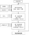
图1为本发明的算法框架示意图。FIG. 1 is a schematic diagram of the algorithm framework of the present invention.
图2为本发明的算法滤波过程示意图。FIG. 2 is a schematic diagram of an algorithm filtering process of the present invention.
具体实施方式Detailed ways
下面详细描述本发明的实施例,所述实施例是示例性的,旨在用于解释本发明,而不能理解为对本发明的限制。The embodiments of the present invention are described in detail below, and the embodiments are exemplary and intended to explain the present invention, but should not be construed as a limitation of the present invention.
本发明提出一种基于MEMS IMU/磁力计/DVL组合的水下运载体组合导航方法,它包括了初始对准过程、惯性解算过程、速度量测卡尔曼滤波过程和航向量测卡尔曼滤波过程。水下运载体入水后,利用磁力计和加速度计得到水下运载体初始航向姿态,完成初始对准过程。此处引入卫星导航数据作为惯导递推解算的初始位置。The invention proposes an integrated navigation method for underwater vehicles based on the combination of MEMS IMU/magnetometer/DVL, which includes an initial alignment process, an inertial calculation process, a velocity measurement Kalman filtering process and a heading measurement Kalman filtering process process. After the underwater carrier enters the water, the initial heading attitude of the underwater carrier is obtained by using the magnetometer and the accelerometer, and the initial alignment process is completed. Here, the satellite navigation data is introduced as the initial position of the inertial navigation recursive solution.
水下运载体在水下航行时,采用MEMS IMU/磁力计/DVL组合导航方式,用初始对准过程得到的航向姿态信息作为水下运载体初始航向姿态,引入的卫星导航数据作为水下运载体的初始位置信息。采用MEMS IMU输出的数据进行姿态速度位置的递推计算,用卡尔曼滤波估计出系统的导航参数,得到水下运载体航向姿态速度以及位置信息。以MEMS IMU和DVL输出的速度之差作为卡尔曼滤波器一次量测,用卡尔曼滤波器估计出航向、姿态等导航参数校正MEMS惯导后,得到较高精度的水平姿态等测量信息。结合反馈修正的水平姿态信息和磁力计测量值,得到水下运载体的磁航向信息。用一次反馈修正得到的航向和磁航向之差作为卡尔曼滤波器二次量测,用卡尔曼滤波器估计出航向、姿态等导航参数,再次对MEMS惯导进行校正,使得水下运载体的导航定位精度大幅度提高。When the underwater vehicle is navigating underwater, the MEMS IMU/magnetometer/DVL combined navigation method is used, the heading attitude information obtained during the initial alignment process is used as the initial heading attitude of the underwater vehicle, and the introduced satellite navigation data is used as the underwater vehicle. The initial position information of the carrier. The data output from the MEMS IMU is used for the recursive calculation of the attitude, velocity and position, and the Kalman filter is used to estimate the navigation parameters of the system to obtain the heading, attitude, velocity and position information of the underwater vehicle. The difference between the velocities output by the MEMS IMU and the DVL is used as the primary measurement of the Kalman filter. The Kalman filter is used to estimate the heading, attitude and other navigation parameters after correcting the MEMS inertial navigation, and then the measurement information such as the horizontal attitude with high precision can be obtained. Combined with the feedback corrected horizontal attitude information and the magnetometer measurement value, the magnetic heading information of the underwater vehicle is obtained. The difference between the heading and the magnetic heading obtained by the first feedback correction is used as the secondary measurement of the Kalman filter, and the navigation parameters such as heading and attitude are estimated by the Kalman filter, and the MEMS inertial navigation is corrected again to make the underwater vehicle The navigation and positioning accuracy is greatly improved.
水下运载体在水下航行过程中建立了多级卡尔曼滤波模式,第一级滤波模式(速度量测卡尔曼滤波)用于减小水下运载体航行过程中的水平姿态和速度误差,此时水下运载体的导航方式为MEMS IMU/DVL组合导航方式,即水下运载体在水下航行过程建立的第一级滤波模式为MEMS IMU/DVL组合导航下的滤波方式。第二级滤波模式(航向量测卡尔曼滤波)用于减小水下运载体航行过程中的航向姿态误差,此时水下运载体的导航方式为MEMSIMU/磁力计组合导航方式,即水下运载体在水下航行过程建立的第二级滤波模式为MEMSIMU/磁力计组合导航下的滤波方式。A multi-level Kalman filter mode is established for the underwater vehicle during the underwater navigation. The first-level filter mode (velocity measurement Kalman filter) is used to reduce the horizontal attitude and velocity errors of the underwater vehicle during the navigation process. At this time, the navigation method of the underwater vehicle is the MEMS IMU/DVL integrated navigation method, that is, the first-level filtering mode established by the underwater vehicle during the underwater navigation process is the filtering method under the MEMS IMU/DVL integrated navigation. The second-stage filtering mode (heading vector measurement Kalman filter) is used to reduce the heading and attitude error during the navigation of the underwater vehicle. At this time, the navigation method of the underwater vehicle is the MEMS IMU/magnetometer combined navigation method, that is The second-level filtering mode established by the carrier in the underwater navigation process is the filtering mode under the MEMS IMU/magnetometer integrated navigation.
所述速度量测卡尔曼滤波,通过建立MEMS惯导与DVL组合导航下的滤波模型,以MEMS IMU和DVL输出的速度之差作为量测值,用卡尔曼滤波器估计出的导航参数校正MEMS惯导后,提高了水下运载体的水平姿态信息的精度,使用磁力计进行航向解算时,需要通过水平姿态角信息对磁力计测量进行坐标转换,精度较高的水平姿态信息可以提高磁力计计算航向精度。For the velocity measurement Kalman filter, by establishing a filtering model under the combined navigation of MEMS inertial navigation and DVL, the difference between the velocities output by the MEMS IMU and the DVL is used as the measurement value, and the navigation parameters estimated by the Kalman filter are used to correct the MEMS After inertial navigation, the accuracy of the horizontal attitude information of the underwater vehicle is improved. When the magnetometer is used for heading calculation, the coordinate transformation of the magnetometer measurement needs to be carried out through the horizontal attitude angle information. The high-precision horizontal attitude information can improve the magnetic force. Calculate the heading accuracy.
所述航向量测卡尔曼滤波,通过建立MEMS惯导与磁力计组合导航下的滤波模型,将磁力计计算航向引入二次量测方程,利用了磁力计长期稳定性好且不存在累积误差的特点,能够一定程度上解决水下运载体的航向漂移问题,提高水下运载体长航时运行的导航定位精度。The Kalman filter for heading measurement, by establishing a filter model under the combined navigation of MEMS inertial navigation and magnetometer, introduces the heading calculated by the magnetometer into the quadratic measurement equation, and utilizes the long-term stability of the magnetometer and the absence of accumulated errors. It can solve the problem of course drift of underwater vehicles to a certain extent, and improve the navigation and positioning accuracy of underwater vehicles in long-running operation.
具体包括以下步骤:Specifically include the following steps:
步骤1:水下运载体入水后,采用MEMS IMU中加速度计数据解算水下运载体的姿态角,用加速度解算的姿态角对磁力计数据进行坐标转换,采用航向角计算公式,得到水下运载体的初始航向姿态信息。Step 1: After the underwater vehicle enters the water, use the accelerometer data in the MEMS IMU to calculate the attitude angle of the underwater vehicle, use the attitude angle calculated by the acceleration to perform coordinate transformation on the magnetometer data, and use the heading angle calculation formula to obtain the water The initial heading and attitude information of the lower carrier.
步骤2:水下运载体开始水下航行时,采用MEMS IMU/磁力计/DVL组合导航,用步骤1得到的航向姿态信息作为水下运载体初始航向姿态,引入卫星导航数据作为水下运载体的初始位置信息。采用MEMS IMU中陀螺和加速度计的数据进行姿态速度位置的递推计算(卡尔曼滤波状态更新),通过卡尔曼滤波估计出系统的导航参数,得到实时的水下运载体航向姿态速度信息。Step 2: When the underwater vehicle starts to navigate underwater, use MEMS IMU/magnetometer/DVL combined navigation, use the heading attitude information obtained in
步骤3:采用步骤2得到的水下运载体速度和DVL输出的速度之差作为卡尔曼滤波器一次量测,用卡尔曼滤波器估计出航向、姿态等导航参数校正MEMS惯导后,得到较高精度的水平姿态等测量信息:Step 3: Use the difference between the speed of the underwater vehicle obtained in step 2 and the speed of the DVL output as a Kalman filter measurement, and use the Kalman filter to estimate the heading, attitude and other navigation parameters after correcting the MEMS inertial navigation, and obtain a comparative High-precision horizontal attitude and other measurement information:
步骤3.1:建立MEMS IMU与DVL组合导航下的卡尔曼滤波模型;Step 3.1: Establish the Kalman filter model under the combined navigation of MEMS IMU and DVL;
MEMS IMU/磁力计/DVL组合导航下的滤波方程状态变量为:The state variables of the filtering equation under the MEMS IMU/magnetometer/DVL combined navigation are:

其中,Φ为水下运载体的姿态角误差;δvn为速度误差;δP为位置误差;εb为陀螺常值漂移;
MEMS IMU/磁力计/DVL组合导航下的系统状态方程为:The state equation of the system under the MEMS IMU/magnetometer/DVL integrated navigation is:

式中,F为系统状态转移矩阵,G为系统噪声分配矩阵,Wb为系统噪声矩阵。In the formula, F is the system state transition matrix, G is the system noise allocation matrix, and Wb is the system noise matrix.
系统状态转移矩阵F为:The system state transition matrix F is:

式中:where:
Mij—惯性系统的状态转移矩阵,与系统误差方程对应;Mij — the state transition matrix of the inertial system, corresponding to the system error equation;

Mdvl—多普勒测速仪DVL的反相关时间矩阵。Mdvl — The inverse correlation time matrix of the Doppler Velocimeter DVL.
系统噪声分配矩阵G为:The system noise distribution matrix G is:

系统噪声矩阵Wb为:The system noise matrix Wb is:

式中:where:


步骤3.2:水下运载体水下航行中以MEMS IMU和DVL输出的速度之差作为滤波器一次量测,利用卡尔曼滤波估计出航向、姿态等导航参数校正MEMS惯导后,提高了水平姿态等测量精度;Step 3.2: During the underwater navigation of the underwater vehicle, the difference between the velocities output by the MEMS IMU and the DVL is used as the filter to measure the first time, and the Kalman filter is used to estimate the navigation parameters such as heading and attitude. After correcting the MEMS inertial navigation, the horizontal attitude is improved. Equal measurement accuracy;
对MEMS IMU与DVL组合导航下的滤波模型先进行离散化得到离散状态方程,再进行离散卡尔曼滤波,当获得速度量测更新时,通过卡尔曼滤波器对导航参数(状态向量X(t))进行估计,将导航参数反馈给MEMS IMU,得到较高精度的水平姿态信息。The filter model under the combined navigation of MEMS IMU and DVL is firstly discretized to obtain the discrete state equation, and then the discrete Kalman filter is performed. When the velocity measurement update is obtained, the navigation parameters (state vector X(t) ) to estimate and feed back the navigation parameters to the MEMS IMU to obtain high-precision horizontal attitude information.
由MEMS IMU解算值和DVL输出的速度之差形成的量测值ZINS/DVL为:The measured value ZINS/DVL formed by the difference between the calculated value of the MEMS IMU and the velocity output by the DVL is:

第一级滤波器的量测方程为:The measurement equation for the first-stage filter is:
ZINS/DVL=H1X+VZINS/DVL = H1 X+V
其中:in:

V=VDV=VD
式中,H1为系统第一级滤波器量测矩阵,Vn为水下运载体在导航下的速度,VD为DVL量测噪声向量。In the formula, H1 is the measurement matrix of the first-stage filter of the system, Vn is the speed of the underwater vehicle under navigation, and VD is the DVL measurement noise vector.
步骤4:采用步骤3得到的较高精度的水平姿态信息和磁力计测量值,得到水下运载体的磁航向信息。用一次反馈修正得到的航向和磁航向之差作为卡尔曼滤波器二次量测,用卡尔曼滤波器估计出航向、姿态等导航参数,再次对MEMS惯导进行校正,得到高精度的水下运载体导航定位信息。Step 4: Obtain the magnetic heading information of the underwater carrier by using the higher-precision horizontal attitude information and magnetometer measurement values obtained in step 3. The difference between the heading and the magnetic heading obtained by the first feedback correction is used as the secondary measurement of the Kalman filter. The Kalman filter is used to estimate the navigation parameters such as heading and attitude, and the MEMS inertial navigation is corrected again to obtain high-precision underwater. Carrier navigation and positioning information.
步骤4.1:采用步骤3得到的较高精度的水平姿态信息和磁力计测量值,得到水下运载体的磁航向信息;Step 4.1: Obtain the magnetic heading information of the underwater carrier by using the higher-precision horizontal attitude information and magnetometer measurement values obtained in step 3;
磁力计计算航向公式为:The formula for calculating the heading of the magnetometer is:

式中,bx、by、bz为载体坐标系下的磁力计输出,γ为一次反馈修正后的载体横滚角,θ为一次反馈修正后的载体俯仰角。In the formula, bx , by , bz are the magnetometeroutputs in the carrier coordinate system, γ is the carrier roll angle after one feedback correction, and θ is the carrier pitch angle after one feedback correction.
步骤4.2:水下运载体水下航行中以一次反馈修正得到的航向和磁航向之差作为滤波器二次量测,利用卡尔曼滤波估计出航向、姿态等导航参数校正MEMS惯导后,得到高精度的水下运载体导航定位信息;Step 4.2: In the underwater navigation of the underwater vehicle, the difference between the heading and the magnetic heading obtained by the one-time feedback correction is used as the secondary measurement of the filter, and the Kalman filter is used to estimate the heading, attitude and other navigation parameters after correcting the MEMS inertial navigation. High-precision underwater vehicle navigation and positioning information;
对MEMS惯导与磁力计组合导航下的滤波模型先进行离散化得到离散状态方程,再进行离散卡尔曼滤波,当获得磁航向量测更新时,通过卡尔曼滤波器对导航参数进行估计,将导航参数反馈给MEMS惯导,得到高精度的水下运载体导航定位信息。The filter model under the combined navigation of MEMS inertial navigation and magnetometer is firstly discretized to obtain the discrete state equation, and then discrete Kalman filtering is performed. When the magnetic heading vector measurement update is obtained, the navigation parameters are estimated by the Kalman filter, and the The navigation parameters are fed back to the MEMS inertial navigation to obtain high-precision navigation and positioning information of the underwater vehicle.
第二级滤波器的量测方程推导如下:The measurement equation for the second-stage filter is derived as follows:

式中,


已知基于惯性系统递推载体航向误差与载体姿态误差角的关系为:It is known that the relationship between the carrier heading error and the carrier attitude error angle based on the inertial system recursion is:

式中,

利用载体的俯仰角和横滚角信息辅助解析磁航向值,根据一阶偏微分定义,对磁计算航向公式求解关于俯仰角θ和横滚角γ的偏导数,得到磁航向值的误差模型为:Using the information of the carrier's pitch angle and roll angle to assist in the analysis of the magnetic heading value, according to the definition of the first-order partial differential, the partial derivatives of the pitch angle θ and the roll angle γ are solved for the magnetic calculation heading formula, and the error model of the magnetic heading value is obtained as: :

其中:in:


式中,

由一次反馈修正得到的航向和磁航向之差形成的量测值ZINS/mag为:The measured value ZINS/mag formed by the difference between the heading and the magnetic heading obtained by one feedback correction is:

第二级滤波器的量测方程为:The measurement equation of the second-stage filter is:
ZINS/mag=H2X+VZINS/mag = H2 X+V
=[A B C 01×14]X+V=[ABC 01×14 ]X+V
其中:in:


C=-1C=-1
V=VMV=VM
式中,H2为系统第二级滤波器量测矩阵,Tij为姿态矩阵
上述方法用到的系统误差模型为:The systematic error model used in the above method is:
姿态误差方程:Attitude error equation:


其中,in,

RMh=RM+hRMh =RM +h
RNh=RN+hRNh =RN +h
式中,φE为载体姿态东向失准角,φN为载体姿态北向失准角,φU为载体姿态天向失准角,VE为载体东向速度,VN为载体北向速度,VU为载体天向速度,εE为陀螺常值误差在东向的投影,εN为陀螺常值误差在北向的投影,εU为陀螺常值误差在天向的投影,ωie为地球自转角速率,RM为子午圈主曲率半径,RN为卯酉圈主曲率半径,δL为纬度误差。where φE is the eastward misalignment angle of the carrier attitude, φN is the northward misalignment angle of the carrier attitude, φU is the carrier attitude skyward misalignment angle, VE is the eastward speed of the carrier, VN is the northward speed of the carrier, VU is the skyward velocity of the carrier, εE is the eastward projection of the gyro constant error, εN is the northward projection of the gyro constant error, εU is the sky projection of the gyro constant error, ωie is the earth Rotation angular rate, RM is the main curvature radius of the meridian circle, RN is the main curvature radius of the 卯unitary circle, and δL is the latitude error.
速度误差方程:Velocity Error Equation:


其中,in,


式中,fE为加速度计输出在东向的投影,fN为加速度计输出在北向的投影,fU为加速度计输出在天向的投影,


位置误差方程:Position error equation:


陀螺仪测量误差:Gyroscope measurement error:

式中,εb为常值漂移,εw为均值为零的高斯白噪声。In the formula,εb is the constant drift, andεw is the Gaussian white noise with zero mean.
加速度计测量误差:Accelerometer measurement error:

式中,

尽管上面已经示出和描述了本发明的实施例,可以理解的是,上述实施例是示例性的,不能理解为对本发明的限制,本领域的普通技术人员在不脱离本发明的原理和宗旨的情况下在本发明的范围内可以对上述实施例进行变化、修改、替换和变型。Although the embodiments of the present invention have been shown and described above, it should be understood that the above embodiments are exemplary and should not be construed as limiting the present invention. Variations, modifications, substitutions, and alterations to the above-described embodiments are possible within the scope of the present invention without departing from the scope of the present invention.
Claims (1)


Priority Applications (1)
| Application Number | Priority Date | Filing Date | Title |
|---|---|---|---|
| CN202010889071.7ACN112097763B (en) | 2020-08-28 | 2020-08-28 | Underwater vehicle combined navigation method based on MEMS IMU/magnetometer/DVL combination |
Applications Claiming Priority (1)
| Application Number | Priority Date | Filing Date | Title |
|---|---|---|---|
| CN202010889071.7ACN112097763B (en) | 2020-08-28 | 2020-08-28 | Underwater vehicle combined navigation method based on MEMS IMU/magnetometer/DVL combination |
Publications (2)
| Publication Number | Publication Date |
|---|---|
| CN112097763A CN112097763A (en) | 2020-12-18 |
| CN112097763Btrue CN112097763B (en) | 2022-07-05 |
Family
ID=73758397
Family Applications (1)
| Application Number | Title | Priority Date | Filing Date |
|---|---|---|---|
| CN202010889071.7AActiveCN112097763B (en) | 2020-08-28 | 2020-08-28 | Underwater vehicle combined navigation method based on MEMS IMU/magnetometer/DVL combination |
Country Status (1)
| Country | Link |
|---|---|
| CN (1) | CN112097763B (en) |
Families Citing this family (16)
| Publication number | Priority date | Publication date | Assignee | Title |
|---|---|---|---|---|
| CN112729283A (en)* | 2020-12-21 | 2021-04-30 | 西北工业大学 | Navigation method based on depth camera/MEMS inertial navigation/odometer combination |
| CN112729286B (en)* | 2020-12-22 | 2022-09-30 | 北京安达维尔科技股份有限公司 | Method for improving three-dimensional attitude angle precision of resolving carrier of airborne attitude and heading reference instrument |
| CN112729291B (en)* | 2020-12-29 | 2022-03-04 | 东南大学 | A SINS/DVL ocean current velocity estimation method for deep-dive and long-endurance submersibles |
| CN115327452A (en)* | 2021-05-11 | 2022-11-11 | 广州视源电子科技股份有限公司 | Method and device for processing magnetometer data |
| CN113029130B (en)* | 2021-05-27 | 2021-08-27 | 腾讯科技(深圳)有限公司 | Data processing method, data processing device, computer equipment and storage medium |
| CN113447018B (en)* | 2021-07-06 | 2023-05-26 | 北京理工导航控制科技股份有限公司 | Real-time attitude estimation method of underwater inertial navigation system |
| CN113670334B (en)* | 2021-08-06 | 2024-02-20 | 广东汇天航空航天科技有限公司 | Initial alignment method and device for aerocar |
| CN113639746B (en)* | 2021-08-26 | 2024-09-10 | 陕西华燕航空仪表有限公司 | MEMS inertial component and attitude correction method |
| CN114459476B (en)* | 2022-03-09 | 2024-03-01 | 东南大学 | Underwater unmanned submarine current measuring DVL/SINS integrated navigation method based on virtual speed measurement |
| CN114577218B (en)* | 2022-05-07 | 2022-08-05 | 中国人民解放军海军工程大学 | Attitude measurement method and system of underwater vehicle based on magnetometer and depth gauge |
| CN115344038A (en)* | 2022-07-07 | 2022-11-15 | 五邑大学 | Underwater robot control method, device, equipment and medium based on bionic architecture |
| CN115060274B (en)* | 2022-08-17 | 2022-11-18 | 南开大学 | Underwater integrated autonomous navigation device and initial alignment method thereof |
| CN115950447B (en)* | 2022-11-04 | 2025-09-26 | 中山大学 | High-precision alignment method and system for underwater dynamic base based on magnetic compass and velocimeter |
| CN116068540B (en)* | 2023-02-17 | 2023-09-12 | 哈尔滨工程大学 | A method of radial beam angle correction for acoustic Doppler velocity measurement |
| CN117146810B (en)* | 2023-08-29 | 2024-02-13 | 广东精天科技有限公司 | Combined positioning system based on satellite navigation and MEMS inertial navigation |
| CN119687956B (en)* | 2024-12-02 | 2025-09-26 | 北京航空航天大学 | A MEMS IMU initial alignment method based on nonlinear optimization of magnetic heading |
Citations (4)
| Publication number | Priority date | Publication date | Assignee | Title |
|---|---|---|---|---|
| CN105424036A (en)* | 2015-11-09 | 2016-03-23 | 东南大学 | Terrain-aided inertial integrated navigational positioning method of low-cost underwater vehicle |
| CN109029454A (en)* | 2018-07-13 | 2018-12-18 | 哈尔滨工程大学 | A kind of abscissa system Strapdown Inertial Navigation System damping algorithm based on Kalman filtering |
| CN110095800A (en)* | 2019-04-19 | 2019-08-06 | 南京理工大学 | A kind of self-adapted tolerance federated filter Combinated navigation method of multi-source fusion |
| CN110988951A (en)* | 2019-12-06 | 2020-04-10 | 中国地质大学(北京) | Multi-source data fusion real-time navigation positioning method and system |
Family Cites Families (1)
| Publication number | Priority date | Publication date | Assignee | Title |
|---|---|---|---|---|
| US7778111B2 (en)* | 2008-03-19 | 2010-08-17 | Honeywell International Inc. | Methods and systems for underwater navigation |
- 2020
- 2020-08-28CNCN202010889071.7Apatent/CN112097763B/enactiveActive
Patent Citations (4)
| Publication number | Priority date | Publication date | Assignee | Title |
|---|---|---|---|---|
| CN105424036A (en)* | 2015-11-09 | 2016-03-23 | 东南大学 | Terrain-aided inertial integrated navigational positioning method of low-cost underwater vehicle |
| CN109029454A (en)* | 2018-07-13 | 2018-12-18 | 哈尔滨工程大学 | A kind of abscissa system Strapdown Inertial Navigation System damping algorithm based on Kalman filtering |
| CN110095800A (en)* | 2019-04-19 | 2019-08-06 | 南京理工大学 | A kind of self-adapted tolerance federated filter Combinated navigation method of multi-source fusion |
| CN110988951A (en)* | 2019-12-06 | 2020-04-10 | 中国地质大学(北京) | Multi-source data fusion real-time navigation positioning method and system |
Non-Patent Citations (2)
| Title |
|---|
| 信息融合技术在水下组合导航系统中的应用;袁小龙;《广州航海高等专科学校学报》;20130331(第01期);第18-20、24页* |
| 联邦滤波器的SINS/GNS/DVS水下组合导航;刘明雍等;《火力与指挥控制》;20091215(第12期);第41-43、67页* |
Also Published As
| Publication number | Publication date |
|---|---|
| CN112097763A (en) | 2020-12-18 |
Similar Documents
| Publication | Publication Date | Title |
|---|---|---|
| CN112097763B (en) | Underwater vehicle combined navigation method based on MEMS IMU/magnetometer/DVL combination | |
| CN109443379B (en) | A SINS/DVL underwater anti-sway alignment method for deep-sea submersibles | |
| CN112629538B (en) | Ship horizontal attitude measurement method based on fusion complementary filtering and Kalman filtering | |
| CN108731670B (en) | Inertial/visual odometer integrated navigation positioning method based on measurement model optimization | |
| CN101949703B (en) | Strapdown inertial/satellite combined navigation filtering method | |
| CN110146076B (en) | SINS/DVL combined positioning method without inverse matrix adaptive filtering | |
| CN107797125B (en) | A method of reducing deep-sea detecting type AUV navigation positioning errors | |
| JP4199553B2 (en) | Hybrid navigation device | |
| CN102706366B (en) | SINS (strapdown inertial navigation system) initial alignment method based on earth rotation angular rate constraint | |
| CN102830414B (en) | Combined navigation method based on SINS/GPS (strapdown inertial navigation system/global position system) | |
| CN111722295B (en) | Underwater strapdown gravity measurement data processing method | |
| CN104697520B (en) | Integrated gyro free strap down inertial navigation system and gps system Combinated navigation method | |
| CN106500727B (en) | A Path Matching Based Error Correction Method for Inertial Navigation System | |
| CN103344259A (en) | Method for correcting feedback of inertial navigation system/global position system (INS/GPS) combined navigation system based on lever arm estimation | |
| CN111323012B (en) | INS-assisted DVL speed measurement error compensation method under high dynamic environment of carrier | |
| CN101900573B (en) | Method for realizing landtype inertial navigation system movement aiming | |
| CN116222551A (en) | An underwater navigation method and device integrating multiple data | |
| CN108627152B (en) | Navigation method of micro unmanned aerial vehicle based on multi-sensor data fusion | |
| CN105910623B (en) | The method for carrying out the correction of course using magnetometer assisted GNSS/MINS tight integration systems | |
| CN114111840B (en) | DVL error parameter online calibration method based on integrated navigation | |
| CN107677292A (en) | Vertical line deviation compensation method based on gravity field model | |
| CN110133695A (en) | A dual-antenna GNSS position delay time dynamic estimation system and method | |
| CN115343738A (en) | Integrated navigation method and device based on GNSS-RTK and IMU | |
| CN105371838A (en) | Combination navigation method and combination navigation system based on INS assisted GNSS single antenna attitude measurement | |
| CN115752453A (en) | Electromagnetic log ocean current estimation and integrated navigation method and system based on HMM |
Legal Events
| Date | Code | Title | Description |
|---|---|---|---|
| PB01 | Publication | ||
| PB01 | Publication | ||
| SE01 | Entry into force of request for substantive examination | ||
| SE01 | Entry into force of request for substantive examination | ||
| GR01 | Patent grant | ||
| GR01 | Patent grant |