CN112068588A - A method for generating trajectory of unmanned aerial vehicle based on flight corridor and Bezier curve - Google Patents
A method for generating trajectory of unmanned aerial vehicle based on flight corridor and Bezier curveDownload PDFInfo
- Publication number
- CN112068588A CN112068588ACN202010807082.6ACN202010807082ACN112068588ACN 112068588 ACN112068588 ACN 112068588ACN 202010807082 ACN202010807082 ACN 202010807082ACN 112068588 ACN112068588 ACN 112068588A
- Authority
- CN
- China
- Prior art keywords
- corridor
- flight
- block
- bezier curve
- trajectory
- Prior art date
- Legal status (The legal status is an assumption and is not a legal conclusion. Google has not performed a legal analysis and makes no representation as to the accuracy of the status listed.)
- Pending
Links
- 238000000034methodMethods0.000titleclaimsabstractdescription49
- 230000008569processEffects0.000claimsabstractdescription18
- 230000001133accelerationEffects0.000claimsabstractdescription17
- 230000036461convulsionEffects0.000claimsdescription11
- 238000005457optimizationMethods0.000claimsdescription11
- 230000004888barrier functionEffects0.000claims2
- 238000010586diagramMethods0.000description14
- 230000006870functionEffects0.000description11
- 230000009286beneficial effectEffects0.000description4
- 230000008859changeEffects0.000description4
- 230000000694effectsEffects0.000description3
- 238000004891communicationMethods0.000description1
- 238000005516engineering processMethods0.000description1
- 238000009499grossingMethods0.000description1
- 238000012986modificationMethods0.000description1
- 230000004048modificationEffects0.000description1
- 238000009877renderingMethods0.000description1
- 230000000717retained effectEffects0.000description1
- 238000010845search algorithmMethods0.000description1
- 238000010408sweepingMethods0.000description1
Images


Classifications
- G—PHYSICS
- G05—CONTROLLING; REGULATING
- G05D—SYSTEMS FOR CONTROLLING OR REGULATING NON-ELECTRIC VARIABLES
- G05D1/00—Control of position, course, altitude or attitude of land, water, air or space vehicles, e.g. using automatic pilots
- G05D1/10—Simultaneous control of position or course in three dimensions
- G05D1/101—Simultaneous control of position or course in three dimensions specially adapted for aircraft
Landscapes
- Engineering & Computer Science (AREA)
- Aviation & Aerospace Engineering (AREA)
- Radar, Positioning & Navigation (AREA)
- Remote Sensing (AREA)
- Physics & Mathematics (AREA)
- General Physics & Mathematics (AREA)
- Automation & Control Theory (AREA)
- Control Of Position, Course, Altitude, Or Attitude Of Moving Bodies (AREA)
Abstract
Description
Translated fromChinese技术领域technical field
本发明属于机器人运动规划领域,具体涉及一种基于飞行走廊和贝塞尔曲线的无人飞行器轨迹生成方法。The invention belongs to the field of robot motion planning, and in particular relates to a method for generating a trajectory of an unmanned aerial vehicle based on a flight corridor and a Bezier curve.
背景技术Background technique
现今社会中机器人的应用越来越广泛,例如扫地机器人,工业机械臂,物流运输机器人,航拍无人机等等,都为人们的生活带去了许多遍历。其中无论是何种形态的机器人,只要涉及运动,就需要考虑到运动过程中的避障问题与运动平滑性问题。The application of robots in today's society is becoming more and more extensive, such as sweeping robots, industrial robotic arms, logistics and transportation robots, aerial photography drones, etc., which have brought a lot of traversal to people's lives. No matter what kind of robot it is, as long as it involves motion, it needs to consider the problem of obstacle avoidance and motion smoothness in the process of motion.
机器人在执行任务的时候要先进行路径规划,规划出来的路径足以避开所有的障碍物,然后再在这条已知的路径基础上做轨迹规划,规划机器人以何种速度通过路径上的每个点。这个问题就化为了路径已知下的轨迹规划。它的目的是规划机器人在路径上各点的速度以保证机器人在运动的过程中能够既不超过控制器的极限,又保证时间或者能量的最优。When the robot performs a task, it must first carry out path planning, and the planned path is enough to avoid all obstacles, and then make trajectory planning based on this known path, and plan the speed at which the robot passes through each path on the path. point. This problem is reduced to trajectory planning with a known path. Its purpose is to plan the speed of the robot at each point on the path to ensure that the robot can neither exceed the limit of the controller during the movement process, but also ensure the optimal time or energy.
传统的轨迹生成方法例如minimum-snap法至少存在以下问题:Traditional trajectory generation methods such as the minimum-snap method have at least the following problems:
(1)对时间的分配敏感。Minimum-snap需要给定运动时间,给定的时间过短时会难以求解,过长时曲线会出现弯折甚至打圈,对机器人运动不利;(1) Sensitive to the allocation of time. Minimum-snap requires a given movement time. If the given time is too short, it will be difficult to solve. If the given time is too long, the curve will bend or even circle, which is not good for the robot movement;
(2)严格遵守经过路径规划得到的中间点这个约束条件,这会限制轨迹的自由度;(2) Strictly abide by the constraint of the intermediate point obtained through the path planning, which will limit the degree of freedom of the trajectory;
(3)路径规划中得到的路径并不是光滑的,往往存在拐角,而大量拐角存在会导致两段轨迹的长度差距过大,求解最优化问题的时候会导致数值的稳定性差;(3) The path obtained in the path planning is not smooth, there are often corners, and the existence of a large number of corners will cause the length difference between the two trajectories to be too large, which will lead to poor numerical stability when solving the optimization problem;
(4)无法保证生成的轨迹一定不碰障碍物,且无法保证轨迹加速度连续,这对无人机类机器人的控制是致命的,因为不连续的加速度会导致无人机姿态频繁变化,导致运动不稳定甚至坠机。(4) There is no guarantee that the generated trajectory will not touch obstacles, and the trajectory acceleration cannot be guaranteed to be continuous, which is fatal to the control of UAV-like robots, because the discontinuous acceleration will cause the UAV’s attitude to change frequently, resulting in motion Instability or even crash.
发明内容SUMMARY OF THE INVENTION
针对上述背景技术的分析,本发明旨在提供一种基于飞行走廊和贝塞尔曲线的无人飞行器轨迹生成方法,可以在保证避障的前提下使机器人满足加速度连续的运动约束,且平均速度较快。具体流程为:通过深度相机传感器/激光雷达传感器,或者全局已知信息,获得周围的地图点云信息,构建栅格化的障碍物地图,使用A*算法规划出一条无碰且最优的路径,基于A*规划的路径生成机器人可运动的无碰撞的飞行走廊,最后在飞行走廊中生成贝塞尔曲线,供机器人运动。In view of the analysis of the above background technology, the present invention aims to provide a method for generating a trajectory of an unmanned aerial vehicle based on a flight corridor and a Bezier curve, which can make the robot meet the motion constraint of continuous acceleration under the premise of ensuring obstacle avoidance, and the average speed faster. The specific process is: obtain the surrounding map point cloud information through the depth camera sensor/lidar sensor, or global known information, build a rasterized obstacle map, and use the A* algorithm to plan a collision-free and optimal path , a collision-free flight corridor that the robot can move based on the path planned by A*, and finally a Bezier curve is generated in the flight corridor for the robot to move.
本发明主要通过以下技术方案实现:The present invention is mainly realized through the following technical solutions:
一种基于飞行走廊和贝塞尔曲线的无人飞行器轨迹生成方法,包括以下步骤:A method for generating trajectory of unmanned aerial vehicle based on flight corridor and Bezier curve, comprising the following steps:
S1:获取无人飞行器所处环境的障碍物点云并实时更新,根据障碍物点云构建栅格化地图;S1: Obtain the obstacle point cloud of the environment where the UAV is located and update it in real time, and construct a rasterized map based on the obstacle point cloud;
S2:获取无人飞行器在栅格化地图中的目标节点,规划从起始点到目标节点的安全路径;S2: Obtain the target node of the UAV in the rasterized map, and plan a safe path from the starting point to the target node;
S3:基于步骤S2生成的安全路径,从起始点开始向之后的节点生成走廊块,直至检测到碰撞,则完成一个走廊块的生成;将上一个走廊块的终点作为下一个走廊块的起始点,继续生成走廊块,直至达到目标节点;将生成的若干个走廊块进行膨胀,增加走廊块之间的重叠部分,最终形成飞行走廊;S3: Based on the safe path generated in step S2, generate corridor blocks from the starting point to the following nodes, until a collision is detected, the generation of a corridor block is completed; the end point of the previous corridor block is used as the starting point of the next corridor block , continue to generate corridor blocks until reaching the target node; expand several generated corridor blocks to increase the overlap between corridor blocks, and finally form a flight corridor;
S4:基于飞行走廊建立贝塞尔曲线生成模型,将求解得到的最优贝塞尔曲线作为飞行轨迹,所述飞行轨迹约束在飞行走廊内;将飞行轨迹发送至无人飞行器的飞行控制器,完成无人飞行器的飞行轨迹跟踪。S4: Build a Bezier curve generation model based on the flight corridor, use the obtained optimal Bezier curve as the flight trajectory, and the flight trajectory is constrained in the flight corridor; send the flight trajectory to the flight controller of the UAV, Complete the flight trajectory tracking of the unmanned aerial vehicle.
进一步的,步骤S2采用A*算法规划从起始点到目标节点的安全路径。Further, step S2 adopts the A* algorithm to plan a safe path from the starting point to the target node.
进一步的,所述的步骤S3具体为:Further, the step S3 is specifically:
S31:将安全路径上的起始点S0作为第一个走廊块的起点,将起始点向后的第一个节点S1作为第一个走廊块的终点,生成走廊块;S31: Take the starting point S0 on the safe path as the starting point of the first corridor block, and take the first node S1 backward from the starting point as the ending point of the first corridor block to generate a corridor block;
S32:判断步骤S31生成的走廊块是否会发生碰撞,若否,则将下一个节点作为当前走廊块的终点,对当前走廊块进行更新,重复步骤S32,直至当前走廊块发生碰撞,撤销上一步的更新过程,完成一个走廊块的生成,放入走廊列表;S32: Determine whether the corridor block generated in step S31 will collide, if not, then take the next node as the end point of the current corridor block, update the current corridor block, repeat step S32, until the current corridor block collides, cancel the previous step The update process of , completes the generation of a corridor block, and puts it into the corridor list;
S33:将走廊列表中最新的走廊块的终点作为下一个走廊块的起点,将下一个节点作为走廊块的终点,重复步骤S32至步骤S33,继续生成走廊块并更新走廊列表,直至达到目标节点;S33: Take the end point of the latest corridor block in the corridor list as the start point of the next corridor block, and use the next node as the end point of the corridor block, repeat steps S32 to S33, continue to generate corridor blocks and update the corridor list until the target node is reached ;
S34:将走廊列表中的若干个走廊块进行膨胀,增加走廊块之间的重叠部分,相邻走廊块之间的重叠部分不与障碍物发生碰撞,最终形成飞行走廊。S34: Expand several corridor blocks in the corridor list, increase the overlapping part between the corridor blocks, the overlapping part between adjacent corridor blocks does not collide with obstacles, and finally form a flight corridor.
进一步的,将贝塞尔曲线的每一段轨迹的时间缩放到(0,1)之间,并基于飞行走廊建立贝塞尔曲线生成模型,将模型转化为以下优化问题:Further, the time of each trajectory of the Bezier curve is scaled to be between (0, 1), and a Bezier curve generation model is established based on the flight corridor, and the model is transformed into the following optimization problem:

式中,J表示轨迹的优化函数,这里选取的是令整段轨迹的加加加速度(snap)平方积分最小,这是最有利于无人机运动和节省能量的。Bj(t)表示缩放后的第j段贝塞尔曲线,Tj表示第j段贝塞尔曲线的时间,M表示总轨迹段数。In the formula, J represents the optimization function of the trajectory. Here, the square integral of the jerk (snap) of the entire trajectory is selected to be the smallest, which is most conducive to the movement of the UAV and saves energy. Bj (t) represents the j-th Bezier curve after scaling, Tj represents the time of the j-th Bezier curve, and M represents the total number of track segments.
进一步的,所述优化问题的约束条件包括节点上的位置、速度、加速度、Jerk的连续性约束,贝塞尔曲线位置约束,以及无人飞行器的运动能力约束。Further, the constraints of the optimization problem include the position, velocity, acceleration on the node, the continuity constraint of Jerk, the position constraint of the Bezier curve, and the movement capability constraint of the unmanned aerial vehicle.
本发明具有以下有益效果:The present invention has the following beneficial effects:
(1)本发明利用飞行走廊生成绝对安全区域,首先基于生成的安全路径,从起始点开始向之后的节点生成走廊块,直至检测到碰撞,则完成一个走廊块的生成;将上一个走廊块的终点作为下一个走廊块的起始点,继续生成走廊块,直至达到目标节点,保证了在飞行走廊内无人机不会与障碍物发生碰撞;进一步的,以生成安全走廊的方式将安全路径上的一系列节点转化为了一系列凸几何体(走廊块),大幅度增加了信息量,保证了建模的准确性。(1) The present invention utilizes the flight corridor to generate an absolutely safe area. First, based on the generated safety path, a corridor block is generated from the starting point to the following nodes, and until a collision is detected, the generation of a corridor block is completed; The end point of the next corridor block is used as the starting point of the next corridor block, and the corridor block is continued to be generated until the target node is reached, which ensures that the drone will not collide with obstacles in the flight corridor; A series of nodes are transformed into a series of convex geometry (corridor blocks), which greatly increases the amount of information and ensures the accuracy of modeling.
(2)本发明将生成的若干个走廊块进行膨胀,增加走廊块之间的重叠部分,最终形成飞行走廊,即对生成的一系列初始化走廊块进行了膨胀处理,增加了相邻走廊块之间的重叠区域,充分利用了空间信息,增加了轨迹的自由度,有利于轨迹生成。(2) The present invention expands several generated corridor blocks, increases the overlapping parts between the corridor blocks, and finally forms a flight corridor, that is, the generated series of initialization corridor blocks are expanded, and the number of adjacent corridor blocks is increased. The overlapping area between them makes full use of the spatial information, increases the degree of freedom of the trajectory, and is beneficial to the trajectory generation.
(3)本发明基于飞行走廊建立贝塞尔曲线生成模型,以整段轨迹的加加加速度(snap)平方积分最小为优化函数,有利于无人机运动和节省能量;将优化后的内塞尔曲线约束在飞行走廊的绝对安全区域内,既不需要强制要求轨迹经过中间节点,也不需要去迭代增加约束点,在实现根本避障的同时使得轨迹更加光滑,并且保证了轨迹生成的实时性。(3) The present invention establishes a Bezier curve generation model based on the flight corridor, and takes the minimum square integral of the jerk (snap) of the entire trajectory as the optimization function, which is beneficial to the movement of the UAV and saves energy; The Er curve is constrained in the absolutely safe area of the flight corridor. It is not necessary to force the trajectory to pass through the intermediate nodes, nor to iteratively increase the constraint points. It makes the trajectory smoother while achieving fundamental obstacle avoidance, and ensures the real-time trajectory generation. sex.
(4)由于在给定的时间内,算法首先会对时间进行放缩,并根据飞行走廊块的长度自适应地调整时间比例,自动获得合理的时间分配,因此本发明对时间的分配不敏感,有利于运动轨迹的规划。(4) In a given time, the algorithm firstly scales the time, and adaptively adjusts the time ratio according to the length of the flight corridor block, and automatically obtains a reasonable time allocation, so the present invention is not sensitive to the time allocation , which is beneficial to the planning of the motion trajectory.
(5)本发明通过贝塞尔曲线控制点约束,还可以对速度,加速度,Jerk做约束,更加符合实际。(5) The present invention can constrain speed, acceleration, and Jerk through Bezier curve control point constraints, which is more practical.
附图说明Description of drawings
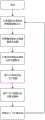
图1是本发明的整体流程图。FIG. 1 is an overall flow chart of the present invention.
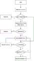
图2是本实施例采用的A*算法流程图。FIG. 2 is a flowchart of the A* algorithm adopted in this embodiment.
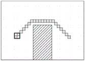
图3是本实施例采用的飞行走廊生成过程示意图。FIG. 3 is a schematic diagram of a flight corridor generation process adopted in this embodiment.
图4是贝塞尔曲线三个方向上的速度、加速度和Jerk变化,三列分别表示x,y,z方向;其中,4(a)对应速度变化,4(b)对应加速度变化,4(c)对应Jerk变化。Figure 4 shows the velocity, acceleration and Jerk changes in the three directions of the Bezier curve. The three columns represent the x, y, and z directions respectively; among them, 4(a) corresponds to the velocity change, 4(b) corresponds to the acceleration change, and 4( c) Corresponding to Jerk changes.
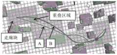
图5是飞行走廊的生成过程示意图;其中5(a)是障碍物及规划的安全路径示意图,5(b)和(c)是第一块走廊块的生成过程示意图,5(d)是第一块走廊块发生碰撞的示意图,5(e)是生成的三块走廊块示意图,5(f)是三块走廊块膨胀前后对比示意图。Figure 5 is a schematic diagram of the generation process of the flight corridor; 5(a) is the schematic diagram of the obstacle and the planned safe path, 5(b) and (c) are the schematic diagrams of the generation process of the first corridor block, and 5(d) is the first block diagram. A schematic diagram of a corridor block colliding, 5(e) is a schematic diagram of the three generated corridor blocks, and 5(f) is a comparison diagram of the three corridor blocks before and after expansion.
图6为本发明的实施效果与传统方法的对比图;Fig. 6 is the contrast diagram of the implementation effect of the present invention and the traditional method;
图7为无人机动态跟踪测试曲线,7(a)、7(b)和7(c)分别为三个跟踪阶段。Figure 7 is the dynamic tracking test curve of the UAV, 7(a), 7(b) and 7(c) are three tracking stages respectively.
具体实施方式Detailed ways
下面结合附图和具体实施方式对本发明进一步阐述和说明。The present invention will be further elaborated and described below with reference to the accompanying drawings and specific embodiments.
如图1所示,本发明采用的一种基于飞行走廊和贝塞尔曲线的无人飞行器轨迹生成方法,包括以下步骤:As shown in Figure 1, a method for generating an unmanned aerial vehicle trajectory based on a flight corridor and a Bezier curve adopted by the present invention includes the following steps:
1、从传感器/全局信息更新障碍物点云,利用障碍物点云构建栅格化地图;1. Update the obstacle point cloud from sensor/global information, and use the obstacle point cloud to build a rasterized map;
2、获取无人飞行器在栅格化地图中的目标节点,采用A*算法规划从起始点到目标节点的安全路径;2. Obtain the target node of the UAV in the rasterized map, and use the A* algorithm to plan the safe path from the starting point to the target node;
3、基于规划得到的安全路径生成飞行走廊;3. Generate a flight corridor based on the planned safe path;
4、基于飞行走廊生成贝塞尔曲线作为飞行轨迹,控制无人飞行器的飞行。4. Generate a Bezier curve based on the flight corridor as a flight trajectory to control the flight of the UAV.
下面对每一个步骤进行具体介绍。Each step is described in detail below.
本实施例中,构建栅格化地图的过程与现有技术无异,可以通过深度相机传感器/激光雷达传感器,或者全局已知信息,获得周围的地图点云信息,构建栅格化的障碍物地图。In this embodiment, the process of constructing a rasterized map is the same as that of the prior art, and the surrounding map point cloud information can be obtained through a depth camera sensor/lidar sensor, or globally known information, and a rasterized obstacle can be constructed map.
作为路径规划算法,常用的包括A*算法、RRT*算法、JPS算法等。由于JPS算法更加节省内存,但因为JPS算法跳点的特性,规划出的栅格地图无法用于飞行走廊生成。As a path planning algorithm, commonly used include A* algorithm, RRT* algorithm, JPS algorithm and so on. Because the JPS algorithm saves more memory, but because of the characteristics of the jump points of the JPS algorithm, the planned raster map cannot be used for flight corridor generation.
其中,A*算法的核心是构造代价函数:Among them, the core of the A* algorithm is to construct the cost function:
F(n)=G(n)+H(n) (1)F(n)=G(n)+H(n) (1)
G(n)是从起点移动到当前点的代价;H(n)是从当前点移动到终点的估计代价。该算法的具体流程图如图2所示:G(n) is the cost of moving from the starting point to the current point; H(n) is the estimated cost of moving from the current point to the end point. The specific flow chart of the algorithm is shown in Figure 2:
创建Openlist;Create Openlist;
将起点放入到Openlist;Put the starting point into Openlist;
判断Openlist是否为空,若是,则规划失败,若否,则寻找Openlist中代价函数最小的点N;Determine whether the Openlist is empty, if so, the planning fails, if not, find the point N with the smallest cost function in the Openlist;
判断N是否为终点,若是,则规划成功,若否,则遍历N周围的节点Ni,将没有被访问过的Ni放入到Openlist中,计算访问过的Ni的代价,若代价大于N+d,则将Ni的代价更新为N+d,否则不更新。Determine whether N is the end point. If so, the planning is successful. If not, traverse the nodes Ni around N, put the unvisited Ni into the Openlist, and calculate the cost of the visited Ni. If the cost is greater than N+d , then the cost of Ni is updated to N+d, otherwise it is not updated.
本实施例对A*算法的启发函数进行了测试对比,通过固定地图,取相同的起点终点,对三种启发式函数(曼哈顿距离、欧式距离、对角线距离)进行了测试,其中的三组测试结果如下:This embodiment tests and compares the heuristic functions of the A* algorithm. By fixing the map and taking the same starting point and ending point, three heuristic functions (Manhattan distance, Euclidean distance, and diagonal distance) are tested. Three of the heuristic functions are tested. The group test results are as follows:
表1:测试地图一Table 1: Test Map One
表2:测试地图二Table 2: Test Map II
表3:测试地图三Table 3: Test Map Three
根据测试结果总结结论如下:The conclusions based on the test results are as follows:
最优性方面:欧式距离和对角线距离都是最优,曼哈顿距离不具有最优性。In terms of optimality: Euclidean distance and diagonal distance are both optimal, and Manhattan distance is not optimal.
时间效率方面:曼哈顿距离最快,其次是对角线距离,最后是欧式距离。In terms of time efficiency: Manhattan distance is the fastest, followed by diagonal distance, and finally Euclidean distance.
内存占用方面:曼哈顿占用最少,其次是对角线距离,最后是欧式距离。In terms of memory usage: Manhattan occupies the least, followed by diagonal distance, and finally Euclidean distance.
稳定性:三种启发式函数都有稳定性。Stability: All three heuristic functions are stable.
此外,本实施例还对A*算法、RRT*算法两种算法进行了对比,选取随机地图,取相同的起点终点分别对三种路径规划算法进行测试。随机选出三组测试样例如下:In addition, this embodiment also compares the two algorithms of the A* algorithm and the RRT* algorithm, selects a random map, and takes the same starting point and ending point to test the three path planning algorithms respectively. Three groups of test samples were randomly selected as follows:
表4:测试地图一Table 4: Test Map One
表5:测试地图二Table 5: Test Map II
表6:测试地图三Table 6: Test Map Three
根据测试结果总结结论如下:The conclusions based on the test results are as follows:
最优性方面:A*得到的路径优于RRT*。In terms of optimality: the path obtained by A* is better than that of RRT*.
时间效率方面:RRT*相对较快,但是地图复杂,RRT*往往耗费最多时间,A*在时间效率方面比较稳定。In terms of time efficiency: RRT* is relatively fast, but the map is complex, RRT* often consumes the most time, and A* is relatively stable in terms of time efficiency.
稳定性:A*比较稳定,RRT*稳定性不算好,当地图复杂,RRT*效率迅速下降。Stability: A* is relatively stable, while RRT* is not very stable. When the map is complex, the efficiency of RRT* drops rapidly.
根据上述分析,本发明优选A*算法来规划从起始点到目标点的安全路径。According to the above analysis, the present invention prefers the A* algorithm to plan a safe path from the starting point to the target point.
此外,由于路径搜索算法得到的路径点没有考虑无人飞行器的运动学约束,无法直接用于无人飞行器运动控制,因此需要进行轨迹生成。对于相邻的两个路径节点,本实施例采用n阶(n取7)多项式来拟合两节点之间的路径,而轨迹规划的目的就是求取轨迹的多项式系数:In addition, since the path point obtained by the path search algorithm does not consider the kinematic constraints of the UAV, it cannot be directly used for the motion control of the UAV, so trajectory generation is required. For two adjacent path nodes, this embodiment adopts n-order (n is 7) polynomial to fit the path between the two nodes, and the purpose of trajectory planning is to obtain the polynomial coefficients of the trajectory:

式中,fm(t)表示第m段轨迹的多项式表达式N表示多项式的阶数,Tm表示第m的轨迹的终止时间,pm,i表示第m段轨迹的第i阶对应的多项式系数。In the formula, fm (t) represents the polynomial expression of the m-th trajectory, N represents the order of the polynomial, Tm represents the termination time of the m-th trajectory, and pm,i represents the i-th order of the m-th trajectory corresponding to Polynomial coefficients.
通过设置轨迹满足的一系列约束条件,比如:设定起点和终点的位置、速度或加速度,相邻轨迹连接处平滑(位置连续、速度连续等),设定最大速度、最大加速度等,甚至轨迹在规定空间内(corridor)等等。By setting a series of constraints that the trajectory satisfies, such as: setting the position, velocity or acceleration of the starting point and end point, smoothing the connection between adjacent trajectories (continuous position, continuous velocity, etc.), setting the maximum speed, maximum acceleration, etc., and even the trajectory In the specified space (corridor) and so on.
基于安全路径上的一系列节点,本实施例采用了飞行走廊结合贝塞尔曲线(Bezier)的方法来实现无人机运动的轨迹生成,即首先利用飞行走廊生成一个绝对安全区域,接着再利用贝塞尔曲线的性质将轨迹约束在飞行走廊内,实现轨迹生成,这样便可以充分利用空间信息,在实现根本避障的同时使得轨迹更加光滑。具体实现过程如下:Based on a series of nodes on the safe path, this embodiment adopts the method of flight corridor combined with Bezier curve (Bezier) to realize the trajectory generation of UAV motion, that is, firstly use the flight corridor to generate an absolutely safe area, and then use The nature of the Bezier curve constrains the trajectory within the flight corridor to realize trajectory generation, so that the spatial information can be fully utilized, and the trajectory can be made smoother while achieving fundamental obstacle avoidance. The specific implementation process is as follows:
(1)建立飞行走廊(1) Establish a flight corridor
本实施例根据安全路径上的节点生成了飞行走廊,所谓飞行走廊也就是飞行器的安全联通区域,采用了一种高效生成飞行走廊的算法,思想是从起点开始向后续节点生成走廊,直到发生碰撞,将起点与碰撞点的上一个节点生成的走廊加入走廊集合,再从该走廊的终点开始继续向后生成走廊,直到到达目标节点,最后对走廊集合进行膨胀,来增加走廊间的重叠,流程图如图3所示,具体过程包括:In this embodiment, a flight corridor is generated according to the nodes on the safe path. The so-called flight corridor is the safe communication area of the aircraft, and an algorithm for efficiently generating the flight corridor is adopted. The idea is to generate the corridor from the starting point to the subsequent nodes until a collision occurs. , add the corridor generated by the starting point and the previous node of the collision point to the corridor set, and then continue to generate the corridor backward from the end point of the corridor until reaching the target node, and finally expand the corridor set to increase the overlap between corridors. As shown in Figure 3, the specific process includes:
S31:将安全路径上的起始点S0作为第一个走廊块的起点,将起始点向后的第一个节点S1作为第一个走廊块的终点;S31: Take the starting point S0 on the safe path as the starting point of the first corridor block, and take the first node S1 backward from the starting point as the end point of the first corridor block;
S32:判断当前走廊块的终点St(t=1,2,3……)是否为安全路径的目标节点,若否,则根据当前走廊块的起点与当前走廊块的终点生成走廊块,进入步骤S33;S32: Determine whether the end point St (t=1, 2, 3...) of the current corridor block is the target node of the safe path, if not, generate a corridor block according to the starting point of the current corridor block and the end point of the current corridor block, and enter Step S33;
若是,则根据当前走廊块的起点与当前走廊块的终点,更新走廊块,并判断当前走廊块是否会发生碰撞,若否,则将当前走廊块放入走廊列表,完成所有走廊块的生成;若是,则撤销上一步的更新过程,完成一个走廊块的生成,放入走廊列表,并进入步骤S34;If yes, update the corridor block according to the starting point of the current corridor block and the end point of the current corridor block, and judge whether the current corridor block will collide; if not, put the current corridor block into the corridor list to complete the generation of all corridor blocks; If so, cancel the update process of the previous step, complete the generation of a corridor block, put it into the corridor list, and enter step S34;
S33:判断步骤S32生成的走廊块是否会发生碰撞,若否,则将下一个节点作为当前走廊块的终点,对当前走廊块进行更新,重复步骤S33,直至当前走廊块发生碰撞,撤销上一步的更新过程,完成一个走廊块的生成,放入走廊列表;S33: Determine whether the corridor block generated in step S32 will collide, if not, then take the next node as the end point of the current corridor block, update the current corridor block, repeat step S33, until the current corridor block collides, cancel the previous step The update process of , completes the generation of a corridor block, and puts it into the corridor list;
S34:将走廊列表中最新的走廊块的终点作为下一个走廊块的起点,将下一个节点作为走廊块的终点,重复步骤S32至步骤S34,继续生成走廊块并更新走廊列表,直至达到目标节点。S34: Take the end point of the latest corridor block in the corridor list as the start point of the next corridor block, and use the next node as the end point of the corridor block, repeat steps S32 to S34, continue to generate corridor blocks and update the corridor list until the target node is reached .
更加形象的示意图可以通过图5(a)至图5(f)进行理解。5(a)是障碍物及规划的安全路径示意图,安全路径在障碍物外围,不与障碍物发生碰撞。5(b)和(c)是第一块走廊块的生成过程示意图,第一块走廊块在更新过程中若检测不发生碰撞,则将下一个节点作为当前走廊块的终点,对当前走廊块再次进行更新,直至当前走廊块发生碰撞,如图5(d)所示。检测到碰撞后,需要撤销上一步的更新过程,完成一个走廊块的生成,放入走廊列表;5(e)是生成的三块走廊块示意图,5(f)是三块走廊块膨胀前后对比示意图,膨胀处理后的走廊块增加了相邻走廊块之间的重叠区域,充分利用了空间信息,增加了轨迹的自由度,有利于轨迹生成。A more vivid schematic diagram can be understood from Figure 5(a) to Figure 5(f). 5(a) is a schematic diagram of the obstacle and the planned safe path. The safe path is around the obstacle and does not collide with the obstacle. 5(b) and (c) are schematic diagrams of the generation process of the first corridor block. If the first corridor block does not collide during the update process, the next node will be used as the end point of the current corridor block. Update again until the current corridor block collides, as shown in Figure 5(d). After the collision is detected, it is necessary to undo the update process of the previous step, complete the generation of a corridor block, and put it into the corridor list; 5(e) is the schematic diagram of the three generated corridor blocks, and 5(f) is the comparison of the three corridor blocks before and after expansion. The schematic diagram shows that the expanded corridor block increases the overlapping area between adjacent corridor blocks, makes full use of spatial information, increases the degree of freedom of the trajectory, and is conducive to trajectory generation.
由本实施例的方法生成的走廊效率很高,典型值在1~2ms,显著快于现有技术中常用的方法(F.Gao,L.Wang,B.Zhou,X.Zhou,J.Pan and S.Shen,"Teach-Repeat-Replan:AComplete and Robust System for Aggressive Flight in Complex Environments,"inIEEE Transactions on Robotics,doi:10.1109/TRO.2020.2993215.)。The corridor generated by the method of this embodiment is very efficient, with a typical value of 1-2ms, which is significantly faster than the methods commonly used in the prior art (F.Gao, L.Wang, B.Zhou, X.Zhou, J.Pan and S. Shen, "Teach-Repeat-Replan: AComplete and Robust System for Aggressive Flight in Complex Environments," in IEEE Transactions on Robotics, doi: 10.1109/TRO.2020.2993215.).
(2)建立贝塞尔曲线(2) Establish a Bezier curve


为了使得贝塞尔曲线的每一段轨迹的时间被放缩到(0,1)之间,做如下改进:In order to make the time of each track of the Bezier curve be scaled between (0, 1), the following improvements are made:


本实施例采用的方法与传统的Minimum-Snap最大的不同在于,Minimum-Snap强制要求轨迹经过中间节点,但是本发明只要求整条轨迹被约束在飞行走廊里面即可,且可以轻松借助贝塞尔曲线的性质来实现。因此,整个优化问题可以被如下建模:The biggest difference between the method used in this embodiment and the traditional Minimum-Snap is that the Minimum-Snap forces the trajectory to pass through the intermediate nodes, but the present invention only requires the entire trajectory to be constrained in the flight corridor, and can easily use the Besse to realize the properties of the Er curve. Therefore, the entire optimization problem can be modeled as follows:

式中,J表示优化目标,Bj(t)表示缩放后的第j段贝塞尔曲线系数,Tj表示第j段贝塞尔曲线的时间;j表示第j段,M表示轨迹的总段数;n表示轨迹的阶数,
上述优化问题的约束条件包括节点上的位置、速度、加速度、Jerk的连续性约束,贝塞尔曲线位置约束,以及无人飞行器的运动能力约束。The constraints of the above optimization problem include the position, velocity, acceleration on the node, the continuity constraint of Jerk, the position constraint of the Bezier curve, and the motion capability constraint of the UAV.
连续性约束:Continuity Constraint:


不等式约束:Inequality constraints:


i=0,1,2…n,u=x,y,z,j=1,2,…,Mi=0,1,2...n,u=x,y,z,j=1,2,...,M
式(8),(9),(10),(11)分别代表在节点上的位置,速度,加速度,Jerk的连续性约束;式(12)代表位置的不等式约束,意为将轨迹约束在实现定义好的飞行走廊内;式(13),(14)代表速度和加速度的不等式约束,因为考虑到实际无人机的运动能力有所限制,因此添加此约束。贝塞尔曲线+飞行走廊的轨迹生成的效果图如5所示,浅色框表示走廊块,深色框表示相邻走廊块之间的重叠区域。Equations (8), (9), (10), and (11) represent the position, velocity, acceleration, and Jerk's continuity constraints on the nodes respectively; Equation (12) represents the position inequality constraint, which means that the trajectory is constrained in Realize the defined flight corridor; Equations (13), (14) represent the inequality constraints of velocity and acceleration, which are added considering the limitations of the actual UAV's movement capabilities. The renderings generated by the trajectory of the Bezier curve + flight corridor are shown in Figure 5. The light-colored box represents the corridor block, and the dark box represents the overlapping area between adjacent corridor blocks.
此外,公式(8)-(14)中各参数的含义如下:In addition, the meanings of the parameters in formulas (8)-(14) are as follows:


如图4(a)至图4(c)所示的贝塞尔曲线三个方向上的速度、加速度、Jerk变化曲线,每一幅图中的三列分别表示x,y,z方向;其中飞行器三个方向的速度、加速度、Jerk都实现了连续变化,且位于约束条件内。The velocity, acceleration, and Jerk change curves in the three directions of the Bezier curve shown in Figure 4(a) to Figure 4(c), the three columns in each figure represent the x, y, and z directions respectively; The speed, acceleration, and Jerk of the aircraft in three directions have achieved continuous changes and are within the constraints.
实施例Example
为了验证本发明的实施效果,本实施例在无人机跟踪场景下进行了测试,以本发明的方法和Minimum-Snap方法进行对比。In order to verify the implementation effect of the present invention, the present embodiment is tested in a drone tracking scenario, and the method of the present invention is compared with the Minimum-Snap method.
实施细节:将无人机的路径规划终点设置为动态运动的目标的实时位置,以10Hz的频率刷新无人机的轨迹,实现跟踪。Implementation details: Set the end point of the UAV's path planning as the real-time position of the dynamically moving target, and refresh the UAV's trajectory at a frequency of 10Hz to achieve tracking.
本发明方法的实施过程不再赘述。The implementation process of the method of the present invention will not be repeated.
Minimum-Snap方法在实施时,由于路径规划生成的原始节点数量庞大,直接用于轨迹生成过于冗余,对于轨迹生成的光滑性与时间效率不利,因此需要进行化简。为了简化路径,保留路径上的关键节点,本实施例采用了Line of Sight算法,具体为:从安全路径上的起始点开始,寻找离当前节点最远的连线无碰节点,并将其设作节点;再将最新的节点作为当前节点,查找下一个节点,循环更新整个安全路径,更新完成后的安全路径仅保留起始点、目标节点以及节点。此外,还对传统的Minimum-Snap方法添加了约束点,有效避免了碰撞。When the Minimum-Snap method is implemented, due to the huge number of original nodes generated by path planning, it is too redundant to directly use it for trajectory generation, which is not good for the smoothness and time efficiency of trajectory generation, so it needs to be simplified. In order to simplify the path and preserve the key nodes on the path, this embodiment adopts the Line of Sight algorithm, specifically: starting from the starting point on the safe path, find the connection-free node farthest from the current node, and set it Then use the latest node as the current node, find the next node, and update the entire safe path cyclically. After the update is completed, only the starting point, the target node and the node are retained in the safe path. In addition, constraint points are added to the traditional Minimum-Snap method, which effectively avoids collisions.
实施效果如图6、图7(a)至7(c)所示。The implementation effect is shown in Fig. 6 and Fig. 7(a) to 7(c).
在轨迹生成中,本发明的方法通过贝塞尔曲线结合飞行走廊的方法来确保轨迹的形状符合动力学约束,它不仅从根本上保证了避障性能,而且更方便对轨迹做出约束,同时由于将之前的一系列节点转化为了一系列有重叠部分的凸几何体,更加充分利用空间信息,图6中的曲线A表示Minimum-Snap轨迹,曲线B表示贝塞尔曲线轨迹,可以看出本发明的方法生成的轨迹曲线增加了轨迹的自由度,轨迹质量明显优于传统的Minimum-Snap。而且在无人机跟踪测试中都展现出优秀的性能。在实际测试中,路径规划和贝塞尔曲线轨迹生成的总时间花费典型值为10~20ms,可以满足实时规划的需求。从图7(a)至7(c)可以看出,本发明的轨迹生成策略有较好的重规划能力。In the trajectory generation, the method of the present invention ensures that the shape of the trajectory conforms to the dynamic constraints by combining the Bezier curve with the flight corridor method, which not only fundamentally guarantees the obstacle avoidance performance, but also makes it more convenient to constrain the trajectory. Since the previous series of nodes are converted into a series of convex geometric bodies with overlapping parts, the spatial information is more fully utilized. The curve A in Figure 6 represents the Minimum-Snap trajectory, and the curve B represents the Bezier curve trajectory. It can be seen that the present invention The trajectory curve generated by the method increases the degree of freedom of the trajectory, and the trajectory quality is significantly better than the traditional Minimum-Snap. And it showed excellent performance in the UAV tracking test. In the actual test, the total time spent for path planning and Bezier curve trajectory generation is typically 10-20ms, which can meet the needs of real-time planning. It can be seen from Figures 7(a) to 7(c) that the trajectory generation strategy of the present invention has better re-planning capability.
以上列举的仅是本发明的具体实施例。显然,本发明不限于以上实施例,还可以有许多变形。本领域的普通技术人员能从本发明公开的内容直接导出或联想到的所有变形,均应认为是本发明的保护范围。The foregoing enumerations are merely specific embodiments of the present invention. Obviously, the present invention is not limited to the above embodiments, and many modifications are possible. All deformations that those of ordinary skill in the art can directly derive or associate from the disclosure of the present invention shall be considered as the protection scope of the present invention.
Claims (7)

Priority Applications (1)
| Application Number | Priority Date | Filing Date | Title |
|---|---|---|---|
| CN202010807082.6ACN112068588A (en) | 2020-08-12 | 2020-08-12 | A method for generating trajectory of unmanned aerial vehicle based on flight corridor and Bezier curve |
Applications Claiming Priority (1)
| Application Number | Priority Date | Filing Date | Title |
|---|---|---|---|
| CN202010807082.6ACN112068588A (en) | 2020-08-12 | 2020-08-12 | A method for generating trajectory of unmanned aerial vehicle based on flight corridor and Bezier curve |
Publications (1)
| Publication Number | Publication Date |
|---|---|
| CN112068588Atrue CN112068588A (en) | 2020-12-11 |
Family
ID=73662702
Family Applications (1)
| Application Number | Title | Priority Date | Filing Date |
|---|---|---|---|
| CN202010807082.6APendingCN112068588A (en) | 2020-08-12 | 2020-08-12 | A method for generating trajectory of unmanned aerial vehicle based on flight corridor and Bezier curve |
Country Status (1)
| Country | Link |
|---|---|
| CN (1) | CN112068588A (en) |
Cited By (30)
| Publication number | Priority date | Publication date | Assignee | Title |
|---|---|---|---|---|
| CN112650301A (en)* | 2021-01-11 | 2021-04-13 | 四川泓宝润业工程技术有限公司 | Control method for guiding unmanned aerial vehicle to accurately land |
| CN112817324A (en)* | 2020-12-17 | 2021-05-18 | 国网山西省电力公司运城供电公司 | Distribution network line multi-unmanned aerial vehicle cooperative inspection task distribution method and system |
| CN112904899A (en)* | 2021-04-25 | 2021-06-04 | 成都华航职业技能培训学校 | Unmanned aerial vehicle flight trajectory perception device and unmanned aerial vehicle flight training system |
| CN112965523A (en)* | 2021-02-09 | 2021-06-15 | 西北工业大学 | Offline track generation method for rope-connected multiple aircrafts |
| CN113297739A (en)* | 2021-05-25 | 2021-08-24 | 深圳市边界智控科技有限公司 | Geometric flight corridor generation method and device and related components thereof |
| CN113359808A (en)* | 2021-07-21 | 2021-09-07 | 国网浙江省电力有限公司双创中心 | Multi-stage path planning method for power inspection of unmanned aerial vehicle and related device |
| CN113419534A (en)* | 2021-07-01 | 2021-09-21 | 湖南大学 | Bezier curve-based steering road section path planning method |
| CN113485418A (en)* | 2021-07-02 | 2021-10-08 | 西北工业大学 | Flexible rope system constraint multi-robot track generation method |
| CN113741486A (en)* | 2021-11-05 | 2021-12-03 | 中国科学院自动化研究所 | Space robot intelligent motion planning method and system based on multiple constraints |
| CN114460968A (en)* | 2022-02-14 | 2022-05-10 | 江西理工大学 | Unmanned aerial vehicle path searching method and device, electronic equipment and storage medium |
| CN114485618A (en)* | 2022-01-26 | 2022-05-13 | 奥特酷智能科技(南京)有限公司 | Method for editing Lanelet2 vector map in unity |
| CN114537435A (en)* | 2022-03-03 | 2022-05-27 | 湖州快飞智能科技有限公司 | Real-time whole vehicle track planning method in automatic driving |
| CN114815884A (en)* | 2022-04-15 | 2022-07-29 | 华南理工大学 | A trajectory planning method for multi-rotor UAV in indoor environment |
| CN115202393A (en)* | 2022-07-14 | 2022-10-18 | 南京航空航天大学 | A fast path planning method for UAV based on binocular vision SLAM |
| CN115291609A (en)* | 2022-08-25 | 2022-11-04 | 七腾机器人有限公司 | A positioning and navigation method and system for an inspection robot |
| CN115409260A (en)* | 2022-08-30 | 2022-11-29 | 中国电子科技集团公司第五十四研究所 | A UAV Trajectory Generation Method Based on Point Cloud Nearest Neighbor Query |
| CN115542947A (en)* | 2022-10-31 | 2022-12-30 | 华东理工大学 | A kind of autonomous navigation method and UAV device of quadrotor UAV |
| CN115657657A (en)* | 2022-08-19 | 2023-01-31 | 北京航空航天大学 | Unmanned vehicle trajectory planning method under non-flat terrain based on convex optimization |
| WO2023039707A1 (en)* | 2021-09-14 | 2023-03-23 | Huawei Technologies Co., Ltd. | Motion planning using spatio-temporal convex corridors |
| CN115857550A (en)* | 2022-11-29 | 2023-03-28 | 之江实验室 | A trajectory planning method for eVTOL aerial tourism |
| CN115903899A (en)* | 2022-11-24 | 2023-04-04 | 中国兵器工业计算机应用技术研究所 | Trajectory planning method, device and simulation system for multi-UAV obstacle avoidance simulation control |
| CN116225068A (en)* | 2023-04-10 | 2023-06-06 | 广东工业大学 | Unmanned aerial vehicle emergency material distribution path planning method and system |
| CN116382257A (en)* | 2022-12-30 | 2023-07-04 | 新石器慧通(北京)科技有限公司 | Track planning method and device, electronic equipment and storage medium |
| CN118210378A (en)* | 2024-03-14 | 2024-06-18 | 浙江大学湖州研究院 | An interactive method for autonomous aerobatic flight of unmanned aerial vehicles |
| CN118760210A (en)* | 2024-07-29 | 2024-10-11 | 上海大学 | A UAV formation control method and system |
| CN119168309A (en)* | 2024-09-13 | 2024-12-20 | 青岛蚂蚁机器人有限责任公司 | Scheduling method based on improved A-star algorithm |
| CN119268701A (en)* | 2024-12-06 | 2025-01-07 | 青岛哈尔滨工程大学创新发展中心 | A method for planning the space-time trajectory of an autonomous underwater vehicle and related equipment |
| CN119299979A (en)* | 2024-09-29 | 2025-01-10 | 广州大学 | Information collection method and related equipment for sensing area |
| CN120491656A (en)* | 2025-07-18 | 2025-08-15 | 苏州玖物智能科技股份有限公司 | Mobile robot control method, mobile robot and storage medium |
| CN119299979B (en)* | 2024-09-29 | 2025-10-10 | 广州大学 | Information collection method and related equipment for sensing area |
Citations (3)
| Publication number | Priority date | Publication date | Assignee | Title |
|---|---|---|---|---|
| US20100085170A1 (en)* | 2008-10-02 | 2010-04-08 | Samsung Electro-Mechanics Co., Ltd. | Camera unit with driving corridor display functionality for a vehicle, method for displaying anticipated trajectory of a vehicle, and system for generating driving corridor markers |
| CN106526610A (en)* | 2016-11-04 | 2017-03-22 | 广东电网有限责任公司电力科学研究院 | Power tower automatic positioning method and apparatus based on unmanned aerial vehicle laser point cloud |
| CN109906186A (en)* | 2016-09-21 | 2019-06-18 | 兹普澜国际股份有限公司 | Automated recycling system for drones |
- 2020
- 2020-08-12CNCN202010807082.6Apatent/CN112068588A/enactivePending
Patent Citations (3)
| Publication number | Priority date | Publication date | Assignee | Title |
|---|---|---|---|---|
| US20100085170A1 (en)* | 2008-10-02 | 2010-04-08 | Samsung Electro-Mechanics Co., Ltd. | Camera unit with driving corridor display functionality for a vehicle, method for displaying anticipated trajectory of a vehicle, and system for generating driving corridor markers |
| CN109906186A (en)* | 2016-09-21 | 2019-06-18 | 兹普澜国际股份有限公司 | Automated recycling system for drones |
| CN106526610A (en)* | 2016-11-04 | 2017-03-22 | 广东电网有限责任公司电力科学研究院 | Power tower automatic positioning method and apparatus based on unmanned aerial vehicle laser point cloud |
Non-Patent Citations (2)
| Title |
|---|
| JING CHEN等: "Online Generation of Collision-Free Trajectories for Quadrotor Flight in Unknown Cluttered Environments", 《2016 IEEE INTERNATIONAL CONFERENCE ON ROBOTICS AND AUTOMATION (ICRA)》* |
| 周炜等: "基于贝塞尔曲线的四旋翼无人机轨迹优化", 《电子测量与仪器学报》* |
Cited By (36)
| Publication number | Priority date | Publication date | Assignee | Title |
|---|---|---|---|---|
| CN112817324A (en)* | 2020-12-17 | 2021-05-18 | 国网山西省电力公司运城供电公司 | Distribution network line multi-unmanned aerial vehicle cooperative inspection task distribution method and system |
| CN112650301A (en)* | 2021-01-11 | 2021-04-13 | 四川泓宝润业工程技术有限公司 | Control method for guiding unmanned aerial vehicle to accurately land |
| CN112965523A (en)* | 2021-02-09 | 2021-06-15 | 西北工业大学 | Offline track generation method for rope-connected multiple aircrafts |
| CN112904899A (en)* | 2021-04-25 | 2021-06-04 | 成都华航职业技能培训学校 | Unmanned aerial vehicle flight trajectory perception device and unmanned aerial vehicle flight training system |
| CN113297739A (en)* | 2021-05-25 | 2021-08-24 | 深圳市边界智控科技有限公司 | Geometric flight corridor generation method and device and related components thereof |
| CN113419534A (en)* | 2021-07-01 | 2021-09-21 | 湖南大学 | Bezier curve-based steering road section path planning method |
| CN113485418B (en)* | 2021-07-02 | 2022-07-05 | 西北工业大学 | Flexible rope system constraint multi-robot track generation method |
| CN113485418A (en)* | 2021-07-02 | 2021-10-08 | 西北工业大学 | Flexible rope system constraint multi-robot track generation method |
| CN113359808A (en)* | 2021-07-21 | 2021-09-07 | 国网浙江省电力有限公司双创中心 | Multi-stage path planning method for power inspection of unmanned aerial vehicle and related device |
| WO2023039707A1 (en)* | 2021-09-14 | 2023-03-23 | Huawei Technologies Co., Ltd. | Motion planning using spatio-temporal convex corridors |
| CN113741486A (en)* | 2021-11-05 | 2021-12-03 | 中国科学院自动化研究所 | Space robot intelligent motion planning method and system based on multiple constraints |
| CN113741486B (en)* | 2021-11-05 | 2022-02-08 | 中国科学院自动化研究所 | Space robot intelligent motion planning method and system based on multiple constraints |
| CN114485618A (en)* | 2022-01-26 | 2022-05-13 | 奥特酷智能科技(南京)有限公司 | Method for editing Lanelet2 vector map in unity |
| CN114460968A (en)* | 2022-02-14 | 2022-05-10 | 江西理工大学 | Unmanned aerial vehicle path searching method and device, electronic equipment and storage medium |
| CN114537435A (en)* | 2022-03-03 | 2022-05-27 | 湖州快飞智能科技有限公司 | Real-time whole vehicle track planning method in automatic driving |
| CN114537435B (en)* | 2022-03-03 | 2024-06-07 | 浙江大学 | A real-time vehicle trajectory planning method for autonomous driving |
| CN114815884A (en)* | 2022-04-15 | 2022-07-29 | 华南理工大学 | A trajectory planning method for multi-rotor UAV in indoor environment |
| CN114815884B (en)* | 2022-04-15 | 2024-09-20 | 华南理工大学 | Track planning method in indoor environment of multi-rotor unmanned aerial vehicle |
| CN115202393A (en)* | 2022-07-14 | 2022-10-18 | 南京航空航天大学 | A fast path planning method for UAV based on binocular vision SLAM |
| CN115657657A (en)* | 2022-08-19 | 2023-01-31 | 北京航空航天大学 | Unmanned vehicle trajectory planning method under non-flat terrain based on convex optimization |
| CN115291609A (en)* | 2022-08-25 | 2022-11-04 | 七腾机器人有限公司 | A positioning and navigation method and system for an inspection robot |
| CN115409260A (en)* | 2022-08-30 | 2022-11-29 | 中国电子科技集团公司第五十四研究所 | A UAV Trajectory Generation Method Based on Point Cloud Nearest Neighbor Query |
| CN115542947A (en)* | 2022-10-31 | 2022-12-30 | 华东理工大学 | A kind of autonomous navigation method and UAV device of quadrotor UAV |
| CN115903899B (en)* | 2022-11-24 | 2025-05-09 | 中国兵器工业计算机应用技术研究所 | Trajectory planning method, device and simulation system for multi-UAV obstacle avoidance simulation control |
| CN115903899A (en)* | 2022-11-24 | 2023-04-04 | 中国兵器工业计算机应用技术研究所 | Trajectory planning method, device and simulation system for multi-UAV obstacle avoidance simulation control |
| CN115857550A (en)* | 2022-11-29 | 2023-03-28 | 之江实验室 | A trajectory planning method for eVTOL aerial tourism |
| CN116382257A (en)* | 2022-12-30 | 2023-07-04 | 新石器慧通(北京)科技有限公司 | Track planning method and device, electronic equipment and storage medium |
| CN116225068A (en)* | 2023-04-10 | 2023-06-06 | 广东工业大学 | Unmanned aerial vehicle emergency material distribution path planning method and system |
| CN118210378A (en)* | 2024-03-14 | 2024-06-18 | 浙江大学湖州研究院 | An interactive method for autonomous aerobatic flight of unmanned aerial vehicles |
| CN118210378B (en)* | 2024-03-14 | 2024-08-13 | 浙江大学湖州研究院 | An interactive method for autonomous aerobatic flight of unmanned aerial vehicles |
| CN118760210A (en)* | 2024-07-29 | 2024-10-11 | 上海大学 | A UAV formation control method and system |
| CN119168309A (en)* | 2024-09-13 | 2024-12-20 | 青岛蚂蚁机器人有限责任公司 | Scheduling method based on improved A-star algorithm |
| CN119299979A (en)* | 2024-09-29 | 2025-01-10 | 广州大学 | Information collection method and related equipment for sensing area |
| CN119299979B (en)* | 2024-09-29 | 2025-10-10 | 广州大学 | Information collection method and related equipment for sensing area |
| CN119268701A (en)* | 2024-12-06 | 2025-01-07 | 青岛哈尔滨工程大学创新发展中心 | A method for planning the space-time trajectory of an autonomous underwater vehicle and related equipment |
| CN120491656A (en)* | 2025-07-18 | 2025-08-15 | 苏州玖物智能科技股份有限公司 | Mobile robot control method, mobile robot and storage medium |
Similar Documents
| Publication | Publication Date | Title |
|---|---|---|
| CN112068588A (en) | A method for generating trajectory of unmanned aerial vehicle based on flight corridor and Bezier curve | |
| CN109144102B (en) | A UAV Route Planning Method Based on Improved Bat Algorithm | |
| CN114967744B (en) | A planning method for multi-UAV collaborative obstacle avoidance | |
| CN110989352B (en) | Group robot collaborative search method based on Monte Carlo tree search algorithm | |
| CN109976347B (en) | Visual servo path planning method based on rapid expansion random tree and potential field method | |
| WO2018176596A1 (en) | Unmanned bicycle path planning method based on weight-improved particle swarm optimization algorithm | |
| Liu et al. | Towards search-based motion planning for micro aerial vehicles | |
| CN109807886A (en) | A prediction-based spatial non-cooperative target capture strategy | |
| CN113900449B (en) | Multi-unmanned aerial vehicle track planning method and device, unmanned aerial vehicle and storage medium | |
| CN112083727B (en) | Multi-autonomous system distributed collision avoidance formation control method based on speed obstacle | |
| CN111596668B (en) | Mobile robot anthropomorphic path planning method based on reverse reinforcement learning | |
| CN113442140B (en) | Cartesian space obstacle avoidance planning method based on Bezier optimization | |
| CN113342030B (en) | Multi-UAV cooperative self-organization control method and system based on reinforcement learning | |
| CN117826713B (en) | Improved reinforcement learning AGV path planning method | |
| CN114578824A (en) | Unknown environment autonomous exploration method suitable for air-ground dual-purpose robot | |
| CN114326726A (en) | A Formation Path Planning Control Method Based on A* and Improved Artificial Potential Field Method | |
| CN114326810B (en) | Obstacle avoidance method of unmanned aerial vehicle in complex dynamic environment | |
| CN112650306A (en) | Unmanned aerial vehicle motion planning method based on dynamics RRT | |
| CN117451068A (en) | A hybrid path planning method based on improved A* algorithm and dynamic window method | |
| Zhang et al. | Research on obstacle avoidance algorithm of multi-UAV consistent formation based on improved dynamic window approach | |
| CN117470244A (en) | Local path planning method for mobile robots based on value distribution deep reinforcement learning | |
| CN117863181A (en) | Obstacle avoidance planning method for redundant manipulators based on improved artificial potential field method | |
| Yao | Path planning algorithm of indoor mobile robot based on ros system | |
| CN117170410A (en) | Control method for unmanned aerial vehicle formation flight and related products | |
| CN115981331A (en) | Optimal broken line path planning method based on safe passing corridor |
Legal Events
| Date | Code | Title | Description |
|---|---|---|---|
| PB01 | Publication | ||
| PB01 | Publication | ||
| SE01 | Entry into force of request for substantive examination | ||
| SE01 | Entry into force of request for substantive examination | ||
| RJ01 | Rejection of invention patent application after publication | ||
| RJ01 | Rejection of invention patent application after publication | Application publication date:20201211 |