CN112068545A - Method and system for planning driving track of unmanned vehicle at crossroad and storage medium - Google Patents
Method and system for planning driving track of unmanned vehicle at crossroad and storage mediumDownload PDFInfo
- Publication number
- CN112068545A CN112068545ACN202010718402.0ACN202010718402ACN112068545ACN 112068545 ACN112068545 ACN 112068545ACN 202010718402 ACN202010718402 ACN 202010718402ACN 112068545 ACN112068545 ACN 112068545A
- Authority
- CN
- China
- Prior art keywords
- path
- vehicle
- obstacle
- trajectory
- optimization
- Prior art date
- Legal status (The legal status is an assumption and is not a legal conclusion. Google has not performed a legal analysis and makes no representation as to the accuracy of the status listed.)
- Granted
Links
- 238000000034methodMethods0.000titleclaimsabstractdescription67
- 238000003860storageMethods0.000titleclaimsabstractdescription6
- 238000005457optimizationMethods0.000claimsabstractdescription100
- 238000004422calculation algorithmMethods0.000claimsabstractdescription20
- 230000006870functionEffects0.000claimsdescription36
- 230000008447perceptionEffects0.000claimsdescription30
- 230000003068static effectEffects0.000claimsdescription25
- 230000008859changeEffects0.000claimsdescription24
- 238000005070samplingMethods0.000claimsdescription17
- 230000014509gene expressionEffects0.000claimsdescription6
- 238000004590computer programMethods0.000claimsdescription4
- 239000011159matrix materialSubstances0.000claimsdescription4
- 230000035945sensitivityEffects0.000claimsdescription2
- 238000004088simulationMethods0.000abstractdescription12
- 230000000694effectsEffects0.000abstractdescription9
- 230000006872improvementEffects0.000abstractdescription8
- 230000009286beneficial effectEffects0.000abstractdescription2
- 238000010586diagramMethods0.000description33
- 238000011156evaluationMethods0.000description11
- 230000033001locomotionEffects0.000description7
- 238000011160researchMethods0.000description6
- 230000001133accelerationEffects0.000description4
- 238000006073displacement reactionMethods0.000description4
- 230000001186cumulative effectEffects0.000description3
- 238000005315distribution functionMethods0.000description3
- 238000005516engineering processMethods0.000description3
- 238000004458analytical methodMethods0.000description2
- 125000004122cyclic groupChemical group0.000description2
- 238000002474experimental methodMethods0.000description2
- 230000008569processEffects0.000description2
- 230000009467reductionEffects0.000description2
- 238000013459approachMethods0.000description1
- 238000004364calculation methodMethods0.000description1
- 238000010835comparative analysisMethods0.000description1
- 238000010276constructionMethods0.000description1
- 238000012937correctionMethods0.000description1
- 238000009795derivationMethods0.000description1
- 238000001514detection methodMethods0.000description1
- 238000011161developmentMethods0.000description1
- 230000018109developmental processEffects0.000description1
- 239000000446fuelSubstances0.000description1
- 230000004927fusionEffects0.000description1
- 230000003993interactionEffects0.000description1
- 238000013507mappingMethods0.000description1
- 238000003825pressingMethods0.000description1
- 230000011218segmentationEffects0.000description1
- 239000007787solidSubstances0.000description1
- 238000006467substitution reactionMethods0.000description1
- 238000012360testing methodMethods0.000description1
- 238000012546transferMethods0.000description1
Images


Classifications
- G—PHYSICS
- G05—CONTROLLING; REGULATING
- G05D—SYSTEMS FOR CONTROLLING OR REGULATING NON-ELECTRIC VARIABLES
- G05D1/00—Control of position, course, altitude or attitude of land, water, air or space vehicles, e.g. using automatic pilots
- G05D1/02—Control of position or course in two dimensions
- G05D1/021—Control of position or course in two dimensions specially adapted to land vehicles
- G05D1/0231—Control of position or course in two dimensions specially adapted to land vehicles using optical position detecting means
- G05D1/0238—Control of position or course in two dimensions specially adapted to land vehicles using optical position detecting means using obstacle or wall sensors
- G05D1/024—Control of position or course in two dimensions specially adapted to land vehicles using optical position detecting means using obstacle or wall sensors in combination with a laser
- G—PHYSICS
- G05—CONTROLLING; REGULATING
- G05D—SYSTEMS FOR CONTROLLING OR REGULATING NON-ELECTRIC VARIABLES
- G05D1/00—Control of position, course, altitude or attitude of land, water, air or space vehicles, e.g. using automatic pilots
- G05D1/02—Control of position or course in two dimensions
- G05D1/021—Control of position or course in two dimensions specially adapted to land vehicles
- G05D1/0212—Control of position or course in two dimensions specially adapted to land vehicles with means for defining a desired trajectory
- G05D1/0214—Control of position or course in two dimensions specially adapted to land vehicles with means for defining a desired trajectory in accordance with safety or protection criteria, e.g. avoiding hazardous areas
- G—PHYSICS
- G05—CONTROLLING; REGULATING
- G05D—SYSTEMS FOR CONTROLLING OR REGULATING NON-ELECTRIC VARIABLES
- G05D1/00—Control of position, course, altitude or attitude of land, water, air or space vehicles, e.g. using automatic pilots
- G05D1/02—Control of position or course in two dimensions
- G05D1/021—Control of position or course in two dimensions specially adapted to land vehicles
- G05D1/0212—Control of position or course in two dimensions specially adapted to land vehicles with means for defining a desired trajectory
- G05D1/0221—Control of position or course in two dimensions specially adapted to land vehicles with means for defining a desired trajectory involving a learning process
- G—PHYSICS
- G05—CONTROLLING; REGULATING
- G05D—SYSTEMS FOR CONTROLLING OR REGULATING NON-ELECTRIC VARIABLES
- G05D1/00—Control of position, course, altitude or attitude of land, water, air or space vehicles, e.g. using automatic pilots
- G05D1/02—Control of position or course in two dimensions
- G05D1/021—Control of position or course in two dimensions specially adapted to land vehicles
- G05D1/0212—Control of position or course in two dimensions specially adapted to land vehicles with means for defining a desired trajectory
- G05D1/0223—Control of position or course in two dimensions specially adapted to land vehicles with means for defining a desired trajectory involving speed control of the vehicle
- G—PHYSICS
- G05—CONTROLLING; REGULATING
- G05D—SYSTEMS FOR CONTROLLING OR REGULATING NON-ELECTRIC VARIABLES
- G05D1/00—Control of position, course, altitude or attitude of land, water, air or space vehicles, e.g. using automatic pilots
- G05D1/02—Control of position or course in two dimensions
- G05D1/021—Control of position or course in two dimensions specially adapted to land vehicles
- G05D1/0231—Control of position or course in two dimensions specially adapted to land vehicles using optical position detecting means
- G05D1/0246—Control of position or course in two dimensions specially adapted to land vehicles using optical position detecting means using a video camera in combination with image processing means
- G05D1/0251—Control of position or course in two dimensions specially adapted to land vehicles using optical position detecting means using a video camera in combination with image processing means extracting 3D information from a plurality of images taken from different locations, e.g. stereo vision
- G—PHYSICS
- G05—CONTROLLING; REGULATING
- G05D—SYSTEMS FOR CONTROLLING OR REGULATING NON-ELECTRIC VARIABLES
- G05D1/00—Control of position, course, altitude or attitude of land, water, air or space vehicles, e.g. using automatic pilots
- G05D1/02—Control of position or course in two dimensions
- G05D1/021—Control of position or course in two dimensions specially adapted to land vehicles
- G05D1/0257—Control of position or course in two dimensions specially adapted to land vehicles using a radar
- G—PHYSICS
- G05—CONTROLLING; REGULATING
- G05D—SYSTEMS FOR CONTROLLING OR REGULATING NON-ELECTRIC VARIABLES
- G05D1/00—Control of position, course, altitude or attitude of land, water, air or space vehicles, e.g. using automatic pilots
- G05D1/02—Control of position or course in two dimensions
- G05D1/021—Control of position or course in two dimensions specially adapted to land vehicles
- G05D1/0276—Control of position or course in two dimensions specially adapted to land vehicles using signals provided by a source external to the vehicle
Landscapes
- Engineering & Computer Science (AREA)
- Physics & Mathematics (AREA)
- Remote Sensing (AREA)
- Radar, Positioning & Navigation (AREA)
- Aviation & Aerospace Engineering (AREA)
- General Physics & Mathematics (AREA)
- Automation & Control Theory (AREA)
- Electromagnetism (AREA)
- Computer Vision & Pattern Recognition (AREA)
- Optics & Photonics (AREA)
- Multimedia (AREA)
- Traffic Control Systems (AREA)
- Control Of Driving Devices And Active Controlling Of Vehicle (AREA)
Abstract
Translated fromChinese
Description
Translated fromChinese技术领域technical field
本发明涉及无人驾驶技术领域,尤其涉及一种无人驾驶车辆在十字路口的行驶轨迹规划方法。The invention relates to the technical field of unmanned driving, in particular to a method for planning a driving trajectory of an unmanned vehicle at an intersection.
背景技术Background technique
随着汽车电子化和高级辅助驾驶技术的快速发展,自动驾驶作为辅助驾驶技术的高级阶段,俨然成为未来解决交通出行的重要方式,成为全球范围内的一个新的技术研究热点和重点。决策规划作为无人驾驶中主要模块,通过获取感知、定位、预测模块提供的丰富外部信息(障碍物信息),进行分析处理,并优化出一条最适合车辆行进的轨迹。十字路口场景作为多道路汇合的交通要塞,由于其特殊的道路特点(中心不存在车道线、行驶策略的多样性),在决策规划的过程中需要进行更进一步的分析和研究。With the rapid development of automotive electronics and advanced assisted driving technology, autonomous driving, as an advanced stage of assisted driving technology, has become an important way to solve traffic travel in the future, and has become a new technology research focus and focus on a global scale. Decision planning, as the main module in unmanned driving, analyzes and processes by acquiring abundant external information (obstacle information) provided by perception, positioning, and prediction modules, and optimizes a trajectory that is most suitable for the vehicle to travel. As a traffic fortress where multiple roads meet, the intersection scene requires further analysis and research in the process of decision-making and planning due to its special road characteristics (no lane lines in the center and diversity of driving strategies).
发明内容SUMMARY OF THE INVENTION
本发明提供了一种无人驾驶车辆在十字路口的行驶轨迹规划方法,包括无障碍物场景决策规划步骤和障碍物十字路口场景决策规划步骤;The invention provides a driving trajectory planning method of an unmanned vehicle at an intersection, including a decision-making planning step for a scene without obstacles and a decision-planning step for a scene at an obstacle-crossroad;
所述无障碍物场景决策规划步骤:在无障碍物十字路口场景中,首先根据车辆目的地确定车辆的行驶策略并在高精度地图上得到相应的标准路径;然后对于不满足车辆动力学模型的标准路径进行平滑优化,得到最优可行路径;最后结合标准速度,得到无障碍物环境下的最优可行轨迹;The step of decision-making and planning in the scene without obstacles: in the scene at the intersection without obstacles, first determine the driving strategy of the vehicle according to the destination of the vehicle and obtain the corresponding standard path on the high-precision map; The standard path is smoothly optimized to obtain the optimal feasible path; finally, combined with the standard speed, the optimal feasible trajectory in the obstacle-free environment is obtained;
所述障碍物十字路口场景决策规划步骤:在障碍物十字路口场景中,首先基于无障碍物轨迹建立三维Frenet框架,并通过感知、预测模块得到静态、动态障碍物的信息;然后进行轨迹优化;最后得到障碍物环境下最优可行轨迹,并循环优化。The step of decision-making and planning in the obstacle intersection scene: in the obstacle intersection scene, firstly, a three-dimensional Frenet frame is established based on the trajectory without obstacles, and the information of static and dynamic obstacles is obtained through the perception and prediction module; then the trajectory is optimized; Finally, the optimal feasible trajectory in the obstacle environment is obtained, and the loop optimization is carried out.
本发明的有益效果是:本发明采用路径-速度迭代优化算法、动态规划、二次规划等方法来研究与进行十字路口场景下车辆的决策规划,并通过仿真实验,取得了不错的效果。The beneficial effects of the present invention are as follows: the present invention adopts the path-speed iterative optimization algorithm, dynamic programming, quadratic programming and other methods to study and carry out the decision planning of vehicles in the crossroad scene, and obtains good results through simulation experiments.
附图说明Description of drawings
图1-1a是实际十字路口图;图1-1b是简化十字路口模型图;图1-2是车辆的自行车模型图;图1-3是静态障碍物的状态量图;图1-4a是无障碍物场景图;图1-4b是障碍物场景图;图2-1是无障碍物场景决策规划方案流程图;图2-2是十字路口不同行驶策略的标准路径示意图;图2-3是基于二维分段高阶多项式的二次规划方案原理图;图2-4a是对标准路径进行采样的示意图;图2-4b是设置边界得到搜索空间示意图;图2-5a 是左转无障碍物最优路径示意图;图2-5b是右转无障碍物最优路径示意图;图2-5c是掉头无障碍物最优路径示意图;图2-6a是左转车辆朝向变化的优化效果示意图;图2-6b 是右转车辆朝向变化的优化效果示意图;图2-6c是掉头车辆朝向变化的优化效果示意图;图2-7a是左转车辆曲率变化的优化效果示意图;图2-7b是右转车辆曲率变化的优化效果示意图;图2-7c是掉头车辆曲率变化的优化效果示意图;图2-8a是无障碍物十字路口场景中左转策略的路径舒适性指标示意图;图2-8b是无障碍物十字路口场景中右转策略的路径舒适性指标示意图;图2-8c是无障碍物十字路口场景中掉头策略的路径舒适性指标示意图;图3-1是障碍物场景决策规划方案流程图;图3-2是SLT坐标系示意图;图3-3是优化模块流程图;图3-4是障碍物投影示意图;图3-5是路径优化的结果图;图3-6是速度优化的结果图;图3-7a是路径舒适性指标示意图;图3-7b是路径偏移量指标示意图;图3-7c是速度舒适性指标示意图;图3-7d是速度偏移量指标示意图;图3-8a是t=0s时刻车辆路径和速度的规划结果示意图;图3-8b是t=1s时刻车辆路径和速度的规划结果示意图;图3-8c是t=2s时刻车辆路径和速度的规划结果示意图;图3-8d是t=2s时刻车辆路径和速度的规划结果示意图。Figure 1-1a is the actual intersection diagram; Figure 1-1b is the simplified intersection model diagram; Figure 1-2 is the bicycle model diagram of the vehicle; Figure 1-3 is the state quantity diagram of the static obstacle; Figure 1-4a is the No obstacle scene diagram; Figure 1-4b is the obstacle scene diagram; Figure 2-1 is the flow chart of the decision planning scheme for the no obstacle scene; Figure 2-2 is the standard path diagram of different driving strategies at the intersection; Figure 2-3 is a schematic diagram of a quadratic programming scheme based on a two-dimensional piecewise high-order polynomial; Figure 2-4a is a schematic diagram of sampling a standard path; Figure 2-4b is a schematic diagram of setting boundaries to obtain a search space; Figure 2-5a is a left turn without obstacles Schematic diagram of the optimal path; Figure 2-5b is a schematic diagram of the optimal path for a right turn without obstacles; Figure 2-5c is a schematic diagram of the optimal path for a U-turn without obstacles; Figure 2-6a is a schematic diagram of the optimization effect of the left-turn vehicle orientation change; 2-6b is a schematic diagram of the optimization effect of changing the orientation of a right-turn vehicle; Figure 2-6c is a schematic diagram of the optimization effect of a U-turn vehicle’s orientation change; Figure 2-7a is a schematic diagram of the optimization effect of a left-turn vehicle curvature change; Figure 2-7b is a right-turning effect diagram Schematic diagram of the optimization effect of vehicle curvature change; Figure 2-7c is a schematic diagram of the optimization effect of the curvature change of a U-turn vehicle; Figure 2-8a is a schematic diagram of the path comfort index of the left-turn strategy in the obstacle-free intersection scene; Figure 2-8b is no Schematic diagram of the path comfort index of the right-turn strategy in the obstacle-free intersection scene; Figure 2-8c is a schematic diagram of the path comfort index of the U-turn strategy in the obstacle-free intersection scene; Figure 3-1 is the flow chart of the decision planning scheme in the obstacle scene ; Figure 3-2 is a schematic diagram of the SLT coordinate system; Figure 3-3 is a flow chart of the optimization module; Figure 3-4 is a schematic diagram of the obstacle projection; Figure 3-5 is the result of path optimization; Figure 3-6 is the speed optimization Figure 3-7a is a schematic diagram of the path comfort index; Figure 3-7b is a schematic diagram of the path offset index; Figure 3-7c is a schematic diagram of the speed comfort index; Figure 3-7d is a schematic diagram of the speed offset index; 3-8a is a schematic diagram of the planning result of the vehicle path and speed at the time of t=0s; Figure 3-8b is a schematic diagram of the planning result of the vehicle path and speed at the time of t=1s; Figure 3-8c is the planning of the vehicle path and speed at the time of t=2s Schematic diagram of the result; Figure 3-8d is a schematic diagram of the planning result of the vehicle path and speed at the time of t=2s.
具体实施方式Detailed ways
本发明公开了一种无人驾驶车辆在十字路口的行驶轨迹规划方法,以下进行具体介绍。The invention discloses a driving trajectory planning method of an unmanned vehicle at an intersection, which will be specifically introduced below.
一.模型1. Model
1.十字路口模型1. Crossroads Model
十字路口是两条道路的相交处,根据道路的特点十字路口可以拆分成两个区域,如图1-1a。第一个区域为中心区域,是处在平面交叉口中心位置的矩形区域。该区域的特点是此范围内不存在车道线,所以对于车辆确定行驶路径造成困难;同时该区域为多车辆、多行人汇聚之地,交通环境复杂,易发生碰撞,所以在此区域需要考验决策规划方案的精准性。第二个区域为缓冲区域,是车辆进入十字路口中心区域之前的一段直行路径,为进入中心区域的缓冲。与中心区域的区别是在该区域内存在车道线,所以决策规划方案需要考虑两个区域路径的融合问题。缓冲区域可能存在多车道,在实际情况下,缓冲区域可能是双向单车道、双向两车道、双向多车道。车辆通过十字路口时存在4种行驶策略:直行、左转、右转、掉头。缓冲区域的每个车道对应一个或者多个行驶策略。本发明将十字路口模型进行简化,如图1-1b。该模型的缓冲区域为双向单车道,单车道中可以选择全4种行驶策略(直行、左转、右转、掉头)。决策规划方案根据车辆的目的地确定相应的行驶策略,并规划出一条最优的通过十字路口的路径。现实中其他不同的十字路口结构可以在该模型的基础上进行扩展,决策规划方案的原理一致。The intersection is the intersection of two roads. According to the characteristics of the road, the intersection can be divided into two areas, as shown in Figure 1-1a. The first area is the central area, which is a rectangular area at the center of the plane intersection. The characteristic of this area is that there are no lane lines in this area, so it is difficult for vehicles to determine the driving path; at the same time, this area is a place where many vehicles and pedestrians gather, the traffic environment is complex, and collisions are prone to occur, so it is necessary to test the decision-making in this area. Accuracy of planning. The second area is the buffer area, which is a straight path before the vehicle enters the central area of the intersection and serves as a buffer for entering the central area. The difference from the central area is that there are lane lines in this area, so the decision planning scheme needs to consider the fusion of the two area paths. There may be multiple lanes in the buffer area. In actual cases, the buffer area may be two-way single-lane, two-way two-lane, or two-way multi-lane. There are four driving strategies when a vehicle passes through an intersection: go straight, turn left, turn right, and turn around. Each lane of the buffer area corresponds to one or more driving strategies. The present invention simplifies the intersection model, as shown in Figure 1-1b. The buffer area of the model is a two-way single lane, and all four driving strategies (go straight, turn left, turn right, and U-turn) can be selected in the single lane. The decision planning scheme determines the corresponding driving strategy according to the destination of the vehicle, and plans an optimal path through the intersection. In reality, other different intersection structures can be extended on the basis of this model, and the principle of decision-making planning scheme is the same.
2.车辆动力学模型2. Vehicle Dynamics Model
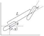
对于本发明,首先车辆运动是一个二维平面运动,即车辆不存在或者不考虑垂直方向的运动;其次本发明针对的车辆是普通的前轮转向车辆,且左右车轮具有相同的转速和转向角ω;同时车辆是一个刚体;另外本发明所研究的城市十字路口场景是一个较低速的场景,车辆的行驶速度不存在剧烈地变化,故可以忽略前后轴载荷的转移。因此,本发明的场景符合自行车模型的要求。For the present invention, firstly, the vehicle motion is a two-dimensional plane motion, that is, the vehicle does not exist or does not consider vertical motion; secondly, the vehicle targeted by the present invention is an ordinary front-wheel steering vehicle, and the left and right wheels have the same rotational speed and steering angle ω; At the same time, the vehicle is a rigid body; in addition, the urban intersection scene studied in the present invention is a low-speed scene, and the driving speed of the vehicle does not change drastically, so the transfer of the front and rear axle loads can be ignored. Therefore, the scene of the present invention meets the requirements of the bicycle model.
车辆的自行车模型如图1-2,动力学方程如下:The bicycle model of the vehicle is shown in Figure 1-2, and the dynamic equation is as follows:

其中,车辆后轴中心的坐标为(x,y),车辆在当前时刻的朝向θ(heading),转向角ω,车辆对应路径点上的曲率κ。
基于此自行车模型,在某个时刻的输入车辆的转向角和加速度(ω,a)后,可以估算车辆在下一个时刻的状态(x,y,θ,v)(空间坐标、车辆朝向、速度)。由于转向角ω很难直接通过车辆轨迹得到,所以用在当前时刻车辆对应轨迹的路径点上的曲率κ(可以通过车辆的轨迹方程得到)来代替转向角ω,从而表示车辆的转向趋势。Based on this bicycle model, after inputting the steering angle and acceleration (ω, a) of the vehicle at a certain moment, the state (x, y, θ, v) of the vehicle at the next moment can be estimated (space coordinates, vehicle orientation, speed) . Since it is difficult to obtain the steering angle ω directly from the vehicle trajectory, the curvature κ (which can be obtained from the vehicle's trajectory equation) at the waypoint of the vehicle's corresponding trajectory at the current moment is used to replace the steering angle ω to represent the vehicle's steering trend.
综上所述,当得到车辆在当前时刻的状态量(x,y,θ,v)和车辆在当前时刻和未来时刻的连续输入量(κ,a)时,就可以计算得到车辆未来时刻的连续状态量,进而完成车辆的行驶控制。To sum up, when the state quantity (x, y, θ, v) of the vehicle at the current moment and the continuous input quantity (κ, a) of the vehicle at the current moment and the future moment are obtained, the future moment of the vehicle can be calculated. Continuous state quantity, and then complete the driving control of the vehicle.
3.车辆轨迹模型3. Vehicle Trajectory Model
车辆轨迹具有以下特点:Vehicle trajectories have the following characteristics:
(1)车辆的轨迹是一个三维曲线。考虑到整个十字路口存在着动态障碍物且车辆的感知范围有限,因此车辆感知范围内的环境是运动的、时变的。所以车辆的行驶轨迹不单单只考虑二维空间维度的路径,还需要增加考虑时间维度。增加了时间维度后,可以得到车辆在不同时间点时的位置,同时可以以此得到车辆的速度特征。因此车辆的轨迹是一个包括二维空间维度和时间维度的三维曲线。(1) The trajectory of the vehicle is a three-dimensional curve. Considering that there are dynamic obstacles in the entire intersection and the vehicle's perception range is limited, the environment within the vehicle's perception range is moving and time-varying. Therefore, the driving trajectory of the vehicle not only considers the path of the two-dimensional space dimension, but also needs to consider the time dimension. After adding the time dimension, the position of the vehicle at different time points can be obtained, and the speed characteristics of the vehicle can be obtained from this. Therefore, the trajectory of the vehicle is a three-dimensional curve including two-dimensional space dimension and time dimension.
(2)车辆轨迹可以拆分为路径、速度两个问题进行研究。直接对三维曲线进行规划通常是复杂的,所以在解决车辆的规划问题的时候,通常会对问题进行拆分从而达到降维的目的。对于三维车辆轨迹,本发明选择将三维规划问题简化为路径、速度两个二维问题进行研究。路径指的是在二维平面空间中一条车辆可行的曲线,在实际车辆行驶的时候,车辆的后轴中心沿着路径行驶;速度问题研究是车辆延路径行驶的距离与时间的关系,在实际车辆行驶的时候,可以得到车辆在每个时间点所行驶的距离。通过决策规划可以分别求得可行的路径曲线和速度曲线,将两者相结合可以得到车辆的轨迹。(2) The vehicle trajectory can be divided into two problems of path and speed for research. It is usually complicated to directly plan three-dimensional curves, so when solving the planning problem of vehicles, the problem is usually divided to achieve the purpose of dimensionality reduction. For the three-dimensional vehicle trajectory, the present invention chooses to simplify the three-dimensional planning problem into two two-dimensional problems of path and speed for research. The path refers to a feasible curve of a vehicle in two-dimensional plane space. When the actual vehicle is driving, the center of the rear axle of the vehicle travels along the path; the research on the speed problem is the relationship between the distance and time the vehicle travels along the path. When the vehicle is driving, the distance traveled by the vehicle at each time point can be obtained. The feasible path curve and speed curve can be obtained separately through decision planning, and the trajectory of the vehicle can be obtained by combining the two.
(3)一条可行的车辆轨迹需要满足车辆的动力学要求。本发明采用的是自行车模型。对于自行车模型,轨迹需要满足:由于车辆的朝向θ、转向角ω(可以等价为曲率κ)、速度v、加速度a的变化是连续的,不可能出现阶跃的情况,所以需要路径曲线、速度曲线和它的一阶导数、二阶导数连续。因此在代价搜索的时候,代价函数需要考虑导数的连续性,此要求在本发明最小化舒适性代价的时候被满足。(3) A feasible vehicle trajectory needs to meet the dynamic requirements of the vehicle. The present invention adopts a bicycle model. For the bicycle model, the trajectory needs to meet: Since the changes of the vehicle's orientation θ, steering angle ω (which can be equivalent to curvature κ), speed v, and acceleration a are continuous, it is impossible to have a step situation, so the path curve, The velocity curve and its first derivative and second derivative are continuous. Therefore, during the cost search, the cost function needs to consider the continuity of the derivative, which is satisfied when the present invention minimizes the comfort cost.
(4)函数优化法求解可行轨迹原理是:将轨迹用多个函数来表示,求解对于目标函数最优的多个函数的表达式,即为最佳的轨迹。本发明对于目标函数的设定主要考虑轨迹舒适性、偏移量和碰撞避免。(4) The principle of solving feasible trajectory by function optimization method is as follows: the trajectory is represented by multiple functions, and the optimal trajectory is obtained by solving the expressions of multiple functions that are optimal for the objective function. The present invention mainly considers trajectory comfort, offset and collision avoidance for the setting of the objective function.
三维笛卡尔坐标系(XYT)下的车辆轨迹模型:Vehicle trajectory model in 3D Cartesian coordinate system (XYT):
本发明对于无障碍物场景的决策规划采用的是三维笛卡尔坐标系。在此坐标系下,除了出了原本需要考虑的平面坐标XY,还需要增加考虑时间维度T,所以此坐标系包括XYT三个维度。The present invention adopts a three-dimensional Cartesian coordinate system for the decision-making planning of the obstacle-free scene. In this coordinate system, in addition to the plane coordinates XY that need to be considered originally, the time dimension T also needs to be considered, so this coordinate system includes three dimensions of XYT.
本发明采用的基于函数优化的决策规划方法,需要将轨迹抽象成函数。由于在XYT坐标系下,X坐标、Y坐标、T坐标都是变化的,所以需要用三个函数来抽象轨迹:对于路径,用x=f(s),y=g(s)来表示;对于速度,用s=u(t)来表示。其中s为车辆沿着路径行驶的弧长。The decision planning method based on function optimization adopted in the present invention needs to abstract the trajectory into a function. Since in the XYT coordinate system, the X coordinate, the Y coordinate, and the T coordinate all change, three functions are needed to abstract the trajectory: for the path, it is represented by x=f(s), y=g(s); For speed, it is represented by s=u(t). where s is the arc length that the vehicle travels along the path.
故三维笛卡尔坐标系下的车辆轨迹模型为:Therefore, the vehicle trajectory model in the three-dimensional Cartesian coordinate system is:

Speed:s=u(t)Speed:s=u(t)
因此车辆除空间坐标(x,y)外的其他状态量和输入量都可以由这三个轨迹函数经过运算得到:Therefore, other state quantities and input quantities of the vehicle except the space coordinates (x, y) can be obtained by the operation of these three trajectory functions:


综上所述,在三维笛卡尔坐标系下,给定x=f(s),y=g(s),s=u(t)三个轨迹函数,就可以表达在任意时刻车辆的状态量和输入量,从而控制车辆沿着轨迹运动。To sum up, in the three-dimensional Cartesian coordinate system, given the three trajectory functions of x=f(s), y=g(s), and s=u(t), the state quantity of the vehicle at any time can be expressed and input quantities to control the movement of the vehicle along the trajectory.
三维Frenet坐标系(SLT)下的车辆轨迹模型:Vehicle trajectory model in 3D Frenet coordinate system (SLT):
本发明对于障碍物场景的决策规划采用的是三维Frenet坐标系。此坐标系包括SLT 三个维度。The present invention adopts the three-dimensional Frenet coordinate system for the decision planning of the obstacle scene. This coordinate system includes three dimensions of the SLT.
此坐标的特点是通过一条参考路径降低了描述路径的函数数量。Frenet坐标系中,需要以一条参考路径(本文用的是无障碍物路径)为基础,车辆沿该路径的纵向行驶距离为S坐标,车辆偏离该路径的横向距离为L坐标,从而用SL这两个维度来表示平面空间。由于车辆是不断沿着参考路径向前行驶的(不考虑倒车或者逆行),所以车辆的横向位移l是随着纵向位移s的变化而变化的,只需要用一个函数l=p(s)就可以抽象平面空间的路径。同时在三维Frenet坐标系下,需要增加考虑时间维度,用s=u(t)来描述车辆的速度特征。The feature of this coordinate is that it reduces the number of functions that describe the path through a reference path. In the Frenet coordinate system, it needs to be based on a reference path (the path without obstacles is used in this article), the longitudinal travel distance of the vehicle along the path is the S coordinate, and the lateral distance of the vehicle deviating from the path is the L coordinate, so that the SL Two dimensions to represent the plane space. Since the vehicle is continuously driving forward along the reference path (regardless of reversing or reverse driving), the lateral displacement l of the vehicle changes with the change of the longitudinal displacement s, and only a function l=p(s) is needed to Paths that can abstract flat space. At the same time, in the three-dimensional Frenet coordinate system, the time dimension needs to be considered, and s=u(t) is used to describe the speed characteristics of the vehicle.
故三维Frenet坐标系下的车辆轨迹模型为:Therefore, the vehicle trajectory model in the three-dimensional Frenet coordinate system is:
Path:l=p(s)Path:l=p(s)
Speed:s=u(t)Speed:s=u(t)
车辆状态量、输入量与三维Frenet坐标系下轨迹函数的映射关系如下:The mapping relationship between the vehicle state quantity, the input quantity and the trajectory function in the three-dimensional Frenet coordinate system is as follows:

综上所述,在三维Frenet坐标系下,给定参考路径线(无障碍物路径)和l=p(s),s=u(t)两个轨迹函数,就可以表达在任意时刻车辆的状态量和输入量,从而控制车辆沿着轨迹运动。To sum up, in the three-dimensional Frenet coordinate system, given the reference path line (the path without obstacles) and the two trajectory functions l=p(s), s=u(t), the vehicle's trajectory at any time can be expressed. state quantities and input quantities, thereby controlling the movement of the vehicle along the trajectory.
4.障碍物模型4. Obstacle model
十字路口场景中,存在静态、动态障碍物。静态障碍物指的是在规划时间范围内状态量不随着时间的变化而变化的障碍物,比如乱停放的车辆、三角警示牌、施工区域等;动态障碍物是在规划时间范围内状态量随着时间的变化而变化的障碍物,比如环境中其他的行驶车辆、运动的行人、运动的自行车等。所以需要合理的设置障碍物模型以及决策规划中的代价函数,使得形式车辆可以避开障碍物。In the intersection scene, there are static and dynamic obstacles. Static obstacles refer to obstacles whose state quantities do not change with time within the planned time range, such as randomly parked vehicles, warning triangles, construction areas, etc.; dynamic obstacles are obstacles whose state quantities change with time within the planned time range. Obstacles that change with time, such as other vehicles in the environment, moving pedestrians, moving bicycles, etc. Therefore, it is necessary to reasonably set the obstacle model and the cost function in the decision planning, so that the formal vehicle can avoid the obstacle.
假定所有的障碍物为凸多边形的行驶,车载传感器通过感知模块可以获得凸多边形各个顶点的坐标。Assuming that all obstacles are convex polygons, the vehicle-mounted sensor can obtain the coordinates of each vertex of the convex polygon through the perception module.
对于静态障碍物,需要将障碍物以bounding box的形式表示为一个矩形区域。如图 1-3,静态障碍物的状态可以由以下参数表示:For static obstacles, the obstacle needs to be represented as a rectangular area in the form of a bounding box. As shown in Figure 1-3, the state of a static obstacle can be represented by the following parameters:
(1)障碍物中心点的坐标(xob,yob)。该坐标可以由凸多边形各个顶点的坐标经过计算得到。(1) The coordinates of the center point of the obstacle (xob , yob ). The coordinates can be calculated from the coordinates of each vertex of the convex polygon.
xob=[min(x1,x2,...,xn)+max(x1,x2,...,xn)]/2xob =[min(x1 ,x2 ,...,xn )+max(x1 ,x2 ,...,xn )]/2
yob=[min(y1,y2,...,yn)+max(y1,y2,...,yn)]/2yob =[min(y1 ,y2 ,...,yn )+max(y1 ,y2 ,...,yn )]/2
其中n为凸多边形的顶点数。where n is the number of vertices of the convex polygon.
(2)矩形区域的长、宽(ρ,w)。(2) The length and width (ρ, w) of the rectangular area.
(3)矩形区域的朝向θob(heading)。(3) The orientation of the rectangular area θob (heading).
所以静态障碍物的状态可以由一个5维向量来表示(xob,yob,ρ,w,θob)。So the state of a static obstacle can be represented by a 5-dimensional vector (xob , yob , ρ, w, θob ).
对于动态障碍物,其状态不能只用当前时刻的状态来表示,需要包括未来时刻预测的状态。所以通过车辆的预测模块获得动态障碍物的预测轨迹并将其离散化,得到动态障碍物的状态量{(xob,i,yob,i,ρi,wi,θob,i,ti)|i=0,1,...,m},其中t0为当前时刻,t1~tm为未来时刻。For a dynamic obstacle, its state cannot be represented only by the state at the current moment, but needs to include the state predicted at the future moment. Therefore, the predicted trajectory of the dynamic obstacle is obtained through the prediction module of the vehicle and discretized to obtain the state quantity of the dynamic obstacle {(xob,i ,yob,i ,ρi ,wi ,θob,i ,ti )|i=0,1,...,m}, where t0 is the current moment, and t1 to tm are the future moments.
5.决策规划模型5. Decision Planning Model
决策规划的目标是在存在静态、动态障碍物的十字路口环境下,在车辆感知范围有限的前提下,求解从起始点到终止点的最优的可行平滑轨迹。The goal of decision planning is to solve the optimal feasible smooth trajectory from the starting point to the ending point under the premise of limited vehicle perception range in the intersection environment with static and dynamic obstacles.
由于十字路口环境的特殊特点(无法确定道路中心线),所以在决策规划方案中考虑将问题拆分成两个场景分步解决:无障碍物十字路口场景和障碍物十字路口场景,如图1-4a,1-4b。Due to the special characteristics of the intersection environment (the road centerline cannot be determined), in the decision planning scheme, the problem is considered to be divided into two scenarios to solve step by step: the obstacle-free intersection scene and the obstacle intersection scene, as shown in Figure 1 -4a, 1-4b.
建立无障碍物十字路口场景的原因是:需要以三维笛卡尔坐标系下得到的平滑无障碍物可行路径作为参考路径建立起三维Frenet框架,用于障碍物场景;平滑的无障碍物轨迹将作为基础轨迹,在遇到障碍物时,基于该轨迹进行优化修正。The reason for establishing the obstacle-free intersection scene is: It is necessary to use the smooth and obstacle-free feasible path obtained in the three-dimensional Cartesian coordinate system as the reference path to establish a three-dimensional Frenet frame for the obstacle scene; the smooth obstacle-free trajectory will be used as the reference path. The basic trajectory, when encountering obstacles, optimize and correct based on this trajectory.
因此决策规划方案的原理如下:Therefore, the principle of the decision planning scheme is as follows:
(1)首先在无障碍物场景下通过高精度地图得到一条最优的可行平滑轨迹,称为无障碍物轨迹,并依据无障碍物路径建立Frenet坐标系。(1) First, an optimal feasible smooth trajectory is obtained through a high-precision map in an obstacle-free scene, which is called an obstacle-free trajectory, and a Frenet coordinate system is established according to the obstacle-free path.
(2)通过车辆上的其他感知模块(摄像头、激光雷达等)对于环境中可能存在的障碍物进行部分感知,利用此感知信息在三维Frenet坐标系下对于无障碍物轨迹进行迭代修正,得到真正行驶的轨迹。(2) Partially perceive obstacles that may exist in the environment through other perception modules (cameras, lidars, etc.) on the vehicle, and use this perception information to iteratively correct the obstacle-free trajectory in the three-dimensional Frenet coordinate system. driving trajectory.
二.无障碍十字路口场景决策规划方案2. Decision-making planning scheme for barrier-free intersection scenarios
无障碍物十字路口场景是指在十字路口中不存在静态或者动态障碍物,车辆仅仅通过高精度地图获得外部的道路环境信息。无障碍物轨迹是在无障碍物场景中,给车辆的一条可行的平滑的行驶轨迹。该轨迹的坐标系采用的是三维笛卡尔坐标系(XYT),所以可以用两条路径函数x=f(s),y=g(s),一条速度函数s=u(t)来表达该轨迹。The obstacle-free intersection scene means that there are no static or dynamic obstacles at the intersection, and the vehicle only obtains the external road environment information through the high-precision map. The obstacle-free trajectory is a feasible and smooth driving trajectory for the vehicle in the obstacle-free scene. The coordinate system of the trajectory is a three-dimensional Cartesian coordinate system (XYT), so two path functions x=f(s), y=g(s) and a velocity function s=u(t) can be used to express the trajectory.
在一般场景中,无人车在无障碍物时候的行驶路径是道路的中心线(通过识别两侧的车道线来确定道路的中心线),行驶速度是参考速度。但在十字路口场景中,由于在十字路口中心不存在车道线,同时行驶策略存在多样性(直行、左转、右转、掉头),所以需要运用合理的决策规划方法来适应此特殊的环境特点。In a general scenario, the driving path of the unmanned vehicle when there are no obstacles is the centerline of the road (the centerline of the road is determined by identifying the lane lines on both sides), and the driving speed is the reference speed. However, in the intersection scene, since there is no lane line in the center of the intersection, and there are various driving strategies (go straight, turn left, turn right, U-turn), it is necessary to use a reasonable decision-making planning method to adapt to this special environment. .
如图2-1,方法如下:As shown in Figure 2-1, the method is as follows:
步骤1:通过目的地的位置,可以确定车辆的行驶策略,是直行、左转、右转还是掉头。根据车辆的行驶策略,通过高精度地图上提供的车辆定位和道路信息,生成相应的标准路径。Step 1: Through the location of the destination, the driving strategy of the vehicle can be determined, whether to go straight, turn left, turn right or turn around. According to the driving strategy of the vehicle, the corresponding standard path is generated through the vehicle positioning and road information provided on the high-precision map.
步骤2:对不满足动力学约束的标准路径利用平滑优化在其附近搜索出一条最优的可行平滑路径。Step 2: Use smooth optimization to search for an optimal feasible smooth path near the standard path that does not satisfy the dynamic constraints.
步骤3:由于环境中不存在障碍物,具有时不变性,车辆的行驶速度恒定为标准速度,即u′=Vsta。将最优的可行平滑路径与标准速度结合,得到无障碍物可行轨迹。Step 3: Since there is no obstacle in the environment and it is time-invariant, the running speed of the vehicle is constant at the standard speed, that is, u′=Vsta . The optimal feasible smooth path is combined with the standard speed to obtain a feasible trajectory without obstacles.
标准路径是最直观、最容易生成的线圆式车辆路径。对于标准路径,转弯采用Dubins曲线的思想,沿着圆弧转弯。所以在十字路口场景下,标准路径是由线段、圆弧和切线构成,如图2-2所示。但是该路径并不一定满足本发明所采用的车辆自行车模型对于曲率连续性的要求(直行策略标准路径的曲率恒为0,满足曲率连续;左转、右转、掉头策略标准路径的曲率均存在阶跃,不满足要求),故对于这些曲率不连续的情况,需要进行平滑优化。Standard paths are the most intuitive and easiest to generate line-circle vehicle paths. For standard paths, turns take the idea of a Dubins curve, making turns along an arc. Therefore, in the intersection scene, the standard path is composed of line segments, arcs and tangents, as shown in Figure 2-2. However, this path does not necessarily meet the requirements of the vehicle and bicycle model used in the present invention for curvature continuity (the curvature of the standard path of the straight-forward strategy is always 0, which satisfies the curvature continuity; the curvature of the standard path of the left-turn, right-turn, and U-turn strategy all exist step, does not meet the requirements), so for these cases of discontinuous curvature, smooth optimization is required.
平滑优化的原理是在标准路径附近搜索出一条最优的可行平滑路径,即找到对于代价而言最优的x=f(s),y=g(s)。由于场景中不存在障碍物,所以整个搜索空间为凸的,可以采用二次规划的优化方案进行平滑优化。如图2-3。The principle of smooth optimization is to search for an optimal feasible smooth path near the standard path, that is, to find the optimal x=f(s), y=g(s) for the cost. Since there are no obstacles in the scene, the entire search space is convex, and the optimization scheme of quadratic programming can be used for smooth optimization. Figure 2-3.
二次规划的优化方案搜索的先决条件是确定路径参数化方式、确定代价函数、确定线性约束,然后利用二次规划快速收敛到最优的可行平滑路径。The prerequisites for the optimization scheme search of quadratic programming are to determine the path parameterization method, determine the cost function, determine the linear constraints, and then use the quadratic programming to quickly converge to the optimal feasible smooth path.
1.路径参数化:1. Path parameterization:
由于连续空间中的路径具有很高的复杂性,直接进行优化很困难且计算量较大。故考虑将路径参数化,用分段高阶多项式来表示路径,这样路径搜索问题就可以简化为对于高阶多项式系数的搜索。分段的原因是为了避免使用单一多项式造成的龙格效应,避免车辆连续转向造成的舒适度下降。Due to the high complexity of paths in continuous space, direct optimization is difficult and computationally expensive. Therefore, it is considered to parameterize the path and use a piecewise high-order polynomial to represent the path, so that the path search problem can be simplified to the search for the coefficients of the high-order polynomial. The reason for the segmentation is to avoid the Runge effect caused by the use of a single polynomial and to avoid the reduction in comfort caused by the continuous steering of the vehicle.
在该场景中,需要对笛卡尔坐标系下的路径进行参数化。由于笛卡尔空间中的路径需要用两个函数来表示,所以采用二维的分段高阶多项式(5阶)来参数化路径。参数化的实现方式:首先以一个较大的间隔ds对于路径的总弧长进行分割,得到n1+1个节点{si|i=0,1,...,n1};然后将每两个节点之间的路径用二维5阶多项式来表示:In this scenario, the path in the Cartesian coordinate system needs to be parameterized. Since a path in Cartesian space needs to be represented by two functions, a two-dimensional piecewise high-order polynomial (5th order) is used to parameterize the path. The parameterization implementation method: firstly divide the total arc length of the path with a large interval ds to obtain n1 +1 nodes {si |i=0,1,...,n1 }; then The path between every two nodes is represented by a two-dimensional 5th order polynomial:

其中s为车辆沿路径行驶的弧长;

路径参数化后,优化问题转化为对于分段高阶多项式系数取值的搜索,即对于最优的系数矩阵
2.代价函数:2. Cost function:
二次规划需要根据场景的要求和关注的指标,设定一个合理的目标函数(代价函数),使得搜索出来的路径满足需求。对于无障碍物十字路口场景,采用的是舒适性代价,目的是:(1)使得搜索出来的轨迹满足车辆的动力学要求,即车辆的朝向θ、路径的曲率κ连续;(2)搜索出来的路径尽可能的平滑,从而降低车辆转向的速度和频率,提升乘客的舒适感。Quadratic programming needs to set a reasonable objective function (cost function) according to the requirements of the scene and the indicators of concern, so that the searched path meets the requirements. For the obstacle-free intersection scene, the comfort cost is adopted, the purpose is to: (1) Make the searched trajectory meet the dynamic requirements of the vehicle, that is, the vehicle’s orientation θ and the path’s curvature κ are continuous; (2) Search out The path is as smooth as possible, thereby reducing the speed and frequency of vehicle steering and improving passenger comfort.
车辆朝向θ与路径曲线一阶导有关;路径曲率κ与路径曲线的二阶导有关。所以舒适性代价需要考虑最小化曲线的二阶导数、三阶导数平方的积分。最小化二阶导数平方的积分满足了车辆朝向θ的连续性,同时尽可能地使车辆朝向的变化更加缓慢;最小化三阶导数平方的积分满足了路径曲率κ的连续性,同时尽可能地使车辆路径的曲率变化更加缓慢,即等价于转向角ω的变化更加缓慢。The vehicle orientation θ is related to the first derivative of the path curve; the path curvature κ is related to the second derivative of the path curve. Therefore, the comfort cost needs to consider the integral of the second derivative and the square of the third derivative of the minimization curve. Minimizing the integral of the square of the second derivative satisfies the continuity of the vehicle orientation θ, while making the change of the vehicle orientation as slow as possible; minimizing the integral of the square of the third derivative satisfies the continuity of the path curvature κ, and at the same time as possible as possible. Make the curvature of the vehicle path change more slowly, which is equivalent to the change of the steering angle ω more slowly.
因此,舒适性代价是两条路径函数不同阶导数的线性加权和,表示如下:Therefore, the comfort cost is a linearly weighted sum of different order derivatives of the two path functions, expressed as:
Costsmooth,path=ws1∫(f″)2(s)+ws2∫(f″′)2(s)+ws3∫(g″)2(s)+ws4∫(g″′)2(s)。Costsmooth,path =ws1 ∫(f″)2 (s)+ws2 ∫(f″′)2 (s)+ws3 ∫(g″)2 (s)+ws4 ∫(g″′)2 (s).
3、线性约束3. Linear constraints
平滑优化的线性约束包括三个部分,搜索空间约束、节点约束、车辆自身约束。The linear constraints of smooth optimization include three parts, search space constraints, node constraints, and vehicle self constraints.
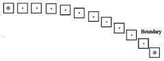
搜索空间约束的目的是将搜索范围限制在标准路径的附近,目的是限制搜索区域以防出现搜索区域违反交通规则的情况(压双黄线、行驶出可行道路范围等),同时不让优化得到的路径距离标准路径过远。实现方法是:首先以一个较小的间隔ds′对标准路径进行采样(ds′<ds),得到n2+1个采样点{sj|j=0,1,...,n2},并通过sj的采样值在标准路径上得到{(xj,yj)|j=0,1,...,n2},如图2-4a,然后在采样点附近框定一个范围,将搜索区域限定在以采样点为中心,边长为boundary的正方形中,如图2-4b。搜索空间约束表达式如下:The purpose of the search space constraint is to limit the search range to the vicinity of the standard path, the purpose is to limit the search area to prevent the search area from violating traffic rules (pressing double yellow lines, driving out of the feasible road range, etc.), and at the same time not allowing the optimization to get The path is too far from the standard path. The implementation method is: firstly sample the standard path with a small interval ds'(ds'<ds) to obtain n2 +1 sampling points {sj |j=0,1,...,n2 } , and obtain {(xj ,yj )|j=0,1,...,n2 } on the standard path through the sampling value of sj , as shown in Figure 2-4a, and then frame a range near the sampling point , the search area is limited to a square with the sampling point as the center and the side length as boundary, as shown in Figure 2-4b. The search space constraint expression is as follows:

节点约束包括两个部分,连接处约束和起始终止点约束。连接处约束的目的是保证分段高阶多项式在不同段的连接处也足够的平滑,所以需要在多项式段的连接点处保证左右两段多项式的取值相等且一阶导数、二阶导数、三阶导数相等。起始终止点约束的目的是保证车辆在起始点处的车辆位置和朝向满足初始和终止条件。节点约束表达式如表2-1所示:The node constraint consists of two parts, the connection constraint and the start-to-end constraint. The purpose of the connection constraint is to ensure that the piecewise high-order polynomial is smooth enough at the connection of different segments, so it is necessary to ensure that the values of the left and right polynomials are equal at the connection point of the polynomial segment and the first-order, second-order, and third-order derivatives are equal. Derivatives are equal. The purpose of the start and end point constraints is to ensure that the vehicle position and orientation of the vehicle at the start point satisfy the initial and end conditions. The node constraint expressions are shown in Table 2-1:
表2-1节点约束表达式Table 2-1 Node constraint expressions


车辆的自身约束是由于车辆自身机械结构的限制而导致的约束。对于路径的平滑优化而言,由于车辆的方向盘存在转向范围的约束和转向灵敏度的约束,所以需要将车辆曲率和曲率变化速度约束在一个范围内,该范围的边界由车辆本身的机械结构决定。The vehicle's own constraints are constraints caused by the limitations of the vehicle's own mechanical structure. For the smooth optimization of the path, since the steering wheel of the vehicle has the constraints of the steering range and the steering sensitivity, it is necessary to constrain the curvature of the vehicle and the rate of curvature change within a range, and the boundary of the range is determined by the mechanical structure of the vehicle itself.
4、二次规划搜索4. Secondary planning search
通过推导可以证明,代价函数满足QP的形式。同时所有约束皆为线性约束。故问题可以转换为如下的二次规划形式:It can be proved by derivation that the cost function satisfies the form of QP. At the same time all constraints are linear constraints. Therefore, the problem can be transformed into the following quadratic programming form:

其中,

其中i=0,1,...,n1-1,s(z)表示高阶多项式矩阵的z阶导数:where i=0,1,...,n1 -1, s(z) represents the z-order derivative of a higher-order polynomial matrix:

因此可以用二次规划来求解规划问题,可以得到二维分段高阶多项式的最优系数
无障碍物场景的仿真以及评价指标分析:Simulation of obstacle-free scenes and analysis of evaluation indicators:
由于无障碍物场景是时不变的,速度为标准速度(恒定值),所以评价指标只需要考虑路径的舒适性。无障碍物场景下的路径舒适性指标:为满足车内乘客的舒适感,车辆要尽可能的缓慢转向,避免急转,从而提升路径曲线的平滑度。所以对于路径函数 x=f(s)和y=g(s)舒适性指标需要考虑的是两者不同阶导数平方积分的加权和:Since the obstacle-free scene is time-invariant and the speed is the standard speed (constant value), the evaluation index only needs to consider the comfort of the path. Path comfort index in a scenario without obstacles: In order to meet the comfort of passengers in the car, the vehicle should turn as slowly as possible to avoid sharp turns, thereby improving the smoothness of the path curve. So for the path function x=f(s) and y=g(s) comfort index, what needs to be considered is the weighted sum of the square integrals of the two derivatives of different orders:
Epath,comfort=ws1∫(f″)2(s)+ws2∫(f″′)2(s)+ws3∫(g″)2(s)+ws4∫(g″′)2(s)Epath,comfort =ws1 ∫(f″)2 (s)+ws2 ∫(f″′)2 (s)+ws3 ∫(g″)2 (s)+ws4 ∫(g″′)2 (s)
路径舒适性指标的值越小表示车辆的转向越缓慢,路径曲线越平滑,车内乘客的舒适感越高;反之路径舒适性指标的值越高表示车辆的转向越频繁、越急促,会降低车内乘客的舒适感The smaller the value of the path comfort index is, the slower the steering of the vehicle, the smoother the path curve, and the higher the comfort of the passengers in the car; on the contrary, the higher the value of the path comfort index, the more frequent and abrupt the vehicle turns, which will decrease Passenger comfort
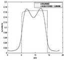
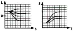
图2-5abc分别为无障碍物十字路口场景中左转、右转和掉头策略的路径曲线。三幅图中的黑色虚线分别为三种行驶策略的标准路径,三幅图中的黑色实线分别为三种行驶策略优化后的无障碍物最优可行路径。通过对比可以看出,经过平滑优化后的路径在十字路口缓冲区域和中心区域之间的转向连接处更加平滑;从整体上来看,相较于标准路径的急转,最优可行路径的转向更加缓慢,有助于乘客舒适感的提升。Figure 2-5abc shows the path curves of the left-turn, right-turn and U-turn strategies in the obstacle-free intersection scene. The black dotted lines in the three figures are the standard paths of the three driving strategies, and the solid black lines in the three figures are the optimal feasible paths without obstacles after the optimization of the three driving strategies. By comparison, it can be seen that the route after smooth optimization is smoother at the turning connection between the buffer area and the central area of the intersection; on the whole, compared with the sharp turn of the standard route, the steering of the optimal feasible route is more smooth. Slow, which contributes to the improvement of passenger comfort.
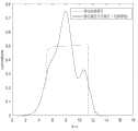
图2-6abc分别为无障碍物十字路口场景中左转、右转和掉头策略的车辆朝向θ变化曲线。三幅图中的黑色虚线分别为三种行驶策略标准路径的车辆朝向θ变化曲线,三幅图中的黑色实线分别为三种行驶策略优化后无障碍物最优可行路径的车辆朝向θ变化曲线。通过对比可以看出,标准路径中车辆朝向是曲折变化的,经过平滑优化后路径的车辆朝向曲线变得更加平滑,这表明优化后车辆朝向的变化更加缓慢,提升了舒适感。Figure 2-6abc is the change curve of the vehicle orientation θ for the left-turn, right-turn and U-turn strategies in the obstacle-free intersection scene. The black dotted lines in the three figures are the change curves of the vehicle orientation θ of the standard paths of the three driving strategies, and the black solid lines in the three figures are the vehicle orientation θ changes of the optimal feasible path without obstacles after the optimization of the three driving strategies. curve. From the comparison, it can be seen that the vehicle orientation in the standard path changes tortuously, and the vehicle orientation curve of the path after smooth optimization becomes smoother, which indicates that the optimized vehicle orientation changes more slowly and improves comfort.
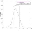
图2-7abc分别为无障碍物十字路口场景中左转、右转和掉头策略的路径曲率κ变化曲线。三幅图中的黑色虚线分别为三种行驶策略标准路径的曲率κ变化曲线,三幅图中的黑色实线分别为三种行驶策略优化后无障碍物最优可行路径的曲率κ变化曲线。通过对比可以看出,标准路径的曲率是阶跃的、不连续的,在十字路口缓冲区域和中心区域之间的转向连接处会存在突变;经过优化后的路径曲率曲线变得连续且平滑,不仅使得路径满足了车辆的动力学要求,是可行的,同时也提升了路径的舒适度。Figure 2-7abc shows the change curves of the path curvature κ of the left turn, right turn and U-turn strategies in the obstacle-free intersection scene. The black dotted lines in the three figures are the curvature κ change curves of the standard paths of the three driving strategies, respectively, and the black solid lines in the three figures are the curvature κ change curves of the optimal feasible path without obstacles after the optimization of the three driving strategies. By comparison, it can be seen that the curvature of the standard path is stepwise and discontinuous, and there will be a sudden change at the turning connection between the buffer area and the central area of the intersection; the optimized path curvature curve becomes continuous and smooth, It not only makes the path meet the dynamic requirements of the vehicle and is feasible, but also improves the comfort of the path.
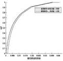
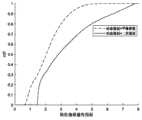
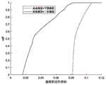
图2-8abc分别为无障碍物十字路口场景中左转、右转和掉头策略的路径舒适性指标。本实验采用两种方法进行对比,第一种方法对标准路径进行降采样,然后用平滑曲线(这里采用的是Spline曲线)进行插值,这是简单且普遍运用的方法;第二种方法是本发明利用标准路径进行二次规划的方法。利用车辆起始点的随机性,进行循环的仿真实验,得到图2-8abc所示路径舒适性指标的累计分布函数(CDF)。三幅图中的黑色虚线分别为三种行驶策略采用第一种决策规划方法(标准路径+插值曲线)的路径舒适性指标的CDF;三幅图中的黑色实线分别为三种行驶策略采用第二种决策规划方法(标准路径+二次规划)的路径舒适性指标的CDF。通过对比可以看出,本发明采用的方法有效地降低了路径舒适性指标的值,即提高了车内乘客的舒适度。Figure 2-8abc is the path comfort index of the left-turn, right-turn and U-turn strategies in the obstacle-free intersection scene. In this experiment, two methods are used for comparison. The first method downsamples the standard path, and then uses a smooth curve (here, the Spline curve is used) for interpolation, which is a simple and commonly used method; the second method is this method. A method for quadratic planning using standard paths is invented. Using the randomness of the starting point of the vehicle, a cyclic simulation experiment is carried out, and the cumulative distribution function (CDF) of the path comfort index shown in Figure 2-8abc is obtained. The black dotted lines in the three figures are the CDFs of the path comfort index of the first decision planning method (standard route + interpolation curve) for the three driving strategies; the black solid lines in the three figures are the three driving strategies adopted respectively. The CDF of the path comfort index of the second decision planning method (standard path + quadratic planning). It can be seen from the comparison that the method adopted in the present invention effectively reduces the value of the path comfort index, that is, improves the comfort of the passengers in the vehicle.
表2-2无障碍物场景中两种决策规划方法路径舒适性指标的均值对比Table 2-2 Comparison of the mean values of the path comfort indexes of the two decision planning methods in the obstacle-free scene

表2-2为无障碍物场景中两种决策规划方法路径舒适性指标的均值对比。从表中可以看出,本发明采用的第二种方法(标准路径+二次规划)相较于第一种(标准路径+插值曲线)而言,降低了路径舒适性指标的均值。由于路径舒适性指标的值与乘客舒适度是成反比的关系,所以可以计算第二种方法相较于第一种方法的路径舒适度提升率:Table 2-2 shows the mean comparison of the path comfort indexes of the two decision planning methods in the obstacle-free scene. It can be seen from the table that the second method (standard path + quadratic programming) adopted in the present invention reduces the mean value of the path comfort index compared with the first method (standard path + interpolation curve). Since the value of the path comfort index is inversely proportional to the passenger comfort, the path comfort improvement rate of the second method compared to the first method can be calculated:

由此可得,对于左转、右转、掉头策略,本发明采用的标准路径+二次规划方法的路径舒适度提升率分别为10.97%,13.10%,18.80%。因此该方法一定程度上提升了车内乘客的乘车体验感。It can be seen that, for the strategy of turning left, turning right, and U-turn, the improvement rates of the path comfort of the standard path + quadratic planning method adopted by the present invention are 10.97%, 13.10%, and 18.80%, respectively. Therefore, this method improves the ride experience of passengers in the vehicle to a certain extent.
三.障碍物十字路口场景决策规划方案3. Decision planning scheme for obstacle intersection scene
障碍物场景是指在十字路口环境下存在静态障碍物和动态障碍物。静态障碍物的状态量是时不变的;动态障碍物的状态量包括当前时刻的状态和未来时刻的预测状态,是时变的。为此,障碍物场景下的决策规划有如下的特点:The obstacle scene refers to the existence of static obstacles and dynamic obstacles in the intersection environment. The state quantities of static obstacles are time-invariant; the state quantities of dynamic obstacles include the state at the current moment and the predicted state at the future moment, which are time-varying. For this reason, decision planning in obstacle scenarios has the following characteristics:
1、基于无障碍物轨迹迭代修正。1. Iterative correction based on obstacle-free trajectory.
由于环境中存在障碍物,本发明所得的无障碍物轨迹可能会与障碍物产生相交情况,从而导致碰撞,所以需要根据感知到的障碍物信息对于无障碍物轨迹进行迭代修正,从而得到障碍物场景下的行驶轨迹。Due to the existence of obstacles in the environment, the obstacle-free trajectory obtained by the present invention may intersect with the obstacle, resulting in a collision, so it is necessary to iteratively correct the obstacle-free trajectory according to the perceived obstacle information, so as to obtain the obstacle The driving trajectory in the scene.
2、无人车对于环境部分感知。2. Unmanned vehicles have partial perception of the environment.
无人车感知静态、动态障碍物是通过车载传感器,例如摄像头、激光雷达等。但是这些车载传感器的感知范围是有一定限制的,如距离超过一定范围,感知的精度会达不到决策规划的要求。因此,设定一个阈值,即感知半径r,感知范围是以车辆中心为圆心,以r为半径的圆形区域。在感知范围之内,可以保证车辆对于环境的感知是精确的(感知误差在可接受范围内)且不会出现漏检现象;在感知范围外,车辆感知误差可能会超出范围且漏掉部分感知目标。本发明只关注感知范围内的感知信息。Unmanned vehicles perceive static and dynamic obstacles through on-board sensors, such as cameras and lidars. However, the sensing range of these on-board sensors is limited. If the distance exceeds a certain range, the sensing accuracy will not meet the requirements of decision-making planning. Therefore, a threshold is set, that is, the perception radius r, and the perception range is a circular area with the center of the vehicle as the center and r as the radius. Within the perception range, it can ensure that the vehicle's perception of the environment is accurate (the perception error is within an acceptable range) and there will be no missed detection; outside the perception range, the vehicle perception error may exceed the range and miss part of the perception Target. The present invention only pays attention to the perceptual information within the perceptual range.
3、决策规划循环进行。3, the decision-making planning cycle.
无人车不能对环境进行全局感知,所以随着车辆的移动和环境的动态变化,感知范围内障碍物也是变化的。当传感器感知到新的障碍物后,需要再次对于轨迹进行修正。所以障碍物场景下的决策规划需要循环求解。Unmanned vehicles cannot perceive the environment globally, so with the movement of the vehicle and the dynamic changes of the environment, the obstacles within the perception range also change. When the sensor senses a new obstacle, the trajectory needs to be corrected again. Therefore, the decision planning in the obstacle scene needs to be solved cyclically.
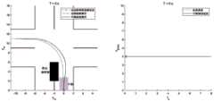
如图3-1所示,中障碍物十字路口场景决策规划步骤包括:As shown in Figure 3-1, the decision-making and planning steps in the middle-obstacle intersection scene include:
步骤A:以无障碍物轨迹为基础,建立三维Frenet框架。Step A: Build a 3D Frenet frame based on the obstacle-free trajectory.
步骤B:感知模块(激光雷达、摄像头等)和预测模块将感知到的静态障碍物状态(xob,yob,ρ,w,θob)、感知和预测到的动态障碍物状态 {(xob,i,yob,i,ρi,wi,θob,i,ti)|i=0,1,...,m}、上一循环求得的车辆轨迹输入优化模块。Step B: The perception module (lidar, camera, etc.) and the prediction module will perceive the static obstacle state (xob , yob , ρ, w, θob ), the perceived and predicted dynamic obstacle state {(xob,i ,yob,i ,ρi ,wi ,θob,i ,ti )|i=0,1,...,m}, the vehicle trajectory obtained in the previous cycle is input to the optimization module.
步骤C:优化模块基于步骤A得到的三维Frenet框架,并根据输入的障碍物信息,进行优化。优化模块分为路径优化、速度优化两个部分,通过优化可以得到平滑可行的路径曲线和速度曲线,并迭代求解。Step C: The optimization module performs optimization based on the three-dimensional Frenet frame obtained in step A and according to the input obstacle information. The optimization module is divided into two parts: path optimization and speed optimization. Through optimization, smooth and feasible path curves and speed curves can be obtained and solved iteratively.
步骤D:将优化后得到的路径曲线和速度曲线相结合,并转换回笛卡尔坐标系,得到障碍物轨迹下的行驶轨迹。Step D: Combine the path curve and speed curve obtained after optimization, and convert back to the Cartesian coordinate system to obtain the driving trajectory under the obstacle trajectory.
步骤E:当感知模块感知到新的障碍物后,返回步骤B,循环求解。Step E: When the perception module perceives a new obstacle, it returns to step B to solve the problem in a loop.
三维Frenet框架:3D Frenet frame:
本发明对于障碍物场景的研究中选择基于上一章求得的无障碍物路径,建立三维Frenet坐标系,让优化问题在三维Frenet框架进行。原因如下:In the research of the obstacle scene, the present invention selects the obstacle-free path obtained in the previous chapter, establishes a three-dimensional Frenet coordinate system, and allows the optimization problem to be carried out in the three-dimensional Frenet frame. The reasons are as follows:
(1)三维Frenet坐标系可以减少规划中轨迹函数的个数。在三维笛卡尔坐标系中,对于轨迹的描述需要使用x=f(s),y=g(s),s=u(t)三个函数表示;但在三维Frenet坐标系下,可以依据无障碍物路径,将路径简化为l=p(s),s=u(t)两个函数,从而简化后续的路径优化。(1) The three-dimensional Frenet coordinate system can reduce the number of trajectory functions in planning. In the three-dimensional Cartesian coordinate system, the description of the trajectory needs to be represented by three functions: x=f(s), y=g(s), and s=u(t). Obstacle path, the path is simplified to l=p(s), s=u(t) two functions, so as to simplify the subsequent path optimization.
(2)三维Frenet坐标系可以根据纵向位移s、横向位移l更好地描述车辆与障碍物的关系。同时在设置碰撞代价的时候可以更好地描述车辆和障碍物的横向、纵向距离与横向、纵向最小安全距离的关系。(2) The three-dimensional Frenet coordinate system can better describe the relationship between the vehicle and the obstacle according to the longitudinal displacement s and lateral displacement l. At the same time, when setting the collision cost, it can better describe the relationship between the lateral and longitudinal distances between vehicles and obstacles and the minimum safe distances in the lateral and longitudinal directions.
(3)三维Frenet坐标系更适用于十字路口这种较曲折的道路环境。本发明优化方法中的动态规划需要将路径的平面空间网格化,在笛卡尔坐标系很难将曲折道路平整地网格化;而Frenet坐标系考虑的是行驶距离和行驶偏移量的关系,可以降低曲折道路的影响。(3) The three-dimensional Frenet coordinate system is more suitable for the more tortuous road environment such as intersections. The dynamic planning in the optimization method of the present invention needs to grid the plane space of the path, and it is difficult to grid the tortuous road evenly in the Cartesian coordinate system; and the Frenet coordinate system considers the relationship between the travel distance and the travel offset , which can reduce the impact of tortuous roads.
三维Frenet坐标系可以拆分为SL坐标系和ST坐标系。路径优化问题在SL坐标系下进行,S维度表示的是车辆沿无障碍物路径行驶的纵向距离,L维度表示的是车辆偏离无障碍物路径的横向距离;速度优化问题在ST坐标系下进行,S维度同样是纵向行驶距离,T维度表示的是车辆的行驶时间。如图3-2所示。The three-dimensional Frenet coordinate system can be split into SL coordinate system and ST coordinate system. The path optimization problem is carried out in the SL coordinate system. The S dimension represents the longitudinal distance of the vehicle along the path without obstacles, and the L dimension represents the lateral distance of the vehicle deviating from the path without obstacles; the speed optimization problem is carried out in the ST coordinate system. , the S dimension is also the longitudinal travel distance, and the T dimension represents the travel time of the vehicle. As shown in Figure 3-2.
障碍物场景下的轨迹优化方法的原理基于EM Motion Planner:对于SLT的三维优化问题采用路径-速度迭代优化算法,求解优化问题采用动态规划结合二次规划的联合优化算法。如图3-3。The principle of the trajectory optimization method in the obstacle scene is based on the EM Motion Planner: the path-velocity iterative optimization algorithm is used for the three-dimensional optimization problem of SLT, and the joint optimization algorithm of dynamic programming and quadratic programming is used to solve the optimization problem. Figure 3-3.
路径-速度迭代优化算法:Path-velocity iterative optimization algorithm:
对于本发明的十字路口场景,由于其环境的复杂性和多变性,决策规划方案的关注点在于轨迹的精细度和规划速率,对于轨迹是全局最优还是局部最优并不需要特别的重视。因此本发明采用的是路径-速度迭代优化算法,方法如下:For the intersection scene of the present invention, due to the complexity and variability of the environment, the focus of the decision planning scheme is on the fineness of the trajectory and the planning rate, and no special attention is needed to whether the trajectory is globally optimal or locally optimal. Therefore, what the present invention adopts is the path-speed iterative optimization algorithm, and the method is as follows:
步骤S1,障碍物投影(SL坐标系):静态障碍物直接投影;对于动态障碍物,提取出上一个循环的轨迹,用来估计车辆与感知范围内的动态障碍物预测轨迹之间的相交情况,并寻找相同时间点有重叠的部分,为期望碰撞区域。Step S1, obstacle projection (SL coordinate system): direct projection of static obstacles; for dynamic obstacles, the trajectory of the previous cycle is extracted to estimate the intersection between the vehicle and the predicted trajectory of dynamic obstacles within the perception range , and look for the overlapping part at the same time point, which is the expected collision area.
步骤S2,路径优化:通过路径规划求解出最优的可行平滑路径曲线。Step S2, path optimization: solve the optimal feasible smooth path curve through path planning.
步骤S3,障碍物投影(ST坐标系):根据这个新的路径曲线,将与新的路径曲线有相交的障碍物投影到ST坐标系下。Step S3, obstacle projection (ST coordinate system): According to the new path curve, project the obstacles that intersect with the new path curve to the ST coordinate system.
步骤S4,速度优化:通过速度规划求解出最优的可行平滑速度曲线。Step S4, speed optimization: solve the optimal feasible smooth speed curve through speed planning.
步骤S5,最后将最优路径曲线和最优速度曲线结合,得到平滑的可行轨迹。该轨迹将被用于下一循环的优化上,这样反复迭代。In step S5, the optimal path curve and the optimal speed curve are finally combined to obtain a smooth feasible trajectory. This trajectory will be used for the next cycle of optimization, and so on.
动态规划结合二次规划的联合优化算法:The joint optimization algorithm of dynamic programming combined with quadratic programming:
路径优化、速度优化的求解方法均采用函数优化方法,本质是分别在SL坐标系、ST坐标系下寻找对于代价而言最优的函数,即最优l=p(s),s=u(t)。考虑到十字路口场景轨迹的精细度和规划速率的同时要求,以及十字路口可能存在大量搜索空间是非凸空间的情形(障碍物在路中间的情形,例如:行人过路口),所以本发明采用动态规划结合二次规划的求解方法。The solution methods of path optimization and speed optimization all adopt the function optimization method. The essence is to find the optimal function for the cost in the SL coordinate system and the ST coordinate system respectively, that is, the optimal l=p(s), s=u( t). Considering the simultaneous requirements of the fineness of the scene trajectory and the planning rate at the intersection, and that there may be a large number of situations where the search space is non-convex at the intersection (the situation where the obstacle is in the middle of the road, for example: pedestrians crossing the intersection), the present invention adopts dynamic The solution method of planning combined with quadratic programming.
1、第一步,动态规划(Dynamic Programming,DP):对于SL坐标系/ST坐标系进行网格化采样,通过动态规划搜索出一个粗略的平滑曲线(此步骤是粗略的,采样频率不用太密),通过该粗略曲线可以得到一个可行凸空间。该步骤的目的是得到车辆面对障碍物时候的决策,同时将原本可能的非凸搜索空间转换为凸空间。1. The first step, Dynamic Programming (DP): Grid sampling is performed for the SL coordinate system/ST coordinate system, and a rough smooth curve is searched through dynamic programming (this step is rough, and the sampling frequency does not need to be too high dense), a feasible convex space can be obtained from this rough curve. The purpose of this step is to obtain a decision when the vehicle faces obstacles, and at the same time convert the otherwise possible non-convex search space into a convex space.
2、第二步,二次规划(Quadratic Programming,QP):以采样点为基础用一维分段高阶多项式(5阶)将曲线参数化,以动态规划的结果作为启发,在动态规划得到的可行凸空间中用二次规划搜索出一条最优的可行平滑曲线。2. The second step, Quadratic Programming (QP): Based on the sampling points, the curve is parameterized with a one-dimensional piecewise high-order polynomial (5th order), and the results of dynamic programming are used as inspiration. An optimal feasible smooth curve is searched by quadratic programming in convex space.
动态规划结合二次规划联合优化算法的代价函数如表3-1。舒适性代价目的是让路径曲线、速度曲线尽可能地平滑。偏移量代价是为了让保证车辆不能偏移无障碍轨迹太远。碰撞代价是为了让车辆和障碍物不发生碰撞。本发明将碰撞代价设置为一个等级为 0/Inf的决策:对于路径优化,碰撞代价是在SL坐标系下让车辆与障碍物之间的S方向、 L方向距离大于横向、纵向最小安全距离;对于速度优化,碰撞代价是在ST坐标系下的同一时间点t,车辆和障碍物之间的S方向距离大于纵向最小安全距离。最小安全距离的设置可以基于责任敏感安全模型(Responsibility Sensitive Safety,RSS)。The cost function of dynamic programming combined with quadratic programming joint optimization algorithm is shown in Table 3-1. The purpose of the comfort cost is to make the path curve and speed curve as smooth as possible. The offset penalty is to ensure that the vehicle cannot deviate too far from the unobstructed trajectory. The collision cost is to keep the vehicle and the obstacle from colliding. The present invention sets the collision cost as a decision with a level of 0/Inf: for path optimization, the collision cost is to make the distances in the S and L directions between the vehicle and the obstacle greater than the horizontal and vertical minimum safe distances under the SL coordinate system; For speed optimization, the collision cost is that at the same time point t in the ST coordinate system, the S-direction distance between the vehicle and the obstacle is greater than the longitudinal minimum safe distance. The setting of the minimum safety distance can be based on Responsibility Sensitive Safety (RSS).
表3-1代价函数Table 3-1 Cost function


优化模块仿真:Optimization module simulation:
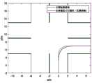
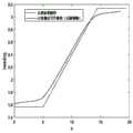
如图3-4为障碍物投影,将静态障碍物、动态障碍物的期望碰撞区域投影到Frenet坐标系下;。图3-5中为SL坐标系下路径优化的仿真,黑色方框为障碍物投影,图中有两条曲线,一条是动态规划后的路径,以此路径为基础进行二次规划,得到另一条动态规划结合二次规划联合优化后的路径;图3-6中为ST坐标系下路径优化的仿真,黑色方框为障碍物投影,图中有两条曲线,一条是动态规划后的ST曲线,以此路径为基础进行二次规划,得到另一条动态规划结合二次规划联合优化后ST曲线。Figure 3-4 shows the obstacle projection, project the expected collision area of static obstacles and dynamic obstacles to the Frenet coordinate system; Figure 3-5 shows the simulation of path optimization in the SL coordinate system. The black box is the obstacle projection. There are two curves in the figure, one is the path after dynamic planning. A path optimized by dynamic programming combined with quadratic programming; Figure 3-6 shows the simulation of path optimization in the ST coordinate system, the black box is the obstacle projection, and there are two curves in the figure, one is the ST after dynamic programming Curve, perform quadratic programming based on this path, and obtain another ST curve after the joint optimization of dynamic programming and quadratic programming.
障碍物路径评价指标:Obstacle path evaluation index:
障碍物十字路口场景的环境是时变的(优化包含路径、速度两个部分),且存在一个参考轨迹(无障碍物轨迹),所以对于轨迹中路径曲线的评价主要在于路径舒适性指标、路径偏移量指标;对于轨迹中速度曲线的评价主要在于速度舒适性指标、速度偏移量指标。The environment of the obstacle intersection scene is time-varying (optimization includes two parts, path and speed), and there is a reference trajectory (no obstacle trajectory), so the evaluation of the path curve in the trajectory mainly lies in the path comfort index, path Offset index; the evaluation of the speed curve in the trajectory mainly lies in the speed comfort index and the speed offset index.
具体表达式如表3-2。路径/速度舒适性指标是为了使优化后路径/速度曲线更加平滑,从而让车辆缓慢转向和缓慢加减速,提升乘客体验感,所以指标表示为路径/速度函数不同阶导数平方积分的加权和,其值越小表示乘客的舒适度越好;路径/速度偏移量指标是为了让车辆的路径/速度尽可能地靠近无障碍物路径/标准速度,从而减小车辆的行驶距离、油耗等,所以指标表示为与无障碍物轨迹之间的差的平方的积分,其值越小表示拟合度越好。The specific expressions are shown in Table 3-2. The path/speed comfort index is to make the optimized path/speed curve smoother, so that the vehicle can turn slowly, accelerate and decelerate slowly, and improve the passenger experience, so the index is expressed as the weighted sum of the square integrals of the different order derivatives of the path/speed function, The smaller the value, the better the comfort of passengers; the path/speed offset indicator is to make the path/speed of the vehicle as close to the obstacle-free path/standard speed as possible, thereby reducing the driving distance of the vehicle, fuel consumption, etc., So the index is expressed as the integral of the square of the difference with the obstacle-free trajectory, and the smaller the value, the better the fit.
表3-2评价指标Table 3-2 Evaluation indicators

在仿真中采用两种决策规划方案进行对比分析。第一种采用的是动态规划+平滑曲线插值的方法,首先通过动态规划得到对于代价而言最优的采样点集合,然后用平滑的曲线(这里采用的是Spline曲线)进行插值,得到无障碍物轨迹;第二种是本文采用的动态规划+二次规划联合优化算法,先通过动态规划得到可行凸空间,然后通过二次规划快速收敛到平滑可行轨迹。利用车辆起始点的随机性,对于路径优化和速度优化进行循环实验得到路径舒适性指标、路径偏移量指标、速度舒适性指标、速度偏移量指标的累计分布函数(CDF):In the simulation, two decision planning schemes are used for comparative analysis. The first method uses dynamic programming + smooth curve interpolation. First, the optimal sampling point set for the cost is obtained through dynamic programming, and then the smooth curve (here, the Spline curve is used) is used for interpolation to obtain barrier-free The second is the dynamic programming + quadratic programming joint optimization algorithm used in this paper, which first obtains a feasible convex space through dynamic programming, and then quickly converges to a smooth feasible trajectory through quadratic programming. Using the randomness of the starting point of the vehicle, cyclic experiments are carried out for the path optimization and speed optimization to obtain the cumulative distribution function (CDF) of the path comfort index, the path offset index, the speed comfort index, and the speed offset index:
图3-7abcd分别为路径舒适性指标、路径偏移量指标、速度舒适性指标、速度偏移量指标的累计分布函数。其中四幅图中的黑色虚线为采用第一种决策规划方法(动态规划+平滑曲线插值)的评价指标CDF;四幅图中的黑色实线为本发明采用第二种决策规划方法(动态规划+二次规划)的评价指标CDF。通过对比可以看出,本发明采用的方法有效地降低了路径舒适性指标、速度舒适性指标,即提高了车内乘客的舒适度,本方法还降低了速度偏移量指标,使行驶速度更贴近标准速度;但同时,该方法使得路径偏移量指标有一定的提高,车辆的行驶路径会距离标准路径更远。Figure 3-7abcd is the cumulative distribution function of the path comfort index, the path offset index, the speed comfort index, and the speed offset index. The black dotted line in the four figures is the evaluation index CDF using the first decision planning method (dynamic programming + smooth curve interpolation); the black solid line in the four figures is the second decision planning method (dynamic programming + two Sub-planning) evaluation index CDF. It can be seen from the comparison that the method adopted in the present invention effectively reduces the path comfort index and speed comfort index, that is, improves the comfort of passengers in the vehicle. It is close to the standard speed; but at the same time, this method improves the path offset index to a certain extent, and the driving path of the vehicle will be farther from the standard path.
表3-3障碍物场景中两种决策规划方法舒适性指标的均值对比Table 3-3 Comparison of the mean values of comfort indexes of the two decision planning methods in the obstacle scene

表3-4障碍物场景中两种决策规划方法偏移量指标的均值对比Table 3-4 Comparison of the mean values of the offset indicators of the two decision planning methods in the obstacle scene

表3-3、3-4分别为障碍物场景中两种决策规划方法的舒适性指标和偏移量指标的均值对比。可以看出,本文采用的第二种方法(动态规划+二次规划)相较于第一种方法 (动态规划+平滑插值曲线),降低了路径舒适性指标、速度舒适性指标、路径偏移量指标的均值,提高了路径偏移量指标。同时由于舒适性指标的值与乘客舒适度是成反比的关系,偏移量指标的值与曲线和无障碍物轨迹的拟合度也是成反比的关系,所以可以计算第二种方法相较于第一种方法的舒适度提升率和拟合度提升率:Tables 3-3 and 3-4 respectively show the comparison of the comfort index and the mean value of the offset index of the two decision planning methods in the obstacle scene. It can be seen that compared with the first method (dynamic programming + smooth interpolation curve), the second method (dynamic programming + quadratic programming) adopted in this paper reduces the path comfort index, speed comfort index, and path offset. The mean value of the quantity index improves the path offset index. At the same time, since the value of the comfort index is inversely proportional to the passenger comfort, the value of the offset index is also inversely proportional to the fit of the curve and the obstacle-free trajectory, so the second method can be calculated compared to The comfort improvement rate and fit improvement rate of the first method:

由此可得,本发明采用的动态规划+二次规划联合算法的路径、速度舒适度提升率分别为52.00%、57.01%,速度拟合度提升率为2.03%;作为代价,该方法的路径拟合度下降了42.37%。It can be seen that the path and speed comfort improvement rates of the dynamic programming + quadratic programming joint algorithm adopted by the present invention are 52.00% and 57.01% respectively, and the speed fitting degree improvement rate is 2.03%; as a cost, the path of this method The fit dropped by 42.37%.
完整十字路口场景仿真:Full intersection scene simulation:
仿真以车辆的左转策略为例。在场景中设置一个静态障碍物,一个动态障碍物,动态障碍物自北朝南行驶,行驶速度为5.2m/s;车辆的感知半径设置为15m,标准速度为 4m/s,规划时间间隔为0.5s。The simulation takes the vehicle's left-turn strategy as an example. Set a static obstacle and a dynamic obstacle in the scene. The dynamic obstacle travels from north to south at a speed of 5.2m/s; the perception radius of the vehicle is set to 15m, the standard speed is 4m/s, and the planning time interval is 0.5 s.
如图3-8a,在t=0s时刻,车辆均只感知到了静态障碍物,动态障碍物并不在车辆的感知范围内。所以车辆只在路径优化中调整了车辆的行驶路径,以避开该静态障碍物;速度方面,车辆仍是以标准速度行驶。As shown in Figure 3-8a, at t=0s, the vehicle only perceives static obstacles, and dynamic obstacles are not within the vehicle's perception range. Therefore, the vehicle only adjusts the driving path of the vehicle in the path optimization to avoid the static obstacle; in terms of speed, the vehicle still runs at the standard speed.
如图3-8b,在t=1s时刻,车辆感知到了动态障碍物,并预测了未来时刻的轨迹,并与上一循环的车辆轨迹进行相互作用的分析,预计在t=3s发生碰撞。所以,如图所示,速度上车辆有一个明显的加速以避开障碍物。As shown in Figure 3-8b, at t=1s, the vehicle perceives the dynamic obstacle, predicts the trajectory of the future time, and analyzes the interaction with the vehicle trajectory of the previous cycle, and it is expected to collide at t=3s. So, as shown, there is a significant acceleration of the vehicle at speed to avoid the obstacle.
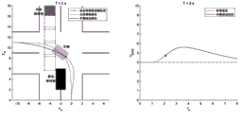
如图3-8c,在t=2s时刻,车辆再次进行规划,不光速度进行加速,同时车辆的路径有一个明显的内收,从而更好地躲避障碍物。As shown in Figure 3-8c, at time t=2s, the vehicle is planned again, not only the speed is accelerated, but also the path of the vehicle has an obvious adduction, so as to better avoid obstacles.
如图3-8d,在t=3s时刻,车辆成功已经避开动态障碍物。在路径方面,车辆需要平滑地重新靠近无障碍物路径;在速度方面,车辆速度同样需要平滑地下降回标准速度。As shown in Figure 3-8d, at time t=3s, the vehicle has successfully avoided the dynamic obstacle. In terms of path, the vehicle needs to smoothly re-approach the obstacle-free path; in terms of speed, the vehicle speed also needs to smoothly drop back to the standard speed.
本发明还公开了一种无人驾驶车辆在十字路口的行驶轨迹规划系统,包括无障碍物场景决策规划模块和障碍物十字路口场景决策规划模块,所述无障碍物场景决策规划模块:用于在无障碍物十字路口场景中,首先根据车辆目的地确定车辆的行驶策略并在高精度地图上得到相应的标准路径;然后对于不满足车辆动力学模型的标准路径进行平滑优化,得到最优可行路径;最后结合标准速度,得到无障碍物环境下的最优可行轨迹。所述障碍物十字路口场景决策规划模块:用于在障碍物十字路口场景中,首先基于无障碍物轨迹建立三维Frenet框架,并通过感知、预测模块得到静态、动态障碍物的信息;然后进行轨迹优化;最后得到障碍物环境下最优可行轨迹,并循环优化。The invention also discloses a driving trajectory planning system for an unmanned vehicle at an intersection, including a decision-making planning module for a scene without obstacles and a decision-making planning module for a scene at an obstacle-free intersection. The decision-making planning module for a scene without obstacles is used for In an obstacle-free intersection scene, first determine the vehicle's driving strategy according to the vehicle's destination and obtain the corresponding standard path on the high-precision map; then smooth and optimize the standard path that does not satisfy the vehicle dynamics model to obtain the optimal feasible path; finally, combined with the standard speed, the optimal feasible trajectory in the obstacle-free environment is obtained. The decision planning module of the obstacle intersection scene is used to establish a three-dimensional Frenet frame based on the obstacle-free trajectory in the obstacle intersection scene, and obtain the information of static and dynamic obstacles through the perception and prediction module; then the trajectory is carried out. Optimization; Finally, the optimal feasible trajectory in the obstacle environment is obtained, and the optimization is performed in a loop.
本发明还公开了一种计算机可读存储介质,所述计算机可读存储介质存储有计算机程序,所述计算机程序配置为由处理器调用时实现本发明所述的行驶轨迹规划方法的步骤。The present invention also discloses a computer-readable storage medium, where the computer-readable storage medium stores a computer program, and the computer program is configured to implement the steps of the driving trajectory planning method of the present invention when invoked by a processor.
在本发明中,结合十字路口场景的特殊道路特点,进行决策规划方案的研究。同时进行仿真实验,并从对于得到的最优的可行平滑轨迹进行评价指标的分析。研究取得了一定的成果,总结为如下几点:In the present invention, the decision-making planning scheme is studied in combination with the special road characteristics of the crossroad scene. At the same time, simulation experiments are carried out, and the evaluation indicators are analyzed from the optimal feasible smooth trajectory obtained. The research has achieved certain results, which can be summarized as follows:
(1)在无障碍物十字路口场景中,提出一种基于二维分段高阶多项式的二次规划算法,对于不同的行驶策略(直行、左转、右转、掉头),规划并得到相应的最优可行轨迹。方案是:首先根据车辆目的地确定车辆的行驶策略并在高精度地图上得到相应的标准路径;然后对于不满足车辆动力学模型的标准路径进行平滑优化,采用基于二维分段高阶多项式的二次优化,得到最优可行路径;最后结合标准速度,得到无障碍物环境下的最优可行轨迹。(1) In the scene of an obstacle-free intersection, a quadratic programming algorithm based on a two-dimensional piecewise high-order polynomial is proposed. For different driving strategies (go straight, turn left, turn right, and turn around), plan and obtain the corresponding maximum Excellent feasible trajectory. The scheme is: first determine the driving strategy of the vehicle according to the destination of the vehicle and obtain the corresponding standard path on the high-precision map; optimization to obtain the optimal feasible path; finally, combined with the standard speed, the optimal feasible trajectory in the environment without obstacles is obtained.
(2)在障碍物十字路口场景中,提出一种基于EM Planner、路径-速度迭代优化算法、动态规划+二次规划联合优化算法、RSS安全模型的决策规划方案,目的是避开感知范围内的静态、动态障碍物,对于无障碍物轨迹进行迭代修正,得到障碍物环境下的最优可行轨迹。方案是:首先基于无障碍物轨迹建立三维Frenet框架,并通过感知、预测模块得到静态、动态障碍物的信息;然后利用路径-速度迭代优化算法、动态规划+二次规划联合优化算法进行轨迹优化;最后得到障碍物环境下最优可行轨迹,并循环优化。(2) In the obstacle intersection scene, a decision planning scheme based on EM Planner, path-speed iterative optimization algorithm, dynamic programming + quadratic programming joint optimization algorithm, and RSS security model is proposed to avoid the perception range. The static and dynamic obstacles are iteratively corrected for the obstacle-free trajectory, and the optimal feasible trajectory under the obstacle environment is obtained. The scheme is: firstly build a three-dimensional Frenet framework based on the trajectory without obstacles, and obtain the information of static and dynamic obstacles through perception and prediction modules; then use the path-speed iterative optimization algorithm, dynamic programming + quadratic programming joint optimization algorithm to optimize the trajectory ; Finally, the optimal feasible trajectory in the obstacle environment is obtained, and the cycle is optimized.
(3)对两个场景进行方案仿真,同时对无障碍物轨迹进行路径舒适性的评价指标进行分析;对障碍物轨迹进行路径舒适性、路径偏移量、速度舒适性、速度偏移量四个评价指标进行分析。(3) Simulate the two scenarios, and analyze the path comfort evaluation indicators for the obstacle-free trajectory; conduct the path comfort, path offset, speed comfort, and speed offset for the obstacle trajectory. An evaluation index is analyzed.
综上所述,本发明采用路径-速度迭代优化算法、动态规划、二次规划等方法来研究与进行十字路口场景下车辆的决策规划,并通过仿真实验,取得了不错的效果。To sum up, the present invention adopts the path-speed iterative optimization algorithm, dynamic programming, quadratic programming and other methods to study and carry out the decision-making planning of vehicles in the intersection scene, and through simulation experiments, good results have been achieved.
以上内容是结合具体的优选实施方式对本发明所作的进一步详细说明,不能认定本发明的具体实施只局限于这些说明。对于本发明所属技术领域的普通技术人员来说,在不脱离本发明构思的前提下,还可以做出若干简单推演或替换,都应当视为属于本发明的保护范围。The above content is a further detailed description of the present invention in combination with specific preferred embodiments, and it cannot be considered that the specific implementation of the present invention is limited to these descriptions. For those of ordinary skill in the technical field of the present invention, without departing from the concept of the present invention, some simple deductions or substitutions can be made, which should be regarded as belonging to the protection scope of the present invention.
Claims (10)
Translated fromChinese


Priority Applications (1)
| Application Number | Priority Date | Filing Date | Title |
|---|---|---|---|
| CN202010718402.0ACN112068545B (en) | 2020-07-23 | 2020-07-23 | Method and system for planning running track of unmanned vehicle at crossroad and storage medium |
Applications Claiming Priority (1)
| Application Number | Priority Date | Filing Date | Title |
|---|---|---|---|
| CN202010718402.0ACN112068545B (en) | 2020-07-23 | 2020-07-23 | Method and system for planning running track of unmanned vehicle at crossroad and storage medium |
Publications (2)
| Publication Number | Publication Date |
|---|---|
| CN112068545Atrue CN112068545A (en) | 2020-12-11 |
| CN112068545B CN112068545B (en) | 2022-12-27 |
Family
ID=73656625
Family Applications (1)
| Application Number | Title | Priority Date | Filing Date |
|---|---|---|---|
| CN202010718402.0AActiveCN112068545B (en) | 2020-07-23 | 2020-07-23 | Method and system for planning running track of unmanned vehicle at crossroad and storage medium |
Country Status (1)
| Country | Link |
|---|---|
| CN (1) | CN112068545B (en) |
Cited By (57)
| Publication number | Priority date | Publication date | Assignee | Title |
|---|---|---|---|---|
| CN112577506A (en)* | 2020-10-30 | 2021-03-30 | 上汽大众汽车有限公司 | Automatic driving local path planning method and system |
| CN112631295A (en)* | 2020-12-17 | 2021-04-09 | 北京汽车研究总院有限公司 | Path planning method and device and vehicle |
| CN112666945A (en)* | 2020-12-18 | 2021-04-16 | 广东嘉腾机器人自动化有限公司 | AGV curve path optimization method |
| CN112859849A (en)* | 2021-01-06 | 2021-05-28 | 北京三快在线科技有限公司 | Crossing motion planning method and device of automatic driving equipment and electronic equipment |
| CN112905849A (en)* | 2021-02-18 | 2021-06-04 | 中国第一汽车股份有限公司 | Vehicle data processing method and device |
| CN112896187A (en)* | 2021-02-08 | 2021-06-04 | 浙江大学 | System and method for considering social compatibility and making automatic driving decision |
| CN112953780A (en)* | 2021-03-23 | 2021-06-11 | 同济大学 | Unmanned vehicle group construction and evaluation method in closed scene |
| CN112987721A (en)* | 2021-02-01 | 2021-06-18 | 哈尔滨工业大学 | Multi-AGV dispatching package and fusion method of global planning and local planning thereof |
| CN113044029A (en)* | 2021-03-19 | 2021-06-29 | 北京理工大学 | Motion planning method for ensuring safe driving of unmanned vehicle on three-dimensional terrain |
| CN113055821A (en)* | 2021-03-15 | 2021-06-29 | 北京京东乾石科技有限公司 | Method and apparatus for transmitting information |
| CN113110489A (en)* | 2021-04-30 | 2021-07-13 | 清华大学 | Trajectory planning method and device, electronic equipment and storage medium |
| CN113295181A (en)* | 2021-07-28 | 2021-08-24 | 国汽智控(北京)科技有限公司 | Vehicle path planning method, device and system |
| CN113411752A (en)* | 2021-08-19 | 2021-09-17 | 智己汽车科技有限公司 | Method and equipment for vehicle to pass through intersection along track |
| CN113433947A (en)* | 2021-07-15 | 2021-09-24 | 天津大学 | Intersection trajectory planning and control method based on obstacle vehicle estimation and prediction |
| CN113460091A (en)* | 2021-08-23 | 2021-10-01 | 吉林大学 | Unprotected crossroad unmanned vehicle rolling optimization decision method |
| CN113483776A (en)* | 2021-07-01 | 2021-10-08 | 广州小鹏自动驾驶科技有限公司 | Path planning method and device and automobile |
| CN113553255A (en)* | 2021-06-16 | 2021-10-26 | 阿波罗智联(北京)科技有限公司 | Route scene file generation method and device, electronic equipment and storage medium |
| CN113654556A (en)* | 2021-07-05 | 2021-11-16 | 的卢技术有限公司 | Local path planning method, medium and equipment based on improved EM algorithm |
| CN113844445A (en)* | 2021-09-14 | 2021-12-28 | 浙江零跑科技股份有限公司 | Automatic emergency braking system and method for vehicle based on prediction reference line coordinate system |
| CN113885771A (en)* | 2021-12-09 | 2022-01-04 | 北京车网科技发展有限公司 | Visual processing method of track information |
| CN113895463A (en)* | 2021-11-25 | 2022-01-07 | 北京航空航天大学 | Path planning method suitable for automatic driving vehicle turning |
| CN113997951A (en)* | 2021-08-17 | 2022-02-01 | 北京百度网讯科技有限公司 | Method, device and automatic driving vehicle for determining driving trajectory of vehicle |
| CN114115298A (en)* | 2022-01-25 | 2022-03-01 | 北京理工大学 | A method and system for smoothing the path of an unmanned vehicle |
| CN114234993A (en)* | 2021-12-15 | 2022-03-25 | 北京福田戴姆勒汽车有限公司 | Vehicle local path planning method, automatic driving system and automatic driving vehicle |
| CN114235441A (en)* | 2021-12-31 | 2022-03-25 | 深兰人工智能(深圳)有限公司 | Unmanned vehicle real-time collision detection method and related device |
| CN114518755A (en)* | 2022-01-28 | 2022-05-20 | 福思(杭州)智能科技有限公司 | Global path planning method, device, equipment and storage medium |
| CN114537435A (en)* | 2022-03-03 | 2022-05-27 | 湖州快飞智能科技有限公司 | Real-time whole vehicle track planning method in automatic driving |
| CN114723903A (en)* | 2022-03-18 | 2022-07-08 | 北京智行者科技有限公司 | Obstacle risk field environment modeling method and device and related products |
| CN114740849A (en)* | 2022-04-07 | 2022-07-12 | 哈尔滨工业大学(深圳) | Autonomous navigation method and device of mobile robot based on pedestrian walking decision rule |
| CN114815811A (en)* | 2022-03-23 | 2022-07-29 | 吉林大学 | Unmanned vehicle trajectory planning method |
| CN114802299A (en)* | 2022-04-12 | 2022-07-29 | 武汉路特斯汽车有限公司 | Path trajectory planning method, terminal and computer readable storage medium |
| CN114834481A (en)* | 2022-04-07 | 2022-08-02 | 武汉路特斯汽车有限公司 | Speed planning method, terminal and computer readable storage medium |
| CN114896303A (en)* | 2022-05-12 | 2022-08-12 | 东软睿驰汽车技术(沈阳)有限公司 | Data mining-based regulation control method, device, system, equipment and storage medium |
| CN114923496A (en)* | 2022-03-29 | 2022-08-19 | 武汉路特斯汽车有限公司 | Path planning method and device, electronic equipment and storage medium |
| CN115050008A (en)* | 2022-06-28 | 2022-09-13 | 重庆长安汽车股份有限公司 | Crossing virtual lane line determining method and device, electronic equipment and storage medium |
| CN115083139A (en)* | 2021-03-12 | 2022-09-20 | 上海交通大学 | Multi-vehicle scheduling method |
| WO2022199855A1 (en)* | 2021-03-26 | 2022-09-29 | Embotech Ag | Method and system for controlling autonomous or semi-autonomous vehicle |
| CN115171414A (en)* | 2022-06-10 | 2022-10-11 | 哈尔滨工业大学重庆研究院 | CACC following traffic flow control system based on Frenet coordinate system |
| CN115185263A (en)* | 2022-05-19 | 2022-10-14 | 上海人工智能创新中心 | Trajectory planning method and computer readable storage medium |
| WO2022241771A1 (en)* | 2021-05-21 | 2022-11-24 | 华为技术有限公司 | Prediction method and apparatus, vehicle, and intelligent driving system |
| CN115465295A (en)* | 2022-09-14 | 2022-12-13 | 重庆长安汽车股份有限公司 | Method and device for predicting future track of crossing vehicle, vehicle and storage medium |
| CN115631651A (en)* | 2022-09-23 | 2023-01-20 | 北京理工大学 | A system and method for decision-making and planning of autonomous driving in an unmanaged intersection environment |
| CN115690839A (en)* | 2022-10-24 | 2023-02-03 | 中国科学院自动化研究所 | Behavior decision method and device, electronic equipment and storage medium |
| WO2023024542A1 (en)* | 2021-08-25 | 2023-03-02 | 驭势科技(北京)有限公司 | Vehicle decision-making planning method and apparatus, and device and medium |
| CN115903812A (en)* | 2022-11-16 | 2023-04-04 | 宁波均胜智能汽车技术研究院有限公司 | A method for planning vehicle trajectories |
| CN116027789A (en)* | 2023-01-17 | 2023-04-28 | 山东新一代信息产业技术研究院有限公司 | A robot path selection method and device |
| CN116300915A (en)* | 2023-02-28 | 2023-06-23 | 山东交通学院 | A method and system for automatic driving speed planning |
| WO2023134364A1 (en)* | 2022-01-12 | 2023-07-20 | 华为技术有限公司 | Method for guiding vehicle driving, map generation method, and related system |
| CN116499486A (en)* | 2023-06-26 | 2023-07-28 | 北京理工大学 | A complex off-road environment path planning method, system and electronic equipment |
| WO2023147769A1 (en)* | 2022-02-01 | 2023-08-10 | Huawei Technologies Co., Ltd. | Systems, methods, and computer-readable media for spatio-temporal motion planning |
| CN116880492A (en)* | 2023-07-25 | 2023-10-13 | 云创智行科技(苏州)有限公司 | Space-time rotation optimization method and device for unmanned motion planning |
| CN117032201A (en)* | 2023-03-07 | 2023-11-10 | 山西省智慧交通研究院有限公司 | Mine automatic driving vehicle coordination planning method based on vehicle-road coordination |
| EP4134285A4 (en)* | 2021-06-08 | 2024-02-21 | Neolix Technologies Co., Ltd. | VEHICLE OBSTACLE AVOIDANCE METHOD AND APPARATUS, ELECTRONIC DEVICE, AND STORAGE MEDIUM |
| WO2024056064A1 (en)* | 2022-09-16 | 2024-03-21 | 广州小鹏自动驾驶科技有限公司 | Turning path planning method, device, vehicle, and storage medium |
| CN118258403A (en)* | 2024-04-01 | 2024-06-28 | 安徽工业大学 | Factory monitoring method based on generalization analysis |
| CN119190026A (en)* | 2024-11-22 | 2024-12-27 | 北京邮电大学 | A kind of intelligent network driving control method |
| CN115690839B (en)* | 2022-10-24 | 2025-10-10 | 中国科学院自动化研究所 | Behavior decision-making method, device, electronic device, and storage medium |
Citations (7)
| Publication number | Priority date | Publication date | Assignee | Title |
|---|---|---|---|---|
| CN105741595A (en)* | 2016-04-27 | 2016-07-06 | 常州加美科技有限公司 | Unmanned vehicle navigation driving method based on cloud database |
| US20170123428A1 (en)* | 2015-11-04 | 2017-05-04 | Zoox, Inc. | Sensor-based object-detection optimization for autonomous vehicles |
| CN108877268A (en)* | 2018-08-07 | 2018-11-23 | 南京大学 | One kind is towards unpiloted no traffic lights crossroad intelligent dispatching method |
| CN109324620A (en)* | 2018-09-25 | 2019-02-12 | 北京主线科技有限公司 | The dynamic trajectory planing method for carrying out avoidance based on lane line parallel offset and overtaking other vehicles |
| CN109976355A (en)* | 2019-04-26 | 2019-07-05 | 腾讯科技(深圳)有限公司 | Method for planning track, system, equipment and storage medium |
| CN110304074A (en)* | 2019-06-28 | 2019-10-08 | 电子科技大学 | A Hybrid Driving Method Based on Hierarchical State Machine |
| CN110749333A (en)* | 2019-11-07 | 2020-02-04 | 中南大学 | Motion planning method for unmanned vehicle based on multi-objective optimization |
- 2020
- 2020-07-23CNCN202010718402.0Apatent/CN112068545B/enactiveActive
Patent Citations (7)
| Publication number | Priority date | Publication date | Assignee | Title |
|---|---|---|---|---|
| US20170123428A1 (en)* | 2015-11-04 | 2017-05-04 | Zoox, Inc. | Sensor-based object-detection optimization for autonomous vehicles |
| CN105741595A (en)* | 2016-04-27 | 2016-07-06 | 常州加美科技有限公司 | Unmanned vehicle navigation driving method based on cloud database |
| CN108877268A (en)* | 2018-08-07 | 2018-11-23 | 南京大学 | One kind is towards unpiloted no traffic lights crossroad intelligent dispatching method |
| CN109324620A (en)* | 2018-09-25 | 2019-02-12 | 北京主线科技有限公司 | The dynamic trajectory planing method for carrying out avoidance based on lane line parallel offset and overtaking other vehicles |
| CN109976355A (en)* | 2019-04-26 | 2019-07-05 | 腾讯科技(深圳)有限公司 | Method for planning track, system, equipment and storage medium |
| CN110304074A (en)* | 2019-06-28 | 2019-10-08 | 电子科技大学 | A Hybrid Driving Method Based on Hierarchical State Machine |
| CN110749333A (en)* | 2019-11-07 | 2020-02-04 | 中南大学 | Motion planning method for unmanned vehicle based on multi-objective optimization |
Cited By (81)
| Publication number | Priority date | Publication date | Assignee | Title |
|---|---|---|---|---|
| CN112577506A (en)* | 2020-10-30 | 2021-03-30 | 上汽大众汽车有限公司 | Automatic driving local path planning method and system |
| CN112631295A (en)* | 2020-12-17 | 2021-04-09 | 北京汽车研究总院有限公司 | Path planning method and device and vehicle |
| CN112666945A (en)* | 2020-12-18 | 2021-04-16 | 广东嘉腾机器人自动化有限公司 | AGV curve path optimization method |
| CN112859849A (en)* | 2021-01-06 | 2021-05-28 | 北京三快在线科技有限公司 | Crossing motion planning method and device of automatic driving equipment and electronic equipment |
| CN112987721A (en)* | 2021-02-01 | 2021-06-18 | 哈尔滨工业大学 | Multi-AGV dispatching package and fusion method of global planning and local planning thereof |
| CN112896187B (en)* | 2021-02-08 | 2022-07-26 | 浙江大学 | System and method for considering social compatibility and making automatic driving decision |
| CN112896187A (en)* | 2021-02-08 | 2021-06-04 | 浙江大学 | System and method for considering social compatibility and making automatic driving decision |
| CN112905849A (en)* | 2021-02-18 | 2021-06-04 | 中国第一汽车股份有限公司 | Vehicle data processing method and device |
| CN115083139B (en)* | 2021-03-12 | 2023-11-24 | 上海交通大学 | Multi-vehicle scheduling method |
| CN115083139A (en)* | 2021-03-12 | 2022-09-20 | 上海交通大学 | Multi-vehicle scheduling method |
| CN113055821B (en)* | 2021-03-15 | 2023-01-31 | 北京京东乾石科技有限公司 | Method and apparatus for transmitting information |
| CN113055821A (en)* | 2021-03-15 | 2021-06-29 | 北京京东乾石科技有限公司 | Method and apparatus for transmitting information |
| CN113044029A (en)* | 2021-03-19 | 2021-06-29 | 北京理工大学 | Motion planning method for ensuring safe driving of unmanned vehicle on three-dimensional terrain |
| CN113044029B (en)* | 2021-03-19 | 2022-03-15 | 北京理工大学 | Motion planning method for ensuring safe driving of unmanned vehicle on three-dimensional terrain |
| CN112953780A (en)* | 2021-03-23 | 2021-06-11 | 同济大学 | Unmanned vehicle group construction and evaluation method in closed scene |
| CN112953780B (en)* | 2021-03-23 | 2022-04-19 | 同济大学 | Unmanned vehicle group construction and evaluation method in closed scene |
| WO2022199855A1 (en)* | 2021-03-26 | 2022-09-29 | Embotech Ag | Method and system for controlling autonomous or semi-autonomous vehicle |
| CN113110489A (en)* | 2021-04-30 | 2021-07-13 | 清华大学 | Trajectory planning method and device, electronic equipment and storage medium |
| WO2022241771A1 (en)* | 2021-05-21 | 2022-11-24 | 华为技术有限公司 | Prediction method and apparatus, vehicle, and intelligent driving system |
| EP4134285A4 (en)* | 2021-06-08 | 2024-02-21 | Neolix Technologies Co., Ltd. | VEHICLE OBSTACLE AVOIDANCE METHOD AND APPARATUS, ELECTRONIC DEVICE, AND STORAGE MEDIUM |
| CN113553255A (en)* | 2021-06-16 | 2021-10-26 | 阿波罗智联(北京)科技有限公司 | Route scene file generation method and device, electronic equipment and storage medium |
| CN113553255B (en)* | 2021-06-16 | 2024-06-04 | 阿波罗智联(北京)科技有限公司 | Route scene file generation method and device, electronic equipment and storage medium |
| CN113483776A (en)* | 2021-07-01 | 2021-10-08 | 广州小鹏自动驾驶科技有限公司 | Path planning method and device and automobile |
| CN113654556B (en)* | 2021-07-05 | 2024-08-13 | 的卢技术有限公司 | Local path planning method, medium and device based on improved EM algorithm |
| CN113654556A (en)* | 2021-07-05 | 2021-11-16 | 的卢技术有限公司 | Local path planning method, medium and equipment based on improved EM algorithm |
| CN113433947A (en)* | 2021-07-15 | 2021-09-24 | 天津大学 | Intersection trajectory planning and control method based on obstacle vehicle estimation and prediction |
| CN113433947B (en)* | 2021-07-15 | 2022-04-01 | 天津大学 | Intersection trajectory planning and control method based on obstacle vehicle estimation and prediction |
| CN113295181A (en)* | 2021-07-28 | 2021-08-24 | 国汽智控(北京)科技有限公司 | Vehicle path planning method, device and system |
| CN113295181B (en)* | 2021-07-28 | 2022-04-15 | 国汽智控(北京)科技有限公司 | Vehicle path planning method, device and system |
| CN113997951A (en)* | 2021-08-17 | 2022-02-01 | 北京百度网讯科技有限公司 | Method, device and automatic driving vehicle for determining driving trajectory of vehicle |
| CN113997951B (en)* | 2021-08-17 | 2024-06-04 | 北京百度网讯科技有限公司 | Method and device for determining running track of vehicle and automatic driving vehicle |
| CN113411752A (en)* | 2021-08-19 | 2021-09-17 | 智己汽车科技有限公司 | Method and equipment for vehicle to pass through intersection along track |
| CN113460091A (en)* | 2021-08-23 | 2021-10-01 | 吉林大学 | Unprotected crossroad unmanned vehicle rolling optimization decision method |
| CN113460091B (en)* | 2021-08-23 | 2022-10-21 | 吉林大学 | Unprotected crossroad unmanned vehicle rolling optimization decision method |
| WO2023024542A1 (en)* | 2021-08-25 | 2023-03-02 | 驭势科技(北京)有限公司 | Vehicle decision-making planning method and apparatus, and device and medium |
| CN113844445B (en)* | 2021-09-14 | 2022-12-30 | 浙江零跑科技股份有限公司 | Automatic emergency braking system and method for vehicle based on prediction reference line coordinate system |
| CN113844445A (en)* | 2021-09-14 | 2021-12-28 | 浙江零跑科技股份有限公司 | Automatic emergency braking system and method for vehicle based on prediction reference line coordinate system |
| CN113895463A (en)* | 2021-11-25 | 2022-01-07 | 北京航空航天大学 | Path planning method suitable for automatic driving vehicle turning |
| CN113895463B (en)* | 2021-11-25 | 2023-06-06 | 北京航空航天大学 | A U-turn Path Planning Method for Autonomous Driving Vehicles |
| CN113885771B (en)* | 2021-12-09 | 2022-03-18 | 北京车网科技发展有限公司 | Visual processing method of track information |
| CN113885771A (en)* | 2021-12-09 | 2022-01-04 | 北京车网科技发展有限公司 | Visual processing method of track information |
| CN114234993A (en)* | 2021-12-15 | 2022-03-25 | 北京福田戴姆勒汽车有限公司 | Vehicle local path planning method, automatic driving system and automatic driving vehicle |
| CN114235441A (en)* | 2021-12-31 | 2022-03-25 | 深兰人工智能(深圳)有限公司 | Unmanned vehicle real-time collision detection method and related device |
| WO2023134364A1 (en)* | 2022-01-12 | 2023-07-20 | 华为技术有限公司 | Method for guiding vehicle driving, map generation method, and related system |
| CN114115298A (en)* | 2022-01-25 | 2022-03-01 | 北京理工大学 | A method and system for smoothing the path of an unmanned vehicle |
| CN114518755A (en)* | 2022-01-28 | 2022-05-20 | 福思(杭州)智能科技有限公司 | Global path planning method, device, equipment and storage medium |
| CN114518755B (en)* | 2022-01-28 | 2025-07-18 | 福思(杭州)智能科技有限公司 | Global path planning method, device, equipment and storage medium |
| US11999376B2 (en) | 2022-02-01 | 2024-06-04 | Huawei Technologies Co., Ltd. | Systems, methods, and computer-readable media for spatio-temporal motion planning |
| WO2023147769A1 (en)* | 2022-02-01 | 2023-08-10 | Huawei Technologies Co., Ltd. | Systems, methods, and computer-readable media for spatio-temporal motion planning |
| CN114537435B (en)* | 2022-03-03 | 2024-06-07 | 浙江大学 | A real-time vehicle trajectory planning method for autonomous driving |
| CN114537435A (en)* | 2022-03-03 | 2022-05-27 | 湖州快飞智能科技有限公司 | Real-time whole vehicle track planning method in automatic driving |
| CN114723903A (en)* | 2022-03-18 | 2022-07-08 | 北京智行者科技有限公司 | Obstacle risk field environment modeling method and device and related products |
| CN114815811B (en)* | 2022-03-23 | 2024-06-25 | 吉林大学 | Unmanned vehicle track planning method |
| CN114815811A (en)* | 2022-03-23 | 2022-07-29 | 吉林大学 | Unmanned vehicle trajectory planning method |
| CN114923496A (en)* | 2022-03-29 | 2022-08-19 | 武汉路特斯汽车有限公司 | Path planning method and device, electronic equipment and storage medium |
| CN114740849B (en)* | 2022-04-07 | 2023-07-04 | 哈尔滨工业大学(深圳) | Mobile robot autonomous navigation method and device based on pedestrian walking decision rule |
| CN114740849A (en)* | 2022-04-07 | 2022-07-12 | 哈尔滨工业大学(深圳) | Autonomous navigation method and device of mobile robot based on pedestrian walking decision rule |
| CN114834481A (en)* | 2022-04-07 | 2022-08-02 | 武汉路特斯汽车有限公司 | Speed planning method, terminal and computer readable storage medium |
| CN114802299A (en)* | 2022-04-12 | 2022-07-29 | 武汉路特斯汽车有限公司 | Path trajectory planning method, terminal and computer readable storage medium |
| CN114896303A (en)* | 2022-05-12 | 2022-08-12 | 东软睿驰汽车技术(沈阳)有限公司 | Data mining-based regulation control method, device, system, equipment and storage medium |
| CN115185263A (en)* | 2022-05-19 | 2022-10-14 | 上海人工智能创新中心 | Trajectory planning method and computer readable storage medium |
| CN115171414A (en)* | 2022-06-10 | 2022-10-11 | 哈尔滨工业大学重庆研究院 | CACC following traffic flow control system based on Frenet coordinate system |
| CN115050008B (en)* | 2022-06-28 | 2024-10-01 | 重庆长安汽车股份有限公司 | Intersection virtual lane line determining method and device, electronic equipment and storage medium |
| CN115050008A (en)* | 2022-06-28 | 2022-09-13 | 重庆长安汽车股份有限公司 | Crossing virtual lane line determining method and device, electronic equipment and storage medium |
| CN115465295A (en)* | 2022-09-14 | 2022-12-13 | 重庆长安汽车股份有限公司 | Method and device for predicting future track of crossing vehicle, vehicle and storage medium |
| WO2024056064A1 (en)* | 2022-09-16 | 2024-03-21 | 广州小鹏自动驾驶科技有限公司 | Turning path planning method, device, vehicle, and storage medium |
| CN115631651A (en)* | 2022-09-23 | 2023-01-20 | 北京理工大学 | A system and method for decision-making and planning of autonomous driving in an unmanaged intersection environment |
| CN115690839A (en)* | 2022-10-24 | 2023-02-03 | 中国科学院自动化研究所 | Behavior decision method and device, electronic equipment and storage medium |
| CN115690839B (en)* | 2022-10-24 | 2025-10-10 | 中国科学院自动化研究所 | Behavior decision-making method, device, electronic device, and storage medium |
| CN115903812A (en)* | 2022-11-16 | 2023-04-04 | 宁波均胜智能汽车技术研究院有限公司 | A method for planning vehicle trajectories |
| CN116027789B (en)* | 2023-01-17 | 2025-07-22 | 山东新一代信息产业技术研究院有限公司 | Robot path selection method and device |
| CN116027789A (en)* | 2023-01-17 | 2023-04-28 | 山东新一代信息产业技术研究院有限公司 | A robot path selection method and device |
| CN116300915A (en)* | 2023-02-28 | 2023-06-23 | 山东交通学院 | A method and system for automatic driving speed planning |
| CN117032201B (en)* | 2023-03-07 | 2024-04-12 | 山西省智慧交通研究院有限公司 | Mine automatic driving vehicle coordination planning method based on vehicle-road coordination |
| CN117032201A (en)* | 2023-03-07 | 2023-11-10 | 山西省智慧交通研究院有限公司 | Mine automatic driving vehicle coordination planning method based on vehicle-road coordination |
| CN116499486B (en)* | 2023-06-26 | 2023-09-22 | 北京理工大学 | Complex off-road environment path planning method and system and electronic equipment |
| CN116499486A (en)* | 2023-06-26 | 2023-07-28 | 北京理工大学 | A complex off-road environment path planning method, system and electronic equipment |
| CN116880492A (en)* | 2023-07-25 | 2023-10-13 | 云创智行科技(苏州)有限公司 | Space-time rotation optimization method and device for unmanned motion planning |
| CN118258403A (en)* | 2024-04-01 | 2024-06-28 | 安徽工业大学 | Factory monitoring method based on generalization analysis |
| CN119190026A (en)* | 2024-11-22 | 2024-12-27 | 北京邮电大学 | A kind of intelligent network driving control method |
| CN119190026B (en)* | 2024-11-22 | 2025-03-14 | 北京邮电大学 | A kind of intelligent network driving control method |
Also Published As
| Publication number | Publication date |
|---|---|
| CN112068545B (en) | 2022-12-27 |
Similar Documents
| Publication | Publication Date | Title |
|---|---|---|
| CN112068545B (en) | Method and system for planning running track of unmanned vehicle at crossroad and storage medium | |
| CN113619603B (en) | Method for planning turning track of double-stage automatic driving vehicle | |
| CN113359757B (en) | A method for path planning and trajectory tracking of unmanned vehicles | |
| US11561542B2 (en) | Safety and comfort constraints for navigation | |
| CN107702716B (en) | Unmanned driving path planning method, system and device | |
| CN111681452B (en) | Unmanned vehicle dynamic lane change track planning method based on Frenet coordinate system | |
| US9405293B2 (en) | Vehicle trajectory optimization for autonomous vehicles | |
| Andersen et al. | Trajectory optimization for autonomous overtaking with visibility maximization | |
| CN114245885A (en) | Top-down scene prediction based on motion data | |
| EP3869342A1 (en) | System and method for generating simulation scenario definitions for an autonomous vehicle system | |
| CN108225364A (en) | A kind of pilotless automobile driving task decision system and method | |
| US11999345B2 (en) | Velocity-based relevance filter | |
| CN110361013A (en) | A kind of path planning system and method for auto model | |
| US11353877B2 (en) | Blocked region guidance | |
| WO2018176593A1 (en) | Local obstacle avoidance path planning method for unmanned bicycle | |
| CN113247023A (en) | Driving planning method and device, computer equipment and storage medium | |
| JP7706815B2 (en) | Vehicle decision-making planning method, apparatus, device and medium | |
| CN112577506A (en) | Automatic driving local path planning method and system | |
| JP2022536743A (en) | Trajectory shape generation method and apparatus for autonomous vehicle | |
| Jiang et al. | Integrated decision and control at multi-lane intersections with mixed traffic flow | |
| CN116867675A (en) | Vehicle motion planning system and method | |
| CN117128995A (en) | Intelligent vehicle obstacle avoidance path planning method and system | |
| Li et al. | Decision making for autonomous vehicles | |
| Rosero et al. | CNN-Planner: A neural path planner based on sensor fusion in the bird's eye view representation space for mapless autonomous driving | |
| CN115520191A (en) | A trajectory planning method for intelligent vehicles changing lanes and overtaking based on Gaussian pseudospectral method |
Legal Events
| Date | Code | Title | Description |
|---|---|---|---|
| PB01 | Publication | ||
| PB01 | Publication | ||
| SE01 | Entry into force of request for substantive examination | ||
| SE01 | Entry into force of request for substantive examination | ||
| GR01 | Patent grant | ||
| GR01 | Patent grant |