CN111811501A - A UAV localization method based on tree trunk feature, UAV and storage medium - Google Patents
A UAV localization method based on tree trunk feature, UAV and storage mediumDownload PDFInfo
- Publication number
- CN111811501A CN111811501ACN202010597975.2ACN202010597975ACN111811501ACN 111811501 ACN111811501 ACN 111811501ACN 202010597975 ACN202010597975 ACN 202010597975ACN 111811501 ACN111811501 ACN 111811501A
- Authority
- CN
- China
- Prior art keywords
- trunk
- frame
- uav
- feature
- measurement unit
- Prior art date
- Legal status (The legal status is an assumption and is not a legal conclusion. Google has not performed a legal analysis and makes no representation as to the accuracy of the status listed.)
- Granted
Links
Images


Classifications
- G—PHYSICS
- G01—MEASURING; TESTING
- G01C—MEASURING DISTANCES, LEVELS OR BEARINGS; SURVEYING; NAVIGATION; GYROSCOPIC INSTRUMENTS; PHOTOGRAMMETRY OR VIDEOGRAMMETRY
- G01C21/00—Navigation; Navigational instruments not provided for in groups G01C1/00 - G01C19/00
- G01C21/10—Navigation; Navigational instruments not provided for in groups G01C1/00 - G01C19/00 by using measurements of speed or acceleration
- G01C21/12—Navigation; Navigational instruments not provided for in groups G01C1/00 - G01C19/00 by using measurements of speed or acceleration executed aboard the object being navigated; Dead reckoning
- G01C21/16—Navigation; Navigational instruments not provided for in groups G01C1/00 - G01C19/00 by using measurements of speed or acceleration executed aboard the object being navigated; Dead reckoning by integrating acceleration or speed, i.e. inertial navigation
- G01C21/165—Navigation; Navigational instruments not provided for in groups G01C1/00 - G01C19/00 by using measurements of speed or acceleration executed aboard the object being navigated; Dead reckoning by integrating acceleration or speed, i.e. inertial navigation combined with non-inertial navigation instruments
- G—PHYSICS
- G06—COMPUTING OR CALCULATING; COUNTING
- G06F—ELECTRIC DIGITAL DATA PROCESSING
- G06F17/00—Digital computing or data processing equipment or methods, specially adapted for specific functions
- G06F17/10—Complex mathematical operations
- G06F17/16—Matrix or vector computation, e.g. matrix-matrix or matrix-vector multiplication, matrix factorization
- G—PHYSICS
- G06—COMPUTING OR CALCULATING; COUNTING
- G06V—IMAGE OR VIDEO RECOGNITION OR UNDERSTANDING
- G06V20/00—Scenes; Scene-specific elements
- G06V20/10—Terrestrial scenes
Landscapes
- Engineering & Computer Science (AREA)
- Physics & Mathematics (AREA)
- General Physics & Mathematics (AREA)
- Remote Sensing (AREA)
- Radar, Positioning & Navigation (AREA)
- Mathematical Physics (AREA)
- Theoretical Computer Science (AREA)
- Pure & Applied Mathematics (AREA)
- Mathematical Optimization (AREA)
- Mathematical Analysis (AREA)
- Data Mining & Analysis (AREA)
- Computational Mathematics (AREA)
- Computing Systems (AREA)
- Algebra (AREA)
- Databases & Information Systems (AREA)
- Software Systems (AREA)
- General Engineering & Computer Science (AREA)
- Multimedia (AREA)
- Automation & Control Theory (AREA)
- Navigation (AREA)
Abstract
Translated fromChinese
Description
Translated fromChinese技术领域technical field
本发明涉及无人机技术领域,特别涉及一种基于树干特征的无人机定位方法、无人机及存储介质。The invention relates to the technical field of unmanned aerial vehicles, in particular to a method for positioning an unmanned aerial vehicle based on tree trunk features, an unmanned aerial vehicle and a storage medium.
背景技术Background technique
在野外森林环境中,人工及地面车辆的正常工作与活动受到极大的限制,难以保证作业的高效开展,无人机由于灵活方便的特性,是执行森林地带等复杂环境下作业任务的理想工具。目前无人机的定位是基于GPS信号来进行,但由于野外森林环境存在大量严重遮挡,导致GPS信号丢失而无法进行定位。In the wild forest environment, the normal work and activities of artificial and ground vehicles are greatly restricted, and it is difficult to ensure the efficient operation of the operation. Due to its flexible and convenient characteristics, UAV is an ideal tool for performing tasks in complex environments such as forest areas. . At present, the positioning of UAVs is based on GPS signals, but due to a large number of serious occlusions in the wild forest environment, GPS signals are lost and positioning cannot be performed.
因此,现有技术还有待改进和提高。Therefore, the existing technology still needs to be improved and improved.
发明内容SUMMARY OF THE INVENTION
针对现有技术的上述缺陷,本发明提供一种基于树干特征的无人机定位方法、无人机及存储介质,旨在解决现有技术中依靠GPS信号定位在野外森林环境下无人机无法定位的问题。In view of the above-mentioned defects of the prior art, the present invention provides a UAV positioning method, UAV and storage medium based on tree trunk features, aiming to solve the problem that the UAV cannot be located in the wild forest environment by relying on GPS signals in the prior art. positioning problem.
为了解决上述技术问题,本发明所采用的技术方案如下:In order to solve the above-mentioned technical problems, the technical scheme adopted in the present invention is as follows:
本发明的第一方面,提供一种基于树干特征的无人机定位方法,所述方法包括:A first aspect of the present invention provides a UAV positioning method based on tree trunk features, the method comprising:
获取无人机的惯性测量单元的测量数据,根据所述测量数据获取所述无人机的定位参数在预设时段内各个时刻分别与惯性测量单元参数的第一对应关系,其中,所述定位参数包括无人机的位置、速度和姿态,所述预设时段为图像序列中n个连续图像帧对应的时间段,所述图像序列通过所述无人机的机载相机获取;Obtain the measurement data of the inertial measurement unit of the drone, and obtain the first correspondence between the positioning parameters of the drone and the parameters of the inertial measurement unit at each moment in a preset period according to the measurement data, wherein the positioning The parameters include the position, speed and attitude of the UAV, and the preset time period is the time period corresponding to n consecutive image frames in the image sequence, and the image sequence is acquired by the onboard camera of the UAV;
根据所述第一对应关系获取所述惯性测量单元在所述预设时段内的数据残差与所述惯性测量单元参数的第二对应关系;Acquiring a second correspondence between the data residuals of the inertial measurement unit within the preset time period and the parameters of the inertial measurement unit according to the first correspondence;
根据所述图像序列获取树干特征,根据所述树干特征获取所述预设时段内的树干特征投影残差与所述惯性测量单元参数的第三对应关系;Obtaining the trunk feature according to the image sequence, and obtaining the third correspondence between the trunk feature projection residual and the inertial measurement unit parameter within the preset time period according to the tree trunk feature;
根据所述第一对应关系、所述第二对应关系以及所述第三对应关系获取所述预设时段内各个图像帧分别对应的目标惯性测量单元参数,并根据所述目标惯性测量单元参数对所述无人机进行定位。The target inertial measurement unit parameters corresponding to each image frame in the preset period are acquired according to the first correspondence, the second correspondence and the third correspondence, and the target inertial measurement unit parameters are paired according to the target inertial measurement unit parameters. The UAV performs positioning.
所述的基于树干特征的无人机定位方法,其中,所述惯性测量单元包括加速度计和陀螺仪,所述测量数据包括加速度计测量值和陀螺仪测量值,所述惯性测量单元参数包括加速度计偏置、加速度计噪声、陀螺仪偏置和陀螺仪噪声;所述定位参数与惯性测量单元参数的第一对应关系通过第一预设公式表示,所述第一预设公式为:The UAV positioning method based on tree trunk features, wherein the inertial measurement unit includes an accelerometer and a gyroscope, the measurement data includes an accelerometer measurement value and a gyroscope measurement value, and the inertial measurement unit parameter includes acceleration gauge bias, accelerometer noise, gyroscope bias and gyroscope noise; the first correspondence between the positioning parameters and the inertial measurement unit parameters is represented by a first preset formula, and the first preset formula is:


其中,l+1时刻为l时刻的后一时刻,Δt为l+1时刻和l时刻之间的间隔,


所述的基于树干特征的无人机定位方法,其中,所述数据残差与所述惯性测量单元参数的第二对应关系通过第二预设公式被表示,所述第二预设公式为:The UAV positioning method based on tree trunk features, wherein the second correspondence between the data residuals and the inertial measurement unit parameters is represented by a second preset formula, and the second preset formula is:


其中,ei-1,i为所述图像序列中第i-1帧和第i帧之间的所述测量数据的数据残差,


所述的基于树干特征的无人机定位方法,其中,所述根据所述图像序列获取树干特征包括:The UAV positioning method based on tree trunk features, wherein the acquiring tree trunk features according to the image sequence includes:
对于每一个图像帧对,获取所述图像帧对对应的光流,根据所述光流获取所述图像帧对对应的特征点对,其中,所述图像帧对包括第一图像帧和与所述第一图像帧相邻的第二图像帧,每个特征点对包括所述第一图像帧上的第一特征点和所述第二图像帧上与所述第一特征点对应的第二特征点;For each image frame pair, the optical flow corresponding to the image frame pair is obtained, and the feature point pair corresponding to the image frame pair is obtained according to the optical flow, wherein the image frame pair includes the first image frame and the A second image frame adjacent to the first image frame, each feature point pair includes a first feature point on the first image frame and a second image frame corresponding to the first feature point on the second image frame Feature points;
根据各个图像帧对分别对应的所述特征点对获取所述树干特征。The tree trunk feature is acquired according to the feature point pairs corresponding to each image frame pair respectively.
所述的基于树干特征的无人机定位方法,其中,所述根据各个图像帧对分别对应的所述特征点对获取所述树干特征包括:The UAV positioning method based on the trunk feature, wherein, the acquiring the trunk feature according to the feature point pair corresponding to each image frame pair respectively includes:
对于新获取的每一帧图像帧,检测所述图像帧上的目标树干矩形区域,获取所述目标树干矩形区域中包括的目标特征点的目标识别信息,根据所述目标识别信息以及已存储的树干矩形区域的特征点识别信息确定所述目标树干矩形区域是否为新的树干矩形区域;For each newly acquired image frame, detect the rectangular area of the target tree trunk on the image frame, obtain the target identification information of the target feature points included in the rectangular area of the target tree trunk, according to the target identification information and the stored The feature point identification information of the trunk rectangular area determines whether the target trunk rectangular area is a new trunk rectangular area;
如是,则建立所述目标树干矩形区域对应的树干特征;If so, then establish the trunk feature corresponding to the target trunk rectangular area;
其中,每个特征点对中包括的所述第一特征点和所述第二特征点的识别信息相同。Wherein, the identification information of the first feature point and the second feature point included in each feature point pair are the same.
所述的基于树干特征的无人机定位方法,其中,所述树干特征投影残差与所述惯性测量单元参数的第三对应关系通过第三预设公式被表示,所述第三预设公式为:The UAV positioning method based on the trunk feature, wherein the third correspondence between the trunk feature projection residual and the inertial measurement unit parameter is represented by a third preset formula, and the third preset formula for:

其中,ec,k,m为第k帧中树干特征mc的树干区域中的点云m对应的所述树干特征投影残差,

所述的基于树干特征的无人机定位方法,其中,所述根据所述第一对应关系、所述第二对应关系以及所述第三对应关系获取目标惯性测量单元参数包括:The UAV positioning method based on the trunk feature, wherein the acquiring the target inertial measurement unit parameters according to the first correspondence, the second correspondence and the third correspondence includes:
求解预设的优化函数,获取使得所述优化函数达到最小值的惯性测量单元参数序列,其中所述关系测量单元参数序列中包括所述预设时段内各个图像帧分别对应的所述目标惯性测量单元参数;Solve a preset optimization function, and obtain an inertial measurement unit parameter sequence that makes the optimization function reach a minimum value, wherein the relationship measurement unit parameter sequence includes the target inertial measurement corresponding to each image frame in the preset time period. unit parameter;
所述优化函数为:The optimization function is:

其中,ep为先验残差,Vp-1为ep的权重,ef,k为第k帧中的特征点f对应的重投影残差,F为第k帧中的特征点的个数,Qf,k-1为ef,k的权重,ek-1,k为k-1,k两帧间的所述数据残差,Rk-1,k-1为ek-1,k的权重,ec,k,m为第k帧中树干特征mc区域中点云m对应的所述树干特征投影残差,Uc,k,m-1为ec,k,m的权重,PCk为第k帧中
所述的基于树干特征的无人机定位方法,其中,所述根据所述目标惯性测量单元参数对所述无人机进行定位包括:The described UAV positioning method based on tree trunk features, wherein the positioning of the UAV according to the target inertial measurement unit parameters includes:
根据所述预设时段内各个图像帧分别对应的所述目标惯性测量单元参数以及所述第一对应关系获取所述预设时段内各个图像帧分别对应的所述定位参数。The positioning parameters corresponding to each image frame in the preset time period are acquired according to the target inertial measurement unit parameter corresponding to each image frame in the preset time period and the first correspondence.
本发明的第二方面,提供一种无人机,所述无人机包括处理器、与处理器通信连接的存储介质,所述存储介质适于存储多条指令,所述处理器适于调用所述存储介质中的指令,以执行实现上述任一项所述的基于树干特征的无人机定位方法的步骤。A second aspect of the present invention provides an unmanned aerial vehicle, the unmanned aerial vehicle comprises a processor and a storage medium communicatively connected to the processor, the storage medium is suitable for storing a plurality of instructions, and the processor is suitable for calling The instructions in the storage medium are used to execute the steps of implementing the method for locating the UAV based on the tree trunk feature described in any one of the above.
本发明的第三方面,提供一种存储介质,所述存储介质存储有一个或者多个程序,所述一个或者多个程序可被一个或者多个处理器执行,以实现上述任一项所述的基于树干特征的无人机定位方法的步骤。According to a third aspect of the present invention, a storage medium is provided, and the storage medium stores one or more programs, and the one or more programs can be executed by one or more processors to implement any one of the above The steps of a UAV localization method based on tree trunk features.
与现有技术相比,本发明提供了一种基于树干特征的无人机定位方法、无人机及存储介质,所述基于树干特征的无人机定位方法基于树干特征以及无人机的惯性测量单元来对无人机进行定位,能够在森林环境下不依靠GPS信号实现定位。Compared with the prior art, the present invention provides a UAV positioning method, UAV and storage medium based on tree trunk features. The UAV positioning method based on tree trunk features is based on the trunk features and the inertia of the UAV. The measurement unit is used to locate the UAV, which can realize the positioning without relying on the GPS signal in the forest environment.
附图说明Description of drawings
图1为本发明提供的基于树干特征的无人机定位方法的实施例的流程图;Fig. 1 is the flow chart of the embodiment of the UAV positioning method based on tree trunk feature provided by the present invention;
图2为本发明提供的基于树干特征的无人机定位方法的实施例中子步骤的流程图;2 is a flowchart of sub-steps in an embodiment of a method for locating an unmanned aerial vehicle based on tree trunk features provided by the present invention;
图3为本发明提供的无人机的实施例的原理示意图。FIG. 3 is a schematic diagram of the principle of an embodiment of an unmanned aerial vehicle provided by the present invention.
具体实施方式Detailed ways
为使本发明的目的、技术方案及效果更加清楚、明确,以下参照附图并举实施例对本发明进一步详细说明。应当理解,此处所表示的具体实施例仅用以解释本发明,并不用于限定本发明。In order to make the objectives, technical solutions and effects of the present invention clearer and clearer, the present invention will be further described in detail below with reference to the accompanying drawings and examples. It should be understood that the specific embodiments shown here are only used to explain the present invention, but not to limit the present invention.
实施例一Example 1
本发明提供的基于树干特征的无人机定位方法,可以是应用在无人机中,所述无人机可以通过本发明提供的基于树干特征的无人机定位方法进行定位,也可以是应用在安装在无人机上的装置中,所述装置可以与无人机进行通信,并通过本发明提供的基于树干特征的无人机定位方法对无人机进行定位。如图1所示,所述基于树干特征的无人机定位方法的一个实施例中,包括步骤:The UAV positioning method based on the trunk feature provided by the present invention can be applied in the UAV, and the UAV can be positioned by the UAV positioning method based on the trunk feature provided by the present invention, or it can be applied In the device installed on the UAV, the device can communicate with the UAV, and locate the UAV through the UAV positioning method based on the tree trunk feature provided by the present invention. As shown in Figure 1, in one embodiment of the UAV positioning method based on tree trunk features, the following steps are included:
S100、获取无人机的惯性测量单元的测量数据,根据所述测量数据获取所述无人机的定位参数在预设时段内各个时刻分别与惯性测量单元参数的第一对应关系。S100. Acquire measurement data of the inertial measurement unit of the UAV, and obtain, according to the measurement data, a first correspondence between the positioning parameters of the UAV and the parameters of the inertial measurement unit at each moment within a preset time period.
所述定位参数包括无人机的位置、速度和姿态,所述预设时段为图像序列中n个连续图像帧对应的时间段,所述图像序列对所述无人机的记载相机拍摄的图像序列。The positioning parameters include the position, speed and attitude of the UAV, and the preset time period is a time period corresponding to n consecutive image frames in the image sequence. sequence.
在现有技术中,能够通过对惯性测量单元采集的测量数据进行积分的方式来获取无人机的位置,实现无人机的定位,但是由于惯性测量单元的测量数据受到噪声和偏置等参数的影响,定位精度低,无法满足长期导航对定位精度的需求,在本实施例中,是通过测量数据的数据残差以及树干特征投影残差来对惯性测量单元参数进行优化,获取使得残差更小的关系测量单元参数,实现更准确的定位。具体地,在本实施例中,所述惯性测量单元(IMU)包括加速度计和陀螺仪,所述关系测量单元参数包括加速度计偏置、加速度计噪声、陀螺仪偏置和陀螺仪噪声,所述根据所述测量数据获取所述无人机的定位参数在预设时段内各个时刻分别与惯性测量单元参数的第一对应关系包括:In the prior art, the position of the UAV can be obtained by integrating the measurement data collected by the inertial measurement unit, so as to realize the positioning of the UAV. However, because the measurement data of the inertial measurement unit is affected by parameters such as noise and offset In this embodiment, the parameters of the inertial measurement unit are optimized by the data residual of the measurement data and the trunk feature projection residual, and the residual error is obtained. Smaller relational measurement unit parameters for more accurate positioning. Specifically, in this embodiment, the inertial measurement unit (IMU) includes an accelerometer and a gyroscope, and the relationship measurement unit parameters include accelerometer bias, accelerometer noise, gyroscope bias, and gyroscope noise, so The first corresponding relationship between the positioning parameters of the UAV and the inertial measurement unit parameters obtained at each moment in the preset time period according to the measurement data includes:
所述定位参数与惯性测量单元参数的第一对应关系通过第一预设公式表示,所述第一预设公式为:The first correspondence between the positioning parameters and the inertial measurement unit parameters is represented by a first preset formula, and the first preset formula is:


其中,l+1时刻为l时刻的后一时刻,Δt为l+1时刻和l时刻之间的间隔,


值得说明的是,无人机的姿态的旋转矩阵表示和四元数表示可以互相转化。It is worth noting that the rotation matrix representation and the quaternion representation of the attitude of the UAV can be transformed into each other.
其中,在所述基于树干特征的无人机定位方法开始的第一时刻,所述无人机的位置、速度和姿态是可以确切获取的,不难看出,根据所述第一预设公式可以将所述预设时段内各个时刻的无人机的位置、速度和姿态用所述惯性测量单元参数表示出来。Wherein, at the first moment when the UAV positioning method based on tree trunk features starts, the position, speed and attitude of the UAV can be accurately obtained. It is not difficult to see that according to the first preset formula, The position, speed and attitude of the UAV at each moment in the preset time period are represented by the inertial measurement unit parameters.
在获取到各个时刻的无人机位置、速度和姿态的表示后可以获取相邻两帧图像之间的无人机相对运动,并获取相邻两帧图像之间的所述测量数据协方差矩阵。After obtaining the representation of the position, speed and attitude of the UAV at each moment, the relative motion of the UAV between two adjacent frames of images can be obtained, and the covariance matrix of the measurement data between the two adjacent frames of images can be obtained. .
具体地,在本实施例中,首先是积分计算相邻两帧之间的相对运动:Specifically, in this embodiment, the first is to calculate the relative motion between two adjacent frames by integral:
相邻的第i帧和第j帧图像帧之间的相对姿态变化、速度变化以及位置变化分别为:The relative attitude change, speed change and position change between the adjacent i-th and j-th image frames are:


其中,相邻的第i帧和第j帧之间存在多个时刻,l时刻为第i帧和第j帧之间的一个时刻,


在i,j两帧之间的l+1时刻,根据扩展卡尔曼滤波(EKF)中的预测步骤,更新上述公式的预积分误差协方差矩阵Pi,l+1为:At time l+1 between frames i, j, according to the prediction step in Extended Kalman Filter (EKF), the pre-integration error covariance matrix Pi,l+1 of the above formula is updated as:
Pi,l+1=Φ(l+1,l)Pi,lΦ(l+1,l)T+QdPi,l+1 =Φ(l+1,l)Pi,l Φ(l+1,l)T +Qd

其中,


I为单位矩阵,


对i,j两帧图像之间所有时刻的数据进行上述的递归计算,即可得到两帧间误差状态的协方差矩阵Pi,j,Pi,j可用于求解目标惯性测量单元参数的过程中,具体将在后文被详细说明。Perform the above recursive calculation on the data at all times between the two frames of images i, j, to obtain the covariance matrix Pi,j of the error state between the two frames, and Pi,j can be used for the process of solving the parameters of the target inertial measurement unit , the details will be described in detail later.
请再次参阅图1,所述基于树干特征的无人机定位方法还包括:Please refer to Fig. 1 again, the UAV positioning method based on tree trunk features further includes:
S200、根据所述第一对应关系获取所述所述惯性测量单元在所述预设时段内的数据残差与所述惯性测量单元参数的第二对应关系。S200. Acquire a second correspondence between the data residual of the inertial measurement unit within the preset time period and the inertial measurement unit parameter according to the first correspondence.
具体地,所述根据所述第一对应关系获取所述测量数据在所述预设时段内的数据残差与所述惯性测量单元参数的第二对应关系包括:Specifically, obtaining the second correspondence between the data residual of the measurement data within the preset time period and the inertial measurement unit parameter according to the first correspondence includes:
所述数据残差与所述惯性测量单元参数的第二对应关系通过第二预设公式被表示,所述第二预设公式为:The second correspondence between the data residuals and the inertial measurement unit parameters is represented by a second preset formula, and the second preset formula is:


其中,ei-1,i为所述图像序列中第i-1帧和第i帧之间的所述测量数据的数据残差,


下面对各个项的具体计算方式进行说明:The specific calculation method of each item is described below:


Δba,Δbg分别为第j帧相对于第i帧的bg,ba变化,由于所述数据残差向中用到了步骤S100中计算的预积分值


其中,

φ=(φ1 φ2 φ3)Tφ=(φ1 φ2 φ3 )T


其中,,


请再次参阅图1,所述基于树干特征的无人机定位方法还包括步骤:Please refer to Fig. 1 again, the UAV positioning method based on tree trunk features further includes the steps:
S300、根据所述图像序列获取树干特征,根据所述树干特征获取所述预设时段内的树干特征投影残差与所述惯性测量单元参数的第三对应关系。S300. Acquire a trunk feature according to the image sequence, and acquire a third correspondence between the trunk feature projection residual and the inertial measurement unit parameter within the preset time period according to the trunk feature.
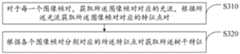
具体地,如图2所示,所述根据所述图像序列获取树干特征包括:Specifically, as shown in FIG. 2 , the obtaining the tree trunk feature according to the image sequence includes:
S310、对于每一个图像帧对,获取所述图像帧对对应的光流,根据所述光流获取所述图像帧对对应的特征点对;S310. For each image frame pair, obtain an optical flow corresponding to the image frame pair, and obtain a feature point pair corresponding to the image frame pair according to the optical flow;
其中,所述图像帧对包括第一图像帧和与所述第一图像帧相邻的第二图像帧,每个特征点对包括所述第一图像帧上的第一特征点和所述第二图像帧上与所述第一特征点对应的第二特征点。所述特征点对中的第一特征点和所述第二特征点是实际环境中的同一特征点,也就是说,二者是同一物体上的同一点在不同帧上的显示,所述获取所述图像帧对对应的光流可以是根据现有的光流算法得到,在本实施例中,是通过LK光流法(Lucas-Kanade光流法)来获取所述图像帧对对应的光流,根据所述光流可以获取所述特征点对,此为现有技术,在此不再赘述。对于所述图像序列中的第一个图像帧,先进行特征点提取,在本实施例中,是通过FAST(Features From Accelerated SegmentTest)算法来提取特征点,当然,也可以采用其他的特征点提取算法来提取特征点,本发明对此不做具体的限制,此后对于新获取的每一帧,都与前一帧构成所述图像帧对,从而可以获取到所述特征点对,即可以获取到前一帧的特征点在当前帧中的位置。特别地,对于当前帧图像中没有特征点的区域,提取新的特征点。The image frame pair includes a first image frame and a second image frame adjacent to the first image frame, and each feature point pair includes a first feature point on the first image frame and the first feature point on the first image frame. A second feature point corresponding to the first feature point on the two image frames. The first feature point and the second feature point in the feature point pair are the same feature point in the actual environment, that is, the two are displays of the same point on the same object on different frames, and the acquisition The optical flow corresponding to the image frame pair may be obtained according to an existing optical flow algorithm. In this embodiment, the LK optical flow method (Lucas-Kanade optical flow method) is used to obtain the optical flow corresponding to the image frame pair. According to the optical flow, the feature point pair can be obtained, which is the prior art and will not be repeated here. For the first image frame in the image sequence, feature point extraction is performed first. In this embodiment, the feature point is extracted by the FAST (Features From Accelerated Segment Test) algorithm. Of course, other feature point extraction can also be used. The present invention does not make specific restrictions on this, and thereafter, for each newly acquired frame, the image frame pair is formed with the previous frame, so that the feature point pair can be obtained, that is, the image frame pair can be obtained. To the position of the feature point of the previous frame in the current frame. In particular, for the region without feature points in the current frame image, new feature points are extracted.
对于每一个特征点,都进行存储,具体的存储方式为:每一个特征点对应有特征点数据,所述特征点数据中包括了特征点的识别信息以及观测到该特征点的图像帧ID以及该特征点在该图像帧上的2D位置,所述识别信息可以设置为特征点的ID,所述识别信息用于识别特征点,不难看出,对于每个特征点对中的第一特征点和第二特征点,应具有相同的识别信息。For each feature point, it is stored, and the specific storage method is as follows: each feature point corresponds to feature point data, and the feature point data includes the identification information of the feature point and the image frame ID where the feature point is observed and the ID of the image frame. The 2D position of the feature point on the image frame, the identification information can be set as the ID of the feature point, and the identification information is used to identify the feature point. It is not difficult to see that for the first feature point in each feature point pair and the second feature point, should have the same identification information.
S320、根据各个图像帧对分别对应的所述特征点对获取所述树干特征。S320. Acquire the tree trunk feature according to the feature point pairs corresponding to each image frame pair respectively.
在获取到所述特征点对后,可以根据所述特征点对来获取各个图像帧中的树干特征。具体地,所述根据各个图像帧对分别对应的所述特征点对获取所述树干特征包括:After the feature point pair is acquired, the tree trunk feature in each image frame can be acquired according to the feature point pair. Specifically, the obtaining the trunk feature according to the feature point pair corresponding to each image frame pair includes:
S321、对于新获取的每一帧图像帧,检测所述图像帧上的目标树干矩形区域,获取所述目标树干矩形区域中包括的目标特征点的目标识别信息,根据所述目标识别信息以及已存储的树干矩形区域的特征点识别信息确定所述目标树干矩形区域是否为新的树干矩形区域;S321. For each newly acquired image frame, detect the rectangular area of the target tree trunk on the image frame, acquire the target identification information of the target feature points included in the rectangular area of the target tree trunk, and obtain the target identification information according to the target identification information and the The feature point identification information of the stored trunk rectangle area determines whether the target trunk rectangle area is a new trunk rectangle area;
S322、如是,则建立所述目标树干矩形区域对应的树干特征。S322. If yes, establish a trunk feature corresponding to the target trunk rectangular area.
在本实施例中,根据所述无人机的记载相机拍摄的所述图像序列构建树干地图,所述树干地图中存储有所述无人机所在环境中的各个树干,以及各个树干分别对应的树干数据,所述树干数据包括树干的特征(在本实施例中,为树干的圆柱模型)、观测到该树干的图像帧ID、该图像帧上检测的该树干的树干矩形区域以及该树干矩形区域中包含的特征点。In this embodiment, a tree trunk map is constructed according to the image sequence captured by the recording camera of the drone, and the tree trunk map stores each tree trunk in the environment where the drone is located, and the corresponding tree trunks respectively Trunk data, the trunk data includes the feature of the trunk (in this embodiment, the cylindrical model of the trunk), the ID of the image frame where the trunk is observed, the trunk rectangle area of the trunk detected on the image frame, and the trunk rectangle Feature points contained in the region.
具体地,每次获取到新的图像帧时,首先对该图像帧进行内容识别,检测所述图像帧上的树干矩形区域,对于每一个树干矩形区域进行处理时,将该树干矩形区域作为所述目标树干矩形区域,将所述目标树干矩形区域中包括的特征点作为目标特征点,首先遍历所述树干地图中所有的树干,获取每个树干对应的最新的所述特征点数据,确定每个树干对应的最新的特征点的识别信息,当所述树干地图中的某个树干具有的与所述目标树干矩形区域中的所述目标特征点的目标识别信息相同的特征点的数量超过预设值时,则确定该树干与所述目标树干矩形区域对应的树干为同一树干,如果遍历所述树干地图中的所有树干后,都不存在与所述目标树干矩形区域的特征点识别信息相同的特征点数量超过预设值的树干,那么,确定所述目标树干矩形区域对应的为一个新的树干,将其加入到所述树干地图中去。Specifically, each time a new image frame is acquired, the content of the image frame is first identified, the rectangular area of the trunk on the image frame is detected, and when each rectangular area of the trunk is processed, the rectangular area of the trunk is used as the Describe the target trunk rectangular area, take the feature points included in the target trunk rectangular area as the target feature points, first traverse all the trunks in the trunk map, obtain the latest described feature point data corresponding to each trunk, determine each The identification information of the latest feature points corresponding to each trunk, when a certain trunk in the trunk map has the same feature points as the target identification information of the target feature point in the rectangular area of the target trunk, the number of feature points exceeds the predetermined number. When setting the value, it is determined that the trunk corresponding to the rectangular area of the target trunk is the same trunk. If all the trunks in the trunk map are traversed, there is no feature point identification information identical to the rectangular area of the target trunk. If the number of feature points exceeds the preset value of the trunk, then, determine that the rectangular area of the target trunk corresponds to a new trunk, and add it to the trunk map.
在确定所述目标树干矩形对应的树干为新的树干后,建立所述目标树干矩形区域对应的树干特征。After it is determined that the trunk corresponding to the target trunk rectangle is a new trunk, a trunk feature corresponding to the target trunk rectangle area is established.
在本实施例中,树干特征是树干对应的圆柱模型,所述建立所述目标树干矩形区域对应的树干特征是根据深度图提取所述目标树干矩形区域中所有像素点的深度数据,再通过相机内参反算出所述目标树干矩形区域中所有像素点在相机坐标系下的三维点云,利用这些属于树干的三维点云估计树干的圆柱参数。In this embodiment, the trunk feature is a cylindrical model corresponding to the trunk, and the establishment of the trunk feature corresponding to the rectangular area of the target trunk is to extract the depth data of all pixels in the rectangular area of the target trunk according to the depth map, and then use the camera The internal parameter inversely calculates the three-dimensional point cloud of all pixels in the rectangular area of the target trunk in the camera coordinate system, and uses these three-dimensional point clouds belonging to the trunk to estimate the cylindrical parameters of the trunk.
在本实施例中,对于树干c,其对应的圆柱模型可以表示为


根据以下相机模型:According to the following camera model:

其中,(Xc Yc Zc)T为某点在相机坐标系中的坐标,(u v)T为该点在图像坐标系中的坐标,fx,fy,cx,cy为相机模型的内参数。利用深度图测量值(u v d)T可以算出该点在相机坐标系中的坐标:Among them, (Xc Yc Zc )T is the coordinate of a point in the camera coordinate system, (uv)T is the coordinate of the point in the image coordinate system, fx , fy , cx , cy are the camera. internal parameters of the model. Using the depth map measurement (uvd)T , the coordinates of the point in the camera coordinate system can be calculated:

在获得树干上的所有三维点云


在获得所有三维点云


计算p0在球坐标系中的另外两个单位矢量:Compute the other two unit vectors for p0 in spherical coordinates:


估计圆柱模型的旋转轴:任意选取法向量非平行的4个点p0,p1,p2,p3,对应的单位法向量分别为:n0、n1、n2、n3,设轴线上的两点为p0+t0n0,p1+t1n1。则向量组p0+t0n0-p2,p1+t1n1-p0-t0n0,n2与向量组p0+t0n0-p3,p1+t1n1-p0-t0n0,n3均满足共面约束,三个共面向量的三重积等于0,即:Estimate the rotation axis of the cylindrical model: arbitrarily select four points p0 , p1 , p2 , p3 whose normal vectors are non-parallel, and the corresponding unit normal vectors are: n0 , n1 , n2 , and n3 . The two points on the axis are p0 +t0 n0 , p1 +t1 n1 . Then the vector group p0 +t0 n0 -p2 , p1 +t1 n1 -p0 -t0 n0 , n2 and the vector group p0 +t0 n0 -p3 , p1 +t1 n1 -p0 -t0 n0 , n3 all satisfy the coplanarity constraint, and the triple product of the three coplanar vectors is equal to 0, that is:
((p0+t0n0-p2)(p1+t1n1-p0-t0n0)n2)=0((p0 +t0 n0 -p2 )(p1 +t1 n1 -p0 -t0 n0 )n2 )=0
((p0+t0n0-p3)(p1+t1n1-p0-t0n0)n3)=0((p0 +t0 n0 -p3 )(p1 +t1 n1 -p0 -t0 n0 )n3 )=0
展开可以得到:Expand to get:
(n0n1n2)t0t1+((p2-p1)n0n2)t0+((p0-p2)n1n2)t1+((p0-p2)(p1-p0)n2)=0(n0 n1 n2 )t0 t1 +((p2 -p1 )n0 n2 )t0 +((p0 -p2 )n1 n2 )t1 +((p0 - p2 )(p1 -p0 )n2 )=0
(n0n1n3)t0t1+((p3-p1)n0n3)t0+((p0-p3)n1n3)t1+((p0-p3)(p1-p0)n3)=0(n0 n1 n3 )t0 t1 +((p3 -p1 )n0 n3 )t0 +((p0 -p3 )n1 n3 )t1 +((p0 - p3 )(p1 -p0 )n3 )=0
消去t0t1,可以分别得到关于t0,t1的二次方程,理想情况下可以得到{t0,t1}的四组解{t0(0),t1(0)},{t0(0),t1(1)},{t0(1),t1(0)},{t0(1),t1(1)},因此旋转轴的初值存在4种可能:By eliminating t0 t1 , quadratic equations about t0 , t1 can be obtained respectively, ideally, four sets of solutions {t0 (0), t1 (0)} of {t0 , t1 } can be obtained, {t0 (0),t1 (1)},{t0 (1),t1 (0)},{t0 (1),t1 (1)}, so the initial value of the rotation axis exists 4 Possibilities:
a0(0)=(p1+t1n1(0))-(p0+t0n0(0))a0 (0)=(p1 +t1 n1 (0))-(p0 +t0 n0 (0))
a0(1)=(p1+t1n1(1))-(p0+t0n0(0))a0 (1)=(p1 +t1 n1 (1))-(p0 +t0 n0 (0))
a0(2)=(p1+t1n1(0))-(p0+t0n0(1))a0 (2)=(p1 +t1 n1 (0))-(p0 +t0 n0 (1))
a0(3)=(p1+t1n1(1))-(p0+t0n0(1))a0 (3)=(p1 +t1 n1 (1))-(p0 +t0 n0 (1))
对每个可能的旋转轴a0(i),计算其与
估计该点的曲率:κ0=λ2(λ0+λ1+λ2),λi为计算该点法向量时的分解协方差矩阵得到的特征值,λ2<λ1<λ0。Estimate the curvature of the point: κ0 =λ2 (λ0 +λ1 +λ2 ), λi is the eigenvalue obtained by decomposing the covariance matrix when calculating the normal vector of the point, λ2 <λ1 <λ0 .
对圆柱c,在得到圆柱参数的初值


代价函数对各参数的导数为:The derivative of the cost function with respect to each parameter is:


根据所述代价函数对所述圆柱参数进行优化,得到优化后的圆柱参数mc。The cylindrical parameters are optimized according to the cost function to obtain the optimized cylindrical parameters mc .
在获取到所述树干特征后,根据所述树干特征获取所述预设时段内的树干特征投影残差与所述惯性测量单元参数的第三对应关系。After the trunk feature is acquired, a third correspondence between the trunk feature projection residual and the inertial measurement unit parameter within the preset time period is acquired according to the trunk feature.
具体地,所述树干特征投影残差与所述惯性测量单元参数的第三对应关系通过第三预设公式被表示,所述第三预设公式为:Specifically, the third correspondence between the trunk feature projection residual and the inertial measurement unit parameter is represented by a third preset formula, and the third preset formula is:

ec,k,m为第k帧中树干


请再次参阅图1,所述基于树干特征的无人机定位方法还包括步骤:Please refer to Fig. 1 again, the UAV positioning method based on tree trunk features further includes the steps:
S400、根据所述第一对应关系、所述第二对应关系和所述第三对应关系获取所述预设时段内各个图像帧分别对应的目标惯性查了单元参数,并根据所述目标惯性测量单元参数对所述无人机进行定位。S400. Acquire, according to the first corresponding relationship, the second corresponding relationship, and the third corresponding relationship, the target inertial search unit parameters corresponding to each image frame within the preset time period, and measure the unit parameters according to the target inertial relationship. The unit parameters locate the drone.
具体地,在步骤S300中,是求解预设的优化函数,获取使得所述优化函数达到最小值的惯性测量单元参数序列,其中,所述惯性测量单元参数序列中包括所述预设时段内各个图像帧分别对应的所述目标惯性测量单元参数。Specifically, in step S300, a preset optimization function is solved, and an inertial measurement unit parameter sequence that makes the optimization function reach a minimum value is obtained, wherein the inertial measurement unit parameter sequence includes each parameter sequence within the preset time period. The target inertial measurement unit parameters corresponding to the image frames respectively.
所述优化函数为:The optimization function is:

其中,ek-1,k为k-1,k两帧间的所述数据残差,Rk-1,k-1为ek-1,k的权重,ec,k,m为第k帧中树干特征mc区域中点云m对应的所述树干特征投影残差,Uc,k,m-1为ec,k,m的权重,PCk为第k帧中
Rk-1,k-1可以设置为步骤S100中获取的惯性测量单元数据的误差状态协方差矩阵Pi,j的逆矩阵,Uc,k,m-1可以设置为单位阵。Rk-1,k-1 may be set as the inverse matrix of the error state covariance matrix Pi,j of the inertial measurement unit data acquired in step S100 , and Uc,k,m-1 may be set as the identity matrix.
所述优化函数的求解,使用ceres优化库,梯度下降策略使用LevenbergMarquardt方法。For the solution of the optimization function, the ceres optimization library is used, and the gradient descent strategy uses the LevenbergMarquardt method.
在另一种可能的实现方式中,为了提升定位精度,还结合特征点重投影残差和先验残差获取所述目标惯性测量单元参数,在这种实现方式中,所述优化函数为:In another possible implementation, in order to improve the positioning accuracy, the target inertial measurement unit parameters are obtained by combining the feature point reprojection residual and the prior residual. In this implementation, the optimization function is:

其中,ep为先验残差,Vp-1为ep的权重,ef,k为第k帧中的特征点f对应的重投影残差,F为第k帧中的特征点的个数,Qf,k-1为ef,k的权重,ek-1,k为k-1,k两帧间的所述数据残差,Rk-1,k-1为ek-1,k的权重,ec,k,m为第k帧中树干特征mc区域中点云m对应的所述树干特征投影残差,Uc,k,m-1为ec,k,m的权重,PCk为第k帧中
Vp-1设置为单位阵,Qf,k-1为提取图像帧中的特征点时特征尺度(大小)的倒数,FAST算法的特征尺度为1,因此,当采用FAST算法提取特征点时,Qf,k-1为单位阵。Vp-1 is set as the unit matrix, Qf,k-1 is the reciprocal of the feature scale (size) when extracting the feature points in the image frame, and the feature scale of the FAST algorithm is 1. Therefore, when the FAST algorithm is used to extract the feature points , Qf,k-1 is the identity matrix.
下面对先验残差以及特征点重投影残差的获取方式进行说明:The following describes how to obtain the prior residuals and feature point reprojection residuals:
特征点重投影残差ef,k:Feature point reprojection residual ef,k :
特征点重投影残差采用AHP(层次分析法)参数化表示,特征点f属于第k-1帧,其参数表示为:


h()是点特征路标的投影函数,zf,k为特征点f在第k帧上的投影观测值,
先验残差ep:Prior residualep :
已知先验变量xp及其协方差矩阵Hpp,对Hpp分解有Hpp=JppTJpp,先验残差的更新为:Knowing the prior variable xp and its covariance matrix Hpp , the decomposition of Hpp has Hpp =JppT Jpp , and the update of the prior residual is:
ep=ep0+Jppδxpep = ep0 +Jpp δxp
ep0为先验残差初值,每次优化前设为0。ep0 is the initial value of the prior residual, which is set to 0 before each optimization.
完成优化之后,计算下一次优化中要用到的先验变量xp:After completing the optimization, calculate the prior variable xp to be used in the next optimization:
先验变量的分布(协方差)可以通过求解此增量方程得到:The distribution (covariance) of the prior variable can be obtained by solving this incremental equation:

xm是将要被边缘化(从滑动窗口中移除)的变量,在滑动窗口中所有包含xm的残差记为em,xp为em中与xm组成残差项的其它优化变量,xp将作为下一次优化中要用到的先验变量。xm is the variable to be marginalized (removed from the sliding window), all residuals containing xm in the sliding window are denoted asem , xp is the other optimization of the residual term inem and xm variable, xp will be used as a priori variable to be used in the next optimization.
em对xm,xp的雅可比矩阵分别记为Jmm,Jpp,则增量方程中的各项为:The Jacobian matrices ofem to x m , x paredenoted as Jmm , Jpp respectively, then the terms in the incremental equation are:
Hmm=JmmTJmm,Hmp=JppTJmmHmm = JmmT Jmm , Hmp = JppT Jmm
Hpm=JmmTJpp,Hpp=JppTJppHpm =JmmT Jpp , Hpp =JppT Jpp
bm=-JmmTem,bp=-JppTepbm =-JmmT em , bp =-JppT ep
边缘化xm后,先验变量xp的协方差矩阵可以通过舒尔消元法算得:After marginalizing xm , the covariance matrix of the prior variable xp can be calculated by Schur elimination:

至此,求得下一次优化时先验变量的协方差矩阵Hpp*。So far, the covariance matrix Hpp* of the prior variables in the next optimization is obtained.
在根据所述预设函数获取到所述惯性测量单元参数序列后,根据所述惯性测量单元参数序列中包括的所述预设时段内各个帧分别对应的所述目标惯性测量单元参数以及定位参数与惯性测量单元参数的所述第一对应关系,即可获取所述预设时段内各个图像帧分别对应的所述定位参数,即可以获取所述预设时段内各个图像帧分别对应的无人机位置、速度以及姿态,实现对所述无人机的定位。After the inertial measurement unit parameter sequence is obtained according to the preset function, the target inertial measurement unit parameters and positioning parameters corresponding to each frame in the preset time period included in the inertial measurement unit parameter sequence The first correspondence with the parameters of the inertial measurement unit, the positioning parameters corresponding to each image frame in the preset time period can be obtained, that is, the unmanned person corresponding to each image frame in the preset time period can be obtained. The position, speed and attitude of the drone are used to realize the positioning of the drone.
综上所述,本实施例提供一种基于树干特征的无人机定位方法,所述基于树干特征的无人机定位方法所述基于树干特征的无人机定位方法基于树干特征以及无人机的惯性测量单元来对无人机进行定位,能够在森林环境下不依靠GPS信号实现定位。To sum up, this embodiment provides a UAV positioning method based on tree trunk features, and the UAV positioning method based on tree trunk features is based on tree trunk features and UAVs. The inertial measurement unit is used to locate the UAV, which can achieve positioning without relying on GPS signals in the forest environment.
应该理解的是,虽然本发明说明书附图中给出的的流程图中的各个步骤按照箭头的指示依次显示,但是这些步骤并不是必然按照箭头指示的顺序依次执行。除非本文中有明确的说明,这些步骤的执行并没有严格的顺序限制,这些步骤可以以其它的顺序执行。而且,流程图中的至少一部分步骤可以包括多个子步骤或者多个阶段,这些子步骤或者阶段并不必然是在同一时刻执行完成,而是可以在不同的时刻执行,这些子步骤或者阶段的执行顺序也不必然是依次进行,而是可以与其它步骤或者其它步骤的子步骤或者阶段的至少一部分轮流或者交替地执行。It should be understood that although the various steps in the flowcharts given in the accompanying drawings of the present invention are shown in sequence according to the arrows, these steps are not necessarily executed in sequence according to the sequence shown by the arrows. Unless explicitly stated herein, the execution of these steps is not strictly limited to the order, and these steps may be performed in other orders. Moreover, at least a part of the steps in the flowchart may include multiple sub-steps or multiple stages. These sub-steps or stages are not necessarily executed at the same time, but may be executed at different times. The execution of these sub-steps or stages The sequence is also not necessarily sequential, but may be performed alternately or alternately with other steps or sub-steps of other steps or at least a portion of a phase.
本领域普通技术人员可以理解实现上述实施例方法中的全部或部分流程,是可以通过计算机程序来指令相关的硬件来完成,所述的计算机程序可存储于一非易失性计算机可读取存储介质中,该计算机程序在执行时,可包括如上述各方法的实施例的流程。其中,本发明所提供的各实施例中所使用的对存储器、存储、数据库或其它介质的任何引用,均可包括非易失性和/或易失性存储器。非易失性存储器可包括只读存储器(ROM)、可编程ROM(PROM)、电可编程ROM(EPROM)、电可擦除可编程ROM(EEPROM)或闪存。易失性存储器可包括随机存取存储器(RAM)或者外部高速缓冲存储器。作为说明而非局限,RAM以多种形式可得,诸如静态RAM(SRAM)、动态RAM(DRAM)、同步DRAM(SDRAM)、双数据率SDRAM(DDRSDRAM)、增强型SDRAM(ESDRAM)、同步链路(Synchlink)DRAM(SLDRAM)、存储器总线(Rambus)直接RAM(RDRAM)、直接存储器总线动态RAM(DRDRAM)、以及存储器总线动态RAM(RDRAM)等。Those of ordinary skill in the art can understand that all or part of the processes in the methods of the above embodiments can be implemented by instructing relevant hardware through a computer program, and the computer program can be stored in a non-volatile computer-readable storage In the medium, when the computer program is executed, it may include the processes of the above-mentioned method embodiments. Wherein, any reference to memory, storage, database or other medium used in the various embodiments provided by the present invention may include non-volatile and/or volatile memory. Nonvolatile memory may include read only memory (ROM), programmable ROM (PROM), electrically programmable ROM (EPROM), electrically erasable programmable ROM (EEPROM), or flash memory. Volatile memory may include random access memory (RAM) or external cache memory. By way of illustration and not limitation, RAM is available in various forms such as static RAM (SRAM), dynamic RAM (DRAM), synchronous DRAM (SDRAM), double data rate SDRAM (DDRSDRAM), enhanced SDRAM (ESDRAM), synchronous chain Road (Synchlink) DRAM (SLDRAM), memory bus (Rambus) direct RAM (RDRAM), direct memory bus dynamic RAM (DRDRAM), and memory bus dynamic RAM (RDRAM), etc.
实施例二Embodiment 2
基于上述实施例,本发明还相应提供了一种无人机,如图3所示,所述无人机包括处理器10以及存储器20。图3仅示出了无人机的部分组件,但是应理解的是,并不要求实施所有示出的组件,可以替代的实施更多或者更少的组件。Based on the above embodiments, the present invention also provides an unmanned aerial vehicle correspondingly, as shown in FIG. 3 , the unmanned aerial vehicle includes a
所述存储器20在一些实施例中可以是所述无人机的内部存储单元,例如无人机的硬盘或内存。所述存储器20在另一些实施例中也可以是所述无人机的外部存储设备,例如所述无人机上配备的插接式硬盘,智能存储卡(Smart Media Card,SMC),安全数字(SecureDigital,SD)卡,闪存卡(Flash Card)等。进一步地,所述存储器20还可以既包括所述无人机的内部存储单元也包括外部存储设备。所述存储器20用于存储安装于所述无人机的应用软件及各类数据。所述存储器20还可以用于暂时地存储已经输出或者将要输出的数据。在一实施例中,存储器20上存储有基于树干特征的无人机定位程序30,该基于树干特征的无人机定位程序30可被处理器10所执行,从而实现本申请中基于树干特征的无人机定位方法。The
所述处理器10在一些实施例中可以是一中央处理器(Central Processing Unit,CPU),微处理器或其他芯片,用于运行所述存储器20中存储的程序代码或处理数据,例如执行所述基于树干特征的无人机定位方法等。In some embodiments, the
在一实施例中,当处理器10执行所述存储器20中基于树干特征的无人机定位程序30时实现以下步骤:In one embodiment, when the
获取无人机的惯性测量单元的测量数据,根据所述测量数据获取所述无人机的定位参数在预设时段内各个时刻分别与惯性测量单元参数的第一对应关系,其中,所述定位参数包括无人机的位置、速度和姿态,所述预设时段为图像序列中n个连续图像帧对应的时间段,所述图像序列通过所述无人机的机载相机获取;Obtain the measurement data of the inertial measurement unit of the drone, and obtain the first correspondence between the positioning parameters of the drone and the parameters of the inertial measurement unit at each moment in a preset period according to the measurement data, wherein the positioning The parameters include the position, speed and attitude of the UAV, and the preset time period is the time period corresponding to n consecutive image frames in the image sequence, and the image sequence is acquired by the onboard camera of the UAV;
根据所述第一对应关系获取所述惯性测量单元在所述预设时段内的数据残差与所述惯性测量单元参数的第二对应关系;Acquiring a second correspondence between the data residuals of the inertial measurement unit within the preset time period and the parameters of the inertial measurement unit according to the first correspondence;
根据所述图像序列获取树干特征,根据所述树干特征获取所述预设时段内的树干特征投影残差与所述惯性测量单元参数的第三对应关系;Obtaining the trunk feature according to the image sequence, and obtaining the third correspondence between the trunk feature projection residual and the inertial measurement unit parameter within the preset time period according to the tree trunk feature;
根据所述第一对应关系、所述第二对应关系以及所述第三对应关系获取所述预设时段内各个图像帧分别对应的目标惯性测量单元参数,并根据所述目标惯性测量单元参数对所述无人机进行定位。The target inertial measurement unit parameters corresponding to each image frame in the preset period are acquired according to the first correspondence, the second correspondence and the third correspondence, and the target inertial measurement unit parameters are paired according to the target inertial measurement unit parameters. The UAV performs positioning.
其中,所述惯性测量单元包括加速度计和陀螺仪,所述测量数据包括加速度计测量值和陀螺仪测量值,所述惯性测量单元参数包括加速度计偏置、加速度计噪声、陀螺仪偏置和陀螺仪噪声;所述定位参数与惯性测量单元参数的第一对应关系通过第一预设公式表示,所述第一预设公式为:Wherein, the inertial measurement unit includes an accelerometer and a gyroscope, the measurement data includes an accelerometer measurement value and a gyroscope measurement value, and the inertial measurement unit parameters include accelerometer bias, accelerometer noise, gyroscope bias and Gyro noise; the first correspondence between the positioning parameters and the inertial measurement unit parameters is represented by a first preset formula, and the first preset formula is:


其中,l+1时刻为l时刻的后一时刻,Δt为l+1时刻和l时刻之间的间隔,


其中,所述数据残差与所述惯性测量单元参数的第二对应关系通过第二预设公式被表示,所述第二预设公式为:Wherein, the second correspondence between the data residuals and the inertial measurement unit parameters is represented by a second preset formula, and the second preset formula is:


其中,ei-1,i为所述图像序列中第i-1帧和第i帧之间的所述测量数据的数据残差,


其中,所述根据所述图像序列获取树干特征包括:Wherein, the obtaining the tree trunk feature according to the image sequence includes:
对于每一个图像帧对,获取所述图像帧对对应的光流,根据所述光流获取所述图像帧对对应的特征点对,其中,所述图像帧对包括第一图像帧和与所述第一图像帧相邻的第二图像帧,每个特征点对包括所述第一图像帧上的第一特征点和所述第二图像帧上与所述第一特征点对应的第二特征点;For each image frame pair, the optical flow corresponding to the image frame pair is obtained, and the feature point pair corresponding to the image frame pair is obtained according to the optical flow, wherein the image frame pair includes the first image frame and the A second image frame adjacent to the first image frame, each feature point pair includes a first feature point on the first image frame and a second image frame corresponding to the first feature point on the second image frame Feature points;
根据各个图像帧对分别对应的所述特征点对获取所述树干特征。The tree trunk feature is acquired according to the feature point pairs corresponding to each image frame pair respectively.
其中,所述根据各个图像帧对分别对应的所述特征点对获取所述树干特征包括:Wherein, the acquiring the trunk feature according to the feature point pair corresponding to each image frame pair respectively includes:
对于新获取的每一帧图像帧,检测所述图像帧上的目标树干矩形区域,获取所述目标树干矩形区域中包括的目标特征点的目标识别信息,根据所述目标识别信息以及已存储的树干矩形区域的特征点识别信息确定所述目标树干矩形区域是否为新的树干矩形区域;For each newly acquired image frame, detect the rectangular area of the target tree trunk on the image frame, obtain the target identification information of the target feature points included in the rectangular area of the target tree trunk, according to the target identification information and the stored The feature point identification information of the trunk rectangular area determines whether the target trunk rectangular area is a new trunk rectangular area;
如是,则建立所述目标树干矩形区域对应的树干特征;If so, then establish the trunk feature corresponding to the target trunk rectangular area;
其中,每个特征点对中包括的所述第一特征点和所述第二特征点的识别信息相同。Wherein, the identification information of the first feature point and the second feature point included in each feature point pair are the same.
其中,所述树干特征投影残差与所述惯性测量单元参数的第三对应关系通过第三预设公式被表示,所述第三预设公式为:Wherein, the third correspondence between the trunk feature projection residual and the inertial measurement unit parameter is represented by a third preset formula, and the third preset formula is:

其中,ec,k,m为第k帧中树干特征mc的树干区域中的点云m对应的所述树干特征投影残差,

其中,所述根据所述第一对应关系、所述第二对应关系以及所述第三对应关系获取目标惯性测量单元参数包括:Wherein, the acquiring target inertial measurement unit parameters according to the first correspondence, the second correspondence and the third correspondence includes:
求解预设的优化函数,获取使得所述优化函数达到最小值的惯性测量单元参数序列,其中所述关系测量单元参数序列中包括所述预设时段内各个图像帧分别对应的所述目标惯性测量单元参数;Solve a preset optimization function, and obtain an inertial measurement unit parameter sequence that makes the optimization function reach a minimum value, wherein the relationship measurement unit parameter sequence includes the target inertial measurement corresponding to each image frame in the preset time period. unit parameter;
所述优化函数为:The optimization function is:
其中,ep为先验残差,Vp-1为ep的权重,ef,k为第k帧中的特征点f对应的重投影残差,F为第k帧中的特征点的个数,Qf,k-1为ef,k的权重,ek-1,k为k-1,k两帧间的所述数据残差,Rk-1,k-1为ek-1,k的权重,ec,k,m为第k帧中树干特征mc区域中点云m对应的所述树干特征投影残差,Uc,k,m-1为ec,k,m的权重,PCk为第k帧中
其中,所述根据所述目标惯性测量单元参数对所述无人机进行定位包括:Wherein, the positioning of the UAV according to the target inertial measurement unit parameters includes:
根据所述预设时段内各个图像帧分别对应的所述目标惯性测量单元参数以及所述第一对应关系获取所述预设时段内各个图像帧分别对应的所述定位参数。The positioning parameters corresponding to each image frame in the preset time period are acquired according to the target inertial measurement unit parameter corresponding to each image frame in the preset time period and the first correspondence.
实施例三Embodiment 3
本发明还提供一种存储介质,其中,存储有一个或者多个程序,所述一个或者多个程序可被一个或者多个处理器执行,以实现如上所述的基于树干特征的无人机定位方法的步骤。The present invention also provides a storage medium, in which one or more programs are stored, and the one or more programs can be executed by one or more processors to realize the above-mentioned tree trunk feature-based UAV positioning steps of the method.
最后应说明的是:以上实施例仅用以说明本发明的技术方案,而非对其限制;尽管参照前述实施例对本发明进行了详细的说明,本领域的普通技术人员应当理解:其依然可以对前述各实施例所记载的技术方案进行修改,或者对其中部分技术特征进行等同替换;而这些修改或者替换,并不使相应技术方案的本质脱离本发明各实施例技术方案的精神和范围。Finally, it should be noted that: the above embodiments are only used to illustrate the technical solutions of the present invention, but not to limit them; although the present invention has been described in detail with reference to the foregoing embodiments, those of ordinary skill in the art should understand: it can still be Modifications are made to the technical solutions described in the foregoing embodiments, or some technical features thereof are equivalently replaced; and these modifications or replacements do not make the essence of the corresponding technical solutions depart from the spirit and scope of the technical solutions of the embodiments of the present invention.
Claims (10)
Translated fromChinese


Priority Applications (1)
| Application Number | Priority Date | Filing Date | Title |
|---|---|---|---|
| CN202010597975.2ACN111811501B (en) | 2020-06-28 | 2020-06-28 | Trunk feature-based unmanned aerial vehicle positioning method, unmanned aerial vehicle and storage medium |
Applications Claiming Priority (1)
| Application Number | Priority Date | Filing Date | Title |
|---|---|---|---|
| CN202010597975.2ACN111811501B (en) | 2020-06-28 | 2020-06-28 | Trunk feature-based unmanned aerial vehicle positioning method, unmanned aerial vehicle and storage medium |
Publications (2)
| Publication Number | Publication Date |
|---|---|
| CN111811501Atrue CN111811501A (en) | 2020-10-23 |
| CN111811501B CN111811501B (en) | 2022-03-08 |
Family
ID=72855631
Family Applications (1)
| Application Number | Title | Priority Date | Filing Date |
|---|---|---|---|
| CN202010597975.2AActiveCN111811501B (en) | 2020-06-28 | 2020-06-28 | Trunk feature-based unmanned aerial vehicle positioning method, unmanned aerial vehicle and storage medium |
Country Status (1)
| Country | Link |
|---|---|
| CN (1) | CN111811501B (en) |
Cited By (1)
| Publication number | Priority date | Publication date | Assignee | Title |
|---|---|---|---|---|
| CN113066103A (en)* | 2021-03-18 | 2021-07-02 | 鹏城实验室 | A method for determining motion between camera frames |
Citations (14)
| Publication number | Priority date | Publication date | Assignee | Title |
|---|---|---|---|---|
| DE102006062061A1 (en)* | 2006-12-29 | 2008-07-03 | Fraunhofer-Gesellschaft zur Förderung der angewandten Forschung e.V. | Device, method, and computer program for determining a position on the basis of a camera image |
| US20120078510A1 (en)* | 2010-09-24 | 2012-03-29 | Honeywell International Inc. | Camera and inertial measurement unit integration with navigation data feedback for feature tracking |
| US9031809B1 (en)* | 2010-07-14 | 2015-05-12 | Sri International | Method and apparatus for generating three-dimensional pose using multi-modal sensor fusion |
| WO2015143615A1 (en)* | 2014-03-24 | 2015-10-01 | 深圳市大疆创新科技有限公司 | Method and apparatus for correcting aircraft state in real time |
| CN107869989A (en)* | 2017-11-06 | 2018-04-03 | 东北大学 | A positioning method and system based on visual inertial navigation information fusion |
| US20180188384A1 (en)* | 2017-01-04 | 2018-07-05 | Qualcomm Incorporated | Systems and methods for using a sliding window of global positioning epochs in visual-inertial odometry |
| US20190063932A1 (en)* | 2017-08-28 | 2019-02-28 | Nec Laboratories America, Inc. | Autonomous Vehicle Utilizing Pose Estimation |
| CN109558879A (en)* | 2017-09-22 | 2019-04-02 | 华为技术有限公司 | A kind of vision SLAM method and apparatus based on dotted line feature |
| CN109631894A (en)* | 2018-12-11 | 2019-04-16 | 智灵飞(北京)科技有限公司 | A kind of monocular vision inertia close coupling method based on sliding window |
| US20190204084A1 (en)* | 2017-09-29 | 2019-07-04 | Goertek Inc. | Binocular vision localization method, device and system |
| CN109974693A (en)* | 2019-01-31 | 2019-07-05 | 中国科学院深圳先进技术研究院 | UAV positioning method, device, computer equipment and storage medium |
| CN109993113A (en)* | 2019-03-29 | 2019-07-09 | 东北大学 | A Pose Estimation Method Based on RGB-D and IMU Information Fusion |
| US20190392212A1 (en)* | 2018-06-25 | 2019-12-26 | Microsoft Technology Licensing, Llc | Object-based localization |
| US20200025570A1 (en)* | 2017-03-29 | 2020-01-23 | Agency For Science, Technology And Research | Real time robust localization via visual inertial odometry |
- 2020
- 2020-06-28CNCN202010597975.2Apatent/CN111811501B/enactiveActive
Patent Citations (14)
| Publication number | Priority date | Publication date | Assignee | Title |
|---|---|---|---|---|
| DE102006062061A1 (en)* | 2006-12-29 | 2008-07-03 | Fraunhofer-Gesellschaft zur Förderung der angewandten Forschung e.V. | Device, method, and computer program for determining a position on the basis of a camera image |
| US9031809B1 (en)* | 2010-07-14 | 2015-05-12 | Sri International | Method and apparatus for generating three-dimensional pose using multi-modal sensor fusion |
| US20120078510A1 (en)* | 2010-09-24 | 2012-03-29 | Honeywell International Inc. | Camera and inertial measurement unit integration with navigation data feedback for feature tracking |
| WO2015143615A1 (en)* | 2014-03-24 | 2015-10-01 | 深圳市大疆创新科技有限公司 | Method and apparatus for correcting aircraft state in real time |
| US20180188384A1 (en)* | 2017-01-04 | 2018-07-05 | Qualcomm Incorporated | Systems and methods for using a sliding window of global positioning epochs in visual-inertial odometry |
| US20200025570A1 (en)* | 2017-03-29 | 2020-01-23 | Agency For Science, Technology And Research | Real time robust localization via visual inertial odometry |
| US20190063932A1 (en)* | 2017-08-28 | 2019-02-28 | Nec Laboratories America, Inc. | Autonomous Vehicle Utilizing Pose Estimation |
| CN109558879A (en)* | 2017-09-22 | 2019-04-02 | 华为技术有限公司 | A kind of vision SLAM method and apparatus based on dotted line feature |
| US20190204084A1 (en)* | 2017-09-29 | 2019-07-04 | Goertek Inc. | Binocular vision localization method, device and system |
| CN107869989A (en)* | 2017-11-06 | 2018-04-03 | 东北大学 | A positioning method and system based on visual inertial navigation information fusion |
| US20190392212A1 (en)* | 2018-06-25 | 2019-12-26 | Microsoft Technology Licensing, Llc | Object-based localization |
| CN109631894A (en)* | 2018-12-11 | 2019-04-16 | 智灵飞(北京)科技有限公司 | A kind of monocular vision inertia close coupling method based on sliding window |
| CN109974693A (en)* | 2019-01-31 | 2019-07-05 | 中国科学院深圳先进技术研究院 | UAV positioning method, device, computer equipment and storage medium |
| CN109993113A (en)* | 2019-03-29 | 2019-07-09 | 东北大学 | A Pose Estimation Method Based on RGB-D and IMU Information Fusion |
Non-Patent Citations (3)
| Title |
|---|
| GUILLERMO HEREDIA等: "Multi-Unmanned Aerial Vehicle (UAV) Cooperative Fault Detection Employing Differential Global Positioning (DGPS), Inertial and Vision Sensors", 《SENSORS》* |
| 刘东辉等: "坐式垂直起降无人机的一种姿态解算算法的设计", 《河北科技大学学报》* |
| 邓一民: "多旋翼无人机光流/惯性组合导航技术研究", 《中国优秀硕士学位论文全文数据库 工程科技Ⅱ辑》* |
Cited By (2)
| Publication number | Priority date | Publication date | Assignee | Title |
|---|---|---|---|---|
| CN113066103A (en)* | 2021-03-18 | 2021-07-02 | 鹏城实验室 | A method for determining motion between camera frames |
| CN113066103B (en)* | 2021-03-18 | 2023-02-21 | 鹏城实验室 | A Method for Determining Motion Between Camera Frames |
Also Published As
| Publication number | Publication date |
|---|---|
| CN111811501B (en) | 2022-03-08 |
Similar Documents
| Publication | Publication Date | Title |
|---|---|---|
| CN109974693B (en) | UAV positioning method, device, computer equipment and storage medium | |
| US12125397B2 (en) | Systems and methods for vehicle guidance | |
| CN112815939B (en) | Pose estimation method of mobile robot and computer readable storage medium | |
| US12073630B2 (en) | Moving object tracking method and apparatus | |
| CN110146909B (en) | Positioning data processing method | |
| Panahandeh et al. | Vision-aided inertial navigation based on ground plane feature detection | |
| Heng et al. | Self-calibration and visual slam with a multi-camera system on a micro aerial vehicle | |
| CN112837352B (en) | Image-based data processing method, device and equipment, automobile and storage medium | |
| CN111583369A (en) | A Laser SLAM Method Based on Surface Line and Corner Feature Extraction | |
| CN112802096A (en) | Device and method for realizing real-time positioning and mapping | |
| Zhang et al. | Vision-aided localization for ground robots | |
| US10977810B2 (en) | Camera motion estimation | |
| CN111623773B (en) | Target positioning method and device based on fisheye vision and inertial measurement | |
| JP6229041B2 (en) | Method for estimating the angular deviation of a moving element relative to a reference direction | |
| CN112116651A (en) | Ground target positioning method and system based on monocular vision of unmanned aerial vehicle | |
| Xian et al. | Fusing stereo camera and low-cost inertial measurement unit for autonomous navigation in a tightly-coupled approach | |
| CN117664124A (en) | Inertial guidance and visual information fusion AGV navigation system and method based on ROS | |
| CN112179373A (en) | A kind of measurement method of visual odometer and visual odometer | |
| CN111811501B (en) | Trunk feature-based unmanned aerial vehicle positioning method, unmanned aerial vehicle and storage medium | |
| Hinzmann et al. | Robust map generation for fixed-wing UAVs with low-cost highly-oblique monocular cameras | |
| Liu et al. | Long-Term Localization Method Integrated with Voxel Mapping LiDAR Odometry and Adaptive Updating Map in Diverse Environment | |
| CN114842224B (en) | An absolute visual matching positioning method for monocular UAV based on geographic base map | |
| CN117451010A (en) | Unmanned aerial vehicle vision positioning method and system | |
| Liu et al. | 6-DOF motion estimation using optical flow based on dual cameras | |
| Qian | Weighted optimal linear attitude and translation estimator: Theory and application |
Legal Events
| Date | Code | Title | Description |
|---|---|---|---|
| PB01 | Publication | ||
| PB01 | Publication | ||
| SE01 | Entry into force of request for substantive examination | ||
| SE01 | Entry into force of request for substantive examination | ||
| GR01 | Patent grant | ||
| GR01 | Patent grant |