CN111640125A - Mask R-CNN-based aerial photograph building detection and segmentation method and device - Google Patents
Mask R-CNN-based aerial photograph building detection and segmentation method and deviceDownload PDFInfo
- Publication number
- CN111640125A CN111640125ACN202010474764.XACN202010474764ACN111640125ACN 111640125 ACN111640125 ACN 111640125ACN 202010474764 ACN202010474764 ACN 202010474764ACN 111640125 ACN111640125 ACN 111640125A
- Authority
- CN
- China
- Prior art keywords
- building
- segmentation
- network
- image
- mask
- Prior art date
- Legal status (The legal status is an assumption and is not a legal conclusion. Google has not performed a legal analysis and makes no representation as to the accuracy of the status listed.)
- Granted
Links
Images


Classifications
- G—PHYSICS
- G06—COMPUTING OR CALCULATING; COUNTING
- G06T—IMAGE DATA PROCESSING OR GENERATION, IN GENERAL
- G06T7/00—Image analysis
- G06T7/10—Segmentation; Edge detection
- G06T7/11—Region-based segmentation
- G—PHYSICS
- G06—COMPUTING OR CALCULATING; COUNTING
- G06T—IMAGE DATA PROCESSING OR GENERATION, IN GENERAL
- G06T2207/00—Indexing scheme for image analysis or image enhancement
- G06T2207/10—Image acquisition modality
- G06T2207/10004—Still image; Photographic image
- G—PHYSICS
- G06—COMPUTING OR CALCULATING; COUNTING
- G06T—IMAGE DATA PROCESSING OR GENERATION, IN GENERAL
- G06T2207/00—Indexing scheme for image analysis or image enhancement
- G06T2207/20—Special algorithmic details
- G06T2207/20081—Training; Learning
- G—PHYSICS
- G06—COMPUTING OR CALCULATING; COUNTING
- G06T—IMAGE DATA PROCESSING OR GENERATION, IN GENERAL
- G06T2207/00—Indexing scheme for image analysis or image enhancement
- G06T2207/20—Special algorithmic details
- G06T2207/20084—Artificial neural networks [ANN]
- G—PHYSICS
- G06—COMPUTING OR CALCULATING; COUNTING
- G06T—IMAGE DATA PROCESSING OR GENERATION, IN GENERAL
- G06T2207/00—Indexing scheme for image analysis or image enhancement
- G06T2207/30—Subject of image; Context of image processing
- G06T2207/30181—Earth observation
Landscapes
- Engineering & Computer Science (AREA)
- Computer Vision & Pattern Recognition (AREA)
- Physics & Mathematics (AREA)
- General Physics & Mathematics (AREA)
- Theoretical Computer Science (AREA)
- Image Analysis (AREA)
Abstract
Translated fromChinese
Description
Translated fromChinese技术领域technical field
本发明涉及人工智能检测技术领域,具体涉及一种基于Mask R-CNN的航拍图建筑物检测和分割方法及装置。The invention relates to the technical field of artificial intelligence detection, in particular to a method and device for detecting and segmenting buildings in aerial images based on Mask R-CNN.
背景技术Background technique
随着国家经济的快速发展,中国城市化的速度也越来越快,城镇中各式各样的建筑物数量都在急剧增加,同时无人机航拍技术的成熟也使得城镇航拍图像和视频被广泛应用在城市规划任务中。在城市规划任务中,构建数字城市任务中的3D重建是发展的主要趋势,但是城镇建筑物的种类繁多和不断更新,比如城中村、城郊临时搭建的工厂由于结构各式各样、空间布局没有规律等问题,构建一个建筑物的3D数字模型是一个工作量很大的任务。建筑物的3D建模任务中首先需要构筑一个建筑物的整体,再对贴图等细节进行渲染和修改。一方面,获取一个建筑物的主体形状信息,可以通过建筑物的屋顶俯视轮廓快速得到。另一方面,随着无人机航拍等技术的快速发展,可以方便快速的获得大量城市建筑物的俯瞰航拍图。所以从这些建筑物航拍图像中检测和分割出建筑物的屋顶区域可以加快建筑物3D建模的速度,促进数字城市的发展,也是图像领域的重要研究方向。With the rapid development of the national economy, the speed of urbanization in China is also getting faster and faster, and the number of various buildings in cities and towns is increasing sharply. At the same time, the maturity of drone aerial photography technology has also made urban aerial photography images and videos. Widely used in urban planning tasks. In urban planning tasks, 3D reconstruction in the task of building a digital city is the main trend of development, but there are a wide variety of urban buildings and continuous updates, such as urban villages and temporary factories in suburban areas due to their various structures and lack of spatial layout. Constructing a 3D digital model of a building is a laborious task. In the 3D modeling task of a building, the whole building needs to be constructed first, and then the details such as textures are rendered and modified. On the one hand, to obtain the main shape information of a building, it can be quickly obtained through the roof top-down profile of the building. On the other hand, with the rapid development of technologies such as drone aerial photography, it is possible to easily and quickly obtain a large number of aerial photographs of urban buildings. Therefore, detecting and segmenting the roof area of buildings from these aerial images of buildings can speed up the speed of building 3D modeling and promote the development of digital cities, which is also an important research direction in the field of imagery.
所以,将深度学习技术应用在建筑物航拍图图像的检测任务中,可以达到很好的效果和具有极高的研究价值。Therefore, the application of deep learning technology in the detection task of building aerial images can achieve good results and have extremely high research value.
发明内容SUMMARY OF THE INVENTION
对于大规模建筑物分割的场景,针对航拍图像中建筑物的检测和分割精度低、成本高的问题,本发明的目的在于提供一种基于Mask R-CNN的航拍图建筑物检测和分割方法和装置来实现航拍图中建筑物高精度、高效率的全自动检测和分割。For the scene of large-scale building segmentation, in view of the problems of low detection and segmentation accuracy and high cost of buildings in aerial images, the purpose of the present invention is to provide a method for detecting and segmenting buildings in aerial images based on Mask R-CNN and the The device is used to achieve high-precision and high-efficiency automatic detection and segmentation of buildings in aerial images.
为实现上述目的,本发明提供了基于Mask R-CNN的航拍图建筑物检测和分割方法,包括以下步骤:In order to achieve the above purpose, the present invention provides a method for detecting and segmenting buildings in aerial images based on Mask R-CNN, which includes the following steps:
步骤1:采集城镇建筑物的清晰航拍图像并对图像中的建筑物轮廓进行标注,得到训练数据集和测试数据集;Step 1: Collect clear aerial images of town buildings and mark the outlines of buildings in the images to obtain training data sets and test data sets;
步骤2:搭建基于Mask R-CNN的航拍图建筑物检测和分割方法的网络架构,所搭建的网络架构包括以下模块:Step 2: Build a network architecture based on the Mask R-CNN-based aerial image building detection and segmentation method. The constructed network architecture includes the following modules:
特征提取模块,该模块使用深层卷积神经网络提取输入图像的高级特征表示;A feature extraction module, which uses a deep convolutional neural network to extract high-level feature representations of the input image;
区域建议网络-RPN(Region Proposal Network),用于从特征提取模块输出的图像特征映射图中提取出需要进行分类的候选区域RoI(Region of Interest);Region Proposal Network-RPN (Region Proposal Network), which is used to extract the candidate region RoI (Region of Interest) that needs to be classified from the image feature map output by the feature extraction module;
RoI区域分类器,用于对RoI中的对象进行分类和输出边界框的坐标;RoI region classifier for classifying objects in the RoI and outputting the coordinates of the bounding box;
RoI区域分割网络,用于执行图像语义分割,生成每个候选区域的建筑物掩码;RoI region segmentation network to perform image semantic segmentation and generate building masks for each candidate region;
步骤3:将增强后的建筑物航拍图训练数据集作为网络的输入,通过迭代训练得到航拍图像分割模型,并且通过测试集数据对训练获得的分割模型进行测试和性能评估,得到最终的航拍图建筑物分割模型;Step 3: Take the enhanced building aerial image training data set as the input of the network, obtain the aerial image segmentation model through iterative training, and test and evaluate the performance of the training obtained segmentation model through the test set data to obtain the final aerial image. Building segmentation model;
步骤4:将所获得的模型应用于用户需要进行处理的建筑物航拍图,得到最终的建筑物航拍图像分割图。Step 4: Apply the obtained model to the building aerial image that the user needs to process to obtain the final building aerial image segmentation map.
进一步的,所述步骤1中包括对训练样本进行非随机掩盖的数据增强,具体操作为对每一幅训练样本进行手工添加掩盖区域,在包括含有阴影部分干扰物的训练图片中,将掩盖区域选择位于阴影干扰物部分;在没有明显干扰的图片中,将掩盖区域选择位于建筑物对象边缘部分,掩盖区域的像素值设置为0,再对所有的图片使用标注工具进行轮廓标注;非随机掩盖方式为数据集添加更符合实际的噪声数据,增加了训练集的数据量以及样本多样性。Further, the
进一步的,所述步骤2搭建基于Mask R-CNN的航拍图建筑物检测和分割方法的网络架构中采用ResNet-101-FPN作为特征提取网络,可以生成多尺度的特征图,在不增加计算量的同时,提升目模型对多尺度下小物体的精准快速检测能力。Further, in the
进一步的,所述步骤3网络在建筑物航拍图数据集上训练之前,通过使用在ImageNet数据集上预训练的模型权重对用于特征提取的ResNet-101网络参数进行初始化,并且使用在COCO数据集上预训练的权重对RPN网络的参数进行初始化,使得模型能够为航拍图数据集中的图像生成有意义的图像特征和准确的候选区域,提高了网络在建筑物航拍图数据集上的训练速度和训练所得模型的准确度。Further, before the network is trained on the building aerial image data set in
进一步的,可以全自动的检测并分割出输入的航拍图中的所有建筑物。Further, all buildings in the input aerial image can be automatically detected and segmented.
本发明还提供基于Mask R-CNN的航拍图建筑物检测和分割装置,包括:The present invention also provides an aerial image building detection and segmentation device based on Mask R-CNN, including:
图像输入模块,用于用户将待分割建筑物航拍图输入网络进行分割;The image input module is used for the user to input the aerial image of the building to be segmented into the network for segmentation;
图像深层特征提取模块,用于对输入图像数据进行深层特征提取,得到多尺度的特征图;The image deep feature extraction module is used to extract deep features from the input image data to obtain multi-scale feature maps;
候选区域获取模块,用于从输入航拍图像的特征图计算得到包含建筑物目标的候选区域;The candidate area acquisition module is used to calculate the candidate area containing the building target from the feature map of the input aerial image;
候选区域分类和修正模块,用于对RPN得到的候选区域进行分类和修正包围框;The candidate region classification and correction module is used to classify and correct the bounding box of the candidate region obtained by the RPN;
候选区域分割和输出模块,用于对修正后的候选区域进行分割,获取目标建筑物的形状掩码,并通过形状掩码和候选区域位置坐标计算出原图中建筑物屋顶轮廓的分割区域,得到最终的建筑物分割图像。The candidate area segmentation and output module is used to segment the corrected candidate area, obtain the shape mask of the target building, and calculate the segmentation area of the building roof outline in the original image through the shape mask and the position coordinates of the candidate area. Get the final building segmentation image.
进一步的,所述图像深层特征提取模块包括:通过已经预先训练好的ResNet-101-FPN网络对输入航拍图进行计算得到多尺度的特征图像金字塔。Further, the image deep feature extraction module includes: calculating the input aerial image through the pre-trained ResNet-101-FPN network to obtain a multi-scale feature image pyramid.
进一步的,所述候选区域获取模块通过已经预先训练好的RPN网络可以为每个建筑物目标生成一个候选区域,以进行后续的分类和分割操作。Further, the candidate region acquisition module can generate a candidate region for each building target through the pre-trained RPN network for subsequent classification and segmentation operations.
进一步的,所述候选区域分割和输出模块包括一个训练好的全卷积神经网络计算得到建筑物的分割掩模,并通过形状掩码和候选区域位置坐标计算出原图中建筑物屋顶轮廓的分割区域,得到最终的建筑物分割图像。Further, the candidate area segmentation and output module includes a trained full convolutional neural network to calculate the segmentation mask of the building, and calculates the roof outline of the building in the original image through the shape mask and the position coordinates of the candidate area. Segment the area to get the final segmented image of the building.
本发明具有以下技术效果:The present invention has the following technical effects:
(1)本发明使用非随机掩盖的数据增强方法,解决了航拍图环境下建筑物屋顶的阴影等干扰物导致的模型分割精度不高的问题,提高了模型在建筑物航拍图的检测和分割任务中的分割精度和抗干扰性。本发明中采用非随机掩盖数据增强方式训练得到的模型可以有效的解决阴影等干扰物对建筑物顶部分割的影响。(1) The present invention uses a non-random masked data enhancement method, which solves the problem of low model segmentation accuracy caused by the shadows of building roofs and other interfering objects in the environment of aerial photographs, and improves the detection and segmentation of models in aerial photographs of buildings. Segmentation accuracy and noise immunity in tasks. The model trained by adopting the non-random masking data enhancement method in the present invention can effectively solve the influence of shadows and other interfering objects on the segmentation of the top of the building.
(2)本发明使用迁移学习的方法,节省了大量的训练时间以及解决了训练数据集有限的问题,对比不适用迁移学习的方法,大大提高了模型的检测和分割精度。(2) The present invention uses the method of transfer learning, which saves a lot of training time and solves the problem of limited training data sets. Compared with methods that do not apply transfer learning, the detection and segmentation accuracy of the model is greatly improved.
(3)本发明所有步骤都在GPU中处理计算,网络的训练时间更短,并且系统的检测和分割效率更高(3) All steps of the present invention are processed and calculated in the GPU, the training time of the network is shorter, and the detection and segmentation efficiency of the system is higher
附图说明Description of drawings
为了更清楚地说明本发明实施例或现有技术中的技术方案,下面将对实施例中所需要使用的附图作简单地介绍,显而易见地,下面描述中的附图仅仅是本发明的一些实施例,对于本领域普通技术人员来讲,在不付出创造性劳动性的前提下,还可以根据这些附图获得其他的附图。In order to more clearly illustrate the embodiments of the present invention or the technical solutions in the prior art, the accompanying drawings required in the embodiments will be briefly introduced below. Obviously, the drawings in the following description are only some of the present invention. In the embodiments, for those of ordinary skill in the art, other drawings can also be obtained according to these drawings without creative labor.
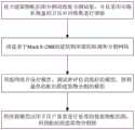
图1为本发明实施例中基于Mask R-CNN的航拍图建筑物检测和分割方法的流程图;1 is a flowchart of an aerial image building detection and segmentation method based on Mask R-CNN in an embodiment of the present invention;
图2为本发明实施例中步骤1中非随机掩盖和随机掩盖的数据增强方式对比图;2 is a comparison diagram of data enhancement methods of non-random masking and random masking in
图3为本发明实施例中步骤1中使用Labelme标注建筑物区域的示意图;Fig. 3 is the schematic diagram of using Labelme to mark the building area in
图4为本发明实施例中搭建的基于Mask R-CNN的航拍图建筑物检测和分割的网络结构图;FIG. 4 is a network structure diagram of building detection and segmentation based on Mask R-CNN in an aerial image constructed in an embodiment of the present invention;
图5为本发明实施例中搭建的基于Mask R-CNN的航拍图建筑物检测和分割的架构中的ResNet-101-FPN网络结构图;Fig. 5 is the ResNet-101-FPN network structure diagram in the framework of building detection and segmentation based on Mask R-CNN built in the embodiment of the present invention;
图6为本发明实施例中提出的方法在采用不同数据增强方式后在干扰测试集上检测和分割精度对比图;6 is a comparison diagram of the detection and segmentation accuracy on the interference test set after the method proposed in the embodiment of the present invention adopts different data enhancement methods;
图7为本发明实施例中的基于Mask R-CNN的航拍图建筑物检测和分割方法的分割效果图;Fig. 7 is the segmentation effect diagram of the aerial image building detection and segmentation method based on Mask R-CNN in the embodiment of the present invention;
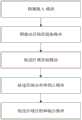
图8为本发明实施例提供的一种基于Mask R-CNN的航拍图建筑物分割的装置结构示意图。FIG. 8 is a schematic structural diagram of an apparatus for segmenting buildings from aerial images based on Mask R-CNN according to an embodiment of the present invention.
具体实施方式Detailed ways
下面将结合本发明实施例中的附图,对本发明实施例中的技术方案进行清楚、完整地描述,显然,所描述的实施例仅仅是本发明一部分实施例,而不是全部的实施例。基于本发明中的实施例,本领域普通技术人员在没有做出创造性劳动前提下所获得的所有其他实施例,都属于本发明保护的范围。The technical solutions in the embodiments of the present invention will be clearly and completely described below with reference to the accompanying drawings in the embodiments of the present invention. Obviously, the described embodiments are only a part of the embodiments of the present invention, but not all of the embodiments. Based on the embodiments of the present invention, all other embodiments obtained by those of ordinary skill in the art without creative efforts shall fall within the protection scope of the present invention.
为了便于对本发明内容的描述,给出如下的定义描述:In order to facilitate the description of the content of the present invention, the following definitions and descriptions are given:
定义1:FPN为Feature Pyramid Networks的简称,为本发明中特征提取网络中的组成部分。Definition 1: FPN is the abbreviation of Feature Pyramid Networks, which is a component of the feature extraction network in the present invention.
实施了1implemented 1
根据本发明实施例,提供了一种基于Mask R-CNN的航拍图建筑物检测和分割方法,解决了传统分割方法步骤繁琐准确率低等问题。该方法流程图如图1所示,具体技术方案和步骤如下:According to the embodiments of the present invention, a method for detecting and segmenting buildings in aerial images based on Mask R-CNN is provided, which solves the problems of complicated steps and low accuracy of traditional segmentation methods. The method flowchart is shown in Figure 1, and the specific technical solutions and steps are as follows:
步骤1:采集城镇建筑物的清晰航拍图像并对图像中的建筑物轮廓进行标注,得到训练数据集和测试数据集,并且使用非随机掩盖的数据增强方式增强训练数据集。具体地,包括以下步骤:Step 1: Collect clear aerial images of town buildings and label the outlines of buildings in the images to obtain training data sets and test data sets, and use non-random masked data enhancement methods to enhance the training data sets. Specifically, it includes the following steps:
步骤1.1:通过无人机拍摄获取不同城镇建筑物的航拍图像,并从中筛选出角度合适成像清晰的300张图片,从其中随机选出200张作为训练数据,再从剩下的100张中随机选出40张作为一般测试集,再从剩余60张图像中人工挑选出屋顶含有明显干扰物的建筑物图像10张,作为干扰测试集。Step 1.1: Obtain aerial images of buildings in different towns through drone photography, and select 300 images with suitable angles and clear imaging, and randomly select 200 images from them as training data, and then randomly select 200 images from the remaining 100 images. 40 images were selected as the general test set, and 10 images of buildings with obvious interferences on the roof were manually selected from the remaining 60 images as the interference test set.
步骤1.2:采用非随机掩盖方法对训练数据集进行增强,提高训练集的数据量以及样本多样性。如图2所示,非随机掩盖的操作方式对掩盖区域位置的选择分两种情况:(1)在含有阴影等干扰物的训练图片中,将掩盖区域选择位于建筑物对象中阴影等干扰物所在区域,如建筑物对象中存在多个干扰物,则选择其中干扰影响最大的一个作为掩盖区域;(2)在没有阴影等明显干扰的图片中,将掩盖区域选择位于建筑物对象边缘部分。掩盖区域的尺寸根据干扰物的大小人为设定,之后将掩盖区域的像素值全都设置为0。然后对增强后的训练数据集以及测试集图片进行标注。用Labelme标注工具打开图像,用多边形工具勾勒出每一个完整的建筑物的顶部轮廓并设置标签为building,如图3示例,然后将标注文件逐一保存。Step 1.2: Use non-random masking method to enhance the training data set to increase the data volume and sample diversity of the training set. As shown in Figure 2, the operation mode of non-random masking has two cases for the selection of the location of the masked area: (1) In the training picture containing shadows and other distractors, the masked area is selected to be located in the shadows and other distractors of the building object. If there are multiple interference objects in the building object, the one with the greatest interference influence is selected as the masked area; (2) In the picture without obvious interference such as shadows, the masked area is selected to be located at the edge of the building object. The size of the masked area is artificially set according to the size of the distractor, and then the pixel values of the masked area are all set to 0. Then annotate the enhanced training data set and test set images. Use the Labelme annotation tool to open the image, use the polygon tool to outline the top outline of each complete building and set the label as building, as shown in the example in Figure 3, and then save the annotation files one by one.
步骤2:部署深度学习平台Tensorflow 2.6的环境,搭建基于Mask R-CNN的航拍图建筑物检测和分割的网络架构,网络结构如图4所示。Step 2: Deploy the environment of the deep learning platform Tensorflow 2.6, and build a network architecture based on Mask R-CNN for building detection and segmentation in aerial images. The network structure is shown in Figure 4.
具体地,所构建的网络的第一模块为特征提取网络ResNet-101-FPN,图5为ResNet-101-FPN网络结构示意图。图中可看到ResNet-101-FPN网络可以通过各区域连接路径的方向分为三个部分:(1)自下而上连接部分。这部分对输入图片进行特征提取,由ResNet-101网络构成,根据输出特征图的大小可以ResNet-101网络将分为5个阶段,这些阶段各自最后一层输出的特征图分别为Conv1、Conv2、Conv3、Conv4和Conv5,分别将它们表示为C1、C2、C3、C4和C5。由于Conv1尺寸最大会导致消耗过多内存,后续不会使用Conv1生成最终特征图。(2)自上而下连接部分。这部分从上而下将不同大小的特征图分别标记为M5、M4、M3和M2,由最高层特征图M5开始向下进行上采样操作,M5是由C5经过1*1卷积得到。为了处理简单和减少训练参数,上采样操作采用最近邻上采样方法,采样倍数为2。(3)横向连接部分。这部分将上采样操作得到的特征图和自下而上连接部分生成相同大小的特征图进行加和操作,逐元素对位求和,然后将结果进行3x3卷积,目的是消除上采样的混叠效应,得到最终特征图。如M4是由C4经过1*1卷积得到的特征图和M5进行2倍上采样的特征图加和操作得到,然后M4再经过3x3卷积操作得到最终特征图P4,以此类推可得到特征图P3和P2。P5由M5直接进行3x3卷积得到,P6由M5经过2倍的下采样Max pooling操作得到,但是P6特征图只用在RPN中用来得到区域建议,不会作为RoIAlign层的输入,计算P6的目的是让输入RPN网络的特征图金字塔包含的最小尺寸更小,有利于RPN网络设计更大尺寸的锚框,从而可以更好地检测出更大尺寸的目标。所以输入图片经过ResNet-101-FPN网络提取特征后得到的RPN输入的是[P2,P3,P4,P5,P6],而作为后续RoIAlign层的输入则是[P2,P3,P4,P5]。在工程实践中,由于航拍图影像数据量比较大、单个图片像素比较高等原因,提高网络的训练速度和分割速度也很重要,所以也可以根据对于时间与精度的实际需求特征提取网络中较深的ResNet-101替换成为合适深度的残差网络。Specifically, the first module of the constructed network is the feature extraction network ResNet-101-FPN, and FIG. 5 is a schematic diagram of the structure of the ResNet-101-FPN network. It can be seen in the figure that the ResNet-101-FPN network can be divided into three parts by the direction of the connection path of each region: (1) The bottom-up connection part. This part performs feature extraction on the input image, which is composed of the ResNet-101 network. According to the size of the output feature map, the ResNet-101 network can be divided into 5 stages. The feature maps output by the last layer of these stages are Conv1, Conv2, Conv3, Conv4, and Conv5, denoting them as C1, C2, C3, C4, and C5, respectively. Since the largest size of Conv1 will consume too much memory, Conv1 will not be used to generate the final feature map in the future. (2) Connect parts from top to bottom. This part marks the feature maps of different sizes as M5, M4, M3 and M2 from top to bottom, and the upsampling operation starts from the top-level feature map M5, which is obtained by 1*1 convolution of C5. For processing simplicity and reducing training parameters, the upsampling operation adopts the nearest neighbor upsampling method with a sampling multiple of 2. (3) Horizontal connection part. This part adds the feature map obtained by the upsampling operation and the feature map of the same size generated by the bottom-up connection part, sums the bits element by element, and then performs 3x3 convolution on the result, in order to eliminate the mixing of upsampling. The stacking effect is obtained to obtain the final feature map. For example, M4 is obtained by adding the feature map obtained by C4 through 1*1 convolution and the feature map obtained by 2 times upsampling of M5, and then M4 is obtained by 3x3 convolution operation to obtain the final feature map P4, and so on to obtain features Figures P3 and P2. P5 is obtained by direct 3x3 convolution of M5, and P6 is obtained by M5 through 2 times downsampling Max pooling operation, but the P6 feature map is only used in RPN to obtain region suggestions, and will not be used as the input of the RoIAlign layer. The purpose is to make the minimum size included in the feature map pyramid of the input RPN network smaller, which is beneficial for the RPN network to design larger-sized anchor boxes, so that larger-sized targets can be better detected. Therefore, the RPN input obtained after the input image is extracted by the ResNet-101-FPN network is [P2, P3, P4, P5, P6], and the input of the subsequent RoIAlign layer is [P2, P3, P4, P5]. In engineering practice, it is also very important to improve the training speed and segmentation speed of the network due to the relatively large amount of aerial image data and the relatively high pixels of a single image. Therefore, it is also possible to extract features that are deeper in the network according to the actual requirements for time and accuracy. The ResNet-101 is replaced by a residual network of suitable depth.
所构建的网络的第二模块为区域建议网络(RPN)。RPN的作用是利用特征图的信息计算出一组包含目标建筑物顶部区域的矩形候选区域在原图(输入图片)的坐标位置,包括中心点的坐标和矩形的长和宽的值。RPN的输入是图片经过ResNet-101-FPN网络得到的不同尺度的特征图金字塔[P2,P3,P3,P5,P6],针对不同尺度的特征图分别进行候选区域的预测。为了预先生成一系列可供筛选和调整的候选区域,首先使用一个大小为3*3的卷积核对特征图进行卷积操作;然后RPN使用一个在特征提取网络输出的特征图上滑动的窗口,在所滑过的位置生成多种预先设置好长宽比与面积的锚框。由于[P2,P3,P3,P5,P6]特征金字塔本身就具有多种尺寸可用,因此对于特征金字塔中的每一层特征图都可以分配特定的锚框面积,特征图P2、P3、P4、P5、P6对应的锚框面积分别为32*32、64*64、128*128、256*256、512*512,每种面积的锚框分别包含1:1、1:2和2:1这三种长宽比,所以对于P2、P3、P4、P5、P6特征图上的每个点都会生成三个不同的锚框,同时还可以得到这些锚框相对于原图的位置坐标。对于生成的每个锚框,单独训练RPN网络判断原图中的锚框区域属于前景还是背景,如果该锚框属于前景则输出该锚框的前景得分和坐标修正值,修正值包括中心点位置的偏移量以及长和宽的变化倍数。在RPN训练时,如果一个锚框区域和真实标注区域的交并比(Intersection over Union,IoU)在0.5以上,那么就判定这个锚框区域属于前景(建筑物);如果该锚框与真实区域的交并比在0.5以下,那么就判定这个锚框就属于背景(非建筑物)。RPN训练完成后,特征提取网络输出的各层特征图进入RPN,RPN会对生成的每个锚框进行二分类,判断其为前景还是背景,并对其坐标位置进行修正,可能会产生大量具有很多重叠区域的锚框,这时根据每个修正后的锚框的前景得分进行排序筛选,最后利用非极大抑制为每个目标保留一个最精确的锚框作为候选区域,与特征图一起输入到RoIAlign层进行后续的分类和分割等操作。The second module of the constructed network is the Region Proposal Network (RPN). The function of RPN is to use the information of the feature map to calculate the coordinate position of a set of rectangular candidate areas containing the top area of the target building in the original image (input image), including the coordinates of the center point and the value of the length and width of the rectangle. The input of the RPN is the feature map pyramids [P2, P3, P3, P5, P6] of different scales obtained by the image through the ResNet-101-FPN network, and the candidate regions are predicted for the feature maps of different scales. In order to pre-generate a series of candidate regions that can be filtered and adjusted, a convolution kernel of
所构建的网络的第三模块是RoI区域分类器(RoI区域分类网络),作用是对由RPN得到的候选区域进行分类和精修目标边界框。由RPN获取包含目标的矩形候选区域之后,传统方法会根据该矩形候选区域的位置在输入图片中裁剪出对应的区域,然后对该区域进行分类等操作。本章所提出的方法中,由特征提取网络得到的特征图和RPN网络得到的区域位置坐标输入到RoIAlign层中,通过RoIAlign层可以从特征图中精确地获取原图中的候选区域所对应的特征,并使用双线性插值法将该特征转换为7*7的固定尺寸作为RoI区域分类网络的输入,从而得到每个候选区域的类别是否为建筑物屋顶和边界框的修正值,完成目标分类和框选的任务。The third module of the constructed network is the RoI region classifier (RoI region classification network), which is used to classify the candidate regions obtained by the RPN and refine the target bounding box. After the RPN obtains the rectangular candidate region containing the target, the traditional method will cut out the corresponding region in the input image according to the position of the rectangular candidate region, and then classify the region and other operations. In the method proposed in this chapter, the feature map obtained by the feature extraction network and the regional position coordinates obtained by the RPN network are input into the RoIAlign layer, and the RoIAlign layer can accurately obtain the features corresponding to the candidate regions in the original image from the feature map. , and use the bilinear interpolation method to convert the feature into a fixed size of 7*7 as the input of the RoI area classification network, so as to obtain whether the category of each candidate area is the correction value of the building roof and bounding box, and complete the target classification and framed tasks.
所构建的网络的第四个模块是RoI区域分割网络,由一个用于语义分割的全卷积神经网络FCN构成。由特征提取网络得到的特征图和RPN网络得到的区域位置坐标经过RoIAlign层得到固定尺寸为14*14的特征图作为RoI区域分割网络的输入,然后经过4个3*3的卷积层和一个2*2的反卷积层得到尺寸大小为28*28的输出,最后经过一个1*1的卷积层和Sigmoid激活层得到最终的尺寸大小为28*28的输出,输出中每个点的值表示候选区域中所对应点属于目标建筑物屋顶的概率;最后,用0.5作为概率阈值得到候选区域目标建筑物屋顶的形状掩码,并通过形状掩码和候选区域位置坐标计算出原图中建筑物屋顶轮廓的分割区域,得到最终的建筑物分割图像。The fourth module of the constructed network is the RoI region segmentation network, which consists of a fully convolutional neural network FCN for semantic segmentation. The feature map obtained by the feature extraction network and the regional position coordinates obtained by the RPN network pass through the RoIAlign layer to obtain a feature map with a fixed size of 14*14 as the input of the RoI region segmentation network, and then go through four 3*3 convolutional layers and a The 2*2 deconvolution layer obtains an output with a size of 28*28, and finally passes through a 1*1 convolutional layer and a Sigmoid activation layer to obtain a final output with a size of 28*28. The value represents the probability that the corresponding point in the candidate area belongs to the roof of the target building; finally, use 0.5 as the probability threshold to obtain the shape mask of the roof of the target building in the candidate area, and calculate the original image through the shape mask and the position coordinates of the candidate area. The segmented area of the building's roof outline is used to obtain the final segmented image of the building.
步骤3:将增强后的建筑物航拍图训练数据集作为网络的输入,通过迭代训练得到航拍图像分割模型,并且通过测试集数据对训练获得的分割模型进行测试和性能评估,得到最终的航拍图建筑物分割模型。具体地,包括以下步骤:Step 3: Take the enhanced building aerial image training data set as the input of the network, obtain the aerial image segmentation model through iterative training, and test and evaluate the performance of the training obtained segmentation model through the test set data to obtain the final aerial image. Building segmentation model. Specifically, it includes the following steps:
在训练网络之前要选择初始化参数。迁移学习是一种机器学习方法,该方法将一个预训练的模型权重重新应用在另一个任务中,该方法可以节省大量的计算资源和时间资源,迁移学习特别适用于训练数据有限的领域特定任务。在本发明实施例中,使用在ImageNet数据集上预训练的权重对ResNet-101网络的参数进行初始化,并且使用在COCO数据集上预训练的权重对RPN网络的参数进行初始化,最后在建筑物航拍图数据集上进行训练;本发明实施例中,训练的batch size设置为2,迭代次数为40,当达到指定的迭代次数时,网络停止训练,得到航拍图数据集上的模型参数并保存;载入训练好的模型参数,对测试样本进行分割测试通过测试集数据对训练获得的模型进行测试和性能评估,得到最终的航拍图建筑物分割模型。The initialization parameters are chosen before training the network. Transfer learning is a machine learning method that re-applies a pre-trained model weights to another task. This method can save a lot of computing resources and time resources. Transfer learning is especially suitable for domain-specific tasks with limited training data. . In the embodiment of the present invention, the parameters of the ResNet-101 network are initialized using the weights pre-trained on the ImageNet dataset, and the parameters of the RPN network are initialized using the weights pre-trained on the COCO dataset, and finally the building Training is performed on the aerial image data set; in the embodiment of the present invention, the batch size of the training is set to 2, and the number of iterations is 40. When the specified number of iterations is reached, the network stops training, and the model parameters on the aerial image data set are obtained and saved. ; Load the trained model parameters, perform segmentation test on the test sample, and test and evaluate the performance of the model obtained by training through the test set data, and obtain the final aerial image building segmentation model.
步骤4:将所获得的模型应用于用户需要进行处理的建筑物航拍图,得到最终的建筑物航拍图像分割图。Step 4: Apply the obtained model to the building aerial image that the user needs to process to obtain the final building aerial image segmentation map.
本发明实施例提供的方法应用在不同的测试集中,对比实验采用的是不同预训练方案和不同的数据增强方式下模型的性能,评估标准为平均精度mAP值,mAPbbox和mAPmask的数值越大说明模型的检测和分割精度越高。三种预训练方案下的模型在一般测试集上的模型检测和分割精度对比参见表1所示。采用不同数据增强方式在两种测试集上的模型检测和分割精度对比参见表2所示,分割对比效果图参见图6所示。The method provided by the embodiment of the present invention is applied in different test sets, and the performance of the model under different pre-training schemes and different data enhancement methods is used in the comparison experiment. The evaluation standard is the average precision mAP value. The higher the value of mAPbbox and mAPmask The larger the model, the higher the detection and segmentation accuracy. The model detection and segmentation accuracy comparisons of the models under the three pre-training schemes on the general test set are shown in Table 1. The comparison of model detection and segmentation accuracy on the two test sets using different data enhancement methods is shown in Table 2, and the segmentation comparison effect is shown in Figure 6.
表1Table 1
表2Table 2

以上实验结果表明了本发明中迁移学习方法的使用是所提出的建筑物检测和分割模型获得的高预测准确性的重要基础。本发明中采用非随机掩盖数据增强方式训练得到的模型可以有效的解决阴影等干扰物对建筑物顶部分割的影响。The above experimental results demonstrate that the use of the transfer learning method in the present invention is an important basis for the high prediction accuracy obtained by the proposed building detection and segmentation model. The model trained by adopting the non-random masking data enhancement method in the present invention can effectively solve the influence of shadows and other interfering objects on the segmentation of the top of the building.
图7是本次发明实施例的最终目的。输入任意一张测试图片,输出一张检测和分割好的图片,如图7所示,三栋建筑物的楼顶都被矩形框识别为building,并且分割结果效果很不错。验证了本发明实施例的方法是行之有效的。FIG. 7 is the final objective of the embodiment of the present invention. Input any test image, and output a detected and segmented image. As shown in Figure 7, the roofs of the three buildings are identified as buildings by rectangular boxes, and the segmentation results are very good. It is verified that the method of the embodiment of the present invention is effective.
实施例2Example 2
以上详细介绍了一种基于Mask R-CNN的航拍图建筑物检测和分割方法的流程,该方法也可以通过相应的装置实现,下面详细介绍该装置的结构和功能。The above describes the process of a method for detecting and segmenting buildings in aerial images based on Mask R-CNN. This method can also be implemented by a corresponding device. The structure and function of the device are described in detail below.
本发明实施例提供的一种基于Mask R-CNN的航拍图建筑物分割装置,该装置使用了实施例1中训练好的航拍图建筑物分割模型。An embodiment of the present invention provides an aerial image building segmentation device based on Mask R-CNN, which uses the aerial image building segmentation model trained in
该装置示意图如图8示,包括:The schematic diagram of the device is shown in Figure 8, including:
图像输入模块,用于用户将待分割建筑物航拍图输入网络进行分割;The image input module is used for the user to input the aerial image of the building to be segmented into the network for segmentation;
图像深层特征提取模块,用于对输入图像数据进行深层特征提取,得到多尺度的特征图;The image deep feature extraction module is used to extract deep features from the input image data to obtain multi-scale feature maps;
候选区域获取模块,用于从输入航拍图像的特征图计算得到包含建筑物目标的候选区域;The candidate area acquisition module is used to calculate the candidate area containing the building target from the feature map of the input aerial image;
候选区域分类和修正模块,用于对RPN得到的候选区域进行分类和修正包围框;The candidate region classification and correction module is used to classify and correct the bounding box of the candidate region obtained by the RPN;
候选区域分割和输出模块,用于对修正后的候选区域进行分割,获取目标建筑物的形状掩码,并通过形状掩码和候选区域位置坐标计算出原图中建筑物屋顶轮廓的分割区域,得到最终的建筑物分割图像。The candidate area segmentation and output module is used to segment the corrected candidate area, obtain the shape mask of the target building, and calculate the segmentation area of the building roof outline in the original image through the shape mask and the position coordinates of the candidate area. Get the final building segmentation image.
作为本发明实施例的一个可选实施方式,图像深层特征提取模块包括:通过已经预先训练好的ResNet-101-FPN网络提取输入航拍图的高维特征表示,得到一组多尺度的特征金字塔。As an optional implementation of the embodiment of the present invention, the image deep feature extraction module includes: extracting the high-dimensional feature representation of the input aerial image through the pre-trained ResNet-101-FPN network to obtain a set of multi-scale feature pyramids.
候选区域获取模块包括一个训练好的RPN网络通过输入航拍图的特征图可以为图像中的每个建筑物生成一个候选区域。The candidate region acquisition module includes a trained RPN network that can generate a candidate region for each building in the image by inputting the feature map of the aerial image.
候选区域分割和输出模块包括:分割出每个候选区域中的建筑物,得到目标建筑物的形状掩码,并通过形状掩码和候选区域位置坐标计算出原图中建筑物屋顶轮廓的分割区域,然后将包含每个建筑物的分割结果的航拍图输出。The candidate area segmentation and output module includes: segmenting the buildings in each candidate area, obtaining the shape mask of the target building, and calculating the segmentation area of the roof outline of the building in the original image through the shape mask and the position coordinates of the candidate area , and then output an aerial image containing the segmentation results for each building.
作为本发明实施例的一个可选实施方式,预测和分割结果输出模块包括:预测和输出模块,用于输出航拍图中待分割目标建筑物分割结果。As an optional implementation of the embodiment of the present invention, the prediction and segmentation result output module includes: a prediction and output module, configured to output the segmentation result of the target building to be segmented in the aerial photograph.
以上所描述的系统实施例仅仅是示意性的,其中所述作为分离部件说明的单元可以是或者也可以不是物理上分开的,作为单元显示的部件可以是或者也可以不是物理单元,即可以位于一个地方,或者也可以分布到多个网络单元上。可以根据实际的需要选择其中的部分或者全部模块来实现本实施例方案的目的。本领域普通技术人员在不付出创造性的劳动的情况下,即可以理解并实施。The system embodiments described above are only illustrative, wherein the units described as separate components may or may not be physically separated, and the components shown as units may or may not be physical units, that is, they may be located in One place, or it can be distributed over multiple network elements. Some or all of the modules may be selected according to actual needs to achieve the purpose of the solution in this embodiment. Those of ordinary skill in the art can understand and implement it without creative effort.
通过以上的实施方式的描述,本领域的技术人员可以清楚地了解到各实施方式可借助软件加必需的通用硬件平台的方式来实现,当然也可以通过硬件。基于这样的理解,上述技术方案本质上或者说对现有技术做出贡献的部分可以以软件产品的形式体现出来,该计算机软件产品可以存储在计算机可读存储介质中,如ROM/RAM、磁碟、光盘等,包括若干指令用以使得一台计算机设备(可以是个人计算机,服务器,或者网络设备等)执行各个实施例或者实施例的某些部分所述的方法。From the description of the above embodiments, those skilled in the art can clearly understand that each embodiment can be implemented by means of software plus a necessary general hardware platform, and certainly can also be implemented by hardware. Based on this understanding, the above-mentioned technical solutions can be embodied in the form of software products in essence or the parts that make contributions to the prior art, and the computer software products can be stored in computer-readable storage media, such as ROM/RAM, magnetic A disc, an optical disc, etc., includes several instructions for causing a computer device (which may be a personal computer, a server, or a network device, etc.) to perform the methods described in various embodiments or some parts of the embodiments.
前述对本发明的具体示例性实施方案的描述是为了说明和例证的目的。这些描述并非想将本发明限定为所公开的精确形式,并且很显然,根据上述教导,可以进行很多改变和变化。对示例性实施例进行选择和描述的目的在于解释本发明的特定原理及其实际应用,从而使得本领域的技术人员能够实现并利用本发明的各种不同的示例性实施方案以及各种不同的选择和改变。本发明的范围意在由权利要求书及其等同形式所限定。The foregoing descriptions of specific exemplary embodiments of the present invention have been presented for purposes of illustration and description. These descriptions are not intended to limit the invention to the precise form disclosed, and obviously many changes and modifications are possible in light of the above teachings. The exemplary embodiments were chosen and described for the purpose of explaining certain principles of the invention and their practical applications, to thereby enable one skilled in the art to make and utilize various exemplary embodiments and various different aspects of the invention. Choose and change. The scope of the invention is intended to be defined by the claims and their equivalents.
Claims (9)
Translated fromChinesePriority Applications (1)
| Application Number | Priority Date | Filing Date | Title |
|---|---|---|---|
| CN202010474764.XACN111640125B (en) | 2020-05-29 | 2020-05-29 | Aerial photography graph building detection and segmentation method and device based on Mask R-CNN |
Applications Claiming Priority (1)
| Application Number | Priority Date | Filing Date | Title |
|---|---|---|---|
| CN202010474764.XACN111640125B (en) | 2020-05-29 | 2020-05-29 | Aerial photography graph building detection and segmentation method and device based on Mask R-CNN |
Publications (2)
| Publication Number | Publication Date |
|---|---|
| CN111640125Atrue CN111640125A (en) | 2020-09-08 |
| CN111640125B CN111640125B (en) | 2022-11-18 |
Family
ID=72331581
Family Applications (1)
| Application Number | Title | Priority Date | Filing Date |
|---|---|---|---|
| CN202010474764.XAActiveCN111640125B (en) | 2020-05-29 | 2020-05-29 | Aerial photography graph building detection and segmentation method and device based on Mask R-CNN |
Country Status (1)
| Country | Link |
|---|---|
| CN (1) | CN111640125B (en) |
Cited By (21)
| Publication number | Priority date | Publication date | Assignee | Title |
|---|---|---|---|---|
| CN112149585A (en)* | 2020-09-27 | 2020-12-29 | 上海商汤智能科技有限公司 | Image processing method, device, equipment and storage medium |
| CN112180903A (en)* | 2020-10-19 | 2021-01-05 | 江苏中讯通物联网技术有限公司 | Vehicle state real-time detection system based on edge calculation |
| CN112215264A (en)* | 2020-09-23 | 2021-01-12 | 西南交通大学 | Steel rail abrasion detection method based on steel rail light band image |
| CN112818840A (en)* | 2021-01-29 | 2021-05-18 | 中国科学院微小卫星创新研究院 | Unmanned aerial vehicle online detection system and method |
| CN112967295A (en)* | 2021-03-10 | 2021-06-15 | 中国科学院深圳先进技术研究院 | Image processing method and system based on residual error network and attention mechanism |
| CN113096016A (en)* | 2021-04-12 | 2021-07-09 | 广东省智能机器人研究院 | Low-altitude aerial image splicing method and system |
| CN113409267A (en)* | 2021-06-17 | 2021-09-17 | 西安热工研究院有限公司 | Pavement crack detection and segmentation method based on deep learning |
| CN113409255A (en)* | 2021-06-07 | 2021-09-17 | 同济大学 | Zebra fish morphological classification method based on Mask R-CNN |
| KR102302893B1 (en)* | 2021-01-28 | 2021-09-23 | 아주대학교산학협력단 | Method and apparatus for estimating the state of waterproof paint of buildings using satellite imagery |
| CN113435458A (en)* | 2021-02-08 | 2021-09-24 | 中国石油化工股份有限公司 | Rock slice image segmentation method, device and medium based on machine learning |
| CN113763326A (en)* | 2021-08-04 | 2021-12-07 | 武汉工程大学 | Pantograph detection method based on Mask scaling R-CNN network |
| CN113822247A (en)* | 2021-11-22 | 2021-12-21 | 广东泰一高新技术发展有限公司 | Method and system for identifying illegal building based on aerial image |
| CN114004963A (en)* | 2021-12-31 | 2022-02-01 | 深圳比特微电子科技有限公司 | Target class identification method and device and readable storage medium |
| CN114399516A (en)* | 2021-12-24 | 2022-04-26 | 河海大学 | A material segmentation method for rockfill dam based on instance segmentation algorithm |
| CN114550117A (en)* | 2022-02-21 | 2022-05-27 | 京东鲲鹏(江苏)科技有限公司 | An image detection method and device |
| CN114581800A (en)* | 2022-03-04 | 2022-06-03 | 中科合肥智慧农业协同创新研究院 | Rice lodging detection method and device based on unmanned aerial vehicle image and deep learning and storage medium |
| CN116168197A (en)* | 2023-01-28 | 2023-05-26 | 北京交通大学 | An Image Segmentation Method Based on Transformer Segmentation Network and Regularization Training |
| CN116205879A (en)* | 2023-02-22 | 2023-06-02 | 中科合肥智慧农业协同创新研究院 | A Wheat Lodging Area Estimation Method Based on UAV Image and Deep Learning |
| CN116235207A (en)* | 2020-10-29 | 2023-06-06 | 欧姆龙株式会社 | Learning method, learned model, detection system, detection method and program |
| CN118657725A (en)* | 2024-06-04 | 2024-09-17 | 四川绿树建设工程有限公司 | An intelligent building quality detection method and system |
| CN119832446A (en)* | 2025-03-17 | 2025-04-15 | 北京东方瑞丰航空技术有限公司 | Building extraction and roof recognition method and device based on RGB satellite pictures |
Citations (8)
| Publication number | Priority date | Publication date | Assignee | Title |
|---|---|---|---|---|
| CN106503687A (en)* | 2016-11-09 | 2017-03-15 | 合肥工业大学 | The monitor video system for identifying figures of fusion face multi-angle feature and its method |
| CN108960281A (en)* | 2018-05-24 | 2018-12-07 | 浙江工业大学 | A kind of melanoma classification method based on nonrandom obfuscated data enhancement method |
| CN109145769A (en)* | 2018-08-01 | 2019-01-04 | 辽宁工业大学 | The target detection network design method of blending image segmentation feature |
| CN109344778A (en)* | 2018-10-10 | 2019-02-15 | 成都信息工程大学 | A method of extracting road information from UAV images based on generative adversarial network |
| US20190057507A1 (en)* | 2017-08-18 | 2019-02-21 | Samsung Electronics Co., Ltd. | System and method for semantic segmentation of images |
| CN109376768A (en)* | 2018-09-21 | 2019-02-22 | 福州大学 | A deep learning-based fault diagnosis method for aerial image tower signage |
| CN109784385A (en)* | 2018-12-29 | 2019-05-21 | 广州海昇计算机科技有限公司 | A kind of commodity automatic identifying method, system, device and storage medium |
| CN111178213A (en)* | 2019-12-23 | 2020-05-19 | 大连理工大学 | A deep learning-based aerial vehicle detection method |
- 2020
- 2020-05-29CNCN202010474764.XApatent/CN111640125B/enactiveActive
Patent Citations (8)
| Publication number | Priority date | Publication date | Assignee | Title |
|---|---|---|---|---|
| CN106503687A (en)* | 2016-11-09 | 2017-03-15 | 合肥工业大学 | The monitor video system for identifying figures of fusion face multi-angle feature and its method |
| US20190057507A1 (en)* | 2017-08-18 | 2019-02-21 | Samsung Electronics Co., Ltd. | System and method for semantic segmentation of images |
| CN108960281A (en)* | 2018-05-24 | 2018-12-07 | 浙江工业大学 | A kind of melanoma classification method based on nonrandom obfuscated data enhancement method |
| CN109145769A (en)* | 2018-08-01 | 2019-01-04 | 辽宁工业大学 | The target detection network design method of blending image segmentation feature |
| CN109376768A (en)* | 2018-09-21 | 2019-02-22 | 福州大学 | A deep learning-based fault diagnosis method for aerial image tower signage |
| CN109344778A (en)* | 2018-10-10 | 2019-02-15 | 成都信息工程大学 | A method of extracting road information from UAV images based on generative adversarial network |
| CN109784385A (en)* | 2018-12-29 | 2019-05-21 | 广州海昇计算机科技有限公司 | A kind of commodity automatic identifying method, system, device and storage medium |
| CN111178213A (en)* | 2019-12-23 | 2020-05-19 | 大连理工大学 | A deep learning-based aerial vehicle detection method |
Non-Patent Citations (2)
| Title |
|---|
| H. SU ET AL.: "Object Detection and Instance Segmentation in Remote Sensing Imagery Based on Precise Mask R-CNN", 《GARSS 2019 - 2019 IEEE INTERNATIONAL GEOSCIENCE AND REMOTE SENSING SYMPOSIUM》* |
| 李大军等: "基于Mask-RCNN的建筑物目标检测算法", 《测绘科学》* |
Cited By (29)
| Publication number | Priority date | Publication date | Assignee | Title |
|---|---|---|---|---|
| CN112215264A (en)* | 2020-09-23 | 2021-01-12 | 西南交通大学 | Steel rail abrasion detection method based on steel rail light band image |
| CN112215264B (en)* | 2020-09-23 | 2022-04-12 | 西南交通大学 | Steel rail abrasion detection method based on steel rail light band image |
| CN112149585B (en)* | 2020-09-27 | 2024-12-10 | 上海商汤智能科技有限公司 | Image processing method, device, equipment and storage medium |
| CN112149585A (en)* | 2020-09-27 | 2020-12-29 | 上海商汤智能科技有限公司 | Image processing method, device, equipment and storage medium |
| CN112180903A (en)* | 2020-10-19 | 2021-01-05 | 江苏中讯通物联网技术有限公司 | Vehicle state real-time detection system based on edge calculation |
| CN116235207A (en)* | 2020-10-29 | 2023-06-06 | 欧姆龙株式会社 | Learning method, learned model, detection system, detection method and program |
| KR102302893B1 (en)* | 2021-01-28 | 2021-09-23 | 아주대학교산학협력단 | Method and apparatus for estimating the state of waterproof paint of buildings using satellite imagery |
| US11195014B1 (en) | 2021-01-28 | 2021-12-07 | Ajou University Industry-Academic Cooperation Foundation | Method and apparatus for estimating state of waterproof paint of buildings using satellite imagery |
| CN112818840A (en)* | 2021-01-29 | 2021-05-18 | 中国科学院微小卫星创新研究院 | Unmanned aerial vehicle online detection system and method |
| CN112818840B (en)* | 2021-01-29 | 2024-08-02 | 中国科学院微小卫星创新研究院 | Unmanned aerial vehicle online detection system and method |
| CN113435458A (en)* | 2021-02-08 | 2021-09-24 | 中国石油化工股份有限公司 | Rock slice image segmentation method, device and medium based on machine learning |
| CN112967295B (en)* | 2021-03-10 | 2024-04-05 | 中国科学院深圳先进技术研究院 | Image processing method and system based on residual network and attention mechanism |
| CN112967295A (en)* | 2021-03-10 | 2021-06-15 | 中国科学院深圳先进技术研究院 | Image processing method and system based on residual error network and attention mechanism |
| CN113096016A (en)* | 2021-04-12 | 2021-07-09 | 广东省智能机器人研究院 | Low-altitude aerial image splicing method and system |
| CN113409255A (en)* | 2021-06-07 | 2021-09-17 | 同济大学 | Zebra fish morphological classification method based on Mask R-CNN |
| CN113409267A (en)* | 2021-06-17 | 2021-09-17 | 西安热工研究院有限公司 | Pavement crack detection and segmentation method based on deep learning |
| CN113763326B (en)* | 2021-08-04 | 2023-11-21 | 武汉工程大学 | A pantograph detection method based on Mask Scoring R-CNN network |
| CN113763326A (en)* | 2021-08-04 | 2021-12-07 | 武汉工程大学 | Pantograph detection method based on Mask scaling R-CNN network |
| CN113822247A (en)* | 2021-11-22 | 2021-12-21 | 广东泰一高新技术发展有限公司 | Method and system for identifying illegal building based on aerial image |
| CN113822247B (en)* | 2021-11-22 | 2022-02-18 | 广东泰一高新技术发展有限公司 | Method and system for identifying illegal building based on aerial image |
| CN114399516A (en)* | 2021-12-24 | 2022-04-26 | 河海大学 | A material segmentation method for rockfill dam based on instance segmentation algorithm |
| CN114399516B (en)* | 2021-12-24 | 2024-02-27 | 河海大学 | Rock-fill dam material segmentation method based on example segmentation algorithm |
| CN114004963A (en)* | 2021-12-31 | 2022-02-01 | 深圳比特微电子科技有限公司 | Target class identification method and device and readable storage medium |
| CN114550117A (en)* | 2022-02-21 | 2022-05-27 | 京东鲲鹏(江苏)科技有限公司 | An image detection method and device |
| CN114581800A (en)* | 2022-03-04 | 2022-06-03 | 中科合肥智慧农业协同创新研究院 | Rice lodging detection method and device based on unmanned aerial vehicle image and deep learning and storage medium |
| CN116168197A (en)* | 2023-01-28 | 2023-05-26 | 北京交通大学 | An Image Segmentation Method Based on Transformer Segmentation Network and Regularization Training |
| CN116205879A (en)* | 2023-02-22 | 2023-06-02 | 中科合肥智慧农业协同创新研究院 | A Wheat Lodging Area Estimation Method Based on UAV Image and Deep Learning |
| CN118657725A (en)* | 2024-06-04 | 2024-09-17 | 四川绿树建设工程有限公司 | An intelligent building quality detection method and system |
| CN119832446A (en)* | 2025-03-17 | 2025-04-15 | 北京东方瑞丰航空技术有限公司 | Building extraction and roof recognition method and device based on RGB satellite pictures |
Also Published As
| Publication number | Publication date |
|---|---|
| CN111640125B (en) | 2022-11-18 |
Similar Documents
| Publication | Publication Date | Title |
|---|---|---|
| CN111640125B (en) | Aerial photography graph building detection and segmentation method and device based on Mask R-CNN | |
| CN109615611B (en) | Inspection image-based insulator self-explosion defect detection method | |
| CN113989662B (en) | A fine-grained target recognition method for remote sensing images based on self-supervised mechanism | |
| CN108305260B (en) | Method, device and device for detecting corner points in an image | |
| CN111914698B (en) | Human body segmentation method, segmentation system, electronic equipment and storage medium in image | |
| CN107977620A (en) | A kind of multi-direction scene text single detection method based on full convolutional network | |
| CN111753828A (en) | A method for horizontal text detection in natural scenes based on deep convolutional neural network | |
| CN109492596B (en) | Pedestrian detection method and system based on K-means clustering and regional recommendation network | |
| CN109241982A (en) | Object detection method based on depth layer convolutional neural networks | |
| CN114519819B (en) | Remote sensing image target detection method based on global context awareness | |
| CN110909724B (en) | A thumbnail generation method for multi-target images | |
| CN111640116B (en) | Aerial photography graph building segmentation method and device based on deep convolutional residual error network | |
| CN110751154B (en) | Complex environment multi-shape text detection method based on pixel-level segmentation | |
| CN113888461B (en) | Small hardware defect detection method, system and equipment based on deep learning | |
| CN118230180A (en) | A remote sensing image target detection method based on multi-scale feature extraction | |
| CN111027538A (en) | Container detection method based on instance segmentation model | |
| CN108564120A (en) | Feature Point Extraction Method Based on Deep Neural Network | |
| CN107808376A (en) | A kind of detection method of raising one's hand based on deep learning | |
| CN109426773A (en) | A kind of roads recognition method and device | |
| CN114972646B (en) | A method and system for extracting and modifying independent ground objects of a real-scene 3D model | |
| CN111709387A (en) | A method and system for building segmentation of high-resolution remote sensing images | |
| CN108805201A (en) | Destination image data set creation method and its device | |
| CN115223080A (en) | A target segmentation method based on non-local feature aggregation neural network | |
| CN113496159B (en) | A Multi-Scale Convolution and Dynamic Weight Cost Function for Segmentation of Smoke and Dust Objects | |
| CN113343749A (en) | Fruit identification method and system based on D2Det model |
Legal Events
| Date | Code | Title | Description |
|---|---|---|---|
| PB01 | Publication | ||
| PB01 | Publication | ||
| SE01 | Entry into force of request for substantive examination | ||
| SE01 | Entry into force of request for substantive examination | ||
| GR01 | Patent grant | ||
| GR01 | Patent grant |