CN111583726A - Airport scene guiding method and device based on ADS-B - Google Patents
Airport scene guiding method and device based on ADS-BDownload PDFInfo
- Publication number
- CN111583726A CN111583726ACN202010300237.7ACN202010300237ACN111583726ACN 111583726 ACN111583726 ACN 111583726ACN 202010300237 ACN202010300237 ACN 202010300237ACN 111583726 ACN111583726 ACN 111583726A
- Authority
- CN
- China
- Prior art keywords
- information
- aircraft
- airport
- ads
- vehicle
- Prior art date
- Legal status (The legal status is an assumption and is not a legal conclusion. Google has not performed a legal analysis and makes no representation as to the accuracy of the status listed.)
- Granted
Links
- 238000000034methodMethods0.000titleclaimsabstractdescription18
- 238000004458analytical methodMethods0.000claimsdescription5
- 238000013213extrapolationMethods0.000claimsdescription5
- 230000004927fusionEffects0.000claimsdescription4
- 230000010365information processingEffects0.000claimsdescription4
- 238000010295mobile communicationMethods0.000abstractdescription9
- 238000012544monitoring processMethods0.000abstractdescription3
- 238000005516engineering processMethods0.000abstractdescription2
- 238000010586diagramMethods0.000description8
- 238000006243chemical reactionMethods0.000description3
- 238000001514detection methodMethods0.000description2
- 238000007493shaping processMethods0.000description2
- 230000009286beneficial effectEffects0.000description1
- 230000005540biological transmissionEffects0.000description1
- 238000004364calculation methodMethods0.000description1
- 238000004891communicationMethods0.000description1
- 239000000306componentSubstances0.000description1
- 239000008358core componentSubstances0.000description1
- 238000004132cross linkingMethods0.000description1
- 230000007547defectEffects0.000description1
- 230000001419dependent effectEffects0.000description1
- 230000005611electricityEffects0.000description1
- 238000002955isolationMethods0.000description1
Images


Classifications
- G—PHYSICS
- G08—SIGNALLING
- G08G—TRAFFIC CONTROL SYSTEMS
- G08G5/00—Traffic control systems for aircraft
- G08G5/80—Anti-collision systems
- G—PHYSICS
- G08—SIGNALLING
- G08G—TRAFFIC CONTROL SYSTEMS
- G08G5/00—Traffic control systems for aircraft
- G08G5/50—Navigation or guidance aids
- G08G5/51—Navigation or guidance aids for control when on the ground, e.g. taxiing or rolling
Landscapes
- Engineering & Computer Science (AREA)
- Aviation & Aerospace Engineering (AREA)
- Physics & Mathematics (AREA)
- General Physics & Mathematics (AREA)
- Traffic Control Systems (AREA)
- Navigation (AREA)
Abstract
Translated fromChinese
Description
Translated fromChinese技术领域technical field
本发明属于航空技术领域,具体涉及基于ADS-B(广播式自动相关监视)的机场场面引导方法及装置。The invention belongs to the field of aviation technology, and in particular relates to an airport scene guidance method and device based on ADS-B (Automatic Dependent Surveillance-Broadcast).
背景技术Background technique
传统场面服务车辆的驾驶员通过对机场场面交通的观察来规划行驶路径,这种方式严重依赖于驾驶员对机场地面标记、机场地图等熟悉程度,存在明显的缺陷。低能见度条件下,驾驶员无法准确感知自身的准确位置及确认服务车辆与场面滑行飞机的安全距离。随着航空业务量的持续高速增长,机场拥堵日益严重,场面服务车辆运行方式安全隐患变得尤为突出。The driver of the traditional ground service vehicle plans the driving path by observing the traffic on the airport scene. This method relies heavily on the driver's familiarity with the airport ground markings and airport maps, and has obvious defects. Under low visibility conditions, the driver cannot accurately perceive his own exact position and confirm the safe distance between the service vehicle and the taxiing aircraft on the ground. With the continuous and rapid growth of aviation business volume, airport congestion is becoming more and more serious, and the safety hazards of the operation mode of ground service vehicles have become particularly prominent.
发明内容SUMMARY OF THE INVENTION
发明目的:提供一种基于ADS-B的机场场面引导方法及装置,以提供冲突预警和告警,及时提醒驾驶员潜在事故的发生,提高机场场面运行的效率和安全性。The purpose of the invention is to provide an airport surface guidance method and device based on ADS-B to provide conflict early warning and warning, timely remind drivers of potential accidents, and improve the efficiency and safety of airport surface operations.
本发明的技术方案:Technical scheme of the present invention:
第一方面,提供了一种基于ADS-B的机场场面引导方法,包括:In a first aspect, an ADS-B-based airport surface guidance method is provided, including:
接收飞机广播的ADS-B链路信息和空管部门输出的TIS-B链路信息;Receive the ADS-B link information broadcast by the aircraft and the TIS-B link information output by the air traffic control department;
根据所述ADS-B链路信息和所述TIS-B链路信息生成场面上飞机、车辆以及机场周边空域内飞机的航迹信息;generating track information of aircraft, vehicles and aircraft in the airspace surrounding the airport according to the ADS-B link information and the TIS-B link information;
接收来自空管部门分发的飞机滑行路径信息;Receive the aircraft taxi path information distributed from the air traffic control department;
根据接收的飞机滑行路径信息,生成飞机在场面由停机位至跑道的四维滑行路径信息;According to the received aircraft taxiing path information, generate the four-dimensional taxiing path information of the aircraft on the surface from the parking lot to the runway;
接收保障车辆的授时定位信息;Receive the timing and positioning information of the guaranteed vehicle;
根据保障车辆的授时定位信息获得保障车辆实时位置;Obtain the real-time position of the guaranteed vehicle according to the timing and positioning information of the guaranteed vehicle;
综合保障车辆的位置与场面上飞机、车辆以及机场周边空域内飞机的航迹信息、飞机的四维滑行路径信息,以机场地图数据库提供的机场地图数据为基础生成综合的场面交通态势信息;Comprehensively guarantee the position of the vehicle, the track information of the plane, the vehicle and the plane in the airspace surrounding the airport, and the four-dimensional taxiing path information of the plane on the scene, and generate the comprehensive scene traffic situation information based on the airport map data provided by the airport map database;
从机场地图数据库获取相应滑行道数据;Obtain the corresponding taxiway data from the airport map database;
根据所述相应滑行道数据,所述场面上飞机、车辆以及机场周边空域内飞机的航迹信息以及所述飞机的四维滑行路径信息,确定无冲突的滑行路径以及滑行方向指引,同时生成车辆在场面运行的冲突告警、跑道侵入告警、偏离告警、速度告警;According to the corresponding taxiway data, the track information of the planes, vehicles on the scene and the planes in the airspace surrounding the airport, and the four-dimensional taxiing path information of the planes, a conflict-free taxiing path and taxiing direction guidance are determined, and at the same time, the vehicles are generated on the scene. Operational conflict warning, runway incursion warning, deviation warning, speed warning;
输出场面交通态势信息和场面引导及告警信息。Output the traffic situation information on the scene and the guidance and warning information on the scene.
进一步地,根据所述ADS-B链路信息和所述TIS-B链路信息生成场面上飞机、车辆以及机场周边空域内飞机的航迹信息,具体包括:Further, according to the ADS-B link information and the TIS-B link information, the track information of planes, vehicles and planes in the airspace surrounding the airport is generated, specifically including:
对所述ADS-B链路信息和所述TIS-B链路信息的原始报文进行协议解析得到解析的ADS-B链路信息和解析的TIS-B链路信息;Perform protocol analysis on the original message of the ADS-B link information and the TIS-B link information to obtain the parsed ADS-B link information and the parsed TIS-B link information;
对解析的ADS-B链路信息和解析的TIS-B链路信息进行融合得到融合的原始航迹信息;Fusion of the parsed ADS-B link information and the parsed TIS-B link information to obtain the fused original track information;
基于所述融合的原始航迹信息,进行航迹预测和航迹外推,生成场面上飞机、车辆以及机场周边空域内飞机的航迹信息。Based on the fused original track information, track prediction and track extrapolation are performed to generate track information of aircraft, vehicles on the surface and aircraft in the airspace surrounding the airport.
进一步地,所述方法还包括:Further, the method also includes:
对保障车辆的授时定位信息进行编码生成保障车辆的ADS-B原始数据信息,并通过全向天线向周围空域广播本车辆的定位信息。The timing and positioning information of the support vehicle is encoded to generate the ADS-B original data information of the support vehicle, and the positioning information of the vehicle is broadcast to the surrounding airspace through the omnidirectional antenna.
进一步地,根据所述相应滑行道数据,所述场面上飞机、车辆以及机场周边空域内飞机的航迹信息以及所述飞机的四维滑行路径信息,确定无冲突的滑行路径以及滑行方向指引,同时生成车辆在场面运行的冲突告警、跑道侵入告警、偏离告警、速度告警,具体包括:Further, according to the corresponding taxiway data, the track information of the aircraft, vehicles and the aircraft in the airspace surrounding the airport and the four-dimensional taxiing path information of the aircraft, the conflict-free taxiing path and the taxiing direction guidance are determined, and simultaneously generate Conflict warnings, runway incursion warnings, departure warnings, and speed warnings for vehicles running on the surface, including:
计算相应滑行道的距离和转弯情况并计算保障车辆的滑行速度;Calculate the distance and turning situation of the corresponding taxiway and calculate the taxi speed of the guaranteed vehicle;
根据所述场面上飞机、车辆以及机场周边空域内飞机的航迹信息,所述飞机的四维滑行路径信息,所述相应滑行道的距离和转弯情况以及保障车辆的滑行速度,确定无冲突的滑行路径以及滑行方向指引,同时生成车辆在场面运行的冲突告警、跑道侵入告警、偏离告警、速度告警。According to the track information of the aircraft, vehicles on the scene and the aircraft in the airspace around the airport, the four-dimensional taxiing path information of the aircraft, the distance and turning situation of the corresponding taxiway, and the taxiing speed of the guaranteed vehicle, determine a conflict-free taxiing path And taxi direction guidance, and generate conflict warnings, runway intrusion warnings, deviation warnings, and speed warnings for vehicles running on the surface.
进一步地,所述方法还包括:Further, the method also includes:
接收触控显示单元的配置管理操作。Receive a configuration management operation of the touch display unit.
第二方面,提供了一种基于ADS-B的机场场面引导装置,包括:In a second aspect, an ADS-B-based airport surface guidance device is provided, including:
交通信息解码模块,用于接收飞机广播的ADS-B链路信息和空管部门输出的TIS-B链路信息;以及根据所述ADS-B链路信息和所述TIS-B链路信息生成场面上飞机、车辆以及机场周边空域内飞机的航迹信息;a traffic information decoding module for receiving the ADS-B link information broadcast by the aircraft and the TIS-B link information output by the air traffic control department; and generating according to the ADS-B link information and the TIS-B link information Track information of aircraft, vehicles on the surface and aircraft in the airspace surrounding the airport;
滑行路径信息处理模块,用于接收来自空管部门分发的飞机滑行路径信息;以及根据接收的飞机滑行路径信息,生成飞机在场面由停机位至跑道的四维滑行路径信息;The taxiing path information processing module is used to receive the aircraft taxiing path information distributed from the air traffic control department; and according to the received aircraft taxiing path information, generate the four-dimensional taxiing path information of the aircraft from the parking space to the runway on the surface;
场面交通态势生成模块,用于接收保障车辆的授时定位信息;根据保障车辆的授时定位信息获得保障车辆实时位置;以及综合保障车辆的位置与场面上飞机、车辆以及机场周边空域内飞机的航迹信息、飞机的四维滑行路径信息,以机场地图数据库提供的机场地图数据为基础生成综合的场面交通态势信息;The surface traffic situation generation module is used to receive the timing and positioning information of the support vehicle; obtain the real-time position of the support vehicle according to the timing and positioning information of the support vehicle; and comprehensively support the position of the vehicle and the track information of the aircraft, vehicles and aircraft in the airspace around the airport. . The four-dimensional taxiing path information of the aircraft is based on the airport map data provided by the airport map database to generate comprehensive surface traffic situation information;
场面引导及告警模块,用于从机场地图数据库获取相应滑行道数据;以及根据所述相应滑行道数据,所述场面上飞机、车辆以及机场周边空域内飞机的航迹信息以及所述飞机的四维滑行路径信息,确定无冲突的滑行路径以及滑行方向指引,同时生成车辆在场面运行的冲突告警、跑道侵入告警、偏离告警、速度告警。The surface guidance and warning module is used to obtain the corresponding taxiway data from the airport map database; and according to the corresponding taxiway data, the track information of the aircraft, vehicles on the surface and the aircraft in the airspace surrounding the airport and the four-dimensional taxiing of the aircraft Path information, determine the non-conflict taxiing path and taxi direction guidance, and generate conflict warnings, runway intrusion warnings, deviation warnings, and speed warnings for vehicles running on the surface at the same time.
进一步地,交通信息解码模块,具体用于:Further, the traffic information decoding module is specifically used for:
对所述ADS-B链路信息和所述TIS-B链路信息的原始报文进行协议解析得到解析的ADS-B链路信息和解析的TIS-B链路信息;Perform protocol analysis on the original message of the ADS-B link information and the TIS-B link information to obtain the parsed ADS-B link information and the parsed TIS-B link information;
对解析的ADS-B链路信息和解析的TIS-B链路信息进行融合得到融合的原始航迹信息;Fusion of the parsed ADS-B link information and the parsed TIS-B link information to obtain the fused original track information;
基于所述融合的原始航迹信息,进行航迹预测和航迹外推,生成场面上飞机、车辆以及机场周边空域内飞机的航迹信息。Based on the fused original track information, track prediction and track extrapolation are performed to generate track information of aircraft, vehicles on the surface and aircraft in the airspace surrounding the airport.
进一步地,所述装置还包括:ADS-B信息编码模块,用于对保障车辆的授时定位信息进行编码生成保障车辆的ADS-B原始数据信息,并通过全向天线向周围空域广播本车辆的定位信息。Further, the device further includes: an ADS-B information encoding module, which is used to encode the timing and positioning information of the security vehicle to generate the ADS-B original data information of the security vehicle, and broadcast the information of the vehicle to the surrounding airspace through an omnidirectional antenna. location information.
进一步地,场面引导及告警模块,具体用于:Further, the scene guidance and warning module is specifically used for:
计算相应滑行道的距离和转弯情况并计算保障车辆的滑行速度;Calculate the distance and turning situation of the corresponding taxiway and calculate the taxi speed of the guaranteed vehicle;
根据所述场面上飞机、车辆以及机场周边空域内飞机的航迹信息,所述飞机的四维滑行路径信息,所述相应滑行道的距离和转弯情况以及保障车辆的滑行速度,确定无冲突的滑行路径以及滑行方向指引,同时生成车辆在场面运行的冲突告警、跑道侵入告警、偏离告警、速度告警。According to the track information of the aircraft, vehicles on the scene and the aircraft in the airspace around the airport, the four-dimensional taxiing path information of the aircraft, the distance and turning situation of the corresponding taxiway, and the taxiing speed of the guaranteed vehicle, determine a conflict-free taxiing path And taxi direction guidance, and generate conflict warnings, runway intrusion warnings, deviation warnings, and speed warnings for vehicles running on the surface.
进一步地,所述装置还包括:场面交通态势生成模块,还用于接收触控显示单元的配置管理操作。Further, the device further includes: a scene traffic situation generating module, which is further configured to receive a configuration management operation of the touch display unit.
有益效果:Beneficial effects:
本发明实现了机场场面服务车辆的驾驶员对机场场面运行态势的全面掌握,提升了服务保障车辆运行效能;本发明提供场面滑行冲突的预警与告警,提高了机场场面运行的安全性。The invention enables the driver of the airport scene service vehicle to fully grasp the operation situation of the airport scene, and improves the operation efficiency of the service guarantee vehicle; the invention provides early warning and warning of the taxiing conflict on the scene, and improves the safety of the airport scene operation.
附图说明Description of drawings
图1为一种具备ADS-B IN/OUT功能的车载场面引导终端交联图。FIG. 1 is a cross-linking diagram of a vehicle scene guidance terminal with ADS-B IN/OUT function.
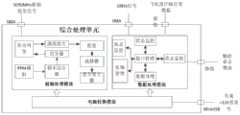
图2为综合处理单元的功能框图。Figure 2 is a functional block diagram of the integrated processing unit.
图3为射频处理模块的功能框图。FIG. 3 is a functional block diagram of a radio frequency processing module.
图4为数据处理模块的功能框图。FIG. 4 is a functional block diagram of a data processing module.
图5为软件的功能框图。Figure 5 is a functional block diagram of the software.
具体实施方式Detailed ways
随着航空业务量的持续高速增长,机场拥堵日益严重,场面服务车辆运行方式安全隐患变得尤为突出。未来,地面空管部门将为场面运行飞机规划其滑行路径,场面服务车辆的驾驶员能在车载终端上看到相应的滑行路径,其车载终端具备ADS-B IN/OUT功能,可以完成与航空器等的相互监视,提高机场场面运行的安全性。因此,本发明提供了一种具备ADS-B IN/OUT功能的车载场面引导终端。利用该终端实现机场场面引导。With the continuous and rapid growth of aviation business volume, airport congestion is becoming more and more serious, and the safety hazards of the operation mode of ground service vehicles have become particularly prominent. In the future, the ground air traffic control department will plan the taxiing path for the aircraft operating on the ground, and the driver of the ground service vehicle can see the corresponding taxiing path on the vehicle terminal. and other mutual monitoring to improve the safety of airport scene operations. Therefore, the present invention provides a vehicle scene guidance terminal with ADS-B IN/OUT function. Use this terminal to realize airport scene guidance.
一种具备ADS-B IN/OUT功能的车载场面引导终端主要由触控显示单元、综合处理单元、移动通信单元、全向天线及GNSS天线等构成。A vehicle scene guidance terminal with ADS-B IN/OUT function is mainly composed of a touch display unit, a comprehensive processing unit, a mobile communication unit, an omnidirectional antenna, a GNSS antenna, and the like.
所述触控显示单元用于显示机场场面交通及告警状况,接收驾驶员输入等操作;所述综合处理单元用于处理ADS-B/TIS-B数据并输出ADS-B数据广播本车辆的信息,完成空情态势生成及滑行冲突的数据处理与计算;所述移动通信单元接收机场场面飞机的滑行路径等信息;所述的全向天线用于接收及发送L波段的射频信号;所述GNSS天线接收北斗及其他GNSS卫星航定位信息。The touch display unit is used to display the traffic and alarm conditions on the airport scene, and to receive operations such as driver input; the integrated processing unit is used to process ADS-B/TIS-B data and output the ADS-B data to broadcast the information of the vehicle. , complete the data processing and calculation of air situation situation generation and taxiing conflict; the mobile communication unit receives information such as the taxiing path of the aircraft on the airport surface; the omnidirectional antenna is used to receive and transmit L-band radio frequency signals; the GNSS The antenna receives Beidou and other GNSS satellite navigation information.
下面结合具体图示,进一步阐述本发明。The present invention will be further described below in conjunction with the specific figures.
如图1所示,一种具备ADS-B IN/OUT功能的车载场面引导终端由1个触控显示单元、1个综合处理单元、1个移动通信单元、1个全向天线及1个GNSS天线等构成。As shown in Figure 1, a vehicle scene guidance terminal with ADS-B IN/OUT function consists of a touch display unit, a comprehensive processing unit, a mobile communication unit, an omnidirectional antenna and a GNSS Antenna, etc.
综合处理单元、移动通信单元、触控显示单元共同组成了终端主机,安装于服务保障车辆的驾驶员前方的前风窗玻璃处,并通过车载+12V直流电供电。GNSS天线通过射频线缆直接连接终端主机,全向天线也通过射频线缆直接连接到终端主机。触控显示单元完成对各类空情信息的显示和接收驾驶员的操作控制。The integrated processing unit, mobile communication unit, and touch display unit together form the terminal host, which is installed at the front windshield in front of the driver of the service support vehicle, and is powered by on-board +12V DC. The GNSS antenna is directly connected to the terminal host through the RF cable, and the omnidirectional antenna is also directly connected to the terminal host through the RF cable. The touch display unit completes the display of various air information and receives the driver's operation control.
GNSS天线采用商用货架产品,可接收北斗、GPS导航数据源的定位及授时信息。The GNSS antenna adopts commercial shelf products, which can receive the positioning and timing information of Beidou and GPS navigation data sources.
触控显示单元采用商用货架产品,实现触摸式图形化显示机场场面地图、当前位置、临近飞机位置、引导路径、跑道入侵警告等信息。The touch display unit adopts commercial shelf products to realize touch-type graphical display of airport scene map, current position, nearby aircraft position, guidance path, runway intrusion warning and other information.
全向天线采用商用货架产品的刀型天线,实现1090MHz射频信号的收发。The omnidirectional antenna adopts the blade antenna of commercial shelf products to realize the transmission and reception of 1090MHz radio frequency signals.
综合处理单元是车载场面引导终端的核心部件,其功能框图如图2所示,主要完成ADS-B/TIS-B信息接收、解调、解算、存储、处理,接收移动通信单元发来的飞机滑行路径等信息,形成综合空情态势,根据本车辆的运行信息生成场面交通、引导及告警等数据,并发送至触控显示单元显示,接收触控显示单元的各配置管理操作。The integrated processing unit is the core component of the vehicle scene guidance terminal. Its functional block diagram is shown in Figure 2. It mainly completes the ADS-B/TIS-B information reception, demodulation, resolution, storage, and processing, and receives the information sent by the mobile communication unit. The information such as the taxiing path of the aircraft forms a comprehensive air situation, and based on the operation information of the vehicle, data such as surface traffic, guidance and warning are generated, and sent to the touch display unit for display, and each configuration management operation of the touch display unit is received.
综合处理单元由射频处理模块、数据处理模块、电源转换模块组成。The integrated processing unit consists of a radio frequency processing module, a data processing module, and a power conversion module.
所述射频处理模块用于对全向天线输出的1090MHz的ADS-B/TIS-B信号进行滤波、变频、放大,向数据处理模块输出ADS-B/TIS-B信号的解调信号;对数据处理模块输出的本车辆自身的ADS-B信号的原始报文进行调制并输出给全向天线。The radio frequency processing module is used to filter, convert and amplify the 1090MHz ADS-B/TIS-B signal output by the omnidirectional antenna, and output the demodulated signal of the ADS-B/TIS-B signal to the data processing module; The original message of the vehicle's own ADS-B signal output by the processing module is modulated and output to the omnidirectional antenna.
所述数据处理模块用于先对ADS-B信号的解调信号进行采样、解码、译码,形成ADS-B信号的原始报文,再通过对GNSS天线的采集获取供ADS-B原始报文解析所需的本地解码的参考位置和信息输出时间基准;最后对ADS-B原始报文解析,提取飞机位置信息,形成飞行器位置、速度、高度、航班号等数据元素;所述数据处理模块还接收移动通信单元传输的飞机场面滑行路径等数据;数据处理模块结合机场场面各数据形成综合态势数据及引导信息,输出至触控显示单元显示。The data processing module is used to first sample, decode and decode the demodulated signal of the ADS-B signal to form the original message of the ADS-B signal, and then acquire the original message for the ADS-B by collecting the GNSS antenna. Analyze the required local decoding reference position and information output time reference; finally, analyze the original ADS-B message, extract the aircraft position information, and form data elements such as aircraft position, speed, altitude, flight number, etc.; the data processing module also Receive data such as the taxiing path of the aircraft scene transmitted by the mobile communication unit; the data processing module combines the various data of the airport scene to form comprehensive situation data and guidance information, and output it to the touch display unit for display.
所述电源模块将车载直流+12V电转换为车载场面引导终端所需的+5V、+3.3V、+1.8V等不同幅值的电压。The power supply module converts the vehicle DC +12V electricity into voltages of different amplitudes such as +5V, +3.3V, +1.8V required by the vehicle scene guidance terminal.
射频处理模块功能框图如图3所示,模块主要由第一级滤波电路、开关电路、数控衰减电路、低噪声放大电路、下变频电路、第二级滤波电路、中频放大电路、第三级滤波电路、检波整形电路和比较电路等组成。收发处理模块接收来自射频收发组件的下行1090MHz信号,经滤波电路、开关电路、数控衰减电路、低噪声放大电路、下变频电路、滤波电路、中频放大电路、再滤波电路、检波整形电路和比较电路后,将解调信号送往数据处理模块;接收来自数据处理模块脉冲信号控制开关产生ADS-B的PPM信号,生成上行1090MHz信号,送往全向天线。射频处理模块根据数据处理模块的收发控制电路发来的收发开关信号,选择收发模式。当处于接收模式时,接收来自全向天线的1090MHz信号;当处于发射模式时,接收数据处理模块发来的1090MHz上行信号,经功率放大电路(PA)及收发开关,送往全向天线,完成上行发射功能。The functional block diagram of the RF processing module is shown in Figure 3. The module is mainly composed of a first-stage filter circuit, a switch circuit, a numerically controlled attenuation circuit, a low-noise amplifier circuit, a down-conversion circuit, a second-stage filter circuit, an intermediate frequency amplifier circuit, and a third-stage filter circuit. It is composed of circuit, detection and shaping circuit and comparison circuit. The transceiver processing module receives the downlink 1090MHz signal from the radio frequency transceiver component, and passes through the filter circuit, switch circuit, digital attenuation circuit, low noise amplifier circuit, down-conversion circuit, filter circuit, intermediate frequency amplifier circuit, re-filter circuit, detection and shaping circuit and comparison circuit Then, send the demodulated signal to the data processing module; receive the pulse signal from the data processing module and control the switch to generate the PPM signal of ADS-B, generate the uplink 1090MHz signal, and send it to the omnidirectional antenna. The radio frequency processing module selects the transceiver mode according to the transceiver switch signal sent by the transceiver control circuit of the data processing module. When in the receiving mode, receive the 1090MHz signal from the omnidirectional antenna; when in the transmitting mode, receive the 1090MHz uplink signal sent by the data processing module, and send it to the omnidirectional antenna through the power amplifier circuit (PA) and the transceiver switch. Uplink transmit function.
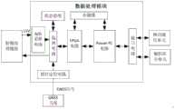
数据处理模块如图4所示由PowerPC主处理器电路、FPGA逻辑控制电路、A/D采集电路、外部通信接口电路、存储器、状态管理电路和外部授时电路等组成,FPGA逻辑控制电路与PowerPc通过本地总线连接。A/D采集电路采集射频处理模块的ADS-B/TIS-B信号的解调信号,将采集的ADS-B/TIS-B信号的数字信号经过隔离电路发送到FPGA逻辑控制电路;FPGA逻辑控制电路对接收的ADS-B/TIS-B信号的解调信号进行解码和纠错处理,获得ADS-B/TIS-B信号的原始报文并发送到PowerPc主处理器电路。As shown in Figure 4, the data processing module is composed of PowerPC main processor circuit, FPGA logic control circuit, A/D acquisition circuit, external communication interface circuit, memory, state management circuit and external timing circuit. The FPGA logic control circuit and PowerPc pass through. Local bus connection. The A/D acquisition circuit collects the demodulated signal of the ADS-B/TIS-B signal of the RF processing module, and sends the collected digital signal of the ADS-B/TIS-B signal to the FPGA logic control circuit through the isolation circuit; FPGA logic control The circuit decodes and corrects the demodulated signal of the received ADS-B/TIS-B signal, obtains the original message of the ADS-B/TIS-B signal, and sends it to the PowerPc main processor circuit.
PowerPc主处理器是核心处理器,主要运行Vxworks操作系统,在操作系统上运行的软件完成了各类数据处理、逻辑算法等运算,其软件功能框图如图5所示。核心处理软件共分为交通信息解码处理、滑行路径信息处理、ADS-B信息编码、场面交通态势生成、场面引导及告警、机场地图数据库等6个软件模块。交通信息解码软件模块的信息来源于飞机广播的ADS-B(1090MHz)链路以及空管部门输出TIS-B(交通信息服务广播)(1090MHz)链路的信息,交通信息解码软件模块对上述2个链路的原始报文进行协议解析,而后对上述2个数据源的解析的经纬度、速度等数据进行融合得到融合的原始航迹信息,以此融合的航迹信息为基础,实现航迹预测和航迹外推功能,最终生成场面上航空器、车辆以及机场周边空域内航空器的航迹。滑行路径信息处理软件模块通过移动通信单元接收来自空管部门分发的飞机滑行路径信息,生成飞机在场面由停机位至跑道的四维滑行路径(位置和时间),为本车辆驾驶员提供飞机在机场场面运行滑行路径信息。场面交通态势生成软件模块还接收GNSS(全球导航卫星系统)的授时定位信息,获得本车辆实时位置信息,本软件模块综合本车辆的位置与场面上航空器、车辆以及空域内的航迹信息,飞机的滑行路径,以机场地图数据库提供的机场地图数据为基础生成综合的场面交通态势。场面引导及告警软件模块还对上述综合信息进行处理,通过机场地图数据库的相应滑行道数据,计算滑行道的距离和转弯情况,计算保障车辆的滑行速度,提供无冲突的滑行路径以及滑行方向指引,同时生成车辆在场面运行的冲突告警、跑道侵入告警、偏离告警、速度告警等,保障车辆的安全运行。ADS-B信息编码软件模块接收本车辆的GNSS的授时定位信息,通过编码生成ADS-B原始数据信息,并通过全向天线向周围空域广播本车辆的定位信息。机场地图数据库存储了基础的机场数据信息。触摸显示屏接收并以图形化方式显示机场场面运行的各类空情信息,主要接收并图形化显示场面交通态势生成软件模块产生的交通态势信息,接收并显示机场地图数据库产生的机场地图信息,接收并显示场面滑行路径引导以及冲突信息。同时,触摸显示屏还接收驾驶员输入的目的地相关数据。The PowerPc main processor is the core processor, which mainly runs the Vxworks operating system. The software running on the operating system completes various data processing, logic algorithms and other operations. Its software function block diagram is shown in Figure 5. The core processing software is divided into 6 software modules including traffic information decoding processing, taxiing path information processing, ADS-B information coding, scene traffic situation generation, scene guidance and warning, and airport map database. The information of the traffic information decoding software module comes from the ADS-B (1090MHz) link broadcast by the aircraft and the information of the TIS-B (traffic information service broadcast) (1090MHz) link output by the air traffic control department. Perform protocol analysis on the original packets of each link, and then fuse the parsed latitude, longitude, speed and other data of the above two data sources to obtain the fused original track information. Based on the fused track information, the track prediction is realized. And track extrapolation function, and finally generate the track of aircraft, vehicles and aircraft in the airspace around the airport. The taxiing path information processing software module receives the aircraft taxiing path information distributed from the air traffic control department through the mobile communication unit, generates a four-dimensional taxiing path (position and time) of the aircraft from the parking stand to the runway on the surface, and provides the driver of the vehicle with the aircraft at the airport. Glide path information for surface operation. The surface traffic situation generation software module also receives the timing and positioning information of GNSS (Global Navigation Satellite System), and obtains the real-time position information of the vehicle. The taxiing path generates a comprehensive scene traffic situation based on the airport map data provided by the airport map database. The surface guidance and warning software module also processes the above-mentioned comprehensive information, calculates the distance and turning situation of the taxiway through the corresponding taxiway data in the airport map database, calculates the taxiing speed of the guaranteed vehicle, and provides a conflict-free taxiing path and taxiing direction guidance At the same time, it generates conflict warnings, runway intrusion warnings, deviation warnings, speed warnings, etc. for vehicles running on the scene to ensure the safe operation of vehicles. The ADS-B information encoding software module receives the GNSS timing and positioning information of the vehicle, generates ADS-B original data information through encoding, and broadcasts the vehicle's positioning information to the surrounding airspace through an omnidirectional antenna. The airport map database stores basic airport data information. The touch display screen receives and graphically displays various types of air information on the airport scene. It mainly receives and graphically displays the traffic situation information generated by the scene traffic situation generation software module, and receives and displays the airport map information generated by the airport map database. Receive and display surface taxi path guidance and conflict information. At the same time, the touchscreen also receives destination-related data entered by the driver.
本发明通过移动通信链路收发飞机场面滑行路径,通过ADS-B/TIS-B链路完成对附近飞机及其他车辆的监视,触控显示模块以触摸式图形化显示机场场面地图、车辆当前位置、临近飞机位置、跑道入侵警告等信息,提供冲突预警和告警,及时提醒驾驶员潜在事故的发生,提高了机场场面运行的效率和安全性。The invention transmits and receives the taxiing path of the aircraft scene through the mobile communication link, completes the monitoring of the nearby aircraft and other vehicles through the ADS-B/TIS-B link, and the touch display module graphically displays the airport scene map, vehicle current Information such as location, nearby aircraft location, runway intrusion warning, etc., provides conflict early warning and warning, reminds drivers of potential accidents in time, and improves the efficiency and safety of airport operations.
可以理解的是,对本领域普通技术人员来说,可以根据本发明的技术方案及其发明构思加以等同替换或改变,而所有这些改变或替换都应属于本发明所附的权利要求的保护范围。It can be understood that for those of ordinary skill in the art, equivalent replacements or changes can be made according to the technical solutions of the present invention and the inventive concept thereof, and all these changes or replacements should belong to the protection scope of the appended claims of the present invention.
Claims (10)
Translated fromChinesePriority Applications (1)
| Application Number | Priority Date | Filing Date | Title |
|---|---|---|---|
| CN202010300237.7ACN111583726B (en) | 2020-04-16 | 2020-04-16 | Airport scene guiding method and device based on ADS-B |
Applications Claiming Priority (1)
| Application Number | Priority Date | Filing Date | Title |
|---|---|---|---|
| CN202010300237.7ACN111583726B (en) | 2020-04-16 | 2020-04-16 | Airport scene guiding method and device based on ADS-B |
Publications (2)
| Publication Number | Publication Date |
|---|---|
| CN111583726Atrue CN111583726A (en) | 2020-08-25 |
| CN111583726B CN111583726B (en) | 2022-11-15 |
Family
ID=72113055
Family Applications (1)
| Application Number | Title | Priority Date | Filing Date |
|---|---|---|---|
| CN202010300237.7AActiveCN111583726B (en) | 2020-04-16 | 2020-04-16 | Airport scene guiding method and device based on ADS-B |
Country Status (1)
| Country | Link |
|---|---|
| CN (1) | CN111583726B (en) |
Cited By (7)
| Publication number | Priority date | Publication date | Assignee | Title |
|---|---|---|---|---|
| CN112365744A (en)* | 2020-10-16 | 2021-02-12 | 中国民用航空总局第二研究所 | Airport scene target operation management method, device and system |
| CN112382131A (en)* | 2020-10-16 | 2021-02-19 | 中国民用航空总局第二研究所 | Airport scene safety collision avoidance early warning system and method |
| CN112885154A (en)* | 2021-01-25 | 2021-06-01 | 璞洛泰珂(上海)智能科技有限公司 | Airport air traffic control account number, role and authority management system and method |
| CN113190635A (en)* | 2021-04-22 | 2021-07-30 | 民航数据通信有限责任公司 | Enhanced airport mobile map device based on data link |
| CN114120716A (en)* | 2021-11-23 | 2022-03-01 | 中国航空工业集团公司洛阳电光设备研究所 | Airborne warning method and system for traffic collision on airport scene |
| CN114360300A (en)* | 2021-11-26 | 2022-04-15 | 中国航空无线电电子研究所 | Traffic conflict warning method for scene-oriented enhanced situation awareness |
| CN116092331A (en)* | 2022-11-30 | 2023-05-09 | 北京华翼助航技术开发有限公司 | Navigation light monitoring method, system and storage medium |
Citations (5)
| Publication number | Priority date | Publication date | Assignee | Title |
|---|---|---|---|---|
| CN108510804A (en)* | 2018-05-25 | 2018-09-07 | 中国民用航空总局第二研究所 | A kind of airdrome scene enhancing what comes into a driver's guiding system |
| CN108766036A (en)* | 2018-05-30 | 2018-11-06 | 中国航空无线电电子研究所 | Airborne taxiway and runway visualization guiding and alarm device |
| CN109218449A (en)* | 2018-11-07 | 2019-01-15 | 航天信息股份有限公司 | A kind of airfield vehicle aided management system and management method based on Internet of Things |
| CN109754643A (en)* | 2019-01-29 | 2019-05-14 | 中国航空无线电电子研究所 | Ground taxi based on map guides system |
| CN209591063U (en)* | 2019-04-24 | 2019-11-05 | 中国民用航空总局第二研究所 | A safety warning device for airport operating vehicles |
- 2020
- 2020-04-16CNCN202010300237.7Apatent/CN111583726B/enactiveActive
Patent Citations (5)
| Publication number | Priority date | Publication date | Assignee | Title |
|---|---|---|---|---|
| CN108510804A (en)* | 2018-05-25 | 2018-09-07 | 中国民用航空总局第二研究所 | A kind of airdrome scene enhancing what comes into a driver's guiding system |
| CN108766036A (en)* | 2018-05-30 | 2018-11-06 | 中国航空无线电电子研究所 | Airborne taxiway and runway visualization guiding and alarm device |
| CN109218449A (en)* | 2018-11-07 | 2019-01-15 | 航天信息股份有限公司 | A kind of airfield vehicle aided management system and management method based on Internet of Things |
| CN109754643A (en)* | 2019-01-29 | 2019-05-14 | 中国航空无线电电子研究所 | Ground taxi based on map guides system |
| CN209591063U (en)* | 2019-04-24 | 2019-11-05 | 中国民用航空总局第二研究所 | A safety warning device for airport operating vehicles |
Cited By (9)
| Publication number | Priority date | Publication date | Assignee | Title |
|---|---|---|---|---|
| CN112365744A (en)* | 2020-10-16 | 2021-02-12 | 中国民用航空总局第二研究所 | Airport scene target operation management method, device and system |
| CN112382131A (en)* | 2020-10-16 | 2021-02-19 | 中国民用航空总局第二研究所 | Airport scene safety collision avoidance early warning system and method |
| CN112885154A (en)* | 2021-01-25 | 2021-06-01 | 璞洛泰珂(上海)智能科技有限公司 | Airport air traffic control account number, role and authority management system and method |
| CN113190635A (en)* | 2021-04-22 | 2021-07-30 | 民航数据通信有限责任公司 | Enhanced airport mobile map device based on data link |
| CN114120716A (en)* | 2021-11-23 | 2022-03-01 | 中国航空工业集团公司洛阳电光设备研究所 | Airborne warning method and system for traffic collision on airport scene |
| CN114120716B (en)* | 2021-11-23 | 2024-05-03 | 中国航空工业集团公司洛阳电光设备研究所 | Airport scene traffic collision airborne warning method and system |
| CN114360300A (en)* | 2021-11-26 | 2022-04-15 | 中国航空无线电电子研究所 | Traffic conflict warning method for scene-oriented enhanced situation awareness |
| CN114360300B (en)* | 2021-11-26 | 2023-05-02 | 中国航空无线电电子研究所 | Traffic conflict warning method oriented to scene enhancement situation awareness |
| CN116092331A (en)* | 2022-11-30 | 2023-05-09 | 北京华翼助航技术开发有限公司 | Navigation light monitoring method, system and storage medium |
Also Published As
| Publication number | Publication date |
|---|---|
| CN111583726B (en) | 2022-11-15 |
Similar Documents
| Publication | Publication Date | Title |
|---|---|---|
| CN111583726B (en) | Airport scene guiding method and device based on ADS-B | |
| JP7086183B2 (en) | Methods and systems for tracking, processing and integrating airport ground vehicle location data into the Automatic Dependent Surveillance (ADS-B) network infrastructure. | |
| CN107818696B (en) | General Aircraft Surveillance Platform Constructed by Beidou and ADS-B Dual Link Navigation Equipment | |
| EP2980775B1 (en) | Remote air traffic surveillance data compositing based on datalinked radio surveillance | |
| US8599045B2 (en) | Systems and methods for enhanced awareness of clearance from conflict for surface traffic operations | |
| WO2021190212A1 (en) | Multi-source sensing and detection system for airport surface operation element | |
| RU2604761C2 (en) | Device of warning about aerological phenomena for aircraft | |
| CN103136952B (en) | Navigation method and navigation service center | |
| Jones et al. | Runway incursion prevention system-demonstration and testing at the dallas/fort worth international airport | |
| CN104501828B (en) | A kind of General Aviation airborne surveillance system | |
| CN110060515B (en) | GNSS-based aircraft monitoring system and method | |
| CN105139606A (en) | Low-altitude aircraft information interaction system | |
| CN112270845A (en) | Guide parking lot face air traffic control situation sharing device based on high-path data chain | |
| US10890657B2 (en) | ADS-B transponder system and method | |
| KR20090069412A (en) | Cockpit display system for providing automatic navigation information | |
| KR20180064271A (en) | Surveillance method for unmanned aerial vehicle, and surveillance apparatus for the same | |
| CN112133136A (en) | Aircraft emergency distress signal monitoring system and monitoring method | |
| CN111968408A (en) | Multi-system emergency distress signal monitoring method | |
| Young et al. | Flight testing of an airport surface guidance, navigation, and control system | |
| CN212032370U (en) | Multi-source perception detection system for airport scene operation elements | |
| Li et al. | An airborne collision avoidance system for low altitude flights using radio data system | |
| Mitkas et al. | A Data Collection Scheme to Support Applications for Capacity Enhancements at Small Airports | |
| Su et al. | Development and Application of the ADS-B Based Vehicle Operation Vision Enhancement System | |
| CN115909821B (en) | A software defined aviation data link ADS-B message receiving and sending method based on software defined radio platform | |
| CN104183130A (en) | Miniature vehicle monitoring system |
Legal Events
| Date | Code | Title | Description |
|---|---|---|---|
| PB01 | Publication | ||
| PB01 | Publication | ||
| SE01 | Entry into force of request for substantive examination | ||
| SE01 | Entry into force of request for substantive examination | ||
| GR01 | Patent grant | ||
| GR01 | Patent grant |