CN111582043A - High-resolution remote sensing image ground object change detection method based on multitask learning - Google Patents
High-resolution remote sensing image ground object change detection method based on multitask learningDownload PDFInfo
- Publication number
- CN111582043A CN111582043ACN202010294564.6ACN202010294564ACN111582043ACN 111582043 ACN111582043 ACN 111582043ACN 202010294564 ACN202010294564 ACN 202010294564ACN 111582043 ACN111582043 ACN 111582043A
- Authority
- CN
- China
- Prior art keywords
- change detection
- remote sensing
- module
- model
- sensing images
- Prior art date
- Legal status (The legal status is an assumption and is not a legal conclusion. Google has not performed a legal analysis and makes no representation as to the accuracy of the status listed.)
- Granted
Links
Images


Classifications
- G—PHYSICS
- G06—COMPUTING OR CALCULATING; COUNTING
- G06V—IMAGE OR VIDEO RECOGNITION OR UNDERSTANDING
- G06V20/00—Scenes; Scene-specific elements
- G06V20/10—Terrestrial scenes
- G06V20/13—Satellite images
- G—PHYSICS
- G06—COMPUTING OR CALCULATING; COUNTING
- G06F—ELECTRIC DIGITAL DATA PROCESSING
- G06F18/00—Pattern recognition
- G06F18/20—Analysing
- G06F18/24—Classification techniques
- G—PHYSICS
- G06—COMPUTING OR CALCULATING; COUNTING
- G06N—COMPUTING ARRANGEMENTS BASED ON SPECIFIC COMPUTATIONAL MODELS
- G06N3/00—Computing arrangements based on biological models
- G06N3/02—Neural networks
- G06N3/04—Architecture, e.g. interconnection topology
- G06N3/045—Combinations of networks
- G—PHYSICS
- G06—COMPUTING OR CALCULATING; COUNTING
- G06N—COMPUTING ARRANGEMENTS BASED ON SPECIFIC COMPUTATIONAL MODELS
- G06N3/00—Computing arrangements based on biological models
- G06N3/02—Neural networks
- G06N3/08—Learning methods
- G06N3/084—Backpropagation, e.g. using gradient descent
- G—PHYSICS
- G06—COMPUTING OR CALCULATING; COUNTING
- G06V—IMAGE OR VIDEO RECOGNITION OR UNDERSTANDING
- G06V10/00—Arrangements for image or video recognition or understanding
- G06V10/20—Image preprocessing
- G06V10/26—Segmentation of patterns in the image field; Cutting or merging of image elements to establish the pattern region, e.g. clustering-based techniques; Detection of occlusion
- G06V10/267—Segmentation of patterns in the image field; Cutting or merging of image elements to establish the pattern region, e.g. clustering-based techniques; Detection of occlusion by performing operations on regions, e.g. growing, shrinking or watersheds
Landscapes
- Engineering & Computer Science (AREA)
- Theoretical Computer Science (AREA)
- Physics & Mathematics (AREA)
- General Physics & Mathematics (AREA)
- Data Mining & Analysis (AREA)
- Evolutionary Computation (AREA)
- Life Sciences & Earth Sciences (AREA)
- Artificial Intelligence (AREA)
- General Engineering & Computer Science (AREA)
- Computing Systems (AREA)
- Multimedia (AREA)
- Molecular Biology (AREA)
- Computational Linguistics (AREA)
- Biophysics (AREA)
- Biomedical Technology (AREA)
- Mathematical Physics (AREA)
- Software Systems (AREA)
- Health & Medical Sciences (AREA)
- General Health & Medical Sciences (AREA)
- Bioinformatics & Cheminformatics (AREA)
- Computer Vision & Pattern Recognition (AREA)
- Evolutionary Biology (AREA)
- Astronomy & Astrophysics (AREA)
- Remote Sensing (AREA)
- Bioinformatics & Computational Biology (AREA)
- Image Analysis (AREA)
Abstract
Translated fromChinese
Description
Translated fromChinese技术领域technical field
本发明属于遥感影像地物变化检测技术领域,更为具体的讲,涉及在地物解译需求下一种基于多任务学习的遥感影像地物变化检测,其综合了遥感图像语义分割任务和地物变化检测任务,既可以确定变化检测区域,又能得到不同地物的变化检测结果,通过同一地理区域不同时刻的遥感影像来检测地球表面地物的变化过程。The invention belongs to the technical field of remote sensing image ground object change detection, and more specifically, relates to a multi-task learning-based remote sensing image ground object change detection under the requirement of ground object interpretation, which integrates remote sensing image semantic segmentation task and ground object change detection. The object change detection task can not only determine the change detection area, but also obtain the change detection results of different objects.
背景技术Background technique
监测特定区域的地物变化检测技术目前已经广泛应用到土地勘测、违章建设监测、自然灾害估计等各类应用中,尤其是可以及时发现在规划区范围之外的违章建设。传统的地物变化检测技术主要是通过灰度匹配和差值变化检测算法,将已经进行地物配准和几何校正的同一地区不同时刻的遥感影像进行直方图匹配,以保证两幅影像的灰度一致性,之后再采用差值法提取灰度变化剧烈的区域作为地物变化区域;这种方法存在检测精度不高,易受天气、光照等外部因素影响的问题,且还需要人为设定阈值,得到的结果也只是变化和未变化两类结果,不能对遥感图像进行分类,无法得到不同地物的变化检测图像。The detection technology of ground feature change monitoring in a specific area has been widely used in various applications such as land survey, illegal construction monitoring, natural disaster estimation, etc., especially the illegal construction outside the planning area can be detected in time. The traditional ground object change detection technology mainly uses the grayscale matching and difference change detection algorithm to match the remote sensing images at different times in the same area that have undergone ground object registration and geometric correction to ensure the grayscale of the two images. After that, the difference method is used to extract the area with severe grayscale changes as the area of ground object change; this method has the problems of low detection accuracy, easy to be affected by external factors such as weather and light, and needs to be set manually. Threshold, the obtained results are only two types of results, which are changed and unchanged. It cannot classify remote sensing images, and cannot obtain change detection images of different objects.
另一种常见的地物变化检测方法是先分类后比较法,首先会采用超像素分割或像素级别的语义分割对同一地区不同时刻的遥感影像进行地物分类,得到两张语义分割结果之后进行逐像素比对,针对不同的地物类型构造差异图像,最后结果不一致的像素区域被认为是变化区域;该方法的优点在于能够得到不同地物的变化检测图像,但是这种方法存在误差累计的问题,即地物变化检测的精度依赖于地物分类的精度。Another common ground object change detection method is the first classification and then comparison method. First, superpixel segmentation or pixel-level semantic segmentation is used to classify the ground objects of remote sensing images in the same area at different times, and then two semantic segmentation results are obtained. By pixel-by-pixel comparison, different images are constructed for different types of ground objects, and the pixel area with inconsistent results is regarded as a change area; the advantage of this method is that it can obtain the change detection images of different ground objects, but this method has accumulated errors. The problem is that the accuracy of object change detection depends on the accuracy of object classification.
发明内容SUMMARY OF THE INVENTION
本发明的目的在于针对上述现有技术中因地物变化检测的精度依赖于地物分类的精度导致得误差累计的问题,提出了一种基于多任务学习的遥感影像地物变化检测方法,不仅能够得到地物变化检测图像,还能够得到地物发生变化前后的地物类型,并且有效防止误差累计的问题,从而显著提升变化检测精度,具有广泛的适用范围。The purpose of the present invention is to solve the problem of accumulating errors caused by the accuracy of the detection of changes in ground objects depending on the accuracy of classification of ground objects in the prior art, and to propose a method for detecting changes in remote sensing images based on multi-task learning, which not only It can obtain the detection image of the change of the ground object, and also can obtain the type of the ground object before and after the change of the ground object, and effectively prevent the problem of error accumulation, thereby significantly improving the accuracy of the change detection, and has a wide range of applications.
为实现上述目的,本发明采用的技术方案如下:For achieving the above object, the technical scheme adopted in the present invention is as follows:
基于多任务学习的高分辨率遥感影像地物变化检测方法,其特征在于,包括以下步骤:A method for detecting changes in high-resolution remote sensing images based on multi-task learning is characterized in that it includes the following steps:
步骤1、遥感影像数据预处理;Step 1, remote sensing image data preprocessing;
步骤1-1、针对同一地理区域、不同时刻下的原始遥感图像进行数据标定和裁剪,得到像素配准的成对遥感图像;Step 1-1. Perform data calibration and cropping on the original remote sensing images in the same geographical area and at different times to obtain pixel-registered paired remote sensing images;
步骤1-2、将成对遥感图像中的两幅遥感图像分别进行逐像素标注,标注后的数据存储在相同尺寸的单通道标签图像中、得到每幅遥感图像的语义标签图像;Step 1-2: Perform pixel-by-pixel labeling on the two remote sensing images in the paired remote sensing images respectively, and store the labelled data in a single-channel label image of the same size to obtain a semantic label image for each remote sensing image;
步骤1-3、将成对遥感图像中的两幅遥感图像对应的语义标签图像进行逐像素比对,若前后标签不一致则视为变化区域、记作1,否则视为非变化区域、记作0,将结果存储在相同尺寸大小的单通道标签图像中、得到成对遥感图像的变化标签图像;Step 1-3: Compare the semantic label images corresponding to the two remote sensing images in the paired remote sensing images pixel by pixel. If the labels before and after are inconsistent, it is regarded as a changed area and recorded as 1; otherwise, it is regarded as a non-changed area and recorded as 0. , store the result in a single-channel label image of the same size, and obtain the change label image of pairs of remote sensing images;
步骤2、构建及训练语义分割模型;Step 2. Build and train a semantic segmentation model;
步骤2-1、构建语义分割模型,包括:特征提取模块、ASPP模块和上采样模块,其中,特征提取模块采用ResNext50特征提取网络,单幅遥感影像输入特征提取模块,得到初步特征图,初步特征图通过ASPP模块和上采样模块得到语义分割结果图;Step 2-1. Build a semantic segmentation model, including: a feature extraction module, an ASPP module and an upsampling module, wherein the feature extraction module adopts the ResNext50 feature extraction network, and a single remote sensing image is input to the feature extraction module to obtain a preliminary feature map and preliminary features. The graph obtains the semantic segmentation result graph through the ASPP module and the upsampling module;
步骤2-2、训练语义分割模型:Step 2-2, train the semantic segmentation model:
采用步骤1中单幅遥感图像与其对应的语义标签图构建语义分隔模型训练集;将单幅遥感图像的语义分割结果图与其对应语义标签图逐像素计算多分类交叉熵损失,采用梯度下降和反向传播算法对全模型进行迭代训练,得到训练完成的语义分割模型;A single remote sensing image and its corresponding semantic label map in step 1 are used to construct a semantic separation model training set; the semantic segmentation result map of a single remote sensing image and its corresponding semantic label map are used to calculate multi-class cross-entropy loss pixel by pixel, using gradient descent and inverse Iteratively trains the full model with the propagation algorithm, and obtains the trained semantic segmentation model;
步骤3、构建及训练变化检测模型;Step 3. Build and train a change detection model;
步骤3-1、构建变化检测模型,包括:特征提取模块、ASPP模块和上采样模块,其中,所述特征提取模块采用步骤2训练完成的语义分割模型中的ResNext50特征提取网络,并冻结网络参数;成对遥感图像输入特征提取模块,得到两张初始特征图,两张初始特征图通过差值法得到差值特征图,差值特征图通过ASPP模块和上采样模块之后得到变化检测结果图;Step 3-1. Build a change detection model, including: a feature extraction module, an ASPP module and an upsampling module, wherein the feature extraction module adopts the ResNext50 feature extraction network in the semantic segmentation model trained in step 2, and freezes network parameters ; The paired remote sensing image input feature extraction module obtains two initial feature maps, the two initial feature maps obtain the difference feature map through the difference method, and the difference feature map obtains the change detection result map after passing through the ASPP module and the upsampling module;
步骤3-2、训练变化检测模型:Step 3-2, train the change detection model:
采用步骤1中成对遥感图像及其对应的变化标签图构建变化检测模型训练集;将成对遥感图像的变化检测结果图与其对应变化标签图求取二分类交叉熵损失,采用梯度下降和反向传播算法对ASPP模块进行迭代训练,得到训练完成的变化检测模型;Use the paired remote sensing images and their corresponding change label maps in step 1 to construct a change detection model training set; obtain the binary cross-entropy loss from the change detection result maps of the paired remote sensing images and their corresponding change label maps, and use gradient descent and reverse The propagation algorithm iteratively trains the ASPP module to obtain the trained change detection model;
步骤4、构建及训练多任务学习地物变化检测模型;Step 4. Build and train a multi-task learning ground object change detection model;
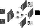
步骤4-1、构建多任务学习地物变化检测模型,包括:两条语义分割模型分支与一条变化检测模型分支;其中,三条分支共享特征提取模块、所述特征提取模块与步骤2及步骤3中特征提取模块相同,所述语义分割模型分支的ASPP模块和上采样模块与步骤2中训练完成的语义分割模型中的ASPP模块和上采样模块相同,所述变化检测模型分支的ASPP模块和上采样模块与步骤3中训练完成的变化检测模型中的ASPP模块和上采样模块相同;成对遥感图像输入特征提取模块得到两张初始特征图,两张初始特征图分别通过两条语义分割模型分支得到两张语义分割结果图、同时两张初始特征图通过差值法得到差值特征图,差值特征图通过变化检测模型分支得到变化检测结果图;Step 4-1, building a multi-task learning ground object change detection model, including: two semantic segmentation model branches and one change detection model branch; wherein, the three branches share the feature extraction module, the feature extraction module and steps 2 and 3. The feature extraction module in the middle is the same, the ASPP module and the upsampling module of the semantic segmentation model branch are the same as the ASPP module and the upsampling module in the semantic segmentation model trained in step 2, and the ASPP module and the upsampling module of the change detection model branch are the same. The sampling module is the same as the ASPP module and the upsampling module in the change detection model trained in step 3; the paired remote sensing image input feature extraction module obtains two initial feature maps, and the two initial feature maps pass through two branches of the semantic segmentation model respectively. Two semantic segmentation result maps are obtained, and two initial feature maps are obtained through the difference method to obtain the difference feature map, and the difference feature map is obtained through the change detection model branch to obtain the change detection result map;
步骤4-2、训练多任务学习地物变化检测模型:Step 4-2, train a multi-task learning ground object change detection model:
采用步骤1中成对遥感图像及其对应的语义标签图与变化标签图构建多任务学习地物变化检测模型训练集;将成对遥感图像的两张语义分割结果图与对应语义分割标签图分别求取多分类交叉熵损失,将成对遥感图像的变化检测结果图与对应变化检测标签图求取二分类交叉熵损失,将三个交叉熵损失进行等权重相加,并基于梯度下降和反向传播算法对全网络进行迭代训练,得到训练完成的多任务学习地物变化检测模型;Using the paired remote sensing images and their corresponding semantic label maps and change label maps in step 1 to construct a multi-task learning ground object change detection model training set; Take the multi-category cross-entropy loss, obtain the binary-category cross-entropy loss from the change detection result map of the paired remote sensing images and the corresponding change detection label map, add the three cross-entropy losses with equal weights, and use gradient descent and back propagation. The algorithm iteratively trains the entire network to obtain a multi-task learning ground object change detection model completed by training;
步骤5、基于步骤4训练完成的多任务学习地物变化检测模型进行高分辨率遥感影像地物变化检测。Step 5: Perform ground object change detection on high-resolution remote sensing images based on the multi-task learning ground object change detection model trained in step 4.
进一步的,所述语义标签图像中,0灰度表示背景,1~6灰度分别表示建筑物、耕地、水体、道路、森林、草地6类地物类型。Further, in the semantic label image, 0 grayscale represents the background, and 1 to 6 grayscales represent six types of ground objects, namely, buildings, cultivated land, water bodies, roads, forests, and grasslands, respectively.
本发明的有益效果在于:The beneficial effects of the present invention are:
首先,本发明通过分割网络构建遥感图像语义分割模型,该模型的特征提取模块能够有效的提取遥感图像的特征,接着构建孪生网络来训练地物变化检测模型,通过共享权重,将两张高分遥感影像映射到新的特征空间,并且构建多任务学习机制,通过语义分割模型来获得变化前后的地物分类结果,结合变化区域能得到所有地物种类的变化检测结果;在本发明中,地物变化检测的精度不完全依赖于地物语义分割的精度,且训练出的端到端地物变化检测模型,能有效避免误差累计;First, the present invention constructs a remote sensing image semantic segmentation model through a segmentation network, and the feature extraction module of the model can effectively extract the features of remote sensing images, and then constructs a twin network to train a ground object change detection model. The remote sensing image is mapped to a new feature space, and a multi-task learning mechanism is constructed. The semantic segmentation model is used to obtain the classification results of the ground objects before and after the change, and the change detection results of all types of ground objects can be obtained in combination with the changed area; The accuracy of object change detection does not completely depend on the accuracy of semantic segmentation of objects, and the trained end-to-end object change detection model can effectively avoid error accumulation;
其次,本发明采用DeepLabV3网络结构应用到遥感图像地物变化检测当中,其中的AS PP层能够对遥感影像中不同尺寸的地物特征进行多尺度信息融合,空洞卷积能够解决大尺度遥感图像感受野不足的问题,骨干网络采用的Resnext50结构也保证了遥感图像变化检测任务的健壮性和高效的运行速率;同时,变化检测模型和语义分割模型的参数共享机制也能有效加速网络运算和降低参数冗余;Secondly, the present invention adopts the DeepLabV3 network structure to be applied to the detection of ground object changes in remote sensing images. The AS PP layer can perform multi-scale information fusion on the features of different sizes of ground objects in remote sensing images, and hole convolution can solve the problem of large-scale remote sensing image perception. To solve the problem of insufficient fields, the Resnext50 structure used in the backbone network also ensures the robustness and efficient running rate of the remote sensing image change detection task; at the same time, the parameter sharing mechanism of the change detection model and the semantic segmentation model can also effectively speed up network operations and reduce parameters. redundancy;
综上所述,本发明提出了一种基于多任务学习的遥感影像地物变化检测方法,综合了地物变化检测任务和语义分割任务,既能够确定地物变化检测区域,又能够得到不同地物的变化检测结果和区域变化前后的地物类型,同时也避免了误差累计的问题,提高了变化检测的精度;并且采用的参数共享机制和加速策略也能保证方法的运行速度。To sum up, the present invention proposes a method for detecting changes in remote sensing images based on multi-task learning, which integrates the task of detecting changes in objects and the tasks of semantic segmentation. The detection results of changes in objects and the types of objects before and after regional changes are also avoided, and the problem of error accumulation is avoided, and the accuracy of change detection is improved; and the adopted parameter sharing mechanism and acceleration strategy can also ensure the running speed of the method.
附图说明Description of drawings
图1为本发明基于多任务学习的高分辨率遥感影像地物变化检测方法的流程设计图。FIG. 1 is a flowchart design diagram of a method for detecting changes in high-resolution remote sensing images based on multi-task learning of the present invention.
图2为本发明依据的全卷积分割网络设计图。FIG. 2 is a design diagram of a fully convolutional segmentation network based on the present invention.
图3为本发明依据的单任务地物变化检测网络设计图。FIG. 3 is a design diagram of a single-task ground object change detection network based on the present invention.
图4为本发明设计的多任务学习地物变化检测网络设计图。FIG. 4 is a design diagram of a multi-task learning ground object change detection network designed by the present invention.
具体实施方式Detailed ways
下面结合附图对本发明做进一步的详细描述。The present invention will be further described in detail below with reference to the accompanying drawings.
本实施例提供一种基于多任务学习的高分辨率遥感影像地物变化检测方法,其流程如图1所示,具体包括以下步骤:This embodiment provides a method for detecting changes in high-resolution remote sensing images based on multi-task learning, the process of which is shown in Figure 1, and specifically includes the following steps:
步骤1、遥感影像数据预处理;Step 1, remote sensing image data preprocessing;
步骤1-1、数据准备包括同一地理区域、不同时刻遥感影像的采集与标注,其中,采集的原始图像为包含近红外通道的高分辨率遥感影像,对同一地理区域、不同时刻的遥感影像先使用ENVI软件进行数据标定和裁剪,得到像素配准的图像对、即成对遥感图像;Step 1-1. Data preparation includes the collection and labeling of remote sensing images in the same geographical area and at different times, wherein the original images collected are high-resolution remote sensing images containing near-infrared channels. Use ENVI software for data calibration and cropping to obtain pixel-registered image pairs, that is, paired remote sensing images;
步骤1-2、将成对遥感图像中的两幅遥感图像分别进行逐像素标注,标注后的数据存储在相同尺寸的单通道标签图像中、即语义标签图像,其中,0灰度表示背景,1~6灰度分别表示建筑物、耕地、水体、道路、森林、草地6类地物类型;Step 1-2: Perform pixel-by-pixel labeling on the two remote sensing images in the paired remote sensing images, respectively, and store the labelled data in a single-channel label image of the same size, that is, a semantic label image, where 0 grayscale represents the background, 1 ~6 grayscales represent 6 types of ground objects, namely buildings, cultivated land, water bodies, roads, forests, and grasslands;
步骤1-3、将成对遥感图像中的两幅遥感图像对应的语义标签图像进行逐像素比对,若前后标签不一致则视为变化区域、记作1,否则视为非变化区域、记作0,将结果存储在相同尺寸大小的单通道图像中、即成对遥感图像的变化标签图像;Step 1-3: Compare the semantic label images corresponding to the two remote sensing images in the paired remote sensing images pixel by pixel. If the labels before and after are inconsistent, it is regarded as a changed area and recorded as 1; otherwise, it is regarded as a non-changed area and recorded as 0. , and store the result in a single-channel image of the same size, that is, the change label image of the paired remote sensing image;
步骤2、构建及训练语义分割模型;Step 2. Build and train a semantic segmentation model;
步骤2-1、构建语义分割模型:模型依据全卷积网络DeeplabV3进行搭建,DeeplabV3网络设计图如图2所示;其中,DeepLabV3采用Resnext50作为特征提取网络,单幅遥感影像经过ResNext50特征提取模块之后,得到(512,W/16,H/16)的特征图,特征图通过ASPP模块和上采样模块得到语义分割结果图;Step 2-1. Build a semantic segmentation model: the model is built based on the fully convolutional network DeeplabV3, and the network design diagram of DeeplabV3 is shown in Figure 2; among them, DeepLabV3 uses Resnext50 as the feature extraction network, and a single remote sensing image passes through the ResNext50 feature extraction module. , obtain the feature map of (512, W/16, H/16), and the feature map obtains the semantic segmentation result map through the ASPP module and the upsampling module;
步骤2-2、训练语义分割模型:Step 2-2, train the semantic segmentation model:
采用步骤1中得到的同一地理区域的任一年份的单幅遥感图像与其对应的语义标签图构建语义分隔模型训练集;基于此训练集对语义分割模型进行训练,单幅遥感图像输入语义分割模型后得到语义分割结果图,将语义分割结果图与输入遥感影像对应语义标签图逐像素计算多分类交叉熵损失,取损失值最大的前N个目标作为难例样本,并返回难例样本的损失值,反馈到全卷积神经网络模型中,使用随机梯度下降法更新全卷积神经网络模型的参数,得到训练完成的语义分割模型;A single remote sensing image in any year of the same geographical area obtained in step 1 and its corresponding semantic label map are used to construct a semantic segmentation model training set; based on this training set, the semantic segmentation model is trained, and a single remote sensing image is input into the semantic segmentation model After obtaining the semantic segmentation result map, the multi-class cross-entropy loss is calculated pixel by pixel between the semantic segmentation result map and the semantic label map corresponding to the input remote sensing image, and the top N targets with the largest loss value are taken as the difficult samples, and the loss of the difficult samples is returned. The value is fed back to the fully convolutional neural network model, and the stochastic gradient descent method is used to update the parameters of the fully convolutional neural network model, and the trained semantic segmentation model is obtained;
步骤3、构建及训练变化检测模型;Step 3. Build and train a change detection model;
步骤3-1、构建变化检测模型:首先,提取步骤2训练完成的语义分隔模型中的特征提取模块,并冻结该模块的参数,即在接下来的训练中不更新模型的参数,以保持模型在语义分割中的准确度;然后,构建基于孪生网络思想的单任务地物变化检测模型,该模型的网络结构如图3所示;其中,特征提取模块采用语义分割模型中相同特征特区模块,成对遥感图像经过Resnext50特征提取网络,映射到特定的特征空间,得到两张(512,W/16,H/16)的初始特征图,两张初始特征图通过差值法得到一张全新的差值特征图、该差值特征图中包含了语义是否发生变化的信息,输入到后续的ASPP模块和上采样模块之后得到语义是否发生变化的变化检测结果图;Step 3-1. Build a change detection model: First, extract the feature extraction module in the semantic separation model trained in Step 2, and freeze the parameters of the module, that is, do not update the parameters of the model in the next training to keep the model The accuracy in semantic segmentation; then, a single-task ground object change detection model based on the idea of the twin network is constructed, and the network structure of the model is shown in Figure 3; among them, the feature extraction module adopts the same feature special zone module in the semantic segmentation model, The paired remote sensing images are mapped to a specific feature space through the Resnext50 feature extraction network, and two (512, W/16, H/16) initial feature maps are obtained. The two initial feature maps are obtained by the difference method. A brand new The difference feature map, the difference feature map contains information about whether the semantics has changed, and after input to the subsequent ASPP module and the upsampling module, the change detection result map of whether the semantics has changed is obtained;
步骤3-2、训练变化检测模型:Step 3-2, train the change detection model:
采用步骤1中得到的同一地理区域、不同时刻的成对遥感图像及其对应的变化标签图构建变化检测模型训练集;基于该训练集对地物变化检测模型进行训练,成对遥感图像输入变化检测模型得到变化检测结果图,将变化检测结果图与输入成对遥感图像对应变化标签图求取二分类交叉熵损失,采用梯度下降和反向传播算法对ASPP模块进行迭代训练,得到训练完成的变化检测模型;The change detection model training set is constructed by using the paired remote sensing images of the same geographical area and different times obtained in step 1 and their corresponding change label maps; The detection model obtains the change detection result map, and the change detection result map and the corresponding change label map of the input paired remote sensing images are used to obtain the binary cross entropy loss. change detection model;
步骤4、共享模型参数,构建及训练多任务学习地物变化检测模型;Step 4. Share model parameters, build and train a multi-task learning ground object change detection model;
步骤4-1、构建多任务学习地物变化检测模型:Step 4-1. Build a multi-task learning ground object change detection model:
基于步骤2的语义分割模型分支和步骤3的单任务变化检测模型分支,训练得到全新的基于多任务学习地物变化检测模型,首先该模型的特征提取模块与步骤2和步骤3模型中的特征提取模块完全相同,并在此时允许特征提取模块参数进行更新;该模型包含语义分割分支和变化检测分支,语义分割分支中的ASPP模块和上采样模块来自步骤2中模型,变化检测分支中的ASPP模块和上采样模块来自步骤3中模型,该模型的设计结构如图4所示;输入成对遥感影像经过共享权重的Resnext50特征提取网络,得到两张(512,W/16,H/16)的初始特征图,两张初始特征图通过差值法得到第三张(512,W/16,H/16)的差值特征图;三个特征图通过不同分支的ASPP模块和上采样模块,得到两张语义分割结果图和一张变化检测结果图;Based on the semantic segmentation model branch of step 2 and the single-task change detection model branch of step 3, a new multi-task learning-based feature change detection model is obtained by training. The extraction modules are exactly the same, and the feature extraction module parameters are allowed to be updated at this time; the model contains the semantic segmentation branch and the change detection branch, the ASPP module and the upsampling module in the semantic segmentation branch are from the model in step 2, and the change detection branch in the The ASPP module and the upsampling module are from the model in step 3. The design structure of the model is shown in Figure 4; the input paired remote sensing images are passed through the Resnext50 feature extraction network with shared weights, and two (512, W/16, H/16 ) of the initial feature map, the two initial feature maps obtained the difference feature map of the third (512, W/16, H/16) through the difference method; the three feature maps passed through different branches of the ASPP module and the upsampling module. , to obtain two semantic segmentation result maps and one change detection result map;
步骤4-2、训练多任务学习地物变化检测模型:Step 4-2, train a multi-task learning ground object change detection model:
采用步骤1中得到的同一地理区域、不同时刻的成对遥感图像及其对应的语义标签图与变化标签图构建多任务学习地物变化检测模型训练集;基于此训练集对多任务学习地物变化检测模型进行训练,成对遥感图像输入多任务学习地物变化检测模型,得到两张语义分割结果图和一张变化检测结果图,两张语义分割结果图与对应的语义分割标签图分别求取多分类交叉熵损失,变化检测结果图与对应的变化检测标签图求取二分类交叉熵损失,将三个交叉熵损失进行等权重相加,并基于梯度下降和反向传播算法对全网络进行迭代训练,不断优化网络参数,使网络更好适应多任务机制,得到训练完成的多任务学习地物变化检测模型;Using the paired remote sensing images of the same geographical area and different times obtained in step 1 and their corresponding semantic label maps and change label maps, a training set of the multi-task learning ground object change detection model is constructed; The change detection model is trained, and the paired remote sensing images are input into the multi-task learning ground object change detection model, and two semantic segmentation result maps and one change detection result map are obtained. Take the multi-category cross-entropy loss, the change detection result graph and the corresponding change detection label graph to obtain the binary-category cross-entropy loss, add the three cross-entropy losses with equal weights, and use the gradient descent and backpropagation algorithms for the whole network. Carry out iterative training, continuously optimize network parameters, make the network better adapt to the multi-task mechanism, and obtain the multi-task learning ground object change detection model after training;
步骤5、基于步骤4训练好的多任务学习地物变化检测模型,进行测试,输入一份大尺寸不同时期成对遥感影像进行“裁剪-分割+地物变化检测-精度评价-拼接”,实现对该区域该时间段地物变化检测的分析;Step 5. Based on the multi-task learning feature change detection model trained in step 4, test it, and input a pair of large-scale remote sensing images in different periods to perform "cropping-segmentation + feature change detection-accuracy evaluation-splicing" to achieve Analysis of the detection of changes in the area during this time period;
步骤5-1、选取已经裁剪和配准完毕的同一地区不同时期的成对高分辨率遥感影像;Step 5-1. Select pairs of high-resolution remote sensing images in different periods of the same area that have been cropped and registered;
步骤5-2、将上述两相影像输入到多任务地物变化检测模型中,进行地物变化检测后进行拼接输出结果;Step 5-2, input the above two-phase image into the multi-task ground object change detection model, perform the ground object change detection, and then splicing and output the result;
具体实施时,以上步骤可采用计算机软件技术实现以上流程的自动运行。During specific implementation, the above steps can be implemented automatically by using computer software technology.
以上所述,仅为本发明的具体实施方式,本说明书中所公开的任一特征,除非特别叙述,均可被其他等效或具有类似目的的替代特征加以替换;所公开的所有特征、或所有方法或过程中的步骤,除了互相排斥的特征和/或步骤以外,均可以任何方式组合。The above descriptions are only specific embodiments of the present invention, and any feature disclosed in this specification, unless otherwise stated, can be replaced by other equivalent or alternative features with similar purposes; all the disclosed features, or All steps in a method or process, except mutually exclusive features and/or steps, may be combined in any way.
Claims (2)
Translated fromChinesePriority Applications (1)
| Application Number | Priority Date | Filing Date | Title |
|---|---|---|---|
| CN202010294564.6ACN111582043B (en) | 2020-04-15 | 2020-04-15 | A multi-task learning-based method for detecting ground object changes in high-resolution remote sensing images |
Applications Claiming Priority (1)
| Application Number | Priority Date | Filing Date | Title |
|---|---|---|---|
| CN202010294564.6ACN111582043B (en) | 2020-04-15 | 2020-04-15 | A multi-task learning-based method for detecting ground object changes in high-resolution remote sensing images |
Publications (2)
| Publication Number | Publication Date |
|---|---|
| CN111582043Atrue CN111582043A (en) | 2020-08-25 |
| CN111582043B CN111582043B (en) | 2022-03-15 |
Family
ID=72124384
Family Applications (1)
| Application Number | Title | Priority Date | Filing Date |
|---|---|---|---|
| CN202010294564.6AActiveCN111582043B (en) | 2020-04-15 | 2020-04-15 | A multi-task learning-based method for detecting ground object changes in high-resolution remote sensing images |
Country Status (1)
| Country | Link |
|---|---|
| CN (1) | CN111582043B (en) |
Cited By (39)
| Publication number | Priority date | Publication date | Assignee | Title |
|---|---|---|---|---|
| CN112101168A (en)* | 2020-09-08 | 2020-12-18 | 中电科大数据研究院有限公司 | Satellite and unmanned aerial vehicle linkage-based commonweal litigation auxiliary evidence obtaining system and method |
| CN112396594A (en)* | 2020-11-27 | 2021-02-23 | 广东电网有限责任公司肇庆供电局 | Change detection model acquisition method and device, change detection method, computer device and readable storage medium |
| CN112489096A (en)* | 2020-11-26 | 2021-03-12 | 西北工业大学 | Remote sensing image change detection method under low registration precision based on graph matching model |
| CN112560740A (en)* | 2020-12-23 | 2021-03-26 | 中国水利水电科学研究院 | PCA-Kmeans-based visible light remote sensing image change detection method |
| CN112560874A (en)* | 2020-12-25 | 2021-03-26 | 北京百度网讯科技有限公司 | Training method, device, equipment and medium for image recognition model |
| CN112598684A (en)* | 2020-12-28 | 2021-04-02 | 长光卫星技术有限公司 | Open-pit area ground feature segmentation method based on semantic segmentation technology |
| CN112668494A (en)* | 2020-12-31 | 2021-04-16 | 西安电子科技大学 | Small sample change detection method based on multi-scale feature extraction |
| CN112733711A (en)* | 2021-01-08 | 2021-04-30 | 西南交通大学 | Remote sensing image damaged building extraction method based on multi-scale scene change detection |
| CN112861829A (en)* | 2021-04-13 | 2021-05-28 | 山东大学 | Water body extraction method and system based on deep convolutional neural network |
| CN113033454A (en)* | 2021-04-07 | 2021-06-25 | 桂林电子科技大学 | Method for detecting building change in urban video camera |
| CN113158807A (en)* | 2021-03-24 | 2021-07-23 | 中科北纬(北京)科技有限公司 | Model self-training and optimizing system for remote sensing image |
| CN113537023A (en)* | 2021-07-08 | 2021-10-22 | 中国人民解放军战略支援部队信息工程大学 | Method for detecting semantic change of remote sensing image |
| CN113658138A (en)* | 2021-08-17 | 2021-11-16 | 天津大学 | A network structure and method applied to change detection task |
| CN113705538A (en)* | 2021-09-28 | 2021-11-26 | 黄河水利委员会黄河水利科学研究院 | High-resolution remote sensing image road change detection device and method based on deep learning |
| CN113807301A (en)* | 2021-09-26 | 2021-12-17 | 武汉汉达瑞科技有限公司 | Automatic extraction method and automatic extraction system for newly-added construction land |
| CN114120148A (en)* | 2022-01-25 | 2022-03-01 | 武汉易米景科技有限公司 | Method for detecting changing area of remote sensing image building |
| CN114170642A (en)* | 2020-09-09 | 2022-03-11 | 成都鼎桥通信技术有限公司 | Image detection processing method, device, equipment and storage medium |
| CN114419368A (en)* | 2021-12-30 | 2022-04-29 | 阿里巴巴达摩院(杭州)科技有限公司 | Image processing method, storage medium and system |
| CN114612782A (en)* | 2022-03-15 | 2022-06-10 | 哈尔滨理工大学 | A Building Detection System Based on Remote Sensing Image |
| CN114820695A (en)* | 2021-01-18 | 2022-07-29 | 阿里巴巴集团控股有限公司 | Object tracking, feature tracking method, device, system and storage medium |
| CN114821315A (en)* | 2022-04-24 | 2022-07-29 | 福州大学 | Remote sensing image cultivated land plot extraction method combining edge detection and multitask learning |
| CN114842351A (en)* | 2022-04-11 | 2022-08-02 | 中国人民解放军战略支援部队航天工程大学 | Remote sensing image semantic change detection method based on twin transforms |
| WO2022160753A1 (en)* | 2021-01-27 | 2022-08-04 | 上海商汤智能科技有限公司 | Image processing method and apparatus, and electronic device and storage medium |
| CN114972191A (en)* | 2022-04-25 | 2022-08-30 | 航天宏图信息技术股份有限公司 | Method and device for detecting farmland change |
| US11507776B2 (en) | 2020-10-14 | 2022-11-22 | Industrial Technology Research Institute | Image recognition method for detection tasks based on single convolutional neural network and image recognition system thereof |
| CN115393721A (en)* | 2022-08-31 | 2022-11-25 | 内蒙古大学 | A method for intelligent monitoring of ultra-high voltage transmission channel environment based on deep learning |
| CN115511781A (en)* | 2022-07-27 | 2022-12-23 | 中国电子科技集团公司第二十八研究所 | Building change detection method based on multi-scale twin network |
| CN115546671A (en)* | 2022-11-01 | 2022-12-30 | 北京数字政通科技股份有限公司 | Unmanned aerial vehicle change detection method and system based on multitask learning |
| CN115908797A (en)* | 2022-10-31 | 2023-04-04 | 江河瑞通(北京)技术有限公司 | A dam bank collapse detection method and system based on deep learning technology |
| CN116109945A (en)* | 2023-04-12 | 2023-05-12 | 北京数慧时空信息技术有限公司 | Remote sensing image interpretation method based on ordered continuous learning |
| CN116229267A (en)* | 2023-03-07 | 2023-06-06 | 湖南星图空间信息技术有限公司 | A method for monitoring semantic changes of urban buildings based on multi-task learning |
| CN116363527A (en)* | 2023-04-11 | 2023-06-30 | 西安交通大学 | Remote sensing image change detection method based on interaction feature perception |
| CN116452983A (en)* | 2023-06-12 | 2023-07-18 | 合肥工业大学 | Quick discovering method for land landform change based on unmanned aerial vehicle aerial image |
| CN116524346A (en)* | 2023-03-06 | 2023-08-01 | 西北工业大学 | Semantic Change Detection Method for High-Resolution Remote Sensing Images Based on Contrastive Learning of Binary Change Detection |
| CN118262169A (en)* | 2024-04-12 | 2024-06-28 | 航天宏图信息技术股份有限公司 | Multi-classification change detection method, device and equipment based on semantic change label |
| CN119048902A (en)* | 2024-08-13 | 2024-11-29 | 航天宏图信息技术股份有限公司 | Small-scale-oriented deep learning change detection method, device, equipment and medium |
| CN119048866A (en)* | 2024-10-30 | 2024-11-29 | 中国林业科学研究院资源信息研究所 | Forest vegetation type change detection method, system and computer program |
| CN119180723A (en)* | 2024-11-18 | 2024-12-24 | 中国林业科学研究院资源信息研究所 | Method, system and computer program for detecting trans-season change of forest zone |
| US12387098B2 (en)* | 2023-03-28 | 2025-08-12 | Ford Global Technologies, Llc | Multi-task learning |
Citations (9)
| Publication number | Priority date | Publication date | Assignee | Title |
|---|---|---|---|---|
| US20170076438A1 (en)* | 2015-08-31 | 2017-03-16 | Cape Analytics, Inc. | Systems and methods for analyzing remote sensing imagery |
| CN107180430A (en)* | 2017-05-16 | 2017-09-19 | 华中科技大学 | A kind of deep learning network establishing method and system suitable for semantic segmentation |
| CN109063569A (en)* | 2018-07-04 | 2018-12-21 | 北京航空航天大学 | A kind of semantic class change detecting method based on remote sensing image |
| CN109255317A (en)* | 2018-08-31 | 2019-01-22 | 西北工业大学 | A kind of Aerial Images difference detecting method based on dual network |
| CN109934166A (en)* | 2019-03-12 | 2019-06-25 | 中山大学 | A UAV Image Change Detection Method Based on Semantic Segmentation and Siamese Neural Network |
| CN110263705A (en)* | 2019-06-19 | 2019-09-20 | 上海交通大学 | Towards two phase of remote sensing technology field high-resolution remote sensing image change detecting method |
| US10467500B1 (en)* | 2018-12-31 | 2019-11-05 | Didi Research America, Llc | Method and system for semantic segmentation involving multi-task convolutional neural network |
| CN110502977A (en)* | 2019-07-10 | 2019-11-26 | 广东国地规划科技股份有限公司 | A kind of building classification of change detection method, system, device and storage medium |
| CN110827415A (en)* | 2019-11-11 | 2020-02-21 | 吉林大学 | All-weather unknown environment unmanned autonomous working platform |
- 2020
- 2020-04-15CNCN202010294564.6Apatent/CN111582043B/enactiveActive
Patent Citations (9)
| Publication number | Priority date | Publication date | Assignee | Title |
|---|---|---|---|---|
| US20170076438A1 (en)* | 2015-08-31 | 2017-03-16 | Cape Analytics, Inc. | Systems and methods for analyzing remote sensing imagery |
| CN107180430A (en)* | 2017-05-16 | 2017-09-19 | 华中科技大学 | A kind of deep learning network establishing method and system suitable for semantic segmentation |
| CN109063569A (en)* | 2018-07-04 | 2018-12-21 | 北京航空航天大学 | A kind of semantic class change detecting method based on remote sensing image |
| CN109255317A (en)* | 2018-08-31 | 2019-01-22 | 西北工业大学 | A kind of Aerial Images difference detecting method based on dual network |
| US10467500B1 (en)* | 2018-12-31 | 2019-11-05 | Didi Research America, Llc | Method and system for semantic segmentation involving multi-task convolutional neural network |
| CN109934166A (en)* | 2019-03-12 | 2019-06-25 | 中山大学 | A UAV Image Change Detection Method Based on Semantic Segmentation and Siamese Neural Network |
| CN110263705A (en)* | 2019-06-19 | 2019-09-20 | 上海交通大学 | Towards two phase of remote sensing technology field high-resolution remote sensing image change detecting method |
| CN110502977A (en)* | 2019-07-10 | 2019-11-26 | 广东国地规划科技股份有限公司 | A kind of building classification of change detection method, system, device and storage medium |
| CN110827415A (en)* | 2019-11-11 | 2020-02-21 | 吉林大学 | All-weather unknown environment unmanned autonomous working platform |
Non-Patent Citations (5)
| Title |
|---|
| HUI RU等: "Detecting changes in high resolution remote sensing images using superpixels", 《2015 IEEE INTERNATIONAL GEOSCIENCE AND REMOTE SENSING SYMPOSIUM (IGARSS)》* |
| 付威福: "基于深度学习的遥感影像变化检测算法研究", 《中国优秀博硕士学位论文全文数据库(硕士)工程科技Ⅱ辑》* |
| 刘文祥等: "采用双注意力机制Deeplabv3+算法的遥感影像语义分割", 《热带地理》* |
| 方梦梁: "基于深度学习的光学遥感图像目标检测研究与应用", 《中国优秀博硕士学位论文全文数据库(硕士)工程科技Ⅱ辑》* |
| 薛丁华: "面向高分辨率遥感图像的变化检测方法研究", 《中国优秀博硕士学位论文全文数据库(硕士)工程科技Ⅱ辑》* |
Cited By (55)
| Publication number | Priority date | Publication date | Assignee | Title |
|---|---|---|---|---|
| CN112101168A (en)* | 2020-09-08 | 2020-12-18 | 中电科大数据研究院有限公司 | Satellite and unmanned aerial vehicle linkage-based commonweal litigation auxiliary evidence obtaining system and method |
| CN114170642A (en)* | 2020-09-09 | 2022-03-11 | 成都鼎桥通信技术有限公司 | Image detection processing method, device, equipment and storage medium |
| US11507776B2 (en) | 2020-10-14 | 2022-11-22 | Industrial Technology Research Institute | Image recognition method for detection tasks based on single convolutional neural network and image recognition system thereof |
| TWI812888B (en)* | 2020-10-14 | 2023-08-21 | 財團法人工業技術研究院 | Image recognition method and image recognition system |
| CN112489096A (en)* | 2020-11-26 | 2021-03-12 | 西北工业大学 | Remote sensing image change detection method under low registration precision based on graph matching model |
| CN112489096B (en)* | 2020-11-26 | 2024-05-28 | 西北工业大学 | Remote sensing image change detection method based on graph matching model under low registration precision |
| CN112396594B (en)* | 2020-11-27 | 2024-03-29 | 广东电网有限责任公司肇庆供电局 | Method and device for acquiring change detection model, change detection method, computer equipment and readable storage medium |
| CN112396594A (en)* | 2020-11-27 | 2021-02-23 | 广东电网有限责任公司肇庆供电局 | Change detection model acquisition method and device, change detection method, computer device and readable storage medium |
| CN112560740A (en)* | 2020-12-23 | 2021-03-26 | 中国水利水电科学研究院 | PCA-Kmeans-based visible light remote sensing image change detection method |
| CN112560874A (en)* | 2020-12-25 | 2021-03-26 | 北京百度网讯科技有限公司 | Training method, device, equipment and medium for image recognition model |
| CN112560874B (en)* | 2020-12-25 | 2024-04-16 | 北京百度网讯科技有限公司 | Training method, device, equipment and medium for image recognition model |
| CN112598684A (en)* | 2020-12-28 | 2021-04-02 | 长光卫星技术有限公司 | Open-pit area ground feature segmentation method based on semantic segmentation technology |
| CN112668494A (en)* | 2020-12-31 | 2021-04-16 | 西安电子科技大学 | Small sample change detection method based on multi-scale feature extraction |
| CN112733711A (en)* | 2021-01-08 | 2021-04-30 | 西南交通大学 | Remote sensing image damaged building extraction method based on multi-scale scene change detection |
| CN114820695A (en)* | 2021-01-18 | 2022-07-29 | 阿里巴巴集团控股有限公司 | Object tracking, feature tracking method, device, system and storage medium |
| WO2022160753A1 (en)* | 2021-01-27 | 2022-08-04 | 上海商汤智能科技有限公司 | Image processing method and apparatus, and electronic device and storage medium |
| CN113158807B (en)* | 2021-03-24 | 2024-02-09 | 中科北纬(北京)科技有限公司 | Model self-training and optimizing system for remote sensing image |
| CN113158807A (en)* | 2021-03-24 | 2021-07-23 | 中科北纬(北京)科技有限公司 | Model self-training and optimizing system for remote sensing image |
| CN113033454A (en)* | 2021-04-07 | 2021-06-25 | 桂林电子科技大学 | Method for detecting building change in urban video camera |
| CN113033454B (en)* | 2021-04-07 | 2023-04-25 | 桂林电子科技大学 | A detection method for building changes in urban video cameras |
| CN112861829A (en)* | 2021-04-13 | 2021-05-28 | 山东大学 | Water body extraction method and system based on deep convolutional neural network |
| CN113537023B (en)* | 2021-07-08 | 2022-12-23 | 中国人民解放军战略支援部队信息工程大学 | Remote sensing image semantic change detection method |
| CN113537023A (en)* | 2021-07-08 | 2021-10-22 | 中国人民解放军战略支援部队信息工程大学 | Method for detecting semantic change of remote sensing image |
| CN113658138A (en)* | 2021-08-17 | 2021-11-16 | 天津大学 | A network structure and method applied to change detection task |
| CN113658138B (en)* | 2021-08-17 | 2023-06-16 | 天津大学 | Network structure and method applied to change detection task |
| CN113807301A (en)* | 2021-09-26 | 2021-12-17 | 武汉汉达瑞科技有限公司 | Automatic extraction method and automatic extraction system for newly-added construction land |
| CN113807301B (en)* | 2021-09-26 | 2024-06-07 | 武汉汉达瑞科技有限公司 | Automatic extraction method and automatic extraction system for newly-added construction land |
| CN113705538A (en)* | 2021-09-28 | 2021-11-26 | 黄河水利委员会黄河水利科学研究院 | High-resolution remote sensing image road change detection device and method based on deep learning |
| CN114419368B (en)* | 2021-12-30 | 2025-09-12 | 阿里巴巴达摩院(杭州)科技有限公司 | Image processing method, storage medium and system |
| CN114419368A (en)* | 2021-12-30 | 2022-04-29 | 阿里巴巴达摩院(杭州)科技有限公司 | Image processing method, storage medium and system |
| CN114120148A (en)* | 2022-01-25 | 2022-03-01 | 武汉易米景科技有限公司 | Method for detecting changing area of remote sensing image building |
| CN114612782A (en)* | 2022-03-15 | 2022-06-10 | 哈尔滨理工大学 | A Building Detection System Based on Remote Sensing Image |
| CN114842351A (en)* | 2022-04-11 | 2022-08-02 | 中国人民解放军战略支援部队航天工程大学 | Remote sensing image semantic change detection method based on twin transforms |
| CN114821315B (en)* | 2022-04-24 | 2024-06-07 | 福州大学 | A method for extracting cultivated land from remote sensing images combining edge detection and multi-task learning |
| CN114821315A (en)* | 2022-04-24 | 2022-07-29 | 福州大学 | Remote sensing image cultivated land plot extraction method combining edge detection and multitask learning |
| CN114972191A (en)* | 2022-04-25 | 2022-08-30 | 航天宏图信息技术股份有限公司 | Method and device for detecting farmland change |
| CN115511781A (en)* | 2022-07-27 | 2022-12-23 | 中国电子科技集团公司第二十八研究所 | Building change detection method based on multi-scale twin network |
| CN115393721A (en)* | 2022-08-31 | 2022-11-25 | 内蒙古大学 | A method for intelligent monitoring of ultra-high voltage transmission channel environment based on deep learning |
| CN115908797A (en)* | 2022-10-31 | 2023-04-04 | 江河瑞通(北京)技术有限公司 | A dam bank collapse detection method and system based on deep learning technology |
| CN115546671A (en)* | 2022-11-01 | 2022-12-30 | 北京数字政通科技股份有限公司 | Unmanned aerial vehicle change detection method and system based on multitask learning |
| CN116524346A (en)* | 2023-03-06 | 2023-08-01 | 西北工业大学 | Semantic Change Detection Method for High-Resolution Remote Sensing Images Based on Contrastive Learning of Binary Change Detection |
| CN116524346B (en)* | 2023-03-06 | 2024-08-09 | 西北工业大学 | High-resolution remote sensing image semantic change detection method based on binary change detection contrast learning |
| CN116229267A (en)* | 2023-03-07 | 2023-06-06 | 湖南星图空间信息技术有限公司 | A method for monitoring semantic changes of urban buildings based on multi-task learning |
| US12387098B2 (en)* | 2023-03-28 | 2025-08-12 | Ford Global Technologies, Llc | Multi-task learning |
| CN116363527A (en)* | 2023-04-11 | 2023-06-30 | 西安交通大学 | Remote sensing image change detection method based on interaction feature perception |
| CN116109945A (en)* | 2023-04-12 | 2023-05-12 | 北京数慧时空信息技术有限公司 | Remote sensing image interpretation method based on ordered continuous learning |
| CN116452983B (en)* | 2023-06-12 | 2023-10-10 | 合肥工业大学 | A method to quickly detect changes in national landforms based on drone aerial images |
| CN116452983A (en)* | 2023-06-12 | 2023-07-18 | 合肥工业大学 | Quick discovering method for land landform change based on unmanned aerial vehicle aerial image |
| CN118262169B (en)* | 2024-04-12 | 2024-11-22 | 航天宏图信息技术股份有限公司 | Multi-classification change detection method, device and equipment based on semantic change labels |
| CN118262169A (en)* | 2024-04-12 | 2024-06-28 | 航天宏图信息技术股份有限公司 | Multi-classification change detection method, device and equipment based on semantic change label |
| CN119048902A (en)* | 2024-08-13 | 2024-11-29 | 航天宏图信息技术股份有限公司 | Small-scale-oriented deep learning change detection method, device, equipment and medium |
| CN119048866A (en)* | 2024-10-30 | 2024-11-29 | 中国林业科学研究院资源信息研究所 | Forest vegetation type change detection method, system and computer program |
| CN119048866B (en)* | 2024-10-30 | 2025-03-25 | 中国林业科学研究院资源信息研究所 | A method, system and computer program product for detecting changes in vegetation types in forest areas |
| CN119180723A (en)* | 2024-11-18 | 2024-12-24 | 中国林业科学研究院资源信息研究所 | Method, system and computer program for detecting trans-season change of forest zone |
| CN119180723B (en)* | 2024-11-18 | 2025-03-25 | 中国林业科学研究院资源信息研究所 | A method, system and computer program product for detecting cross-seasonal changes in forest areas |
Also Published As
| Publication number | Publication date |
|---|---|
| CN111582043B (en) | 2022-03-15 |
Similar Documents
| Publication | Publication Date | Title |
|---|---|---|
| CN111582043A (en) | High-resolution remote sensing image ground object change detection method based on multitask learning | |
| CN112287807B (en) | A road extraction method from remote sensing images based on multi-branch pyramid neural network | |
| CN111915592A (en) | Remote sensing image cloud detection method based on deep learning | |
| CN111461258A (en) | Remote sensing image scene classification method of coupling convolution neural network and graph convolution network | |
| CN109886176B (en) | Lane line detection method in complex driving scene | |
| CN114022408A (en) | Remote sensing image cloud detection method based on multi-scale convolution neural network | |
| CN110781773A (en) | Road extraction method based on residual error neural network | |
| CN112801270A (en) | Automatic U-shaped network slot identification method integrating depth convolution and attention mechanism | |
| CN113312993B (en) | A PSPNet-based Land Cover Classification Method for Remote Sensing Data | |
| CN109902601B (en) | Video target detection method combining convolutional network and recursive network | |
| CN101770581A (en) | Semi-automatic detecting method for road centerline in high-resolution city remote sensing image | |
| CN117765361B (en) | A method for detecting building change areas in dual-temporal remote sensing images based on residual neural network | |
| CN116343063B (en) | A road network extraction method, system, device and computer-readable storage medium | |
| CN112434723A (en) | Day/night image classification and object detection method based on attention network | |
| CN110751077A (en) | An optical remote sensing image ship detection method based on component matching and distance constraints | |
| Li et al. | An aerial image segmentation approach based on enhanced multi-scale convolutional neural network | |
| CN114549959A (en) | Infrared dim target real-time detection method and system based on target detection model | |
| Fang et al. | Scene change detection by differential aggregation network and class probability-based fusion strategy | |
| CN115690597A (en) | A method for detecting changes of urban ground objects in remote sensing images based on depth background difference | |
| CN116662630B (en) | Image and text retrieval method in civil aviation field based on multimodal pre-training model | |
| CN118015483A (en) | A lightweight remote sensing image cloud detection method, system, device and medium guided by geoscience prior knowledge | |
| Wang et al. | Hierarchical kernel interaction network for remote sensing object counting | |
| CN115546658B (en) | A Nocturnal Cloud Detection Method Combining Dataset Quality Improvement and Improved CNN | |
| CN116343078A (en) | Target tracking method, system and equipment based on video SAR | |
| Kajabad et al. | YOLOv4 for urban object detection: Case of electronic inventory in St. Petersburg |
Legal Events
| Date | Code | Title | Description |
|---|---|---|---|
| PB01 | Publication | ||
| PB01 | Publication | ||
| SE01 | Entry into force of request for substantive examination | ||
| SE01 | Entry into force of request for substantive examination | ||
| GR01 | Patent grant | ||
| GR01 | Patent grant |