CN111462329A - A 3D reconstruction method of UAV aerial images based on deep learning - Google Patents
A 3D reconstruction method of UAV aerial images based on deep learningDownload PDFInfo
- Publication number
- CN111462329A CN111462329ACN202010212933.2ACN202010212933ACN111462329ACN 111462329 ACN111462329 ACN 111462329ACN 202010212933 ACN202010212933 ACN 202010212933ACN 111462329 ACN111462329 ACN 111462329A
- Authority
- CN
- China
- Prior art keywords
- depth
- depth map
- network
- layer
- deep learning
- Prior art date
- Legal status (The legal status is an assumption and is not a legal conclusion. Google has not performed a legal analysis and makes no representation as to the accuracy of the status listed.)
- Granted
Links
Images


Classifications
- G—PHYSICS
- G06—COMPUTING OR CALCULATING; COUNTING
- G06T—IMAGE DATA PROCESSING OR GENERATION, IN GENERAL
- G06T17/00—Three dimensional [3D] modelling, e.g. data description of 3D objects
- G06T17/20—Finite element generation, e.g. wire-frame surface description, tesselation
- G—PHYSICS
- G06—COMPUTING OR CALCULATING; COUNTING
- G06N—COMPUTING ARRANGEMENTS BASED ON SPECIFIC COMPUTATIONAL MODELS
- G06N3/00—Computing arrangements based on biological models
- G06N3/02—Neural networks
- G06N3/04—Architecture, e.g. interconnection topology
- G06N3/045—Combinations of networks
- G—PHYSICS
- G06—COMPUTING OR CALCULATING; COUNTING
- G06N—COMPUTING ARRANGEMENTS BASED ON SPECIFIC COMPUTATIONAL MODELS
- G06N3/00—Computing arrangements based on biological models
- G06N3/02—Neural networks
- G06N3/08—Learning methods
- Y—GENERAL TAGGING OF NEW TECHNOLOGICAL DEVELOPMENTS; GENERAL TAGGING OF CROSS-SECTIONAL TECHNOLOGIES SPANNING OVER SEVERAL SECTIONS OF THE IPC; TECHNICAL SUBJECTS COVERED BY FORMER USPC CROSS-REFERENCE ART COLLECTIONS [XRACs] AND DIGESTS
- Y02—TECHNOLOGIES OR APPLICATIONS FOR MITIGATION OR ADAPTATION AGAINST CLIMATE CHANGE
- Y02T—CLIMATE CHANGE MITIGATION TECHNOLOGIES RELATED TO TRANSPORTATION
- Y02T10/00—Road transport of goods or passengers
- Y02T10/10—Internal combustion engine [ICE] based vehicles
- Y02T10/40—Engine management systems
Landscapes
- Engineering & Computer Science (AREA)
- Physics & Mathematics (AREA)
- Theoretical Computer Science (AREA)
- General Physics & Mathematics (AREA)
- Software Systems (AREA)
- Biomedical Technology (AREA)
- General Engineering & Computer Science (AREA)
- Health & Medical Sciences (AREA)
- Life Sciences & Earth Sciences (AREA)
- Artificial Intelligence (AREA)
- Mathematical Physics (AREA)
- Biophysics (AREA)
- Computational Linguistics (AREA)
- Data Mining & Analysis (AREA)
- Evolutionary Computation (AREA)
- General Health & Medical Sciences (AREA)
- Molecular Biology (AREA)
- Computing Systems (AREA)
- Geometry (AREA)
- Computer Graphics (AREA)
- Image Analysis (AREA)
- Image Processing (AREA)
Abstract
Translated fromChinese
Description
Translated fromChinese技术领域technical field
本发明涉及一种基于深度学习的无人机航拍影像的三维重建方法,属于计算机视觉技术领域。The invention relates to a three-dimensional reconstruction method of aerial photography images of unmanned aerial vehicles based on deep learning, and belongs to the technical field of computer vision.
背景技术Background technique
无人机(Unmanned Aerial Vehicle,UAV)因其灵活性高、成本低、抗干扰能力强、受地面地形约束小等特点,广泛应用于军事领域及民用领域。此外,无人机能够巡航于云层以下,因此可以快速获取高空间分辨率的航拍影像,为基于影像的三维重建提供了有效途径。Unmanned Aerial Vehicle (UAV) is widely used in military and civilian fields due to its high flexibility, low cost, strong anti-jamming ability, and small constraints on ground terrain. In addition, UAVs can cruise under the clouds, so they can quickly acquire aerial images with high spatial resolution, providing an effective way for image-based 3D reconstruction.
现有的基于无人机航拍影像的三维重建技术可以划分为两类方法:Existing 3D reconstruction techniques based on UAV aerial images can be divided into two categories:
一种是传统航测方法。该类方法广泛应用于大范围航迹规则的摄影测量。然而,传统航测方法生产工艺复杂、生产效率低下、工作强度较高,需要内外业人员具备专业素质,这一系列的弊端使得传统的方式并不能满足某些情况下的时效性需求。此外,传统航测方法中无人机仅作为数据获取的工具,无法实时传输处理图像数据,在现场无法确定原始成果的质量情况,使得三维重建周期长、成本高、过程繁琐。One is the traditional aerial survey method. This kind of method is widely used in photogrammetry of large-scale track rules. However, the traditional aerial survey method has complex production process, low production efficiency and high work intensity, and requires professional quality of internal and external personnel. These series of drawbacks make the traditional method unable to meet the timeliness requirements in some cases. In addition, in the traditional aerial survey method, the UAV is only used as a tool for data acquisition, and cannot transmit and process image data in real time, and the quality of the original results cannot be determined on the spot, which makes the 3D reconstruction cycle long, costly and cumbersome.
另一种是基于多视图几何的三维重建方法。该类方法根据匹配特征点之间的几何约束关系求解基础矩阵,进一步得到相机的运动参数,从而重建出场景的三维结构,广泛应于复杂地形区域下不规则航迹采集的影像处理。这其中,SfM(Structure-from-Motion)和SLAM(Simultaneous Localization and Mapping)作为视觉重建的核心算法技术,取得了很大的进展。SfM主要用于离线计算无序图像序列的相机参数模型,而SLAM则用于实时计算视频流中相机的位置参数。由于SLAM计算量大、精度不高、耗时长且硬件设备要求高,使其难以快速实现稠密地图重建。采用上述方法在进行三维重建时,如何保证重建完整性的情况下实现高效率的无人机快速三维重建是研究的重点和难点。The other is a 3D reconstruction method based on multi-view geometry. This kind of method solves the fundamental matrix according to the geometric constraint relationship between the matching feature points, and further obtains the motion parameters of the camera, thereby reconstructing the three-dimensional structure of the scene, which is widely used in image processing of irregular track acquisition in complex terrain areas. Among them, SfM (Structure-from-Motion) and SLAM (Simultaneous Localization and Mapping) have made great progress as the core algorithm technology of visual reconstruction. SfM is mainly used for offline calculation of camera parameter models for disordered image sequences, while SLAM is used for real-time calculation of camera position parameters in video streams. Due to the large amount of computation, low accuracy, long time-consuming and high hardware requirements, SLAM is difficult to quickly achieve dense map reconstruction. When using the above method for 3D reconstruction, how to achieve high-efficiency UAV rapid 3D reconstruction while ensuring the integrity of the reconstruction is the focus and difficulty of research.
发明内容SUMMARY OF THE INVENTION
本发明针对以上问题,提出了一种在现有的三维重建方法下,根据多视图几何理论,提供了一种基于深度学习的无人机航拍影像的三维重建方法。该方法将无人机上搭载的多个相机采集到的建筑物视频序列作为输入,基于现有MVSNet网络设计适用于无人机的神经网络模型,并利用已有的大型户外建筑物数据集训练该网络模型得到最优模型参数,进一步对视频序列图像进行格式处理并实时输入最优网络模型中,最终得到建筑物的3D点云重建图。In view of the above problems, the present invention proposes a three-dimensional reconstruction method of UAV aerial photography images based on deep learning according to the multi-view geometric theory under the existing three-dimensional reconstruction method. The method takes the building video sequences collected by multiple cameras mounted on the UAV as input, designs a neural network model suitable for UAVs based on the existing MVSNet network, and uses the existing large-scale outdoor building dataset to train the model. The network model obtains the optimal model parameters, further formats the video sequence images and inputs them into the optimal network model in real time, and finally obtains the 3D point cloud reconstruction map of the building.
本发明的技术方案为:按以下步骤进行重建:The technical scheme of the present invention is: rebuild according to the following steps:
S1、改进MVSNet网络模型,使其与无人机载体适配;S1. Improve the MVSNet network model to adapt it to the UAV carrier;
S2、利用BlendedMVS数据集,对改进后的网络模型进行训练,经过若干次迭代更新网络权重参数,选取最优网络模型参数;S2. Use the BlendedMVS data set to train the improved network model, update the network weight parameters after several iterations, and select the optimal network model parameters;
S3、利用无人机上多个相机进行数据采集,从而获取到的含有位置信息的航拍图片数据;S3. Use multiple cameras on the UAV to collect data, so as to obtain the aerial image data containing location information;
S4、对步骤S3获取到的图片数据进行格式处理,并在此后输入端到端的神经网络模型得到的相关深度图中;S4, performing format processing on the image data obtained in step S3, and then inputting the relevant depth map obtained by the end-to-end neural network model;
S5、采用深度图融合算法技术,把深度图转变为3D点云图保存。S5. Using the depth map fusion algorithm technology, the depth map is converted into a 3D point cloud image and saved.
步骤S1中按以下步骤改进MVSNet网络模型:In step S1, the MVSNet network model is improved as follows:
S1.1、提取图像特征:对MVSNet中特征提取的卷积神经网络进行改进,使其在保证能够提取充足的特征点情况下,减少图片的占有内存,更有效率地对图像进行降采样处理,从而最终能更好的和无人机相结合;S1.1. Extract image features: Improve the convolutional neural network for feature extraction in MVSNet, so that it can reduce the memory occupied by the image and downsample the image more efficiently under the condition that sufficient feature points can be extracted. , so that it can finally be better combined with drones;
S1.2、构建3D代价体素Cost Volume:根据参考视图的相机锥体构建3D代价体素Cost Volume:根据可微单应性变换,利用提取到的N个特征图和相应的相机参数把其他视角提取到的特征图转化到参考相机视锥下的不同深度上,由此得到N个特征体,进一步基于方差操作将它们合成一个Cost Volume,最后采用一个多尺度3D卷积神经网络去噪声污染得到最优Cost Volume;S1.2. Build a 3D cost voxel Cost Volume: Build a 3D cost voxel Cost Volume according to the camera cone of the reference view: According to the differentiable homography transformation, use the extracted N feature maps and the corresponding camera parameters to convert other The feature maps extracted from the perspective are converted to different depths under the reference camera frustum to obtain N feature bodies, which are further synthesized into a Cost Volume based on variance operations, and finally a multi-scale 3D convolutional neural network is used to remove noise pollution. Get the optimal Cost Volume;
S1.3、生成初始深度图:根据概率加权和公式,沿着深度方向计算期望值,在构建代价体素Cost Volume期间,此处的期望值能够产生一个连续的深度估算,输出深度图,从而更好地控制离群值滤波的阈值参数;S1.3. Generate the initial depth map: Calculate the expected value along the depth direction according to the probability weighted sum formula. During the construction of the cost voxel Cost Volume, the expected value here can generate a continuous depth estimation and output the depth map, so as to better control the threshold parameter of outlier filtering;
S1.4、利用损失函数优化深度图:根据深度残差网络,将初始深度图和调整大小的参考视图进行连接操作输入网络,网络输出的结果添加初始深度图后生成细化深度图;根据真值深度图,利用绝对平均差作为训练的损失函数,同时对初始深度图和细化深度图进行优化操作。S1.4. Use the loss function to optimize the depth map: According to the depth residual network, connect the initial depth map and the resized reference view to the network, and add the initial depth map to the output of the network to generate a refined depth map; Value depth map, using the absolute mean difference as the loss function for training, while optimizing the initial depth map and the refined depth map.
步骤S1.1包括:Step S1.1 includes:
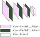
采用一个8层2D卷积神经网络对输入图像进行特征提取,将第二、第四、第六层步长设置为2,使特征提取金字塔分为四种尺度,并且卷积神经网络输出得到的特征图尺寸为原始输入尺寸的1/8,且通道数为32;对于每种尺度,利用一层卷积网络来提取更高层次的图像表示;除了最后一层卷积层外,每个卷积层后面都有一个批处理标准化层(BN)和线性修正单元(ReLU);同时,对于N个视图所采用的N个特征提取金字塔之间共享权重参数;经此操作后,每个保留像素点的原始领域信息被编码到像素描述符中,使得提取的每个特征图包含了原始像素的周围信息。An 8-layer 2D convolutional neural network is used to extract features from the input image, and the second, fourth, and sixth layer step size is set to 2, so that the feature extraction pyramid is divided into four scales, and the output of the convolutional neural network is obtained. The feature map size is 1/8 of the original input size, and the number of channels is 32; for each scale, a layer of convolutional There is a batch normalization layer (BN) and a linear correction unit (ReLU) behind the product layer; at the same time, the weight parameters are shared among the N feature extraction pyramids used for N views; after this operation, each reserved pixel The original domain information of the points is encoded into the pixel descriptor, so that each extracted feature map contains the surrounding information of the original pixel.
步骤S1.2包括:Step S1.2 includes:
利用可微单应性变换,将所有特征图转换到平行于参考视锥的不同平面上,基于像素操作的平面变换公式如下:Using the differentiable homography transformation, all feature maps are transformed to different planes parallel to the reference frustum. The plane transformation formula based on pixel operations is as follows:
x0~Hi(d)·xx0 to Hi (d) x
其中,x为投影前像素点,x0为投影后的像素点,~为投影操作,Hi(d)为第i个特征图和深度为d的参考特征图之间的单应性变换;Among them, x is the pixel point before projection, x0 is the pixel point after projection, ~ is the projection operation, and Hi (d) is the homography transformation between the i-th feature map and the reference feature map with depth d;
单应性变换由一个3*3矩阵表示:The homography transformation is represented by a 3*3 matrix:

其中,Ki,Ri和ti分别为第i个视角图像的相机内参矩阵,旋转矩阵和位移矩阵,

单应性变换作为连接2D特征提取和3D正则化网络的核心步骤,采用可微的方式实现了N个特征图到N个特征体的操作,并且实现了深度图推理的端到端训练;As the core step of connecting 2D feature extraction and 3D regularization network, homography transformation realizes the operation of N feature maps to N feature volumes in a differentiable way, and realizes the end-to-end training of depth map reasoning;
每个特征体大小可由下列数学表达式计算:The size of each feature volume can be calculated by the following mathematical expression:

其中,D为深度采样数128,F为特征图通道数32,经过三个步长为2的卷积层缩放得到特征图宽度和高度都为原来的1/8;Among them, D is the depth sampling number of 128, and F is the feature map channel number of 32. After three convolutional layers with a step size of 2, the width and height of the feature map are both 1/8 of the original;
进一步基于方差操作具体数学表达式如下:The specific mathematical expression further based on the variance operation is as follows:

其中,N为视角个数,
采用一个四级多尺度3D卷积神经网络对代价体素Cost Volume进行正则化操作达到平滑去噪声效果;它使用了编码器-解码器结构,以相对较低的内存和计算成本从一个较大的接收域聚合邻近的信息;将第一个3D卷积层后的32通道代价体素Cost Volume减小到8通道,并将每个尺度内的卷积设置为2层;最后一个卷积层输出一个1通道的代价体素CostVolume;最后利用softmax操作沿深度方向进行概率归一化。A four-level multi-scale 3D convolutional neural network is used to regularize the cost voxel Cost Volume to achieve smooth and denoising effect; it uses an encoder-decoder structure to achieve a relatively low memory and computational cost from a large The receptive field aggregates adjacent information; the 32-channel cost voxel Cost Volume after the first 3D convolutional layer is reduced to 8 channels, and the convolution within each scale is set to 2 layers; the last convolutional layer Output a 1-channel cost voxel CostVolume; finally use the softmax operation to normalize the probability along the depth direction.
步骤S1.3中概率加权和具体数学表达式如下:In step S1.3, the probability weighting sum and the specific mathematical expression are as follows:

其中,P(d)为深度d处所有像素点的概率估计值,[dmin,dmax]为采样深度取值范围。Among them, P(d) is the probability estimation value of all pixels at depth d, and [dmin , dmax ] is the value range of sampling depth.
步骤S1.4包括:Step S1.4 includes:
利用深度残差网络来生成细化深度图,深度残差网络一共有四层卷积层,前三层为32通道的2D卷积层,最后一层为1通道的2D卷积层;除了最后一层外,每个卷积层后面都有一个批处理标准化层和线性修正单元,最后一层用来学习负残差,深度残差网络输出的结果添加上初始深度图后得到细化深度图;A deep residual network is used to generate a refined depth map. The deep residual network has a total of four convolutional layers. The first three layers are 32-channel 2D convolutional layers, and the last layer is a 1-channel 2D convolutional layer; except for the last In addition to one layer, each convolutional layer is followed by a batch normalization layer and a linear correction unit. The last layer is used to learn the negative residual. The result of the deep residual network output is added to the initial depth map to obtain a refined depth map. ;
根据损失函数优化初始深度图和细化深度图,损失函数数学表达式如下:The initial depth map and the refined depth map are optimized according to the loss function. The mathematical expression of the loss function is as follows:

其中,d(p)为像素点p的真值深度值,

步骤S2包括:Step S2 includes:
BlendedMVS数据集中的低分辨率数据集图片尺寸为768*576,该数据集包含113个精心挑选和重建的3D模型。这些纹理模型涵盖了各种不同的场景,包括城市、建筑、雕塑和小物件。每个场景包含20到1000张输入图像,总共有17818张图像。为了使用BlendedMVS训练MVSNet网络,将所有训练样本调整为H*W=576*768,并将深度采样值设为D=128。相应地,将该数据集分为106个训练场景和7个验证场景来评估网络训练。The low-resolution dataset in the BlendedMVS dataset has a picture size of 768*576, and the dataset contains 113 carefully selected and reconstructed 3D models. These textured models cover a variety of different scenes, including cities, buildings, sculptures, and small objects. Each scene contains 20 to 1000 input images, for a total of 17818 images. In order to train the MVSNet network with BlendedMVS, all training samples are adjusted to H*W=576*768 and the depth sample value is set to D=128. Correspondingly, this dataset is divided into 106 training scenarios and 7 validation scenarios to evaluate network training.
本发明采用结合深度学习思想的MVS(Multi-View Stereo)算法,而MVS作为对重叠图像进行稠密表示的一种估计方法,具有重建精度高的优点。同时,利用深度学习有效改善了重建快速性和完整性。The present invention adopts the MVS (Multi-View Stereo) algorithm combined with the idea of deep learning, and as an estimation method for dense representation of overlapping images, MVS has the advantage of high reconstruction accuracy. At the same time, the use of deep learning effectively improves the reconstruction speed and completeness.
本发明提出的基于深度学习的无人机航拍影像的三维重建方法与现有的技术相比优点在于:Compared with the existing technology, the advantages of the deep learning-based three-dimensional reconstruction method of UAV aerial photography images proposed by the present invention are:
一、本发明采用基于深度学习无人机航拍影像的三维重建方法,不再将无人机仅作为数据获取的工具,而是在现场能确定原始成果的质量情况,充分利用无人机平台的便捷性为三维重建的时效性服务。1. The present invention adopts a three-dimensional reconstruction method based on deep learning drone aerial images, and no longer uses drones as a tool for data acquisition, but can determine the quality of the original results on the spot, making full use of the unmanned aerial vehicle platform. Convenience serves the timeliness of 3D reconstruction.
二、采用基于深度学习的MVS算法,与传统MVS方法相比,通过神经网络提取图像特征,生成深度图。基于学习的方法可以引入全局语义信息,如高光先验和反射先验,从而实现更强的匹配,解决了传统方法难以处理场景中低纹理、高光和反射区域的稠密匹配问题,从而很大程度上改善了重建的完整性。2. Using the MVS algorithm based on deep learning, compared with the traditional MVS method, the image features are extracted through the neural network to generate the depth map. Learning-based methods can introduce global semantic information, such as highlight priors and reflection priors, to achieve stronger matching and solve the problem of dense matching in low-texture, highlight and reflection areas in the scene that are difficult for traditional methods to deal with, thus greatly improving improved the integrity of the reconstruction.
三、本发明将深度学习思想与无人机载体相结合,为无人机进行三维重建提供一种新的思路,有效提高了利用无人机进行重建的速度。3. The present invention combines the idea of deep learning with the UAV carrier, provides a new idea for the three-dimensional reconstruction of the UAV, and effectively improves the reconstruction speed by using the UAV.
附图说明Description of drawings
图1为基于深度学习的无人机航拍影像的三维重建方法流程图;Fig. 1 is a flow chart of the 3D reconstruction method of UAV aerial imagery based on deep learning;
图2为改进MVSNet原理框图;Figure 2 is a schematic block diagram of the improved MVSNet;
图3为提取图像特征的金字塔网络模型;Fig. 3 is a pyramid network model for extracting image features;
图4为深度图优化原理图。Figure 4 is a schematic diagram of the depth map optimization.
具体实施方式Detailed ways
本发明针对MVSNet网络模型进行改进,使其更好地应用到无人机载体上。根据BlendedMVS数据集,对改进后的网络模型进行训练,经过若干次迭代更新网络权重参数,选取最优网络模型参数。利用无人机上多个相机进行数据采集,其包括将采集到的含有位置信息的航拍图片数据实时上传,图像序列经格式处理后输入端到端的神经网络模型得到相关深度图。采用深度图融合算法技术,把深度图转变为3D点云图保存。The invention improves the MVSNet network model so that it can be better applied to the UAV carrier. According to the BlendedMVS data set, the improved network model is trained, the network weight parameters are updated after several iterations, and the optimal network model parameters are selected. Data collection is performed by using multiple cameras on the UAV, which includes uploading the collected aerial image data containing location information in real time, and the image sequence is formatted and input into the end-to-end neural network model to obtain the relevant depth map. Using the depth map fusion algorithm technology, the depth map is converted into a 3D point cloud image and saved.
下面结合附图和具体实施步骤对本发明进行详细说明。The present invention will be described in detail below with reference to the accompanying drawings and specific implementation steps.
如图1所示,本发明的具体实施方法如下:As shown in Figure 1, the specific implementation method of the present invention is as follows:
S1、改进MVSNet网络模型,使其与无人机载体适配;从而可更好地应用到无人机载体上;S1. Improve the MVSNet network model to adapt it to the UAV carrier; thus, it can be better applied to the UAV carrier;
图2展示了改进后MVSNet原理框图,进一步对各个模块详细描述。Figure 2 shows the schematic block diagram of the improved MVSNet, and further describes each module in detail.
S1.1、提取图像特征:对MVSNet中特征提取的卷积神经网络进行改进,使其在保证能够提取充足的特征点情况下,减少图片的占有内存,更有效率地对图像进行降采样处理,从而最终能更好的和无人机相结合;S1.1. Extract image features: Improve the convolutional neural network for feature extraction in MVSNet, so that it can reduce the memory occupied by the image and downsample the image more efficiently under the condition that sufficient feature points can be extracted. , so that it can finally be better combined with drones;
采用一个8层2D卷积神经网络对输入图像进行特征提取,将第二、第四、第六层步长设置为2,使特征提取金字塔分为四种尺度,并且卷积神经网络输出得到的特征图尺寸为原始输入尺寸的1/8,且通道数为32;对于每种尺度,利用一层卷积网络来提取更高层次的图像表示;除了最后一层卷积层外,每个卷积层后面都有一个批处理标准化层(BN)和线性修正单元(ReLU);同时,对于N个视图所采用的N个特征提取金字塔之间共享权重参数;经此操作后,每个保留像素点的原始领域信息被编码到像素描述符中,使得提取的每个特征图包含了原始像素的周围信息。An 8-layer 2D convolutional neural network is used to extract features from the input image, and the second, fourth, and sixth layer step size is set to 2, so that the feature extraction pyramid is divided into four scales, and the output of the convolutional neural network is obtained. The feature map size is 1/8 of the original input size, and the number of channels is 32; for each scale, a layer of convolutional There is a batch normalization layer (BN) and a linear correction unit (ReLU) behind the product layer; at the same time, the weight parameters are shared among the N feature extraction pyramids used for N views; after this operation, each reserved pixel The original domain information of the points is encoded into the pixel descriptor, so that each extracted feature map contains the surrounding information of the original pixel.
图3为提取图像特征的网络模型结构图。Figure 3 is a structural diagram of a network model for extracting image features.
S1.2、构建3D代价体素Cost Volume:根据参考视图的相机锥体构建3D代价体素Cost Volume:根据可微单应性变换,利用提取到的N个特征图和相应的相机参数把其他视角提取到的特征图转化到参考相机视锥下的不同深度上,由此得到N个特征体,进一步基于方差操作将它们合成一个Cost Volume,最后采用一个多尺度3D卷积神经网络去噪声污染得到最优Cost Volume;S1.2. Build a 3D cost voxel Cost Volume: Build a 3D cost voxel Cost Volume according to the camera cone of the reference view: According to the differentiable homography transformation, use the extracted N feature maps and the corresponding camera parameters to convert other The feature maps extracted from the perspective are converted to different depths under the reference camera frustum to obtain N feature bodies, which are further synthesized into a Cost Volume based on variance operations, and finally a multi-scale 3D convolutional neural network is used to remove noise pollution. Get the optimal Cost Volume;
利用可微单应性变换,将所有特征图转换到平行于参考视锥的不同平面上,基于像素操作的平面变换公式如下:Using the differentiable homography transformation, all feature maps are transformed to different planes parallel to the reference frustum. The plane transformation formula based on pixel operations is as follows:
x0~Hi(d)·xx0 to Hi (d) x
其中,x为投影前像素点,x0为投影后的像素点,~为投影操作,Hi(d)为第i个特征图和深度为d的参考特征图之间的单应性变换。Among them, x is the pixel point before projection, x0 is the pixel point after projection, ~ is the projection operation, and Hi (d) is the homography transformation between the i-th feature map and the reference feature map with depth d.
单应性变换由一个3*3矩阵表示:The homography transformation is represented by a 3*3 matrix:

其中,Ki,Ri和ti分别为第i个视角图像的相机内参矩阵,旋转矩阵和位移矩阵,

单应性变换作为连接2D特征提取和3D正则化网络的核心步骤,采用可微的方式实现了N个特征图到N个特征体的操作,并且实现了深度图推理的端到端训练。Homography transformation, as the core step connecting 2D feature extraction and 3D regularization network, realizes the operation of N feature maps to N feature volumes in a differentiable way, and realizes the end-to-end training of depth map inference.
每个特征体大小可由下列数学表达式计算:The size of each feature volume can be calculated by the following mathematical expression:

其中,D为深度采样数128,F为特征图通道数32,经过三个步长为2的卷积层缩放得到特征图宽度和高度都为原来的1/8。Among them, D is the depth sampling number of 128, and F is the feature map channel number of 32. After three convolutional layers with a stride of 2, the width and height of the feature map are both 1/8 of the original.
进一步基于方差操作具体数学表达式如下:The specific mathematical expression further based on the variance operation is as follows:

其中,N为视角个数,
采用一个四级多尺度3D卷积神经网络对代价体素Cost Volume进行正则化操作达到平滑去噪声效果。它使用了编码器-解码器结构,以相对较低的内存和计算成本从一个较大的接收域聚合邻近的信息。将第一个3D卷积层后的32通道代价体素Cost Volume减小到8通道,并将每个尺度内的卷积设置为2层。最后一个卷积层输出一个1通道的代价体素CostVolume。最后利用softmax操作沿深度方向进行概率归一化。A four-level multi-scale 3D convolutional neural network is used to regularize the cost voxel Cost Volume to achieve smooth denoising effect. It uses an encoder-decoder structure to aggregate adjacent information from a large receptive field with relatively low memory and computational cost. Reduce the 32-channel cost voxel Cost Volume after the first 3D convolutional layer to 8 channels, and set the convolution within each scale to 2 layers. The last convolutional layer outputs a 1-channel cost voxel CostVolume. Finally, the softmax operation is used to normalize the probability along the depth direction.
S1.3、生成初始深度图:根据概率加权和公式,沿着深度方向计算期望值,在构建代价体素Cost Volume期间,此处的期望值能够产生一个连续的深度估算,输出深度图,从而更好地控制离群值滤波的阈值参数;S1.3. Generate the initial depth map: Calculate the expected value along the depth direction according to the probability weighted sum formula. During the construction of the cost voxel Cost Volume, the expected value here can generate a continuous depth estimation and output the depth map, so as to better control the threshold parameter of outlier filtering;
概率加权和具体数学表达式如下:The probability weighting and specific mathematical expressions are as follows:

其中,P(d)为深度d处所有像素点的概率估计值,[dmin,dmax]为采样深度取值范围。Among them, P(d) is the probability estimation value of all pixels at depth d, and [dmin , dmax ] is the value range of sampling depth.
S1.4、利用损失函数优化深度图:根据深度残差网络,将初始深度图和调整大小的参考视图进行连接操作输入网络,网络输出的结果添加初始深度图后生成细化深度图;根据真值深度图,利用绝对平均差作为训练的损失函数,同时对初始深度图和细化深度图进行优化操作。S1.4. Use the loss function to optimize the depth map: According to the depth residual network, connect the initial depth map and the resized reference view to the network, and add the initial depth map to the output of the network to generate a refined depth map; Value depth map, using the absolute mean difference as the loss function for training, while optimizing the initial depth map and the refined depth map.
利用深度残差网络来生成细化深度图,深度残差网络一共有四层卷积层,前三层为32通道的2D卷积层,最后一层为1通道的2D卷积层。除了最后一层外,每个卷积层后面都有一个批处理标准化层(BN)和线性修正单元(ReLU),最后一层用来学习负残差,深度残差网络输出的结果添加上初始深度图后得到细化深度图。The deep residual network is used to generate the refined depth map. The deep residual network has a total of four convolutional layers, the first three layers are 32-channel 2D convolutional layers, and the last layer is a 1-channel 2D convolutional layer. Except for the last layer, each convolutional layer is followed by a batch normalization layer (BN) and a linear correction unit (ReLU). The last layer is used to learn the negative residual, and the output of the deep residual network is added to the initial The refined depth map is obtained after the depth map.
图4为深度图优化模块,包含深度残差网络结构图。Figure 4 shows the depth map optimization module, including the structure diagram of the deep residual network.
根据损失函数优化初始深度图和细化深度图,损失函数数学表达式如下:The initial depth map and the refined depth map are optimized according to the loss function. The mathematical expression of the loss function is as follows:

其中,d(p)为像素点p的真值深度值,

S2、利用BlendedMVS数据集,对改进后的网络模型进行训练,经过若干次迭代更新网络权重参数,选取最优网络模型参数;S2. Use the BlendedMVS data set to train the improved network model, update the network weight parameters after several iterations, and select the optimal network model parameters;
即利用BlendedMVS中低分辨率数据集对网络模型进行训练和验证。That is, the network model is trained and verified using the low-resolution dataset in BlendedMVS.
BlendedMVS数据集中的低分辨率数据集图片尺寸为768*576,该数据集包含113个精心挑选和重建的3D模型。这些纹理模型涵盖了各种不同的场景,包括城市、建筑、雕塑和小物件。每个场景包含20到1000张输入图像,总共有17818张图像。为了使用BlendedMVS训练MVSNet网络,将所有训练样本调整为H*W=576*768,并将深度采样值设为D=128。相应地,将该数据集分为106个训练场景和7个验证场景来评估网络训练。The low-resolution dataset in the BlendedMVS dataset has a picture size of 768*576, and the dataset contains 113 carefully selected and reconstructed 3D models. These textured models cover a variety of different scenes, including cities, buildings, sculptures, and small objects. Each scene contains 20 to 1000 input images, for a total of 17818 images. In order to train the MVSNet network with BlendedMVS, all training samples are adjusted to H*W=576*768 and the depth sample value is set to D=128. Correspondingly, this dataset is divided into 106 training scenarios and 7 validation scenarios to evaluate network training.
S3、利用无人机上多个相机进行数据采集,从而获取到的含有位置信息的航拍图片数据;S3. Use multiple cameras on the UAV to collect data, so as to obtain the aerial image data containing location information;
S4、对步骤S3获取到的图片数据进行格式处理,并在此后输入端到端的神经网络模型得到的相关深度图中;S4, performing format processing on the image data obtained in step S3, and then inputting the relevant depth map obtained by the end-to-end neural network model;
S5、采用深度图融合算法技术,把深度图转变为3D点云图保存。S5. Using the depth map fusion algorithm technology, the depth map is converted into a 3D point cloud image and saved.
综上所述,本发明基于多视图几何理论,提供了一种基于深度学习的无人机航拍影像的三维重建方法。该方法将无人机上搭载的多个相机采集到的建筑物视频序列作为输入,基于现有MVSNet网络设计适用于无人机的神经网络模型,并利用已有的大型户外建筑物数据集训练该网络模型得到最优模型参数,进一步对视频序列图像进行格式处理并实时输入最优网络模型中,最终得到建筑物的3D点云重建图。In conclusion, based on the multi-view geometric theory, the present invention provides a three-dimensional reconstruction method of UAV aerial photography images based on deep learning. The method takes the building video sequences collected by multiple cameras mounted on the UAV as input, designs a neural network model suitable for UAVs based on the existing MVSNet network, and uses the existing large-scale outdoor building dataset to train the model. The network model obtains the optimal model parameters, further formats the video sequence images and inputs them into the optimal network model in real time, and finally obtains the 3D point cloud reconstruction map of the building.
以上所述仅为本发明的优选实施例而已,并不用于限制本发明,对于本领域的技术人员来说,本发明可以有各种更改和变化。凡在本发明的精神和原则之内,所作的任何修改、等同替换、改进等,均应包含在本发明的保护范围之内。The above descriptions are only preferred embodiments of the present invention, and are not intended to limit the present invention. For those skilled in the art, the present invention may have various modifications and changes. Any modification, equivalent replacement, improvement, etc. made within the spirit and principle of the present invention shall be included within the protection scope of the present invention.
Claims (7)


Priority Applications (1)
| Application Number | Priority Date | Filing Date | Title |
|---|---|---|---|
| CN202010212933.2ACN111462329B (en) | 2020-03-24 | 2020-03-24 | Three-dimensional reconstruction method of unmanned aerial vehicle aerial image based on deep learning |
Applications Claiming Priority (1)
| Application Number | Priority Date | Filing Date | Title |
|---|---|---|---|
| CN202010212933.2ACN111462329B (en) | 2020-03-24 | 2020-03-24 | Three-dimensional reconstruction method of unmanned aerial vehicle aerial image based on deep learning |
Publications (2)
| Publication Number | Publication Date |
|---|---|
| CN111462329Atrue CN111462329A (en) | 2020-07-28 |
| CN111462329B CN111462329B (en) | 2023-09-29 |
Family
ID=71685669
Family Applications (1)
| Application Number | Title | Priority Date | Filing Date |
|---|---|---|---|
| CN202010212933.2AActiveCN111462329B (en) | 2020-03-24 | 2020-03-24 | Three-dimensional reconstruction method of unmanned aerial vehicle aerial image based on deep learning |
Country Status (1)
| Country | Link |
|---|---|
| CN (1) | CN111462329B (en) |
Cited By (29)
| Publication number | Priority date | Publication date | Assignee | Title |
|---|---|---|---|---|
| CN112233228A (en)* | 2020-10-28 | 2021-01-15 | 五邑大学 | Unmanned aerial vehicle-based urban three-dimensional reconstruction method and device and storage medium |
| CN112509124A (en)* | 2020-12-14 | 2021-03-16 | 成都数之联科技有限公司 | Depth map obtaining method and system, unmanned aerial vehicle orthographic map generating method and medium |
| CN112734915A (en)* | 2021-01-19 | 2021-04-30 | 北京工业大学 | Multi-view stereoscopic vision three-dimensional scene reconstruction method based on deep learning |
| CN112762957A (en)* | 2020-12-29 | 2021-05-07 | 西北工业大学 | Multi-sensor fusion-based environment modeling and path planning method |
| CN112800524A (en)* | 2021-02-05 | 2021-05-14 | 河北工业大学 | Pavement disease three-dimensional reconstruction method based on deep learning |
| CN112967381A (en)* | 2021-03-05 | 2021-06-15 | 北京百度网讯科技有限公司 | Three-dimensional reconstruction method, apparatus, and medium |
| CN113066165A (en)* | 2021-03-19 | 2021-07-02 | 北京邮电大学 | Three-dimensional reconstruction method and device for multi-stage unsupervised learning and electronic equipment |
| CN113066168A (en)* | 2021-04-08 | 2021-07-02 | 云南大学 | Multi-view stereo network three-dimensional reconstruction method and system |
| CN113139661A (en)* | 2021-04-19 | 2021-07-20 | 中山大学 | Ground feature depth prediction method based on deep learning and multi-view remote sensing image |
| CN113178009A (en)* | 2021-04-19 | 2021-07-27 | 中国人民解放军陆军工程大学 | Indoor three-dimensional reconstruction method utilizing point cloud segmentation and grid repair |
| CN113393577A (en)* | 2021-05-28 | 2021-09-14 | 中铁二院工程集团有限责任公司 | Oblique photography terrain reconstruction method |
| CN113673400A (en)* | 2021-08-12 | 2021-11-19 | 土豆数据科技集团有限公司 | Real scene three-dimensional semantic reconstruction method and device based on deep learning and storage medium |
| CN113870422A (en)* | 2021-11-30 | 2021-12-31 | 华中科技大学 | Pyramid Transformer-based point cloud reconstruction method, device, equipment and medium |
| CN113963117A (en)* | 2021-10-29 | 2022-01-21 | 温州大学 | Multi-view three-dimensional reconstruction method and device based on variable convolution depth network |
| CN114268782A (en)* | 2020-09-16 | 2022-04-01 | 镇江多游网络科技有限公司 | 2D to 3D video conversion method, device and storage medium based on attention transfer |
| CN114359503A (en)* | 2021-12-13 | 2022-04-15 | 广西壮族自治区自然资源和不动产登记中心 | Oblique photography modeling method based on unmanned aerial vehicle |
| CN114463492A (en)* | 2022-01-12 | 2022-05-10 | 青海师范大学 | A deep learning-based adaptive channel attention 3D reconstruction method |
| CN114494594A (en)* | 2022-01-18 | 2022-05-13 | 中国人民解放军63919部队 | Astronaut operating equipment state identification method based on deep learning |
| CN114742873A (en)* | 2022-04-22 | 2022-07-12 | 华南理工大学 | A three-dimensional reconstruction method, device and medium based on adaptive network |
| CN114937073A (en)* | 2022-04-08 | 2022-08-23 | 陕西师范大学 | Image processing method of multi-view three-dimensional reconstruction network model MA-MVSNet based on multi-resolution adaptivity |
| CN115049782A (en)* | 2022-05-12 | 2022-09-13 | 香港中文大学(深圳) | Method and device for reconstructing dense three-dimensional model and readable storage medium |
| CN115147709A (en)* | 2022-07-06 | 2022-10-04 | 西北工业大学 | A 3D reconstruction method of underwater target based on deep learning |
| CN115222889A (en)* | 2022-07-19 | 2022-10-21 | 深圳万兴软件有限公司 | 3D reconstruction method and device based on multi-view image and related equipment |
| CN115457101A (en)* | 2022-11-10 | 2022-12-09 | 武汉图科智能科技有限公司 | Edge-preserving multi-view depth estimation and ranging method for unmanned aerial vehicle platform |
| CN115908730A (en)* | 2022-11-11 | 2023-04-04 | 南京理工大学 | An edge-based 3D scene reconstruction system method at the remote control terminal under low communication bandwidth |
| CN117974895A (en)* | 2024-01-31 | 2024-05-03 | 中国矿业大学(北京) | Three-dimensional reconstruction and depth prediction method and system for monocular video of pipeline |
| CN118015189A (en)* | 2024-01-31 | 2024-05-10 | 中国科学院国家空间科学中心 | A method and system for multi-view stereoscopic reconstruction of small celestial bodies based on weak light adaptation |
| US20240338031A1 (en)* | 2023-04-04 | 2024-10-10 | Aselsan Elektronik Sanayi Ve Ticaret Anonim Sirketi | Relative position determination method for multiple unmanned aerial, marine and land vehicles |
| US12159423B2 (en) | 2022-03-16 | 2024-12-03 | Toyota Research Institute, Inc. | Multi-camera cost volumes for self-supervised depth estimation |
Citations (4)
| Publication number | Priority date | Publication date | Assignee | Title |
|---|---|---|---|---|
| CN105184863A (en)* | 2015-07-23 | 2015-12-23 | 同济大学 | Unmanned aerial vehicle aerial photography sequence image-based slope three-dimension reconstruction method |
| US20160239976A1 (en)* | 2014-10-22 | 2016-08-18 | Pointivo, Inc. | Photogrammetric methods and devices related thereto |
| CN107945265A (en)* | 2017-11-29 | 2018-04-20 | 华中科技大学 | Real-time dense monocular SLAM method and systems based on on-line study depth prediction network |
| CN110570522A (en)* | 2019-08-22 | 2019-12-13 | 天津大学 | A multi-view 3D reconstruction method |
- 2020
- 2020-03-24CNCN202010212933.2Apatent/CN111462329B/enactiveActive
Patent Citations (4)
| Publication number | Priority date | Publication date | Assignee | Title |
|---|---|---|---|---|
| US20160239976A1 (en)* | 2014-10-22 | 2016-08-18 | Pointivo, Inc. | Photogrammetric methods and devices related thereto |
| CN105184863A (en)* | 2015-07-23 | 2015-12-23 | 同济大学 | Unmanned aerial vehicle aerial photography sequence image-based slope three-dimension reconstruction method |
| CN107945265A (en)* | 2017-11-29 | 2018-04-20 | 华中科技大学 | Real-time dense monocular SLAM method and systems based on on-line study depth prediction network |
| CN110570522A (en)* | 2019-08-22 | 2019-12-13 | 天津大学 | A multi-view 3D reconstruction method |
Cited By (44)
| Publication number | Priority date | Publication date | Assignee | Title |
|---|---|---|---|---|
| CN114268782A (en)* | 2020-09-16 | 2022-04-01 | 镇江多游网络科技有限公司 | 2D to 3D video conversion method, device and storage medium based on attention transfer |
| CN112233228A (en)* | 2020-10-28 | 2021-01-15 | 五邑大学 | Unmanned aerial vehicle-based urban three-dimensional reconstruction method and device and storage medium |
| CN112233228B (en)* | 2020-10-28 | 2024-02-20 | 五邑大学 | UAV-based urban three-dimensional reconstruction method, device and storage medium |
| CN112509124A (en)* | 2020-12-14 | 2021-03-16 | 成都数之联科技有限公司 | Depth map obtaining method and system, unmanned aerial vehicle orthographic map generating method and medium |
| CN112509124B (en)* | 2020-12-14 | 2023-09-22 | 成都数之联科技股份有限公司 | Depth map obtaining method and system, unmanned aerial vehicle orthogram generating method and medium |
| CN112762957A (en)* | 2020-12-29 | 2021-05-07 | 西北工业大学 | Multi-sensor fusion-based environment modeling and path planning method |
| CN112762957B (en)* | 2020-12-29 | 2022-12-30 | 西北工业大学 | Multi-sensor fusion-based environment modeling and path planning method |
| CN112734915A (en)* | 2021-01-19 | 2021-04-30 | 北京工业大学 | Multi-view stereoscopic vision three-dimensional scene reconstruction method based on deep learning |
| CN112800524A (en)* | 2021-02-05 | 2021-05-14 | 河北工业大学 | Pavement disease three-dimensional reconstruction method based on deep learning |
| CN112967381A (en)* | 2021-03-05 | 2021-06-15 | 北京百度网讯科技有限公司 | Three-dimensional reconstruction method, apparatus, and medium |
| CN112967381B (en)* | 2021-03-05 | 2024-01-16 | 北京百度网讯科技有限公司 | Three-dimensional reconstruction methods, equipment and media |
| CN113066165A (en)* | 2021-03-19 | 2021-07-02 | 北京邮电大学 | Three-dimensional reconstruction method and device for multi-stage unsupervised learning and electronic equipment |
| CN113066165B (en)* | 2021-03-19 | 2022-06-21 | 北京邮电大学 | 3D reconstruction method, apparatus and electronic device for multi-stage unsupervised learning |
| CN113066168A (en)* | 2021-04-08 | 2021-07-02 | 云南大学 | Multi-view stereo network three-dimensional reconstruction method and system |
| CN113178009A (en)* | 2021-04-19 | 2021-07-27 | 中国人民解放军陆军工程大学 | Indoor three-dimensional reconstruction method utilizing point cloud segmentation and grid repair |
| CN113139661A (en)* | 2021-04-19 | 2021-07-20 | 中山大学 | Ground feature depth prediction method based on deep learning and multi-view remote sensing image |
| CN113178009B (en)* | 2021-04-19 | 2023-08-25 | 中国人民解放军陆军工程大学 | Indoor three-dimensional reconstruction method utilizing point cloud segmentation and grid repair |
| CN113393577A (en)* | 2021-05-28 | 2021-09-14 | 中铁二院工程集团有限责任公司 | Oblique photography terrain reconstruction method |
| CN113393577B (en)* | 2021-05-28 | 2023-04-07 | 中铁二院工程集团有限责任公司 | Oblique photography terrain reconstruction method |
| CN113673400A (en)* | 2021-08-12 | 2021-11-19 | 土豆数据科技集团有限公司 | Real scene three-dimensional semantic reconstruction method and device based on deep learning and storage medium |
| CN113963117A (en)* | 2021-10-29 | 2022-01-21 | 温州大学 | Multi-view three-dimensional reconstruction method and device based on variable convolution depth network |
| CN113963117B (en)* | 2021-10-29 | 2024-03-29 | 温州大学 | Multi-view three-dimensional reconstruction method and device based on variable convolution depth network |
| CN113870422A (en)* | 2021-11-30 | 2021-12-31 | 华中科技大学 | Pyramid Transformer-based point cloud reconstruction method, device, equipment and medium |
| CN113870422B (en)* | 2021-11-30 | 2022-02-08 | 华中科技大学 | A point cloud reconstruction method, device, equipment and medium |
| CN114359503A (en)* | 2021-12-13 | 2022-04-15 | 广西壮族自治区自然资源和不动产登记中心 | Oblique photography modeling method based on unmanned aerial vehicle |
| CN114463492A (en)* | 2022-01-12 | 2022-05-10 | 青海师范大学 | A deep learning-based adaptive channel attention 3D reconstruction method |
| CN114463492B (en)* | 2022-01-12 | 2024-03-26 | 青海师范大学 | Self-adaptive channel attention three-dimensional reconstruction method based on deep learning |
| CN114494594A (en)* | 2022-01-18 | 2022-05-13 | 中国人民解放军63919部队 | Astronaut operating equipment state identification method based on deep learning |
| US12159423B2 (en) | 2022-03-16 | 2024-12-03 | Toyota Research Institute, Inc. | Multi-camera cost volumes for self-supervised depth estimation |
| CN114937073B (en)* | 2022-04-08 | 2024-08-09 | 陕西师范大学 | An image processing method based on multi-resolution adaptive multi-view stereo reconstruction network model MA-MVSNet |
| CN114937073A (en)* | 2022-04-08 | 2022-08-23 | 陕西师范大学 | Image processing method of multi-view three-dimensional reconstruction network model MA-MVSNet based on multi-resolution adaptivity |
| CN114742873B (en)* | 2022-04-22 | 2025-01-17 | 华南理工大学 | A three-dimensional reconstruction method, device and medium based on adaptive network |
| CN114742873A (en)* | 2022-04-22 | 2022-07-12 | 华南理工大学 | A three-dimensional reconstruction method, device and medium based on adaptive network |
| CN115049782A (en)* | 2022-05-12 | 2022-09-13 | 香港中文大学(深圳) | Method and device for reconstructing dense three-dimensional model and readable storage medium |
| CN115049782B (en)* | 2022-05-12 | 2025-02-07 | 香港中文大学(深圳) | Method, device and readable storage medium for reconstructing dense three-dimensional model |
| CN115147709B (en)* | 2022-07-06 | 2024-03-19 | 西北工业大学 | A three-dimensional reconstruction method of underwater targets based on deep learning |
| CN115147709A (en)* | 2022-07-06 | 2022-10-04 | 西北工业大学 | A 3D reconstruction method of underwater target based on deep learning |
| CN115222889A (en)* | 2022-07-19 | 2022-10-21 | 深圳万兴软件有限公司 | 3D reconstruction method and device based on multi-view image and related equipment |
| CN115457101A (en)* | 2022-11-10 | 2022-12-09 | 武汉图科智能科技有限公司 | Edge-preserving multi-view depth estimation and ranging method for unmanned aerial vehicle platform |
| CN115908730A (en)* | 2022-11-11 | 2023-04-04 | 南京理工大学 | An edge-based 3D scene reconstruction system method at the remote control terminal under low communication bandwidth |
| US20240338031A1 (en)* | 2023-04-04 | 2024-10-10 | Aselsan Elektronik Sanayi Ve Ticaret Anonim Sirketi | Relative position determination method for multiple unmanned aerial, marine and land vehicles |
| CN117974895A (en)* | 2024-01-31 | 2024-05-03 | 中国矿业大学(北京) | Three-dimensional reconstruction and depth prediction method and system for monocular video of pipeline |
| CN118015189A (en)* | 2024-01-31 | 2024-05-10 | 中国科学院国家空间科学中心 | A method and system for multi-view stereoscopic reconstruction of small celestial bodies based on weak light adaptation |
| CN117974895B (en)* | 2024-01-31 | 2025-01-21 | 中国矿业大学(北京) | A pipeline monocular video 3D reconstruction and depth prediction method and system |
Also Published As
| Publication number | Publication date |
|---|---|
| CN111462329B (en) | 2023-09-29 |
Similar Documents
| Publication | Publication Date | Title |
|---|---|---|
| CN111462329B (en) | Three-dimensional reconstruction method of unmanned aerial vehicle aerial image based on deep learning | |
| CN113345082B (en) | Characteristic pyramid multi-view three-dimensional reconstruction method and system | |
| Liu et al. | A novel recurrent encoder-decoder structure for large-scale multi-view stereo reconstruction from an open aerial dataset | |
| CN111652966B (en) | Three-dimensional reconstruction method and device based on multiple visual angles of unmanned aerial vehicle | |
| CN109410321B (en) | Three-dimensional reconstruction method based on convolutional neural network | |
| CN113936139B (en) | Scene aerial view reconstruction method and system combining visual depth information and semantic segmentation | |
| CN111127538B (en) | A 3D reconstruction method of multi-view images based on convolutional cyclic encoding-decoding structure | |
| CN116258817B (en) | A method and system for constructing autonomous driving digital twin scenes based on multi-view three-dimensional reconstruction | |
| CN114359509B (en) | Multi-view natural scene reconstruction method based on deep learning | |
| CN117115359B (en) | Multi-view power grid three-dimensional space data reconstruction method based on depth map fusion | |
| CN113780389B (en) | Deep learning semi-supervised dense matching method and system based on consistency constraint | |
| CN114677479A (en) | A deep learning-based multi-view 3D reconstruction method for natural landscapes | |
| CN111899328A (en) | Point cloud three-dimensional reconstruction method based on RGB data and generation countermeasure network | |
| CN113077554A (en) | Three-dimensional structured model reconstruction method based on any visual angle picture | |
| CN111914615A (en) | Fire-fighting area passability analysis system based on stereoscopic vision | |
| CN114119884A (en) | A method for building LOD1 model of buildings based on Gaofen-7 satellite images | |
| CN119107528A (en) | A 3D real-time modeling fusion method for digital twin pumped storage power station | |
| CN119068114A (en) | A method for 3D reconstruction of building automation | |
| CN119416333B (en) | Architectural design and analysis method based on point cloud 3D reconstruction | |
| CN116168070A (en) | A monocular depth estimation method and system based on infrared images | |
| CN116051758B (en) | A method for constructing a terrain map containing height information for outdoor robots | |
| CN116342675A (en) | Real-time monocular depth estimation method, system, electronic equipment and storage medium | |
| CN120426982A (en) | Occupation grid prediction method combining urban nerve radiation field priori with time domain enhancement | |
| CN104463962A (en) | Three-dimensional scene reconstruction method based on GPS information video | |
| CN115471397A (en) | Multimodal Image Registration Method Based on Disparity Estimation |
Legal Events
| Date | Code | Title | Description |
|---|---|---|---|
| PB01 | Publication | ||
| PB01 | Publication | ||
| SE01 | Entry into force of request for substantive examination | ||
| SE01 | Entry into force of request for substantive examination | ||
| GR01 | Patent grant | ||
| GR01 | Patent grant |