CN111412912A - Navigation board, multi-source data fusion method for navigation board and carrier - Google Patents
Navigation board, multi-source data fusion method for navigation board and carrierDownload PDFInfo
- Publication number
- CN111412912A CN111412912ACN202010288979.2ACN202010288979ACN111412912ACN 111412912 ACN111412912 ACN 111412912ACN 202010288979 ACN202010288979 ACN 202010288979ACN 111412912 ACN111412912 ACN 111412912A
- Authority
- CN
- China
- Prior art keywords
- navigation
- gnss
- board
- inertial
- attitude
- Prior art date
- Legal status (The legal status is an assumption and is not a legal conclusion. Google has not performed a legal analysis and makes no representation as to the accuracy of the status listed.)
- Pending
Links
Images


Classifications
- G—PHYSICS
- G01—MEASURING; TESTING
- G01C—MEASURING DISTANCES, LEVELS OR BEARINGS; SURVEYING; NAVIGATION; GYROSCOPIC INSTRUMENTS; PHOTOGRAMMETRY OR VIDEOGRAMMETRY
- G01C21/00—Navigation; Navigational instruments not provided for in groups G01C1/00 - G01C19/00
- G01C21/005—Navigation; Navigational instruments not provided for in groups G01C1/00 - G01C19/00 with correlation of navigation data from several sources, e.g. map or contour matching
- G—PHYSICS
- G01—MEASURING; TESTING
- G01C—MEASURING DISTANCES, LEVELS OR BEARINGS; SURVEYING; NAVIGATION; GYROSCOPIC INSTRUMENTS; PHOTOGRAMMETRY OR VIDEOGRAMMETRY
- G01C21/00—Navigation; Navigational instruments not provided for in groups G01C1/00 - G01C19/00
- G01C21/10—Navigation; Navigational instruments not provided for in groups G01C1/00 - G01C19/00 by using measurements of speed or acceleration
- G01C21/12—Navigation; Navigational instruments not provided for in groups G01C1/00 - G01C19/00 by using measurements of speed or acceleration executed aboard the object being navigated; Dead reckoning
- G01C21/16—Navigation; Navigational instruments not provided for in groups G01C1/00 - G01C19/00 by using measurements of speed or acceleration executed aboard the object being navigated; Dead reckoning by integrating acceleration or speed, i.e. inertial navigation
- G01C21/165—Navigation; Navigational instruments not provided for in groups G01C1/00 - G01C19/00 by using measurements of speed or acceleration executed aboard the object being navigated; Dead reckoning by integrating acceleration or speed, i.e. inertial navigation combined with non-inertial navigation instruments
- G—PHYSICS
- G01—MEASURING; TESTING
- G01S—RADIO DIRECTION-FINDING; RADIO NAVIGATION; DETERMINING DISTANCE OR VELOCITY BY USE OF RADIO WAVES; LOCATING OR PRESENCE-DETECTING BY USE OF THE REFLECTION OR RERADIATION OF RADIO WAVES; ANALOGOUS ARRANGEMENTS USING OTHER WAVES
- G01S19/00—Satellite radio beacon positioning systems; Determining position, velocity or attitude using signals transmitted by such systems
- G01S19/01—Satellite radio beacon positioning systems transmitting time-stamped messages, e.g. GPS [Global Positioning System], GLONASS [Global Orbiting Navigation Satellite System] or GALILEO
- G01S19/13—Receivers
- G01S19/35—Constructional details or hardware or software details of the signal processing chain
- G—PHYSICS
- G01—MEASURING; TESTING
- G01S—RADIO DIRECTION-FINDING; RADIO NAVIGATION; DETERMINING DISTANCE OR VELOCITY BY USE OF RADIO WAVES; LOCATING OR PRESENCE-DETECTING BY USE OF THE REFLECTION OR RERADIATION OF RADIO WAVES; ANALOGOUS ARRANGEMENTS USING OTHER WAVES
- G01S19/00—Satellite radio beacon positioning systems; Determining position, velocity or attitude using signals transmitted by such systems
- G01S19/38—Determining a navigation solution using signals transmitted by a satellite radio beacon positioning system
- G01S19/39—Determining a navigation solution using signals transmitted by a satellite radio beacon positioning system the satellite radio beacon positioning system transmitting time-stamped messages, e.g. GPS [Global Positioning System], GLONASS [Global Orbiting Navigation Satellite System] or GALILEO
- G01S19/393—Trajectory determination or predictive tracking, e.g. Kalman filtering
- G—PHYSICS
- G01—MEASURING; TESTING
- G01S—RADIO DIRECTION-FINDING; RADIO NAVIGATION; DETERMINING DISTANCE OR VELOCITY BY USE OF RADIO WAVES; LOCATING OR PRESENCE-DETECTING BY USE OF THE REFLECTION OR RERADIATION OF RADIO WAVES; ANALOGOUS ARRANGEMENTS USING OTHER WAVES
- G01S19/00—Satellite radio beacon positioning systems; Determining position, velocity or attitude using signals transmitted by such systems
- G01S19/38—Determining a navigation solution using signals transmitted by a satellite radio beacon positioning system
- G01S19/39—Determining a navigation solution using signals transmitted by a satellite radio beacon positioning system the satellite radio beacon positioning system transmitting time-stamped messages, e.g. GPS [Global Positioning System], GLONASS [Global Orbiting Navigation Satellite System] or GALILEO
- G01S19/396—Determining accuracy or reliability of position or pseudorange measurements
- G—PHYSICS
- G01—MEASURING; TESTING
- G01S—RADIO DIRECTION-FINDING; RADIO NAVIGATION; DETERMINING DISTANCE OR VELOCITY BY USE OF RADIO WAVES; LOCATING OR PRESENCE-DETECTING BY USE OF THE REFLECTION OR RERADIATION OF RADIO WAVES; ANALOGOUS ARRANGEMENTS USING OTHER WAVES
- G01S19/00—Satellite radio beacon positioning systems; Determining position, velocity or attitude using signals transmitted by such systems
- G01S19/38—Determining a navigation solution using signals transmitted by a satellite radio beacon positioning system
- G01S19/39—Determining a navigation solution using signals transmitted by a satellite radio beacon positioning system the satellite radio beacon positioning system transmitting time-stamped messages, e.g. GPS [Global Positioning System], GLONASS [Global Orbiting Navigation Satellite System] or GALILEO
- G01S19/40—Correcting position, velocity or attitude
- G—PHYSICS
- G01—MEASURING; TESTING
- G01S—RADIO DIRECTION-FINDING; RADIO NAVIGATION; DETERMINING DISTANCE OR VELOCITY BY USE OF RADIO WAVES; LOCATING OR PRESENCE-DETECTING BY USE OF THE REFLECTION OR RERADIATION OF RADIO WAVES; ANALOGOUS ARRANGEMENTS USING OTHER WAVES
- G01S19/00—Satellite radio beacon positioning systems; Determining position, velocity or attitude using signals transmitted by such systems
- G01S19/38—Determining a navigation solution using signals transmitted by a satellite radio beacon positioning system
- G01S19/39—Determining a navigation solution using signals transmitted by a satellite radio beacon positioning system the satellite radio beacon positioning system transmitting time-stamped messages, e.g. GPS [Global Positioning System], GLONASS [Global Orbiting Navigation Satellite System] or GALILEO
- G01S19/42—Determining position
- G01S19/45—Determining position by combining measurements of signals from the satellite radio beacon positioning system with a supplementary measurement
- G01S19/47—Determining position by combining measurements of signals from the satellite radio beacon positioning system with a supplementary measurement the supplementary measurement being an inertial measurement, e.g. tightly coupled inertial
Landscapes
- Engineering & Computer Science (AREA)
- Radar, Positioning & Navigation (AREA)
- Remote Sensing (AREA)
- Physics & Mathematics (AREA)
- General Physics & Mathematics (AREA)
- Computer Networks & Wireless Communication (AREA)
- Automation & Control Theory (AREA)
- Signal Processing (AREA)
- Navigation (AREA)
- Position Fixing By Use Of Radio Waves (AREA)
Abstract
Translated fromChinese
Description
Translated fromChinese技术领域technical field
本发明实施例涉及导航技术领域,尤其涉及一种导航板卡、用于导航板卡的多源数据融合方法以及运载体。Embodiments of the present invention relate to the technical field of navigation, and in particular, to a navigation board, a multi-source data fusion method for a navigation board, and a carrier.
背景技术Background technique
随着导航技术的发展,对导航精度的要求也越来越高。With the development of navigation technology, the requirements for navigation accuracy are getting higher and higher.
在城市峡谷、建筑山林等环境下,GNSS(全球导航卫星系统定位)信号易受到遮挡和干扰,导致导航定位精度下降甚至中断,GNSS导航定位连续性和可靠性比较差,此外GNSS定位数据频率较低,无法满足高动态应用场景的动态性要求。而GNSS与INS(惯性定向定位导航系统)组合导航定位技术充分发挥了卫星导航定位技术和惯性导航定位技术的优势,并很好的弥补两者的缺陷,GNSS/INS组合导航定位技术能够为客户提供高精度、高动态、连续可靠的导航定位服务。因此自动驾驶、轨迹跟踪、智能控制等应用领域,用户对GNSS/INS组合导航产品有强烈的需求。In urban canyons, buildings, mountains and other environments, GNSS (Global Navigation Satellite System Positioning) signals are easily blocked and interfered, resulting in reduced or even interrupted navigation and positioning accuracy, poor continuity and reliability of GNSS navigation and positioning, and relatively high frequency of GNSS positioning data. Low, unable to meet the dynamic requirements of high dynamic application scenarios. The combined navigation and positioning technology of GNSS and INS (Inertial Oriented Positioning and Navigation System) gives full play to the advantages of satellite navigation and positioning technology and inertial navigation and positioning technology, and makes up for the shortcomings of both. The combined GNSS/INS navigation and positioning technology can provide customers with Provide high-precision, high-dynamic, continuous and reliable navigation and positioning services. Therefore, in the application fields of automatic driving, trajectory tracking, and intelligent control, users have strong demand for GNSS/INS integrated navigation products.
但现有GNSS/INS的组合导航产品,多是将单独的GNSS板卡和INS模块集成在一个外壳内,不利于原有运载体中GNSS板卡的替换、升级。However, most of the existing GNSS/INS integrated navigation products integrate a separate GNSS board and INS module into one shell, which is not conducive to the replacement and upgrade of the GNSS board in the original carrier.
发明内容SUMMARY OF THE INVENTION
本发明提供一种导航板卡、用于导航板卡的多源数据融合方法以及运载体,以将GNSS导航定位模块和惯性传感器集成在同一PCB板上,进而在实现GNSS/INS组合导航定位的基础上,减小组合导航定位产品的尺寸,实现导航板卡对现有运载体上的标准GNSS板卡直接替换。The present invention provides a navigation board, a multi-source data fusion method for the navigation board, and a carrier, so as to integrate a GNSS navigation and positioning module and an inertial sensor on the same PCB board, thereby realizing GNSS/INS combined navigation and positioning. On this basis, the size of the integrated navigation and positioning product is reduced, and the navigation board can be directly replaced with the standard GNSS board on the existing carrier.
第一方面,本发明实施例提供一种导航板卡,包括:PCB板、GNSS导航定位模块、惯性传感器、处理器和数据接口,所述数据接口包括外部传感器接口;In a first aspect, an embodiment of the present invention provides a navigation board, including: a PCB board, a GNSS navigation and positioning module, an inertial sensor, a processor, and a data interface, where the data interface includes an external sensor interface;
所述GNSS导航定位模块用于跟踪解析GNSS卫星信号及执行GNSS导航定位解算;The GNSS navigation and positioning module is used to track and analyze GNSS satellite signals and perform GNSS navigation and positioning solutions;
所述惯性传感器用于测量所述导航板卡的三维惯性角速度和三维惯性加速度;The inertial sensor is used to measure the three-dimensional inertial angular velocity and three-dimensional inertial acceleration of the navigation board;
所述处理器用于根据所述GNSS导航定位模块的运算结果、所述惯性传感器的测量结果和外部传感器的观测结果,执行大失准角初始化算法、惯性捷联解算算法和多源数据融合解算;The processor is configured to execute the large misalignment angle initialization algorithm, the inertial strapdown solution algorithm and the multi-source data fusion solution according to the calculation result of the GNSS navigation and positioning module, the measurement result of the inertial sensor and the observation result of the external sensor. Calculate;
所述GNSS导航定位模块、所述惯性传感器和所述处理器集成在所述PCB板上,所述GNSS导航定位模块和所述惯性传感器均通过所述PCB板上的电路实现与所述处理器的电连接;The GNSS navigation and positioning module, the inertial sensor and the processor are integrated on the PCB board, and both the GNSS navigation and positioning module and the inertial sensor are implemented with the processor through the circuit on the PCB board. the electrical connection;
所述导航板卡的尺寸小于或等于标准GNSS板卡的尺寸,且所述导航板卡至少包括与标准GNSS板卡的数据接口相同的数据接口。The size of the navigation board is smaller than or equal to the size of the standard GNSS board, and the navigation board at least includes the same data interface as that of the standard GNSS board.
第二方面,本发明实施例还提供了一种用于导航板卡的多源数据融合方法,其特征在于,由第一方面提供的导航板卡执行,所述导航板卡的多源数据融合方法包括:In a second aspect, an embodiment of the present invention further provides a multi-source data fusion method for a navigation board, characterized in that it is performed by the navigation board provided in the first aspect, and the multi-source data fusion of the navigation board is Methods include:
处理器同步获取GNSS导航定位模块、惯性传感器和外部传感器的观测数据;The processor synchronously obtains the observation data of the GNSS navigation and positioning module, inertial sensors and external sensors;
处理器执行大失准角初始化算法进行导航定位状态的初始化,确定初始姿态、初始速度和初始位置;The processor executes the large misalignment angle initialization algorithm to initialize the navigation and positioning state, and determines the initial attitude, initial speed and initial position;
处理器分别以所述初始姿态、所述初始速度和所述初始位置为惯性导航定位起始时刻的姿态、速度和位置,周期性获取所述惯性传感器的角速度和加速度观测值,并执行惯性捷联解算算法进行惯性导航定位解算,得到第一姿态、第一速度和第一位置;The processor takes the initial attitude, the initial speed and the initial position as the attitude, speed and position at the initial moment of inertial navigation positioning, periodically obtains the angular velocity and acceleration observations of the inertial sensor, and executes the inertial shortcut. The joint solution algorithm performs inertial navigation positioning solution to obtain the first attitude, the first speed and the first position;
处理器根据所述GNSS导航定位模块解算的第二位置、第二速度和第二姿态观测及所述外部传感器获取的第三位置、第三速度和第三姿态观测,与惯性捷联解算的第一姿态、第一速度和第一位置结果进行融合解算得到新的姿态、速度和位置作为导航结果输出;或者处理器根据所述GNSS导航定位模块获取的伪距、载波相位和多普勒原始观测量作为第四观测及所述外部传感器获取的第三位置、第三速度、第三位置观测数据,与惯性捷联解算的第一姿态、第一速度和第一位置结果进行融合解算得到新的姿态、速度和位置作为导航结果输出。The processor calculates the second position, the second velocity and the second attitude based on the observation of the second position, the second velocity and the second attitude calculated by the GNSS navigation and positioning module and the third position, the third velocity and the third attitude observation obtained by the external sensor, and the inertial strapdown calculation. The first attitude, the first speed and the first position result are fused and calculated to obtain a new attitude, speed and position as the navigation result output; or the processor obtains the pseudorange, carrier phase and Doppler according to the GNSS navigation and positioning module. The original observations are taken as the fourth observation and the third position, third velocity, and third position observation data obtained by the external sensor, and are fused with the first attitude, first velocity, and first position results of the inertial strapdown solution. The new attitude, velocity, and position are solved and output as the navigation result.
第三方面,本发明实施例还提供了一种运载体,所述运载体上以任意角度安装有第一方面提供的导航板卡。In a third aspect, an embodiment of the present invention further provides a carrier on which the navigation board provided in the first aspect is installed at any angle.
本实施例提供的导航板卡、用于导航板卡的多源数据融合方法以及运载体,通过将GNSS导航定位模块、惯性传感器和处理器集成在PCB板上,GNSS导航定位模块和惯性传感器均通过PCB板上的电路实现与处理器的电连接,进而实现GNSS导航定位模块和惯性传感器形成一体化导航板卡,并通过设计导航板卡的尺寸小于或等于标准GNSS板卡的尺寸,进而使得在现有运载体中安装GNSS板卡的空间内可以容置本实施例提供的导航板卡,进而有利于实现该导航板卡对运载体中GNSS板卡的直接替换。并且,因本实施例提供的导航板卡至少包括与标准GNSS板卡的数据接口相同的数据接口,使得该导航板卡替换原有运载体中的GNSS板卡后,运载体中原来与GNSS板卡数据接口连接的线路直接连接到对应的导航板卡的数据接口即可,进而使得将运载体中GNSS板卡替换为本实施例中的导航板卡后,仍可保证正常工作。并且通过处理器可根据GNSS导航定位模块的运算结果、惯性传感器的测量结果和外部传感器的观测结果,执行大失准角初始化算法、惯性捷联解算算法和多源数据融合算法,可实现GNSS/INS组合导航功能,充分发挥卫星导航定位系统高精度、误差独立和惯性导航定位系统高动态、全自主、短期精度高的优势,以GNSS/INS一体化的硬件设计和大失准角初始化算法、惯性捷联解算算法和多源数据融合算法为基础实现GNSS/INS一体化板卡设计,使得在GNSS信号中断、遮挡、干扰等恶劣环境下,仍能保持连续、可靠的高精度导航定位,提高导航定位系统的容错能力和可靠性,满足用户对于不同应用场境下高精度、高可靠的连续导航定位需求。In the navigation board, the multi-source data fusion method for the navigation board, and the carrier provided in this embodiment, by integrating the GNSS navigation and positioning module, the inertial sensor, and the processor on the PCB, the GNSS navigation and positioning module and the inertial sensor are both integrated. The electrical connection with the processor is realized through the circuit on the PCB board, so that the GNSS navigation and positioning module and the inertial sensor form an integrated navigation board, and the size of the navigation board is designed to be smaller than or equal to the size of the standard GNSS board, so that the The navigation board provided in this embodiment can be accommodated in the space in which the GNSS board is installed in the existing carrier, thereby facilitating the direct replacement of the GNSS board in the carrier by the navigation board. In addition, because the navigation board provided by this embodiment at least includes the same data interface as the data interface of the standard GNSS board, after the navigation board replaces the GNSS board in the original carrier, the original GNSS board in the carrier is The line connected by the card data interface may be directly connected to the data interface of the corresponding navigation board, so that after the GNSS board in the carrier is replaced with the navigation board in this embodiment, normal operation can still be guaranteed. And through the processor, according to the calculation results of the GNSS navigation and positioning module, the measurement results of the inertial sensors and the observation results of the external sensors, the large misalignment angle initialization algorithm, the inertial strapdown solution algorithm and the multi-source data fusion algorithm can be executed to realize GNSS. /INS integrated navigation function, give full play to the advantages of high precision, independent error of satellite navigation and positioning system and high dynamic, full autonomy and high short-term accuracy of inertial navigation and positioning system, with GNSS/INS integrated hardware design and large misalignment angle initialization algorithm , Inertial strapdown solution algorithm and multi-source data fusion algorithm to realize GNSS/INS integrated board design, so that in harsh environments such as GNSS signal interruption, occlusion, interference, etc., it can still maintain continuous and reliable high-precision navigation and positioning , to improve the fault tolerance and reliability of the navigation and positioning system, and meet the needs of users for high-precision, high-reliability continuous navigation and positioning in different application scenarios.
附图说明Description of drawings
图1是本发明实施例提供的一种导航板卡的结构示意图;1 is a schematic structural diagram of a navigation board provided by an embodiment of the present invention;
图2是本发明实施例提供的一种导航板卡的立体结构示意图;2 is a schematic three-dimensional structure diagram of a navigation board provided by an embodiment of the present invention;
图3是本发明实施例提供的一种用于导航板卡的多源数据融合方法的流程图;3 is a flowchart of a multi-source data fusion method for a navigation board provided by an embodiment of the present invention;
图4是本发明实施例提供的步骤220的具体流程图;FIG. 4 is a specific flowchart of
图5是本发明实施例提供的数据自检过程的流程图;5 is a flowchart of a data self-checking process provided by an embodiment of the present invention;
具体实施方式Detailed ways
下面结合附图和实施例对本发明作进一步的详细说明。可以理解的是,此处所描述的具体实施例仅仅用于解释本发明,而非对本发明的限定。另外还需要说明的是,为了便于描述,附图中仅示出了与本发明相关的部分而非全部结构。The present invention will be further described in detail below in conjunction with the accompanying drawings and embodiments. It should be understood that the specific embodiments described herein are only used to explain the present invention, but not to limit the present invention. In addition, it should be noted that, for the convenience of description, the drawings only show some but not all structures related to the present invention.
正如背景技术中所述,现有GNSS/INS的组合导航产品,多是将单独的GNSS板卡和INS模块集成在一个外壳内,不利于原有GNSS设备板卡的替换、升级。经发明人研究发现,出现上述问题的原因在于,GNSS/INS的组合导航产品中,GNSS板卡和INS模块分别为独立的模块,且现有GNSS/INS的组合导航产品所选用INS模块的尺寸较大,使得GNSS/INS的组合导航产品的尺寸较大,而现有运载体中所安装的GNSS板卡尺寸通常较小,使得安装GNSS板卡的空间内不足以容置GNSS/INS的组合导航产品。并且现有GNSS/INS组合导航产品的数据接口与GNSS板卡也存在不一致,更加使得GNSS/INS组合导航产品无法直接对运载体中已有的GNSS板卡直接替换升级。并且运载体上安装的GNSS板卡对安装方向无要求,可以任意角度安装,而现有的GNSS/INS组合导航产品一般对在载体的安装方向有一定要求,更加使得现有GNSS/INS组合导航产品无法实现对运载体中GNSS板卡的直接替换。As described in the background art, most of the existing GNSS/INS integrated navigation products integrate a separate GNSS board and an INS module into one housing, which is not conducive to the replacement and upgrade of the original GNSS equipment board. The inventor's research found that the reason for the above problem is that in the integrated navigation product of GNSS/INS, the GNSS board and the INS module are independent modules, and the size of the INS module selected for the existing integrated navigation product of GNSS/INS. The size of the GNSS/INS integrated navigation product is larger, and the size of the GNSS board installed in the existing carrier is usually small, so that the space for installing the GNSS board is not enough to accommodate the combination of GNSS/INS Navigate products. In addition, the data interface of the existing GNSS/INS integrated navigation product is also inconsistent with the GNSS board, which makes it impossible for the GNSS/INS integrated navigation product to directly replace and upgrade the existing GNSS board in the carrier. And the GNSS board installed on the carrier has no requirements on the installation direction, and can be installed at any angle, while the existing GNSS/INS integrated navigation products generally have certain requirements on the installation direction of the carrier, which makes the existing GNSS/INS integrated navigation products. The product cannot directly replace the GNSS board in the carrier.
基于上述原因,本发明实施例提供一种导航板卡,图1是本发明实施例提供的一种导航板卡的结构示意图,参考图1,该导航板卡包括:Based on the above reasons, an embodiment of the present invention provides a navigation board. FIG. 1 is a schematic structural diagram of a navigation board provided by an embodiment of the present invention. Referring to FIG. 1 , the navigation board includes:
PCB板110、GNSS导航定位模块120、惯性传感器130、处理器140和数据接口150,数据接口150包括外部传感器接口;GNSS导航定位模块120用于跟踪解析GNSS卫星信号及执行GNSS导航定位解算;惯性传感器130用于测量导航板卡的三维惯性角速度和三维惯性加速度;处理器140用于根据GNSS导航定位模块120的运算结果、惯性传感器130的测量结果和外部传感器的观测结果,执行大失准角初始化算法、惯性捷联解算算法和多源数据融合解算;GNSS导航定位模块120、惯性传感器130和处理器140集成在PCB板110上,GNSS导航定位模块120和惯性传感器130均通过PCB板110上的电路实现与处理器140的电连接;导航板卡的尺寸小于或等于标准GNSS板卡的尺寸,且导航板卡至少包括与标准GNSS板卡的数据接口150相同的数据接口150。The
其中,PCB板110即印刷电路板,作为GNSS导航定位模块120、惯性传感器130和处理器140的承载板,GNSS导航定位模块120、惯性传感器130和处理器140集成在PCB板110上,进而实现GNSS导航定位模块120与惯性传感器130的一体化,其中惯性传感器130即相当于现有技术中GNSS/INS组合导航产品的INS模块。PCB板110上设置有电路结构,GNSS导航定位模块120与处理器140通过PCB板110上的电路结构电连接,惯性传感器130与处理器140通过PCB板110上的电路结构电连接。并且导航板卡的尺寸小于或等于标准GNSS板卡的尺寸,且导航板卡至少包括与标准GNSS板卡的数据接口150相同的数据接口150。可选的,GNSS导航定位模块120型号为UBLOXF9P或UBLOXM8T。可选的,处理器140型号为IMX.RT1052、STM32H7或SAMA5D27,上述型号的处理器140内部集成RAM/DDR,外围器件数量少、处理器140最小系统尺寸小,集成度高。可选的,惯性传感器130型号为ADIS505、IMU330或SCC2X30,上述型号的惯性传感器130与现有GNSS/INS导航组合产品中的INS模块相比,具有小封装、高性能的优点,型号为UBLOXF9P或UBLOXM8T的GNSS导航定位模块120的尺寸以及型号为IMX.RT1052、STM32H7或SAMA5D27的处理器140尺寸也较小,进而使得本实施例中的导航板卡的整体尺寸可以较小。并且可设计导航板卡的尺寸小于或等于标准GNSS板卡的尺寸,进而使得在现有运载体中安装GNSS板卡的空间内可以容置本实施例提供的导航板卡,进而有利于实现该导航板卡对运载体中GNSS板卡的直接替换。并且,因本实施例提供的导航板卡至少包括与标准GNSS板卡的数据接口150相同的数据接口150,使得该导航板卡替换原有运载体中的GNSS板卡后,运载体中原来与GNSS板卡数据接口150连接的线路直接连接到对应的导航板卡的数据接口150即可,进而使得将运载体中GNSS板卡替换为本实施例中的导航板卡后,仍可保证正常工作。Among them, the
可选的,该导航板卡还包括GNSS导航定位模块120天线接口160,用于连接外部GNSS天线,接收GNSS信号。Optionally, the navigation board further includes an
可选的,外部传感器接口用于接收里程计数据、毫米波雷达数据、激光雷达数据、视觉传感器数据和地图数据中的至少一种。Optionally, the external sensor interface is used to receive at least one of odometer data, millimeter wave radar data, lidar data, visual sensor data, and map data.
具体的,GNSS导航定位模块120可以包括GNSS信号捕获解析单元和GNSS导航定位单元,其中GNSS信号捕获解析单元用于跟踪解析GNSS卫星信号,GNSS导航定位单元用于根据GNSS卫星信号进行GNSS导航定位解算,得到伪距、载波相位和多普勒原始观测量等数据。惯性传感器130至少包括三轴MEMS加速度计、三轴MEMS陀螺仪,可选配一个温度传感器和一个三轴磁力计,其中三轴MEMS加速度计可用于测量导航板卡的三维惯性加速度,三轴MEMS陀螺仪可用于测量导航板卡的三维惯性角速度。Specifically, the GNSS navigation and
处理器140可根据GNSS导航定位模块120的运算结果、惯性传感器130的测量结果和外部传感器的观测结果,执行大失准角初始化算法、惯性捷联解算算法和多源数据融合算法,具体的,处理器140执行大失准角初始化算法可对导航定位状态的初始化,确定初始姿态、初始速度和初始位置,进而使得无论导航板卡以何种安装方向安装,处理器140均可确定出导航板卡的各初始数据,尤其是初始姿态,进而可为后续导航定位计算提供初始数据。因此,本实施例提供的导航板卡,通过处理器140采用大失准角初始化算法对导航板卡的初始姿态、初始速度和初始位置进行确定,可以使得导航板卡安装时,可以和现有GNSS板卡一样以任意角度进行安装,没有安装方向的限制。其中大失准角初始化算法的具体过程请详见本发明以下关于用于导航板卡的多源数据融合方法的实施例。The
处理器140执行惯性捷联解算算法时,分别以初始姿态、初始速度和初始位置为惯性导航定位起始时刻的姿态、速度和位置,周期性获取惯性传感器130的角速度和加速度观测值,并执行惯性捷联解算算法进行惯性导航定位解算,得到第一姿态、第一速度和第一位置;其中惯性捷联解算算法的具体过程详见本发明以下关于用于导航板卡的多源数据融合方法的实施例。When the
处理器140执行多源数据融合解算时,根据GNSS导航定位模块120解算的第二位置、第二速度及第二姿态观测及外部传感器获取的第三位置、第三速度和第三姿态观测,与惯性捷联解算的第一姿态、第一速度和第一位置结果进行融合解算得到姿态、速度和位置作为导航结果输出;或者处理器140根据GNSS导航定位模块120获取的伪距、载波相位和多普勒原始观测量作为第四观测及外部传感器获取的第三位置、第三速度、第三位置观测数据,与惯性捷联解算的第一姿态、第一速度和第一位置结果进行融合解算得到姿态、速度和位置作为导航结果输出。其中,处理器140执行多源数据融合解算的具体过程详见本发明以下关于用于导航板卡的多源数据融合方法实施例。通过集成GNSS导航定位模块120与惯性传感器130,实现GNSS/INS组合导航功能,充分发挥卫星导航定位系统高精度、误差独立和惯性导航定位系统高动态、全自主、短期精度高的优势,以GNSS/INS一体化的硬件设计和大失准角初始化算法、惯性捷联解算算法和多源数据融合算法为基础实现GNSS/INS一体化板卡设计,使得在GNSS信号中断、遮挡、干扰等恶劣环境下,仍能保持连续、可靠的高精度导航定位,提高导航定位系统的容错能力和可靠性,满足用户对于不同应用场境下高精度、高可靠的连续导航定位需求。When the
本实施例提供的导航板卡,通过将GNSS导航定位模块、惯性传感器和处理器集成在PCB板上,GNSS导航定位模块和惯性传感器均通过PCB板上的电路实现与处理器的电连接,进而实现GNSS导航定位模块和惯性传感器形成一体化导航板卡,并通过设计导航板卡的尺寸小于或等于标准GNSS板卡的尺寸,进而使得在现有运载体中安装GNSS板卡的空间内可以容置本实施例提供的导航板卡,进而有利于实现该导航板卡对运载体中GNSS板卡的直接替换。并且,因本实施例提供的导航板卡至少包括与标准GNSS板卡的数据接口相同的数据接口,使得该导航板卡替换原有运载体中的GNSS板卡后,运载体中原来与GNSS板卡数据接口连接的线路直接连接到对应的导航板卡的数据接口即可,进而使得将运载体中GNSS板卡替换为本实施例中的导航板卡后,仍可保证正常工作。并且通过处理器可根据GNSS导航定位模块的运算结果、惯性传感器的测量结果和外部传感器的观测结果,执行大失准角初始化算法、惯性捷联解算算法和多源数据融合算法,可实现GNSS/INS组合导航功能,充分发挥卫星导航定位系统高精度、误差独立和惯性导航定位系统高动态、全自主、短期精度高的优势,以GNSS/INS一体化的硬件设计和大失准角初始化算法、惯性捷联解算算法和多源数据融合算法为基础实现GNSS/INS一体化板卡设计,使得在GNSS信号中断、遮挡、干扰等恶劣环境下,仍能保持连续、可靠的高精度导航定位,提高导航定位系统的容错能力和可靠性,满足用户对于不同应用场境下高精度、高可靠的连续导航定位需求。In the navigation board provided in this embodiment, by integrating the GNSS navigation and positioning module, the inertial sensor, and the processor on the PCB board, the GNSS navigation and positioning module and the inertial sensor are both electrically connected to the processor through the circuit on the PCB board, thereby achieving electrical connection with the processor. The GNSS navigation and positioning module and the inertial sensor are realized to form an integrated navigation board, and the size of the navigation board is designed to be smaller than or equal to the size of the standard GNSS board, so that the space for installing the GNSS board in the existing carrier can be accommodated. The navigation board provided in this embodiment is installed, thereby facilitating the direct replacement of the GNSS board in the carrier by the navigation board. In addition, because the navigation board provided by this embodiment at least includes the same data interface as the data interface of the standard GNSS board, after the navigation board replaces the GNSS board in the original carrier, the original GNSS board in the carrier is The line connected by the card data interface may be directly connected to the data interface of the corresponding navigation board, so that after the GNSS board in the carrier is replaced with the navigation board in this embodiment, normal operation can still be guaranteed. And through the processor, according to the calculation results of the GNSS navigation and positioning module, the measurement results of the inertial sensors and the observation results of the external sensors, the large misalignment angle initialization algorithm, the inertial strapdown solution algorithm and the multi-source data fusion algorithm can be executed to realize GNSS. /INS integrated navigation function, give full play to the advantages of high precision, independent error of satellite navigation and positioning system and high dynamic, full autonomy and high short-term accuracy of inertial navigation and positioning system, with GNSS/INS integrated hardware design and large misalignment angle initialization algorithm , Inertial strapdown solution algorithm and multi-source data fusion algorithm to realize GNSS/INS integrated board design, so that in harsh environments such as GNSS signal interruption, occlusion, interference, etc., it can still maintain continuous and reliable high-precision navigation and positioning , to improve the fault tolerance and reliability of the navigation and positioning system, and meet the needs of users for high-precision, high-reliability continuous navigation and positioning in different application scenarios.
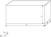
图2是本发明实施例提供的一种导航板卡的立体结构示意图,参考图2,在上述技术方案的基础上,可选的,导航板卡的尺寸包括长度a、宽度b和高度c,其中导航板卡的长度a小于或者等于100毫米,导航板卡的宽度b小于或等于60毫米,导航板卡的高度c小于或等于15毫米。FIG. 2 is a schematic diagram of a three-dimensional structure of a navigation board provided by an embodiment of the present invention. Referring to FIG. 2 , on the basis of the above technical solution, optionally, the size of the navigation board includes a length a, a width b, and a height c. The length a of the navigation board is less than or equal to 100 mm, the width b of the navigation board is less than or equal to 60 mm, and the height c of the navigation board is less than or equal to 15 mm.
参考图2,图2以导航板卡为标准的长方体为例进行示出,需要说明的是,导航板卡形状也可不是标准的长方体,导航板卡的长度a指在x方向导航板卡的最大尺寸,导航板卡的宽度b指在y方向导航板卡的最大尺寸,导航板卡的高度c指在z方向导航板卡的最大尺寸。本实施例中,通过设置导航板卡的长度a小于或者等于100毫米,导航板卡的宽度b小于或等于60毫米,导航板卡的高度c小于或等于15毫米,使得导航板卡的尺寸较小,进而有利于实现导航板卡对运载体中GNSS板卡的直接替换。Referring to Fig. 2, Fig. 2 is shown by taking the navigation board as a standard cuboid as an example. It should be noted that the shape of the navigation board may not be a standard cuboid, and the length a of the navigation board refers to the length of the navigation board in the x direction. Maximum size, the width b of the navigation board refers to the maximum size of the navigation board in the y direction, and the height c of the navigation board refers to the maximum size of the navigation board in the z direction. In this embodiment, by setting the length a of the navigation board to be less than or equal to 100 mm, the width b of the navigation board to be less than or equal to 60 mm, and the height c of the navigation board to be less than or equal to 15 mm, the size of the navigation board is smaller than or equal to 15 mm. It is small, which is conducive to the direct replacement of the GNSS board in the carrier by the navigation board.
可选的,GNSS导航模块、惯性传感器和处理器为贴片式器件,并以焊锡贴片的形式固定连接在PCB板上。Optionally, the GNSS navigation module, the inertial sensor and the processor are SMD components, and are fixedly connected to the PCB in the form of solder patches.
具体的,贴片式器件的尺寸通常较小,进而有利于减小导航板卡的尺寸。GNSS导航模块、惯性传感器和处理器以焊锡贴片的形式固定连接在PCB板上,使得GNSS导航模块、惯性传感器和处理器与PCB板上电路的连接方便可靠。Specifically, the size of the SMD device is usually small, which is beneficial to reduce the size of the navigation board. The GNSS navigation module, inertial sensor and processor are fixedly connected to the PCB in the form of solder patches, which makes the connection between the GNSS navigation module, inertial sensor and processor and the circuit on the PCB convenient and reliable.
可选的,导航板卡的数据接口包括RS232、RS422、UART、USB、网口、WIFI、4G/5G、蓝牙、CAN和EVENT中的至少一种数据接口。并且,可选的同种类、不同数量的数据接口任意组合、灵活搭配,以满足不同使用场景数据传输需求。导航板卡是数据接口的形态可以是排针,以实现对GNSS板卡的硬件兼容,便于现有设备GNSS板卡的替换、升级;导航板卡是数据接口的形态还可以是邮票孔,以提高基于GNSS/INS一体化板卡开发设备的集成度,抗震动、抗冲击性能。Optionally, the data interface of the navigation board includes at least one data interface among RS232, RS422, UART, USB, network port, WIFI, 4G/5G, Bluetooth, CAN and EVENT. In addition, the optional data interfaces of the same type and different numbers can be combined arbitrarily and flexibly to meet the data transmission requirements of different usage scenarios. The navigation board is in the form of a data interface and can be a pin header to achieve hardware compatibility with GNSS boards and facilitate the replacement and upgrade of existing equipment GNSS boards; the navigation board is in the form of a data interface or a stamp hole, so as to Improve the integration, anti-vibration and anti-shock performance of GNSS/INS integrated board development equipment.
导航板卡通过RS232、RS422、UART、USB、网口、WIFI、4G/5G、蓝牙、CAN、EVENT等数据接口中的一种或多种,获取外部传感器数据、差分数据、用户配置参数、触发信号;也可通过RS232、RS422、UART、USB、网口、WIFI、4G/5G、蓝牙、CAN、EVENT等数据接口中的一种或多种,输出GNSS导航定位模块解析的卫星伪距、载波、多普勒原始观测数据;还可通过RS232、RS422、UART、USB、网口、WIFI、4G/5G、蓝牙、CAN、EVENT等数据接口中的一种或多种,输出GNSS导航定位模块解算的三维位置、三维速度、航向、俯仰、时间结果数据;还可通过RS232、RS422、UART、USB、网口、WIFI、4G/5G、蓝牙、CAN、EVENT等数据接口中的一种或多种,输出GNSS/INS/外部传感器信息融合后的三维位置、三维速度、三维姿态数据;还可通过RS232、RS422、UART、USB、网口、WIFI、4G/5G、蓝牙、CAN、EVENT等数据接口中的一种或多种,输出差分数据、用户配置参数、日志信息、PPS信号。The navigation board obtains external sensor data, differential data, user configuration parameters, triggers through one or more of data interfaces such as RS232, RS422, UART, USB, network port, WIFI, 4G/5G, Bluetooth, CAN, EVENT, etc. Signal; it can also output satellite pseudorange and carrier wave analyzed by GNSS navigation and positioning module through one or more of RS232, RS422, UART, USB, network port, WIFI, 4G/5G, Bluetooth, CAN, EVENT and other data interfaces , Doppler raw observation data; can also output GNSS navigation and positioning module solution through one or more of RS232, RS422, UART, USB, network port, WIFI, 4G/5G, Bluetooth, CAN, EVENT and other data interfaces Calculated 3D position, 3D speed, heading, pitch, time result data; also through one or more of RS232, RS422, UART, USB, Ethernet, WIFI, 4G/5G, Bluetooth, CAN, EVENT and other data interfaces It can output 3D position, 3D velocity, 3D attitude data after GNSS/INS/external sensor information fusion; it can also pass RS232, RS422, UART, USB, network port, WIFI, 4G/5G, Bluetooth, CAN, EVENT and other data One or more of the interfaces output differential data, user configuration parameters, log information, and PPS signals.
本发明实施例还提供了一种用于导航板卡的多源数据融合方法,由上述任意实施例提供的导航板卡执行,图3是本发明实施例提供的一种用于导航板卡的多源数据融合方法的流程图,参考图3,该用于导航板卡的多源数据融合方法包括:An embodiment of the present invention further provides a multi-source data fusion method for a navigation board, which is executed by the navigation board provided in any of the above embodiments. FIG. 3 is a method for a navigation board provided by an embodiment of the present invention. The flowchart of the multi-source data fusion method, referring to FIG. 3, the multi-source data fusion method for the navigation board includes:
步骤210、处理器同步获取GNSS导航定位模块、惯性传感器和外部传感器的观测数据;
在导航板卡的GNSS导航定位模块跟踪到卫星信号后,处理器周期性的获取惯性传感器观测的三轴加速度和三轴角速度,通常的采样频率为100Hz/200Hz/400Hz,若接入了外部传感器则同时按设定的采样频率周期性的获取外接传感器的观测数据,对惯性传感器的观测数据、外接传感器观测数据和GNSS导航定位模块的观测、解算信息的时间同步,进而使得后续步骤中用到的数据均为时间同步后的数据,保证算法计算的准确性。After the GNSS navigation and positioning module of the navigation board tracks the satellite signal, the processor periodically obtains the triaxial acceleration and triaxial angular velocity observed by the inertial sensor. The usual sampling frequency is 100Hz/200Hz/400Hz. If an external sensor is connected At the same time, the observation data of the external sensor is periodically obtained according to the set sampling frequency, and the time synchronization of the observation data of the inertial sensor, the observation data of the external sensor and the observation and calculation information of the GNSS navigation and positioning module, so that the following steps can be used. The received data are all time-synchronized data to ensure the accuracy of the algorithm calculation.
步骤220、处理器执行大失准角初始化算法进行导航定位状态的初始化,确定初始姿态、初始速度和初始位置;
上述实施例提供的导航板卡为GNSS/INS组合导航产品,GNSS/INS组合导航产品导航定位解算需要设置初始位置、初始速度和初始姿态,初始姿态的设定是关键环节。本发明通过大失准角初始化算法完成姿态角初始化的方法,可实现导航板卡任意角度安装时的初始姿态估计,实现了导航板卡的任意角度安装,便于对运载体中已安装的GNSS板卡的直接替换、升级。其中,大失准角初始化算法的具体过程如下:The navigation board provided by the above embodiment is a GNSS/INS integrated navigation product, and the initial position, initial speed and initial attitude need to be set for the navigation and positioning solution of the GNSS/INS integrated navigation product, and the setting of the initial attitude is a key link. The invention completes the attitude angle initialization method through the large misalignment angle initialization algorithm, which can realize the initial attitude estimation when the navigation board is installed at any angle, realizes the installation of the navigation board at any angle, and facilitates the installation of the GNSS board in the carrier. Direct replacement and upgrade of the card. Among them, the specific process of the large misalignment angle initialization algorithm is as follows:
1)导航板卡任意角度安装时,初始姿态误差不满足小角度条件,滤波器模型为非线性模型。本发明利用变换估计量的方法,将对航向角的估计转换为对两个三角函数的估计,将非线性模型线性化,从而可以直接使用标准卡尔曼滤波器估计航向角。1) When the navigation board is installed at any angle, the initial attitude error does not meet the small angle condition, and the filter model is a nonlinear model. The invention uses the method of transforming the estimator to convert the estimation of the heading angle into the estimation of two trigonometric functions, and linearizes the nonlinear model, so that the heading angle can be estimated directly by using the standard Kalman filter.
惯性捷联解算运动方程:Inertial strapdown solves the equations of motion:

其中


变换估计量航向角估计模型设计:Transform estimator heading angle estimation model design:
定义


定义DCM的误差如下:The error in defining the DCM is as follows:

其中上标^代表估计。where the superscript ^ represents an estimate.
定义航向误差为


通过公式(4)即将对航向角


假设俯仰角误差δθ和横滚角误差δγ为小量,记


将(5),(6)带入(3),推导可得:


分别对(7)和(5)进行求导,则有:Differentiating (7) and (5) respectively, we have:


结合公式(5),则有如下误差方程:Combined with formula (5), there is the following error equation:


对速度进行微分,有如下结果:Differentiating the velocity yields the following results:


对经纬度进行微分,有如下结果:Differentiating the latitude and longitude yields the following results:


其中,

变换估计量航向角估计卡尔曼滤波器设计:Transform estimator heading angle estimation Kalman filter design:
卡尔曼滤波器的标准过程如下:The standard procedure for a Kalman filter is as follows:
①状态一步预测①Status one-step prediction

其中,

②状态一步预测均方误差② State one-step prediction mean square error

其中,Pk-1指k-1时刻的状态估计均方差阵,Pk|k-1指一步预测状态估计均方差阵,Γk-1指k-1时刻的系统噪声驱动阵,Qk-1指k-1时刻的系统噪声方差阵;Among them, Pk-1 refers to the mean square error matrix of state estimation at time k-1, Pk|k-1 refers to the mean square error matrix of one-step prediction state estimation, Γk-1 refers to the system noise driving matrix at time k-1, Qk -1 refers to the system noise variance matrix at time k-1;
③滤波增益③Filter gain


其中,Hk指k时刻量测阵,Rk指量测噪声方差阵,Kk指滤波增益阵,PXZ,k|k-1指k-1时刻到k时刻的状态量和量测量的协方差阵,PZZ,k|k-1指一步预测量测均方差阵;Among them, Hk refers to the measurement array at time k, Rk refers to the measurement noise variance array, Kk refers to the filter gain array, PXZ,k|k-1 refers to the state quantity and quantity measurement from time k-1 to time k Covariance matrix, PZZ,k|k-1 refers to the one-step prediction measurement mean variance matrix;
④状态估计④ State estimation

其中,Zk指k时刻的量测量,
⑤状态估计均方误差⑤ State estimation mean square error
Pk=(I-KkHk)Pk/k-1 (16)Pk = (IKk Hk )Pk/k-1 (16)
其中,Pk指k时刻的状态估计均方差阵,I指6行6列的单位矩阵。Among them, Pk refers to the state estimation mean square error matrix at time k, and I refers to the identity matrix with 6 rows and 6 columns.
选取滤波器状态空间如下:The filter state space is selected as follows:

根据公式(9)(10)(11)可以提取如下状态转移矩阵:According to formulas (9) (10) (11), the following state transition matrix can be extracted:

Φ=I6×6+F(t)×dtΦ=I6×6 +F(t)×dt
以绝对测量传感器测量的位置,速度作为滤波器的观测,则有:Taking the position measured by the absolute measurement sensor and the velocity as the observation of the filter, there are:


以上即为变换估计量航向角估计算法的滤波器模型和建模过程。The above is the filter model and modeling process of the transform estimator heading angle estimation algorithm.
其中,图4是本发明实施例提供的步骤220的具体流程图,参考图4,该步骤220可以包括:4 is a specific flowchart of
步骤221、GNSS导航定位模块获取固定解状态下的GNSS位置、速度设定初始位置、速度;处理器根据惯性传感器测得的三轴加速度计和三轴角速度,计算出的俯仰角和横滚角设置初始俯仰角和初始横滚角,初始航向角设定为任意值;
步骤222、设置双滤波器,两个滤波器除航向初始值设置不同,两个滤波器同时运行,双滤波器均达到稳态且满足航向角估计判断条件时,中断大失准角初始化算法的解算,将此时估计的航向角作为导航定位解算的初始航向。Step 222: Set dual filters. The two filters are set differently except for the initial value of the heading. The two filters are running at the same time. When both filters reach a steady state and meet the heading angle estimation judgment conditions, the large misalignment angle initialization algorithm is interrupted. Solution, take the estimated heading angle at this time as the initial heading of the navigation and positioning solution.
其中,步骤222中滤波器即上述卡尔曼滤波器。参考图4,该步骤222中,可分别设置滤波器1和滤波器2,且滤波器1和滤波器2的航向角分别设置为任意值1和任意值2,其中任意值1和任意值2不同,通过判断滤波器1和滤波器2分别得到的航向角收敛值1和航向角收敛值2之差是否小于阈值,该阈值可预先设定来判定是否完成初始化,即当航向角收敛值1和航向角收敛值2之差小于阈值时,初始化完成。The filter in
步骤230、处理器分别以初始姿态、初始速度和初始位置为惯性导航定位起始时刻的姿态、速度和位置,周期性获取惯性传感器的角速度和加速度观测值,并执行惯性捷联解算算法进行惯性导航定位解算,得到第一姿态、第一速度和第一位置;
其中,惯性捷联解算算法可见关于大失准角初始化算法中公式(1)-公式(11)。Among them, the inertial strapdown solution algorithm can be seen from the formula (1)-formula (11) in the initialization algorithm for the large misalignment angle.
步骤240、处理器根据GNSS导航定位模块解算的第二位置、第二速度和第二姿态观测及外部传感器获取的第三位置、第三速度和第三姿态观测,与惯性捷联解算的第一姿态、第一速度和第一位置结果进行融合解算得到新的姿态、速度和位置作为导航结果输出;或者处理器根据GNSS导航定位模块获取的伪距、载波相位和多普勒原始观测量作为第四观测及外部传感器获取的第三位置、第三速度、第三位置观测数据,与惯性捷联解算的第一姿态、第一速度和第一位置结果进行融合解算得到新的姿态、速度和位置作为导航结果输出。
可选的,上述步骤240中,处理器利用GNSS导航定位模块解算的第二位置、第二速度和第二姿态观测及外部传感器获取的第三位置、第三速度和第三姿态观测,与惯性捷联解算的第一姿态、第一速度和第一位置结果进行融合解算得到新的姿态、速度和位置作为导航结果输出,包括:Optionally, in the
处理器根据惯性捷联解算算法的微分方程构建卡尔曼滤波器模型,以惯性捷联解算的频率同时进行卡尔曼滤波器时间更新,以第一位置和第二位置的差值、第一速度和第二速度的差值作为卡尔曼滤波器的观测量进行卡尔曼滤波器的量测更新,估计惯性捷联算法得到的姿态、速度和位置的误差以及惯性传感器的零偏误差,并将对应误差进行反馈修正,以第一位置和第三位置的差值、第一速度和第三速度的差值和第一姿态和第三姿态的差值作为卡尔曼滤波器的观测量再次进行卡尔曼滤波器的量测更新、修正,以修正后的惯性导航姿态、速度和位置分别作导航结果输出。The processor constructs a Kalman filter model according to the differential equation of the inertial strapdown solution algorithm, and simultaneously updates the Kalman filter time at the frequency of the inertial strapdown solution, using the difference between the first position and the second position, the first position The difference between the speed and the second speed is used as the observation value of the Kalman filter to update the measurement of the Kalman filter, estimate the attitude, speed and position errors obtained by the inertial strapdown algorithm and the zero bias error of the inertial sensor, and use Perform feedback correction corresponding to the error, and take the difference between the first position and the third position, the difference between the first speed and the third speed, and the difference between the first attitude and the third attitude as the observations of the Kalman filter. The measurement update and correction of the Mann filter are used to output the navigation results with the corrected inertial navigation attitude, speed and position respectively.
可选的,上述步骤240中,处理器根据GNSS导航定位模块获取的伪距、载波相位和多普勒原始观测量作为第四观测及外部传感器获取的第三位置、第三速度、第三位置观测数据,与惯性捷联解算的第一姿态、第一速度和第一位置结果进行融合解算得到新的姿态、速度和位置作为导航结果输出,包括:Optionally, in the
处理器根据惯性捷联解算算法的微分方程构建卡尔曼滤波器模型,以惯性捷联解算的频率同时进行卡尔曼滤波器时间更新,以第四观测伪距、载波相位和多普勒始观测量作为卡尔曼滤波器的观测量进行卡尔曼滤波器的量测更新,估计惯性捷联算法得到的姿态、速度和位置的误差以及惯性传感器的零偏误差,并将对应误差进行反馈修正,以第一位置和第三位置的差值、第一速度和第三速度的差值和第一姿态和第三姿态的差值作为卡尔曼滤波器的观测量再次进行卡尔曼滤波器的量测更新、修正,以修正后的惯性导航姿态、速度和位置分别作导航结果输出。The processor constructs the Kalman filter model according to the differential equation of the inertial strapdown solution algorithm, and simultaneously updates the Kalman filter time at the frequency of the inertial strapdown solution. The fourth observation pseudorange, carrier phase and Doppler start. The observed value is used as the observed value of the Kalman filter to update the measurement of the Kalman filter, estimate the attitude, velocity and position errors obtained by the inertial strapdown algorithm and the zero bias error of the inertial sensor, and feedback the corresponding errors to correct them. Use the difference between the first position and the third position, the difference between the first speed and the third speed, and the difference between the first attitude and the third attitude as the observation value of the Kalman filter, and perform the measurement of the Kalman filter again. Update, correct, and output the navigation results with the corrected inertial navigation attitude, speed and position.
本实施例提供的用于导航板卡的多源数据融合方法,通过大失准角初始化算法完成姿态角初始化的方法,可实现导航板卡任意角度安装时的初始姿态估计,实现了导航板卡的任意角度安装,便于对运载体中已安装的GNSS板卡的直接替换、升级。通过处理器根据GNSS导航定位模块解算的第二位置、第二速度和第二姿态观测及外部传感器获取的第三位置、第三速度和第三姿态观测,与惯性捷联解算的第一姿态、第一速度和第一位置结果进行融合解算得到新的姿态、速度和位置作为导航结果输出;或者处理器根据GNSS导航定位模块获取的伪距、载波相位和多普勒原始观测量作为第四观测及外部传感器获取的第三位置、第三速度、第三位置观测数据,与惯性捷联解算的第一姿态、第一速度和第一位置结果进行融合解算得到新的姿态、速度和位置作为导航结果输出,可实现GNSS/INS组合导航功能,充分发挥卫星导航定位系统高精度、误差独立和惯性导航定位系统高动态、全自主、短期精度高的优势,以GNSS/INS一体化的硬件设计和大失准角初始化算法、惯性捷联解算算法和多源数据融合算法为基础实现GNSS/INS一体化板卡设计,使得在GNSS信号中断、遮挡、干扰等恶劣环境下,仍能保持连续、可靠的高精度导航定位,提高导航定位系统的容错能力和可靠性,满足用户对于不同应用场境下高精度、高可靠的连续导航定位需求。并且,因处理器计算导航结构时,将外接传感器的数据也进行了融合,因此,本发明具备优秀的可扩展能力,可满足用户对于多源传感器融合导航定位的需求。The multi-source data fusion method for the navigation board provided in this embodiment, the method for completing the attitude angle initialization through the large misalignment angle initialization algorithm, can realize the initial attitude estimation when the navigation board is installed at any angle, and realizes the navigation board. It can be installed at any angle, which is convenient for the direct replacement and upgrade of the installed GNSS boards in the carrier. The second position, the second velocity and the second attitude calculated by the processor according to the GNSS navigation and positioning module and the third position, the third velocity and the third attitude obtained by the external sensor are observed, and the first position calculated by the inertial strapdown The attitude, the first velocity and the first position result are fused and calculated to obtain a new attitude, velocity and position as the navigation result output; or the processor uses the pseudorange, carrier phase and Doppler original observations obtained by the GNSS navigation and positioning module as the The fourth observation and the third position, third velocity, and third position observation data obtained by the external sensor are fused with the first attitude, first velocity, and first position results of the inertial strapdown solution to obtain a new attitude, The speed and position are output as the navigation results, which can realize the integrated navigation function of GNSS/INS, and give full play to the advantages of high precision, independent error of satellite navigation and positioning system and high dynamic, full autonomy and short-term accuracy of inertial navigation and positioning system. The integrated hardware design and large misalignment angle initialization algorithm, inertial strapdown solution algorithm and multi-source data fusion algorithm are used to realize the GNSS/INS integrated board design, so that in harsh environments such as GNSS signal interruption, occlusion, interference, etc. It can still maintain continuous and reliable high-precision navigation and positioning, improve the fault tolerance and reliability of the navigation and positioning system, and meet users' needs for high-precision, high-reliability continuous navigation and positioning in different application scenarios. In addition, when the processor calculates the navigation structure, the data of the external sensors is also fused. Therefore, the present invention has excellent scalability and can meet the user's needs for multi-source sensor fusion navigation and positioning.
在上述技术方案的基础上,可选的,上述步骤240中,GNSS导航定位模块获取伪距、载波相位和多普勒原始观测量时,根据惯性捷联解算得到当前历元时刻的用户的位置和速度信息,结合由卫星星历数据得到的卫星位置、速度信息,计算得到用户至卫星视线方向的单位矢量和伪距信息,进而得到视线方向上的多普勒频移和码相位偏移,以多普勒频移和码相位偏移作为搜索范围的中心,并根据惯性捷联解算的位置和速度信息的不确定度来设定搜索范围,控制本地码/载波数控振荡器在设定搜索范围内进行搜索。On the basis of the above technical solution, optionally, in the
其中,基于惯性传感器的惯性定向定位导航可辅助GNSS导航定位模块获取伪距、载波相位和多普勒原始观测量,并且获取时可分为粗捕获和精捕获两部分:Among them, the inertial orientation positioning and navigation based on inertial sensors can assist the GNSS navigation and positioning module to obtain pseudorange, carrier phase and Doppler raw observations, and the acquisition can be divided into two parts: coarse acquisition and fine acquisition:
其中粗捕获采用基于快速傅里叶变换的循环相关捕获方法,基于惯性传感器的惯性定向定位导航和卫星星历共同预测多普勒信息,提高接收机搜索性能,从而减小频率搜索范围,达到快速捕获信号的目的。在粗捕获阶段,基于惯性传感器的惯性定向定位导航结合星历,提供载体与卫星的速度、加速度,从而可以计算出多普勒频移Δf,将计算的频移量反馈到载波数控振荡器NCO(Numerical Controlled Oscillator)中,共同调节本地载波频率中心值。为了更好地利用,基于惯性传感器的惯性定向定位导航提供的频移估计量,应该将,基于惯性传感器的惯性定向定位导航与接收机信息融合应该放在捕获流程靠前的位置。由于载体运动而产生的多普勒频移Δf的估计值和本地载波fc的估计值分别为:The coarse acquisition adopts the cyclic correlation acquisition method based on fast Fourier transform, and the inertial orientation positioning and navigation based on inertial sensors and satellite ephemeris jointly predict Doppler information to improve the receiver search performance, thereby reducing the frequency search range and achieving fast The purpose of capturing the signal. In the rough acquisition stage, the inertial orientation positioning and navigation based on the inertial sensor combined with the ephemeris provides the speed and acceleration of the carrier and the satellite, so that the Doppler frequency shift Δf can be calculated, and the calculated frequency shift is fed back to the carrier numerically controlled oscillator NCO. In (Numerical Controlled Oscillator), the center value of the local carrier frequency is adjusted together. In order to make better use of the frequency shift estimate provided by inertial orientation positioning and navigation based on inertial sensors, the integration of inertial orientation positioning and navigation based on inertial sensors and receiver information should be placed at the front of the acquisition process. The estimated value of Doppler shift Δf due to carrier motion and the estimated value of local carrierfc are:


式中,

通过INS输出的惯性速度信息可以估算出载体的速度V2;通过卫星星历解算得到卫星的速度V1;利用INS结合星历提供的卫星位置信息,可以计算出载体和卫星视线方向的矢量e,结合式(7-1)和式(7-2)可以准确地估算出载波中心频率,因此,大大地减小频率搜索范围,到达快速捕获的目的。The velocity V2 of the carrier can be estimated by the inertial velocity information output by the INS; the velocity V1 of the satellite can be obtained by calculating the satellite ephemeris; the vector e of the direction of sight of the carrier and the satellite can be calculated by using the satellite position information provided by the INS combined with the ephemeris, Combining formula (7-1) and formula (7-2), the carrier center frequency can be accurately estimated, therefore, the frequency search range is greatly reduced, and the purpose of fast acquisition is achieved.
精捕获,假设在N时刻,有1ms电文中的最高频率分量为xN(k),N+T时刻的频率很强的分量xN+T(k),一般可以通过相位的方法来得到满足跟踪环路需求的精细频率,可以通过离散傅里叶变换(DFT)计算出xN(k)的初始相位θN(k)为Precise capture, assuming that at time N, the highest frequency component in the 1ms message is xN (k), and the component with strong frequency at time N+T is xN+T (k), which can generally be satisfied by the phase method. Tracking the fine frequency of the loop demand, the initial phase θN (k) of xN (k) can be calculated by discrete Fourier transform (DFT) as

式中,Im和Re分别表示虚部和实部,同样,N+T时刻的xN+T(k)的初始相位θN+T(k)为In the formula,Im andRe represent the imaginary part and the real part, respectively. Similarly, the initial phase θN+T (k) of xN+T (k) at the time N+T is

用这两个相位可以计算出精细频率为:Using these two phases, the fine frequency can be calculated as:

此时精确的载波频率为:The exact carrier frequency at this time is:
fT=f+f' (7-6)fT = f + f' (7-6)
利用基于惯性传感器的惯性定向定位导航解算的位置和速度信息,结合GNSS星历信息解算得到的卫星位置和速度信息,计算得到用户至卫星视线方向的多普勒频移信息。将其输入到载波数控振荡器NCO(Numerical Controlled Oscillator)中,以减弱GNSS信号的多普勒频移,使GNSS板卡载波跟踪的动态性减小。载波环路带宽变窄,可有效提高GNSS接收机在高动态条件下的跟踪性能和抗干扰能力,增强GNSS板卡的实用性。通过利用于惯性传感器的惯性定向定位导航辅助GNSS导航定位模块的信号捕获、跟踪,可以大大缩短信号捕获时间,提高捕获能力,而采用于惯性传感器的惯性定向定位导航解算的用户动态信息辅助GNSS接收机跟踪环路,可以提高GNSS接收机环路跟踪的稳定性,有效增强其抗干扰能力。Using the position and velocity information calculated by inertial orientation positioning and navigation based on inertial sensors, combined with the satellite position and velocity information calculated by GNSS ephemeris information, the Doppler frequency shift information of the user's line of sight to the satellite is calculated. Input it into the Numerical Controlled Oscillator NCO (Numerical Controlled Oscillator) to weaken the Doppler frequency shift of the GNSS signal and reduce the dynamics of the carrier tracking of the GNSS board. The carrier loop bandwidth is narrowed, which can effectively improve the tracking performance and anti-interference ability of the GNSS receiver under high dynamic conditions, and enhance the practicability of the GNSS board. By using the inertial orientation positioning and navigation of the inertial sensor to assist the signal acquisition and tracking of the GNSS navigation and positioning module, the signal acquisition time can be greatly shortened and the acquisition capability can be improved. The receiver tracking loop can improve the stability of the GNSS receiver loop tracking and effectively enhance its anti-interference ability.
可选的,用于导航板卡的多源数据融合方法还包括数据自检过程,图5是本发明实施例提供的数据自检过程的流程图,参考图5,数据自检过程包括:Optionally, the multi-source data fusion method for the navigation board also includes a data self-checking process. FIG. 5 is a flowchart of the data self-checking process provided by the embodiment of the present invention. Referring to FIG. 5 , the data self-checking process includes:
在步骤240之前,Before
步骤251、对GNSS导航定位模块的观测数据、GNSS导航定位模块的解算结果、惯性传感器的观测数据、外部传感器的观测数据、惯性捷联解算的结果进行异常数据检测;Step 251: Perform abnormal data detection on the observation data of the GNSS navigation and positioning module, the calculation result of the GNSS navigation and positioning module, the observation data of the inertial sensor, the observation data of the external sensor, and the result of the inertial strapdown calculation;
其中,步骤251包括判断GNSS导航定位模块的观测数据、GNSS导航定位模块的解算结果、惯性传感器的观测数据、外部传感器的观测数据、惯性捷联解算的结果是否存在数据异常,若是,记录异常数据,判断数据异常时间是否大于阈值时间,若是,执行导航板卡声光提示/通讯接口发送异常消息。Wherein,
数据自检过程还包括在步骤240之后,The data self-check process also includes after
步骤252、对导航结果进行异常数据检测。Step 252: Perform abnormal data detection on the navigation result.
其中步骤252包括判断导航结果是否存在数据异常,若是,执行导航板卡声光提示/通讯接口发送异常消息,若否,输出导航结果。Step 252 includes judging whether there is data abnormality in the navigation result, if yes, executing the acousto-optic prompt/communication interface of the navigation board to send an abnormal message, if not, outputting the navigation result.
具体的,不同于传统GNSS板卡只有单一GNSS卫星观测信息,本实施的导航板卡除了具有GNSS卫星观测信息,还具有惯性传感器输出的高频加速度和角速度信息,以及从里程计、毫米波雷达、激光雷达、视觉传感器等外部传感器获取的绝对或相对的三维空间观测信息。经过组合导航处理装置将不同观测信息进行融合,不同观测信息间相互矫正,可以实现GNSS/INS一体化导航板卡的惯性传感器观测数据、GNSS导航定位模块观测数据、GNSS导航定位模块定位结果、外接传感器观测数据以及多源融合解算的导航定位结果的异常检测。相比传统GNSS板卡,对GNSS/INS一体化导航板卡异常数据检测更加准确和完善,导航定位结果更可靠性。Specifically, unlike the traditional GNSS board that only has a single GNSS satellite observation information, the navigation board of this implementation not only has the GNSS satellite observation information, but also has the high-frequency acceleration and angular velocity information output by the inertial sensor, as well as the information from the odometer, millimeter wave radar , absolute or relative three-dimensional space observation information obtained by external sensors such as lidar and vision sensors. After the integrated navigation processing device fuses different observation information and corrects each other, the inertial sensor observation data of the GNSS/INS integrated navigation board, the observation data of the GNSS navigation and positioning module, the positioning results of the GNSS navigation and positioning module, and the external Anomaly detection of sensor observation data and navigation and positioning results of multi-source fusion solutions. Compared with the traditional GNSS board, the abnormal data detection of the GNSS/INS integrated navigation board is more accurate and complete, and the navigation and positioning results are more reliable.
1)GNSS数据异常检测1) GNSS data anomaly detection
将GNSS导航定位模块输出的差分龄期、DOP、信噪比、可见卫星颗数、使用卫星颗数、位置标准差、速度标准差、航向标准差信息进行加权处理,通过设置合理阈值,区分GNSS异常数据;对卡尔曼滤波器GNSS观测数据新息进行分析,通过设置合理阈值,区分GNSS异常数据;The differential age, DOP, signal-to-noise ratio, the number of visible satellites, the number of satellites in use, the position standard deviation, the speed standard deviation, and the heading standard deviation information output by the GNSS navigation and positioning module are weighted, and GNSS is distinguished by setting a reasonable threshold. Abnormal data; analyze the new information of Kalman filter GNSS observation data, and distinguish GNSS abnormal data by setting a reasonable threshold;
2)惯性传感器数据异常检测2) Anomaly detection of inertial sensor data
本发明使用惯性传感器数据均为数字量信号,惯性传感器数据异常表现通常有通讯异常、惯性传感器数据错误两种。The inertial sensor data used in the present invention are all digital signals, and the abnormal performance of the inertial sensor data usually includes two types: communication abnormality and inertial sensor data error.
在读取加速度、角速度时,同时读取器件ID或某一特征值,若该器件ID或某一特征值与预期不一致,可以判定惯性传感器通讯失效,加速度、角速度不可用;在使用惯性传感器数据时,对加速度、角速度大小进行判断,若数据超出设定阈值,加速度、角速度不可用。When reading the acceleration and angular velocity, read the device ID or a certain eigenvalue at the same time. If the device ID or a certain eigenvalue is inconsistent with the expectation, it can be determined that the inertial sensor communication is invalid, and the acceleration and angular velocity are unavailable; when using the inertial sensor data When , the acceleration and angular velocity are judged. If the data exceeds the set threshold, the acceleration and angular velocity are unavailable.
3)外部传感器数据异常检测3) Abnormal detection of external sensor data
在使用外部传感器数据时,对其大小进行判断,若数据超出设定阈值,外部传感器数据不可用;对卡尔曼滤波器外部传感器观测数据新息进行分析,通过设置合理阈值,区分外部传感器异常数据。When using external sensor data, judge its size, if the data exceeds the set threshold, the external sensor data is unavailable; analyze the new information of the external sensor observation data of the Kalman filter, and distinguish the abnormal data of the external sensor by setting a reasonable threshold .
4)多源融合解算结果异常检测4) Anomaly detection of multi-source fusion solution results
将多源融合解算结果、GNSS导航定位结果,以及从里程计、毫米波雷达、激光雷达、视觉传感器等外部传感器获取的绝对或相对的三维空间观测信息进行三取二、四取三等冗余检测,判断多源融合解算结果或其他数据是否异常有明显异常。The multi-source fusion solution results, GNSS navigation and positioning results, and absolute or relative three-dimensional space observation information obtained from external sensors such as odometers, millimeter-wave radars, lidars, and vision sensors are redundant. Additional detection is needed to determine whether the multi-source fusion solution results or other data are abnormal or not.
在上述技术方案的基础上,可选的,处理器同步获取GNSS导航定位模块、惯性传感器和外部传感器的观测数据,包括:On the basis of the above technical solution, optionally, the processor synchronously obtains the observation data of the GNSS navigation and positioning module, inertial sensors and external sensors, including:
处理器根据GNSS导航定位模块的秒脉冲信号和时间信息,对自身时间序列进行同步以将惯性传感器的观测数据、外部传感器的观测数据和GNSS导航定位模块的观测数据与解算信息的时间同步。The processor synchronizes its own time series according to the second pulse signal and time information of the GNSS navigation and positioning module to synchronize the time of the observation data of the inertial sensor, the observation data of the external sensor and the observation data of the GNSS navigation and positioning module with the time of the solution information.
具体的,GNSS/INS一体化导航板卡的GNSS模块跟踪到卫星信号后,处理器下周期性的获取IMU惯性传感器观测的三轴加速度和三轴角速度,通常的采样频率为100Hz/200Hz/400Hz,若接入了外部传感器则同时按设定的采样频率周期性的获取外接传感器的观测数据,同时获取GNSS导航定位模块的PPS秒脉冲信号与GNSS时间信息,基于GNSS时间信息和PPS秒脉冲信号对处理器的时间序列进行同步,从而实现惯性传感器的观测数据、外接传感器观测数据和GNSS导航定位模块的观测与解算信息的时间同步。Specifically, after the GNSS module of the GNSS/INS integrated navigation board tracks the satellite signal, the processor periodically obtains the triaxial acceleration and triaxial angular velocity observed by the IMU inertial sensor, and the usual sampling frequency is 100Hz/200Hz/400Hz , if an external sensor is connected, the observation data of the external sensor will be periodically obtained according to the set sampling frequency, and the PPS second pulse signal and GNSS time information of the GNSS navigation and positioning module will be obtained at the same time. Based on the GNSS time information and the PPS second pulse signal Synchronize the time series of the processor, so as to realize the time synchronization of the observation data of the inertial sensor, the observation data of the external sensor and the observation and calculation information of the GNSS navigation and positioning module.
本实施例还提供了一种运载体,该运载体上以任意角度安装有上述任意实施例提的导航板卡。This embodiment also provides a carrier on which the navigation board card mentioned in any of the foregoing embodiments is installed at any angle.
其中,不同载体类型具有不同的运动学模型,可针对不同载体的运动特点进行针对性建模,可以获得GNSS导航定位模块/外部传感器以外的其他观测信息,如乘用车侧向速度基本为零等,可以提高没有导航定位模块/外部传感器观测数据时基于惯性传感器的惯性导航系统的导航精度。Among them, different carrier types have different kinematic models, which can be modeled according to the motion characteristics of different carriers, and other observation information other than GNSS navigation and positioning module/external sensors can be obtained, such as the lateral speed of passenger cars is basically zero etc., can improve the navigation accuracy of inertial sensor-based inertial navigation system when there is no navigation positioning module/external sensor observation data.
在GNSS导航定位模块定位稳定时,通过GNSS导航定位模块速度可以判定载体的运动静止状态,从而可以对惯性传感器数据进行动静态标记。建立机器学习模型,在GNSS导航定位模块定位稳定时通过已标记惯性传感器数据对模型进行训练,在没有GNSS导航定位模块/外部传感器信息时,机器学习模型通过识别IMU数据特征进行动静态判定,载体静止时,虚拟零速观测信息提高基于惯性传感器的惯性导航系统导航精度。When the positioning of the GNSS navigation and positioning module is stable, the motion and static state of the carrier can be determined by the speed of the GNSS navigation and positioning module, so that the inertial sensor data can be dynamically and statically marked. Establish a machine learning model, and train the model through the marked inertial sensor data when the GNSS navigation and positioning module is stable. When there is no GNSS navigation and positioning module/external sensor information, the machine learning model makes dynamic and static judgments by identifying the characteristics of the IMU data. When stationary, the virtual zero-speed observation information improves the navigation accuracy of the inertial navigation system based on inertial sensors.
通过对安装载体进行分类,对不同类型载体进行针对性建模,上述任意实施例提供的导航板卡可应用到乘用车,商用车,物流车,铲车,除雪车,洒水车,环卫车,渣土车、消防车,摆渡车,旋翼无人机,固定翼无人机,无人船,无人清扫车,拖拉机,插秧机,播种机,收割机,推土机,平地机,挖掘机,摊铺机,压路机,装载机,起重机,钻孔机等不同载体中。By classifying installation carriers and modeling different types of carriers, the navigation board provided by any of the above embodiments can be applied to passenger cars, commercial vehicles, logistics vehicles, forklifts, snow removal vehicles, sprinklers, and sanitation vehicles , muck trucks, fire trucks, shuttle trucks, rotary-wing drones, fixed-wing drones, unmanned boats, unmanned sweepers, tractors, rice transplanters, seeders, harvesters, bulldozers, graders, excavators, Pavers, rollers, loaders, cranes, drilling machines and other different carriers.
注意,上述仅为本发明的较佳实施例及所运用技术原理。本领域技术人员会理解,本发明不限于这里所述的特定实施例,对本领域技术人员来说能够进行各种明显的变化、重新调整和替代而不会脱离本发明的保护范围。因此,虽然通过以上实施例对本发明进行了较为详细的说明,但是本发明不仅仅限于以上实施例,在不脱离本发明构思的情况下,还可以包括更多其他等效实施例,而本发明的范围由所附的权利要求范围决定。Note that the above are only preferred embodiments of the present invention and applied technical principles. Those skilled in the art will understand that the present invention is not limited to the specific embodiments described herein, and various obvious changes, readjustments and substitutions can be made by those skilled in the art without departing from the protection scope of the present invention. Therefore, although the present invention has been described in detail through the above embodiments, the present invention is not limited to the above embodiments, and can also include more other equivalent embodiments without departing from the concept of the present invention. The scope is determined by the scope of the appended claims.
Claims (13)
Translated fromChinesePriority Applications (4)
| Application Number | Priority Date | Filing Date | Title |
|---|---|---|---|
| CN202010288979.2ACN111412912A (en) | 2020-04-14 | 2020-04-14 | Navigation board, multi-source data fusion method for navigation board and carrier |
| US17/051,677US11789163B2 (en) | 2020-04-14 | 2020-05-26 | Navigation board, multi-source data fusion method for navigation board and transporter |
| EP20793549.5AEP3916432A4 (en) | 2020-04-14 | 2020-05-26 | NAVIGATION MAP, MULTI-SOURCE DATA MERGE METHOD FOR NAVIGATION MAP AND TRANSPORTER |
| PCT/CN2020/092321WO2021208190A1 (en) | 2020-04-14 | 2020-05-26 | Navigation board, multi-source data fusion method for navigation board, and carrier |
Applications Claiming Priority (1)
| Application Number | Priority Date | Filing Date | Title |
|---|---|---|---|
| CN202010288979.2ACN111412912A (en) | 2020-04-14 | 2020-04-14 | Navigation board, multi-source data fusion method for navigation board and carrier |
Publications (1)
| Publication Number | Publication Date |
|---|---|
| CN111412912Atrue CN111412912A (en) | 2020-07-14 |
Family
ID=71489821
Family Applications (1)
| Application Number | Title | Priority Date | Filing Date |
|---|---|---|---|
| CN202010288979.2APendingCN111412912A (en) | 2020-04-14 | 2020-04-14 | Navigation board, multi-source data fusion method for navigation board and carrier |
Country Status (4)
| Country | Link |
|---|---|
| US (1) | US11789163B2 (en) |
| EP (1) | EP3916432A4 (en) |
| CN (1) | CN111412912A (en) |
| WO (1) | WO2021208190A1 (en) |
Cited By (12)
| Publication number | Priority date | Publication date | Assignee | Title |
|---|---|---|---|---|
| CN112902949A (en)* | 2021-01-20 | 2021-06-04 | 上海华测导航技术股份有限公司 | Small, portable and low-cost integrated navigation system device |
| CN112985387A (en)* | 2021-02-01 | 2021-06-18 | 中北大学 | GNSS and IMU time synchronization method and skiing synchronization detection system |
| CN113359167A (en)* | 2021-04-16 | 2021-09-07 | 电子科技大学 | Method for fusing and positioning GPS and laser radar through inertial measurement parameters |
| CN113917875A (en)* | 2021-10-19 | 2022-01-11 | 河南工业大学 | Open general intelligent controller, method and storage medium for autonomous unmanned system |
| CN115209527A (en)* | 2022-06-22 | 2022-10-18 | 中国科学院空天信息创新研究院 | WIFI and INS fusion positioning system and method based on Kalman filtering for mobile phone |
| CN115523918A (en)* | 2022-09-26 | 2022-12-27 | 千寻位置网络有限公司 | Fuse positioning board card and electronic equipment |
| CN115683110A (en)* | 2022-10-21 | 2023-02-03 | 中交上海航道局有限公司 | A method and system for establishing an indoor absolute coordinate system |
| CN115856978A (en)* | 2022-12-28 | 2023-03-28 | 哈尔滨工业大学芜湖机器人产业技术研究院 | Miniature positioning navigation time service system applied to unmanned vehicle |
| CN116908893A (en)* | 2023-07-17 | 2023-10-20 | 中国铁路广州局集团有限公司株洲机务段 | Train positioning system and method based on multi-source fusion |
| CN117452448A (en)* | 2023-12-25 | 2024-01-26 | 合众新能源汽车股份有限公司 | High-precision positioning jump joint fault diagnosis method and vehicle positioning control system |
| CN118168505A (en)* | 2024-02-05 | 2024-06-11 | 广东逸动科技有限公司 | Method and related equipment for obtaining posture data of water body |
| CN118228464A (en)* | 2024-03-15 | 2024-06-21 | 苏州大学 | A method for estimating external wind force of a quadrotor drone |
Families Citing this family (20)
| Publication number | Priority date | Publication date | Assignee | Title |
|---|---|---|---|---|
| US11175375B2 (en)* | 2010-11-12 | 2021-11-16 | Position Imaging, Inc. | Position tracking system and method using radio signals and inertial sensing |
| CN114167471A (en)* | 2020-09-11 | 2022-03-11 | 意法半导体股份有限公司 | Method, corresponding device and computer program product for motion estimation in a vehicle |
| CN114018264B (en)* | 2021-10-28 | 2023-05-23 | 北京信息科技大学 | Navigation chip |
| CN114459470B (en)* | 2022-01-19 | 2025-05-02 | 国网江西省电力有限公司超高压分公司 | Inspection robot positioning method based on multi-sensor fusion |
| CN114739415B (en)* | 2022-03-24 | 2025-07-11 | 中国人民解放军国防科技大学 | Multi-vehicle positioning method, device and computer equipment based on multi-sensor fusion |
| CN114894185B (en)* | 2022-05-09 | 2025-05-09 | 南昌大学 | Carrier attitude zero-speed correction system based on Bluetooth AOA and IMU fusion |
| CN115096301B (en)* | 2022-06-21 | 2024-09-17 | 中铁第五勘察设计院集团有限公司 | Multi-sensor time synchronization method and application of rail inspection trolley |
| CN115183776A (en)* | 2022-06-24 | 2022-10-14 | 山东科技大学 | A navigation method for assisting the operation of marine vessels |
| CN115278874A (en)* | 2022-08-02 | 2022-11-01 | 上海移柯通信技术股份有限公司 | Data processing method and device, electronic equipment and computer readable storage medium |
| CN115060274B (en)* | 2022-08-17 | 2022-11-18 | 南开大学 | Underwater integrated autonomous navigation device and initial alignment method thereof |
| EP4336145A1 (en)* | 2022-09-08 | 2024-03-13 | Septentrio N.V. | Method and system for determining initial heading angle |
| CN115184969B (en)* | 2022-09-13 | 2022-12-09 | 青岛秀山移动测量有限公司 | Multi-sensor fusion positioning, attitude determining and speed measuring method for engineering machinery |
| CN115508872B (en)* | 2022-09-27 | 2023-08-25 | 安徽理工大学 | GNSS data acquisition and positioning system based on embedded platform |
| CN116202520A (en)* | 2023-04-10 | 2023-06-02 | 上海交通大学 | GNSS/INS Integrated Navigation Playback Evaluation System |
| CN117191049A (en)* | 2023-08-10 | 2023-12-08 | 北京航空航天大学 | Airborne positioning method and system for aviation navigation network |
| CN117033943A (en)* | 2023-08-21 | 2023-11-10 | 北京斯年智驾科技有限公司 | Fault detection method and device based on multi-mode sensor fusion |
| CN117268372B (en)* | 2023-11-21 | 2024-02-20 | 北京理工大学前沿技术研究院 | INS/GNSS integrated navigation method and system integrating magnetic navigation information |
| CN117782227B (en)* | 2024-02-26 | 2024-05-10 | 中国铁路设计集团有限公司 | Multisource aerial remote sensing data acquisition device, system and control method |
| CN118149803B (en)* | 2024-05-10 | 2024-08-13 | 浙江航天润博测控技术有限公司 | Inertial measurement method, apparatus, device, computer-readable storage medium, and product |
| CN119936943B (en)* | 2025-04-08 | 2025-06-10 | 西北工业大学 | A positioning method based on low-orbit satellite opportunity signal and MEMS-INS combination |
Citations (8)
| Publication number | Priority date | Publication date | Assignee | Title |
|---|---|---|---|---|
| US20120221244A1 (en)* | 2011-02-28 | 2012-08-30 | Trusted Positioning Inc. | Method and apparatus for improved navigation of a moving platform |
| CN205643716U (en)* | 2016-05-14 | 2016-10-12 | 四川中卫北斗科技有限公司 | Navigation signal reception machine |
| CN106767787A (en)* | 2016-12-29 | 2017-05-31 | 北京时代民芯科技有限公司 | A kind of close coupling GNSS/INS combined navigation devices |
| CN107643535A (en)* | 2017-08-17 | 2018-01-30 | 桂林电子科技大学 | A kind of indoor and outdoor Position Fixing Navigation System and method |
| CN109764870A (en)* | 2019-01-17 | 2019-05-17 | 上海华测导航技术股份有限公司 | Carrier Initial Heading Estimation Method Based on Transform Estimator Modeling Scheme |
| CN110780326A (en)* | 2019-09-26 | 2020-02-11 | 上海瀚所信息技术有限公司 | Vehicle-mounted integrated navigation system and positioning method |
| CN110779521A (en)* | 2019-11-12 | 2020-02-11 | 成都中科微信息技术研究院有限公司 | Multi-source fusion high-precision positioning method and device |
| CN110988951A (en)* | 2019-12-06 | 2020-04-10 | 中国地质大学(北京) | Multi-source data fusion real-time navigation positioning method and system |
Family Cites Families (15)
| Publication number | Priority date | Publication date | Assignee | Title |
|---|---|---|---|---|
| US6317688B1 (en)* | 2000-01-31 | 2001-11-13 | Rockwell Collins | Method and apparatus for achieving sole means navigation from global navigation satelite systems |
| TW524985B (en) | 2000-11-15 | 2003-03-21 | Ching-Fang Lin | Miniaturized GPS/MEMS IMU integrated board |
| JP5398120B2 (en)* | 2007-03-22 | 2014-01-29 | 古野電気株式会社 | GPS combined navigation system |
| US9014975B2 (en)* | 2012-05-23 | 2015-04-21 | Vectornav Technologies, Llc | System on a chip inertial navigation system |
| CN102879793B (en)* | 2012-09-28 | 2014-07-23 | 北京信息科技大学 | Super-miniature GPS (global positioning system), INS (inertial navigation system), magnetometer and barometer integrated navigation system |
| US9453921B1 (en)* | 2014-05-08 | 2016-09-27 | Rockwell Collins, Inc. | Delayed-based geographic position data generation system, device, and method |
| US10228252B2 (en) | 2014-09-03 | 2019-03-12 | Invensense, Inc. | Method and apparatus for using multiple filters for enhanced portable navigation |
| US9778043B1 (en) | 2015-03-25 | 2017-10-03 | Inertial Sense, LLC | Aided INS microchip assemblies and related methods |
| CN204731643U (en)* | 2015-06-30 | 2015-10-28 | 零度智控(北京)智能科技有限公司 | A kind of control device of unmanned plane |
| US9791575B2 (en)* | 2016-01-27 | 2017-10-17 | Novatel Inc. | GNSS and inertial navigation system utilizing relative yaw as an observable for an ins filter |
| CN105823484B (en) | 2016-05-26 | 2017-06-23 | 清华大学 | A kind of integrated form inertial navigation measuring unit and corresponding measuring method |
| US10429196B2 (en)* | 2017-03-08 | 2019-10-01 | Invensense, Inc. | Method and apparatus for cart navigation |
| CN107544533A (en) | 2017-10-12 | 2018-01-05 | 中国人民解放军国防科技大学 | Multifunctional Portable Micro UAV System |
| CN109991640B (en) | 2017-12-29 | 2022-04-01 | 上海司南卫星导航技术股份有限公司 | Combined navigation system and positioning method thereof |
| CN108616810A (en) | 2018-05-10 | 2018-10-02 | 上海交通大学 | A kind of fleet is independently with vehicle system, mancarried device and method |
- 2020
- 2020-04-14CNCN202010288979.2Apatent/CN111412912A/enactivePending
- 2020-05-26EPEP20793549.5Apatent/EP3916432A4/enactivePending
- 2020-05-26WOPCT/CN2020/092321patent/WO2021208190A1/ennot_activeCeased
- 2020-05-26USUS17/051,677patent/US11789163B2/enactiveActive
Patent Citations (8)
| Publication number | Priority date | Publication date | Assignee | Title |
|---|---|---|---|---|
| US20120221244A1 (en)* | 2011-02-28 | 2012-08-30 | Trusted Positioning Inc. | Method and apparatus for improved navigation of a moving platform |
| CN205643716U (en)* | 2016-05-14 | 2016-10-12 | 四川中卫北斗科技有限公司 | Navigation signal reception machine |
| CN106767787A (en)* | 2016-12-29 | 2017-05-31 | 北京时代民芯科技有限公司 | A kind of close coupling GNSS/INS combined navigation devices |
| CN107643535A (en)* | 2017-08-17 | 2018-01-30 | 桂林电子科技大学 | A kind of indoor and outdoor Position Fixing Navigation System and method |
| CN109764870A (en)* | 2019-01-17 | 2019-05-17 | 上海华测导航技术股份有限公司 | Carrier Initial Heading Estimation Method Based on Transform Estimator Modeling Scheme |
| CN110780326A (en)* | 2019-09-26 | 2020-02-11 | 上海瀚所信息技术有限公司 | Vehicle-mounted integrated navigation system and positioning method |
| CN110779521A (en)* | 2019-11-12 | 2020-02-11 | 成都中科微信息技术研究院有限公司 | Multi-source fusion high-precision positioning method and device |
| CN110988951A (en)* | 2019-12-06 | 2020-04-10 | 中国地质大学(北京) | Multi-source data fusion real-time navigation positioning method and system |
Non-Patent Citations (3)
| Title |
|---|
| 刘天雄等: "《卫星导航系统概论》", 30 November 2018* |
| 周战馨等: "基于无轨迹卡尔曼滤波的大失准角INS初始对准", 《系统仿真学报》* |
| 夏家和等: "大失准角下基于交互模型的惯导快速对准", 《信息与控制》* |
Cited By (15)
| Publication number | Priority date | Publication date | Assignee | Title |
|---|---|---|---|---|
| CN112902949A (en)* | 2021-01-20 | 2021-06-04 | 上海华测导航技术股份有限公司 | Small, portable and low-cost integrated navigation system device |
| CN112985387B (en)* | 2021-02-01 | 2023-08-11 | 中北大学 | A time synchronization method between GNSS and IMU and a ski synchronization detection system |
| CN112985387A (en)* | 2021-02-01 | 2021-06-18 | 中北大学 | GNSS and IMU time synchronization method and skiing synchronization detection system |
| CN113359167A (en)* | 2021-04-16 | 2021-09-07 | 电子科技大学 | Method for fusing and positioning GPS and laser radar through inertial measurement parameters |
| CN113917875A (en)* | 2021-10-19 | 2022-01-11 | 河南工业大学 | Open general intelligent controller, method and storage medium for autonomous unmanned system |
| CN115209527A (en)* | 2022-06-22 | 2022-10-18 | 中国科学院空天信息创新研究院 | WIFI and INS fusion positioning system and method based on Kalman filtering for mobile phone |
| CN115523918A (en)* | 2022-09-26 | 2022-12-27 | 千寻位置网络有限公司 | Fuse positioning board card and electronic equipment |
| CN115683110A (en)* | 2022-10-21 | 2023-02-03 | 中交上海航道局有限公司 | A method and system for establishing an indoor absolute coordinate system |
| CN115683110B (en)* | 2022-10-21 | 2025-05-30 | 中交上海航道局有限公司 | A method and system for establishing an indoor absolute coordinate system |
| CN115856978A (en)* | 2022-12-28 | 2023-03-28 | 哈尔滨工业大学芜湖机器人产业技术研究院 | Miniature positioning navigation time service system applied to unmanned vehicle |
| CN116908893A (en)* | 2023-07-17 | 2023-10-20 | 中国铁路广州局集团有限公司株洲机务段 | Train positioning system and method based on multi-source fusion |
| CN117452448A (en)* | 2023-12-25 | 2024-01-26 | 合众新能源汽车股份有限公司 | High-precision positioning jump joint fault diagnosis method and vehicle positioning control system |
| CN117452448B (en)* | 2023-12-25 | 2024-04-09 | 合众新能源汽车股份有限公司 | High-precision positioning jump joint fault diagnosis method and vehicle positioning control system |
| CN118168505A (en)* | 2024-02-05 | 2024-06-11 | 广东逸动科技有限公司 | Method and related equipment for obtaining posture data of water body |
| CN118228464A (en)* | 2024-03-15 | 2024-06-21 | 苏州大学 | A method for estimating external wind force of a quadrotor drone |
Also Published As
| Publication number | Publication date |
|---|---|
| US11789163B2 (en) | 2023-10-17 |
| EP3916432A1 (en) | 2021-12-01 |
| US20230098511A1 (en) | 2023-03-30 |
| EP3916432A4 (en) | 2022-05-11 |
| WO2021208190A1 (en) | 2021-10-21 |
Similar Documents
| Publication | Publication Date | Title |
|---|---|---|
| CN111412912A (en) | Navigation board, multi-source data fusion method for navigation board and carrier | |
| Gowda et al. | Tracking drone orientation with multiple GPS receivers | |
| CN109931926B (en) | Unmanned aerial vehicle seamless autonomous navigation method based on station-core coordinate system | |
| Hsu et al. | Hong Kong UrbanNav: An open-source multisensory dataset for benchmarking urban navigation algorithms | |
| CN110095800A (en) | A kind of self-adapted tolerance federated filter Combinated navigation method of multi-source fusion | |
| CN111102978A (en) | Method and device for determining vehicle motion state and electronic equipment | |
| CN105806339B (en) | A kind of Combinated navigation method and equipment based on GNSS, INS and Time keeping system | |
| CN109781098B (en) | Train positioning method and system | |
| CN102590842B (en) | GNSS/IMU (global navigation satellite system/inertial measurement unit) integrated antenna | |
| CN115096303B (en) | A GNSS multi-antenna and INS tightly combined positioning and attitude determination method and device | |
| De Agostino et al. | Performances comparison of different MEMS-based IMUs | |
| CN106405592B (en) | Vehicle-mounted Beidou carrier phase cycle slips detection and restorative procedure and system | |
| WO2022037340A1 (en) | Fault detection method, apparatus, and system | |
| Hwang et al. | Design of a low-cost attitude determination GPS/INS integrated navigation system | |
| US20210035456A1 (en) | Unmanned aircraft, and method and system for navigation | |
| Falco et al. | Low-cost real-time tightly-coupled GNSS/INS navigation system based on carrier phase double differences for UAV applications | |
| CN115683092A (en) | DME/DME/SINS tightly-combined navigation system relocation method | |
| Zhu et al. | POSMind: developing a hierarchical GNSS/SINS post-processing service system for precise position and attitude determination | |
| Afia et al. | A low-cost gnss/imu/visual monoslam/wss integration based on federated kalman filtering for navigation in urban environments | |
| Forno et al. | Techniques for improving localization applications running on low-cost IoT devices | |
| CN118041305A (en) | Asynchronous filter of multi-source heterogeneous elastic deep combination system | |
| Dai et al. | Heading-determination using the sensor-fusion based maritime PNT Unit | |
| Kais et al. | A multi-sensor acquisition architecture and real-time reference for sensor and fusion methods benchmarking | |
| CN117029878A (en) | Train navigation rapid initial alignment system based on double-antenna assistance | |
| CN117232506A (en) | Military mobile equipment positioning system under complex battlefield environment |
Legal Events
| Date | Code | Title | Description |
|---|---|---|---|
| PB01 | Publication | ||
| PB01 | Publication | ||
| SE01 | Entry into force of request for substantive examination | ||
| SE01 | Entry into force of request for substantive examination | ||
| TA01 | Transfer of patent application right | Effective date of registration:20220316 Address after:201702 room 104, building 1, No. 599, Gaojing Road, Xujing Town, Qingpu District, Shanghai Applicant after:SHANGHAI SHUANGWEI NAVIGATION TECHNOLOGY CO.,LTD. Address before:201702 3rd floor, block D, China Beidou Industrial Park, 599 Gaojing Road, Xujing Town, Qingpu District, Shanghai Applicant before:SHANGHAI HUACE NAVIGATION TECHNOLOGY Ltd. | |
| TA01 | Transfer of patent application right | ||
| RJ01 | Rejection of invention patent application after publication | Application publication date:20200714 | |
| RJ01 | Rejection of invention patent application after publication |