CN111352444A - Method and system for autonomous landing of UAV outdoor mobile platform based on wireless navigation - Google Patents
Method and system for autonomous landing of UAV outdoor mobile platform based on wireless navigationDownload PDFInfo
- Publication number
- CN111352444A CN111352444ACN202010327852.7ACN202010327852ACN111352444ACN 111352444 ACN111352444 ACN 111352444ACN 202010327852 ACN202010327852 ACN 202010327852ACN 111352444 ACN111352444 ACN 111352444A
- Authority
- CN
- China
- Prior art keywords
- base station
- landing
- unmanned aerial
- aerial vehicle
- mobile platform
- Prior art date
- Legal status (The legal status is an assumption and is not a legal conclusion. Google has not performed a legal analysis and makes no representation as to the accuracy of the status listed.)
- Pending
Links
Images

Classifications
- G—PHYSICS
- G05—CONTROLLING; REGULATING
- G05D—SYSTEMS FOR CONTROLLING OR REGULATING NON-ELECTRIC VARIABLES
- G05D1/00—Control of position, course, altitude or attitude of land, water, air or space vehicles, e.g. using automatic pilots
- G05D1/0088—Control of position, course, altitude or attitude of land, water, air or space vehicles, e.g. using automatic pilots characterized by the autonomous decision making process, e.g. artificial intelligence, predefined behaviours
- G—PHYSICS
- G01—MEASURING; TESTING
- G01S—RADIO DIRECTION-FINDING; RADIO NAVIGATION; DETERMINING DISTANCE OR VELOCITY BY USE OF RADIO WAVES; LOCATING OR PRESENCE-DETECTING BY USE OF THE REFLECTION OR RERADIATION OF RADIO WAVES; ANALOGOUS ARRANGEMENTS USING OTHER WAVES
- G01S5/00—Position-fixing by co-ordinating two or more direction or position line determinations; Position-fixing by co-ordinating two or more distance determinations
- G01S5/02—Position-fixing by co-ordinating two or more direction or position line determinations; Position-fixing by co-ordinating two or more distance determinations using radio waves
- G01S5/06—Position of source determined by co-ordinating a plurality of position lines defined by path-difference measurements
- G—PHYSICS
- G05—CONTROLLING; REGULATING
- G05D—SYSTEMS FOR CONTROLLING OR REGULATING NON-ELECTRIC VARIABLES
- G05D1/00—Control of position, course, altitude or attitude of land, water, air or space vehicles, e.g. using automatic pilots
- G05D1/12—Target-seeking control
Landscapes
- Engineering & Computer Science (AREA)
- General Physics & Mathematics (AREA)
- Radar, Positioning & Navigation (AREA)
- Remote Sensing (AREA)
- Physics & Mathematics (AREA)
- Aviation & Aerospace Engineering (AREA)
- Automation & Control Theory (AREA)
- Health & Medical Sciences (AREA)
- Evolutionary Computation (AREA)
- Game Theory and Decision Science (AREA)
- Medical Informatics (AREA)
- Artificial Intelligence (AREA)
- Business, Economics & Management (AREA)
- Traffic Control Systems (AREA)
Abstract
Translated fromChinese
Description
Translated fromChinese技术领域technical field
本发明涉及无人机技术领域,尤其是涉及一种基于无线导航的无人机室外移动平台自主降落方法及系统。The invention relates to the technical field of unmanned aerial vehicles, in particular to a method and system for autonomous landing of an outdoor mobile platform of unmanned aerial vehicles based on wireless navigation.
背景技术Background technique
随着科技进步,无人机技术迅速发展,由于其自主灵活,在军事、海洋、农林等行业的得到广泛应用。获取高精度的导航信息对提高无人机自主化、智能化具有重要意义。With the advancement of science and technology, UAV technology has developed rapidly. Due to its autonomy and flexibility, it has been widely used in military, marine, agriculture, forestry and other industries. Obtaining high-precision navigation information is of great significance for improving the autonomy and intelligence of UAVs.
目前常见的无人机导航技术有GPS和视觉导航,两种方法均存在不足,难以保证无人机的安全性,GPS导航是传统方法,在民用无人机中使用较为普遍,但是这种方法定位精度低,GPS信号容易受干扰且穿透能力差,不适用于障碍物多或室内等环境中,视觉导航技术受到飞行距离、光照条件和目标特征的限制,定位范围小,尤其是在阴天或夜晚,且受到目标形状、纹理的影响,导致导航精度差。At present, the common UAV navigation technologies include GPS and visual navigation. Both methods have shortcomings and it is difficult to ensure the safety of UAVs. GPS navigation is a traditional method and is more commonly used in civilian UAVs, but this method The positioning accuracy is low, the GPS signal is easily interfered and the penetration ability is poor. It is not suitable for environments such as many obstacles or indoors. The visual navigation technology is limited by the flight distance, lighting conditions and target characteristics, and the positioning range is small, especially in the dark. Day or night, and is affected by the shape and texture of the target, resulting in poor navigation accuracy.
发明内容SUMMARY OF THE INVENTION
本发明的目的就是为了克服上述现有技术存在的缺陷而提供一种基于无线导航的无人机室外移动平台自主降落方法。The purpose of the present invention is to provide a method for autonomous landing of an outdoor mobile platform of an unmanned aerial vehicle based on wireless navigation in order to overcome the above-mentioned defects of the prior art.
本发明的目的可以通过以下技术方案来实现:The object of the present invention can be realized through the following technical solutions:
一种基于无线导航的无人机室外移动平台自主降落方法,包括以下步骤:An autonomous landing method for an outdoor mobile platform of an unmanned aerial vehicle based on wireless navigation, comprising the following steps:
1)在降落平台上确定目标降落区域,选择目标降落区域内一点作为坐标原点,建立空间直角坐标系,并在原点位置处设置第四基站,在xyz三个坐标轴正向分别设置第一基站、第二基站和第三基站;1) Determine the target landing area on the landing platform, select a point in the target landing area as the coordinate origin, establish a space rectangular coordinate system, and set the fourth base station at the origin position, and set the first base station in the positive direction of the three coordinate axes of xyz. , a second base station and a third base station;
2)无人机上安装作为定位标签的UWB模块以及分别与PC端通信的无线数传模块;2) A UWB module as a positioning tag and a wireless data transmission module for communicating with the PC are installed on the drone;
3)采用TOA算法测量定位标签分别与第一基站、第二基站和第三基站之间的距离Li,并据此解算得到定位标签的初始位置坐标;3) adopt theTOA algorithm to measure the distance Li between the positioning tag and the first base station, the second base station and the third base station respectively, and calculate the initial position coordinates of the positioning tag accordingly;
4)采用高斯牛顿迭代法对初始位置坐标进行优化得到最接近真实值的标签位置坐标;4) Using the Gauss-Newton iteration method to optimize the initial position coordinates to obtain the label position coordinates closest to the true value;
5)PC端根据标签位置坐标,通过无线数据传输模块向无人机发送飞行控制指令,引导其飞向目标降落区域的正上方,检测到达目标点后完成降落。5) The PC terminal sends flight control commands to the UAV through the wireless data transmission module according to the position coordinates of the tag, and guides it to fly directly above the target landing area, and completes the landing after reaching the target point.
所述的降落平台为静止降落平台或移动降落平台。The landing platform is a static landing platform or a mobile landing platform.
所述的步骤3)中,定位标签与第i基站之间的距离Li的表达式为:In the described step 3), the expression of the distance Li between the positioning label and thei -th base station is:

其中,c为光速,T1为定位标签发送信号和接收回应信号的时间间隔,T2i为第i个基站接收信号和发出回应信号的时间间隔。Among them, c is the speed of light, T1 is the time interval between the positioning tag sending a signal and receiving a response signal, and T2i is the time interval between the i-th base station receiving a signal and sending a response signal.
所述的步骤3)中,通过以下公式解算得到定位标签的初始位置坐标(x0,y0,z0):In the step 3), the initial position coordinates (x0 , y0 , z0 ) of the positioning label are obtained by solving the following formula:


其中,(x,y,z)为位置坐标,(a,0,0)、(0,b,0)、(0,0,c)分别为第一基站、第二基站、第三基站的坐标。Among them, (x, y, z) are the position coordinates, (a, 0, 0), (0, b, 0), (0, 0, c) are the coordinates of the first base station, the second base station, and the third base station, respectively. coordinate.
所述的步骤4)中,高斯牛顿迭代法具体包括以下步骤:In the described step 4), the Gauss-Newton iteration method specifically includes the following steps:
41)定义定位标签到第i个基站距离为f(α,β),则有:41) Define the distance from the positioning tag to the i-th base station as f(α,β), then there are:

α=(ai,bi,ci)α=(ai ,bi , c i)
β=(x,y,z)β=(x, y, z)
其中,α为第i个基站的坐标,β为定位标签的坐标;Among them, α is the coordinate of the i-th base station, and β is the coordinate of the positioning tag;
42)计算残差平方和S,则有;42) Calculate the residual sum of squares S, then there are;

ri=Li-f(α,β)ri =Li -f(α, β)
其中,ri为残差;Among them,ri is the residual;
43)为使残差平方和S最小,令偏导数为0,则有:43) In order to minimize the residual sum of squares S, let the partial derivative be 0, then there are:

βk+1=βk+Δββk+1 = βk +Δβ
其中,下标k表示迭代次数,Δβ为迭代矢量;Among them, the subscript k represents the number of iterations, and Δβ is the iteration vector;
44)在βk处对f(α,β)进行泰勒展开,并省略二阶以上的偏导数项,此时的残差表示为:44) Perform Taylor expansion of f(α, β) at βk , and omit the partial derivative terms above the second order, and the residual at this time is expressed as:

45)令
JTJΔβ=JT(Li-f(α,βk))JT JΔβ=JT (Li -f(α, βk ))
即:which is:
βk+1=βk+(JTJ)-1JT(Li-f(α,βk))βk+1 = βk +(JT J)−1 JT (Li −f(α, βk ))
46)以初始位置坐标β0=(x0,y0,z0)为初始值,进行迭代,当满足设定的误差率后,停止迭代,输出真实值,即标签位置坐标。46) Take the initial position coordinate β0 =(x0 , y0 , z0 ) as the initial value, perform iteration, when the set error rate is satisfied, stop the iteration, and output the real value, that is, the label position coordinate.
一种基于无线导航的无人机室外移动平台自主降落系统,该系统包括:An autonomous landing system for an outdoor mobile platform of an unmanned aerial vehicle based on wireless navigation, the system includes:
无人机:用以实现跟踪降落;UAV: used to achieve tracking and landing;
UWB定位系统:包括多个定位用的基站以及安装在无人机上的UWB模块,用以实现无人机的实时测距定位;UWB positioning system: It includes multiple base stations for positioning and UWB modules installed on the UAV to realize real-time ranging and positioning of the UAV;
PC端:用以实现位置信息解算以及生成控制指令;PC side: used to solve position information and generate control instructions;
无线数传模块:安装在无人机上,用以传输无人机相对目标降落区域的距离以及PC端的飞行控制指令。Wireless data transmission module: Installed on the UAV to transmit the distance of the UAV relative to the target landing area and the flight control instructions from the PC.
所述的目标降落区域设置在降落平台上,以目标降落区域内的一点为原点建立空间直角坐标系,并分别在原点以及各坐标轴上分别设置基站。The target landing area is set on the landing platform, a space rectangular coordinate system is established with a point in the target landing area as the origin, and base stations are respectively set on the origin and each coordinate axis.
所述的UWB模块包括相互连接的控制器和无线收发芯片。The UWB module includes interconnected controllers and wireless transceiver chips.
所述的无线收发芯片型号为DW1000。The wireless transceiver chip model is DW1000.
所述的控制器为STM32单片机。The controller described is an STM32 single-chip microcomputer.
与现有技术相比,本发明具有以下优点:Compared with the prior art, the present invention has the following advantages:
1)本发明采用了高斯牛顿迭代法得到接近真实值的坐标,解决了传统GPS定位精度差的问题。1) The present invention adopts the Gauss-Newton iterative method to obtain coordinates close to the true value, and solves the problem of poor positioning accuracy of traditional GPS.
2)方法实现简单,抗干扰能力强,解算速度快,增强位置解算的实时性。2) The method is simple to implement, has strong anti-interference ability, fast calculation speed, and enhances the real-time performance of position calculation.
3)定位精准,与GPS或者视觉导航信息融合,可显著提高在移动平台上降落的安全性和可靠性。3) Accurate positioning, integrated with GPS or visual navigation information, can significantly improve the safety and reliability of landing on mobile platforms.
附图说明Description of drawings
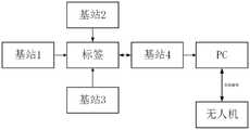
图1为本发明的设计演示示意图。FIG. 1 is a schematic diagram of a design demonstration of the present invention.
图2为基于UWB实现的无人机自主降落系统的结构框图。Figure 2 is a structural block diagram of the UWB-based autonomous landing system for UAVs.
图中标记说明:Description of marks in the figure:
1、第一基站,2、第二基站,3、第三基站,4、第四基站,5、无人机,6、降落平台,7、UWB模块,8、PC端,9、无线数据传输模块。1. The first base station, 2, the second base station, 3, the third base station, 4, the fourth base station, 5, the drone, 6, the landing platform, 7, the UWB module, 8, the PC terminal, 9, the wireless data transmission module.
具体实施方式Detailed ways
下面结合附图和具体实施例对本发明进行详细说明。The present invention will be described in detail below with reference to the accompanying drawings and specific embodiments.
实施例Example
随着无线定位技术和无线通信技术的发展,超宽带(ultra wide band,UWB)进入人们视野,实现简单,其成为解决复杂环境中定位问题的重要方案之一,UWB技术在用于无人机导航时,主要用于室内定点定位,误差可达厘米级,本发明给出了UWB技术在室外固定的或者移动降落应用中用于无人机导航的方法,解决现有GPS导航和视觉导航下自主降落定位精度差、安全性低的问题,同时提高了抗干扰性能。With the development of wireless positioning technology and wireless communication technology, ultra wide band (UWB) has entered people's field of vision and is easy to implement. It has become one of the important solutions to solve positioning problems in complex environments. UWB technology is used in drones. When navigating, it is mainly used for indoor fixed-point positioning, and the error can reach the centimeter level. The problems of poor positioning accuracy and low safety of autonomous landing, while improving the anti-interference performance.
本发明的具体内容如下:The specific content of the present invention is as follows:
首先,在静止或移动降落平台上规划目标降落区域,在该区域内规定一点为原点,建立空间直角坐标系。第一基站、第二基站、第三基站分别位于三个坐标轴的正方向上,记坐标为(a,0,0)、(0,b,0)、(0,0,c),第四基站位于原点,与PC端连接,能够把其余三个基站测得的位置信息汇总到该基站中,发送到PC端解算。First, plan the target landing area on the stationary or mobile landing platform, specify a point in this area as the origin, and establish a space Cartesian coordinate system. The first base station, the second base station, and the third base station are respectively located in the positive directions of the three coordinate axes, and the coordinates are denoted as (a, 0, 0), (0, b, 0), (0, 0, c), and the fourth The base station is located at the origin and is connected to the PC. The position information measured by the other three base stations can be summarized into the base station and sent to the PC for calculation.
其次,无人机上安装UWB模块和无线数传模块。UWB模块作为定位标签,其在空间直角坐标系下的坐标代表无人机的位置,记为(x,y,z)。无线数传模块用于将无人机相对目标降落点的距离发送给PC端,并且接收PC端的飞行控制指令。Secondly, the UWB module and wireless data transmission module are installed on the drone. The UWB module is used as a positioning label, and its coordinates in the space rectangular coordinate system represent the position of the UAV, denoted as (x, y, z). The wireless data transmission module is used to send the distance of the drone relative to the target landing point to the PC, and receive the flight control instructions from the PC.
再者,利用TOA算法测量标签到各个基站的距离Li,将距离信息汇总到第四基站,发送至PC端。标签发送信号和接收回应信号的时间间隔记为T1,第i个基站接收信号和发出回应信号的时间间隔为T2i,光速为c,标签到第i个基站间的距离为Furthermore, theTOA algorithm is used to measure the distance Li between the tag and each base station, and the distance information is aggregated to the fourth base station and sent to the PC. The time interval between the tag sending the signal and receiving the response signal is denoted as T1 , the time interval between the i-th base station receiving the signal and sending the response signal is T2i , the speed of light is c, and the distance between the tag and the i-th base station is

又因为also because


据此可以解算出一组标签的坐标(x0,y0,z0)。According to this, the coordinates (x0 , y0 , z0 ) of a set of labels can be solved.
UWB技术在用于室内定位时,由于环境固定,电磁干扰特征变化不大,对定位的额影响较小。在室外移动背景下使用UWB定位技术时,由于环境在不断变化,会伴有复杂的电磁干扰,从而导致测量出的距离值不理想,解算出的标签坐标不准确。针对这一问题,本发明使用高斯牛顿迭代法得到接近真实值的坐标。记When UWB technology is used for indoor positioning, due to the fixed environment, the electromagnetic interference characteristics do not change much, and the impact on positioning is small. When using UWB positioning technology in the background of outdoor mobile, due to the constantly changing environment, there will be complex electromagnetic interference, resulting in unsatisfactory measured distance values and inaccurate calculated tag coordinates. To solve this problem, the present invention uses the Gauss-Newton iteration method to obtain coordinates close to the true value. remember
α=(ai,bi,ci)α=(ai ,bi , c i)
β=(x,y,z)β=(x,y,z)
α代表基站坐标,β代表标签坐标,标签到基站距离为α represents the base station coordinates, β represents the label coordinates, and the distance from the label to the base station is

残差记为ri=Li-f(α,β)The residual is recorded as ri =Li -f(α,β)
残差平方和为The residual sum of squares is

为使S最小,求偏导数得To minimize S, find the partial derivative to get

k指迭代次数,Δβ指迭代矢量。k refers to the number of iterations, and Δβ refers to the iteration vector.
在βk处对f(α,β)泰勒展开,省略二阶以上的偏导数项,有Taylor expansion of f(α,β) at βk , omitting the partial derivative terms above the second order, we have

此时,残差可表示为At this point, the residual can be expressed as
ri=Li-f(α,β)=Li-f(α,βk)+f(α,βk)-f(α,β)ri =Li -f(α,β)=Li -f(α,βk )+f(α,βk )-f(α,β)
即which is

令
JTJΔβ=JT(Li-f(α,βk))JT JΔβ=JT (Li -f(α,βk ))
故Therefore
βk+1=βk+(JTJ)-1JT(Li-f(α,βk)),βk+1 = βk +(JT J)-1 JT (Li -f(α,βk )),
以β0=(x0,y0,z0)为初始值,按上述方式迭代,当满足给定的误差率后,停止迭代,输出真实值。Taking β0 =(x0 , y0 , z0 ) as the initial value, the iteration is performed in the above-mentioned manner. When the given error rate is satisfied, the iteration is stopped and the real value is output.
最后,得到无人机在平台上的三维位置信息后,作为动态跟踪和降落算法的依据。PC端通过无线数据传输模块发送控制指令,引导无人机飞到目标降落区域的正上方,实现精准降落。Finally, after obtaining the three-dimensional position information of the UAV on the platform, it is used as the basis for the dynamic tracking and landing algorithm. The PC terminal sends control commands through the wireless data transmission module to guide the drone to fly directly above the target landing area to achieve precise landing.
实施例Example
本发明的基于UWB实现的无人机自主降落系统包含无人机子系统、UWB定位子系统、PC端处理子系统、无线数传模块。其中,无人机执行跟踪降落任务,UWB定位系统由STM32单片机作为控制器、DW1000作为无线收发芯片,用于无人机实时测距定位,PC端用于位置信息解算以及生成控制指令,无线数传用于传输无人机相对目标降落区域距离和PC端的飞行控制指令。该方法的执行过程包括以下8个具体实施步骤。The UWB-based autonomous landing system of the present invention includes an unmanned aerial vehicle subsystem, a UWB positioning subsystem, a PC terminal processing subsystem, and a wireless data transmission module. Among them, the UAV performs the tracking and landing task. The UWB positioning system uses the STM32 microcontroller as the controller and the DW1000 as the wireless transceiver chip for real-time ranging and positioning of the UAV. The PC terminal is used for position information calculation and generation of control commands. Wireless The data transmission is used to transmit the distance of the drone relative to the target landing area and the flight control instructions from the PC. The execution process of the method includes the following 8 specific implementation steps.
步骤1:在静止或移动降落平台6上规划目标降落区域,在该区域内规定一点为原点,建立空间直角坐标系,如图1所示;Step 1: Plan the target landing area on the stationary or
步骤2:安装UWB模块7于无人机5上,第四基站4安装在坐标系原点,与PC端8连接,第一基站1、第二基站2、第三基站3分别安装在三个坐标轴正方向上,测量3个基站到原点的距离a、b、c,则坐标为(a,0,0)、(0,b,0)、(0,0,c);Step 2: Install the UWB module 7 on the drone 5, the fourth base station 4 is installed at the origin of the coordinate system, and is connected to the
步骤3:利用TOA算法测量标签到各个基站的距离Li,标签发送信号和接收回应信号的时间间隔记为T1,第i个基站接收信号和发出回应信号的时间间隔为T2i,光速为c,根据Step 3: Use the TOA algorithm to measure the distance Li between the tag and each base station, the time interval between the tag sending and receiving the response signal is denoted as T1 , the time interval between thei -th base station receiving the signal and sending the response signal is T2i , and the speed of light is c, according to

这里有here has

将标签到各基站的距离差的信息汇总到第四基站4,发送至PC端:Summarize the information of the distance difference between the tag and each base station to the fourth base station 4 and send it to the PC:
步骤4:Step 4:


据此可以解算出一组标签的坐标(x0,y0,z0)。由于在使用超宽带定位技术时,室外有复杂的电磁干扰,会导致测量出的距离值不理想,解算出的标签坐标不准确。针对这一问题,以(x0,y0,z0)为初始值,使用高斯牛顿迭代法逼近,得到最接近真实值的标签坐标(x,y,z)。According to this, the coordinates (x0 , y0 , z0 ) of a set of labels can be solved. Due to the complex electromagnetic interference outdoors when using the ultra-wideband positioning technology, the measured distance value will be unsatisfactory, and the calculated tag coordinates will be inaccurate. To solve this problem, take (x0 , y0 , z0 ) as the initial value, use Gauss-Newton iterative method to approximate, and obtain the label coordinates (x, y, z) that are closest to the true value.
步骤5:根据标签的三维位置(x,y,z),PC端8通过无线数据传输模块9向无人机发送飞行控制指令,引导其飞向目标降落区域4的正上方,检测到达目标点后,实现降落。Step 5: According to the three-dimensional position (x, y, z) of the tag, the
以上显示和描述了本发明的基本原理和主要特征以及本发明的优点,本行业的技术人员应该了解,本发明不受上述实施例的限制,上述实施方式和说明书中描述的只是说明本发明的原理,在不脱离本发明精神和范围的前提下,本发明还会有各种变化和改进,这些变化和改进都落入要求保护的本发明范围内。本发明要求保护范围由所附的权利要求书及其等效物界定。The basic principles and main features of the present invention and the advantages of the present invention are shown and described above. Those skilled in the art should understand that the present invention is not limited by the above-mentioned embodiments, and the descriptions in the above-mentioned embodiments and descriptions are only for illustrating the present invention. In principle, without departing from the spirit and scope of the present invention, the present invention may have various changes and improvements, and these changes and improvements all fall within the scope of the claimed invention. The claimed scope of the present invention is defined by the appended claims and their equivalents.
Claims (10)
Translated fromChinese


Priority Applications (1)
| Application Number | Priority Date | Filing Date | Title |
|---|---|---|---|
| CN202010327852.7ACN111352444A (en) | 2020-04-23 | 2020-04-23 | Method and system for autonomous landing of UAV outdoor mobile platform based on wireless navigation |
Applications Claiming Priority (1)
| Application Number | Priority Date | Filing Date | Title |
|---|---|---|---|
| CN202010327852.7ACN111352444A (en) | 2020-04-23 | 2020-04-23 | Method and system for autonomous landing of UAV outdoor mobile platform based on wireless navigation |
Publications (1)
| Publication Number | Publication Date |
|---|---|
| CN111352444Atrue CN111352444A (en) | 2020-06-30 |
Family
ID=71193397
Family Applications (1)
| Application Number | Title | Priority Date | Filing Date |
|---|---|---|---|
| CN202010327852.7APendingCN111352444A (en) | 2020-04-23 | 2020-04-23 | Method and system for autonomous landing of UAV outdoor mobile platform based on wireless navigation |
Country Status (1)
| Country | Link |
|---|---|
| CN (1) | CN111352444A (en) |
Cited By (10)
| Publication number | Priority date | Publication date | Assignee | Title |
|---|---|---|---|---|
| CN112518757A (en)* | 2020-12-17 | 2021-03-19 | 湖南工程学院 | Robot control method, robot, and readable storage medium |
| CN112558633A (en)* | 2020-12-10 | 2021-03-26 | 广东电网有限责任公司 | Accurate landing method and system for unmanned aerial vehicle |
| CN112731500A (en)* | 2020-12-30 | 2021-04-30 | 西安电子科技大学 | Method for three-dimensional positioning of outdoor unmanned aerial vehicle and indoor unmanned aerial vehicle |
| CN113109852A (en)* | 2021-03-11 | 2021-07-13 | 国网江西省电力有限公司电力科学研究院 | Path planning method and device for unmanned aerial vehicle to enter narrow space |
| CN113674227A (en)* | 2021-08-02 | 2021-11-19 | 上海工程技术大学 | A method for detecting layer distance of grid assembly of ion thruster |
| CN113821043A (en)* | 2021-09-10 | 2021-12-21 | 佛山中科云图智能科技有限公司 | Unmanned aerial vehicle positioning landing method and device, storage medium and electronic equipment |
| CN115493535A (en)* | 2022-10-12 | 2022-12-20 | 云南电网有限责任公司红河供电局 | UWB positioning-based sag online monitoring method |
| CN116126013A (en)* | 2022-12-12 | 2023-05-16 | 国网安徽省电力有限公司超高压分公司 | A method, system and readable storage medium for UAV landing with high precision |
| CN120084340A (en)* | 2025-04-30 | 2025-06-03 | 山东师范大学 | Three-dimensional GPS navigation system |
| US12436543B2 (en) | 2022-06-08 | 2025-10-07 | Asylon, Inc. | Precision landing system |
Citations (15)
| Publication number | Priority date | Publication date | Assignee | Title |
|---|---|---|---|---|
| CN102981144A (en)* | 2012-11-21 | 2013-03-20 | 西安电子科技大学 | Method for three-dimensional passive positioning of targets by air moving platform |
| US20160342934A1 (en)* | 2015-05-22 | 2016-11-24 | Peter Michalik | System and process for communicating between a drone and a handheld device |
| CN106291462A (en)* | 2016-08-31 | 2017-01-04 | 合肥飞友网络科技有限公司 | A kind of method being accurately positioned aircraft position |
| CN107943081A (en)* | 2017-11-30 | 2018-04-20 | 成都科力夫科技有限公司 | Unmanned plane land automatically UWB guiding system |
| CN110132283A (en)* | 2019-05-28 | 2019-08-16 | 中国人民解放军火箭军工程大学 | A method and system for locating ground stationary targets by an unmanned aerial vehicle optoelectronic platform |
| CN110155350A (en)* | 2019-04-23 | 2019-08-23 | 西北大学 | A UAV landing device and its control method |
| CN110244770A (en)* | 2019-04-14 | 2019-09-17 | 西安烛龙智能科技有限公司 | A kind of accurate landing system of unmanned plane based on UWB positioning |
| CN110275548A (en)* | 2019-05-17 | 2019-09-24 | 中国人民解放军陆军工程大学 | Unmanned aerial vehicle relay node automatic positioning method oriented to regional communication coverage optimization |
| WO2019182521A1 (en)* | 2018-03-22 | 2019-09-26 | Infinium Robotics Pte Ltd | Autonomous taking off, positioning and landing of unmanned aerial vehicles (uav) on a mobile platform |
| CN110493742A (en)* | 2019-08-28 | 2019-11-22 | 哈尔滨工程大学 | A kind of indoor 3-D positioning method for ultra wide band |
| CN110569838A (en)* | 2019-04-25 | 2019-12-13 | 内蒙古工业大学 | A method for autonomous landing of quadrotor UAV based on vision positioning |
| CN110933630A (en)* | 2019-11-27 | 2020-03-27 | 云南电网有限责任公司电力科学研究院 | Indoor three-dimensional positioning method and device based on ultra-wideband communication |
| CN110989687A (en)* | 2019-11-08 | 2020-04-10 | 上海交通大学 | A UAV Landing Method Based on Nested Square Visual Information |
| CN110989673A (en)* | 2019-12-16 | 2020-04-10 | 西安因诺航空科技有限公司 | Autonomous tracking take-off and landing system of rotor unmanned aerial vehicle mobile platform and control method |
| CN110989682A (en)* | 2019-12-30 | 2020-04-10 | 福州大学 | Unmanned aerial vehicle accurate landing method based on single base station |
- 2020
- 2020-04-23CNCN202010327852.7Apatent/CN111352444A/enactivePending
Patent Citations (15)
| Publication number | Priority date | Publication date | Assignee | Title |
|---|---|---|---|---|
| CN102981144A (en)* | 2012-11-21 | 2013-03-20 | 西安电子科技大学 | Method for three-dimensional passive positioning of targets by air moving platform |
| US20160342934A1 (en)* | 2015-05-22 | 2016-11-24 | Peter Michalik | System and process for communicating between a drone and a handheld device |
| CN106291462A (en)* | 2016-08-31 | 2017-01-04 | 合肥飞友网络科技有限公司 | A kind of method being accurately positioned aircraft position |
| CN107943081A (en)* | 2017-11-30 | 2018-04-20 | 成都科力夫科技有限公司 | Unmanned plane land automatically UWB guiding system |
| WO2019182521A1 (en)* | 2018-03-22 | 2019-09-26 | Infinium Robotics Pte Ltd | Autonomous taking off, positioning and landing of unmanned aerial vehicles (uav) on a mobile platform |
| CN110244770A (en)* | 2019-04-14 | 2019-09-17 | 西安烛龙智能科技有限公司 | A kind of accurate landing system of unmanned plane based on UWB positioning |
| CN110155350A (en)* | 2019-04-23 | 2019-08-23 | 西北大学 | A UAV landing device and its control method |
| CN110569838A (en)* | 2019-04-25 | 2019-12-13 | 内蒙古工业大学 | A method for autonomous landing of quadrotor UAV based on vision positioning |
| CN110275548A (en)* | 2019-05-17 | 2019-09-24 | 中国人民解放军陆军工程大学 | Unmanned aerial vehicle relay node automatic positioning method oriented to regional communication coverage optimization |
| CN110132283A (en)* | 2019-05-28 | 2019-08-16 | 中国人民解放军火箭军工程大学 | A method and system for locating ground stationary targets by an unmanned aerial vehicle optoelectronic platform |
| CN110493742A (en)* | 2019-08-28 | 2019-11-22 | 哈尔滨工程大学 | A kind of indoor 3-D positioning method for ultra wide band |
| CN110989687A (en)* | 2019-11-08 | 2020-04-10 | 上海交通大学 | A UAV Landing Method Based on Nested Square Visual Information |
| CN110933630A (en)* | 2019-11-27 | 2020-03-27 | 云南电网有限责任公司电力科学研究院 | Indoor three-dimensional positioning method and device based on ultra-wideband communication |
| CN110989673A (en)* | 2019-12-16 | 2020-04-10 | 西安因诺航空科技有限公司 | Autonomous tracking take-off and landing system of rotor unmanned aerial vehicle mobile platform and control method |
| CN110989682A (en)* | 2019-12-30 | 2020-04-10 | 福州大学 | Unmanned aerial vehicle accurate landing method based on single base station |
Non-Patent Citations (3)
| Title |
|---|
| ZHIXIN WU: "Autonomous UAV Landing System Based on Visual Navigation", 《 2019 IEEE INTERNATIONAL CONFERENCE ON IMAGING SYSTEMS AND TECHNIQUES (IST)》* |
| 朱自强: "超宽带定位的关键技术研究", 《中国优秀硕士学位论文全文数据库(信息科技辑)》* |
| 韩鹏,等: "无人机视觉识别与移动追踪技术综述", 《飞航导弹》* |
Cited By (13)
| Publication number | Priority date | Publication date | Assignee | Title |
|---|---|---|---|---|
| CN112558633A (en)* | 2020-12-10 | 2021-03-26 | 广东电网有限责任公司 | Accurate landing method and system for unmanned aerial vehicle |
| CN112518757A (en)* | 2020-12-17 | 2021-03-19 | 湖南工程学院 | Robot control method, robot, and readable storage medium |
| CN112731500B (en)* | 2020-12-30 | 2023-06-30 | 西安电子科技大学 | Method for three-dimensional positioning of outdoor unmanned aerial vehicle and indoor unmanned aerial vehicle |
| CN112731500A (en)* | 2020-12-30 | 2021-04-30 | 西安电子科技大学 | Method for three-dimensional positioning of outdoor unmanned aerial vehicle and indoor unmanned aerial vehicle |
| CN113109852A (en)* | 2021-03-11 | 2021-07-13 | 国网江西省电力有限公司电力科学研究院 | Path planning method and device for unmanned aerial vehicle to enter narrow space |
| CN113109852B (en)* | 2021-03-11 | 2024-03-12 | 国网江西省电力有限公司电力科学研究院 | A path planning method and device for drones entering narrow spaces |
| CN113674227B (en)* | 2021-08-02 | 2023-08-08 | 上海工程技术大学 | Layer spacing detection method for ion thruster grid assembly |
| CN113674227A (en)* | 2021-08-02 | 2021-11-19 | 上海工程技术大学 | A method for detecting layer distance of grid assembly of ion thruster |
| CN113821043A (en)* | 2021-09-10 | 2021-12-21 | 佛山中科云图智能科技有限公司 | Unmanned aerial vehicle positioning landing method and device, storage medium and electronic equipment |
| US12436543B2 (en) | 2022-06-08 | 2025-10-07 | Asylon, Inc. | Precision landing system |
| CN115493535A (en)* | 2022-10-12 | 2022-12-20 | 云南电网有限责任公司红河供电局 | UWB positioning-based sag online monitoring method |
| CN116126013A (en)* | 2022-12-12 | 2023-05-16 | 国网安徽省电力有限公司超高压分公司 | A method, system and readable storage medium for UAV landing with high precision |
| CN120084340A (en)* | 2025-04-30 | 2025-06-03 | 山东师范大学 | Three-dimensional GPS navigation system |
Similar Documents
| Publication | Publication Date | Title |
|---|---|---|
| CN111352444A (en) | Method and system for autonomous landing of UAV outdoor mobile platform based on wireless navigation | |
| CN108303995B (en) | A substation inspection UAV flight safety system and its use method | |
| CN108646215A (en) | It is a kind of that method for rapidly positioning is followed based on ultra wide band automatically | |
| CN206709853U (en) | Drawing system is synchronously positioned and builds in a kind of multi-rotor unmanned aerial vehicle room | |
| CN113204015B (en) | Multi-unmanned aerial vehicle track planning method and system for distributed radar target simulation | |
| CN111751785B (en) | Vehicle visible light positioning method in tunnel environment | |
| CN106597369B (en) | A kind of control method of unmanned plane, control platform, control system | |
| CN108919297A (en) | A kind of unmanned plane indoor locating system and method | |
| CN107144281A (en) | Unmanned plane indoor locating system and localization method based on cooperative target and monocular vision | |
| CN102932739A (en) | Non line-of-sight propagation state identification and data reconfiguration method of ultra-wide bandwidth wireless positioning | |
| CN115858701A (en) | Unmanned aerial vehicle target searching method and system based on electromagnetic map | |
| CN112556695B (en) | Indoor positioning and three-dimensional modeling methods, systems, electronic devices and storage media | |
| Guan et al. | An improved LSE-EKF optimisation algorithm for UAV UWB positioning in complex indoor environments | |
| CN110309883A (en) | A method for autonomous positioning of UAV based on visual SLAM | |
| CN114580452A (en) | Olfactory algorithm-based method for remotely sensing RFID electronic interface | |
| CN112207844A (en) | Intelligent guiding robot based on ismart | |
| Bao et al. | High-Precision UAV Positioning Method Based on MLP Integrating UWB and IMU | |
| CN209063105U (en) | An indoor service robot system based on UWB positioning | |
| Li et al. | Research on relative positioning system of UAVs Swarm based on distributed UWB | |
| CN116299163A (en) | Unmanned aerial vehicle track planning method, unmanned aerial vehicle track planning device, unmanned aerial vehicle track planning equipment and unmanned aerial vehicle track planning medium | |
| Lin et al. | Design and test of a positioning system for a greenhouse electric micro-tiller based on ultra-wideband | |
| CN115563845A (en) | Adaptive particle filtering algorithm for ultra-wideband positioning of unmanned aerial vehicle | |
| CN116952240A (en) | Indoor drone positioning method, medium and drone based on weighted least squares method | |
| CN115238978A (en) | Intelligence library index car based on UWB | |
| CN115792797A (en) | A positioning method for dense forest environment based on mobile airborne UWB base station |
Legal Events
| Date | Code | Title | Description |
|---|---|---|---|
| PB01 | Publication | ||
| PB01 | Publication | ||
| SE01 | Entry into force of request for substantive examination | ||
| SE01 | Entry into force of request for substantive examination | ||
| RJ01 | Rejection of invention patent application after publication | Application publication date:20200630 | |
| RJ01 | Rejection of invention patent application after publication |