CN111351495A - Server systems, methods, and machine-readable media - Google Patents
Server systems, methods, and machine-readable mediaDownload PDFInfo
- Publication number
- CN111351495A CN111351495ACN202010056018.9ACN202010056018ACN111351495ACN 111351495 ACN111351495 ACN 111351495ACN 202010056018 ACN202010056018 ACN 202010056018ACN 111351495 ACN111351495 ACN 111351495A
- Authority
- CN
- China
- Prior art keywords
- vehicle
- road
- navigation
- image
- image capture
- Prior art date
- Legal status (The legal status is an assumption and is not a legal conclusion. Google has not performed a legal analysis and makes no representation as to the accuracy of the status listed.)
- Granted
Links
Images


Classifications
- G—PHYSICS
- G01—MEASURING; TESTING
- G01C—MEASURING DISTANCES, LEVELS OR BEARINGS; SURVEYING; NAVIGATION; GYROSCOPIC INSTRUMENTS; PHOTOGRAMMETRY OR VIDEOGRAMMETRY
- G01C21/00—Navigation; Navigational instruments not provided for in groups G01C1/00 - G01C19/00
- G01C21/38—Electronic maps specially adapted for navigation; Updating thereof
- G01C21/3804—Creation or updating of map data
- G01C21/3807—Creation or updating of map data characterised by the type of data
- G01C21/3815—Road data
- G01C21/3822—Road feature data, e.g. slope data
- G—PHYSICS
- G01—MEASURING; TESTING
- G01C—MEASURING DISTANCES, LEVELS OR BEARINGS; SURVEYING; NAVIGATION; GYROSCOPIC INSTRUMENTS; PHOTOGRAMMETRY OR VIDEOGRAMMETRY
- G01C21/00—Navigation; Navigational instruments not provided for in groups G01C1/00 - G01C19/00
- G01C21/38—Electronic maps specially adapted for navigation; Updating thereof
- G01C21/3804—Creation or updating of map data
- G01C21/3833—Creation or updating of map data characterised by the source of data
- G01C21/3837—Data obtained from a single source
- G—PHYSICS
- G06—COMPUTING OR CALCULATING; COUNTING
- G06F—ELECTRIC DIGITAL DATA PROCESSING
- G06F16/00—Information retrieval; Database structures therefor; File system structures therefor
- G06F16/20—Information retrieval; Database structures therefor; File system structures therefor of structured data, e.g. relational data
- G06F16/29—Geographical information databases
- B—PERFORMING OPERATIONS; TRANSPORTING
- B60—VEHICLES IN GENERAL
- B60W—CONJOINT CONTROL OF VEHICLE SUB-UNITS OF DIFFERENT TYPE OR DIFFERENT FUNCTION; CONTROL SYSTEMS SPECIALLY ADAPTED FOR HYBRID VEHICLES; ROAD VEHICLE DRIVE CONTROL SYSTEMS FOR PURPOSES NOT RELATED TO THE CONTROL OF A PARTICULAR SUB-UNIT
- B60W30/00—Purposes of road vehicle drive control systems not related to the control of a particular sub-unit, e.g. of systems using conjoint control of vehicle sub-units
- B60W30/10—Path keeping
- B—PERFORMING OPERATIONS; TRANSPORTING
- B60—VEHICLES IN GENERAL
- B60W—CONJOINT CONTROL OF VEHICLE SUB-UNITS OF DIFFERENT TYPE OR DIFFERENT FUNCTION; CONTROL SYSTEMS SPECIALLY ADAPTED FOR HYBRID VEHICLES; ROAD VEHICLE DRIVE CONTROL SYSTEMS FOR PURPOSES NOT RELATED TO THE CONTROL OF A PARTICULAR SUB-UNIT
- B60W30/00—Purposes of road vehicle drive control systems not related to the control of a particular sub-unit, e.g. of systems using conjoint control of vehicle sub-units
- B60W30/14—Adaptive cruise control
- B—PERFORMING OPERATIONS; TRANSPORTING
- B60—VEHICLES IN GENERAL
- B60W—CONJOINT CONTROL OF VEHICLE SUB-UNITS OF DIFFERENT TYPE OR DIFFERENT FUNCTION; CONTROL SYSTEMS SPECIALLY ADAPTED FOR HYBRID VEHICLES; ROAD VEHICLE DRIVE CONTROL SYSTEMS FOR PURPOSES NOT RELATED TO THE CONTROL OF A PARTICULAR SUB-UNIT
- B60W30/00—Purposes of road vehicle drive control systems not related to the control of a particular sub-unit, e.g. of systems using conjoint control of vehicle sub-units
- B60W30/18—Propelling the vehicle
- B—PERFORMING OPERATIONS; TRANSPORTING
- B60—VEHICLES IN GENERAL
- B60W—CONJOINT CONTROL OF VEHICLE SUB-UNITS OF DIFFERENT TYPE OR DIFFERENT FUNCTION; CONTROL SYSTEMS SPECIALLY ADAPTED FOR HYBRID VEHICLES; ROAD VEHICLE DRIVE CONTROL SYSTEMS FOR PURPOSES NOT RELATED TO THE CONTROL OF A PARTICULAR SUB-UNIT
- B60W40/00—Estimation or calculation of non-directly measurable driving parameters for road vehicle drive control systems not related to the control of a particular sub unit, e.g. by using mathematical models
- B60W40/02—Estimation or calculation of non-directly measurable driving parameters for road vehicle drive control systems not related to the control of a particular sub unit, e.g. by using mathematical models related to ambient conditions
- B60W40/06—Road conditions
- B—PERFORMING OPERATIONS; TRANSPORTING
- B60—VEHICLES IN GENERAL
- B60W—CONJOINT CONTROL OF VEHICLE SUB-UNITS OF DIFFERENT TYPE OR DIFFERENT FUNCTION; CONTROL SYSTEMS SPECIALLY ADAPTED FOR HYBRID VEHICLES; ROAD VEHICLE DRIVE CONTROL SYSTEMS FOR PURPOSES NOT RELATED TO THE CONTROL OF A PARTICULAR SUB-UNIT
- B60W60/00—Drive control systems specially adapted for autonomous road vehicles
- B60W60/001—Planning or execution of driving tasks
- B60W60/0015—Planning or execution of driving tasks specially adapted for safety
- B—PERFORMING OPERATIONS; TRANSPORTING
- B60—VEHICLES IN GENERAL
- B60W—CONJOINT CONTROL OF VEHICLE SUB-UNITS OF DIFFERENT TYPE OR DIFFERENT FUNCTION; CONTROL SYSTEMS SPECIALLY ADAPTED FOR HYBRID VEHICLES; ROAD VEHICLE DRIVE CONTROL SYSTEMS FOR PURPOSES NOT RELATED TO THE CONTROL OF A PARTICULAR SUB-UNIT
- B60W60/00—Drive control systems specially adapted for autonomous road vehicles
- B60W60/001—Planning or execution of driving tasks
- B60W60/0027—Planning or execution of driving tasks using trajectory prediction for other traffic participants
- B60W60/00274—Planning or execution of driving tasks using trajectory prediction for other traffic participants considering possible movement changes
- B—PERFORMING OPERATIONS; TRANSPORTING
- B62—LAND VEHICLES FOR TRAVELLING OTHERWISE THAN ON RAILS
- B62D—MOTOR VEHICLES; TRAILERS
- B62D15/00—Steering not otherwise provided for
- B62D15/02—Steering position indicators ; Steering position determination; Steering aids
- B62D15/025—Active steering aids, e.g. helping the driver by actively influencing the steering system after environment evaluation
- G—PHYSICS
- G01—MEASURING; TESTING
- G01C—MEASURING DISTANCES, LEVELS OR BEARINGS; SURVEYING; NAVIGATION; GYROSCOPIC INSTRUMENTS; PHOTOGRAMMETRY OR VIDEOGRAMMETRY
- G01C21/00—Navigation; Navigational instruments not provided for in groups G01C1/00 - G01C19/00
- G01C21/10—Navigation; Navigational instruments not provided for in groups G01C1/00 - G01C19/00 by using measurements of speed or acceleration
- G01C21/12—Navigation; Navigational instruments not provided for in groups G01C1/00 - G01C19/00 by using measurements of speed or acceleration executed aboard the object being navigated; Dead reckoning
- G01C21/14—Navigation; Navigational instruments not provided for in groups G01C1/00 - G01C19/00 by using measurements of speed or acceleration executed aboard the object being navigated; Dead reckoning by recording the course traversed by the object
- G—PHYSICS
- G01—MEASURING; TESTING
- G01C—MEASURING DISTANCES, LEVELS OR BEARINGS; SURVEYING; NAVIGATION; GYROSCOPIC INSTRUMENTS; PHOTOGRAMMETRY OR VIDEOGRAMMETRY
- G01C21/00—Navigation; Navigational instruments not provided for in groups G01C1/00 - G01C19/00
- G01C21/10—Navigation; Navigational instruments not provided for in groups G01C1/00 - G01C19/00 by using measurements of speed or acceleration
- G01C21/12—Navigation; Navigational instruments not provided for in groups G01C1/00 - G01C19/00 by using measurements of speed or acceleration executed aboard the object being navigated; Dead reckoning
- G01C21/16—Navigation; Navigational instruments not provided for in groups G01C1/00 - G01C19/00 by using measurements of speed or acceleration executed aboard the object being navigated; Dead reckoning by integrating acceleration or speed, i.e. inertial navigation
- G01C21/165—Navigation; Navigational instruments not provided for in groups G01C1/00 - G01C19/00 by using measurements of speed or acceleration executed aboard the object being navigated; Dead reckoning by integrating acceleration or speed, i.e. inertial navigation combined with non-inertial navigation instruments
- G01C21/1652—Navigation; Navigational instruments not provided for in groups G01C1/00 - G01C19/00 by using measurements of speed or acceleration executed aboard the object being navigated; Dead reckoning by integrating acceleration or speed, i.e. inertial navigation combined with non-inertial navigation instruments with ranging devices, e.g. LIDAR or RADAR
- G—PHYSICS
- G01—MEASURING; TESTING
- G01C—MEASURING DISTANCES, LEVELS OR BEARINGS; SURVEYING; NAVIGATION; GYROSCOPIC INSTRUMENTS; PHOTOGRAMMETRY OR VIDEOGRAMMETRY
- G01C21/00—Navigation; Navigational instruments not provided for in groups G01C1/00 - G01C19/00
- G01C21/10—Navigation; Navigational instruments not provided for in groups G01C1/00 - G01C19/00 by using measurements of speed or acceleration
- G01C21/12—Navigation; Navigational instruments not provided for in groups G01C1/00 - G01C19/00 by using measurements of speed or acceleration executed aboard the object being navigated; Dead reckoning
- G01C21/16—Navigation; Navigational instruments not provided for in groups G01C1/00 - G01C19/00 by using measurements of speed or acceleration executed aboard the object being navigated; Dead reckoning by integrating acceleration or speed, i.e. inertial navigation
- G01C21/165—Navigation; Navigational instruments not provided for in groups G01C1/00 - G01C19/00 by using measurements of speed or acceleration executed aboard the object being navigated; Dead reckoning by integrating acceleration or speed, i.e. inertial navigation combined with non-inertial navigation instruments
- G01C21/1656—Navigation; Navigational instruments not provided for in groups G01C1/00 - G01C19/00 by using measurements of speed or acceleration executed aboard the object being navigated; Dead reckoning by integrating acceleration or speed, i.e. inertial navigation combined with non-inertial navigation instruments with passive imaging devices, e.g. cameras
- G—PHYSICS
- G01—MEASURING; TESTING
- G01C—MEASURING DISTANCES, LEVELS OR BEARINGS; SURVEYING; NAVIGATION; GYROSCOPIC INSTRUMENTS; PHOTOGRAMMETRY OR VIDEOGRAMMETRY
- G01C21/00—Navigation; Navigational instruments not provided for in groups G01C1/00 - G01C19/00
- G01C21/20—Instruments for performing navigational calculations
- G—PHYSICS
- G01—MEASURING; TESTING
- G01C—MEASURING DISTANCES, LEVELS OR BEARINGS; SURVEYING; NAVIGATION; GYROSCOPIC INSTRUMENTS; PHOTOGRAMMETRY OR VIDEOGRAMMETRY
- G01C21/00—Navigation; Navigational instruments not provided for in groups G01C1/00 - G01C19/00
- G01C21/26—Navigation; Navigational instruments not provided for in groups G01C1/00 - G01C19/00 specially adapted for navigation in a road network
- G01C21/28—Navigation; Navigational instruments not provided for in groups G01C1/00 - G01C19/00 specially adapted for navigation in a road network with correlation of data from several navigational instruments
- G01C21/30—Map- or contour-matching
- G01C21/32—Structuring or formatting of map data
- G—PHYSICS
- G01—MEASURING; TESTING
- G01C—MEASURING DISTANCES, LEVELS OR BEARINGS; SURVEYING; NAVIGATION; GYROSCOPIC INSTRUMENTS; PHOTOGRAMMETRY OR VIDEOGRAMMETRY
- G01C21/00—Navigation; Navigational instruments not provided for in groups G01C1/00 - G01C19/00
- G01C21/26—Navigation; Navigational instruments not provided for in groups G01C1/00 - G01C19/00 specially adapted for navigation in a road network
- G01C21/34—Route searching; Route guidance
- G01C21/3407—Route searching; Route guidance specially adapted for specific applications
- G—PHYSICS
- G01—MEASURING; TESTING
- G01C—MEASURING DISTANCES, LEVELS OR BEARINGS; SURVEYING; NAVIGATION; GYROSCOPIC INSTRUMENTS; PHOTOGRAMMETRY OR VIDEOGRAMMETRY
- G01C21/00—Navigation; Navigational instruments not provided for in groups G01C1/00 - G01C19/00
- G01C21/26—Navigation; Navigational instruments not provided for in groups G01C1/00 - G01C19/00 specially adapted for navigation in a road network
- G01C21/34—Route searching; Route guidance
- G01C21/3446—Details of route searching algorithms, e.g. Dijkstra, A*, arc-flags or using precalculated routes
- G—PHYSICS
- G01—MEASURING; TESTING
- G01C—MEASURING DISTANCES, LEVELS OR BEARINGS; SURVEYING; NAVIGATION; GYROSCOPIC INSTRUMENTS; PHOTOGRAMMETRY OR VIDEOGRAMMETRY
- G01C21/00—Navigation; Navigational instruments not provided for in groups G01C1/00 - G01C19/00
- G01C21/26—Navigation; Navigational instruments not provided for in groups G01C1/00 - G01C19/00 specially adapted for navigation in a road network
- G01C21/34—Route searching; Route guidance
- G01C21/3453—Special cost functions, i.e. other than distance or default speed limit of road segments
- G01C21/3476—Special cost functions, i.e. other than distance or default speed limit of road segments using point of interest [POI] information, e.g. a route passing visible POIs
- G—PHYSICS
- G01—MEASURING; TESTING
- G01C—MEASURING DISTANCES, LEVELS OR BEARINGS; SURVEYING; NAVIGATION; GYROSCOPIC INSTRUMENTS; PHOTOGRAMMETRY OR VIDEOGRAMMETRY
- G01C21/00—Navigation; Navigational instruments not provided for in groups G01C1/00 - G01C19/00
- G01C21/26—Navigation; Navigational instruments not provided for in groups G01C1/00 - G01C19/00 specially adapted for navigation in a road network
- G01C21/34—Route searching; Route guidance
- G01C21/36—Input/output arrangements for on-board computers
- G01C21/3602—Input other than that of destination using image analysis, e.g. detection of road signs, lanes, buildings, real preceding vehicles using a camera
- G—PHYSICS
- G01—MEASURING; TESTING
- G01C—MEASURING DISTANCES, LEVELS OR BEARINGS; SURVEYING; NAVIGATION; GYROSCOPIC INSTRUMENTS; PHOTOGRAMMETRY OR VIDEOGRAMMETRY
- G01C21/00—Navigation; Navigational instruments not provided for in groups G01C1/00 - G01C19/00
- G01C21/26—Navigation; Navigational instruments not provided for in groups G01C1/00 - G01C19/00 specially adapted for navigation in a road network
- G01C21/34—Route searching; Route guidance
- G01C21/36—Input/output arrangements for on-board computers
- G01C21/3605—Destination input or retrieval
- G01C21/3623—Destination input or retrieval using a camera or code reader, e.g. for optical or magnetic codes
- G—PHYSICS
- G01—MEASURING; TESTING
- G01C—MEASURING DISTANCES, LEVELS OR BEARINGS; SURVEYING; NAVIGATION; GYROSCOPIC INSTRUMENTS; PHOTOGRAMMETRY OR VIDEOGRAMMETRY
- G01C21/00—Navigation; Navigational instruments not provided for in groups G01C1/00 - G01C19/00
- G01C21/26—Navigation; Navigational instruments not provided for in groups G01C1/00 - G01C19/00 specially adapted for navigation in a road network
- G01C21/34—Route searching; Route guidance
- G01C21/36—Input/output arrangements for on-board computers
- G01C21/3626—Details of the output of route guidance instructions
- G01C21/3644—Landmark guidance, e.g. using POIs or conspicuous other objects
- G—PHYSICS
- G01—MEASURING; TESTING
- G01C—MEASURING DISTANCES, LEVELS OR BEARINGS; SURVEYING; NAVIGATION; GYROSCOPIC INSTRUMENTS; PHOTOGRAMMETRY OR VIDEOGRAMMETRY
- G01C21/00—Navigation; Navigational instruments not provided for in groups G01C1/00 - G01C19/00
- G01C21/26—Navigation; Navigational instruments not provided for in groups G01C1/00 - G01C19/00 specially adapted for navigation in a road network
- G01C21/34—Route searching; Route guidance
- G01C21/36—Input/output arrangements for on-board computers
- G01C21/3626—Details of the output of route guidance instructions
- G01C21/3658—Lane guidance
- G—PHYSICS
- G01—MEASURING; TESTING
- G01C—MEASURING DISTANCES, LEVELS OR BEARINGS; SURVEYING; NAVIGATION; GYROSCOPIC INSTRUMENTS; PHOTOGRAMMETRY OR VIDEOGRAMMETRY
- G01C21/00—Navigation; Navigational instruments not provided for in groups G01C1/00 - G01C19/00
- G01C21/26—Navigation; Navigational instruments not provided for in groups G01C1/00 - G01C19/00 specially adapted for navigation in a road network
- G01C21/34—Route searching; Route guidance
- G01C21/36—Input/output arrangements for on-board computers
- G01C21/3691—Retrieval, searching and output of information related to real-time traffic, weather, or environmental conditions
- G—PHYSICS
- G01—MEASURING; TESTING
- G01C—MEASURING DISTANCES, LEVELS OR BEARINGS; SURVEYING; NAVIGATION; GYROSCOPIC INSTRUMENTS; PHOTOGRAMMETRY OR VIDEOGRAMMETRY
- G01C21/00—Navigation; Navigational instruments not provided for in groups G01C1/00 - G01C19/00
- G01C21/38—Electronic maps specially adapted for navigation; Updating thereof
- G01C21/3804—Creation or updating of map data
- G01C21/3833—Creation or updating of map data characterised by the source of data
- G01C21/3841—Data obtained from two or more sources, e.g. probe vehicles
- G—PHYSICS
- G01—MEASURING; TESTING
- G01C—MEASURING DISTANCES, LEVELS OR BEARINGS; SURVEYING; NAVIGATION; GYROSCOPIC INSTRUMENTS; PHOTOGRAMMETRY OR VIDEOGRAMMETRY
- G01C21/00—Navigation; Navigational instruments not provided for in groups G01C1/00 - G01C19/00
- G01C21/38—Electronic maps specially adapted for navigation; Updating thereof
- G01C21/3885—Transmission of map data to client devices; Reception of map data by client devices
- G01C21/3896—Transmission of map data from central databases
- G—PHYSICS
- G01—MEASURING; TESTING
- G01S—RADIO DIRECTION-FINDING; RADIO NAVIGATION; DETERMINING DISTANCE OR VELOCITY BY USE OF RADIO WAVES; LOCATING OR PRESENCE-DETECTING BY USE OF THE REFLECTION OR RERADIATION OF RADIO WAVES; ANALOGOUS ARRANGEMENTS USING OTHER WAVES
- G01S19/00—Satellite radio beacon positioning systems; Determining position, velocity or attitude using signals transmitted by such systems
- G01S19/01—Satellite radio beacon positioning systems transmitting time-stamped messages, e.g. GPS [Global Positioning System], GLONASS [Global Orbiting Navigation Satellite System] or GALILEO
- G01S19/03—Cooperating elements; Interaction or communication between different cooperating elements or between cooperating elements and receivers
- G01S19/10—Cooperating elements; Interaction or communication between different cooperating elements or between cooperating elements and receivers providing dedicated supplementary positioning signals
- G—PHYSICS
- G01—MEASURING; TESTING
- G01S—RADIO DIRECTION-FINDING; RADIO NAVIGATION; DETERMINING DISTANCE OR VELOCITY BY USE OF RADIO WAVES; LOCATING OR PRESENCE-DETECTING BY USE OF THE REFLECTION OR RERADIATION OF RADIO WAVES; ANALOGOUS ARRANGEMENTS USING OTHER WAVES
- G01S5/00—Position-fixing by co-ordinating two or more direction or position line determinations; Position-fixing by co-ordinating two or more distance determinations
- G01S5/0009—Transmission of position information to remote stations
- G01S5/0018—Transmission from mobile station to base station
- G01S5/0027—Transmission from mobile station to base station of actual mobile position, i.e. position determined on mobile
- G—PHYSICS
- G01—MEASURING; TESTING
- G01S—RADIO DIRECTION-FINDING; RADIO NAVIGATION; DETERMINING DISTANCE OR VELOCITY BY USE OF RADIO WAVES; LOCATING OR PRESENCE-DETECTING BY USE OF THE REFLECTION OR RERADIATION OF RADIO WAVES; ANALOGOUS ARRANGEMENTS USING OTHER WAVES
- G01S5/00—Position-fixing by co-ordinating two or more direction or position line determinations; Position-fixing by co-ordinating two or more distance determinations
- G01S5/16—Position-fixing by co-ordinating two or more direction or position line determinations; Position-fixing by co-ordinating two or more distance determinations using electromagnetic waves other than radio waves
- G—PHYSICS
- G05—CONTROLLING; REGULATING
- G05D—SYSTEMS FOR CONTROLLING OR REGULATING NON-ELECTRIC VARIABLES
- G05D1/00—Control of position, course, altitude or attitude of land, water, air or space vehicles, e.g. using automatic pilots
- G05D1/0088—Control of position, course, altitude or attitude of land, water, air or space vehicles, e.g. using automatic pilots characterized by the autonomous decision making process, e.g. artificial intelligence, predefined behaviours
- G—PHYSICS
- G05—CONTROLLING; REGULATING
- G05D—SYSTEMS FOR CONTROLLING OR REGULATING NON-ELECTRIC VARIABLES
- G05D1/00—Control of position, course, altitude or attitude of land, water, air or space vehicles, e.g. using automatic pilots
- G05D1/02—Control of position or course in two dimensions
- G05D1/021—Control of position or course in two dimensions specially adapted to land vehicles
- G05D1/0212—Control of position or course in two dimensions specially adapted to land vehicles with means for defining a desired trajectory
- G05D1/0219—Control of position or course in two dimensions specially adapted to land vehicles with means for defining a desired trajectory ensuring the processing of the whole working surface
- G—PHYSICS
- G05—CONTROLLING; REGULATING
- G05D—SYSTEMS FOR CONTROLLING OR REGULATING NON-ELECTRIC VARIABLES
- G05D1/00—Control of position, course, altitude or attitude of land, water, air or space vehicles, e.g. using automatic pilots
- G05D1/02—Control of position or course in two dimensions
- G05D1/021—Control of position or course in two dimensions specially adapted to land vehicles
- G05D1/0212—Control of position or course in two dimensions specially adapted to land vehicles with means for defining a desired trajectory
- G05D1/0221—Control of position or course in two dimensions specially adapted to land vehicles with means for defining a desired trajectory involving a learning process
- G—PHYSICS
- G05—CONTROLLING; REGULATING
- G05D—SYSTEMS FOR CONTROLLING OR REGULATING NON-ELECTRIC VARIABLES
- G05D1/00—Control of position, course, altitude or attitude of land, water, air or space vehicles, e.g. using automatic pilots
- G05D1/02—Control of position or course in two dimensions
- G05D1/021—Control of position or course in two dimensions specially adapted to land vehicles
- G05D1/0231—Control of position or course in two dimensions specially adapted to land vehicles using optical position detecting means
- G05D1/0246—Control of position or course in two dimensions specially adapted to land vehicles using optical position detecting means using a video camera in combination with image processing means
- G05D1/0251—Control of position or course in two dimensions specially adapted to land vehicles using optical position detecting means using a video camera in combination with image processing means extracting 3D information from a plurality of images taken from different locations, e.g. stereo vision
- G—PHYSICS
- G05—CONTROLLING; REGULATING
- G05D—SYSTEMS FOR CONTROLLING OR REGULATING NON-ELECTRIC VARIABLES
- G05D1/00—Control of position, course, altitude or attitude of land, water, air or space vehicles, e.g. using automatic pilots
- G05D1/02—Control of position or course in two dimensions
- G05D1/021—Control of position or course in two dimensions specially adapted to land vehicles
- G05D1/0231—Control of position or course in two dimensions specially adapted to land vehicles using optical position detecting means
- G05D1/0246—Control of position or course in two dimensions specially adapted to land vehicles using optical position detecting means using a video camera in combination with image processing means
- G05D1/0253—Control of position or course in two dimensions specially adapted to land vehicles using optical position detecting means using a video camera in combination with image processing means extracting relative motion information from a plurality of images taken successively, e.g. visual odometry, optical flow
- G—PHYSICS
- G05—CONTROLLING; REGULATING
- G05D—SYSTEMS FOR CONTROLLING OR REGULATING NON-ELECTRIC VARIABLES
- G05D1/00—Control of position, course, altitude or attitude of land, water, air or space vehicles, e.g. using automatic pilots
- G05D1/02—Control of position or course in two dimensions
- G05D1/021—Control of position or course in two dimensions specially adapted to land vehicles
- G05D1/0276—Control of position or course in two dimensions specially adapted to land vehicles using signals provided by a source external to the vehicle
- G05D1/0278—Control of position or course in two dimensions specially adapted to land vehicles using signals provided by a source external to the vehicle using satellite positioning signals, e.g. GPS
- G—PHYSICS
- G05—CONTROLLING; REGULATING
- G05D—SYSTEMS FOR CONTROLLING OR REGULATING NON-ELECTRIC VARIABLES
- G05D1/00—Control of position, course, altitude or attitude of land, water, air or space vehicles, e.g. using automatic pilots
- G05D1/02—Control of position or course in two dimensions
- G05D1/021—Control of position or course in two dimensions specially adapted to land vehicles
- G05D1/0287—Control of position or course in two dimensions specially adapted to land vehicles involving a plurality of land vehicles, e.g. fleet or convoy travelling
- G—PHYSICS
- G05—CONTROLLING; REGULATING
- G05D—SYSTEMS FOR CONTROLLING OR REGULATING NON-ELECTRIC VARIABLES
- G05D1/00—Control of position, course, altitude or attitude of land, water, air or space vehicles, e.g. using automatic pilots
- G05D1/20—Control system inputs
- G05D1/24—Arrangements for determining position or orientation
- G05D1/247—Arrangements for determining position or orientation using signals provided by artificial sources external to the vehicle, e.g. navigation beacons
- G05D1/248—Arrangements for determining position or orientation using signals provided by artificial sources external to the vehicle, e.g. navigation beacons generated by satellites, e.g. GPS
- G—PHYSICS
- G05—CONTROLLING; REGULATING
- G05D—SYSTEMS FOR CONTROLLING OR REGULATING NON-ELECTRIC VARIABLES
- G05D1/00—Control of position, course, altitude or attitude of land, water, air or space vehicles, e.g. using automatic pilots
- G05D1/40—Control within particular dimensions
- G05D1/43—Control of position or course in two dimensions
- G—PHYSICS
- G05—CONTROLLING; REGULATING
- G05D—SYSTEMS FOR CONTROLLING OR REGULATING NON-ELECTRIC VARIABLES
- G05D1/00—Control of position, course, altitude or attitude of land, water, air or space vehicles, e.g. using automatic pilots
- G05D1/60—Intended control result
- G05D1/69—Coordinated control of the position or course of two or more vehicles
- G05D1/692—Coordinated control of the position or course of two or more vehicles involving a plurality of disparate vehicles
- G—PHYSICS
- G06—COMPUTING OR CALCULATING; COUNTING
- G06F—ELECTRIC DIGITAL DATA PROCESSING
- G06F16/00—Information retrieval; Database structures therefor; File system structures therefor
- G06F16/20—Information retrieval; Database structures therefor; File system structures therefor of structured data, e.g. relational data
- G06F16/23—Updating
- G06F16/2379—Updates performed during online database operations; commit processing
- G—PHYSICS
- G06—COMPUTING OR CALCULATING; COUNTING
- G06T—IMAGE DATA PROCESSING OR GENERATION, IN GENERAL
- G06T7/00—Image analysis
- G—PHYSICS
- G06—COMPUTING OR CALCULATING; COUNTING
- G06V—IMAGE OR VIDEO RECOGNITION OR UNDERSTANDING
- G06V20/00—Scenes; Scene-specific elements
- G06V20/50—Context or environment of the image
- G06V20/56—Context or environment of the image exterior to a vehicle by using sensors mounted on the vehicle
- G06V20/58—Recognition of moving objects or obstacles, e.g. vehicles or pedestrians; Recognition of traffic objects, e.g. traffic signs, traffic lights or roads
- G06V20/582—Recognition of moving objects or obstacles, e.g. vehicles or pedestrians; Recognition of traffic objects, e.g. traffic signs, traffic lights or roads of traffic signs
- G—PHYSICS
- G06—COMPUTING OR CALCULATING; COUNTING
- G06V—IMAGE OR VIDEO RECOGNITION OR UNDERSTANDING
- G06V20/00—Scenes; Scene-specific elements
- G06V20/50—Context or environment of the image
- G06V20/56—Context or environment of the image exterior to a vehicle by using sensors mounted on the vehicle
- G06V20/58—Recognition of moving objects or obstacles, e.g. vehicles or pedestrians; Recognition of traffic objects, e.g. traffic signs, traffic lights or roads
- G06V20/584—Recognition of moving objects or obstacles, e.g. vehicles or pedestrians; Recognition of traffic objects, e.g. traffic signs, traffic lights or roads of vehicle lights or traffic lights
- G—PHYSICS
- G06—COMPUTING OR CALCULATING; COUNTING
- G06V—IMAGE OR VIDEO RECOGNITION OR UNDERSTANDING
- G06V20/00—Scenes; Scene-specific elements
- G06V20/50—Context or environment of the image
- G06V20/56—Context or environment of the image exterior to a vehicle by using sensors mounted on the vehicle
- G06V20/588—Recognition of the road, e.g. of lane markings; Recognition of the vehicle driving pattern in relation to the road
- G—PHYSICS
- G06—COMPUTING OR CALCULATING; COUNTING
- G06V—IMAGE OR VIDEO RECOGNITION OR UNDERSTANDING
- G06V20/00—Scenes; Scene-specific elements
- G06V20/60—Type of objects
- G06V20/62—Text, e.g. of license plates, overlay texts or captions on TV images
- G06V20/63—Scene text, e.g. street names
- G—PHYSICS
- G06—COMPUTING OR CALCULATING; COUNTING
- G06V—IMAGE OR VIDEO RECOGNITION OR UNDERSTANDING
- G06V20/00—Scenes; Scene-specific elements
- G06V20/60—Type of objects
- G06V20/64—Three-dimensional objects
- G—PHYSICS
- G08—SIGNALLING
- G08G—TRAFFIC CONTROL SYSTEMS
- G08G1/00—Traffic control systems for road vehicles
- G08G1/01—Detecting movement of traffic to be counted or controlled
- G08G1/0104—Measuring and analyzing of parameters relative to traffic conditions
- G08G1/0108—Measuring and analyzing of parameters relative to traffic conditions based on the source of data
- G08G1/0112—Measuring and analyzing of parameters relative to traffic conditions based on the source of data from the vehicle, e.g. floating car data [FCD]
- G—PHYSICS
- G08—SIGNALLING
- G08G—TRAFFIC CONTROL SYSTEMS
- G08G1/00—Traffic control systems for road vehicles
- G08G1/01—Detecting movement of traffic to be counted or controlled
- G08G1/0104—Measuring and analyzing of parameters relative to traffic conditions
- G08G1/0125—Traffic data processing
- G08G1/0129—Traffic data processing for creating historical data or processing based on historical data
- G—PHYSICS
- G08—SIGNALLING
- G08G—TRAFFIC CONTROL SYSTEMS
- G08G1/00—Traffic control systems for road vehicles
- G08G1/01—Detecting movement of traffic to be counted or controlled
- G08G1/0104—Measuring and analyzing of parameters relative to traffic conditions
- G08G1/0137—Measuring and analyzing of parameters relative to traffic conditions for specific applications
- G08G1/0145—Measuring and analyzing of parameters relative to traffic conditions for specific applications for active traffic flow control
- G—PHYSICS
- G08—SIGNALLING
- G08G—TRAFFIC CONTROL SYSTEMS
- G08G1/00—Traffic control systems for road vehicles
- G08G1/09—Arrangements for giving variable traffic instructions
- G08G1/0962—Arrangements for giving variable traffic instructions having an indicator mounted inside the vehicle, e.g. giving voice messages
- G08G1/09623—Systems involving the acquisition of information from passive traffic signs by means mounted on the vehicle
- G—PHYSICS
- G08—SIGNALLING
- G08G—TRAFFIC CONTROL SYSTEMS
- G08G1/00—Traffic control systems for road vehicles
- G08G1/09—Arrangements for giving variable traffic instructions
- G08G1/0962—Arrangements for giving variable traffic instructions having an indicator mounted inside the vehicle, e.g. giving voice messages
- G08G1/0967—Systems involving transmission of highway information, e.g. weather, speed limits
- G08G1/096708—Systems involving transmission of highway information, e.g. weather, speed limits where the received information might be used to generate an automatic action on the vehicle control
- G08G1/096725—Systems involving transmission of highway information, e.g. weather, speed limits where the received information might be used to generate an automatic action on the vehicle control where the received information generates an automatic action on the vehicle control
- G—PHYSICS
- G08—SIGNALLING
- G08G—TRAFFIC CONTROL SYSTEMS
- G08G1/00—Traffic control systems for road vehicles
- G08G1/09—Arrangements for giving variable traffic instructions
- G08G1/0962—Arrangements for giving variable traffic instructions having an indicator mounted inside the vehicle, e.g. giving voice messages
- G08G1/0968—Systems involving transmission of navigation instructions to the vehicle
- G08G1/096805—Systems involving transmission of navigation instructions to the vehicle where the transmitted instructions are used to compute a route
- G—PHYSICS
- G08—SIGNALLING
- G08G—TRAFFIC CONTROL SYSTEMS
- G08G1/00—Traffic control systems for road vehicles
- G08G1/16—Anti-collision systems
- G08G1/167—Driving aids for lane monitoring, lane changing, e.g. blind spot detection
- H—ELECTRICITY
- H04—ELECTRIC COMMUNICATION TECHNIQUE
- H04L—TRANSMISSION OF DIGITAL INFORMATION, e.g. TELEGRAPHIC COMMUNICATION
- H04L67/00—Network arrangements or protocols for supporting network services or applications
- H04L67/01—Protocols
- H04L67/12—Protocols specially adapted for proprietary or special-purpose networking environments, e.g. medical networks, sensor networks, networks in vehicles or remote metering networks
- H—ELECTRICITY
- H04—ELECTRIC COMMUNICATION TECHNIQUE
- H04W—WIRELESS COMMUNICATION NETWORKS
- H04W4/00—Services specially adapted for wireless communication networks; Facilities therefor
- H04W4/30—Services specially adapted for particular environments, situations or purposes
- H04W4/40—Services specially adapted for particular environments, situations or purposes for vehicles, e.g. vehicle-to-pedestrians [V2P]
- H04W4/44—Services specially adapted for particular environments, situations or purposes for vehicles, e.g. vehicle-to-pedestrians [V2P] for communication between vehicles and infrastructures, e.g. vehicle-to-cloud [V2C] or vehicle-to-home [V2H]
- B—PERFORMING OPERATIONS; TRANSPORTING
- B60—VEHICLES IN GENERAL
- B60W—CONJOINT CONTROL OF VEHICLE SUB-UNITS OF DIFFERENT TYPE OR DIFFERENT FUNCTION; CONTROL SYSTEMS SPECIALLY ADAPTED FOR HYBRID VEHICLES; ROAD VEHICLE DRIVE CONTROL SYSTEMS FOR PURPOSES NOT RELATED TO THE CONTROL OF A PARTICULAR SUB-UNIT
- B60W2420/00—Indexing codes relating to the type of sensors based on the principle of their operation
- B60W2420/40—Photo, light or radio wave sensitive means, e.g. infrared sensors
- B60W2420/403—Image sensing, e.g. optical camera
- B—PERFORMING OPERATIONS; TRANSPORTING
- B60—VEHICLES IN GENERAL
- B60W—CONJOINT CONTROL OF VEHICLE SUB-UNITS OF DIFFERENT TYPE OR DIFFERENT FUNCTION; CONTROL SYSTEMS SPECIALLY ADAPTED FOR HYBRID VEHICLES; ROAD VEHICLE DRIVE CONTROL SYSTEMS FOR PURPOSES NOT RELATED TO THE CONTROL OF A PARTICULAR SUB-UNIT
- B60W2420/00—Indexing codes relating to the type of sensors based on the principle of their operation
- B60W2420/40—Photo, light or radio wave sensitive means, e.g. infrared sensors
- B60W2420/408—Radar; Laser, e.g. lidar
- B—PERFORMING OPERATIONS; TRANSPORTING
- B60—VEHICLES IN GENERAL
- B60W—CONJOINT CONTROL OF VEHICLE SUB-UNITS OF DIFFERENT TYPE OR DIFFERENT FUNCTION; CONTROL SYSTEMS SPECIALLY ADAPTED FOR HYBRID VEHICLES; ROAD VEHICLE DRIVE CONTROL SYSTEMS FOR PURPOSES NOT RELATED TO THE CONTROL OF A PARTICULAR SUB-UNIT
- B60W2552/00—Input parameters relating to infrastructure
- B60W2552/30—Road curve radius
- B—PERFORMING OPERATIONS; TRANSPORTING
- B60—VEHICLES IN GENERAL
- B60W—CONJOINT CONTROL OF VEHICLE SUB-UNITS OF DIFFERENT TYPE OR DIFFERENT FUNCTION; CONTROL SYSTEMS SPECIALLY ADAPTED FOR HYBRID VEHICLES; ROAD VEHICLE DRIVE CONTROL SYSTEMS FOR PURPOSES NOT RELATED TO THE CONTROL OF A PARTICULAR SUB-UNIT
- B60W2552/00—Input parameters relating to infrastructure
- B60W2552/53—Road markings, e.g. lane marker or crosswalk
- B—PERFORMING OPERATIONS; TRANSPORTING
- B60—VEHICLES IN GENERAL
- B60W—CONJOINT CONTROL OF VEHICLE SUB-UNITS OF DIFFERENT TYPE OR DIFFERENT FUNCTION; CONTROL SYSTEMS SPECIALLY ADAPTED FOR HYBRID VEHICLES; ROAD VEHICLE DRIVE CONTROL SYSTEMS FOR PURPOSES NOT RELATED TO THE CONTROL OF A PARTICULAR SUB-UNIT
- B60W2554/00—Input parameters relating to objects
- B60W2554/20—Static objects
- B—PERFORMING OPERATIONS; TRANSPORTING
- B60—VEHICLES IN GENERAL
- B60W—CONJOINT CONTROL OF VEHICLE SUB-UNITS OF DIFFERENT TYPE OR DIFFERENT FUNCTION; CONTROL SYSTEMS SPECIALLY ADAPTED FOR HYBRID VEHICLES; ROAD VEHICLE DRIVE CONTROL SYSTEMS FOR PURPOSES NOT RELATED TO THE CONTROL OF A PARTICULAR SUB-UNIT
- B60W2554/00—Input parameters relating to objects
- B60W2554/40—Dynamic objects, e.g. animals, windblown objects
- B—PERFORMING OPERATIONS; TRANSPORTING
- B60—VEHICLES IN GENERAL
- B60W—CONJOINT CONTROL OF VEHICLE SUB-UNITS OF DIFFERENT TYPE OR DIFFERENT FUNCTION; CONTROL SYSTEMS SPECIALLY ADAPTED FOR HYBRID VEHICLES; ROAD VEHICLE DRIVE CONTROL SYSTEMS FOR PURPOSES NOT RELATED TO THE CONTROL OF A PARTICULAR SUB-UNIT
- B60W2554/00—Input parameters relating to objects
- B60W2554/60—Traversable objects, e.g. speed bumps or curbs
- B—PERFORMING OPERATIONS; TRANSPORTING
- B60—VEHICLES IN GENERAL
- B60W—CONJOINT CONTROL OF VEHICLE SUB-UNITS OF DIFFERENT TYPE OR DIFFERENT FUNCTION; CONTROL SYSTEMS SPECIALLY ADAPTED FOR HYBRID VEHICLES; ROAD VEHICLE DRIVE CONTROL SYSTEMS FOR PURPOSES NOT RELATED TO THE CONTROL OF A PARTICULAR SUB-UNIT
- B60W2555/00—Input parameters relating to exterior conditions, not covered by groups B60W2552/00, B60W2554/00
- B60W2555/60—Traffic rules, e.g. speed limits or right of way
- B—PERFORMING OPERATIONS; TRANSPORTING
- B60—VEHICLES IN GENERAL
- B60W—CONJOINT CONTROL OF VEHICLE SUB-UNITS OF DIFFERENT TYPE OR DIFFERENT FUNCTION; CONTROL SYSTEMS SPECIALLY ADAPTED FOR HYBRID VEHICLES; ROAD VEHICLE DRIVE CONTROL SYSTEMS FOR PURPOSES NOT RELATED TO THE CONTROL OF A PARTICULAR SUB-UNIT
- B60W2556/00—Input parameters relating to data
- B60W2556/35—Data fusion
- B—PERFORMING OPERATIONS; TRANSPORTING
- B60—VEHICLES IN GENERAL
- B60W—CONJOINT CONTROL OF VEHICLE SUB-UNITS OF DIFFERENT TYPE OR DIFFERENT FUNCTION; CONTROL SYSTEMS SPECIALLY ADAPTED FOR HYBRID VEHICLES; ROAD VEHICLE DRIVE CONTROL SYSTEMS FOR PURPOSES NOT RELATED TO THE CONTROL OF A PARTICULAR SUB-UNIT
- B60W2556/00—Input parameters relating to data
- B60W2556/40—High definition maps
- B—PERFORMING OPERATIONS; TRANSPORTING
- B60—VEHICLES IN GENERAL
- B60W—CONJOINT CONTROL OF VEHICLE SUB-UNITS OF DIFFERENT TYPE OR DIFFERENT FUNCTION; CONTROL SYSTEMS SPECIALLY ADAPTED FOR HYBRID VEHICLES; ROAD VEHICLE DRIVE CONTROL SYSTEMS FOR PURPOSES NOT RELATED TO THE CONTROL OF A PARTICULAR SUB-UNIT
- B60W2556/00—Input parameters relating to data
- B60W2556/45—External transmission of data to or from the vehicle
- B60W2556/50—External transmission of data to or from the vehicle of positioning data, e.g. GPS [Global Positioning System] data
- B—PERFORMING OPERATIONS; TRANSPORTING
- B60—VEHICLES IN GENERAL
- B60W—CONJOINT CONTROL OF VEHICLE SUB-UNITS OF DIFFERENT TYPE OR DIFFERENT FUNCTION; CONTROL SYSTEMS SPECIALLY ADAPTED FOR HYBRID VEHICLES; ROAD VEHICLE DRIVE CONTROL SYSTEMS FOR PURPOSES NOT RELATED TO THE CONTROL OF A PARTICULAR SUB-UNIT
- B60W2710/00—Output or target parameters relating to a particular sub-units
- B60W2710/18—Braking system
- B—PERFORMING OPERATIONS; TRANSPORTING
- B60—VEHICLES IN GENERAL
- B60W—CONJOINT CONTROL OF VEHICLE SUB-UNITS OF DIFFERENT TYPE OR DIFFERENT FUNCTION; CONTROL SYSTEMS SPECIALLY ADAPTED FOR HYBRID VEHICLES; ROAD VEHICLE DRIVE CONTROL SYSTEMS FOR PURPOSES NOT RELATED TO THE CONTROL OF A PARTICULAR SUB-UNIT
- B60W2710/00—Output or target parameters relating to a particular sub-units
- B60W2710/20—Steering systems
- B—PERFORMING OPERATIONS; TRANSPORTING
- B60—VEHICLES IN GENERAL
- B60W—CONJOINT CONTROL OF VEHICLE SUB-UNITS OF DIFFERENT TYPE OR DIFFERENT FUNCTION; CONTROL SYSTEMS SPECIALLY ADAPTED FOR HYBRID VEHICLES; ROAD VEHICLE DRIVE CONTROL SYSTEMS FOR PURPOSES NOT RELATED TO THE CONTROL OF A PARTICULAR SUB-UNIT
- B60W2720/00—Output or target parameters relating to overall vehicle dynamics
- B60W2720/10—Longitudinal speed
- G—PHYSICS
- G01—MEASURING; TESTING
- G01C—MEASURING DISTANCES, LEVELS OR BEARINGS; SURVEYING; NAVIGATION; GYROSCOPIC INSTRUMENTS; PHOTOGRAMMETRY OR VIDEOGRAMMETRY
- G01C21/00—Navigation; Navigational instruments not provided for in groups G01C1/00 - G01C19/00
- G01C21/38—Electronic maps specially adapted for navigation; Updating thereof
- G01C21/3804—Creation or updating of map data
- G01C21/3807—Creation or updating of map data characterised by the type of data
- G01C21/3811—Point data, e.g. Point of Interest [POI]
- G—PHYSICS
- G01—MEASURING; TESTING
- G01C—MEASURING DISTANCES, LEVELS OR BEARINGS; SURVEYING; NAVIGATION; GYROSCOPIC INSTRUMENTS; PHOTOGRAMMETRY OR VIDEOGRAMMETRY
- G01C21/00—Navigation; Navigational instruments not provided for in groups G01C1/00 - G01C19/00
- G01C21/38—Electronic maps specially adapted for navigation; Updating thereof
- G01C21/3804—Creation or updating of map data
- G01C21/3807—Creation or updating of map data characterised by the type of data
- G01C21/3815—Road data
- G01C21/3819—Road shape data, e.g. outline of a route
- G—PHYSICS
- G01—MEASURING; TESTING
- G01S—RADIO DIRECTION-FINDING; RADIO NAVIGATION; DETERMINING DISTANCE OR VELOCITY BY USE OF RADIO WAVES; LOCATING OR PRESENCE-DETECTING BY USE OF THE REFLECTION OR RERADIATION OF RADIO WAVES; ANALOGOUS ARRANGEMENTS USING OTHER WAVES
- G01S13/00—Systems using the reflection or reradiation of radio waves, e.g. radar systems; Analogous systems using reflection or reradiation of waves whose nature or wavelength is irrelevant or unspecified
- G01S13/86—Combinations of radar systems with non-radar systems, e.g. sonar, direction finder
- G01S13/867—Combination of radar systems with cameras
- G—PHYSICS
- G01—MEASURING; TESTING
- G01S—RADIO DIRECTION-FINDING; RADIO NAVIGATION; DETERMINING DISTANCE OR VELOCITY BY USE OF RADIO WAVES; LOCATING OR PRESENCE-DETECTING BY USE OF THE REFLECTION OR RERADIATION OF RADIO WAVES; ANALOGOUS ARRANGEMENTS USING OTHER WAVES
- G01S13/00—Systems using the reflection or reradiation of radio waves, e.g. radar systems; Analogous systems using reflection or reradiation of waves whose nature or wavelength is irrelevant or unspecified
- G01S13/88—Radar or analogous systems specially adapted for specific applications
- G01S13/93—Radar or analogous systems specially adapted for specific applications for anti-collision purposes
- G01S13/931—Radar or analogous systems specially adapted for specific applications for anti-collision purposes of land vehicles
- G01S2013/9327—Sensor installation details
- G01S2013/93271—Sensor installation details in the front of the vehicles
- G—PHYSICS
- G05—CONTROLLING; REGULATING
- G05D—SYSTEMS FOR CONTROLLING OR REGULATING NON-ELECTRIC VARIABLES
- G05D2101/00—Details of software or hardware architectures used for the control of position
- G05D2101/10—Details of software or hardware architectures used for the control of position using artificial intelligence [AI] techniques
- G05D2101/15—Details of software or hardware architectures used for the control of position using artificial intelligence [AI] techniques using machine learning, e.g. neural networks
- G—PHYSICS
- G05—CONTROLLING; REGULATING
- G05D—SYSTEMS FOR CONTROLLING OR REGULATING NON-ELECTRIC VARIABLES
- G05D2111/00—Details of signals used for control of position, course, altitude or attitude of land, water, air or space vehicles
- G05D2111/10—Optical signals
- G—PHYSICS
- G06—COMPUTING OR CALCULATING; COUNTING
- G06T—IMAGE DATA PROCESSING OR GENERATION, IN GENERAL
- G06T2207/00—Indexing scheme for image analysis or image enhancement
- G06T2207/20—Special algorithmic details
- G06T2207/20081—Training; Learning
- G—PHYSICS
- G06—COMPUTING OR CALCULATING; COUNTING
- G06T—IMAGE DATA PROCESSING OR GENERATION, IN GENERAL
- G06T2207/00—Indexing scheme for image analysis or image enhancement
- G06T2207/30—Subject of image; Context of image processing
- G06T2207/30248—Vehicle exterior or interior
- G06T2207/30252—Vehicle exterior; Vicinity of vehicle
- G06T2207/30256—Lane; Road marking
- G—PHYSICS
- G06—COMPUTING OR CALCULATING; COUNTING
- G06T—IMAGE DATA PROCESSING OR GENERATION, IN GENERAL
- G06T2207/00—Indexing scheme for image analysis or image enhancement
- G06T2207/30—Subject of image; Context of image processing
- G06T2207/30248—Vehicle exterior or interior
- G06T2207/30252—Vehicle exterior; Vicinity of vehicle
- G06T2207/30261—Obstacle
- G—PHYSICS
- G08—SIGNALLING
- G08G—TRAFFIC CONTROL SYSTEMS
- G08G1/00—Traffic control systems for road vehicles
- G08G1/01—Detecting movement of traffic to be counted or controlled
- G08G1/0104—Measuring and analyzing of parameters relative to traffic conditions
- G08G1/0137—Measuring and analyzing of parameters relative to traffic conditions for specific applications
- G08G1/0141—Measuring and analyzing of parameters relative to traffic conditions for specific applications for traffic information dissemination
Landscapes
- Engineering & Computer Science (AREA)
- Remote Sensing (AREA)
- Radar, Positioning & Navigation (AREA)
- Physics & Mathematics (AREA)
- General Physics & Mathematics (AREA)
- Automation & Control Theory (AREA)
- Theoretical Computer Science (AREA)
- Multimedia (AREA)
- Mechanical Engineering (AREA)
- Transportation (AREA)
- Aviation & Aerospace Engineering (AREA)
- Databases & Information Systems (AREA)
- Computer Vision & Pattern Recognition (AREA)
- Chemical & Material Sciences (AREA)
- Life Sciences & Earth Sciences (AREA)
- Atmospheric Sciences (AREA)
- General Engineering & Computer Science (AREA)
- Data Mining & Analysis (AREA)
- Analytical Chemistry (AREA)
- Electromagnetism (AREA)
- Human Computer Interaction (AREA)
- Combustion & Propulsion (AREA)
- Environmental Sciences (AREA)
- Environmental & Geological Engineering (AREA)
- Ecology (AREA)
- Biodiversity & Conservation Biology (AREA)
- Computer Networks & Wireless Communication (AREA)
- Medical Informatics (AREA)
- Health & Medical Sciences (AREA)
- Signal Processing (AREA)
- Mathematical Physics (AREA)
- Game Theory and Decision Science (AREA)
- Evolutionary Computation (AREA)
- Artificial Intelligence (AREA)
- Business, Economics & Management (AREA)
- Computing Systems (AREA)
- General Health & Medical Sciences (AREA)
- Traffic Control Systems (AREA)
- Navigation (AREA)
- Control Of Driving Devices And Active Controlling Of Vehicle (AREA)
Abstract
Description
Translated fromChinese本申请是申请日为2016年2月10日、申请号为201680021179.6(国际 申请号为PCT/US2016/017411)、发明名称为“用于自主车辆导航的稀疏地图” 的发明专利申请的分案申请。This application is a divisional application for an invention patent application with an application date of February 10, 2016, an application number of 201680021179.6 (international application number is PCT/US2016/017411), and an invention title of "sparse map for autonomous vehicle navigation" .
相关申请的交叉引用CROSS-REFERENCE TO RELATED APPLICATIONS
本申请要求以下各项的优先权权益:2015年2月10日提交的美国临时 专利申请第62/114091号;2015年5月20日提交的美国临时专利申请第 62/164055号;2015年6月4日提交的美国临时专利申请第62/170728号;2015 年6月19日提交的美国临时专利申请第62/181784号;2015年7月15日提 交的美国临时专利申请第62/192576号;2015年9月9日提交的美国临时专 利申请第62/215764号;2015年9月17日提交的美国临时专利申请第 62/219733号;2015年12月1日提交的美国临时专利申请第62/261578号; 2015年12月1日提交的美国临时专利申请第62/261598号;2015年12月15 日提交的美国临时专利申请第62/267643号;2015年12月28日提交的美国 临时专利申请第62/269818号;2015年12月21日提交的美国临时专利申请 第62/270408号;2015年12月21日提交的美国临时专利申请第62/270418 号;2015年12月21日提交的美国临时专利申请第62/270431号;2015年12 月22日提交的美国临时专利申请第62/271103号;2016年1月5日提交的美 国临时专利申请第62/274883号;2016年1月5日提交的美国临时专利申请 第62/274968号;2016年1月5日提交的美国临时专利申请第62/275007号; 2016年1月5日提交的美国临时专利申请第62/275046号;以及2016年1月 11日提交的美国临时专利申请第62/277068号。通过引用将所有前述申请整 体地合并于此。This application claims the benefit of priority to: US Provisional Patent Application No. 62/114091, filed February 10, 2015; US Provisional Patent Application No. 62/164055, filed May 20, 2015; June 2015 US Provisional Patent Application No. 62/170728, filed June 4; US Provisional Patent Application No. 62/181784, filed June 19, 2015; US Provisional Patent Application No. 62/192576, filed July 15, 2015 ; US Provisional Patent Application No. 62/215764, filed September 9, 2015; US Provisional Patent Application No. 62/219733, filed September 17, 2015; US Provisional Patent Application No. 62/261598, filed December 1, 2015; US Provisional Patent Application No. 62/267643, filed December 15, 2015; US Provisional Patent Application No. 62/267643, filed December 28, 2015 Provisional Patent Application No. 62/269818; US Provisional Patent Application No. 62/270408, filed December 21, 2015; US Provisional Patent Application No. 62/270418, filed December 21, 2015; US Provisional Patent Application No. 62/270431 filed on December 22, 2015; US Provisional Patent Application No. 62/271103 filed on December 22, 2015; US Provisional Patent Application No. 62/274883 filed on January 5, 2016; 2016 US Provisional Patent Application No. 62/274968, filed January 5, 2016; US Provisional Patent Application No. 62/275007, filed January 5, 2016; US Provisional Patent Application No. 62/, filed January 5, 2016 275046; and US Provisional Patent Application No. 62/277068, filed January 11, 2016. All of the foregoing applications are incorporated herein by reference in their entirety.
技术领域technical field
本公开一般涉及自主车辆导航和用于自主车辆导航的稀疏地图。此外, 本公开涉及用于构建、使用、和更新用于自主车辆导航的稀疏地图的系统和 方法。The present disclosure generally relates to autonomous vehicle navigation and sparse maps for autonomous vehicle navigation. Furthermore, the present disclosure relates to systems and methods for constructing, using, and updating sparse maps for autonomous vehicle navigation.
背景技术Background technique
随着技术的不断进步,能够在路面上导航的完全自主车辆的目标即将出 现。自主车辆可能需要考虑各种各样的因素,并且基于那些因素做出适当的 决定,以安全和准确地到达期望的目的地。例如,自主车辆可能需要处理和 解释可视信息(例如,从相机捕获的信息),并且也可能使用从其它源(例如, 从GPS设备、速率传感器、加速器、悬架传感器等等)获得的信息。同时, 为了导航到目的地,自主车辆还可能需要标识它在特定路面之内的位置(例 如,在多车道道路之内的特定车道),沿着其它车辆旁边导航、避开障碍物和 行人、观察交通信号和标志、以及在适当的交叉点或交汇处从一条道路行驶 到另一道路。随着自主车辆行驶到它的目的地,利用和解释由自主车辆收集 的海量信息造成大量的设计挑战。自主车辆可能需要分析、访问、和/或存储 的庞大数量的数据(例如,捕获的图像数据、地图数据、GPS数据、传感器 数据等等)造成能够事实上限制或甚至不利地影响自主导航的挑战。而且, 如果自主车辆依赖传统的测绘技术来导航,则存储和更新地图所需的庞大数 量的数据造成令人怯步的挑战。As technology continues to advance, the goal of fully autonomous vehicles capable of navigating the road is on the horizon. Autonomous vehicles may need to consider a wide variety of factors and make appropriate decisions based on those factors to safely and accurately arrive at a desired destination. For example, autonomous vehicles may need to process and interpret visual information (eg, information captured from cameras), and may also use information obtained from other sources (eg, from GPS devices, rate sensors, accelerators, suspension sensors, etc.) . At the same time, in order to navigate to a destination, an autonomous vehicle may also need to identify its location within a specific road surface (eg, a specific lane within a multi-lane road), navigate alongside other vehicles, avoid obstacles and pedestrians, Observe traffic signals and signs, and drive from one road to another at appropriate junctions or interchanges. Utilizing and interpreting the vast amount of information gathered by the autonomous vehicle creates numerous design challenges as the autonomous vehicle travels to its destination. The enormous amount of data that autonomous vehicles may need to analyze, access, and/or store (eg, captured image data, map data, GPS data, sensor data, etc.) creates challenges that can actually limit or even adversely affect autonomous navigation . Moreover, if autonomous vehicles rely on traditional mapping techniques to navigate, the sheer amount of data required to store and update maps creates daunting challenges.
发明内容SUMMARY OF THE INVENTION
与本公开一致的实施例提供了用于自主车辆导航的系统和方法。所公开 的实施例可以使用相机来提供自主车辆导航特征。例如,与所公开的实施例 一致,所公开的系统可以包括一个、两个、或更多监视车辆的环境的相机。 所公开的系统可以基于,例如,对由相机中的一个或多个捕获的图像的分析 来提供导航响应。导航响应还可以考虑其它数据,包括:例如,全球定位系 统(global positioning system,GPS)数据、传感器数据(来自加速器、速率 传感器、悬架传感器等等)、和/或其它地图数据。Embodiments consistent with the present disclosure provide systems and methods for autonomous vehicle navigation. The disclosed embodiments may use cameras to provide autonomous vehicle navigation features. For example, consistent with the disclosed embodiments, the disclosed system may include one, two, or more cameras that monitor the environment of the vehicle. The disclosed system can provide navigational responses based on, for example, analysis of images captured by one or more of the cameras. The navigation response may also take into account other data, including, for example, global positioning system (GPS) data, sensor data (from accelerators, velocity sensors, suspension sensors, etc.), and/or other map data.
在一些实施例中,所公开的系统和方法可以将稀疏地图用于自主车辆导 航。例如,稀疏地图可以为导航提供充足的信息而无需要求过多的数据存储。In some embodiments, the disclosed systems and methods may utilize sparse maps for autonomous vehicle navigation. For example, a sparse map can provide sufficient information for navigation without requiring excessive data storage.
在其它实施例中,所公开的系统和方法可以构建用于自主车辆导航的道 路模型。例如,所公开的系统和方法可以将包括推荐轨迹的众包数据用于自 主车辆导航。作为其它示例,所公开的系统和方法可以标识在车辆的环境中 的地标,并且完善地标定位。In other embodiments, the disclosed systems and methods can build road models for autonomous vehicle navigation. For example, the disclosed systems and methods can utilize crowdsourced data including recommended trajectories for autonomous vehicle navigation. As other examples, the disclosed systems and methods can identify landmarks in the environment of a vehicle and refine landmark localization.
在又其它实施例中,所公开的系统和方法可以使用用于自主车辆导航的 稀疏道路模型。例如,所公开的系统和方法可以基于已识别地标提供导航、 对齐车辆的尾部以用于导航、允许车辆导航道路枢纽、允许车辆使用局部重 叠的地图来导航、允许车辆使用稀疏地图来导航、基于期望的地标位置导航、 基于道路签名自主地导航道路、基于后向相机提供向前导航、基于自由空间 确定来导航、在雪中导航、提供自主车辆速率校准、基于识别的地标位置确 定车道分配、以及将超级地标用作导航辅助。In yet other embodiments, the disclosed systems and methods may use sparse road models for autonomous vehicle navigation. For example, the disclosed systems and methods may provide navigation based on recognized landmarks, align the rear of the vehicle for navigation, allow the vehicle to navigate road junctions, allow the vehicle to navigate using partially overlapping maps, allow the vehicle to navigate using sparse maps, based on Desired landmark location navigation, autonomously navigating roads based on road signatures, providing forward navigation based on backward-facing cameras, navigating based on free space determination, navigating in snow, providing autonomous vehicle velocity calibration, determining lane assignments based on identified landmark locations, As well as using super landmarks as a navigation aid.
还是在其它实施例中,所公开的系统和方法可以提供自适应自主导航。 例如,公开的系统和方法可以基于用户干预提供自适应导航、提供自知式自 适应导航、提供自适应道路模型管理器、以及基于选择性反馈来管理道路模 型。In still other embodiments, the disclosed systems and methods may provide adaptive autonomous navigation. For example, the disclosed systems and methods may provide adaptive navigation based on user intervention, provide self-aware adaptive navigation, provide an adaptive road model manager, and manage road models based on selective feedback.
在一些实施例中,非瞬时性计算机可读介质可以包括用于沿着路段的自 主车辆导航的稀疏地图。稀疏地图可以包括用于沿着路段的自主车辆的目标 轨迹的多项式表示;和与路段相关联的多个预定地标,其中多个预定的地标 可以隔开至少50米,并且其中稀疏地图可以具有每千米不超过1兆字节的数 据密度。In some embodiments, the non-transitory computer-readable medium may include a sparse map for autonomous vehicle navigation along a road segment. The sparse map may include a polynomial representation for the target trajectory of the autonomous vehicle along the road segment; and a plurality of predetermined landmarks associated with the road segment, wherein the plurality of predetermined landmarks may be separated by at least 50 meters, and wherein the sparse map may have each A kilometer does not exceed a data density of 1 megabyte.
在非瞬时性计算机可读介质的一些实施例中,多项式表示可以是三维的 多项式表示。可以基于车辆沿着路段的在先穿越的两个或更多个重建的轨迹 来确定目标轨迹的多项式表示。多个预定地标可以包括在稀疏地图中由不超 过50个字节的数据表示的交通标志。多个预定地标可以包括在稀疏地图中由 不超过50个字节的数据表示的方向标志。多个预定地标可以包括在稀疏地图 中被不超过100个字节的数据表示的通用标志。多个预定地标可以包括在稀 疏地图中被不超过100个字节的数据表示的一般矩形对象。在稀疏地图中的 一般矩形对象的表示可以包括与一般矩形对象相关联的浓缩的图像签名。可 以通过包括地标尺寸、与先前地标的距离、地标类型、和地标位置的参数在 稀疏地图中表示多个预定地标。被包括在稀疏地图中的多个预定地标可以隔 开至少2千米。被包括在稀疏地图中的多个预定地标可以隔开至少1千米。 被包括在稀疏地图中的多个预定地标可以隔开至少100米。稀疏地图可以具 有每千米不超过100千字节的数据密度。稀疏地图可以具有每千米不超过10 千字节的数据密度。多个预定地标可以以足以维持1米之内的纵向位置确定精度的频率以上的频率出现在稀疏地图中。In some embodiments of the non-transitory computer-readable medium, the polynomial representation may be a three-dimensional polynomial representation. The polynomial representation of the target trajectory may be determined based on two or more reconstructed trajectories of the vehicle's prior traversal along the road segment. The plurality of predetermined landmarks may include traffic signs represented by no more than 50 bytes of data in the sparse map. The plurality of predetermined landmarks may include direction markers represented in the sparse map by no more than 50 bytes of data. The plurality of predetermined landmarks may include generic markers represented in the sparse map by no more than 100 bytes of data. The plurality of predetermined landmarks may include generally rectangular objects represented in the sparse map by no more than 100 bytes of data. The representation of generic rectangular objects in the sparse map may include condensed image signatures associated with generic rectangular objects. A plurality of predetermined landmarks can be represented in the sparse map by parameters including landmark size, distance from previous landmarks, landmark type, and landmark location. The plurality of predetermined landmarks included in the sparse map may be separated by at least 2 kilometers. The plurality of predetermined landmarks included in the sparse map may be separated by at least 1 kilometer. The plurality of predetermined landmarks included in the sparse map may be separated by at least 100 meters. Sparse maps can have a data density of no more than 100 kilobytes per kilometer. A sparse map can have a data density of no more than 10 kilobytes per kilometer. The plurality of predetermined landmarks may appear in the sparse map more frequently than sufficient to maintain longitudinal position determination accuracy within 1 meter.
在一些实施例中,自主车辆可以包括本体;以及非瞬时性计算机可读介 质,所述非瞬时性计算机可读介质可以包括用于自主车辆沿着路段的导航的 稀疏地图。稀疏地图可以包括用于自主车辆沿着路段的目标轨迹的多项式表 示;和与路段相关联的多个预定地标,其中多个预定地标隔开至少50米,并 且其中稀疏地图可以具有每千米不超过1兆字节的数据密度。自主车辆可以 包括处理器,其被配置为执行被包括在稀疏地图中的数据,以用于提供沿着 路段的自主车辆导航。In some embodiments, an autonomous vehicle may include an ontology; and a non-transitory computer-readable medium that may include a sparse map for navigation of the autonomous vehicle along a road segment. The sparse map may include a polynomial representation for the target trajectory of the autonomous vehicle along the road segment; and a plurality of predetermined landmarks associated with the road segment, wherein the plurality of predetermined landmarks are separated by at least 50 meters, and wherein the sparse map may have a Over 1 megabyte data density. The autonomous vehicle may include a processor configured to execute data included in the sparse map for providing autonomous vehicle navigation along the road segment.
在自主车辆的一些实施例中,多项式表示可以是三维的多项式表示。可 以基于沿着路段的车辆的在先穿越的两个或更多个重建的轨迹来确定目标轨 迹的多项式表示。In some embodiments of the autonomous vehicle, the polynomial representation may be a three-dimensional polynomial representation. A polynomial representation of the target trajectory may be determined based on two or more reconstructed trajectories of previous traversals of the vehicle along the road segment.
在一些实施例中,自主车辆可以包括本体;以及处理器,所述处理器被 配置为接收被包括在稀疏地图中的数据,并且运行数据以用于自主车辆沿着 路段的导航。稀疏地图可以包括用于自主车辆沿着路段的目标轨迹的多项式 表示;和与路段相关联的多个预定地标,其中多个预定地标隔开至少50米, 并且其中稀疏地图可以具有每千米不超过1兆字节的数据密度。In some embodiments, the autonomous vehicle may include an ontology; and a processor configured to receive data included in the sparse map, and to operate the data for navigation of the autonomous vehicle along the road segment. The sparse map may include a polynomial representation for the target trajectory of the autonomous vehicle along the road segment; and a plurality of predetermined landmarks associated with the road segment, wherein the plurality of predetermined landmarks are separated by at least 50 meters, and wherein the sparse map may have different values per kilometer. Over 1 megabyte data density.
在一些实施例中,处理车辆导航信息以用于自主车辆导航的方法可以包 括由服务器从多个车辆接收导航信息。来自多个车辆的导航信息可以与公共 路段相关联。该方法可以包括由服务器存储与公共路段相关联的导航信息。 该方法可以包括:由服务器基于来自多个车辆的导航信息生成用于公共路段 的自主车辆道路导航模型的至少一部分;以及由服务器将自主车辆道路导航 模型分发给一个或多个自主车辆以用于沿着公共路段自主地导航该一个或多 个自主车辆。In some embodiments, a method of processing vehicle navigation information for autonomous vehicle navigation may include receiving, by a server, navigation information from a plurality of vehicles. Navigation information from multiple vehicles can be associated with common road segments. The method may include storing, by the server, navigation information associated with the public road segment. The method may include: generating, by the server, at least a portion of an autonomous vehicle road navigation model for the common road segment based on navigation information from the plurality of vehicles; and distributing, by the server, the autonomous vehicle road navigation model to the one or more autonomous vehicles for use in The one or more autonomous vehicles are autonomously navigated along the public road segment.
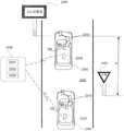
在方法的一些实施例中,当每个车辆在公共路段上行驶时,导航信息可 以包括来自多个车辆中的每一个的轨迹。可以基于相机的感测到的运动来确 定轨迹,所述运动包括三维平移和三维旋转运动。导航信息可以包括车道分 配。生成自主车辆道路导航模型的至少一部分可以包括聚类沿着公共路段的 车辆轨迹、以及基于所聚类的车辆轨迹确定沿着公共路段的目标轨迹。自主 车辆道路导航模型可以包括与沿着公共路段的目标轨迹相对应的三维样条。 目标轨迹可以与公共路段的单个车道相关联。自主车辆道路导航模型可以包 括多个目标轨迹,每个目标轨迹与公共路段的单独的车道相关联。基于所聚 类的车辆轨迹来确定沿着公共路段的目标轨迹,可以包括基于所聚类的车辆 轨迹寻找均值轨迹或平均轨迹。可以通过三维样条来表示目标轨迹。该样条 可以通过每千米小于10千字节来定义。自主车辆道路导航模型可以包括至少 一个地标的标识,所述标识包括至少一个地标的位置。可以基于使用与多个 车辆相关联的传感器系统所执行的位置测量来确定至少一个地标的位置。位 置测量可以被平均,以获得至少一个地标的位置。至少一个地标可以包括以 下各项中的至少一个:交通标志、箭头标记、车道标记、虚线车道标记、交 通灯、停止线、方向标志、地标信标、或灯柱。In some embodiments of the method, the navigation information may include trajectories from each of the plurality of vehicles as each vehicle travels on a common road segment. The trajectory may be determined based on the sensed motion of the camera, including three-dimensional translational and three-dimensional rotational motion. Navigation information may include lane assignments. At least a portion of generating the autonomous vehicle road navigation model may include clustering vehicle trajectories along the common road segment, and determining a target trajectory along the public road segment based on the clustered vehicle trajectories. The autonomous vehicle road navigation model may include three-dimensional splines corresponding to target trajectories along public road segments. The target trajectory can be associated with a single lane of a public road segment. An autonomous vehicle road navigation model may include multiple target trajectories, each associated with a separate lane of a common road segment. Determining the target trajectory along the common road segment based on the clustered vehicle trajectories may include finding a mean trajectory or an average trajectory based on the clustered vehicle trajectories. The target trajectory can be represented by a three-dimensional spline. The spline can be defined by being less than 10 kilobytes per kilometer. The autonomous vehicle road navigation model may include an identification of at least one landmark, the identification including the location of the at least one landmark. The location of the at least one landmark may be determined based on location measurements performed using sensor systems associated with the plurality of vehicles. The position measurements can be averaged to obtain the position of at least one landmark. The at least one landmark may include at least one of: a traffic sign, an arrow marker, a lane marker, a dashed lane marker, a traffic light, a stop line, a directional sign, a landmark beacon, or a lamp post.
在一些实施例中,用于车辆的导航系统可以包括以下各项:至少一个处 理器,被编程为从相机接收与车辆相关联的至少一个环境图像;分析至少一 个环境图像,以确定与车辆有关的导航信息;从车辆向服务器发送导航信息。 至少一个处理器可以被编程为从服务器接收自主车辆道路导航模型。自主车 辆道路导航模型可以包括基于所发送的导航信息的至少一个更新。至少一个 处理器可以被编程为基于自主车辆道路导航模型来引起由车辆进行的至少一 个导航操纵。In some embodiments, a navigation system for a vehicle may include the following: at least one processor programmed to receive from a camera at least one image of the environment associated with the vehicle; analyzing the at least one image of the environment to determine the image related to the vehicle navigation information; send navigation information from the vehicle to the server. At least one processor may be programmed to receive the autonomous vehicle road navigation model from the server. The autonomous vehicle road navigation model may include at least one update based on the transmitted navigation information. At least one processor may be programmed to cause at least one navigation maneuver by the vehicle based on the autonomous vehicle road navigation model.
导航系统的一些实施例中,导航信息可以包括来自多个车辆中的每一个 车辆的、当每个车辆在公共路段上行驶时的轨迹。In some embodiments of the navigation system, the navigation information may include trajectories from each of the plurality of vehicles as each vehicle travels on a common road segment.
在一些实施例中,用于处理车辆导航信息以便在自主车辆导航中使用的 服务器可以包括:通信单元,被配置为与多个车辆通信;以及至少一个处理 器,被编程为经由通信单元接收来自车辆的导航信息。至少一个处理器可以 被编程为:基于导航信息生成自主车辆道路导航模型的至少一部分;以及向 车辆中的至少一个发送自主车辆道路导航模型的至少一部分,以引起至少一 个车辆的、基于自主车辆道路导航模型的部分的导航操纵。In some embodiments, a server for processing vehicle navigation information for use in autonomous vehicle navigation may include: a communication unit configured to communicate with a plurality of vehicles; and at least one processor programmed to receive, via the communication unit, information from Navigation information for the vehicle. The at least one processor may be programmed to: generate at least a portion of the autonomous vehicle road navigation model based on the navigation information; and send at least a portion of the autonomous vehicle road navigation model to at least one of the vehicles to cause at least one vehicle's autonomous vehicle road based Navigation manipulation for parts of the navigation model.
服务器的一些实施例中,导航信息可以包括来自多个车辆中的每一个车 辆的、当每个车辆在公共路段上行驶时的轨迹。自主车辆道路导航模型的部 分可以包括对自主车辆道路导航模型的更新。In some embodiments of the server, the navigation information may include trajectories from each of the plurality of vehicles as each vehicle travels on a common road segment. Portions of the autonomous vehicle road navigation model may include updates to the autonomous vehicle road navigation model.
在一些实施例中,用于车辆的导航系统可以包括:至少一个处理器,被 编程为从一个或多个传感器接收指示车辆的运动的输出;基于来自一个或多 个传感器的输出来确定车辆的实际轨迹;从相机接收与车辆相关联的至少一 个环境图像;分析至少一个环境图像以确定与至少一个导航约束相关联的信 息;确定目标轨迹,所述目标轨迹包括车辆的实际轨迹和基于所确定的与至 少一个导航约束相关联的信息对实际轨迹的一个或多个修改;以及从车辆向 服务器发送目标轨迹。In some embodiments, a navigation system for a vehicle may include: at least one processor programmed to receive output from one or more sensors indicative of motion of the vehicle; actual trajectory; receiving at least one environmental image associated with the vehicle from a camera; analyzing the at least one environmental image to determine information associated with at least one navigation constraint; determining a target trajectory, the target trajectory including the actual trajectory of the vehicle and a one or more modifications to the actual trajectory by information associated with the at least one navigation constraint; and sending the target trajectory from the vehicle to the server.
在该系统的一些实施例中,一个或多个传感器可以包括速率传感器。一 个或多个传感器可以包括加速器。一个或多个传感器可以包括相机。至少一 个导航约束可以包括以下各项中的至少一个:障碍、对象、车道标记、标志、 或另一车辆。相机可以被包括在车辆中。In some embodiments of the system, the one or more sensors may include rate sensors. One or more of the sensors may include accelerators. The one or more sensors may include cameras. The at least one navigation constraint may include at least one of: an obstacle, an object, a lane marking, a sign, or another vehicle. The camera may be included in the vehicle.
在一些实施例中,将目标轨迹上传到服务器的方法可以包括:从一个或 多个传感器接收指示车辆的运动的输出;基于来自一个或多个传感器的输出 来确定车辆的实际轨迹;从相机接收与车辆相关联的至少一个环境图像;分 析至少一个环境图像以确定与至少一个导航约束相关联的信息;确定目标轨 迹,所述目标轨迹包括车辆的实际轨迹和基于所确定的与至少一个导航约束 相关联的信息对实际轨迹的一个或多个修改;以及从车辆向服务器发送目标 轨迹。In some embodiments, the method of uploading the target trajectory to the server may include: receiving output from one or more sensors indicative of motion of the vehicle; determining the actual trajectory of the vehicle based on the output from the one or more sensors; receiving from a camera at least one environmental image associated with the vehicle; analyzing the at least one environmental image to determine information associated with the at least one navigation constraint; determining a target trajectory, the target trajectory comprising the actual trajectory of the vehicle and the at least one navigation constraint based on the determined one or more modifications to the actual trajectory by the associated information; and sending the target trajectory from the vehicle to the server.
在方法的一些实施例中,一个或多个传感器可以包括速率传感器。一个 或多个传感器可以包括加速器。一个或多个传感器可以包括相机。至少一个 导航约束可以包括以下各项中的至少一个:障碍、对象、车道标记、标志、 或另一车辆。相机可以被包括在车辆中。In some embodiments of the method, the one or more sensors may include rate sensors. One or more of the sensors may include accelerators. The one or more sensors may include cameras. The at least one navigation constraint may include at least one of: an obstacle, an object, a lane marking, a sign, or another vehicle. The camera may be included in the vehicle.
在一些实施例中,用于标识地标以用于自主车辆导航的系统可以包括至 少一个处理器,被编程为:接收与地标相关联的至少一个标识符;将地标与 相应的路段相关联;更新相对于相应的路段而言的自主车辆道路导航模型, 以包括与地标相关联的至少一个标识符;以及将更新后的自主车辆道路导航 模型分发给多个自主车辆。可以基于以下各项来确定标识符:从与主车辆相 关联的相机的表示主车辆的环境的至少一个图像的获取;为标识主车辆的环 境中的地标的至少一个图像的分析;以及为确定与地标相关联的至少一个标 识符的至少一个图像的分析。In some embodiments, a system for identifying landmarks for autonomous vehicle navigation may include at least one processor programmed to: receive at least one identifier associated with the landmark; associate the landmark with a corresponding road segment; update an autonomous vehicle road navigation model relative to a corresponding road segment to include at least one identifier associated with the landmark; and distributing the updated autonomous vehicle road navigation model to a plurality of autonomous vehicles. The identifier may be determined based on: acquisition of at least one image representing the environment of the host vehicle from a camera associated with the host vehicle; analysis of at least one image for identifying landmarks in the environment of the host vehicle; and for determining Analysis of at least one image of at least one identifier associated with the landmark.
在该系统的一些实施例中,至少一个标识符可以包括地标的位置。至少 一个标识符可以包括地标的形状。至少一个标识符可以包括地标的尺寸。至 少一个标识符可以包括地标相对于另一地标的距离。可以基于被标识为多个 地标类型之一的地标来确定至少一个标识符。地标类型可以包括交通标志。 地标类型可以包括标杆。地标类型可以包括方向指示符。地标类型可以包括 矩形标志。至少一个标识符还可以包括浓缩的签名表示。可以基于将地标的 图像映射成预定数据尺寸的数字的序列来确定地标的浓缩的签名表示。浓缩 的签名表示可以指示地标的出现。浓缩的签名表示可以指示地标的图像的色 彩模式、或图像的亮度模式中的至少一个。地标可以包括以下各项中的至少 一个:方向标志、交通标志、灯柱、道路标记、和商业标志。In some embodiments of the system, the at least one identifier may include the location of the landmark. At least one identifier may include the shape of the landmark. The at least one identifier may include the dimensions of the landmark. At least one identifier may include a distance of a landmark relative to another landmark. The at least one identifier may be determined based on a landmark identified as one of a plurality of landmark types. Landmark types may include traffic signs. Landmark types can include landmarks. Landmark types can include directional indicators. Landmark types can include rectangular markers. The at least one identifier may also include a condensed signature representation. A condensed signature representation of a landmark may be determined based on mapping an image of the landmark into a sequence of numbers of predetermined data sizes. The condensed signature representation can indicate the presence of a landmark. The condensed signature representation may indicate at least one of a color mode of the image of the landmark, or a brightness mode of the image. Landmarks may include at least one of the following: directional signs, traffic signs, lamp posts, road markings, and business signs.
在一些实施例中,标识地标以用于自主车辆导航的方法可以包括:接收 与地标相关联的至少一个标识符;将地标与相应的路段相关联;更新相对于 相应的路段而言的自主车辆道路导航模型,以包括与地标相关联的至少一个 标识符;以及将更新后的自主车辆道路导航模型分发给多个自主车辆。In some embodiments, a method of identifying a landmark for autonomous vehicle navigation may include: receiving at least one identifier associated with the landmark; associating the landmark with a corresponding road segment; updating the autonomous vehicle relative to the corresponding road segment a road navigation model to include at least one identifier associated with the landmark; and distributing the updated autonomous vehicle road navigation model to a plurality of autonomous vehicles.
在一些实施例中,该方法可以包括确定至少一个标识符。确定至少一个 标识符可以包括:从与主车辆相关联的相机获取表示主车辆的环境的至少一 个图像;分析至少一个图像以标识在主车辆的环境中的地标;以及分析至少 一个图像以确定与地标相关联的至少一个标识符。至少一个标识符可以包括 地标相对于另一地标的距离,并且其中确定至少一个标识符包括确定地标相 对于另一地标的距离。至少一个标识符还可以包括浓缩的签名表示,并且其 中确定至少一个标识符包括从至少一个图像确定浓缩的签名表示。In some embodiments, the method may include determining at least one identifier. Determining the at least one identifier may include: acquiring from a camera associated with the host vehicle at least one image representing the environment of the host vehicle; analyzing the at least one image to identify landmarks in the environment of the host vehicle; and analyzing the at least one image to determine association with the host vehicle At least one identifier associated with the landmark. The at least one identifier may include a distance of the landmark relative to another landmark, and wherein determining the at least one identifier includes determining a distance of the landmark relative to the other landmark. The at least one identifier may also include a condensed signature representation, and wherein determining the at least one identifier includes determining the condensed signature representation from the at least one image.
在一些实施例中,用于确定地标的位置以用于自主车辆的导航的系统可 以包括至少一个处理器,被编程为:接收地标的测量的位置;并且基于地标 的测量的位置和至少一个针对地标先前获取的位置来确定地标的完善位置。 测量的位置和至少一个先前获取的位置可以基于以下各项来确定:从与主车 辆相关联的相机的与主车辆相关联的至少一个环境图像的获取、为标识主车 辆的环境中的地标的至少一个环境图像的分析、表示主车辆的位置的全球定 位系统(GPS)数据的接收、为确定所标识的地标相对于主车辆的相对位置 而至少一个环境图像的分析、以及至少基于GPS数据和所确定的相对位置的 地标的全球本地化位置的确定。In some embodiments, a system for determining a location of a landmark for navigation of an autonomous vehicle may include at least one processor programmed to: receive a measured location of the landmark; and based on the measured location of the landmark and at least one for The previously acquired position of the landmark is used to determine the perfect position of the landmark. The measured location and the at least one previously acquired location may be determined based on acquisition of at least one image of the environment associated with the host vehicle from a camera associated with the host vehicle, for identifying landmarks in the host vehicle's environment. Analysis of at least one image of the environment, receipt of global positioning system (GPS) data representing the location of the host vehicle, analysis of the at least one image of the environment to determine the relative location of the identified landmark with respect to the host vehicle, and analysis of at least one image of the environment based on at least the GPS data and The determination of the globally localized location of the landmark relative to the determined location.
在系统的一些实施例中,地标可以包括以下各项中的至少一个:交通标 志、箭头、车道标记、虚线车道标记、交通灯、停止线、方向标志、地标信 标、或灯柱。为确定所标识的地标相对于车辆的相对位置的至少一个图像的 分析可以包括基于与至少一个图像相关联的尺度来计算距离。分析至少一个 图像以确定所标识地标相对于车辆的相对位置,可以包括基于与至少一个图 像相关联的光流来计算距离。可以从被包括在主车辆中的GPS设备接收GPS 数据。相机可以被包括在主车辆中。确定地标的完善位置,可以包括将地标 的测量的位置与至少一个先前获取的位置取平均。In some embodiments of the system, landmarks may include at least one of: traffic signs, arrows, lane markings, dashed lane markings, traffic lights, stop lines, directional signs, landmark beacons, or lamp posts. The analysis of the at least one image to determine the relative position of the identified landmark with respect to the vehicle may include calculating a distance based on a scale associated with the at least one image. Analyzing the at least one image to determine the relative position of the identified landmark with respect to the vehicle may include calculating a distance based on optical flow associated with the at least one image. GPS data may be received from a GPS device included in the host vehicle. The camera may be included in the host vehicle. Determining the perfect location of the landmark may include averaging the measured location of the landmark with at least one previously acquired location.
在一些实施例中,用于确定地标的位置以在自主车辆的导航中使用的方 法可以包括:接收地标的测量的位置;并且基于地标的测量的位置和针对地 标的至少一个先前获取的位置来确定地标的完善位置。测量的位置和至少一 个先前获取的位置可以基于以下各项来确定:从与主车辆相关联的相机的与 主车辆相关联的至少一个环境图像的获取、为标识主车辆的环境中的地标的 至少一个环境图像的分析、表示主车辆的位置的全球定位系统(GPS)数据 的接收、为确定所标识的地标相对于主车辆的相对位置的至少一个环境图像 的分析、以及基于至少GPS数据和所确定的相对位置的地标的全球本地化位 置的确定。In some embodiments, a method for determining a location of a landmark for use in navigation of an autonomous vehicle may include: receiving a measured location of the landmark; and determining the location based on the measured location of the landmark and at least one previously acquired location for the landmark. Identify the perfect location for the landmark. The measured location and the at least one previously acquired location may be determined based on acquisition of at least one image of the environment associated with the host vehicle from a camera associated with the host vehicle, for identifying landmarks in the host vehicle's environment. Analysis of at least one image of the environment, receipt of global positioning system (GPS) data representing the location of the host vehicle, analysis of the at least one image of the environment to determine the relative location of the identified landmark with respect to the host vehicle, and analysis of at least one image of the environment based on at least the GPS data and The determination of the globally localized location of the landmark relative to the determined location.
在该方法的一些实施例中,地标可以包括以下各项中的至少一个:交通 标志、箭头、车道标记、虚线车道标记、交通灯、停止线、方向标志、地标 信标、或灯柱。为确定所标识地标相对于车辆的相对位置的至少一个图像的 分析,可以包括基于与至少一个图像相关联的尺度来计算距离。为确定所标 识地标相对于车辆的相对位置的至少一个图像的分析,可以包括基于与至少 一个图像相关联的光流来计算距离。可以从被包括在主车辆中的GPS设备接 收GPS数据。相机可以被包括在主车辆中。确定地标的完善位置,可以包括 将地标的测量的位置与至少一个先前获取的位置取平均。In some embodiments of the method, the landmark may include at least one of: traffic signs, arrows, lane markings, dashed lane markings, traffic lights, stop lines, directional signs, landmark beacons, or lamp posts. The analysis of the at least one image to determine the relative position of the identified landmark with respect to the vehicle may include calculating a distance based on a scale associated with the at least one image. Analysis of the at least one image to determine the relative position of the identified landmark with respect to the vehicle may include calculating a distance based on optical flow associated with the at least one image. GPS data may be received from a GPS device included in the host vehicle. The camera may be included in the host vehicle. Determining the perfect location of the landmark may include averaging the measured location of the landmark with at least one previously acquired location.
在一些实施例中,自主车辆可以包括本体和至少一个处理器,所述处理 器被编程为:接收地标的测量的位置;以及基于地标的测量的位置和至少一 个针对地标先前获取的位置来确定地标的完善位置。至少一个处理器还可以 被编程为基于以下各项来确定测量的位置和至少一个先前获取的位置:从与 车辆相关联的相机对与车辆相关联的至少一个环境图像的获取、为标识车辆 的环境中的地标而对至少一个环境图像的分析、对表示车辆的位置的全球定 位系统(GPS)数据的接收、为确定所标识的地标相对于车辆的相对位置而对至少一个环境图像的分析、以及基于至少GPS数据和所确定的相对位置对 地标的全球本地化位置的确定。In some embodiments, an autonomous vehicle may include a body and at least one processor programmed to: receive a measured location of a landmark; and determine based on the measured location of the landmark and at least one previously acquired location for the landmark Perfect location for landmarks. The at least one processor may also be programmed to determine the measured location and the at least one previously acquired location based on the acquisition of at least one environmental image associated with the vehicle from a camera associated with the vehicle, for identification of the vehicle. analysis of at least one image of the environment for landmarks in the environment, receipt of Global Positioning System (GPS) data representing the position of the vehicle, analysis of at least one image of the environment to determine the relative position of the identified landmark with respect to the vehicle, and the determination of a globally localized location of the landmark based on at least the GPS data and the determined relative location.
在车辆的一些实施例中,地标可以包括以下各项中的至少一个:交通标 志、箭头、车道标记、虚线车道标记、交通灯、停止线、方向标志、地标信 标、或灯柱。为确定所标识地标相对于车辆的相对位置的至少一个图像的分 析,可以包括基于与至少一个图像相关联的尺度来计算距离。分析至少一个 图像以确定所标识的地标相对于车辆的相对位置,可以包括基于与至少一个 图像相关联的光流来计算距离。可以从被包括在主车辆中的GPS设备接收 GPS数据。确定地标的完善位置,可以包括将地标的测量的位置与至少一个 先前获取的位置取平均。In some embodiments of the vehicle, the landmarks may include at least one of: traffic signs, arrows, lane markings, dashed lane markings, traffic lights, stop lines, directional signs, landmark beacons, or lamp posts. The analysis of the at least one image to determine the relative position of the identified landmark with respect to the vehicle may include calculating a distance based on a scale associated with the at least one image. Analyzing the at least one image to determine the relative position of the identified landmark with respect to the vehicle may include calculating a distance based on optical flow associated with the at least one image. GPS data may be received from a GPS device included in the host vehicle. Determining the perfect location of the landmark may include averaging the measured location of the landmark with at least one previously acquired location.
在一些实施例中,用于沿着路段自主地导航车辆的系统可以包括至少一 个处理器,其被编程为:从图像捕获设备接收表示车辆的环境的至少一个图 像;分析至少一个图像以标识至少一个已识别地标;至少部分地基于所识别 地标的预定位置,来确定车辆相对于与路段相关联的预定道路模型轨迹的当 前位置;并且基于预定道路模型轨迹在车辆相对于预定道路模型轨迹的所确 定的当前位置处的方向,来确定车辆的自主转向动作。In some embodiments, a system for autonomously navigating a vehicle along a road segment may include at least one processor programmed to: receive from an image capture device at least one image representing the environment of the vehicle; analyze the at least one image to identify at least one an identified landmark; determining a current position of the vehicle relative to a predetermined road model trajectory associated with the road segment based, at least in part, on the predetermined location of the identified landmark; and at all locations of the vehicle relative to the predetermined road model trajectory based on the predetermined road model trajectory The determined direction at the current position is used to determine the autonomous steering action of the vehicle.
在系统的一些实施例中,已识别地标可以包括以下各项中的至少一个: 交通标志、箭头标记、车道标记、虚线车道标记、交通灯、停止线、方向标 志、反射镜、地标信标、或灯柱。所识别的地标可以包括在路段上的线的间 隔的改变。所识别的地标可以包括商业标志。预定道路模型轨迹可以包括沿 着路段的目标轨迹的三维多项式表示。在已识别地标之间的导航可以包括车 辆速度的整合,以确定沿着预定道路模型轨迹的车辆的位置。处理器还可以 被编程为基于自主转向动作调整车辆的转向系统,以导航车辆。处理器还可 以被编程为:确定车辆距至少一个已识别地标的距离;并且基于该距离确定 车辆是否位于与路段相关联的预定道路模型轨迹上。处理器还可以被编程为: 当车辆不位于预定道路模型轨迹上时,调整车辆的转向系统,以将车辆从车 辆的当前定位移动到在预定道路模型轨迹上的位置。In some embodiments of the system, the identified landmarks may include at least one of the following: traffic signs, arrow markings, lane markings, dashed lane markings, traffic lights, stop lines, directional signs, mirrors, landmark beacons, or lamp posts. The identified landmarks may include changes in the spacing of the lines on the road segment. Identified landmarks may include commercial signs. The predetermined road model trajectory may comprise a three-dimensional polynomial representation of the target trajectory along the road segment. Navigation between identified landmarks may include integration of vehicle speeds to determine the position of the vehicle along a predetermined road model trajectory. The processor may also be programmed to adjust the vehicle's steering system to navigate the vehicle based on the autonomous steering action. The processor may also be programmed to: determine a distance of the vehicle from the at least one identified landmark; and determine whether the vehicle is located on a predetermined road model trajectory associated with the road segment based on the distance. The processor may also be programmed to: when the vehicle is not on the predetermined road model trajectory, adjust the vehicle's steering system to move the vehicle from the vehicle's current location to a position on the predetermined road model trajectory.
在一些实施例中,车辆可以包括:本体;至少一个图像捕获设备,被配 置为获取表示车辆的环境的至少一个图像;以及至少一个处理器,被编程为: 从至少一个图像捕获设备接收至少一个图像,分析至少一个图像以标识至少 一个已识别地标,至少部分地基于所识别地标的预定位置来确定相对于与路 段相关联的预定道路模型轨迹的车辆的当前位置,基于在相对于预定道路模 型轨迹的车辆的所确定的当前位置处的预定道路模型轨迹的方向来为车辆确 定自主转向动作。In some embodiments, a vehicle may include: a body; at least one image capture device configured to acquire at least one image representing an environment of the vehicle; and at least one processor programmed to: receive at least one image capture device from the at least one image capture device images, analyzing at least one image to identify at least one identified landmark, determining a current position of the vehicle relative to a predetermined road model trajectory associated with the road segment based at least in part on a predetermined location of the identified landmark, based at least in part on the predetermined road model The direction of the predetermined road model trajectory at the determined current location of the vehicle of the trajectory is used to determine an autonomous steering action for the vehicle.
在车辆的一些实施例中,所识别地标可以包括以下各项中的至少一个: 交通标志、箭头标记、车道标记、虚线车道标记、交通灯、停止线、方向标 志、反射镜、地标信标、灯柱、道路上的线的间隔的改变、或商业标志。预 定道路模型轨迹可以包括沿着路段的目标轨迹的三维多项式表示。在已识别 地标之间的导航可以包括车辆速度的整合,以确定沿着预定道路模型轨迹的 车辆的位置。处理器还可以被编程为基于自主转向动作调整车辆的转向系统, 以导航车辆。处理器还可以被编程为:确定车辆距至少一个已识别地标的距离;并且基于该距离确定车辆是否位于与路段相关联的预定道路模型轨迹上。 处理器还可以被编程为:当车辆没有位于预定道路模型轨迹上时,调整车辆 的转向系统,以将车辆从车辆的当前位置移动到在预定道路模型轨迹上的位 置。In some embodiments of the vehicle, the identified landmarks may include at least one of the following: traffic signs, arrow markings, lane markings, dashed lane markings, traffic lights, stop lines, directional signs, mirrors, landmark beacons, Lamp posts, changes in the spacing of lines on a road, or commercial signs. The predetermined road model trajectory may comprise a three-dimensional polynomial representation of the target trajectory along the road segment. Navigation between the identified landmarks may include integration of vehicle speeds to determine the position of the vehicle along a predetermined road model trajectory. The processor may also be programmed to adjust the vehicle's steering system based on the autonomous steering action to navigate the vehicle. The processor may also be programmed to: determine a distance of the vehicle from the at least one identified landmark; and determine whether the vehicle is located on a predetermined road model trajectory associated with the road segment based on the distance. The processor may also be programmed to adjust the steering system of the vehicle to move the vehicle from the vehicle's current position to a position on the predetermined road model trajectory when the vehicle is not on the predetermined road model trajectory.
在一些实施例中,导航车辆的方法可以包括:从与车辆相关联的图像捕 获设备接收表示车辆的环境的至少一个图像;使用于与车辆相关联的处理器 分析至少一个图像,以标识至少一个已识别地标;至少部分地基于所识别地 标的预定位置来确定相对于与路段相关联的预定道路模型轨迹的车辆的当前 位置;基于在相对于预定道路模型轨迹的车辆的所确定的当前位置处的预定 道路模型轨迹的方向来为车辆确定自主转向动作;并且基于自主转向动作调 整车辆的转向系统以导航车辆。In some embodiments, a method of navigating a vehicle may include: receiving from an image capture device associated with the vehicle at least one image representing an environment of the vehicle; analyzing the at least one image with a processor associated with the vehicle to identify at least one A landmark has been identified; a current position of the vehicle relative to a predetermined road model trajectory associated with the road segment is determined based at least in part on a predetermined position of the identified landmark; based at the determined current position of the vehicle relative to the predetermined road model trajectory The direction of the predetermined road model trajectory of the vehicle is determined to determine an autonomous steering action for the vehicle; and the steering system of the vehicle is adjusted based on the autonomous steering action to navigate the vehicle.
在一些实施例中,方法可以包括通过整合车辆速度确定沿着预定道路模 型轨迹的车辆的位置。方法可以包括:使用处理器确定车辆与至少一个已识 别地标的距离;以及基于该距离确定车辆是否位于与路段相关联的预定道路 模型轨迹上。方法可以包括:确定将车辆从车辆的当前位置移动到在预定道 路模型轨迹上的位置所要求的变换;以及基于该变换调整车辆的转向系统。In some embodiments, the method may include determining the position of the vehicle along the predetermined road model trajectory by integrating the vehicle speed. The method may include: determining, using the processor, a distance of the vehicle from the at least one identified landmark; and determining whether the vehicle is located on a predetermined road model trajectory associated with the road segment based on the distance. The method may include determining a transformation required to move the vehicle from a current position of the vehicle to a position on a predetermined road model trajectory; and adjusting a steering system of the vehicle based on the transformation.
在一些实施例中,用于沿着路段自主地导航自主车辆的系统可以包括至 少一个处理器,其被编程为:从图像捕获设备接收表示自主车辆的环境的多 个图像;至少部分地基于对多个图像中的一个或多个的分析来确定沿着路段 的自主车辆的行驶过的轨迹;基于对多个图像中的一个或多个的分析来确定 沿着预定道路模型轨迹的自主车辆的当前位置;基于所确定的行驶过的轨迹 为自主车辆确定航向方向;并且通过在自主车辆的当前位置处将行驶过的轨 迹和预定道路模型轨迹进行比较,来相对于航向方向为自主车辆确定转向方 向。In some embodiments, a system for autonomously navigating an autonomous vehicle along a road segment may include at least one processor programmed to: receive, from an image capture device, a plurality of images representing the environment of the autonomous vehicle; analysis of one or more of the plurality of images to determine a traveled trajectory of the autonomous vehicle along the road segment; determining a trajectory of the autonomous vehicle along a predetermined road model trajectory based on the analysis of the one or more of the plurality of images current location; determining a heading direction for the ego vehicle based on the determined traveled trajectory; and determining a steering for the ego vehicle relative to the heading direction by comparing the traveled trajectory to a predetermined road model trajectory at the current position of the ego vehicle direction.
在系统的一些实施例中,行驶过的轨迹和预定道路模型轨迹之间的比较 可以包括对减小行驶过的轨迹和预定道路模型轨迹之间的误差的变换的确 定。处理器还可以被编程为基于该变换调整自主车辆的转向系统。预定道路 模型轨迹可以包括沿着路段的目标轨迹的三维多项式表示。可以从被存储在 被包括在自主车辆中的存储器中的数据库检索预定道路模型轨迹。可以从自 主车辆通过无线通信接口可访问的数据库检索预定道路模型轨迹。图像捕获 设备可以被包括在自主车辆中。转向方向的确定还可以基于一个或多个额外 线索,所述额外线索包括以下各项中的一个或多个:左车道标记多项式模型、 右车道标记多项式模型、整体路径预测、前方车辆的运动、在自主车辆之前 的确定的自由空间、以及基于自主车辆前方的车辆的位置所确定的虚拟车道 或虚拟车道约束。转向方向的确定可以基于应用到一个或多个额外线索的权 重。In some embodiments of the system, the comparison between the traveled trajectory and the predetermined road model trajectory may include a determination of a transformation that reduces the error between the traveled trajectory and the predetermined road model trajectory. The processor may also be programmed to adjust the steering system of the autonomous vehicle based on the transformation. The predetermined road model trajectory may comprise a three-dimensional polynomial representation of the target trajectory along the road segment. The predetermined road model trajectory may be retrieved from a database stored in memory included in the autonomous vehicle. The predetermined road model trajectory can be retrieved from a database accessible by the autonomous vehicle through a wireless communication interface. Image capture devices may be included in autonomous vehicles. The determination of steering direction may also be based on one or more additional cues including one or more of the following: left lane marking polynomial model, right lane marking polynomial model, overall path prediction, motion of the vehicle ahead, The determined free space in front of the ego vehicle, and the virtual lane or virtual lane constraints determined based on the position of the vehicle in front of the ego vehicle. The determination of the steering direction may be based on weights applied to one or more additional cues.
在一些实施例中,自主车辆可以包括本体;至少一个图像捕获设备,被 配置为获取表示自主车辆的环境的至少一个图像;以及至少一个处理器,被 配置为:从图像捕获设备接收表示自主车辆的环境的多个图像;至少部分地 基于对多个图像中的一个或多个的分析来确定沿着路段的自主车辆的行驶轨 迹;基于对多个图像中的一个或多个的分析来确定沿着预定道路模型轨迹的 自主车辆的当前位置;基于所确定的行驶轨迹为自主车辆确定航向方向;并 且通过在自主车辆的当前位置处对行驶轨迹和预定道路模型轨迹进行比较, 来相对于航向方向,为自主车辆确定转向方向。In some embodiments, an autonomous vehicle may include a body; at least one image capture device configured to acquire at least one image representing an environment of the autonomous vehicle; and at least one processor configured to receive representations of the autonomous vehicle from the image capture device a plurality of images of an environment of a a current position of the ego vehicle along a predetermined road model trajectory; determining a heading direction for the ego vehicle based on the determined travel trajectory; and relative to the heading by comparing the travel trajectory to the predetermined road model trajectory at the current position of the ego vehicle Orientation, which determines the steering direction for the autonomous vehicle.
在自主车辆的一些实施例中,行驶轨迹和预定道路模型轨迹之间的比较 可以包括对减小行驶轨迹和预定道路模型轨迹之间的误差的变换的确定。预 定道路模型轨迹可以包括沿着路段的目标轨迹的三维多项式表示。可以从被 存储在被包括在自主车辆中的存储器中的数据库和自主车辆通过无线通信接 口可访问的数据库中的一个来检索预定道路模型轨迹。转向方向的确定还可 以基于一个或多个额外线索,所述额外线索包括以下各项中的一个或多个: 左车道标记多项式模型、右车道标记多项式模型、整体路径预测、前方车辆 的运动、在自主车辆之前的确定的自由空间、以及基于自主车辆前方的车辆 的位置所确定的虚拟车道或虚拟车道约束。转向方向的确定可以基于应用到 一个或多个额外线索的权重。In some embodiments of the autonomous vehicle, the comparison between the driving trajectory and the predetermined road model trajectory may include determining a transformation that reduces the error between the driving trajectory and the predetermined road model trajectory. The predetermined road model trajectory may comprise a three-dimensional polynomial representation of the target trajectory along the road segment. The predetermined road model trajectory may be retrieved from one of a database stored in a memory included in the autonomous vehicle and a database accessible by the autonomous vehicle through a wireless communication interface. The determination of the steering direction may also be based on one or more additional cues including one or more of the following: left lane marking polynomial model, right lane marking polynomial model, overall path prediction, motion of the vehicle ahead, The determined free space in front of the ego vehicle, and the virtual lane or virtual lane constraints determined based on the position of the vehicle in front of the ego vehicle. The determination of the steering direction may be based on weights applied to one or more additional cues.
在一些实施例中,导航自主车辆的方法可以包括:从图像捕获设备接收 表示自主车辆的环境的多个图像;至少部分地基于对多个图像中的一个或多 个的分析来确定沿着路段的自主车辆的行驶轨迹;基于对多个图像中的一个 或多个的分析来确定沿着预定道路模型轨迹的自主车辆的当前位置;基于所 确定的行驶轨迹为自主车辆确定航向方向;并且通过在自主车辆的当前位置 处将行驶轨迹和预定道路模型轨迹进行比较,来相对于航向方向,为自主车 辆确定转向方向。In some embodiments, a method of navigating an autonomous vehicle may include: receiving, from an image capture device, a plurality of images representing an environment of the autonomous vehicle; determining the current position of the autonomous vehicle along a predetermined road model trajectory based on analysis of one or more of the plurality of images; determining a heading direction for the autonomous vehicle based on the determined driving trajectory; and by The driving trajectory is compared to a predetermined road model trajectory at the current location of the ego vehicle to determine a steering direction for the ego vehicle relative to the heading direction.
在方法的一些实施例中,将行驶轨迹和预定道路模型轨迹进行比较可以 包括确定减小行驶轨迹和预定道路模型轨迹之间的误差的变换。确定转向方 向可以基于一个或多个额外线索,所述额外线索包括以下各项中的一个或多 个:左车道标记多项式模型、右车道标记多项式模型、整体路径预测、前方 车辆的运动、在自主车辆之前的确定的自由空间、以及基于自主车辆前方的 车辆的位置所确定的虚拟车道或虚拟车道约束。确定转向方向可以包括将权 重应用到一个或多个额外线索。In some embodiments of the method, comparing the travel trajectory to the predetermined road model trajectory may include determining a transformation that reduces an error between the travel trajectory and the predetermined road model trajectory. Determining the steering direction may be based on one or more additional cues including one or more of the following: left lane marking polynomial model, right lane marking polynomial model, overall path prediction, motion of the vehicle ahead, in autonomous The determined free space in front of the vehicle, and the virtual lane or virtual lane constraints determined based on the position of the vehicle in front of the ego vehicle. Determining the steering direction may include applying weights to one or more additional cues.
在一些实施例中,用于自主地导航车辆通过道路枢纽的系统可以包括至 少一个处理器,被编程为:从图像捕获设备接收表示车辆的环境的至少一个 图像;分析至少一图像以标识位于车辆的环境中的两个或更多个地标;为两 个或更多个地标中的每一个,确定相对于车辆的方向指示符;基于针对两个 或更多个地标的方向指示符的交叉来确定相对于道路枢纽的车辆的当前位 置;基于针对两个或更多个地标的方向指示符来为车辆确定航向;并且通过 在车辆的当前位置处将车辆航向与预定道路模型轨迹进行比较来为车辆确定 转向角度。In some embodiments, a system for autonomously navigating a vehicle through a road junction may include at least one processor programmed to: receive from an image capture device at least one image representing the environment of the vehicle; analyze the at least one image to identify vehicles located in the vehicle two or more landmarks in the environment; for each of the two or more landmarks, determine a directional indicator relative to the vehicle; determining a current position of the vehicle relative to the road junction; determining a heading for the vehicle based on directional indicators for two or more landmarks; and by comparing the vehicle heading to a predetermined road model trajectory at the vehicle's current position The vehicle determines the steering angle.
在系统的一些实施例中,预定道路模型轨迹可以包括沿着路段的目标轨 迹的三维多项式表示。两个或更多个地标可以包括三个或更多个地标。至少 一个处理器还可以被编程为向车辆的转向系统发送指定转向角度的控制信 号。处理器可以被配置为从被存储在被包括在车辆中的存储器中的数据库检 索预定道路模型轨迹。处理器可以被配置为从车辆通过无线通信接口可访问 的数据库检索预定道路模型轨迹。相机可以被包括在车辆中。处理器还可以 被编程为通过以下各项为车辆确定航向:基于针对两个或更多个地标的方向 指示符的交叉来确定相对于道路枢纽的车辆的先前位置;以及基于先前位置 和当前位置确定航向。In some embodiments of the system, the predetermined road model trajectory may comprise a three-dimensional polynomial representation of the target trajectory along the road segment. Two or more landmarks may include three or more landmarks. The at least one processor may also be programmed to send a control signal to a steering system of the vehicle specifying a steering angle. The processor may be configured to retrieve the predetermined road model trajectory from a database stored in a memory included in the vehicle. The processor may be configured to retrieve the predetermined road model trajectory from a database accessible to the vehicle through the wireless communication interface. The camera may be included in the vehicle. The processor may also be programmed to determine a heading for the vehicle by: determining a previous position of the vehicle relative to the road junction based on the intersection of directional indicators for two or more landmarks; and based on the previous position and the current position Determine the heading.
在一些实施例中,自主车辆可以包括本体;至少一个图像捕获设备,被 配置为获取表示车辆的环境的至少一个图像;以及至少一个处理器,被编程 为:从相机接收表示车辆的环境的至少一个图像;分析至少一图像以标识位 于车辆的环境中的两个或更多个地标;为两个或更多个地标中的每一个,确 定相对于车辆的方向指示符;基于针对两个或更多个地标的方向指示符的交 叉来确定相对于道路枢纽的车辆的当前位置;基于针对两个或更多个地标的 方向指示符来为车辆确定航向;并且通过在车辆的当前位置处将车辆航向与 预定道路模型轨迹进行比较来为车辆确定转向角度。In some embodiments, the autonomous vehicle may include a body; at least one image capture device configured to acquire at least one image representing the environment of the vehicle; and at least one processor programmed to receive from the camera at least one image representing the environment of the vehicle one image; analyzing at least one image to identify two or more landmarks located in the environment of the vehicle; for each of the two or more landmarks, determining a direction indicator relative to the vehicle; based on targeting the two or more landmarks determining the current position of the vehicle relative to the road junction by the intersection of the direction indicators of the more landmarks; determining the heading for the vehicle based on the direction indicators for the two or more landmarks; The vehicle heading is compared to a predetermined road model trajectory to determine a steering angle for the vehicle.
在车辆的一些实施例中,预定道路模型轨迹可以包括沿着路段的目标轨 迹的三维多项式表示。两个或更多个地标可以包括三个或更多个地标。至少 一个处理器还可以被编程为向车辆的转向系统发送指定转向角度的控制信 号。可以从被存储在被包括在车辆中的存储器中的数据库和车辆通过无线通 信接口可访问的数据库中的一个来检索预定道路模型轨迹。处理器还可以被 编程为通过以下各项为车辆确定航向:基于针对两个或更多个地标的方向指 示符的交叉来确定相对于道路枢纽的车辆的先前位置;以及基于先前位置和 当前位置确定航向。In some embodiments of the vehicle, the predetermined road model trajectory may comprise a three-dimensional polynomial representation of the target trajectory along the road segment. Two or more landmarks may include three or more landmarks. The at least one processor may also be programmed to send a control signal to a steering system of the vehicle specifying a steering angle. The predetermined road model trajectory may be retrieved from one of a database stored in a memory included in the vehicle and a database accessible to the vehicle through a wireless communication interface. The processor may also be programmed to determine a heading for the vehicle by: determining a previous position of the vehicle relative to the road junction based on the intersection of directional indicators for two or more landmarks; and based on the previous position and the current position Determine the heading.
在一些实施例中,导航自主车辆的方法可以包括:从图像捕获设备接收 表示车辆的环境的至少一个图像;使用至少一个处理器分析至少一图像以标 识位于车辆的环境中的两个或更多个地标;为两个或更多个地标中的每一个, 确定相对于车辆的方向指示符;基于针对两个或更多个地标的方向指示符的 交叉来确定相对于道路枢纽的车辆的当前位置;基于针对两个或更多个地标 的方向指示符来为车辆确定航向;以及通过在车辆的当前位置处将车辆航向 与预定道路模型轨迹进行比较来为车辆确定转向角度。In some embodiments, a method of navigating an autonomous vehicle may include: receiving from an image capture device at least one image representing an environment of the vehicle; analyzing the at least one image using at least one processor to identify two or more located in the environment of the vehicle landmarks; for each of the two or more landmarks, determining a directional indicator relative to the vehicle; determining the current relative to the vehicle of the road junction based on the intersection of the directional indicators for the two or more landmarks location; determining a heading for the vehicle based on directional indicators for two or more landmarks; and determining a steering angle for the vehicle by comparing the vehicle heading to a predetermined road model trajectory at the vehicle's current location.
在方法的一些实施例中,预定道路模型轨迹可以包括沿着路段的目标轨 迹的三维多项式表示。方法可以包括从被存储在被包括在车辆中的存储器中 的数据库和车辆通过无线通信接口可访问的数据库中的一个来检索预定道路 模型轨迹。方法可以包括向车辆的转向系统发送指定转向角度的控制信号。 为车辆确定航向可以包括:基于针对两个或更多个地标的方向指示符的交叉 来确定相对于道路枢纽的车辆的先前位置;以及基于先前位置和当前位置确 定航向。In some embodiments of the method, the predetermined road model trajectory may comprise a three-dimensional polynomial representation of the target trajectory along the road segment. The method may include retrieving the predetermined road model trajectory from one of a database stored in a memory included in the vehicle and a database accessible to the vehicle through a wireless communication interface. The method may include sending a control signal specifying a steering angle to a steering system of the vehicle. Determining the heading for the vehicle may include: determining a previous position of the vehicle relative to the road junction based on the intersection of directional indicators for two or more landmarks; and determining the heading based on the previous position and the current position.
在一些实施例中,用于基于多个重叠的导航地图来自主地导航车辆的系 统可以包括至少一个处理器,被编程为:接收第一导航地图以在自主地控制 车辆中使用,其中第一导航地图与第一路段相关联;基于对第一导航地图的 分析为沿着第一路段的车辆确定至少第一自主导航响应;接收第二导航地图 以在自主地控制车辆中使用,其中,第二导航地图与第二路段相关联,其中, 第一路段不同于第二路段,并且其中第一路段和第二路段在重叠段处相互重 叠;基于对第二导航地图的分析为沿着第二路段的车辆确定至少第二自主导 航响应;并且基于第一导航地图和第二导航地图中的至少一个来为在重叠段 中的车辆确定至少第三自主导航响应。In some embodiments, a system for autonomously navigating a vehicle based on a plurality of overlapping navigation maps may include at least one processor programmed to receive a first navigation map for use in an autonomously controlled vehicle, wherein the first a navigation map is associated with the first road segment; determining at least a first autonomous navigation response for a vehicle along the first road segment based on the analysis of the first navigation map; receiving a second navigation map for use in an autonomously controlled vehicle, wherein the The second navigation map is associated with the second road segment, wherein the first road segment is different from the second road segment, and wherein the first road segment and the second road segment overlap each other at the overlapping segment; The vehicle of the road segment determines at least a second autonomous navigation response; and based on at least one of the first navigation map and the second navigation map, at least a third autonomous navigation response is determined for the vehicle in the overlapping segment.
在系统的一些实施例中,多个重叠的导航地图中的每一个可以具有它自 己的坐标系。多个重叠的导航地图中的每一个可以包括沿着路段的目标轨迹 的多项式表示。重叠的导航地图中的每一个可以是具有每千米不超过10千字 节的数据密度的稀疏地图。重叠段可以具有至少50米的长度。重叠段可以具 有至少100米的长度。至少一个处理器可以被编程为基于第一导航地图和第 二导航地图两者来确定第三自主导航响应。第三自主导航响应可以是第一自 主导航响应和第二自主导航响应的组合。第三自主导航响应可以是第一自主 导航响应和第二自主导航响应的平均。处理器还可以被编程为:确定第一自 主导航响应和第二自主导航响应之间的误差;并且当误差小于阈值误差时, 基于第二自主导航响应来确定第三自主导航响应。In some embodiments of the system, each of the multiple overlapping navigation maps may have its own coordinate system. Each of the plurality of overlapping navigation maps may include a polynomial representation of the target trajectory along the road segment. Each of the overlapping navigation maps may be a sparse map with a data density of no more than 10 kilobytes per kilometer. The overlapping segments may have a length of at least 50 meters. The overlapping segments may have a length of at least 100 meters. At least one processor may be programmed to determine a third autonomous navigation response based on both the first navigation map and the second navigation map. The third autonomous navigation response may be a combination of the first autonomous navigation response and the second autonomous navigation response. The third autonomous navigation response may be an average of the first autonomous navigation response and the second autonomous navigation response. The processor may also be programmed to: determine an error between the first autonomous navigation response and the second autonomous navigation response; and when the error is less than a threshold error, determine a third autonomous navigation response based on the second autonomous navigation response.
在一些实施例中,自主车辆可以包括本体;至少一个图像捕获设备,被 配置为获取表示车辆的环境的至少一个图像;至少一个处理器,被编程为: 基于至少一个图像确定车辆的当前位置;接收与第一路段相关联的第一导航 地图;当车辆的当前位置位于第一导航地图上时,基于对第一导航地图的分 析来为车辆确定至少第一自主导航响应;接收与不同于第一路段的第二路段 相关联的第二导航地图,第一路段和第二路段在重叠段处相互重叠;当车辆 的当前位置位于第二导航地图上时,基于对第二导航地图的分析来为车辆确定至少第二自主导航响应;并且当车辆的当前位置位于重叠段中时,基于第 一导航地图和第二导航地图中的至少一个来为车辆确定至少第三自主导航响 应。In some embodiments, the autonomous vehicle may include a body; at least one image capture device configured to acquire at least one image representing an environment of the vehicle; at least one processor programmed to: determine a current location of the vehicle based on the at least one image; receiving a first navigation map associated with the first road segment; determining at least a first autonomous navigation response for the vehicle based on an analysis of the first navigation map when the current location of the vehicle is on the first navigation map; A second navigation map associated with a second road segment of one road segment, the first road segment and the second road segment overlap each other at the overlapping segment; when the current position of the vehicle is located on the second navigation map, based on the analysis of the second navigation map At least a second autonomous navigation response is determined for the vehicle; and when the current location of the vehicle is in the overlapping segment, at least a third autonomous navigation response is determined for the vehicle based on at least one of the first navigation map and the second navigation map.
在自主车辆的一些实施例中,第一导航地图和第二导航地图中的每一个 可以具有它自己的坐标系。第一导航地图和第二导航地图中的每一个可以包 括沿着路段的目标轨迹的多项式表示。至少一个处理器可以被编程为基于第 一导航地图和第二导航地图两者来确定第三自主导航响应。第三自主导航响 应可以是第一自主导航响应和第二自主导航响应的组合。处理器还可以被编 程为:确定第一自主导航响应和第二自主导航响应之间的误差;并且当误差 小于阈值误差时,基于第二自主导航响应来确定第三自主导航响应。In some embodiments of the autonomous vehicle, each of the first navigation map and the second navigation map may have its own coordinate system. Each of the first navigation map and the second navigation map may include a polynomial representation of the target trajectory along the road segment. At least one processor may be programmed to determine a third autonomous navigation response based on both the first navigation map and the second navigation map. The third autonomous navigation response may be a combination of the first autonomous navigation response and the second autonomous navigation response. The processor may also be programmed to: determine an error between the first autonomous navigation response and the second autonomous navigation response; and determine a third autonomous navigation response based on the second autonomous navigation response when the error is less than a threshold error.
在一些实施例中,导航自主车辆的方法可以包括:从图像捕获设备接收 表示车辆的环境的至少一个图像;使用与车辆相关联的处理器,基于至少一 个图像来确定车辆的当前位置;接收与第一路段相关联的第一导航地图;当 车辆的当前位置位于第一导航地图上时,基于对第一导航地图的分析来为车 辆确定至少第一自主导航响应;接收与不同于第一路段的第二路段相关联的 第二导航地图,第一路段和第二路段在重叠段处相互重叠;当车辆的当前位 置位于第二导航地图上时,基于对第二导航地图的分析来为车辆确定至少第二自主导航响应;以及当车辆的当前位置位于重叠段中时,基于第一导航地 图和第二导航地图中的至少一个来为车辆确定至少第三自主导航响应。In some embodiments, a method of navigating an autonomous vehicle may include: receiving from an image capture device at least one image representing an environment of the vehicle; determining, using a processor associated with the vehicle, a current location of the vehicle based on the at least one image; a first navigation map associated with the first road segment; when the vehicle's current location is on the first navigation map, determining at least a first autonomous navigation response for the vehicle based on an analysis of the first navigation map; receiving a response that differs from the first road segment The second navigation map associated with the second road segment of the determining at least a second autonomous navigation response; and determining at least a third autonomous navigation response for the vehicle based on at least one of the first navigation map and the second navigation map when the vehicle's current location is in the overlapping segment.
在方法的一些实施例中,多个重叠的导航地图中的每一个可以具有它自 己的坐标系,并且多个重叠的导航地图中的每一个可以包括沿着路段的目标 轨迹的多项式表示。确定第三自主导航响应可以包括确定第一自主导航响应 和第二自主导航响应的组合。方法可以包括确定第一自主导航响应和第二自 主导航响应之间的误差;以及当误差小于阈值误差时,基于第二自主导航响 应确定第三自主导航响应。In some embodiments of the method, each of the plurality of overlapping navigation maps may have its own coordinate system, and each of the plurality of overlapping navigation maps may include a polynomial representation of the target trajectory along the road segment. Determining the third autonomous navigation response may include determining a combination of the first autonomous navigation response and the second autonomous navigation response. The method may include determining an error between the first autonomous navigation response and the second autonomous navigation response; and when the error is less than a threshold error, determining a third autonomous navigation response based on the second autonomous navigation response.
在一些实施例中,用于沿着路段的车辆的稀疏地图自主导航的系统可以 包括至少一个处理器,被编程为:接收路段的稀疏地图,其中,稀疏地图具 有每千米不超过1兆字节的数据密度;从相机接收表示车辆的环境的至少一 个图像;分析稀疏地图和从相机接收的至少一个图像;以及仅基于对稀疏地 图和从相机接收的至少一个图像的分析来为车辆确定自主导航响应。In some embodiments, a system for autonomous navigation of a sparse map of a vehicle along a road segment may include at least one processor programmed to receive a sparse map of the road segment, wherein the sparse map has no more than 1 megaword per kilometer receiving at least one image representing the environment of the vehicle from the camera; analyzing the sparse map and the at least one image received from the camera; and determining autonomy for the vehicle based only on the analysis of the sparse map and the at least one image received from the camera Navigation response.
在系统的一些实施例中,稀疏地图可以包括沿着路段的目标轨迹的多项 式表示。稀疏地图可以包括一个或多个已识别地标。已识别地标可以以每千 米不超过0.5个的频率在稀疏地图中隔开。已识别地标可以以每千米不超过1 个的频率在稀疏地图中隔开。已识别地标可以以每100米不超过1个的频率 在稀疏地图中隔开。稀疏地图可以具有每千米不超过100千字节的数据密度。 稀疏地图可以具有每千米不超过10千字节的数据密度。In some embodiments of the system, the sparse map may include a polynomial representation of the target trajectory along the road segment. A sparse map can include one or more identified landmarks. Identified landmarks can be separated in the sparse map at a frequency of no more than 0.5 per kilometer. Identified landmarks can be separated in the sparse map at a frequency of no more than 1 per kilometer. Identified landmarks can be spaced in the sparse map at a frequency of no more than 1 per 100 meters. A sparse map can have a data density of no more than 100 kilobytes per kilometer. A sparse map can have a data density of no more than 10 kilobytes per kilometer.
在一些实施例中,用于沿着路段的车辆的稀疏地图自主导航的方法可以 包括:接收路段的稀疏地图,其中,稀疏地图具有每千米不超过1兆字节的 数据密度;从相机接收表示车辆的环境的至少一个图像;分析稀疏地图和从 相机接收的至少一个图像;以及仅基于对稀疏地图和从相机接收的至少一个 图像的分析来为车辆确定自主导航响应。In some embodiments, a method for autonomous navigation of a sparse map of a vehicle along a road segment may include: receiving a sparse map of the road segment, wherein the sparse map has a data density of no more than 1 megabyte per kilometer; receiving from a camera at least one image representing the environment of the vehicle; analyzing the sparse map and the at least one image received from the camera; and determining an autonomous navigation response for the vehicle based only on the analysis of the sparse map and the at least one image received from the camera.
在方法的一些实施例中,稀疏地图可以包括沿着路段的目标轨迹的多项 式表示。稀疏地图可以包括一个或多个已识别地标。已识别地标可以以每千 米不超过0.5个的频率在稀疏地图中隔开。已识别地标可以以每千米不超过1 个的频率在稀疏地图中隔开。已识别地标可以以每100米不超过1个的频率 在稀疏地图中隔开。稀疏地图可以具有每千米不超过100千字节的数据密度。 稀疏地图可以具有每千米不超过10千字节的数据密度。In some embodiments of the method, the sparse map may comprise a polynomial representation of the target trajectory along the road segment. A sparse map can include one or more identified landmarks. Identified landmarks can be separated in the sparse map at a frequency of no more than 0.5 per kilometer. Identified landmarks can be separated in a sparse map at a frequency of no more than 1 per kilometer. Identified landmarks can be spaced in the sparse map at a frequency of no more than 1 per 100 meters. A sparse map can have a data density of no more than 100 kilobytes per kilometer. A sparse map can have a data density of no more than 10 kilobytes per kilometer.
在一些实施例中,非瞬时性计算机可读介质可以存储引起至少一个处理 器执行沿着路段的车辆的稀疏地图自主导航的指令,其可以包括接收路段的 稀疏地图。指令可以引起处理器执行以下各项步骤:接收路段的稀疏地图, 其中,稀疏地图具有每千米不超过1兆字节的数据密度;从相机接收表示车 辆的环境的至少一个图像;分析稀疏地图和从相机接收的至少一个图像;以 及仅基于对稀疏地图和从相机接收的至少一个图像的分析来为车辆确定自主 导航响应。In some embodiments, a non-transitory computer-readable medium may store instructions that cause at least one processor to perform autonomous navigation of a sparse map of a vehicle along a road segment, which may include receiving a sparse map of the road segment. The instructions may cause the processor to perform the steps of: receiving a sparse map of road segments, wherein the sparse map has a data density of no more than 1 megabyte per kilometer; receiving from the camera at least one image representing the environment of the vehicle; analyzing the sparse map and at least one image received from the camera; and determining an autonomous navigation response for the vehicle based solely on analysis of the sparse map and the at least one image received from the camera.
在非瞬时性计算机可读介质的一些实施例中,稀疏地图可以包括沿着路 段的目标轨迹的多项式表示。稀疏地图可以包括一个或多个已识别地标。已 识别地标可以以每千米不超过0.5个的频率在稀疏地图中隔开。In some embodiments of the non-transitory computer-readable medium, the sparse map may include a polynomial representation of the target trajectory along the road segment. A sparse map can include one or more identified landmarks. Identified landmarks may be spaced in the sparse map at a frequency of no more than 0.5 per kilometer.
在一些实施例中,用于基于预定地标位置沿着路段自主地导航车辆的系 统可以包括至少一个处理器,其被编程为:从相机接收表示车辆的环境的至 少一个图像;至少部分地基于与至少一个图像相关联的信息确定沿着与路段 相关联的预定道路模型轨迹的车辆的位置;基于所确定的位置标识车辆前方 的已识别地标,其中,所识别的地标超出相机的视野范围;通过将车辆的所 确定的位置和所识别地标的预定位置进行比较来确定车辆和所识别地标之间 的当前距离;并且基于所确定的当前距离为车辆确定自主导航响应。In some embodiments, a system for autonomously navigating a vehicle along a road segment based on predetermined landmark locations may include at least one processor programmed to: receive from a camera at least one image representative of the vehicle's environment; Information associated with at least one image determines a position of the vehicle along a predetermined road model trajectory associated with the road segment; identifies an identified landmark in front of the vehicle based on the determined position, wherein the identified landmark is beyond the field of view of the camera; by A current distance between the vehicle and the identified landmark is determined by comparing the determined location of the vehicle to a predetermined location of the identified landmark; and an autonomous navigation response is determined for the vehicle based on the determined current distance.
在系统的一些实施例中,所识别地标的预定位置可以被确定为与所识别 地标相关联的多个获取的位置测量的平均,其中,多个获取的位置测量基于 以下各项来确定:至少一个环境图像的获取、为标识在环境中的已识别地标 的对至少一个环境图像的分析、全球定位系统(GPS)数据的接收、为确定 相对于车辆的已识别地标的相对位置的对至少一个环境图像的分析、以及基 于至少GPS数据和所确定的相对位置的已识别地标的全球本地化位置的确 定。自主导航响应可以包括与车辆相关联的制动器的应用。自主导航响应可 以包括修改车辆的转向角度。所识别地标可以包括停止线、交通灯、停车标 志、或沿着路段的弯道。相机可以被包括在车辆中。In some embodiments of the system, the predetermined location of the identified landmark may be determined as an average of a plurality of acquired position measurements associated with the identified landmark, wherein the plurality of acquired position measurements are determined based on at least: Acquisition of an image of the environment, analysis of at least one image of the environment for identification of recognized landmarks in the environment, reception of Global Positioning System (GPS) data, at least one of Analysis of environmental images, and determination of globally localized locations of identified landmarks based on at least GPS data and the determined relative locations. The autonomous navigation response may include application of brakes associated with the vehicle. The autonomous navigation response may include modifying the steering angle of the vehicle. Identified landmarks may include stop lines, traffic lights, stop signs, or curves along road segments. The camera may be included in the vehicle.
在一些实施例中,用于基于预定地标位置沿着路段自主地导航车辆的方 法可以包括从相机接收表示车辆的环境的至少一个图像;至少部分地基于与 至少一个图像相关联的信息来确定沿着与路段相关联的预定道路模型轨迹的 车辆的位置;基于所确定的位置来标识车辆前方的已识别地标,其中,已识 别地标超出相机的视野范围;通过将车辆的所确定的位置和已识别地标的预 定位置进行比较来确定车辆和已识别地标之间的当前距离;以及基于所确定 的当前距离为车辆确定自主导航响应。In some embodiments, a method for autonomously navigating a vehicle along a road segment based on predetermined landmark locations may include receiving from a camera at least one image representing an environment of the vehicle; determining a direction along the road based at least in part on information associated with the at least one image position of the vehicle following a predetermined road model trajectory associated with the road segment; identifying an identified landmark in front of the vehicle based on the determined position, wherein the identified landmark is beyond the camera's field of view; by combining the determined position of the vehicle with the identified landmark The predetermined locations of the identified landmarks are compared to determine a current distance between the vehicle and the identified landmark; and an autonomous navigation response is determined for the vehicle based on the determined current distance.
在方法的一些实施例中,已识别地标的预定位置可以被确定为与已识别 地标相关联的多个获取的位置测量的平均,其中,多个获取的位置测量可以 基于以下各项来确定:至少一个环境图像的获取、为标识在环境中的已识别 地标的对至少一个环境图像的分析、全球定位系统(GPS)数据的接收、为 确定相对于车辆的已识别地标的相对位置的对至少一个环境图像的分析、以 及基于至少GPS数据和所确定的相对位置的对已识别地标的全球本地化位置 的确定。自主导航响应可以包括与车辆相关联的制动器的应用。自主导航响应可以包括修改车辆的转向角度。已识别地标可以包括停止线、交通灯、停 车标志、或沿着路段的弯道。相机可以被包括在车辆中。In some embodiments of the method, the predetermined location of the identified landmark may be determined as an average of a plurality of acquired position measurements associated with the identified landmark, wherein the plurality of acquired position measurements may be determined based on: Acquisition of at least one image of the environment, analysis of at least one image of the environment for identifying identified landmarks in the environment, reception of global positioning system (GPS) data, pairing at least Analysis of an image of the environment, and determination of globally localized locations of identified landmarks based on at least GPS data and the determined relative locations. The autonomous navigation response may include application of brakes associated with the vehicle. The autonomous navigation response may include modifying the steering angle of the vehicle. Recognized landmarks can include stop lines, traffic lights, stop signs, or curves along road segments. The camera may be included in the vehicle.
在一些实施例中,非瞬时性计算机可读介质可以存储引起至少一个处理 器执行沿着路段的车辆的自主导航的指令。指令可以引起处理器执行以下各 项步骤:从相机接收表示车辆的环境的至少一个图像;至少部分地基于与至 少一个图像相关联的信息来确定沿着与路段相关联的预定道路模型轨迹的车 辆的位置;基于所确定的位置来标识车辆前方的已识别地标,其中,已识别 地标超出相机的视野范围;通过将车辆的所确定的位置和已识别地标的预定 位置进行比较来确定车辆和已识别地标之间的当前距离;以及基于所确定的 当前距离为车辆确定自主导航响应。In some embodiments, a non-transitory computer-readable medium may store instructions that cause at least one processor to perform autonomous navigation of a vehicle along a road segment. The instructions may cause the processor to perform the steps of: receiving from the camera at least one image representing the environment of the vehicle; determining a vehicle along a predetermined road model trajectory associated with the road segment based at least in part on information associated with the at least one image the position of the vehicle; identify the identified landmark in front of the vehicle based on the determined position, wherein the identified landmark is beyond the field of view of the camera; determine the vehicle and the identified landmark by comparing the determined position of the vehicle with the predetermined position of the identified landmark identifying a current distance between landmarks; and determining an autonomous navigation response for the vehicle based on the determined current distance.
在非瞬时性计算机可读介质的一些实施例中,自主导航响应可以包括与 车辆相关联的制动器的应用。自主导航响应可以包括修改车辆的转向角度。 已识别地标可以包括停止线、交通灯、停车标志、或沿着路段的弯道。In some embodiments of the non-transitory computer readable medium, the autonomous navigation response may include the application of brakes associated with the vehicle. The autonomous navigation response may include modifying the steering angle of the vehicle. Identified landmarks may include stop lines, traffic lights, stop signs, or curves along road segments.
在一些实施例中,用于沿着路段自主地导航车辆的系统可以包括至少一 个处理器,其被编程为:从至少一个传感器接收与路段的一个或多个方面有 关的信息;基于接收到的信息确定路段的局部特征;将局部特征与用于路段 的预定签名特征进行比较;基于局部特征和预定签名特征的比较来确定沿着 与路段相关联的预定道路模型轨迹的车辆的当前位置;并且基于在所确定的 位置处的预定道路模型轨迹的方向来为车辆确定自主转向动作。In some embodiments, a system for autonomously navigating a vehicle along a road segment may include at least one processor programmed to: receive information from at least one sensor regarding one or more aspects of the road segment; based on the received the information determines a local feature of the road segment; compares the local feature to a predetermined signature feature for the road segment; determines a current location of the vehicle along a predetermined road model trajectory associated with the road segment based on the comparison of the local feature and the predetermined signature feature; and An autonomous steering action is determined for the vehicle based on the direction of the predetermined road model trajectory at the determined location.
在系统的一些实施例中,至少一个处理器还可以被编程为:确定在当前 位置处车辆的航向方向,并且通过将预定道路模型轨迹的方向与航向方向进 行比较来确定自主转向动作。可以基于车辆的行驶轨迹确定航向方向。至少 一个传感器可以包括图像捕获设备,被配置为获取表示车辆的环境的至少一 个图像。签名特征可以包括在路段的至少一部分上的道路宽度轮廓。签名特 征可以包括在路段的至少一部分上的车道宽度轮廓。签名特征可以包括在路 段的至少一部分上的虚线间隔轮廓。签名特征可以包括沿着路段的至少一部 分的预定数量的道路标记。签名特征可以包括在路段的至少一部分上的道路 表面轮廓。签名特征可以包括与路段相关联的预定曲率。确定车辆的当前位 置可以包括比较指示预定道路模型轨迹的曲率的第一参数值和指示针对车辆 的测量的轨迹的曲率的第二参数值。至少一个传感器可以包括悬架组件监视 器。In some embodiments of the system, the at least one processor may also be programmed to determine a heading direction of the vehicle at the current location, and to determine an autonomous steering action by comparing the direction of the predetermined road model trajectory to the heading direction. The heading direction can be determined based on the travel trajectory of the vehicle. The at least one sensor may include an image capture device configured to acquire at least one image representative of the environment of the vehicle. The signature feature may include a road width profile over at least a portion of the road segment. The signature feature may include a lane width profile over at least a portion of the road segment. The signature features may include dashed spaced contours on at least a portion of the road segment. The signature features may include a predetermined number of road markings along at least a portion of the road segment. The signature feature may include a road surface profile on at least a portion of the road segment. The signature feature may include a predetermined curvature associated with the road segment. Determining the current position of the vehicle may include comparing a first parameter value indicative of the curvature of the predetermined road model trajectory with a second parameter value indicative of the curvature of the measured trajectory for the vehicle. The at least one sensor may include a suspension assembly monitor.
在一些实施例中,车辆可以包括本体;至少一个传感器,被配置为获取 与路段的一个或多个方面有关的信息;以及至少一个处理器,被编程为:基 于从至少一个传感器接收的信息确定路段的局部特征;将局部特征与针对路 段的预定签名特征进行比较;基于局部特征和预定签名特征的比较来确定沿 着与路段相关联的预定道路模型轨迹的车辆的当前位置;并且基于在当前位 置处的预定道路模型轨迹的方向来为车辆确定自主转向动作。In some embodiments, a vehicle may include a body; at least one sensor configured to obtain information related to one or more aspects of the road segment; and at least one processor programmed to: determine based on the information received from the at least one sensor local characteristics of the road segment; comparing the local characteristics with predetermined signature characteristics for the road segment; determining the current position of the vehicle along the predetermined road model trajectory associated with the road segment based on the comparison of the local characteristics and the predetermined signature characteristics; The direction of the predetermined road model trajectory at the location is used to determine the autonomous steering action for the vehicle.
在车辆的一些实施例中,签名特征可以包括以下各项中的至少一个:在 路段的至少一部分上的道路宽度轮廓、在路段的至少一部分上的车道宽度轮 廓、在路段的至少一部分上的虚线间隔轮廓、沿着路段的至少一部分的预定 数量的道路标记、在路段的至少一部分上的道路表面轮廓、以及与路段相关 联的预定曲率。车辆可以包括悬架组件监视器,其中,处理器还被编程为基 于来自悬架组件监视器的信号来确定局部特征。处理器还可以被编程为:确 定车辆的航向方向;确定在当前位置处预定道路模型轨迹的方向;以及通过 将该方向与航向方向进行比较来确定自主转向动作。In some embodiments of the vehicle, the signature features may include at least one of: a road width profile over at least a portion of the road segment, a lane width profile over at least a portion of the road segment, a dashed line over at least a portion of the road segment A spacing profile, a predetermined number of road markings along at least a portion of the road segment, a road surface profile on at least a portion of the road segment, and a predetermined curvature associated with the road segment. The vehicle may include a suspension assembly monitor, wherein the processor is further programmed to determine local characteristics based on signals from the suspension assembly monitor. The processor may also be programmed to: determine the heading direction of the vehicle; determine the direction of the predetermined road model trajectory at the current location; and determine an autonomous steering action by comparing the direction to the heading direction.
在一些实施例中,导航车辆的方法可以包括:从至少一个传感器接收与 路段的一个或多个方面有关的信息;使用至少一个处理器,基于从至少一个 传感器接收的信息来确定路段的局部特征;将接收到的信息和用于路段的预 定签名特征进行比较;基于接收到的信息和预定签名特征的比较来确定沿着 与路段相关联的预定道路模型轨迹的车辆的当前位置;并且基于在当前位置 处的预定道路模型轨迹的方向来为车辆确定自主转向动作。In some embodiments, a method of navigating a vehicle may include: receiving information from at least one sensor related to one or more aspects of a road segment; using at least one processor to determine local characteristics of the road segment based on the information received from the at least one sensor ; compare the received information with predetermined signature features for the road segment; determine the current position of the vehicle along the predetermined road model trajectory associated with the road segment based on the comparison of the received information and the predetermined signature characteristics; and The direction of the predetermined road model trajectory at the current location to determine the autonomous steering action for the vehicle.
在一些实施例中,方法可以包括确定在当前位置处车辆的航向方向;确 定在当前位置处预定道路模型轨迹的方向;以及通过将预定道路模型轨迹的 方向与航向方向进行比较来确定自主转向动作。局部特征可以包括以下各项 中的至少一个:在路段的至少一部分上的道路宽度轮廓、在路段的至少一部 分上的车道宽度轮廓、在路段的至少一部分上的虚线间隔轮廓、沿着路段的 至少一部分的预定数量的道路标记、在路段的至少一部分上的道路表面轮廓、 以及与路段相关联的预定曲率。方法可以包括:使用悬架组件监视器确定道 路表面轮廓;将道路表面轮廓与预定道路表面轮廓进行比较;以及基于道路 表面轮廓与预定道路表面轮廓的比较来确定当前位置。In some embodiments, the method may include determining a heading direction of the vehicle at the current location; determining the direction of a predetermined road model trajectory at the current location; and determining an autonomous steering action by comparing the direction of the predetermined road model trajectory with the heading direction . The local features may include at least one of: a road width profile on at least a portion of the road segment, a lane width profile on at least a portion of the road segment, a dashed spaced profile on at least a portion of the road segment, at least a A predetermined number of road markings for a portion, a road surface profile on at least a portion of the road segment, and a predetermined curvature associated with the road segment. The method may include: determining a road surface profile using a suspension assembly monitor; comparing the road surface profile to a predetermined road surface profile; and determining the current position based on the comparison of the road surface profile to the predetermined road surface profile.
在一些实施例中,用于自主地导航车辆的系统可以包括至少一个处理器, 被编程为:从后向相机接收表示在车辆后方的区域的至少一个图像;分析至 少一个后向图像以在图像中定位至少一个地标的表示;确定相对于车辆的地 标的位置的至少一个指示符;至少部分地基于相对于车辆的地标的位置的指 示符来为车辆确定前进轨迹;以及引起车辆沿着所确定的前进轨迹导航。In some embodiments, a system for autonomously navigating a vehicle may include at least one processor programmed to: receive from a rear-facing camera at least one image representing an area behind the vehicle; determining at least one indicator of the location of the landmark relative to the vehicle; determining a forward trajectory for the vehicle based at least in part on the indicator of the location of the landmark relative to the vehicle; forward trajectory navigation.
在系统的一些实施例中,位置的指示符可以包括车辆和地标之间的距离。 位置的指示符可以包括车辆和地标之间的相对角度。地标可以包括道路边缘、 车道标记、反射镜、杆、道路上的线条图案的改变、或道路标志。地标可以 包括道路标志的背面。至少一个处理器还可以被编程为基于地标的位置的指 示符来确定在行驶的当前车道之内的车辆的车道偏移量,并且其中,前进轨 迹的确定还基于所确定的车道偏移量。至少一个处理器还可以被编程为从另 一相机接收表示车辆的另一区域的至少一个图像,并且其中,前进轨迹的确定还基于从另一相机接收的至少一个图像。In some embodiments of the system, the indicator of location may include the distance between the vehicle and the landmark. The indicator of location may include the relative angle between the vehicle and the landmark. Landmarks may include road edges, lane markings, mirrors, poles, changes in line patterns on the road, or road signs. Landmarks can include the back of road signs. The at least one processor may also be programmed to determine a lane offset for the vehicle within the current lane of travel based on the indicator of the location of the landmark, and wherein the determination of the forward trajectory is further based on the determined lane offset. The at least one processor may also be programmed to receive at least one image from another camera representing another area of the vehicle, and wherein the determination of the forward trajectory is further based on the at least one image received from the other camera.
在一些实施例中,自主地导航车辆的方法可以包括从后向相机接收表示 在车辆后方的区域的至少一个图像;分析至少一个后向图像以在图像中位置 至少一个地标的表示;确定相对于车辆的地标的位置的至少一个指示符;至 少部分地基于相对于车辆的地标的位置的指示符来为车辆确定前进轨迹;并 且引起车辆沿着所确定的前进轨迹导航。In some embodiments, a method of autonomously navigating a vehicle may include receiving from a rear-facing camera at least one image representing an area behind the vehicle; analyzing the at least one rear-facing image to position a representation of at least one landmark in the image; determining relative to at least one indicator of the location of the landmark of the vehicle; determining a forward trajectory for the vehicle based at least in part on the indicator of the location of the landmark relative to the vehicle; and causing the vehicle to navigate along the determined forward trajectory.
在方法的一些实施例中,位置的指示符可以包括车辆和地标之间的距离。 位置的指示符可以包括车辆和地标之间的相对角度。地标可以包括道路边缘、 车道标记、反射镜、杆、道路上的线条图案的改变、或道路标志。地标可以 包括道路标志的背面。方法可以包括基于地标的位置的指示符来确定在行驶 的当前车道之内的车辆的车道偏移量,并且其中,前进轨迹的确定可以基于 所确定的车道偏移量。In some embodiments of the method, the indicator of location may include a distance between the vehicle and the landmark. The indicator of location may include the relative angle between the vehicle and the landmark. Landmarks may include road edges, lane markings, mirrors, poles, changes in line patterns on the road, or road signs. Landmarks can include the back of road signs. The method may include determining a lane offset for a vehicle within a current lane of travel based on an indicator of the location of the landmark, and wherein the determination of the forward trajectory may be based on the determined lane offset.
在一些实施例中,车辆可以包括本体;后向相机;以及至少一个处理器, 被编程为:经由连接后向相机的向后相机接口来接收表示在车辆后方的区域 的至少一个图像;分析至少一个后向图像以在图像中定位至少一个地标的表 示;确定相对于车辆的地标的位置的至少一个指示符;至少部分地基于相对 于车辆的地标的位置的指示符来为车辆确定前进轨迹;并且引起车辆沿着所 确定的前进轨迹导航。In some embodiments, a vehicle may include a body; a rear-facing camera; and at least one processor programmed to: receive, via a rear-facing camera interface connected to the rear-facing camera, at least one image representing an area behind the vehicle; analyze at least one image a backward image to locate a representation of the at least one landmark in the image; determine at least one indicator of the location of the landmark relative to the vehicle; determine a forward trajectory for the vehicle based at least in part on the indicator of the location of the landmark relative to the vehicle; And cause the vehicle to navigate along the determined forward trajectory.
在车辆的一些实施例中,后向相机可以安装在连接到车辆的对象上。对 象可以是拖车、自行车架、滑雪板/滑雪板架、安装座、或行李架。向后相机 接口可以包括可拆卸接口。向后相机接口可以包括无线接口。In some embodiments of the vehicle, the rear-facing camera may be mounted on an object attached to the vehicle. Objects can be trailers, bike racks, ski/snowboard racks, mounts, or luggage racks. The rearward camera interface may include a detachable interface. The rearward camera interface may include a wireless interface.
在一些实施例中,用于通过确定车辆能够在其中行驶的自由空间区来导 航车辆的系统可以包括至少一个处理器,被编程为:从图像捕获设备接收与 车辆的环境相关联的多个图像;分析多个图像中的至少一个以标识在车辆的 驾驶员侧上并且向车辆的前方延伸的第一自由空间边界、在车辆的乘客侧上 并且向车辆的前方延伸的第二自由空间边界、以及在车辆前方并且在第一自 由空间边界和第二自由空间边界之间延伸的前方自由空间边界;其中,第一 自由空间边界、第二自由空间边界、和前方自由空间边界定义车辆前方的自 由空间区;通过自由空间区为车辆确定导航路径;并且引起车辆在车辆前方 的自由空间区之内的所确定的导航路径的至少一部分上行驶。In some embodiments, a system for navigating a vehicle by determining a free space zone in which the vehicle can travel may include at least one processor programmed to receive a plurality of images from an image capture device associated with the environment of the vehicle analyzing at least one of the plurality of images to identify a first free space boundary on the driver's side of the vehicle and extending toward the front of the vehicle, a second free space boundary on the passenger side of the vehicle and extending toward the front of the vehicle, and a forward free space boundary in front of the vehicle and extending between the first free space boundary and the second free space boundary; wherein the first free space boundary, the second free space boundary, and the forward free space boundary define the freedom in front of the vehicle a space zone; determining a navigation path for the vehicle through the free space zone; and causing the vehicle to travel on at least a portion of the determined navigation path within the free space zone in front of the vehicle.
在系统的一些实施例中,第一自由空间边界可以对应于以下各项中的至 少一个:道路边缘、路缘石、障碍、车道划分结构、停放的车辆,隧道壁、 或桥梁结构。第二自由空间边界可以对应于以下各项中的至少一个:道路边 缘、路缘石、障碍、车道划分结构、停放的车辆、隧道壁、或桥梁结构。前 方自由空间可以对应于道路水平线。至少一个处理器还可以被编程为,基于 对多个图像中的至少一个的分析来标识车辆前方的障碍物,并且将所标识的 障碍物从车辆前方的自由空间区排除。障碍物可以包括行人。障碍物可以包 括另一车辆。障碍物可以包括岩块。至少一个处理器还可以被编程为基于对 多个图像中的至少一个的分析来标识车辆前方的障碍物,并且将围绕所标识 障碍物的区从车辆前方的自由空间区排除。至少一个处理器还可以被编程为 基于下面各项中的一个或多个来确定围绕所标识障碍物的区:车辆的速率、 障碍物的类型、图像捕获设备的图像捕获速率、以及障碍物的移动速率。In some embodiments of the system, the first free space boundary may correspond to at least one of: a road edge, a curb, an obstacle, a lane dividing structure, a parked vehicle, a tunnel wall, or a bridge structure. The second free space boundary may correspond to at least one of: a road edge, a curb, a barrier, a lane dividing structure, a parked vehicle, a tunnel wall, or a bridge structure. The free space ahead may correspond to the road horizon. The at least one processor may also be programmed to identify obstacles in front of the vehicle based on the analysis of at least one of the plurality of images, and to exclude the identified obstacles from the free space zone in front of the vehicle. Obstacles can include pedestrians. The obstacle may include another vehicle. Obstacles can include rock blocks. The at least one processor may also be programmed to identify an obstacle in front of the vehicle based on the analysis of at least one of the plurality of images, and to exclude a zone surrounding the identified obstacle from the free space zone in front of the vehicle. The at least one processor may also be programmed to determine a zone around the identified obstacle based on one or more of the following: the speed of the vehicle, the type of obstacle, the image capture rate of the image capture device, and the speed of the obstacle. Movement rate.
在一些实施例中,车辆可以包括:本体,其包括驾驶员侧和乘客侧;图 像捕获设备;和至少一个处理器,被编程为:从图像捕获设备接收与车辆的 环境相关联的多个图像;分析多个图像中的至少一个以标识在本体的驾驶员 侧上并向本体的前方延伸的第一自由空间边界、在本体的乘客侧上并向本体 的前方延伸的第二自由空间边界、以及在本体前方并在第一自由空间边界和 第二自由空间边界之间延伸的前方自由空间边界;其中,第一自由空间边界、 第二自由空间边界、和前方自由空间边界定义本体前方的自由空间区;通过自由空间区为车辆确定导航路径;并且引起车辆在车辆前方的自由空间区之 内的所确定的导航路径的至少一部分上行驶。In some embodiments, a vehicle may include: a body including a driver side and a passenger side; an image capture device; and at least one processor programmed to receive a plurality of images from the image capture device associated with the environment of the vehicle analyzing at least one of the plurality of images to identify a first free space boundary extending on the driver's side of the body and extending forward of the body, a second free space boundary extending on the passenger side of the body and extending forward of the body, and a forward free space boundary in front of the body and extending between the first free space boundary and the second free space boundary; wherein the first free space boundary, the second free space boundary, and the forward free space boundary define the freedom in front of the body a space zone; determining a navigation path for the vehicle through the free space zone; and causing the vehicle to travel on at least a portion of the determined navigation path within the free space zone in front of the vehicle.
在一些实施例中,通过确定车辆能够在其中行驶的自由空间区来导航车 辆的方法可以包括:从图像捕获设备接收与车辆的环境相关联的多个图像; 分析多个图像中的至少一个以标识在车辆的驾驶员侧上并向车辆的前方延伸 的第一自由空间边界、在车辆的乘客侧上并向车辆的前方延伸的第二自由空 间边界、以及在车辆前方并在第一自由空间边界和第二自由空间边界之间延 伸的前方自由空间边界;其中,第一自由空间边界、第二自由空间边界、和 前方自由空间边界定义车辆前方的自由空间区;确定车辆通过自由空间区的 导航路径;并且引起车辆在车辆前方的自由空间区之内的所确定的导航路径 的至少一部分上行驶。In some embodiments, a method of navigating a vehicle by determining a free space area in which the vehicle can travel may include: receiving, from an image capture device, a plurality of images associated with an environment of the vehicle; analyzing at least one of the plurality of images to Identify a first free space boundary on the driver's side of the vehicle and extending forward of the vehicle, a second free space boundary on the passenger side of the vehicle and extending forward of the vehicle, and a front of the vehicle and in the first free space A front free space boundary extending between the boundary and the second free space boundary; wherein the first free space boundary, the second free space boundary, and the front free space boundary define a free space area in front of the vehicle; determining the passage of the vehicle through the free space area a navigation path; and causing the vehicle to travel on at least a portion of the determined navigation path within a free space area in front of the vehicle.
在方法的一些实施例中,第一自由空间边界可以对应于以下各项中的至 少一个:道路边缘、路缘石、障碍、车道划分结构、停放的车辆、隧道壁、 或桥梁结构。第二自由空间边界可以对应于以下各项中的至少一个:道路边 缘、路缘石、障碍、车道划分结构、停放的车辆、隧道壁、或桥梁结构。前 方自由空间可以对应于道路水平线。方法可以包括基于对多个图像中的至少 一个的分析来标识车辆前方的障碍物,并且将所标识的障碍物从车辆前方的 自由空间区排除。障碍物可以包括行人。障碍物可以包括另一车辆。障碍物 可以包括岩块。方法可以包括基于对多个图像中的至少一个的分析来标识车 辆前方的障碍物,并且将围绕所标识障碍物的区从车辆前方的自由空间区排 除。方法可以包括基于下面各项中的一个或多个来确定围绕所标识障碍物的 区:车辆的速率、障碍物的类型、图像捕获设备的图像捕获速率、以及障碍 物的移动速率。In some embodiments of the method, the first free space boundary may correspond to at least one of: a road edge, a curb, an obstacle, a lane dividing structure, a parked vehicle, a tunnel wall, or a bridge structure. The second free space boundary may correspond to at least one of: a road edge, a curb, a barrier, a lane dividing structure, a parked vehicle, a tunnel wall, or a bridge structure. The free space ahead may correspond to the road horizon. The method may include identifying obstacles in front of the vehicle based on analysis of at least one of the plurality of images, and excluding the identified obstacles from a free space zone in front of the vehicle. Obstacles can include pedestrians. The obstacle may include another vehicle. Obstacles can include rock blocks. The method may include identifying an obstacle in front of the vehicle based on analysis of at least one of the plurality of images, and excluding the area surrounding the identified obstacle from the free space area in front of the vehicle. The method may include determining a zone around the identified obstacle based on one or more of: the velocity of the vehicle, the type of obstacle, the image capture rate of the image capture device, and the rate of movement of the obstacle.
在一些实施例中,用于在雪覆盖至少一些车道标记和道路边缘的道路上 导航车辆的系统可以包括至少一个处理器,被编程为:从图像捕获设备接收 车辆前方的至少一个环境图像,包括其中雪覆盖至少一些车道标记和道路边 缘的区域;基于对至少一个图像的分析来标识覆盖有雪的道路的至少一部分、 和用于界定覆盖有雪的道路的至少一部分的道路边缘的可能位置;并且引起 车辆导航包括道路的所标识的部分并且落入道路边缘的所确定的可能的位置 之内的导航路径。In some embodiments, a system for navigating a vehicle on a road where snow covers at least some lane markings and road edges may include at least one processor programmed to receive from an image capture device at least one image of the environment ahead of the vehicle, including an area in which snow covers at least some lane markings and a road edge; identifying at least a portion of the snow-covered road and a possible location of a road edge for defining at least a portion of the snow-covered road based on analysis of the at least one image; And the vehicle is caused to navigate a navigation path that includes the identified portion of the road and falls within the determined possible positions of the road edge.
在系统的一些实施例中,对至少一个图像的分析可以包括标识在雪中的 至少一个轮胎压痕。对至少一个图像的分析可以包括标识遍及雪的表面的光 的改变。对至少一个图像的分析可以包括标识沿着道路的边缘的多个树。对 至少一个图像的分析可以包括识别雪的表面的曲率的改变。曲率的所识别的 改变可以被确定为对应于道路边缘的可能的位置。对至少一个图像的分析可 以包括对至少一个图像的像素分析,在所述像素分析中,比较至少第一像素 和至少第二像素,以便确定与覆盖至少一些车道标记和道路边缘的雪的表面 相关联的特征。特征可以对应于轮胎压痕的边缘。特征可以对应于道路的边 缘。至少一个处理器还可以被编程为引起车辆在道路的所确定的边缘之间导 航。至少一个处理器还可以被编程为引起车辆通过至少部分的遵循雪中的轮 胎压痕来导航。In some embodiments of the system, the analysis of the at least one image may include identifying at least one tire indentation in the snow. Analysis of the at least one image may include identifying changes in light throughout the surface of the snow. The analysis of the at least one image may include identifying a plurality of trees along the edge of the road. Analysis of the at least one image may include identifying changes in the curvature of the surface of the snow. The identified change in curvature may be determined to correspond to a possible location of the road edge. The analysis of the at least one image may include pixel analysis of the at least one image in which at least a first pixel and at least a second pixel are compared to determine a surface associated with snow covering at least some of the lane markings and road edges linked characteristics. The feature may correspond to the edge of the tire indentation. Features may correspond to the edges of roads. The at least one processor may also be programmed to cause the vehicle to navigate between the determined edges of the road. The at least one processor may also be programmed to cause the vehicle to navigate by at least partially following tire indentations in the snow.
在一些实施例中,在雪覆盖至少一些车道标记和道路边缘的道路上导航 车辆的方法可以包括:从图像捕获设备接收车辆前方的至少一个环境图像, 包括其中雪覆盖至少一些车道标记和道路边缘的区域;基于对至少一个图像 的分析来标识覆盖有雪的道路的至少一部分、和用于界定覆盖有雪的道路的 至少一部分的道路边缘的可能位置;并且引起车辆导航包括道路的所标识的 部分并且落入道路边缘的所确定的可能的位置之内的导航路径。In some embodiments, a method of navigating a vehicle on a road where snow covers at least some lane markings and road edges may include receiving from an image capture device at least one image of the environment in front of the vehicle, including where snow covers at least some lane markings and road edges an area of A navigation path that is part of and falls within the determined possible positions of the road edge.
在方法的一些实施例中,对至少一个图像的分析可以包括标识在雪中的 至少一个轮胎压痕。对至少一个图像的分析可以包括标识遍及雪的表面的光 的改变。对至少一个图像的分析可以包括标识沿着道路的边缘的多个树。对 至少一个图像的分析可以包括识别雪的表面的曲率的改变。曲率的所识别的 改变可以被确定为对应于道路边缘的可能的位置。对至少一个图像的分析可 以包括对至少一个图像的像素分析,在所述像素分析中,比较至少第一像素 和至少第二像素,以便确定与覆盖至少一些车道标记和道路边缘的雪的表面 相关联的特征。特征可以对应于轮胎压痕的边缘。特征可以对应于道路的边 缘。方法可以包括引起车辆在道路的所确定的边缘之间导航。方法可以包括 引起车辆通过至少部分的遵循雪中的轮胎压痕来导航。In some embodiments of the method, analyzing the at least one image may include identifying at least one tire indentation in the snow. Analysis of the at least one image may include identifying changes in light throughout the surface of the snow. The analysis of the at least one image may include identifying a plurality of trees along the edge of the road. Analysis of the at least one image may include identifying changes in the curvature of the surface of the snow. The identified change in curvature may be determined to correspond to a possible location of the road edge. The analysis of the at least one image may include pixel analysis of the at least one image in which at least a first pixel and at least a second pixel are compared to determine a surface associated with snow covering at least some of the lane markings and road edges linked characteristics. The feature may correspond to the edge of the tire indentation. Features may correspond to the edges of roads. The method may include causing the vehicle to navigate between the determined edges of the road. The method may include causing the vehicle to navigate by at least partially following tire indentations in the snow.
在一些实施例中,用于在至少部分地覆盖有雪的道路上导航车辆的系统 可以包括至少一个处理器,被编程为:从图像捕获设备接收捕获车辆前方环 境的多个图像,包括其中雪覆盖了车辆在其上行驶的道路的区域;分析多个 图像中的至少一个以标识在车辆的驾驶员侧上并且向车辆的前方延伸的第一 自由空间边界、在车辆的乘客侧上并且向车辆的前方延伸的第二自由空间边 界、以及在车辆前方并且在第一自由空间边界和第二自由空间边界之间延伸 的前方自由空间边界;其中,第一自由空间边界、第二自由空间边界、和前 方自由空间边界定义车辆前方的自由空间区;通过自由空间区为车辆确定第 一建议导航路径;向神经网络提供多个图像中的至少一个,并且基于神经网 络对多个图像中的至少一个的分析,从神经网络接收对于车辆的第二建议导 航路径;确定第一建议导航路径是否与第二建议导航路径一致;并且如果确 定第一建议导航路径与第二建议导航路径一致,则引起车辆在第一建议导航 路径的至少一部分上行驶。In some embodiments, a system for navigating a vehicle on a road that is at least partially covered with snow may include at least one processor programmed to receive, from an image capture device, a plurality of images capturing the environment in front of the vehicle, including snow therein covers an area of the road on which the vehicle travels; at least one of the plurality of images is analyzed to identify a first free space boundary on the driver's side of the vehicle and extending forward of the vehicle, on the passenger side of the vehicle and extending toward the front of the vehicle; a second free space boundary extending in front of the vehicle, and a forward free space boundary extending in front of the vehicle and between the first free space boundary and the second free space boundary; wherein the first free space boundary, the second free space boundary , and the front free space boundary define a free space area in front of the vehicle; determine a first suggested navigation path for the vehicle through the free space area; provide at least one of the plurality of images to the neural network, and based on the neural network, at least one of the plurality of images is determined. An analysis of receiving a second suggested navigation path for the vehicle from the neural network; determining whether the first suggested navigation path is consistent with the second suggested navigation path; and if it is determined that the first suggested navigation path is consistent with the second suggested navigation path, causing The vehicle is traveling on at least a portion of the first suggested navigation path.
在一些实施例中,用于校准自主车辆的速率的指示符的系统可以包括至 少一个处理器,被编程为:从相机接收表示车辆的环境的多个图像;分析多 个图像以标识至少两个已识别地标;基于两个已识别地标的已知位置确定指 示至少两个已识别地标之间的距离的值;基于与自主车辆相关联的至少一个 传感器的输出确定至少两个地标之间的测量的距离;并且基于对指示至少两 个已识别地标之间的距离的值和至少两个地标之间的测量的距离的比较,来 为至少一个传感器确定校正因子。In some embodiments, a system for calibrating an indicator of velocity of an autonomous vehicle may include at least one processor programmed to: receive from a camera a plurality of images representing the environment of the vehicle; analyze the plurality of images to identify at least two Identifying landmarks; determining a value indicative of a distance between the at least two identified landmarks based on known locations of the two identified landmarks; determining a measurement between the at least two landmarks based on an output of at least one sensor associated with the autonomous vehicle and determining a correction factor for the at least one sensor based on a comparison of the value indicative of the distance between the at least two identified landmarks and the measured distance between the at least two landmarks.
在系统的一些实施例中,可以确定校正因子,从而校正因子对所确定的 沿着路段的距离的操作与经由无线收发器接收的距离值相匹配。两个已识别 地标可以包括以下各项中的一个或多个:交通标志、箭头标记、车道标记、 虚线车道标记、交通灯、停止线、方向标志、反射镜、地标信标、或灯柱。 至少一个传感器可以包括与车辆相关联的速率计。可以从相对于车辆远程定 位的基于服务器的系统来接收两个已识别地标的已知位置。已知位置中的每 一个可以构成基于多个基于GPS的测量来确定的完善位置。In some embodiments of the system, a correction factor may be determined such that the operation of the correction factor on the determined distance along the road segment matches the distance value received via the wireless transceiver. The two identified landmarks may include one or more of the following: traffic signs, arrow markings, lane markings, dashed lane markings, traffic lights, stop lines, directional signs, reflectors, landmark beacons, or lamp posts. The at least one sensor may include a speedometer associated with the vehicle. The known locations of the two identified landmarks may be received from a server-based system remotely located relative to the vehicle. Each of the known locations may constitute a complete location determined based on multiple GPS-based measurements.
在一些实施例中,用于校准自主车辆的速率的指示符的系统可以包括至 少一个处理器,被编程为:基于与自主车辆相关联的至少一个传感器的输出 来确定沿着路段的距离;经由无线收发器接收与路段相关联的距离值;并且 基于所确定的沿着路段的距离和经由无线收发器接收的距离值来确定用于至 少一个传感器的校正因子。In some embodiments, a system for calibrating an indicator of velocity of an autonomous vehicle may include at least one processor programmed to: determine a distance along a road segment based on the output of at least one sensor associated with the autonomous vehicle; via The wireless transceiver receives a distance value associated with the road segment; and determines a correction factor for the at least one sensor based on the determined distance along the road segment and the distance value received via the wireless transceiver.
在系统的一些实施例中,与路段相关联的、经由无线收发器接收的距离 值,可以基于由多个测量车辆进行的在先测量来确定。多个测量车辆可以包 括至少100个测量车辆。多个测量车辆可以包括至少1000个测量车辆。可以 确定校正因子,从而校正因子对所确定的沿着路段的距离的操作与经由无线 收发器接收的距离值相匹配。至少一个处理器可以被编程为基于多个确定的 校正因子来确定复合校正因子。可以通过平均多个确定的校正因子来确定复 合校正因子。可以通过寻找多个确定的校正因子的均值来确定复合校正因子。In some embodiments of the system, the distance value associated with the road segment, received via the wireless transceiver, may be determined based on previous measurements made by a plurality of measuring vehicles. The plurality of measurement vehicles may include at least 100 measurement vehicles. The plurality of measurement vehicles may include at least 1000 measurement vehicles. A correction factor may be determined such that the operation of the correction factor on the determined distance along the road segment matches the distance value received via the wireless transceiver. At least one processor may be programmed to determine a composite correction factor based on the plurality of determined correction factors. A composite correction factor may be determined by averaging a plurality of determined correction factors. A composite correction factor may be determined by finding the mean of a plurality of determined correction factors.
在一些实施例中,车辆可以包括本体;相机;和至少一个处理器,被编 程为:从相机接收表示车辆的环境的多个图像;分析多个图像以标识至少两 个已识别地标;基于两个已识别地标的已知位置确定指示至少两个已识别地 标之间的距离的值;基于与自主车辆相关联的至少一个传感器的输出确定至 少两个地标之间的测量的距离;并且基于对指示至少两个已识别地标之间的 距离的值和至少两个地标之间的测量的距离的比较,来为至少一个传感器确 定校正因子。In some embodiments, a vehicle may include a body; a camera; and at least one processor programmed to: receive from the camera a plurality of images representing an environment of the vehicle; analyze the plurality of images to identify at least two identified landmarks; and based on the two the known locations of the identified landmarks determine a value indicative of a distance between the at least two identified landmarks; determine the measured distance between the at least two landmarks based on the output of at least one sensor associated with the autonomous vehicle; and A comparison of a value indicative of the distance between the at least two identified landmarks and the measured distance between the at least two landmarks determines a correction factor for the at least one sensor.
在车辆的一些实施例中,至少一个传感器可以包括与车辆相关联的速率 计。两个已识别地标可以包括以下各项中的一个或多个:交通标志、箭头标 记、车道标记、虚线车道标记、交通灯、停止线、方向标志、反射镜、地标 信标、或灯柱。可以从相对于车辆远程定位的基于服务器的系统来接收两个 已识别地标的已知位置。In some embodiments of the vehicle, the at least one sensor may include a speedometer associated with the vehicle. The two identified landmarks may include one or more of the following: traffic signs, arrow markings, lane markings, dashed lane markings, traffic lights, stop lines, directional signs, reflectors, landmark beacons, or lamp posts. The known locations of the two identified landmarks may be received from a server-based system remotely located relative to the vehicle.
在一些实施例中,用于为沿着路段的自主车辆确定车道分配的系统可以 包括至少一个处理器,被编程为:从相机接收表示车辆的环境的至少一个图 像;分析所述至少一个图像以标识至少一个已识别地标;确定车辆和至少一 个已识别地标之间的横向偏移距离的指示符;并且基于车辆和至少一个已识 别地标之间的横向偏移距离的指示符来确定沿着路段的车辆的车道分配。In some embodiments, a system for determining a lane assignment for an autonomous vehicle along a road segment may include at least one processor programmed to: receive from a camera at least one image representing the environment of the vehicle; analyze the at least one image to identifying at least one identified landmark; determining an indicator of a lateral offset distance between the vehicle and the at least one identified landmark; and determining along the road segment based on the indicator of the lateral offset distance between the vehicle and the at least one identified landmark the lane assignment of the vehicle.
在系统的一些实施例中,车辆的环境可以包括路段、车道的数量、以及 至少一个已识别地标。至少一个已识别地标可以包括以下各项中的至少一个: 交通标志、箭头标记、车道标记、虚线车道标记、交通灯、停止线、方向标 志、反射镜、地标信标、或灯柱。至少一个已识别地标可以包括商业标志。 车辆和至少一个已识别地标之间的横向偏移距离可以是车辆和路段的第一侧 之间的第一距离、以及道路的第一侧和至少一个已识别地标之间的第二距离 的总和。车辆和至少一个已识别地标之间的横向偏移距离的指示符的确定可 以基于至少一个已识别地标的预定定位。车辆和至少一个已识别地标之间的 横向偏移距离的指示符的确定可以基于与至少一个图像相关联的尺度。车道 分配的确定还可以基于以下各项中的至少一个:路段的宽度、路段的车道的 数量、以及车道宽度。车道分配的确定还可以基于与路段相关联的预定道路 模型轨迹。至少一个已识别地标可以包括在车辆的第一侧的第一已识别地标 和在车辆的第二侧的第二已识别地标,并且,其中沿着路段的车辆的车道分 配的确定是基于车辆和第一已识别地标之间的横向偏移距离的第一指示符、 以及车辆和第二已识别地标之间的横向偏移距离的第二指示符。In some embodiments of the system, the environment of the vehicle may include road segments, the number of lanes, and at least one identified landmark. The at least one identified landmark may include at least one of: a traffic sign, an arrow marker, a lane marker, a dashed lane marker, a traffic light, a stop line, a directional sign, a reflector, a landmark beacon, or a light post. At least one of the identified landmarks may include commercial signs. The lateral offset distance between the vehicle and the at least one identified landmark may be the sum of a first distance between the vehicle and a first side of the road segment and a second distance between the first side of the road and the at least one identified landmark . The determination of the indicator of the lateral offset distance between the vehicle and the at least one identified landmark may be based on a predetermined location of the at least one identified landmark. The determination of the indicator of the lateral offset distance between the vehicle and the at least one identified landmark may be based on a scale associated with the at least one image. The determination of lane assignment may also be based on at least one of: the width of the road segment, the number of lanes of the road segment, and the width of the lanes. The determination of lane assignments may also be based on predetermined road model trajectories associated with road segments. The at least one identified landmark may include a first identified landmark on a first side of the vehicle and a second identified landmark on a second side of the vehicle, and wherein the determination of the lane assignment of the vehicle along the road segment is based on the vehicle and A first indicator of a lateral offset distance between the first identified landmarks, and a second indicator of a lateral offset distance between the vehicle and the second identified landmark.
在一些实施例中,用于为沿着路段的自主车辆确定车道分配的计算机实 施的方法可以包括由一个或多个处理器执行的下面的操作:从相机接收表示 车辆的环境的至少一个图像;分析至少一个图像以标识至少一个已识别地标; 确定车辆和至少一个已识别地标之间的横向偏移距离的指示符;并且基于车 辆和至少一个已识别地标之间的横向偏移距离的指示符来确定沿着路段的车 辆的车道分配。In some embodiments, a computer-implemented method for determining lane assignments for an autonomous vehicle along a road segment may include, by one or more processors, the following operations: receiving from a camera at least one image representing the environment of the vehicle; analyzing the at least one image to identify the at least one identified landmark; determining an indicator of a lateral offset distance between the vehicle and the at least one identified landmark; and based on the indicator of the lateral offset distance between the vehicle and the at least one identified landmark to determine the lane assignment of vehicles along the road segment.
在方法的一些实施例中,至少一个已识别地标可以包括以下各项中的至 少一个:交通标志、箭头标记、车道标记、虚线车道标记、交通灯、停止线、 方向标志、反射镜、地标信标、或灯柱。至少一个已识别地标可以包括商业 标志。车道分配的确定还可以基于与路段相关联的预定道路模型轨迹。至少 一个已识别地标可以包括在车辆的第一侧的第一已识别地标和在车辆的第二 侧的第二已识别地标,并且,其中沿着路段的车辆的车道分配的确定是基于 车辆和第一已识别地标之间的横向偏移距离的第一指示符、以及车辆和第二 已识别地标之间的横向偏移距离的第二指示符。In some embodiments of the method, the at least one identified landmark may include at least one of the following: traffic signs, arrow markings, lane markings, dashed lane markings, traffic lights, stop lines, directional signs, reflectors, landmark signs sign, or lamp post. At least one of the identified landmarks may include commercial signs. The determination of lane assignments may also be based on predetermined road model trajectories associated with road segments. The at least one identified landmark may include a first identified landmark on a first side of the vehicle and a second identified landmark on a second side of the vehicle, and wherein the determination of the lane assignment of the vehicle along the road segment is based on the vehicle and A first indicator of a lateral offset distance between the first identified landmark and a second indicator of a lateral offset distance between the vehicle and the second identified landmark.
在一些实施例中,计算机可读存储介质可以包括可由至少一个处理器执 行以引起至少一个处理器执行用于为沿着路段的自主车辆确定车道分配的方 法的指令的集合。方法可以包括从相机接收表示车辆的环境的至少一个图像; 分析至少一个图像以标识至少一个已识别地标;确定车辆和至少一个已识别 地标之间的横向偏移距离的指示符;并且基于车辆和至少一个已识别地标之 间的横向偏移距离的指示符来确定沿着路段的车辆的车道分配。In some embodiments, a computer-readable storage medium may include a set of instructions executable by at least one processor to cause the at least one processor to perform a method for determining lane assignments for autonomous vehicles along a road segment. The method may include receiving from the camera at least one image representing the environment of the vehicle; analyzing the at least one image to identify the at least one identified landmark; determining an indicator of a lateral offset distance between the vehicle and the at least one identified landmark; and based on the vehicle and the at least one identified landmark. At least one indicator of the lateral offset distance between the identified landmarks is used to determine lane assignments for vehicles along the road segment.
在计算机可读存储介质的一些实施例中,至少一个已识别地标可以包括 以下各项中的至少一个:交通标志、箭头标记、车道标记、虚线车道标记、 交通灯、停止线、方向标志、反射镜、地标信标、或灯柱。至少一个已识别 地标可以包括商业标志。车道分配的确定还可以基于与路段相关联的预定道 路模型轨迹。至少一个已识别地标可以包括在车辆的第一侧的第一已识别地 标和在车辆的第二侧的第二已识别地标,并且,其中沿着路段的车辆的车道 分配的确定是基于车辆和第一已识别地标之间的横向偏移距离的第一指示 符、以及车辆和第二已识别地标之间的横向偏移距离的第二指示符。In some embodiments of the computer-readable storage medium, the at least one identified landmark may include at least one of: traffic signs, arrow markings, lane markings, dashed lane markings, traffic lights, stop lines, directional signs, reflections mirrors, landmark beacons, or lamp posts. At least one of the identified landmarks may include commercial signs. The determination of lane assignments may also be based on predetermined road model trajectories associated with road segments. The at least one identified landmark may include a first identified landmark on a first side of the vehicle and a second identified landmark on a second side of the vehicle, and wherein the determination of the lane assignment of the vehicle along the road segment is based on the vehicle and A first indicator of a lateral offset distance between the first identified landmark and a second indicator of a lateral offset distance between the vehicle and the second identified landmark.
在一些实施例中,用于沿着路段自主地导航车辆的系统可以包括至少一 个处理器,其被编程为:从相机接收表示车辆的环境的至少一个图像;分析 至少一个图像以标识至少一个已识别地标,其中至少一个已识别地标是已识 别地标的组的部分,并且至少一个已识别地标的标识是至少部分地基于与已 识别地标的组相关联的一个或多个地标组特性;至少部分地基于已识别地标 的预定位置来确定相对于与路段相关联的预定道路模型轨迹的车辆的当前位 置;并且基于在相对于预定道路模型轨迹的车辆的所确定的当前位置处的预 定道路模型轨迹的方向来为车辆确定自主转向动作。In some embodiments, a system for autonomously navigating a vehicle along a road segment may include at least one processor programmed to: receive from a camera at least one image representing the environment of the vehicle; analyze the at least one image to identify at least one identifying landmarks, wherein at least one of the identified landmarks is part of a group of identified landmarks, and the identification of at least one of the identified landmarks is based, at least in part, on one or more landmark group characteristics associated with the group of identified landmarks; at least in part determining the current position of the vehicle relative to the predetermined road model trajectory associated with the road segment based on the predetermined position of the identified landmark; and based on the predetermined road model trajectory at the determined current position of the vehicle relative to the predetermined road model trajectory direction to determine autonomous steering action for the vehicle.
在系统的一些实施例中,至少一个已识别地标可以包括以下各项中的至 少一个:交通标志、箭头标记、车道标记、虚线车道标记、交通灯、停止线、 方向标志、反射镜、地标信标、或灯柱。至少一个已识别地标可以包括商业 标志。预定道路模型轨迹可以包括沿着路段的目标轨迹的三维多项式表示。 至少一个处理器还可以被编程为基于车辆速度确定沿着预定道路模型轨迹的 车辆的当前位置。一个或多个地标组特性可以包括已识别地标的组的成员之 间的相对距离。一个或多个地标组特性可以包括已识别地标的组的成员的排序序列。一个或多个地标组特性可以包括被包括在已识别地标的组中的地标 的数量。至少一个已识别地标的标识可以至少部分地基于与已识别地标的组 相关联的超级地标签名。至少一个处理器可以被编程为通过将车辆的航向方 向和在车辆的所确定的当前位置处的预定道路模型轨迹进行比较来为车辆确 定自主转向动作。In some embodiments of the system, the at least one identified landmark may include at least one of the following: traffic signs, arrow markings, lane markings, dashed lane markings, traffic lights, stop lines, directional signs, reflectors, landmark signs sign, or lamp post. At least one of the identified landmarks may include commercial signs. The predetermined road model trajectory may comprise a three-dimensional polynomial representation of the target trajectory along the road segment. The at least one processor may also be programmed to determine the current position of the vehicle along the predetermined road model trajectory based on the vehicle speed. The one or more landmark group characteristics may include relative distances between members of the group of identified landmarks. The one or more landmark group properties may include an ordered sequence of members of the group of identified landmarks. The one or more landmark group characteristics may include the number of landmarks included in the group of identified landmarks. The identification of the at least one identified landmark may be based, at least in part, on a superplace tag name associated with the group of identified landmarks. At least one processor may be programmed to determine an autonomous steering maneuver for the vehicle by comparing the heading direction of the vehicle to a predetermined road model trajectory at the determined current location of the vehicle.
在一些实施例中,用于沿着路段自主地导航车辆的计算机实施的方法可 以包括由一个或多个处理器执行的下面的各项操作:从相机接收表示车辆的 环境的至少一个图像;分析至少一个图像以标识至少一个已识别地标,其中, 至少一个已识别地标是已识别地标的组的部分,并且至少一个已识别地标的 标识是至少部分地基于与已识别地标的组相关联的一个或多个地标组特性; 相对于车辆,至少部分地基于已识别地标的预定位置来确定相对于与路段相 关联的预定道路模型轨迹的车辆的当前位置;并且基于在相对于预定道路模 型轨迹的车辆的所确定的当前位置处的预定道路模型轨迹的方向来为车辆确定自主转向动作。In some embodiments, a computer-implemented method for autonomously navigating a vehicle along a road segment may include, by one or more processors: receiving from a camera at least one image representing an environment of the vehicle; analyzing at least one image to identify at least one identified landmark, wherein the at least one identified landmark is part of a group of identified landmarks, and the identification of the at least one identified landmark is based at least in part on one associated with the group of identified landmarks or more landmark group characteristics; relative to the vehicle, determining a current location of the vehicle relative to a predetermined road model trajectory associated with the road segment based at least in part on predetermined locations of the identified landmarks; The direction of the predetermined road model trajectory at the determined current location of the vehicle is used to determine an autonomous steering action for the vehicle.
在方法的一些实施例中,至少一个已识别地标可以包括以下各项中的至 少一个:交通标志、箭头标记、车道标记、虚线车道标记、交通灯、停止线、 方向标志、反射镜、地标信标、或灯柱。至少一个已识别地标可以包括商业 标志。一个或多个地标组特性可以包括已识别地标的组的成员之间的相对距 离。一个或多个地标组特性可以包括已识别地标的组的成员的排序序列。In some embodiments of the method, the at least one identified landmark may include at least one of the following: traffic signs, arrow markings, lane markings, dashed lane markings, traffic lights, stop lines, directional signs, reflectors, landmark signs sign, or lamp post. At least one of the identified landmarks may include commercial signs. The one or more landmark group characteristics may include relative distances between members of the group of identified landmarks. The one or more landmark group properties may include an ordered sequence of members of the group of identified landmarks.
在一些实施例中,计算机可读存储介质可以包括可由至少一个处理器执 行以引起至少一个处理器执行用于沿着路段自主地导航车辆的方法的指令的 集合。方法可以包括从相机接收表示车辆的环境的至少一个图像;分析至少 一个图像以标识至少一个已识别地标,其中,至少一个已识别地标是已识别 地标的组的部分,并且至少一个已识别地标的标识是至少部分地基于与已识 别地标的组相关联的一个或多个地标组特性;相对于车辆,至少部分地基于 已识别地标的预定位置来确定相对于与路段相关联的预定道路模型轨迹的车 辆的当前位置;并且基于在相对于预定道路模型轨迹的车辆的所确定的当前 位置处的预定道路模型轨迹的方向来为车辆确定自主转向动作。In some embodiments, a computer-readable storage medium may include a set of instructions executable by at least one processor to cause the at least one processor to perform a method for autonomously navigating a vehicle along a road segment. The method may include receiving from the camera at least one image representing the environment of the vehicle; analyzing the at least one image to identify at least one identified landmark, wherein the at least one identified landmark is part of a group of identified landmarks and the at least one identified landmark is The identification is based at least in part on one or more landmark group characteristics associated with the group of identified landmarks; relative to the vehicle, the trajectory is determined relative to a predetermined road model associated with the road segment based at least in part on predetermined locations of the identified landmarks and determining an autonomous steering action for the vehicle based on the direction of the predetermined road model trajectory at the determined current position of the vehicle relative to the predetermined road model trajectory.
在计算机可读存储介质的一些实施例中,至少一个已识别地标可以包括 以下各项中的至少一个:交通标志、箭头标记、车道标记、虚线车道标记、 交通灯、停止线、方向标志、反射镜、地标信标、或灯柱。至少一个已识别 地标可以包括商业标志。一个或多个地标组特性可以包括已识别地标的组的 成员之间的相对距离。一个或多个地标组特性可以包括已识别地标的组的成 员的排序序列。In some embodiments of the computer-readable storage medium, the at least one identified landmark may include at least one of: traffic signs, arrow markings, lane markings, dashed lane markings, traffic lights, stop lines, directional signs, reflections mirrors, landmark beacons, or lamp posts. At least one of the identified landmarks may include commercial signs. The one or more landmark group characteristics may include relative distances between members of the group of identified landmarks. The one or more landmark group properties may include an ordered sequence of members of the group of identified landmarks.
在一些实施例中,用于车辆的导航系统可以包括至少一个处理器,被编 程为:从相机接收与车辆相关联的至少一个环境图像;基于对至少一个环境 图像的分析确定对于车辆的导航操纵;引起车辆发起导航操纵;接收与不同 于所发起的导航操纵的用户的导航响应相关联的用户输入;基于接收到的用 户输入确定与车辆有关的导航情形信息;并且联合与用户输入有关的信息来 存储导航情形信息。In some embodiments, a navigation system for a vehicle may include at least one processor programmed to: receive from a camera at least one image of the environment associated with the vehicle; determine a navigation maneuver for the vehicle based on an analysis of the at least one image of the environment ; cause the vehicle to initiate a navigation maneuver; receive user input associated with a navigation response from a user other than the user that initiated the navigation maneuver; determine navigation situation information related to the vehicle based on the received user input; and combine the information related to the user input to store navigation situation information.
在系统的一些实施例中,导航操纵可以基于在至少一个环境图像中所标 识的已识别地标。与用户输入有关的信息可以包括指定车辆的转弯的程度、 车辆的加速度的量、以及车辆的制动的量中的至少一个的信息。控制系统可 以包括转向控制、加速度控制、以及制动控制中的至少一个。导航情形信息 可以包括由在车辆上的相机捕获的一个或多个图像。用户输入可以包括制动、 转向、或加速中的至少一个。导航情形信息可以包括车辆的位置。导航情形 信息可以包括在车辆上的传感器的至少一个输出。传感器可以是速率计。传 感器可以是加速计。传感器可以是IR传感器。导航情形信息可以包括当日时 间。导航情形信息可以包括视觉抑制剂(vision inhibitor)的存在的指示。视 觉抑制剂可以由眩光引起。导航情形信息可以基于至少一个环境图像来确定。 系统可以包括发送器,其用于向远离车辆的服务器传送导航情形信息。In some embodiments of the system, the navigational maneuvers may be based on identified landmarks identified in at least one image of the environment. The information related to the user input may include information specifying at least one of a degree of turning of the vehicle, an amount of acceleration of the vehicle, and an amount of braking of the vehicle. The control system may include at least one of steering control, acceleration control, and braking control. The navigation situation information may include one or more images captured by a camera on the vehicle. The user input may include at least one of braking, steering, or acceleration. The navigation situation information may include the location of the vehicle. The navigation situation information may include at least one output of sensors on the vehicle. The sensor may be a rate meter. The sensor may be an accelerometer. The sensor may be an IR sensor. Navigation situation information may include the time of day. Navigation situation information may include an indication of the presence of a vision inhibitor. Visual depressants can be caused by glare. Navigation situation information may be determined based on at least one environment image. The system may include a transmitter for transmitting navigation situation information to a server remote from the vehicle.
在一些实施例中,非瞬时性计算机可读介质可以包括可由至少一个处理 器执行以引起至少一个处理器执行方法的指令。方法可以包括从相机接收与 车辆相关联的至少一个环境图像;基于对至少一个环境图像的分析为车辆确 定导航操纵;引起车辆发起导航操纵;接收与不同于所发起的导航操纵的用 户的导航响应相关联的用户输入;基于接收到的用户输入确定与车辆有关的 导航情形信息;并且联合与用户输入有关的信息来存储导航情形信息。In some embodiments, a non-transitory computer-readable medium may include instructions executable by at least one processor to cause the at least one processor to perform a method. The method may include receiving from a camera at least one environmental image associated with the vehicle; determining a navigation maneuver for the vehicle based on the analysis of the at least one environmental image; causing the vehicle to initiate a navigation maneuver; receiving a navigation response to a user other than the initiated navigation maneuver associated user input; determining navigation situation information related to the vehicle based on the received user input; and storing the navigation situation information in conjunction with the information related to the user input.
在一些实施例中,用于车辆的导航系统可以包括至少一个处理器,被编 程为:至少部分地基于车辆的运动相对于表示路段的预定模型的比较来为车 辆确定导航操纵;从相机接收表示车辆的环境的至少一个图像;基于对至少 一个图像的分析,确定在车辆的环境中导航调整条件的存在;基于导航调整 条件的存在引起车辆调整导航操纵;并且存储与导航调整条件有关的信息。In some embodiments, a navigation system for a vehicle may include at least one processor programmed to: determine a navigation maneuver for the vehicle based at least in part on a comparison of motion of the vehicle relative to a predetermined model representing the road segment; receive representations from a camera at least one image of the vehicle's environment; determining the presence of a navigation adjustment condition in the vehicle's environment based on the analysis of the at least one image; causing the vehicle to adjust a navigation maneuver based on the presence of the navigation adjustment condition; and storing information related to the navigation adjustment condition.
在系统的一些实施例中,导航调整条件可以包括停放的汽车。导航调整 条件可以包括车道转变(lane shift)。导航调整条件可以包括最近遇到的交通 标志或最近遇到的交通灯中的至少一个。导航调整条件可以包括建筑工地区 域。处理器还可以被编程为引起与导航调整条件有关的所存储的信息被发送 到道路模型管理系统,以用于确定导航调整条件是否保证了对表示路段的预 定模型的更新。相对于导航调整条件而存储的信息可以包括以下各项中的至 少一个:遇到导航调整条件的位置的指示符、对导航操纵进行的调整的指示 符、以及至少一个图像。表示路段的预定模型可以包括表示沿着路段行驶的 预定路径的三维样条。In some embodiments of the system, the navigation adjustment condition may include a parked car. Navigation adjustment conditions may include lane shifts. The navigation adjustment condition may include at least one of a recently encountered traffic sign or a recently encountered traffic light. Navigation adjustment conditions may include construction site areas. The processor may also be programmed to cause stored information related to the navigation adjustment conditions to be sent to the road model management system for use in determining whether the navigation adjustment conditions warrant an update to the predetermined model representing the road segment. The information stored with respect to the navigation adjustment condition may include at least one of: an indicator of the location where the navigation adjustment condition was encountered, an indicator of an adjustment made to the navigation maneuver, and at least one image. The predetermined model representing the road segment may include a three-dimensional spline representing a predetermined path to travel along the road segment.
在一些实施例中,用于导航车辆的方法可以包括:至少部分地基于车辆 的运动相对于表示路段的预定模型的比较来为车辆确定导航操纵;从相机接 收表示车辆的环境的至少一个图像;基于对至少一个图像的分析,确定在车 辆的环境中导航调整条件的存在;基于导航调整条件的存在引起车辆调整导 航操纵;以及存储与导航调整条件有关的信息。In some embodiments, a method for navigating a vehicle may include: determining a navigation maneuver for the vehicle based at least in part on a comparison of motion of the vehicle relative to a predetermined model representing the road segment; receiving from a camera at least one image representing an environment of the vehicle; Determining the presence of a navigation adjustment condition in the environment of the vehicle based on the analysis of the at least one image; causing the vehicle to adjust a navigation maneuver based on the presence of the navigation adjustment condition; and storing information related to the navigation adjustment condition.
在方法的一些实施例中,导航调整条件可以包括停放的汽车。导航调整 条件可以包括车道转变。导航调整条件可以包括最近遇到的交通标志或最近 遇到的交通灯中的至少一个。导航调整条件可以包括建筑工地区域。方法可 以包括引起与导航调整条件有关的所存储信息被发送到道路模型管理系统, 以用于确定导航调整条件是否保证了对表示路段的预定模型的更新。相对于 导航调整条件而存储的信息可以包括以下各项中的至少一个:遇到导航调整 条件的位置的指示符、对导航操纵进行的调整的指示符、以及至少一个图像。 表示路段的预定模型可以包括表示沿着路段行驶的预定路径的三维样条。In some embodiments of the method, the navigation adjustment condition may include a parked car. Navigation adjustment conditions may include lane changes. The navigation adjustment condition may include at least one of a recently encountered traffic sign or a recently encountered traffic light. Navigation adjustment conditions may include construction site areas. The method may include causing stored information related to the navigation adjustment condition to be sent to the road model management system for use in determining whether the navigation adjustment condition warrants an update to a predetermined model representing the road segment. The information stored with respect to the navigation adjustment condition may include at least one of: an indicator of a location where the navigation adjustment condition was encountered, an indicator of an adjustment made to the navigation maneuver, and at least one image. The predetermined model representing the road segment may include a three-dimensional spline representing a predetermined path to travel along the road segment.
在一些实施例中,非瞬时性计算机可读介质可以包括可由至少一个处理 器执行以引起至少一个处理器执行方法的指令。方法可以包括:至少部分地 基于车辆的运动相对于表示路段的预定模型的比较来为车辆确定导航操纵; 从相机接收表示车辆的环境的至少一个图像;基于对至少一个图像的分析, 确定在车辆的环境中导航调整条件的存在;基于导航调整条件的存在引起车 辆调整导航操纵;以及存储与导航调整条件有关的信息。In some embodiments, a non-transitory computer-readable medium may include instructions executable by at least one processor to cause the at least one processor to perform a method. The method may include: determining a navigation maneuver for the vehicle based at least in part on a comparison of motion of the vehicle relative to a predetermined model representing the road segment; receiving from a camera at least one image representing an environment of the vehicle; the presence of a navigation adjustment condition in the environment; causing the vehicle to adjust a navigation maneuver based on the presence of the navigation adjustment condition; and storing information related to the navigation adjustment condition.
在计算机可读介质的一些实施例中,方法可以包括引起与导航调整条件 有关的所存储的信息被发送到道路模型管理系统,以用于确定导航调整条件 是否保证了对表示路段的预定模型的更新。相对于导航调整条件而存储的信 息可以包括以下各项中的至少一个:遇到导航调整条件的位置的指示符、对 导航操纵进行的调整的指示符、以及至少一个图像。表示路段的预定模型可 以包括表示沿着路段行驶的预定路径的三维样条。In some embodiments of the computer-readable medium, the method may include causing stored information related to the navigation adjustment condition to be sent to a road model management system for use in determining whether the navigation adjustment condition warrants a predetermined model representing the road segment. renew. The information stored relative to the navigation adjustment condition may include at least one of: an indicator of a location where the navigation adjustment condition was encountered, an indicator of an adjustment made to the navigation maneuver, and at least one image. The predetermined model representing the road segment may include a three-dimensional spline representing a predetermined path to travel along the road segment.
在一些实施例中,用于与多个自主车辆交互的系统可以包括:存储器, 所述存储器包括表示至少一个路段的预定模型;以及至少一个处理器被编程 为:从多个自主车辆中的每一个接收与对确定的导航操纵的调整的发生相关 联的导航情形信息;分析导航情形信息;基于对导航情形信息的分析来确定 对确定的导航操纵的调整是否是由于瞬时条件;并且如果对确定的导航操纵 的调整不是由于瞬时条件,则更新表示至少一个路段的预定模型。In some embodiments, a system for interacting with a plurality of autonomous vehicles may include: a memory including a predetermined model representing at least one road segment; and at least one processor programmed to: retrieve data from each of the plurality of autonomous vehicles one receives navigation situation information associated with the occurrence of the adjustment to the determined navigation maneuver; analyzes the navigation situation information; determines whether the adjustment to the determined navigation maneuver is due to transient conditions based on the analysis of the navigation situation information; The adjustment of the navigation maneuver is not due to instantaneous conditions, then the predetermined model representing at least one road segment is updated.
在系统的一些实施例中,表示至少一个路段的预定模型可以包括表示沿 着至少一个路段行驶的预定路径的三维样条。对预定模型的更新可以包括对 表示沿着至少一个路段行驶的预定路径的三维样条的更新。对确定的导航操 纵的调整可以是由用户干预导致。对确定的导航操纵的调整可以是由自动确 定导致的,所述自动确定基于对在车辆环境中的导航调整条件的存在的图像 分析。导航情形信息可以包括表示自主车辆的环境的至少一个图像。导航情 形信息可以包括表示自主车辆的环境的视频。瞬时条件可以与停放的汽车、 插入其间的汽车、行人、弱光条件、眩光条件、临时障碍、或临时道路施工 相关联。In some embodiments of the system, the predetermined model representing the at least one road segment may comprise a three-dimensional spline representing a predetermined path to travel along the at least one road segment. Updating the predetermined model may include updating a three-dimensional spline representing a predetermined path traveled along the at least one road segment. Adjustments to certain navigation maneuvers may result from user intervention. Adjustments to the determined navigation maneuvers may result from automatic determinations based on image analysis of the presence of navigation adjustment conditions in the vehicle environment. The navigation situation information may include at least one image representing the environment of the autonomous vehicle. The navigation situation information may include video representing the environment of the autonomous vehicle. Transient conditions may be associated with parked cars, intervening cars, pedestrians, low light conditions, glare conditions, temporary obstacles, or temporary road construction.
在一些实施例中,用于与多个自主车辆交互的方法可以包括从多个自主 车辆中的每一个接收与对确定的导航操纵的调整的发生相关联的导航情形信 息;分析导航情形信息;基于对导航情形信息的分析来确定对确定的导航操 纵的调整是否是由于瞬时条件;并且如果对确定的导航操纵的调整不是由于 瞬时条件,则更新表示至少一个路段的预定模型。In some embodiments, a method for interacting with a plurality of autonomous vehicles may include receiving, from each of the plurality of autonomous vehicles, navigation situation information associated with occurrence of an adjustment to the determined navigation maneuver; analyzing the navigation situation information; Whether the adjustment to the determined navigation maneuver is due to a transient condition is determined based on the analysis of the navigation situation information; and if the adjustment to the determined navigation maneuver is not due to the transient condition, updating a predetermined model representing at least one road segment.
在方法的一些实施例中,表示至少一个路段的预定模型可以包括表示沿 着至少一个路段行驶的预定路径的三维样条。对预定模型的更新可以包括对 表示沿着至少一个路段行驶的预定路径的三维样条的更新。对确定的导航操 纵的调整可以是由用户干预导致的。对确定的导航操纵的调整可以是由自动 确定导致的,所述自动确定基于对在车辆环境中的导航调整条件的存在的图 像分析。导航情形信息可以包括表示自主车辆的环境的至少一个图像。导航 情形信息可以包括表示自主车辆的环境的视频。瞬时条件可以与停放的汽车、 插入其间的汽车、行人、弱光条件、眩光条件、临时障碍、或临时道路施工 相关联。In some embodiments of the method, the predetermined model representing the at least one road segment may comprise a three-dimensional spline representing a predetermined path to travel along the at least one road segment. Updating the predetermined model may include updating a three-dimensional spline representing a predetermined path traveled along the at least one road segment. Adjustments to certain navigation maneuvers may result from user intervention. Adjustments to the determined navigation maneuvers may result from automatic determinations based on image analysis of the presence of navigation adjustment conditions in the vehicle environment. The navigation situation information may include at least one image representing the environment of the autonomous vehicle. Navigation situation information may include video representing the environment of the autonomous vehicle. Transient conditions may be associated with parked cars, intervening cars, pedestrians, low light conditions, glare conditions, temporary obstacles, or temporary road construction.
在一些实施例中,非瞬时性计算机可读介质可以包括可由至少一个处理 器执行以引起至少一个处理器执行方法的指令。方法可以包括:从多个自主 车辆中的每一个接收与对确定的导航操纵的调整的发生相关联的导航情形信 息;分析导航情形信息;基于对导航情形信息的分析来确定对确定的导航操 纵的调整是否是由于瞬时条件;并且如果对确定的导航操纵的调整不是由于 瞬时条件,则更新表示至少一个路段的预定模型。In some embodiments, a non-transitory computer-readable medium may include instructions executable by at least one processor to cause the at least one processor to perform a method. The method may include: receiving, from each of the plurality of autonomous vehicles, navigation situation information associated with the occurrence of the adjustment to the determined navigation maneuver; analyzing the navigation situation information; and determining the determined navigation maneuver based on the analysis of the navigation situation information whether the adjustment of is due to transient conditions; and if the adjustment to the determined navigation maneuver is not due to transient conditions, updating a predetermined model representing at least one road segment.
在计算机可读介质的一些实施例中,表示至少一个路段的预定模型可以 包括表示沿着至少一个路段行驶的预定路径的三维样条。更新预定模型可以 包括对表示沿着至少一个路段行驶的预定路径的三维样条的更新。瞬时条件 可以与停放的汽车、插入其间的汽车、行人、弱光条件、眩光条件、临时障 碍、或临时道路施工相关联。In some embodiments of the computer-readable medium, the predetermined model representing the at least one road segment may comprise a three-dimensional spline representing a predetermined path to travel along the at least one road segment. Updating the predetermined model may include updating a three-dimensional spline representing a predetermined path to travel along the at least one road segment. Transient conditions may be associated with parked cars, intervening cars, pedestrians, low light conditions, glare conditions, temporary obstacles, or temporary road construction.
在一些实施例中,用于与多个自主车辆交互的系统可以包括存储器,所 述存储器包括表示至少一个路段的预定道路模型;以及至少一个处理器,被 编程为:基于由多个自主车辆通过它们各自的道路环境的导航,从多个自主 车辆选择性地接收道路环境信息;基于道路环境信息确定是否要求对预定道 路模型的一个或多个更新;更新预定道路模型以包括一个或多个更新。In some embodiments, a system for interacting with a plurality of autonomous vehicles may include a memory including a predetermined road model representing at least one road segment; and at least one processor programmed to: based on passage by the plurality of autonomous vehicles navigation of their respective road environments, selectively receiving road environment information from a plurality of autonomous vehicles; determining whether one or more updates to the predetermined road model are required based on the road environment information; updating the predetermined road model to include the one or more updates .
在系统的一些实施例中,道路模型可以包括表示沿着至少一个路段行驶 的预定路径的三维样条。选择性地接收道路环境信息可以包括对从特定车辆 接收的信息传输的频率的限制。选择性地接收道路环境信息可以包括对从车 辆的组接收的信息传输的频率的限制。选择性地接收道路环境信息可以包括 对从在特定地理区之内行驶的车辆接收的信息传输的频率的限制。选择性地 接收道路环境信息可以包括基于与特定地理区相关联的确定的模型置信水 平,对从车辆接收的信息传输的频率的限制。选择性地接收道路环境信息可 以包括将从车辆接收的信息传输限制为仅那些相对于预定道路模型的至少一 个方面包括潜在矛盾的传输的限制。In some embodiments of the system, the road model may include a three-dimensional spline representing a predetermined path to travel along at least one road segment. Selectively receiving road environment information may include restrictions on the frequency of transmission of information received from a particular vehicle. Selectively receiving road environment information may include a restriction on the frequency of transmission of information received from the group of vehicles. Selectively receiving road environment information may include limiting the frequency of transmission of information received from vehicles traveling within a particular geographic area. Selectively receiving road environment information may include limiting the frequency of transmission of information received from the vehicle based on a determined model confidence level associated with a particular geographic region. Selectively receiving road environment information may include limiting information transmissions received from the vehicle to only those transmissions that include potentially contradictory transmissions with respect to at least one aspect of the predetermined road model.
在一些实施例中,用于与多个自主车辆交互的方法可以包括:基于多个 自主车辆通过它们各自的道路环境的导航,从多个自主车辆选择性地接收道 路环境信息;基于道路环境信息确定是否要求对预定道路模型的一个或多个 更新;更新预定道路模型以包括一个或多个更新。In some embodiments, a method for interacting with a plurality of autonomous vehicles may include: selectively receiving road environment information from a plurality of autonomous vehicles based on navigation of the plurality of autonomous vehicles through their respective road environments; based on the road environment information Determining whether one or more updates to the predetermined road model are required; updating the predetermined road model to include the one or more updates.
在方法的一些实施例中,道路模型可以包括表示沿着至少一个路段行驶 的预定路径的三维样条。选择性地接收道路环境信息可以包括对从特定车辆 接收的信息传输的频率的限制。选择性地接收道路环境信息可以包括对从车 辆的组接收的信息传输的频率的限制。选择性地接收道路环境信息可以包括 对从在特定地理区之内行驶的车辆接收的信息传输的频率的限制。选择性地 接收道路环境信息可以包括基于与特定地理区相关联的确定的模型置信水 平,对从车辆接收的信息传输的频率的限制。选择性地接收道路环境信息可 以包括将从车辆接收的信息传输限制为仅那些相对于预定道路模型的至少一 个方面包括潜在矛盾的传输的限制。In some embodiments of the method, the road model may comprise a three-dimensional spline representing a predetermined path to travel along at least one road segment. Selectively receiving road environment information may include restrictions on the frequency of transmission of information received from a particular vehicle. Selectively receiving road environment information may include a restriction on the frequency of transmission of information received from the group of vehicles. Selectively receiving road environment information may include limiting the frequency of transmission of information received from vehicles traveling within a particular geographic area. Selectively receiving road environment information may include limiting the frequency of transmission of information received from the vehicle based on a determined model confidence level associated with a particular geographic region. Selectively receiving road environment information may include limiting information transmissions received from the vehicle to only those transmissions that include potentially contradictory transmissions with respect to at least one aspect of the predetermined road model.
在一些实施例中,非瞬时性计算机可读介质可以包括可由至少一个处理 器执行以引起至少一个处理器执行方法的指令。方法可以包括:基于多个自 主车辆通过它们各自的道路环境的导航,从多个自主车辆选择性地接收道路 环境信息;基于道路环境信息确定是否要求对预定道路模型的一个或多个更 新;更新预定道路模型以包括一个或多个更新。In some embodiments, a non-transitory computer-readable medium may include instructions executable by at least one processor to cause the at least one processor to perform a method. The method may include: selectively receiving road environment information from a plurality of autonomous vehicles based on navigation of the plurality of autonomous vehicles through their respective road environments; determining whether one or more updates to a predetermined road model are required based on the road environment information; updating The road model is predetermined to include one or more updates.
在计算机可读介质的一些实施例中,道路模型可以包括表示沿着至少一 个路段行驶的预定路径的三维样条。选择性地接收道路环境信息可以包括对 从特定车辆接收的信息传输的频率的限制。选择性地接收道路环境信息可以 包括对从车辆的组接收的信息传输的频率的限制。选择性地接收道路环境信 息可以包括对从在特定地理区之内行驶的车辆接收的信息传输的频率的限 制。选择性地接收道路环境信息可以包括将从车辆接收的信息传输限制为仅 那些相对于预定道路模型的至少一个方面包括潜在矛盾的传输的限制。In some embodiments of the computer-readable medium, the road model may include a three-dimensional spline representing a predetermined path to travel along at least one road segment. Selectively receiving road environment information may include restrictions on the frequency of transmission of information received from a particular vehicle. Selectively receiving road environment information may include a restriction on the frequency of transmission of information received from the group of vehicles. Selectively receiving road environment information may include restrictions on the frequency of transmission of information received from vehicles traveling within a particular geographic area. Selectively receiving road environment information may include limiting information transmissions received from the vehicle to only those transmissions that include potentially contradictory transmissions with respect to at least one aspect of the predetermined road model.
在一些实施例中,一种服务器系统可以包括:处理器;以及包含指令的 存储器,所述指令在被所述处理器执行时使所述处理器:基于来自多个车辆 的图像来发起对地标的识别,所述地标包括交通标志;将所述地标与现有地 图融合以产生更新后的地图;以及将更新后的地图分发给多个车辆以用于自 主运行。In some embodiments, a server system may include: a processor; and memory containing instructions that, when executed by the processor, cause the processor to: initiate a search for landmarks based on images from a plurality of vehicles identification of landmarks including traffic signs; fusing the landmarks with an existing map to generate an updated map; and distributing the updated map to a plurality of vehicles for autonomous operation.
在一些实施例中,至少一种机器可读介质包含数据,所述数据在被基于 处理器的服务器系统使用时使所述基于处理器的服务器系统执行指令,所述 指令使所述基于处理器的服务器系统执行操作,所述操作可以包括:基于来 自多个车辆的图像来识别地标,所述地标包括交通标志;将所述地标与现有 地图融合以产生更新后的地图;以及将更新后的地图分发给多个车辆以用于 自主运行。In some embodiments, at least one machine-readable medium contains data that, when used by a processor-based server system, cause the processor-based server system to execute instructions that cause the processor-based server system to execute instructions. The server system performs operations that may include: identifying landmarks, including traffic signs, based on images from a plurality of vehicles; fusing the landmarks with an existing map to generate an updated map; and distributed maps to multiple vehicles for autonomous operation.
在一些实施例中,一种方法可以包括:基于来自多个车辆的图像来识别 地标,所述地标包括交通标志;将所述地标与现有地图融合以产生更新后的 地图;以及将更新后的地图分发给多个车辆以用于自主运行。In some embodiments, a method may include: identifying landmarks, including traffic signs, based on images from a plurality of vehicles; fusing the landmarks with an existing map to generate an updated map; and integrating the updated distributed maps to multiple vehicles for autonomous operation.
与其它公开的实施例一致,非瞬时性计算机可读存储介质可以存储由至 少一个处理设备执行并且执行本文所描述的方法中的任何的程序指令。Consistent with other disclosed embodiments, a non-transitory computer-readable storage medium may store program instructions that are executed by at least one processing device and perform any of the methods described herein.
前述的一般描述和下面的详细描述仅仅是示范性和说明性的,并且不限 制权利要求。The foregoing general description and the following detailed description are exemplary and explanatory only and do not limit the claims.
附图说明Description of drawings
被合并入本公开中并构成本公开的一部分的附图示出各种公开的实施 例。在附图中:The accompanying drawings, which are incorporated in and constitute a part of this disclosure, illustrate various disclosed embodiments. In the attached image:
图1是与本公开实施例一致的示范性系统的图示性表示。1 is a diagrammatic representation of an exemplary system consistent with embodiments of the present disclosure.
图2A是包括与本公开实施例一致的系统的示范性车辆的图示性侧视图 表示。2A is a diagrammatic side view representation of an exemplary vehicle including a system consistent with embodiments of the present disclosure.
图2B是与本公开实施例一致的在图2A中示出的车辆和系统的图示性顶 视图表示。Figure 2B is a diagrammatic top view representation of the vehicle and system shown in Figure 2A, consistent with embodiments of the present disclosure.
图2C是包括与本公开实施例一致的系统的车辆的另一实施例的图示性 顶视图表示。2C is a diagrammatic top view representation of another embodiment of a vehicle including a system consistent with embodiments of the present disclosure.
图2D是包括与本公开实施例一致的系统的车辆的又一实施例的图示性 顶视图表示。2D is a diagrammatic top view representation of yet another embodiment of a vehicle including a system consistent with embodiments of the present disclosure.
图2E是包括与本公开实施例一致的系统的车辆的又一实施例的图示性 顶视图表示。2E is a diagrammatic top view representation of yet another embodiment of a vehicle including a system consistent with embodiments of the present disclosure.
图2F是与本公开实施例一致的示范性车辆控制系统的图示性表示。2F is a diagrammatic representation of an exemplary vehicle control system consistent with embodiments of the present disclosure.
图3A是与本公开实施例一致的、包括用于车辆成像系统的后视镜和用 户接口的车辆的内部的图示性表示。3A is a diagrammatic representation of the interior of a vehicle including a rearview mirror and a user interface for a vehicle imaging system, consistent with embodiments of the present disclosure.
图3B是与本公开实施例一致的、被配置为放置在后视镜后面并且倚靠车 辆挡风玻璃的相机安装的示例的例示。3B is an illustration of an example of a camera mount configured to be placed behind a rearview mirror and against a vehicle windshield, consistent with embodiments of the present disclosure.
图3C是与本公开实施例一致的、从不同视角的图3B中所示的相机安装 的例示。Figure 3C is an illustration of the camera mount shown in Figure 3B from a different perspective, consistent with embodiments of the present disclosure.
图3D是与与本公开实施例一致的、被配置为放置在后视镜后面并且倚 靠车辆挡风玻璃的相机安装的示例的例示。3D is an illustration of an example of a camera mount configured to be placed behind a rearview mirror and against a vehicle windshield, consistent with embodiments of the present disclosure.
图4是与与本公开实施例一致的、被配置为存储用于执行一个或多个操 作的指令的存储器的示范性框图。4 is an exemplary block diagram of a memory configured to store instructions for performing one or more operations, consistent with embodiments of the present disclosure.
图5A是示出与本公开实施例一致的、用于基于单目图像分析引起一个 或多个导航响应的示范性过程的流程图。5A is a flowchart illustrating an exemplary process for eliciting one or more navigation responses based on monocular image analysis, consistent with embodiments of the present disclosure.
图5B是示出与本公开实施例一致的、用于检测在图像的集合中的一个或 多个车辆和/或行人的示范性过程的流程图。5B is a flowchart illustrating an exemplary process for detecting one or more vehicles and/or pedestrians in a collection of images, consistent with embodiments of the present disclosure.
图5C是示出与本公开实施例一致的、用于检测在图像的集合中的道路标 记和/或车道几何信息的示范性过程的流程图。5C is a flowchart illustrating an exemplary process for detecting road markings and/or lane geometry information in a collection of images, consistent with embodiments of the present disclosure.
图5D是示出与本公开实施例一致的、用于检测在图像的集合中的交通 灯的示范性过程的流程图。5D is a flowchart illustrating an exemplary process for detecting traffic lights in a collection of images, consistent with embodiments of the present disclosure.
图5E是示出与本公开实施例一致的、用于基于车辆路径引起一个或多个 导航响应的示范性过程的流程图。5E is a flowchart illustrating an exemplary process for eliciting one or more navigation responses based on a vehicle path, consistent with embodiments of the present disclosure.
图5F是示出与本公开实施例一致的、用于检测前方车辆是否改变车道的 示范性过程的流程图。5F is a flowchart illustrating an exemplary process for detecting whether a preceding vehicle has changed lanes, consistent with embodiments of the present disclosure.
图6是示出与本公开实施例一致的、用于基于立体图像分析引起一个或 多个导航响应的示范性过程的流程图。6 is a flowchart illustrating an exemplary process for eliciting one or more navigation responses based on stereoscopic image analysis, consistent with embodiments of the present disclosure.
图7是示出与本公开实施例一致的、用于基于对图像的三个集合的分析 引起一个或多个导航响应的示范性过程的流程图。7 is a flowchart illustrating an exemplary process for eliciting one or more navigational responses based on analysis of three sets of images, consistent with embodiments of the present disclosure.
图8示出与本公开实施例一致的用于提供自主车辆导航的稀疏地图。8 illustrates a sparse map for providing autonomous vehicle navigation consistent with embodiments of the present disclosure.
图9A示出与本公开实施例一致的部分路段的多项式表示。9A shows a polynomial representation of a partial road segment consistent with embodiments of the present disclosure.
图9B示出与本公开实施例一致的、表示被包括在稀疏地图中的特定路段 的车辆的目标轨迹在三维空间中的曲线。9B shows a curve in three-dimensional space representing a target trajectory of a vehicle of a particular road segment included in a sparse map, consistent with an embodiment of the present disclosure.
图10示出可能被包括在与本公开实施例一致的稀疏地图中的示例性地 标。10 illustrates exemplary landmarks that may be included in a sparse map consistent with embodiments of the present disclosure.
图11A示出与本公开实施例一致的轨迹的多项式表示。11A shows a polynomial representation of a trajectory consistent with an embodiment of the present disclosure.
图11B和图11C示出沿着与本公开实施例一致的多车道道路的目标轨 迹。11B and 11C illustrate target trajectories along a multi-lane road consistent with embodiments of the present disclosure.
图11D示出与本公开实施例一致的示例性道路签名轮廓。FIG. 11D illustrates an exemplary road signature profile consistent with embodiments of the present disclosure.
图12是与本公开实施例一致的、使用用于自主车辆导航的从多个车辆接 收众包数据的系统的示意图。12 is a schematic diagram of a system for receiving crowdsourced data from multiple vehicles using for autonomous vehicle navigation, consistent with embodiments of the present disclosure.
图13示出与本公开实施例一致的,由多个三维样条表示的示例性自主车 辆道路导航模型。13 illustrates an exemplary autonomous vehicle road navigation model represented by a plurality of three-dimensional splines, consistent with embodiments of the present disclosure.
图14示出与本公开实施例一致的服务器的框图。14 shows a block diagram of a server consistent with embodiments of the present disclosure.
图15示出与本公开实施例一致的存储器的框图。15 shows a block diagram of a memory consistent with embodiments of the present disclosure.
图16示出与本公开实施例一致的聚类与车辆相关联的车辆轨迹的过程。16 illustrates a process for clustering vehicle trajectories associated with vehicles, consistent with embodiments of the present disclosure.
图17示出与本公开实施例一致的可以用于自主导航的导航系统17 illustrates a navigation system that may be used for autonomous navigation consistent with embodiments of the present disclosure
图18是示出与本公开实施例一致的、用于处理车辆导航信息以便在自主 车辆导航中使用的示范性过程的流程图。18 is a flowchart illustrating an exemplary process for processing vehicle navigation information for use in autonomous vehicle navigation, consistent with embodiments of the present disclosure.
图19是示出与本公开实施例一致的、由车辆的导航系统执行的示范性过 程的流程图。19 is a flowchart illustrating an exemplary process performed by a vehicle's navigation system, consistent with embodiments of the present disclosure.
图20示出与本公开实施例一致的存储器的示例性示图。20 shows an exemplary diagram of a memory consistent with embodiments of the present disclosure.
图21示出与本公开实施例一致的、向服务器上传推荐的轨迹的流程图。FIG. 21 shows a flowchart for uploading recommended tracks to a server, consistent with embodiments of the present disclosure.
图22示出与本公开实施例一致的、包括用于标识地标以便在自主车辆中 使用的系统的示范性环境。22 illustrates an exemplary environment that includes a system for identifying landmarks for use in an autonomous vehicle, consistent with embodiments of the present disclosure.
图23示出与本公开实施例一致的、包括用于标识地标以便在自主车辆中 使用的系统的示范性环境。23 illustrates an exemplary environment that includes a system for identifying landmarks for use in an autonomous vehicle, consistent with embodiments of the present disclosure.
图24示出与本公开实施例一致的、确定地标的浓缩的签名表示的方法。24 illustrates a method of determining a condensed signature representation of a landmark, consistent with embodiments of the present disclosure.
图25示出与本公开实施例一致的、确定地标的浓缩的签名表示的另一方 法。Figure 25 illustrates another method of determining a condensed signature representation of a landmark, consistent with embodiments of the present disclosure.
图26示出与本公开实施例一致的存储器的示例性框图。26 illustrates an exemplary block diagram of a memory consistent with embodiments of the present disclosure.
图27是示出与本公开实施例一致的用于确定地标的标识器的示范性过 程的流程图。27 is a flowchart illustrating an exemplary process for determining a marker of a landmark, consistent with embodiments of the present disclosure.
图28是示出与本公开实施例一致的、用于更新和分发车辆道路导航模型 的示范性过程的流程图。28 is a flowchart illustrating an exemplary process for updating and distributing a vehicle road navigation model consistent with embodiments of the present disclosure.
图29示出与本公开实施例一致的、用于确定地标的位置以便在自主车辆 的导航中使用的系统的示范性框图。29 shows an exemplary block diagram of a system for determining the location of a landmark for use in navigation of an autonomous vehicle, consistent with embodiments of the present disclosure.
图30示出与本公开实施例一致的存储器的示例性框图。30 illustrates an exemplary block diagram of a memory consistent with embodiments of the present disclosure.
图31示出与本公开实施例一致的、用于确定车辆到地标的距离的示范性 比例方法。31 illustrates an exemplary scaling method for determining vehicle-to-landmark distance consistent with embodiments of the present disclosure.
图32示出与本公开实施例一致的、用于确定车辆到地标的距离的示范性 光流。32 illustrates exemplary optical flow for determining vehicle-to-landmark distance consistent with embodiments of the present disclosure.
图33A示出与本公开实施例一致的、用于确定地标的位置以便在自主车 辆的导航中使用的示范性过程的流程图。33A shows a flowchart of an exemplary process for determining the location of a landmark for use in navigation of an autonomous vehicle, consistent with embodiments of the present disclosure.
图33B示出与本公开实施例一致的、用于测量地标的位置以便在自主车 辆的导航中使用的示范性过程的流程图。33B illustrates a flowchart of an exemplary process for measuring the location of a landmark for use in navigation of an autonomous vehicle, consistent with embodiments of the present disclosure.
图34是包括与本公开实施例一致的、其中车辆使用地标来导航的系统的 示范性车辆的图示性顶视图表示。34 is a diagrammatic top view representation of an exemplary vehicle including a system in which the vehicle navigates using landmarks, consistent with embodiments of the present disclosure.
图35是包括与本公开实施例一致的、其中车辆使用地标来导航的系统的 示范性车辆的另一图示性顶视图表示。35 is another diagrammatic top view representation of an exemplary vehicle including a system in which the vehicle navigates using landmarks, consistent with embodiments of the present disclosure.
图36是示出用于使用地标来导航示范性车辆的示范性过程的流程图的 流程图。36 is a flowchart illustrating a flowchart of an exemplary process for navigating an exemplary vehicle using landmarks.
图37是包括与本公开实施例一致的、其中自主车辆使用尾部对齐来导航 的系统的示范性自主车辆的图示性顶视图表示。37 is a diagrammatic top view representation of an exemplary autonomous vehicle including a system in which an autonomous vehicle navigates using tail alignment, consistent with embodiments of the present disclosure.
图38是包括与本公开实施例一致的、其中自主车辆使用尾部对齐来导航 的系统的示范性自主车辆的另一图示性顶视图表示。38 is another diagrammatic top view representation of an exemplary autonomous vehicle including a system in which an autonomous vehicle navigates using tail alignment, consistent with embodiments of the present disclosure.
图39是示出用于使用尾部对齐来导航示范性自主车辆的示范性过程的 流程图。39 is a flowchart illustrating an exemplary process for navigating an exemplary autonomous vehicle using tail alignment.
图40是包括与本公开实施例一致的、其中车辆使用两个或更多个地标来 导航道路枢纽的系统的示范性车辆的图示性顶视图表示。40 is a diagrammatic top view representation of an exemplary vehicle including a system in which the vehicle navigates a road junction using two or more landmarks, consistent with embodiments of the present disclosure.
图41是示出用于使用两个或更多个地标来导航在道路枢纽的示范性车 辆的示范性过程的流程图。41 is a flowchart illustrating an exemplary process for navigating an exemplary vehicle at a road junction using two or more landmarks.
图42是包括与本公开实施例一致的、其中车辆使用重叠地图来导航的系 统的示范性车辆的图示性顶视图表示。42 is a diagrammatic top view representation of an exemplary vehicle including a system in which the vehicle navigates using overlapping maps, consistent with embodiments of the present disclosure.
图43A、图43B、和图43C示示出用于使用重叠地图导航示范性车辆的 示范性过程的流程图。43A, 43B, and 43C illustrate flowcharts illustrating an exemplary process for navigating an exemplary vehicle using an overlay map.
图44示出与本公开实施例一致的、在通信车辆中的示范性远程服务器。44 illustrates an exemplary remote server in a communicating vehicle, consistent with embodiments of the present disclosure.
图45示出与本公开实施例一致的、沿着多车道道路导航的车辆。45 illustrates a vehicle navigating along a multi-lane road consistent with embodiments of the present disclosure.
图46示出与本公开实施例一致的、使用沿着多车道道路的目标轨迹来导 航的车辆。46 illustrates a vehicle navigating using target trajectories along a multi-lane road, consistent with embodiments of the present disclosure.
图47示出与本公开实施例一致的道路签名轮廓的示例。47 illustrates an example of a road signature profile consistent with embodiments of the present disclosure.
图48示出与本公开实施例一致的示范性环境。48 illustrates an exemplary environment consistent with embodiments of the present disclosure.
图49是示出与本公开实施例一致的、稀疏地图自主车辆导航的示范性过 程的流程图。49 is a flowchart illustrating an exemplary process for sparse map autonomous vehicle navigation consistent with embodiments of the present disclosure.
图50示出与本公开实施例一致的、用于基于期望的地标位置的自主导航 的示例性环境。50 illustrates an exemplary environment for autonomous navigation based on desired landmark locations, consistent with embodiments of the present disclosure.
图51示出与本公开实施例一致的用于自主导航的配置。Figure 51 illustrates a configuration for autonomous navigation consistent with embodiments of the present disclosure.
图52示出与本公开实施例一致的、用于基于期望的地标位置的自主导航 的示另一例性环境。52 illustrates another exemplary environment for autonomous navigation based on desired landmark locations, consistent with embodiments of the present disclosure.
图53示出与本公开实施例一致的、用于基于期望的地标位置的自主导航 的示另一例性环境。53 illustrates another exemplary environment for autonomous navigation based on desired landmark locations, consistent with embodiments of the present disclosure.
图54是示出与本公开实施例一致的、用于基于期望的地标位置的自主导 航的示范性过程的流程图。54 is a flowchart illustrating an exemplary process for autonomous navigation based on desired landmark locations, consistent with embodiments of the present disclosure.
图55是与本公开实施例一致的示范性车辆控制系统的图示性表示。55 is a diagrammatic representation of an exemplary vehicle control system consistent with embodiments of the present disclosure.
图56是包括与本公开实施例一致的、其中车辆使用车道宽度轮廓和道路 宽度轮廓来导航的系统的示范性车辆的图示性顶视图表示。56 is a diagrammatic top view representation of an exemplary vehicle including a system in which the vehicle navigates using lane width contours and road width contours, consistent with embodiments of the present disclosure.
图57是示出可能被与本公开实施例一致的车辆控制系统使用的示范性 轮廓的图形。57 is a diagram illustrating an exemplary profile that may be used by a vehicle control system consistent with embodiments of the present disclosure.
图58是包括与本公开实施例一致的、其中车辆使用道路标记的长度或间 隔来导航的系统的示范性车辆的图示性顶视图表示。58 is a diagrammatic top view representation of an exemplary vehicle including a system in which the vehicle navigates using lengths or intervals of road markings, consistent with embodiments of the present disclosure.
图59是包括与本公开实施例一致的、其中车辆使用关于路段的曲率的信 息来导航的系统的示范性车辆的图示性顶视图表示。59 is a diagrammatic top view representation of an exemplary vehicle including a system in which the vehicle navigates using information about the curvature of a road segment, consistent with embodiments of the present disclosure.
图60是示出用于使用道路签名来导航示范性车辆的示范性过程的流程 图。60 is a flowchart illustrating an exemplary process for navigating an exemplary vehicle using road signatures.
图61A是与本公开实施例一致的示范性车辆的图示性侧视图表示。61A is a diagrammatic side view representation of an exemplary vehicle consistent with embodiments of the present disclosure.
图61B是与本公开实施例一致的示范性车辆的图示性侧视图表示。61B is a diagrammatic side view representation of an exemplary vehicle consistent with embodiments of the present disclosure.
图62是与本公开实施例一致的、示范性车辆自主地在道路上导航的图示 性顶视图表示。62 is a diagrammatic top view representation of an exemplary vehicle autonomously navigating a road, consistent with embodiments of the present disclosure.
图63是示出与本公开实施例一致的用于自主地导航的示范性过程的流 程图。63 is a flow diagram illustrating an exemplary process for autonomous navigation consistent with embodiments of the present disclosure.
图64是由在与本公开实施例一致的示范性车辆上的前向图像捕获设备 捕获的环境的图示性透视图。64 is a diagrammatic perspective view of an environment captured by a forward-facing image capture device on an exemplary vehicle consistent with embodiments of the present disclosure.
图65是与与本公开实施例一致的从车辆的前向图像捕获设备接收的示 范性图像。65 is an exemplary image received from a forward-facing image capture device of a vehicle consistent with embodiments of the present disclosure.
图66是示出与公开的实施例一致的、用于通过确定车辆能够在其中行驶 的自由空间区来导航车辆的示范性过程的流程图。66 is a flowchart illustrating an exemplary process for navigating a vehicle by determining a free space zone in which the vehicle can travel, consistent with disclosed embodiments.
图67是与本公开实施例一致的、在具有覆盖至少一些车道标记和道路边 缘的雪的道路上导航的示范性车辆的图示性顶视图表示。67 is a diagrammatic top view representation of an exemplary vehicle navigating on a road with snow covering at least some lane markings and road edges, consistent with embodiments of the present disclosure.
图68是与本公开实施例一致的、用于在雪覆盖至少一些车道标记和道路 边缘的道路上导航车辆的示范性过程的流程图。68 is a flowchart of an exemplary process for navigating a vehicle on a road where snow covers at least some lane markings and road edges, consistent with embodiments of the present disclosure.
图69是与本公开实施例一致的、包括用于校准车辆的速率的示范性车辆 的图示性顶视图表示。69 is a diagrammatic top view representation of an exemplary vehicle including a velocity calibration for the vehicle, consistent with embodiments of the present disclosure.
图70是示出与本公开实施例一致的用于校准车辆的速率的示范性过程 的流程图。70 is a flowchart illustrating an exemplary process for calibrating the velocity of a vehicle, consistent with embodiments of the present disclosure.
图71是与本公开实施例一致的、包括用于校准车辆的速率的示范性车辆 的另一图示性顶视图表示。71 is another diagrammatic top view representation of an exemplary vehicle including a velocity calibration vehicle, consistent with embodiments of the present disclosure.
图72是示出与本公开实施例一致的用于校准车辆的速率的另一示范性 过程的流程图。72 is a flowchart illustrating another exemplary process for calibrating the velocity of a vehicle, consistent with embodiments of the present disclosure.
图73是与所公开的实施例一致的、示范性路段的街道视图的例示。73 is an illustration of a street view of an exemplary road segment, consistent with disclosed embodiments.
图74是与本公开实施例一致的、示范性路段的鸟瞰视图。74 is an aerial view of an exemplary road segment, consistent with embodiments of the present disclosure.
图75是示出与本公开实施例一致的、用于确定车辆的车道分配的示范性 过程的流程图。75 is a flowchart illustrating an exemplary process for determining lane assignments for vehicles, consistent with embodiments of the present disclosure.
图76是与所公开的实施例一致的、示范性路段的街道视图的例示。76 is an illustration of a street view of an exemplary road segment, consistent with disclosed embodiments.
图77A是与所公开的实施例一致的、示范性路段的鸟瞰视图的例示。77A is an illustration of a bird's eye view of an exemplary road segment, consistent with disclosed embodiments.
图77B是与本公开实施例一致的、示范性路段的街道视图。77B is a street view of an exemplary road segment, consistent with embodiments of the present disclosure.
图78是示出与本公开实施例一致的、用于沿着路段自主地导航车辆的示 范性过程的流程图。78 is a flowchart illustrating an exemplary process for autonomously navigating a vehicle along a road segment, consistent with embodiments of the present disclosure.
图79A示出与所公开的实施例一致的、车辆在路面上行驶、接近在特定 位置处冬天的和结冰的道路条件的平面图。Figure 79A shows a plan view of a vehicle traveling on a road surface, approaching winter and icy road conditions at a particular location, consistent with the disclosed embodiments.
图79B示出与本公开实施例一致的、在接近行人的路面上行驶的车辆的 平面图。Figure 79B shows a plan view of a vehicle traveling on a road near pedestrians, consistent with embodiments of the present disclosure.
图79C示出与本公开实施例一致的、在与另一车辆靠得很近的路面上行 驶的车辆的平面图。Figure 79C shows a plan view of a vehicle traveling on a road surface in close proximity to another vehicle, consistent with embodiments of the present disclosure.
图79D示出与公开的实施例一致的、在正在结束的车道中的路面上行驶 的车辆的平面图Figure 79D shows a plan view of a vehicle traveling on the road surface in an ending lane, consistent with disclosed embodiments
图80示出包括与本公开实施例一致的系统的示范性车辆的图示性侧视 图表示。80 shows a diagrammatic side view representation of an exemplary vehicle including a system consistent with embodiments of the present disclosure.
图81示出与本公开实施例一致的、表示用于基于用户干预的车辆的自适 应导航的方法的示例性流程图。81 illustrates an exemplary flowchart representing a method for adaptive navigation of a vehicle based on user intervention, consistent with embodiments of the present disclosure.
图82A示出与本公开实施例一致的、在具有停放的汽车的路面上行驶的 车辆的平面图。82A shows a plan view of a vehicle traveling on a road surface with parked automobiles, consistent with embodiments of the present disclosure.
图82B示出与本公开实施例一致的、在正在结束的车道中的路面上行驶 的车辆的平面图。Figure 82B shows a plan view of a vehicle traveling on a road surface in an ending lane, consistent with an embodiment of the present disclosure.
图82C示出与本公开实施例一致的、在接近行人的路面上行驶的车辆的 平面图。Figure 82C shows a plan view of a vehicle traveling on a road near pedestrians, consistent with embodiments of the present disclosure.
图82D示出与本公开实施例一致的、在接近建筑工地的区域的路面上行 驶的车辆的平面图。Figure 82D shows a plan view of a vehicle driving on a road surface in an area close to a construction site, consistent with embodiments of the present disclosure.
图83示出与本公开实施例一致的、表示用于车辆的自我意识导航的方法 的示例性流程图。83 illustrates an exemplary flowchart representing a method for self-aware navigation of a vehicle, consistent with embodiments of the present disclosure.
图84A示出与本公开实施例一致的、在具有多个停放的汽车的路面上行 驶的车辆的平面图。84A shows a plan view of a vehicle driving on a road surface with multiple parked cars, consistent with embodiments of the present disclosure.
图84B示出与本公开实施例一致的、在具有直接插入车辆前面的汽车的 路面上行驶的车辆的平面图。84B shows a plan view of a vehicle traveling on a road surface with a car inserted directly in front of the vehicle, consistent with an embodiment of the present disclosure.
图84C示出与本公开实施例一致的、在具有直接在车辆前面的临时障碍 的路面上行驶的车辆的平面图。84C shows a plan view of a vehicle traveling on a road surface with a temporary obstacle directly in front of the vehicle, consistent with embodiments of the present disclosure.
图84D示出与本公开实施例一致的、在具有直接在车辆前面的临时建筑 工地的路面上行驶的车辆的平面图。84D shows a plan view of a vehicle traveling on a road surface with a temporary construction site directly in front of the vehicle, consistent with embodiments of the present disclosure.
图85A示出与本公开实施例一致的、在具有直接在车辆前面的坑洼的路 面上行驶的车辆的平面图。85A shows a plan view of a vehicle driving on a road surface having a pothole directly in front of the vehicle, consistent with embodiments of the present disclosure.
图85B示出与本公开实施例一致的、在具有横跨在车辆前面的动物和行 人的路面上行驶的车辆的平面图。85B shows a plan view of a vehicle traveling on a road surface with animals and pedestrians straddling in front of the vehicle, consistent with embodiments of the present disclosure.
图86示出与本公开实施例一致的、表示用于自适应道路模型管理器的方 法的示例性流程图。86 illustrates an exemplary flow diagram representing a method for an adaptive road model manager, consistent with embodiments of the present disclosure.
图87A示出与本公开实施例一致的、在具有路面上行驶的单个车辆的平 面图。Figure 87A shows a plan view of a single vehicle driving on a road surface, consistent with embodiments of the present disclosure.
图87B示出与本公开实施例一致的、在城市路面上行驶的车辆的组的平 面图。87B shows a plan view of a group of vehicles traveling on urban road surfaces consistent with embodiments of the present disclosure.
图87C示出与本公开实施例一致的、在特定的农村地理区之内的路面上 行驶的车辆的平面图。87C shows a plan view of a vehicle traveling on a road surface within a particular rural geographic area, consistent with embodiments of the present disclosure.
图87D示出与本公开实施例一致的、在具有车道转变的路面上行驶的车 辆的平面图。87D shows a plan view of a vehicle traveling on a road surface with lane changes, consistent with embodiments of the present disclosure.
图88示出与本公开实施例一致的、表示基于选择性反馈的道路模型管理 的方法的示例性流程图。88 illustrates an exemplary flow diagram representing a method of selective feedback-based road model management, consistent with embodiments of the present disclosure.
具体实施例specific embodiment
下面的详细描述参考附图。在任何可能的情况下,在附图和下面的描述 中使用的相同的参考标号指代相同或相似的部分。虽然本文中描述了数个例 示性实施例,但是修改、适应、和其它实施方式是可能的。例如,可以对在 附图中示出的组件做出替代、添加、或修改,并且可以通过对所公开的方法 进行替代、重新排序、移除、或添加步骤来修改本文描述的例示性方法。因 此,下面的详细描述不限于本公开的实施例和示例。相反,由所附权利要求 定义合适的范围。The following detailed description refers to the accompanying drawings. Wherever possible, the same reference numbers are used in the drawings and the following description to refer to the same or like parts. Although several illustrative embodiments are described herein, modifications, adaptations, and other implementations are possible. For example, substitutions, additions, or modifications to the components shown in the figures may be made, and the illustrative methods described herein may be modified by substituting, reordering, removing, or adding steps to the disclosed methods. Accordingly, the following detailed description is not limited to the embodiments and examples of the present disclosure. Rather, the proper scope is defined by the appended claims.
自主车辆概览Autonomous Vehicle Overview
如贯穿本公开所使用的,术语“自主车辆”是指在没有驾驶员输入的情 况下能够实施至少一个导航改变的车辆。“导航改变”是指车辆的转向、制动、 或加速中的一个或多个。所谓自主,是指车辆不需要是完全自动的(例如, 在没有驾驶员或没有驾驶员输入的情况下完全地操作)。相反,自主车辆包括 能够在某些时间段期间在驾驶员的控制下操作,且在其他时间段期间无需驾 驶员控制的那些车辆。自主车辆还可以包括仅控制车辆导航的一些方面,诸 如转向(例如,在车辆车道限制之间维持车辆路线),但可以将其它方面留给驾驶员(例如,制动)的车辆。在一些情况下,自主车辆可以处理车辆的制 动、速率控制、和/或转向的一些或全部方面。As used throughout this disclosure, the term "autonomous vehicle" refers to a vehicle capable of implementing at least one navigation change without driver input. "Navigation change" refers to one or more of steering, braking, or acceleration of the vehicle. By autonomous, it is meant that the vehicle does not need to be fully autonomous (eg, operate fully without or without driver input). Conversely, autonomous vehicles include those vehicles that are capable of operating under the control of a driver during certain periods of time and not requiring driver control during other periods of time. Autonomous vehicles may also include vehicles that only control some aspects of vehicle navigation, such as steering (eg, maintaining the vehicle's course between vehicle lane limits), but may leave other aspects to the driver (eg, braking). In some cases, the autonomous vehicle may handle some or all aspects of braking, rate control, and/or steering of the vehicle.
由于人类驾驶员典型地依赖于可视线索和观察顺序来控制车辆,因此而 建造了运输基础设施,其具有全部都被设计为向驾驶员提供可视信息的车道 标记、交通标志、和交通灯。鉴于运输基础设施的这些设计特性,自主车辆 可以包括相机、和分析从车辆的环境捕获的可视信息的处理单元。可视信息 可以包括,例如,由驾驶员观察到的运输基础设施的组件(例如,车道标记、 交通标志、交通灯等等)、和其它障碍物(例如,其它车辆、行人、岩块等等)。 此外,自主车辆还可以使用存储的信息,诸如当导航时提供车辆的环境的模型的信息。例如车辆可以使用GPS数据、传感器数据(例如,来自加速计、 速率传感器、悬架传感器等等)和/或其它地图数据,以在车辆正在行驶的同 时提供与它自身的环境有关的信息,并且该车辆(以及其它车辆)可以使用 该信息来在模型上本地化它自身。Since human drivers typically rely on visual cues and observation sequences to control vehicles, transportation infrastructures have been built with lane markings, traffic signs, and traffic lights all designed to provide visual information to the driver . Given these design characteristics of transportation infrastructure, autonomous vehicles may include cameras, and processing units that analyze visual information captured from the vehicle's environment. The visual information may include, for example, components of the transportation infrastructure (eg, lane markings, traffic signs, traffic lights, etc.) as viewed by the driver, and other obstacles (eg, other vehicles, pedestrians, rocks, etc.) ). Additionally, the autonomous vehicle may also use stored information, such as information that provides a model of the vehicle's environment when navigating. For example, the vehicle may use GPS data, sensor data (eg, from accelerometers, rate sensors, suspension sensors, etc.) and/or other map data to provide information about its own environment while the vehicle is traveling, and The vehicle (and other vehicles) can use this information to localize itself on the model.
在本公开的一些实施例中,自主车辆可以使用在导航的同时获得的信息 (例如,从相机、GPS设备、加速计、速率传感器、悬架传感器等等)。在其 它实施例中,自主车辆可以在导航的同时使用由该车辆(或由其它车辆)从 过去的导航获得的信息。在又一实施例中,自主车辆可以使用在导航的同时 获得的信息和从过去的导航获得信息的组合。下面的部分提供与本公开实施 例一致的系统的概览,接着是前向成像系统和与该系统一致的方法的概览。 以下的部分公开了用于构建、使用、和更新用于自主车辆导航的稀疏地图的 系统和方法。In some embodiments of the present disclosure, the autonomous vehicle may use information obtained while navigating (eg, from cameras, GPS devices, accelerometers, rate sensors, suspension sensors, etc.). In other embodiments, the autonomous vehicle may use information obtained by the vehicle (or by other vehicles) from past navigations while navigating. In yet another embodiment, the autonomous vehicle may use a combination of information obtained while navigating and information obtained from past navigations. The following sections provide an overview of a system consistent with embodiments of the present disclosure, followed by an overview of a forward imaging system and methods consistent with the system. The following sections disclose systems and methods for constructing, using, and updating sparse maps for autonomous vehicle navigation.
系统概览System overview
图1是表示与示范性公开实施例一致的系统100的框图。根据特定实施 方式的要求,系统100可以包括各种组件。在一些实施例中,系统100可以 包括处理单元110,图像获取单元120,位置传感器130,一个或多个存储器 单元140、150,地图数据库160,用户接口170,以及无线收发器172。处理 单元110可以包括一个或多个处理设备。在一些实施例中,处理单元110可 以包括应用处理器180、图像处理器190、或任何其它合适的处理设备。相似地,根据特定应用的要求,图像获取单位120可以包括任意数量的图像获取 设备和组件。在一些实施例中,图像获取单元120可以包括诸如图像捕获设 备122、图像捕获设备124、和图像捕获设备126的一个或多个图像捕获设备 (例如,相机)。系统100还可以包括可通信地将处理设备110连接到图像获 取设备120的数据接口128。例如,数据接口128可以包括任何有线和/或无 线链路、或用于向处理单元110发送由图像获取设备120获取的图像数据的 链路。FIG. 1 is a block diagram representing a
无线收发器172可以包括一个或多个设备,被配置为通过使用射频、红 外频率、磁场、或电场将通过空中接口的传输交换到一个或多个网络(例如, 蜂窝、互联网等等)。无线收发器172可以使用任何熟知的标准发送和/或接 收数据(例如,Wi-Fi、
应用处理器180和图像处理器190两者都可以包括各种类型的处理设备。 例如,应用处理器180和图像处理器190的两者或其中之一可以包括微处理 器、预处理器(诸如图像预处理器)、图形处理器、中央处理单元(CPU)、 支持电路、数字信号处理器、集成电路、存储器、或适于运行应用和适于图 像处理和分析的任何其它类型的设备。在一些实施例中,应用处理器180和/ 或图像处理器190可以包括任何类型的单核或多核处理器、移动设备微控制 器、中央处理单元等等。可以使用各种处理设备,包括,例如,可向诸如


在一些实施例中,应用处理器180和/或图像处理器190可以包括可向


本文公开的处理设备中的任何可以被配置为执行某些功能。配置诸如所 描述的EyeQ处理器或其它控制器或微处理器中的任何的处理设备以执行某 些功能可以包括对计算机可执行指令编程,并且使这些指令可用于处理设备, 以用于在处理设备的操作期间的执行。在一些实施例中,配置处理设备可以 包括直接利用架构指令对处理设备编程。在其它实施例中,配置处理设备可 以包括在处理设备在操作期间可访问的存储器上存储可执行指令。例如,处 理设备可以在操作期间访问存储器以获得并执行存储的指令。Any of the processing devices disclosed herein may be configured to perform certain functions. Configuring any processing device, such as the described EyeQ processor or other controller or microprocessor, to perform certain functions may include programming computer-executable instructions and making those instructions available to the processing device for use in processing Execution during operation of the device. In some embodiments, configuring the processing device may include programming the processing device directly with architectural instructions. In other embodiments, configuring the processing device may include storing executable instructions on memory accessible by the processing device during operation. For example, a processing device may access memory during operation to obtain and execute stored instructions.
虽然图1描绘了被包括在处理单元110中的两个单独的处理设备,但是 可以使用更多或更少的处理设备。例如,在一些实施例中,单个处理设备可 以用来完成应用处理器180和图像处理器190的任务。在其它实施例中,这 些任务可以通过多于两个的处理设备来执行。另外,在一些实施例中,系统100可以包括处理单元110中的一个或多个,而不包括诸如图像获取单元120 的其它组件。Although Figure 1 depicts two separate processing devices included in
处理单元110可以包含各种类型的设备。例如,处理单元110可以包括 各种设备,诸如控制器、图像预处理器、中央处理单元(CPU)、支持电路、 数字信号处理器、集成电路、存储器、或用于图像处理和分析的任何其它类 型的设备。图像预处理器可以包括用于捕获、数字化、和处理来自图像传感 器的成像的视频处理器。CPU可以包括任意数量的微控制器或微处理器。支 持电路可以是领域内通常熟知的任意数量的电路,包括高速缓存电路、电源 电路、时钟电路、和输入输出电路。存储器可以存储当被处理器执行时控制 系统的操作的软件。存储器可以包括数据库和图像处理软件。存储器可以包 括任意数量的随机存取存储器、只读存储器、快闪存储器、磁盘驱动器、光 学储存器、带储存器、可移除储存器、以及其它类型的储存器。在一个实例 中,存储器可以与处理单元110分离。在另一实例中,存储器可以被整合到 处理单元110中。The
每个存储器140、150可以包括当被处理器(例如,应用处理器180和/ 或图像处理器190)执行时可以控制系统100的各种方面的操作的软件指令。 这些存储器单元可以包括各种数据库和图像处理软件。存储器单元可以包括 随机存取存储器、只读存储器、快闪存储器、磁盘驱动器、光学储存器、带 存储器、可移除储存器、和/或任何其它类型的储存器。在一些实施例中,存 储器单元140、150可以与应用处理器180、和/或图像处理器190分离。在其 它实施例中,这些存储器单元可以被整合到应用处理器180和/或图像处理器 190中。Each
位置传感器130可以包括适于确定与系统100的至少一个组件相关联的 位置的任何类型的设备。在一些实施例中,位置传感器130可以包括GPS接 收器。这样的接收器能够通过处理由全球定位系统卫星广播的信号来确定用 户位置和速度。来自位置传感器130的位置信息可以提供给应用处理器180 和/或图像处理器190。
在一些实施例中,系统100可以包括诸如用于测量车辆200的速率的速 率传感器(例如,转速计)、和/或用于测量车辆200的加速度的加速计的组 件。In some embodiments, the
用户接口170可以包括适于向系统100的一个或多个用户提供信息或从 系统100的一个或多个用户接收输入的任何设备。在一些实施例中,用户接 口170可以包括用户输入设备,包括,例如,触摸屏、麦克风、键盘、指针 设备、轨道轮、相机、旋钮、按钮等等。利用这样的输入设备,用户可以能 够通过键入指令或信息,提供语音命令,使用按钮、指针、或眼跟踪能力在 屏幕上选择菜单选项,或通过用于向系统100通信传达信息的任何其它适合的技术,来向系统100提供信息输入或命令。
用户接口170可以配备有一个或多个处理设备,所述一个或多个处理设 备被配置为向用户提供信息和从用户接收信息,并且处理该信息以被例如应 用处理器180使用。在一些实施例中,这样的处理设备可以执行用于识别和 跟踪眼移动、接收和解释语音命令、识别和解释对触摸屏做出的触摸和手势、 响应键盘条目或菜单选择等等的指令。在一些实施例中,用户接口170可以 包括显示器、扬声器、触觉设备、和/或用于向用户提供输出信息的任何其它 设备。The
地图数据库160可以包括用于存储对系统100有用的地图数据的任何类 型的数据库。在一些实施例中,地图数据库160可以包括与各种项目在参考 坐标系统中的位置有关的数据,所述各种项目包括道路、水文要素、地理特 征、商业、兴趣点、餐馆、加油站等等。地图数据库160可以不仅存储这样 的项目的位置,还存储与那些项目有关的描述符,包括,例如,与存储的特 征的任何相关联的名称。在一些实施例中,地图数据库160可以与系统100的其它组件物理地位于一起。可替换地或额外地,地图数据库160或其的一 部分可以相对于系统100的其它组件(例如,处理单元110)远程定位。在 这样的实施例中,可以通过到网络的有线或无线数据连接(例如,通过蜂窝 网络和/或互联网等等)下载来自地图数据库160的信息。
图像捕获设备122、124、和126可以各自包括适于从环境捕获至少一个 图像的任何类型的设备。而且,任意数量的图像捕获设备可以用来获取用于 输入到图像处理器的图像。一些实施例可以仅包括单个图像捕获设备,而其 它实施例可以包括两个、三个、或甚至四个或更多个图像捕获设备。图像捕 获设备122、124、和126还将参考以下的图2B-图2E来描述。
系统100、或其的各种组件可以被合并到各种不同的平台中。在一些实 施例中,系统100可以被包括在车辆200上,如图2A中所示。例如,如以 上相对于图1所述的,车辆200可以配备有处理单元110、和系统100的其 它组件中的任何。虽然在一些实施例中,车辆200可以仅配备有单个图像捕 获设备(例如,相机),但是在其它实施例中,诸如结合图2B-图2E讨论的 那些实施例,可以使用多个图像捕获设备。例如,如图2A中所示,车辆200 的图像捕获设备122和图像捕获设备124两者之一可以是ADAS(Advanced Driver Assistance System,高级辅助驾驶系统)成像设置的一部分。
作为图像获取单元120的一部分的、被包括在车辆200上的图像捕获设 备,可以被放置在任何合适的位置。在一些实施例中,如图2A-图2E、以及 图3A-图3C中所示,图像捕获设备122可以位于后视镜的附近。此位置可以 提供相似于车辆200的驾驶员的视线,其可以辅助确定对驾驶员来说什么是 可视的和什么是不可视的。图像捕获设备122可以被放置于靠近后视镜的任 何位置,但是将图像捕获设备122放置在镜子的驾驶员侧还可以有助于获得 表示驾驶员的视场和/或视线的图像。The image capture device included on the
也可以使用针对图像获取单元120的图像捕获设备的其它位置。例如, 图像捕获设备124可以位于车辆200的保险杠之上或之中。这样的位置可以 尤其适于具有宽视场的图像捕获设备。位于保险杠的图像捕获设备的视线能 够不同于驾驶员的视线,因此,保险杠图像捕获设备和驾驶员可以并不总看 见相同的对象。图像捕获设备(例如,图像捕获设备122、124、和126)还 可以位于其它位置。例如,图像捕获设备可以位于车辆200的一侧镜子或两 侧镜子之上或之中、车辆200的车顶上、车辆200的引擎盖上、车辆200的 后备箱上、车辆200的侧面上,可以被安装在车辆200的任何车窗上、被放 置在车辆200的任何车窗后、或被放置在车辆200的任何车窗前,并且可以 被安装在车辆200的前部和/或后部上的光图中或附近。Other locations for the image capture device of the
除了图像捕获设备之外,车辆200可以包括系统100的各种其它组件。 例如,处理单元110可以被包括在车辆200上,与车辆的引擎控制单元(engine control unit,ECU)整合或分离。车辆200还可以配备有诸如GPS接收器的 位置传感器130,并且还可以包括地图数据库160和存储器单元140以及存 储器单元150。In addition to the image capture device, the
如早先讨论的,无线收发器172可以通过一个或多个网络(例如,蜂窝 网络、互联网等等)和/或接收数据。例如,无线收发器172可以将由系统100 收集的数据上传到一个或多个服务器,并且从一个或多个服务器下载数据。 系统100可以经由无线收发器172接收,例如,对存储在地图数据库160、 存储器140、和/或存储器150中的数据的周期性更新或按需求的更新。相似 地,无线收发器172可以将由系统100接收的任何数据(例如,由图像获取单元120捕获的图像,由位置传感器130或其它传感器、车辆控制系统接收 的数据等等)和/或由处理单元110处理的任何数据上传到一个或多个服务器。As discussed earlier, the
系统100可以基于隐私水平设置将数据上传到服务器(例如,上传到云)。 例如,系统100可以实施隐私水平设置,以规定或限制被发送到服务器的、 可以独特地标识车辆和/或车辆的驾驶员或拥有者的数据(包括元数据)的类 型。这样的设置可以由用户经由,例如,无线收发器172来设置,可以由出 厂默认设置、或由无线收发器172接收的数据来初始化。The
在一些实施例中,系统100可以根据“高”隐私水平上传数据,并且在 设置设定下,系统100可以发送没有关于特定车辆、和/或驾驶员/拥有者的任 何细节的数据(例如,与路途有关的位置信息,捕获的图像等等)。例如,当 根据“高”隐私设置来上传数据时,系统100可以不包括车辆标识编号(vehicle identification number,VIN)、或车辆驾驶员或拥有者的名字,并且可以代替 地发送诸如被捕获的图像、和/或与路途有关的限制的位置信息的数据。In some embodiments,
其它隐私水平可以被考虑。例如,系统100可以根据“中间”隐私水平 向服务器发送数据,并且可以包括在“高”隐私水平下不包括的额外信息, 诸如车辆的模型和/或制作、和/或车辆类型(例如载客车辆、运动型多用途车 辆、卡车等等)。在一些实施例中,系统100可以根据“低”隐私水平上传数 据。在“低”隐私水平设置下,系统100上传数据,并且包括足以唯一地标 识特定车辆、拥有者/驾驶员、和/或由车辆行驶的部分或整个路途的信息。这样的“低”隐私水平数据可以包括以下各项中的至少一个:例如,VIN、驾 驶员/拥有者名称、出发之前车辆的源点、车辆的期望目的地、车辆的制作和 /或模型、车辆的类型等等。Other privacy levels can be considered. For example, the
图2A是与本公开实施例一致的示范性车辆成像系统的图示性侧视图表 示。图2B是如图2A中所示的实施例的图示性顶视图例示。如图2B中所示, 所公开的实施例可以包括车辆200,在所述车辆200的本体中包括系统100, 所述系统100具有放置在后视镜附近和/或车辆200的驾驶员附近的第一图像 捕获设备122、放置在车辆200的保险杠区(例如,保险杠区210中的一个) 之上或之中的第二图像捕获设备124、和处理单元110。2A is a diagrammatic side view representation of an exemplary vehicle imaging system consistent with embodiments of the present disclosure. Figure 2B is a diagrammatic top view illustration of the embodiment shown in Figure 2A. As shown in FIG. 2B , the disclosed embodiments may include a
如图2C中所示,图像捕获设备122和图像捕获设备124可以都被放置在 车辆200的后视镜附近和/或驾驶员附近。额外地,虽然图2B和图2C示出了 两个图像捕获设备,图像捕获设备122和图像捕获设备124,但应该理解其 它实施例可以包括多于两个图像捕获设备。例如,在如图2D和图2E中所示 的实施例中,第一、第二、和第三图像捕获设备122、124、和126被包括在 车辆200的系统100中。As shown in Figure 2C,
如图2D中所示,图像捕获设备122可以被放置在车辆200的后视镜附 近和/或驾驶员附近,并且图像捕获设备124和图像捕获设备126可以被放置 在车辆的保险杠区(例如,保险杠区210中的一个)之上或之中。如图2E中 所示,图像捕获设备122、124、和126可以被放置在车辆200的后视镜附近 和/或驾驶员座椅附近。所公开的实施例不限于图像捕获设备的任何特定数量 和配置,并且图像捕获设备可以被放置在车辆200内和/或车辆200上的任何 适当的位置。As shown in FIG. 2D,
将理解,所公开的实施例不限于车辆并且可以被应用于其它上下文中。 还将理解,所公开的实施例不限于车辆200的特定类型,并且对包括汽车、 卡车、拖车、和其它类型的车辆的所有类型的车辆是可应用的。It will be appreciated that the disclosed embodiments are not limited to vehicles and may be applied in other contexts. It will also be appreciated that the disclosed embodiments are not limited to a particular type of
第一图像捕获设备122可以包括任何合适的类型的图像捕获设备。图像 捕获设备122可以包括光轴。在一个实例中,图像捕获设备122可以包括具 有全局快门的AptinaM9V024 WVGA传感器。在其它实施例中,图像捕获设 备122可以提供1280×960像素的分辨率,并且可以包括滚动快门。图像捕 获设备122可以包括各种光学元件。在一些实施例中,可以包括一个或多个 镜头,例如,来为图像捕获设备提供期望的焦距和视场。在一些实施例中, 图像捕获设备122可以与6mm镜头或12mm镜头相关联。在一些实施例中, 图像捕获设备122可以被配置为捕获具有期望的视场(field-of-view,FOV) 202的图像,如图2D所示。例如,图像捕获设备122可以被配置为具有常规 FOV,诸如在40度至56度的范围之内,包括46度FOV、50度FOV、52度 FOV、或更大的FOV。可替换地,图像捕获设备122可以被配置为具有在23 度至40度的范围内的窄FOV,诸如28度FOV、或36度FOV。此外,图像 捕获设备122可以被配置为具有在100度至180度的范围内的宽FOV。在一 些实施例中,图像捕获设备122可以包括广角保险杠相机(bumper camera)、 或具有高达180度FOV的相机。在一些实施例中,图像捕获设备122可以是 具有大约2:1的高宽比(例如,H×V=3800×1900像素)、具有大约100度 水平FOV的7.2M像素图像捕获设备。这样的图像捕获设备可以被用在三个 图像捕获设备配置的地方。由于严重的镜头失真,在图像捕获设备使用径向 对称镜头的实施方式中,这样的图像捕获设备的垂直FOV可以显著地小于 50度。例如,这样的镜头可以不是径向对称的,其可以允许具有100度水平 FOV的大于50度的垂直FOV。The first
第一图像捕获设备122可以获取相对于与200相关联的场景而言的多个 第一图像。多个第一图像中的每一个可以被获取为一系列图像扫描线,其可 以使用滚动快门来捕获。每个扫描线可以包括多个像素。The first
第一图像捕获设备122可以具有与第一系列的图像扫描线中的每一个的 获取相关联的扫描频率。扫描频率可以指代一频率,其中图像传感器能够以 该频率获取与被包括在特定扫描线中的每一个像素相关联的图像数据。The first
图像捕获设备122、124、和126可以包含任何合适的类型和数量的图像 传感器,包括,例如,CCD传感器或CMOS传感器。在一个实施例中,CMOS 图像传感器可以连同滚动快门一起被采用,从而每次读取一行中的每个像素, 并且在逐行的基础上进行对行的扫描,直到整个图像帧已经被捕获。在一些 实施例中,可以相对于帧从上到下顺序地捕获行。
在一些实施例中,本文公开的图像捕获设备中的一个或多个(例如,图 像捕获设备122、124、和126)可以构成高分辨率成像器,并且可以具有大 于5M像素、7M像素、10M像素、或更大像素的分辨率。In some embodiments, one or more of the image capture devices disclosed herein (eg,
滚动快门的使用可以导致不同行中的像素在不同时间被曝光和被捕获, 其可以引起所捕获的图像帧中的歪斜和其它图像伪影。另一方面,当图像捕 获设备122被配置为利用全局快门或同步快门操作时,所有像素可以被曝光 相同的时间量,并且在共同的曝光时段期间被曝光。结果,在从采用全局快 门的系统收集的帧中的图像数据表示在特定时间的整个FOV(诸如FOV 202) 的快照。相反,在滚动快门应用中,帧中的每行在不同时间被曝光,并且数 据在不同时间被捕获。因此,在具有滚动快门的图像捕获设备中,移动对象 可以出现失真。以下将更详细地描述此现象。The use of a rolling shutter can result in pixels in different rows being exposed and captured at different times, which can cause skew and other image artifacts in the captured image frames. On the other hand, when
第二图像捕获设备124和第三图像捕获设备126可以是任何类型的图像 捕获设备。类似于第一图像捕获设备122,图像捕获设备124和图像捕获设 备126中的每一个可以包括光轴。在一个实施例中,图像捕获设备124和图 像捕获设备126中的每一个可以包括具有全局快门的Aptina M9V024 WVGA 传感器。可替换地,图像捕获设备124和图像捕获设备126中的每一个可以 包括滚动快门。类似于第一图像捕获设备122,图像捕获设备124和图像捕 获设备126可以被配置为包括各种镜头和光学元件。在一些实施例中,与图 像捕获设备124和图像捕获设备126相关联的镜头可以提供和与图像捕获设 备122相关联的FOV(诸如FOV 202)相同或比其更窄的FOV(诸如FOV 204 和FOV 206)。例如,图像捕获设备124和图像捕获设备126可以具有40度、 30度、26度、23度、20度、或更小角度的FOV。The second
图像捕获设备124和图像捕获设备126可以获取相对于与车辆200相关 联的场景而言的多个第二图像和多个第三图像。多个第二图像和多个第三图 像中的每一个可以被获取为第二系列图像扫描线和第三系列图像扫描线,其 可以使用滚动快门来捕获。每个扫描线或行可以具有多个像素。图像捕获设 备124和图像捕获设备126可以具有与被包括在第二系列和第三系列中的图 像扫描线中的每一个的获取相关联的第二扫描频率和第三扫描频率。
图像捕获设备122、124、和126各自可以被放置在相对于车辆200的任 何合适的位置和朝向处。图像捕获设备122、124、和126的相对位置可以被 选择,以助于将从图像捕获设备获取的信息融合在一起。例如,在一些实施 例中,与图像捕获设备124相关联的FOV(诸如FOV 204)可以和与图像捕 获设备122相关联的FOV(诸如FOV 202)以及与图像捕获设备126相关联 的FOV(诸如FOV 206)部分地或完全地重叠。
图像捕获设备122、124、和126可以以任何合适的相对高度位于车辆200 之上。在一个实例中,图像捕获设备122、124、和126之间可能存在高度差, 其可以提供足够的视差信息,以使得能够进行立体分析。例如,如图2A中 所示,两个图像捕获设备,图像捕获设备122和图像捕获设备124在不同的 高度。图像捕获设备122、124、和126之间还可以存在横向位移差,给予额 外的视差信息以用于,例如,处理单元110进行立体分析。横向位移中的差可以由dx表示,如图2C和图2D中所示。在一些实施例中,图像捕获设备 122、124、和126之间可以存在前后位移(例如,范围位移)。例如,图像捕 获设备122可以位于图像捕获设备124和/或图像捕获设备126后面的0.5米 至2米或更多米。此类型的位移可以使得图像捕获设备中的一个能够覆盖其 它(多个)图像捕获设备的潜在盲点。
图像捕获设备122可以具有任何合适的分辨能力(例如与图像传感器相 关联的像素的数量),并且与图像捕获设备122相关联的(多个)图像传感器 的分辨率可以比与图像捕获设备124和图像捕获设备126相关联的(多个) 图像传感器的分辨率更高、更低或与其相同。在一些实施例中,与图像捕获 设备122和/或图像捕获设备124和图像捕获设备126相关联的(多个)图像 传感器可以具有640×480、1024×768、1280×960的分辨率,或其它合适的 分辨率。
帧率(例如,图像捕获设备在继续捕获与下一图像帧相关联的像素数据 之前以该频率获取一个图像帧的像素数据的集合的频率)可以是可控的。与 图像捕获设备122相关联的帧率可以比与图像捕获设备124和图像捕获设备 126相关联的帧率更高、更低、或与其相同。与图像捕获设备122、124、和 126相关联的帧率可以取决于可以影响帧率的定时的各种因素。例如,图像 捕获设备122、124、和126中的一个或多个可以包括在与在图像捕获设备122、 124、和/或126中的图像传感器的一个或多个像素相关联的图像数据的获取 之前或之后施加的可选择的像素延迟期(pixel delay period)。通常,可以根 据针对设备的时钟频率(例如,每时钟周期一个像素)来获取与每个像素相 对应的图像数据。另外,在包括滚动快门的实施例中,图像捕获设备122、 124、和126中的一个或多个可以包括在与图像捕获设备122、124、和/或126 中的图像传感器的一行像素相关联的图像数据的获取之前或之后施加的可选 择的水平消隐期。此外,图像捕获设备122、124、和/或126中的一个或多个可以包括在与图像捕获设备122、124、和126的图像帧相关联的图像数据的 获取之前或之后施加的垂直消隐期。The frame rate (e.g., the frequency at which the image capture device acquires a set of pixel data for one image frame before continuing to capture pixel data associated with the next image frame) may be controllable. The frame rate associated with
这些定时控制可以使得与图像捕获设备122、124、和126相关联的帧率 能够同步,即使在每个图像捕获设备的线扫描频率不同的情况下。另外,如 将在以下更详细地讨论的,这些可选择的定时控制,以及其它因素(例如, 图像传感器分辨率、最大线扫描频率等),可以使得从图像捕获设备122的 FOV与图像捕获设备124和图像捕获设备126中的一个或多个FOV重叠的 区域的图像捕获能够同步,即使在图像捕获设备122的视场不同于图像捕获 设备124和图像捕获设备126的FOV的情况下。These timing controls may enable synchronization of the frame rates associated with
图像捕获设备122、124、和126中的帧率定时可以取决于相关联的图像 传感器的分辨率。例如,假设两个设备的线扫描频率相似,如果一个设备包 括具有分辨率为640×480的图像传感器,并且另一设备包括具有分辨率为1280×960的图像传感器,那么从具有更高分辨率的传感器获得图像数据的 帧将要求更多时间。Frame rate timing in
可以影响在图像捕获设备122、124、和126中的图像数据获取的定时的 另一因素是最大线扫描频率。例如从被包括在图像捕获设备122、124、和126 中的图像传感器的一行图像数据的获取将要求某些最小时间量。假设没有添 加像素延迟期,用于一行图像数据的获取的该最小时间量将与特定设备的最 大线扫描频率有关。提供更高最大线扫描频率的设备具有提供比具有更低最 大线扫描频率的设备更高的帧率的潜能。在一些实施例中,图像捕获设备124 和图像捕获设备126中的一个或多个可以具有高于与图像捕获设备122相关 联的最大线扫描频率的最大线扫描频率。在一些实施例中,图像捕获设备124 和/或图像捕获设备126的最大线扫描频率可以是图像捕获设备122的最大线 扫描频率的1.25倍、1.5倍、1.75倍、或2倍、或更多倍。Another factor that can affect the timing of image data acquisition in
在另一实施例中,图像捕获设备122、124、和126可以具有相同的最大 线扫描频率,但是图像捕获设备122可以以小于或等于它的最大扫描频率的 扫描频率来操作。该系统可以被配置,从而图像捕获设备124和图像捕获设 备126中的一个或多个以等于图像捕获设备122的线扫描频率的线扫描频率 来操作。在其它实例中,该系统可以被配置,从而图像捕获设备124和/或图 像捕获设备126的线扫描频率可以是图像捕获设备122的1.25倍、1.5倍、 1.75倍、或2倍、或更多倍。In another embodiment,
在一些实施例中,图像捕获设备122、124、和126可以是非对称的。也 就是说,它们可以包括具有不同视场(FOV)和焦距的相机。图像捕获设备 122、124、和126的视场可以包括,例如,与车辆200的环境有关的任何期 望的区域。在一些实施例中,图像捕获设备122、124、和126中的一个或多 个可以被配置为从车辆200的前面、车辆200的后面、到车辆200的侧面, 或从它们的组合的环境来获取图像数据。In some embodiments,
另外,与每个图像捕获设备122、124、和/或126相关联的焦距可以是可 选择的(例如,按照所包含的适当的镜头等等),从而每个设备在相对于车辆 200而言的期望的距离范围处获取对象的图像。例如,在一些实施例中,图 像捕获设备122、124、和126可以获取在离车辆几米之内的特写对象的图像。 图像捕获设备122、124、和126还可以被配置为获取在离车辆更遥远的范围 (例如,25m、50m、100m、150m、或更多)的对象的图像。另外,图像捕 获设备122、124、和126的焦距可以被选择,从而一个图像捕获设备(例如, 图像捕获设备122)能够获取相对靠近车辆(例如,10m或20m之内)的对 象的图像,而其它图像捕获设备(例如,图像捕获设备124和图像捕获设备 126)能够获取离车辆200更遥远(例如,大于20m、50m、100m、150m等 等)的对象的图像。Additionally, the focal lengths associated with each
根据一些实施例,一个或多个图像捕获设备122、124、和126的FOV 可以具有广角。例如,具有140度的FOV可以是有益的,尤其对于可以用来 捕获在车辆200附近的区域的图像的图像捕获设备122、124、和126。例如, 图像捕获设备可以被用来捕获车辆200右或左的区域的图像,并且在这样的 实施例中,图像捕获设备122具有宽FOV(例如,至少140度)可以是想要 的。According to some embodiments, the FOV of one or more
与图像捕获设备122、124、和126中的每一个相关联的视场可以取决于 各自的焦距。例如,随着焦距增加,相应的视场减小。The field of view associated with each of
图像捕获设备122、124、和126可以被配置为具有任何合适的视场。在 一个特定的示例中,图像捕获设备122可以具有46度的水平FOV、图像捕 获设备124可以具有23度的水平FOV、以及图像捕获设备126可以具有23 度至46度之间的水平FOV。在另一实例中,图像捕获设备122可以具有52 度的水平FOV、图像捕获设备124可以具有26度的水平FOV、以及图像捕 获设备126可以具有26度至52度之间的水平FOV。在一些实施例中,图像 捕获设备122的FOV与图像捕获设备124和/或图像捕获设备126的FOV的 比率可以在1.5到2.0之间变化。在其它实施例中,该比率可以在1.25和2.25 之间变化。
系统100可以被配置,从而图像捕获设备122的视场至少部分地或完全 地与图像捕获设备124和/或图像捕获设备126的视场重叠。在一些实施例中, 系统100可以被配置,从而图像捕获设备124和图像捕获设备126的视场, 例如,落入图像捕获设备122的视场之内(例如,比图像捕获设备122的视 场窄)并且与图像捕获设备122的视场共享共同的中心。在其它实施例中, 图像捕获设备122、124、和126可以捕获相邻的FOV,或可以在它们的FOV中具有部分的重叠。在一些实施例中,图像捕获设备122、124、和126的视 场可以对齐,从而更窄FOV的图像捕获设备124和/或图像捕获设备126的 中心可以位于更宽FOV的设备122的视场的下半部中。
图2F是与本公开实施例一致的示范性车辆控制系统的图示性表示。如图 2F中指示的,车辆200可以包括节流系统220、制动系统230、和转向系统 240。系统100可以通过一个或多个数据链路(例如,任何有线和/或无线链 路、或用于发送数据的链路)向节流系统220、制动系统230、和转向系统 240中的一个或多个提供输入(例如,控制信号)。例如,基于对由图像捕获 设备122、124、和126获取的图像的分析,系统100可以向节流系统220、 制动系统230、和转向系统240中的一个或多个提供控制信号以导航车辆200 (例如,通过引起加速、转弯、车道转变等等)。另外,系统100可以从节流 系统220、制动系统230、和转向系统240中的一个或多个接收指示车辆200 的操作状况的输入(例如,速率,车辆200是否正制动和/或转弯等等)。以 下将结合图4-图7提供进一步细节。2F is a diagrammatic representation of an exemplary vehicle control system consistent with embodiments of the present disclosure. As indicated in FIG. 2F , the
如图3A中所示,车辆200还可以包括用于与车辆200的驾驶员或乘客 交互的用户接口170。例如,车辆应用中的用户接口170可以包括触摸屏320、 旋钮330、按钮340、和麦克风350。车辆200的驾驶员或乘客还可以使用手 柄(例如,位于车辆200的驾驶杆上或附近,包括,例如,转弯信号手柄)、 按钮(例如,位于车辆200的方向盘上)等等,以与系统100交互。在一些 实施例中,麦克风350可以被放置为与后视镜310相邻。相似地,在一些实 施例中,图像捕获设备122可以位于靠近后视镜310。在一些实施例中,用 户接口170还可以包括一个或多个扬声器360(例如,车辆音频系统的扬声 器)。例如,系统100可以经由扬声器360提供各种通知(例如,警告)。As shown in FIG. 3A , the
图3B-图3D是与公开的实施例一致的、被配置为放置在后视镜后面并倚 靠车辆挡风玻璃的示范性相机架370的例示。如图3B中所示,相机架370 可以包括图像捕获设备122、124、和126。图像捕获设备124和图像捕获设 备126可以被放置在遮光板380的后面,所述遮光板380可以与车辆挡风玻 璃齐平并且包括薄膜和/或抗反射材料的组合物。例如,遮光板380可以被放 置使得它与具有匹配的斜率的车辆挡风玻璃对齐。在一些实施例中,图像捕获设备122、124、和126中的每一个可以被放置在遮光板380的后面,例如, 如图3D中描绘的。所公开的实施例不限于图像捕获设备122、124、和126、 相机架370、以及遮光板380的任何特定配置。图3C是从前视角的、图3B 中所示的相机架370的例示。3B-3D are illustrations of an
如受益于本公开的本领域技术人员将领会的,可以对前述公开实施例做 出很多变化和/或修改。例如,并非所有组件对于系统100的操作都是必需的。 另外,任何组件可以位于系统100的任何适当的部分,并且在提供本公开实 施例的功能的同时,组件可以被重新排列为各种配置。因此,前述配置是示 例,并且不管以上所讨论的配置如何,系统100能够提供宽范围的功能,以 分析车辆200的周围环境并且响应于该分析导航车辆200。Numerous changes and/or modifications may be made to the foregoing disclosed embodiments, as will be appreciated by those skilled in the art having the benefit of this disclosure. For example, not all components are necessary for the operation of
如以下更详细地讨论和与各种公开的实施例一致的,系统100可以提供 与自主驾驶和/或驾驶员协助技术有关的各种特征。例如,系统100可以分析 图像数据、位置数据(例如,GPS位置信息)、地图数据、速率数据、和/或 来自被包括在车辆200中的传感器的数据。系统100可以从,例如,图像获 取单元120、位置传感器130、和其它传感器收集用于分析的数据。另外,系 统100可以分析所收集的数据以确定车辆200是否应该采取某一行动,然后在没有人的干预的情况下自动地采取所确定的行动。例如,当车辆200在没 有人的干预的情况下导航时,系统100可以自动地控制车辆200的制动、加 速、和/或转向(例如,通过向节流系统220、制动系统230、和转向系统240 中的一个或多个传送控制信号)。另外,系统100可以分析所收集的数据,并 且基于对所收集数据的分析向车辆乘员发出警告和/或警报。以下提供由系统 100提供的关于各种实施例的额外细节。As discussed in greater detail below and consistent with various disclosed embodiments,
前向多成像系统Forward Multiple Imaging System
如以上所讨论的,系统100可以提供使用多相机系统的驾驶协助功能。 多相机系统可以使用面向车辆前进方向的一个或多个相机。在其它实施例中, 多相机系统可以包括面向车辆侧面或车辆后方的一个或多个相机。在一个实 施例中,例如,系统100可以使用两相机成像系统,其中,第一相机和第二 相机(例如,图像捕获设备122和图像捕获设备124)可以被放置在车辆(例 如,车辆200)的前面和/或侧面。第一相机可以具有大于、小于第二相机的 视场,或与第二相机的视场部分重叠的视场。此外,第一相机可以被连接到 第一图像处理器以执行对由第一相机提供的图像的单目图像分析,并且第二 相机可以被连接到第二图像处理器以执行对由第二相机提供的图像的单目图 像分析。可以组合第一图像处理器和第二图像处理器的输出(例如,经处理 的信息)。在一些实施例中,第二图像处理器可以从第一相机和第二相机两者 接收图像以执行立体分析。在另一实施例中,系统100可以使用三相机成像 系统,其中相机中的每一个具有不同的视场。因此,这样的系统可以基于从 位于车辆前方和侧面两者的不同距离的对象推导出的信息来做出决定。对单 目图像分析的参考可以指代其中基于从单个视点(例如,从单个相机)捕获 的图像来执行图像分析的实例。立体图像分析可以指代其中基于利用图像捕 获参数的一个或多个变型而捕获的两个或更多个图像来执行图像分析的实 例。例如,适于执行立体图像分析的被捕获的图像可以包括:从两个或更多 个不同位置捕获的图像、从不同视场捕获的图像、使用不同焦距捕获的图像、 与视差信息一起所捕获的图像等等。As discussed above, the
例如,在一个实施例中,系统100可以使用图像捕获设备122-126实施 三个相机配置。在这样的配置中,图像捕获设备122可以提供窄的视场(例 如,34度、或从大约20度至45度的范围选择的其它值等),图像捕获设备 124可以提供宽的视场(例如,150度、或从大约100度至大约180度的范围 选择的其它值),以及图像捕获设备126可以提供中间视场(例如,46度、 或从大约35度至大约60度的范围选择的其它值)。在一些实施例中,图像捕 获设备126可以担当主要或首要相机。图像捕获设备122-126可以被放置在 后视镜310后面,并且基本上被并排放置(例如,相距6cm)。另外,在一些 实施例中,如以上所讨论的,图像捕获设备122-126中的一个或多个可以被 安装在与车辆200的挡风玻璃齐平的遮光板380后面。做出这样的屏蔽以最 小化来自汽车内部的任何反射对图像捕获设备122-126的影响。For example, in one embodiment,
在另一实施例中,如以上结合图3B和图3C所讨论的,宽视场相机(例 如,以上示例中的图像捕获设备124)可以被安装为低于窄视场相机和主视 场相机(例如,以上示例中的相机设备122和相机设备126)。此配置可以从 宽视场相机提供自由视线。为减少反射,相机可以被安装在靠近车辆200的 挡风玻璃,并且可以在相机上包括偏振镜以抑制反射光。In another embodiment, as discussed above in connection with Figures 3B and 3C, a wide field of view camera (eg,
三相机系统可以提供某些性能特性。例如,一些实施例可以包括基于来 自一个相机的检测结果来验证另一相机对对象的检测的能力。在以上讨论的 三相机配置中,处理单元110可以包括,例如,三个处理设备(例如,如以 上讨论的,三个EyeQ系列的处理芯片),每个处理设备专用于处理由图像捕 获设备122-126中的一个或多个捕获的图像。A triple-camera system can offer certain performance characteristics. For example, some embodiments may include the ability to verify the detection of an object by another camera based on detection results from another camera. In the three-camera configuration discussed above, the
在三相机系统中,第一处理设备可以从主相机和窄视场相机两者接收图 像,并且执行对窄FOV相机的视觉处理以,例如,检测其它车辆、行人、车 道标记、交通标志、交通灯、和其它道路对象。另外,第一处理设备可以计 算来自主相机和窄相机的图像之间的像素的视差,并且创建车辆200的环境 的3D重建。然后第一处理设备可以组合3D重建与3D地图数据、或组合3D 重建与基于来自另一相机的信息计算出的3D信息。In a three-camera system, the first processing device may receive images from both the main camera and the narrow field of view camera, and perform visual processing of the narrow FOV camera to, for example, detect other vehicles, pedestrians, lane markings, traffic signs, traffic lights, and other road objects. Additionally, the first processing device may calculate the disparity of the pixels between the images from the main camera and the narrow camera, and create a 3D reconstruction of the environment of the
第二处理设备可以从主相机接收图像,并且执行视觉处理以检测其它车 辆、行人、车道标记、交通标志、交通灯、和其它道路对象。另外,第二处 理设备可以计算相机位移,并且基于该位移,计算连续的图像之间的像素的 视差并创建场景的3D重建(例如,运动恢复结构)。第二处理设备可以将基 于运动恢复结构的3D重建传送到第一处理设备,以与立体3D图像组合。The second processing device may receive images from the primary camera and perform vision processing to detect other vehicles, pedestrians, lane markings, traffic signs, traffic lights, and other road objects. Additionally, the second processing device may calculate the camera displacement and, based on the displacement, calculate the disparity of the pixels between successive images and create a 3D reconstruction of the scene (e.g., a motion restoration structure). The second processing device may transmit the 3D reconstruction based on the motion recovery structure to the first processing device for combining with the stereoscopic 3D image.
第三处理设备可以从宽FOV相机接收图像,并处理图像以检测车辆、行 人、车道标记、交通标志、交通灯、和其它道路对象。第三处理设备还可以 执行额外的处理指令以分析图像进而标识在图像中移动的对象,诸如正改变 车道的车辆、行人等等。The third processing device may receive the image from the wide FOV camera and process the image to detect vehicles, pedestrians, lane markings, traffic signs, traffic lights, and other road objects. The third processing device may also execute additional processing instructions to analyze the image to identify objects moving in the image, such as vehicles changing lanes, pedestrians, and the like.
在一些实施例中,具有独立被捕获和被处理的基于图像的信息的流可以 提供用于在系统中提供冗余的机会。这样的冗余可以包括,例如,使用第一 图像捕获设备和从那个设备处理的图像来验证和/或补充通过捕获和处理来 自至少第二图像捕获设备的图像信息而获得的信息。In some embodiments, a stream with image-based information that is captured and processed independently may provide an opportunity for providing redundancy in the system. Such redundancy may include, for example, using a first image capture device and images processed from that device to validate and/or supplement information obtained by capturing and processing image information from at least a second image capture device.
在一些实施例中,系统100可以将两个图像捕获设备(例如,图像捕获 设备122和图像捕获设备124)用在向车辆200提供导航辅助,并且使用第 三图像捕获设备(例如,图像捕获设备126)提供冗余并验证对从其它两个 图像捕获设备接收的数据的分析。例如,在这样的配置中,图像捕获设备122 和图像捕获设备124可以为导航车辆200提供用于通过系统100的立体分析 的图像,而图像捕获设备126可以提供用于被系统100进行单目分析的图像以提供冗余和对基于从图像捕获设备122和/或图像捕获设备124捕获的图像 而获得的信息的验证。也就是说,图像捕获设备126(和相应的处理设备) 可以被考虑为提供冗余子系统,以用于提供对从图像捕获设备122和图像捕 获设备124推导出的分析的检查(例如,提供自动紧急制动(automatic emergency braking,AEB)系统)。In some embodiments,
本领域技术人员将认识到,以上相机配置、相机安置、相机的数量、相 机位置等等仅仅是示例。这些组件和相对于总体系统所描述的其它组件可以 被组装,并且被用在各种不同的配置中而不脱离本公开实施例的范围。关于 提供驾驶员协助和/或自主车辆功能的多相机系统的使用的进一步细节在下 面描述。Those skilled in the art will recognize that the above camera configurations, camera placements, number of cameras, camera positions, etc. are merely examples. These components, and others described with respect to the overall system, may be assembled and used in a variety of different configurations without departing from the scope of the disclosed embodiments. Further details regarding the use of multi-camera systems to provide driver assistance and/or autonomous vehicle functionality are described below.
图4是可以被存储/被编程具有用于执行与本公开实施例一致的一个或多 个操作的指令的存储器140和/或存储器150的示范性功能性框图。虽然下面 指代存储器140,但是本领域技术人员将认识到指令可以被存储在存储器140 和/或存储器150中。4 is an exemplary functional block diagram of
如图4中所示,存储器140可以存储单目图像分析模块402、立体图像 分析模块404、速度和加速度模块406、以及导航响应模块408。所公开的实 施例不限于存储器140的任何特定配置。另外,应用处理器180和/或图像处 理器190可以执行被存储在被包括在存储器140中的模块402-模块408中的 任何中的指令。本领域技术人员将理解在下面讨论中的对处理单元110的参 考可以单独地或共同地指代应用处理器180和图像处理器190。因此,下面 的过程中的任何的步骤可以由一个或多个处理设备来执行。As shown in FIG. 4,
在一个实施例中,单目图像分析模块402可以存储指令(诸如计算机视 觉软件),所述指令当被处理单元110执行时,其执行对由图像捕获设备122、 124、和126中的一个获取的图像的集合的单目图像分析。在一些实施例中, 处理单元110可以组合来自图像的集合的信息与额外的传感信息(例如,来 自雷达的信息)以执行单目图像分析。如以下结合图5A-图5D所描述的,单 目图像分析模块402可以包括用于检测在图像的集合之内的诸如车道标记、 车辆、行人、道路标志、公路出口坡道、交通灯、危险对象、和与车辆的环 境相关联的任何其它特征的特征的集合的指令。基于该分析,系统100(例 如,经由处理单元110)可以在车辆200中引起一个或多个导航响应,诸如 转弯、车道转变、加速度的改变等等,如以下结合导航响应模块408的所讨 论的。In one embodiment, monocular
在一个实施例中,立体图像分析模块404可以存储指令(诸如计算机视 觉软件),所述指令当被处理单元110执行时,其执行对由从图像捕获设备 122、124、和126中的任何所选择的图像捕获设备的组合而获取的图像的第 一集合和第二集合的立体图像分析。在一些实施例中,处理单元110可以组 合来自图像的第一集合和第二集合的信息与额外的传感信息(例如,来自雷 达的信息)以执行立体图像分析。例如,立体图像分析模块404可以包括用 于基于由第一捕获设备124获取的图像的第一集合和由图像捕获设备126获 取的图像的第二集合来执行立体图像分析的指令。如以下结合图6所描述的, 立体图像分析模块404可以包括用于检测在图像的第一集合和第二集合之内 的诸如车道标记、车辆、行人、道路标志、公路出口坡道、交通灯、危险对 象等等的特征的集合的指令。基于该分析,如以下结合导航响应模块408的 所讨论的,处理单元110可以在车辆200中引起一个或多个导航响应,诸如 转弯、车道转变、加速度的改变等等。In one embodiment, the stereoscopic
在一个实施例中,速度和加速度模块406可以存储被配置为分析从车辆 200中的一个或多个计算和机电设备接收的数据的软件,所述一个或多个计 算和机电设备被配置为引起车辆200的速度和/或加速度的改变。例如,处理 单元110可以执行与速度和加速度模块406相关联的指令,以基于从单目图 像分析模块402和/或立体图像分析模块404的执行所推导出的数据来计算针 对车辆200的目标速率。这样的数据可以包括,例如,目标位置、速度、和/ 或加速度、相对于附近车辆、行人、或道路对象的车辆200的位置和/或速率、相对于道路的车道标记的车辆200的位置信息等等。此外,处理单元110可 以基于传感输入(例如,来自雷达的信息)和来自车辆200的其它系统(诸 如车辆200的节流系统220、制动系统230、和/或转向系统240)的输入来计 算车辆200的目标速率。基于计算出的目标速率,处理单元110可以向车辆 200的节流系统220、制动系统230、和/或转向系统240发送电子信号,以通 过,例如,物理地压下制动器或放松加速器来触发车辆200的速度和/或加速 度的改变。In one embodiment, the velocity and
在一个实施例中,导航响应模块408可以存储可由处理单元110执行的 软件,以基于从单目图像分析模块402和/或立体图像分析模块404的执行而 推导出的数据来确定期望的导航响应。这样的数据可以包括与附近车辆、行 人、和道路对象相关联的位置和速率信息,车辆200的目标位置信息等等。 另外,在一些实施例中,导航响应可以(部分地或完全地)基于地图数据、 车辆200的预定位置、和/或从单目图像分析模块402和/或立体图像分析模块 404的执行而检测到的车辆200和一个或多个对象之间的相对速度或相对加 速度。导航响应模块408还可以基于传感输入(例如,来自雷达的信息)和 来自车辆200的其它系统(诸如车辆200的节流系统220、制动系统230、和 /或转向系统240)的输入来确定期望的导航响应。基于所期望的导航响应, 处理单元110可以向车辆200的节流系统220、制动系统230、和转向系统 240发送电子信号,以通过,例如,转动车辆200的方向盘以实现预定角度的旋转来触发期望的导航响应。在一些实施例中,处理单元110可以使用导 航响应模块408的输出(例如,期望的导航响应)作为用于计算车辆200的 速率的改变的速度和加速度模块406的执行的输入。In one embodiment, the
图5A是示出与本公开实施例一致的、用于基于单目图像分析引起一个 或多个导航响应的示范性过程500A的流程图。在步骤510,处理单元110可 以经由在处理单元110和图像获取单元120之间的数据接口128接收多个图 像。例如,被包括在图像获取单元120中的相机(诸如具有视场202的图像 捕获设备122)可以捕获车辆200前方区域(或,例如,车辆侧面和后方的 区域)的多个图像,并且通过数据连接(例如,数字、有线、USB、无线、 蓝牙等等)向处理单元110发送它们。处理单元110可以在步骤520执行单 目图像分析模块402以分析多个图像,如以下结合图5B-图5D的更详细地描 述的。通过执行该分析,处理单元110可以检测在图像的集合之内的特征的 集合,诸如车道标记、车辆、行人、道路标志、公路出口坡道、交通灯等等。5A is a flowchart illustrating an
处理单元110还可以在步骤520运行单目图像分析模块402以检测各种 道路危险,诸如,例如,卡车轮胎的部分,坠落的道路标志,散货,小动物 等等。道路危险可以在结构、形状、尺寸、和色彩方面变化,其可以使得对 这样的危险的检测更具挑战性。在一些实施例中,处理单元110可以运行单 目图像分析模块402,以对多个图像执行多帧分析,进而检测道路危险。例 如,处理单元110可以估计在连续的图像帧之间的相机运动并且计算在帧之间的像素中的视差,以构建道路的3D地图。然后处理单元110可以使用3D 地图检测道路表面以及道路表面上存在的危险。The
在步骤530,处理单元110可以运行导航响应模块408以基于在步骤520 执行的分析和如以上结合图4所述的技术,在车辆200中引起一个或多个导 航响应。导航响应可以包括,例如,转弯、车道转变、加速度的改变等等。 在一些实施例中,处理单元110可以使用从速度和加速度模块406的运行推 导出的数据来引起一个或多个导航响应。另外,多个导航响应可以同时发生、 按顺序发生、或它们的任何组合。例如,处理单元110可以通过,例如,顺 序地向车辆200的转向系统240和节流系统220发送控制信号来引起车辆200 转移一个车道并且然后加速。可替换地,处理单元110可以通过,例如,同 时向车辆200的制动系统230和转向系统240发送控制信号,以在偏移车道 的同时引起车辆200制动。At
图5B是示出与本公开实施例一致的、用于在图像的集合中检测一个或多 个车辆和/或行人的示范性过程500B的流程图。处理单元110可以运行单目 图像分析模块402以实施过程500B。在步骤540,处理单元110可以确定表 示可能的车辆、和/或行人的候选对象的集合。例如,处理单元110可以扫描 一个或多个图像,将图像和一个或多个预定图案进行比较,并且在每个图像 之内标识可以包含感兴趣的对象(例如,车辆、行人、或它们的部分)的可 能的位置。该预定图案可以以这样的方式来设计以实现高“假命中”率和低 “遗漏”率。例如,处理单元110可以将相似度的低阈值用于预定图案,来 标识候选对象作为可能的车辆或行人。这样做可以允许处理单元110减小遗 漏(例如,没有标识)表示车辆或行人的候选对象的概率。5B is a flowchart illustrating an
在步骤542,处理单元110可以基于分类准则过滤候选对象的集合以排 除某些候选(例如,不相关或不太相关的对象)。可以从与存储在数据库(例 如,存储在存储器140中的数据库)中的对象类型相关联的各种属性推导出 这样的准则。属性可以包括对象形状、尺寸、纹理、位置(例如,相对于车 辆200)等等。因此,处理单元110可以使用准则的一个或多个集合从候选 对象的集合拒绝错误候选。At
在步骤544,处理单元110可以分析图像的多个帧以确定在候选对象的 集合中的对象是否表示车辆和/或行人。例如,处理单元110可以跨越连续的 帧跟踪被检测的候选对象,并逐帧积累与所检测对象相关联的数据(例如, 相对于车辆200的尺寸、位置等等)。另外,处理单元110可以估计所检测对 象的参数,并且将对象的逐帧位置数据和预定的位置进行比较。At
在步骤546,处理单元110可以构建对于所检测对象的测量的集合。这 样的测量可以包括,例如,与所检测的对象相关联的位置、速度、和加速度 值(相对于车辆200)。在一些实施例中,处理单元110可以基于使用一系列 诸如卡尔曼滤波器或线性二次估计(linearquadratic estimation,LQE)的基于 时间的观察的估计技术、和/或基于对于不同的对象类型(例如,汽车、卡车、 行人、自行车、道路标志等等)可用的建模数据来构建测量。卡尔曼滤波器 可以基于对象的尺度的测量,其中尺度测量与要碰撞的时间(例如,车辆200 到达对象的时间量)成比例。因此,通过执行步骤540-步骤546,处理单元 110可以标识出现在被捕获的图像的集合之内的车辆和行人,并且导出与车 辆和行人相关联的信息(例如,位置、速率、尺寸)。基于该标识和所导出的 信息,处理单元110可以在车辆200中引起一个或多个导航响应,如以上结 合图5A所描述的。At
在步骤548,处理单元110可以执行对一个或多个图像的光流分析以减 小检测“假命中”和遗漏表示车辆或行人的候选对象的概率。光流分析可以 指代,例如,在与其它车辆和行人相关联的一个或多个图像中分析相对于车 辆200的运动模式,并且所述运动模式与道路表面运动不同。处理单元110 可以通过跨不同时间捕获的多个图像帧观察对象的不同的位置,来计算候选 对象的运动。处理单元110可以将该位置和时间值用作向用于计算候选对象 的运动的数学模型的输入。因此,光流分析可以提供检测在车辆200附近的 车辆和行人的另一方法。处理单元110可以结合步骤540-步骤546执行光流 分析,以提供用于检测车辆和行人的冗余并且增加系统100的可靠性。At
图5C是示出与公开的实施例一致的、用于在图像的集合中检测道路标记 和/或车道几何信息的示范性过程500C的流程图。处理单元110可以运行单 目图像分析模块402以实施过程500C。在步骤550,处理单元110可以通过 扫描一个或多个图像来检测对象的集合。为了检测车道标记、车道几何信息、 和其它相关的道路标记的片段,处理单元110可以过滤对象的集合以排除确 定为不相关的那些(例如,小凹坑,小石头等等)。在步骤552,处理单元110 可以把在步骤550中检测到的、属于相同道路标记或车道标记的片段分为一组。基于分组,处理单元110可以开发表示检测到的片段的模型,诸如数学 模型。5C is a flowchart illustrating an
在步骤554,处理单元110可以构建与检测到的片段相关联的测量的集 合。在一些实施例中,处理单元110可以创建检测到的片段从图像平面到现 实世界平面上的投影。可以使用具有与物理属性(诸如检测的道路的位置、 斜率、曲率、和曲率导数)相对应的系数的三次多项式来表示该投影的特征。 在生成投影时,处理单元110可以考虑道路表面的改变,以及与车辆200相 关联的俯仰和滚转速率。此外,处理单元110可以通过分析道路表面上所呈 现的位置和运动线索来建模道路标高。另外,处理单元110可以通过跟踪在 一个或多个图像中的特征点的集合来估计与车辆200相关联的间距和滚转速 率。At
在步骤556,处理单元110可以通过,例如,跨越连续的图像帧跟踪检 测到的片段和逐帧积累与检测到的片段相关联的数据来执行多帧分析。随着 处理单元110执行多帧分析,在步骤554构建的测量的集合可以变得更可靠, 并且与增加的更高的置信水平相关联。因此,通过执行步骤550-步骤556, 处理单元110可以标识出现在被捕获的图像的集合之内的道路标记,并且导 出车道几何信息。基于该标识和所导出的信息,处理单元110可以在车辆200 中引起一个或多个导航响应,如以上结合图5A所描述的。At
在步骤558,处理单元110可以考虑额外来源的信息,以进一步开发在 车辆200周围的环境中的车辆200的安全模型。处理单元110可以使用该安 全模型,来定义在其中系统100可以以安全方式执行车辆200的自主控制的 上下文。为了开发安全模型,在一些实施例中,处理单元110可以考虑其它 车辆的位置和运动、检测到的道路边缘和障碍、和/或从地图数据(诸如来自 地图数据库160的数据)提取的一般道路形状描述。通过考虑额外来源的信 息,处理单元110可以为检测道路标记和车道几何提供冗余,并且增加系统 100的可靠性。At
图5D是示出与公开的实施例一致的、用于在图像的集合中检测交通灯 的示范性过程500D的流程图。处理单元110可以执行单目图像分析模块402 以实施过程500D。在步骤560,处理单元110可以扫描图像的集合并且标识 可能包含交通灯的、在图像中的位置出现的对象。例如,处理单元110可以 过滤所标识的对象,以构建排除不太可能对应于交通灯的那些对象的候选对 象的集合。可以基于与交通灯相关联的诸如形状、大小、纹理、位置(例如, 相对于车辆200)等等的各种属性来进行过滤。这样的属性可以基于交通灯 和交通控制信号的多个示例,并且可以被存储在数据库中。在一些实施例中, 处理单元110可以对反映可能的交通灯的候选对象的集合执行多帧分析。例 如,处理单元110可以跨越连续的图像帧跟踪候选对象、估计候选对象的真 实世界位置、并且过滤掉正在运动的那些对象(其不太可能是交通灯)。在一 些实施例中,处理单元110可以对候选对象执行色彩分析,并且标识在可能 的交通灯内部出现的检测到的色彩的相对位置。5D is a flowchart illustrating an
在步骤562,处理单元110可以分析枢纽的几何。分析可以基于以下各 项的任何组合:(i)在车辆200的任一侧检测到的车道的数量;(ii)道路上 检测到的标记(诸如箭头标记);(iii)从地图数据(诸如来自地图数据库160 的数据)提取的对枢纽的描述。处理单元110可以使用从单目分析模块402 的运行推导出的信息来进行该分析。此外,处理单元110可以确定在步骤560 检测到的交通灯和在车辆200附近出现的车道之间的对应。At
随着车辆200接近枢纽,在步骤564,处理单元110可以更新与所分析 的枢纽几何和检测到的交通灯相关联的置信水平。例如,将估计要在枢纽处 出现的交通灯的数量与实际在枢纽处出现的交通灯的数量进行比较,可以影 响置信水平。因此,基于置信水平,处理单元110可以将控制委派给车辆200 的驾驶员,以便改进安全条件。通过执行步骤560-步骤564,处理单元110 可以标识出现在被捕获的图像的集合之内的交通灯,并且分析枢纽几何信息。 基于该标识和分析,处理单元110可以在车辆200中引起一个或多个导航响 应,如以上结合图5A所描述的。As the
图5E是示出与本公开实施例一致的、用于基于车辆路径在车辆200中引 起一个或多个导航响应的示范性过程500E的流程图。在步骤570,处理单元 110可以构建与车辆200相关联的初始路径。车辆路径可以使用以坐标表达 的点(x,z)的集合来表示车辆路径,并且在点的集合中的两个点之间的距离 di可以落入1至5米的范围内。在一个实施例中,处理单元110可以使用诸 如左道路多项式和右道路多项式的两个多项式来构建初始车辆路径。处理单 元110可以计算两个多项式之间的几何中点,并且如果有的话,按照预定的 偏移(例如,智能车道偏移)来偏移被包括在合成的车辆路径中的每个点(偏 移为零可以对应于在车道中间行驶)。该偏移可以在垂直于车道路径中的任何 两个点之间的线段的方向上。在另一实施例中,处理单元110可以使用一个 多项式和估计的车道宽度将车辆路径的每个点偏移所估计的车道宽度的一半 加上预定的偏移(例如,智能车道偏移)。5E is a flowchart illustrating an
在步骤572,处理单元110可以更新在步骤570处构建的车辆路径。处 理单元110可以使用更高的分辨率重建在步骤570处构建的车辆路径,从而 在表示车辆路径的点的集合中的两点之间的距离dk小于上述距离di。例如, 距离dk可以落入0.1至0.3米的范围内。处理单元110可以使用抛物线样条 算法重建车辆路径,其可以得出对应于车辆路径的总长度(例如,基于表示 车辆路径的点的集合)的累积距离向量S。At
在步骤574,处理单元110可以基于在步骤572处重建的更新后的车辆 路径来确定前瞻点(look-ahead point)(以坐标表达为(xl,zl))。处理单元110 可以从累积距离向量S提取前瞻点,并且前瞻点可以与前瞻距离和前瞻时间 相关联。可以具有在10米至20米范围内变动的下限的前瞻距离可以被计算 为车辆200的速率和前瞻时间的乘积。例如,当车辆200的速率减小时,前 瞻距离也可以减小(例如,直到它达到下限)。可以在0.5至1.5秒的范围内 变动的前瞻时间,可以和与在车辆200中引起导航响应相关联的一个或多个 控制环路(诸如航向误差跟踪控制回路)的增益成反比。例如,航向误差跟 踪控制回路的增益可以取决于横摆角速度回路、转向传动回路、汽车横向动 力学等等。因此,航向误差跟踪控制回路的增益越高,前瞻时间越小。At
在步骤576,处理单元110可以基于在步骤574处确定的前瞻点来确定 航向误差和横摆角速度命令。处理单元110可以通过计算前瞻点的反正切(例 如,arctan(xl/zl))来确定航向误差。处理单元110可以将横摆角速度命令 确定为航向误差和高水平控制增益的乘积。如果前瞻距离不在下限处,则高 水平控制增益可以等于:(2/前瞻时间)。否则,高水平控制增益可以等于: (2*车辆200的速率/前瞻距离)。At
图5F是示出与本公开实施例一致的、用于确定前方车辆是否正改变车道 的示范性过程500F的流程图。在步骤580,处理单元110可以确定与前方车 辆(例如,行驶在车辆200之前的车辆)相关联的导航信息。例如,处理单 元110可以使用以上结合图5A和5B所描述的技术来确定前方车辆的位置、 速度(例如,方向和速率)、和/或加速度。处理单元110还可以使用以上结 合图5E所描述的技术来确定一个或多个道路多项式、前瞻点(与车辆200相关联的)、和/或蜗牛踪迹(snail trail)(例如,描述前方车辆采取的路径的 点的集合)。5F is a flowchart illustrating an
在步骤582,处理单元110可以分析在步骤580处确定的导航信息。在 一个实施例中,处理单元110可以计算蜗牛踪迹和道路多项式(例如,沿着 踪迹)之间的距离。如果沿着踪迹的该距离的方差超过预定阈值(例如,在 直路上0.1至0.2米、在中等弯路上0.3至0.4米、以及在具有急转弯的道路 上0.5至0.6米),则处理单元110可以确定前方车辆很可能正改变车道。在 多个车辆被检测到在车辆200之前行驶的情况下,处理单元110可以比较与每个车辆相关联的蜗牛踪迹。基于该比较,处理单元110可以确定蜗牛踪迹 与其它车辆的蜗牛踪迹不匹配的车辆很可能正改变车道。处理单元110可以 额外地将蜗牛踪迹的曲率(与前方车辆相关联的)与前方车辆正在其中行驶 的路段的期望曲率进行比较。可以从地图数据(例如,来自地图数据库160 的数据)、从道路多项式、从其它车辆的蜗牛踪迹、从关于道路的先验知识等 等提取期望曲率。如果蜗牛踪迹的曲率和路段的期望曲率的差异超过预定阈 值,则处理单元110可以确定前方车辆很可能正改变车道。At
在另一实施例中,处理单元110可以在特定时间段(例如,0.5到1.5秒) 将前方车辆的瞬时位置和前瞻点(与车辆200相关联的)进行比较。如果前 方车辆的瞬时位置和前瞻点之间的距离在特定时间段内变化,并且该变化的 累积和超过预定阈值(例如,在直路上0.3至0.4米、在中等弯路上0.7至0.8 米、以及在具有急转弯的道路上1.3至1.7米),则处理单元110可以确定前 方车辆很可能正改变车道。在另一实施例中,处理单元110可以通过比较沿 着踪迹行驶的横向距离与蜗牛踪迹的期望曲率来分析蜗牛踪迹的几何。可以 根据以下计算来确定曲率的期望半径:(δz2+δx2)/2/(δx),其中,δx表示 行驶的横向距离,且δz表示行驶的纵向距离。如果行驶的横向距离和期望曲 率之间的差异超过预定阈值(例如,500至700米),则处理单元110可以确 定前方车辆很可能正改变车道。在另一实施例中,处理单元110可以分析前 方车辆的位置。如果前方车辆的位置使道路多项式模糊(例如,前方车辆覆 盖在道路多项式的顶部),那么处理单元110可以确定前方车辆很可能正改变 车道。在前方车辆的位置是这样、另一车辆被检测到在前方车辆之前、并且 这两个车辆的蜗牛踪迹不并行的情况下,处理单元110可以确定(更靠近的) 前方车辆很可能正改变车道。In another embodiment, the
在步骤584,处理单元110可以基于在步骤582处执行的分析来确定前 方车辆200是否正改变车道。例如,处理单元110可以基于在步骤582处执 行的各个分析的加权平均来做出确定。在这样的方案下,例如,由处理单元 110基于特定类型的分析的、前方车辆很可能正改变车道的决定可以被分配 值“1”(且“0”表示前方车辆不大可能正改变车道的确定)。在步骤582处 执行的不同分析可以被分配不同的权重,并且所公开的实施例不限于分析和 权重的任何特定的组合。At
图6是示出与公开的实施例一致的、用于基于立体图像分析引起一个或 多个导航响应的示范性过程600的流程图。在步骤610,处理单元110可以 经由数据接口128接收第一多个图像和第二多个图像。例如,被包括在图像 获取单元120中的相机(诸如具有视场202的图像捕获设备122和具有视场 204的图像捕获设备124)可以捕获车辆200的前方区域的第一多个图像和第 二多个图像并且将它们通过数字连接(例如,USB、无线、蓝牙等等)发送到处理单元110。在一些实施例中,处理单元110可以经由两个或更多个数据 接口接收第一多个图像和第二多个图像。所公开的实施例不限于任何特定数 据接口配置或协议。6 is a flowchart illustrating an
在步骤620,处理单元110运行立体图像分析模块404以执行对第一多 个图像和第二多个图像的立体图像分析,进而创建在车辆前面的道路的3D 地图并且检测在图像之内的诸如车道标记、车辆、行人、道路标志、公路出 口坡道、交通灯、道路危险等等的特征。可以以与以上结合图5A-图5D所描 述的步骤相似的方式来执行立体图像分析。例如,处理单元110可以运行立 体图像分析模块404以检测在第一多个图像和第二多个图像之内的候选对象 (例如,车辆、行人、道路标记、交通灯、道路危险等等),基于各种准则过 滤掉候选对象的子集,并且执行多帧分析,构建测量,并且确定对于剩余候 选对象的置信水平。在执行以上步骤时,处理单元110可以考虑来自第一多 个图像和第二多个图像两者信息,而不是来自图像的单独一个集合的信息。 例如,处理单元110可以对出现在第一多个图像和第二多个图像两者中的候 选对象分析在像素级数据(或从被捕获图像的两个流当中的其它数据子集) 中的差异。作为另一示例,处理单元110可以通过观察对象在所述多个图像 中的一个中出现而在另一多个图像中不出现,或相对于其它差异(所述其它 差异是相对于出现在两个图像流中的对象之间可能存在的差异)来估计候选 对象的位置和/或速度(例如,相对于车辆200)。例如,可以基于与出现在图 像流中的一个或两者中的对象相关联的轨迹、位置、移动特性等等的特征来 确定相对于车辆200的位置、速度、和/或加速度。At
在步骤630,处理单元110可以运行导航响应模块408以基于在步骤620 执行的分析和如以上结合图4所描述的技术,在车辆200中引起一个或多个 导航响应。导航响应可以包括,例如,转弯、车道转变、加速度的改变、速 度的改变、制动等等。在一些实施例中,处理单元110可以使用从速度和加 速度模块406的运行推导出的数据来引起一个或多个导航响应。另外,多个 导航响应可以同时发生、按顺序发生、或它们的任何组合。At
图7是示出与公开的实施例一致的、用于基于对图像的三个集合的分析 来引起一个或多个导航响应的示范性过程700的流程图。在步骤710,处理 单元110可以经由数据接口128接收第一多个图像、第二多个图像、和第三 多个图像。例如,被包括在图像获取单元120中的相机(诸如具有视场202 的图像捕获设备122、具有视场204的图像捕获设备124、和具有视场206的 图像捕获设备126)可以捕获车辆200的前方和/或侧面区域的第一多个图像、 第二多个图像、和第三多个图像并且将它们通过数字连接(例如,USB、无 线、蓝牙等等)发送到处理单元110。在一些实施例中,处理单元110可以经 由三个或更多个数据接口接收第一多个图像、第二多个图像、和第三多个图 像。例如,图像捕获设备122、124、和126中的每一个可以具有用于向处理 单元110通信传达数据的相关联的数据接口。所公开的实施例不限于任何特 定数据接口配置或协议。7 is a flowchart illustrating an
在步骤720,处理单元110可以分析第一多个图像、第二多个图像、和 第三多个图像,以检测在图像之内的诸如车道标记、车辆、行人、道路标志、 公路出口坡道、交通灯、道路危险等等的特征。可以以与以上结合图5A-图 5D和图6所描述的步骤相似的方式来执行该分析。例如,处理单元110可以 (例如,经由单目图像分析模块402的运行、和基于以上结合图5A-图5D所 描述的步骤)对第一多个图像、第二多个图像、和第三多个图像中的每一个执行单目图像分析。可替换地,处理单元110可以(例如,经由立体图像分 析模块404的运行、和基于以上结合图6所描述的步骤)对第一多个图像和 第二多个图像、第二多个图像和第三多个图像、和/或第一多个图像和第三多 个图像执行立体图像分析。可以组合与第一、第二、和/或第三多个图像分析 相对应的经处理的信息。在一些实施例中,处理单元110可以执行单目图像 分析和立体图像分析的组合。例如,处理单元110可以(例如,经由单目图像分析模块402的运行)对第一多个图像执行单目图像分析,并且(例如, 经由立体图像分析模块404的运行)对第二和第三多个图像执行立体图像分 析。图像捕获设备122、124、和126的配置-包括它们各自的位置以及视场 202、视场204、和视场206-可以影响对第一多个图像、第二多个图像、和第 三多个图像进行的分析的类型。所公开的实施例不限于图像捕获设备122、 124、和126的特定配置或对第一多个图像、第二多个图像、和第三多个图像 进行的分析的类型。At
在一些实施例中,处理单元110可以基于在步骤710和720处获取和分 析的图像来对系统100执行测试。这样的测试可以提供针对图像捕获设备 122、124、和126的某些配置的系统100的总体性能的指示。例如,处理单 元110可以确定“假命中”(例如,系统100不正确地确定了车辆或行人的呈 现的情况)和“遗漏”的比例。In some embodiments, processing
在步骤730,处理单元110可以基于从第一多个图像、第二多个图像、 和第三多个图像中的两个推导出的信息,在车辆200中引起一个或多个导航 响应。对第一多个图像、第二多个图像、和第三多个图像中的两个的选择可 以取决于各种因素,诸如,例如,在多个图像中的每一个中检测到的对象的 数量、类型、和尺寸。处理单元110还可以基于图像质量和分辨率、图像中 反映的有效视场、被捕获帧的数量、感兴趣的一个或多个对象实际出现在帧 中的程度(例如,其中对象出现的帧的百分比、在每个这样的帧中出现的对 象的比例)等等做出选择。At
在一些实施例中,处理单元110可以通过确定从一个图像来源推导出的 信息与从其它图像推导出的信息的一致程度,来选择从第一多个图像、第二 多个图像、和第三多个图像中的两个推导出的信息。例如,处理单元110可 以组合从图像捕获设备122、124、和126中的每一个推导出的经处理的信息 (无论通过单目分析、立体分析、还是这两个的组合),并且确定跨从图像捕 获设备122、124、和126中的每一个捕获的图像一致的可视指示符(例如, 车道标记、检测到的车辆以及它的位置和/或路径、检测到的交通灯等等)。 处理单元110还可以排除跨所捕获的图像不一致的信息(例如,改变车道的 车辆、指示太靠近车辆200的车辆的车辆模型等等)。因此,处理单元110可 以基于一致和不一致信息的确定来选择从第一多个图像、第二多个图像、和 第三多个图像中的两个推导出的信息。In some embodiments, processing
导航响应可以包括,例如,转弯、车道转变、加速度的改变等等。处理 单元110可以基于在步骤720处执行的分析和如以上结合图4所述的技术来 引起一个或多个导航响应。处理单元110还可以使用从速度和加速度模块406 的运行推导出的数据来引起一个或多个导航响应。在一些实施例中,处理单 元110可以基于车辆200和在第一多个图像、第二多个图像、和第三多个图 像中的任何之内检测到的对象之间的相对位置、相对速度、和/或相对加速度 来引起一个或多个导航响应。多个导航响应可以同时发生、按顺序发生、或 它们的任何组合。Navigation responses may include, for example, turns, lane changes, changes in acceleration, and the like.
用于自主车辆导航的稀疏道路模型Sparse road models for autonomous vehicle navigation
在一些实施例中,所公开的系统和方法可以将稀疏地图用于自主车辆导 航。例如,稀疏地图可以提供用于导航自主车辆的足够的信息而不存储和/或 更新大量数据。如以下更详细地讨论的,自主车辆可以使用稀疏地图以基于 一个或多个轨迹导航一个或多个道路。In some embodiments, the disclosed systems and methods may utilize sparse maps for autonomous vehicle navigation. For example, a sparse map may provide sufficient information for navigating an autonomous vehicle without storing and/or updating large amounts of data. As discussed in more detail below, the autonomous vehicle may use the sparse map to navigate one or more roads based on one or more trajectories.
用于自主车辆导航的稀疏地图Sparse maps for autonomous vehicle navigation
在一些实施例中,所公开的系统和方法可以将稀疏地图用于自主车辆导 航。例如,稀疏地图可以为导航提供充足的信息而不要求过多的数据存储或 数据传递速率。如以下更详细地讨论的,车辆(可以是自主车辆)可以使用 稀疏地图来导航一个或多个道路。例如,在一些实施例中,稀疏地图可以包 括可以是对于车辆导航足够的、但也展示出小的数据足迹(data footprint)的、 与道路和沿着道路的潜在地标有关的数据。例如,与包括诸如沿着道路收集 的图像数据的详细地图信息的数字地图相比,以下详细描述的稀疏数据地图 可以要求显著更少的存储空间和数据传递带宽。例如,稀疏地图可以存储沿 着道路的优选车辆路径的三维多项式表示,而不是存储路段的详细表示。这 些路径可以要求非常小的数据存储空间。另外,在所描述的稀疏数据地图中, 地标可以被标识并且可以被包括在稀疏地图道路模型中以辅助导航。这些地 标可以位于适于使得车辆导航能够实现的任何间隔处,但是在有些情况下, 在高密度和短间隔处,这样的地标不需要被标识和被包括在模型中。相反, 在有些情况下,基于间隔为至少50米、至少100米、至少500米、至少1千米、或至少2千米的地标,导航可以是可能的。如将在其它部分更详细地讨 论的,当车辆沿着路面行驶时,可以基于由配备有诸如图像捕获设备、全球 定位系统传感器、运动传感器等等的各种传感器和设备的车辆收集和测量的 数据来生成稀疏地图。在有些情况下,可以基于在一个或多个车辆沿着特定 路面的多个驾驶期间收集到的数据来生成稀疏地图。In some embodiments, the disclosed systems and methods may utilize sparse maps for autonomous vehicle navigation. For example, a sparse map can provide sufficient information for navigation without requiring excessive data storage or data transfer rates. As discussed in more detail below, a vehicle (which may be an autonomous vehicle) may use the sparse map to navigate one or more roads. For example, in some embodiments, a sparse map may include data related to roads and potential landmarks along the road that may be sufficient for vehicle navigation, but also exhibit a small data footprint. For example, the sparse data map described in detail below may require significantly less storage space and data transfer bandwidth than a digital map that includes detailed map information such as image data collected along a road. For example, a sparse map may store a three-dimensional polynomial representation of preferred vehicle paths along a road, rather than storing detailed representations of road segments. These paths can require very little data storage space. Additionally, in the described sparse data map, landmarks can be identified and included in the sparse map road model to aid navigation. These landmarks may be located at any interval suitable to enable vehicle navigation, but in some cases, at high densities and short intervals, such landmarks need not be identified and included in the model. Rather, in some cases, navigation may be possible based on landmarks spaced at least 50 meters, at least 100 meters, at least 500 meters, at least 1 kilometer, or at least 2 kilometers apart. As will be discussed in more detail elsewhere, as the vehicle travels along the road surface, it can be based on data collected and measured by the vehicle equipped with various sensors and devices such as image capture devices, global positioning system sensors, motion sensors, etc. data to generate sparse maps. In some cases, a sparse map may be generated based on data collected during multiple drives of one or more vehicles along a particular road surface.
与本公开实施例一致的,自主车辆系统可以将稀疏地图用于导航。在稀 疏地图的核心处,一个或多个三维轮廓可以表示当自主车辆沿着相关联路段 移动时它们可以穿越的预定轨迹。稀疏地图还可以包括表示一个或多个道路 特征的数据。这样的道路特征可以包括:识别的地标、道路签名轮廓、和在 导航车辆时有用的道路有关的其它特征。稀疏地图可以基于被包括在稀疏地 图中的相对少量的数据,使得能够进行车辆的自主导航。例如,所公开的稀 疏地图的实施例可以要求相对少量的存储空间,而不是包括诸如道路边缘、道路曲率、与路段相关联的图像、或详述与路段相关联的其它物理特征的数 据的道路的详细表示,但是仍然可以充分地为自主车辆导航提供。可以通过 存储要求小量数据但仍使得能够进行自主导航的道路有关的元素,来在一些 实施例中实现以下更详细地讨论的所公开的稀疏地图的小数据足迹。例如, 所公开的稀疏地图可以存储车辆可以沿着道路遵循的一个或多个轨迹的多项 式表示,而不是存储道路的各方面的详细表示。因此,不是存储(或必须传 递)关于使得能够进行沿着道路的导航的道路的物理性质的细节,而是使用 所公开的稀疏地图,可以沿着特定路段导航车辆,而无需,在有些情况下, 必须解释道路的物理方面,而是通过将它的行驶路径与沿着特定路段的轨迹 (例如,多项式样条)对齐。以这种方式,可以主要基于所存储的轨迹(例 如,多项式样条)来导航车辆,其可以比涉及路面图像、道路参数、道路布 局的存储的方案要求更少的存储空间。Consistent with embodiments of the present disclosure, autonomous vehicle systems may use sparse maps for navigation. At the core of the sparse map, one or more three-dimensional contours may represent predetermined trajectories that autonomous vehicles can traverse as they move along the associated road segment. A sparse map may also include data representing one or more road features. Such road features may include: recognized landmarks, road signature profiles, and other road-related features useful in navigating the vehicle. The sparse map may enable autonomous navigation of the vehicle based on the relatively small amount of data included in the sparse map. For example, the disclosed embodiments of sparse maps may require a relatively small amount of storage space, rather than roads that include data such as road edges, road curvature, images associated with road segments, or data detailing other physical features associated with road segments A detailed representation of , but can still be adequately provided for autonomous vehicle navigation. The small data footprint of the disclosed sparse map, discussed in more detail below, can be achieved in some embodiments by storing road-related elements that require a small amount of data but still enable autonomous navigation. For example, the disclosed sparse map may store a polynomial representation of one or more trajectories that a vehicle may follow along a road, rather than storing detailed representations of various aspects of the road. Thus, rather than storing (or having to communicate) details about the physical properties of the road that enable navigation along the road, using the disclosed sparse map, it is possible to navigate a vehicle along a particular road segment without, in some cases, , must account for the physical aspects of the road, but by aligning its travel path with a trajectory (eg, a polynomial spline) along a specific road segment. In this way, the vehicle may be navigated primarily based on stored trajectories (e.g., polynomial splines), which may require less storage space than schemes involving storage of road surface images, road parameters, road layouts.
除了所存储的沿着路段的轨迹的多项式表示之外,所公开的稀疏地图还 可以包括可以表示道路特征的小数据对象。在一些实施例中,小数据对象可 以包括从由在沿着道路行驶的车辆上的传感器(例如,相机、或诸如悬架传 感器的其它传感器)获得的数字图像(或数字信号)推导出的数字签名。数 字签名可以具有相对于由传感器获取的信号而言的减小的尺寸。在一些实施 例中,数字签名可以被创建以与分类功能兼容,所述分类功能被配置为从由 传感器,例如,在随后的驾驶期间,获取的信号中检测和标识道路特征。在 一些实施例中,数字签名可以被创建,从而具有尽可能小的占用(footprint), 同时保持基于由在随后的时间沿着相同路段行驶的车辆上的相机捕获的道路 特征的图像(或如果所存储的签名不是基于图像和/或包括其它数据,则是由 传感器生成的数字信号)将道路特征与所存储的签名相关联或相匹配的能力。 在一些实施例中,数据对象的尺寸还可以与道路特征的独特性相关联。例如, 对于可由在车辆上的相机检测到的道路特征而言,并且其中车辆上的相机系 统被耦合到分类器,所述分类器能够将对应于道路特征的图像数据区分为与 道路特征的特定类型(例如,道路标志)相关联,并且其中,这样的道路标 志在那个区域中是局部独特的(例如,附近不存在相同的道路标志或相同类 型的道路标志),足以存储指示该道路特征的类型和它的位置数据。In addition to the stored polynomial representations of trajectories along road segments, the disclosed sparse maps can also include small data objects that can represent road features. In some embodiments, the small data objects may include numbers derived from digital images (or digital signals) obtained by sensors (eg, cameras, or other sensors such as suspension sensors) on the vehicle traveling along the road sign. The digital signature may have a reduced size relative to the signal acquired by the sensor. In some embodiments, digital signatures may be created to be compatible with classification functions configured to detect and identify road features from signals acquired by sensors, e.g., during subsequent driving. In some embodiments, digital signatures can be created to have as small a footprint as possible, while maintaining images based on road features captured by cameras on vehicles traveling along the same road segment at subsequent times (or if The stored signatures are not based on images and/or include other data, but are digital signals generated by sensors) the ability to correlate or match road features to the stored signatures. In some embodiments, the size of the data object may also be associated with the uniqueness of the road feature. For example, for road features detectable by a camera on a vehicle, and where the camera system on the vehicle is coupled to a classifier capable of distinguishing image data corresponding to the road feature as specific to the road feature type (e.g., road signs), and wherein such road signs are locally unique in that area (e.g., the same road signs or road signs of the same type do not exist nearby), sufficient to store a type and its location data.
如以下将更详细地讨论的,道路特征(例如,沿着路段的地标)可以被 存储为可以以相对少的字节来表示道路特征的小数据对象,同时提供用于识 别的足够的信息并将这样的特征用于导航。正好在一个示例中,道路标志可 以被标识为已识别地标,车辆的导航可以基于该道路标志。可以在稀疏地图 中存储道路标志的表示以包括,例如,指示地标类型(例如,停车标志)的 几个字节的数据和指示地标位置的几个字节的数据。基于地标的这样的轻量 数据表示(例如,使用基于地标的足以定位、识别、和导航的表示)的导航 可以提供与稀疏地图相关联导航功能的期望水平,而不显著地增加与稀疏地 图相关联的数据开销。地标(和其它道路特征)的这种精益表示可以利用被 包括在这样的车辆上的、被配置为检测、标识、和/或分类某些道路特征的传 感器和处理器。当,例如,标志或甚至标志的特定类型在给定区域中是本独 特的(例如,当不存在其它标志或相同类型的其它标志)时,稀疏地图可以 使用指示地标类型的数据(标志或标志的特定类型),并且在导航(例如,自 主导航)期间,当在自主车辆上的相机捕获到包括标志的区域的图像(或特 定类型的标志的图像)时,处理器可以处理该图像、检测该标志(如果确实 呈现在图像中)、将它分类为标志(或分类为特定类型的标志),并且将它的 位置与被存储在稀疏地图中的标志的位置相关联。As will be discussed in more detail below, road features (eg, landmarks along road segments) can be stored as small data objects that can represent road features in relatively few bytes, while providing sufficient information for identification and Use such features for navigation. In just one example, a road sign may be identified as a recognized landmark upon which the vehicle's navigation may be based. Representations of road signs may be stored in a sparse map to include, for example, a few bytes of data indicating the type of landmark (e.g., a stop sign) and a few bytes of data indicating the location of the landmark. Navigation based on such lightweight data representations of landmarks (eg, using landmark-based representations sufficient for localization, identification, and navigation) may provide a desired level of navigation functionality associated with sparse maps without significantly increasing correlation with sparse maps data overhead. This lean representation of landmarks (and other road features) may utilize sensors and processors included on such vehicles that are configured to detect, identify, and/or classify certain road features. When, for example, a marker or even a particular type of marker is inherently unique in a given area (eg, when no other markers or other markers of the same type exist), a sparse map may use data indicating the type of landmark (marker or marker particular type of sign), and during navigation (eg, autonomous navigation), when a camera on the autonomous vehicle captures an image of an area including a sign (or an image of a particular type of sign), the processor may process the image, detect The marker (if it does appear in the image), classifies it as a marker (or as a particular type of marker), and associates its location with the location of the marker stored in the sparse map.
在一些实施例中,自主车辆可以包括车辆本体;以及处理器,其被配置 为接收被包括在稀疏地图中的数据,并且生成用于基于稀疏地图中的数据来 沿着路段导航车辆的导航指令。In some embodiments, the autonomous vehicle may include a vehicle body; and a processor configured to receive data included in the sparse map and generate navigation instructions for navigating the vehicle along a road segment based on the data in the sparse map .
图8示出车辆200(可以是自主车辆)可以访问的、用于提供自主车辆 导航的稀疏地图800。稀疏地图800可以被存储在诸如存储器140或存储器 150的存储器中。这样的存储器设备可以包括任何类型的非瞬时性存储设备 或计算机可读介质。例如,在一些实施例中,存储器140或存储器150可以 包括硬盘驱动器、光盘、快闪存储器、基于磁的存储器设备、基于光学的存 储器设备等等。在一些实施例中,稀疏地图800可以被存储在数据库中(例 如,地图数据库160),所述数据库可以被存储在存储器140或存储器150、 或其它类型的存储设备中。Figure 8 shows a sparse map 800 accessible by a vehicle 200 (which may be an autonomous vehicle) for providing autonomous vehicle navigation. The sparse map 800 may be stored in a memory such as
在一些实施例中,稀疏地图800可以被存储在车辆200上提供的存储设 备或非瞬时性计算机可读介质上(例如,被包括在车辆200上的导航系统中 的存储设备)。在车辆200上提供的处理器(例如,处理单元110)可以访问 被存储在车辆200上提供的存储设备或计算机可读介质中的稀疏地图800, 以便生成用于当自主车辆200穿过路段时用于引导它的导航指令。In some embodiments, the sparse map 800 may be stored on a storage device provided on the
然而,针对车辆,稀疏地图800不需要被本地存储。在一些实施例中, 稀疏地图800可以被存储在与车辆200通信的远程服务器上或与车辆200相 关联的设备上提供的存储设备或计算机可读介质上。车辆200上提供的处理 器(例如,处理单元110)可以从远程服务器接收被包括在稀疏地图800中 的数据,并且可以执行该数据以用于引导车辆200的自主驾驶。在这样的实 施例中,稀疏地图800可以被制作为对穿越各种路段的多个车辆(例如,数十、数百、数千、或数百万车辆等等)可访问。还应该注意到,稀疏地图800 可以包括多个子地图。例如,在一些实施例中,稀疏地图800可以包括能够 用于导航车辆的数百、数千、数百万、或更多个子集。这样的子地图可以被 称为本地地图,并且沿着路面行驶的车辆可以访问与车辆正行驶的位置相关 的任意数量的本地地图。可以利用全球导航卫星系统(GlobalNavigation Satellite System,GNSS)秘钥作为稀疏地图800的数据库的索引来存储稀疏地图800的本地地图部分。因此,虽然在当前系统中可以在没有对主车辆的 GNSS位置、道路特征、或地标的依赖的情况下执行对用于导航主车辆的转 向角度的计算,但是这样的GNSS信息可以被用于相关本地地图的检索。However, for vehicles, the sparse map 800 need not be stored locally. In some embodiments, the sparse map 800 may be stored on a remote server in communication with the
在其它部分中详细说明数据的收集和稀疏地图800的生成。通常,然而, 稀疏地图800可以基于当一个或多个车辆沿着路面行驶时从它们收集的数据 来生成。例如,使用在一个或多个车辆上的传感器(例如,相机、速率计、 GPS、加速计等等),可以记录一个或多个车辆沿着路段行驶的轨迹,并且可 以基于所收集的、由该一个或多个车辆行驶的轨迹来确定沿着路段进行随后 行驶的车辆的优选轨迹的多项式表示。相似地,由一个或多个车辆收集的数 据可以辅助标识沿着特定路段的潜在地标。从正在穿越的车辆收集的数据还 可以用来标识诸如道路宽度轮廓、道路粗糙度轮廓、交通线间隔轮廓等等的 道路轮廓信息。使用所收集的信息,可以生成和分发(例如,用于本地存储 或经由即时数据传输)稀疏地图800,以便在导航一个或多个自主车辆中使 用。然而,在初始生成了地图后,可以不结束地图生成。如在其它部分中将 更详细地讨论的,可以在车辆继续穿越被包括在稀疏地图800中的路面时基 于从那些车辆收集的数据,来连续地或周期地更新稀疏地图800。The collection of data and the generation of the sparse map 800 are detailed in other sections. Generally, however, the sparse map 800 may be generated based on data collected from one or more vehicles as they travel along the road surface. For example, using sensors on one or more vehicles (eg, cameras, rate meters, GPS, accelerometers, etc.), the trajectory of one or more vehicles along a road segment can be recorded and can be The trajectories of the one or more vehicles are used to determine a polynomial representation of the preferred trajectories of vehicles for subsequent travel along the road segment. Similarly, data collected by one or more vehicles can assist in identifying potential landmarks along a particular road segment. Data collected from passing vehicles can also be used to identify road profile information such as road width profiles, road roughness profiles, traffic line spacing profiles, and the like. Using the collected information, a sparse map 800 can be generated and distributed (e.g., for local storage or via instant data transfer) for use in navigating one or more autonomous vehicles. However, after the map is initially generated, it is not necessary to end the map generation. As will be discussed in greater detail elsewhere, the sparse map 800 may be continuously or periodically updated based on data collected from those vehicles as the vehicles continue to traverse the road surface included in the sparse map 800.
记录在稀疏地图800中的数据可以包括基于全球定位系统(GPS)数据 的位置信息。例如,用于各种地图元素,包括,例如,地标位置、道路轮廓 位置等等的位置信息可以被包括在稀疏地图800中。可以使用从穿越路面的 车辆收集的GPS数据来获得用于被包括在稀疏地图800中的地图元素的位 置。例如,正在经过已标识地标的车辆可以使用与车辆相关联的GPS位置信 息以及已标识地标相对于车辆的位置的确定(例如,基于对从在车辆上的一 个或多个相机收集的数据的图像分析)来确定已标识地标的位置。当额外的 车辆经过已标识地标(或被包括在稀疏地图800中的任何其它特征)的位置 时,可以重复这样的已标识地标的位置确定。额外的位置确定中的一些或全 部能够用于完善相对于已标识地标的被存储在稀疏地图800中的位置信息。 例如,在一些实施例中,相对于被存储在稀疏地图800中的特定特征的多个 位置测量可以一起被平均。然而,基于用于地图元素的多个已确定的位置, 还可以使用任何其它数学操作来完善地图元素的存储位置。The data recorded in the sparse map 800 may include location information based on global positioning system (GPS) data. For example, location information for various map elements including, for example, landmark locations, road outline locations, etc., may be included in sparse map 800. The locations of map elements for inclusion in sparse map 800 may be obtained using GPS data collected from vehicles traversing the road. For example, a vehicle that is passing an identified landmark may use GPS location information associated with the vehicle and a determination of the location of the identified landmark relative to the vehicle (eg, based on images of data collected from one or more cameras on the vehicle) analysis) to determine the location of the identified landmarks. The location determination of such identified landmarks may be repeated as additional vehicles pass the locations of the identified landmarks (or any other feature included in the sparse map 800). Some or all of the additional location determinations can be used to refine the location information stored in the sparse map 800 relative to the identified landmarks. For example, in some embodiments, multiple location measurements relative to a particular feature stored in sparse map 800 may be averaged together. However, based on the plurality of determined locations for the map elements, any other mathematical operation may also be used to refine the storage locations of the map elements.
所公开的实施例的稀疏地图可以使得能够进行使用相对少量的存储数据 的车辆的自主导航。在一些实施例中,稀疏地图800可以具有以下各项数据 密度(包括表示目标轨迹、地标、和任何其它存储的道路特征的数据):道路 的每千米小于2MB的数据密度、道路的每千米小于1MB的数据密度、道路 的每千米小于500kB的数据密度、或道路的每千米小于100kB的数据密度。 在一些实施例中,稀疏地图800的数据密度可以是:道路的每千米小于10kB、 或甚至道路的每千米小于2kB(例如,每千米1.6kB),或道路的每千米不大 于10kB、或道路的每千米不大于20kB。在一些实施例中,可以使用具有总 共4GB或更少的数据来自主地导航美国大多数(如果不是所有)路面。这些 数据密度值可以表示对整个稀疏地图800取平均、对稀疏地图800之内的本 地地图取平均、和/或对稀疏地图800之内的特定路段取平均。The sparse maps of the disclosed embodiments may enable autonomous navigation of vehicles using relatively small amounts of stored data. In some embodiments, the sparse map 800 may have the following data densities (including data representing object trajectories, landmarks, and any other stored road features): a data density of less than 2MB per kilometer of roads, a data density of less than 2MB per kilometer of roads, A data density of less than 1 MB per meter, a data density of less than 500 kB per kilometer of a road, or a data density of less than 100 kB per kilometer of a road. In some embodiments, the data density of the sparse map 800 may be less than 10 kB per kilometer of roads, or even less than 2 kB per kilometer of roads (eg, 1.6 kB per kilometer), or no more than 1.6 kB per kilometer of roads 10kB, or no more than 20kB per kilometer of road. In some embodiments, most, if not all, road surfaces in the United States can be autonomously navigated using data with a total of 4 GB or less. These data density values may represent averaging over the entire sparse map 800, averaging over a local map within the sparse map 800, and/or averaging specific road segments within the sparse map 800.
如已经提到的,稀疏地图800可以包括用于引导沿着路段自主驾驶或导 航的多个目标轨迹810的表示。这样的目标轨迹可以被存储为三维样条。可 以基于车辆沿着特定路段的在先穿越的两个或更多个重建的轨迹来确定被存 储在稀疏地图800中的目标轨迹。路段可以与单个目标轨迹或多个目标轨迹 相关联。例如,对双车道道路,可以存储第一目标轨迹以表示在第一方向上 沿着道路行驶的期望路径,并且可以存储第二目标轨迹以表示在另一方向(例 如,与第一方向相反)上沿着道路行驶的期望路径。针对特定路段,可以存储额外的目标轨迹。例如,关于多车道道路,可以存储一个或多个目标轨迹, 其表示用于在与多车道道路相关联的一个或多个车道中的车辆的期望的行驶 路径。在一些实施例中,多车道道路中的每个车道可以与它自己的目标轨迹 相关联。在其它实施例中,可以存在比多车道道路上呈现的车道更少的存储 的目标轨迹。在这样的情况下,导航多车道道路的车辆可以通过考虑从车道(针对该车道的目标轨迹被存储)的车道偏移的量,来使用已存储的目标轨 迹中的任何来引导它的导航(例如,如果车辆在三车道公路的最左车道中行 驶,并且仅对于公路的中间车道存储了目标轨迹,则该车辆可以在生成导航 指令时通过考虑中间车道和最左车道之间的车道偏移量,进而使用中间车道 的目标轨迹来导航)。As already mentioned, the sparse map 800 may include representations of
在一些实施例中,目标轨迹可以表示当车辆行驶时车辆应该采取的理想 路径。目标轨迹可以位于,例如,行驶的车道的近似中心处。在其它情况下, 目标轨迹可以位于相对于路段的其它地方。例如,目标轨迹可以近似与道路 的中心、道路的边缘、或车道的边缘等等一致。在这样的情况下,基于目标 轨迹的导航可以包括确定相对于目标轨迹的位置将要维持的偏移量。而且, 在一些实施例中,基于车辆的类型,相对于目标轨迹的位置所确定的将要维 持的偏移量可以不同(例如,沿着目标轨迹的至少一部分,包括两个轴的载 客车辆可以具有与包括多于两个轴的卡车不同的偏移)。In some embodiments, the target trajectory may represent an ideal path that the vehicle should take as the vehicle travels. The target trajectory may be located, for example, at the approximate center of the driving lane. In other cases, the target trajectory may be located elsewhere relative to the road segment. For example, the target trajectory may be approximately coincident with the center of the road, the edge of the road, or the edge of the lane, or the like. In such a case, navigation based on the target trajectory may include determining an offset to maintain the position relative to the target trajectory. Also, in some embodiments, the determined offset to be maintained relative to the position of the target trajectory may vary based on the type of vehicle (eg, along at least a portion of the target trajectory, a passenger vehicle including two axles may have a different offset than trucks that include more than two axles).
稀疏地图800还可以包括与多个预定地标820有关的数据,所述预定地 标820与特定路段、本地地图等等相关联。如在其它部分详细讨论的,这些 地标可以用于自主车辆的导航。例如,在一些实施例中,该地标可以用来确 定车辆相对于已存储的目标轨迹的当前位置。利用此位置信息,自主车辆能 够调整航向方向以匹配在所确定位置的目标轨迹的方向。The sparse map 800 may also include data related to a plurality of
可以以任何适合的间隔在稀疏地图800中标识和存储多个地标820。在 一些实施例中,可以以相对高的密度(例如,每隔几米或更多)来存储地标。 然而,在一些实施例中,可以采用显著更大的地标间隔。例如,在稀疏地图 800中,已标识(或已识别)的地标可以隔开10米、20米、50米、100米、 1千米、或2千米。在有些情况下,已标识地标可以位于间隔甚至大于2千 米的距离。车辆可以基于航位推算来在地标之间,并且因此,在车辆相对于 目标轨迹的定位的确定之间导航,在航位推测法中,车辆使用传感器确定它 的自我运动并且估计其相对于目标轨迹的位置。因为在通过航位推算导航期 间可以累积误差,所以随时间推移,相对于目标轨迹的位置确定可以变得越 来越不准确。车辆可以使用在稀疏地图800中出现的地标(和它们的已知位 置)在位置确定中移除航位推算引起的误差。以这种方式,被包括在稀疏地 图800中的已标识地标可以充当导航锚,根据该导航锚可以确定相对于目标轨迹的车辆的准确的位置。因为一定量的误差在定位位置中是可接受的,所 以已标识地标并不需要总是对自主车辆可用。相反,甚至基于如以上提到的 10米、20米、50米、100米、500米、1千米、2千米、或更多的地标间隔, 合适的导航可以是可能的。在一些实施例中,每1km道路1个已标识地标的 密度可以足以将纵向位置确定精度维持在1m之内。因此,并非沿着路段出 现的每个潜在地标都需要被存储在稀疏地图800中。
除了目标轨迹和已标识地标之外,稀疏地图800可以包括与各种其它道 路有关的信息。例如,图9A示出了可以被存储在稀疏地图800中的沿着特 定路段的曲线的表示。在一些实施例中,道路的单个车道可以通过道路左侧 和右侧的三维多项式描述来建模。图9A中示出了表示单个车道的左侧和右 侧的这样的多项式。不管道路可以具有多少车道,都可以以相似于图9A中 所示的方式、使用多项式来表示道路。例如,多车道道路的左侧和右侧可以 通过相似于图9A中所示的那些的多项式来表示,并且被包括在多车道道路 上的中间车道标记(例如,表示车道边界的虚线标记、表示在不同方向行驶 的车道之间的边界的黄色实线等等)也可以使用诸如在图9A中所示的那些 的多项式来表示。In addition to object trajectories and identified landmarks, sparse map 800 may include information related to various other roads. For example, FIG. 9A shows a representation of a curve along a particular road segment that may be stored in sparse map 800. In some embodiments, a single lane of a road may be modeled by a three-dimensional polynomial description of the left and right sides of the road. Such polynomials representing the left and right sides of a single lane are shown in Figure 9A. Regardless of how many lanes a road may have, the road may be represented using a polynomial in a manner similar to that shown in Figure 9A. For example, the left and right sides of a multi-lane road may be represented by polynomials similar to those shown in FIG. 9A and included in the middle lane markings on the multi-lane road (eg, dashed markings representing lane boundaries, representing The solid yellow lines at the boundaries between lanes traveling in different directions, etc.) can also be represented using polynomials such as those shown in Figure 9A.
如图9A中所示,可以使用多项式(例如,一阶、二阶、三阶、或任何 合适的阶的多项式)来表示车道900。为了例示,车道900被示出为二维车 道,并且多项式被示出为二维多项式。车道900包括左侧910和右侧920。 在一些实施例中,可以使用多于一个多项式来表示道路的每侧或车道边界的 位置。例如,左侧910和右侧920中的每一个可以通过任何合适长度的多个 多项式来表示。在有些情况下,多项式可以具有约100m的长度,虽然还可 以使用大于或小于100m的长度。另外,多项式能够相互重叠,以便当主车 辆沿着路面行驶时促进基于随后遇到的多项式的导航中的无缝转换。例如, 左侧910和右侧920中的每一个都可以由被分成长度约100米(第一预定范 围的示例)的段的多个三阶多项式来表示,并且所述段互相重叠约50米。表 示左侧910和右侧920的多项式可以具有或可以不具有相同的阶。例如,在 一些实施例中,一些多项式可以是二阶多项式、一些可以是三阶多项式、并 且一些可以是四阶多项式。As shown in Figure 9A, a polynomial (e.g., a polynomial of first order, second order, third order, or any suitable order) may be used to represent
在图9A中示出的示例中,车道900的左侧910由两组三阶多项式来表 示。第一组包括多项式段911、多项式段912、和多项式段913。第二组包括 多项式段914、多项式段915、和多项式段916。该两个组,虽然基本上彼此 平行,但遵循它们各自侧道路的位置。多项式段911-多项式段916具有约100 米的长度,并且与该系列中的相邻段重叠约50米。然而,如先前已经提到的, 还可以使用不同长度和不同重叠量的多项式。例如,多项式可以具有500m、1km、或更多的长度,并且重叠量可以从0至50m、50m至100m、或大于100m 变化。另外,虽然图9A被示出为表示在2D空间中延伸的多项式(例如,在 纸的表面上),但是将理解这些多项式可以表示在三维(例如,包括高度分量) 中延伸的曲线以表示除了X-Y曲率之外的路段中的标高改变。In the example shown in Figure 9A, the
回到稀疏地图800的目标轨迹,图9B示出表示用于沿着特定路段行驶的 车辆的目标轨迹的三维多项式。目标轨迹不仅表示主车辆沿着特定路段应该 行驶的X-Y路径,而且表示当沿着路段行驶时,主车辆将经历的标高改变。 因此,与图9B中示出的三维多项式950相似,稀疏地图800中的每个目标轨 迹都可以通过一个或多个三维多项式来表示。稀疏地图800可以包括多个轨 迹(例如,数百万、或数十亿、或更多,以表示车辆沿着贯穿世界的路面的 各种路段的轨迹)。在一些实施例中,每个目标轨迹可以对应于连接三维多项 式段的样条。Returning to the target trajectory of the sparse map 800, Figure 9B shows a three-dimensional polynomial representing the target trajectory for a vehicle traveling along a particular road segment. The target trajectory represents not only the X-Y path the host vehicle should travel along a particular road segment, but also the elevation changes that the host vehicle will experience while traveling along the road segment. Thus, similar to the three-dimensional polynomial 950 shown in Figure 9B, each object trajectory in the sparse map 800 can be represented by one or more three-dimensional polynomials. The sparse map 800 may include multiple trajectories (e.g., millions, or billions, or more, to represent the trajectories of vehicles along various segments of road surfaces throughout the world). In some embodiments, each target trajectory may correspond to a spline connecting three-dimensional polynomial segments.
关于存储在稀疏地图800中的多项式曲线的数据足迹,在一些实施例中, 每个三次多项式可以通过四个参数来表示,每个参数要求四字节的数据。可 以利用每100m要求约192字节的数据的三次多项式来获得合适的表示。这 意味着对于行驶近似100km/hr的主车辆,每小时近似200kB的数据使用量/ 传递量的要求。Regarding the data footprint of polynomial curves stored in sparse map 800, in some embodiments, each cubic polynomial can be represented by four parameters, each requiring four bytes of data. A suitable representation can be obtained with a cubic polynomial requiring about 192 bytes of data per 100m. This means a data usage/transfer requirement of approximately 200kB per hour for a host vehicle traveling approximately 100km/hr.
稀疏地图800可以使用几何描述符和元数据的组合来描述车道网络。该 几何可以通过如上所述的多项式和样条来描述。元数据可以描述车道的数量、 特殊的特性(诸如合乘车辆车道)、和可能的其它稀疏标记。这样的指示符的 总共占用可以是微不足道的。The sparse map 800 may describe the lane network using a combination of geometric descriptors and metadata. This geometry can be described by polynomials and splines as described above. The metadata may describe the number of lanes, special characteristics (such as ride-sharing vehicle lanes), and possibly other sparse markings. The total occupancy of such indicators may be insignificant.
如先前已经提到的,稀疏地图800可以包括与路段相关联的多个预定地 标。可以使用比存储的实际图像将要求的数据更少的数据来表示和识别稀疏 地图800中的每个地标,而不是存储地标的实际图像和,例如,依赖于基于 已捕获图像和已存储图像的图像识别分析。表示地标的数据可以包括用于描 述或标识沿着道路的地标的足够的信息。存储描述地标的特性的数据,而不 是地标的实际图像,可以减小稀疏地图800的尺寸。As already mentioned previously, the sparse map 800 may include a plurality of predetermined landmarks associated with road segments. Instead of storing the actual images of the landmarks and, for example, relying on data based on the captured and stored images, each landmark in the sparse map 800 may be represented and identified using less data than the actual images stored would require. Image recognition analysis. The data representing the landmarks may include sufficient information to describe or identify the landmarks along the road. Storing data describing the characteristics of the landmarks, rather than the actual images of the landmarks, can reduce the size of the sparse map 800.
图10示出在稀疏地图800中可以被表示的地标的类型的示例。地标可以 包括沿着路段的可见和可标识的任何对象。地标可以被选择,从而它们是固 定的,并且不经常相对于它们的位置和/或内容改变。当车辆穿越特定路段时, 被包括在稀疏地图800中的地标可以在确定车辆200相对于目标轨迹的位置 时是有用的。地标的示例可以包括:交通标志、方向标志、通用标志(例如, 矩形标志)、路缘石的固定附物(例如,灯柱、反射镜等等)、以及任何其它 合适的类别。在一些实施例中,道路上的车道标记也可以作为地标被包括在 稀疏地图800中。FIG. 10 shows an example of the types of landmarks that can be represented in the sparse map 800 . A landmark can include any object that is visible and identifiable along a road segment. Landmarks can be selected so that they are fixed and do not change frequently relative to their location and/or content. Landmarks included in sparse map 800 may be useful in determining the position of
图10中示出的地标的示例包括交通标志、方向标志、固定附物、和通用 标志。交通标志可以包括,例如:限速标志(例如,限速标志1000)、让车 标志(例如,让车标志1005)、路途编号(例如,路途编号标志1010)、交通 灯标志(例如,交通灯标志1015)、停车标志(例如,停车标志1020)。方向 标志可以包括,包括指示到不同地方的一个或多个方向的一个或多个箭头的 标志。例如,方向标志可以包括具有用于指引车辆到不同道路或地方的箭头 的公路标志1025、具有指挥车辆离开道路的箭头的出口标志1030等等。Examples of landmarks shown in FIG. 10 include traffic signs, directional signs, fixtures, and general signs. Traffic signs may include, for example: speed limit signs (eg, speed limit sign 1000), yield signs (eg, yield sign 1005), road numbers (eg, road number signs 1010), traffic light signs (eg, traffic lights sign 1015), stop sign (eg, stop sign 1020). Directional signs may include signs including one or more arrows indicating one or more directions to different places. For example, directional signs may include
通用标志可以与交通无关。例如,通用标志可以包括用于广告的公告牌、 或邻近两个国家、州、县、市、或镇之间的边界的欢迎牌。图10示出通用标 志1040(“Joe的餐馆”)。虽然通用标志1040可以具有长方形形状,如图10 中所示,但是通用标志1040可以具有诸如正方形、圆形、三角形等等的其它 形状。Generic signs can be unrelated to traffic. For example, a generic sign may include a bulletin board for advertising, or a welcome sign near the border between two countries, states, counties, cities, or towns. Figure 10 shows a generic logo 1040 ("Joe's Restaurant"). While the
地标还可以包括路缘石的固定附物。路缘石的固定附物可以为不是标志 的对象,并且可以不是与交通或方向有关的对象。例如,路缘石的固定附物 可以包括灯柱(例如,灯柱1035)、电力线柱、交通灯柱等等。Landmarks may also include curbstone fixtures. Curb attachments may be objects other than signs, and may not be traffic or direction related objects. For example, curb attachments may include lamp posts (e.g., lamp posts 1035), power line posts, traffic light posts, and the like.
地标还可以包括可以是专门为在自主车辆导航系统中的使用而设计的信 标。例如,这样的信标可以包括以预定间隔放置以辅助导航主车辆的独立结 构。这样的信标还可以包括可以被沿着路段行驶的车辆标识或识别的、被添 加到现有道路标志的可视/图形信息(例如,图标、徽章、条形码等等)。这 样的信标还可以包括电子组件。在这样的实施例中,电子信标(例如,RFID 标签等等)可以被用来向主车辆发送非可视信息。这样的信息可以包括,例 如,主车辆可以在确定它的沿着目标轨迹的位置时使用的地标标识和/或地标 位置信息。Landmarks may also include beacons that may be specifically designed for use in autonomous vehicle navigation systems. For example, such beacons may comprise separate structures placed at predetermined intervals to aid in navigating the host vehicle. Such beacons may also include visual/graphic information (e.g., icons, badges, barcodes, etc.) added to existing road signs that can be identified or identified by vehicles traveling along the road segment. Such beacons may also include electronic components. In such embodiments, electronic beacons (eg, RFID tags, etc.) may be used to transmit non-visual information to the host vehicle. Such information may include, for example, landmark identification and/or landmark location information that the host vehicle may use in determining its position along the target trajectory.
在一些实施例中,被包括在稀疏地图800中的地标可以通过预定尺寸的 数据对象来表示。表示地标的数据可以包括用于标识特定地标的任何合适的 参数。例如,在一些实施例中,存储在稀疏地图800中的地标可以包括参数, 所述参数诸如:地标的物理尺寸(例如,用以支持基于已知尺寸/尺度的到地 标的距离的估计)、到先前地标的距离、横向偏移、高度、类型代码(例如, 地标类型-什么类型的方向标志、交通标志等等)、GPS坐标(例如,用以支 持全球本地化)、和任何其它合适的参数。每个参数可以与数据尺寸相关联。 例如,可以使用8字节的数据来存储地标尺寸。可以使用12字节的数据来指 定到先前地标的距离、横向偏移、和高度。与诸如方向标志或交通标志的地 标相关联的类型代码可以要求约2字节的数据。对于通用标志,通用标志的 图像签名使得识别可以使用50字节的数据存储来存储。地标GPS位置可以 与16字节的数据存储相关联。这些用于每个参数的数据尺寸仅仅是示例,并 且还可以使用其它的数据尺寸。In some embodiments, landmarks included in sparse map 800 may be represented by data objects of predetermined size. Data representing a landmark may include any suitable parameters for identifying a particular landmark. For example, in some embodiments, landmarks stored in sparse map 800 may include parameters such as physical dimensions of the landmarks (eg, to support estimation of distances to landmarks based on known sizes/scales), Distance to previous landmark, lateral offset, altitude, type code (eg, landmark type - what type of directional signs, traffic signs, etc.), GPS coordinates (eg, to support global localization), and any other suitable parameter. Each parameter can be associated with a data size. For example, 8 bytes of data can be used to store the landmark size. 12 bytes of data can be used to specify the distance to the previous landmark, lateral offset, and altitude. Type codes associated with landmarks such as directional signs or traffic signs may require about 2 bytes of data. For generic logos, the image signature of the generic logo enables identification to be stored using 50 bytes of data storage. Landmark GPS locations can be associated with 16 bytes of data storage. These data sizes for each parameter are just examples, and other data sizes may also be used.
以这种方式在稀疏地图800中表示地标可以为在数据库中高效地表示地 标提供精益解决方案。在一些实施例中,标志可以被称为语义标志和非语义 标志。语义标志可以包括对于其存在标准含义的任何种类的标志(例如,限 速标志、警告标志、方向标志等等)。非语义标志可以包括与标准含义不相关 联的任何标志(例如,通用广告标志、标识营业场所的标志等等)。例如,每 个语义标志可以利用38字节的数据来表示(例如,8字节用于表示尺寸;12 字节用于表示到先前地标的距离、横向偏移、和高度;2字节用于表示类型 代码、以及16字节用于表示GPS坐标)。稀疏地图800可以使用标签系统以 表示地标类型。在有些情况下,每个交通标志或方向标志可以与它自己的标 签相关联,其可以作为地标标识的一部分被存储在数据库中。例如,数据库 可以包括约1000个不同标签以表示各种交通标志,并且包括约10000个不同 标签以表示方向标志。当然,可以使用任何合适的数量的标签,并且当需要 时可以创建额外的标签。在一些实施例中,可以使用少于约100字节来表示 通用标志(例如,约86字节,包括:8字节用于表示尺寸;12字节用于表示 到先前地标的距离、横向偏移、和高度;50字节用于表示图像签名;以及16 字节用于表示GPS坐标)。Representing landmarks in the sparse map 800 in this manner may provide a lean solution for efficiently representing landmarks in a database. In some embodiments, tokens may be referred to as semantic tokens and non-semantic tokens. Semantic signs may include any kind of signs for which a standard meaning exists (e.g., speed limit signs, warning signs, directional signs, etc.). Non-semantic signs may include any signs not associated with standard meanings (e.g., generic advertising signs, signs identifying business premises, etc.). For example, each semantic marker may be represented with 38 bytes of data (eg, 8 bytes for size; 12 bytes for distance, lateral offset, and height to previous landmarks; 2 bytes for Indicates the type code, and 16 bytes for GPS coordinates). The sparse map 800 may use a labeling system to represent landmark types. In some cases, each traffic sign or direction sign may be associated with its own label, which may be stored in the database as part of the landmark identification. For example, the database may include about 1,000 different labels to represent various traffic signs, and about 10,000 different labels to represent directional signs. Of course, any suitable number of tags can be used, and additional tags can be created as needed. In some embodiments, less than about 100 bytes may be used to represent a generic flag (eg, about 86 bytes, including: 8 bytes for size; 12 bytes for distance to previous landmark, lateral offset shift, and altitude; 50 bytes for the image signature; and 16 bytes for the GPS coordinates).
因此,对于不要求图像签名的语义道路标志,即使在每50m约1个地标 的相对高的地标密度,数据密度对稀疏地图800的影响可以在量级为约每千 米760字节(例如,每km 20个地标×每个地标38字节=760字节)。即使对 于包括图像签名分量的通用标志,数据密度影响是每km约1.72kB(例如, 每km 20个地标×每个地标86字节=1720字节)。对于语义道路标志,对于 行驶100km/hr的车辆,这相当于每小时约76kB的数据使用量。对于通用标志,对于行驶100km/hr的车辆,这相当于每小时约170kB的数据使用量。Thus, for semantic road signs that do not require image signatures, even at relatively high landmark densities of about 1 landmark per 50m, the impact of data density on sparse map 800 can be on the order of about 760 bytes per kilometer (eg, 20 landmarks per km x 38 bytes per landmark = 760 bytes). Even for a generic marker including an image signature component, the data density impact is about 1.72kB per km (e.g. 20 landmarks per km x 86 bytes per landmark = 1720 bytes). For semantic road signs, this equates to about 76kB of data usage per hour for a vehicle traveling 100km/hr. For generic flags, this equates to about 170kB of data usage per hour for a vehicle traveling at 100km/hr.
在一些实施例中,可以通过不多于100字节的数据在稀疏地图800中表 示诸如矩形标志的通用矩形对象。稀疏地图800中的通用矩形对象(例如, 通用标志1040)的表示可以包括与通用矩形对象相关联的浓缩的图像签名(例 如,浓缩的图像签名1045)。这种浓缩的图像签名可以用来,例如,辅助通 用标志(例如,已识别地标)的标识。这样的浓缩的图像签名(例如,从表 示对象的实际图像数据推导出的图像信息)可以避免对对象的实际图像的存 储的需要、或对实际图像执行比较性图像分析以便识别地标的需要。In some embodiments, generic rectangular objects, such as rectangular markers, may be represented in sparse map 800 with no more than 100 bytes of data. The representation of a generic rectangular object (e.g., generic logo 1040) in sparse map 800 may include a condensed image signature (e.g., condensed image signature 1045) associated with the generic rectangular object. Such condensed image signatures can be used, for example, to assist in the identification of common landmarks (e.g., recognized landmarks). Such a condensed image signature (e.g., image information derived from actual image data representing the object) may avoid the need for storage of the actual image of the object, or the need to perform comparative image analysis on the actual image in order to identify landmarks.
参考图10,稀疏地图800可以包括或存储与通用标志1040相关联的浓 缩的图像签名1045,而不是通用标志1040的实际图像。例如,在图像捕获 设备(例如,图像捕获设备122、124、或126)捕获通用标志1040的图像之 后,处理器(例如,图像处理器190和在主车辆上或相对于主车辆远程定位 的、能够处理图像的任何其它处理器)可以执行图像分析以提取/创建包括与 通用标志1040相关联的独特签名或图案的浓缩的图像签名1045。在一个实施例中,浓缩的图像签名1045可以包括形状、色彩模式、亮度模式、或可以 从通用标志1040的图像提取以用于描述通用标志1040的任何其它特征。例 如,在图10中,浓缩的图像签名1045中示出的圆形、三角形、和星形可以 表示不同颜色的区域。由圆形、三角形、和星形表示的图案可以被存储在稀 疏地图800中,例如,在被指定用于包括图像签名的50个字节内。值得注意 的是,圆形、三角形、和星形不一定意在指示这样的形状被存储为图像签名 的一部分。相反,这些形状意在概念地表示具有可辨别的色差、文本区域、 图像形状、或可以与通用标志相关联的其它特性的变化的可识别区域。这样 的浓缩的图像签名能够用于以通用标志的形式来标识地标。例如,浓缩的图 像签名能够用于基于将已存储的浓缩的图像签名与,例如,使用在自主车辆 上的相机捕获的图像数据进行比较,来执行相同不相同分析。Referring to FIG. 10, the sparse map 800 may include or store a
回到主车辆可以用来导航特定路段的目标轨迹,图11A示出在建造或维 护稀疏地图800的过程期间捕获的多项式表示轨迹。可以基于沿着相同路段 的车辆的在先穿越的两个或更多个重建的轨迹来确定被包括在稀疏地图800 中的目标轨迹的多项式表示。在一些实施例中,被包括在稀疏地图800中的 目标轨迹的多项式表示可以是沿着相同路段的车辆的在先穿越的两个或更多 个重建的轨迹的聚合。在一些实施例中,被包括在稀疏地图800中的目标轨 迹的多项式表示可以是沿着相同路段的车辆的在先穿越的两个或更多个重建的轨迹的平均。还可以使用其它数学操作,来基于从沿着路段行驶的车辆收 集的重建的轨迹来构建沿着道路路径的目标轨迹。Returning to the target trajectory that the host vehicle can use to navigate a particular road segment, FIG. 11A shows a polynomial representation of the trajectory captured during the process of building or maintaining the sparse map 800. Polynomial representations of target trajectories included in sparse map 800 may be determined based on two or more reconstructed trajectories of previous traversals of vehicles along the same road segment. In some embodiments, the polynomial representation of the target trajectory included in the sparse map 800 may be an aggregation of two or more reconstructed trajectories of previous traversals of vehicles along the same road segment. In some embodiments, the polynomial representation of the target trajectory included in the sparse map 800 may be an average of two or more reconstructed trajectories of previous traversals of vehicles along the same road segment. Other mathematical operations may also be used to construct target trajectories along the road path based on reconstructed trajectories collected from vehicles traveling along the road segment.
如图11A中所示,路段1100可以被若干车辆200在不同时间行驶。每个 车辆200可以收集与它采取的沿着路段的路径有关的数据。可以基于相机数 据、加速计信息、速率传感器信息、和/或GPS信息、以及其它潜在来源来确 定由特定车辆行驶的路径。这样的数据可以用于重建沿着路段行驶的车辆的 轨迹,并且基于这些重建的轨迹,可以确定用于特定路段的目标轨迹(或多 个目标轨迹)。这样的目标轨迹可以表示当主车辆(例如,由自主导航系统引 导的)沿着路段行驶时它的偏好路径。As shown in FIG. 11A , a
在如图11A所示的示例中,第一重建的轨迹1101可以基于从在第一时间 段(例如,第1天)穿越路段1100的第一车辆接收的数据来确定,第二重建 的轨迹1102可以从在第二时间段(例如,第2天)穿越路段1100的第二车 辆获得的数据来确定,并且第三重建的轨迹1103可以从在第三时间段(例如, 第3天)穿越路段1100的第三车辆获得的数据来确定。每个轨迹1101、1102、 和1103可以通过诸如三维多项式的多项式来表示。应该注意到,在一些实施 例中,重建的轨迹中的任何可以被组装在穿越路段1100的车辆上。In the example shown in FIG. 11A, a first
另外或者可替换地,可以基于从穿越路段1100的车辆接收的信息,在服 务器侧确定这样的重建的轨迹。例如,在一些实施例中,车辆200可以将数 据发送到与它们的沿着路段1100的运动(例如,转向角度、航向、时间、位 置、速率、感测到的道路几何、和/或感测到的地标等)有关的一个或多个服 务器。服务器可以基于接收到的数据为车辆200重建轨迹。服务器也可以基 于第一轨迹1101、第二轨迹1102、和第三轨迹1103生成用于引导自主车辆的导航的目标轨迹,所述自主车辆将稍后沿着相同的路段1100行驶。虽然目 标轨迹可以与路段路的单个在先穿越相关联,但是在一些实施例中,可以基 于穿越相同路段的车辆的两个或更多个重建的轨迹来确定被包括在稀疏地图 800中的每个目标轨迹。在图11A中,目标轨迹由1110表示。在一些实施例 中,目标轨迹1110可以基于第一轨迹1101、第二轨迹1102、和第三轨迹1103 的平均来生成。在一些实施例中,被包括在稀疏地图800中的目标轨迹1110 可以是两个或更多个重建的轨迹的聚合(例如,加权组合)。Additionally or alternatively, such reconstructed trajectories may be determined on the server side based on information received from vehicles traversing
图11B和图11C还示出与在地理区1111之内呈现的路段相关联的目标轨 迹的概念。如图11B中所示,在地理区1111之内的第一路段1120可以包括 多车道道路,其包括指定用于第一方向上的车辆行驶的两个车道1122,和指 定用于在与第一方向相反的第二方向上的车辆行驶的两个额外的车道1124。 车道1122和车道1124可以被双黄线1123分离。地理区1111还可以包括与 路段1120交叉的分支路段1130。路段1130可以包括两车道的道路,每个车 道被指定用于不同的行驶方向。地理区1111还可以包括其它道路特征,诸如 停止线1132、停车标志1134、限速标志1136、和危险标志1138。11B and 11C also illustrate the concept of target trajectories associated with road segments presented within
如图11C中所示,稀疏地图800可以包括本地地图1140,本地地图1140 包括用于协助在地理区1111之内的车辆的自主导航的道路模型。例如,本地 地图1140可以包括用于与在地理区1111之内的路段1120、和/或路段1130 相关联的一个或多个车道的目标轨迹。例如,本地地图1140可以包括当自主 车辆穿越车道1122时可以访问或依赖的目标轨迹1141、和/或目标轨迹1142。 相似地,本地地图1140可以包括当自主车辆穿越车道1124时可以访问或依 赖的目标轨迹1143、和/或目标轨迹1144。另外,本地地图1140可以包括当 自主车辆穿越车道1130时可以访问或依赖的目标轨迹1145、和/或目标轨迹 1146。目标轨迹1147表示当自主车辆从车道1120(并且具体地,相对于与车 道1120的最右车道相关联的目标轨迹1140)转换到路段1130(并且具体地, 相对于与路段1130的第一侧相关联的目标轨迹1145)时应该遵循的偏好路 径。相似地,目标轨迹1148表示当自主车辆从路段1130(并且具体地,相对 于目标轨迹1146)转换到路段1124的一部分(并且具体地,如示出的,相对 于与车道1124的左车道相关联的目标轨迹1143)时应该遵循的偏好路径。As shown in FIG. 11C , the sparse map 800 may include a
稀疏地图800还可以包括与地理区1111相关联的其它道路有关的特征的 表示。例如,稀疏地图800还可以包括在地理区1111中识别的一个或多个地 标的表示。这样的地标可以包括与停止线1132相关联的第一地标1150、与停 车标志1134相关联的第二地标1152、与限速标志1154相关联的第三地标、 和与危险标志1138相关联的第四地标1156。这样的地标可以用来,例如,协 助自主车辆确定相对于示出的任何目标轨迹的它的当前位置,从而车辆可以 在确定的位置调整它的航向以匹配目标轨迹的方向。Sparse map 800 may also include representations of other road-related features associated with
在一些实施例中,稀疏地图800还可以包括道路签名轮廓。这样的道路 签名轮廓可以与和道路相关联的至少一个参数的任何可辨别的/可测量的变 化相关联。例如,在有些情况下,这样的轮廓可以与特定路段的表面粗糙度 的变化、特定路段上的道路宽度的变化、沿着特定路段描绘的虚线之间的距 离的变化、沿着特定路段的道路曲率的变化等等相关联。图11D示出道路签 名轮廓1160的示例。虽然轮廓1160可以表示上述的参数中的任何,或其它, 但是在一个示例中,轮廓1160可以表示对道路表面粗糙度的测量,如,例如, 通过监视当车辆在特定路段上行驶时提供指示悬架位移的量的一个或多个传 感器所获得的。可替换地,轮廓1160可以表示道路宽度的变化,如基于经由 行驶特定路段的车辆上的相机获得的图像数据所确定的。这样的轮廓,例如, 在确定主车辆相对于特定目标轨迹自的特定位置时是有用的。也就是说,在 自主车辆穿越路段时,它可以测量与一个或多个参数相关联的轮廓,所述参 数与路段相关联。如果所测量的轮廓能够与相对于沿着路段的位置绘制参数 变化的预定轮廓相关联/相匹配,那么所测量的轮廓和预定轮廓可以被使用 (例如,通过覆盖所测量的轮廓和预定轮廓的相应部分),以便确定沿着路段 的当前位置,并且因此确定相对于用于路段的目标轨迹的当前位置。In some embodiments, the sparse map 800 may also include road signature outlines. Such a road signature profile may be associated with any discernible/measurable change in at least one parameter associated with the road. For example, in some cases such a profile may be related to changes in surface roughness of a particular road segment, changes in road width over a particular road segment, changes in distance between dashed lines drawn along a particular road segment, road along a particular road segment Changes in curvature and so on are associated. FIG. 11D shows an example of a
在一些实施例中,基于与自主车辆的用户、环境状况、和/或与驾驶有关 的其它参数相关联的不同的特性,稀疏地图800可以包括不同的轨迹。例如, 在一些实施例中,可以基于不同的用户偏好和/或配置文件(Profiles)生成不 同的轨迹。可以将包括这样的不同轨迹的稀疏地图800提供给不同用户的不 同自主车辆。例如,一些用户更喜欢避免收费道路,而其它用户可能更喜欢 采取最短或最快的路途而不管路途上是否存在收费道路。所公开的系统可以 基于这样的不同的用户偏好或配置文件(Profiles)生成具有不同的轨迹的不 同的稀疏地图。作为另一示例,一些用户可能更喜欢在快速移动的车道中行 驶,而其它用户可能更喜欢一直维持在中央车道中的位置。In some embodiments, sparse map 800 may include different trajectories based on different characteristics associated with the user of the autonomous vehicle, environmental conditions, and/or other parameters related to driving. For example, in some embodiments, different trajectories may be generated based on different user preferences and/or profiles. A sparse map 800 including such different trajectories may be provided to different autonomous vehicles of different users. For example, some users prefer to avoid toll roads, while other users may prefer to take the shortest or fastest route regardless of the presence of toll roads on the route. The disclosed system can generate different sparse maps with different trajectories based on such different user preferences or profiles. As another example, some users may prefer to drive in a fast-moving lane, while other users may prefer to maintain a position in the center lane at all times.
基于诸如白天和夜晚、雪、雨、雾等等的不同的环境条件,不同的轨迹 可以被生成并且被包括在稀疏地图800中。可以将基于这样的不同的环境条 件生成的稀疏地图800提供给在不同环境条件下驾驶的自主车辆。在一些实 施例中,在自主车辆上提供的相机可以检测环境条件,并且可以将这样的信 息提供回生成并提供稀疏地图的服务器。例如,服务器可以生成或更新已经 生成的稀疏地图800,以包括对于在所检测到的环境条件下的自主驾驶可以 更合适或更安全的轨迹。基于环境条件的稀疏地图800的更新可以在自主车 辆正在沿着道路行驶时被动态地执行。Based on different environmental conditions such as day and night, snow, rain, fog, etc., different trajectories can be generated and included in the sparse map 800. A sparse map 800 generated based on such different environmental conditions may be provided to autonomous vehicles driving under different environmental conditions. In some embodiments, cameras provided on the autonomous vehicle can detect environmental conditions and can provide such information back to a server that generates and provides sparse maps. For example, the server may generate or update the already generated sparse map 800 to include trajectories that may be more appropriate or safer for autonomous driving under the detected environmental conditions. The updating of the sparse map 800 based on environmental conditions may be performed dynamically while the autonomous vehicle is traveling along the road.
与驾驶有关的其它不同的参数也可以被用作向不同的自主车辆生成并且 提供不同的稀疏地图的基础。例如,当自主车辆以高速行驶时,转弯可能会 更紧。与特定车道而不是道路相关联的轨迹可以被包括在稀疏地图800中, 从而当自主车辆遵循特定轨迹时,它可以维持在特定车道之内。当由在自主 车辆上的相机捕获的图像指示车辆已经漂移在车道外部(例如,跨越了车道 标记)时,可以根据特定轨迹在车辆之内触发行动以将车辆带回到指定的车 道。Other different parameters related to driving can also be used as a basis for generating and providing different sparse maps to different autonomous vehicles. For example, when the autonomous vehicle is traveling at high speed, the cornering may be tighter. Trajectories associated with a particular lane rather than a road can be included in the sparse map 800 so that when an autonomous vehicle follows a particular trajectory, it can remain within a particular lane. When an image captured by a camera on the autonomous vehicle indicates that the vehicle has drifted outside the lane (e.g., crossed a lane marking), actions can be triggered within the vehicle according to a particular trajectory to bring the vehicle back into the designated lane.
构建用于自主车辆导航的道路模型Building road models for autonomous vehicle navigation
在一些实施例中,所公开的系统和方法可以构建用于自主车辆导航的道 路模型。例如,道路模型可以包括众包数据。所公开的系统和方法可以基于 观察到的本地条件来完善众包数据。另外,所公开的系统和方法可以基于传 感器信息来确定用于自主车辆的完善后的轨迹。更进一步,所公开的系统和 方法可以标识地标以便在道路模型中使用,还完善道路模型中的地标的位置。 下面的部分更详细地公开这些系统和方法。In some embodiments, the disclosed systems and methods can build road models for autonomous vehicle navigation. For example, road models may include crowdsourced data. The disclosed systems and methods can refine crowdsourced data based on observed local conditions. Additionally, the disclosed systems and methods can determine a refined trajectory for an autonomous vehicle based on sensor information. Still further, the disclosed systems and methods can identify landmarks for use in a road model, and also refine the location of the landmarks in the road model. The following sections disclose these systems and methods in more detail.
用于自主车辆导航的众包数据Crowdsourced data for autonomous vehicle navigation
在一些实施例中,所公开的系统和方法可以构建用于自主车辆导航的道 路模型。例如,公开的系统和方法可以将众包数据用于一个或多个自主车辆 可以用来沿着道路的系统导航的自主车辆道路模型的生成。通过众包,意味 着数据是从在不同时间在路段上行驶的各种车辆(例如,自主车辆)接收的, 并且这样的数据可以被用来生成和/或更新道路模型。反过来,模型可以被发 送到稍后沿着路段行驶的车辆或其它车辆,以用于协助自主车辆导航。道路 模型可以包括表示当自主车辆穿越路段时它们应该遵循的优选轨迹的多个目 标轨迹。目标轨迹可以与从穿越路段的车辆收集到的重建的实际轨迹相同, 其可以从车辆被发送到服务器。在一些实施例中,目标轨迹可以不同于当穿 越路段时一个或多个车辆先前采用的实际轨迹。可以基于实际轨迹来生成目 标轨迹(例如,通过平均或其它合适的操作)。In some embodiments, the disclosed systems and methods can build road models for autonomous vehicle navigation. For example, the disclosed systems and methods can use crowdsourced data for the generation of a road model of an autonomous vehicle that one or more autonomous vehicles can use to systematically navigate along a road. By crowdsourcing, it is meant that data is received from various vehicles (e.g., autonomous vehicles) traveling on a road segment at different times, and such data can be used to generate and/or update road models. In turn, the model can be sent to a vehicle or other vehicle later along the road segment for use in assisting autonomous vehicle navigation. The road model may include multiple target trajectories representing preferred trajectories that autonomous vehicles should follow as they traverse the road segment. The target trajectory may be the same as the reconstructed actual trajectory collected from the vehicle traversing the road segment, which may be sent from the vehicle to the server. In some embodiments, the target trajectory may be different from the actual trajectory previously taken by one or more vehicles when traversing the road segment. The target trajectory can be generated based on the actual trajectory (e.g., by averaging or other suitable operations).
车辆可以上传到服务器的车辆轨迹数据可以与车辆的实际重建的轨迹相 对应,或它可以对应于推荐的轨迹,所述推荐的轨迹可以基于或有关于车辆 的实际重建的轨迹,但可以不同于实际重建的轨迹。例如,车辆可以修改它 们的实际的重建的轨迹并且向服务器提交(例如,推荐)修改的实际轨迹。 道路模型可以使用推荐的、修改后的轨迹作为用于其它车辆的自主导航的目 标轨迹。The vehicle trajectory data that the vehicle can upload to the server can correspond to the actual reconstructed trajectory of the vehicle, or it can correspond to a recommended trajectory that can be based on or related to the actual reconstructed trajectory of the vehicle, but can be different from the actual reconstructed trajectory of the vehicle. The actual reconstructed trajectory. For example, vehicles may modify their actual reconstructed trajectories and submit (e.g., recommend) the modified actual trajectories to the server. The road model can use the recommended, modified trajectory as the target trajectory for autonomous navigation of other vehicles.
除了轨迹信息之外,用于在建造稀疏数据地图800中潜在使用的其它信 息可以包括与潜在地标候选有关的信息。例如,通过信息的众包,所公开的 系统和方法可以标识在环境中的潜在地标,并且完善地标位置。可以通过自 主车辆的导航系统来使用地标以确定和/或调整车辆沿着目标轨迹的位置。In addition to trajectory information, other information for potential use in building the sparse data map 800 may include information related to potential landmark candidates. For example, through crowdsourcing of information, the disclosed systems and methods can identify potential landmarks in an environment and refine landmark locations. Landmarks may be used by the autonomous vehicle's navigation system to determine and/or adjust the vehicle's position along the target trajectory.
可以通过任何合适的方法来获得当车辆沿着道路行驶时它可以生成的重 建的轨迹。在一些实施例中,可以通过使用,例如,自我运动估计(例如, 相机的三维平移和三维旋转,并由此估计的车辆本体的三维平移和三维旋转) 来整合对于车辆的运动的片段来开发重建的轨迹。可以基于对由一个或多个 图像捕获设备捕获的图像的分析连同来自诸如惯性传感器和速率传感器的其 它传感器或设备的信息来确定旋转和平移估计。例如,惯性传感器可以包括 加速计、或被配置为测量车辆本体的平移和/或旋转的变化的其它合适的传感 器。车辆可以包括测量车辆的速率的速率传感器。The reconstructed trajectory that the vehicle can generate as it travels along the road can be obtained by any suitable method. In some embodiments, it may be developed by integrating segments of motion for the vehicle using, for example, ego motion estimation (eg, 3D translation and 3D rotation of the camera, and thus estimated 3D translation and 3D rotation of the vehicle body). reconstructed trajectory. Rotation and translation estimates may be determined based on analysis of images captured by one or more image capture devices along with information from other sensors or devices such as inertial sensors and velocity sensors. For example, inertial sensors may include accelerometers, or other suitable sensors configured to measure changes in translation and/or rotation of the vehicle body. The vehicle may include a velocity sensor that measures the velocity of the vehicle.
在一些实施例中,可以基于对所捕获的图像的光流分析来估计相机的自 我运动(并由此估计车辆本体的自我运动)。一系列图像的光流分析识别 (identifies)来自该序列图像的像素的移动,并且基于所识别的(identified) 移动确定车辆的运动。可以随时间推移并沿着路段整合自我运动,以重建与 车辆已遵循的路段相关联的目标轨迹。In some embodiments, the ego-motion of the camera (and thus the ego-motion of the vehicle body) may be estimated based on optical flow analysis of the captured images. Optical flow analysis of a sequence of images identifies movement of pixels from the sequence of images and determines vehicle motion based on the identified movement. Ego movements can be integrated over time and along road segments to reconstruct target trajectories associated with road segments the vehicle has followed.
多个车辆在不同时间沿着路段的多个驾驶中收集的数据(例如,重建的 轨迹)可以用来重建被包括在稀疏地图800中的道路模型(例如,包括目标 轨迹等等)。多个车辆在不同时间沿着路段的多个驾驶中收集的数据还可以被 平均以增加模型的精度。在一些实施例中,关于道路几何和/或地标的数据可 以从在不同时间行驶通过公共路段的多个车辆接收。可以组合这样的从不同 车辆接收到的数据来生成道路模型和/或来更新道路模型。Data (e.g., reconstructed trajectories) collected from multiple drives of multiple vehicles along a road segment at different times may be used to reconstruct a road model (e.g., including target trajectories, etc.) included in sparse map 800. Data collected from multiple drives of multiple vehicles along a road segment at different times can also be averaged to increase the accuracy of the model. In some embodiments, data regarding road geometry and/or landmarks may be received from multiple vehicles traveling through a common road segment at different times. Such data received from different vehicles may be combined to generate road models and/or to update road models.
所公开的系统和方法可以使得能够利用低占用模型进行自主车辆导航 (例如,转向控制),所述低占用模型可以通过自主车辆它们自己来收集而无 需昂贵的勘测设备的辅助。为支持自主导航(例如,转向应用),道路模型可 以包括道路的几何、它的车道结构、和可以用来确定沿着被包括在模型中的 轨迹的车辆的位置或位置的地标。道路模型的生成可以由与行驶在道路上的 车辆通信并且从车辆接收数据的远程服务器来执行。数据可以包括感测的数 据、基于该感测的数据重建的轨迹、和/或可以表示修改后的重建轨迹的推荐 轨迹。服务器可以将模型发送回稍后在道路上行驶的车辆或其它车辆以辅助 自主导航。The disclosed systems and methods may enable autonomous vehicle navigation (e.g., steering control) utilizing low-occupancy models that can be collected by autonomous vehicles themselves without the aid of expensive survey equipment. To support autonomous navigation (e.g., steering applications), a road model may include the geometry of the road, its lane structure, and landmarks that may be used to determine the position or location of vehicles along trajectories included in the model. The generation of the road model may be performed by a remote server that communicates with vehicles traveling on the road and receives data from the vehicles. The data may include sensed data, a trajectory reconstructed based on the sensed data, and/or a recommended trajectory that may represent a modified reconstructed trajectory. The server can send the model back to vehicles or other vehicles driving on the road later to assist in autonomous navigation.
沿着路段的重建的轨迹(以及目标轨迹)的几何可以由在三维空间中的 曲线来表示,其可以是连接三维多项式的样条。可以从对由安装在车辆上的 相机捕获的视频流或多个图像的分析来确定重建的轨迹曲线。在一些实施例 中,在每个帧或图像中标识在车辆的当前位置之前几米的位置。该位置是车 辆在预定时间段内预计要行驶到的地点。可以逐帧重复此操作,并且同时, 车辆可以计算相机的自我运动(旋转和平移)。在每个帧或每个图像,由车辆 在附接到相机的参考系中生成期望路径的短程模型。可以将短程模型整合在一起以在相同坐标系中获得道路的三维模型,该坐标系可以是任意的或预定 的坐标系。然后可以通过样条拟合道路的三维模型,该样条可以包括或连接 合适的顺序的一个或多个多项式。The geometry of the reconstructed trajectory (and the target trajectory) along the road segment can be represented by a curve in three-dimensional space, which can be a spline connecting three-dimensional polynomials. The reconstructed trajectory curve can be determined from analysis of a video stream or multiple images captured by a camera mounted on the vehicle. In some embodiments, a location several meters before the current location of the vehicle is identified in each frame or image. The location is where the vehicle is expected to travel within a predetermined period of time. This can be repeated frame by frame, and at the same time, the vehicle can calculate the camera's ego motion (rotation and translation). At each frame or each image, a short-range model of the desired path is generated by the vehicle in the frame of reference attached to the camera. The short-range models can be integrated together to obtain a three-dimensional model of the road in the same coordinate system, which can be an arbitrary or predetermined coordinate system. The three-dimensional model of the road may then be fitted by a spline, which may include or connect one or more polynomials in a suitable order.
为推断出在每个帧的短程道路模型,可以使用一个或多个检测模块。例 如,可以使用自下而上的车道检测模块。当车道标记被绘画在道路上时,自 下而上车道检测模块可以是有用的。此模块可以在图像中寻找边缘,并将它 们组装在一起以形成车道标记。第二模块可以与自下而上车道检测模块一起 使用。第二模块是端到端深度神经网络,其可以被训练以从输入图像预测正 确的短程路径。在第一模块和第二模块两者中,道路模型可以在图像坐标系 中被检测到,并且被变换到可以被虚拟附接到相机的三维空间。To infer the short-range road model at each frame, one or more detection modules can be used. For example, a bottom-up lane detection module can be used. Bottom-up lane detection modules can be useful when lane markings are drawn on the road. This module can find edges in an image and assemble them together to form lane markings. The second module can be used with the bottom-up lane detection module. The second module is an end-to-end deep neural network that can be trained to predict correct short-range paths from input images. In both the first and second modules, the road model can be detected in the image coordinate system and transformed into a three-dimensional space that can be virtually attached to the camera.
虽然由于在长的时间段上的自我运动的整合,其可以包括噪声分量,重 建的轨迹建模方法可能引入误差的累积,但是当所生成的模型可以提供用于 在本地尺度上的导航时,这样的误差可能是微不足道的。此外,通过使用诸 如卫星图像或大地测量的外部信息来源,有可能消除所整合的误差。例如, 所公开的系统和方法可以使用GNSS接收器以消除累积误差。然而,GNSS 位置信号可能并不总是可用的和准确的。所公开的系统和方法可以启用微弱 取决于GNSS位置的可用性和精度的转向应用。在这样的系统中,GNSS信 号的使用可以被限制。例如,在一些实施例中,所公开的系统可以将GNSS 信号仅用于数据库索引用途。Although the reconstructed trajectory modeling approach may introduce an accumulation of errors due to the integration of ego-motion over long time periods, which can include noise components, this is not the case when the generated model can provide for navigation on a local scale. The error may be insignificant. Furthermore, by using external sources of information such as satellite imagery or geodetic surveys, it is possible to eliminate the integrated errors. For example, the disclosed systems and methods may use a GNSS receiver to cancel accumulated errors. However, GNSS position signals may not always be available and accurate. The disclosed systems and methods can enable steering applications that are weakly dependent on the availability and accuracy of GNSS position. In such systems, the use of GNSS signals may be limited. For example, in some embodiments, the disclosed system may use GNSS signals only for database indexing purposes.
在一些实施例中,可以与自主车辆导航转向应用相关的范围尺度(例如, 本地尺度),可以近似于50米、100米、200米、300米等等。当几何道路模 型主要用于以下两个用途时,可以使用这样的距离:计划前方轨迹和在道路 模型上本地化车辆。在一些实施例中,当控制算法根据位于前方1.3秒(或 任何其它时间,诸如:1.5秒、1.7秒、2秒等等)的目标点将车辆转向时, 计划任务可以在前方40米(或任何其它合适的前方距离,诸如:20米、30 米、50米)的典型范围上使用模型。根据在另一部分更详细描写的、被称为 “尾部对齐”的方法,本地化任务在汽车后方60米(或任何其它合适的距离, 诸如:50米、100米、150米等等)的典型范围上使用道路模型。所公开的 系统和方法可以生成在诸如100米的特定范围上具有足够精度的几何模型, 从而所计划的轨迹将不会与车道中心偏离,例如,30cm。In some embodiments, the range scale (eg, local scale) that may be associated with autonomous vehicle navigation steering applications may be approximately 50 meters, 100 meters, 200 meters, 300 meters, and so on. Such distances can be used when the geometric road model is mainly used for two purposes: planning the trajectory ahead and localizing the vehicle on the road model. In some embodiments, the planned mission may be 40 meters ahead (or Models are used over typical ranges of any other suitable forward distance, such as: 20 meters, 30 meters, 50 meters). According to a method called "tail alignment" described in more detail in another section, the localization task is typically 60 meters (or any other suitable distance, such as: 50 meters, 100 meters, 150 meters, etc.) behind the car Use the road model on the range. The disclosed system and method can generate a geometric model with sufficient accuracy over a specific range, such as 100 meters, so that the planned trajectory will not deviate from the center of the lane, for example, 30 cm.
如上所说明的,三维道路模型可以从检测短程部分并整合它们来构建。 可以通过使用由相机捕获的视频和/或图像、来自反映车辆的运动的惯性传感 器的数据、和主车辆速度信号,来计算六度自我运动模型以使得能够进行整 合。累积的误差可以在诸如大约100米的一些本地里程标尺上足够小。所有 这些都可以在特定路段上的单个驾驶中完成。As explained above, a three-dimensional road model can be constructed from detecting short-range parts and integrating them. A six-degree ego-motion model may be calculated to enable integration by using video and/or images captured by the cameras, data from inertial sensors reflecting the motion of the vehicle, and host vehicle speed signals. The accumulated error may be sufficiently small on some local mileage scale, such as about 100 meters. All of this can be done in a single drive on a specific road segment.
在一些实施例中,多个驾驶可以被用来对得到的模型取平均,以进一步 增加它的精度。相同的汽车可以多次行驶相同的路途,或多个汽车可以将它 们的收集到的模型数据传送到中央服务器。在任何情况下,可以执行匹配程 序以标识重叠的模型并且使得能够进行平均以便生成目标轨迹。一旦满足收 敛准则,所构建的模型(例如,包括目标轨迹)就可以用于转向。随后的驾 驶可以被使用于进一步的模型改进、以及以便适应基础设施的改变。In some embodiments, multiple drives may be used to average the resulting model to further increase its accuracy. The same car can drive the same route multiple times, or multiple cars can transmit their collected model data to a central server. In any case, a matching procedure can be performed to identify overlapping models and enable averaging to generate target trajectories. Once the convergence criteria are met, the constructed model (e.g., including the target trajectory) can be used for steering. Subsequent drives can be used for further model refinement, as well as to accommodate infrastructure changes.
如果多个汽车被连接到中央服务器,则在它们之间的驾驶经历(诸如感 测的数据)的共享变得可行。每个车辆客户端可以存储通用道路模型的部分 副本,其可以是关于当前位置的。可以由车辆和服务器来执行车辆和服务器 之间的双向更新程序。以上讨论的小占用概念使得所公开的系统和方法能够 使用非常小的带宽执行双向更新。If multiple cars are connected to a central server, sharing of driving experiences (such as sensed data) between them becomes feasible. Each vehicle client may store a partial copy of the generic road model, which may be related to the current location. The two-way update procedure between the vehicle and the server may be performed by the vehicle and the server. The small footprint concept discussed above enables the disclosed system and method to perform bidirectional updates using very little bandwidth.
与潜在地标有关的信息也可以被确定并且被转发到中央服务器。例如, 所公开的系统和方法可以基于包括地标的一个或多个图像来确定潜在地标的 一个或多个物理属性。物理属性可以包括:地标的物理尺寸(例如,高度、 宽度)、从车辆到地标的距离、地标到先前地标之间的距离、地标的横向位置 (例如,地标相对于行驶的车道的位置)、地标的GPS坐标、地标的类型、 地标上的文字的标识等等。例如,车辆可以分析由相机捕获的一个或多个图 像以检测诸如限速标志的潜在地标。车辆可以基于对一个或多个图像的分析 确定从车辆到地标的距离。在一些实施例中,可以基于使用诸如缩放方法和/ 或光流方法的合适的图像分析方法对地标的图像的分析来确定距离。在一些 实施例中,所公开的系统和方法可以被配置为确定潜在地标的类型和分类。 在车辆确定某一潜在地标对应于被存储在稀疏地图中的预定类型和分类的情 况下,车辆可以足以向服务器通信传达地标的类型或分类连同它的位置的指 示。服务器可以存储这样的指示符。稍后,其它车辆可以捕获地标的图像、 处理该图像(例如,使用分类器)、以及比较来自处理图像的结果和被存储在 服务器中的关于地标的类型的指示。可以存在各种类型的地标,并且不同类 型的地标可以与将要被上传到服务器或被存储在服务器中的不同类型的数据 相关联,在车辆上的不同的处理可以检测地标并且将关于地标的信息通信传 达到服务器,并且在车辆上的系统可以从服务器接收地标数据并且将该地标 数据用于在自主导航中标识地标。Information related to potential landmarks can also be determined and forwarded to a central server. For example, the disclosed systems and methods may determine one or more physical attributes of a potential landmark based on one or more images including the landmark. Physical attributes may include: the physical dimensions of the landmark (eg, height, width), the distance from the vehicle to the landmark, the distance between the landmark and the previous landmark, the lateral position of the landmark (eg, the position of the landmark relative to the lane of travel), The GPS coordinates of the landmark, the type of landmark, the identification of the text on the landmark, and so on. For example, a vehicle may analyze one or more images captured by a camera to detect potential landmarks such as speed limit signs. The vehicle may determine the distance from the vehicle to the landmark based on analysis of one or more images. In some embodiments, distances may be determined based on analysis of images of landmarks using suitable image analysis methods such as scaling methods and/or optical flow methods. In some embodiments, the disclosed systems and methods can be configured to determine the type and classification of potential landmarks. Where the vehicle determines that a potential landmark corresponds to a predetermined type and classification stored in the sparse map, it may be sufficient for the vehicle to communicate to the server the type or classification of the landmark along with an indication of its location. The server may store such indicators. Later, other vehicles may capture an image of the landmark, process the image (eg, using a classifier), and compare the results from processing the image with an indication of the type of landmark stored in the server. There may be various types of landmarks, and different types of landmarks may be associated with different types of data to be uploaded to or stored in the server, and different processing on the vehicle may detect the landmarks and combine information about the landmarks. The communication is communicated to the server, and the system on the vehicle can receive the landmark data from the server and use the landmark data to identify the landmark in autonomous navigation.
在一些实施例中,在路段上行驶的多个自主车辆可以与服务器通信。车 辆(或客户端)可以在任意坐标系中生成描述它的驾驶的曲线(例如,通过 自我运动整合)。车辆可以检测地标并且在相同的系中将它们定位。车辆可以 将曲线和地标上传到服务器。服务器可以通过多个驾驶从车辆收集数据,并 且生成统一的道路模型。服务器可以将模型分发给客户端(车辆)。当从车辆 接收新数据时,服务器可以连续地或周期地更新模型。例如,服务器可以处 理新数据以评估它是否包括应该触发在服务器上更新或新数据的创建的信 息。服务器可以将更新后的模型或更新分发给车辆以用于提供自主车辆导航。In some embodiments, multiple autonomous vehicles traveling on the road segment may communicate with the server. A vehicle (or client) can generate curves describing its driving in an arbitrary coordinate system (e.g., through ego-motion integration). The vehicle can detect landmarks and locate them in the same system. Vehicles can upload curves and landmarks to the server. The server can collect data from vehicles through multiple drives and generate a unified road model. The server can distribute the model to clients (vehicles). The server may update the model continuously or periodically as new data is received from the vehicle. For example, the server may process new data to evaluate whether it contains information that should trigger an update on the server or the creation of new data. The server may distribute the updated model or update to the vehicle for use in providing autonomous vehicle navigation.
服务器可以使用一个或多个准则来确定从车辆接收的新数据是否应该触 发对模型的更新或触发新数据的创建。例如,当新数据指示在特定位置的先 前已识别地标不再存在或被另一地标替代时,则服务器可以确定新数据应该 触发对模型的更新。作为另一示例,当新数据指示路段已经封闭并且当其已 被从其它车辆接收的数据证实时,则服务器可以确定新数据应该触发对模型 的更新。The server may use one or more criteria to determine whether new data received from the vehicle should trigger an update to the model or trigger the creation of new data. For example, when the new data indicates that a previously identified landmark at a particular location no longer exists or is replaced by another landmark, the server may determine that the new data should trigger an update to the model. As another example, the server may determine that the new data should trigger an update to the model when the new data indicates that the road segment has been closed and when it has been confirmed by data received from other vehicles.
服务器可以将更新后的模型(或模型的更新后的部分)分发给正行驶在 路段上的一个或多个车辆,其中更新后的模型与所述路段相关联。服务器还 可以将更新后的模型分发给即将在路段上行驶的车辆、或计划的旅行包括路 段的车辆,其中对模型的更新与所述路段相关联。例如,在自主车辆在到达 关联有更新的路段之前正沿着另一路段行驶的同时,服务器可以在自主车辆 到达该路段之前将更新或更新后的模型分发给自主车辆。The server may distribute the updated model (or updated portion of the model) to one or more vehicles driving on the road segment with which the updated model is associated. The server may also distribute the updated model to vehicles about to travel on the road segment, or vehicles whose planned trip includes the road segment with which the update to the model is associated. For example, the server may distribute an updated or updated model to the ego vehicle before the ego vehicle arrives at the road segment while the ego vehicle is traveling along another road segment before reaching the road segment associated with the update.
在一些实施例中,远程服务器可以从多个客户端(例如,沿着公共路段 行驶的车辆)收集轨迹和地标。服务器可以使用地标来匹配曲线,并且基于 从多个车辆收集的轨迹创建平均道路模型。服务器还可以计算道路的图形、 和在路段的每个节点或结合处的最可能的路径。In some embodiments, the remote server may collect trajectories and landmarks from multiple clients (e.g., vehicles traveling along public road segments). The server can use landmarks to match curves and create an average road model based on trajectories collected from multiple vehicles. The server may also compute a graph of the road, and the most probable path at each node or junction of the road segment.
服务器可以对从沿着公共路段行驶的多个车辆接收的、诸如由多个车辆 测量的一个地标到另一地标(例如,沿着路段的先前地标)之间的距离的地 标属性取平均,以确定弧长参数并且支持对每个客户端车辆的沿着路径的位 置和速率校准。服务器可以对由沿着公共路段行驶的多个车辆测量的并且被 识别为相同的地标的地标的物理大小取平均。经平均的物理大小可以用来支 持对诸如从车辆到地标的距离的距离估计。服务器可以对由沿着公共路段行 驶的多个车辆测量的并且被识别为相同的地标的地标的横向位置(例如,从 车辆正在行驶的车道到地标的位置)取平均。经平均的横向位置可以用来支 持车道分配。服务器可以对由沿着相同路段行驶的多个车辆测量的并且被识 别为相同的地标的地标的GPS坐标取平均。地标的经平均的GPS坐标可以用 来支持地标在道路模型中的全球位置或位置。The server may average landmark attributes received from a plurality of vehicles traveling along a common road segment, such as distances from one landmark to another landmark (eg, previous landmarks along the road segment) measured by the plurality of vehicles, to Determines arc length parameters and supports position and velocity calibration along the path for each client vehicle. The server may average the physical sizes of landmarks measured by multiple vehicles traveling along a common road segment and identified as the same landmark. The averaged physical size can be used to support distance estimates such as distances from vehicles to landmarks. The server may average the lateral positions of landmarks (e.g., from the lane in which the vehicle is traveling to the landmark's position) measured by multiple vehicles traveling along the common road segment and identified as the same landmark. The averaged lateral position can be used to support lane assignment. The server may average the GPS coordinates of landmarks measured by multiple vehicles traveling along the same road segment and identified as the same landmark. The averaged GPS coordinates of the landmarks can be used to support the global location or location of the landmarks in the road model.
在一些实施例中,服务器可以基于从车辆接收的数据来标识诸如建筑工 地、绕道、新标志、标志的移除等等的模型改变。服务器可以在从车辆接收 新数据时,连续地或周期性地或即刻地更新模型。服务器可以将对模型的更 新或更新后的模型分发给车辆,以用于提供自主导航。In some embodiments, the server may identify model changes such as construction sites, detours, new signs, removal of signs, etc. based on data received from the vehicle. The server may update the model continuously or periodically or instantaneously as new data is received from the vehicle. The server may distribute the updated or updated model to the model to the vehicle for use in providing autonomous navigation.
在一些实施例中,服务器可以在自主驾驶期间分析驾驶员干预。服务器 可以分析在干预发生的时间和位置从车辆接收的数据、和/或在干预发生的时 间之前接收的数据。服务器可以标识引起干预或与干预紧密相关的数据的某 些部分,例如,指示临时车道封闭设置的数据、指示在道路中的行人的数据。 服务器可以基于所标识的数据更新模型。例如,服务器可以修改被存储在模 型中的一个或多个轨迹。In some embodiments, the server may analyze driver intervention during autonomous driving. The server may analyze data received from the vehicle at the time and location of the intervention, and/or data received prior to the time the intervention occurred. The server may identify certain portions of the data that cause or are closely related to the intervention, for example, data indicating temporary lane closure settings, data indicating pedestrians in the road. The server may update the model based on the identified data. For example, the server may modify one or more trajectories stored in the model.
与公开的实施例一致的,系统能够存储在自主导航(或常规的驾驶员控 制的导航)期间获得的信息,以便在沿着相同道路的稍后的行驶中使用。当 其它车辆沿着道路导航时,系统可以与它们共享该信息。然后每个客户端系 统可以基于观察到的本地条件来进一步完善众包数据。Consistent with the disclosed embodiments, the system can store information obtained during autonomous navigation (or conventional driver-controlled navigation) for use on later drives along the same road. The system can share this information with other vehicles as they navigate the road. Each client system can then further refine the crowdsourced data based on the observed local conditions.
图12是将众包数据用于自主车辆导航的系统的示意图。图12示出包括 一个或多个车道的路段1200。多个车辆1205、1210、1215、1220、和1225 可以在相同时间或不同时间在路段1200上行驶(虽然图12中示出为同时出 现在路段1200上)。车辆1205-1225中的至少一个可以是自主车辆。为了本 示例的简洁性,假定所有车辆1205-1225都是自主车辆。每个车辆可以与在 其它实施例中公开的车辆(例如,车辆200)相似,并且可以包括在其它实 施例中公开的车辆中包括的、或与在其它实施例中公开的车辆相关联的组件 或设备。每个车辆可以配备有图像捕获设备或相机(例如,图像捕获设备122 或相机122)。如虚线所指示的,每个车辆可以通过无线通信路径1235、经由 一个或多个网络(例如,通过蜂窝网络和/或互联网等等)与远程服务器1230 通信。每个车辆可以向服务器1230发送数据并从服务器1230接收数据。例 如,服务器1230可以从在不同时间在路段1200上行驶的多个车辆收集数据, 并且可以处理所收集的数据以生成自主车辆道路导航模型、或对模型的更新。 服务器1230可以向发送数据到服务器1230的车辆发送自主车辆道路导航模 型或对模型的更新。服务器1230可以向在稍后的时间在路段1200上行驶的 其它车辆发送自主车辆道路导航模型或对模型的更新。12 is a schematic diagram of a system that uses crowdsourced data for autonomous vehicle navigation. Figure 12 shows a
当车辆1205-1225在路段1200上行驶时,由车辆1205-1225收集的(例 如,检测到的、感测到的、或测量的)导航信息可以被发送到服务器1230。 在一些实施例中,导航信息可以与公共路段1200相关联。当车辆1205-1225 中的每一个驶过路段1200时,导航信息可以包括与每个车辆相关联的轨迹。 在一些实施例中,可以基于由在车辆1205上提供的各种传感器和设备感测的 数据来重建轨迹。例如,可以基于加速计数据、速率数据、地标数据、道路 几何或轮廓数据、车辆位置数据、和自我运动数据中的至少一个来重建轨迹。 在一些实施例中,可以基于来自诸如加速计的惯性传感器的数据、和由速率 传感器感测的车辆1205的速度来重建轨迹。此外,在一些实施例中,可以基 于相机的所感测的自我运动来确定(例如,由在车辆1205-1225中的每一个 上的处理器)轨迹,所述自我运动可以指示三维平移和/或三维旋转(或旋转 运动)。可以从对由相机捕获的一个或多个图像的分析来确定相机(并由此车 辆本体)的自我运动。As vehicles 1205-1225 travel on
在一些实施例中,车辆1205的轨迹可以由在车辆1205上提供的处理器 来确定,并被发送到服务器1230。在其它实施例中,服务器1230可以接收 由在车辆1205中提供的各种传感器和设备感测的数据,并且基于从车辆1205 接收的数据来确定轨迹。In some embodiments, the trajectory of the
在一些实施例中,从车辆1205-1225发送到服务器1230的导航信息可以 包括关于道路几何或轮廓的数据。路段1200的几何可以包括车道结构和/或 地标。车道结构可以包括路段1200的车道的总数、车道的类型(例如,单行 道、双向车道、行车车道、超车道等等)、车道上的标记、车道宽度等等。在 一些实施例中,导航信息可以包括车道分配,例如,车辆正行驶在多个车道 中的哪一个车道。例如,车道分配可以与指示车辆正在从左或从右的第三车 道上行驶的数字值“3”相关联。作为另一示例,车道分配可以与指示车辆正 在中心车道上行驶的文本值“中心车道”相关联。In some embodiments, the navigation information sent from the vehicles 1205-1225 to the
服务器123可以在诸如硬盘驱动器、光盘、磁带、存储器等等的非瞬时 性计算机可读介质上存储导航信息。服务器1230可以基于从多个车辆 1205-1225接收的导航信息,生成(例如,通过被包括在服务器1230中的处 理器)用于公共路段1200的自主车辆道路导航模型的至少一部分。服务器 1230可以基于从在不同时间在路段的车道上行驶的多个车辆(例如,车辆 1205-1225)接收的众包数据(例如,导航信息)来确定与每个车道相关联的 轨迹。服务器1230可以基于以众包导航数据为基础而确定的多个轨迹生成自 主车辆道路导航模型或该模型的一部分(例如,更新后的部分)。服务器1230 可以向正在路段1200上行驶的自主车辆1205-1225中的一个或多个、或稍后 在路段上行驶的任何其它自主车辆发送模型或该模型的更新后的部分,以用 于更新在车辆的导航系统中提供的现有的自主车辆道路导航模型。自主车辆 道路导航模型可以被自主车辆在沿着公共路段1200自主地导航时使用。Server 123 may store navigation information on non-transitory computer readable media such as hard drives, optical discs, tapes, memory, and the like. The
在一些实施例中,自主车辆道路导航模型可以被包括在稀疏地图(例如, 图8中描绘的稀疏地图800)中。稀疏地图800可以包括道路几何和/或与沿 着道路的地标有关的数据的稀疏记录,其可以提供用于引导自主车辆的自主 导航的充足的信息,而不要求过多的数据存储。在一些实施例中,自主车辆 道路导航模型可以独立于稀疏地图800被存储,并且当该模型被执行以用于 导航时,可以使用来自稀疏地图800的地图数据。在一些实施例中,自主车 辆道路导航模型可以使用被包括在稀疏地图800中的地图数据来确定用于引 导自主车辆1205-1225、或稍后沿着路段1200行驶的其它车辆的自主导航的 沿着路段1200的目标轨迹。例如,当自主车辆道路导航模型由被包括在车辆 1205的导航系统中的处理器执行时,该模型可以引起处理器将基于从车辆 1205接收的导航信息来确定的轨迹和被包括在稀疏地图800中的预定轨迹进 行比较,以验证和/或纠正车辆1205的当前行驶路线。In some embodiments, the autonomous vehicle road navigation model may be included in a sparse map (eg, sparse map 800 depicted in FIG. 8). The sparse map 800 may include a sparse record of road geometry and/or data related to landmarks along the road, which may provide sufficient information for guiding autonomous navigation of an autonomous vehicle without requiring excessive data storage. In some embodiments, the autonomous vehicle road navigation model may be stored independently of the sparse map 800, and map data from the sparse map 800 may be used when the model is executed for navigation. In some embodiments, the autonomous vehicle road navigation model may use the map data included in the sparse map 800 to determine the route used to guide autonomous navigation of the autonomous vehicles 1205 - 1225 , or other vehicles later traveling along the
在自主车辆道路导航模型中,道路特征的几何、或目标轨迹可以由在三 维空间中的曲线来编码。在一个实施例中,曲线可以是包括一个或多个连接 三维多项式的三维样条。如本领域技术人员将理解的,样条可以是由用于拟 合数据的一系列多项式来分段定义的数值函数。用于拟合道路的三维几何数 据的样条可以包括线性样条(一阶)、二次样条(二阶)、三次样条(三阶)、 或任何其它样条(其它阶)、或它们的组合。样条可以包括连接(例如,拟合) 道路的三维几何数据的数据点的一个或多个不同阶数的三维多项式。在一些实施例中,自主车辆道路导航模型可以包括与沿着公共路段(例如,路段1200) 或路段1200的车道的目标轨迹相对应的三维样条。In an autonomous vehicle road navigation model, the geometry of road features, or target trajectories, can be encoded by curves in three-dimensional space. In one embodiment, the curve may be a three-dimensional spline comprising one or more connected three-dimensional polynomials. As will be understood by those skilled in the art, a spline may be a numerical function defined piecewise by a series of polynomials used to fit the data. The splines used to fit the three-dimensional geometric data of the road may include linear splines (first order), quadratic splines (second order), cubic splines (third order), or any other splines (other orders), or their combination. The splines may include one or more three-dimensional polynomials of different orders that connect (eg, fit) the data points of the three-dimensional geometric data of the road. In some embodiments, the autonomous vehicle road navigation model may include three-dimensional splines corresponding to target trajectories along a public road segment (eg, road segment 1200 ) or a lane of
自主车辆道路导航模型可以包括诸如沿着路段1200的至少一个地标的 标识的其它信息。地标在被安装在车辆1205-1225中的每一个上的相机(例 如,相机122)的视场之内可以是可见的。在一些实施例中,相机122可以 捕获地标的图像。在车辆1205上提供的处理器(例如,处理器180、190、 或处理单元110)可以处理地标的图像,来为地标提取标识信息。地标标识 信息,而不是地标的实际图像,可以被存储在稀疏地图800中。地标标识信 息可以比实际图像要求更少的存储空间。其它传感器或系统(例如,GPS系 统)也可以提供地标的某些标识信息(例如,地标的位置)。地标可以包括以 下各项中的至少一个:交通标志、箭头标记、车道标记、虚线车道标记、交 通灯、停止线、方向标志(例如,具有指示方向的箭头的公路出口标志、具 有指向不同方向或地方的箭头的公路标志)、地标信标、或灯柱。地标信标是 指沿着路段安装的、向安装在车辆上的接收器发送或反射信号的设备(例如, RFID设备),从而当车辆经过设备时,被车辆接收的信标和设备的位置(例 如,从设备的GPS位置确定的)可以被用作将要被包括在自主车辆道路导航 模型和/或稀疏地图800中的地标。The autonomous vehicle road navigation model may include other information such as identification of at least one landmark along
至少一个地标的标识可以包括至少一个地标的定位。可以基于使用与多 个车辆1205-1225相关联的传感器系统(例如,全球定位系统、基于惯性的 定位系统、地标信标等等)执行的位置测量来确定地标的位置。在一些实施 例中,可以通过对由在不同车辆1205-1225上的传感器系统通过多个驾驶来 检测、收集、或接收的位置测量取平均,来确定地标的位置。例如,车辆 1205-1225可以向服务器1230发送位置测量数据,该服务器1230可以对位置 测量取平均,并且使用经平均的位置测量作为地标的位置。可以由在随后的 驾驶中从车辆接收的测量来连续地完善地标的位置。The identification of the at least one landmark may include the location of the at least one landmark. The location of the landmark may be determined based on position measurements performed using sensor systems (e.g., global positioning systems, inertial-based positioning systems, landmark beacons, etc.) associated with the plurality of vehicles 1205-1225. In some embodiments, the location of a landmark may be determined by averaging location measurements detected, collected, or received by sensor systems on different vehicles 1205-1225 through multiple drives. For example, vehicles 1205-1225 may send location measurement data to
地标的标识可以包括地标的尺寸。在车辆(例如,1205)上提供的处理 器可以基于对图像的分析来估计地标的物理尺寸。服务器1230可以从不同驾 驶的不同车辆接收对相同地标的物理尺寸的多个估计。服务器1230可以对不 同的估计取平均以得出用于地标的物理尺寸,并将该地标尺寸存储在道路模 型中。物理尺寸估计可以用来进一步确定或估计从车辆到地标的距离。可以 基于车辆的当前速率来估计到地标的距离、以及基于地标在图像中相对于相 机的延伸焦点出现的位置来估计延伸的尺度。例如,到地标的距离可以通过Z=V*dt*R/D来估计,其中,V是车辆的速率,R是在图像中的、在时间t1 从地标到延伸焦点的距离,以及D是在图像中的、从t1到t2地标的距离的 改变。dt表示(t2-t1)。例如,到地标的距离可以通过Z=V*dt*R/D来估计,其 中,V是车辆的速率,R是在图像中地标和延伸焦点之间的距离,dt是时间 间隔、以及D是地标沿着核线的图像位移。诸如Z=V*ω/Δω的与以上方程 式等效的其它方程式被用于估计到地标的距离。这里,V是车辆速率、ω是 图像长度(相似对象宽度)、以及Δω是以时间为单位的图像长度的改变。The identification of the landmark may include the dimensions of the landmark. A processor provided on the vehicle (e.g., 1205) can estimate the physical size of the landmark based on analysis of the image.
当地标的物理尺寸已知时,到地标的距离还可以基于下面的方程式来确 定:Z=f*W/ω,其中,f是焦距、W是地标的尺寸(例如,高度或宽度)、 ω是当地标离开图像时的像素的数量。从以上方程式,可以使用ΔZ=f*W*Δ ω/ω2+f*Δw/ω来计算距离Z的改变,其中ΔW通过平均衰减到零,并且其 中Δw是表示图像中的边界框精度的像素的数量。可以通过在服务器侧对多 个观察值取平均来计算估计地标的物理尺寸的值。距离估计中的产生的误差 可以非常小。当使用以上公式时,存在两个可能发生误差的来源,也就是说, ΔW和Δω。它们的对距离误差的贡献由ΔZ=f*W*Δω/ω2+f*Δw/ω给定。 然而,ΔW通过平均衰减为零;因此ΔZ由ΔW确定(例如,图像中的边界 框的不精确度)。When the physical dimensions of the landmark are known, the distance to the landmark can also be determined based on the following equation: Z=f*W/ω, where f is the focal length, W is the dimension (eg, height or width) of the landmark, and ω is The number of pixels at which the landmark leaves the image. From the above equation, the change in distance Z can be calculated using ΔZ=f*W*Δω/ω2+f*Δw/ω, where ΔW decays to zero by averaging, and where Δw is a pixel representing the bounding box accuracy in the image quantity. A value estimating the physical size of a landmark can be calculated by averaging multiple observations on the server side. The resulting error in the distance estimation can be very small. When using the above formula, there are two possible sources of error, namely, ΔW and Δω. Their contribution to the distance error is given by ΔZ=f*W*Δω/ω2+f*Δw/ω. However, ΔW decays to zero by averaging; therefore ΔZ is determined by ΔW (e.g., the imprecision of the bounding box in the image).
对于未知尺寸的地标,可以通过跟踪连续帧之间的地标上的特征点来估 计到地标的距离。例如,可以在两个或更多个图像帧之间跟踪出现在限速标 志上的某些特征。基于这些跟踪的特征,可以生成每特征点的距离分布。可 以从距离分布提取距离估计。例如,出现在距离分布中的最频繁的距离可以 被用作距离估计。作为另一示例,距离分布的平均可以被用作距离估计。For landmarks of unknown size, the distance to the landmark can be estimated by tracking feature points on the landmark between consecutive frames. For example, certain features that appear on speed limit signs can be tracked between two or more image frames. Based on these tracked features, a distance distribution per feature point can be generated. Distance estimates can be extracted from distance distributions. For example, the most frequent distances appearing in the distance distribution can be used as distance estimates. As another example, the average of the distance distribution can be used as the distance estimate.
图13示出由多个三维样条1301、1302、和1303表示的示例性自主车辆 道路导航模型。图13中示出的曲线1301-1303仅仅用于例示的目的。每个样 条可以包括连接多个数据点1310的一个或多个三维多项式。每个多项式可以 是一阶多项式、二阶多项式、三阶多项式、或具有不同阶数的任何合适的多 项式的组合。每个数据点1310可以与从车辆1205-1225接收的导航信息相关 联。在一些实施例中,每个数据点1310可以与和地标有关的数据(例如,地 标的尺寸、位置、和标识信息)和/或道路签名轮廓(例如,道路几何、道路 粗糙度轮廓、道路曲率轮廓、道路宽度轮廓)相关联。在一些实施例中,一 些数据点1310可以与和地标有关的数据相关联,并且其它的可以与和道路签 名轮廓有关的数据相关联。13 shows an exemplary autonomous vehicle road navigation model represented by a plurality of three-
图14示出服务器1230的框图。服务器1230可以包括通信单元1405, 其可以包括硬件组件(例如,通信控制电路、开关、和天线)、和软件组件(例 如,通信协议、计算机代码)两者。服务器1230可以通过通信单元1405与 车辆1205-1225通信。例如,服务器1230可以通过通信单元1405接收从车 辆1205-1225发送的导航信息。服务器1230可以通过通信单元1405向一个 或多个自主车辆分发自主车辆道路导航模型。14 shows a block diagram of
服务器1230可以包括诸如硬盘驱动、光盘、磁带等等的一个或多个存储 设备1410。存储设备1410可以被配置为存储诸如从车辆1205-1225接收的导 航信息、和/或服务器1230基于导航信息生成的自主车辆道路导航模型的数 据。存储设备1410可以被配置为存储诸如稀疏地图(例如,结合图8讨论的 稀疏地图800)的任何其它信息。
除了存储设备1410之外,或代替存储设备1410,服务器1230可以包括 存储器1415。存储器1415可以与存储器140或存储器150相似或不同。存 储器1415可以是诸如快闪存储器、随机存取存储器等等的非瞬时性存储器。 存储器1415可以被配置为存储数据,诸如可由处理器(例如,处理器1420) 执行的计算机代码或指令、地图数据(例如,稀疏地图800的数据)、自主车 辆道路导航模型、和/或从车辆1205-1225接收的导航信息。In addition to, or in place of, storage device 1410,
服务器1230可以包括被配置为执行被存储在存储器1415中以执行各种 功能的计算机代码或指令的处理器1420。例如,处理器1420可以分析从车 辆1205-1225接收的导航信息,并且基于该分析生成自主车辆道路导航模型。 处理器1420可以控制通信单元1405向一个或多个自主车辆(例如,车辆 1205-1225中的一个或多个、或稍后在路段1200上行驶的任何车辆)分发自 主车辆道路导航模型。处理器1420可以与处理器180、190、或处理单元110 相似或不同。
图15示出存储器1415的框图,其可以存储用于执行用于处理车辆导航 信息的一个或多个操作的计算机代码或指令,以便在自主车辆导航中使用。 如图15中所示,存储器1415可以存储用于执行用于处理车辆导航信息的操 作的一个或多个模块。例如,存储器1415可以包括模型生成模块1505和模 型分发模块1510。处理器1420可以执行被存储在被包括在存储器1415中的 模块1505和模块1510中的任何一个中的指令。15 shows a block diagram of memory 1415, which may store computer code or instructions for performing one or more operations for processing vehicle navigation information for use in autonomous vehicle navigation. As shown in FIG. 15, memory 1415 may store one or more modules for performing operations for processing vehicle navigation information. For example, memory 1415 may include
模型生成模块1505可以存储指令,当该指令被处理器1420执行时,可 以基于从车辆1205-1225接收的导航信息生成用于公共路段(例如,路段1200) 的自主车辆道路导航模型的至少一部分。例如,在生成自主车辆道路导航模 型时,处理器1420可以将沿着公共路段1200的车辆轨迹聚类成不同的簇。 处理器1420可以基于所聚类的车辆轨迹来为不同的簇中的每一个确定沿着 公共路段1200的目标轨迹。这样的操作可以包括在每个簇中寻找所聚类的车 辆轨迹的均值轨迹或平均轨迹(例如,通过对表示所聚类的车辆轨迹的数据取平均)。在一些实施例中,目标轨迹可以与公共路段1200的单个车道相关 联。自主车辆道路导航模型可以包括多个目标轨迹,每个目标轨迹与公共路 段1200的单独的车道相关联。在一些实施例中,目标轨迹可以与公共路段 1200,而不是与路段1200的单个车道相关联。目标轨迹可以由三维样条来表 示。在一些实施例中,样条可以通过每千米小于10千字节、每千米小于20 千字节、每千米小于100千字节、每千米小于1兆字节、或每千米任何其它 合适的存储尺寸来定义。
道路模型和/或稀疏地图可以存储与路段相关联的轨迹。这些轨迹可以被 称为目标轨迹,其被提供给自主车辆以用于自主导航。目标轨迹可以从多个 车辆接收,或可以基于从多个车辆接收的实际轨迹或推荐的轨迹(具有一些 修改的实际轨迹)来生成。被包括在道路模型或稀疏地图中的目标轨迹可以 利用从其它车辆接收的新轨迹被连续地更新(例如,被平均)。Road models and/or sparse maps may store trajectories associated with road segments. These trajectories may be referred to as target trajectories, which are provided to the autonomous vehicle for autonomous navigation. The target trajectory can be received from multiple vehicles, or can be generated based on actual trajectories or recommended trajectories received from multiple vehicles (actual trajectories with some modifications). Target trajectories included in the road model or sparse map may be continuously updated (eg, averaged) with new trajectories received from other vehicles.
在路段上行驶的车辆可以通过各种传感器收集数据。数据可以包括地标、 道路签名轮廓、车辆运动(例如,加速计数据、速率数据)、车辆位置(例如, GPS数据),并且或者它们自己可以重建实际轨迹、或向将为车辆重建实际轨 迹的服务器发送数据。在一些实施例中,车辆可以向服务器1230发送与轨迹 (例如,任意参考系中的曲线)有关的数据、地标数据、沿着行驶路径的车 道分配。沿着相同路段行驶的各种车辆在多个驾驶可以具有不同的轨迹。服 务器1230可以从通过聚类处理从车辆接收的轨迹中标识与每个车道相关联 的路途或轨迹。Vehicles traveling on a road segment can collect data through various sensors. The data may include landmarks, road signature profiles, vehicle motion (eg, accelerometer data, velocity data), vehicle location (eg, GPS data), and or may reconstruct the actual trajectory themselves, or to a server that will reconstruct the actual trajectory for the vehicle send data. In some embodiments, the vehicle may send data related to the trajectory (e.g., a curve in an arbitrary frame of reference), landmark data, lane assignments along the travel path to the
图16示出聚类与车辆1205-1225相关联的车辆轨迹以用于确定针对公共 路段(例如,路段1200)的目标轨迹的过程。从聚类过程确定的目标轨迹或 多个目标轨迹可以被包括在自主车辆道路导航模型或稀疏地图800中。在一 些实施例中,沿着路段1200行驶的车辆1205-1225可以向服务器1230发送 多个轨迹1600。在一些实施例中,服务器1230可以基于从车辆1205-1225接 收的地标、道路几何、和车辆运动信息来生成轨迹。为生成自主车辆道路导 航模型,服务器1230可以将车辆轨迹1600聚类成多个簇1605-1630,如图 16中所示。16 illustrates a process for clustering vehicle trajectories associated with vehicles 1205-1225 for use in determining target trajectories for a common road segment (e.g., road segment 1200). The target trajectory or target trajectories determined from the clustering process may be included in the autonomous vehicle road navigation model or sparse map 800. In some embodiments, vehicles 1205-1225 traveling along
可以使用各种准则执行聚类。在一些实施例中,针对沿着路段1200的绝 对航向,簇中的所有驾驶可以是相似的。绝对航向可以从由车辆1205-1225 接收的GPS信号得到。在一些实施例中,可以使用航位推算得到绝对航向。 如本领域技术人员将理解的,航位推算可以被用来确定当前位置,并由此通 过使用先前确定的位置、估计的速率等等确定车辆1205-1225的航向。通过 绝对航向聚类的轨迹对于标识沿着路面的路途可以是有用的。Clustering can be performed using various criteria. In some embodiments, all drives in the cluster may be similar for absolute heading along
在一些实施例中,针对沿着路段1200上的驾驶的车道分配(例如,在枢 纽之前或之后的相同的车道中),簇中的所有驾驶可以是相似的。通过车道分 配所聚类的轨迹对于标识沿着路面的车道可以是有用的。在一些实施例中, 两种准则(例如,绝对航向和车道分配)都可以用于聚类。In some embodiments, all drives in the cluster may be similar for lane assignments along the driving on road segment 1200 (e.g., in the same lane before or after the hub). Trajectories clustered by lane assignment can be useful for identifying lanes along a road surface. In some embodiments, both criteria (eg, absolute heading and lane assignment) may be used for clustering.
在每个簇1605-1630中,可以对轨迹取平均以获得与特定簇相关联的目 标轨迹。例如,来自与相同车道簇相关联的多个驾驶的轨迹可以被平均。经 平均的轨迹可以是与特定车道相关联的目标轨迹。为了对一簇轨迹取平均, 服务器1230可以选择任意轨迹C0的参考系。对于所有的其它轨迹(C1,…, Cn),服务器1230可以找到将Ci映射到C0的坐标变换,其中i=1,2,…,n,其中,n是与被包括在簇中的轨迹的总数相对应的正整数。服务器1230可以在C0参考系中计算均值曲线或轨迹。Within each cluster 1605-1630, the trajectories may be averaged to obtain the target trajectory associated with a particular cluster. For example, trajectories from multiple drives associated with the same lane cluster may be averaged. The averaged trajectory may be the target trajectory associated with a particular lane. To average a cluster of trajectories, the
在一些实施例中,地标可以定义在不同驾驶之间的弧长匹配,其可以用 于轨迹与车道的对齐。在一些实施例中,在枢纽之前和之后的车道标记可以 用于轨迹和车道的对齐。In some embodiments, landmarks may define arc length matches between different drives, which may be used for trajectory-to-lane alignment. In some embodiments, lane markings before and after the hub can be used for track and lane alignment.
为了从轨迹组装车道,服务器1230可以选择任意车道的参考系。服务器 1230可以将部分重叠的车道映射到所选择的参考系。服务器1230可以继续 映射直到所有车道都在相同的参考系中。彼此相邻的车道可以被对齐,就好 像它们是相同的车道,并且稍后它们可以被横向偏移。To assemble lanes from trajectories, the
沿着路段识别的地标可以被映射到公共参考系,首先在车道水平、然后 在枢纽水平上映射。例如,相同地标可以在多次驾驶中被多个车辆多次识别。 在不同驾驶中接收的关于相同地标的数据可以略为不同。这样的数据可以被 平均并且被映射到诸如C0参考系的相同的参考系。另外或者可替换地,可以 计算在多个驾驶中接收的相同地标的数据的方差。Landmarks identified along road segments can be mapped to a common frame of reference, first at the lane level and then at the hub level. For example, the same landmark may be recognized multiple times by multiple vehicles over multiple drives. The data received about the same landmark in different drives can be slightly different. Such data can be averaged and mapped to the same reference frame, such as the CO reference frame. Additionally or alternatively, the variance of data received for the same landmark across multiple drives may be calculated.
在一些实施例中,路段1200的每个车道可以与目标轨迹和某些地标相关 联。目标轨迹或多个这样的目标轨迹可被包括在自主车辆道路导航模型中, 其可以稍后被沿着相同路段1200行驶的其它自主车辆使用。被车辆1205-1225 在车辆沿着路段1200行驶的同时标识的地标可以与目标轨迹相关联地被记 录。可以利用从在随后的驾驶中的其它车辆接收到的新数据来连续地或周期 地更新目标轨迹和地标的数据。In some embodiments, each lane of
为了对自主车辆定位,所公开的系统和方法可以使用扩展的卡尔曼滤波 器。可以基于三维位置数据和/或三维朝向数据来确定车辆的位置,通过自我 运动的整合来进行车辆的当前位置前方的未来位置的预测。可以通过地标的 图像观察来纠正或调整车辆的位置。例如,当车辆在由相机捕获的图像之内 检测到地标时,可以将地标与被存储在道路模型或稀疏地图800之内的已知 地标进行比较。已知地标可以具有沿着被存储在道路模型和/或稀疏地图800 中的目标轨迹的已知的位置(例如,GPS数据)。基于当前的速率和地标的图 像,可以估计从车辆到地标的距离。可以基于到地标的距离和地标的已知位 置(被存储在道路模型或稀疏地图800中)来调整沿着目标轨迹的车辆的位 置。可以假定被存储在道路模型或稀疏地图800中的地标的位置/位置数据(例 如,来自多个驾驶的平均值)是准确的。To localize autonomous vehicles, the disclosed systems and methods may use extended Kalman filters. The position of the vehicle can be determined based on the three-dimensional position data and/or the three-dimensional orientation data, and the prediction of the future position in front of the current position of the vehicle is made through the integration of the ego-motion. The position of the vehicle can be corrected or adjusted by visual observation of landmarks. For example, when the vehicle detects a landmark within an image captured by the camera, the landmark may be compared to known landmarks stored within the road model or sparse map 800. Known landmarks may have known locations (eg, GPS data) along object trajectories stored in the road model and/or sparse map 800 . Based on the current velocity and the image of the landmark, the distance from the vehicle to the landmark can be estimated. The position of the vehicle along the target trajectory may be adjusted based on the distance to the landmark and the known location of the landmark (stored in the road model or sparse map 800). The location/location data of landmarks stored in the road model or sparse map 800 (e.g., averages from multiple drives) may be assumed to be accurate.
在一些实施例中,所公开的系统可以形成闭环子系统,其中,车辆六个 自由度位置的估计(例如,三维位置数据加上三维朝向数据)可以被用于导 航自主车辆(例如,自主车辆的转向)以到达期望点(例如,在被存储中的 前1.3秒)。反过来,从转向和实际导航测量的数据可以用来估计六个自由度 位置。In some embodiments, the disclosed system may form a closed-loop subsystem in which an estimate of the vehicle's six degrees of freedom position (eg, three-dimensional position data plus three-dimensional orientation data) may be used to navigate an autonomous vehicle (eg, an autonomous vehicle of turns) to reach the desired point (eg, the first 1.3 seconds in storage). In turn, data from steering and actual navigation measurements can be used to estimate six degrees of freedom position.
在一些实施例中,诸如灯柱、和电线杆或电缆线杆的沿着道路的杆可以 被用作用于本地化车辆的地标。沿着路段的诸如交通标志、交通灯、道路上 的箭头、停止线、以及对象的静态特征或签名的其它地标也可以被用作用于 本地化车辆的地标。当杆被用于定位时,由于杆的底部可能被遮挡,并且有 时它们不在道路平面上,所以可以使用杆的x观察(即,从车辆的观看角度) 而不是y观察(即,到杆的距离)。In some embodiments, poles along the road, such as lamp posts, and telephone or cable poles, may be used as landmarks for localizing vehicles. Other landmarks along the road segment such as traffic signs, traffic lights, arrows on the road, stop lines, and static features or signatures of objects can also be used as landmarks for localizing the vehicle. When poles are used for positioning, the x view of the pole (ie, from the vehicle's viewing angle) can be used instead of the y view (ie, to the pole, since the bottom of the pole may be occluded, and sometimes they are not in the road plane). distance).
图17示出可以被用于自主导航的用于车辆的导航系统。为了例示,车辆 被称为车辆1205。图17中所示的车辆可以是本文所公开的任何其它车辆, 包括,例如,在其它实施例中示出的车辆1210、1215、1220、和1225、以及 车辆200。如图12中所示,车辆1205可以与服务器1230通信。车辆1205 可以包括图像捕获设备122(例如,相机122)。车辆1205可以包括导航系统 1700,所述导航系统1700被配置用于为车辆1205提供导航引导以在道路(例 如,路段1200)上行驶。车辆1205还可以包括诸如速率传感器1720和加速 计1725的其它传感器。速率传感器1720可以被配置为检测车辆1205的速率。 加速计1725可以被配置为检测车辆1205的加速度或减速度。如图17中所示 的车辆1205可以是自主车辆,并且导航系统1700可以用于为自主驾驶提供 导航引导。可替换地,车辆1205还可以是非自主的、人为控制的车辆,并且 导航系统1700仍然可以用于提供导航引导。Figure 17 shows a navigation system for a vehicle that can be used for autonomous navigation. For purposes of illustration, the vehicle is referred to as
导航系统1700可以包括通信单元1705,所述通信单元1705被配置为通 过通信路径1235与服务器1230通信。导航系统1700可以包括被配置为接收 和处理GPS信号的GPS单元1710。导航系统1700可以包括至少一个处理器 1715,所述至少一个处理器1715被配置为处理诸如GPS信号、来自稀疏地 图800(其可以被存储在车辆1205上提供的存储设备上或从服务器1230接 收)的地图数据、由道路轮廓传感器1730感测的道路几何、由相机122捕获的图像、和/或从服务器1230接收的自主车辆道路导航模型的数据。路轮廓 传感器1730可以包括用于测量诸如道路表面粗糙度、道路宽度、道路标高、 道路曲率等等的不同类型的道路轮廓的不同类型的设备。例如,道路轮廓传 感器1730可以包括测量车辆1205的悬架的运动以导出道路粗糙度轮廓的设 备。在一些实施例中,道路轮廓传感器1730可以包括雷达传感器,以测量从 车辆1205到道路旁(例如,道路旁的障碍)的距离,从而测量道路的宽度。在一些实施例中,道路轮廓传感器1730可以包括被配置用于测量道路的上下 标高的设备。在一些实施例中,道路轮廓传感器1730可以包括被配置为测量 道路曲率的设备。例如,相机(例如。相机122或另一相机)可以被用来捕 获示出道路曲率的道路的图像。车辆1205可以使用这样的图像来检测道路曲 率。The
至少一个处理器1715可以被编程为从相机122接收与车辆1205相关联 的至少一个环境图像。至少一个处理器1715可以分析至少一个环境图像以确 定与车辆1205有关的导航信息。导航信息可以包括与车辆1205沿着路段1200 的行驶有关的轨迹。至少一个处理器1715可以基于诸如三维平移和三维旋转 运动的相机122的运动(并由此,车辆的运动)来确定轨迹。在一些实施例 中,至少一个处理器1715可以基于对由相机122获取的多个图像的分析来确 定相机122的平移和旋转运动。在一些实施例中,导航信息可以包括车道分 配信息(例如,车辆1205正在哪个车道中沿着路段1200行驶)。从车辆1205 向服务器1230发送的导航信息可以被服务器1230使用,以生成和/或更新自 主车辆道路导航模型,该导航模型可以从服务器1230被发送回车辆1205, 以用于向车辆1205提供自主导航引导。At least one
至少一个处理器1715还可以被编程为从车辆1205向服务器1230发送导 航信息。在一些实施例中,导航信息可以连同道路信息一起被发送到服务器 1230。道路位置信息可以包括以下各项中的至少一个:由GPS单元1710接 收的GPS信号、地标信息、道路几何、车道信息等等。至少一个处理器1715 可以从服务器1230接收自主车辆道路导航模型或该模型的一部分。从服务器 1230接收的自主车辆道路导航模型可以包括基于从车辆1205发送到服务器 1230的导航信息的至少一个更新。从车辆1205发送到服务器1230的模型的 部分可以包括模型的更新后的部分。至少一个处理器1715可以基于接收到的 自主车辆道路导航模型或该模型的更新后的部分引起由车辆1205进行的至 少一个导航操纵(例如,诸如做出转弯的转向、制动、加速、经过另一车辆 等等)。At least one
至少一个处理器1715可以被配置为与被包括在车辆1205中的各种传感 器和组件通信,所述各种传感器和组件包括通信单元1705、GPS单元1715、 相机122、速率传感器1720、加速计1725、和道路轮廓传感器1730。至少一 个处理器1715可以从各种传感器和组件收集信息或数据,并通过通信单元 1705将信息和数据发送到服务器1230。可替换地或另外,车辆1205的各种 传感器或组件也可以与服务器1230通信,并向服务器1230发送由传感器或 组件收集的数据或信息。At least one
在一些实施例中,车辆1205-1225可以彼此通信,并且可以彼此共享导 航信息,从而,车辆1205-1225中的至少一个可以基于由其它车辆共享的信 息来生成自主车辆道路导航模型。在一些实施例中,车辆1205-1225可以彼 此共享导航信息,并且每个车辆可以更新在车辆中提供的、它自己的自主车 辆道路导航模型。在一些实施例中,车辆1205-1225中的至少一个(例如, 车辆1205)可以起到轮毂车辆的作用。轮毂车辆(例如,车辆1205)的至少一个处理器1715可以执行由服务器1230执行的功能中的一些或全部。例如, 轮毂车辆的至少一个处理器1715可以与其它车辆通信并且从其它车辆接收 导航信息。轮毂车辆的至少一个处理器1715可以基于从其它车辆接收的共享 的信息来生成自主车辆道路导航模型或对该模型的更新。轮毂车辆的至少一 个处理器1715可以向其它车辆发送用于提供自主导航引导的自主车辆道路 导航模型或对模型的更新。In some embodiments, the vehicles 1205-1225 can communicate with each other and can share navigation information with each other, whereby at least one of the vehicles 1205-1225 can generate an autonomous vehicle road navigation model based on the information shared by the other vehicles. In some embodiments, vehicles 1205-1225 may share navigation information with each other, and each vehicle may update its own autonomous vehicle road navigation model provided in the vehicle. In some embodiments, at least one of vehicles 1205-1225 (eg, vehicle 1205) may function as a hub vehicle. At least one
图18是示出用于处理车辆导航信息以用于自主车辆导航的示范性过程 1800的流程图。可以由被包括在轮毂车辆中的服务器1230或处理器1715来 执行过程1800。在一些实施例中,过程1800可以用于聚合车辆导航信息, 以提供自主车辆道路导航模型或更新该模型。过程1800可以包括从多个车辆 接收导航信息(步骤1805)。例如,服务器1230可以从车辆1205-1225接收 导航信息。导航信息可以与车辆1205-1225沿着其行驶的公共路段(例如, 路段1200)相关联。过程1800可以包括存储与公共路段相关联的导航信息 (步骤1810)。例如,服务器1230可以在存储设备1410和/或存储器1415中 存储导航信息。过程1800可以包括基于导航信息生成自主车辆道路导航模型 的至少一部分(步骤1815)。例如,服务器1230可以基于从在公共路段1200 上行驶的车辆1205-1225接收的导航信息来生成用于公共路段1200的自主车 辆道路导航模型的至少一部分。过程1800还可以包括将自主车辆道路导航模 型分发给一个或多个自主车辆(步骤1820)。例如,服务器1230可以将自主车辆道路导航模型或该模型的一部分分发给车辆1205-1225、或稍后在路段 1200上行驶的任何其它车辆,以用于沿着路段1200自主地导航车辆。18 is a flowchart illustrating an
过程1800可以包括额外的操作或步骤。例如,生成自主车辆道路导航模 型可以包括将从沿着路段1200的车辆1205-1225接收的车辆轨迹聚类成多个 簇。过程1800可以包括通过对在每个簇中的已聚类的车辆轨迹取平均来确定 沿着公共路段1200的目标轨迹。过程1800还可以包括将目标轨迹与公共路 段1200的单个车道相关联。过程1800可以包括确定三维样条以在自主车辆 道路导航模型中表示目标轨迹。
图19是示出由车辆的导航系统执行的示例过程1900的流程图。可以由 被包括在导航系统1700中的处理器1715来执行过程1900。过程1900可以 包括从相机接收与车辆相关联的至少一个环境图像(步骤1905)。例如,处 理器1715可以从相机122接收与车辆1205相关联的至少一个环境图像。相 机122可以在车辆1205沿着路段1200行驶时,捕获围绕车辆1205的环境的 一个或多个图像。过程1900可以包括分析至少一个环境图像以确定与车辆有 关的导航信息(步骤1910)。例如,处理器1715可以分析从相机122接收的 环境图像,以确定诸如沿着路段1200的行驶的轨迹的导航信息。处理器1715 可以基于通过,例如,对图像的分析所感测的相机自我运动(例如,三维平 移和/或三维旋转运动)来确定车辆1205的行驶的轨迹。FIG. 19 is a flowchart illustrating an
过程1900可以包括将导航信息从车辆发送到服务器(步骤1915)。在一 些实施例中,导航信息可以连同道路信息一起从车辆被发送到服务器1230。 例如,处理器1715可以经由通信单元1705将导航信息连同诸如车道分配、 道路几何的道路信息一起从车辆1205发送到服务器1230。过程1900可以包 括从服务器接收自主车辆道路导航模型或该模型的一部分(步骤1920)。例 如,处理器1715可以从服务器1230接收自主车辆道路导航模型或该模型的 一部分。模型或模型的一部分可以包括基于从车辆1205发送的导航信息的对 模型的至少一个更新。处理器1715可以更新在车辆1205的导航系统1700中 提供的现有模型。过程1900可以包括基于自主车辆道路导航模型引起由车辆 进行的至少一个导航操纵(步骤1925)。例如,处理器1715可以引起车辆1205 转向、做出转弯、改变车道、加速、制动、停止等等。处理器1715可以向节 流系统220、制动系统230、和转向系统240中的至少一个传送信号,以引起 车辆1205执行导航操纵。
过程1900可以包括由处理器1715执行的其它操作或步骤。例如,导航 信息可以包括用于车辆沿着路段行驶的目标轨迹,并且过程1900可以包括由 处理器1715聚类与在路段上行驶的多个车辆有关的车辆轨迹、并基于所聚类 的车辆轨迹确定目标轨迹。聚类车辆轨迹可以包括,由处理器1715基于车辆 的绝对航向或车辆的车道分配中的至少一个将与在路段上行驶的车辆有关的 多个轨迹聚类成多个簇。生成目标轨迹可以包括,由处理器1715对所聚类的 轨迹取平均。如上所述的由服务器1230执行的其它过程或步骤也可以被包括 在过程1900中。
所公开的系统和方法可以包括其它特征。例如,所公开的系统可以使用 本地坐标,而不是全球坐标。对于自主驾驶,一些系统可以在世界坐标中呈 现数据。例如,可以使用地球表面上的经度和纬度坐标。为了将地图使用于 转向,主车辆必须知道相对于地图它的位置和朝向。使用车载GPS设备以便 在地图上定位车辆以及以便找到本体参考系和世界参考系(例如,北部、东 部、和向下)之间的旋转变换似乎是自然的。一旦本体参考系与地图参考系 对齐,就可以在本体参考系中表达期望路途并且可以计算或生成转向命令。The disclosed systems and methods may include other features. For example, the disclosed system may use local coordinates rather than global coordinates. For autonomous driving, some systems can present data in world coordinates. For example, longitude and latitude coordinates on the surface of the earth can be used. In order to use the map for steering, the host vehicle must know its position and orientation relative to the map. It seems natural to use an onboard GPS device to locate the vehicle on a map and to find the rotational transformation between the ontology frame of reference and the world frame of reference (e.g., north, east, and down). Once the ontology reference frame is aligned with the map reference frame, the desired route can be expressed in the ontology frame of reference and steering commands can be calculated or generated.
然而,此策略的一个可能的问题是当前GPS技术不经常提供本体位置并 且不具有充足精度和可用性。为了克服此问题,已经提议使用其世界坐标已 知的地标。该想法是构建非常详细的地图(称为高清晰度或HD(High Definition,高清)地图),其包含不同种类的地标。假定车辆被配备有能够在 它自己的参考系中检测和定位地标的传感器。一旦找到车辆和地标之间的相 对位置,就从HD地图取地标的世界坐标,并且车辆能够使用它们计算它自 己的位置和姿态。However, a possible problem with this strategy is that current GPS technology does not often provide the location of the body and does not have sufficient accuracy and availability. To overcome this problem, it has been proposed to use landmarks whose world coordinates are known. The idea is to build very detailed maps (called high definition or HD (High Definition) maps) that contain different kinds of landmarks. The vehicle is assumed to be equipped with sensors capable of detecting and locating landmarks in its own frame of reference. Once the relative position between the vehicle and the landmark is found, the world coordinates of the landmark are taken from the HD map and the vehicle can use them to calculate its own position and attitude.
此方法仍然使用世界坐标系统作为建立地图和本体参考系之间的对齐的 中介者。也就是说,使用地标是为了补偿在车辆上的GPS设备的限制。地标 与HD地图一起,可以使得能够计算全球坐标中的精确的车辆姿态,并由此 解决地图-本体对齐问题。This method still uses the world coordinate system as the mediator for establishing the alignment between the map and ontology reference frame. That is, landmarks are used to compensate for the limitations of the GPS device on the vehicle. Landmarks, together with HD maps, can enable the calculation of precise vehicle poses in global coordinates and thereby solve the map-ontology alignment problem.
在所公开的系统和方法中,可以将许多地图碎片或本地地图用于自主导 航,而不是使用世界的一个全球地图。地图的每个碎片或每个本地地图可以 定义它自己的坐标系。这些坐标系可以是任意的。本地地图中的车辆的坐标 可以不需要指示车辆在地球的表面上定位在何处。而且,可以不要求本地地 图在大规模上准确,意味着可以不存在能够在全球世界坐标系统中插入本地 地图的坐标变换。In the disclosed system and method, instead of using one global map of the world, many map fragments or local maps can be used for autonomous navigation. Each fragment of the map or each local map can define its own coordinate system. These coordinate systems can be arbitrary. The coordinates of the vehicle in the local map may not need to indicate where the vehicle is located on the surface of the earth. Furthermore, the local map may not be required to be accurate on a large scale, meaning that there may be no coordinate transformation capable of interpolating the local map in the global world coordinate system.
存在与世界的此表示相关联的两个主要过程,一个与地图的生成有关, 另一个与使用它们有关。针对地图生成,可以通过众包来创建和维护此类型 的表示。因为HD地图的使用是有限的,所以可以不需要应用复杂的勘测装 备,并由此众包变得可行。针对使用,可以采用不通过标准的世界坐标系来 对齐本地地图和本体参考系的高效的方法。因此,至少在大多数场景和环境 中,可以不需要具有在全球坐标中的对车辆位置和姿态的精确估计。可以将 本地地图的存储占用保持为非常小。There are two main processes associated with this representation of the world, one related to the generation of maps and the other to use them. For map generation, this type of representation can be created and maintained through crowdsourcing. Since the use of HD maps is limited, the application of complex survey equipment may not be required, and thus crowdsourcing becomes feasible. For use, an efficient method of aligning the local map and ontology reference frame without passing through the standard world coordinate system can be employed. Therefore, at least in most scenarios and environments, it may not be necessary to have an accurate estimate of the vehicle's position and attitude in global coordinates. The storage footprint of the local map can be kept very small.
地图生成的潜在原则是自我运动的整合。车辆感测相机在空间中的运动 (3D平移和3D旋转)。车辆或服务器可以通过随时间推移的自我运动的整合 来重建车辆的轨迹,并且此整合的路径可以被用作用于道路几何的模型。此 过程可以与近距离车道标记的感测组合,然后重建的路途可以反映车辆应该 遵循的路径而并非车辆遵循过的特定路径。换句话说,重建的路途或轨迹可 以基于与近距离车道标记有关的感测的数据来修改,并且修改后的重建轨迹 可以被用作推荐轨迹或目标轨迹,该推荐轨迹或目标轨迹可以被保存在道路 模型或稀疏地图中,以被导航相同路段的其它车辆使用。The underlying principle of map generation is the integration of self-motion. The vehicle senses the movement of the camera in space (3D translation and 3D rotation). The vehicle or server can reconstruct the vehicle's trajectory by integrating the ego-motion over time, and this integrated path can be used as a model for the road geometry. This process can be combined with the sensing of close-range lane markings, and the reconstructed route can then reflect the path the vehicle should follow rather than the specific path the vehicle has followed. In other words, the reconstructed route or trajectory can be modified based on sensed data related to close-range lane markings, and the modified reconstructed trajectory can be used as a recommended trajectory or target trajectory, which can be saved In road models or sparse maps to be used by other vehicles navigating the same road segment.
在一些实施例中,地图坐标系统可以是任意的。相机参考系可以在任意 时间被选择,并且被用作地图原点。可以在该特定的所选择系的坐标系统中 表达相机的整合的轨迹。地图中的路途坐标的值可以不直接表示在地球上的 位置。In some embodiments, the map coordinate system may be arbitrary. The camera reference frame can be selected at any time and used as the map origin. The integrated trajectory of the camera can be expressed in the coordinate system of the particular selected frame. The values of the road coordinates in the map may not directly represent the position on the earth.
该整合路径可以累积误差。这可能是由于自我运动的感测可能不是绝对 准确的事实。累积的误差的结果是本地地图可能分歧,并且本地地图可能不 被视为全球地图的本地副本。本地地图碎片的尺寸越大,从地球上的“真实” 几何的偏差就越大。This integration path can accumulate errors. This may be due to the fact that the sensing of ego-motion may not be absolutely accurate. The result of the accumulated error is that the local map may diverge, and the local map may not be considered a local copy of the global map. The larger the size of the local map fragments, the greater the deviation from the "true" geometry on Earth.
本地地图的任意性和分歧可能不是设计原则,而可以宁可说是后果。这 些属性可以是整合方法的后果,所述整合方法可以被应用以便(由沿着道路 行驶的车辆)以众包方式构建地图。然而,车辆可以成功地将本地地图使用 于转向。The arbitrariness and divergence of local maps may not be a design principle, but rather a consequence. These properties can be a consequence of an integrated approach that can be applied to build maps in a crowdsourced fashion (by vehicles traveling along the road). However, the vehicle can successfully use the local map for steering.
所提议的地图可以在长距离上分歧。由于地图被用来计划车辆附近的轨 迹,所以该分歧的效果是可接受的。在任何时间实例,系统(例如,服务器1230或车辆1205)可以重复对齐程序,并且使用地图来预测道路位置(在相 机坐标系中)某些前1.3秒(或诸如1.5秒、1.0秒、1.8秒等等的任何其它秒 数)。只要通过该实例的所累积的误差足够小,那么为自主驾驶提供的转向命 令可以被使用。The proposed map can diverge over long distances. The effect of this divergence is acceptable since the map is used to plan the trajectory in the vicinity of the vehicle. At any instance of time, the system (eg,
在一些实施例中,本地地图可以集中在本地区域,并且可能不覆盖太大 的区域。这意味着在自主驾驶中使用本地地图来转向的车辆可以到达离地图 终点的某些点,并且可能必须切换到地图的另一本地碎片。该切换可以被彼 此重叠的本地地图启用。一旦车辆进入两个地图公共的区域,系统(例如服 务器1230或车辆1205)就可以基于第一本地地图(正在被使用的地图)继 续生成转向命令,但是同时,系统可以在与第一本地地图重叠的另一地图(或 第二本地地图)上本地化车辆。换句话说,系统可以同时将相机的当前的坐 标系与第一地图的坐标系和第二地图的坐标系对齐。当建立了新的对齐时, 系统可以切换到另一地图并在那里计划车辆轨迹。In some embodiments, the local map may be centered on the local area and may not cover too large an area. This means that a vehicle steered using a local map in autonomous driving can reach some point from the end of the map and may have to switch to another local fragment of the map. This toggle can be enabled by local maps that overlap each other. Once the vehicle enters an area common to both maps, the system (eg,
所公开的系统可以包括额外的特征、该特征之一与系统将车辆的坐标系 与地图对齐的方式有关。如以上所说明的,假设车辆可以测量它对地标的相 对位置,则地标可以被用于对齐。这在自主驾驶中是有用的,但有时它可能 导致对大量地标的需求,并由此导致对大量存储器占用的需求。所公开的系 统因此可以使用解决此问题的对齐程序。在对齐程序中,系统可以使用稀疏 地标和自我运动的整合来为沿着道路的车辆的位置计算1D估计器。系统它 自己可以使用轨迹的形状,以使用在以下其它部分中详细讨论的尾部对齐方法来计算对齐的旋转部分。想法是车辆在驾驶“尾部”的同时重建它自己的 轨迹,并且计算围绕它的沿着道路的假设位置的旋转,以便将尾部和地图对 齐。The disclosed system may include additional features, one of which is related to the manner in which the system aligns the vehicle's coordinate system with the map. As explained above, assuming the vehicle can measure its relative position to the landmark, the landmark can be used for alignment. This is useful in autonomous driving, but sometimes it can lead to the need for a large number of landmarks and thus a large memory footprint. The disclosed system can therefore use an alignment procedure that addresses this problem. In the alignment procedure, the system can use the integration of sparse landmarks and ego-motion to compute a 1D estimator for the position of the vehicle along the road. The system itself can use the shape of the trajectory to calculate the rotated portion of the alignment using the tail alignment method discussed in detail elsewhere below. The idea is that the vehicle reconstructs its own trajectory while driving the "tail" and computes a rotation around its assumed position along the road in order to align the tail with the map.
在所公开的系统和方法中,仍然可以使用GPS设备。全球坐标可以被用 于索引存储轨迹和/或地标的数据库。车辆附近的相关的本地地图的碎片和相 关的地标可以被存储在存储器中,并且可以使用全球GPS坐标从存储器被检 索。然而,在一些实施例中,全球坐标可以不用于路径计划,并且可以不准 确。在一个示例中,全球坐标的使用可以被限制为对信息的索引。In the disclosed systems and methods, GPS devices can still be used. Global coordinates can be used to index databases storing trajectories and/or landmarks. Fragments of the associated local map and associated landmarks in the vicinity of the vehicle may be stored in memory and retrieved from memory using global GPS coordinates. However, in some embodiments, global coordinates may not be used for path planning and may not be accurate. In one example, the use of global coordinates may be limited to indexing information.
在“尾部对齐”不能运作良好的情形中,系统可以使用大量的地表来计 算车辆的姿态。这可以是罕见的情况,并由此对存储器占用的影响可以是适 度的。道路十字路口是这样的情形的示例。In situations where "tail alignment" does not work well, the system can use a large amount of the ground surface to calculate the vehicle's attitude. This may be a rare case, and thus the impact on memory footprint may be modest. A road intersection is an example of such a situation.
所公开的系统和方法可以使用语义地标(例如,交通标志),因为它们能 够从现场被可靠地检测到,并且能够与被存储在道路模型或稀疏地图中的地 标相匹配。如以上讨论的,在有些情况下,所公开的系统也可以使用非语义 地标(例如,通用标志),并且在这样的情况下,非语义地标可以被附接到外 观签名。系统可以将学习方法使用于遵循“相同或不相同”识别范例的签名 的生成。The disclosed systems and methods can use semantic landmarks (e.g., traffic signs) because they can be reliably detected from the field and can be matched to landmarks stored in road models or sparse maps. As discussed above, in some cases, the disclosed system may also use non-semantic landmarks (e.g., generic signs), and in such cases, non-semantic landmarks may be attached to the appearance signature. The system can use learning methods for the generation of signatures that follow the "same or not" recognition paradigm.
例如,给定沿着驾驶带有GPS坐标的许多驾驶,所公开的系统可以产生 底层的道路结构枢纽和路段。假设道路彼此足够远以致于能够使用GPS区分 它们。仅仅需要粗粒度地图。为了生成潜在的道路结构图形,空间可以被划 分为给定分辨率(例如,50m×50m))的格子。每个驾驶可以被看作格子地 点的有序列表。系统可以对属于一驾驶的每个格子地点着色,以产生合并后 的驾驶的图像。被着色的格子点可以被表示为在合并后的驾驶上的节点。从 一个节点经过到另一节点的驾驶可以被表示为链路。系统可以填满图像中的 小孔,以避免区分车道并纠正GPS误差。系统可以使用合适的细化算法(例 如,被命名为“Zhang-Suen”细化算法的算法)来获得图像的骨架。此骨架 可以表示底层的道路结构,并且可以使用掩码(例如,连接到至少三个其它 点的点)来找到枢纽。枢纽被找到之后,段可以是连接它们的骨架部分。为 了将驾驶匹配回骨架,系统可以使用隐马尔科夫模型。每个GPS点可以与格 子地址相关联,所述格子地址具有与它距该地址的距离相反的概率。使用合 适的算法(例如,被命名为“维特比”算法的算法)将GPS点与格子地点匹 配,而不允许将连续的GPS点与非相邻的格子地点匹配。For example, given a number of drives with GPS coordinates along the drive, the disclosed system can generate underlying road structure pivots and segments. Suppose the roads are far enough from each other that GPS can be used to distinguish them. Only coarse-grained maps are required. To generate the underlying road structure graph, the space can be divided into grids of a given resolution (e.g., 50m x 50m). Each drive can be viewed as an ordered list of grid locations. The system may colorize each grid location belonging to a drive to produce an image of the merged drive. The shaded grid points can be represented as nodes on the merged drive. Driving from one node to another can be represented as a link. The system can fill in small holes in the image to avoid distinguishing lanes and correct for GPS errors. The system may use a suitable refinement algorithm (e.g., an algorithm named "Zhang-Suen" refinement algorithm) to obtain the skeleton of the image. This skeleton can represent the underlying road structure, and a mask (e.g., points connected to at least three other points) can be used to find hinges. After the hub is found, the segments can be the parts of the skeleton that connect them. To match the driving back to the skeleton, the system can use a Hidden Markov Model. Each GPS point can be associated with a grid address with a probability opposite to its distance from that address. GPS points are matched to grid locations using a suitable algorithm (e.g., an algorithm named "Viterbi" algorithm), which does not allow matching consecutive GPS points to non-adjacent grid locations.
多个方法可以被用于将驾驶映射回地图。例如,第一解决方案可以包括 在细化过程期间保持跟踪。第二解决方案可以使用接近度匹配。第三解决方 案可以使用隐马尔科夫模型。隐马尔科夫模型对每个观察假定潜在隐藏状态, 并且为给定状态的给定观察、和给定先前状态的状态分配概率。维特比算法 可以被用来找到给定观察的列表的最可能的状态。Several methods can be used to map driving back to the map. For example, a first solution may include keeping track during the refinement process. A second solution could use proximity matching. A third solution can use Hidden Markov Models. A hidden Markov model assumes a latent hidden state for each observation, and assigns a probability to a given observation for a given state, and a state for a given previous state. The Viterbi algorithm can be used to find the most probable state given a list of observations.
所公开的系统和方法可以包括额外的特征。例如,所公开的系统和方法 可以检测公路入口/出口。可以使用GPS数据将在相同区域中的多个驾驶合并 到相同的坐标系统。系统可以使用可视特征点来映射和定位。The disclosed systems and methods may include additional features. For example, the disclosed system and method can detect highway entry/exit. Multiple drives in the same area can be merged into the same coordinate system using GPS data. Visual feature points can be used by the system for mapping and localization.
在一些实施例中,在相对于由在先前驾驶中穿越相同的道路的伸展的车 辆生成的地图而言(映射阶段)的一个驾驶(定位阶段)中,为了登记移动 车辆的定位和朝向的目的,通用可视特征可以被用作地标。这些车辆可以配 备有对车辆周围成像的校准相机、和GPS接收器。车辆可以与维护最新地图 的中央服务器(例如,服务器1230)通信,该地图包括被连接到其它显著的 几何的和语义的信息(例如,车道结构、道路标志的类型和定位、道路标记 的类型和定位、由物理障碍物的位置描绘出的附近可驾驶的地面区域的形状、 当由人类驾驶员控制时先前被驾驶过的车辆路径的形状)的这些可视地标。 在映射阶段和定位阶段两者中,道路的每长度的中央服务器和车辆之间通信 的数据的总量小。In some embodiments, in one drive (location phase) relative to a map generated by a stretched vehicle traversing the same road in a previous drive (mapping phase), for the purpose of registering the location and orientation of the moving vehicle , generic visual features can be used as landmarks. These vehicles can be equipped with calibrated cameras that image the surroundings of the vehicle, and GPS receivers. The vehicle may communicate with a central server (eg, server 1230 ) that maintains an up-to-date map including geometric and semantic information linked to other significant (eg, lane structure, type and location of road markings, type of road markings, and These visual landmarks are positioned, the shape of the nearby drivable ground area delineated by the location of the physical obstacle, the shape of the previously driven vehicle path when controlled by a human driver). In both the mapping phase and the localization phase, the total amount of data communicated between the central server and the vehicle per length of the road is small.
在映射阶段,所公开的系统(例如,车辆或服务器)可以检测特征点 (featurepoint,FP)并且计算它们的描述符(例如,使用FAST/BRISK/ORB 检测器和描述符、或使用以下讨论的数据库来训练的检测器/描述符对)。系 统可以使用在图像平面中的FP的运动、并且通过使用在描述符空间中的例如 欧几里德或汉明距离来匹配它们的描述符,在FP出现的帧之间跟踪FP。系 统可以使用跟踪到的FP来估计相机运动、和在其上FP被检测到和被跟踪到 的对象的世界位置。系统可以将FP分类为在未来驾驶中将很可能被检测到的 FP(例如,在瞬间移动的对象上、停放的汽车上和阴影纹理上检测到的FP 将很可能在未来驾驶中不重新出现)。此再现性分类(reproducibility classification,RC)可以是围绕被检测到的FP的图像金字塔的区中的强度、 在图像平面中所跟踪的FP的运动两者的函数,在该图像平面中FP和它的3D 位置被成功地跟踪到/检测到。在一些实施例中,车辆可以向服务器1230传 送表示性的FP描述符(从观察的集合计算出的),相对于车辆的所估计的3D 位置、和瞬间的车辆GPS坐标。During the mapping phase, the disclosed system (eg, vehicle or server) can detect feature points (FP) and compute their descriptors (eg, using FAST/BRISK/ORB detectors and descriptors, or using the database to train detector/descriptor pairs). The system can use the motion of the FPs in the image plane and match their descriptors using e.g. Euclidean or Hamming distances in the descriptor space to track FPs between frames where they occur. The system can use the tracked FPs to estimate camera motion, and the world positions of objects on which the FPs are detected and tracked. The system can classify FPs as FPs that will likely be detected in future driving (e.g. FPs detected on telescopic objects, parked cars, and shadow textures will likely not reappear in future driving). ). This reproducibility classification (RC) can be a function of both the intensity in the region of the image pyramid surrounding the detected FP, the motion of the tracked FP in the image plane in which the FP and its The 3D position of is successfully tracked/detected. In some embodiments, the vehicle may transmit to the server 1230 a representative FP descriptor (computed from the set of observations), the estimated 3D position relative to the vehicle, and the instantaneous vehicle GPS coordinates.
在映射阶段期间,当映射车辆和中央服务器之间的通信带宽被限制时, 当FP或地图中的其它语义地标(诸如道路标志和车道结构)的呈现被限制并 且不足以用于定位的目的时,车辆可以以高频率向服务器传送FP。虽然在映 射阶段的车辆可以以低空间频率传送FP,但是这些FP可以在服务器中结块。 对再次发生的FP的检测也可以由服务器来执行,并且服务器可以存储再次发 生的FP的集合。地标的可视外观至少在有些情况下可以对它们被捕获的当日 时间或季节灵敏。为了增加FP的再现性概率,可以由服务器将这些二进制成时刻二进制和季节二进制(season bin)。During the mapping phase, when the communication bandwidth between the mapping vehicle and the central server is limited, when the presentation of FPs or other semantic landmarks in the map (such as road signs and lane structures) is limited and insufficient for localization purposes , the vehicle can transmit FP to the server with high frequency. Although vehicles in the mapping phase can transmit FPs at low spatial frequencies, these FPs can agglomerate in the server. The detection of recurring FPs can also be performed by the server, and the server can store a collection of recurring FPs. The visual appearance of landmarks can, at least in some cases, be sensitive to the time of day or season in which they were captured. In order to increase the reproducibility probability of FP, these bins can be binned into time bins and season bins by the server.
车辆可以向服务器传送在附近的FP坐标系统中其它语义和几何信息(车 道形状、道路平面的结构、障碍物的3D位置、在映射裁剪瞬间坐标系统中 的自由空间、在到停放位置的设置驾驶中的由人类驾驶员驾驶的路径)。The vehicle can transmit to the server other semantic and geometric information in the nearby FP coordinate system (lane shape, structure of the road plane, 3D positions of obstacles, free space in the coordinate system at the moment of the map clipping, driving in the setting to the parking position paths driven by human drivers).
在定位阶段,服务器可以向车辆传送包含以FP位置的形式的地标、和描 述符的地图。特征点(FP)可以在当前连续帧的集合之内几乎实时地被检测 到和被跟踪到。跟踪到的FP可以被用来估计相机运动和FP的世界位置。可 以搜索当前检测到的FP描述符以匹配具有GPS坐标的地图FP的列表,所述 GPS坐标在来自瞬间的GPS读取的、被估计的有限GPS不确定性半径之内。 可以通过搜索在描述符空间中最小化欧几里德或汉明距离的当前FP和映射 FP的所有对来完成匹配。使用FP匹配以及它们的当前位置和地图位置,可 以登记瞬间的车辆位置和本地地图坐标系统之间的旋转和平移。During the positioning phase, the server may transmit to the vehicle a map containing landmarks in the form of FP locations, and descriptors. Feature points (FPs) can be detected and tracked in near real-time within the current set of consecutive frames. The tracked FP can be used to estimate the camera motion and the world position of the FP. The currently detected FP descriptors can be searched to match a list of map FPs with GPS coordinates that are within an estimated limited GPS uncertainty radius from instant GPS readings. Matching can be done by searching for all pairs of the current FP and the mapped FP that minimize the Euclidean or Hamming distance in the descriptor space. Using FP matches and their current and map positions, rotations and translations between the instantaneous vehicle position and the local map coordinate system can be registered.
所公开的系统和方法可以包括用于训练再现性分类器的方法。可以按照 下面的方案之一来执行训练,以便增涨标注成本和分类器精度。The disclosed systems and methods can include methods for training reproducibility classifiers. Training can be performed according to one of the following schemes to increase the labeling cost and classifier accuracy.
在第一方案中,可以收集包括由具有匹配瞬间的车辆GPS位置的车辆相 机记录的大量裁剪的数据库。该数据库可以包括驾驶的代表性样本(针对各 种属性:例如,当日时间、季节、天气条件、路面的类型)。在相似的GPS 位置和航向、从不同驾驶的帧所提取的特征点(FP)可以在GPS不确定性半 径之内被潜在地匹配。不匹配的FP可以被标注不可再生,并且那些匹配的 FP可以被标注可再生。给定了在图像金字塔中分类器的外观、它相对于车辆 的瞬间的位置和在其中它被成功地跟踪到的视点位置的范围,然后可以训练 分类器以预测FP的再现性标注。In a first approach, a database comprising a large number of tailorings recorded by vehicle cameras with vehicle GPS positions at matching instants may be collected. The database may include a representative sample of driving (for various attributes: e.g., time of day, season, weather conditions, type of road surface). Feature points (FPs) extracted from frames of different drives at similar GPS positions and headings can potentially be matched within the GPS uncertainty radius. Unmatched FPs can be marked as non-reproducible, and those matching FPs can be marked as renewable. Given the appearance of the classifier in the image pyramid, its instantaneous position relative to the vehicle, and the range of viewpoint positions within which it was successfully tracked, the classifier can then be trained to predict reproducible annotations for FP.
在第二方案中,还可以由负责注释在裁剪之间的FP匹配的人类来标注从 在第一方案中描述的裁剪数据库提取的FP对。In the second scheme, FP pairs extracted from the crop database described in the first scheme can also be annotated by humans responsible for annotating FP matches between cuts.
在第三方案中,使用光探测和测距(Light Detection And Ranging,LIDAR) 测量来增强第一方案的车辆位置、车辆的朝向、和图像像素深度,从而具有 精确的车辆位置、车辆的朝向、和图像像素深度的数据库可以用于准确地匹 配在不同驾驶中的世界位置。然后可以在图像区计算特征点描述符,所述图 像区与在不同视点和驾驶时间的那些世界点相对应。然后可以训练分类器以 预测在描述符空间中的平均距离,所述描述符间距是描述符位于距它的所匹 配的描述符的间距。在这种情况下,可以按照可能具有低描述符距离来测量 再现性。In the third scheme, Light Detection and Ranging (LIDAR) measurements are used to enhance the vehicle position, vehicle orientation, and image pixel depth of the first scheme to have precise vehicle position, vehicle orientation, and image pixel depth database can be used to accurately match the world position in different driving. Feature point descriptors can then be computed in image regions corresponding to those world points at different viewpoints and driving times. The classifier can then be trained to predict the average distance in descriptor space, which is the distance a descriptor is located from its matched descriptor. In this case, reproducibility can be measured in terms of possibly having a low descriptor distance.
上传推荐的、并非实际的轨迹Upload suggested, not actual tracks
与所公开的实施例一致的,系统可以基于穿越公共路段的车辆的所观察 到的轨迹(例如,其可以与由车辆转发到服务器的轨迹信息相对应)来生成 自主车辆道路导航模型。然而,所观察到的轨迹可以不与被穿越路段的车辆 采取的实际轨迹相对应。相反,在某些情形中,可以相对于由车辆确定的实 际重建的轨迹来修改上传到服务器的轨迹。例如,车辆系统,在重建实际被 采取的轨迹的同时,可以使用传感器信息(例如,对由相机提供的图像的分 析)来确定它自己的轨迹可能不是对于路段的优选轨迹。例如,车辆可以基 于来自车载相机的图像数据确定它没有在车道的中心驾驶、或它在一段确定 的时间内越过车道边界。在这样的情况下,除了其它以外,可以基于从传感 器输出推导的信息做出对车辆的重建的轨迹(穿越的实际路径)的完善。然 后完善后的轨迹,并非实际轨迹,可以被上传到服务器以便在建造或更新稀 疏数据地图800中潜在的使用。Consistent with the disclosed embodiments, the system may generate an autonomous vehicle road navigation model based on observed trajectories of vehicles traversing public road segments (e.g., which may correspond to trajectory information forwarded by the vehicles to the server). However, the observed trajectory may not correspond to the actual trajectory taken by the vehicle traversing the road segment. Instead, in some cases, the trajectory uploaded to the server may be modified relative to the actual reconstructed trajectory determined by the vehicle. For example, a vehicle system, while reconstructing the trajectory actually taken, may use sensor information (e.g., analysis of images provided by cameras) to determine that its own trajectory may not be the preferred trajectory for the road segment. For example, the vehicle may determine, based on image data from an onboard camera, that it is not driving in the center of the lane, or that it has crossed the lane boundary within a determined period of time. In such a case, refinement of the reconstructed trajectory (actual path traversed) of the vehicle may be made based on, among other things, information derived from the sensor output. The refined trajectory, not the actual trajectory, can then be uploaded to a server for potential use in building or updating the sparse data map 800.
参考图12和图17,车辆1205可以与服务器1230通信。车辆1205可以 是自主车辆或传统的、主要人为控制的车辆。当车辆1205沿着路段1200行 驶时,车辆1205可以收集(例如,检测、感测、测量)关于路段1200的数 据。所搜集的数据可以包括诸如道路几何,包括标志、道路标记等等的已识 别地标的导航信息。车辆1205可以将收集的数据发送到服务器1230。服务 器1230可以基于从车辆1205接收的数据生成和/或更新自主车辆道路导航模型。自主车辆道路导航模型可以包括表示沿着特定路段的行驶的偏好路径的 多个目标轨迹。Referring to FIGS. 12 and 17 , the
如图17中所示,车辆1205可以包括导航系统1700。导航系统可以包括 被配置用于存储自主车辆道路导航模型和/或地图数据(例如,稀疏地图800 的地图数据)的存储设备(例如,硬盘驱动器、存储器)。应该注意到,存储 设备可以存储来自稀疏数据地图800的整个道路模型的本地副本。交替地, 存储设备可以仅仅存储当需要时被提供给导航车辆的稀疏数据地图的部分 (例如,本地地图)。在这样的实施例中,本地地图可以仅仅被临时地存储在 存储设备中,并且在一个或多个新接收的本地地图的接收时、或在确定车辆 已经离开特定导航区域或地区之后,本地地图可以从存储设备中被清除。导 航系统1700可以包括至少一个处理器1715。As shown in FIG. 17 , the
导航系统1700可以包括诸如相机122、GPS单元1710、道路轮廓传感器 1730、速率传感器1720、和加速计1725的一个或多个传感器。车辆1205可 以包括诸如雷达传感器的其它传感器。被包括在车辆1205中的传感器可以在 车辆1205沿着路段1200行驶时收集与路段1200有关的数据。
处理器1715可以被配置为从一个或多个传感器接收指示车辆1205的运 动的输出。例如,加速计1725可以输出指示相机122的三维平移和/或三维 旋转运动的信号。速率传感器可以输出车辆1205的速率。道路轮廓传感器 1730可以输出指示道路粗糙度、道路宽度、道路标高、道路曲率的信号,其 可以被用于确定车辆1205的运动或轨迹。The
处理器1715可以基于来自一个或多个传感器的输出来确定车辆1205的 实际轨迹。例如,基于对从相机122输出的图像的分析,处理器1715可以标 识沿着路段1200的地标。地标可以包括交通标志(例如,限速标志)、方向 标志(例如,指向不同路途或地方的公路方向标志)、和通用标志(例如,与 诸如色彩模式的独特签名相关联的矩形商业标志)。标识的地标可以与被存储 在稀疏地图800中的地标相比较。当找到匹配时,被存储在稀疏地图800中 的地标的位置可以被用作标识的地标的位置。标识的地标的位置可以用于确 定沿着目标路径的车辆1205的位置。在一些实施例中,处理器1715还可以 基于由GPS单元1710输出的GPS信号来确定车辆1205的位置。The
处理器1715可以基于来自加速计1725、相机122、和/或速率传感器1720 的输出来确定车辆运动。例如,速率传感器1720可以将车辆1205的当前速 率输出到处理器1715。加速计1725可以将指示车辆1205的三维平移和/或三 维旋转的信号输出到处理器1715。相机122可以将车辆1205的周围环境的 多个图像输出到处理器1715。基于来自多个传感器和设备的输出,处理器 1715可以确定车辆1205的实际轨迹。实际轨迹反映车辆1205已经采取或正 在采取的实际路径,包括,例如,车辆1205已经驶入或正在驶入沿着路段 1200的哪个车道,以及车辆1205已经沿着什么不同的路段行驶。The
处理器1715可以从相机122接收与车辆1205相关联的至少一个环境图 像。例如,相机122可以是面向前面的相机,其可以捕获在车辆1205前面的 环境的图像。相机122可以面向其它方向,诸如车辆1205的侧面或车辆1205 的后方。车辆1205可以包括面向不同方向的多个相机。处理器1715可以分 析至少一个环境图像以确定与至少一个导航约束相关联的信息。导航约束可 以包括以下各项中的至少一个:障碍(例如,车道分离障碍)、对象(行人、 灯柱、交通灯柱)、车道标记(例如,黄色实线车道标记)、标志(例如,交 通标志、方向标志、通用标志)、或另一车辆(例如,前方车辆、跟随车辆、 在车辆1205的侧面行驶的车辆)。The
处理器1715还可以确定用于发送到服务器1230的目标轨迹。目标轨迹 可以与由处理器1715基于传感器输出所确定的实际轨迹相同。在一些实施例 中,目标轨迹可以不同于基于传感器输出所确定的实际轨迹。目标轨迹可以 包括基于与至少一个导航约束相关联的确定的信息而对实际轨迹的一个或多 个修改。The
例如,由相机122捕获的环境图像可以包括障碍,诸如改变车道(例如, 当由于前方事故而临时转移车道)的车辆1250之前100米的临时车道转变障 碍100。处理器1715可以从图像检测临时车道转变障碍,并且遵从临时车道 转变,采取不同于与被存储在道路模型或稀疏地图中的目标轨迹相对应的车 道的车道。实际轨迹可以反映车道的这种改变。然而,车道转变是临时的, 并且可以在接下来10、15、或30分钟内被清除。因此,车辆1205可以修改 车辆1205已经采取的实际轨迹(即,车道的偏移),以反映目标轨迹应该不 同于车辆1205已经采取的实际轨迹。例如,系统可以识别到所行驶的路径不 同于对于道路的优选的轨迹。因此,系统可以在向服务器上传轨迹信息之前 调整重建的轨迹。在其它实施例中,实际的重建的轨迹信息可以被上传,通 过一个或多个推荐的轨迹进行的完善(例如,将要对重建的轨迹的至少一部 分进行的尺寸和方向的平移)也可以被上传。在一些实施例中,处理器1715 可以向服务器1230发送修改后的实际轨迹。服务器1230可以基于接收到的 信息生成或更新目标轨迹,并且可以向稍后在相同路段上行驶的其它自主车 辆发送目标轨迹。For example, an image of the environment captured by the
作为另一示例,环境图像可以包括诸如突然出现在路段1200中的行人的 对象。处理器1715可以检测到行人,并且车辆1205可以改变车道以避免与 行人的碰撞。基于感测的数据所重建的车辆1205的实际轨迹可以包括车道的 改变。然而,行人可能很快离开路面。所以,车辆1205可以修改实际轨迹(或 确定推荐的修改),以反映目标轨迹应该不同于所采取的实际轨迹(因为行人 的出现是临时状况,其在目标轨迹确定中不应该被考虑)。在一些实施例中, 当实际轨迹被修改时,车辆可以向服务器发送指示与预定轨迹的临时偏差的数据。数据可以指示偏差的原因,或服务器可以分析数据以确定偏差的原因。 知道偏差的原因可以是有用的。例如,当偏差是由于驾驶员注意到最近发生 的事故,并转方向盘作为响应以避免碰撞时,服务器可以基于偏差的原因计 划对与路段相关联的模型或特定轨迹的更适度的调整。作为另一示例,当偏 差的原因是行人穿过道路时,服务器可以确定没有必要在将来改变轨迹。As another example, the environment image may include objects such as pedestrians suddenly appearing in
作为另一示例,环境图像可以包括指示车辆1205或许是在人类驾驶员的 控制下,正稍微地驾驶在车道的外部的车道标记。处理器1715可以从所捕获 的图像检测车道标记,并且可以修改车辆1205的实际轨迹,以对从车道的离 开作出应对。例如,偏移可以被应用于重建的轨迹,使得其落入所观察车道 的中心之内。As another example, the environment image may include lane markings indicating that the
图20示出示例存储器2000。存储器2000可以包括各种模块,所述各种 模块当被处理器执行时,可以引起处理器执行所公开的方法。例如,存储器 2000可以包括实际轨迹确定模块2005。实际轨迹确定模块2005当被处理器 (例如,处理器1715或其它处理器)执行时,可以引起处理器基于从被包括 在车辆中的一个或多个传感器输出的或接收的数据来确定车辆的实际轨迹。 例如,处理器可以基于从加速计1725、相机122、和/或速率传感器1720中 的一个或多个接收的信号来重建实际轨迹。在一些实施例中,处理器可以基 于指示车辆的运动的、从传感器接收的输出来确定实际轨迹。FIG. 20 shows an example memory 2000. Memory 2000 can include various modules that, when executed by a processor, can cause the processor to perform the disclosed methods. For example, memory 2000 may include actual
存储器2000还可以包括目标轨迹确定模块2010。目标轨迹确定模块2010 当被处理器执行时,可以引起处理器基于实际轨迹确定目标轨迹。例如,基 于从传感器接收的数据,处理器可以确定需要对实际轨迹做出一个或多个修 改。修改后的实际轨迹可以被用作用于向服务器(例如,服务器1230)发送 的目标轨迹。目标轨迹可以表示用于当其它自主车辆稍后在相同路段上行驶 时所遵循的、比实际轨迹更好的轨迹。在一些实施例中,处理器可以确定包 括实际轨迹和基于与导航约束相关联的信息的一个或多个修改的目标轨迹。The memory 2000 may also include a target
存储器2000还可以包括图像分析模块2015。图像分析模块当被处理器 执行时,可以引起处理器使用各种图像分析算法分析由相机(例如,相机122) 捕获的一个或多个图像。例如,处理器可以分析环境的图像以标识地标、至 少一个导航约束,或计算从车辆到地标的距离等等。The memory 2000 may also include an
图21是示出用于向服务器上传推荐的轨迹的流程图。可以由诸如被包括 在自主车辆1205的导航系统1700中的处理器1715的、被包括在车辆的导航 系统中的处理器来执行过程2100。过程2100可以包括从一个或多个传感器 接收指示车辆的运动的输出(步骤2105)。例如,处理器1715可以从诸如指 示车辆1205的三维平移和/或三维旋转运动的加速计1725的惯性传感器接收 输出。过程2100可以包括基于来自一个或多个传感器的输出来确定车辆的实 际轨迹(步骤2110)。例如,处理器1715可以分析来自相机122的图像、来 自速率传感器1720的速率、来自GPS单元1710的位置信息、来自加速计1725 的运动数据,以确定实际轨迹。过程2100可以包括从相机接收与车辆相关联 的至少一个环境图像(步骤2115)。例如,处理器1715可以从相机122接收 与车辆1205相关联的至少一个环境图像。相机122可以是面向前面的相机, 其可以捕获在车辆1205前面的环境的图像。过程2100可以包括分析至少一 个环境图像以确定与至少一个导航约束相关联的信息(步骤2120)。例如,处理器1715可以分析来自相机122的环境图像,以检测图像中的障碍、对象、 车道标记、标志、或另一车辆中的至少一个。过程2100还可以包括确定目标 轨迹,其包括实际轨迹和基于与导航约束相关联的所确定的信息对实际轨迹 进行的一个或多个修改(步骤2125)。例如,基于从环境图像检测到的障碍、 对象、车道标记、标志、或另一车辆中的至少一个,处理器1715可以修改实 际轨迹,例如,以包括除了车辆1205正在其中行驶的车道和道路之外的车道 或道路。修改后的实际轨迹可以被用作目标轨迹。目标轨迹可以反映比车辆 1205正在采取的实际轨迹更安全或更好的轨迹。过程2100还可以包括向服 务器发送目标轨迹(步骤2130)。例如,处理器1715可以将目标轨迹从车辆 1205发送到服务器1230。服务器1230可以将从车辆1205接收的目标轨迹发 送到其它车辆(其可以是自主车辆,或传统的、人为操作的车辆)。其它车辆 可以基于目标轨迹改变它们的车道或路径。在一些实施例中,过程2100可以 包括超驰由服务器建议的轨迹的改变。例如,当车辆接近车道分裂,并且服 务器确定将当前车道改变到已经被临时封闭或被标记用于其它交通的车道 时,处理器1715可以基于对临时封闭的检测(例如,从由车辆上的相机捕获 的图像)通过服务器超驰该确定。FIG. 21 is a flowchart showing a recommended trajectory for uploading to a server.
过程2100可以包括其它操作或步骤。例如,处理器1715可以从服务器 1230接收目标轨迹。目标轨迹可以从在相同的路段1200上、在车辆1205之 前行驶的其它车辆被发送到服务器1230。处理器1715可以利用从服务器1230 接收的目标轨迹更新在导航系统1700中提供的自主车辆道路导航模型,并且 引起车辆1205做出诸如改变车道的导航操纵。
地标标识Landmark identification
与所公开的实施例一致的,系统可以标识地标以在自主车辆道路导航模 型中使用。此标识可以包括地标类型、物理尺寸、和所标识地标的位置的确 定、以及其它特性。Consistent with the disclosed embodiments, the system may identify landmarks for use in an autonomous vehicle road navigation model. This identification may include the landmark type, physical size, and determination of the location of the identified landmark, among other characteristics.
图22示出包括用于标识地标以在自主车辆中使用的系统的示例环境。在 该示例中,图22示出路段2200。车辆2201和车辆2202可以正沿着路段2200 行驶。沿着路段2200,可以存在一个或多个标志或对象(例如,对象2205 和对象2206),其可以被标识为地标。地标可以被存储在自主车辆道路导航 模型或稀疏地图(例如,稀疏地图800)中。地标的实际图像不需要被保存 在模型或稀疏地图中。相反,如先前讨论的,表征地标类型、位置、物理尺寸,以及,在某些情况下,浓缩的图像签名的少量的数据可以被存储在模型 或稀疏地图中,从而减小存储模型或稀疏地图、和/或向自主车辆发送稀疏地 图中的一些或全部所要求的存储空间。此外,并非沿着路段出现的每个地标 都被存储。模型或稀疏地图可以具有所识别地标的稀疏记录,其可以彼此沿 着路段隔开至少50米、100米、500米、1千米、2千米等等。地标的稀疏记 录还减小存储与地标有关的数据所要求的存储空间。被存储在模型和/或稀疏 地图中的地标可以被用于沿着路段2200导航的自主车辆。例如,被包括在稀 疏数据地图800中的所识别地标可以被用于定位车辆2201和车辆2202(例 如,确定沿着被存储在模型或稀疏地图中的目标轨迹的车辆2201和车辆2202 的位置)。22 illustrates an example environment including a system for identifying landmarks for use in an autonomous vehicle. In this example, Figure 22 shows a
车辆2201和车辆2202可以是自主车辆,并且可以与在其它实施例中公 开的车辆相似。例如,车辆2201和车辆2202可以包括诸如至少一个图像捕 获设备(例如,图像捕获设备或相机122)的、被包括在车辆200中的组件 和设备。车辆2201和2202可以各自包括与处理器180、190或处理单元110 相似的至少一个处理器2210。车辆2201和车辆2202中的每一个可以包括通 信单元2215,其可以经由一个或多个网络(例如,通过蜂窝网络和/或互联网等等)与服务器2230通信。
服务器2230可以包括硬件组件(例如,电路、开关、网络卡)和软件组 件(例如,通信协议、计算机可读指令或代码)两者。例如,服务器2230可 以包括通信单元2231,其被配置为与车辆2201和车辆2202的通信单元2215 通信。服务器2230可以包括至少一个处理器2232,其被配置为处理诸如自 主车辆道路导航模型、稀疏地图(例如,稀疏地图800)、和/或从车辆2201 和车辆2202接收的导航信息的数据。导航信息可以包括从车辆2201和车辆2202接收的诸如地标的图像、地标标识符、全球定位系统信号、自我运动数 据、速率、加速度、道路几何(例如,道路轮廓、车道结构、路段2200的标 高)等等的任何信息。服务器2230可以包括存储设备2233,其可以是硬盘 驱动器、光盘、存储器、或其它非瞬时性计算机可读介质。
当车辆2201和车辆2202沿着路段2200行驶时,车辆可以经由相机122 捕获车辆的环境的至少一个图像。环境的图像可以包括标志、或地标2205和 地标2206的图像。在一些实施例中,与地标2205和地标2206相关联的至少 一个标识符可以被车辆2201和车辆2202确定,并且标识符可以从车辆被发 送到服务器2230。在一些实施例中,与地标2205和地标2206相关联的至少 一个标识符可以由服务器2230基于由相机122捕获并且被发送到服务器2230 的地标2205和地标2206的图像来确定。As
例如,安装在主车辆上的相机122(例如,车辆2201主相机122)可以 获取表示车辆2201的环境(例如,在车辆2201的前面)的至少一个图像。 被包括在车辆2201中的处理器2215可以分析至少一个图像以在主车辆的环 境中标识地标(例如,地标2206)。处理器2215还可以分析至少一个图像以 确定与地标相关联的至少一个标识符。For example, a
在一些实施例中,处理器2215可以然后向服务器2230发送至少一个标 识符。服务器2230(例如,通过处理器2232和通信单元2231)可以接收与 地标相关联的至少一个标识符。处理器2232可以将地标与对应的路段2200 相关联。处理器2232可以更新相对于对应的路段2200的自主车辆道路导航 模型,以包括与地标相关联的至少一个标识符。处理器2232可以将更新后的 自主车辆道路导航模型分发给诸如车辆2201和车辆2202、以及稍后沿着路 段2200行驶的其它车辆的多个自主车辆。In some embodiments, the
与地标(例如,地标2205或地标2206)相关联的至少一个标识符可以 包括地标的位置。可以基于由安装在车辆2201和车辆2202上的各种传感器 或设备提供的信号(例如,GPS信号,车辆运动信号)来确定位置。标识符 可以包括地标的形状。例如,标识符可以包括指示地标2205的矩形形状、或 地标2206的三角形形状的数据。标识符可以包括地标的尺寸。例如,标识符 可以包括指示矩形标志2205和/或三角形标志2206的宽度和/或高度的数据。 标识符可以包括地标相对于另一地标的距离。例如,与地标2206相关联的标 识符可以包括从地标2206到地标2205的距离d。距离d被示出为沿着路段 2200的地标2205和地标2206之间的距离。也可以使用诸如横跨路段2200 的地标2205和地标2206之间的直接距离的其它距离。在一些实施例中,距 离可以指代从所识别地标(例如,2206)到先前已识别地标(例如,沿着路 段2200往回至少50米、100米、500米、1千米、2千米的被识别的地标) 的距离。At least one identifier associated with a landmark (e.g.,
在一些实施例中,可以基于被标识为多个地标类型中的一个的地标来确 定标识符。换句话说,标识符可以是地标的类型。地标类型包括交通标志(例 如,限速标志)、标杆(例如,灯柱)、方向指示符(例如,具有指示方向的 箭头的公路出口标志)、商业标志(例如,诸如标志2205的矩形标志)、反射 镜(例如,为了安全用途的在弯道处的反光的镜子)、距离标记等等。每个类 型可以与独特标签(例如,数字值、文本值等等)相关联,所述标签要求很少的数据存储(例如,4字节、8字节等等)。当地标被识别为特定的、被存 储的类型时,与地标的类型相对应的标签可以连同地标的其它特征(例如, 尺寸、形状、位置等等)一起被存储。In some embodiments, the identifier may be determined based on a landmark identified as one of a plurality of landmark types. In other words, the identifier can be a type of landmark. Landmark types include traffic signs (eg, speed limit signs), poles (eg, lamp posts), directional indicators (eg, highway exit signs with arrows indicating direction), commercial signs (eg, rectangular signs such as sign 2205) , mirrors (eg, reflective mirrors at bends for safety purposes), distance markers, etc. Each type can be associated with a unique tag (e.g., numeric value, textual value, etc.) that requires little data storage (e.g., 4 bytes, 8 bytes, etc.). When a landmark is identified as a particular, stored type, a tag corresponding to the type of landmark may be stored along with other characteristics of the landmark (e.g., size, shape, location, etc.).
地标可以被分类为两个类别:与驾驶直接有关的地标、和与驾驶不直接 有关的地标。与驾驶直接有关的地标可以包括交通标志、道路上的箭头、车 道标记、交通灯、停止线等等。这些地标可以包括标准形式。与驾驶直接相 关的地标可以容易地被自主车辆识别为某一类型。因此,可以利用小的数据 存储空间(例如,1字节、2字节、4字节、8字节等等)来存储与地标的类 型相对应的标签。例如,具有数字值“55”的标签可以与停车标志相关联、 具有数字值“100”的标签可以与速率限制相关联、具有数字值“108”的标 签可以与交通灯相关联等等。Landmarks can be classified into two categories: landmarks directly related to driving, and landmarks not directly related to driving. Landmarks directly related to driving can include traffic signs, arrows on the road, lane markings, traffic lights, stop lines, and the like. These landmarks can include standard forms. Landmarks directly related to driving can be easily identified by autonomous vehicles as a certain type. Therefore, a small data storage space (e.g., 1 byte, 2 bytes, 4 bytes, 8 bytes, etc.) can be utilized to store labels corresponding to the type of landmark. For example, a tag with a numerical value of "55" can be associated with a stop sign, a tag with a numerical value of "100" can be associated with a rate limit, a tag with a numerical value of "108" can be associated with a traffic light, and so on.
与驾驶不直接有关的地标可以包括,例如,灯柱、方向标志、商业标志 或公告牌(例如,用于广告)。这些地标可以不具有标准形式。诸如用于广告 的公告牌和灯柱的与驾驶不直接有关的地标可能不容易被自主车辆识别。如 同公告牌的标志可以被称为通用标志。通用标志可以使用浓缩的签名表示(或 浓缩的签名)来标识。例如,与通用标志地标相关联的标识符可以包括从地 标的图像的推导出的浓缩的签名表示。可以使用表示浓缩的签名的数据,而 不是地标的实际图像来存储通用标志地标。浓缩的签名可以要求小的数据存 储空间。在一些实施例中,浓缩的签名可以由一个或多个整数来表示,所述 一个或多个整数可以仅仅要求几个字节的数据存储。浓缩的签名表示可以包 括从地标的图像提取或从地标的图像推导出的独特特征、模式、或特性。地 标的浓缩的签名表示可以指示地标的出现。Landmarks not directly related to driving may include, for example, lamp posts, directional signs, commercial signs, or bulletin boards (e.g., for advertising). These landmarks may not have a standard form. Landmarks not directly related to driving, such as billboards and lamp posts for advertising, may not be easily recognized by autonomous vehicles. A sign like a bulletin board can be called a generic sign. Generic signs can be identified using a condensed signature representation (or condensed signature). For example, an identifier associated with a generic landmark landmark may include a condensed signature representation derived from an image of the landmark. Generic landmark landmarks may be stored using data representing condensed signatures, rather than actual images of landmarks. Condensed signatures may require small data storage space. In some embodiments, the condensed signature may be represented by one or more integers that may require only a few bytes of data storage. The condensed signature representation may include unique features, patterns, or characteristics extracted or derived from images of landmarks. The condensed signature representation of the landmark can indicate the occurrence of the landmark.
地标的标识符可以被存储在可以被用来向自主车辆提供导航引导的自主 车辆道路导航模型或稀疏地图800之内。例如,当另一车辆稍后沿着路段2200 驾驶时,用于所识别地标的先前确定的位置可以被用于该车辆相对于针对路 段的目标轨迹的位置的确定。The identifiers of the landmarks may be stored within an autonomous vehicle road navigation model or sparse map 800 that may be used to provide navigational guidance to the autonomous vehicle. For example, when another vehicle later drives along
图23示出包括用于标识地标以在自主车辆中使用的系统的示例环境。车 辆2301和车辆2302(其可以是自主车辆)可以沿着路段2200行驶。车辆2301 和2302可以与在其它实施例中公开的其它车辆(例如车辆200、2201、和2202) 相似。车辆2301可以包括相机122、处理器2310、和通信单元2315。车辆 2302可以包括相机122、处理器2311、和通信单元2315。在这个实施例中, 车辆2301和车辆2302之一可以起到轮毂车辆(例如,车辆2301)的作用,其可以执行由在图22中示出的实施例中的服务器2230执行的功能。例如, 与服务器2230相似的服务器可以被安装在轮毂车辆2301上,以执行与由服 务器2230执行的那些功能相似的功能。作为另一示例,在车辆2310上提供 的处理器2310可以执行服务器2230的功能中的一些或全部。23 illustrates an example environment including a system for identifying landmarks for use in an autonomous vehicle.
如图23中所示,车辆2301和2302可以通过通信单元2315、2316、和 通信路径2340彼此通信。在路段2200上的其它自主车辆,虽然在图23中未 示出,也可以与轮毂车辆2301通信。车辆2302(和其它车辆)可以将由在 车辆2302上的处理器2311捕获或处理的地标数据(例如,地标2206的图像) 发送到在轮毂车辆2301上的处理器2310。车辆2302还可以将其它导航信息 (例如,道路几何)发送到轮毂车辆2301。在一些实施例中,在轮毂车辆2301 上的处理器2310可以处理从车辆2302接收的地标数据,以确定与由车辆2302 检测到的地标相关联的标识符。在一些实施例中,车辆2302上的处理器2311 可以处理图像,以确定与地标相关联的标识符,并且将标识符发送到车辆 2301。轮毂车辆2301上的处理器2310可以将地标与路段2200相关联,并且 更新自主车辆道路导航模型和/或稀疏地图800以包括与地标2206相关联的 标识符。轮毂车辆2301上的处理器2310可以将更新后的自主车辆道路导航 模型和/或稀疏地图800分发给诸如车辆2302和在路段2200上行驶的其它自 主车辆的多个自主车辆。应该理解,相对于轮毂车辆所参考的或所描述的任 何功能可以由相对于在道路的系统上行驶的车辆远程定位的一个或多个服务 器来执行。例如,这样的服务器可以位于一个或多个中央设施中,并且可以 经由无线通信接口与部署的车辆通信。As shown in FIG. 23,
图24示出确定地标的浓缩的签名表示的方法。可以为诸如通用标志的、 与驾驶不直接有关的地标确定浓缩的签名表示(或浓缩的签名、或签名)。例 如,可以为诸如标志或地标2205的矩形商业标志(广告)确定浓缩的签名表 示。浓缩的签名,而不是通用标志的实际图像可以被存储在其可以被用于稍 后与由其它车辆推导出的浓缩的签名的比较的模型或稀疏地图之内。在图24 示出的实施例中,地标2205的图像可以被映射到诸如32字节(或诸如16字 节、64字节等等的任何其它尺寸)的预定数据尺寸的数字的序列。映射可以 通过由箭头2405指示的映射函数来执行。可以使用任何合适的映射函数。在 一些实施例中,神经网络可以被用来基于多个训练图像学习映射函数。图24 示出包括在-128至127的范围之内的32个数字的示例数组2410。数字的数 组2410可以是地标2205的示例浓缩的签名表示或标识符。24 illustrates a method of determining a condensed signature representation of a landmark. Condensed signature representations (or condensed signatures, or signatures) may be determined for landmarks, such as generic signs, that are not directly related to driving. For example, a condensed signature representation may be determined for a rectangular commercial sign (advertising) such as a sign or
图25示出确定地标的浓缩的签名表示的另一方法。例如,可以从诸如矩 形商业标志2205的通用标志的图像提取或推导色彩模式。作为另一示例,可 以从通用标志的图像提取或推导亮度模式。浓缩的签名表示可以包括色彩模 式或亮度模式中的至少一个。在一些实施例中,如通过图25中的网格示出的, 地标2205的图像可以被划分为多个像素部分。对于每个像素部分,色彩值或 亮度值可以被计算并且可以与如由圆形、星形、或三角表示的像素部分相关 联。图案2500可以表示色彩模式(在这种情况下,圆形、星形、和三角中的 每一个表示色彩值)、或亮度模式(在这种情况下,圆形、星形、和三角中的 每一个表示亮度值)。图案2500可以被用作地标2205的浓缩的签名表示。Figure 25 illustrates another method of determining a condensed signature representation of a landmark. For example, a color pattern can be extracted or derived from an image of a generic sign, such as
图26示出存储器的示例框图,所述存储器可以存储用于执行用于标识地 标以用于自主车辆导航的一个或多个操作的计算机代码或指令。如图26中所 示,存储器2600可以存储用于执行用于标识地标以用于自主车辆导航的操作 的一个或多个模块。26 illustrates an example block diagram of a memory that may store computer code or instructions for performing one or more operations for identifying landmarks for autonomous vehicle navigation. As shown in FIG. 26, memory 2600 may store one or more modules for performing operations for identifying landmarks for autonomous vehicle navigation.
例如,存储器2600可以包括模型更新和分发模块2605,以及地标标识 符确定模块2610。在一些实施例中,模型更新和分发模块2605、以及地标标 识符确定模块2610可以被存储在相同的存储器2600中、或不同的存储器中。 处理器可以执行模块以执行由被包括在模块之内的指令或代码所定义的各种 功能。例如,当被处理器执行时,模型更新和分发模块2605可以引起处理器 更新相对于对应路段的自主车辆道路导航模型,以包括与地标相关联的至少 一个标识符。模型更新和分发模块2605还可以引起处理器将更新后的自主车辆道路导航模型分发给多个自主车辆以用于提供自主导航。当被处理器运行 时,地标标识符确定模块2610可以引起处理器分析表示车辆的环境的至少一 个图像,以在图像中标识地标。地标标识符确定模块2610还可以引起处理器 分析图像以确定与地标相关联的至少一个标识符。标识符可以被用于在模型 更新和分发模块2605中更新模型。For example, memory 2600 may include model update and
在一些实施例中,地标标识符确定模块2610可以被配置有某一预定义的 检测优先级。例如,地标标识符确定模块2610可以引起处理器首先搜索道路 标志,并且如果在离先前地标的某一距离之内没有找到道路标志,那么地标 标识符确定模块2610可以使用其它地标。In some embodiments, landmark
此外,地标标识符确定模块2610可以包括最小地标密度/频率、和最大 地标密度/频率,以限制地标频率(例如,在预定距离上被检测到或被存储的 地标)。在一些实施例中,这些限制可以保证存在足够的地标,但被识别或被 检测和被存储的地标不会太多。Additionally, the landmark
在一些实施例中,地标密度/频率可以与存储尺寸或带宽尺寸相关联。当 更多道路标志可用时,可以使用更多存储空间或带宽。可替换地或额外地, 不同设置可以与不同类型的地标相关联。例如,交通标志可以与更高的地标 密度/频率相关联,而通用标志可以与更低的地标密度/频率相关联,从而在预 定距离之内,比通用标志更多的交通标志可以被检测到和被存储。In some embodiments, landmark density/frequency may be associated with storage size or bandwidth size. When more road signs are available, more storage space or bandwidth can be used. Alternatively or additionally, different settings may be associated with different types of landmarks. For example, traffic signs can be associated with higher landmark density/frequency, while generic signs can be associated with lower landmark density/frequency, so that more traffic signs than generic signs can be detected within a predetermined distance and are stored.
在一些实施例中,存储器2600可以被包括在服务器2230中,例如,作 为存储设备2233的部分。被包括在服务器2230中的处理器2232可以执行模 型更新和分发模块2605以更新自主车辆道路导航模型,进而包括与地标相关 联的至少一个标识符,并且可以将更新后的模型分发给多个自主车辆。在一 些实施例中,被包括在服务器2230中的处理器2232可以从车辆(例如,车 辆2201、2202)接收数据(地标的图像、导航信息、道路信息等等),并且可以执行地标标识符确定模块2610以基于接收到的数据确定与地标相关联 的标识符。In some embodiments, memory 2600 may be included in
在一些实施例中,存储器2600可以是在执行服务器2230的功能的轮毂 自主车辆上提供的存储器。例如,当轮毂车辆是车辆2201时,处理器2210 可以执行模型更新和分发模块2605来更新自主车辆道路导航模型,以包括与 地标相关联的标识符。处理器2210还可以将更新后的模型分发给沿着路段 2200行驶的多个其它自主车辆。在一些实施例中,轮毂车辆2201的处理器 2210可以从其它自主车辆(例如,车辆2202)接收数据(例如,地标的图像、 导航信息、道路信息等等)。轮毂车辆2201的处理器2210可以执行地标标识 符确定模块2610,以基于从其它自主车辆接收到的数据来确定地标的标识符。 例如,轮毂车辆2201的处理器2210可以分析另一车辆的环境的图像,以标 识地标并且确定与地标相关联的至少一个标识符。模型更新和分发模块2605 可以使用标识符,来通过轮毂车辆2201更新模型。In some embodiments, memory 2600 may be memory provided on a hub autonomous vehicle that performs the functions of
在一些实施例中,模块更新和分发模块2605和地标标识符确定模块2610 可以被存储在单独的存储器中。例如,模块更新和分发模块2605可以被存储 在被包括在服务器2230中的存储器中,并且地标标识符确定模块2610可以 被存储在自主车辆上提供的存储器中(例如,在车辆2201、2202、2301、和 2302上提供的导航系统的存储器)。在服务器2230中提供的处理器(例如, 处理器2232)可以执行模块更新和分发模块2605以更新模型并将更新后的 模型分发给自主车辆。在自主车辆中提供的处理器(例如,处理器2210、2310、 或2311)可以执行地标标识符确定模块2610以确定与地标相关联的标识符。In some embodiments, the module update and
图27是示出用于确定地标的标识符的示范性过程2700的流程图。当处 理器,例如,被包括在服务器2230中的处理器2232、或在自主车辆上提供 的处理器2210、2310、和2311,执行地标标识符确定模块2610时,过程2700 可以被执行。过程2700可以包括获取主车辆的环境的至少一个图像(步骤 2710)。例如,在主车辆2202(其上的相机122是主相机)上提供的相机122 可以捕获车辆2202周围的环境的至少一个图像。在车辆2202上提供的处理 器2210可以从相机122接收图像。过程2700还可以包括分析图像以标识地 标(步骤2720)。例如,在车辆2202上提供的处理器2210可以分析从相机 122接收的图像以标识在车辆2202周围的环境中的地标。过程2700还可以 包括分析图像以确定与地标相关联的至少一个标识符(步骤2730)。例如, 在车辆2202上提供的处理器2210可以分析从相机122接收的图像以确定与 地标相关联的至少一个标识符。标识符可以包括与候选地标相关联的任何可 观察的特性,所述特性包括以上讨论的那些特性中的任何,以及其它特性。 例如,对这样的地标的观察可以基于对所捕获图像的分析通过视觉识别来进 行,和/或可以涉及由一个或多个传感器(例如,悬架传感器)感测、或任何 其它观察手段。27 is a flowchart illustrating an
过程2700可以包括其它操作或步骤。例如,在从环境的图像标识地标时, 处理器2210可以基于预定的类型来标识地标。在确定与地标相关联的标识符 时,处理器2210可以基于由车辆2202接收的GPS信号、或可以被用来确定 位置的其它传感器信号,来确定地标的位置。处理器2210可以从图像确定地 标的形状或尺寸中的至少一个。处理器2210还可以确定出现在图像中或现实 世界中的地标到另一地标的距离。处理器2210可以提取或推导浓缩的签名表 示作为地标的标识符的部分。处理器2210可以基于将地标的图像映射到预定 数据尺寸(例如,32字节、64字节等等)的数字的序列来确定浓缩的签名表 示。处理器2210可以将色彩模式或亮度模式中的至少一个确定为地标的浓缩 的签名表示。
图28是示出用于基于标识符更新和分发车辆道路导航模型的示范性过 程的流程图。当诸如被包括在服务器2230中的处理器2232、或被包括在自 主车辆中的处理器2210、2310、和2311的处理器执行模型更新和分发模块 2602时,过程2800可以被执行。过程2800可以包括接收与地标相关联的标 识符(步骤2810)。例如,处理器2232可以从自主车辆2201和自主车辆2202 接收与地标相关联的至少一个标识符。过程2800可以包括将地标与对应的路 段相关联(步骤2820)。例如,处理器2332可以将地标2206与路段2200相 关联。过程2800可以包括更新自主车辆道路导航模型以包括与地标相关联的 标识符(步骤2830)。例如,处理器2232可以更新自主车辆道路导航模型以 在模型中包括与地标2205相关联的标识符(包括,例如,位置信息、尺寸、 形状、模式)。在一些实施例中,处理器2232还可以更新稀疏地图800以包 括与地标2205相关联的标识符。过程2800可以包括将更新后的模型分发给 多个自主车辆(步骤2840)。例如,处理器2232可以将更新后的模型分发给 自主车辆2201、2202、和稍后在路段2200上行驶的其它车辆。更新的模型 可以向自主车辆提供更新后的导航引导。28 is a flowchart illustrating an exemplary process for updating and distributing vehicle road navigation models based on identifiers.
过程2800可以包括其它操作或步骤。例如,被包括在服务器2230中的 处理器2232可以执行用于确定与地标相关联的标识符的过程2700中的一些 或全部。处理器2232可以从车辆2201和车辆2202接收与地标有关的数据(包 括环境的图像)。处理器2232可以分析数据(例如,图像)以在图像中标识 地标并且确定与图像相关联的标识符。
所公开的系统和方法可以包括其它特征。例如,在一些实施例中,可以 由车辆或远程服务器上的处理器通过整合两个地标之间的车辆的速度来确定 沿着路段的车辆位置。因此,地标可以充当一个维度的(1D)定位锚。在模 型中,可以基于在多个驾驶中由多个车辆所标识的定位通过,例如,对这些 定位取平均来计算地标的定位。The disclosed systems and methods may include other features. For example, in some embodiments, the vehicle's position along the road segment may be determined by a processor on the vehicle or on a remote server by integrating the speed of the vehicle between two landmarks. Therefore, landmarks can act as one-dimensional (1D) localization anchors. In the model, the location of a landmark may be calculated based on the location passes identified by multiple vehicles in multiple drives, for example, by averaging these locations.
对于诸如通用标志的某些地标,所公开的系统存储图像签名(例如,浓 缩的签名)而不是地标的实际图像。可以以相对高的精度检测某些类型的地 标,并且所述类型的地标可以被容易地用于定位(例如,确定车辆的定位)。 例如,诸如具有数字“80”的圆形限速标志的与交通直接相关的标志可以被 容易地分类为某一类型并被容易地检测到。另一方面,邀请驾驶员到附近餐 馆的信标标志(例如,矩形广告标志)可能难以被找到而没有任何错误的检 测。原因是难以学习针对非常多种种类的对象的模型(例如,广告标志可以 不落入已知的种类或类型)。当其它易于检测的标志不可用时,通用标志也可 以被用作地标,虽然它们提出一些错误检测的风险。For certain landmarks, such as generic signs, the disclosed system stores image signatures (e.g., condensed signatures) rather than the actual image of the landmark. Certain types of landmarks can be detected with relatively high accuracy and can be easily used for localization (e.g., to determine the location of a vehicle). For example, a sign directly related to traffic such as a circular speed limit sign with the number "80" can be easily classified into a certain type and easily detected. On the other hand, beacon signs (e.g., rectangular advertising signs) inviting drivers to nearby restaurants may be difficult to find without any false detection. The reason is that it is difficult to learn a model for a very wide variety of objects (e.g., advertising signs may not fall into a known class or type). Generic signs can also be used as landmarks when other easily detectable signs are not available, although they present some risk of false detection.
对于难以解释的地标,所公开的系统将外观签名(或浓缩的签名、或签 名)与它相关联。签名可以与地标的位置信息一起被存储在模型(例如,道 路模型或自主车辆道路导航模型)中。当车辆检测这样的对象并将其与已存 储的模式匹配时,所公开的系统可以匹配地标的签名。签名可以不编码种类 信息(例如,指示所标识的对象是否是标志的种类信息)而宁可说是“相同 不相同”信息(例如,指示所标识的对象是否与已经被标识的对象相同、或 是否与已经在模型中存储的对象相同)。For inexplicable landmarks, the disclosed system associates an appearance signature (or condensed signature, or signature) with it. The signature may be stored in a model (e.g., a road model or an autonomous vehicle road navigation model) along with the location information of the landmarks. When the vehicle detects such an object and matches it to a stored pattern, the disclosed system can match the landmark's signature. The signature may not encode category information (eg, category information indicating whether the identified object is a logo) but rather "same different" information (eg, indicating whether the identified object is the same as an already identified object, or whether same as objects already stored in the model).
系统(例如,远程服务器或在车辆上提供的处理器)可以从在先示例中 学习图像签名。当且仅当一对图像属于相同的特定对象(在特定位置的特定 地标)时,它们可以被标记为“相同”。在一些实施例中,所公开的系统可以 使用诸如Siamese神经网络的神经网络来学习签名。地标的签名可以要求诸 如10字节、20字节、32字节、50字节、100字节等等的小的存储空间。The system (e.g., a remote server or a processor provided on the vehicle) can learn image signatures from previous examples. A pair of images can be marked as "same" if and only if they belong to the same particular object (a particular landmark at a particular location). In some embodiments, the disclosed system can use a neural network, such as a Siamese neural network, to learn signatures. The signature of a landmark may require a small storage space such as 10 bytes, 20 bytes, 32 bytes, 50 bytes, 100 bytes, and so on.
地标可以被用于沿着道路的车辆的纵向位置。一旦地标(例如,沿着道 路的第一地标和与第一地标隔开某一距离的第二地标)之间的相对距离以充 足的精度被估计,那么,一旦当车辆经过地标时,车辆就可以“重置”该标 识符位置估计并消除因自我速率的整合出现的误差。Landmarks can be used for the longitudinal position of vehicles along the road. Once the relative distance between landmarks (eg, a first landmark along the road and a second landmark some distance from the first landmark) is estimated with sufficient accuracy, then once the vehicle passes the landmark, the vehicle The identifier position estimate can be "reset" and errors due to the integration of the ego velocity can be removed.
系统可以使用来自方向盘传感器(例如,速率传感器)、或来自全球导航 卫星系统(GNSS)系统的自我速率。在第一选项中,系统可以学习每车辆的 校准因子以消除车辆之间的变化。The system may use ego velocity from steering wheel sensors (e.g., velocity sensors), or from a global navigation satellite system (GNSS) system. In a first option, the system can learn a per-vehicle calibration factor to eliminate vehicle-to-vehicle variation.
为本地化相机的位置,所公开的系统可以标识可视地标。具有可以被重 复标识的显著特征的任何对象可以充当可视地标。关于道路场景,特别是道 路旁标志和交通标志频繁地充当地标。交通标志常常与类型相关联。例如, “让车”类型的交通标志,可以遍及特定的国家完全相同或基本上相同地出 现。当所公开的系统标识具有类型的交通标志,又称为类型交通标志时,系 统可以在地图中寻找这种类型,并且当匹配被找到时建立相机位置。To localize the location of the camera, the disclosed system can identify visual landmarks. Any object with distinctive features that can be repeatedly identified can serve as a visual landmark. Regarding road scenes, especially roadside signs and traffic signs frequently serve as landmarks. Traffic signs are often associated with types. For example, a "give car" type traffic sign may appear identically or substantially identically throughout a particular country. When the disclosed system identifies a traffic sign of a type, also known as a type of traffic sign, the system can look for this type in the map and establish a camera position when a match is found.
然而,一些交通标志并不看起来相同。公共的示例是“方向”交通标志, 其告诉驾驶员哪个车道去往何处。还可以使用其它更通用的标志,诸如特定 餐馆的标志或广告。可以使用被设计为识别数十个或几百个标志的交通标志 识别算法来检测标准的交通标志。可以使用一个标识字节和用于位置(例如, 标志的位置)的几个字节来将这些标准的标志存储在地图中。However, some traffic signs don't look the same. A common example is a "direction" traffic sign, which tells the driver which lane to go where. Other more general signs may also be used, such as signs or advertisements for specific restaurants. Standard traffic signs can be detected using traffic sign recognition algorithms designed to recognize dozens or hundreds of signs. These standard flags can be stored in the map using one identification byte and several bytes for the location (eg, the location of the flag).
存储通用标志的一个方式是在地图数据库中存储标志的图像,并且寻找 该图像。然而,此解决方案可能要求大的存储占用。反之,类型交通标志可 以要求单个整数(例如,4字节),无类型交通标志的图像碎片可以要求256 字节或更多以存储甚至低分辨率32×32像素的图像。所公开的系统和方法提 供的解决方案使用将示出标志的任何给定的图像碎片映射到32字节(还可以 使用任何其它字节,例如,50字节)的独特序列的签名函数。概念地,函数 的输出是示出标志的图像碎片的签名。使用此签名函数,系统可以将任何标 志变换为“签名”,其可以是一个32字节(或8个整数)的序列。使用签名, 然后系统可以在地图中查找具有相似签名的标志的位置,或相反地,在图像 中查找根据地图应该在图像的该区域中可见的签名。One way to store a generic marker is to store an image of the marker in a map database and look for that image. However, this solution may require a large storage footprint. Conversely, typed traffic signs may require a single integer (e.g., 4 bytes), and image fragments of untyped traffic signs may require 256 bytes or more to store even low resolution 32x32 pixel images. The disclosed system and method provide a solution using a signature function that maps any given image fragment showing a flag to a unique sequence of 32 bytes (any other bytes, e.g., 50 bytes can also be used). Conceptually, the output of the function is the signature of the image fragment showing the logo. Using this signature function, the system can transform any token into a "signature", which can be a sequence of 32 bytes (or 8 integers). Using the signature, the system can then look up the map for the location of a sign with a similar signature, or conversely, in the image for a signature that should be visible in that area of the image according to the map.
签名函数可以被设计为将相似的签名给相似的图像碎片,并且将不同的 签名给不同的图像碎片。系统可以使用深度神经网络学习签名函数和两个签 名之间的距离函数。在神经网络中,图像中的标志的实际尺寸不是已知的。 在图像中检测可以是用于标志的候选的各种尺寸的矩形。然后,每个矩形可 以被缩放到例如32×32像素的统一尺寸,虽然还可以使用其它尺寸。为了训 练神经网络,相同标志的相似图像被加上如“相同”的标签,而,在相同地 理位置被捕获的不同标志的图像被标记为“不同”。图像碎片被全部缩放到统 一尺寸。系统可以使用Siamese网络,所述Siamese网络接收各自为32×32 像素的两个图像碎片并且输出二进制比特:0意味着图像碎片不相同,以及1 意味着图像碎片相同。例如,在图24中示出的示例中,地标2205的签名2410 可以被存储在地图中。签名包括整数序列(第一序列),如图24中所示。当 车辆经过与标志2205在相同位置的标志时,车辆可以捕获标志的图像,并且 使用映射函数推导第二数字序列。例如,第二数字序列可以包括[44,4,-2, -34,-58,5,-17,-106,26,-23,-8,-4,7,57,-16,-9,-11,1,-26, 34,18,-21,-19,-52,17,-6,4,33,-6,9,-7,-6]。系统可以使用神经 网络比较第二序列和第一第二序列,所述神经网络可以输出针对比较的分数。 在一些实施例中,负分数可以指示两个签名不相同,以及正分数可以指示两 个签名相同。应该注意到系统可以不要求两个签名完全相同以便让它们被视 为相同。神经网络可以能够处理低分辨率图像,其在实现高性能的同时得到 低计算成本。The signature function can be designed to assign similar signatures to similar image fragments, and to assign different signatures to different image fragments. The system can use a deep neural network to learn a signature function and a distance function between two signatures. In neural networks, the actual dimensions of the landmarks in the image are not known. Rectangles of various sizes that can be candidates for the logo are detected in the image. Each rectangle can then be scaled to a uniform size of, for example, 32x32 pixels, although other sizes can also be used. To train the neural network, similar images of the same landmark are labeled as "same", whereas images of different landmarks captured in the same geographic location are labeled as "different". The image fragments are all scaled to a uniform size. The system may use a Siamese network that receives two image fragments each of 32x32 pixels and outputs binary bits: 0 means that the image fragments are not identical, and 1 means that the image fragments are the same. For example, in the example shown in Figure 24, the
训练完成以后,Siamese网络可以被分成两个网络:签名网络,其可以是 接收信号碎片、并且输出地标图像的“签名”的网络的部分;以及SNS (same-not-same,相同不相同)网络,其可以是接收两个不同签名并输出标 量(例如,分数)的网络的部分。After training, the Siamese network can be split into two networks: the signature network, which can be part of the network that receives the signal fragments and outputs a "signature" of the landmark image; and the SNS (same-not-same) network , which can be part of a network that receives two different signatures and outputs a scalar (eg, a score).
地标的签名可以附接到它在地图上的位置。当地标的矩形候选被观察到 时,可以使用签名网络来计算它的签名。然后两个签名,来自地图的一个签 名和来自当前地标的一个签名被送入SNS网络。如果SNS网络的输出分数是 负的,则其可以指示在所捕获的图像中的地标与被存储在地图中的地标不相 同。如果SNS网络的输出分数是正的,则其可以指示在所捕获的图像中的地 标与被存储在地图中的地标是相同的。A landmark's signature can be attached to its location on the map. When a landmark rectangle candidate is observed, its signature can be computed using the signature network. Then two signatures, one from the map and one from the current landmark are fed into the SNS network. If the output score of the SNS network is negative, it may indicate that the landmark in the captured image is not the same as the landmark stored in the map. If the output score of the SNS network is positive, it may indicate that the landmark in the captured image is the same as the landmark stored in the map.
签名可以要求小的存储空间。例如,签名可以使用32字节(虽然还可以 使用诸如10字节、20字节、50字节等等的其它尺寸)。这样的小尺寸签名还 可以使得能够进行在低带宽通信信道上的传输。Signatures can require small storage space. For example, the signature could use 32 bytes (although other sizes such as 10 bytes, 20 bytes, 50 bytes, etc. could also be used). Such small size signatures may also enable transmission over low bandwidth communication channels.
签名可以与其它尺寸相关联。签名的长度(因此尺寸)与算法的辨别能 力之间可以存在折衷。更小的尺寸可以给出更高的误差率,反之,更大的签 名可以给出更少的误差。由于所公开的系统可能限制对来自相同地理位置的 地标签名的辨别要求,所以签名尺寸可以更紧凑。Signatures can be associated with other dimensions. There can be a tradeoff between the length (and therefore size) of the signature and the discriminative power of the algorithm. Smaller size can give higher error rate, conversely, larger signature can give less error. The signature size may be more compact since the disclosed system may limit the identification requirements for place tag names from the same geographic location.
以下提供被包括在车辆中的导航系统中的地标的使用的示例。在车辆上 提供的相机可以检测例如矩形标志的地标候选。处理器(在车辆或在远程服 务器上提供的)可以将矩形标志缩放到标准尺寸(例如,32×32像素)。处 理器可以计算签名(例如,使用诸如在示例数据上训练的神经网络的系统)。 处理器可以将计算出的签名和被存储在地图中的签名进行比较。如果签名匹 配,那么处理器可以从地图获得地标的尺寸。处理器还可以基于地标尺寸和/ 或车辆运动数据(例如,速率、平移和/或旋转数据)来估计车辆到地标的距离。处理器可以使用距地标的距离来本地化沿着道路或路径(例如,沿着被 存储在地图中的目标轨迹)的车辆的位置。An example of the use of landmarks included in a navigation system in a vehicle is provided below. A camera provided on the vehicle can detect landmark candidates such as rectangular landmarks. A processor (provided in the vehicle or on a remote server) can scale the rectangular logo to a standard size (e.g., 32x32 pixels). The processor may compute the signature (e.g., using a system such as a neural network trained on example data). The processor can compare the calculated signature to the signature stored in the map. If the signatures match, the processor can obtain the dimensions of the landmark from the map. The processor may also estimate vehicle-to-landmark distance based on landmark dimensions and/or vehicle motion data (eg, velocity, translation, and/or rotation data). The processor may use the distance from the landmark to localize the position of the vehicle along a road or path (e.g., along a target trajectory stored in a map).
所公开的系统和方法可以检测诸如灯柱的典型的街道结构。系统可以考 虑灯柱的本地形状和灯柱在场景中的布置两者:灯柱典型地在道路旁(或在 分隔带上)、灯柱经常在单个图像中和以不同尺寸出现不止一次。在公路上的 灯柱可以具有基于国家标准的固定的间隔(例如,大约25米至50米间隔)。 所公开的系统可以使用卷积神经网络算法从可以足以捕捉几乎所有的街道杆 的图像(例如,136×72像素)分类恒定条带。网络可以不包含任何仿射层、 并且可以仅仅由卷积层、最大池化垂直层(Max Pooling vertical layer)和激励 层(ReLu layer)组成。网络的输出维度可以是条带宽度的3倍,这些三通道 对于条带中的每个列可以具有3个自由度。第一自由度可以指示在此列中是 否存在街道杆、第二自由度可以指示此杆的顶部、并且第三自由度可以指示 它的底部。利用网络的输出结果,系统可以采取在阈值以上的所有的本地最 大值,并且建造界定杆的矩形。The disclosed system and method can detect typical street structures such as lamp posts. The system can take into account both the local shape of the lamppost and the placement of the lamppost in the scene: the lamppost is typically beside a road (or on a divider), the lamppost often appears more than once in a single image and at different sizes. The lamp posts on the highway may have fixed intervals based on national standards (e.g., approximately 25 to 50 meter intervals). The disclosed system can use a convolutional neural network algorithm to classify constant bands from images (e.g., 136x72 pixels) that can be sufficient to capture nearly all street poles. The network may not contain any affine layers, and may only consist of convolutional layers, Max Pooling vertical layers and excitation layers (ReLu layer). The output dimension of the network can be 3 times the width of the strip, and these three channels can have 3 degrees of freedom for each column in the strip. The first degree of freedom may indicate whether there is a street pole in this column, the second degree of freedom may indicate the top of this pole, and the third degree of freedom may indicate its bottom. Using the output of the network, the system can take all local maxima above the threshold and build rectangles bounding the bars.
系统得到初始矩形之后,系统可以使用两个对齐神经网络和一个滤波器 神经网络,以及包括光流和卡尔曼滤波器的算法来跟踪这些杆。被多次检测 到并被良好跟踪的杆可以被给予更高的置信。After the system has the initial rectangles, the system can track the rods using two alignment neural networks and a filter neural network, as well as algorithms including optical flow and Kalman filters. Rods that are detected multiple times and tracked well can be given higher confidence.
本公开介绍在城市情景中与相机(或车辆)本地化的上下文之内的地标 标识有关的想法。诸如交通标志的一些地标往往是相当普通,并且此种的一 个单个地标可能不被唯一地标识,除非GPS定位是良好的。然而,普通地标 的序列可以是相当独特的,并且即使当GPS信号如“城市峡谷”中那样差时 也可以给出定位。具有高建筑的城市区域可以引起卫星信号反射,因此引起 差的GPS信号。另一方面,城市区域挤满了各种各样的地标。因此,相机可 以被用来使用可视地标来自我本地化。然而,某些地标可以沿着路径或轨迹 被重复看见,使得难以将地标与地图上的具体位置匹配。“让车”标志在城市 情景中是常见的。当只观察到“让车”交通标志时,由于在车辆附近存在许 多“让车”标志,所以系统可能不能使用它来定位,并且系统可能不能知道 它们中的哪一个是被相机捕获到的“让车”标志。The present disclosure introduces ideas related to landmark identification within the context of camera (or vehicle) localization in urban contexts. Some landmarks such as traffic signs tend to be fairly generic, and a single landmark of this kind may not be uniquely identified unless GPS positioning is good. However, the sequence of common landmarks can be quite unique and can give a position fix even when the GPS signal is poor as in an "urban canyon". Urban areas with tall buildings can cause satellite signal reflections and therefore poor GPS signals. On the other hand, urban areas are packed with various landmarks. Thus, cameras can be used to self-localize using visual landmarks. However, some landmarks can be seen repeatedly along a path or trajectory, making it difficult to match the landmark to a specific location on the map. "Give car" signs are common in urban settings. When only a "yield" traffic sign is observed, since there are many "yield" signs in the vicinity of the vehicle, the system may not be able to use it for localization, and the system may not know which of them was captured by the camera" Let the car" sign.
所公开的系统和方法可以使用下面的解决方案中的任何。在解决方案一 中,虽然几乎所有的定位算法使用地标,但是所公开的系统可以使用地标的 位置布置以创建定位地标。例如,车辆可以测量出现在相同图像中的多个地 标之间的位置关系。地标的位置关系的配置可以被当作定位地标。而不是只 注意地标,系统还可以计算出现在相同图像中的不同地标之间的距离。这些 距离的集合可以建立针对彼此定位的地标的签名。例如,被车辆检测到的地 标的序列可以是在第一地标和第二地标之间隔开11mm、在第二地标和第三地标之间隔开16mm、在第三地标和第四地标之间隔开28mm。在一些实施例 中,当前可见的地标的特定位置布置在地图中可以是独特的,并且因此,可 以被用作本地化用途的定位地标。由于定位地标可以是独特的,所以将它们 与地图上的位置相关联是容易的。The disclosed systems and methods can use any of the following solutions. In solution one, although almost all positioning algorithms use landmarks, the disclosed system can use the location arrangement of landmarks to create positioning landmarks. For example, a vehicle can measure the positional relationship between multiple landmarks that appear in the same image. The configuration of the positional relationship of the landmarks can be regarded as positioning the landmarks. Instead of just paying attention to landmarks, the system can also calculate the distances between different landmarks that appear in the same image. The collection of these distances can build signatures for landmarks located to each other. For example, the sequence of landmarks detected by the vehicle may be 11 mm between the first and second landmarks, 16 mm between the second and third landmarks, and 28 mm between the third and fourth landmarks . In some embodiments, the specific location placement of currently visible landmarks may be unique in the map and, thus, may be used as locating landmarks for localization purposes. Since locating landmarks can be unique, it is easy to associate them with locations on the map.
解决方案二使用另一方式来基于地标创建独特地标是使用地标的序列, 而不是单个地标的地标。例如,地标的序列可以包括停车标志、限速标志、 和让车标志。虽然让车标志地标可以是丰富的,并由此几乎没有定位价值, 数个地标的序列可以更加独特并且可以造成明确的定位。Solution Two Another way to create unique landmarks based on landmarks is to use a sequence of landmarks instead of a single landmark. For example, the sequence of landmarks may include stop signs, speed limit signs, and yield signs. While letting the car mark landmarks can be plentiful and thus of little localization value, a sequence of several landmarks can be more unique and can result in unambiguous localization.
在一些实施例中,以上解决方案可以一起被使用。例如,路途可以被标 记有地标的序列和它们之间的距离。当GPS信号弱时,地标之间的位置和距 离可以主要地基于量距(例如,基于图像、和/或惯性传感器和速率计)。多 个车辆沿着路途驾驶并且捕获沿着路途的地标和它们的位置。所收集的关于 地标的信息可以从车辆被发送到服务器。服务器可以将地标信息整理成地标 序列。每个数据收集车辆可以给出略为不同的距离。可以使用平均距离、或 诸如中位数的稳健统计量。距离之间的方差也可以被存储在地图中。可以考 虑在来自车辆中的一些的记录中的可能遗漏的地标来对齐地标的序列。地标 遗漏的次数给出关于地标可见性的指示。在序列中那个位置处,地标的可见 性也可以被存储在地图中。In some embodiments, the above solutions can be used together. For example, a route can be marked with a sequence of landmarks and the distance between them. When GPS signals are weak, the location and distance between landmarks may be primarily based on distance (e.g., based on images, and/or inertial sensors and rate meters). Multiple vehicles drive along the road and capture landmarks and their locations along the road. The collected information about the landmarks can be sent from the vehicle to the server. The server can organize the landmark information into a landmark sequence. Each data collection vehicle can give slightly different distances. Average distances, or robust statistics such as medians can be used. The variance between distances can also be stored in the map. The sequence of landmarks may be aligned taking into account possible missing landmarks in the records from some of the vehicles. The number of landmark omissions gives an indication about the visibility of the landmark. At that position in the sequence, the visibility of the landmark can also be stored in the map.
当客户端车辆沿着路途驾驶时,它可以将地标、和由客户端车辆检测的 距离与被存储在地图中(或可替换地从服务器接收)的序列进行比较。车辆 可以匹配在这两个序列中的地标类型,并且可以惩罚对于遗漏的地标和距离 误差的所检测到的序列。具有低可见性或具有大距离方差的地标可以被更少 地惩罚。As the client vehicle drives along the road, it can compare the landmarks, and distances detected by the client vehicle, to sequences stored in the map (or alternatively received from the server). Vehicles can match landmark types in both sequences, and detected sequences can be penalized for missing landmarks and distance errors. Landmarks with low visibility or with large distance variance can be penalized less.
用于检测地标的相机可以被增强有任何距离测量装置,诸如激光或雷达。Cameras used to detect landmarks can be augmented with any distance measuring device, such as laser or radar.
沿着路途行驶的车辆可以记录两个不同的序列是有可能的。例如,50个 车辆沿着路途行驶,它们中的20个可以报告具有一致的距离的“星形、星形、 正方形、圆形、星形”的序列(其中,“星形”、“正方形”、“圆形”可以各自 表示某种类型的标志),而它们中的其它30个可以报告具有一致的距离的“:星 形、星形、正方形、正方形、三角形”,并且其中,前三个“星形、星形、正 方形”具有与其它20个车辆一致的距离。这可以指示存在诸如十字路口或道 路分裂的一些感兴趣的道路特征。It is possible that a vehicle traveling along the road could record two different sequences. For example, 20 of 50 vehicles traveling along a road may report a sequence of "star, star, square, circle, star" with consistent distances (where "star", "square" , "circle" can each represent some type of sign), while the other 30 of them can report ":star, star, square, square, triangle" with consistent distances, and where the first three "Star, star, square" has the same distance as the other 20 vehicles. This may indicate the presence of some interesting road features such as intersections or road splits.
完善地标位置Perfect landmark location
虽然系统中的用于转向的模型不需要全球地准确,但是与公开的实施例 一致的,全球位置对于导航系统可以是有用的。例如,全球坐标作为确定哪 个本地地图可以与沿着特定路段的导航有关、或区分相似的地标和另一地标 (例如,位于里程碑45附近处的限速标记相对位于里程碑68处的相似的限 速标志)的索引可以是有用的。通过基于图像分析首先确定相对于主车辆的 特定地标的位置,可以将全球坐标分配给模型中的地标。将这些相对坐标加 到主车辆的全球位置,可以定义地标的全球位置。然而,此测量可能不比基 于标准的自动全球导航卫星系统(GNSS)接收器的主车辆的所测量的位置更 准确。因此,尽管这样的位置确定对于索引的用途可能是足够的,在稍后部 分中详细描述的所公开的导航技术依赖于地标来确定相对于路段的目标轨迹 的车辆的当前位置。为此目的地标的使用可能比基于GPS的测量能够提供的 要求用于地标的更准确的位置信息。例如,如果GPS测量仅仅准确到+-5米, 那么相对于目标轨迹的位置确定可能有5米的不准确,其可能不适合使车辆 能遵循目标轨迹。Although the model used for steering in the system need not be globally accurate, consistent with the disclosed embodiments, global locations may be useful for navigation systems. For example, global coordinates are used to determine which local map may be relevant for navigation along a particular road segment, or to distinguish a similar landmark from another landmark (eg, a speed limit sign located near milestone 45 versus a similar speed limit located at milestone 68 ). flags) can be useful. By first determining the location of specific landmarks relative to the host vehicle based on image analysis, global coordinates can be assigned to landmarks in the model. Adding these relative coordinates to the global location of the host vehicle defines the global location of the landmark. However, this measurement may not be more accurate than the measured position of the host vehicle based on a standard automated global navigation satellite system (GNSS) receiver. Thus, although such a position determination may be sufficient for index purposes, the disclosed navigation technique, described in detail in a later section, relies on landmarks to determine the current position of the vehicle relative to the target trajectory of the road segment. The use of destination landmarks for this purpose may require more accurate location information for the landmarks than GPS-based measurements can provide. For example, if GPS measurements are only accurate to +-5 meters, the position determination relative to the target trajectory may be inaccurate by 5 meters, which may not be suitable for enabling the vehicle to follow the target trajectory.
一个解决方案可以是勘测与路段相关联的地标,并且在全球坐标中为那 些地标定义高度准确的位置。然而,这样的方法可能在时间和金钱上价格高 昂。作为完善所确定的地标位置的精确度(达到足以充当用于所公开的自主 车辆导航的方法的全球本地化参考的水平)的另一途径,可以进行对地标位 置的多个测量,并且该多个测量可以被用来完善地标的所确定的位置。多个 测量可以由被配备为确定地标相对于车辆的GPS位置的位置的经过车辆在该 车辆经过地标时获得。One solution could be to survey landmarks associated with road segments and define highly accurate locations for those landmarks in global coordinates. However, such an approach can be expensive in time and money. As another approach to refining the accuracy of the determined landmark locations (to a level sufficient to serve as a global localization reference for the disclosed method of autonomous vehicle navigation), multiple measurements of landmark locations may be made, and the multiple The measurements can be used to refine the determined location of the landmark. A number of measurements may be obtained by a passing vehicle equipped to determine the location of the landmark relative to the GPS position of the vehicle as the vehicle passes the landmark.
图22和图23各自示出用于标识地标以在自主车辆导航中使用的示例系 统。系统还可以确定地标的位置或定位。在图22中示出的实施例中,系统可 以包括服务器2230,其被配置为与在路段2200上行驶的多个车辆(例如, 车辆2201和车辆2202)通信。沿着路段2200,可以存在一个或多个地标。 地标可以包括以下各项中的至少一个:交通标志、箭头、车道标记、虚线车 道标记、交通灯、停止线、方向标志、地标信标、或灯柱。为了例示,图22示出两个地标,地标2205和地标2206。服务器2230可以接收由车辆2201 和车辆2202收集的数据,包括被车辆2201和车辆2202识别的地标(例如, 地标2205和地标2206)。由车辆2201和车辆2202收集的关于地标的数据可 以包括位置数据(例如,地标的位置)、地标的物理尺寸、沿着路段2200的 两个被顺序地识别的地标之间的距离、从车辆2201或车辆2202到地标(例 如,地标2205或地标2206)的距离。车辆2201和车辆2202都可以经过地 标2206,并且可以测量地标2206的位置并向服务器2230发送所测量的位置。 服务器2230可以基于从车辆2201和车辆2202接收的地标的所测量的位置数 据来确定地标的完善后的位置。例如完善后的位置可以是从车辆2201和车辆 2202接收的所测量的位置数据的平均,所述车辆2201和车辆2202两者都经 过并识别地标2206。地标2206的完善后的位置可以连同地标2206的标识符 (例如,类型、尺寸、浓缩的签名)一起被存储在自主车辆道路导航模型或 稀疏地图800中。地标2206的目标位置可以被稍后沿着路段2200行驶的其 它车辆使用,以确定沿着与路段2200相关联的目标轨迹的它们的位置,所述 目标轨迹可以被存储在模型或稀疏地图中。当服务器2230从其它车辆接收相 对于已识别地标的新测量的位置数据时,已识别地标(例如,已经被包括在 稀疏地图800中的已识别地标)的完善后的位置可以被更新或被进一步完善。22 and 23 each illustrate an example system for identifying landmarks for use in autonomous vehicle navigation. The system can also determine the location or location of the landmark. In the embodiment shown in FIG. 22, the system may include a
在图23中示出的实施例中,系统可以利用自主车辆之一作为轮毂车辆来 执行由在图22中示出的远程服务器2230所执行的功能中的一些或全部,并 且因此,可以不包括服务器。轮毂车辆可以与其它自主车辆通信并且可以从 其它车辆接收数据。轮毂车辆可以执行与生成道路模型、对模型的更新、稀 疏地图、对稀疏地图的更新、目标轨迹等等有关的功能。在一些实施例中, 轮毂车辆还可以基于由穿越路段2200的多个车辆测量的多个位置来确定被 存储在模型或稀疏地图中的地标的完善后的位置。In the embodiment shown in FIG. 23, the system may utilize one of the autonomous vehicles as a hub vehicle to perform some or all of the functions performed by the
例如,在图23中示出的实施例中,车辆2201可以是轮毂车辆,其包括 至少一个处理器(例如,处理器2310),所述处理器被配置为从车辆2202接 收包括地标2206的所测量的位置的各种数据。车辆2201可以基于从车辆2202 接收的所测量的位置数据、以及来自先前经过并识别地标2206的车辆的其它 先前接收的所测量的位置数据,来确定地标2206的完善后的位置。地标2206 的完善后的位置可以被存储在道路模型或稀疏地图800之内。当车辆2201从 其它车辆接收关于相同地标的新测量的位置数据时,完善后的位置可以被更 新或被完善。For example, in the embodiment shown in FIG. 23 ,
图29示出用于确定/处理/存储地标的位置的系统2900的示例框图。系统 2900可以在服务器2230或轮毂车辆(例如,车辆2201)中实施。系统2900 可以包括存储器2910。存储器2910可以与在其它实施例中公开的其它存储 器相似。例如,存储器2910可以是非瞬时性快闪存储器。存储器2910可以 存储可以由处理器执行的、诸如计算机代码或指令的数据。系统2900可以包 括存储设备2920。存储设备2920可以包括硬盘驱动器、光盘、磁带等等中 的一个或多个。存储设备2920可以被配置为存储诸如稀疏地图800、自主车 辆道路导航模型、道路轮廓数据、地标信息等等的数据。系统2900可以包括 被配置为执行各种代码或指令以执行一个或多个所公开的方法或过程的至少 一个处理器2930。处理器2930可以与在其它实施例中公开的其它存储器相 似。处理器2930可以包括硬件组件(例如,计算电路)和软件组件(例如, 软件代码)两者。系统2900还可以包括通信单元2940,其被配置为经由诸 如无线互联网、蜂窝通信网络等等的无线通信与自主车辆通信。29 shows an example block diagram of a
图30示出被包括在系统2900中的存储器2910的示例框图。存储器2910 可以存储用于执行一个或多个操作的计算机代码或指令,所述操作用于确定 地标的位置或位置以在自主车辆导航中使用。如图30中所示,存储器2910 可以存储用于执行操作的一个或多个模块,所述操作用于确定地标的位置。30 shows an example block diagram of memory 2910 included in
例如,存储器2910可以包括地标标识模块3010、和地标位置确定模块 3020。存储器2910还可以包括地标位置完善模块3030。处理器(例如,处 理器2930)可以执行模块以执行由被包括在模块之内的指令或代码定义的各 种功能。For example, memory 2910 may include
例如,当被处理器执行时,地标标识模块3010可以引起处理器从由在车 辆上提供的相机捕获的图像中标识地标。在一些实施例中,处理器可以从安 装在主车辆上的相机获取与主车辆相关联的至少一个环境图像。处理器可以 分析至少一个环境图像以在主车辆的环境中标识地标。处理器可以标识地标 的类型、地标的物理尺寸、和/或地标的浓缩的签名。For example, when executed by the processor, the
当被处理器执行时,地标位置确定模块3020可以引起处理器确定地标的 位置。在一些实施例中,处理器可以接收表示主车辆的位置的全球定位系统 (GPS)数据、分析环境图像,以确定相对于主车辆(的已标识地标的相对 位置例如,从车辆到地标的距离)。处理器还可以基于至少GPS数据和所确 定的相对位置来进一步确定地标的全球本地化位置。全球本地化位置可以被 用作地标的位置并且被存储在模型或地图中。When executed by the processor, the landmark
当被处理器执行时,地标位置完善模块3030可以完善由模块3020确定 的位置。在一些实施例中,处理器可以从多个驾驶中的多个车辆接收与相同 地标有关的多个位置、或可以通过多个驾驶中的相同车辆测量相同地标的位 置。多个位置可以被用来完善已被存储在地图中的地标的位置。例如,处理 器可以计算多个位置的平均、或多个位置的中位数值,并使用其(平均或中 值)更新被存储在地图中的地标的位置。作为另一示例,每当处理器接收由 新车辆测量的标识相同地标的新位置时,新位置可以被用来更新已被存储在 地图中的地标的位置。When executed by the processor, the landmark
各种方法可以被用于基于对由在车辆上提供的相机捕获的一个或多个图 像的分析来确定已标识地标相对于车辆的相对位置。例如,图31示出用于基 于与地标的一个或多个图像相关联的缩放来确定地标与主车辆的相对位置 (或从主车辆到地标的距离)的方法。在这个示例中,在车辆2201上提供的 相机122可捕获在车辆2201前面的环境的图像3100。环境可以包括地标 3130,其为限速标志,由具有数字“70”的圆形表示。数字3120指示延伸的 焦点。相机122可以捕获诸如图像的序列的环境的多个图像。限速标志3130 可以在由时间t1指示的位置处的第一图像中出现。限速标志3130可以在由 时间t2指示的位置处的在第一图像之后被捕获的第二图像中出现。由r指示 第一位置(在时间t1)到延伸的焦点3120之间的距离,以及由d指示限速标 志3130的第一位置和第二位置之间的距离。从车辆2201到地标3130的距离 可以通过Z=V*(t2-t1)*r/d来计算,其中,V是车辆2201的速率,以及Z是从 车辆2201到地标3130的距离(或从地标3130到车辆2201的相对位置)。Various methods may be used to determine the relative position of the identified landmark with respect to the vehicle based on analysis of one or more images captured by a camera provided on the vehicle. For example, FIG. 31 illustrates a method for determining the relative position of a landmark to a host vehicle (or the distance from the host vehicle to the landmark) based on a zoom associated with one or more images of the landmark. In this example, the
图32示出用于基于与在视场3200之内的环境的多个图像相关联的光流 分析,来确定相对于主车辆的地标的相对位置(或从车辆到地标的距离)的 方法。例如,相机122可以捕获在车辆2201前面的环境的多个图像。环境可 以包括地标。地标的第一图像(由更小的粗体矩形表示)被引用为3210,以 及地标的第二图像(由更大的粗体矩形表示)被引用为3220。光流分析可以 分析相同对象的两个或更多个图像,并且可以推导如箭头的场所指示的光流 场3230。由编号3240引用延伸的第一焦点,以及由编号3250引用延伸的第 二焦点。在一些实施例中,光流分析可以基于从图像的光流推导出的延伸率 来确定碰撞时间(TTC,time to collision)。可以基于碰撞时间和车辆的速率 来确定从车辆到地标的距离。32 illustrates a method for determining the relative position of a landmark with respect to a host vehicle (or distance from the vehicle to the landmark) based on optical flow analysis associated with multiple images of the environment within the field of
图33A是示出用于确定地标的位置以在自主车辆的导航中使用的示例过 程3300的流程图。过程3300可以由处理器2930来执行,所述处理器2930 可以被包括在远程服务器中(例如,服务器2230)、或被包括在自主车辆上 (例如,车辆2301)。过程3300可以包括接收地标的所测量的位置(步骤 3310)。例如,处理器2930可以从车辆2202接收地标2206的所测量的位置。 车辆2202可以基于指示车辆的位置的GPS数据、根据对包括地标的车辆2202 的环境的一个或多个图像的分析所确定的地标相对于车辆2202的相对位置 来测量地标2206的位置。过程3000可以包括基于地标的所测量的位置和至 少一个先前获取的位置来确定地标的完善后的位置(步骤3320)。例如,处 理器2930可以对地标的所测量的位置与至少一个先前获取的位置(诸如从其 它车辆接收的标识地标的一个或多个先前获取的位置)取平均。在一些实施 例中,处理器2930可以将所测量的位置与基于地标的至少一个先前获取的位 置所确定的被存储在地图(例如,稀疏地图800)中的测量的位置取平均。 处理器2930可以使用经平均的位置作为完善后的位置。在一些实施例中,处 理器2930可以计算所测量的位置和至少一个先前获取的位置(例如,多个先 前获取的位置)的中位数值,并且使用该中位数值作为完善后的位置。可以 从所测量的位置和多个先前获取的位置获得的其它统计量参数可以被用作目 标位置。过程3000可以利用完善后的位置来更新被存储在地图中的地标的位 置(步骤3330)。例如,处理器2930可以利用完善后的位置来替代被存储在 地图中的位置。当接收到新的位置数据时,处理器2930可以重复步骤3320 和步骤3330,以完善被存储在地图中的地标的位置,从而增加地标的位置的 精度。33A is a flowchart illustrating an
图33B是示出用于测量地标的位置的示例过程3350的流程图。过程3350 可以由处理器2930来执行,所述处理器可以在服务器2230或自主车辆(例 如,车辆2201、2202、2301、和2302)中被提供。也可以使用过程3350来 获得被存储在地图中的先前获取的位置。过程3350可以包括从相机获取环境 图像(步骤3351)。例如,在车辆2202上提供的相机122可以捕获可以包括 地标2206的、车辆2202的环境的一个或多个图像。处理器2930可以从相机122获取图像。过程3350可以包括分析环境图像以标识地标(步骤3351)。 例如,在车辆2202上提供的处理器2930(或处理器2210)可以分析图像以 标识地标2206。过程3350还可以包括从在车辆上提供的GPS单元接收GPS 数据(步骤3353)。例如,处理器2930可以从在车辆2202上提供的GPS单 元接收GPS数据。GPS数据可以表示车辆2202(主车辆)的位置。过程3350 可以包括分析环境图像以确定已标识地标相对于车辆的相对位置(步骤 3354)。例如,处理器2930可以分析环境的图像,以使用合适的方法来确定 已标识地标2206相对于车辆2202的相对位置。在一些实施例中,处理器2930 可以分析图像,以基于以上结合图31所讨论的缩放来确定相对位置。在一些 实施例中,如以上结合图32所讨论的,处理器2930可以分析图像以基于图 像的光流分析来确定相对位置。过程3350还可以包括基于GPS数据和地标 相对于车辆的所确定的相对位置来确定地标的全球本地化位置(步骤3355)。 例如,处理器2930可以通过组合如由GPS数据所指示的车辆2202的位置和 相对位置(或从车辆2202到地标2206的距离)来计算地标的全球本地化位 置。地标的全球本地化位置可以被用作地标的所测量的位置。33B is a flowchart illustrating an
所公开的系统和方法可以包括以下讨论的其它特征。所公开的系统可以 在不知道车辆相对于全球坐标系的精确位置的情况下,能够沿着目标轨迹驾 驶自主车辆。GPS信息可以具有大于10m的误差,所以GPS信息被主要用来 索引存储器以便检索地标候选或相关的道路砖。可以使用可视自我运动来确 定全球本地化。为了避免漂移,系统可以通过组合主车辆的GPS位置和主车 辆与地标的相对位置来估计地标的GPS位置。可以利用从多个车辆和多个驾 驶获得的位置数据来完善(例如,平均)全球地标位置。地标的所测量的位置或位置可以表现得像随机变量,因此可以被平均以改进精度。GPS信号被 主要用作对于存储地标的数据库的密钥或索引,并且不需要具有用于确定车 辆的位置的高精度。低精度GPS数据可以被用来确定车辆的位置,其可以被 用来确定地标的位置。由低精度GPS数据引入的误差可以累积。可以通过对 来自多个车辆的地标的位置数据取平均来修正这样的误差。The disclosed systems and methods may include other features discussed below. The disclosed system can drive an autonomous vehicle along a target trajectory without knowing the precise location of the vehicle relative to a global coordinate system. GPS information can have errors greater than 10m, so GPS information is primarily used to index memory for retrieving landmark candidates or related road tiles. Visual ego movement can be used to determine glocalization. To avoid drift, the system can estimate the GPS position of the landmark by combining the GPS position of the host vehicle and the relative position of the host vehicle to the landmark. Global landmark locations can be refined (eg, averaged) with location data obtained from multiple vehicles and multiple drivers. The measured locations or locations of landmarks can behave like random variables and thus can be averaged to improve accuracy. GPS signals are primarily used as keys or indexes to databases storing landmarks, and do not need to have high accuracy for determining the vehicle's position. Low precision GPS data can be used to determine the location of the vehicle, which can be used to determine the location of landmarks. Errors introduced by low-precision GPS data can accumulate. Such errors can be corrected by averaging the location data of landmarks from multiple vehicles.
在一些实施例中,为了驾驭的目的,GPS坐标可以仅仅被用来索引数据 库。GPS数据可以不被考虑到转向角度的计算中。包括地标的位置的模型可 以被转换到全球坐标系统。转换可以包括通过平均来确定地标的GPS坐标, 推断地标附近(全球本地化)的车辆的GPS位置,以及通过使用曲线几何、 沿着路径的位置、车道分配和车道中的位置来使全局位置远离地标。In some embodiments, GPS coordinates may simply be used to index the database for steering purposes. GPS data may not be taken into account in the calculation of the steering angle. A model including the locations of landmarks can be transformed to a global coordinate system. Transformation may include determining the GPS coordinates of the landmark by averaging, inferring the GPS position of vehicles near the landmark (global localization), and moving the global position away by using curve geometry, position along the path, lane assignment, and position in the lane landmark.
使用稀疏道路模型的自主导航Autonomous Navigation Using Sparse Road Models
在一些实施例中,所公开的系统和方法可以将稀疏道路模型使用于自主 车辆导航。例如,所公开的系统和方法可以基于已识别地标提供导航、对齐 车辆的尾部以用于导航、允许车辆导航道路枢纽、允许车辆使用局部重叠的 地图导航、允许车辆使用稀疏地图导航、基于期望的地标位置导航、基于道 路签名自主地导航车辆、基于后向相机导航车辆向前、基于自由空间确定导 航车辆、以及在雪中导航车辆。另外,所公开的实施例提供用于以下各项的 系统和方法:自主车辆速率校准、基于已识别地标位置确定车辆的车道分配、以及当导航车辆时使用超级地标作为导航辅助。以下详述这些系统和方法。In some embodiments, the disclosed systems and methods can use sparse road models for autonomous vehicle navigation. For example, the disclosed systems and methods may provide navigation based on identified landmarks, align the rear of the vehicle for navigation, allow the vehicle to navigate road junctions, allow the vehicle to navigate using partially overlapping maps, allow the vehicle to use sparse map navigation, based on desired Landmark location navigation, autonomously navigating a vehicle based on road signatures, navigating a vehicle forward based on a rear-facing camera, navigating a vehicle based on free space determination, and navigating a vehicle in snow. Additionally, the disclosed embodiments provide systems and methods for autonomous vehicle velocity calibration, determining vehicle lane assignments based on identified landmark locations, and using super-landmarks as a navigation aid when navigating a vehicle. These systems and methods are detailed below.
基于已识别地标的导航Navigation based on recognized landmarks
与所公开的实施例一致,系统可以使用地标,例如,来确定主车辆沿着 表示目标道路模型轨迹的路径的位置(例如,通过标识地标的相对方向矢量 与目标道路模型轨迹的交叉点)。一旦此位置被确定,就能够通过比较在所确 定位置处的航向方向和目标道路模型轨迹来确定转向方向。地标可以包括, 例如,在至少一个路段的环境中的任何可标识的、固定的对象,或与路段的 特定部分相关联的任何可观察的特性。在有些情况下,地标可以包括交通标 志(例如,限速标志、危险标志等等)。在其它情况下,地标可以包括与路段 的特定部分相关联的道路特性轮廓。在再其它情况下,地标可以包括如,例 如,由车辆的悬架传感器所感测的道路轮廓。在先前部分中讨论了地标的各 种类型的进一步示例,并且在图10中示出了一些地标示例。Consistent with the disclosed embodiments, the system may use landmarks, e.g., to determine the location of the host vehicle along a path representing the target road model trajectory (e.g., by identifying the intersection of the landmark's relative direction vector with the target road model trajectory). Once this location is determined, the steering direction can be determined by comparing the heading at the determined location to the target road model trajectory. A landmark may include, for example, any identifiable, fixed object in the environment of at least one road segment, or any observable characteristic associated with a particular portion of the road segment. In some cases, landmarks may include traffic signs (e.g., speed limit signs, hazard signs, etc.). In other cases, landmarks may include outlines of road characteristics associated with particular portions of road segments. In still other cases, landmarks may include, for example, road contours sensed by suspension sensors of the vehicle. Further examples of various types of landmarks are discussed in the previous sections, and some examples of landmarks are shown in FIG. 10 .
图34示出在路段3400上行驶的车辆200(其可以是自主车辆),其中可 以使用用于使用一个或多个已识别地标3402、3404来导航车辆200的所公开 的系统和方法。虽然图34将车辆200描绘为配备有图像捕获设备122、124、 126,但是在任何特定车辆200上可以采用更多或更少的图像捕获设备。如图34中所示,路段3400可以由左侧3406和右侧3408划界。预定道路模型轨 迹3410可以定义当车辆200沿着路段3400行驶时车辆200可以遵循的、在 路段3400之内的偏好路径(例如,目标道路模型轨迹)。在一些示范性实施 例中,预定道路模型轨迹3410可以位于与左侧3406和右侧3408等距。然而, 可以预见的是,预定道路模型轨迹3410可以位于更靠近路段3400的左侧3406 和右侧3408中的一个或另一个。进一步,虽然图34示出路段3400中的一个 车道,但是可以预见的是,路段3400可以具有任意数量的车道。还可以预见 的是,可以根据所公开的方法和系统使用一个或多个地标3402、3404来导航 沿着路段3400的任何车道行驶的车辆200。34 shows a vehicle 200 (which may be an autonomous vehicle) traveling on a
图像获取单元120可以被配置为获取表示车辆200的环境的图像。例如, 图像获取单元120可以使用图像捕获设备120、124、126中的一个或多个来 获得示出在车辆200前面的视野的图像。车辆200的处理单元110可以被配 置为在由图像获取单元120获取的一个或多个图像中检测一个或多个地标 3402、3404。处理单元110可以使用以上参考图22-图28所讨论的地标标识 的一个或多个过程来检测一个或多个地标3402、3404。虽然图34仅仅示出两个地标,地标3402、地标3404,但是可以预见的是,车辆200可以基于由 图像获取单元120获取的图像检测少于或多余地标3402、3404的地标。The
处理单元110可以被配置为分别确定相对于车辆200的当前位置3412的 一个或多个地标3402、3404的位置3432、3434。处理单元110还可以被配 置为确定车辆200的当前位置3412与一个或多个地标3402、3404之间的距 离。进一步,处理单元110可以被配置为确定相对于车辆200的当前位置3412 的一个或多个地标3402、3404的一个或多个方向指示符3414、3416。处理 单元110可以被配置为将方向指示符3414、3416确定为源于车辆200的当前 位置3412并分别朝向,例如,地标3402的位置3432、地标3404的位置3434 延伸的矢量。The
处理单元110还可以被配置确定一个或多个方向指示符3414、3416与预 定道路模型轨迹3410的交叉点3418。在如图34中所示的一个示范性实施例 中,交叉点3418可以与车辆200的当前位置3412一致。例如,当车辆200 位于预定道路模型轨迹3410上时,这可以发生。虽然通常可以预期车辆位于 预定道路模型轨迹3410上或在预定道路模型轨迹3410附近,但是,如以下 将要针对图35讨论的,可以预见的是,车辆200可以不位于预定道路模型轨 迹3410上。The
处理单元110可以被配置为确定在交叉点3418处的预定道路模型轨迹 3410的方向3420。处理单元110可以将方向3420确定为与预定道路模型轨 迹3410相切的方向。在一个示范性实施例中,处理单元110可以被配置为基 于表示预定道路模型轨迹3410的三维多项式的梯度或斜率来确定方向3420。The
处理单元110还可以被配置为确定车辆200的航向方向3430。如图34 中所示,车辆200的航向方向3430可以是相对于与车辆200相关联的本地坐 标系统、图像捕获设备122可以沿着其朝向的方向。处理单元110可以被配 置为确定车辆200的航向方向3430是否与预定道路模型轨迹3410的方向 3420对齐(即,通常平行)。当在交叉点3418处,航向方向3430与预定道 路模型轨迹3410的方向3420不对齐时,处理单元110可以确定自主转向动 作,从而车辆200的航向方向3430可以与预定道路模型轨迹3410的方向3420 对齐。在一个示范性实施例中,自主转向动作可以包括,例如,角度的确定, 其中,车辆200的方向盘或前轮可以转动所述角度以帮助保证车辆200的航 向方向3430可以与预定道路模型轨迹3410的方向3420对齐。在另一示范性 实施例中,自主转向动作还可以包括车辆200的当前速度的减小或加速,以 帮助保证在预定的时间量内,车辆200的航向方向3430可以与预定道路模型 轨迹3410的方向3420对齐。处理单元110可以被配置为执行被存储在导航 响应模块408中的指令,以通过,例如,转动车辆200的方向盘以实现预定 角度的旋转来触发期望的导航响应。预定角度的旋转可以帮助将车辆200的 航向方向3430与方向3420对齐。The
当确定自主转向动作时,处理单元110可以包括额外的考虑。例如,在 一些示例性实施例中,处理单元110可以基于车辆的运动学和物理模型来确 定自主转向动作,所述运动学和物理模型可以包括关于车辆或关于车辆200 的用户的各种可能的自主转向动作的效果。处理单元110可以实施用于从多 个自主转向动作选择至少一个自主转向动作的选择准则。在其它示例性实施 例中,处理单元110可以基于“向前看”操作来确定自主转向动作,所述“向 前看”操作可以评估位于车辆200的当前位置3418前面的路段3400的部分。 处理单元110可以确定可以由一个或多个自主转向动作引起的、一个或多个 自主转向动作对在当前位置3418前面的位置处的车辆200的行为或对车辆 200的用户造成的影响。在又一些其它示例性实施例中,处理单元110还可 以考虑在车辆200附近的一个或多个其它车辆的存在和行为,以及一个或多 个自主转向动作对这样的一个或多个其它车辆的可能的(估计的)影响。处 理单元110可以将额外的考虑实施为超驰。因此,例如,处理单元110可以 最初确定可以帮助保证在当前位置3418处车辆200的航向方向3430与预定 道路模型轨迹3410的方向3420对齐的自主转向动作。当处理单元110确定 所确定的自主转向与由额外考虑所施加的一个或多个约束不相符时,处理单 元110可以修改自主转向动作以帮助保证所有的约束被满足。The
图像获取单元120可以,例如,在预定的时间量之后,重复获取车辆200 前面的环境的图像。处理单元110还可以被配置为重复地检测在由图像获取 单元120获取的图像中的一个多个地标3402、3404,并且如以上讨论的确定 自主转向动作。因此,图像获取单元120和处理单元110可以协作来使用一 个或多个地标3402、3404沿着路段3400导航车辆。The
图35示出沿着路段3400行驶的另一车辆200,在该路段中,用于使用 一个或多个已识别地标3402、3404来导航车辆200的所公开的系统和方法可 以被使用。不同于图34,图35的车辆200不位于预定道路模型轨迹3410上。 结果,如图35中所示,方向指示符3416的交叉点3418可能不与车辆200的 当前位置3412一致。35 illustrates another
如以上针对图34所讨论的,处理单元110可以被配置为确定在交叉点 3418处的预定道路模型轨迹3410的方向3420。处理单元110还可以被配置 为确定车辆200的航向方向3430是否与方向3420对齐(即,通常平行)。当 航向方向3430与在交叉点3418处的预定道路模型轨迹3410的方向3420不 对齐时,处理单元110可以确定第一自主转向动作,从而车辆200的航向方 向3430可以与预定道路模型轨迹3410的方向3420对齐。例如,如图35所 示,处理单元110可以确定要求某一角度的旋转的第一自主转向动作以帮助 保证车辆200的航向方向3430可以与方向3420对齐。As discussed above with respect to FIG. 34 , the
此外,当车辆200的当前位置3412不位于预定道路模型轨迹3410上时, 处理单元120可以确定第二自主转向动作以帮助保证车辆200可以从当前位 置3412移动到在预定道路模型轨迹3410上的交叉点3418。例如,如图35 中所示,处理单元110可以确定车辆200必须被平移以将当前位置3412移动 到与预定道路模型轨迹3410上的交叉点3418一致的距离“d”。虽然图35中 没有示出,但是处理单元110还可以被配置为确定帮助保证车辆200可以从 当前位置3421移动到在预定道路模型轨迹3410上的交叉点3418可能要求的 旋转。处理单元110可以被配置为执行被存储在导航响应模块408中的指令, 以触发与第一自主转向动作、第二自主转向动作、或第一自主转向动作和第 二自主转向动作的一些组合相对应的期望的导航响应。在一些实施例中,处 理单元110可以以任何次序顺序地执行指令,以触发与第一自主转向动作和 第二自主转向动作相对应的期望的导航响应。Additionally, when the
图36是示出与所公开的实施例一致的、用于使用一个或多个地标3402、 3404沿着路段3400导航车辆200的示范性过程3600的流程图。可以由处理 器单元110和图像获取单元120中的一个或多个来执行过程3600的步骤,在 需要或不需要访问存储器140或存储器150的情况下。提供过程3600中的步 骤的次序和排列是用于例示的目的。如将从本公开领会的,可以通过,例如, 添加、组合、移除、和/或重新排列针对过程的步骤来对过程3600进行修改。36 is a flowchart illustrating an
如图36中所示,过程3600可以包括获取表示车辆的环境的图像的步骤 3602。在一个示范性实施例中,图像获取单元120可以获取车辆200前方(或 例如,车辆的侧面或后面)的区域的一个或多个图像。例如,图像获取单元 120可以使用具有视场202的图像捕获设备122获得图像。在另一示范性示 例中,图像获取单元120可以从具有视场202的图像捕获设备122、具有视 场204的图像捕获设备124、具有视场206的图像捕获设备126中的一个或 多个获取图像。图像获取单元120可以通过数据连接(例如,数字的、有线 的、USB、无线的、蓝牙等等)向处理单元110发送一个或多个图像。As shown in Figure 36,
过程3600还可以包括在一个或多个图像中标识一个或多个地标3402、 3404的步骤3604。处理单元110可以从图像获取单元120接收一个或多个图 像。如结合图5B-图5D更详细描述的,处理单元110可以执行单目图像分析 模块402以在步骤3604分析多个图像。通过执行该分析,处理单元110可以 检测在图像的集合之内的特征的集合,例如,一个或多个地标3402、3404。 地标3402、3404可以包括一个或多个交通标志、箭头标记、车道标记、虚线车道标记、交通灯、停止线、方向标志、反射镜、地标信标、灯柱、道路上 的线的间隔的改变、商业标志等等。
在一些实施例中,处理单元110可以执行单目图像分析模块402,以对 多个图像执行多帧分析,来检测地标3402、3404。例如,处理单元110可以 估计在连续图像帧之间的相机运动并且计算帧之间的像素中的视差,以构建 道路的3D-地图。然后处理单元110可以使用3D-地图来检测道路表面以及地 标3402、3404。在另一示范性实施例中,处理单元110的图像处理器190可 以将从图像获取单元120接收的多个图像组合成一个或多个复合图像。处理 单元110可以使用该复合图像来检测一个或多个地标3402、3404。In some embodiments, the
在一些实施例中,处理单元110可以能够识别可以适合作为潜在地标的 对象的各种属性。此信息可以被上传到,例如,远离车辆的服务器。服务器 可以处理所接收到的信息,并且可以建立新的,例如,在稀疏数据地图800 之内的已识别地标。对于服务器,更新已经被包括在稀疏地图800中的已识 别地标的一个或多个特性(例如,尺寸、位置等等)也是可能的。In some embodiments,
在有些情况下,处理单元110可以从可以辅助定位已识别地标(例如, 在稀疏数据地图800中已经被标识和表示的那些地标)的远程服务器接收信 息。例如,当车辆沿着特定路段行驶时,处理器110可以访问与正被穿越的 路段相对应的一个或多个本地地图。本地地图可以是被存储在相对于车辆远 程定位的服务器上的稀疏数据地图800的部分,并且一个或多个本地地图可 以根据需要被无线地下载。在有些情况下,稀疏地图800可以相对于导航车 辆被本地地存储。本地地图可以包括与路段相关联的各种特征。例如,本地 地图可以包括表示车辆应该沿着路段遵循的目标轨迹的多项式样条。本地地 图还可以包括已识别地标的表示。在有些情况下,如先前描述的,已识别地 标可以包括诸如地标类型、位置、尺寸、到另一地标的距离、或其它特性的 信息。在非语义标志(例如,不一定与道路导航相关联的通用标志)的情况 下,例如,被存储在稀疏数据地图800中的信息可以包括与非语义道路标志 相关联的浓缩的图像签名。In some cases,
从稀疏数据地图800中接收的这样的信息可以辅助处理器单元110沿着 路段标识已识别地标。例如,处理单元110可以基于它的当前位置(例如, 基于GPS数据、相对于最近所确定位置的航位推算、或任何其它合适的方法 所确定的)和被包括在本地地图中的信息(例如,将要遇到的下一地标的本 地位置、和/或指示从最近遇到的地标到下一地标的距离的信息)来确定已识 别地标应该位于车辆之前大约95米且当前航向方向的右侧10度的位置。处 理单元110还可以从本地地图中的信息确定已识别地标具有与限速标志相对 应的类型、以及该标志具有大约2英尺宽×3英尺高的矩形形状。Such information received from the sparse data map 800 may assist the
因此,当处理器单元110接收到由车载相机捕获的图像时,可以通过从 稀疏地图800搜索在已识别地标的期望位置处的对象来分析那些图像。在限 速标志示例中,处理单元110可以检阅所捕获的图像并且在图像中的车辆的 航向方向右侧10度的位置处寻找矩形形状。进一步,处理器可以在95米的 相对距离处寻找占据图像的若干像素的矩形形状,所述若干像素是2英尺×3 英尺的矩形标志将被期望占据的。在图像中标识这样的对象时,可以预见的 是,处理器可以开发期望的已识别地标已经被标识的某一置信水平。例如, 通过分析图像以确定何种文本或图形出现在所捕获的图像中的标志上,可以 获得进一步确认。通过纹理或图形识别过程,处理器单元可以确定所捕获的 图像中的矩形形状包括文本“限速55”。通过将所捕获的文本和与被存储在 稀疏数据地图800中的已识别地标相关联的类型代码(例如,指示将要遇到 的下一地标是限速标志的类型)进行比较,此信息能够进一步验证在所捕获 图像中的所观察到的对象事实上是期望的已识别地标。Thus, when the
过程3600可以包括确定车辆200相对于目标轨迹的当前位置3412的步 骤3606。处理单元110可以以许多不同的方式来确定车辆200的当前位置 3412。例如,处理单元110可以基于来自,位置传感器130,例如GPS传感 器,的信号来确定当前位置3412。在另一示范性实施例中,当车辆200沿着 预定道路模型轨迹3410行驶时,处理单元110可以通过整合车辆200的速度 来确定车辆200的当前位置3412。例如,处理单元110可以确定车辆200在 预定道路模型轨迹3410的两个位置之间行驶所要求的时间“t”。处理单元110 可以整合车辆200随时间t上的速度,以确定相对于预定道路模型轨迹3410 的两个位置的车辆200的当前位置3412。
一旦已识别地标在所捕获图像中被标识,已识别地标的预定特性就可以 被用来协助主车辆导航。例如,在一些实施例中,已识别地标可以被用来确 定主车辆的当前位置。在一些情况下,可以相对于来自稀疏数据模型800的 目标轨迹来确定主车辆的当前位置。知道车辆相对于目标轨迹的相对位置可 以辅助确定引起车辆遵循目标轨迹所需要的转向角度(例如,通过在车辆相 对于目标轨迹的所确定的当前位置处比较航向方向和目标轨迹的方向)。Once the identified landmark is identified in the captured image, predetermined characteristics of the identified landmark can be used to assist the host vehicle in navigating. For example, in some embodiments, the identified landmarks may be used to determine the current location of the host vehicle. In some cases, the current location of the host vehicle may be determined relative to the target trajectory from the sparse data model 800. Knowing the relative position of the vehicle relative to the target trajectory can assist in determining the steering angle required to cause the vehicle to follow the target trajectory (e.g., by comparing the heading direction to the direction of the target trajectory at the vehicle's determined current position relative to the target trajectory).
可以以多种方式来确定车辆相对于来自稀疏数据地图800的目标轨迹的 位置。例如,在一些实施例中,可以采用6D卡尔曼滤波技术。在其它实施 例中,可以相对于车辆和已识别地标使用方向指示符。例如,过程3600还可 以包括分别确定与一个或多个地标3402、3404相关联的一个或多个方向指示 符3414、3416的步骤3608。处理单元110可以基于一个或多个地标3402、 3404分别相对于车辆200的当前位置3412的相对位置3432、3434来确定方 向指示符3414、3416。例如,处理单元110可以从可以被存储在存储器140 或150中的一个或多个数据库中的信息来接收分别对于地标3402、3404的地 标位置3432、3434。处理单元110还可以确定车辆200的当前位置3412与 分别对于地标3402、3404的地标位置3432、3434之间的距离。此外,处理 单元110可以将方向指示符3414确定为,从车辆200的当前位置3412延伸 并且沿着穿过当前位置3412和地标位置3432的直线延伸的矢量。同样地, 处理单元110可以将方向指示符3416确定为,从车辆200的当前位置3412 延伸并且沿着穿过当前位置3412和地标位置3434的直线延伸的矢量。虽然 在上述讨论中引用两个地标3402、3404,但是可以预见的是,处理单元110 可以确定地标位置3432、3434,当前位置3412和地标位置3402、34014之 间的距离,以及对于少于或多于地标3402、3404的方向指示符3414、3416。The position of the vehicle relative to the target trajectory from the sparse data map 800 can be determined in a number of ways. For example, in some embodiments, 6D Kalman filtering techniques may be employed. In other embodiments, directional indicators may be used relative to vehicles and identified landmarks. For example, the
过程3600可以包括确定预定道路模型轨迹3410与方向指示符3416的交 叉点3418的步骤3610。处理单元110可以确定交叉点3418的位置,在该位 置处,预定道路模型轨迹3410与在车辆200的当前位置3412和地标位置3414 之间延伸的直线交叉。处理单元110可以从被存储在存储器140、150中的信 息获得预定道路模型轨迹3410的数学表示。处理单元110还可以生成穿过车 辆200的当前位置3412和地标3404的地标位置3434两者的直线的数学表示。 处理单元110可以使用预定道路模型轨迹3410的数学表示、和在当前位置 3412和地标位置3434之间延伸的直线的数学表示,来确定交叉点3418的位 置。
在如图34中所示的一个示范性实施例中,交叉点3418可以与车辆200 的当前位置3412一致(例如,与车辆相关联的、可以被任意分配的参考点的 位置)。例如,当车辆200位于预定道路模型轨迹3410上时,这可以发生。 在如图35中所示的另一示范性实施例中,交叉点3418可以与当前位置3412 分离。处理单元110可以通过将当前位置3412和地标位置3434之间的第一 距离“D1”与交叉点3418和地标位置3434之间的第二距离“D2”进行比较,来检测车辆200没有位于预定道路模型轨迹3410上。In one exemplary embodiment as shown in Figure 34, the
当交叉点3418与车辆200的当前位置3412分离时,处理单元110可以 确定帮助将车辆200从当前位置3412移动到预定道路模型轨迹3410上的交 叉点3418所要求的平移和/或旋转的量。在一些示范性实施例中,处理单元 110可以执行导航模块408,以基于在步骤520执行的分析和如以上结合图4 所述的技术在车辆200中引起一个或多个导航响应。例如,处理单元110可 以向转向系统240发出命令以移动车辆200,从而车辆200的当前位置3412 可以与交叉点3418一致。When the
过程3600可以包括确定在交叉点3418处的预定道路模型轨迹3410的方 向3420的步骤3612。在一个示例性实施例中,处理单元110可以获得预定 道路模型轨迹3410的数学表示(例如,三维多项式)。处理单元110可以将 方向3420确定为在交叉点3418处与预定道路模型轨迹3410相切的矢量。例 如,处理单元110可以将方向3420确定为在交叉点3418处沿着预定道路模 型轨迹3410的数学表示的梯度指向的矢量。The
过程3600还可以包括为车辆200确定自主转向动作的步骤3614。在一 个示范性实施例中,处理单元110可以确定车辆200的航向方向3430。例如, 如图34和图35中所示,处理单元110可以将车辆200的航向方向3430确定 为图像捕获设备122相对于与车辆200相关联的本地坐标系统所朝向的方向。 在另一示范性实施例中,处理单元200可以将航向方向3430确定为在当前位 置3412处车辆200的运动的方向。处理单元110还可以确定航向方向3430 和预定道路模型轨迹3410的方向3420之间的旋转角度。处理单元110可以 执行在导航模块408中的指令,来为车辆200确定可以帮助保证车辆200的 航向方向3430与在交叉点3418处的预定道路模型轨迹3410的方向3420对 齐(即,平行)的自主转向动作。处理单元110还可以向转向系统240传送 控制信号,以调整车辆200的车轮的旋转,来转动车辆200,从而航向方向 3430可以与在交叉点3418处的预定道路模型轨迹3410的方向3420对齐。 在一个示范性实施例中,处理单元110可以向转向系统240传送信号,以调 整车辆200的车轮的旋转,来转动车辆200直到航向方向3430和在交叉点 3418处的预定道路模型轨迹3410的方向3420之间的差异可以小于预定阈值。The
处理单元110和/或图像获取单元120可以在预定的时间量之后重复步骤 3602至步骤3614。在一个示范性实施例中,预定的时间量可以在大约0.5秒 至1.5秒之间的范围内。通过重复地确定交叉点3418、航向方向3430、在交 叉点3418处的预定道路模型轨迹3410的方向3420、以及将航向方向3430 与方向3420对齐所要求的自主转向动作,处理单元110和/或图像获取单元120可以使用一个或多个地标3402、3404帮助导航车辆200,从而车辆200 可以沿着路段3400行驶。
尾部对齐导航tail-aligned navigation
与所公开的实施例一致,系统能够通过对主车辆(尾部)的行驶轨迹与 沿着道路模型轨迹的在已知位置处的预定道路模型轨迹进行比较和对齐来为 主车辆确定转向方向。行驶轨迹提供在主车辆位置处的车辆航向方向,并且 能够通过确定最小化或减小行驶轨迹和在沿着道路模型轨迹的车辆的已知位 置处的道路模型轨迹之间的误差的变换(例如,旋转和潜在的平移),来相对 于航向方向获得转向方向。Consistent with the disclosed embodiments, the system is capable of determining a steering direction for the host vehicle by comparing and aligning the travel trajectory of the host vehicle (tail) with predetermined road model trajectories at known locations along the road model trajectory. The driving trajectory provides the vehicle heading direction at the host vehicle location and can be determined by determining a transformation that minimizes or reduces the error between the driving trajectory and the road model trajectory at the vehicle's known location along the road model trajectory (e.g. , rotation and potentially translation) to obtain the steering direction relative to the heading direction.
尾部对齐是基于关于车辆已经驶过的路径的信息,将自主车辆的航向与 路径的预先存在的模型对齐的方法。尾部对齐使用在某一距离上的自主车辆 的跟踪路径(因此,称为“尾部”)。跟踪路径是自主车辆已经行驶以便到达 自主车辆的当前位置的路径的表示。例如,跟踪路径可以包括自主车辆行驶 了以便到达它的当前位置的在自主车辆后面的预定距离(例如,60m或其它 期望的长度)的路径。跟踪路径可以与模型进行比较以确定,例如,自主车 辆的航向角度。Tail alignment is a method of aligning the heading of an autonomous vehicle with a pre-existing model of the path based on information about the path the vehicle has traveled. Tail alignment uses the tracked path of the ego vehicle over a certain distance (hence the term "tail"). A tracked path is a representation of the path that the ego vehicle has traveled in order to reach the ego vehicle's current location. For example, a tracked path may include a path that the ego vehicle has traveled a predetermined distance (e.g., 60 m or other desired length) behind the ego vehicle in order to reach its current location. The tracked path can be compared to the model to determine, for example, the heading angle of the autonomous vehicle.
在一些实施例中,后视相机被用来确定已行驶路径或辅助已行驶路径的 确定。后视相机对于建模、航向估计,和横向偏移估计两者都可以是有用的。 由于不良的亮度情形(例如,水平线上的低太阳)很少会影响前视相机和后 视相机两者,所以通过添加后视相机,提升系统的可靠性是可能的。In some embodiments, a rear view camera is used to determine the traveled path or to assist in the traveled path determination. A rear-view camera can be useful for both modeling, heading estimation, and lateral offset estimation. Since poor brightness conditions (eg, low sun on the horizon) rarely affect both the front and rear cameras, it is possible to increase the reliability of the system by adding a rear camera.
跟踪路径还能够可选地与自主车辆的预测路径组合。通过处理在自主车 辆前方的环境的图像并检测车道、或其它道路布局、标记,可以生成预测路 径。在这一点上,值得注意的是,在本公开的潜在实施方式中,由于累积误 差(自我运动的整合)道路模型可能发散。因此,例如,在自主车辆的当前 位置前面的预定距离(例如,40m)上的预测路径可以与跟踪路径进行比较, 来为自主车辆确定航向角度。The tracked path can also optionally be combined with the predicted path of the autonomous vehicle. Predicted paths can be generated by processing images of the environment in front of the autonomous vehicle and detecting lanes, or other road layouts, markings. At this point, it is worth noting that in potential implementations of the present disclosure, the road model may diverge due to accumulated error (integration of ego-motion). Thus, for example, a predicted path over a predetermined distance (e.g., 40 m) in front of the ego vehicle's current location can be compared to the tracked path to determine a heading angle for the ego vehicle.
图37示出在路段3700上行驶的车辆200(其可以是自主车辆),其中, 用于使用尾部对齐来导航车辆200的所公开的系统和方法可以被使用。如这 里和贯穿本公开所使用的,术语“自主车辆”是指能够在没有驾驶员输入的 情况下实施路线中的至少一个导航改变的车辆。为了是自主的,车辆不需要 完全地自动(例如,在没有驾驶员或没有驾驶员输入的情况下完全可操作的)。 相反,自主车辆包括那些能够在某些时间段期间在驾驶员的控制下操作,且 在其它时间段期间无需驾驶员控制的车辆。自主车辆还包括仅控制车辆导航的一些方面,诸如转向(例如,维持车辆路线在车辆车道限制之间),但可以 将其它方面留给驾驶员(例如,制动)的车辆。在一些情况下,自主车辆可 以处理车辆的制动、速率控制、和/或转向的一些或全部方面。37 shows a vehicle 200 (which may be an autonomous vehicle) traveling on a
虽然图37将车辆200描绘为配备有图像捕获设备122、124、126,但是 在任何特定车辆200上可以采用更多或更少的图像捕获设备。如图37中所示, 路段3700可以通过左侧3706和右侧3708划界。预定道路模型轨迹3710可 以在路段3700之内定义当车辆200沿着路段3700行驶时车辆200可以遵循 的偏好路径(即,目标道路模型轨迹)。在一些示范性实施例中,预定道路模 型轨迹3710可以位于与左侧3706和右侧3708等距。然而,可以预见的是,预定道路模型轨迹3710可以位于更靠近路段3700的左侧3706和右侧3708 中的一个或另一个。进一步,虽然图37示出路段3700中的一个车道,但是 可以预见的是,路段3700可以具有任意数量的车道。还可以预见的是,根据 所公开的方法和系统,沿着路段3400的任何车道行驶的车辆200可以使用尾 部对齐来导航。Although FIG. 37 depicts the
图像获取单元120可以被配置为在车辆200沿着路段3700行驶时,获取 表示车辆200的环境的多个图像。例如,图像获取单元120可以使用图像捕 获设备120、124、126中的一个或多个来获得示出在车辆200前面的视野的 多个图像。车辆200的处理单元110可以被配置为在多个图像中的每一个中 检测车辆200的位置。车辆200的处理单元110还可以被配置为基于所检测 的位置来确定已行驶轨迹3720。如本公开中所使用的,已行驶轨迹3720可以表示当车辆200沿着路段3700行驶时,车辆200所采取的实际路径。
处理单元110可以被配置为基于对多个图像的分析来确定车辆200的当 前位置3712。在如图37中所示的一个示范性实施例中,车辆200的当前位 置3712可以与在预定道路模型轨迹3710上的目标位置3714一致。例如,当 车辆200位于预定道路模型轨迹3710上时,这可以发生。虽然通常车辆可以 被期望位于预定道路模型轨迹3710上或非常靠近预定道路模型轨迹3710, 但是,如以下将要针对图38讨论的,可以预见的是,车辆200可以不位于预 定道路模型轨迹3410上。The
处理单元110可以被配置为通过比较已行驶轨迹3720和在车辆200的当 前位置3712处的预定道路模型轨迹3710,来为车辆200确定自主转向动作。 例如,处理单元110可以被配置为确定变换(例如,旋转和潜在的平移),从 而可以减小在已行驶轨迹3720和预定道路模型轨迹3710之间的误差。The
处理单元110可以被配置为确定在当前位置3712处的车辆200的航向方 向3730。处理单元110可以基于已行驶轨迹3720确定航向方向3730。例如, 处理单元110可以将航向方向3730确定为已行驶轨迹3720在车辆200的当 前位置3712处的梯度。处理单元110还可以被配置为将转向方向3740确定 为与预定道路模型轨迹3710相切的方向。在一个示范性实施例中,处理单元 110可以被配置为基于表示预定道路模型轨迹3710的三维多项式的梯度来确 定转向方向3740。The
处理单元110可以被配置为确定车辆200的航向方向3730是否与预定道 路模型轨迹3710的转向方向3740对齐(即,通常平行)。当航向方向3730 与车辆200的当前位置3712处的预定道路模型轨迹3710的转向方向3740不 对齐时,处理单元110可以确定自主转向动作,从而车辆200的航向方向3730 可以与预定道路模型轨迹3710的转向方向3740对齐。处理单元110可以被 配置为执行被存储在导航响应模块408中的指令,以通过,例如,转动车辆 200的方向盘以实现角度为的旋转来触发期望的导航响应。角度为的旋 转可以帮助将车辆200的航向方向3730与转向方向3740对齐。因此,例如, 处理单元110可以通过确定角度来执行车辆200的尾部对齐,车辆200可 以转动所述角度使得自主车辆的航向方向3730可以与转向方向3740对齐。The
例如,在预定的时间量之后,图像获取单元120可以重复地获取车辆200 前面的环境的多个图像。处理单元110还可以被配置为重复地确定如以上所 讨论的变换。因此,图像获取单元120和处理单元110可以使用车辆200的 已行驶轨迹3720(例如,尾部)沿着路段3400协作导航车辆200。For example, the
图38示出在路段3700上行驶的另一车辆200,其中,用于导航车辆200 的所公开的系统和方法使用尾部对齐。不同于图38,图38的车辆200不位 于预定道路模型轨迹3710上。结果,如图38中所示,车辆200的目标位置 3714可能不与车辆200的当前位置3712一致。FIG. 38 shows another
如以上针对图37所讨论的,处理单元110可以被配置为确定在车辆200 的当前位置3712处的预定道路模型轨迹3710的转向方向3740。处理单元110 可以将转向方向3740确定为预定道路模型轨迹3710在目标位置3714处的梯 度的方向。处理单元110还可以被配置为确定车辆200的航向方向3730是否 与转向方向3740对齐(即,通常平行)。当航向方向3730不与转向方向3740 对齐时,处理单元110可以确定可以包括,例如,将航向方向3730与转向方 向3740对齐所要求的旋转角度的变换。此外,变换可以包括保证车辆200可 以从当前位置3712移动到在预定道路模型轨迹3710上的目标位置3714所要 求的平移“d”。As discussed above with respect to FIG. 37 , the
处理单元110可以被配置为通过比较预定道路模型轨迹3710与车辆200 的已行驶轨迹3720来确定变换。在一个示范性实施例中,处理单元110可以 通过减小预定道路模型轨迹3710和已行驶轨迹3720之间的误差来确定变换。 处理单元110可以被配置为执行被存储在导航响应模块408中的指令,以基 于所确定的变换来触发期望的导航响应。The
图39是示出与所公开的实施例一致的、用于沿着路段3700导航车辆200 的示范性过程3900的流程图。可以由处理器单元110和图像获取单元120中 的一个或多个来执行过程3900的步骤,需要或不需要访问存储器140或存储 器150。提供过程3900中的步骤的次序和排列是用于例示的目的。如将从本 公开领会的,可以通过,例如,添加、组合、移除、和/或重新排列用于过程 的步骤来对过程3900进行修改。39 is a flowchart illustrating an
如图39中所示,过程3900可以包括获取表示车辆的环境的多个图像的 步骤3902。在一个示范性实施例中,当车辆沿着路段3700行驶时,图像获 取单元120可以获取在多个位置处的、在车辆200前方(例如,或车辆的侧 面或后方)区域的多个图像。例如,图像获取单元120可以在位置3752-3768 和位置3712中的每一个处,使用具有视场202的图像捕获设备122获得图像 (见图37、图38)。在其它示范性实施例中,图像获取单元120可以在位置3752-3768和3712中的每一个处从具有视场202的图像捕获设备122、具有 视场204的图像捕获设备124、具有视场206的图像捕获设备126中的一个 或多个获取图像。图像获取单元120可以通过数据连接(例如,数字、有线、 USB、无线、蓝牙等等)向处理单元110发送一个或多个图像。由一个或多 个图像捕获设备122、124、126获得的图像可以被存储在存储器140、150、 和/或数据库160中的一个或多个中。As shown in Figure 39,
过程3900还可以包括确定已行驶轨迹3720的步骤3904。处理单元110 可以从图像获取单元120接收一个或多个图像。处理单元110可以执行相似 于针对图34-图36所讨论的那些的过程,以在多个图像中标识车辆200的位 置3752-3768。例如,处理单元110可以标识一个或多个地标,并且使用地标 的方向矢量,以使用针对图34至图36所公开的系统和方法来确定位置 3752-3768、以及当前位置3712。处理单元110可以基于车辆200的已确定的 位置3752-3768以及当前位置3712来确定已行驶轨迹3720。在一个示范性实 施例中,处理单元110可以通过对车辆的所确定的位置3752-3768以及当前 位置3712曲线拟合一三维多项式来确定已行驶轨迹3720。
在一些实施例中,处理单元110可以执行单目图像分析模块402以对多 个图像执行多帧分析。例如,处理单元110可以估计在连续图像帧之间的相 机运动并且计算在帧之间的像素视差,以构建道路的3D-地图。然后,处理 单元110可以使用3D-地图来检测道路表面以及生成车辆200的已行驶轨迹 3720。In some embodiments, processing
过程3900可以包括确定车辆200的当前位置3712的步骤3906。处理单 元110可以通过执行与,例如,关于基于已识别地标导航的、针对图34-图 36所讨论的那些过程相似的过程,来确定车辆200的当前位置3712。在一些 示范性实施例中,处理单元110可以基于来自位置传感器130,例如,GPS 传感器的信号来确定当前位置3712。在另一示范性实施例中,处理单元110 可以通过整合车辆200在车辆200沿着已行驶轨迹3720行驶时的速度来确定车辆200的当前位置3712。例如,处理单元110可以确定车辆200在已行驶 轨迹3720上的两个位置3751和位置3712之间行驶所要求的时间“t”。处理 单元110可以整合车辆200在时间t上的速度,以确定车辆200相对于位置 3751的当前位置3712。
过程3900还可以包括确定车辆200的当前位置是否位于预定道路模型轨 迹3710上的步骤3908。在一些示范性实施例中,可以由沿着路段3700的目 标轨迹的三维多项式来表示预定道路模型轨迹3710。处理单元110可以从被 存储在被包括在车辆200中的一个或多个存储器140和存储器150中的数据 库160检索预定道路模型轨迹3710。在一些实施例中,处理单元110可以经 由无线通信接口从存储在遥远位置处的数据库160检索预定道路模型轨迹 3710。The
处理单元110可以通过,例如,确定车辆200和已识别地标之间的距离, 来使用与针对图34-图37所讨论的那些过程相似的过程来确定车辆200的当 前位置3712是否位于预定道路模型轨迹3710上。当处理单元110确定车辆 200的当前位置在预定道路模型轨迹3710上时(见图37),处理单元110可 以前进到步骤3912。然而,当处理单元110确定车辆200的当前位置不在预 定道路模型轨迹3710上时(见图38),处理单元110可以前进到步骤3910。The
在步骤3910中,处理单元110可以确定可以帮助保证车辆200可以从当 前位置3712移动到在预定道路模型轨迹3710上的目标位置3714的横向偏移 “d”。处理单元110可以确定横向偏移d。在一个实施例中,处理单元110 可以通过确定左侧3706、和右侧3708来确定横向偏移d。在一个其它示范性 实施例中,处理单元110可以确定将当前位置转换到目标位置3714所需要的 平移函数。在另一实施例中,处理单元110可以通过减小在当前位置3712和 目标位置3714之间的误差来确定平移函数。在额外的示范性实施例中,处理 单元110可以通过观察(使用一个或多个车载相机、和由那些相机捕获的一 个或多个图像)路段3700的左侧3706和右侧3708来确定横向偏移d。在确 定横向偏移d之后,处理单元可以前进到步骤3912。In
过程3900可以包括确定车辆200的航向方向3730的步骤3912、并且可 能确定对在步骤3906中计算出的当前位置3712的纠正。在一个示范性实施 例中,处理单元110可以通过将在当前位置3712处的已行驶轨迹3720和模 型轨迹3710对齐来确定航向方向3730和对位置3712的纠正。对齐程序可以 提供减小或最小化位置3720和位置3712之间的距离的坐标变换。在一个示 范性实施例中,处理单元110可以考虑3D旋转(航向)和1D纵向平移,计算有四个自由度的坐标变换。在另一示范性实施例中,处理单元110可以计 算有1和6之间的任意数量的参数(自由度)的坐标变换。对齐之后,处理 单元110可以基于车辆200的当前速度和模型轨迹3710的几何来确定在时间 “t”之后的车辆200的预测位置3774(见图37、图38)。
在其它示范性实施例中,在步骤3912,处理单元110可以确定车辆200 的航向方向3730,并且可能确定对在步骤3906中计算出的当前位置3712的 纠正。例如,处理单元110可以通过将在当前位置3712处的已行驶轨迹3720 和模型轨迹3710对齐来确定航向方向3730和改进后的位置3712。对齐程序 可以找到最小化3720和3712之间的距离的坐标变换。在一个示范性实施例 中,处理单元110可以考虑3D旋转(航向)和1D纵向平移,计算有四个自 由度的坐标变换。在另一示范性实施例中,处理单元110可以利用1和6之 间的任意数量的参数(自由度)来计算坐标变换。对齐之后,处理单元110 可以基于车辆200的当前速度和模型轨迹3710的几何来确定在时间“t”之 后的车辆200的预测位置3774(见图37、图38)。In other exemplary embodiments, at
在再其它示范性实施例中,处理单元110可以将航向方向3730和位置 3712确定为已行驶轨迹3720在车辆200的当前位置3712处的梯度。例如, 处理单元110可以获得表示已行驶轨迹3720的三维多项式的斜率,以确定车 辆200的航向方向3730。在另一示范性实施例中,过程110可以从当前位置 3712将已行驶轨迹3720向前投影。在投影已行驶轨迹3720时,处理单元110 可以基于车辆200的当前速度来确定在时间“t”之后的车辆200的预测位置 3774(见图37、图38)。In still other exemplary embodiments, processing
处理单元110还可以基于许多线索中的一个来确定在时间“t”之后的车 辆200的预测位置3774。例如,处理单元110可以基于可以是表示路段3700 的左侧3706的多项式的左车道标记多项式来确定时间“t”之后的车辆200 的预测位置3774。因此,例如,处理单元110可以确定在与车辆200的当前 位置3712相对应的左车道标记多项式上的左位置3770(见图37、图38)。 处理单元110可以通过基于左车道标记多项式确定在当前位置3712和左侧 3706之间的距离“D”来确定位置3770。可以预见的是,当车辆200不位于 预定道路模型轨迹3710上时(如图38中),处理单元110可以将距离D确定 为目标位置3714和左侧3706之间的距离。处理单元110还可以使用左车道 标记多项式的数学表示和车辆200的当前速度,确定在时间“t”之后的、在 左侧3706上的位置3772。处理单元110可以通过将在左侧3706上的、所确 定的位置3773横向地偏移距离D来确定车辆200的预测位置3774。在另一 示范性实施例中,处理单元110可以基于可以是表示路段3700的右侧3708 的多项式的右车道标记多项式来确定时间“t”之后的车辆200的位置。处理 单元110可以执行与以上针对左车道标记多项式所讨论的那些过程相似的过 程,以基于右车道标记多项式确定车辆200的预测位置3774。The
在一些示范性实施例中,处理器110可以基于由可能正在车辆200的前 面行驶的前方车辆所遵循的轨迹来确定在时间“t”之后的车辆200的位置。 在其它示范性实施例中,处理单元200可以通过确定在车辆200前方的自由 空间的量和车辆200的当前速度来确定在时间“t”之后的车辆200的位置。 在一些实施例中,处理单元200可以基于虚拟车道或虚拟的车道约束来确定 在时间“t”之后的车辆200的位置。例如,当处理单元110检测到在车辆200 前面行驶的两个车辆,每个相邻车道中一个车辆时,处理单元110可以使用 在前面的两个车辆之间的平均横向距离作为轨迹(虚拟车道记号),该轨迹可 以被用来确定在时间“t”之后车辆200的位置。在其它实施例中,当定义虚 拟车道约束时,处理单元110可以使用左侧3706(即,左侧车道标记多项式) 和右侧3708(即,右侧车道标记多项式)的数学表示。处理单元110可以基 于虚拟车道约束(即,基于左车道标记多项式和右车道标记多项式两者)和 车辆200离左侧3706和右侧3708的估计的位置来确定车辆200的预测位置 3774。In some demonstrative embodiments,
在其它实施例中,处理单元110可以基于遵循使用整体路径预测方法所 预测的路径来确定在时间“t”之后车辆200的预测位置3774。在一些示范性 实施例中,处理单元110可以通过对上述线索中的一些或全部施加权重,来 确定在时间“t”之后车辆200的预测位置3774。例如,处理单元110可以将 在时间“t”之后车辆200的位置确定为基于以下各项中的一个或多个所预测 的位置的加权组合:左车道标记多项式模型、右车道标记多项式模型、整体 路径预测、前方车辆的运动、自主车辆前面的所确定的自由空间、以及虚拟 车道。处理单元110可以使用车辆200的当前位置3712和在时间“t”之后 的预测位置3774来为车辆200确定航向方向3730。In other embodiments, the
在一些实施例中,在过程3900的步骤3912中,处理单元110还可以估 计纵向偏移。例如,处理单元110可以通过在模型轨迹和车辆200的尾部之 间的对齐程序来解决航向和偏移。In some embodiments, in
过程3900还可以包括确定转向方向3740的步骤3914。在一个示例性实 施例中,处理单元110可以获得预定道路模型轨迹3710的数学表示(例如, 三维多项式)。处理单元110可以将转向方向3740确定为在目标位置3714处 与预定道路模型轨迹3710相切的矢量。例如,处理单元110可以将方向3740 确定为指向沿着预定道路模型轨迹3710的数学表示在目标位置3714处的梯 度的矢量。
过程3900还可以包括基于,例如,在步骤3910-3914中所确定的变换来 调整车辆200的转向系统240的步骤3916。所要求的变换可以包括横向偏移 d。变换还可以包括按照某一角度的旋转,以帮助保证车辆200的航向方向 3430可以与转向方向3740对齐的。虽然,图37、图38示出在航向方向3730 和转向方向3740之间的一个角度的确定,但是可以预见的是,在三维空间中, 可以要求沿着在三个通常正交的平面中的三个角度的旋转,以保证航向方向 3730可以与转向方向3730对齐。因此,本领域普通技术人员将认识到在步 骤3910-3914中所确定的变换可以包括至少三个旋转角度和至少一个平移 (即,横向偏移)。
当车辆200不位于预定道路模型轨迹3710上时,处理单元110可以向转 向系统240传送控制信号,以调整车辆200的车轮的旋转,从而航向方向3730 可以与转向方向3740对齐,并且车辆200可以从当前位置3712移动到目标 位置3714。处理单元110和/或图像获取单元120可以在预定的时间量之后重 复步骤3902至步骤3916。在一个示范性实施例中,预定的时间量可以在大 约0.5秒至1.5秒之间的范围内。通过重复确定横向偏移d和旋转角度,处理 单元110和/或图像获取单元120可以使用尾部对齐帮助沿着路段3700导航 车辆200。When the
如在其它部分中所讨论的,沿着路段的自主车辆的导航可以包括一个或 多个已识别地标的使用。除了其它以外,这样的已识别地标可以使得自主车 辆能够确定它相对于来自稀疏数据模型800的目标轨迹的当前位置。使用一 个或多个已识别地标的当前位置确定可以比使用,例如,GPS感测来确定位 置更精确。As discussed in other sections, navigation of an autonomous vehicle along a road segment may include the use of one or more identified landmarks. Among other things, such identified landmarks may enable the ego vehicle to determine its current location relative to the target trajectory from the sparse data model 800. Determination of the current position using one or more identified landmarks may be more accurate than determining the position using, for example, GPS sensing.
在已识别地标之间,自主车辆可以使用航位推测技术导航。该技术可以 涉及基于车辆的所感测的自我运动,周期性地估计车辆相对于目标轨迹的当 前位置。这样的所感测的自我运动使得车辆不仅能够(例如,使用处理单元 110)估计车辆相对于目标轨迹的当前位置,而且它还可以使得处理单元110 能够重建车辆的已行驶轨迹。可以被用来确定车辆的自我运动的传感器可以 包括诸如,例如,车载相机、速率计、和/或加速计的各种传感器。使用这样 的传感器,处理单元110可以感测车辆已经行驶过的地点并且重建已行驶轨 迹。然后,可以使用上述尾部对齐技术将该重建的已行驶轨迹与目标轨迹进 行比较,以确定,如果有的话,将在当前位置处的已行驶轨迹和当前位置处 的目标轨迹对齐要求何种导航改变。Between identified landmarks, autonomous vehicles can navigate using dead reckoning techniques. The technique may involve periodically estimating the current position of the vehicle relative to the target trajectory based on the vehicle's sensed ego-motion. Such sensed ego-motion not only enables the vehicle (eg, using processing unit 110) to estimate the vehicle's current position relative to the target trajectory, but it also enables processing
导航道路枢纽Navigate road hubs
与本公开实施例一致的,系统可以导航通过可以由具有少量车道标记或 没有车道标记的区域构成的道路枢纽。枢纽导航可以包括基于两个或更多个 地标的3D位置。因此,例如,系统可以依赖两个或更多个地标来确定自主 车辆的当前位置和航向。进一步,系统可以基于所确定的航向和表示对于车 辆的偏好路径的预定道路模型轨迹的方向来确定转向动作。Consistent with embodiments of the present disclosure, the system may navigate through road junctions that may consist of areas with few or no lane markings. Hub navigation may include 3D locations based on two or more landmarks. Thus, for example, the system may rely on two or more landmarks to determine the current position and heading of the autonomous vehicle. Further, the system may determine a steering action based on the determined heading and the direction of a predetermined road model trajectory representing a preferred path for the vehicle.
图40示出行驶通过道路枢纽4000的车辆200(其可以是自主车辆),其 中用于导航道路枢纽的所公开的系统和方法可以被使用。如图40中所示,车 辆200可以正在沿着可以与路段4004交叉的路段4002行驶。虽然在图40中, 路段4002和路段4004似乎以直角相交,但是可以预见的是,路段4002和路 段4004可以以任何角度相交。进一步,虽然在图40中,路段4002和路段 4004每个具有两个车道,但是可以预见的是,路段4002和路段4004可以具有任何数量的车道。还可以预见的是,路段4002和路段4004可以具有相同 或不同数量的车道。40 shows a vehicle 200 (which may be an autonomous vehicle) traveling through a
车辆200可以沿着路段4002的车道4006行驶。车辆200可以配备有三 个图像捕获设备122、124、126。虽然图40将车辆200描绘为配备有图像捕 获设备122、124、126,但是在任何特定车辆200上可以采用更多或更少的 图像捕获设备。如图40中所示,路段4002的车道4006可以通过左侧4008 和右侧4010划界。预定道路模型轨迹4012可以定义当车辆200沿着路段 4002、4004通过枢纽4000时车辆200可以遵循的在路段4002、4004的车道 4006之内的偏好路径(即,目标道路模型轨迹)。在一些示范性实施例中, 预定道路模型轨迹4012可以位于与左侧4008和右侧4010等距。然而,可以 预见的是,预定道路模型轨迹4012可以位于更靠近路段4002的左侧4008和 右侧4010中的一个或另一个。
在一个示范性实施例中,可以使用三维多项式函数来算数地定义预定道 路模型轨迹4012。在一些示范性实施例中,车辆200的处理单元110可以被 配置为从被存储在被包括在车辆200中的一个或多个存储器140、150中的数 据库(例如,160)检索预定道路模型轨迹4012。在其它示范性实施例中, 车辆200的处理单元110可以被配置为通过无线通信接口从可以远离车辆200 被存储的数据库(例如,160)检索预定道路模型轨迹4012。如图40的示范 性实施例中所示,预定道路模型轨迹4012可以允许车辆200从路段4002的 车道4006左转到路段4004的车道4014。In one exemplary embodiment, the predetermined
图像获取单元120可以被配置为获取表示车辆200的环境的图像。例如, 图像获取单元120可以使用图像捕获设备120、124、126中的一个或多个来 获得示出在车辆200前面的视野的图像。车辆200的处理单元110可以被配 置为在由图像获取单元120获取的一个或多个图像中检测两个或更多个地标 4016、4018。例如,可以使用先前讨论的地标检测技术来发生这样的检测。 处理单元110可以使用以上参考图22-图28所讨论的地标标识的一个或多个 过程来检测两个或更多个地标4016、4018。虽然图40示出两个地标,地标 4016、4018,但是可以预见的是,车辆200可以基于由图像获取单元120获 取的图像检测多于两个地标4016、4018(即,三个或更多个地标)。例如, 图40示出可以被处理单元110检测到和使用的额外的地标,地标4020和地 标4022。The
处理单元110可以被配置为分别确定地标4016、地标4018相对于车辆 200的位置4024、位置4026。处理单元110还可以被配置为确定地标4016、 地标4018相对于车辆200的一个或多个方向指示符4030、方向指示符4032。 进一步,处理单元110可以被配置为基于方向指示符4030、方向指示符4032 的交叉来确定车辆200的当前位置4028。在如图40中所示的一个示范性实 施例中,处理单元110可以被配置为将当前位置4028确定为方向指示符4030、 4032的交叉点。The
处理单元110可以被配置为确定车辆200的先前位置。在一个示范性实 施例中,当车辆200在路段4002和路段4004上行驶时,处理单元110可以 重复地确定车辆200的位置。因此,例如,在车辆200到达它的当前位置4028 之前,车辆可以位于先前位置4034处,并且可以从先前位置4034行驶到当 前位置4028。在到达当前位置4028之前,车辆200的处理单元110可以被 配置为分别确定地标4016、地标4018相对于车辆200的位置4024、位置4026。处理单元110还可以被配置为确定地标4016、地标4018相对于车辆200的 方向指示符4036、方向指示符4038。处理单元110还可以被配置为基于方向 指示符4036、4038的交叉来确定车辆200的先前位置4034。在如图40中所 示的一个示范性实施例中,处理单元110可以被配置为将先前位置4034确定 为方向指示符4036、4038的交叉点。The
处理单元110可以被配置为确定预定道路模型轨迹4012在车辆200的当 前位置4028处的方向4040。处理单元110可以将方向4040确定为与预定道 路模型轨迹4012相切的方向。在一个示范性实施例中,处理单元110可以被 配置为基于表示预定道路模型轨迹4012的三维多项式的梯度或斜率来确定 方向4040。The
处理单元110还可以被配置为确定车辆200的航向方向4050。处理单元 110可以基于地标4016和4018来确定航向方向4050。处理单元110可以基 于车辆200的当前位置4028和先前位置4034来确定航向方向4050。例如, 处理单元110可以将航向方向4050确定为从先前位置4034朝着当前位置 4028延伸的矢量。在一些示范性实施例中,处理单元110可以将航向方向4050 确定为沿着图像捕获设备122相对于与车辆200相关联的本地坐标系的可以 朝向的方向。The
处理单元110可以被配置为确定车辆200的航向方向4050是否与预定道 路模型轨迹4012的方向4040对齐(即,通常平行)。当航向方向4050与预 定道路模型轨迹4012在车辆200的当前位置4028处的方向4040不对齐时, 处理单元110可以确定在车辆200的航向方向4050和预定道路模型轨迹4012 的方向4040之间的转向角度。在一个示范性实施例中,处理单元110还可以 确定,例如,帮助保证在预定的时间量内,车辆200的航向方向4050可以与预定道路模型轨迹4012的方向4040对齐所要求的车辆200的当前速度的减 小或加速。处理单元110可以被配置为执行被存储在导航响应模块408中的 指令以,例如,向车辆的转向系统240发送指定转向角度的控制信号。反过 来,转向系统200可以被配置为旋转车辆200的车轮以帮助保证车辆200的 航向方向4050与预定道路模型轨迹4012的方向4040对齐。The
图像获取单元120可以,例如,在预定的时间量之后,重复地获取车辆 200前面的环境的图像。处理单元110还可以被配置为重复地在由图像获取 单元120获取的图像中检测地标4016、4018、4020、4022等等,并且如以上 讨论的确定转向角度。因此,图像获取单元120和处理单元110可以使用地 标4016、4018、4020、4022中的两个或更多个协作导航车辆200通过枢纽。The
图41是示出与所公开的实施例一致的、用于使用两个或更多个地标 4016、4018、4020、4022导航车辆200通过枢纽4000的示范性过程4100。 可以由处理单元110和图像获取单元120中的一个或多个来执行过程4100的 步骤,需要或不需要访问存储器140或存储器150。提供过程4100中的步骤 的次序和排列是用于例示的目的。如将从本公开领会的,可以通过,例如, 添加、组合、移除、和/或重新排列过程的步骤来对过程4100进行修改。41 is a diagram illustrating an
如图41中所示,过程4100可以包括获取表示车辆的环境的图像的步骤4102。在一个示范性实施例中,图像获取单元120可以获取车辆200前方(或 例如,车辆的侧面或后面)的区域的一个或多个图像。例如,图像获取单元 120可以使用具有视场202的图像捕获设备122获得图像。在其它示范性示 例中,图像获取单元120可以从具有视场202的图像捕获设备122、具有视 场204的图像捕获设备124、具有视场206的图像捕获设备126中的一个或 多个获取图像。图像获取单元120可以通过数据连接(例如,数字、有线、 USB、无线、蓝牙等等)向处理单元110发送一个或多个图像。As shown in FIG. 41, the
过程4100还可以包括在一个或多个图像中标识两个或更多个地标4016、 4018、4020、4022的步骤4104。处理单元110可以从图像获取单元120接收 一个或多个图像。如结合图5B-图5D更详细描述的,处理单元110可以执行 单目图像分析模块402以在步骤4104分析多个图像。通过执行分析,处理单 元110可以检测在图像的集合之内的特征的集合,例如,两个或更多个地标 4016、4018、4020、4022。地标4016、4018、4020、4022可以包括一个或多 个交通标记、箭头标记、车道标记、虚线车道标记、交通灯、停止线、方向 标志、反射镜、地标信标、灯柱、在道路上的线的间隔的改变、商业标志等 等。
在一些实施例中,处理单元110可以执行单目图像分析模块402以对多 个图像执行多帧分析,来检测两个或更多个地标4016、4018、4020、4022。 例如,处理单元110可以估计在连续图像帧之间的相机运动并且计算在帧之 间的像素视差,以构建道路的3D-地图。然后处理单元110可以使用3D-地图 来检测道路表面以及地标4016、4018、4020、4022。在另一示范性实施例中, 处理单元110的图像处理器190可以将从图像获取单元120接收的多个图像 组合成一个或多个复合图像。处理单元110可以使用复合图像来检测两个或 更多个地标4016、4018、4020、4022。例如,在一些实施例中,处理单元110 可以执行来自两个或更多个图像捕获设备的图像的立体处理。In some embodiments, the
过程4100还可以包括确定分别与至少两个地标4016、4018相关联的方 向指示符4030、4032的步骤4106。处理单元110可以分别基于至少两个地 标4016、4018相对于车辆200的位置4024、4026来确定方向指示符4030、 4032。例如,处理单元110可以从可以被存储在存储器140或150中的一个 或多个数据库中的信息来接收分别对于地标4016、4018的地标位置4024、 4026。处理单元110可以将方向指示符4030确定为从车辆200朝着地标位置4024延伸的矢量。同样地,处理单元110可以将方向指示符4032确定为从 车辆200朝着地标位置4026延伸的矢量。虽然在以上讨论中引用了两个地标 4016、4018,但是可以预见的是,处理单元110可以为多于两个地标4016、 4018(例如,为地标4020、4022)确定地标位置4024、4026,以及方向指示 符4030、4032。
过程4100可以包括确定车辆200的当前位置4028的步骤4108。处理单 元110可以基于地标4016、4018的分别的方向指示符4030和4032的交叉(例 如,在方向指示符4030和4032的交叉点处)来确定当前位置4028。过程4100 可以包括确定车辆200的先前位置4034的步骤4110。如以上讨论的,处理 单元110可以被配置为基于两个或更多个地标4016、4018、4020、4022来 确定车辆200的先前位置4034。在一个示范性实施例中,处理单元110可以 在车辆200在路段4002和路段4004上移动时,使用两个或更多个地标4016、 4018、4020、4022重复地确定车辆200的位置。因此,例如,在车辆200到 达它的当前位置4028之前,车辆可以位于先前位置4034处,并且可以从先 前位置4034行驶到当前位置4028。在到达当前位置4028之前,车辆200的 处理单元110可以被配置为确定地标4016、地标4018分别相对于车辆200 的位置4024、位置4026。处理单元110可以执行与以上针对步骤4108所讨 论的那些过程相似的过程,来确定车辆200的先前位置4034。例如,处理单 元110可以被配置为确定地标4016、4018相对于车辆200的方向指示符4036、 4038。处理单元110还可以被配置为基于方向指示符4036、4038的交叉(例 如,在方向指示符4036和4038的交叉点处)来确定车辆200的先前位置4034。
过程4100可以包括确定车辆200的航向方向4050的步骤4112。如以上 讨论的,处理单元110可以基于车辆200的当前位置4028和先前位置4034 来确定航向方向4050,车辆200的当前位置4028和先前位置4034两者都可 以使用地标4016、4018、4020、4022中的两个或更多个来确定。在一个示范 性实施例中,处理单元110可以将航向方向4050确定为从先前位置4034朝 着当前位置4028延伸的矢量。在另一示范性实施例中,处理单元110可以将航向方向4050确定为沿着图像捕获设备122相对于与车辆200相关联的本地 坐标系统可以朝向的方向。虽然针对确定车辆200的当前位置4028和先前位 置4024仅仅描述了两个地标4016、4018,但是可以预见的是,处理单元可 以使用多于两个地标4016、4018来确定车辆200的当前位置4028和先前位 置4024以及航向方向4050。
过程4100可以包括确定预定道路模型轨迹4012在车辆200的当前位置 4028处的方向4040的步骤4114。在一个示例性实施例中,处理单元110可 以获得预定道路模型轨迹4012的数学表示(例如,三维多项式)。处理单元 110可以将方向4040确定为与预定道路模型轨迹4012在车辆200的当前位 置4028处相切的矢量。例如,处理单元110可以将方向4040确定为指向沿 着预定道路模型轨迹4012的数学表示在车辆200的当前位置4028处的梯度的矢量。虽然以上描述假定车辆200的当前位置4028和先前位置4034位于 预定道路模型轨迹4012上,但是当车辆200不位于预定道路模型轨迹4012 上时,处理单元110可以执行与以上针对图34-图39所讨论的那些过程相似 的过程。例如,处理单元110可以在如以上讨论的确定方向4040之前,确定 将车辆200移动到预定道路模型轨迹4012所要求的变换。The
过程4100还可以包括为车辆200确定转向角度的步骤4116。处理单 元110还可以将转向角度确定为航向方向4050和预定道路模型轨迹4012 在车辆200的当前位置4028处的方向4040之间的旋转角度。处理单元110 可以执行在导航模块408中的指令以,例如,向转向系统240发送指定转向 角度的控制信号。转向系统240可以帮助调整,例如,车辆200的方向盘 以转动车辆200的车轮,来帮助保证车辆200的航向方向4050可以与预定道 路模型轨迹4012的方向4040对齐(即,平行)。
处理单元110和/或图像获取单元120可以在预定的时间量之后重复步骤 4102至步骤4116。在一个示范性实施例中,预定的时间量可以在大约0.5秒 至1.5秒之间的范围内。通过重复地确定当前位置4028、航向方向4050、预 定道路模型轨迹4012在当前位置4028处的方向4040、和将航向方向4050 与方向4040对齐的所要求的转向角度,处理单元110可以向节流系统220、 转向系统240、和制动系统230中的一个或多个发送一个或多个控制信号, 以使用两个或多个地标4016、4018、4020、4022来导航车辆200通过道路枢 纽4000。
使用本地重叠地图的导航Navigation using local overlay maps
与所公开的实施例一致的,系统可以将多个本地地图用于导航。每个地 图可以具有它自己的任意的坐标系。为了使在导航中从一个本地地图到另一 本地地图的转换容易,地图可以包括重叠段,并且在重叠段中的导航可以基 于该两个重叠地图。Consistent with the disclosed embodiments, the system may utilize multiple local maps for navigation. Each map can have its own arbitrary coordinate system. To facilitate the transition from one local map to another in navigation, the map may include overlapping segments, and the navigation in the overlapping segments may be based on the two overlapping maps.
图43示出分别与第一路段4204和第二路段4203相关联的第一本地地图 4200和第二本地地图4202。第一路段4204可以不同于第二路段4206。地图 4200和地图4202可以各自具有它们自己的任意的坐标系。地图4200和地图 4202还可以各自构成具有相同或不同数据密度的稀疏地图。在一个示范性实 施例中,地图4200和地图4202可以各自具有每千米不超过10个千字节的数 据密度。当然,本地地图4200和本地地图4202可以包括诸如,例如,先前 相对于稀疏地图800所讨论的数据密度中的任何的其它数据密度值。在第一 路段4204和/或第二路段4206上行驶的车辆200(其可以是自主车辆)可以 将所公开的系统和方法用于导航。车辆200可以包括至少一个图像捕获设备 122,其可以被配置为获得表示自主车辆的环境的一个或多个图像。虽然图 42将车辆200描绘为配备有图像捕获设备122、124、126,但是在任何特定 车辆200上可以采用更多或更少的图像捕获设备。如图42中所示,地图4200 可以包括路段4204,其可以由左侧4208和右侧4210来划界。预定道路模型 轨迹4212可以定义路段4204之内的偏好路径(即,目标道路模型轨迹)。可 以由三维多项式来数学地表示预定道路模型轨迹4212。当车辆200沿着路段 4204行驶时,车辆200可以遵循预定道路模型轨迹4212。在一些示范性实施 例中,预定道路模型轨迹4212位于与左侧4208和右侧4210等距。然而,可 以预见的是,预定道路模型轨迹4212可以位于更靠近路段4204的左侧4208 和右侧4210中的一个或另一个。并且如图42中所示,在划界点A和划界点 B之间的路段4204的一部分可以表示重叠段4220。如稍后将被描述的,在路 段4204的点A和点B之间的重叠段4220可以与路段4206的一部分重叠。 进一步,虽然图42在路段4204中示出一个车道,但是可以预见的是,路段 4204可以具有任意数量的车道。还可以预见的是,可以根据所公开的方法和 系统来导航沿着路段4204的任何车道行驶的车辆200。进一步,在一些实施例中,路段可以在两个已知位置诸如,例如,两个交叉,之间延伸。Figure 43 shows a first
并且如图42中所示,地图4202可以包括路段4206,其可以由左侧4222 和右侧4224来划界。预定道路模型轨迹4226可以定义在路段4206之内的偏 好路径(即,目标道路模型轨迹)。可以由三维多项式来数学地表示预定道路 模型轨迹4226。当车辆200沿着路段4206行驶时,车辆200可以遵循预定 道路模型轨迹4226。在一些示范性实施例中,预定道路模型轨迹4226可以 位于与左侧4222和右侧4224等距。然而,可以预见的是,预定道路模型轨 迹4226可以位于更靠近路段4206的左侧4222和右侧4224中的一个或另一 个。并且如图42中所示,在划界点A’和划界点B’之间的路段4206的一 部分可以表示重叠段4220,其可以与在路段4204的划界点A和划界点B之 间的重叠段4220重叠。虽然图42在路段4206中示出一个车道,但是可以预 见的是,路段4206可以具有任意数量的车道。还可以预见的是,可以根据所 公开的方法和系统来导航沿着路段4206的任何车道行驶的车辆200。And as shown in FIG. 42 , the
如在本公开中使用的,术语重叠,指示重叠段4220表示车辆200可以在 其上行驶的道路的相同部分。在一些实施例中,重叠段4220可以包括表示路 段、和也被地图4222的相对应的段(即,重叠段)表示的相关联的道路特征 (诸如,地标等等)的地图4200的段。结果,重叠段4220可以包括具有相 同尺寸(长度、宽度、高度等等)、形状(朝向和倾角)等等的路段4204、 4206的部分。而且,在重叠段4220中预定道路模型轨迹4212和预定道路模 型轨迹4216的形状和长度可以相似。然而,因为地图4200和地图4202可以 具有不同的本地坐标系统,所以在重叠段4220中预定道路模型轨迹4212和 预定道路模型轨迹4216的数学表示(例如,三维多项式)可以不同。在一个 示范性实施例中,重叠段4220可以具有在50m和150m范围内的长度。The term overlap, as used in this disclosure, indicates that the overlapping
图像获取单元120可以被配置为获取表示车辆200的环境的图像。例如, 图像获取单元120可以使用图像获取单元120、124、126中的一个或多个来 获得示出在车辆200前面的视野的图像。车辆200的处理单元110可以被配 置为使用以上参考图34-图36所讨论的一个或多个导航过程来检测车辆200 的当前位置4214。处理单元110还可以被配置为使用一个或多个过程来确定 车辆200的当前位置4214是否位于路段4204或路段4206上,所述过程是如 以上参考图34-图36所讨论的、利用预定道路模型轨迹4212和预定道路模型 轨迹4226中的一个或多个来确定对于已识别地标的方向矢量的交叉点的过 程。另外,处理单元110可以被配置为使用以上针对图34-图36所讨论的相 似过程来确定车辆200的当前位置4214是否位于路段4204上、路段4206上、 或重叠段4220中。The
当车辆200位于路段4204上时,处理单元110可以被配置为将车辆200 的本地坐标系统和与路段4204相关联的本地坐标系统对齐。在对齐该两个坐 标系统之后,处理单元110可以被配置为确定预定道路模型轨迹4212在车辆200的当前位置4214处的方向4230。处理单元110可以将方向4230确定为 与预定道路模型轨迹4212相切的方向。在一个示范性实施例中,处理单元 110可以被配置为基于表示预定道路模型轨迹4212的三维多项式的梯度或斜 率来确定方向4230。When the
处理单元110还可以被配置为确定车辆200的航向方向4240。如图42 中所示,车辆200的航向方向4240可以是沿着图像捕获设备122相对于与车 辆200相关联的本地坐标系统所朝向的方向。处理单元110可以被配置为确 定车辆200的航向方向4240是否与预定道路模型轨迹4212的方向4230对齐 (即,通常平行)。当航向方向4240与预定道路模型轨迹4212在车辆200的 当前位置4214处的方向不对齐时,处理单元110可以确定可以帮助保证车辆 200的航向方向4240可以与预定道路模型轨迹4212的方向4230对齐的第一 自主导航响应(autonomous navigational response,ANR)。The
在一个示范性实施例中,第一ANR可以包括,例如,角度的确定,其中, 车辆200的方向盘或前轮可以转动所述角度以帮助保证车辆200的航向方向 4240可以与预定道路模型轨迹4212的方向4230对齐。在另一示范性实施例 中,第一自主导航响应还可以包括车辆200的当前速度的减小或加速,以帮 助保证在预定的时间量内,车辆200的航向方向4240可以与预定道路模型轨 迹4212的方向4230对齐。处理单元110可以被配置为执行被存储在导航响 应模块408中的指令,以通过,例如,将车辆200的方向盘转动到实现角度 1的旋转来触发第一ANR。按照角度1的旋转可以帮助对齐车辆200的航向 方向4240与方向4230。In one exemplary embodiment, the first ANR may include, for example, the determination of the angle by which the steering wheel or front wheels of the
当车辆200位于路段4206上时,处理单元110可以被配置为将车辆200 的本地坐标系统和与路段4206相关联的本地坐标系统对齐。在对齐两个坐标 系统之后,处理单元110可以被配置为确定预定道路模型轨迹4226在车辆 200的当前位置4214处的方向4250。处理单元110可以将方向4250确定为 与预定道路模型轨迹4226相切的方向。在一个示范性实施例中,处理单元 110可以被配置为基于表示预定道路模型轨迹4226的三维多项式的梯度或斜 率来确定方向4250。When the
处理单元110还可以被配置为确定车辆200的航向方向4260。如图42 中所示,车辆200的航向方向4260可以是沿着图像捕获设备122相对于与车 辆200相关联的本地坐标系统所朝向的方向。处理单元110可以被配置为确 定车辆200的航向方向4260是否与预定道路模型轨迹4226的方向4250对齐 (即,通常平行)。当航向方向4260与预定道路模型轨迹4226在车辆200的 当前位置4214处的方向4250不对齐时,处理单元110可以确定可以帮助保 证车辆200的航向方向4260与预定道路模型轨迹4226的方向4250对齐的第 二ANR。The
在一个示范性实施例中,第二ANR可以包括,例如,角度2的确定,其 中,车辆200的方向盘或前轮可以转动所述角度以帮助保证车辆200的航向 方向4260可以与预定道路模型轨迹4226的方向4250对齐。在另一示范性实 施例中,第二ANR还可以包括车辆200的当前速度的减小或加速,以帮助保 证在预定的时间量内,车辆200的航向方向4260可以与预定道路模型轨迹 4226的方向4250对齐。处理单元110可以被配置为执行被存储在导航响应模块408中的指令,以通过,例如,转动车辆200的方向盘以实现角度2的 旋转来触发第二ANR。按照角度2的旋转可以帮助对齐车辆200的航向方向 4260与方向4250。In one exemplary embodiment, the second ANR may include, for example, the determination of
当车辆200位于路段4204、4206的重叠段4220上时,处理单元110可 以被配置为将车辆200的本地坐标系统、和与路段4204相关联的本地坐标系 统以及与路段4206相关联的本地坐标系统两者对齐。因此,处理单元110可 以被配置为基于地图4200和地图4202两者确定第三ANR。在一个示范性实 施例中,处理单元110可以将第三ANR确定为角度3,其中,车辆200的方 向盘和前轮可以转动所述角度3以帮助保证车辆200的航向方向4240可以与 预定道路模型轨迹的航向方向4230对齐,并且车辆200的航向方向4260可 以与预定道路模型轨迹4226的方向4250对齐。因此,例如,处理单元110 可以将角度3确定为角度1和角度2的组合。When the
图像获取单元120可以,例如,在预定的时间量之后,重复获取车辆200 前面的环境的图像。处理单元110还可以被配置为重复地检测车辆200的当 前位置4214是否位于路段4204上、路段4206上、或重叠段4220中。处理 单元110可以基于车辆200位于路段4204、4206上的地点来确定第一ANR、 第二ANR、或第三ANR(例如,角度1、角度2、或角度3)。因此,图像获 取单元120和处理单元110可以协作以使用重叠段4220沿着路段4204和路 段4206导航车辆200。The
图43A-图43C包括示出与所公开的实施例一致的、用于使用重叠地图4200、4202沿着路段4204、4206导航车辆200的示范性过程4300的流程图。 可以由处理器单元110和图像获取单元120中的一个或多个来执行过程4300 的步骤,需要或不需要访问存储器140或存储器150。提供过程4300中的步 骤的次序和排列是用于例示的目的。如将从本公开领会的,可以通过,例如, 添加、组合、移除、和/或重新安排过程4300的步骤来对过程4300进行修改。43A-43C include flowcharts illustrating an
如图43A中所示,过程4300可以包括获取表示车辆的环境的图像的步 骤4302。在一个示范性实施例中,图像获取单元120可以获取车辆200前方 (或例如,车辆的侧面或后方)的区域的一个或多个图像。例如,图像获取 单元120可以使用具有视场202的图像捕获设备122获得图像。在其它示范 性示例中,图像获取单元120可以从具有视场202的图像捕获设备122、具 有视场204的图像捕获设备124、具有视场206的图像捕获设备126中的一 个或多个获取图像。图像获取单元120可以通过数据连接(例如,数字、有 线、USB、无线、蓝牙等等)向处理单元110发送一个或多个图像。As shown in Figure 43A,
过程4300还可以包括确定车辆200的当前位置4214的步骤4302。处理 单元110可以从图像获取单元120接收一个或多个图像。如结合图5B-图5D 更详细描述的,处理单元110可以执行单目图像分析模块402以在步骤4302 分析多个图像。通过执行分析,处理单元110可以检测在图像的集合之内的 特征的集合,例如,一个或多个地标。处理单元110可以使用地标并且执行 与,例如,以上在图34-图36中所讨论的那些过程相似的过程,来确定车辆 200的当前位置4214。
过程4300可以包括确定车辆200是否位于第一路段4304上的步骤4306。 处理单元110可以以许多方式来确定车辆200是否位于第一路段4304上。例 如,处理单元可以将,例如,在步骤4304中所确定的当前位置4214和预定 道路模型轨迹4212进行比较,以确定当前位置4214是否位于预定道路模型 轨迹4212上。当当前位置4214位于预定道路模型轨迹4212上时,处理单元 可以确定车辆200位于路段4304上。在另一示范性实施例中,处理单元110 可以使用地标和针对地标的方向指示符来确定车辆200的当前位置4214是否 位于路段4204上。例如,如以上针对图34-图36所讨论的,如果已识别地标 的方向指示符与预定道路模型轨迹4212相交叉(例如,以上关于图34至图 36所讨论的),则处理单元110可以确定车辆200的当前位置4214位于路段 4204中。当处理单元110确定车辆200位于路段4204中(步骤4306:是) 时,处理单元110可以前进到步骤4308。然而,当处理单元110确定车辆200不位于路段4204上(步骤4306:否)时,处理单元110可以经由过程片段C 前进到步骤4314。
在步骤4308中,处理单元110可以确定车辆200是否位于重叠段4220 中。处理单元110可以使用与以上针对步骤4306所讨论的那些过程相似的过 程来确定车辆200是否位于重叠段4220中。例如,处理单元110可以确定与 已识别地标相对应的方向指示符是否与预定道路模型轨迹4212在位于重叠 段4220中的A和B之间的预定道路模型轨迹4212的部分相交。在另一示范 性实施例中,处理单元110可以将车辆200的当前位置4214和预定道路模型轨迹4212的数学表示进行比较,以确定车辆200是否位于重叠段4220中。 在又一示范性实施例中,处理单元110可以确定在第一路段4204中,车辆 200沿着预定道路模型轨迹4212行驶过的距离。处理单元可以使用与以上针 对图37-图39所讨论的关于使用尾部对齐的导航的那些过程相似的过程来确 定行驶过的距离。处理单元110可以基于车辆200行驶过的距离来确定车辆 200的当前位置4214是否位于重叠段4220中。当处理单元110确定车辆200位于重叠段4220之内(步骤4308:是)时,处理单元110可以经由过程片 段D前进到步骤4320。然而,当处理单元110确定车辆200不位于重叠段4220 之内(步骤4308:否)时,处理单元110可以前进到步骤4310。In
过程4300可以包括确定第一ANR的步骤4310。处理单元110可以基于 它的确定来确定第一ANR,其中它的确定为车辆200位于第一路段4204而 不位于重叠段4220中。在一个示例性实施例中,处理单元110可以获得预定 道路模型轨迹4212的数学表示(例如,三维多项式)。处理单元110可以将 预定道路模型轨迹4212的方向4230确定为与预定道路模型轨迹4212在车辆 200的当前位置4214处相切的矢量。例如,处理单元110可以将方向4230 确定为沿着预定道路模型轨迹4212的数学表示在当前位置4214处的梯度指 向的矢量。虽然以上描述假定车辆200的当前位置位于预定道路模型轨迹 4212上,但是当车辆200不位于预定道路模型轨迹4212上时,处理单元110 可以执行与以上针对图34-图39所讨论的那些过程相似的过程。例如,处理 单元可以在如以上讨论的确定方向4230之前,确定将车辆200移动到预定道 路模型轨迹4212所要求的变换。
处理单元110还可以确定车辆200的航向方向4240。例如,如图42中 所示,处理单元110可以将车辆200的航向方向4240确定为图像捕获设备 122相对于与车辆200相关联的本地坐标系统可以朝向的方向。在另一示范 性实施例中,处理单元200可以将航向方向4240确定为车辆200在当前位置 4214处的运动的方向。在又一示范性实施例中,处理单元可以如以上针对图 37-图39所讨论的基于行驶轨迹来确定航向方向。处理单元110可以确定航 向方向4240和预定道路模型轨迹4212的方向4230之间的旋转角度1。在 一个示范性实施例中,第一ANR可以包括可以帮助保证车辆200的航向方向 4240可以与预定道路模型轨迹4212的方向4230对齐的旋转角度1。在另一 示范性实施例中,第一ANR还可以包括帮助保证在预定的时间量内,车辆 200的航向方向4240可以与预定道路模型轨迹4212的方向4230对齐所可以 要求的车辆200的加速或减速。The
过程4300还可以包括基于第一ANR调整转向系统240的步骤4312。处 理单元110可以被配置为执行被存储在导航响应模块408中的指令,以通过, 例如,转动车辆200的方向盘以实现角度1的旋转来触发第一ANR。处理单 元110还可以执行被存储在导航响应模块408中的指令,来控制节流系统220 和/或制动系统230适当地控制车辆200的速率,以帮助保证在预定的时间量 内车辆200的航向方向4240可以与预定道路模型轨迹4212的方向4230对齐。
返回到步骤4306,当处理单元110确定车辆200不位于路段4204上(步 骤4306:否)时,处理单元110可以经由过程片段C前进到步骤4314。在步 骤4314中,处理单元110可以确定车辆200是否位于路段4206中。处理单 元110可以执行与以上在步骤4306中所讨论的那些操作相似的操作来确定车 辆200是否位于路段4206中。当处理单元110确定车辆200不位于路段4206 中时,过程4300可以结束。然而,当处理单元110确定车辆200位于路段 4206中时,处理单元110可以前进到确定第二ANR的步骤4316。Returning to step 4306, when processing
处理单元110可以使用与以上针对步骤4310所讨论的那些过程相似的过 程来确定第二ANR。例如,处理单元110可以确定预定道路模型轨迹4226 在车辆200的当前位置4214处的方向4250、航向方向4260、和可以帮助保 证车辆200的航向方向4260可以与方向4250对齐的旋转2的角度。进一步, 如同第一ANR,第二ANR还可以包括帮助保证在预定的时间量内,车辆200 的航向方向4260可以与预定道路模型轨迹4226的方向4250对齐所可以要求 的车辆200的加速或减速。
过程4300还可以包括基于第二ANR调整转向系统240的步骤4318。处 理单元110可以被配置为执行被存储在导航响应模块408中的指令,以通过, 例如,转动车辆200的方向盘以实现角度2的旋转来触发第二ANR。处理单 元110还可以执行被存储在导航响应模块408中的指令,来控制节流系统220 和/或制动系统230适当地控制车辆200的速率,以帮助保证在预定的时间量 内车辆200的航向方向4260可以与预定道路模型轨迹4226的方向4250对齐。
返回到步骤4308,当处理单元110确定车辆200位于重叠段4220(步骤 4308:是)时,处理单元110可以经由过程片段D前进到步骤4320。在步骤 4320中,处理单元110可以确定第一ANR。处理单元110可以使用与以上针 对步骤4310所讨论的那些操作相似的操作来确定第一ANR。因此,例如, 处理单元110可以确定预定道路模型轨迹4212在车辆200的当前位置4214 处的方向4240、航向方向4230、和可以帮助保证车辆200的航向方向4240 可以与方向4230对齐的旋转1的角度。进一步,第一ANR还可以包括帮助 保证在预定的时间量内,车辆200的航向方向4240可以与预定道路模型轨迹 4212的方向4230对齐所可以要求的车辆200的加速或减速。Returning to step 4308, when processing
过程4300还可以包括确定第二ANR的步骤4322。处理单元110可以使 用与以上针对步骤4316所讨论的那些操作相似的操作来确定第二ANR。因 此,例如,处理单元110可以确定预定道路模型轨迹4226在车辆200的当前 位置4214处的方向4260、航向方向4250、和可以帮助保证车辆200的航向 方向4260可以与方向4250对齐的旋转2的角度。进一步,第二ANR还可以 包括帮助保证在预定的时间量内,车辆200的航向方向4260可以与预定道路 模型轨迹4226的方向4250对齐所可以要求的车辆200的加速或减速。
过程4300还可以包括确定第一ANR和第二ANR之间的误差的步骤 4324。在一个示范性实施例中,处理单元110可以将误差确定为,例如,在 步骤4320和步骤4322中所确定的旋转1和旋转2的角度之间的误差。在另 一示范性实施例中,处理单元110可以将误差确定为在预定道路模型轨迹 4212的方向4230和预定道路模型轨迹4226的方向4250之间的误差。在另 一示范性实施例中,处理单元110可以将误差确定为方向4230和方向4250 之间的余弦距离。本领域普通技术人员将认识到,处理单元110可以使用其 它数学函数来确定在方向4230和方向4250之间的误差。
过程4300还可以包括确定误差是否小于阈值误差的步骤4326。因为只 有当车辆200位于重叠段4220中时,处理单元110才可以执行步骤4324, 所以误差可以指示车辆200的坐标系是否与路段4204和路段4206两者对齐。 可以预见的是,在一些实施例中,当车辆200首先进入重叠段4220时,误差 可能超过阈值误差,并且基于导航地图4200和导航地图4202两者导航车辆 200可以改进精度。当车辆200进一步在重叠路段4220之内行驶时,误差可 以降低并且可以最后变得小于阈值误差。当车辆200的坐标系与路段4204和 路段4206两者对齐时,误差可能小于阈值误差,并且仅仅基于导航地图4202 开始导航车辆200就可以是足够的。
当处理单元110确定误差大于阈值误差(步骤4326:是)时,处理单元 110可以前进到步骤4328。在步骤4328中,处理单元110可以基于第一ANR 和第二ANR两者来确定第三ANR,从而可以基于地图4200和地图4202两 者导航车辆200。因此,例如,处理单元110可以将旋转3的第三角度确定 为,例如,在步骤4320和步骤4322中所确定的旋转1和旋转2的角度的组 合。在一些示范性实施例中,该组合可以是平均、加权平均、或旋转1和旋 转2的角度的一些其它数学组合。同样的,处理单元110可以基于,例如, 在步骤4320和步骤4322中所确定的加速和/或减速的组合,来为车辆200确 定加速或减速。When processing
过程4300还可以包括基于第三ANR调整转向系统240的步骤4330。处 理单元110可以被配置为执行被存储在导航响应模块408中的指令,以通过, 例如,转动车辆200的方向盘以实现角度3的旋转来触发第三ANR。处理单 元110还可以执行被存储在导航响应模块408中的指令,以基于在步骤4330 或步骤4332中确定的加速和/或减速来控制节流系统220和/或制动系统230。
返回到步骤4326,当处理单元110确定误差小于阈值误差(步骤4326: 否)时,处理单元110可以前进到仅仅基于第二ANR来确定第三ANR的步 骤4332。如以上讨论的,当误差小于阈值误差时,仅仅基于地图4202来导 航车辆200可以是足够的。因此,在一个示范性实施例中,处理单元110可 以设置第三ANR等于第二ANR。在另一示范性实施例中,处理单元110可 以通过使用缩放因子缩放(即,放大或缩小)第二ANR来设置第三ANR。 在完成步骤4332之后,处理单元110可以前进到基于第三ANR来调整转向 系统240的步骤4330。Returning to step 4326, when the
处理单元110和/或图像获取单元120可以在预定的时间量之后重复过程4300。在一个示范性实施例中,预定的时间量可以在大约0.5秒至1.5秒之间 的范围内。通过重复地确定车辆200的当前位置4214,确定当前位置4214 是否位于重叠段4220中,以及基于车辆200的位置确定第一ANR、第二ANR、 和第三ANR,处理单元110和/或图像获取单元120可以使用本地地图4200、 4202的重叠路段4220帮助导航车辆200。
稀疏地图自主车辆导航Sparse Maps for Autonomous Vehicle Navigation
在一些实施例中,所公开的系统和方法可以将稀疏地图用于自主车辆导 航。如以上关于图8-图11D所讨论的,稀疏地图可以提供用于导航的足够的 信息,而不要求过多的数据存储或数据传递速率。进一步,车辆(其可以是 自主车辆)可以使用稀疏地图来导航一个或多个道路。例如,如以下更详细 地讨论的,车辆200可以基于对稀疏地图和表示车辆200的环境的至少一个 图像的分析来确定自主导航响应。In some embodiments, the disclosed systems and methods may utilize sparse maps for autonomous vehicle navigation. As discussed above with respect to Figures 8-1 ID, sparse maps can provide sufficient information for navigation without requiring excessive data storage or data transfer rates. Further, a vehicle (which may be an autonomous vehicle) may use the sparse map to navigate one or more roads. For example, as discussed in greater detail below, the
在一些实施例中,车辆200可以访问稀疏地图,该稀疏地图可以包括对 于车辆导航可以是足够的、与车辆200在其上行驶的道路和沿着道路的潜在 的地标有关的数据。如以上部分中讨论的,与包括诸如沿着道路收集的图像 数据的详细的图信息的数字地图相比,由车辆200访问的稀疏数据地图可以 要求显著更少的存储空间和数据传递带宽。例如,稀疏数据地图可以存储沿 着道路的优选车辆路径的三维多项式表示,而不是存储车辆200在其上行驶 的路段的详细表示。沿着道路的优选的车辆路径的多项式表示可以是沿着路段的目标轨迹的多项式表示。这些路径可以要求非常少的数据存储空间。In some embodiments, the
与所公开的实施例一致的,自主车辆系统可以将稀疏地图用于导航。如 早先讨论的,在稀疏地图的核心处,一个或多个三维轮廓可以表示当自主车 辆沿着相关联路段移动时它们可以穿越的预定轨迹。还如更早地讨论的,稀 疏地图还可以包括其它特征,诸如一个或多个已识别地标、道路签名轮廓、 以及在导航车辆中有用的任何其它道路有关的特征。Consistent with the disclosed embodiments, autonomous vehicle systems may use sparse maps for navigation. As discussed earlier, at the core of the sparse map, one or more three-dimensional contours may represent predetermined trajectories that autonomous vehicles can traverse as they move along the associated road segment. As also discussed earlier, the sparse map may also include other features, such as one or more recognized landmarks, road signature outlines, and any other road-related features useful in navigating a vehicle.
在一些实施例中,自主车辆可以包括车辆本体和处理器,所述处理器被 配置为接收被包括在稀疏地图中的数据,并且生成用于基于稀疏地图中的数 据来沿着路段导航车辆的导航指令。In some embodiments, an autonomous vehicle may include a vehicle body and a processor configured to receive data included in the sparse map and generate a method for navigating the vehicle along a road segment based on the data in the sparse map Navigation instructions.
如以上结合图8所讨论的,车辆200(其可以是自主车辆)可以访问稀 疏地图800以导航。如图8中所示,在一些实施例中,稀疏地图800可以被 存储在诸如,存储器140或存储器150的存储器中。例如,稀疏地图800可 以被存储在车辆200上提供的存储设备或非瞬时性计算机可读介质上(例如, 被包括在车辆200上的导航系统中的存储设备)。在车辆200上提供的处理器 (例如,处理单元110)可以访问被存储在车辆200上提供的存储设备或计 算机可读介质中的稀疏地图4400,以便生成用于当自主车辆200穿过路段时 引导它的导航指令。As discussed above in connection with Figure 8, the vehicle 200 (which may be an autonomous vehicle) may access the sparse map 800 for navigation. As shown in FIG. 8, in some embodiments, sparse map 800 may be stored in a memory such as
在一些实施例中,稀疏地图800可以被远程存储。图44示出与所公开的 实施例一致的、车辆200从远程服务器4400接收数据的示例。如图44中所 示,远程服务器4400可以包括在与车辆200通信的远程服务器4400上提供 的存储设备4405(例如,计算机可读介质)。例如,远程服务器4400可以将 稀疏地图数据库4410存储在存储设备4405中。稀疏地图数据库4410可以包 括稀疏地图800。在一些实施例中,稀疏地图数据库4410可以包括多个稀疏地图。可以基于某些区(例如,基于地理边界、国家边界、州边界等等)或 基于任何适当的参数(例如,车辆的类型或尺寸、天气等等)来索引稀疏地 图数据库4410。车辆200可以通过无线通信路径经由一个或多个网络(例如, 通过蜂窝网络和/或互联网等等)与远程服务器440通信。在一些实施例中, 在车辆200上提供的处理器(处理单元110)可以通过一个或多个网络从远 程服务器4400接收被包括在稀疏地图数据库4410中的数据。而且,如以下 更详细地讨论的,车辆200可以执行用于使用稀疏地图800来导航车辆200 的指令。In some embodiments, the sparse map 800 may be stored remotely. Figure 44 shows an example of
如以上参考图8所讨论的,稀疏地图800可以包括用于引导沿着路段自 主驾驶或导航的多个目标轨迹810的表示。这样的目标轨迹可以被存储为三 维样条。可以基于车辆沿着特定路段的在先穿越的两个或更多个重建的轨迹 来确定被存储在稀疏地图800中的目标轨迹。路段可以与单个目标轨迹或多 个目标轨迹相关联。例如,在双车道道路上,可以存储第一目标轨迹以表示 在第一方向上沿着路段行驶的期望路径,并且可以存储第二目标轨迹以表示 在另一方向(例如,与第一方向相反)上沿着路段行驶的期望路径。针对特定路段,可以存储额外的目标轨迹。As discussed above with reference to FIG. 8, the sparse map 800 may include representations of
稀疏地图800还可以包括与多个预定地标820有关的数据,所述多个预 定地标820与特定路段、本地地图等等相关联。如在其它部分中详细讨论的, 这些地标可以被用于车辆200的导航。例如,在一些实施例中,地标可以被 用来确定车辆200相对于存储的目标轨迹的当前位置。利用此位置信息,车 辆200可以能够调整航向方向以匹配目标轨迹在所确定位置处的方向。The sparse map 800 may also include data related to a plurality of
地标可以包括,例如,在至少一个路段的环境中的任何可标识的、固定 的对象,或与特定路段的特定部分相关联的任何可观察的特性。在有些情况 下,地标可以包括交通标志(例如,限速标志、危险标志等等)。在其它情况 下,地标可以包括与路段的特定部分相关联的道路特性轮廓。地标的各种类 型的进一步示例在先前部分中被讨论,并且以上结合图10讨论并示出了一些 地标示例。A landmark may include, for example, any identifiable, fixed object in the environment of at least one road segment, or any observable characteristic associated with a particular portion of a particular road segment. In some cases, landmarks may include traffic signs (eg, speed limit signs, hazard signs, etc.). In other cases, landmarks may include outlines of road characteristics associated with particular portions of road segments. Further examples of various types of landmarks are discussed in previous sections, and some examples of landmarks are discussed and shown above in connection with FIG. 10 .
图45示出与所公开的实施例一致的、沿着多车道道路导航的车辆200。 这里,车辆200可以导航出现在先前在图11B中示出的地理区1111之内的路 段。如先前关于图11B所讨论的,路段1120可以包括具有车道1122和车道 1124、双黄线1123、和与路段1120交叉的分支路段1130的多车道道路。地 理区1111还可以包括其它道路特征,诸如停止线1132、停车标志1134、限 速标志1136、和危险标志1138。FIG. 45 shows a
图46示出与所公开的实施例一致的、车辆200使用沿着多车道道路的目 标轨迹导航。车辆200可以使用目标轨迹4600导航先前在图11B和图45中 示出的地理区1111。目标轨迹4600可以被包括在稀疏地图800的本地地图中 (例如,图11C的本地地图1140),并且可以为与路段相关联的一个或多个 车道提供目标轨迹。如先前讨论的,稀疏地图800可以包括与地理区1111相 关联的道路有关特征的表示,诸如在地理区1111中标识的一个或多个地标的 表示。这样的地标可以包括限速标志1136和危险标志1138。车辆200可以使 用限速标志1136和危险标志1138来协助确定它相对于目标轨迹4600的当前 位置。基于所确定的车辆200相对于目标轨迹4600的当前位置,车辆200可 以调整它的航向以匹配目标轨迹在所确定的位置处的方向。Figure 46 illustrates
如以上讨论的,在一些实施例中,稀疏地图800还可以包括道路签名轮 廓。这样的道路签名轮廓可以与和道路相关联的至少一个参数的任何可辨别 的/可测量的变化相关联。例如,在有些情况下,这样的轮廓可以与特定路段 的表面粗糙度的变化、特定路段上的道路宽度的变化、沿着特定路段描绘的 虚线之间的距离的变化、沿着特定路段的道路曲率的变化等等相关联。As discussed above, in some embodiments, the sparse map 800 may also include road signature outlines. Such a road signature profile may be associated with any discernible/measurable change in at least one parameter associated with the road. For example, in some cases such a profile may be related to changes in surface roughness of a particular road segment, changes in road width over a particular road segment, changes in distance between dashed lines drawn along a particular road segment, road along a particular road segment Changes in curvature and so on are associated.
图47示出当车辆200在图45和图46中所示的道路上行驶时,与车辆 200相关联的道路签名轮廓1160的示例。虽然轮廓1160可以表示以上提到 的参数中的任何或关于车辆200的其它,但是,在一个示例中,轮廓1160可 以表示通过监视当车辆行驶图46中的路段时提供指示悬架位移的量的一个 或多个传感器获得的对道路表面粗糙度的测量。可替换地,轮廓1160可以表 示,如基于经由在图46中的路段中行驶的车辆上的相机获得的图像数据所确 定的道路宽度的变化。这样的轮廓,例如,在确定车辆200相对于目标轨迹 4600的具体位置时可以是有用的,并且可以辅助车辆200的导航。也就是说, 当车辆200穿越图46的路段时,车辆200可以测量与一个或多个参数相关联 的轮廓,所述一个或多个参数与该路段相关联。如果所测量的轮廓能够与绘 制相对于沿着路段的位置的参数变化的预定轮廓相关联/相匹配,那么所测量 的轮廓和所预定的轮廓可以被车辆200使用(例如,通过覆盖所测量的轮廓 和所预定的轮廓的相应部分),以便确定沿着路段的当前位置,并且因此确定 相对于路段的目标轨迹4600的当前位置。当车辆200在图46的车道1124中 行驶时,由车辆200进行的轮廓的测量可以继续,以便连续地确定沿着路段 的当前位置和车辆200相对于目标轨迹4600的当前位置。因而,车辆200的 导航可以被提供。Figure 47 shows an example of a
图48是如在图45和图46中所示的道路环境4800的一部分的示例的例 示。在这个示例中,图48示出路段1120。车辆200可以正沿着路段1120行 驶。沿着路段1120可以呈现诸如限速标志1136和危险标志1138的地标。限 速标志1136和危险标志1138可以是被存储在稀疏地图800中的已识别地标, 并且可以被用于沿着路段1120的自主车辆导航(例如,用于定位车辆200, 和/或用于确定车辆200的目标轨迹)。在稀疏地图800中的已识别地标1136和已识别地标1138可以以某一频率彼此隔开。例如,已识别地标可以以每千 米不多于0.5个、以每千米不多于1个、或以每100米不多于1个的频率在 稀疏地图中隔开。地标1136和地标1138可以被用来,例如,协助车辆200 确定它相对于目标轨迹4600的当前位置,从而车辆可以调整它的航向以匹配 目标轨迹在所确定的位置处的方向。Figure 48 is an illustration of an example of a portion of a
图49是示出与所公开的实施例一致的、用于稀疏地图自主导航的示范性 过程4900的流程图。处理单元110可以利用应用处理器180和图像处理器 190中的一个或两者来实施过程4900。如以下更详细地讨论的,车辆200可 以基于对稀疏地图和表示车辆200的环境的至少一个图像的分析来确定自主 导航响应。49 is a flowchart illustrating an
在步骤4902,处理单元110可以从存储器140或存储器150接收路段的 稀疏地图,诸如稀疏地图800。例如,可以基于由位置传感器进行的对车辆 200的位置的计算来将稀疏地图发送到处理单元110。在其它示范性实施例 中,车辆200可以从远程服务器4400接收稀疏地图。稀疏地图可以具有特定 的数据密度。稀疏地图的数据密度可以按照每单位距离的数据单位来表达。 例如,稀疏地图可以具有每千米不多于1兆字节的数据密度。在另一示例中, 稀疏地图可以具有每千米不多于100千字节的数据密度。在另一示例中,稀 疏地图可以具有每千米不多于10千字节的数据密度。数据密度可以按照任何 想得到的数据单位和单位距离来表达。进一步,稀疏地图可以包括沿着路段 的目标轨迹的多项式表示。At
在步骤4904,处理单元110可以接收表示车辆200的环境的至少一个图 像。例如,处理单元110可以使用图像捕获设备122从图像获取单元120接 收至少一个图像。在其它示范性实施例中,图像获取单元120可以从图像捕 获设备122、124、和126中的一个或多个获取一个或多个图像。图像获取单 元120可以通过数据连接(例如,数字、有线、USB、无线、蓝牙等等)向 处理单元110发送一个或多个图像。At
在步骤4906,处理单元110可以分析接收到的稀疏地图和车辆200的环 境的至少一个图像。例如,如结合图5B-图5D更详细地描述的,处理单元110 可以执行单目图像分析模块402以分析一个或多个图像。通过执行分析,处 理单元110可以检测在图像的集合之内的特征的集合,例如,诸如地标1134、 1136、1138的一个或多个地标。如早先讨论的,地标可以包括一个或多个交 通标志、箭头标记、车道标记、虚线车道标记、交通灯、停止线、方向标志、 反射镜、地标信标、灯柱、在道路上的线的间隔的改变、商业标志等等。而 且,处理单元110可以分析稀疏地图以确定在一个或多个图像中的对象是已 识别地标。例如,处理单元110可以比较对象的图像和被存储在稀疏地图中 的数据。基于该比较,图像处理器190可以确定对象是否是已识别地标。处 理单元110可以使用来自环境的所捕获图像数据的已识别地标、和/或GPS数 据来确定车辆200的位置。然后,处理单元110可以确定车辆200相对于稀疏地图的目标轨迹的位置。At
在步骤4908,处理单元110可以仅基于在步骤4906执行的、对稀疏地 图和环境的至少一个图像的分析,在车辆200中引起一个或多个导航响应。 例如,处理单元110可以基于车辆200相对于稀疏地图的目标轨迹的位置选 择适当的导航响应。导航响应可以包括,例如,转弯、车道转变、加速度的 改变等等。处理单元110可以引起系统100向如图2F中所示的节流系统220、 制动系统230、和转向系统240中的一个或多个提供输入(例如,控制信号), 以导航车辆200(例如,通过引起加速、转向、车道转变等等)来提供导航 响应。系统100可以通过一个或多个数据链路(例如,任何有线和/或无线链 路、或用于发送数据的链路)向节流系统220、制动系统230、和转向系统 240中的一个或多个提供输入。另外,多个导航响应可以同时发生、按顺序 发生、或它们的任何组合。例如,处理单元110可以通过,例如,顺序地向 车辆200的转向系统240和节流系统220发送控制信号来引起车辆200转移 一个车道并且然后加速。可替换地,处理单元110可以通过,例如,同时向 车辆200的制动系统230和转向系统240发送控制信号,以在偏移车道的同 时引起车辆200制动。At
基于期望的地标位置的导航Navigation based on desired landmark location
在由车辆上的相机捕获的图像中出现的地标可以在所公开的实施例中使 用,以确定车辆沿着道路模型轨迹的位置。这样的地标可以包括例如,在稀 疏地图800中所表示的已识别地标。车辆200的处理单元110可以分析从车 辆200上的一个或多个相机捕获的图像,以在所捕获的图像中寻找和验证已 识别地标(来自稀疏数据地图800)的呈现。根据在本公开的其它部分中详 细描述的技术,然后,在车辆的环境中的验证的、已识别地标可以被用来导 航车辆(例如,通过启用对车辆200沿着与路段相关联的目标轨迹的位置的 确定)。Landmarks present in images captured by cameras on the vehicle can be used in the disclosed embodiments to determine the vehicle's position along the trajectory of the road model. Such landmarks may include, for example, identified landmarks represented in sparse map 800. The
然而,在所公开的实施例中,处理器单元110还可以不仅基于在所捕获 图像中出现的那些地标,而且基于如由稀疏数据地图800所传达的已识别地 标的期望的位置来生成导航指令。例如,可以在离诸如停止线、交通灯、停 车标志、急转弯等等的已识别地标某一距离时发起车辆的制动,甚至在那些 地标经由车载相机是可检测的之前。地标可以包括,例如,在至少一个路段 的环境中的任何可标识的、固定的对象,或与路段的特定部分相关联的任何 可观察的特性。在有些情况下,地标可以包括交通标志(例如,限速标志、 危险标志等等)。在其它情况下,地标可以包括与路段的特定部分相关联的道 路特性轮廓。在先前部分中讨论了地标的各种类型的进一步示例,并且在图 10中示出了一些地标示例。However, in the disclosed embodiment, the
图50示出与所公开实施例一致的示范性环境。车辆200(其可以是自主 车辆)可以在道路5004中沿着目标道路模型轨迹5002行驶。车辆200可以 配备有捕获车辆的环境的图像的一个或多个图像捕获设备(例如,图像捕获 设备122、124、或126中的一个或多个)。一个或多个图像捕获设备可以具 有视野范围5006。视野范围5006可以定义车辆200的图像捕获设备能够捕 获车辆200周围的环境的准确图像的范围。例如,视野范围5006可以定义车辆200的图像捕获设备的视场、焦距、分辨率焦点、锐度、图像质量等等足 以为车辆200的导航提供图像的范围。区5008可以定义在车辆200的图像捕 获设备的视野范围5006的外部的范围。在区5008中,车辆200的图像捕获 设备可能不能够捕获足以允许车辆200的导航的车辆200周围的环境的图像。 在其它示范性实施例中,每个图像捕获设备可以具有不同的视野范围。Figure 50 illustrates an exemplary environment consistent with the disclosed embodiments. Vehicle 200 (which may be an autonomous vehicle) may travel in
如图50中所示,已识别地标5010在视野范围5006之内。因为已识别地 标5010在视野范围5006之内,所以其可以被车辆200的图像捕获设备捕获、 和标识、以及用来导航车辆200。车辆200可以根据以上结合例如图34-图36 所讨论的技术,来标识已识别地标5010。As shown in FIG. 50 , the identified
如先前讨论的,已识别地标5012在区5008之内。然而,区5008定义车 辆200的图像捕获设备的视野范围5006的外部的范围。因此,车辆200可能 不能够使用车辆200的图像捕获设备标识已识别地标5012,因为已识别地标 5012在图像捕获设备的视野范围之外。As previously discussed, the identified
与所公开实施例一致的,车辆200可以使用替换技术标识已识别地标 5012。例如,车辆200的图像捕获设备可以捕获在视野范围5006之内的环境 的图像。车辆200的处理器(例如,处理单元110)可以接收图像。然后, 处理器可以基于所捕获的图像来确定车辆200在道路5004中的沿着预定道路 模型轨迹5002的位置。例如,如在其它部分中所讨论的,处理器可以将表示 来自环境的所捕获的图像的已识别地标的数据信息和诸如以上讨论的被存储 在稀疏地图800中的数据的存储的数据进行比较,以确定车辆200在道路5004 中的沿着预定道路模型轨迹5002的位置。Consistent with the disclosed embodiments, the
基于车辆200的所确定的位置,然后,处理器可以标识车辆200的前方 超出视野范围5006的已识别地标(例如,已识别地标5012)。例如,通过访 问被存储在稀疏数据地图800或稀疏数据地图800的任何部分(例如,稀疏 数据地图800的任何接收到的本地地图部分)中的信息,车辆200的处理单 元110可以确定将要被车辆200遇到的下一期望的已识别地标(或将要被车 辆200遇到的任何其它的已识别地标)。处理器还可以基于在稀疏数据地图800中可用的信息来确定已识别地标5012的预定位置。然后,处理单元110 可以确定在车辆200和期望的已识别地标5012之间的当前距离5014。车辆 200和已识别地标5012之间的当前距离5014可以通过比较车辆200的所确 定的位置和已识别地标5012的预定位置来确定。基于距离5014,然后,车 辆200的处理器可以为车辆确定自主导航响应。例如,除了其它响应以外, 处理单元110可以在地标5012之前发起制动,甚至在来自车辆200上的图像 捕获设备的任何所捕获的图像中的地标5012的检测之前发起制动。Based on the determined location of the
图51示出与所公开的实施例一致的用于自主导航的配置5100。如早先 讨论的,处理单元110可以从图像获取单元120接收图像。图像获取单元可 以包括一个或多个图像捕获设备(例如,图像捕获设备122、124、或126)。 图像可以描绘在车辆200上的图像捕获设备的视场之内的车辆200的环境。Figure 51 shows a
虽然不需要依赖于GPS数据来确定车辆200沿着目标轨迹的准确位置, 但GPS数据(例如,来自GPS单元5016的GPS数据)可以被用作用于确定 相关本地地图的索引以从稀疏数据地图800之内访问。这样的GPS数据还可 以被用作通用索引,以辅助验证观察到的已识别地标。Although GPS data need not be relied upon to determine the exact location of
图52示出与本公开一致的环境5200的示例。如图52中所示,车辆200 可以接近具有停车标志5204和停止线5210的枢纽5202。停车标志5204或 停止线5210中的一个或两者可以与在稀疏数据地图800中被表示的已识别地 标相对应。停车标志5204或停止线5210中的一个或两者可以位于超出车辆 200上的图像捕获设备的焦距的区5208中,或另外位于图像捕获设备的可用 的视野范围的外部。基于相对于停车标志56204和/或停止线5210的被存储 在稀疏数据地图800中的信息,处理单元110可以甚至在从车辆200上的图 像捕获设备接收的图像中标识出停止线5204或停止线5210之前,基于与停 止线5204或停止线5210的所确定的期望的距离发起制动。这样的导航技术, 例如,可以辅助逐渐地减慢车辆200或可以根据预定的制动配置文件甚至没 有对到制动的触发器(例如,停车标志5204、停止线5210、期望的曲线等等) 的距离的可视确认的情况下。FIG. 52 shows an example of an
图53示出与本公开一致的另一示例环境5300。如图53中所示,车辆200 可以接近道路5304的弯道5302。车辆200可以包括图像获取单元(例如, 图像获取单元120),该图像获取单元包括提供视野范围5306的一个或多个 图像捕获设备。区5308可以定义车辆200的图像获取单元的视野范围5306 的外部的范围。FIG. 53 illustrates another
车辆200可能需要放缓速率或实施转向,以对道路5304中的弯道5302 作出应对。为计划放缓速率或实施转向,事先知道弯道5302位于何处可以是 有用的。然而,弯道5302可以位于超出车辆200上的图像捕获设备的焦距的 区5308中。因此,车辆200可以使用弯道5302的预定位置,例如,如在稀 疏数据地图800中所表示的,以及车辆200沿着预定道路模型轨迹5310的位 置,来确定到弯道5302的距离5320。此距离可以被用来在弯道出现在由车载相机捕获的图像中之前减慢车辆200、改变车辆200的路线等等。
与所公开的实施例一致的,为了确定到弯道5302的距离5320,车辆200 的图像获取设备可以捕获环境的图像。图像可以包括已识别地标5318。车辆 200的处理器(例如,处理单元110)可以接收图像并且基于所捕获的图像来 确定车辆200沿着预定道路模型轨迹5310的位置和已识别地标5308的位置。 基于车辆200的所确定的位置,然后,处理器可以基于与弯道5302有关的、 被包括在稀疏数据地图800中的信息来标识超出车辆200的前方的视野范围 5306的弯道5302。可以将用于弯道5302的、被包括在稀疏数据地图800中 的位置信息,与用于车辆200的车辆200沿着目标轨迹的所确定的位置进行 比较,以确定车辆200和弯道5302之间的距离。此距离可以被用于在由车辆 200上的相机捕获的图像之内的弯道5302的标识之前为车辆200生成导航响 应。Consistent with the disclosed embodiments, to determine the
图54是示出与所公开的实施例一致的、用于自主地导航车辆200的示范 性过程5400的流程图。车辆200的处理单元(例如,处理单元110)可以使 用应用处理器180和图像处理器190中的一个或两者来实施过程5400。如以 下更详细地讨论的,车辆200可以基于预定的地标位置自主地沿着路段导航。 而且,预定的地标位置可以超出车辆200的视野范围。54 is a flowchart illustrating an
在步骤5402,车辆200的处理单元(例如,处理单元110)可以从车辆 200的图像捕获设备(例如,图像捕获设备122)接收至少一个图像。至少一 个图像可以表示车辆200的环境。至少一个图像可以包括表示环境中的一个 或多个地标的数据。例如,至少一个图像可以包括表示诸如道路标志(包括 停车标志、让车标志等等)、交通灯、通用标志、在道路上的线、沿着路段的 弯道的地标的数据。如在先前部分中讨论的,车辆200的处理单元可以验证在至少一个图像中出现的已识别地标。At
在步骤5404,车辆200的处理单元可以确定车辆200的位置。例如,车 辆200的处理单元可以至少部分地基于与至少一个图像相关联的信息来确定 车辆200沿着与路段相关联的预定道路模型轨迹的位置。At
在步骤5406,超出车辆200的图像捕获设备的焦距范围的已识别地标、 和在车辆100的前方的已识别地标可以被标识。该标识可以基于车辆200沿 着与路段相关联的预定道路模型轨迹的所确定的位置。例如,关于沿着预定 道路模型轨迹的已识别地标的信息可以先前被存储在诸如稀疏地图800的稀 疏地图中,如以上讨论的。基于车辆200沿着与路段相关联的预定道路模型 轨迹的所确定的位置,车辆200的处理单元可以确定一个或多个已识别地标 位于沿着预定道路模型轨迹的车辆200的前方,但是超出车辆200的图像捕 获设备的视野范围。而且,车辆200的处理单元可以通过访问稀疏地图800 来访问已识别地标的预定位置。At
在步骤5408,可以确定车辆和位于车辆200的前方、超出车辆200的图 像捕获设备的视野范围的已识别地标之间的当前距离。可以通过将车辆200 沿着与路段相关联的预定道路模型轨迹的所确定的位置和超出视野范围的、 在车辆200的前方的已识别地标的预定位置进行比较,来确定当前距离。At
在步骤5410,可以基于车辆200和位于车辆200的前方的已识别地标之 间的所确定的当前距离来确定用于车辆的自主导航响应。如在本公开的其它 部分中所讨论的,处理单元110可以控制节流系统220、制动系统230、和转 向系统240中的一个或多个以执行某一导航响应。例如,自主导航响应可以 包括向制动系统230传送控制信号,以提供与车辆200相关联的制动的应用。 在另一示例中,自主导航响应可以包括向转向系统240传送控制信号以修改 车辆200的转向角度。At
基于道路签名的自主导航Autonomous Navigation Based on Road Signature
与所公开的实施例一致的,系统可以基于预定道路签名而不使用地标来 导航。如以上讨论的,这样的道路签名可以与和道路相关联的至少一个参数 的任何可辨别的或可测量的变化相关联。例如,在一些情况下,道路签名可 以与特定路段的表面粗糙度的变化、特定路段上的道路宽度的变化、沿着特 定路段描绘的虚线之间的距离的变化、沿着特定路段的道路曲率的变化等等 相关联。基于可视信息(例如,从相机获得的图像)或基于其它传感器输出 (例如,一个或多个悬架传感器输出、加速计等等),可以在车辆穿越路段时 标识道路签名。这些签名可以被用来沿着预定道路轮廓来定位车辆,然后能 够基于将道路模型在所确定的位置处的方向与车辆的航向方向进行比较来为 车辆确定前进轨迹。Consistent with the disclosed embodiments, the system may navigate based on predetermined road signatures without using landmarks. As discussed above, such a road signature may be associated with any discernible or measurable change in at least one parameter associated with the road. For example, in some cases a road signature may be related to changes in surface roughness of a particular road segment, changes in road width over a particular road segment, changes in distance between dashed lines drawn along a particular road segment, road curvature along a particular road segment changes, etc. Based on visual information (eg, images obtained from cameras) or based on other sensor outputs (eg, one or more suspension sensor outputs, accelerometers, etc.), road signatures may be identified as the vehicle traverses the road segment. These signatures can be used to locate the vehicle along a predetermined road profile, and a forward trajectory can then be determined for the vehicle based on comparing the direction of the road model at the determined location to the heading direction of the vehicle.
图55是与所公开的实施例一致的示范性车辆控制系统的图示性表示。如 图55中所示,车辆200(其可以是自主车辆)可以包括处理单元110,其可 以具有与以上针对图1和图2F所讨论的那些特征相似的特征。车辆200可以 包括成像单元220,其也可以具有与以上针对图1和图2F所讨论的那些特征 相似的特征。此外,车辆200可以包括能够检测车辆200相对于道路表面的 悬架的移动的一个或多个悬架传感器5500。例如,来自位于邻近车辆200的 每个车轮的悬架传感器5500的信号可以被用来确定车辆可以位于其上的道 路表面的局部形状、倾角、或筑堤。在一些示范性实施例中,车辆200可以 额外地或者可替换地包括可以在车辆200在道路表面上行行驶时,获取关于 道路表面的变化的信息的加速计、或其它位置传感器。还可以预见的是,在 图55中示出的系统100可以包括以上针对例如图1和图2F所讨论的组件中 的一些或全部。55 is a diagrammatic representation of an exemplary vehicle control system consistent with disclosed embodiments. As shown in Figure 55, a vehicle 200 (which may be an autonomous vehicle) may include a
图56示出在路段5600上行驶的车辆200,在该路段中,用于使用一个 或多个道路签名来导航车辆200的所公开的系统和方法可以被使用。路段 5600可以包括车道5602和车道5604。如图56中所示,车道5602可以由道 路中心5606和右侧5608划界,而车道5604可以由左侧5610和道路中心5606 划界。车道5602和车道5604可以具有相同或不同的宽度。还可以预见的是, 车道5602和车道5604中的每一个可以沿着路段5600的长度具有统一或不统一的宽度。虽然图56将路段5604描绘为仅仅包括两个车道5602、5604,但 是可以预见的是,路段5600可以包括任意数量的车道。56 shows a
在如图56中所示的一个示范性实施例中,车辆200可以沿着车道5602 行驶。车辆200可以被配置为沿着预定道路模型轨迹5612行驶,所述预定道 路模型轨迹5612可以定义在路段5600的车道5602之内的偏好路径(例如, 目标道路模型轨迹)。在一些示范性实施例中,预定道路模型轨迹5612位于 与道路中心5606和右侧5608等距。然而,可以预见的是,预定道路模型轨 迹5612可以位于更靠近路段5600的中心5606和右侧5608中的一个或另一个。在一些实施例中,道路模型轨迹5612可以位于相对于道路的其它地方。 例如,道路模型轨迹5612可以位于与路面的中心、道路边缘、车道边缘等等 近似一致。In one exemplary embodiment as shown in FIG. 56 ,
在一些实施例中,预定道路模型轨迹5612可以由三维多项式函数数学地 表示,所述三维多项式函数可以被存储在与车辆200相关联的存储器140、 150中。还可以预见的是,道路模型轨迹5612的三维多项式表示可以被存储 在位于远离车辆200的存储设备中。车辆200的处理单元110可以被配置为 通过无线通信接口从存储设备检索预定道路模型轨迹5612。In some embodiments, the predetermined
车辆200可以配备有图像获取单元120的图像捕获设备122、124、126。 可以预见的是车辆200可以包括比在图56中示出的图像捕获设备更多或更少 的图像捕获设备。图像捕获设备122、124、126可以被配置为当车辆200沿 着路段5600行驶时,获取表示车辆200的环境的多个图像。例如,图像捕获 设备122、124、126中的一个或多个可以获得示出车辆200的前方的视野的 多个图像。车辆200的处理单元110可以被配置为当车辆沿着路段5600行驶时,基于由图像捕获设备122、124、126获得的一个或多个图像、或基于从 例如悬架传感器5500接收到的信号来检测车辆200的位置。The
如图56中所示,车辆200可以经由位置5622、5624、5626行驶到当前 位置5628。虽然图56中仅仅示出了三个在先位置5622-5626,但是本领域普 通技术人员将认识到,可以在路段5600上呈现车辆200的任何数量的先前位 置。处理单元110可以分析从图像捕获设备122、124、126接收的一个或多 个图像,以分别确定,例如,在位置5622、5624、5626、5628处的道路宽度 Wp1、Wp2、Wp3、Wc,其中下标“p”指代先前位置,并且下标“c”指代 车辆200的当前位置5628。在一些示范性实施例中,处理单元110可以额外 地或者可替换地分别确定,例如,在位置5622、5624、5626、5628处的车道 宽度Dp1、Dp2、Dp3、Dc。处理单元110可以生成在路段5600的部分5614 上的道路宽度轮廓或车道宽度轮廓。所确定的道路宽度轮廓或车道宽度轮廓 可以与当前位置5628相对应。As shown in Figure 56, the
图57示出由车辆200的处理单元110生成的示范性轮廓5700。如图57 中所示,道路宽度、车道宽度、或其它参数可以被绘图在y轴上,而车辆200 沿着路段5600行驶的距离可以被绘图在x轴上。处理单元110可以使用与以 上针对图34-图36所讨论的系统和方法相似的系统和方法来确定行驶过的距 离。FIG. 57 shows an exemplary contour 5700 generated by the
处理单元110可以确定与车辆200的当前位置5628相对应的路段5600 的局部特征。例如,处理单元110可以通过曲线拟合所确定的道路宽度Wp1、 Wp2、Wp3、Wc和/或车道宽度Dp1、Dp2、Dp3、Dc来确定轮廓(例如,在 图57中示出的轮廓)的数学表示。在一个示范性实施例中,处理单元110可 以确定,例如,与道路宽度轮廓或车道宽度轮廓的曲线拟合相关联的系数(例 如,a1、a2、……、an)。所确定系数可以表示路段5600在当前位置5628 处的局部特征。在另一示范性实施例中,处理单元110可以将轮廓5700的斜 率确定为局部特征。可以预见的是处理单元110可以对轮廓5700执行其它数 学操作,以确定与车辆200的当前位置相对应的道路5600的局部特征。The
处理单元110可以,例如,从被存储在存储器140、150中的数据库160 检索与路段5600相关联的预定签名特征。在一个示范性实施例中,预定签名 特征可以包括表示与沿着预定道路模型轨迹5612的各种位置相对应的道路 宽度轮廓或车道宽度轮廓的最佳的或偏好的拟合线的系数。例如,预定签名 特征可以包括在位置1处的系数b1、b2、……bn;在位置2处的c1、c2、…… cn;在位置3处的d1、d2、……dn等等。处理单元110可以将基于道路宽度Wp1、Wp2、Wp3、Wc和/或车道宽度Dp1、Dp2、Dp3、Dc确定的系数(例 如,a1、a2、……、an)和系数(例如,b1、b2、……bn;c1、c2、……cn; d1、d2、……dn;等等)进行比较。处理单元110可以基于系数的匹配确定 车辆200的当前位置5628。例如,如果系数a1、a2、……、an分别与系数c1、c2、……cn匹配,则处理单元110可以将车辆200的位置5628确定为与 预定道路模型轨迹5612的位置2相对应。
处理单元110可以以许多方式确定匹配。在一个示范性实施例中,处理 单元110可以确定系数(例如,a1、a2、……、an)和与位置1、2、3等等 相对应的每组系数(例如,b1、b2、……bn;c1、c2、……cn;d1、d2、…… dn;等等)之间的距离测量。当所确定的距离测量中的至少一个小于阈值距 离时,处理单元110可以确定存在匹配。在其它示范性实施例中,处理单元 110可以确定系数(例如,a1、a2、……、an)和与位置1、2、3等等相对 应的每组系数(例如,b1、b2、……bn;c1、c2、……cn;d1、d2、……dn; 等等)之间的误差。当至少一个误差小于阈值误差时,处理单元110可以确 定匹配。本领域普通技术人员将认识到,处理单元110可以使用其它数学计 算来确定两组系数之间的相关性或匹配。
在一些示范性实施例中,处理单元110可以使用道路宽度W4和/或车道 宽度w4作为局部特征来确定车辆500的当前位置5628。例如,路段5600的 预定签名特征可以包括与沿着预定道路模型轨迹5612的位置1、2、3、4、 5、……n相对应的道路宽度w1、w2、w3、w4、w5、……wn。额外地,或 者可替换地,路段5600的预定签名特征可以包括与沿着预定道路模型轨迹 5612的位置1、2、3、4、5、……n相对应的车道宽度d1、d2、d3、d4、d5、…… dn。处理单元110可以分别将道路宽度Wc和/或车道宽度Dc与道路宽度w1、 w2、w3、w4、w5、……wn和/或车道宽度d1、d2、d3、d4、d5、……dn进 行比较,以确定当前位置5628。例如,如果道路宽度Wc匹配道路宽度w5, 则处理单元110可以将位置5628确定为与位置5相对应。同样地,如果车道 宽度DC与车道宽度d3匹配,则处理单元110可以将位置5628确定为与位 置3相对应。处理单元可以使用与以上讨论的技术相似的技术确定道路宽度 W4和/或车道宽度D4是否匹配。In some demonstrative embodiments, processing
处理单元110可以使用其它参数来确定当前位置5628。例如,处理单元 110可以确定平均道路宽度Wavg(Wp1、Wp2、Wp3、Wc的平均)、道路宽 度方差Wvar(Wp1、Wp2、Wp3、Wc的方差)、平均车道宽度Davg(Dp1、 Dp2、Dp3、Dc的平均)、车道宽度方差Dvar(Dp1、Dp2、Dp3、Dc的方差)、 或诸如中值、众数等等的其它参数中的一个或多个,来表示与当前位置5628 相对应的局部特征。相应的预定道路签名特征还可以由在预定道路模型轨迹 5612上的预定位置处的平均道路宽度、道路宽度方差、平均车道宽度、车道 宽度方差、道路宽度的中值或众数值、车道宽度的中值或众数值等等来表示。 处理单元110可以通过如以上讨论的、比较所确定的局部特征和预定道路签 名特征来确定车辆200的当前位置5628。The
在一些示范性实施例中,局部特征和路段5600的预定签名特征可以基于 在路段5600上的标记(道路标记)的长度、或其之间的间隔。图58示出在 路段5600上行驶的车辆200,在路段5600中,预定道路签名可以基于在路 段5600上的道路标记。例如,图58将道路中心5606例示为由道路标记 5802-5816表示的虚线。当车辆200沿着路段5600行驶时,处理单元110可 以分析从一个或多个图像捕获设备122、124、126等等接收的一个或多个图 像,来检测道路标记5802-5816。处理单元110还可以分别确定,例如,道路 标记5802-5804、5804-5806、5806-5808、5808-5810之间的间隔Sp1、Sp2、 Sp3、Sc。处理单元110可以额外地或者可替换地分别确定道路标记5802、 5804、5806、5808的长度Lp1、Lp2、Lp3、Lc。在一个示范性实施例中,处 理单元可以以与以上针对图56和图57所讨论的轮廓相似的方式,分别基于 间隔Sp1、Sp2、Sp3、Sc或长度Lp1、Lp2、Lp3、Lc生成虚线间隔轮廓或虚 线长度轮廓。处理单元110还可以基于如以上针对图56和图57所讨论的对 虚线间隔轮廓和/或虚线长度轮廓的曲线拟合的系数来确定局部特征。处理单 元110可以比较路段5600的局部特征(例如,表示虚线间隔轮廓或虚线长度 轮廓的系数)和预定签名特征。例如,处理单元110可以将表示所确定的虚 线间隔轮廓或虚线长度轮廓的系数和在沿着预定道路模型轨迹的已知位置处的虚线间隔/长度轮廓的预定系数进行比较。当所确定的虚线间隔/长度轮廓的 系数匹配如以上针对图56和图57所讨论的、在特定的已知位置处的预定系 数时,处理单元110可以确定车辆200的当前位置5628。In some demonstrative embodiments, the local features and predetermined signature features of
在一些示范性实施例中,处理单元110可以使用虚线间隔Sc和/或虚线 长度Lc作为局部特征来确定车辆500的当前位置5628。例如,路段5600的 预定签名特征可以包括与沿着预定道路模型轨迹5612的位置1、2、3、4、5…… n相对应的虚线车道间隔s1、s2、s3、s4、s5、……sn。额外地,或者可替 换地,路段5600的预定签名特征可以包括与沿着预定道路模型轨迹5612的 位置1、2、3、4、5……n相对应的虚线长度l1、l2、l3、l4、l5、……ln。处 理单元110可以分别将虚线间隔Sc和/或虚线长度Lc与虚线车道间隔s1、s2、 s3、s4、s5、……sn和/或虚线长度l1、l2、l3、l4、l5、……ln进行比较, 来确定当前位置5628。例如,如果虚线间隔Sc匹配虚线间隔s5,则处理单 元110可以将位置5628确定为与位置5相对应。同样地,如果虚线长度Lc 匹配虚线间隔l3,则处理单元110可以将位置5628确定为与位置3相对应。处理单元可以使用与以上讨论的那些匹配技术相似的匹配技术来确定虚线间 隔Sc和/或虚线长度Lc是否匹配预定的虚线间隔、长度。In some demonstrative embodiments, processing
在其它示范性实施例中,处理单元110可以将平均虚线长度Lavg、虚线 方差Lvar、虚线间隔平均Savg、或虚线间隔方差Svar确定为局部参数。处 理单元110可以将虚线长度Lavg、虚线方差Lvar、虚线间隔平均Savg、或虚 线间隔方差Svar和在沿着预定道路模型轨迹5612的各种位置处的虚线长度、 虚线方差、虚线间隔平均、或虚线间隔方差的预定值进行比较。在各种位置 处的虚线长度、虚线方差、虚线间隔平均、或虚线间隔方差可以组成路段5600 的预定签名特征。处理单元110可以将车辆200的当前位置5628确定为虚线 长度Lavg、虚线方差Lvar、虚线间隔平均Savg、或虚线间隔方差Svar中的 至少一个匹配虚线长度、虚线方差、虚线间隔平均、或虚线间隔的预定的相 应值的位置。In other exemplary embodiments, the
在又其它示范性实施例中,处理单元110可以使用虚线的数量作为局部 特征。例如,当由机器描绘道路标记5802-5816时,可以以固定的长度和间 隔来描绘道路标记5802-5816。因此,当车辆200在路段5600上行驶时,有 可能基于对道路标记的计数来确定车辆200的当前位置5628。处理单元110 可以确定车辆200直到到达位置5628可能已经经过的虚线的计数“Nc”。处 理单元110可以将计数Nc分别和与沿着预定道路模型轨迹5612分别到达位 置1、2、3、……n的道路标记的数量相对应的计数n1、n2、n3、……nn进 行比较。计数n1、n2、n3、……nn可以与路段5600的预定签名特征相对应。 在一个示例中,当计数Nc匹配n2时,处理单元可以将当前位置5628确定为 与位置2相对应。In yet other exemplary embodiments, processing
在一些示范性实施例中,路段5600的局部特征和预定签名特征可以基于 预定道路模型轨迹和车辆200行驶过的实际轨迹的曲率半径。例如,如图59 中所示,车辆200可以在可以包括车道5902和车道5904的路段5900上行驶。 如图59中所示,车道5902可以被道路中心5906和右侧5908划界,而车道 5904可以被左侧5910和道路中心5906划界。车辆200可以被配置为沿着预 定道路模型轨迹5912行驶,其可以定义当车辆200沿着路段5900行驶时车 辆200可以遵循的在路段5900的车道5902之内的偏好路径(例如,目标道 路模型轨迹)。还如图59中所示,车辆200可以经由先前位置5922、5924、 5926、5928、5930、5932行驶到当前位置5934。虽然图59中仅仅示出了六 个先前位置5922-5932,但是本领域普通技术人员将认识到在路段5900上可 以呈现车辆200的任何数量的先前位置。In some exemplary embodiments, the local features and predetermined signature features of
当车辆200穿过车辆200的先前位置5922-5932时,处理单元110可以 确定车辆200的已行驶轨迹5914。在一个示范性实施例中,处理单元110可 以拟合通过位置5922-5932的、可以是与表示预定道路模型轨迹5912的三维 多项式相似的三维多项式的曲线。处理单元110还可以确定表示预定道路模 型轨迹5912的各种段(部分)的曲率的第一参数值。进一步,处理单元110 可以确定表示已行驶轨迹5914的曲率的第二参数值。处理单元110可以基于 第一参数值和第二参数值确定车辆200的当前位置5934。When the
例如,考虑R1、R2、R3、……Rz表示预定道路模型轨迹5912的段C1、 C2、C3、……Cz的曲率半径的情况。参考图59,预定道路模型轨迹5912的 部分C1、C2、C3、……Cz可以表示在位置5922-5944、5922-5946、5922-5948 等等之间的预定道路模型轨迹5912的部分。处理单元可以确定,例如,在位 置5922和位置5934之间的已行驶轨迹5914的曲率半径Rt。处理单元110 可以将曲率半径Rt和半径R1、R2、R3、……Rz进行比较。当曲率半径Rt 匹配位于位置5922和位置5970之间的预定道路模型轨迹的一部分的曲率半 径Rp时,处理单元110可以将车辆200的当前位置5934确定为位置5970。 处理单元110可以使用与以上讨论的匹配技术相似的匹配技术确定半径Rt和 Rp之间的匹配。For example, consider the case where R1 , R2 , R3 , . . . Rz represent the radii of curvature of segments C1 , C2 , C3 , . 59, portions C1, C2, C3, . . . Cz of the predetermined
图60是示出与所公开的实施例一致的、用于使用道路签名沿着路段5900 (或5600)导航车辆200的示范性过程6000的流程图。可以由处理单元110 和图像获取单元120中的一个或多个来执行过程6000的步骤,需要或不需要 访问存储器140或存储器150。提供过程6000中的步骤的次序和排列是用于 例示的目的。如将从本公开领会的,可以通过,例如,添加、组合、移除、 和/或重新排列用于过程的步骤来对过程6000进行修改。60 is a flowchart illustrating an exemplary process 6000 for navigating
如图60中所示,过程6000可以包括从传感器接收关于路段5900(或 5600)的一个或多个方面的信息的步骤6002。在一个示范性实施例中,传感 器可以包括可以获取表示车辆的环境的一个或多个图像的图像捕获设备122、 124、126中的一个或多个。在一个示范性实施例中,图像获取单元120可以 获取车辆200前方(或例如,车辆的侧面或后面)的区域的一个或多个图像。 例如,图像获取单元120可以使用具有视场202的图像捕获设备122获得图 像。在其它示范性实施例中,图像获取单元120可以从具有视场202的图像 捕获设备122、具有视场204的图像捕获设备124、具有视场206的图像捕获 设备126中的一个或多个获取图像。图像获取单元120可以通过数据连接(例 如,数字、有线、USB、无线、蓝牙等等)向处理单元110发送一个或多个 图像。As shown in FIG. 60, process 6000 may include
在另一示范性实施例中,传感器可以包括在车辆200上的一个或多个悬 架传感器5500。悬架传感器5500可以被配置为响应于悬架相对于路段5900 (或5600)的表面的移动,生成信号。当车辆200沿着路段5900(或5600) 移动时,处理单元110可以从在车辆200上的一个或多个悬架传感器5500接 收信号。例如,处理单元110可以基于位于邻近车轮的悬架传感器5500,接 收关于邻近车辆200的车轮中的每一个的车辆200的相对高度的信息。处理单元110可以使用此信息来确定在车辆200的位置处的道路表面轮廓。道路 表面轮廓可以提供关于,例如,车道5902(或5602)相对于道路中心5906 或右侧5908的倾斜或倾角的信息。在一些实施例中,道路表面轮廓还可以基 于来自一个或多个悬架传感器5500的信号来标识路段5900(或5600)中的 凸起。In another exemplary embodiment, the sensors may include one or
过程6000还可以包括基于从传感器(例如,成像单元110、一个或多个 悬架传感器5500等等)接收的信息来确定局部特征的步骤6004。局部特征 可以表示在车辆200的当前位置5628或5932处的路段的一个或多个方面。 例如,局部特征可以包括在车辆200的当前位置5932处的道路宽度、车道宽 度、或道路表面轮廓中的至少一个。在一些示范性实施例中,局部特征可以 基于当车辆沿着预定道路模型轨迹行驶到当前位置5932时由处理单元110收 集的数据。特别地,基于当车辆行驶到当前位置5932时所确定的道路宽度、 车道宽度、道路标记(虚线)的长度、相邻道路标记(虚线)之间的间隔等 等,处理单元110可以确定道路宽度轮廓、车道宽度轮廓、虚线长度轮廓、 虚线间隔轮廓、表示已行驶轨迹5914的曲率的第二参数值、和/或如以上针 对图55-图58所讨论的其它参数。Process 6000 may also include a
过程6000可以包括接收针对路段5900的预定签名特征的步骤6006。例 如,处理单元110可以从被存储在与车辆200相关联的存储器140、150中的 数据库160、或从位于远离车辆200的数据库160检索预定签名特征。如以 上针对图56-图59所讨论的,预定签名特征可以包括表示在沿着预定道路模 型轨迹5912的预定位置处的道路宽度、车道宽度、虚线长度、虚线间隔等等 中的至少一个的一个或多个预定参数值。在一些示范性实施例中,预定签名 特征还可以包括在沿着预定道路模型轨迹5912的各种预定位置处的在路段 的至少一部分上的道路宽度轮廓、在路段的至少一部分上的车道宽度轮廓、 在路段的至少一部分上的虚线间隔轮廓、沿着路段的至少一部分的道路标记 的预定数量、在路段的至少一部分上的道路表面轮廓、或与路段相关联的预 定曲率中的一个或多个。在一些示范性实施例中,处理单元110可以检索表 示路段5900的至少一个预定签名特征的参数值的第一集合。Process 6000 may include
更进一步,在一些示范性实施例中,预定签名特征可以在已知位置(例 如,十字路口)开始,并且如果车道标记段长度和间隔是已知的而且车道标 记段被计数,则处理单元110可以从已知位置确定关于道路的位置。在一些 实施例中,特定段(例如,典型地靠近交叉点)的已知长度与关于一致的段 长度和间隔的统计一起的组合也可以被用作预定签名特征。进一步,在一些 实施例中,预定签名特征可以包括两个重复特征的组合,诸如车道标记段和 灯柱的组合。还是在其它实施例中,预定签名特征可以包括GPS数据(例如, 近似位置)和车道标记段的组合。Still further, in some exemplary embodiments, the predetermined signature feature may start at a known location (eg, an intersection), and if the lane marking segment lengths and spacing are known and the lane marking segments are counted, the
过程600还可以包括确定,例如,在步骤6004中确定的局部特征是否匹 配从,例如,在步骤6006中检索的至少一个预定签名特征的步骤6008。处 理单元110可以确定是否存在如以上针对图57-图59所讨论的匹配。当处理 单元110确定局部特征匹配预定签名特征(步骤6008:是)时,处理单元110 可以前进到步骤6010。在步骤6010,处理单元可以确定车辆200的当前位置 5628、5932。处理单元110可以如以上针对图57-图59所讨论的确定当前位 置5932。返回到步骤6008,然而,当处理单元110确定局部特征不匹配预定 签名特征(步骤6008:否)时,处理单元110可以返回到步骤6006以从数 据库160检索另一预定签名特征。
过程6000可以包括确定在当前位置5628、5932处的车辆200的航向方 向5980的步骤6012。处理单元110可以使用以上针对图37-图39所讨论的 一个或多个操作确定航向方向5980。例如,处理单元110可以将航向方向5980 确定为已行驶轨迹5914在车辆200的当前位置5932处的梯度。过程6000还 可以包括确定预定道路模型轨迹5912的方向5990的步骤6014。处理单元110 可以使用如以上针对图37-图43所讨论的一个或多个操作来确定方向5990。 例如,处理单元110可以将方向5990确定为在车辆200的当前位置5932处 与预定道路模型轨迹5912相切的矢量。处理单元110可以将相切矢量确定为 沿着预定道路模型轨迹5912在当前位置5932处的数学表示的梯度指向的矢 量。Process 6000 may include
过程6000还可以包括为车辆200确定自主转向动作的步骤6016。处理 单元110可以确定航向方向5980和预定道路模型轨迹5912的方向5990之间 的旋转角度。处理单元110可以执行导航模块408中的指令,以确定可以 帮助保证车辆200的航向方向5980与预定道路模型轨迹5912在车辆200的 当前位置5932处的方向5990对齐(即,平行)的车辆200的自主转向动作。 处理单元110还可以向转向系统240传送控制信号,以调整车辆200的车轮 的旋转来转动车辆200,从而航向方向5980可以与预定道路模型轨迹5912 在当前位置5932处的方向5990对齐。Process 6000 may also include a
处理单元110和/或图像获取单元120可以在预定的时间量之后重复步骤 6002至步骤6016。在一个示范性实施例中,预定的时间量可以在大约0.5秒 至1.5秒之间的范围内。通过重复地基于道路签名确定车辆200的当前位置 5932、基于已行驶轨迹5914确定航向方向5980、确定预定道路模型轨迹3410 在当前位置5932处的方向5990、以及确定对齐航向方向5980与方向5990 所要求的自主转向动作,处理单元110和/或图像获取单元120可以使用道路 签名帮助导航车辆200,从而车辆200可以沿着路段5912行驶。The
基于后向相机的向前导航Forward Navigation Based on Backward Camera
与所公开的实施例一致的,在不利的光照条件禁止使用前向相机的导航 的情形中(例如,驾驶到明亮的太阳下),可以基于从后向相机获得的图像信 息来导航。Consistent with the disclosed embodiments, in situations where adverse lighting conditions prohibit navigation using forward-facing cameras (e.g., driving into a bright sun), navigation may be based on image information obtained from rear-facing cameras.
在一个实施例中,用于自主地导航车辆的系统可以包括至少一个处理器。 至少一个处理器可以被编程为:从后向相机接收表示在车辆的后方的区域的 至少一个图像、分析至少一个后向图像以在图像中定位至少一个地标的表示、 确定地标相对于车辆的位置的至少一个指示符、至少部分地基于地标相对于 车辆的位置的指示符确定车辆的前进轨迹、并且引起车辆沿着所确定的前进 轨迹导航。In one embodiment, a system for autonomously navigating a vehicle may include at least one processor. The at least one processor may be programmed to: receive from the rear-facing camera at least one image representing an area behind the vehicle, analyze the at least one rear-facing image to locate a representation of the at least one landmark in the image, determine the location of the landmark relative to the vehicle At least one indicator of the vehicle determines a forward trajectory of the vehicle based at least in part on the indicator of the location of the landmark relative to the vehicle, and causes the vehicle to navigate along the determined forward trajectory.
在有关的实施例中,地标的位置的指示符可以包括车辆和地标之间的距 离和/或车辆和地标之间的相对角度。地标可以包含道路标记、车道标记、反 射镜、杆、道路上的线条图案的改变、道路标志、或与路段相关联的任何其 它可观察的特征。地标可以包括例如,道路标志的背面。至少一个处理器还 可以被编程为基于地标的位置的指示符确定在行驶的当前车道之内的车辆的 车道偏移量,并且前进轨迹的确定可以基于所确定的车道偏移量。至少一个 处理器还可以被编程为从另一相机接收表示车辆的另一区域的至少一个图像,并且前进轨迹的确定还可以基于从另一相机接收的至少一个图像。In a related embodiment, the indicator of the location of the landmark may include the distance between the vehicle and the landmark and/or the relative angle between the vehicle and the landmark. Landmarks may include road markings, lane markings, mirrors, poles, changes in line patterns on the road, road signs, or any other observable feature associated with a road segment. Landmarks may include, for example, the backs of road signs. The at least one processor may also be programmed to determine a lane offset for the vehicle within the current lane of travel based on the indicator of the location of the landmark, and the determination of the forward trajectory may be based on the determined lane offset. The at least one processor may also be programmed to receive at least one image from another camera representing another area of the vehicle, and the determination of the forward trajectory may also be based on the at least one image received from the other camera.
在一些实施例中,后向相机可以安装在连接到车辆的对象上。该对象可 以是拖车、自行车架、安装座、滑雪板/滑雪板架、或行李架。后方相机接口 可以是可拆卸的接口或无线接口。In some embodiments, the rear-facing camera may be mounted on an object attached to the vehicle. The object can be a trailer, bike rack, mount, ski/snowboard rack, or luggage rack. The rear camera interface can be a detachable interface or a wireless interface.
图61A是与所公开的实施例一致的示范性车辆6100的图示性侧视图表 示。除了车辆6100在它的本体中包括面向相对于车辆6100的后方方向的图 像捕获设备6102之外,车辆6100可以与图2A的车辆200相似。系统6104 可以与图1中的系统100相似,并且可以包括与处理单元110相似的处理单 元6106。如图61A中所示,图像捕获设备6102可以被放置在车辆6100的后 备箱附近。图像捕获设备6102还可以位于,例如,以下各项位置中的一个: 车辆6100的侧镜上或侧镜中;车辆6100的车顶上;车辆6100的侧面上;被 安装在车辆6100的车窗/挡风玻璃中的任何上、被放置在车辆6100的车窗/ 挡风玻璃中的任何后面、或被放置在车辆6100的车窗/挡风玻璃中的任何的 前面;后保险杠上或后保险杠中;安装在车辆6100的后面的光图中或附近; 或图像捕获设备6102可以捕获车辆6100的后方的区域的图像的任何其它位 置。在一些实施例中,如以上讨论的,图像捕获设备6102可以被安装在与车 辆6100的后挡风玻璃齐平的遮光板后面。这样的屏蔽可以最小化来自车辆 6100内部的反射对图像捕获设备6102的影响。61A is a diagrammatic side view representation of an
图61A示出面向车辆6100的后方方向的一个图像捕获设备6102。然而, 其它实施例可以包括位于不同位置并面向车辆6100的后方方向的多个图像 捕获设备。例如,第一图像捕获设备可以位于车辆6100的后备箱中面向车辆 6100的后方略微朝下的方向,并且第二捕获设备可以安装在车辆6100的车 顶,面向车辆6100的后方略微朝上的方向。在另一示例中,第一图像捕获设 备可以安装在车辆6100的左侧镜上,并且第二图像捕获设备可以被安装在车 辆6100的右侧镜上。第一图像捕获设备和第二图像捕获设备两者都可以面向 车辆6100的后方方向。FIG. 61A shows one
在一些实施例中,可以选择图像捕获设备的相对位置,从而图像捕获设 备的视场完全地重叠、部分地重叠、或完全不重叠。进一步,图像捕获设备 可以具有相同或不同的视场,以及相同或不同的焦距。In some embodiments, the relative positions of the image capture devices may be selected such that the fields of view of the image capture devices completely overlap, partially overlap, or do not overlap at all. Further, the image capture devices may have the same or different fields of view, and the same or different focal lengths.
图61A示出面向相对于车辆6100的后方方向的图像捕获设备6102。然 而,本领域技术人员将认识到车辆6100还可以包括面向各个方向的任意数量 的图像捕获设备,并且处理单元6106还可以被编程为操作这些额外的图像捕 获设备。例如,车辆6100还可以包括图2A中的图像捕获设备122和图像捕 获设备124,并且处理单元6106可以被编程为执行系统100的处理单元110 的编程的功能。本领域技术人员还将认识到具有多个图像捕获设备,一个面 向车辆6100的后方方向并且另一个面向车辆6100的前方方向,这在不利的 光照条件可能禁止使用图像捕获设备中的一个来导航的情形中(例如,驾驶 到明亮的太阳下)可以能是有益的。由于不利的光照条件很少影响朝向上述 两个方向的图像捕获设备两者,所以系统6104可以被配置为在这些情形中基 于从被光照条件更少地不利影响的图像捕获设备接收的图像来导航。FIG. 61A shows
在一些实施例中,可以基于从后向相机接收的图像与从前向相机接收的 图像一起、或独立于从前向相机接收的图像来确定车辆的前进轨迹。在一些 实施例中,可以通过,例如,对两个所确定的轨迹取平均来确定前进轨迹, 其中所述两个所确定的轨迹一个是基于从后向相机接收的图像所确定,另一 个是基于从前向相机接收的图像所确定。In some embodiments, the forward trajectory of the vehicle may be determined based on images received from the rear-facing cameras in conjunction with, or independently of, images received from the front-facing cameras. In some embodiments, the forward trajectory may be determined by, for example, averaging two determined trajectories, one of which is determined based on images received from a rear-facing camera and the other of which is Determined based on images received from front-facing cameras.
在一些实施例中,可以分析来自前向相机和后向相机的图像以确定哪个 相机当前正在提供更有用的图像。基于此确定,来自前向相机或后向相机的 图像可以选择性地在导航车辆时使用。例如,在车辆6100可能面向引起前向 相机捕获缺乏可以基于其来准确地确定导航响应的足够的细节的图像的明亮 光源(例如,太阳)的情形中,从没有被相同光源影响的后向相机收集的图 像可以在导航车辆时使用。从可用图像流的图像的该确定和选择可以即时进 行。In some embodiments, the images from the forward and backward cameras may be analyzed to determine which camera is currently providing a more useful image. Based on this determination, images from the forward-facing camera or the rear-facing camera can optionally be used in navigating the vehicle. For example, in a situation where the
在一些实施例中,因为一个或多个对象(例如,大卡车或其它车辆)阻 挡前向相机的视场的一部分,所以导航可以基于从后向相机接收的图像。在 其它情形中,导航可以基于作为从前向相机收集的图像的补充的、从后向相 机收集的图像。例如,在一些实施例中,车辆可以在它的前向相机的视场中 定位已识别地标。从当已识别地标第一次进入前向相机的视场的时间,直到 当车辆已经经过已识别地标(或否则地标已经离开前向相机的视场)的时间, 导航能够基于已识别地标的被捕获的图像来进行(例如,基于上述的任何技术)。然而,当车辆经过地标时,基于已识别地标的导航不必结束。相反,当 车辆驶离该地标时,后向相机能够捕获相同的已识别地标的图像。如上所述, 这些图像能够用来确定车辆相对于针对特定路段的目标轨迹的位置,并且只 要地标的背面是可见的、或在由后向相机捕获的图像中出现,那么已识别地 标的背面的图像就是可用的。使用这样的技术可以延长车辆能够利用已识别 地标的好处来导航的时间量,并且可以延迟车辆必须转换到航位推算或没有 由已识别地标的已知位置锚固的另一导航技术的时间。结果,导航误差可以 更进一步减小,从而车辆更紧密地遵循目标轨迹In some embodiments, navigation may be based on images received from rear-facing cameras because one or more objects (e.g., large trucks or other vehicles) block a portion of the forward-facing camera's field of view. In other cases, navigation may be based on images collected from rear-facing cameras in addition to images collected from forward-facing cameras. For example, in some embodiments, a vehicle may locate an identified landmark in the field of view of its forward-facing camera. From the time when the identified landmark first enters the forward-facing camera's field of view, until the time when the vehicle has passed the identified landmark (or otherwise the landmark has left the forward-facing camera's field of view), navigation can be based on the identified landmark's being captured images (eg, based on any of the techniques described above). However, the navigation based on the identified landmark need not end when the vehicle passes the landmark. Conversely, when the vehicle drives away from the landmark, the rear-facing camera is able to capture an image of the same identified landmark. As mentioned above, these images can be used to determine the position of the vehicle relative to the target trajectory for a particular road segment, and as long as the backside of the landmark is visible, or is present in the image captured by the rear-facing camera, the backside of the landmark has been identified. Images are available. Use of such techniques can extend the amount of time the vehicle can navigate to take advantage of the identified landmarks, and can delay the time the vehicle must switch to dead reckoning or another navigation technique that is not anchored by the known location of the identified landmarks. As a result, the navigation error can be reduced even further, so that the vehicle follows the target trajectory more closely
在一些实施例中,(多个)对象可以在车辆6100的后面出现,并且此对 象可以在图像捕获设备6102的视场中,干扰图像捕获设备6102准确地捕获 表示在车辆6100的后方的区域的图像的能力。对象可以是,例如,拖车、自 行车架、安装座、滑雪板/滑雪板架、或行李架。在这些实施例中,图像捕获 设备6102可以安装在对象上,并且被安排捕获表示对象的后方的区域的图 像。图61B示出具有这样的对象的示范性车辆。In some embodiments, the object(s) may appear behind the
图61B是与所公开的实施例一致的示范性车辆6150的图示性侧视图表 示。除了车辆6150正在牵引拖车6108并且图像捕获装置6102被安装在拖车 6108上之外,车辆6150与车辆6100相似。如图61B中所示,图像捕获设备 6102面向拖车6108的后方方向,并且被放置为捕获表示拖车6108后方的区 域的图像。如以上讨论的,拖车6108的出现可以干扰可能被安装在车辆6150 的本体上并且面向车辆6108的后方方向的任何图像捕获设备。61B is a diagrammatic side view representation of an
在一些实施例中,图61B的图像捕获设备6102可以先前已经被安装在车 辆6150的本体中或本体上(与图61A的图像捕获设备6102相似),并且现 在被重新放置在拖车6108上。在这些实施例中,图像捕获设备6102可以经 由可拆卸电接口6110电连接至系统6104。“可拆卸电接口”可以被广泛地定 义为能够由驾驶员或乘客(或可能不是技术人员的任何其它人)连接和断开 的连接器的集合。可拆卸电接口6110允许可能不是技术人员的用户,诸如车 辆6150的驾驶员或乘客,例如,从拖车6108到车辆6105重新安装图像捕获 设备6102。在车辆6150频繁地在具有和不具有拖车6108的操作之间切换的 情况下,该能力可以是特别有用的。在其它实施例中,后向相机6102可被配 置为与处理单元6106无线通信。In some embodiments, the
图62是与所公开的实施例一致的、在道路上自主导航的示例性车辆的图 示性顶视图表示。图62示出包括图像捕获设备6102(它的视线为6102A) 和用于自主地导航车辆6100的系统6104的图61A的车辆6100。图62还示 出数个潜在的已识别地标,包括:与特定路段相关联的道路粗糙度轮廓6208、 车道标记6210的改变,反射镜6202A-6202C,背对着车辆6100的道路标志 6204、面向车辆6100的道路标志6206、和杆6214。62 is a diagrammatic top view representation of an exemplary vehicle autonomously navigating a road, consistent with disclosed embodiments. 62 shows the
图62还示出地标相对于车辆6100的位置的指示符。图62中的位置的指 示符包括地标(例如,反射镜6202A)和车辆6100之间的距离6212A和/或 相对角度6212B。“位置的指示符”可以指代与位置有关的任何信息。因此, 地标的位置的指示符可以包括与地标的位置有关的任何信息。在图62的示例 中,地标的位置的指示符是相对于车辆6100来确定的。FIG. 62 also shows an indicator of the location of the landmark relative to the
如图62中所示,距离6212A是图像捕获设备6102与地标之间的距离, 角度6212B是图像捕获设备6102的视线6102A与从图像捕获设备6102到地 标的假想线之间的角度。然而,在一些实施例中,距离6212A可以是车辆6100 附近的参考点与地标之间的距离,并且角度6212B可以是通过参考点的参考 线与从参考点到地标的假想线之间的角度。参考点可以是,例如,车辆6100 的中心,并且参考线可以是,例如,通过车辆6100的中心的线。As shown in Figure 62,
在一些实施例中,一个或多个地标、和/或一个或多个位置的指示符可以 在车辆6100的自主导航中使用。例如,可以使用位置的指示符来确定车辆相 对于被存储在,例如,稀疏地图800中的目标轨迹的当前位置。基于从后向 相机接收的图像,可以采用以上针对在为车辆确定一个或多个导航响应时的 地标识别和使用所讨论的技术中的任何。In some embodiments, one or more landmarks, and/or one or more location indicators may be used in autonomous navigation of the
图63是示出用于使用一个或多个地标、和一个或多个位置的指示符来自 主地导航车辆的示例性过程的流程图。过程6300可以使用来自后向相机的至 少一个图像,并且分析至少一个图像以沿着前进轨迹导航车辆。63 is a flowchart illustrating an exemplary process for autonomously navigating a vehicle using one or more landmarks, and one or more indicators of location.
在步骤6302,处理单元6106可以从后向相机接收表示车辆6100的后方 的区域的至少一个图像。在可选步骤,处理单元6106可以从另一相机接收表 示车辆6100的另一区域的至少一个图像。在一些实施例中,处理单元6106 可以经由一个或多个相机接口接收图像。例如,处理单元6106可以经由后方 相机接口接收表示车辆的后方的区域的至少一个图像,并且经由前方相机接 口接收表示车辆的前方的区域的一个图像。在一些实施例中,如以上讨论的, 一个或多个相机接口可以包括可拆卸接口或无线接口。At
在步骤6304,处理单元6106可以分析至少一个后向图像以在图像中定 位至少一个地标的表示。如以上参考图62所讨论的,地标可以包括:例如, 道路轮廓6208、车道标记6210的改变、反射镜6202A-6202C、背对着车辆 6100的道路标志6204、面对着车辆6100的道路标志6206、和杆621。可替 换地或额外地,地标可以包括:例如,交通标志、箭头标记、车道标记、交 通灯、停止线、方向标志、地标信标、灯柱、方向标志、限速标志、道路标 记、商业标志、距离标记、或道路上线的间隔的改变。At
在一些实施例中,在接收到的图像中定位到地标之前或之后,处理单元 6106可以检索与自主车辆附近的已识别地标有关的信息。与已识别地标有关 的信息可以包括,例如,与地标的尺寸、和/或形状有关的信息。与地标有关 的信息可以从,例如,数据库获取,该数据库可以位于系统6104中或位于车 辆6100外部(经由诸如蜂窝网络或其它无线平台的通信系统连接到系统 6104)。In some embodiments, the
在步骤6306,处理单元6106可以确定地标相对于车辆的位置的至少一 个指示符。例如,位置的指示符可以包括地标和车辆之间的距离、和/或地标 和车辆之间的相对角度。如以上参考图62所讨论的,距离可以是,例如,距 离6202A,其为图像捕获设备6102与地标之间的距离,并且角度可以是角度 6212B,其为图像捕获设备6102的视线6102A与从图像捕获设备6102到地 标的假想线之间的角度。At
在一些实施例中,处理单元6106可以基于在接收到的所定位的地标的表 示来确定地标相对于车辆的位置的至少一个指示符。例如,在接收到的图像 中的所定位的地标的表示的尺寸和形状可以被用来估计与车辆6100的距离 6212A(例如,通过监视多个图像帧上的对象的尺度的改变)。在另一示例中, 在接收到的图像中的所定位的地标的表示所占据的像素的坐标可以被用来估 计角度6212B。在与地标有关的信息被处理单元6106检索到的实施例中,该 信息可以被用来建模并且与接收到的图像中的所定位的地标的表示进行比 较。在这些实施例中,该信息可以提高位置的所确定的指示符的精度。In some embodiments, the
在可选步骤6308,处理单元6106可以基于地标相对于车辆的位置的指 示符来确定行驶的当前车道之内的车辆的车道偏移量(或甚至做出对行驶的 当前车道的确定)。例如,可以通过知道已识别地标的位置、连同已识别地标 相对于路段的车道的相对位置一起来确定这样的偏移确定或车道确定。因此, 一旦相对于已识别地标确定了距离和方向,就可以计算出行驶的当前车道和/ 或行驶的具体车道之内的车道偏移量。车辆的车道偏移可以指代从车道指示 符到参考点的垂直距离。在一些实施例中,参考点可以与车辆的边缘、或沿 着车辆的中心线的点相对应。在其它实施例中,参考点可以与车道或道路的 中点相对应。车道指示符可以包括:例如,车道标记、道路边缘、用于提高 车道的可见性的反射镜、或在车道的边界上或附近的任何其它对象。在以上 示例中,车道偏移可以是从道路边缘6208到车辆6100的垂直距离。At
在步骤6310,处理单元6106可以至少部分地基于地标相对于车辆的位 置的指示符来为车辆确定前进轨迹。在可选步骤6308被执行的实施例中,处 理单元6106还可以基于所确定的车道偏移量来为车辆确定前进轨迹。在处理 单元6106从另一相机接收表示车辆6100的另一区域的至少一个图像的实施 例中,处理单元6106还可以基于从另一相机接收的至少一个图像来为车辆确 定前进轨迹。这样的轨迹确定可以基于上述技术中的任何(例如,基于已识 别地标、尾部对齐的导航等等)。At
在步骤6312,处理单元6106可以引起车辆6100沿着所确定的前进轨迹 导航。在一些实施例中,处理单元6106可以引起在车辆6100中的一个或多 个导航响应,以沿着所确定的前进轨迹导航。导航响应可以包括,例如,转 弯、车道转变、加速度的改变等等。额外地,多个导航响应可以同时发生、 按顺序发生、或它们的任何组合,以沿着所确定的前进轨迹导航。例如,处 理单元6106可以通过,例如,顺序地向转向系统240和节流系统220发送控制信号来引起车辆200转移一个车道并且然后加速。可替换地,处理单元110 可以通过,例如,同时向制动系统230和转向系统240发送控制信号,以在 偏移车道的同时引起车辆6100制动。At
基于自由空间确定的导航Navigation based on free space determination
与所公开的实施例一致的,系统能够识别停放的车辆、道路边缘、障碍、 行人、和其它对象,来确定车辆能够在其之内行驶的自由空间边界。Consistent with the disclosed embodiments, the system can identify parked vehicles, road edges, obstacles, pedestrians, and other objects to determine the boundaries of free space within which the vehicle can travel.
在一些情形中,自由空间可以被用来导航车辆。这些情况可以包括,例 如,当因为车道不存在和/或因为障碍物覆盖车道标记(例如,停放的汽车和 雪)所以车道标记不可见时。可替换地,可以除了基于车道标记的导航方法 之外,还使用自由空间边界来导航车辆,以增加系统的稳健性。In some cases, free space may be used to navigate the vehicle. These situations may include, for example, when the lane markings are not visible because the lane does not exist and/or because obstacles cover the lane markings (e.g., parked cars and snow). Alternatively, the vehicle can be navigated using free space boundaries in addition to lane marking based navigation methods to increase the robustness of the system.
图64是与所公开的实施例一致的由在示范性车辆上的前向图像捕获设 备捕获的环境6400的图示性透视图。示范性车辆可以是,例如,以上参考图 2A-图2F所描述的车辆200,并且可以包括诸如车辆200的处理单元110的 处理单元。前向图像捕获设备可以是,例如,车辆200的图像捕获设备122、 图像捕获设备124、或图像捕获设备126。64 is a diagrammatic perspective view of an
图64示出具有道路边缘6410A的非道路区域6410、具有路缘石6412A 的人行道6412、以及道路地平线6414。道路障碍6418可以出现在道路边缘 6410A附近,并且汽车6416可以停放在路缘石6412A附近。图64还示出第 一自由空间边界6404、第二自由空间边界6406、和前方自由空间边界6408。 前方自由空间边界6408可以在第一自由空间边界6404和第二自由空间边界 6406之间延伸。车辆(图中未示出)前方的自由空间区6402可以是由这三 个边界所界定的区,并且可以表示在环境6400之内的物理可驾驶区。第一自 由空间边界6404和第二自由空间边界6406可以各自对应于例如,道路边缘、 道路障碍、停放的汽车、路缘石、车道划分结构、隧道壁、和/或桥梁结构, 或它们的组合。前方自由空间6408可以对应于,例如,道路的尽头、道路地 平线、道路障碍、车辆、或它们的组合。64 shows a
在图64的示例中,第一自由空间边界6404和第二自由空间边界6406可 以各自与多个对象相对应。例如,第一自由空间边界6404可以与道路边缘 6410A的一部分以及道路障碍6418相对应,并且第二自由空间边界6406可 以与路缘石6412A的一部分以及停放的汽车6414相对应。然而,在一些实 施例中,每个自由空间边界可以与单个对象相对应。相似地,前方自由空间 6408可以与一个或多个对象相对应。例如,在图64中,前方自由空间6408与道路地平线6414相对应。In the example of Figure 64, the first
在一些实施例中,一个或多个障碍物可以存在于由三个自由空间边界 6404、6406、和6408所界定的自由空间区6402中。在这些实施例中,可以 将障碍物从自由空间区6402排除。例如,在图64中,行人6420站在由三个 自由空间边界6404、6406、和6408所界定的自由空间区6402之内。因此, 可以将行人6420从自由空间区6402排除。可替换地,可以将围绕障碍物的 区从自由空间区6402排除。例如,可以将围绕行人6420的区6422,而不是 被行人6420占据的区从自由空间区6402排除。障碍物可以包括,例如,行 人、另一车辆、和岩块。In some embodiments, one or more obstacles may exist in
围绕障碍物(例如,行人6420)的区(例如,区6422)的尺寸可以确定 在导航期间在车辆和障碍物之间可以存在的最小距离。在一些实施例中,区 的尺寸可以基本上与障碍物的尺寸相同。在其它实施例中,可以基于障碍物 的类型来确定区的尺寸。例如,出于安全原因,围绕行人6420的区6422可 以相对大,而围绕岩块的另一区可以相对小。在一些实施例中,可以基于障 碍物正移动的速率、图像捕获设备的帧率、车辆的速率、或它们的组合来确定区的尺寸。在一些实施例中,围绕障碍物的区的形状可以是圆形、三角形、 矩形、或多边形。The size of the zone (eg, zone 6422) surrounding the obstacle (eg, pedestrian 6420) may determine the minimum distance that can exist between the vehicle and the obstacle during navigation. In some embodiments, the size of the zone may be substantially the same as the size of the obstacle. In other embodiments, the size of the zone may be determined based on the type of obstacle. For example, for safety reasons, the
在图64中,第一自由空间边界6404与道路边缘6410的一部分以及道路 障碍6148相对应,第二自由空间边界6406与路缘石6412A的一部分以及停 放的汽车6416相对应。然而,在其它实施例中,第一自由空间边界6404和 第二自由空间边界6406可以分别与道路边缘6410A和路缘石6412A相对应, 并且道路障碍6148和停放的汽车6416可以被认为是障碍物。In Figure 64, a first
在一些实施例中,可以将障碍物之间的区从自由空间区6402排除。例如, 如果两个障碍物之间的区的宽度小于车辆的宽度,则可以将该区从自由空间 区6402排除。In some embodiments, the area between obstacles may be excluded from the
图65是与所公开的实施例一致的从车辆的前向图像捕获设备接收的示 范性图像。图65示出第一自由空间边界6504和第二自由空间边界6506。两 个自由空间边界都对应于在道路每侧上的路缘石和停放的汽车(例如,停放 的汽车6516)。图65还示出可以由第一自由空间边界6504、第二自由空间边 界6506、和前方自由空间边界(未示出)定义的自由空间区6502。额外地, 图65示出可以被认为是障碍物的正移动的汽车6520。因此,可以将正移动 的汽车6520从自由空间区6502排除。65 is an exemplary image received from a forward-facing image capture device of a vehicle, consistent with disclosed embodiments. FIG. 65 shows a first
图66是示出与所公开的实施例一致的、用于基于车辆200能够在其中行 驶的自由空间区6402来导航车辆200的示范性过程6600的流程图。过程6300 可以使用来自前向图像捕获设备的多个图像、分析多个图像中的至少一个图 像以标识自由空间边界并且定义由自由空间边界界定的自由空间区。而且, 过程6300可以基于所定义的自由空间区导航车辆。66 is a flowchart illustrating an
在步骤6602,处理单元110可以从图像捕获设备122接收与车辆200的 环境6400相关联的多个图像。如以上讨论的,图65是可以从图像捕获设备 122接收的图像的示例。在一些实施例中,图像可以由图像捕获设备122在 不同的时间捕获(例如,可以间隔小于asecond、1秒、2秒等等捕获图像)。 在一些实施例中,车辆200可以包括多个图像捕获设备(例如,车辆200的 图像捕获设备122和124),并且处理单元110可以从每个图像捕获设备接收 与车辆200的环境6400相关联的多个图像。从每个图像捕获设备接收的多个 图像可以是由每个图像捕获设备在不同时间捕获的图像。At step 6602, the
在步骤6604,处理单元110可以分析从,例如,图像捕获设备122接收 的多个图像中的至少一个。在基于从多个图像捕获设备接收的图像来生成单 一多个图像的实施例中,处理单元110可以分析单一多个图像中的至少一个 图像。可替换地,从每个图像捕获设备接收的每个图像可以被独立地分析。At
额外地,处理单元110可以标识在车辆200的驾驶员侧上并且向车辆200 的前方延伸的第一自由空间边界6404、在车辆200的乘客侧并且向车辆200 的前方延伸的第二自由空间边界6404、以及在车辆200的前方并且在第一自 由空间边界6404和第二自由空间边界6406之间延伸的前方自由空间边界 6408。额外地,处理单元110还可以将在车辆前方的自由空间区6402标识为 由第一自由空间边界6404、第二自由空间边界6406、和前方自由空间边界 6408界定的区。如以上所讨论的,第一自由空间边界6404和第二自由空间 边界6406可以各自对应于例如,道路边缘、道路障碍、停放的汽车、路缘石、 车道划分结构、隧道壁、和/或桥梁结构,或它们的组合。此外,如以上所讨 论的,前方自由空间6408可以对应于,例如,道路的尽头、道路地平线、道 路障碍、车辆、或它们的组合。Additionally, the
在可选步骤,处理单元110可以基于在步骤6604的分析来标识车辆200 的前方的障碍物(例如,行人6420),并且将所标识的障碍物从车辆200的 前方的自由空间区6402排除。可替换地,处理单元110可以基于在步骤6640 的对多个图像中的至少一个的分析来标识车辆的前方的障碍物(例如,行人 6420),并且将围绕所标识障碍物的区(例如,区6624)从车辆的前方的自 由空间区6402排除。In an optional step, the
在一些实施例中,如以上讨论的,围绕所标识障碍物的区的尺寸可以基 本上与障碍物的尺寸相同,或可替换地,围绕障碍物的区的尺寸可以基于障 碍物的类型来确定。在一些实施例中,如以上讨论的,可以基于障碍物正移 动的速率、图像捕获设备122的帧率、车辆200的速率、或它们的组合来确 定区的尺寸。In some embodiments, as discussed above, the size of the zone surrounding the identified obstacle may be substantially the same as the size of the obstacle, or alternatively, the size of the zone surrounding the obstacle may be determined based on the type of obstacle . In some embodiments, as discussed above, the size of the zone may be determined based on the rate at which the obstacle is moving, the frame rate of the
在另一可选步骤,处理单元110可以将所标识的障碍物之间的区、和/或 所标识的障碍物和自由空间边界6404、6406之间的区从自由空间区6402排 除。在一些实施例中,如以上讨论的,处理单元110可以基于所标识的障碍 物之间的距离来确定是否排除所标识障碍物之间的区。而且,处理单元110 可以基于所标识障碍物和自由空间边界6404、6406之间的距离来确定是否排 除所标识障碍物和自由空间边界6404、6406之间的区。In another optional step, the
在步骤6606,处理单元110可以通过自由空间区6402为车辆200确定 导航路径。在一些实施例中,导航路径可以是通过自由空间区6402的中心的 路径。在其它实施例中,导航路径可以是与第一自由空间边界6404和第二自 由空间边界6406中的一个相距预定距离的路径。预定距离可以是固定距离, 或可替换地,预定距离可以基于,例如,下面各项中的一个或多个来确定: 车辆200的速率,自由空间区6402的宽度、和自由空间区6402之内的障碍 物的数量。可替换地,导航路径可以是,例如,使用最小数量的导航响应的 路径、或短路径。At
在步骤6608,处理单元110可以引起车辆200在车辆200的前方的自由 空间区6402之内的、所确定的导航路径的至少一部分上行驶。在一些实施例 中,处理单元110可以在车辆200中引起一个或多个导航响应,以沿着所确 定的导航路径导航。导航响应可以包括,例如,转弯、车道转变、加速度的 改变等等。额外地,多个导航响应可以同时发生、按顺序发生、或它们的任 何组合,以沿着所确定的前进轨迹导航。例如,处理单元110可以通过,例如,顺序地向转向系统240和节流系统220发送控制信号来引起车辆200横 向移动并且然后加速。可替换地,处理单元110可以通过,例如,同时向制 动系统230和转向系统240发送控制信号,以引起车辆200在横向移动的同 时制动。进一步,例如,自由空间边界可以以与车道标记被使用的方式相同 的方式来充当局部化辅助。一旦自由空间边界被编码,它就可以描述空间中 的3D曲线。在局部化阶段,该3D曲线到图像的投影可以提供局部化线索, 由于它可能与该位置处的自由空间检测冲突。At step 6608, the
在雪中导航Navigate in the snow
与所公开的实施例一致的,系统可以在恶劣的天气条件下,诸如当道路 被雪覆盖时,确定道路的边缘。例如,系统可以考虑光线的变化、树线的曲 线、和轮胎压痕,以确定道路边缘的可能位置。Consistent with the disclosed embodiments, the system can determine the edge of the road during severe weather conditions, such as when the road is covered with snow. For example, the system can consider changes in light, the curve of tree lines, and tire indentations to determine the likely location of a road edge.
图67是与所公开的实施例一致的、在雪覆盖至少一些车道标记和道路边 缘的道路上导航的示范性车辆的图示性顶视图表示。示范性车辆可以是,例 如,以上参考图2A-图2F所描述的车辆200,并且可以包括诸如车辆200的 处理单元110的处理单元。前向图像捕获设备可以是,例如,车辆200的图 像捕获设备122、图像捕获设备124、或图像捕获设备126。67 is a diagrammatic top view representation of an exemplary vehicle navigating on a road with snow covering at least some lane markings and road edges, consistent with the disclosed embodiments. An exemplary vehicle may be, for example, the
在图67中,道路可以包括驾驶员侧车道标记6702和乘客侧车道标记6704。图67还示出非道路区域6710和道路边缘6706。在一个示例中,非道 路区域6710可以是非铺砌区域、人行道、或山丘的开始处。在另一示例中, 非道路区域6710可以是没有平台的区域,诸如具有急剧的垂直下降的区域 (即悬崖)。In FIG. 67 , the road may include driver
图67还示出被雪覆盖的区域6708。具体地,区域6708覆盖道路边缘6706 的一部分、和车道标记6702、6704的部分。因此,通过对在车辆200的导航 期间捕获的图像的分析,道路边缘6706、和/或车道标记6702、6704中的一 个或多个可能不是显而易见。在这样的情形下,车辆200可以通过确定界定 被雪覆盖的道路的部分的道路边缘的可能位置,基于对所捕获的图像的分析 来导航。Figure 67 also shows an
在一些实施例中,对于道路边缘的可能位置的确定可以基于被雪覆盖的 区域6708上的轮胎压痕6712。例如,轮胎压痕6712的存在可以指示具有轮 胎压痕6712的、被雪覆盖的区域6708的部分在道路边缘的范围之内。在一 些实施例中,车辆的处理单元可以将轮胎压痕的路径考虑作为可行的导航路 径,并且可以受制于其它准则的考虑(例如,压痕是否保持在被确定为可能 与道路,或更具体地,车辆行驶的车道相对应的区域之内)引起车辆跟随轮 胎压痕。In some embodiments, the determination of the likely location of the road edge may be based on
在其它实施例中,对于道路边缘的可能位置的确定可以基于跨被雪覆盖 的区域6708的表面的光线的改变。光线的源可以包括,例如,车辆200的头 灯,来自其它车辆的光线、路灯、或太阳。跨被雪覆盖的区域6708的表面的 光线的改变可以由于各种原因而发生。在一个示例中,非道路区域6710的表 面粗糙度和道路的表面粗糙度可以不同;非道路区域6710可以是砾石区域, 而道路可以是铺砌区域。在另一示例中,非道路区域6710和道路可以不是同 高的。非道路区域6710可以是典型地高于道路的人行道;可替换地,非道路 区域6710可能是山丘或悬崖。这些中的每一个可以更改雪覆盖的表面,并且 可以基于在雪覆盖的表面的某些变化(例如,高度的改变,纹理的改变等等) 而被识别,所述变化可能被投射遍及雪表面的阴影而被加重。In other embodiments, the determination of the likely location of the road edge may be based on changes in light across the surface of the snow-covered
在其它实施例中,对于道路边缘的可能位置的确定可以基于沿着道路边 缘的多个树(例如,形成树线)。例如,在图67中,树6714可以沿着道路边 缘存在,并且即使当雪覆盖道路边缘6706时也是可见的。在树6714靠近道 路边缘6714存在的情形中,树6714的位置可以被用作道路边缘的可能位置。 然而,在一些情形中,树6714可以与道路边缘相距一些距离存在。因此,在 一些实施例中,道路边缘的可能位置可以被确定为与树6714的位置相距一距 离的位置。该距离可以是固定值,或可替换地,可以基于,例如,上个可见 的道路边缘来动态地确定该距离。In other embodiments, the determination of possible locations for the road edge may be based on multiple trees (e.g., forming tree lines) along the road edge. For example, in Figure 67,
在其它实施例中,对于道路边缘的可能位置的确定可以基于雪的表面的 所观察到的曲率的改变。雪的表面的曲率的改变可以由于各种原因而发生。 例如,当非道路区域6710和道路不同高时,雪的表面的曲率的改变可以发生。 在非道路区域6710是,例如,典型地高于路面的人行道的情形中,雪可能在 道路边缘6706附近堆积,从而改变道路边缘6706附近的雪的曲率。在其它 情形中,非道路区域可以是山丘的开始处,并且雪的表面的曲率可以遵循在 道路边缘6706处开始的山丘的曲率。在这些实施例中,可以将曲率开始改变的位置确定为道路边缘的可能位置。In other embodiments, the determination of the likely location of the road edge may be based on changes in the observed curvature of the surface of the snow. Changes in the curvature of the snow's surface can occur for various reasons. For example, a change in the curvature of the surface of the snow may occur when the
图68是示出与所公开的实施例一致的、用于在雪覆盖至少一些车道标记 和道路边缘的道路上导航车辆200的示范性过程6800的流程图。过程6800 可以使用如上所述的用于道路边缘的可能位置来导航车辆200。68 is a flowchart illustrating an
在6802,处理单元110可以从图像捕获设备接收车辆的前方的至少一个 环境图像,其包括雪覆盖至少一些车道标记(例如车道标记6702、6704)和 道路边缘(例如,道路边缘6706)的区域。At 6802, the
在步骤6804,处理单元110可以基于对至少一个图像的分析来标识覆盖 有雪的道路的至少一部分、和用于界定覆盖有雪的道路的至少一部分的道路 边缘的可能位置。如以上讨论的,对至少一个图像的分析可以包括标识雪中 的至少一个轮胎压痕、跨雪的表面的光线的改变、和/或沿着道路的边缘的树。 进一步,如以上讨论的,对至少一个图像的分析可以包括识别雪的表面的曲 率的改变,其中,所识别的曲率的改变被确定为对应于道路边缘的可能位置。At
在一些实施例中,对至少一个图像的分析可以包括对至少一个图像的像 素分析,在所述像素分析中,比较至少第一像素和至少第二像素,以便确定 与覆盖至少一些车道标记和道路边缘的雪的表面相关联的特征。例如,图像 中的每个像素可以与每个相邻像素进行比较。在一些实施例中,第一像素的 色彩可以与至少第二像素的色彩进行比较。可替换地,或额外地,第一像素 的色彩分量的强度可以与至少第二像素的色彩分量的强度进行比较。在其它 实施例中,可以比较像素的以下属性。In some embodiments, the analysis of the at least one image may include a pixel analysis of the at least one image in which at least a first pixel and at least a second pixel are compared in order to determine and cover at least some of the lane markings and roads Features associated with the edge of the snow surface. For example, every pixel in an image can be compared to every neighboring pixel. In some embodiments, the color of the first pixel may be compared to the color of at least the second pixel. Alternatively, or additionally, the intensity of the color component of the first pixel may be compared to the intensity of the color component of at least the second pixel. In other embodiments, the following properties of pixels may be compared.
在一些实施例中,像素分析可以标识诸如轮胎压痕6712的边缘、或道路 边缘6706的特征。用于标识这样的特征的分析可以包括标识像素属性改变的 频率超过阈值频率的像素的集合。像素属性可以包括,例如,像素的色彩、 和/或像素的色彩分量的强度。In some embodiments, pixel analysis may identify features such as edges of
在步骤6806,处理单元110可以引起车辆导航包括道路的所标识的部分 并且落入道路边缘所确定的可能位置之内的导航路径。At
在基于所标识的轮胎压痕6712来确定道路边缘的可能位置的实施例中, 处理单元110可以引起车辆200通过至少部分地遵循在雪中的、所标识的轮 胎压痕6712来导航。在基于跨被雪覆盖的区域6708的表面的光线的改变、 沿着道路的边缘的多个树(例如,形成树线)、和/或雪的表面的曲率的改变 来确定道路边缘(例如,道路边缘6702、6704)的可能位置的实施例中,处 理单元110可以引起车辆200在道路的所确定的边缘之间导航。In embodiments where the likely location of the road edge is determined based on the identified
而且,在通过分析在步骤6802接收到的图像的像素来确定道路的边缘的 实施例中,处理单元110可以引起车辆200在道路的所确定的边缘之间导航。 在通过分析在步骤6802接收到的图像的像素来确定轮胎压痕的边缘的实施 例中,处理单元110可以引起车辆200通过至少部分地遵循在雪中的轮胎压 痕来导航。Also, in embodiments where the edges of the road are determined by analyzing the pixels of the image received at
在一些实施例中,处理单元110可以引起在车辆200中的一个或多个导 航响应,以沿着所确定的导航路径导航。导航响应可以包括,例如,转弯、 车道转变、加速度的改变等等。额外地,多个导航响应可以同时发生、按顺 序发生、或它们的任何组合,以沿着所确定的前进轨迹导航。例如,处理单 元110可以通过,例如,顺序地向转向系统240和节流系统220发送控制信 号来引起车辆200横向移动然后加速。可替换地,处理单元110可以,例如,同时向制动系统230和转向系统240发送控制信号,以引起车辆200在横向 移动的同时制动。In some embodiments, processing
处理单元110还可以采用额外的技术来在至少部分地被雪覆盖的道路上 导航车辆。例如,在一些实施例中,可以采用一个或多个神经网络以辅助沿 着被雪覆盖的道路行驶的建议路径的确定。此技术可以被称为整体路径预测 (holistic path prediction,HPP)。可以通过,例如,当用户沿着道路驾驶时所 供应的图像来训练这样的神经网络。为了训练在被雪覆盖的道路的导航中神 经网络,可以使用涉及被雪覆盖的道路的各种测试情形。使用当驾驶员沿着 被雪覆盖的道路导航车辆时所捕获的覆盖有雪的道路的图像(可能是数千个 训练图像、数百万个图像、或更多),神经网络将学习开发沿着雪的建议导航 路径。该过程可以涉及建立神经网络以周期性地或连续地基于被雪覆盖的道 路的观察到的特征(包括,例如,道路表面的多方面、道路的边缘、道路的 侧面、出现的障碍、与道路相邻的对象、道路上的汽车等等)生成建议导航 路径,并相对驾驶员的实际行为测试建议的导航路径。在建议的导航路径与 驾驶员遵循的实际路径有分歧的情况下,神经网络将分析可用的图像并且对 它的处理算法做出调整,以便将来在相似的情形中提供不同的响应(例如, 提供更紧密匹配驾驶员的行为的建议导航路径)。一旦被训练,神经网络就可 以提供在覆盖有雪的道路上的建议导航路径。通过雪的导航可以仅仅基于单 一训练的神经网络的输出。The
然而,在一些实施例中,可以使用其它技术来导航车辆通过雪。在一些 实施例中,在本公开的另一部分中所描述的自由空间确定技术可以被用来定 义车辆通过被看作自由空间的区域的前方的路径。例如,基于被捕获的图像 或图像流,处理单元110可以分析多个图像中的至少一个,以标识在车辆的 驾驶员侧上并且向车辆前方延伸的第一自由空间边界。可以标识在车辆的乘 客侧并且向车辆的前方延伸的第二自由空间边界。可以标识在车辆的前方并 且在第一自由空间边界和第二自由空间边界之间延伸的前方自由空间边界。当然,这些边界不需要是直线,而是能够用一复杂系列的曲线或线段来表示, 这些曲线或线段有时勾画高度不规则的边界条件(特别是在车辆侧面)。第一 自由空间边界、第二自由空间边界、和前方自由空间边界一起定义车辆前方 的自由空间区。然后,处理单元110可以确定用于车辆通过自由空间区的建 议的导航路径。车辆通过雪的导航可以只基于自由空间确定技术。应该注意 到,可以使用一个或多个神经网络实施自由空间确定技术。在一些实施例中, 实施自由空间确定技术的神经网络可以不同于实施HPP技术的神经网络。However, in some embodiments, other techniques may be used to navigate the vehicle through snow. In some embodiments, free space determination techniques described in another section of this disclosure may be used to define the path of a vehicle through the front of an area considered to be free space. For example, based on the captured image or stream of images, the
在一些实施例中,通过雪的导航可以基于组合使用的一个或多个技术。 例如,所公开的导航系统中的任何可以被一起使用以在雪中导航车辆。在一 些实施例中,自由空间确定技术可以与HPP技术组合。也就是说,可以将多 个被捕获的图像供应给实施自由空间技术的神经网络,以便获得用于车辆的 第一建议导航路径。还可以将多个被捕获的图像供应给实施HHP技术的神经 网络,以获得用于车辆的第二建议导航路径。如果处理单元确定第一建议导 航路径与第二建议导航路径一致,那么处理单元可以引起车辆在所建议的导航路径中的一个的至少一部分(或所建议的导航路径的聚合)上行驶。在此 背景下中,一致并不一定要求所建议的导航路径的精确匹配。相反,如果所 建议的导航路径具有大于预定程度的相关性(其可以使用任何合适的比较函 数来确定),则可以确定一致。In some embodiments, navigation through snow may be based on one or more techniques used in combination. For example, any of the disclosed navigation systems can be used together to navigate a vehicle in snow. In some embodiments, free space determination techniques may be combined with HPP techniques. That is, a plurality of captured images may be fed to a neural network implementing free space techniques in order to obtain a first suggested navigation path for the vehicle. The plurality of captured images may also be fed to a neural network implementing the HHP technique to obtain a second suggested navigation path for the vehicle. If the processing unit determines that the first suggested navigation path is consistent with the second suggested navigation path, the processing unit may cause the vehicle to travel on at least a portion of one of the suggested navigation paths (or an aggregate of the suggested navigation paths). In this context, agreement does not necessarily require an exact match of the proposed navigation path. Conversely, if the suggested navigation paths have a correlation greater than a predetermined degree (which may be determined using any suitable comparison function), then a match may be determined.
如果第一建议导航路径与第二建议导航路径不一致,则可以向用户提供 提示以接管对车辆的至少一些方面的控制。可替换地,可以考虑额外的信息 以便为车辆确定适当的导航路径。例如,在根据自由空间和HPP技术的建议 导航路径存在不一致的情况下,处理单元110可以指望来自稀疏数据地图800 的目标轨迹(连同自我运动估计或基于地标的相对于目标轨迹的当前位置的 确定一起)来为车辆确定行驶的方向。也可以查阅在处理单元110上操作的 其它模块的输出。例如,车辆检测模块可以提供在主车辆的环境中的其它车辆的存在的指示。这样的车辆可以被用来辅助主车辆的路径预测(例如,通 过跟随前方车辆、避免停放的车辆等等)。可以查阅危险检测模块以确定具有 超过阈值的高度的、路面中或沿着路面的任何边缘的存在。可以查阅弯道检 测模块来定位车辆前方的弯道并且建议通过弯道的路径。也可以在处理单元 110上操作的任何其它合适的检测/分析模块查阅可以辅助建立用于主车辆的 有效路径的输入。If the first suggested navigation path is inconsistent with the second suggested navigation path, a prompt may be provided to the user to take over control of at least some aspects of the vehicle. Alternatively, additional information may be considered in order to determine an appropriate navigation path for the vehicle. For example, in the event of inconsistencies in the suggested navigation paths according to free space and HPP techniques, processing
以上的描述和图示出被雪覆盖的道路;然而,在一些实施例中,道路可 以被除了雪之外的(多个)对象覆盖。例如,道路可以被沙子或砾石而不是 雪覆盖,并且所公开的实施例可以相似地应用于被这些对象覆盖的道路。The above description and figures illustrate roads covered by snow; however, in some embodiments, roads may be covered by object(s) other than snow. For example, roads may be covered with sand or gravel rather than snow, and the disclosed embodiments may be similarly applied to roads covered by these objects.
自主车辆速率校准Autonomous Vehicle Velocity Calibration
在一些情形中,车辆导航能够基于航位推算(例如,至少对于短的段), 其中,车辆基于它的上个已知位置、它的速率历史、和它的运动历史来确定 它的当前位置。然而,因为每个新的位置确定可能依赖可能引入某一水平的 误差的平移和旋转速度的测量,所以航位推算可以引入累积误差。相似地, 每个新的位置确定可能依赖于先前确定的坐标,该坐标反过来可能已经基于 包括它们自己的不精确度的测量。这样的不精确度和误差可以通过各种来源 (诸如例如车量速率传感器的输出)被传递到航位推算位置确定。甚至速率 感测中的小的不精确度可以随时间推移而累积。例如,在一些情况下,在速 率感测中的小的误差(例如,近似于1km/hr甚至更小)可以导致1千米近似1米、5米、或更多的位置确定误差。然而,这样的误差,可以通过车辆速率 传感器的校准而减小或消除。根据所公开的实施例,这样的校准可以由自主 车辆基于已知的地标位置或基于沿着被车辆穿越的路段的参考距离来执行。In some cases, vehicle navigation can be based on dead reckoning (eg, at least for short segments), where the vehicle determines its current location based on its last known location, its velocity history, and its motion history . However, dead reckoning can introduce cumulative errors because each new position determination may rely on translational and rotational velocity measurements that may introduce some level of error. Similarly, each new location determination may rely on previously determined coordinates, which in turn may have been based on measurements including their own inaccuracies. Such inaccuracies and errors may be communicated to the dead reckoning position determination through various sources such as, for example, the output of a traffic rate sensor. Even small inaccuracies in rate sensing can accumulate over time. For example, in some cases a small error in velocity sensing (e.g., on the order of 1 km/hr or even less) can result in a position determination error of approximately 1 meter, 5 meters, or more for 1 kilometer. However, such errors can be reduced or eliminated by calibration of the vehicle speed sensor. According to the disclosed embodiments, such calibration may be performed by the autonomous vehicle based on known landmark locations or based on a reference distance along the road segment traversed by the vehicle.
图69是与所公开的实施例一致的、包括用于校准车辆的速率的示范性车 辆的图示性顶视图表示。示范性车辆可以是,例如,以上参考图2A-图2F所 描述的车辆200,并且可以包括诸如车辆200的处理单元110的处理单元。 前向图像捕获设备可以包括,例如,车辆200的图像捕获设备122、图像捕 获设备124、或图像捕获设备126。这样的图像捕获设备可以被配置为获得车 辆200的前方、侧面、和/或后方的环境的图像。69 is a diagrammatic top view representation of an exemplary vehicle including a velocity for calibrating the vehicle, consistent with disclosed embodiments. An exemplary vehicle may be, for example, the
在一些实施例中,车辆200可以包括各种传感器。这样的传感器可以包 括一个或多个速率传感器、GPS接收器、加速计等等。In some embodiments, the
在一些实施例中,已识别地标可以在车辆的速率校准过程中使用。这样 的已识别地标可以包括,例如,在稀疏地图800中表示的那些地标。图69示 出可以被用于校准车辆200的速率的地标的示例。例如,图69示出诸如交通 标志6906、虚线标记6902、交通灯6908、停止线6912、反射镜6910、和灯 柱6914的地标。其它地标可以包括,例如,箭头标记、方向标志、地标信标、 减速带6904等等。In some embodiments, the identified landmarks may be used in the vehicle's velocity calibration process. Such identified landmarks may include, for example, those landmarks represented in sparse map 800. 69 shows an example of a landmark that may be used to calibrate the velocity of the
在一些实施例中,车辆200的处理单元110可以标识一个或多个已识别 地标。处理单元110可以基于先前描述的技术中的任何来标识一个或多个已 识别的可视地标。例如,处理单元110可以接收包括已识别地标的表示的、 与稀疏地图800相关联的局部地图(或甚至可以接收或装载着稀疏地图800)。 因为这些地标可以被索引和/或因为处理单元110可以知晓车辆200的当前位 置(例如,相对于沿着路段的目标轨迹),所以当车辆200穿越路段时,处理 器单元110可以预期下一预计的已识别地标。以这种方式,处理单元110甚 至可以“指望”在预计出现下一已识别地标的、从图像捕获设备122接收的 图像之内的特定位置。一旦在一个所捕获的图像或多个所捕获的图像之内定 位了已识别地标,处理器单元110就可以验证出现在图像中的地标是预计的 已识别地标。例如,可以将在所捕获的图像中的与地标相关联的各种特征与 相对于已识别地标的被存储在稀疏数据地图800中的信息进行比较。这样的 特征可以包括尺寸、地标类型(例如限速标志、危险标志等等)、位置、距先 前地标的距离等等。如果地标的观察到的特征与相对于已识别地标的所存储 的特征相匹配,则处理器单元110能够推断出所观察到的地标是预计的已识 别地标。In some embodiments, the
在一些实施例中,在已识别地标被标识之后,处理单元110可以检索与 已识别地标相关联的信息。信息可以包括,例如,已识别地标的位置信息。 在一些实施例中,与已识别地标相关联的信息可以被存储在远程服务器上, 并且处理单元110可以指示可以包括无线收发器的车辆200的无线系统检索 与已识别地标相关联的信息。在其它情况下,信息可以已经驻留在车辆200 上(例如,在导航期间接收的来自稀疏数据地图800的局部地图之内,或在 预加载到车辆200的存储器中的稀疏数据地图800之内)。在一些实施例中, 此位置信息可用于校准自主车辆(例如,车辆200的一个或多个速率传感器) 的速率的一个或多个指示符。In some embodiments, after the identified landmark is identified, processing
图70是示出与所公开的实施例一致的用于校准车辆200的速率的示范性 过程7000的流程图。在步骤7002,处理单元110可以从图像捕获设备122 接收表示车辆200的环境的多个图像。在一些实施例中,图像可以在不同时 间被图像捕获设备122捕获(例如,例如,图像可以每秒被捕获许多次)。在 一些实施例中,车辆200可以包括多个图像捕获设备(例如,车辆200的图 像捕获设备122和124),并且处理单元110可以从每个图像捕获设备接收表 示车辆200的环境的多个图像。从每个图像捕获设备接收的多个图像可以包 括在不同时间被车辆上的图像捕获设备中的一个或多个捕获的图像。70 is a flowchart illustrating an
在步骤7004,处理单元110可以分析多个图像以标识在图像中出现的至 少两个已识别地标。两个已识别地标不需要出现在多个图像当中的单个图像 中。事实上,在许多情况中,多个图像中所标识的两个已识别地标将不会出 现在相同的图像中。相反,第一已识别地标可以在从图像捕获设备接收到的 第一图像中被标识。在稍后的时间,并且可能在许多图像帧之后(例如,10s, 100s、或1000s的图像帧之后,或更多),第二已识别地标可以在从图像捕获 设备接收的多个图像中的另一个中被识别。第一已识别地标可以被用来确定在时间T1车辆沿着目标轨迹的第一位置S1,并且第二已识别地标可以被用 来确定在时间T2车辆沿着目标轨迹的第二位置S2。使用诸如S1和S2之间 的测量距离的信息并且知道T1和T2之间的时间差可以使得车辆的处理器单 元能够确定S1和S2之间的距离被覆盖的速率。该速率能够与基于车辆的速 率传感器的输出所获得的综合速度进行比较。在一些实施例中,此比较可以 得出调整/校准车辆的速率传感器以匹配基于S1至S2速率计算所确定的速率 所需要的校正因子。At
可替换地或额外地,处理器单元可以使用车辆的速率传感器的输出以确 定S1和S2之间的基于传感器的距离读数。该基于传感器的距离读数能够与 S1和S2之间的计算出的距离进行比较,以便确定校准车辆的速率传感器的 适当的校正因子。Alternatively or additionally, the processor unit may use the output of the vehicle's speed sensor to determine the sensor-based distance reading between S1 and S2. This sensor-based distance reading can be compared to the calculated distance between S1 and S2 in order to determine an appropriate correction factor for calibrating the vehicle's speed sensor.
处理单元110可以根据本公开中其它地方所描述的技术中的任何来在被 捕获的图像流中标识已识别地标。例如,处理单元110可以将潜在地标的一 个或多个观察到的特性与被存储在稀疏数据地图800中的针对已识别地标的 特性进行比较。在发现一个或多个所观察到的特性与所存储的特性相匹配的 情况,然后,处理单元110可以推断出所观察到的潜在地标事实上是已识别 地标。除了其它以外,这样的特性可以包括尺寸、形状、位置、到另一已识 别地标的距离、地标类型、浓缩的图像签名等等。
在步骤7006,处理单元110可以基于两个已识别地标的已知位置来确定 指示至少两个已识别地标之间的距离的值。例如,如以上讨论的,处理单元 110可以在标识已识别地标之后检索或否则依赖与已识别地标相关联的信息。 进一步,信息可以包括已识别地标的位置信息,并且处理单元110可以基于 与两个地标相关联的所检索的位置信息来计算两个已识别地标之间的距离。 位置信息可以包括,例如,可以基于由多个车辆根据沿着包括两个已识别地 标的路段的在先穿越所做出的位置确定(例如基于GPS的位置确定)的聚合 来确定每个已识别地标的全局坐标。At
在步骤7008,处理单元110可以基于与自主车辆相关联的至少一个传感 器的输出来确定至少两个地标之间的测量的距离。在一些实施例中,处理单 元110可以基于由车辆200的图像捕获设备122、惯性传感器、和/或速率计 捕获的图像使用量距技术来测量两个已识别地标之间的距离。例如,如上所 述,车辆的第一位置S1可以被用作起始点,并且车辆的第二位置S2可以被 用作终点。可以使用在本公开的其它部分中描述的技术,分别基于所收集的 第一已识别地标和第二已识别地标的图像来确定这些位置。车辆传感器(例 如,速率计)能够被用来测量位置S1和S2之间的距离。该测量的距离可以 与,例如,沿着车辆的预定目标轨迹的位置S1和位置S2之间的计算出的距 离进行比较。At step 7008, the
在一些实施例中,可以根据与已识别地标的特定关系来选择S1和S2。 例如,可以将S1和S2选择为分别从第一地标和第二地标延伸的直线以直角 与目标轨迹相交的位置。当然,还可以使用任何其它合适的关系。在根据预 定关系来定义S2和S1的这样的实施例中,S2和S1之间的距离可以是已知 的,并且可以例如在稀疏数据地图800中被表示(例如,作为到在前的已识 别地标的距离值)。因此,在这样的实施例中,此距离值可以已经是从稀疏数 据地图800可获得的,而不是必须计算S1和S2之间的距离。如在先前实施 例中的,可以将S1和S2之间的预定距离与使用车辆传感器测量的S1和S2 之间的距离进行比较。In some embodiments, S1 and S2 may be selected based on a particular relationship to an identified landmark. For example, S1 and S2 may be selected as positions where straight lines extending from the first landmark and the second landmark, respectively, intersect the target trajectory at right angles. Of course, any other suitable relationship may also be used. In such embodiments where S2 and S1 are defined according to a predetermined relationship, the distance between S2 and S1 may be known and may be represented, for example, in the sparse data map 800 (eg, as a the distance value of the landmark). Thus, in such an embodiment, this distance value may already be available from the sparse data map 800, rather than having to calculate the distance between S1 and S2. As in the previous embodiment, the predetermined distance between S1 and S2 may be compared with the distance between S1 and S2 measured using vehicle sensors.
例如,在一些实施例中,可以经由GPS设备(例如,位置传感器130) 完成两个地标之间的距离的测量。例如,可以选择彼此远离(例如,5千米) 的两个地标,并且它们之间的道路可以相当直。可以,例如,通过将两个地 标的GPS坐标相减来测量该路段的长度。每个这样的坐标可以以几米的误差 (即,GPS误差)被测量,但是由于路段的长度长,所述误差可以是相对小 的误差。For example, in some embodiments, the measurement of the distance between two landmarks may be accomplished via a GPS device (eg, location sensor 130). For example, two landmarks may be selected that are far apart (eg, 5 kilometers) from each other, and the road between them may be fairly straight. The length of the road segment can be measured, for example, by subtracting the GPS coordinates of two landmarks. Each such coordinate can be measured with an error of a few meters (i.e. GPS error), but due to the long length of the road segment, the error can be a relatively small error.
在步骤7010,处理单元110可以基于指示至少两个已识别地标之间的距 离的值和该至少两个地标之间的所测量的距离的比较,来确定针对至少一个 传感器的校正因子。校正因子可以是,例如,指示至少两个已识别地标之间 的距离的值和该至少两个地标之间的所测量的距离的比率。在一些实施例中, 校正因子可以被称为校准因子,并且可以表示可以被用来基于车辆的传感器 将所测量的距离值变换为计算出的/预定的距离值的值。At
在可选步骤中,处理单元110可以基于多个确定的校正因子来确定复合 校正因子。可以基于地标的不同的集合来确定多个所确定的校正因子的校正 因子。在一些实施例中,通过对多个确定的校正因子取平均、或通过找到多 个所确定的校正因子的均值来确定复合校正因子。In an optional step, processing
图71是与所公开的实施例一致的、包括用于校准车辆的速率的指示符的 系统的示范性车辆200的图示性顶视图表示。在图71的示例中,车辆200正 在第一路段7102A上行驶。图71还示出第二路段7102B和车道标记7104、 7106。路段包括道路的任何部分。71 is a diagrammatic top view representation of an
在一些实施例中,处理单元110可以使用车辆200的一个或多个传感器 确定沿着路段(例如,路段7102A或7102B)的距离。在一个示例中,处理 单元110可以使用车辆200的一个或多个传感器确定与车辆200正在其上行 驶的路段(例如,路段7102A)相关联的道路签名轮廓。这样的道路签名轮 廓可以与和路段相关联的至少一个参数的任何可辨别/可测量的变化相关联。 在一些情况下,这样的轮廓可以与,例如,特定路段的表面粗糙度的变化、 特定路段上的道路宽度的变化、沿着特定路段描绘的虚线之间的距离的变化、 沿着特定路段的道路曲率的变化等等相关联。如以上讨论的,图11D示出示 范性道路签名轮廓1160。虽然道路签名轮廓可以表示以上提到的参数中的任 何,或其它,但是在一个示例中,道路签名轮廓可以表示如,例如,通过监 视当车辆200在第一路段7102A上行驶时提供指示悬架位移的量的输出的一 个或多个传感器所获得的对道路表面粗糙度的测量。可替换地,道路签名轮 廓1160可以表示道路宽度的变化,如基于经由在第一路段7102A上行驶的车辆200的图像捕获设备122所获得的图像数据所确定的。这样的轮廓,例如, 在确定自主车辆相对于特定目标轨迹的特定位置时是有用的。也就是说,在 自主车辆穿越路段时,自主车辆可以测量与一个或多个参数相关联的轮廓, 所述一个或多个参数与路段相关联。如果所测量的轮廓能够与描绘参数变化 相对于沿着路段的位置的预定轮廓相关联/相匹配,那么可以使用所测量的轮 廓和预定轮廓(例如,通过覆盖所测量的轮廓和预定轮廓的相应部分),以便 确定沿着路段的当前位置,并且因此确定相对于针对路段的目标轨迹的当前 位置。可以基于沿着路段确定的多个位置来确定沿着路段的距离。In some embodiments, processing
图72是示出与所公开的实施例一致的用于校准车辆200的速率的指示符 的示范性过程7200的流程图。在一些实施例中,车辆200可以通过基于沿着 路段确定的距离和经由无线收发器接收的距离值计算校正因子来校准车辆 200的速率的指示符。也就是说,可以经由稀疏数据地图800(例如,经由无 线收发器)接收针对路段的预定部分的距离值,而不是基于地标确定位置S1 和S2,然后计算位置S1和S2之间的距离。FIG. 72 is a flowchart illustrating an
在步骤7204,处理单元110可以经由无线收发器接收与路段相关联的距 离值。在一个示例中,无线收发器可以是3GPP兼容的或LTE兼容的收发器。 可以基于由多个测量车辆做出的在先测量来确定存储在远程服务器上的与路 段相关联的距离值。例如,多个车辆可以在过去已经先前在相同路段上行驶, 并且将与路段相关联的所确定的距离值(例如,在两个或更多个预定参考点、 地标等之间的距离值)上传到远程服务器。被存储在远程服务器上的、与路 段相关联的距离值可以是由多个测量车辆确定的距离值的平均。At
在一些实施例中,存储在远程服务器上的与路段相关联的距离值可以基 于由至少100个测量车辆做出的在先测量来确定。在其它实施例中,存储在 远程服务器上的与路段相关联的距离值可以基于由至少1000个测量车辆做 出的在先测量来确定。In some embodiments, the distance value associated with the road segment stored on the remote server may be determined based on prior measurements made by at least 100 measuring vehicles. In other embodiments, the distance value associated with the road segment stored on the remote server may be determined based on prior measurements made by at least 1000 measuring vehicles.
在步骤7206,处理单元110可以基于沿着路段的所确定的距离和经由无 线收发器接收的距离值来确定用于至少一个速率传感器的校正因子。校正因 子可以是,例如,使用传感器确定的沿着路段的距离和经由无线收发器接收 的距离值的比率。并且,校正因子可以表示可以被用来基于车辆的传感器将 所测量的距离值变换为接收到的/预定的距离值的值。At
在可选步骤中,处理单元110可以基于多个所确定的校正因子来确定复 合校正因子。可以基于不同的地标来确定多个所确定的校正因子的校正因子。 在一些实施例中,通过对多个确定的校正因子取平均、或通过找到多个所确 定的校正因子的均值来确定复合校正因子。In an optional step, processing
基于已识别地标位置确定车道分配Determining Lane Assignments Based on Identified Landmark Locations
除了基于对相机输出的分析确定车道分配(例如,察看车辆的当前行驶 车道的右边和/或左边的额外的车道)之外,系统可以基于已识别地标相对于 车辆的所确定的横向位置来确定和/或验证车道分配。In addition to determining lane assignments based on analysis of camera output (eg, looking at additional lanes to the right and/or left of the vehicle's current lane of travel), the system may determine based on the determined lateral positions of the identified landmarks relative to the vehicle and/or verify lane assignments.
图73是与所公开的实施例一致的、示范性路段的街道视图的图示性例 示。如图73中所示,路段7300可以包括若干组件,所述若干组件包括道路 7310、车道标记7320、地标7330、7340、和7350等等。如本领域普通技术 人员将理解的,除了在示范性路段7300中描绘的组件之外,路段可以包括其 它组件,所述其它组件包括更少的或额外的车道、地标等等。73 is a diagrammatic illustration of a street view of an exemplary road segment, consistent with disclosed embodiments. As shown in Figure 73,
在一个实施例中,路段7300可以包括可以被一个或多个车道标记7320 划分为两个或更多个车道的路段7310。路段7300还可以包括诸如车辆7360 的一个或多个车辆。而且,路段7300可以包括诸如7330、7340、和7350的 一个或多个地标。在一个实施例中,诸如73中所示,地标可以被放置在道路 7310旁边。被放置在道路7310旁边的地标可以包括,例如,交通标志(例 如,诸如地标7330和7340的限速标志)、英里标记(例如,地标7350)、公 告牌、出口标志等等。地标还可以包括通用目的标志(例如,与商业或信息 源有关的非语义标志等等)。可替换地,地标可以被放置在道路7310上面或 道路7310上方。放置在道路7310上面或上方的地标可以包括,例如,车道 标记(例如,车道标记7320)、反射镜、出口标志、招牌等等。标志还能够 包括在本公开中的其它地方所讨论的示例中的任何。In one embodiment,
图74是与所公开的实施例一致的、示范性路段的鸟瞰视图的图示性例 示。如图74中所示,示范性路段7400可以包括若干组件,所述若干组件包 括:道路7405,车道标记7410,车辆7415,行驶路径7420,航向7425,预 测路径7430,预定道路模型轨迹7435,地标7440、7455和7470,直接偏移 距离7445、7460和7475,以及横向偏移距离7450和7465。如本领域普通技 术人员将理解的,除了在示范性路段7300中描绘的组件之外,路段可以包括其它组件,所述其它组件包括更少的或额外的车道、地标、和车辆。Figure 74 is a diagrammatic illustration of a bird's eye view of an exemplary road segment, consistent with disclosed embodiments. As shown in FIG. 74, an
在一个实施例中,路段7400可以包括可以被一个或多个车道标记7410 划分为两个或更多个车道的道路7405。路段7300还可以包括诸如车辆7415 的一个或多个车辆。而且,路段7400可以包括诸如7440、7455、和7470的 一个或多个地标。In one embodiment,
在一个实施例中,车辆7415可以沿着在路径中的道路7405的一个或多 个车道行驶。车辆7415已经行驶的路径在图74中被表示为已穿越的路径 7420。车辆7415前进的方向被描绘为航向7425。基于车辆7145的当前位置 和航向7425以及其它因素,可以确定诸如预测路径7430的车辆7415预计行 驶的路径。图74还描绘可以表示车辆7415的理想路径的预定道路模型轨迹 7435。In one embodiment, the
在一个实施例中,直接偏移距离7445、7406、和7475可以分别表示车 辆7415与地标7440、7455、和7470之间的距离。当车辆7415直接在地标 7440和7455旁边时,横向偏移距离7450、和7465可以表示车辆7415与地 标7440、和7455之间的距离。In one embodiment, direct offset
例如,两个技术可以被用来基于主车辆和地标之间的横向距离估计来计 算车道的数量。作为第一示例,可以使用聚类技术。使用均值转移聚类,系 统可以计算车道的数量和针对每个驾驶的车道分配。接下来,为了丰富观察 的数量并且提供来自每个车道的观察,系统可以添加对相邻车道的观察(例 如,如果车道的DNN网络判定存在这样的车道)。接下来,系统可以确定道 路宽度并且基于计算出的车道宽度将道路分割为车道。作为第二示例,在另 一技术中,基于车道的DNN网络确定车道在极(左或右)车道或在与其相邻 的车道上的车辆的观看,系统可以创建地标、和极左或极右地标之间的横向 距离的估计的集合。接下来,使用投票或最小二乘机制,系统可以确定地标 和道路边缘之间的一致的距离估计。接下来,从到道路边缘的距离估计,系 统可以提取道路宽度,并且通过将道路宽度除以在驾驶中观察到的中值车道 宽度来确定车道的数量。系统可以基于主机之间的所观测到距离的二进制给 每个驾驶分配车道。For example, two techniques can be used to calculate the number of lanes based on lateral distance estimates between the host vehicle and the landmark. As a first example, clustering techniques can be used. Using mean-shift clustering, the system can calculate the number of lanes and lane assignments for each drive. Next, in order to enrich the number of observations and provide observations from each lane, the system may add observations of adjacent lanes (e.g., if the DNN network of a lane determines that such a lane exists). Next, the system can determine the road width and divide the road into lanes based on the calculated lane width. As a second example, in another technique, where a lane-based DNN network determines the lane's view of vehicles in the extreme (left or right) lane or in the lane adjacent to it, the system can create landmarks, and extreme left or extreme right A collection of estimates of lateral distances between landmarks. Next, using a voting or least squares mechanism, the system can determine a consistent distance estimate between the landmark and the road edge. Next, from the distance estimate to the road edge, the system can extract the road width and determine the number of lanes by dividing the road width by the median lane width observed while driving. The system can assign lanes to each driver based on a binary binary of the observed distance between the hosts.
图75是示出与所公开的实施例一致的、用于确定沿着路段的车辆(其可 以是自主车辆)的车道分配的示范性过程7500的流程图。与此示范性过程相 关联的步骤可以由图1的组件来执行。例如,与该过程相关联的步骤可以由 图1中所示的系统100的应用处理器180和/或图像处理器190来执行。75 is a flowchart illustrating an
在步骤7510中,至少一个处理器从相机接收表示车辆的环境的至少一个 图像。例如,图像处理器128可以相机122、124、和126中的一个或多个接 收表示车辆的环境的一个或多个图像。图像处理器128可以将一个或多个图 像提供给应用处理器180以用于进一步分析。车辆的环境可以包括诸如路段 和沿着路段的任何标志、建筑、或景观的围绕车辆的外表的区域。在一个实 施例中,车辆的环境包括路段、若干车道、和至少一个已识别地标。In
在步骤7520中,至少一个处理器分析至少一个图像以标识至少一个已识 别地标。在一个实施例中,至少一个已识别地标包括以下各项中的至少一个: 交通标志、箭头标记、车道标记、虚线车道标记、交通灯、停止线、方向标 志、反射镜、地标信标、或灯柱等等。例如,至少一个已识别地标可以包括 地标7330、7340、和7350,其中每一个都是交通标志。特别地,地标7330 和7340是限速标志,地标7350是英里标记标志。在另一实施例中,至少一个已识别地标包括商业标志。例如,至少一个已识别地标可以包括用于商业 的公告牌广告、或标记商业位置的标志。In
在步骤7530中,至少一个处理器确定车辆和至少一个已识别地标之间的 横向偏移距离的指示符。在一些实施例中,车辆与至少一个已识别地标之间 的横向偏移距离的指示符的确定可以基于至少一个已识别地标的已知位置。 至少一个已识别地标的已知位置可以被存储在,例如,存储器140、或地图 数据库160中(例如,作为稀疏地图800的一部分)。In
在步骤7540中,至少一个处理器基于车辆和至少一个已识别地标之间的 横向偏移距离的指示符来确定沿着路段的车辆的车道分配。例如,至少一个 处理器可以基于横向偏移距离的指示符来确定车辆正在哪个车道行驶。例如, 可以基于从已识别地标到最靠近已识别地标的车道边缘的横向距离的知识、 从已识别地标到在道路上出现的任何车道边缘的横向距离的知识、从已识别 地标到与路段相关联的目标轨迹的横向距离的知识、或从已识别地标到与路 段相关联的多个目标轨迹的横向距离的知识等等,来确定车道分配。所确定 的已识别地标和主车辆之间的横向偏移距离的指示符可以与这些量以及其它 中的任何进行比较,然后被用来基于一个或多个算术和/或三角计算确定当前 车道分配。In
在一个实施例中,至少一个已识别地标包括在车辆的第一侧面上的第一 已识别地标、和在车辆的第二侧面上的第二已识别地标,并且其中,沿着路 段的车辆的车道分配的确定是基于车辆与第一已识别地标之间的横向偏移距 离的第一指示符、和车辆与第二已识别地标之间的横向偏移距离的第二指示 符。可以基于横向偏移距离的第一指示符与横向偏移距离的第二指示符的比 率来确定车道分配。例如,给定关于路段上的车道数量或车道宽度的信息, 如果车辆位于距离贴在道路的左边缘上的地标20英尺,且距离贴在道路的右 边缘上的地标60英尺,则可以基于此比率来确定车道分配。可替换地,可以 基于车辆与第一已识别地标和第二已识别地标之间的横向偏移距离的指示符 单独地计算车道分配,并且可以相互检查这些单独的计算,以验证所确定的 (多个)车道分配是否正确。In one embodiment, the at least one identified landmark includes a first identified landmark on a first side of the vehicle, and a second identified landmark on a second side of the vehicle, and wherein the The determination of the lane assignment is based on a first indicator of a lateral offset distance between the vehicle and the first identified landmark, and a second indicator of a lateral offset distance between the vehicle and the second identified landmark. The lane assignment may be determined based on a ratio of the first indicator of the lateral offset distance to the second indicator of the lateral offset distance. For example, given information about the number of lanes or lane widths on a road segment, if the vehicle is located 20 feet from a landmark affixed to the left edge of the road and 60 feet from a landmark affixed to the right edge of the road, then based on this ratio to determine lane allocation. Alternatively, lane assignments may be calculated separately based on indicators of lateral offset distances between the vehicle and the first and second identified landmarks, and these individual calculations may be checked against each other to verify the determined ( multiple) whether the lane assignment is correct.
超级地标作为导航辅助Super landmarks as navigation aids
系统可以通过使用已识别地标辅助确定自主车辆沿着道路模型轨迹的当 前位置来导航。然而,在一些情形中,地标标识可能是不明确的(例如,在 存在高密度的相似类型的地标的情形)。在这样的情形中,地标可以被分组在 一起,以辅助它们的识别。例如,地标的组之内的地标之间的距离可以被用 来创建超级地标签名,以辅助地标的正标识。还可以使用诸如地标的组之内 的地标序列的其它特征。The system can navigate by using the identified landmarks to assist in determining the current position of the autonomous vehicle along the trajectory of the road model. However, in some cases landmark identification may be ambiguous (e.g., where there is a high density of landmarks of similar type). In such a case, landmarks can be grouped together to aid in their identification. For example, the distances between landmarks within a group of landmarks can be used to create super landmark names to aid in the positive identification of landmarks. Other features such as landmark sequences within a group of landmarks can also be used.
图76是与所公开的实施例一致的、示范性路段的街道视图的例示。如图 76中所示,路段7600可以包括若干组件,所述若干组件包括道路7610、车 道标记7620、车辆7630、和地标7640、7650、7660、7670、和7680等等。 如本领域普通技术人员将理解的,除了在示范性路段7600中描绘的组件之 外,路段可以包括其它组件,所述其它组件包括更少的或额外的车道、地标、 和车辆。76 is an illustration of a street view of an exemplary road segment, consistent with disclosed embodiments. As shown in Figure 76,
在一个实施例中,路段7600可以包括可以被一个或多个车道标记7620 划分为两个或更多个车道的道路7610。路段7600还可以包括诸如车辆7630 的一个或多个车辆。而且,路段7600可以包括诸如地标7640、7650、7660、 7670、和7680的一个或多个地标。在一个实施例中,地标可以被分配与道路 7610相关联的对象/结构(例如,地标7670和7680)。沿着道路7610的地标 可以包括:例如,交通标志(例如,诸如地标7670的英里标记)、公告牌(例如,地标7680)、车道标记(例如,地标7620)、反射镜,交通标志(例如, 诸如地标7640、7650、和7660的出口标志)、招牌等等。在稀疏数据地图800 中被标识、或否则被表示的地标可以被称为已识别地标。In one embodiment,
一些区域,尤其在城市环境中,可以具有高密度的已识别地标。因此, 在一些情况下,基于仅基于地标尺寸、形状、类型,被索引的位置等等的比 较,区分某些已识别地标可能是困难的。为了进一步辅助从车辆环境的被捕 获的图像之内标识一个或多个已识别地标,两个或更多个地标的组可以被指 定为超级地标。这样的超级地标可以提供可以辅助标识或验证一个或多个已 识别地标(例如,从地标的组当中)的额外特性。Some areas, especially in urban environments, may have a high density of identified landmarks. Thus, in some cases, it may be difficult to distinguish certain identified landmarks based on comparisons based solely on landmark size, shape, type, indexed location, and the like. To further assist in identifying one or more identified landmarks from within a captured image of the vehicle environment, groups of two or more landmarks may be designated as super-landmarks. Such super-landmarks may provide additional properties that may assist in identifying or verifying one or more identified landmarks (e.g., from among a group of landmarks).
在图76中,超级地标可以从由地标7640、7650、7660、7670、和7680 组成的组,或这些地标中的两个或更多个的一些子集形成。通过将两个或更 多个地标分组在一起,可以增加从遥远的有利点准确地标识组分地标的概率。In Figure 76, a super-landmark may be formed from the group consisting of
超级地标可以与一个或多个特性相关联,诸如组分地标之间的距离、组 中的地标的数量、排序序列、地标组的成员之间的一个或多个相对空间关系 等等。而且,这些特性可以被用来生成超级地标签名。超级地标性签名可以 表示标识地标的组或甚至在组之内的单个地标的独特形式。A super-landmark may be associated with one or more properties, such as distances between component landmarks, the number of landmarks in a group, an ordering sequence, one or more relative spatial relationships between members of a landmark group, and the like. Furthermore, these features can be used to generate super-tag names. A superlandmark signature may represent a unique form that identifies a group of landmarks or even a single landmark within a group.
图77A是与所公开的实施例一致的、示范性路段的鸟瞰视图的例示。如 图77中所示,示范性路段7700可以与包括道路7705,车道标记7710,车辆 7715,已行驶路径7720,预定道路模型轨迹7725,地标7730、7735、7740、 7745、和7750,横向偏移矢量7755,以及直接偏移矢量7760的若干组件相 关联。如本领域普通技术人员将理解的,除了在示范性路段7700中描绘的组 件之外,路段可以与包括更少的或额外的车道、地标、和车辆的其它组件相 关联。77A is an illustration of a bird's eye view of an exemplary road segment, consistent with disclosed embodiments. As shown in FIG. 77, an
在一个实施例中,路段7700可以包括可以被一个或多个车道标记7710 划分为两个或更多个车道的道路7705。路段7700还可以包括诸如车辆7715 的一个或多个车辆。而且,路段7700可以包括诸如地标7730、7735、7740、 7745、和7750的一个或多个地标。In one embodiment,
在一个实施例中,车辆7715可以在路径中沿着道路7705的一个或多个 车道行驶。车辆7715已经行驶的路径在图77中被表示为已穿越的路径7720。 图77还描绘可以表示用于车辆7715的目标路径的预定道路模型轨迹7725。In one embodiment, the
在一个实施例中,直接偏移矢量可以是连接车辆7715和地标的矢量。例 如,直接偏移矢量7760可以是连接车辆7715和地标7730的矢量。车辆7715 和地标之间的距离可以等效于连接车辆7715和地标的直接偏移矢量的幅度。 横向偏移矢量可以是连接车辆和具有地标的道路侧上的点的矢量。车辆相对 于地标的横向偏移距离可以等效于横向偏移矢量的幅度,并且,当车辆7715 直接在地标旁边时还可以等效于车辆7715和地标之间的距离。可以通过确定 车辆与地标位于其上的道路的边缘之间的第一距离和该边缘与地标之间的第 二距离的和来计算车辆7715和地标之间的横向偏移距离。In one embodiment, the direct offset vector may be a vector connecting the
图77B提供包括由四个已识别地标:限速标志7790、停车标志7791、和 两个交通灯7792和7793构成的超级地标的路段的街道水平视图。可以基于 对被包括在组中的地标之间的各种关系的识别来标识被包括在超级地标组中 的已识别地标中的任何。例如,在与主车辆的距离为D1处的限速标志、其 后为在与主车辆的距离为D2处的停车标志、和在与主车辆的距离为D3处的 两个交通灯(其中,D3>D2>D1)的序列(其可以被存储在稀疏数据图800中)可以组成超级地标的独特的、可识别的特性,其可以辅助将限速标志7790 验证为,例如,来自稀疏数据地图800的已识别地标。77B provides a street level view of a road segment including a super-landmark consisting of four identified landmarks: a
超级地标的成员之间的其它关系也可以被存储在稀疏数据地图800中。 例如,在距已识别地标7790特定的预定距离处、并且沿着与路段相关联的目 标轨迹,超级地标可以在点A、B、C、和D(各自与超级地标的成员的中心 相关联)之间形成多项式7794。段长A-B、B-C、C-D、和D-A可以被确定 并且可以被存储在稀疏数据地图800中,为了相对于超级地标的位置的一个 或多个位置。额外地,三角形7795可以由交通灯7793、交通灯7792、和停 车标志7791形成。再次,三角形7795的边长以及角度可以以相对于超级地 标的位置的一个或更多个位置被引入稀疏数据地图800中。可以为三角形 7796(点A,C、和D之间)和三角形7797(点A-B-C之间)确定和存储相 似的信息。这样的角度、形状、和段长可以辅助从相对于超级地标的某一观 看位置的超级地标的识别。例如,一旦车辆位于超级地标的可视信息被包括在稀疏数据地图800中的观看位置,车辆的处理单元就能够分析由车辆上的 一个或多个相机捕获的图像,以寻找期望的形状、图案、角度、段长等等, 来确定对象的组是否形成期望的超级地标。在验证所识别的超级地标时,可 以基于被包括在超级地标组中的地标中的任何来着手对沿着目标轨迹的车辆 的位置确定。Other relationships between members of a super-landmark may also be stored in the sparse data map 800 . For example, at a certain predetermined distance from the identified
图78是示出与本公开实施例一致的、用于沿着路段自主地导航车辆的示 范性过程7800的流程图。与此示范性过程相关联的步骤可以由图1的组件来 执行。例如,与该过程相关联的步骤可以由图1中所示的系统100的应用处 理器180和/或图像处理器190来执行。78 is a flowchart illustrating an
在步骤7810中,至少一个处理器可以从相机接收表示车辆的环境的至少 一个图像。例如,图像处理器128可以从相机122、124、和126中的一个或 多个接收表示车辆的环境的一个或多个图像。图像处理器128可以将一个或 多个图像提供给应用处理器180以用于进一步分析。车辆的环境可以包括诸 如路段和沿着路段的任何标志、建筑、或景观的围绕车辆的外面的区域。在 一个实施例中,车辆的环境包括路段、若干车道、和至少一个已识别地标。In
在步骤7820中,至少一个处理器可以分析至少一个图像以标识超级地标 并且从超级地标中标识至少一个已识别地标。在一个实施例中,至少一个已 识别地标包括以下各项中的至少一个:交通标志、箭头标记、车道标记、虚 线车道标记、交通灯、停止线、方向标志、反射镜、地标信标、或灯柱。例 如,至少一个已识别地标可以包括地标7640、7650、7660、和7670,其中每 一个都是交通标志。特别地,地标7640、7650、和7660是出口标志,地标7670是英里标记标志。在另一实施例中,至少一个已识别地标包括商业标志。 例如,至少一个已识别地标可以包括用于商业的公告牌广告(例如,地标 7680)、或标记商业的位置的标志。In
如上所述,至少一个地标的标识是至少部分地基于与地标的组相关联的 一个或多个地标组特性。在一个实施例中,一个或多个地标组特性可以包括 地标的组的成员之间的相对距离。例如,地标组特性可以包括信息,所述信 息指定将组中的每个地标与组中的其它地标中的每一个分开的距离。在另一 实施例中,一个或多个地标组特性可以包括地标的组的成员的排序序列。例 如,地标的组可以与序列相关联,该序列指示当从道路观看时,地标从左到 右、从前到后等等出现的次序。然而在另一实施例中,一个或多个地标组特 性可以包括被包括在地标的组中的地标的数量。As described above, the identification of the at least one landmark is based, at least in part, on one or more landmark group properties associated with the group of landmarks. In one embodiment, the one or more landmark group characteristics may include relative distances between members of the group of landmarks. For example, a landmark group characteristic may include information specifying a distance that separates each landmark in the group from each of the other landmarks in the group. In another embodiment, the one or more landmark group properties may include an ordered sequence of members of the landmark's group. For example, a group of landmarks may be associated with a sequence indicating the order in which the landmarks appear from left to right, front to back, etc. when viewed from the road. In another embodiment, however, the one or more landmark group characteristics may include the number of landmarks included in the group of landmarks.
参考图76作为示例,地标组(或超级地标)可以由地标7640、7650、 7660、7670、和7680组成。地标组可以与包括组中的每个地标与组中其它地 标中的每一个之间的相对距离、组中地标的排序顺序、和地标的数量的地标 组特性相关联。在图76中描绘的示例中,地标组特性可以包括指定以下各项 的信息:地标7680与地标7640、7650、7660、和7670中的每一个之间的距 离,地标7640与地标7650、7660、和7670中的每一个之间的距离,地标7650与地标7660和7670中的每一个之间的距离,以及地标7660与7670之间的 距离。Referring to FIG. 76 as an example, a landmark group (or super landmark) may be composed of
进一步,在此示例中,排序顺序可以指示组中的地标的次序从左到右是 (当从沿着道路驾驶的车辆(例如,车辆7630)的视角观看时)7680、7640、 7650、7660、和7670。可替换地或额外地,排序顺序可以指示组中的地标的 次序从前到后是(例如,沿着道路在路径中最早到最后穿越)首先7670、然 后7640、7650、和7660、以及最后7680。而且,地标组特性可以指定此示 范性地标组包括五个地标。Further, in this example, the sort order may indicate that the order of the landmarks in the group is from left to right (when viewed from the perspective of a vehicle (eg, vehicle 7630) driving along the road) 7680, 7640, 7650, 7660, and 7670. Alternatively or additionally, the sort order may indicate that the order of the landmarks in the group is from front to back (e.g., earliest to last traversal in the path along the road) first 7670, then 7640, 7650, and 7660, and last 7680. Also, the landmark group property may specify that this exemplary landmark group includes five landmarks.
在一个实施例中,对至少一个地标的标识可以至少部分地基于与地标的 组相关联的超级地标签名。超级地标签名可以是用于唯一地标识地标的组的 签名。在一个实施例中,超级地标签名可以基于以上讨论的一个或多个地标 组特性(例如,地标的数量、地标之间的相对距离、和地标的排序顺序)。In one embodiment, the identification of the at least one landmark may be based, at least in part, on a super landmark name associated with the group of landmarks. A super landmark name may be a signature used to uniquely identify a group of landmarks. In one embodiment, the super place tag name may be based on one or more of the landmark group characteristics discussed above (e.g., number of landmarks, relative distance between landmarks, and sort order of landmarks).
一旦基于超级地标组的所识别的特性标识了已识别地标,则已识别地标 的预定特性就可以用来在导航中协助主车辆。例如,在一些实施例中,已识 别地标可以被用来确定主车辆的当前位置。在一些情况下,可以相对于来自 稀疏数据模型800的目标轨迹来确定主车辆的当前位置。知道相对于目标轨 迹的当前位置可以辅助确定引起车辆遵循目标轨迹所需要的转向角度(例如, 通过比较航向方向与在车辆相对于目标轨迹的所确定的当前位置处的目标轨 迹的方向)。Once the identified landmark is identified based on the identified characteristics of the super-landmark set, the predetermined characteristics of the identified landmark can be used to assist the host vehicle in navigation. For example, in some embodiments, the identified landmarks may be used to determine the current location of the host vehicle. In some cases, the current location of the host vehicle may be determined relative to the target trajectory from the sparse data model 800. Knowing the current position relative to the target trajectory can assist in determining the steering angle required to cause the vehicle to follow the target trajectory (e.g., by comparing the heading direction to the direction of the target trajectory at the vehicle's determined current position relative to the target trajectory).
可以以多种方式来确定车辆相对于来自稀疏数据地图800的目标轨迹的 位置。例如,在一些实施例中,可以采用6D卡尔曼滤波技术。在其它实施 例中,相对于车辆和已识别地标可以使用方向指示符。例如,在步骤7830中, 至少一个处理器可以相对于车辆确定与至少一个地标相关联的方向指示符。 在一个实施例中,方向指示符可以包括连接车辆和至少一个地标的线或矢量。 方向指示符可以指示车辆将必须在其中行驶以到达至少一个地标的方向。例 如,在图77描绘的示例性实施例中,直接偏移矢量7760可以表示与地标7730相对于车辆7715相关联的方向指示符。The position of the vehicle relative to the target trajectory from the sparse data map 800 can be determined in a number of ways. For example, in some embodiments, 6D Kalman filtering techniques may be employed. In other embodiments, directional indicators may be used relative to vehicles and identified landmarks. For example, in
在步骤7840中,至少一个处理器可以确定方向指示符与和路段相关联的 预定道路模型轨迹的交叉。在一个实施例中,预定道路模型轨迹可以包括沿 着路段的目标轨迹的三维多项式表示。目标轨迹可以包括用于沿着路段的指 定位置的车辆的理想轨迹。在一个实施例中,至少一个处理器还可以被编程 为基于车辆速度来确定沿着预定道路模型轨迹的位置。例如,至少一个处理 器可以访问关于在特定时间车辆的位置和速度的信息,基于速度和从车辆在 该位置以来所经过的时间来计算已行驶的估计距离,并且标识估计距离超出 先前观察到的位置的、沿着预定道路模型轨迹的点。In
在步骤7850中,至少一个处理器可以基于在所确定的交叉处的预定道路 模型轨迹的方向来确定车辆的自主转向动作。在一个实施例中,确定车辆的 自主转向动作可以包括将车辆的航向方向与在所确定的交叉处的预定道路模 型轨迹进行比较。在一个实施例中,车辆的自主转向动作可以包括改变车辆 的航向。在另一实施例中,车辆的自主转向动作可以包括通过分别应用加油、 或制动来加速或减速,进而改变车辆的速率。In
自适应自主导航Adaptive Autonomous Navigation
在一些实施例中,所公开的系统和方法可以提供自适应自主导航并且更 新稀疏地图。例如,所公开的系统和方法可以基于用户干预来适应导航、基 于由系统(例如,自我意识系统)做出的确定来提供自适应导航、基于在道 路上观察到的条件是瞬时还是非瞬时来适应道路模型(例如,自适应道路模 型管理器)、并且基于从一个或多个系统接收的选择性反馈来管理道路模型。 以下进一步详细讨论这些自适应系统和方法。In some embodiments, the disclosed systems and methods can provide adaptive autonomous navigation and update sparse maps. For example, the disclosed systems and methods can adapt navigation based on user intervention, provide adaptive navigation based on determinations made by the system (eg, a self-awareness system), based on whether conditions observed on the road are transient or non-transient A road model (eg, an adaptive road model manager) is adapted and managed based on selective feedback received from one or more systems. These adaptive systems and methods are discussed in further detail below.
基于用户干预的自适应导航Adaptive Navigation Based on User Intervention
在一些实施例中,所公开的系统和方法可以涉及基于用户干预的自适应 导航。例如,如早先的部分中讨论的,基于来自现有车辆的输入的道路模型 组装可以从服务器(例如,早先讨论的服务器1230)分发到车辆。基于从自 主车辆接收的反馈,系统可以确定道路模型是否需要一个或多个更新(例如, 对模型的适应)以,例如,对道路情形的变化作出应对。例如,在一些实施 例中,在车辆根据道路模型在路面上行驶的同时,用户可以干预以更改车辆 (其可以是自主车辆)的操纵。基于用户干预的车辆的更改后的操纵可以与 由道路模型提供的超驰预定的车辆的轨迹指令进行比对。进一步,所公开的 系统和方法可以捕获并且存储关于超驰在其中发生的情形的导航情形信息、 和/或通过一个或多个网络(例如,通过蜂窝网络和/或互联网等等)将导航情 形信息从车辆传送到服务器,以用于分析。如本文所讨论的,导航情形信息 可以包括以下各项中的一个或多个:车辆的位置、车辆到已识别地标的距离、 观察到的条件、当日时间、由车辆的图像捕获设备捕获的图像或视频、或关于导航情形的任何其它适合的信息来源。In some embodiments, the disclosed systems and methods may involve adaptive navigation based on user intervention. For example, as discussed in an earlier section, a road model assembly based on input from existing vehicles may be distributed to vehicles from a server (e.g.,
图79A示出与所公开的实施例一致的、车辆7902在路面7900上行驶、 接近在特定位置处冬天的和结冰的道路条件7930的平面图。车辆7902可以 包括提供导航特征的系统,所述导航特征包括基于用户干预来适应导航的特 征。车辆7902可以包括诸如以上结合车辆200所讨论的那些组件的组件。例 如,如描绘的,车辆7902可以配备有图像捕获设备122和124;可以采用更 多或更少的图像捕获设备(例如,包括相机)。79A shows a plan view of a
如示出的,路面7900可以被细分为诸如车道7910和7920的车道。车道 7910和7920被示出为示例;基于路面的尺寸和性质,例如,州际公路,给 定的路面7900可以具有额外的车道。在如图79A的示例中,车辆7902正根 据从道路模型(例如,沿着目标轨迹的航向方向)推导出的指令,在车道7910 中行驶,并且正接近在如由,例如,位置传感器130、温控器传感器、和/或 冰传感器所标识的特定的特定位置处的冬天的和结冰的道路条件7930。在用 户干预以便超驰自主生成的转向指令(例如,使得车辆能够维持沿着目标轨 迹的路线的指令)并且更改在车道7910中行驶的车辆7902的路线(例如, 由于结冰条件而造成的转向),处理单元110可以存储导航情形信息、和/或 将导航情形信息传送到道路模型系统的服务器,以用于进行可能的更新。在 这个示例中,导航情形信息可以包括由位置传感器130所标识或者基于沿着 目标轨迹的位置的基于地标的确定的车辆的位置、被包括在车辆中的图像捕 获设备捕获的描绘车辆的环境的图像、图像流(例如,视频)、传感器输出数 据(例如,从速率计,加速计等等)。As shown,
在一些实施例中,处理单元110可以通过一个或多个网络(例如,通过 蜂窝网络、和/或因特网等等)经由无线数据连接将导航情形信息从车辆传送 到服务器。服务器侧可以分析接收到的信息(例如,使用自动的图像分析过 程)以基于检测到的用户干预来确定对稀疏数据模型800的任何更新是否有 保证。在此示例中,服务器可以在图像中识别冬天的或结冰的道路条件的出 现(临时或瞬时状态),因此,可以确定不改变或不更新道路模型。In some embodiments, the
图79B示出与所公开的实施例一致的、车辆7902在路面上行驶、接近行 人的平面图。在图79B的示例中,车辆7902在具有行人7922的路面7900 的车道7910中驾驶。如示出的,行人7922可能突然变得直接位于跨越车道 7910或7920的路面7900中。在此示例中,当用户干预以超驰道路模型以便 避开行人并且更改车辆7902沿着与路段相关联的目标轨迹在车道7910中行 驶的操纵时,导航情形信息包括车辆沿着路段的目标轨迹的位置(例如,基 于到诸如限速标志7923的已识别地标的距离d1确定的),视频或图像,包括 在用户干预期间的车辆的周围的捕获条件、传感器数据等。在图79B中示出 的示例中,给定跨越的行人的临时性质,服务器可以确定不改变或不更新道 路模型。Figure 79B shows a plan view of a
虽然图79B中示出的示例描绘限速标志7923,但是其它已识别地标(未 示出)可以被使用。地标可以包括,例如,在至少一个路段的环境中的任何 可标识的、固定的对象,或与路段的特定部分相关联的任何可观察的特性。 在有些情况下,地标可以包括交通标志(例如,限速标志、危险标志等等)。 在其它情况下,地标可以包括与路段的特定部分相关联的道路特性轮廓。在 先前部分中讨论了地标的各种类型的进一步示例,并且在图10中示出了一些 地标示例。Although the example shown in Figure 79B depicts a
图79C示出与所公开的实施例一致的、车辆在路面上行驶、与另一车辆 靠得很近的平面图。在图79C的示例中,两个车辆7902a和7902b正在路面 7900的车道7910中行驶。如示出的,车辆7902b在路面7900的车道7910 中突然直接向车辆7902a的前面驾驶。在用户干预以超驰道路模型并更改在 车道7910中行驶的车辆7902a的路线(例如,由于邻近车辆而造成的转向) 的情况下,导航情形信息可以被捕获并被存储在存储器(例如,存储器140)中,并且/或被发送到服务器(例如,服务器1230),以用于对道路模型进行 可能的更新。例如,在这个示例中,导航情形信息可以包括车辆7902a的位 置。导航情形信息还可以包括在用户干预的时候,描绘车辆7902的环境的一 个或多个图像。然而,给定另一相近的或邻近的车辆的临时性质,服务器可 以不改变或更新道路模型。Figure 79C shows a plan view of a vehicle traveling on a road in close proximity to another vehicle, consistent with the disclosed embodiments. In the example of Figure 79C, two
图79D示出与公开的实施例一致的、车辆在路面上即将结束的车道中的 行驶的的平面图。车辆7902可以从图像捕获设备122和124接收表示车道 7910结束的转弯路面7900的至少一个环境图像。车道7910可以基于导致距 离d2忽然缩短的车道7910最近的改变而结束。例如,作为最近在建筑工地 地带的场所放置的混泥土障碍的结果,车道可以结束。作为此意外缩短的结 果,鉴于车道7910的改变,用户可以干预以改变车辆7902的路线。如将在 另一部分中更详细地讨论的,处理单元110识别即将结束的车道(例如,基 于被捕获的在车辆前面的混凝土障碍的图像)、并且自动调整车辆的路线、并 且向服务器传送导航情形信息以用于对稀疏数据模型800的可能的更新是有 可能的。作为用户干预的结果,系统可以测量距离(例如c1和c2)。例如, 距离c1和c2可以表示从车辆7902的侧面到车道7910的边缘的距离,所述 边缘是车道约束7924、或划分车道7910/7920的路面7900的中间的虚线中心 线。在其它实施例中,可以测量到车道7920(未示出)的远侧上的车道约束 7924的距离。除了上述距离c1和c2之外,在一些实施例中,处理单元110 还可以被配置为计算相对于与该车道相关联的一个或多个车道约束的距离 w1和w2以及车道7910的中点m。当一起求和时,距离w1和w2等于在图 79D中示出的测量w。Figure 79D shows a plan view of a vehicle traveling in a near-ending lane on a road surface, consistent with disclosed embodiments.
在此示例中,在用户干预以超驰道路模型来更改在车道7910中行驶的车 辆7902的操纵的情况下,包括到车道约束7924的距离c1、c2、d2、w1、和 w2的导航情形信息可以被捕获,并且被存储在存储器(例如,存储器140) 中、和/或被发送到服务器以用于对道路模型进行可能的更新。当然,也可以 收集其它导航情形信息并将其发送到服务器以用于检查。这样的信息可以包 括传感器输出、被捕获的图像/图像流、车辆的位置等等。给定由混泥土障碍 所标记的结束车道的永久或半永久性质,服务器可以决定改变或更新道路模型。因此,车辆可以接收引起车辆在接近新车道约束7924时遵循针对路段的 新的或更新的目标轨迹的对道路模型的更新。In this example, navigation situation information including distances c1 , c2 , d2 , w1 , and w2 to
图80示出与所公开的实施例一致的包括系统100的示范性车辆7902的 图示性侧视图表示。如示出的,车辆7902可以被诸如来自太阳和/或故障灯 8004的眩光8002的视觉禁止器限制。额外地,车辆7902被描绘具有传感器8006,并且系统100能够确定是否是白天或夜晚。传感器8006可以包括,例 如,IR传感器和/或加速计。例如,在用户干预以超驰道路模型来移动车辆 7902以避免由太阳产生的眩光的情况下,处理单元110可以捕获反映当日时 间和/或眩光的出现的导航情形信息。处理单元110可以存储导航情形信息、 和/或将导航情形信息发送到服务器以用于存储和/或分析。给定眩光的临时性 质,服务器可以决定不改变或更新道路模型。80 shows a diagrammatic side view representation of an
图81示出与所公开的实施例一致的、表示用于基于超驰道路模型的用户 干预的车辆的自适应导航的方法的示范性流程图。具体地,图81示出与所公 开的实施例一致的用于车辆的自适应导航的过程8100。过程8100的步骤可 以由系统100的处理单元110来执行。过程8100可以允许用户输入和基于对 环境图像的分析的导航操纵。在存在偏离由道路模型规定的导航操纵的用户 输入的情况下,可以根据用户输入来更改操纵,并且围绕用户输入的条件可 以被捕获并且被存储和/或被发送到服务器以用于进行对道路模型的可能的更新。81 illustrates an exemplary flow diagram representing a method for adaptive navigation of a vehicle based on user intervention of an overriding road model, consistent with disclosed embodiments. Specifically, Figure 81 illustrates a
在步骤8110,处理单元110可以接收车辆7902前方的区域的至少一个环 境图像。例如,图像可以示出一个或多个已识别地标。如在其它地方详细讨 论的,已识别地标可以在所捕获的图像中被验证,并且被用来确定沿着针对 特定路段的目标轨迹的车辆的位置。基于所确定的位置,处理单元110可以 引起一个或多个导航响应,例如,以维持车辆沿着目标轨迹。At
在步骤8112,处理单元110可以包括确定响应于对车辆7902前方的区域 的至少一个环境图像的分析的导航操纵。例如,基于针对沿着目标轨迹的车 辆的基于地标的位置确定,处理单元110可以引起一个或多个导航响应以维 持车辆沿着目标轨迹。At
在步骤8114中,过程8100可以引起车辆7902发起导航操纵。例如,处 理单元110可以向与车辆7902相关联的一个或多个系统传送指令以发起导航 操纵,并且可以引起车辆7902沿着路面7900根据预定轨迹驾驶。与所公开 的实施例一致的,发起指令可以被传送到节流系统220、制动系统230、和/ 或转向系统240。In
在步骤8116,系统可以接收与由处理单元110基于稀疏数据地图800实 施的导航操纵的一个或多个方面不同的用户输入。例如,到节流系统220、 制动系统230、和/或转向系统240中的一个或多个的用户输入可以不同于发 起的操纵,并且引起基于接收到的用户输入更改操纵的超驰。At step 8116, the system may receive user input that differs from one or more aspects of the navigation manipulation performed by the
基于用户超驰或干预条件的检测,处理单元110可以在用户干预之前、 用户干预期间、和/或用户干预之后的时间收集与车辆和用户输入有关的导航 情形信息。例如,处理单元110可以接收与用户输入有关的信息,所述信息 包括指定由用户干预引起的以下各项中的至少一个的信息:车辆7902的转动 的角度、加速的量、和制动的量等等(步骤8118)。Based on detection of user override or intervention conditions, processing
在步骤8118,处理单元110可以确定与车辆用户输入有关的额外的导航 情形信息。导航情形信息可以包括:例如,车辆的位置、到一个或多个已识 别地标的距离、由位置传感器130确定的位置、由车辆7902的图像捕获设备 捕获的一个或多个图像、传感器输出等等。At
在步骤8020,处理单元110可以与关于用户输入的信息有关联地将导航 情形信息存储到系统100的存储器140或150中。可替换地,在其它实施例 中,可以将导航情形信息发送到服务器(例如,服务器1230),以用于对道 路模型进行可能的更新。可替换地,还是在其它实施例中,如果系统100确 定导航情形信息与诸如涉及在车辆7902前方移动的行人或动物的、将来可能 不发生的条件(例如,特殊条件或瞬态条件)相关联,则系统100可以不存储导航情形信息。系统100可以确定这样的条件不保证进一步分析,并且这 可以确定不存储与瞬时条件相关联的导航情形信息。At step 8020, the
用于自适应导航的自我意识系统Self-awareness system for adaptive navigation
在一些实施例中,所公开的系统和方法可以提供用于自适应导航的自我 意识系统。例如,服务器(服务器1230)可以向车辆分发道路模型。基于从 自主车辆接收的反馈,系统可以确定道路模型是否需要一个或多个更新(例 如,对模型的适应),以对道路情形的改变作出应对。例如,在一些实施例中, 车辆(其可以是自主车辆)可以基于道路模型在路面上行驶,并且可以使用 由自我感知系统做出的观察以便基于导航调整条件来调整车辆的导航操纵。 如本文所讨论的,导航调整条件可以包括在车辆的环境中的任何可观察的或可测量的条件。系统可以至少部分地基于车辆相对于表示路段的预定模型的 运动的比较来确定车辆的导航操纵。系统可以从相机接收表示车辆的环境的 至少一个图像,然后基于对至少一个图像的分析来确定在车辆的环境中的导 航调整条件的存在。基于此分析,系统可以在没有用户干预的情况下引起车 辆基于导航调整条件的存在来调整导航操纵。系统可以存储与导航调整条件 有关的信息,所述信息包括,例如,与导航调整条件有关的数据、图像、或 视频。并且,系统可以将所存储的信息发送到一个或多个基于服务器的系统, 以用于对是否需要对道路模型的更新的分析和/或确定。In some embodiments, the disclosed systems and methods can provide a self-awareness system for adaptive navigation. For example, a server (server 1230) may distribute road models to vehicles. Based on feedback received from the autonomous vehicle, the system can determine whether the road model requires one or more updates (e.g., adaptations to the model) in response to changes in road conditions. For example, in some embodiments, a vehicle (which may be an autonomous vehicle) may drive on a road surface based on a road model, and observations made by the self-awareness system may be used to adjust the vehicle's navigation maneuvers based on the navigation adjustment conditions. As discussed herein, navigation adjustment conditions may include any observable or measurable condition in the environment of the vehicle. The system may determine a navigation maneuver of the vehicle based at least in part on a comparison of motion of the vehicle relative to a predetermined model representing the road segment. The system may receive at least one image representing the environment of the vehicle from the camera and then determine the existence of a navigation adjustment condition in the environment of the vehicle based on analysis of the at least one image. Based on this analysis, the system can cause the vehicle to adjust navigation maneuvers based on the presence of navigation adjustment conditions without user intervention. The system may store information related to the navigation adjustment conditions, including, for example, data, images, or video related to the navigation adjustment conditions. Also, the system may send the stored information to one or more server-based systems for analysis and/or determination of whether an update to the road model is required.
在一些实施例中,在车辆上或在云中的系统可以标识被估计为与导航调 整条件相关联的对象或条件。系统可以建立导航调整条件是否是临时的,以 及道路模型是否应该被更新。系统还可以以此方式建立是否从相同区域、位 置、道路、区等等的未来穿越收集进一步信息。In some embodiments, the system on the vehicle or in the cloud may identify objects or conditions that are estimated to be associated with navigation adjustment conditions. The system can establish whether the navigation adjustment conditions are temporary and whether the road model should be updated. The system can also establish in this way whether to collect further information from future crossings of the same area, location, road, district, etc.
图82A示出与所公开的实施例一致的、车辆在具有停放的汽车的路面上 行驶的平面图。具体地,图82A示出车辆7902a沿着第二车辆7902c直接停 在车辆7902a的前面的路面7900,根据表示预定行驶路径8200(例如,目标 轨迹)的三维样条行驶。车辆7902a可以包括提供导航特征的系统,所述特 征包括允许基于用户输入的导航的特征。车辆7902a可以包括诸如以上结合 车辆200所讨论的那些组件的组件。例如,如所描绘的,车辆7902a可以配备有图像捕获设备122和124;可以采用更多或更少的图像捕获设备(例如, 包括相机)。Figure 82A shows a plan view of a vehicle driving on a road surface with parked cars, consistent with disclosed embodiments. Specifically, Figure 82A shows
如示出的,路面7900可以被细分为诸如车道7910和7920的车道。车辆 7902a可以从图像捕获设备122和124中的一个或多个接收包括停放车辆 7902c的图像的至少一个环境图像。在图82A的示例中,车辆7902a正根据 从道路模型(例如,沿着目标轨迹的航向方向)推导出的指令沿着路径8200 在车道7910中行驶,并且正接近停放的车辆7902c。在系统由于导航调整条 件,例如,为了避免停放的车辆7902c,超驰自主生成的转向指令(例如,使得车辆能够维持沿着目标轨迹的路线的指令)以调整车辆7902a的操纵的情 况下,导航调整条件信息可以被捕获并且被存储在存储器(例如,存储器140) 中、和/或被发送到服务器(例如,服务器1230),以用于对道路模型进行可 能的更新。在此示例中,导航调整条件信息可以包括当做出自主导航改变(例 如,由自我意识系统做出)时的车辆7902c的位置。车辆位置可以由位置传 感器130标识,或基于沿着目标轨迹的位置的基于地标的确定。其它导航条 件信息可以被包括在由被包括在车辆7902c中的图像捕获设备捕获的一个或 多个描绘车辆的环境的图像(例如,包括停放车辆7902c的图像)、图像流(例 如,视频)、和/或传感器输出数据(例如,从速率计,加速计等等)中。As shown,
在一些实施例中,处理单元110可以通过一个或多个网络(例如,通过 蜂窝网络、和/或因特网等等)经由无线数据连接将导航情形信息从车辆传送 到服务器。服务器侧可以分析接收到的信息(例如,使用自动的图像分析过 程)以基于检测到的系统干预来确定对稀疏数据模型800的任何更新是否有 保证。在此示例中,服务器可以识别在主车辆的目标轨迹中或附近的停放汽 车的出现,并且确定停放汽车表示临时或瞬时条件。因此,服务器可以确定 不改变或不更新道路模型。然而,在一些实施例中,基于车辆7902a的位置, 服务器可以确定停放的汽车位于住宅区域中,并且因此可以由于车辆沿着路 肩停放的可能性而改变或更新道路模型。另外,在一些实施例中,车辆上的 系统100可以对对象或条件分类,并且系统100可以确定是否改变或更新道 路模型。In some embodiments, the
图82B示出与所公开的实施例一致的、车辆在路面上沿着与路段相关联 的目标轨迹行驶的平面图。车辆7902可以从图像捕获设备122和124接收表 示车道7910结束的转弯路面7900的至少一个环境图像。车道7910中的这种 改变可能是由于对道路的最近的修缮,因此可能还没有反映在稀疏数据模型 800中。82B shows a plan view of a vehicle traveling on a road surface along a target trajectory associated with a road segment, consistent with disclosed embodiments.
在此示例中,车辆系统可以识别结束的车道并根据道路模型超驰导航, 以便调整在车道7910中沿着路径8200行驶的车辆7902的操纵。例如,处理 单元110可以使用利用车辆上的像机捕获的一个或多个图像识别沿着与路段 相关联的目标轨迹的路径中的堵塞。处理单元110可以调整车辆的转向以离 开由目标轨迹指示的路径以便避免车道约束7924。作为系统生成的导航调整 的结果,导航调整条件信息(例如,包括车道7910的结束的存在,距离c1、 c2、d2、r、w1、和w2等等中的任何)可以被存储在存储器中(例如,存储 器140)、和/或被发送到服务器(例如,服务器123),以用于道路模型的可 能的更新。此外或可替换地,在一些实施例中,导航调整条件信息可以包括 基于由位置传感器130确定的数据的车辆7902的位置、和/或车辆7902相对 于一个或多个已识别地标的位置。In this example, the vehicle system may identify the ending lane and override the navigation according to the road model in order to adjust the maneuvering of the
服务器侧可以分析接收到的信息(例如,使用自动的图像分析过程)以 基于检测到的系统干预来确定对稀疏数据模型800的任何更新是否有保证。 在一些实施例中,基于接收到的导航调整条件信息,服务器可以或可以不更 新道路模型。例如,给定伴随车道转变的结束车道的永久性质,服务器可以 决定有必要改变或更新道路模型。因此,服务器可以修改道路模型,以便在 接近车道约束7924时转向或转动,以在这些距离c1、c2、d2、w1、和w2处 合并。还可以基于接收到的、重建的、和当车辆7902导航通过结束车道时被 它采取的实际的轨迹来更新模型。额外地,目标轨迹可以被默认为车辆7902 的路径,而不是将车辆7902的实际路径与针对特定路段的、被存储在稀疏数 据模型800中的其它轨迹聚合(例如,通过对被存储在稀疏数据模型800中 的其它轨迹和车辆7902的路径取平均)。也就是说,因为服务器可以确定导 航改变的原因是非瞬时(或半永久)条件,所以对于特定路段车辆7902的路 径可以比在条件存在之前收集到的、针对路段的其它轨迹更准确。在接收不 是基于由自我意识车辆系统而是基于由用户干预(上述)的控制的导航修改 时,也可以采用相同的方案和分析。The server side may analyze the received information (eg, using an automated image analysis process) to determine whether any updates to the sparse data model 800 are warranted based on detected system intervention. In some embodiments, the server may or may not update the road model based on the received navigation adjustment condition information. For example, given the permanent nature of the ending lane that accompanies lane transitions, the server may decide that it is necessary to change or update the road model. Therefore, the server can modify the road model to steer or turn when approaching the
图82C示出与所公开的实施例一致的、车辆正在路面上行驶、接近行人 的平面图。在图82C的示例中,车辆7902正在具有行人7926的路面7900 的车道7910中驾驶。如示出的,行人7926可以被直接放置在路面7900中, 或可替换地,被放置在路面7900的边上。车辆7902可以根据基于道路模型 (例如,沿着目标轨迹的航向方向)推导出的指令在车道7910中行驶,并且 可以接近行人7926。车辆7902可以从图像捕获设备122和124接收包括行 人7926的图像的至少一个环境图像。在系统干预以超驰道路模型来调整在车 道7910中行驶的车辆7902的操纵以避免行人7926的情况下,包括,例如, 到停车标志的距离d1、和/或描绘行人7926的捕获图像的导航调整条件信息 可以被捕获并且被存储在存储器(例如,存储器140)中和/或被发送到服务 器(例如,服务器1230),以用于对道路模型进行可能的更新。服务器侧可 以分析接收到的信息(例如,使用自动的图像分析过程)以基于检测到的系 统干预来确定对稀疏数据模型800的任何更新是否有保证。在这个示例中, 给定行人的临时性质,服务器可以确定不改变或不更新道路模型。Figure 82C shows a plan view of a vehicle driving on a road, approaching a pedestrian, consistent with the disclosed embodiments. In the example of FIG. 82C,
可选地,在一些实施例中,当系统不确信地确定干预的起因时,或当起 因的性质不清楚或固有地不恒定或不稳定时,服务器可以发出警报和/或提供 一个、两个、或更多个替换的路径或道路模型。在这样的实施例中,服务器 可以引起车辆上的系统检查地面上的情形,所述情形包括何时车辆到达偏差 或干预发生的地点。服务器还可以提供干预的怀疑和/或验证的原因的位置, 以允许系统集中在该区域上。因而,系统可以具有更多的时间和更多的信息 来评估情形。Optionally, in some embodiments, the server may issue an alert and/or provide one, two , or more alternate path or road models. In such an embodiment, the server may cause the system on the vehicle to check the situation on the ground, including when the vehicle arrives at the location where the deviation or intervention occurred. The server may also provide the location of suspected and/or verified reasons for intervention to allow the system to focus on that area. Thus, the system can have more time and more information to evaluate the situation.
图82D示出与所公开的实施例一致的、车辆在路面上行驶接近建筑工地 的区域的平面图。如示出的,车辆7902在建筑工地区域8200d直接位于车辆 7902的前面的路面7900上沿着与路段相关联的目标轨迹(例如,根据表示 预定目标轨迹8200的三维样条)行驶。车辆7902可以从图像捕获设备122 和124接收包括建筑工地区域8200d的图像的至少一个环境图像。在系统干 预以超驰基于道路模型生成的一个或多个导航操纵以便避免建筑工地区域 8200d的情况下,可以存储导航调整条件信息。这样的信息可以包括,例如, 建筑工地区域8200d的存在(例如,如在一个或多个被捕获的图像中所描绘 的)。还可以将导航调整条件信息发送到服务器(例如,服务器120),以用 于对稀疏数据模型800进行一个或多个可能的更新。在一些实施例中,导航 调整条件信息可以包括基于,例如,位置传感器130、和/或在调整的时候已 知地标相对于车辆7902的位置的车辆7902的位置。服务器侧可以分析接收 到的信息(例如,使用自动的图像分析过程)以基于检测到的系统干预来确 定对稀疏数据模型800的任何更新是否有保证。在此示例中,由于路面建筑 工地的非瞬时性质(非瞬时性可以指代可能比预定的时间段更长的存在的条 件,包括,例如,数个小时、一天、一周、一月、或更长时间),服务器可以 确定改变或更新道路模型。Figure 82D shows a plan view of an area where a vehicle is traveling on a road surface approaching a construction site, consistent with the disclosed embodiments. As shown,
图83示出与所公开的实施例一致的、表示用于基于车辆的自我意识导航 的模型自适应的方法的示例性流程图。具体地,图83示出可以被系统100的 处理单元110执行的过程8300。如以下讨论的,过程8300可以使用定义预 定车辆轨迹8200的道路模型。在操纵偏离基于预定模型车辆轨迹8200开发 的导航操纵的情况下,关于导航调整条件的模型和信息可以被捕获并且被存 储和/或被发送到服务器(例如,服务器1230),以用于对道路模型进行可能 的更新。83 illustrates an exemplary flow diagram representing a method of model adaptation for vehicle-based self-aware navigation, consistent with disclosed embodiments. Specifically, FIG. 83 illustrates a
在步骤8310,处理单元110可以基于车辆位置位相对于与路段相关联的 预定模型的比较来确定导航操纵。如在其它地方详细讨论的,已识别地标可 以在所捕获的图像中被验证,并且被用来确定沿着针对特定路段的目标轨迹 的车辆的位置。基于所确定的位置,处理单元110可以引起一个或多个导航 响应,例如,维持车辆(例如,转向车辆)沿着目标轨迹的导航操纵。At
在步骤8312,处理单元110可以接收车辆7902前方的区域的环境图像。 例如,处理单元110可以接收包括停放的车辆,具有道路弯曲、或提供指示 例如路面车道结束、行人、和/或建筑工地区域的信息的转弯路面半径r的车 道约束的车辆7902的环境的图像。At
在步骤8314,处理单元110可以确定导航调整条件的存在。导航调整条 件可以响应于对在车辆7902前方的区域的至少一个环境图像的分析被确定, 并且可以包括例如在车辆7902a前面的停放的汽车,提供指示例如在车道 7910中的建筑工地区域的信息的具有转弯半径r的路面弯曲。这些当然是示 例,并且所捕获的图像可以包括可以保证在远离被包括在稀疏数据模型800 中的目标轨迹的导航中的调整的、车辆环境之内的大量条件中的任何。At
在步骤8316,处理单元110可以引起车辆7902基于导航调节条件来调 整导航操纵。例如,处理单元110可以引起车辆7902改变航向方向远离目标 轨迹的方向,以便避免停放的汽车、道路建筑工地地址、行人等。与所公开 的实施例一致的,指令可以被传送到节流系统220、制动系统230、和/或转 向系统240,以便引起对基于稀疏数据模型800生成的一个或多个导航操纵 的调整。At
在步骤8318,处理单元110可以将与导航调整条件信息有关的信息存储 到系统100的存储器140或150中。这样的信息可以包括在导致离开稀疏数 据模型800的目标轨迹的导航调整的时候,捕获的车辆的环境的一个或多个 图像。信息还可以包括车辆的位置、与车辆相关联的一个或多个传感器的输 出等等。At
在步骤8320,处理单元110可以将导航调整条件信息发送到道路模型管 理系统(例如,服务器1230),以用于分析和潜在地更新表示路面的预定模 型。At
自适应道路模型管理器Adaptive Road Model Manager
在一些实施例中,所公开的系统和方法可以提供自适应道路模型管理器。 可以由服务器(例如,服务器1230)来提供自适应道路模型管理器,所述服 务器可以从车辆接收数据,并且如果来自期望的车辆导航操纵的调整不是由 于瞬时条件造成的,则服务器可以决定是否对道路模型做出更新。车辆可以 通过一个或多个网络(例如,包括通过蜂窝网络和/或因特网)使用无线数据 连接向服务器传送关于与道路模型的导航偏离的数据。例如,服务器可以从 多个自主车辆中的每一个接收与对确定的导航操纵的调整的发生相关联的导航情形信息。服务器可以分析导航情形信息,并基于对导航情形信息的分析 来确定对所确定的导航操纵的调整是否是由于瞬时条件。在一些实施例中, 服务器可以从由车辆提供的原始数据检测导航操纵(例如,通过处理图像数 据)。如果对所确定的导航操纵的调整不是由于瞬时条件造成的,则服务器可 以更新表示至少一个路段的预定模型。如本文所讨论的,瞬时条件是在预定 时间段(例如,少于几小时、一天、或一周或更多)之后预计要改变的任何 条件,从而对道路模型的更新是不保证的或不想要的。可以预计这样的瞬时 条件在预定时间段之后肯呢个不会出现,因此服务器可以确定不改变或不更 新道路模型。相反,如果服务器确定调整不是由于瞬时条件造成的,则服务 器可以确定更新道路模型。In some embodiments, the disclosed systems and methods may provide an adaptive road model manager. The adaptive road model manager may be provided by a server (eg, server 1230 ), which may receive data from the vehicle, and if the adjustment from the desired vehicle navigation maneuver is not due to transient conditions, the server may decide whether to The road model has been updated. The vehicle may transmit data regarding navigational deviations from the road model to the server using a wireless data connection over one or more networks (e.g., including over a cellular network and/or the Internet). For example, the server may receive from each of the plurality of autonomous vehicles navigation situation information associated with the occurrence of adjustments to the determined navigation maneuver. The server may analyze the navigation situation information and determine whether the adjustment to the determined navigation maneuver is due to transient conditions based on the analysis of the navigation situation information. In some embodiments, the server may detect navigation maneuvers from raw data provided by the vehicle (eg, by processing image data). If the adjustment to the determined navigation maneuver is not due to transient conditions, the server may update the predetermined model representing the at least one road segment. As discussed herein, a transient condition is any condition that is expected to change after a predetermined period of time (eg, less than a few hours, a day, or a week or more) such that updates to the road model are not guaranteed or desired of. Such transient conditions may not be expected to occur after a predetermined period of time, so the server may determine not to change or update the road model. Conversely, if the server determines that the adjustment is not due to transient conditions, the server may determine to update the road model.
在一些实施例中,当检测到导航操纵时,服务器可以将道路模型的表示 区域标记为与被怀疑的改变相关联。然后,服务器可以确定从来自相同位置 或附近位置处的进一步更新(例如,在一些实施例中从在该位置或附近的车 辆“拉”这样的更新)来确定,并且可以处理数据以企图验证该改变。当改 变被验证时,服务器可以更新模型,并且可以随后通信传达各个区域的更新 后的模型,替换模型的以前版本。服务器可以实施置信水平,从而当置信水 平高于某一水平时发生更新。置信水平可以与操纵的类型,两个或更多个操 纵之间的相似性,对调整的来源的标识,一致更新的频率,以及不一致更新 的比率的数量,诸如天气、城市vs农村环境等等的环境条件相关联。在确定 置信水平时,也可以考虑到操纵的原因的严重性。如果操纵是剧烈的(例如, 急转弯)并且原因可能与潜在的天气情形相关联,则在一些实施例中,能够 使用更少的限制性批准过程。In some embodiments, when a navigation maneuver is detected, the server may mark a representation area of the road model as being associated with the suspected change. The server may then determine from further updates from the same or nearby locations (eg, in some embodiments "pulling" such updates from vehicles at or near that location), and may process the data in an attempt to verify the Change. When the changes are validated, the server can update the model, and can then communicate the updated model for the various regions, replacing the previous version of the model. The server may implement a confidence level so that an update occurs when the confidence level is above a certain level. The confidence level can be related to the type of manipulation, the similarity between two or more manipulations, the identification of the source of the adjustment, the frequency of consistent updates, and the number of rates of inconsistent updates, such as weather, urban vs rural environments, etc. related to the environmental conditions. The seriousness of the cause of the manipulation may also be considered when determining the confidence level. In some embodiments, a less restrictive approval process can be used if the maneuver is abrupt (e.g., a sharp turn) and the cause may be associated with a potential weather situation.
图84A示出与所公开实施例一致的、车辆在具有多个停放的汽车的路面 上行驶的平面图。如示出的,车辆7902a正沿着另一车辆7902c直接停放在 车辆7902a的前面的路面7900,根据道路模型的目标轨迹(例如,表示行驶 8400的预定路径的三维样条)行驶。路面7900可以被细分为诸如车道7910 和7920的车道。在系统或用户干预以超驰基于道路模型生成的导航操纵并且 调整沿着路径8400在车道7910中行驶的车辆7902的操纵以避免停放的车辆 7902c的情况下,包括例如,在车道7910中的停放的汽车7902c的存在(例 如,如在由车辆7902a的图像捕获设备捕获的一个或多个图像中所描绘的) 的导航情形信息可以被传送到服务器(例如,服务器1230)以用于分析。Figure 84A shows a plan view of a vehicle traveling on a road surface with multiple parked cars, consistent with disclosed embodiments. As shown,
服务器侧可以分析接收到的信息(例如,使用自动图像分析过程),以基 于调整是否是由于瞬时条件来确定对稀疏数据模型800的任何更新是否被保 证。在调整不是由于瞬时条件的存在的情况下,道路模型可以被更新。例如, 在所经历的条件被确定为可能持续超出预定的时间阈值(例如,几个小时、 一天、或一周或更多),那么可以对模型进行更新。在一些实施例中,用于确 定瞬时条件的阈值可以取决于确定条件发生的地理区、在遇到条件的路段行 驶的车辆的平均数量、或任何其它合适的准则。例如,在诸如农村区的包括 可能遇到道路相关的条件的更少的车辆的地理区中,用于做出瞬时或非瞬时 确定的时间阈值可以比包括在特定时间段上可能遇到道路有关的条件的更多 的车辆的另一地理区(例如,城市环境)更长。也就是说,随着行驶路段的 车辆的平均数量增加,用于做出瞬时性确定的时间阈值可以更低。这样的方 案可以减小在城市环境中行驶的汽车的数量,所述汽车需要依赖它们的内部 系统(相机、传感器、处理器等等)来识别保证与基于稀疏模型800的所期 望的导航响应不同的导航响应的道路条件。同时,在更低交通量的区域中的 更长的瞬时性时间阈值可以减小模型被改变以对所经历的道路条件作出应 对,并且在较短时间之后(例如,数小时,一天等等之内),例如,在所经历 的道路条件不再存在之后,需要改变回原始状态的可能性。The server side can analyze the received information (e.g., using an automated image analysis process) to determine whether any updates to the sparse data model 800 are warranted based on whether the adjustment is due to transient conditions. In cases where the adjustment is not due to the presence of transient conditions, the road model can be updated. For example, the model may be updated after the experienced conditions are determined to be likely to persist beyond a predetermined time threshold (eg, a few hours, a day, or a week or more). In some embodiments, the threshold used to determine the instantaneous condition may depend on the geographic region in which the condition is determined to occur, the average number of vehicles traveling on the segment of the road where the condition is encountered, or any other suitable criteria. For example, in a geographic area such as a rural area that includes fewer vehicles that may encounter road-related conditions, the time threshold for making instantaneous or non-instantaneous determinations may be more relevant than including the likelihood of encountering road-related conditions over a particular time period Another geographic area (eg, urban environment) with more vehicles in conditions is longer. That is, as the average number of vehicles traveling a segment increases, the time threshold for making instantaneous determinations can be lower. Such a scheme can reduce the number of cars driving in urban environments that need to rely on their internal systems (cameras, sensors, processors, etc.) to identify guarantees that differ from the expected navigation response based on the sparse model 800 The navigation responds to the road conditions. At the same time, a longer transient time threshold in lower traffic areas may reduce the model being changed to respond to the road conditions experienced, and after a shorter period of time (eg, hours, a day, etc. within), for example, the possibility of changing back to the original state after the experienced road conditions no longer exist.
相反,在导航调整被确定是响应于瞬时条件的情况下,服务器可以选择 不对道路模型作出任何更新。例如,在系统或用户干预以将车辆7902a导航 到车道7920中以避免停放在紧邻车道7910的肩部的车辆7902c(图84A)的 情况下,在第i个系统或用户导航主车辆以避免干预汽车7902d(图84B)的 情况下,其中系统或用户导航主车辆以避免临时障碍8402(诸如如图84C中 所示的倒下的树),或在系统或用户导航主车辆以避免指定临时道路施工的标 记8200d(图84D)的情况下,在系统或用户导航主车辆以避免在路面中出 现的坑洞8502(图85A)的情况下,在系统或用户导航主车辆以避免行人8504 或在路面中的行人(图85B)的情况下,服务器可以在每种情况下确定所经 历的条件构成不保证对稀疏数据模型800的更新的瞬时条件。Conversely, where the navigation adjustment is determined to be in response to transient conditions, the server may choose not to make any updates to the road model. For example, where the system or user intervenes to navigate
在一些情况下,如上所述,基于某些道路条件的存在的可能的时间的确 定(少于几小时、一天、一周等等),某些道路条件可以被分类为瞬时。在其 它情况下,某些道路条件是否是瞬时的道路条件的确定可以是基于除了时间 之外的或而不是时间的因素。例如,在一个或多个图像中所捕获的坑洞的情 况下,服务器(或与主车辆相关联的处理单元)可以确定坑洞的深度,其可 以辅助确定坑洞是否表示瞬时条件,以及,因此,是否应该鉴于坑洞来更新 稀疏数据模型800。如果坑洞8502被确定为具有如果被驾驶通过可能导致对 主车辆的潜在损坏的深度(例如,近似大于3cm、5cm、10cm、或更大的深 度),则坑洞可以被分类为非瞬时的。相似地,如果坑洞8502位于已知道路 修复有点缓慢(例如,需要多于一天、一周、或更长时间来修理)的地理区 中,则坑洞可以被分类为非瞬时的。In some cases, certain road conditions may be classified as instantaneous based on a determination of the likely time (less than a few hours, a day, a week, etc.) that certain road conditions exist, as described above. In other cases, the determination of whether certain road conditions are instantaneous road conditions may be based on factors other than or instead of time. For example, in the case of a pothole captured in one or more images, the server (or a processing unit associated with the host vehicle) may determine the depth of the pothole, which may assist in determining whether the pothole represents a transient condition, and, Therefore, should the sparse data model 800 be updated in view of the potholes. If the
对特定道路条件是否构成瞬时条件的确定可以是完全自动化的,并可以 由一个或多个基于服务器的系统来执行。例如,在一些实施例中,一个或多 个基于服务器的系统可以基于由在主车辆上的像机捕获的一个或多个图像采 用自动图像分析技术。在一些实施例中,图像分析技术可以包括被训练为识 别某些形状、道路特征、和/或对象的机器学习系统。例如,服务器可以被训 练以在图像或图像流中识别混凝土障碍的出现(可能指示非瞬时建筑工地或 车道分离条件的存在),道路的表面中的坑洞(取决于大小、深度等等的可能 的瞬时或非瞬时条件),与行驶的期望路径相交的道路边缘(潜在地指示非瞬 时车道转变或新交通模式),停放的汽车(潜在的瞬时条件),道路中的动物 形状(潜在的瞬态条件),或任何其它相关的形状、对象、或道路特征。The determination of whether a particular road condition constitutes a transient condition may be fully automated and may be performed by one or more server-based systems. For example, in some embodiments, one or more server-based systems may employ automated image analysis techniques based on one or more images captured by cameras on the host vehicle. In some embodiments, image analysis techniques may include machine learning systems trained to recognize certain shapes, road features, and/or objects. For example, a server may be trained to recognize the presence of concrete obstacles (possibly indicative of the presence of non-transient construction sites or lane separation conditions), potholes in the surface of a road (possible depending on size, depth, etc.) in an image or stream of images instantaneous or non-instantaneous conditions), road edges intersecting the desired path of travel (potentially indicating non-instantaneous lane changes or new traffic patterns), parked cars (potentially instantaneous conditions), animal shapes in the road (potentially instantaneous state conditions), or any other related shape, object, or road feature.
服务器采用的图像分析技术还可以包括确定与图像中呈现的文本相关联 的含义的文本识别组件。例如,在文本在来自主车辆的环境的一个或多个上 传的图像中出现的情况下,服务器可以确定图像中是否存在文本。如果文本 存在,则服务器可以使用诸如光学字符识别的技术来帮助确定文本是否与主 车辆的系统或用户引起的导航操纵与基于稀疏模型800的期望的导航操纵不 同的原因有关。例如,在标志在图像中被标识并且该标志被确定为包括文本 “前方新交通模式”的情况下,该文本可以帮助服务器确定所经历的条件具 有非瞬时性质。相似地,诸如“前方道路封闭”或“断桥”的标志也可以帮 助指示非瞬时条件的呈现,对于所述非瞬时条件,对稀疏道路模型的更新可 以是合理的。The image analysis techniques employed by the server may also include a text recognition component that determines the meaning associated with the text presented in the image. For example, where text is present in one or more uploaded images from the environment of the host vehicle, the server may determine whether text is present in the image. If the text exists, the server may use techniques such as optical character recognition to help determine whether the text is related to a reason why the host vehicle's system or user-induced navigation maneuver is different from the expected navigation maneuver based on the sparse model 800. For example, where a sign is identified in an image and the sign is determined to include the text "new traffic pattern ahead", the text may assist the server in determining that the conditions experienced are of a non-transient nature. Similarly, signs such as "road closed ahead" or "broken bridge" may also help to indicate the presence of non-transient conditions for which updates to the sparse road model may be justified.
当确定所经历的道路条件是否为瞬时的时,基于服务器的系统还可以被 配置为考虑其它信息。例如,服务器可以确定在特定的时间量内在路段行驶 的车辆的平均数量。这样的信息在确定临时条件在预计条件会持续的时间量 内可能会影响的车辆的数量方面可以是有帮助的。被条件影响的车辆的更高 的数量可以建议应该更新稀疏地图的确定。The server-based system may also be configured to take into account other information when determining whether the experienced road conditions are transient. For example, the server may determine the average number of vehicles traveling on a road segment during a particular amount of time. Such information can be helpful in determining the number of vehicles that the temporary condition is likely to affect for the amount of time the condition is expected to last. A higher number of vehicles affected by the condition may suggest a determination that the sparse map should be updated.
在一些实施例中,对特定道路条件是否构成瞬时条件的确定可以包括至 少一些水平的人类辅助。例如,除了上述自动特征之外,人类操作者还可以 参与检查从一个或多个车辆上传的信息、和/或确定鉴于接收到的信息是否应 该更新稀疏数据模型800。In some embodiments, the determination of whether a particular road condition constitutes a transient condition may include at least some level of human assistance. For example, in addition to the automatic features described above, a human operator may be involved in examining information uploaded from one or more vehicles, and/or determining whether the sparse data model 800 should be updated in light of the received information.
图86示出与所公开的实施例一致的、表示用于自适应道路模型管理器的 方法的示例性流程图。特别地,图86示出与所公开的实施例一致的、用于自 适应道路模型管理器的过程8600。可以由服务器(例如,服务器1230)来执 行过程8600的步骤,该服务器可以通过一个或多个网络(例如,蜂窝、和/ 或互联网等等)从多个自主车辆接收数据。86 shows an exemplary flow diagram representing a method for an adaptive road model manager, consistent with the disclosed embodiments. In particular, Figure 86 illustrates a
在步骤8610,服务器可以从多个自主车辆中的每一个接收与对所确定的 导航操纵的调整的发生相关联的导航情形信息。导航情形信息可以源于超驰 道路模型的系统或用户发明。导航情形信息可以包括表示车辆7902的环境的 至少一个图像或视频。在一些实施例中,导航情形信息还可以包括车辆7902 的位置(例如,如由位置传感器130、和/或基于车辆7902到已识别地标的距 离所确定的)。At
在步骤8612,服务器可以分析导航情形信息。例如,服务器侧可以分析 接收到的信息(例如,使用自动图像分析过程)来确定在表示车辆7902的环 境的至少一个图像或视频中描绘了什么。该分析可以包括对以下各项的存在 的标识:例如,停放的汽车、干预汽车、诸如直接在车辆前面的倒下的树的 临时障碍、道路施工、弱光条件、眩光条件、坑洞、动物、或行人。At
在步骤8614,服务器可以基于对导航情形信息的分析来确定对所确定的 操纵的调整是否是由于瞬时条件造成的。例如,瞬时条件可以包括以下各项 的情况:第二车辆直接停放在车辆前面、一车辆直接插入车辆前面、诸如直 接位于车辆前面的倒下的树的障碍、弱光条件、眩光条件、坑洞(例如,有 最小深度的坑洞)、动物、或行人。At
在步骤8616,过程8600可以包括如果对所确定的导航操纵的调整不是 由于瞬时条件造成的,则服务器更新表示至少一个路段的预定模型。例如, 可以是非瞬时的条件可以包括大量的坑洞、长期和/或广阔的道路施工等等。 该更新可以包括对表示沿着至少一个路段行驶的预定路径的三维样条的更 新。At
基于选择性反馈的道路模型管理Road Model Management Based on Selective Feedback
在一些实施例中,所公开的系统和方法可以基于从一个或多个车辆接收 的选择性反馈来管理道路模型。如在早先的部分中讨论的,道路模型可以包 括目标轨迹(例如,表示沿着路段行驶的预定轨迹的三维样条)。与所公开的 实施例一致,服务器(例如,服务器1230)可以从自主车辆选择性地接收道 路环境信息,以便更新道路模型。如本文所使用的,道路环境信息可以包括 与和道路或路段相关联的可观察的或可测量的条件有关的任何信息。服务器 可以基于各种准则选择性地接收道路环境信息。相对于所公开的实施例,选 择性地接收信息可以指代基于服务器的系统限制从一个或多个自主车辆到服 务器的数据传输的任何能力。对从一个或多个自主车辆的数据传输施加的这 样的限制可以基于任何合适的准则来进行。In some embodiments, the disclosed systems and methods can manage road models based on selective feedback received from one or more vehicles. As discussed in an earlier section, the road model may include target trajectories (e.g., three-dimensional splines representing predetermined trajectories to travel along the road segment). Consistent with the disclosed embodiments, a server (e.g., server 1230) may selectively receive road environment information from an autonomous vehicle in order to update the road model. As used herein, road environment information may include any information related to observable or measurable conditions associated with a road or road segment. The server may selectively receive road environment information based on various criteria. With respect to the disclosed embodiments, selectively receiving information may refer to any ability of a server-based system to limit data transfer from one or more autonomous vehicles to the server. Such restrictions on data transfer from one or more autonomous vehicles may be imposed based on any suitable criteria.
例如,在一些实施例中,服务器可以限制将道路环境信息从特定车辆、 车辆的组、和/或在特定地理区之内行驶的车辆上传到服务器的频率。可以基 于与特定地理区相关联的所确定的模型置信水平来施加这样的限制。在一些 实施例中,服务器可以将从自主车辆的数据传输限制为仅仅包括建议相对于 道路模型的至少一个方面的潜在差异的信息的那些传输(例如,这样的信息 可以被确定为提示对模型的一个或多个更新)。服务器可以基于从自主车辆选 择性接收的道路环境信息来确定是否要求对道路模型的一个或多个更新,并 且可以更新道路模型以包括该一个或多个更新。以下讨论服务器选择性地从 自主车辆接收道路环境信息的示例。For example, in some embodiments, the server may limit the frequency with which road environment information is uploaded to the server from a particular vehicle, group of vehicles, and/or vehicles traveling within a particular geographic area. Such constraints may be imposed based on a determined model confidence level associated with a particular geographic region. In some embodiments, the server may limit data transmissions from the autonomous vehicle to only those transmissions that include information suggesting potential differences with respect to at least one aspect of the road model (eg, such information may be determined to suggest a one or more updates). The server may determine whether one or more updates to the road model are required based on road environment information selectively received from the autonomous vehicle, and may update the road model to include the one or more updates. An example in which the server selectively receives road environment information from the autonomous vehicle is discussed below.
图87A示出与所公开的实施例一致的、车辆在州际公路上行驶的平面图。 如示出的,车辆7902正在沿着与州际公路7900相关联的的预定行驶路径8700 (例如,根据道路模型的目标轨迹)行驶。如示出的,公路7900可以被细分 为诸如车道7910和7920的车道。服务器可以基于由车辆7902通过诸如公路 7900的道路环境的导航,来选择性地接收道路环境信息。例如,道路环境信 息可以包括:由车辆7902的图像捕获设备捕获的一个或多个图像;表示通过, 例如,使用位置传感器130、和/或基于车辆7902相对于已识别地标的位置所 确定的车辆7902的位置的位置信息;来自与车辆7902相关联的一个或多个 传感器的输出等等。基于道路环境信息,服务器可以确定是否要求更新道路 模型。87A shows a plan view of a vehicle traveling on an interstate, consistent with disclosed embodiments. As shown,
在图87中示出的示例中,单个的特定车辆7902被示出正沿着州际公路 7900行驶并且遵循目标轨迹8700。图87B示出车辆7902e、7902f、7902g、 和7902h的组正沿着城市道路7900行驶并且遵循可以与,例如,道路7900 的车道7910和7920相关联的目标轨迹8700a和8700b的平面图。图87C示 出车辆7902i在道路7900上的农村地理区8722之内行驶的平面图。图87D 示出车辆7902在包括新修改的交通模式的道路7900上行驶。例如,一旦车 道7910可能已经延伸到车辆7902的前方,则在车道7910现在在车辆7902 的前方到达尽头的地方可以存在新交通模式。In the example shown in FIG. 87 , a single
与在这些情形以及其它中的任何情形下的车辆7902的导航有关的信息, 可以被收集并且被上传到维护稀疏数据地图800的一个或多个基于服务器的 系统。基于接收到的信息,服务器可以分析是否需要对稀疏数据地图800的 一个或多个更新,并且如果更新被确定为是合理的,则服务器可以对稀疏数 据地图800进行更新。在一些实施例中,可以由服务器经由对由车辆7910上 的相机捕获的图像进行的自动图像分析、对传感器和位置信息的自动检查、 对从多个自主车辆接收的信息的自动互相关等等,来自动地执行分析和更新。 在一些实施例中,与基于服务器的系统相关联的操作者可以帮助对从自主车 辆接收到的信息的检查、以及对基于接收到的信息的是否需要对稀疏数据模 型800的更新的确定。Information related to the navigation of the
在一些实施例中,服务器可以被配置为从所有可用的自主车辆接收导航 信息。进一步,可以基于预定协议将该信息上传到服务器。例如,可以通过 流数据馈送上传信息。额外地或者可替换地,信息可以以预定的周期性频率 (例如,每秒数次、每秒一次,每分钟一次,每数分钟一次,每小时一次, 或任何其它合适的时间间隔)被上传到服务器。该信息还可以基于车辆导航 的多方面被上传到服务器。例如,当车辆从一个路段移动到另一路段时、或 当车辆从与稀疏数据地图800相关联的一个局部地图移动到另一局部地图 时,导航信息可以从车辆被上传到服务器。In some embodiments, the server may be configured to receive navigation information from all available autonomous vehicles. Further, the information can be uploaded to the server based on a predetermined protocol. For example, information can be uploaded via a streaming data feed. Additionally or alternatively, information may be uploaded at a predetermined periodic frequency (eg, several times per second, once per second, once per minute, once every few minutes, once per hour, or any other suitable time interval) to the server. This information may also be uploaded to the server based on various aspects of the vehicle's navigation. For example, navigation information may be uploaded from the vehicle to the server as the vehicle moves from one road segment to another, or as the vehicle moves from one local map associated with the sparse data map 800 to another local map.
在一些实施例中,服务器可以被配置为选择性地控制从一个或多个自主 车辆的导航信息的接收。也就是说,服务器可以限制它从一个或多个可用自 主车辆接收的信息量,而不是从所有可用自主车辆接收所有可用导航信息。 以这种方式,服务器可以减小与可用自主车辆通信所需要的带宽量。对来自 自主车辆和服务器的信息流的这样的选择性控制还可以减小处理从自主车辆 传入的通信所要求的处理资源量。In some embodiments, the server may be configured to selectively control the receipt of navigation information from one or more autonomous vehicles. That is, instead of receiving all available navigation information from all available autonomous vehicles, the server may limit the amount of information it receives from one or more available autonomous vehicles. In this manner, the server may reduce the amount of bandwidth required to communicate with available autonomous vehicles. Such selective control of the flow of information from the autonomous vehicle and the server may also reduce the amount of processing resources required to process incoming communications from the autonomous vehicle.
自主车辆和服务器之间的信息流的选择性控制可以基于任何合适的准 则。在一些实施例中,选择性可以基于车辆正在穿越的道路的类型。参考图 87A中示出的示例,车辆7902正在穿过州际公路,其可能是交通繁忙的道路。 在这样的情形中,服务器可能已经累积大量与州际公路有关的导航信息,州 际公路的各种车道、与道路相关联的地标等等。在这样的环境中,继续接收 从沿着州际公路行驶的每个车辆上传的全部信息可能不会对在稀疏数据图 800中所表示的道路模型的显著的或进一步的完善做出贡献。因此,服务器 可以限制、或沿着某一类型的道路或特定路段行驶的自主车辆可以限制被上 传到服务器的信息的量或类型。Selective control of information flow between the autonomous vehicle and the server may be based on any suitable criteria. In some embodiments, the selectivity may be based on the type of road the vehicle is traversing. Referring to the example shown in Figure 87A,
在一些实施例中,服务器可以完全放弃从沿着特定的州际公路、交通繁 忙的城市道路、或者稀疏数据模型800被确定为不要求额外的完善的任何其 它道路行驶的车辆的自动信息上传。反而,在一些实施例中,服务器可以选 择性地从沿着这样的道路行驶的车辆获取数据,作为用于周期性地确认稀疏 数据地图800沿着所选择的道路保持有效的手段。例如,服务器可以询问被 确定为正沿着州际公路、交通繁忙的路段等等行驶的一个或多个车辆,以从 所询问的车辆收集导航信息。此信息可以包括与以下各项有关的信息:沿着 公路的车辆的重建的轨迹、公路上的车辆的位置、来自车辆的传感器信息、 来自车辆上的相机的被捕获的图像等等。使用此技术,服务器可以在没有数 据传输和/或数据处理资源的不必要的使用的情况下,周期性地监视公路的状 态,并且确定是否需要对稀疏数据模型800的更新。In some embodiments, the server may completely forego automatic information uploads from vehicles traveling along particular interstate highways, urban roads with heavy traffic, or any other road that the sparse data model 800 determines does not require additional refinement. Instead, in some embodiments, the server may selectively obtain data from vehicles traveling along such roads as a means for periodically confirming that the sparse data map 800 remains valid along the selected road. For example, the server may query one or more vehicles determined to be traveling along interstate highways, high-traffic sections, etc., to collect navigation information from the queried vehicles. This information may include information related to reconstructed trajectories of the vehicle along the road, the location of the vehicle on the road, sensor information from the vehicle, captured images from cameras on the vehicle, and the like. Using this technique, the server can periodically monitor the state of the road and determine if updates to the sparse data model 800 are required without unnecessary use of data transmission and/or data processing resources.
在一些实施例中,服务器还可以基于组内被确定为正沿着公路行驶的汽 车的数量来选择性地控制来自自主车辆的数据流。例如,在自主车辆的组(例 如,两个或更多个车辆)被确定为会在另一车辆的某一接近度之内行驶(例 如,在100米、1千米、或任何其它合适的接近度包络)时,信息上传可以 受限于组中的任何成员。例如,服务器可以将信息传递限制到组的仅仅一个 成员、组的成员的任何子集、来自道路的每个车道组的一个成员等等。In some embodiments, the server may also selectively control the flow of data from the autonomous vehicle based on the number of vehicles within the group determined to be traveling along the highway. For example, where a group of autonomous vehicles (eg, two or more vehicles) are determined to travel within a certain proximity of another vehicle (eg, within 100 meters, 1 kilometer, or any other suitable proximity envelope), information uploads can be restricted to any member of the group. For example, the server may limit the delivery of information to only one member of the group, any subset of the members of the group, one member of each lane group from the road, and so on.
在一些实施例中,服务器还可以基于地理区选择性地控制来自自主车辆 的数据流。例如,一些地理区可以包括稀疏数据模型800已经针对其包括完 善的目标轨迹、地标表示、地标位置等等的路段。例如,在某些地理区(例 如,城市环境、交通繁忙的公路等等)中,可以基于在数据收集模式中由车 辆进行的各种路段的多次穿越来生成稀疏数据模型800。每个穿越可以导致 与地理区中的路段有关的额外的数据,可以根据所述数据来完善稀疏数据模 型800。在一些情况下,针对某些地理区的稀疏数据地图800可以基于各种 路段的100、1000、10000、或更多个在先的穿越。在那些区中,从一个或多 个自主车辆接收到的额外的信息可能不充当对稀疏数据模型的进一步、显著 的完善的基础。因此,服务器可以限制从驶入某些地理区的车辆的上传。例 如,在一些情况下,服务器可以阻止从驶入所选择的地理区的车辆的道路数 据的所有自动传输。在其它情况下,服务器可以使得从驶入某一地理区的车 辆(例如,2个车辆中的1个、5个车辆中的1个、100个车辆中的1个等等) 中的仅仅一部分车辆能够进行数据的传输。在其它情况下,服务器可以仅仅 从服务器标识并查询更新的道路信息的地理位置中的那些车辆接收传输。服 务器能够使用从来自某一地理区的车辆的任何部分接收的信息来验证和/或 更新稀疏数据模型800的任何方面。In some embodiments, the server may also selectively control the flow of data from the autonomous vehicle based on geographic region. For example, some geographic regions may include road segments for which the sparse data model 800 has included refined object trajectories, landmark representations, landmark locations, and the like. For example, in certain geographic areas (e.g., urban environments, heavily trafficked highways, etc.), the sparse data model 800 may be generated based on multiple traversals of various road segments by vehicles in data collection mode. Each crossing may result in additional data related to road segments in the geographic region, from which the sparse data model 800 may be refined. In some cases, the sparse data map 800 for certain geographic areas may be based on 100, 1000, 10000, or more prior traversals of various road segments. In those regions, the additional information received from one or more autonomous vehicles may not serve as a basis for further, significant refinement of the sparse data model. Thus, the server may restrict uploads from vehicles driving into certain geographic areas. For example, in some cases, the server may prevent all automatic transmission of road data from vehicles entering the selected geographic area. In other cases, the server may allow access from only a portion of the vehicles (eg, 1 of 2 vehicles, 1 of 5 vehicles, 1 of 100 vehicles, etc.) The vehicle can transmit data. In other cases, the server may only receive transmissions from those vehicles in the geographic location that the server identifies and queries for updated road information. The server can validate and/or update any aspect of the sparse data model 800 using information received from any portion of the vehicle in a geographic area.
在一些实施例中,服务器还可以基于分配给特定局部地图、路段、地理 区等等的置信水平来选择性地控制来自自主车辆的数据流。例如,与地理区 示例相似,某些路段、局部地图、和/或地理区可以与指示,例如,那些区中 的稀疏数据图800的完善的水平的置信水平相关联。服务器可以限制来自在 与高于预定阈值的置信水平相关联的任何道路、局部地图区域、或地理区上 行驶的车辆的道路信息的传输。例如,在一些情况下,服务器可以阻止来自 在具有高于预定阈值的置信水平的区中行驶的车辆的道路数据的所有自动传 输。在其它情况下,服务器可以使得来自在那些区中行驶的车辆中的仅仅一 部分车辆(例如,2个车辆中的1个、5个车辆中的1个、100个车辆中的1 个等等)能够进行数据的传输。在其它情况下,服务器可以仅仅从服务器标 识并查询更新的道路信息的高置信区域(包括高于预定阈值的置信水平的区 域)中的那些车辆接收传输。服务器能够使用从来自高置信水平区的车辆的 任何部分接收到的信息来验证和/或更新稀疏数据模型800的任何方面。In some embodiments, the server may also selectively control the flow of data from the autonomous vehicle based on a confidence level assigned to a particular local map, road segment, geographic area, and the like. For example, similar to the geographic region example, certain road segments, local maps, and/or geographic regions may be associated with a confidence level indicating, for example, the level of refinement of the sparse data map 800 in those regions. The server may limit the transmission of road information from vehicles traveling on any road, local map area, or geographic area associated with a confidence level above a predetermined threshold. For example, in some cases, the server may prevent all automatic transmission of road data from vehicles traveling in zones with a confidence level above a predetermined threshold. In other cases, the server may make traffic from only a portion of the vehicles traveling in those zones (eg, 1 of 2 vehicles, 1 of 5 vehicles, 1 of 100 vehicles, etc.) Data can be transmitted. In other cases, the server may only receive transmissions from those vehicles in high confidence regions (including regions with a confidence level above a predetermined threshold) that the server identifies and queries for updated road information. The server can validate and/or update any aspect of the sparse data model 800 using information received from any portion of the vehicle in the high confidence level zone.
在一些实施例中,服务器还可以基于被包括在将要被特定自主车辆上传 的导航信息之内的信息的类型,选择性地控制来自自主车辆的数据流。例如, 在许多情况下,从各种主车辆上传到服务器的道路信息可能不会显著地影响 稀疏数据模型800。例如,在高置信水平的地理区域或路段等等中,来自穿 越车辆的额外的道路信息对于验证稀疏数据模型800的持续的准确性可能是 有用的,但是这样的信息可能不提供对于稀疏数据模型800的额外的显著的 完善的潜力。因此,验证稀疏数据模型800但是不提供对于稀疏数据模型800 的显著的进一步完善的潜力的信息的继续传输可以消耗数据传输和处理资 源,而没有显著的好处的潜力。In some embodiments, the server may also selectively control the flow of data from the autonomous vehicle based on the type of information included in the navigation information to be uploaded by a particular autonomous vehicle. For example, road information uploaded to the server from various host vehicles may not significantly affect the sparse data model 800 in many cases. For example, additional road information from passing vehicles may be useful to verify the continued accuracy of the sparse data model 800 in high confidence level geographic areas or road segments, etc., but such information may not provide information for the sparse data model 800's of additional significant refinement potential. Thus, the continued transmission of information that validates the sparse data model 800 but does not provide the potential for significant further refinement of the sparse data model 800 has the potential to consume data transmission and processing resources without significant benefit.
在这样的情况下,对于服务器,限制从车辆的数据发送可能是想要的。 服务器可以将来自车辆的数据传输仅仅限制于经历可能影响稀疏道路模型 800的情形的数据传输,而不是从所有(或甚至一部分)可用车辆自动地接 收数据传输。例如,在穿越路段的车辆经历要求偏离稀疏数据模型800所预 期的导航响应的导航响应的情况下(例如,车辆必须行驶不同于针对路段的 目标轨迹的路径的情况下),然后处理单元110可以确定这样的偏离已经发生 并且可以将该信息中继到服务器。作为响应,服务器可以向车辆查询与导航 偏离相关的信息,从而服务器能够确定是否需要对稀疏数据模型800进行任 何更新。换句话说,服务器可以选择仅仅在信息建议可能需要对稀疏数据模 型800进行改变的情况下从车辆接收道路信息。In such a case, it may be desirable for the server to limit data transmission from the vehicle. Instead of automatically receiving data transmissions from all (or even a portion of) available vehicles, the server may limit data transmissions from vehicles only to data transmissions that experience situations that may affect the sparse road model 800. For example, where a vehicle traversing a road segment experiences a navigation response that requires a deviation from the navigation response expected by the sparse data model 800 (eg, where the vehicle must travel a different path than the target trajectory for the road segment), then the
图88示出与所公开实施例一致的、表示针对基于选择性反馈的道路模型 管理的方法的示例性流程图。过程8800的步骤可以由服务器(例如,服务器 1230)执行。如以下讨论的,过程8800可以涉及选择性地接收反馈以基于来 自自主车辆的道路环境信息潜在地更新道路模型。88 illustrates an exemplary flowchart representing a method for selective feedback-based road model management, consistent with disclosed embodiments. The steps of
在步骤8810,服务器可以基于来自多个自主车辆通过它们各自的道路环 境的导航来选择性地接收道路环境信息。例如,服务器可以选择性地对从以 下各项接收的信息传输的频率施加限制:从特定车辆、从车辆的组、从在特 定地理区之内行驶的车辆、或从基于与特定地理区相关联的所确定的模型置 信水平的车辆。进一步,在一些实施例中,服务器可以选择性地将来自车辆 的数据传输仅仅限制于反映相对于预定道路模型的至少一个方面的潜在差异 的那些传输。At
在步骤8812,服务器可以基于道路环境信息来确定是否要求对道路模型 的一个或多个更新。如果服务器基于从一个或多个自主车辆选择性地接收到 的信息确定对道路模型的更新是合理的,则可以在步骤8814进行这些更新。At step 8812, the server may determine whether one or more updates to the road model are required based on the road environment information. If the server determines that updates to the road model are warranted based on information selectively received from one or more autonomous vehicles, these updates may be made at
为了例示的目的,已经呈现了前述描述。这不是详尽的,并且不限于所 公开的精确形式或实施例。根据对所公开实施例的说明书和实践的考虑,修 改和改编对于本领域技术人员来说将是清楚的。额外地,虽然所公开的实施 例的多方面被描述为被存储在存储器中,但是本领域技术人员将领会这些方 面还能够被存储在诸如辅助存储设备的其它类型的计算机可读介质,例如, 硬盘或CD ROM、或其它形式的RAM或ROM、USB介质、DVD、蓝光、 4K超HD蓝光、或其它光驱介质。The foregoing description has been presented for purposes of illustration. This is not exhaustive and is not limited to the precise form or embodiments disclosed. Modifications and adaptations will be apparent to those skilled in the art from consideration of the specification and practice of the disclosed embodiments. Additionally, although aspects of the disclosed embodiments are described as being stored in memory, those skilled in the art will appreciate that these aspects can also be stored in other types of computer-readable media, such as secondary storage devices, for example, Hard disk or CD ROM, or other forms of RAM or ROM, USB media, DVD, Blu-ray, 4K Ultra HD Blu-ray, or other optical drive media.
基于书面描述和所公开的方法的计算机程序是有经验的开发人员的技能 之内。能够使用本领域技术人员已知的技术中的任何来创建各种程序或程序 模块,或能够结合现有的软件设计各种程序或程序模块。例如,能够借助.Net Framework、.Net CompactFramework(和诸如Visual Basic、C等等的相关语言)、 Java、C++、Objective-C、HTML、HTML/AJAX组合、XML、或包含Java applet 的HTML来设计程序段或程序模块。Computer programs based on the written description and the disclosed methods are within the skill of the experienced developer. Various programs or program modules can be created using any of the techniques known to those skilled in the art, or can be designed in conjunction with existing software. For example, can be designed with .Net Framework, .Net CompactFramework (and related languages such as Visual Basic, C, etc.), Java, C++, Objective-C, HTML, HTML/AJAX combination, XML, or HTML with Java applets Program segment or program module.
而且,虽然本文已经描述了例示性实施例,但是基于本公开,本领域技 术人员将领会具有等同元件、修改、省略、组合(例如,跨越各种实施例的 方面)、适配、和/或更改的任何和所有实施例的范围。基于在权利要求中采 用的语言,权里要求中的限制将被广泛地解释,并且不限于在本说明书或申 请的起诉期间描述的示例。示例将要被解释为非排它性的。而且,可以以任 何方式修改所公开的方法的步骤,包括通过对步骤重新排序、和/或插入、或 删除步骤。因此,意图是,说明书和示例被认为仅仅是例示性的,由所附权 利要求和等同物的全部范围指示的真实范围和精神。Furthermore, although illustrative embodiments have been described herein, those skilled in the art will appreciate, based on this disclosure, the existence of equivalent elements, modifications, omissions, combinations (eg, across aspects of the various embodiments), adaptations, and/or The scope of any and all examples of modifications. The limitations in the claims are to be construed broadly based on the language employed in the claims, and are not limited to the examples described during prosecution of this specification or application. Examples are to be construed as non-exclusive. Furthermore, the steps of the disclosed methods may be modified in any way, including by reordering steps, and/or inserting, or deleting steps. Therefore, it is intended that the specification and examples are to be regarded as illustrative only, with the true scope and spirit indicated by the appended claims and the full scope of equivalents.
Claims (9)
Priority Applications (1)
| Application Number | Priority Date | Filing Date | Title |
|---|---|---|---|
| CN202010056018.9ACN111351495B (en) | 2015-02-10 | 2016-02-10 | Server system, method and machine-readable medium |
Applications Claiming Priority (43)
| Application Number | Priority Date | Filing Date | Title |
|---|---|---|---|
| US201562114091P | 2015-02-10 | 2015-02-10 | |
| US62/114,091 | 2015-02-10 | ||
| US201562164055P | 2015-05-20 | 2015-05-20 | |
| US62/164,055 | 2015-05-20 | ||
| US201562170728P | 2015-06-04 | 2015-06-04 | |
| US62/170,728 | 2015-06-04 | ||
| US201562181784P | 2015-06-19 | 2015-06-19 | |
| US62/181,784 | 2015-06-19 | ||
| US201562192576P | 2015-07-15 | 2015-07-15 | |
| US62/192,576 | 2015-07-15 | ||
| US201562215764P | 2015-09-09 | 2015-09-09 | |
| US62/215,764 | 2015-09-09 | ||
| US201562219733P | 2015-09-17 | 2015-09-17 | |
| US62/219,733 | 2015-09-17 | ||
| US201562261578P | 2015-12-01 | 2015-12-01 | |
| US201562261598P | 2015-12-01 | 2015-12-01 | |
| US62/261,578 | 2015-12-01 | ||
| US62/261,598 | 2015-12-01 | ||
| US201562267643P | 2015-12-15 | 2015-12-15 | |
| US62/267,643 | 2015-12-15 | ||
| US201562269818P | 2015-12-18 | 2015-12-18 | |
| US62/269,818 | 2015-12-18 | ||
| US201562270431P | 2015-12-21 | 2015-12-21 | |
| US201562270408P | 2015-12-21 | 2015-12-21 | |
| US201562270418P | 2015-12-21 | 2015-12-21 | |
| US62/270,408 | 2015-12-21 | ||
| US62/270,431 | 2015-12-21 | ||
| US62/270,418 | 2015-12-21 | ||
| US201562271103P | 2015-12-22 | 2015-12-22 | |
| US62/271,103 | 2015-12-22 | ||
| US201662275007P | 2016-01-05 | 2016-01-05 | |
| US201662275046P | 2016-01-05 | 2016-01-05 | |
| US201662274883P | 2016-01-05 | 2016-01-05 | |
| US201662274968P | 2016-01-05 | 2016-01-05 | |
| US62/274,883 | 2016-01-05 | ||
| US62/274,968 | 2016-01-05 | ||
| US62/275,046 | 2016-01-05 | ||
| US62/275,007 | 2016-01-05 | ||
| US201662277068P | 2016-01-11 | 2016-01-11 | |
| US62/277,068 | 2016-01-11 | ||
| CN202010056018.9ACN111351495B (en) | 2015-02-10 | 2016-02-10 | Server system, method and machine-readable medium |
| PCT/US2016/017411WO2016130719A2 (en) | 2015-02-10 | 2016-02-10 | Sparse map for autonomous vehicle navigation |
| CN201680021179.6ACN107438754A (en) | 2015-02-10 | 2016-02-10 | Sparse maps for autonomous vehicle navigation |
Related Parent Applications (1)
| Application Number | Title | Priority Date | Filing Date |
|---|---|---|---|
| CN201680021179.6ADivisionCN107438754A (en) | 2015-02-10 | 2016-02-10 | Sparse maps for autonomous vehicle navigation |
Publications (2)
| Publication Number | Publication Date |
|---|---|
| CN111351495Atrue CN111351495A (en) | 2020-06-30 |
| CN111351495B CN111351495B (en) | 2024-05-28 |
Family
ID=55485323
Family Applications (16)
| Application Number | Title | Priority Date | Filing Date |
|---|---|---|---|
| CN202110157140.XAActiveCN112902975B (en) | 2015-02-10 | 2016-02-10 | Autonomous vehicle navigation method, readable device, server, vehicle and system |
| CN202010056018.9AActiveCN111351495B (en) | 2015-02-10 | 2016-02-10 | Server system, method and machine-readable medium |
| CN202110126453.9AActiveCN112923936B (en) | 2015-02-10 | 2016-02-10 | Navigation system, method, and computer readable medium for vehicle |
| CN202010046632.7AActiveCN111351494B (en) | 2015-02-10 | 2016-02-10 | Navigation system and computer readable medium |
| CN202410820705.1APendingCN118816908A (en) | 2015-02-10 | 2016-02-10 | Sparse maps for autonomous vehicle navigation |
| CN202410821093.8APendingCN118816923A (en) | 2015-02-10 | 2016-02-10 | Sparse maps for autonomous vehicle navigation |
| CN202110146025.2AActiveCN112857387B (en) | 2015-02-10 | 2016-02-10 | System, vehicle and method for autonomously navigating an autonomous vehicle along a road segment |
| CN202110146031.8AActiveCN112945249B (en) | 2015-02-10 | 2016-02-10 | System, vehicle and method for autonomously navigating a vehicle along a road segment |
| CN202410820953.6APendingCN118816852A (en) | 2015-02-10 | 2016-02-10 | Sparse maps for autonomous vehicle navigation |
| CN202110157164.5AActiveCN112945250B (en) | 2015-02-10 | 2016-02-10 | Device for controlling vehicle operation, vehicle, and machine-readable storage medium |
| CN201680021179.6APendingCN107438754A (en) | 2015-02-10 | 2016-02-10 | Sparse maps for autonomous vehicle navigation |
| CN202010056873.XAActiveCN111380545B (en) | 2015-02-10 | 2016-02-10 | Method, server, autonomous vehicle and medium for autonomous vehicle navigation |
| CN202110146027.1AActiveCN112923937B (en) | 2015-02-10 | 2016-02-10 | System, autonomous vehicle and method for autonomously navigating an autonomous vehicle along a road segment |
| CN202110158276.2AActiveCN112945251B (en) | 2015-02-10 | 2016-02-10 | System, method, and computer-readable storage medium for determining lane assignment |
| CN202410821180.3APendingCN118816924A (en) | 2015-02-10 | 2016-02-10 | Sparse maps for autonomous vehicle navigation |
| CN202011070068.9AActiveCN112146669B (en) | 2015-02-10 | 2016-02-10 | Server system, method and machine-readable medium |
Family Applications Before (1)
| Application Number | Title | Priority Date | Filing Date |
|---|---|---|---|
| CN202110157140.XAActiveCN112902975B (en) | 2015-02-10 | 2016-02-10 | Autonomous vehicle navigation method, readable device, server, vehicle and system |
Family Applications After (14)
| Application Number | Title | Priority Date | Filing Date |
|---|---|---|---|
| CN202110126453.9AActiveCN112923936B (en) | 2015-02-10 | 2016-02-10 | Navigation system, method, and computer readable medium for vehicle |
| CN202010046632.7AActiveCN111351494B (en) | 2015-02-10 | 2016-02-10 | Navigation system and computer readable medium |
| CN202410820705.1APendingCN118816908A (en) | 2015-02-10 | 2016-02-10 | Sparse maps for autonomous vehicle navigation |
| CN202410821093.8APendingCN118816923A (en) | 2015-02-10 | 2016-02-10 | Sparse maps for autonomous vehicle navigation |
| CN202110146025.2AActiveCN112857387B (en) | 2015-02-10 | 2016-02-10 | System, vehicle and method for autonomously navigating an autonomous vehicle along a road segment |
| CN202110146031.8AActiveCN112945249B (en) | 2015-02-10 | 2016-02-10 | System, vehicle and method for autonomously navigating a vehicle along a road segment |
| CN202410820953.6APendingCN118816852A (en) | 2015-02-10 | 2016-02-10 | Sparse maps for autonomous vehicle navigation |
| CN202110157164.5AActiveCN112945250B (en) | 2015-02-10 | 2016-02-10 | Device for controlling vehicle operation, vehicle, and machine-readable storage medium |
| CN201680021179.6APendingCN107438754A (en) | 2015-02-10 | 2016-02-10 | Sparse maps for autonomous vehicle navigation |
| CN202010056873.XAActiveCN111380545B (en) | 2015-02-10 | 2016-02-10 | Method, server, autonomous vehicle and medium for autonomous vehicle navigation |
| CN202110146027.1AActiveCN112923937B (en) | 2015-02-10 | 2016-02-10 | System, autonomous vehicle and method for autonomously navigating an autonomous vehicle along a road segment |
| CN202110158276.2AActiveCN112945251B (en) | 2015-02-10 | 2016-02-10 | System, method, and computer-readable storage medium for determining lane assignment |
| CN202410821180.3APendingCN118816924A (en) | 2015-02-10 | 2016-02-10 | Sparse maps for autonomous vehicle navigation |
| CN202011070068.9AActiveCN112146669B (en) | 2015-02-10 | 2016-02-10 | Server system, method and machine-readable medium |
Country Status (9)
| Country | Link |
|---|---|
| US (34) | US10198001B2 (en) |
| EP (11) | EP3845427A1 (en) |
| JP (14) | JP2018510373A (en) |
| KR (5) | KR102534792B1 (en) |
| CN (16) | CN112902975B (en) |
| AU (4) | AU2016219343B2 (en) |
| BR (1) | BR112017017121A2 (en) |
| CA (3) | CA2976344A1 (en) |
| WO (1) | WO2016130719A2 (en) |
Cited By (1)
| Publication number | Priority date | Publication date | Assignee | Title |
|---|---|---|---|---|
| CN115107798A (en)* | 2021-03-09 | 2022-09-27 | 本田技研工业株式会社 | vehicle location recognition device |
Families Citing this family (1252)
| Publication number | Priority date | Publication date | Assignee | Title |
|---|---|---|---|---|
| US10488860B1 (en)* | 2006-02-21 | 2019-11-26 | Automodality, Inc. | Geocoding data for an automated vehicle |
| US7512487B1 (en)* | 2006-11-02 | 2009-03-31 | Google Inc. | Adaptive and personalized navigation system |
| EP2208354A4 (en) | 2007-10-10 | 2010-12-22 | Gerard Dirk Smits | Image projector with reflected light tracking |
| US12025807B2 (en) | 2010-10-04 | 2024-07-02 | Gerard Dirk Smits | System and method for 3-D projection and enhancements for interactivity |
| US11237556B2 (en) | 2012-06-22 | 2022-02-01 | Knowm, Inc. | Autonomous vehicle |
| US9739619B2 (en)* | 2014-04-23 | 2017-08-22 | Here Global B.V. | Dynamic traffic rendering |
| US9495877B2 (en)* | 2014-05-27 | 2016-11-15 | The Boeing Company | Airspace deconfliction system and method |
| GB201410612D0 (en)* | 2014-06-13 | 2014-07-30 | Tomtom Int Bv | Methods and systems for generating route data |
| US9798322B2 (en) | 2014-06-19 | 2017-10-24 | Skydio, Inc. | Virtual camera interface and other user interaction paradigms for a flying digital assistant |
| US9678506B2 (en) | 2014-06-19 | 2017-06-13 | Skydio, Inc. | Magic wand interface and other user interaction paradigms for a flying digital assistant |
| US12007763B2 (en) | 2014-06-19 | 2024-06-11 | Skydio, Inc. | Magic wand interface and other user interaction paradigms for a flying digital assistant |
| US9336448B2 (en)* | 2014-08-11 | 2016-05-10 | Here Global B.V. | Variable speed sign value prediction and confidence modeling |
| WO2016025502A1 (en) | 2014-08-11 | 2016-02-18 | Gerard Dirk Smits | Three-dimensional triangulation and time-of-flight based tracking systems and methods |
| JP6441616B2 (en)* | 2014-08-29 | 2018-12-19 | 株式会社ゼンリン | Positioning device, driving support device, and control program |
| WO2016065375A1 (en)* | 2014-10-27 | 2016-05-06 | Fts Computertechnik Gmbh | Computer vision monitoring for a computer vision system |
| US11947354B2 (en)* | 2016-06-07 | 2024-04-02 | FarmX Inc. | Geocoding data for an automated vehicle |
| JP6354542B2 (en) | 2014-11-26 | 2018-07-11 | 株式会社デンソー | Automatic vehicle driving system |
| JP6115576B2 (en)* | 2015-01-07 | 2017-04-19 | トヨタ自動車株式会社 | Vehicle travel control device |
| US10175054B2 (en)* | 2015-01-11 | 2019-01-08 | Microsoft Technology Licensing, Llc | Predicting and utilizing variability of travel times in mapping services |
| JP6104484B2 (en)* | 2015-01-30 | 2017-03-29 | 三菱電機株式会社 | Evaluation information collection system |
| CN112902975B (en)* | 2015-02-10 | 2024-04-30 | 御眼视觉技术有限公司 | Autonomous vehicle navigation method, readable device, server, vehicle and system |
| US10115024B2 (en) | 2015-02-26 | 2018-10-30 | Mobileye Vision Technologies Ltd. | Road vertical contour detection using a stabilized coordinate frame |
| JPWO2016170767A1 (en)* | 2015-04-20 | 2018-02-15 | 日本電気株式会社 | Crowd guidance device, crowd guidance system, crowd guidance method, and program |
| US9858284B2 (en) | 2015-04-21 | 2018-01-02 | International Business Machines Corporation | Crowd sourced data sampling at the crowd |
| DE102015208590A1 (en)* | 2015-05-08 | 2016-11-10 | Conti Temic Microelectronic Gmbh | DEVICE FOR DETERMINING A ROUGH FOR A VEHICLE, CORRESPONDING METHOD AND VEHICLE |
| US9898671B2 (en) | 2015-05-11 | 2018-02-20 | Magna Electronics Inc. | Vehicle vision system with structure and motion estimation |
| US9616773B2 (en) | 2015-05-11 | 2017-04-11 | Uber Technologies, Inc. | Detecting objects within a vehicle in connection with a service |
| JP6235528B2 (en)* | 2015-05-15 | 2017-11-22 | トヨタ自動車株式会社 | Vehicle control device |
| EP3104189B1 (en)* | 2015-06-11 | 2020-09-30 | Veoneer Sweden AB | Misalignment estimation for a vehicle radar system |
| WO2017011327A1 (en)* | 2015-07-10 | 2017-01-19 | Whether or Knot LLC | Systems and methods for electronic data distribution |
| JP6184447B2 (en)* | 2015-07-13 | 2017-08-23 | 株式会社豊田中央研究所 | Estimation apparatus and estimation program |
| US10282997B2 (en)* | 2015-07-20 | 2019-05-07 | Dura Operating, Llc | System and method for generating and communicating lane information from a host vehicle to a vehicle-to-vehicle network |
| CA2993420C (en)* | 2015-07-24 | 2018-11-20 | Nissan Motor Co., Ltd. | Self-position estimation device and self-position estimation method |
| US10691958B1 (en)* | 2015-07-30 | 2020-06-23 | Ambarella International Lp | Per-lane traffic data collection and/or navigation |
| JP6298021B2 (en)* | 2015-07-30 | 2018-03-20 | トヨタ自動車株式会社 | Attack detection system and attack detection method |
| US10086870B2 (en) | 2015-08-18 | 2018-10-02 | Magna Electronics Inc. | Trailer parking assist system for vehicle |
| DE102015215699A1 (en)* | 2015-08-18 | 2017-02-23 | Robert Bosch Gmbh | Method for locating an automated motor vehicle |
| WO2017074966A1 (en)* | 2015-10-26 | 2017-05-04 | Netradyne Inc. | Joint processing for embedded data inference |
| US9606539B1 (en) | 2015-11-04 | 2017-03-28 | Zoox, Inc. | Autonomous vehicle fleet service and system |
| WO2017079341A2 (en) | 2015-11-04 | 2017-05-11 | Zoox, Inc. | Automated extraction of semantic information to enhance incremental mapping modifications for robotic vehicles |
| US12265386B2 (en) | 2015-11-04 | 2025-04-01 | Zoox, Inc. | Autonomous vehicle fleet service and system |
| US10248119B2 (en) | 2015-11-04 | 2019-04-02 | Zoox, Inc. | Interactive autonomous vehicle command controller |
| US10334050B2 (en) | 2015-11-04 | 2019-06-25 | Zoox, Inc. | Software application and logic to modify configuration of an autonomous vehicle |
| US9632502B1 (en) | 2015-11-04 | 2017-04-25 | Zoox, Inc. | Machine-learning systems and techniques to optimize teleoperation and/or planner decisions |
| US9754490B2 (en) | 2015-11-04 | 2017-09-05 | Zoox, Inc. | Software application to request and control an autonomous vehicle service |
| US11283877B2 (en) | 2015-11-04 | 2022-03-22 | Zoox, Inc. | Software application and logic to modify configuration of an autonomous vehicle |
| US10401852B2 (en) | 2015-11-04 | 2019-09-03 | Zoox, Inc. | Teleoperation system and method for trajectory modification of autonomous vehicles |
| US9630619B1 (en) | 2015-11-04 | 2017-04-25 | Zoox, Inc. | Robotic vehicle active safety systems and methods |
| GB201519510D0 (en)* | 2015-11-05 | 2015-12-23 | Mach To Machine Solutions Ltd | Method and system for handling data |
| KR102149295B1 (en)* | 2015-11-10 | 2020-08-28 | 현대자동차주식회사 | Vehicle control apparatus and method for operation on passing lane |
| EP3168711A1 (en)* | 2015-11-11 | 2017-05-17 | ams AG | Method, optical sensor arrangement and computer program product for passive optical motion detection |
| US10144419B2 (en)* | 2015-11-23 | 2018-12-04 | Magna Electronics Inc. | Vehicle dynamic control system for emergency handling |
| DE102015224338B4 (en)* | 2015-12-04 | 2021-10-28 | Volkswagen Aktiengesellschaft | Method and device in a motor vehicle for automated driving |
| US10712160B2 (en) | 2015-12-10 | 2020-07-14 | Uatc, Llc | Vehicle traction map for autonomous vehicles |
| US9840256B1 (en) | 2015-12-16 | 2017-12-12 | Uber Technologies, Inc. | Predictive sensor array configuration system for an autonomous vehicle |
| US9841763B1 (en) | 2015-12-16 | 2017-12-12 | Uber Technologies, Inc. | Predictive sensor array configuration system for an autonomous vehicle |
| JP6854828B2 (en) | 2015-12-18 | 2021-04-07 | ジェラルド ディルク スミッツ | Real-time position detection of an object |
| EP3391339A2 (en) | 2015-12-18 | 2018-10-24 | Iris Automation, Inc. | Real-time visual situational awareness system |
| US9889859B2 (en)* | 2015-12-21 | 2018-02-13 | Intel Corporation | Dynamic sensor range in advanced driver assistance systems |
| US11386780B2 (en) | 2016-01-13 | 2022-07-12 | Parkhub, Inc. | System for monitoring arrival of a vehicle at a given location and associated methods |
| US11455838B2 (en) | 2016-01-13 | 2022-09-27 | Parkhub, Inc. | System for monitoring arrival of a vehicle at a given location and associated methods |
| WO2017132636A1 (en)* | 2016-01-29 | 2017-08-03 | Pointivo, Inc. | Systems and methods for extracting information about objects from scene information |
| AU2016390303B2 (en)* | 2016-01-29 | 2019-10-24 | Komatsu Ltd. | Work machine management system, work machine, and work machine management method |
| EP3418686A4 (en)* | 2016-02-19 | 2019-10-23 | Pioneer Corporation | CHARACTERISTIC DATA STRUCTURE, CONTROL DEVICE, STORAGE DEVICE, CONTROL METHOD, PROGRAM, AND STORAGE MEDIUM |
| US9990548B2 (en) | 2016-03-09 | 2018-06-05 | Uber Technologies, Inc. | Traffic signal analysis system |
| EP3217374A1 (en)* | 2016-03-10 | 2017-09-13 | Volvo Car Corporation | Method and system for estimating a boundary of a road technical field |
| US10124730B2 (en)* | 2016-03-17 | 2018-11-13 | Ford Global Technologies, Llc | Vehicle lane boundary position |
| US10223380B2 (en)* | 2016-03-23 | 2019-03-05 | Here Global B.V. | Map updates from a connected vehicle fleet |
| US20170284816A1 (en)* | 2016-03-30 | 2017-10-05 | Ca, Inc. | Establishing convergence points and determining time to convergence of related objects in motion |
| GB2568158B (en)* | 2016-04-04 | 2021-12-01 | Walmart Apollo Llc | Systems and methods for estimating a geographical location of an unmapped object within a defined environment |
| US10783382B2 (en)* | 2016-04-06 | 2020-09-22 | Semiconductor Components Industries, Llc | Systems and methods for buffer-free lane detection |
| JP6327283B2 (en)* | 2016-04-06 | 2018-05-23 | トヨタ自動車株式会社 | Vehicle information providing device |
| DE102016205868A1 (en)* | 2016-04-08 | 2017-10-12 | Robert Bosch Gmbh | Method for determining a pose of an at least partially automated vehicle using specially selected landmarks transmitted by a back-end server |
| US10618673B2 (en)* | 2016-04-15 | 2020-04-14 | Massachusetts Institute Of Technology | Systems and methods for dynamic planning and operation of autonomous systems using image observation and information theory |
| JP6607139B2 (en)* | 2016-04-26 | 2019-11-20 | トヨタ自動車株式会社 | Information collection system |
| TWI581207B (en)* | 2016-04-28 | 2017-05-01 | 國立清華大學 | Computing method for ridesharing path, computing apparatus and recording medium using the same |
| US10126141B2 (en)* | 2016-05-02 | 2018-11-13 | Google Llc | Systems and methods for using real-time imagery in navigation |
| JP6418407B2 (en)* | 2016-05-06 | 2018-11-07 | トヨタ自動車株式会社 | Brake control device for vehicle |
| US10366290B2 (en)* | 2016-05-11 | 2019-07-30 | Baidu Usa Llc | System and method for providing augmented virtual reality content in autonomous vehicles |
| CN109070887B (en)* | 2016-05-16 | 2021-08-24 | 本田技研工业株式会社 | Vehicle control system, vehicle control method, and storage medium |
| TWI589839B (en)* | 2016-05-17 | 2017-07-01 | Mitac Int Corp | Method for determining whether a vehicle is currently located on a viaduct or on a surface road |
| US10303166B2 (en)* | 2016-05-23 | 2019-05-28 | nuTonomy Inc. | Supervisory control of vehicles |
| US20170350718A1 (en)* | 2016-06-03 | 2017-12-07 | Toyota Motor Sales, U.S.A., Inc. | Information-attainment system based on monitoring an occupant |
| US10810883B1 (en)* | 2016-06-03 | 2020-10-20 | Uber Technologies, Inc. | Travel time estimation |
| JP6723079B2 (en)* | 2016-06-08 | 2020-07-15 | 日立オートモティブシステムズ株式会社 | Object distance detection device |
| US9880561B2 (en)* | 2016-06-09 | 2018-01-30 | X Development Llc | Sensor trajectory planning for a vehicle |
| US10176389B2 (en)* | 2016-06-09 | 2019-01-08 | International Business Machines Corporation | Methods and systems for moving traffic obstacle detection |
| JP6810996B2 (en)* | 2016-06-14 | 2021-01-13 | 大学共同利用機関法人自然科学研究機構 | Texture evaluation system |
| DE102016210745A1 (en)* | 2016-06-16 | 2017-12-21 | Robert Bosch Gmbh | Updating navigation data |
| DE102016007567A1 (en)* | 2016-06-21 | 2017-12-21 | Audi Ag | Method for operating a vehicle system designed for determining a trajectory to be traveled and / or for performing driving interventions, method for operating a control system and motor vehicle |
| US9898005B2 (en)* | 2016-06-24 | 2018-02-20 | Toyota Motor Engineering & Manufacturing North America, Inc. | Driving path determination for autonomous vehicles |
| US9953535B1 (en)* | 2016-06-27 | 2018-04-24 | Amazon Technologies, Inc. | Annotated virtual track to inform autonomous vehicle control |
| US10540689B2 (en)* | 2016-06-27 | 2020-01-21 | International Business Machines Corporation | System, method, and recording medium for fuel deal advertisements |
| EP3475778B1 (en)* | 2016-06-28 | 2024-07-10 | Cognata Ltd. | Realistic 3d virtual world creation and simulation for training automated driving systems |
| CN107563256A (en)* | 2016-06-30 | 2018-01-09 | 北京旷视科技有限公司 | Aid in driving information production method and device, DAS (Driver Assistant System) |
| US9916760B1 (en)* | 2016-06-30 | 2018-03-13 | Amazon Technologies, Inc. | Efficient traffic map rendering |
| US9661604B1 (en) | 2016-06-30 | 2017-05-23 | HawkEye 360, Inc. | Determining emitter locations |
| DE102016008175A1 (en)* | 2016-07-01 | 2018-01-04 | Audi Ag | Updating an electronic map |
| US20180005052A1 (en) | 2016-07-01 | 2018-01-04 | Uber Technologies, Inc. | Static object detection for operating autonomous vehicle |
| US10331138B2 (en)* | 2016-07-05 | 2019-06-25 | Baidu Usa Llc | Standard scene-based planning control methods for operating autonomous vehicles |
| JP6644425B2 (en)* | 2016-07-07 | 2020-02-12 | アルパイン株式会社 | Travel route generation device and travel route generation method |
| JP6616257B2 (en)* | 2016-07-13 | 2019-12-04 | 株式会社Soken | Position estimation device |
| JP6662227B2 (en)* | 2016-07-19 | 2020-03-11 | 株式会社デンソー | Control device |
| US10248124B2 (en) | 2016-07-21 | 2019-04-02 | Mobileye Vision Technologies, Inc. | Localizing vehicle navigation using lane measurements |
| US10162354B2 (en)* | 2016-07-21 | 2018-12-25 | Baidu Usa Llc | Controlling error corrected planning methods for operating autonomous vehicles |
| US10365658B2 (en) | 2016-07-21 | 2019-07-30 | Mobileye Vision Technologies Ltd. | Systems and methods for aligning crowdsourced sparse map data |
| WO2018031678A1 (en)* | 2016-08-09 | 2018-02-15 | Nauto Global Limited | System and method for precision localization and mapping |
| DE102016214868A1 (en)* | 2016-08-10 | 2018-02-15 | Volkswagen Aktiengesellschaft | Method and device for creating or supplementing a map for a motor vehicle |
| US10127461B2 (en)* | 2016-08-12 | 2018-11-13 | Here Global B.V. | Visual odometry for low illumination conditions using fixed light sources |
| US10520943B2 (en) | 2016-08-12 | 2019-12-31 | Skydio, Inc. | Unmanned aerial image capture platform |
| US10495480B1 (en)* | 2016-08-18 | 2019-12-03 | Apple Inc. | Automated travel lane recommendation |
| US9747793B1 (en)* | 2016-08-21 | 2017-08-29 | International Business Machines Corporation | Transportation vehicle traffic management |
| JP6432572B2 (en)* | 2016-08-22 | 2018-12-05 | トヨタ自動車株式会社 | Display device, display system |
| US10083606B2 (en)* | 2016-08-22 | 2018-09-25 | Allstate Insurance Company | Glare detection systems and methods for automated vehicular control |
| US10438493B2 (en) | 2016-08-24 | 2019-10-08 | Uber Technologies, Inc. | Hybrid trip planning for autonomous vehicles |
| WO2018039644A1 (en)* | 2016-08-25 | 2018-03-01 | Purdue Research Foundation | System and method for controlling a self-guided vehicle |
| US10390003B1 (en) | 2016-08-29 | 2019-08-20 | Perceptln Shenzhen Limited | Visual-inertial positional awareness for autonomous and non-autonomous device |
| US10366508B1 (en)* | 2016-08-29 | 2019-07-30 | Perceptin Shenzhen Limited | Visual-inertial positional awareness for autonomous and non-autonomous device |
| US10402663B1 (en) | 2016-08-29 | 2019-09-03 | Trifo, Inc. | Visual-inertial positional awareness for autonomous and non-autonomous mapping |
| US10162362B2 (en) | 2016-08-29 | 2018-12-25 | PerceptIn, Inc. | Fault tolerance to provide robust tracking for autonomous positional awareness |
| US10571926B1 (en) | 2016-08-29 | 2020-02-25 | Trifo, Inc. | Autonomous platform guidance systems with auxiliary sensors and obstacle avoidance |
| US10043076B1 (en) | 2016-08-29 | 2018-08-07 | PerceptIn, Inc. | Visual-inertial positional awareness for autonomous and non-autonomous tracking |
| US10571925B1 (en) | 2016-08-29 | 2020-02-25 | Trifo, Inc. | Autonomous platform guidance systems with auxiliary sensors and task planning |
| US10032276B1 (en) | 2016-08-29 | 2018-07-24 | PerceptIn, Inc. | Visual-inertial positional awareness for autonomous and non-autonomous device |
| US10395117B1 (en) | 2016-08-29 | 2019-08-27 | Trifo, Inc. | Visual-inertial positional awareness for autonomous and non-autonomous tracking |
| US11314262B2 (en) | 2016-08-29 | 2022-04-26 | Trifo, Inc. | Autonomous platform guidance systems with task planning and obstacle avoidance |
| US10410328B1 (en)* | 2016-08-29 | 2019-09-10 | Perceptin Shenzhen Limited | Visual-inertial positional awareness for autonomous and non-autonomous device |
| US10453213B2 (en) | 2016-08-29 | 2019-10-22 | Trifo, Inc. | Mapping optimization in autonomous and non-autonomous platforms |
| US20180188031A1 (en)* | 2016-08-31 | 2018-07-05 | Faraday&Future Inc. | System and method for calibrating vehicle dynamics expectations for autonomous vehicle navigation and localization |
| US10466714B2 (en)* | 2016-09-01 | 2019-11-05 | Ford Global Technologies, Llc | Depth map estimation with stereo images |
| WO2018047496A1 (en)* | 2016-09-06 | 2018-03-15 | 日立オートモティブシステムズ株式会社 | Vehicle braking force control device |
| US10640111B1 (en) | 2016-09-07 | 2020-05-05 | Waymo Llc | Speed planning for autonomous vehicles |
| US10678240B2 (en) | 2016-09-08 | 2020-06-09 | Mentor Graphics Corporation | Sensor modification based on an annotated environmental model |
| US11067996B2 (en) | 2016-09-08 | 2021-07-20 | Siemens Industry Software Inc. | Event-driven region of interest management |
| JP6759899B2 (en)* | 2016-09-08 | 2020-09-23 | アイシン精機株式会社 | Image processing device for vehicles |
| US10802450B2 (en)* | 2016-09-08 | 2020-10-13 | Mentor Graphics Corporation | Sensor event detection and fusion |
| US10317901B2 (en) | 2016-09-08 | 2019-06-11 | Mentor Graphics Development (Deutschland) Gmbh | Low-level sensor fusion |
| JP6677134B2 (en)* | 2016-09-13 | 2020-04-08 | スズキ株式会社 | Driving support device |
| DE102016217637B4 (en) | 2016-09-15 | 2025-05-15 | Volkswagen Aktiengesellschaft | Odometry method for determining a position of a motor vehicle, control device and motor vehicle |
| US10093315B2 (en)* | 2016-09-19 | 2018-10-09 | Ford Global Technologies, Llc | Target vehicle deselection |
| US10133273B2 (en)* | 2016-09-20 | 2018-11-20 | 2236008 Ontario Inc. | Location specific assistance for autonomous vehicle control system |
| DE102016218232B4 (en)* | 2016-09-22 | 2024-02-15 | Volkswagen Aktiengesellschaft | Positioning system for a mobile unit, vehicle and method for operating a positioning system |
| RU2720140C1 (en)* | 2016-09-27 | 2020-04-24 | Ниссан Мотор Ко., Лтд. | Method for self-position estimation and self-position estimation device |
| US10803423B2 (en) | 2016-09-29 | 2020-10-13 | The Parking Genius, Inc. | System for managing parking of autonomous driving vehicles |
| US11480438B2 (en)* | 2016-10-07 | 2022-10-25 | Google Llc | Identifying and displaying smooth and demarked paths |
| DE102016219594A1 (en)* | 2016-10-10 | 2018-04-12 | Volkswagen Aktiengesellschaft | Method and device for driving dynamics control for a motor vehicle |
| KR20190062390A (en)* | 2016-10-11 | 2019-06-05 | 모빌아이 비젼 테크놀로지스 엘티디. | Vehicle navigation based on detected barriers |
| CN106406312B (en)* | 2016-10-14 | 2017-12-26 | 平安科技(深圳)有限公司 | Guide to visitors robot and its moving area scaling method |
| US10452068B2 (en)* | 2016-10-17 | 2019-10-22 | Uber Technologies, Inc. | Neural network system for autonomous vehicle control |
| US10274965B2 (en)* | 2016-10-17 | 2019-04-30 | Denso International America, Inc. | Sensor system for vehicle |
| JP6731619B2 (en)* | 2016-10-26 | 2020-07-29 | パナソニックIpマネジメント株式会社 | Information processing system, information processing method, and program |
| CN107990905B (en)* | 2016-10-27 | 2020-04-10 | 高德软件有限公司 | Method and device for determining U-turn intersection |
| US10296001B2 (en) | 2016-10-27 | 2019-05-21 | Uber Technologies, Inc. | Radar multipath processing |
| US10496890B2 (en)* | 2016-10-28 | 2019-12-03 | International Business Machines Corporation | Vehicular collaboration for vehicular blind spot detection |
| WO2018106360A2 (en) | 2016-10-31 | 2018-06-14 | Gerard Dirk Smits | Fast scanning lidar with dynamic voxel probing |
| FR3058214B1 (en)* | 2016-11-02 | 2020-06-12 | Safran Electronics & Defense | METHOD FOR DEVELOPING A SELF-NAVIGATION MAP FOR A VEHICLE |
| US9989964B2 (en)* | 2016-11-03 | 2018-06-05 | Mitsubishi Electric Research Laboratories, Inc. | System and method for controlling vehicle using neural network |
| CN108072375B (en)* | 2016-11-09 | 2020-01-10 | 腾讯科技(深圳)有限公司 | Information identification method in navigation and terminal |
| WO2018089703A1 (en)* | 2016-11-09 | 2018-05-17 | The Texas A&M University System | Method and system for accurate long term simultaneous localization and mapping with absolute orientation sensing |
| WO2018089714A1 (en)* | 2016-11-09 | 2018-05-17 | Aatonomy, Inc. | Autonomous vehicle moving system, device and method |
| US10372128B2 (en) | 2016-11-21 | 2019-08-06 | Ford Global Technologies, Llc | Sinkhole detection systems and methods |
| US9933781B1 (en)* | 2016-11-23 | 2018-04-03 | Denso International America, Inc. | Data-driven planning for automated driving |
| US10299122B2 (en) | 2016-11-23 | 2019-05-21 | The Parking Genius, Inc. | User validation system utilizing symbolic or pictographic representations of validation codes |
| US11295458B2 (en) | 2016-12-01 | 2022-04-05 | Skydio, Inc. | Object tracking by an unmanned aerial vehicle using visual sensors |
| US10162360B2 (en)* | 2016-12-01 | 2018-12-25 | GM Global Technology Operations LLC | Vehicle environment imaging systems and methods |
| US20180155058A1 (en)* | 2016-12-01 | 2018-06-07 | Wal-Mart Stores, Inc. | Autonomous vehicle with secondary camera system for use with encountered events during travel |
| US10943148B2 (en)* | 2016-12-02 | 2021-03-09 | Apple Inc. | Inspection neural network for assessing neural network reliability |
| CN110249609B (en)* | 2016-12-06 | 2020-12-15 | 日产北美公司 | Bandwidth-Constrained Image Processing for Autonomous Vehicles |
| JP6609540B2 (en)* | 2016-12-09 | 2019-11-20 | 日立オートモティブシステムズ株式会社 | Road identification device and vehicle control system |
| EP3551967A2 (en)* | 2016-12-09 | 2019-10-16 | TomTom Global Content B.V. | Method and system for video-based positioning and mapping |
| US10423156B2 (en) | 2016-12-11 | 2019-09-24 | Aatonomy, Inc. | Remotely-controlled device control system, device and method |
| US10488863B2 (en)* | 2016-12-13 | 2019-11-26 | Ford Global Technologies, Llc | Autonomous vehicle post-fault operation |
| KR102819289B1 (en)* | 2016-12-14 | 2025-06-11 | 삼성전자주식회사 | Apparatus and method for generating training data for training neural network determining information related to road included in an image |
| US10085117B2 (en)* | 2016-12-15 | 2018-09-25 | DISH Technologies L.L.C. | Methods and apparatus for altitude-based geofencing |
| WO2018111297A1 (en)* | 2016-12-16 | 2018-06-21 | Hitachi Automotive Systems, Ltd. | Road detection using traffic sign information |
| DE102016225592B4 (en)* | 2016-12-20 | 2023-08-31 | Siemens Mobility GmbH | Method and arrangement for the function test of at least one sensor of a vehicle and vehicle, data carrier and computer program |
| US10421459B2 (en)* | 2016-12-20 | 2019-09-24 | GM Global Technology Operations LLC | Contextual-assessment vehicle systems |
| US9922566B1 (en)* | 2016-12-20 | 2018-03-20 | GM Global Technology Operations LLC | Passing zone advisory systems and methods |
| US10268200B2 (en)* | 2016-12-21 | 2019-04-23 | Baidu Usa Llc | Method and system to predict one or more trajectories of a vehicle based on context surrounding the vehicle |
| US11231287B2 (en)* | 2016-12-22 | 2022-01-25 | Nissan North America, Inc. | Autonomous vehicle service system |
| US10678237B2 (en)* | 2016-12-22 | 2020-06-09 | Panasonic Intellectual Property Corporation Of America | Information processing apparatus, operated vehicle, information processing method, and recording medium storing program |
| DE102016015514A1 (en)* | 2016-12-23 | 2018-06-28 | Lucas Automotive Gmbh | Driving assistance for a motor vehicle |
| JP7329444B2 (en) | 2016-12-27 | 2023-08-18 | ジェラルド ディルク スミッツ | Systems and methods for machine perception |
| EP3343431B1 (en)* | 2016-12-28 | 2025-04-30 | Volvo Car Corporation | Method and system for vehicle localization from camera image |
| JP6649512B2 (en)* | 2016-12-28 | 2020-02-19 | 本田技研工業株式会社 | Vehicle control system, vehicle control method, and vehicle control program |
| US10139830B2 (en)* | 2016-12-29 | 2018-11-27 | Automotive Research & Testing Center | Automatic lane following control system and method for vehicles |
| US10794711B2 (en) | 2016-12-30 | 2020-10-06 | DeepMap Inc. | High definition map updates based on sensor data collected by autonomous vehicles |
| CN110832348B (en) | 2016-12-30 | 2023-08-15 | 辉达公司 | Point cloud data enrichment for high-definition maps of autonomous vehicles |
| WO2018126067A1 (en)* | 2016-12-30 | 2018-07-05 | DeepMap Inc. | Vector data encoding of high definition map data for autonomous vehicles |
| EP3343172B1 (en)* | 2017-01-03 | 2024-03-13 | iOnRoad Technologies Ltd. | Creation and use of enhanced maps |
| US10296812B2 (en) | 2017-01-04 | 2019-05-21 | Qualcomm Incorporated | Systems and methods for mapping based on multi-journey data |
| MY204883A (en)* | 2017-01-05 | 2024-09-20 | Fraunhofer Ges Zur Frderung Der Angewandten Forschung E V | Generation and use of hd maps |
| KR102513185B1 (en)* | 2017-01-12 | 2023-03-23 | 모빌아이 비젼 테크놀로지스 엘티디. | rules-based navigation |
| US10696227B2 (en) | 2017-01-12 | 2020-06-30 | Mobileye Vision Technologies Ltd. | Determining a road surface characteristic |
| US10037037B1 (en)* | 2017-01-18 | 2018-07-31 | Toyota Motor Engineering & Manufacturing North America, Inc. | Systems and methods for trajectory planning in an autonomous vehicle using different fixed durations for steering and speed parameters |
| US20180202819A1 (en)* | 2017-01-18 | 2018-07-19 | Microsoft Technology Licensing, Llc | Automatic routing to event endpoints |
| US10229599B2 (en)* | 2017-01-19 | 2019-03-12 | Ford Global Technologies, Llc | Vehicle lane changing |
| DE102017200842B4 (en) | 2017-01-19 | 2020-06-18 | Audi Ag | Process for operating a traffic control infrastructure and traffic control infrastructure |
| US10209715B2 (en)* | 2017-01-19 | 2019-02-19 | Robert Bosch Gmbh | System and method of using crowd-sourced driving path data in an autonomous or semi-autonomous driving system |
| US10254121B2 (en) | 2017-01-23 | 2019-04-09 | Uber Technologies, Inc. | Dynamic routing for self-driving vehicles |
| US10152635B2 (en) | 2017-01-24 | 2018-12-11 | Here Global B.V. | Unsupervised online learning of overhanging structure detector for map generation |
| CN110235026A (en) | 2017-01-26 | 2019-09-13 | 御眼视觉技术有限公司 | Vehicle Navigation Based on Aligned Image and Lidar Information |
| US10290137B2 (en)* | 2017-01-31 | 2019-05-14 | Saudi Arabian Oil Company | Auto-generation of map landmarks using sensor readable tags |
| US10929462B2 (en)* | 2017-02-02 | 2021-02-23 | Futurewei Technologies, Inc. | Object recognition in autonomous vehicles |
| US10436595B2 (en)* | 2017-02-02 | 2019-10-08 | Baidu Usa Llc | Method and system for updating localization maps of autonomous driving vehicles |
| US20210129868A1 (en)* | 2017-02-06 | 2021-05-06 | Vayavision Sensing Ltd. | Computer aided driving |
| US20180224284A1 (en)* | 2017-02-06 | 2018-08-09 | Robert Bosch Gmbh | Distributed autonomous mapping |
| CN110418743B (en) | 2017-02-10 | 2022-10-04 | 日产北美公司 | Autonomous vehicle operation management hinders monitoring |
| US10654476B2 (en) | 2017-02-10 | 2020-05-19 | Nissan North America, Inc. | Autonomous vehicle operational management control |
| BR112019016268B1 (en) | 2017-02-10 | 2023-11-14 | Nissan North America, Inc. | METHOD FOR USE IN CROSSING A VEHICLE AND AUTONOMOUS VEHICLE TRANSPORTATION NETWORK |
| US10137900B2 (en)* | 2017-02-15 | 2018-11-27 | Ford Global Technologies, Llc | Methods for vehicle speed accuracy compensation |
| KR102742851B1 (en)* | 2017-02-16 | 2024-12-13 | 삼성전자주식회사 | Control method and control apparatus of car for automatic driving and learning method for automatic driving |
| US10279807B2 (en)* | 2017-02-17 | 2019-05-07 | GM Global Technology Operations LLC | System and method for predicting a possible lane departure when driving a vehicle autonomously or semi-autonomously, and for taking a remedial action to prevent a lane departure |
| US10607481B2 (en)* | 2017-02-27 | 2020-03-31 | International Business Machines Corporation | Dynamic road width division for adaptive road-space utilization |
| US10133275B1 (en) | 2017-03-01 | 2018-11-20 | Zoox, Inc. | Trajectory generation using temporal logic and tree search |
| US10671076B1 (en) | 2017-03-01 | 2020-06-02 | Zoox, Inc. | Trajectory prediction of third-party objects using temporal logic and tree search |
| CN108537094B (en)* | 2017-03-03 | 2022-11-22 | 株式会社理光 | Image processing method, device and system |
| US9988048B1 (en)* | 2017-03-03 | 2018-06-05 | GM Global Technology Operations LLC | Lane detection systems and methods |
| US10281920B2 (en) | 2017-03-07 | 2019-05-07 | nuTonomy Inc. | Planning for unknown objects by an autonomous vehicle |
| EP3593337A4 (en)* | 2017-03-07 | 2021-01-06 | Motional AD LLC | Planning for unknown objects by an autonomous vehicle |
| US10095234B2 (en) | 2017-03-07 | 2018-10-09 | nuTonomy Inc. | Planning for unknown objects by an autonomous vehicle |
| US10234864B2 (en) | 2017-03-07 | 2019-03-19 | nuTonomy Inc. | Planning for unknown objects by an autonomous vehicle |
| KR101934368B1 (en)* | 2017-03-09 | 2019-01-04 | 씨드로닉스(주) | Autonomous navigation ship controlling apparatus using ensemble artificial neural network combination and method therefor |
| EP3373193B1 (en)* | 2017-03-10 | 2023-09-20 | The Hi-Tech Robotic Systemz Ltd | Method and system for artificial intelligence based advanced driver assistance |
| EP3372465B1 (en)* | 2017-03-10 | 2022-08-24 | The Hi-Tech Robotic Systemz Ltd | Method and system for vehicle status based advanced driver assistance |
| EP3372467A1 (en)* | 2017-03-10 | 2018-09-12 | The Hi-Tech Robotic Systemz Ltd | Method and system for historical state based advanced driver assistance |
| DE102017203983B4 (en) | 2017-03-10 | 2023-10-05 | Audi Ag | Method for operating a motor vehicle during maneuvering |
| US11151447B1 (en)* | 2017-03-13 | 2021-10-19 | Zoox, Inc. | Network training process for hardware definition |
| US10209718B2 (en)* | 2017-03-14 | 2019-02-19 | Starsky Robotics, Inc. | Vehicle sensor system and method of use |
| DE102017205647A1 (en)* | 2017-03-14 | 2018-09-20 | Bitmanagement Software GmbH | METHOD FOR DETERMINING A PATH ALONG AN OBJECT, SYSTEM AND METHOD FOR AUTOMATIC INSPECTION OF AN OBJECT |
| JP6666289B2 (en)* | 2017-03-15 | 2020-03-13 | 株式会社東芝 | Moving object spatial information calculation apparatus and collision avoidance system |
| EP4357869A3 (en)* | 2017-03-20 | 2024-06-12 | Mobileye Vision Technologies Ltd. | Trajectory selection for an autonomous vehicle |
| US11067995B2 (en)* | 2017-03-20 | 2021-07-20 | Mobileye Vision Technologies Ltd. | Navigation by augmented path prediction |
| US10379538B1 (en)* | 2017-03-20 | 2019-08-13 | Zoox, Inc. | Trajectory generation using motion primitives |
| DE102017204839A1 (en)* | 2017-03-22 | 2018-09-27 | Robert Bosch Gmbh | Method and device for operating a vehicle |
| WO2018176000A1 (en) | 2017-03-23 | 2018-09-27 | DeepScale, Inc. | Data synthesis for autonomous control systems |
| JPWO2018173907A1 (en)* | 2017-03-23 | 2019-11-07 | 日立オートモティブシステムズ株式会社 | Vehicle control device |
| US11168993B1 (en) | 2017-03-29 | 2021-11-09 | Apple Inc. | Constrained registration of map information |
| US11578981B1 (en)* | 2017-03-29 | 2023-02-14 | Apple Inc. | Constrained registration of map information |
| US10994729B2 (en)* | 2017-03-29 | 2021-05-04 | Mitsubishi Electric Research Laboratories, Inc. | System and method for controlling lateral motion of vehicle |
| JP6438516B2 (en)* | 2017-03-31 | 2018-12-12 | 株式会社Subaru | Vehicle travel control device |
| JP6450413B2 (en)* | 2017-03-31 | 2019-01-09 | 本田技研工業株式会社 | Vehicle control device |
| JP6465319B2 (en)* | 2017-03-31 | 2019-02-06 | 株式会社Subaru | Vehicle travel control device |
| BR112019020582A2 (en)* | 2017-03-31 | 2020-04-28 | A^3 By Airbus, Llc | vehicle monitoring system and method |
| JP2018173834A (en)* | 2017-03-31 | 2018-11-08 | 本田技研工業株式会社 | Vehicle controller |
| US10296828B2 (en) | 2017-04-05 | 2019-05-21 | Here Global B.V. | Learning a similarity measure for vision-based localization on a high definition (HD) map |
| US10424079B2 (en) | 2017-04-05 | 2019-09-24 | Here Global B.V. | Unsupervised approach to environment mapping at night using monocular vision |
| US10705525B2 (en)* | 2017-04-07 | 2020-07-07 | Nvidia Corporation | Performing autonomous path navigation using deep neural networks |
| CN115855022A (en)* | 2017-04-07 | 2023-03-28 | 辉达公司 | Perform Autonomous Path Navigation Using Deep Neural Networks |
| CN106997466B (en)* | 2017-04-12 | 2021-05-04 | 百度在线网络技术(北京)有限公司 | Method and device for detecting road |
| CA3059862A1 (en)* | 2017-04-12 | 2018-10-18 | Nissan Motor Co., Ltd. | Driving control method and driving control device |
| GB201706129D0 (en)* | 2017-04-18 | 2017-05-31 | Blue Vision Labs Uk Ltd | Distributed device mapping |
| US10397896B2 (en)* | 2017-04-19 | 2019-08-27 | International Business Machines Corporation | IP address geo-position detection based on landmark sequencing |
| WO2018200522A1 (en)* | 2017-04-24 | 2018-11-01 | Mobileye Vision Technologies Ltd. | Systems and methods for compression of lane data |
| CN109923488A (en)* | 2017-04-27 | 2019-06-21 | 深圳市大疆创新科技有限公司 | The system and method for generating real-time map using loose impediment |
| US10884409B2 (en) | 2017-05-01 | 2021-01-05 | Mentor Graphics (Deutschland) Gmbh | Training of machine learning sensor data classification system |
| DE102017207544A1 (en)* | 2017-05-04 | 2018-11-08 | Volkswagen Aktiengesellschaft | METHOD, DEVICES AND COMPUTER READABLE STORAGE MEDIUM WITH INSTRUCTIONS FOR LOCATING A DATE MENTIONED BY A MOTOR VEHICLE |
| WO2018208591A1 (en)* | 2017-05-06 | 2018-11-15 | The Texas A&M University System | Method and system for vehicular communication and safety monitoring of driving environment to provide early warnings in real-time |
| US10942525B2 (en) | 2017-05-09 | 2021-03-09 | Uatc, Llc | Navigational constraints for autonomous vehicles |
| US10571280B2 (en)* | 2017-05-09 | 2020-02-25 | Toyota Research Institute, Inc. | Systems and methods for localizing a vehicle using a roadway signature |
| US10612199B2 (en)* | 2017-05-09 | 2020-04-07 | Toyota Research Institute, Inc. | Systems and methods for roadway fingerprinting |
| US20180328745A1 (en)* | 2017-05-09 | 2018-11-15 | Uber Technologies, Inc. | Coverage plan generation and implementation |
| US10740627B2 (en)* | 2017-05-10 | 2020-08-11 | Fotonation Limited | Multi-camera vision system and method of monitoring |
| WO2018209096A2 (en) | 2017-05-10 | 2018-11-15 | Gerard Dirk Smits | Scan mirror systems and methods |
| US11354616B1 (en)* | 2017-05-11 | 2022-06-07 | State Farm Mutual Automobile Insurance Company | Vehicle driver safety performance based on relativity |
| US10493994B1 (en) | 2017-05-11 | 2019-12-03 | State Farm Mutual Automobile Insurance Company | Vehicle driver performance based on contextual changes and driver response |
| DE102017208124B4 (en)* | 2017-05-15 | 2019-04-04 | Bayerische Motoren Werke Aktiengesellschaft | Method, apparatus and system for determining a road construction site |
| US12013695B1 (en)* | 2017-05-16 | 2024-06-18 | State Farm Mutual Automobile Insurance Company | Autonomous vehicle operation based on real-time analytics |
| CA3063820A1 (en)* | 2017-05-16 | 2019-12-09 | Nissan Motor Co., Ltd. | Action prediction method and action prediction device of traveling assistance device |
| US10501091B2 (en)* | 2017-05-23 | 2019-12-10 | Uber Technologies, Inc. | Software version and mode switching for autonomous vehicles |
| US10489721B2 (en)* | 2017-05-23 | 2019-11-26 | Uatc, Llc | Path segment risk regression system for on-demand transportation services |
| US11282009B2 (en) | 2017-05-23 | 2022-03-22 | Uatc, Llc | Fleet utilization efficiency for on-demand transportation services |
| US10753753B2 (en)* | 2017-05-26 | 2020-08-25 | Ford Global Technologies, Llc | Vehicle route navigation |
| US20180350086A1 (en)* | 2017-05-31 | 2018-12-06 | Qualcomm Incorporated | System And Method Of Dynamically Filtering Depth Estimates To Generate A Volumetric Map Of A Three-Dimensional Environment Having An Adjustable Maximum Depth |
| US10289115B2 (en)* | 2017-06-01 | 2019-05-14 | Aptiv Technologies Limited | Automated vehicle map localization based on observed geometries of roadways |
| US11573573B2 (en) | 2017-06-06 | 2023-02-07 | Plusai, Inc. | Method and system for distributed learning and adaptation in autonomous driving vehicles |
| US11392133B2 (en) | 2017-06-06 | 2022-07-19 | Plusai, Inc. | Method and system for object centric stereo in autonomous driving vehicles |
| US11042155B2 (en)* | 2017-06-06 | 2021-06-22 | Plusai Limited | Method and system for closed loop perception in autonomous driving vehicles |
| WO2018225446A1 (en)* | 2017-06-09 | 2018-12-13 | 株式会社デンソー | Map points-of-change detection device |
| US11126195B2 (en)* | 2017-06-12 | 2021-09-21 | Faraday & Future Inc. | System and method for detecting occluded objects based on image processing |
| US10663303B2 (en)* | 2017-06-12 | 2020-05-26 | Panasonic Intellectual Property Management Co., Ltd. | System and method for dynamically authenticating map data using blockchains |
| IL311264A (en)* | 2017-06-14 | 2024-05-01 | Mobileye Vision Technologies Ltd | Fusion framework of navigation information for autonomous navigation |
| US10444761B2 (en) | 2017-06-14 | 2019-10-15 | Trifo, Inc. | Monocular modes for autonomous platform guidance systems with auxiliary sensors |
| DE102017210070A1 (en)* | 2017-06-14 | 2018-12-20 | Robert Bosch Gmbh | Method for creating a digital map for an automated vehicle |
| US10387732B2 (en)* | 2017-06-15 | 2019-08-20 | GM Global Technology Operations LLC | Method and apparatus for position error detection |
| BR112019027273A2 (en)* | 2017-06-20 | 2020-07-14 | Nissan Motor Co., Ltd. | target control method and target control device |
| US10870426B2 (en)* | 2017-06-22 | 2020-12-22 | Magna Electronics Inc. | Driving assistance system with rear collision mitigation |
| JP6720296B2 (en)* | 2017-06-22 | 2020-07-08 | バイドゥドットコム タイムズ テクロノジー (ベイジン) カンパニー リミテッドBaidu.com Times Technology (Beijing) Co., Ltd. | Traffic prediction based on map images for autonomous driving |
| JP6722280B2 (en)* | 2017-06-22 | 2020-07-15 | バイドゥドットコム タイムズ テクノロジー (ベイジン) カンパニー リミテッドBaidu.com Times Technology (Beijing) Co., Ltd. | An evaluation framework for predicting trajectories in traffic prediction for autonomous vehicles |
| US11493348B2 (en) | 2017-06-23 | 2022-11-08 | Direct Current Capital LLC | Methods for executing autonomous rideshare requests |
| JP2019008519A (en)* | 2017-06-23 | 2019-01-17 | パナソニック インテレクチュアル プロパティ コーポレーション オブ アメリカPanasonic Intellectual Property Corporation of America | Mobile body detection method, mobile body learning method, mobile body detector, mobile body learning device, mobile body detection system, and program |
| US10007269B1 (en)* | 2017-06-23 | 2018-06-26 | Uber Technologies, Inc. | Collision-avoidance system for autonomous-capable vehicle |
| US20180374341A1 (en)* | 2017-06-27 | 2018-12-27 | GM Global Technology Operations LLC | Systems and methods for predicting traffic patterns in an autonomous vehicle |
| WO2019006033A1 (en)* | 2017-06-27 | 2019-01-03 | Drive.Ai Inc | Method for detecting and managing changes along road surfaces for autonomous vehicles |
| DE102017210961B4 (en)* | 2017-06-28 | 2025-08-07 | Audi Ag | Method for at least partially automated operation of a motor vehicle |
| WO2019000417A1 (en) | 2017-06-30 | 2019-01-03 | SZ DJI Technology Co., Ltd. | SYSTEMS AND METHODS OF GENERATING CARDS |
| DE102017213247A1 (en)* | 2017-06-30 | 2019-01-03 | Conti Temic Microelectronic Gmbh | Knowledge transfer between different deep-learning architectures |
| US10466336B2 (en) | 2017-06-30 | 2019-11-05 | HawkEye 360, Inc. | Detecting radio signal emitter locations |
| DE102017114605A1 (en)* | 2017-06-30 | 2019-01-03 | Connaught Electronics Ltd. | Method for operating a driver assistance system for a motor vehicle with determination of a trajectory based on an environment scenario, driver assistance system and motor vehicle |
| CN107339996A (en)* | 2017-06-30 | 2017-11-10 | 百度在线网络技术(北京)有限公司 | Vehicle method for self-locating, device, equipment and storage medium |
| US10379545B2 (en)* | 2017-07-03 | 2019-08-13 | Skydio, Inc. | Detecting optical discrepancies in captured images |
| US11653090B1 (en)* | 2017-07-04 | 2023-05-16 | Ramin Farjadrad | Intelligent distributed systems and methods for live traffic monitoring and optimization |
| WO2019008581A1 (en)* | 2017-07-05 | 2019-01-10 | Cortica Ltd. | Driving policies determination |
| US10496104B1 (en) | 2017-07-05 | 2019-12-03 | Perceptin Shenzhen Limited | Positional awareness with quadocular sensor in autonomous platforms |
| US10474908B2 (en)* | 2017-07-06 | 2019-11-12 | GM Global Technology Operations LLC | Unified deep convolutional neural net for free-space estimation, object detection and object pose estimation |
| DE102017211629A1 (en)* | 2017-07-07 | 2019-01-10 | Robert Bosch Gmbh | Method for operating a higher automated vehicle (HAF), in particular a highly automated vehicle |
| CN109144052B (en)* | 2017-07-07 | 2021-12-28 | 奥特埃克斯股份有限公司 | Navigation system for autonomous vehicle and method thereof |
| US10866313B2 (en) | 2017-07-07 | 2020-12-15 | Waymo Llc | Vehicle sensor synchronization using an external clock source |
| CN107316486A (en)* | 2017-07-11 | 2017-11-03 | 湖南星云智能科技有限公司 | Pilotless automobile visual identifying system based on dual camera |
| US10416681B2 (en)* | 2017-07-12 | 2019-09-17 | Mitsubishi Electric Research Laboratories, Inc. | Barcode: global binary patterns for fast visual inference |
| CN107146473A (en)* | 2017-07-13 | 2017-09-08 | 京东方科技集团股份有限公司 | A vehicle lane change reminder device, method and vehicle |
| US10921437B2 (en)* | 2017-07-13 | 2021-02-16 | Databuoy Corporation | Object tracking in an area of distributed sensors |
| US11300958B2 (en) | 2017-07-13 | 2022-04-12 | Waymo Llc | Sensor adjustment based on vehicle motion |
| WO2019010682A1 (en)* | 2017-07-14 | 2019-01-17 | 深圳前海达闼云端智能科技有限公司 | Robot character setting method and apparatus, and robot |
| DE102017212221A1 (en)* | 2017-07-18 | 2019-01-24 | Audi Ag | Remote control method for a driver assistance system, driver assistance system and thus provided motor vehicle |
| US10471955B2 (en)* | 2017-07-18 | 2019-11-12 | lvl5, Inc. | Stop sign and traffic light alert |
| EP3656118A4 (en)* | 2017-07-18 | 2021-03-03 | Hangzhou Taro Positioning Technology Co., Ltd. | INTELLIGENT OBJECT TRACKING |
| JP2020527805A (en)* | 2017-07-20 | 2020-09-10 | ニューロ・インコーポレーテッドNuro Incorporated | Relocation of autonomous vehicles |
| DE102017212615A1 (en)* | 2017-07-21 | 2019-01-24 | Zf Friedrichshafen Ag | Device and method for curved path guidance of a vehicle |
| US10671349B2 (en) | 2017-07-24 | 2020-06-02 | Tesla, Inc. | Accelerated mathematical engine |
| US11893393B2 (en) | 2017-07-24 | 2024-02-06 | Tesla, Inc. | Computational array microprocessor system with hardware arbiter managing memory requests |
| US11157441B2 (en) | 2017-07-24 | 2021-10-26 | Tesla, Inc. | Computational array microprocessor system using non-consecutive data formatting |
| US11409692B2 (en) | 2017-07-24 | 2022-08-09 | Tesla, Inc. | Vector computational unit |
| US20190005667A1 (en)* | 2017-07-24 | 2019-01-03 | Muhammad Zain Khawaja | Ground Surface Estimation |
| US10670725B2 (en) | 2017-07-25 | 2020-06-02 | Waymo Llc | Determining yaw error from map data, lasers, and cameras |
| DE102017212908B4 (en)* | 2017-07-27 | 2025-03-06 | Bayerische Motoren Werke Aktiengesellschaft | Method for improving the lateral and/or longitudinal guidance of a vehicle |
| US20190033859A1 (en)* | 2017-07-27 | 2019-01-31 | Aptiv Technologies Limited | Sensor failure compensation system for an automated vehicle |
| WO2019023747A1 (en)* | 2017-07-31 | 2019-02-07 | Bellator Pty Ltd | A self-drive land vehicle |
| CN109323709B (en)* | 2017-07-31 | 2022-04-08 | 株式会社理光 | Visual odometry method, device and computer-readable storage medium |
| DE102017117297A1 (en)* | 2017-07-31 | 2019-01-31 | HELLA GmbH & Co. KGaA | Control system for a motor vehicle, motor vehicle, method for controlling a motor vehicle, computer program product and computer-readable medium |
| US10621448B2 (en) | 2017-08-02 | 2020-04-14 | Wing Aviation Llc | Systems and methods for determining path confidence for unmanned vehicles |
| US10423934B1 (en) | 2017-08-10 | 2019-09-24 | Zoox, Inc. | Automated vehicle diagnostics and maintenance |
| US10395444B1 (en) | 2017-08-10 | 2019-08-27 | Zoox, Inc. | Vehicle self-diagnostics |
| JP6838522B2 (en)* | 2017-08-10 | 2021-03-03 | トヨタ自動車株式会社 | Image collection systems, image collection methods, image collection devices, and recording media |
| US10229590B2 (en)* | 2017-08-14 | 2019-03-12 | GM Global Technology Operations LLC | System and method for improved obstable awareness in using a V2X communications system |
| US11037063B2 (en) | 2017-08-18 | 2021-06-15 | Diveplane Corporation | Detecting and correcting anomalies in computer-based reasoning systems |
| US10482769B2 (en)* | 2017-08-22 | 2019-11-19 | TuSimple | Post-processing module system and method for motioned-based lane detection with multiple sensors |
| CN109426800B (en)* | 2017-08-22 | 2021-08-13 | 北京图森未来科技有限公司 | A kind of lane line detection method and device |
| US10373003B2 (en)* | 2017-08-22 | 2019-08-06 | TuSimple | Deep module and fitting module system and method for motion-based lane detection with multiple sensors |
| US10816354B2 (en) | 2017-08-22 | 2020-10-27 | Tusimple, Inc. | Verification module system and method for motion-based lane detection with multiple sensors |
| JP6821527B2 (en)* | 2017-08-22 | 2021-01-27 | アイシン・エィ・ダブリュ株式会社 | Driving support system, route guidance system, driving support method and driving support program |
| DE102017214731A1 (en)* | 2017-08-23 | 2019-02-28 | Robert Bosch Gmbh | Method and device for determining a highly accurate position and for operating an automated vehicle |
| CN109427199B (en)* | 2017-08-24 | 2022-11-18 | 北京三星通信技术研究有限公司 | Augmented reality method and device for assisted driving |
| JP6780611B2 (en) | 2017-08-25 | 2020-11-04 | トヨタ自動車株式会社 | Autonomous driving device |
| US11362882B2 (en)* | 2017-08-25 | 2022-06-14 | Veniam, Inc. | Methods and systems for optimal and adaptive urban scanning using self-organized fleets of autonomous vehicles |
| JP7043755B2 (en)* | 2017-08-29 | 2022-03-30 | ソニーグループ株式会社 | Information processing equipment, information processing methods, programs, and mobiles |
| JP6638178B2 (en)* | 2017-08-29 | 2020-01-29 | 本田技研工業株式会社 | Vehicle control system, vehicle control method, and program |
| US10317220B2 (en)* | 2017-08-30 | 2019-06-11 | Aptiv Technologies Limited | Alignment of multiple digital maps used in an automated vehicle |
| WO2019044625A1 (en)* | 2017-09-01 | 2019-03-07 | 株式会社村上開明堂 | Collision prediction device, collision prediction method, and program |
| US11010672B1 (en) | 2017-09-01 | 2021-05-18 | Google Llc | Evolutionary techniques for computer-based optimization and artificial intelligence systems |
| WO2019051134A1 (en)* | 2017-09-06 | 2019-03-14 | Howell Asset Locator, Llc | Technologies for tracking and locating underground assets |
| US10953881B2 (en) | 2017-09-07 | 2021-03-23 | Tusimple, Inc. | System and method for automated lane change control for autonomous vehicles |
| US10649458B2 (en) | 2017-09-07 | 2020-05-12 | Tusimple, Inc. | Data-driven prediction-based system and method for trajectory planning of autonomous vehicles |
| US10953880B2 (en) | 2017-09-07 | 2021-03-23 | Tusimple, Inc. | System and method for automated lane change control for autonomous vehicles |
| US10782694B2 (en)* | 2017-09-07 | 2020-09-22 | Tusimple, Inc. | Prediction-based system and method for trajectory planning of autonomous vehicles |
| US10782693B2 (en) | 2017-09-07 | 2020-09-22 | Tusimple, Inc. | Prediction-based system and method for trajectory planning of autonomous vehicles |
| EP3680742B1 (en)* | 2017-09-08 | 2022-10-05 | NSK Ltd. | Self-propelled device, and travelling control method and travelling control program of self-propelled device |
| US10496098B2 (en)* | 2017-09-12 | 2019-12-03 | Baidu Usa Llc | Road segment-based routing guidance system for autonomous driving vehicles |
| US10520319B2 (en)* | 2017-09-13 | 2019-12-31 | Baidu Usa Llc | Data driven map updating system for autonomous driving vehicles |
| US11560177B1 (en) | 2017-09-13 | 2023-01-24 | State Farm Mutual Automobile Insurance Company | Real-time vehicle driver feedback based on analytics |
| DE102017216238A1 (en)* | 2017-09-14 | 2019-03-14 | Bayerische Motoren Werke Aktiengesellschaft | Method for determining a position of a motor vehicle in an environment and control device for a motor vehicle and computing device for operating on a data network |
| US10611371B2 (en) | 2017-09-14 | 2020-04-07 | Toyota Motor Engineering & Manufacturing North America, Inc. | System and method for vehicle lane change prediction using structural recurrent neural networks |
| GB2566523B (en)* | 2017-09-18 | 2020-02-26 | Jaguar Land Rover Ltd | System and method for vehicle convoys |
| WO2019058726A1 (en)* | 2017-09-19 | 2019-03-28 | オムロン株式会社 | Mobile sensor management unit, mobile sensor apparatus, matching apparatus, sensing data distribution system, data provision method, and data provision program |
| US10446024B2 (en) | 2017-09-21 | 2019-10-15 | The Parking Genius, Inc. | Parking sensors capable of determining direction and speed of vehicle entering or leaving a parking lot |
| US10325497B2 (en) | 2017-09-21 | 2019-06-18 | The Parking Genius, Inc. | Parking sensors capable of determining direction and speed of vehicle entering or leaving a parking lot using magnetic signature recognition |
| DE112017008071B4 (en) | 2017-09-22 | 2023-07-20 | Continental Automotive Technologies GmbH | Method and system for global localization |
| CN107703936A (en)* | 2017-09-22 | 2018-02-16 | 南京轻力舟智能科技有限公司 | Automatic Guided Vehicle system and dolly localization method based on convolutional neural networks |
| US10990111B2 (en)* | 2017-09-22 | 2021-04-27 | Hyundai Mobis Co., Ltd. | Position determination apparatus and method for vehicle |
| KR102271912B1 (en)* | 2017-09-22 | 2021-07-01 | 현대모비스 주식회사 | Apparatus for determining position of vehicle and method thereof |
| US10545025B2 (en)* | 2017-09-22 | 2020-01-28 | Telenav, Inc. | Navigation system with a system initiated inquiry and method of operation thereof |
| KR102271913B1 (en)* | 2017-09-22 | 2021-07-02 | 현대모비스 주식회사 | Apparatus for determining position of vehicle and method thereof |
| US11079497B2 (en)* | 2017-09-25 | 2021-08-03 | Continental Automotive Systems, Inc. | Vehicle localization based on neural network |
| DE102017217065A1 (en)* | 2017-09-26 | 2019-03-28 | Robert Bosch Gmbh | Method and system for mapping and locating a vehicle based on radar measurements |
| CN107590479B (en)* | 2017-09-26 | 2020-04-10 | 京东方科技集团股份有限公司 | Road analysis processing method and device |
| KR102014144B1 (en)* | 2017-09-26 | 2019-08-26 | 엘지전자 주식회사 | Method for controlling the driving system of a vehicle |
| DE102017217212A1 (en) | 2017-09-27 | 2019-03-28 | Robert Bosch Gmbh | Method for locating a higher automated vehicle (HAF), in particular a highly automated vehicle, and a vehicle system |
| US11009884B2 (en)* | 2017-09-29 | 2021-05-18 | Direct Current Capital LLC | Method for calculating nominal vehicle paths for lanes within a geographic region |
| CN107590484A (en)* | 2017-09-29 | 2018-01-16 | 百度在线网络技术(北京)有限公司 | Method and apparatus for information to be presented |
| CN107883974B (en)* | 2017-09-30 | 2020-08-28 | 百度在线网络技术(北京)有限公司 | Navigation path planning method, navigation server and computer readable medium |
| US10882449B2 (en)* | 2017-10-03 | 2021-01-05 | Ford Global Technologies, Llc | Vehicle light platoon |
| US10713570B1 (en) | 2017-10-04 | 2020-07-14 | Diveplane Corporation | Evolutionary programming techniques utilizing context indications |
| US10935982B2 (en)* | 2017-10-04 | 2021-03-02 | Huawei Technologies Co., Ltd. | Method of selection of an action for an object using a neural network |
| JP6969962B2 (en)* | 2017-10-05 | 2021-11-24 | トヨタ自動車株式会社 | Map information providing system for vehicle driving support and / or driving control |
| US10788831B2 (en)* | 2017-10-06 | 2020-09-29 | Wipro Limited | Method and device for identifying center of a path for navigation of autonomous vehicles |
| DE102018124798A1 (en)* | 2017-10-09 | 2019-04-11 | GM Global Technology Operations LLC | METHOD AND DEVICE FOR PRODUCING AND DISPLAYING GUIDELINES |
| US20200241549A1 (en)* | 2017-10-12 | 2020-07-30 | Sony Corporation | Information processing apparatus, moving apparatus, and method, and program |
| EP3470947B1 (en)* | 2017-10-12 | 2021-07-28 | Volvo Car Corporation | Method and system for guiding an autonomous vehicle |
| DE102017218192A1 (en)* | 2017-10-12 | 2019-04-18 | Robert Bosch Gmbh | Method and device for traffic sign recognition |
| CN111183467B (en) | 2017-10-13 | 2023-01-17 | 罗伯特·博世有限公司 | System and method for estimating orientation of traffic participant |
| DE102017218405A1 (en)* | 2017-10-13 | 2019-04-18 | Robert Bosch Gmbh | Process for processing images |
| US10703363B2 (en)* | 2017-10-13 | 2020-07-07 | Ford Global Technologies, Llc | In-vehicle traffic assist |
| KR102374919B1 (en) | 2017-10-16 | 2022-03-16 | 주식회사 만도모빌리티솔루션즈 | Device And Method of Automatic Driving Support |
| WO2019079750A1 (en)* | 2017-10-19 | 2019-04-25 | Gerard Dirk Smits | Methods and systems for navigating a vehicle including a novel fiducial marker system |
| RU2756439C1 (en)* | 2017-10-24 | 2021-09-30 | Ниссан Норт Америка, Инк. | Determination of localisation for operation of a vehicle |
| CN107909837A (en)* | 2017-10-24 | 2018-04-13 | 华为技术有限公司 | The method and control centre that a kind of vehicle piggybacking passes through |
| WO2019082301A1 (en)* | 2017-10-25 | 2019-05-02 | 楽天株式会社 | Unmanned aircraft control system, unmanned aircraft control method, and program |
| JP6759175B2 (en)* | 2017-10-27 | 2020-09-23 | 株式会社東芝 | Information processing equipment and information processing system |
| US12416917B1 (en)* | 2017-10-27 | 2025-09-16 | AI Incorporated | Autonomous shopping device |
| US10836405B2 (en) | 2017-10-30 | 2020-11-17 | Nissan North America, Inc. | Continual planning and metareasoning for controlling an autonomous vehicle |
| US10971017B2 (en)* | 2017-10-31 | 2021-04-06 | Cummins Inc. | Sensor fusion and information sharing using inter-vehicle communication |
| WO2019088989A1 (en) | 2017-10-31 | 2019-05-09 | Nissan North America, Inc. | Reinforcement and model learning for vehicle operation |
| WO2019089015A1 (en)* | 2017-10-31 | 2019-05-09 | Nissan North America, Inc. | Autonomous vehicle operation with explicit occlusion reasoning |
| GB2568060B (en)* | 2017-11-02 | 2020-02-12 | Jaguar Land Rover Ltd | Controller for a vehicle |
| CN108051836B (en) | 2017-11-02 | 2022-06-10 | 中兴通讯股份有限公司 | Positioning method, device, server and system |
| US11151883B2 (en)* | 2017-11-03 | 2021-10-19 | International Business Machines Corporation | Empathic autonomous vehicle |
| WO2019094564A1 (en)* | 2017-11-09 | 2019-05-16 | Westinghouse Air Brake Technologies Corporation | Method and process for automatically calibrating a system to determine the heading of a vehicle |
| US11537868B2 (en)* | 2017-11-13 | 2022-12-27 | Lyft, Inc. | Generation and update of HD maps using data from heterogeneous sources |
| JP7006159B2 (en)* | 2017-11-14 | 2022-01-24 | トヨタ自動車株式会社 | Server device |
| US10859384B2 (en)* | 2017-11-15 | 2020-12-08 | Uatc, Llc | Lightweight vehicle localization systems and methods |
| FR3073482A1 (en)* | 2017-11-16 | 2019-05-17 | Psa Automobiles Sa | METHOD FOR THE RELIABILITY OF THE CONTROL OF AN AUTONOMOUS VEHICLE |
| US11676069B2 (en) | 2018-12-13 | 2023-06-13 | Diveplane Corporation | Synthetic data generation using anonymity preservation in computer-based reasoning systems |
| US11092962B1 (en)* | 2017-11-20 | 2021-08-17 | Diveplane Corporation | Computer-based reasoning system for operational situation vehicle control |
| US11727286B2 (en) | 2018-12-13 | 2023-08-15 | Diveplane Corporation | Identifier contribution allocation in synthetic data generation in computer-based reasoning systems |
| US11941542B2 (en) | 2017-11-20 | 2024-03-26 | Diveplane Corporation | Computer-based reasoning system for operational situation control of controllable systems |
| US10453275B2 (en)* | 2017-11-20 | 2019-10-22 | Intel Corporation | Sensor management in autonomous vehicles |
| US11640561B2 (en) | 2018-12-13 | 2023-05-02 | Diveplane Corporation | Dataset quality for synthetic data generation in computer-based reasoning systems |
| JP7142428B2 (en) | 2017-11-20 | 2022-09-27 | 株式会社ニフコ | heating device |
| US11625625B2 (en) | 2018-12-13 | 2023-04-11 | Diveplane Corporation | Synthetic data generation in computer-based reasoning systems |
| US11669769B2 (en) | 2018-12-13 | 2023-06-06 | Diveplane Corporation | Conditioned synthetic data generation in computer-based reasoning systems |
| GB2568548B (en)* | 2017-11-21 | 2020-07-29 | Jaguar Land Rover Ltd | Apparatus and method for controling a process |
| US10627825B2 (en) | 2017-11-22 | 2020-04-21 | Waymo Llc | Using discomfort for speed planning in autonomous vehicles |
| US10967861B2 (en) | 2018-11-13 | 2021-04-06 | Waymo Llc | Using discomfort for speed planning in responding to tailgating vehicles for autonomous vehicles |
| US10916132B2 (en)* | 2017-11-22 | 2021-02-09 | International Business Machines Corporation | Vehicle dash cam sign reading |
| EP3717973B1 (en) | 2017-11-28 | 2025-07-30 | Elta Systems Ltd. | Failure detection in an autonomous vehicle |
| US10665127B2 (en)* | 2017-11-28 | 2020-05-26 | Toyota Motor Engineering & Manufacturing North America, Inc. | Systems and methods for sharing driver coaching data |
| DE102017221381A1 (en)* | 2017-11-29 | 2019-05-29 | Robert Bosch Gmbh | Method, apparatus and computer program for determining a distance to an object |
| KR102464586B1 (en)* | 2017-11-30 | 2022-11-07 | 현대오토에버 주식회사 | Traffic light location storage apparatus and method |
| CN111629945B (en) | 2017-11-30 | 2022-04-26 | 日产北美公司 | Autonomous vehicle operation management scenario |
| US10435020B2 (en)* | 2017-12-01 | 2019-10-08 | Robert Bosch Gmbh | Lane keeping support on roads covered by snow |
| US10699571B2 (en)* | 2017-12-04 | 2020-06-30 | Ford Global Technologies, Llc | High definition 3D mapping |
| US11360475B2 (en) | 2017-12-05 | 2022-06-14 | Waymo Llc | Real-time lane change selection for autonomous vehicles |
| US10793161B2 (en) | 2017-12-06 | 2020-10-06 | Toyota Motor Engineering & Manufacturing North America, Inc. | Systems and methods for selective driver coaching based on driver efficiency |
| US10520593B2 (en) | 2017-12-07 | 2019-12-31 | Ouster, Inc. | Installation and use of vehicle light ranging system |
| US10921133B2 (en)* | 2017-12-07 | 2021-02-16 | International Business Machines Corporation | Location calibration based on movement path and map objects |
| JP6867086B2 (en)* | 2017-12-12 | 2021-04-28 | 三菱電機株式会社 | Map update device, map update system, and map update method |
| DE102017222600B3 (en) | 2017-12-13 | 2018-12-27 | Audi Ag | Optical position determination of a vehicle by means of a convolutional autencoder and / or a deep neural network |
| CN109955850B (en)* | 2017-12-14 | 2022-04-15 | 比亚迪股份有限公司 | Vehicle and method and system for recording adaptive cruise trajectory thereof |
| US10921142B2 (en)* | 2017-12-14 | 2021-02-16 | Waymo Llc | Methods and systems for sun-aware vehicle routing |
| DE102017222810A1 (en)* | 2017-12-14 | 2019-06-19 | Robert Bosch Gmbh | Method for creating a feature-based localization map for a vehicle taking into account characteristic structures of objects |
| FR3075355B1 (en)* | 2017-12-14 | 2019-11-08 | Safran Electronics & Defense | METHOD FOR ESTIMATING NAVIGATION DATA OF A GROUND VEHICLE USING GEOMETRY PARAMETERS AND ROUTE ORIENTATION |
| JP6766798B2 (en)* | 2017-12-15 | 2020-10-14 | 株式会社デンソー | Road map generation system and road map generation method |
| US11130497B2 (en)* | 2017-12-18 | 2021-09-28 | Plusai Limited | Method and system for ensemble vehicle control prediction in autonomous driving vehicles |
| US11273836B2 (en) | 2017-12-18 | 2022-03-15 | Plusai, Inc. | Method and system for human-like driving lane planning in autonomous driving vehicles |
| US20190185012A1 (en)* | 2017-12-18 | 2019-06-20 | PlusAI Corp | Method and system for personalized motion planning in autonomous driving vehicles |
| WO2019126236A1 (en)* | 2017-12-19 | 2019-06-27 | Datalogic IP Tech, S.r.l. | User-wearable systems and methods to collect data and provide information |
| DE102017223206A1 (en)* | 2017-12-19 | 2019-06-19 | Robert Bosch Gmbh | Low-dimensional determination of demarcated areas and movement paths |
| US10899348B2 (en)* | 2017-12-20 | 2021-01-26 | Here Global B.V. | Method, apparatus and computer program product for associating map objects with road links |
| DE102017011808A1 (en) | 2017-12-20 | 2019-06-27 | Daimler Ag | Method for controlling the movement of a vehicle in an automated driving operation and device for carrying out the method |
| US11874120B2 (en) | 2017-12-22 | 2024-01-16 | Nissan North America, Inc. | Shared autonomous vehicle operational management |
| JP7051424B2 (en)* | 2017-12-22 | 2022-04-11 | 株式会社デンソー | Anomaly detection device |
| US10757320B2 (en) | 2017-12-28 | 2020-08-25 | Waymo Llc | Multiple operating modes to expand dynamic range |
| US11328210B2 (en) | 2017-12-29 | 2022-05-10 | Micron Technology, Inc. | Self-learning in distributed architecture for enhancing artificial neural network |
| US10713510B2 (en) | 2017-12-29 | 2020-07-14 | Waymo Llc | Autonomous vehicle system configured to respond to temporary speed limit signs |
| KR102589967B1 (en)* | 2017-12-29 | 2023-10-16 | 삼성전자주식회사 | Method and apparatus of detecting line |
| US12307350B2 (en) | 2018-01-04 | 2025-05-20 | Tesla, Inc. | Systems and methods for hardware-based pooling |
| US10657391B2 (en)* | 2018-01-05 | 2020-05-19 | Uatc, Llc | Systems and methods for image-based free space detection |
| CN110248861B (en) | 2018-01-07 | 2023-05-30 | 辉达公司 | Guiding a vehicle using a machine learning model during vehicle maneuvers |
| US10831636B2 (en)* | 2018-01-08 | 2020-11-10 | Waymo Llc | Software validation for autonomous vehicles |
| JP7114165B2 (en)* | 2018-01-10 | 2022-08-08 | 三菱電機株式会社 | Position calculation device and position calculation program |
| WO2019138994A1 (en) | 2018-01-11 | 2019-07-18 | パイオニア株式会社 | Information recording device, information recording method, and program for recording information |
| US10916135B2 (en)* | 2018-01-13 | 2021-02-09 | Toyota Jidosha Kabushiki Kaisha | Similarity learning and association between observations of multiple connected vehicles |
| US10963706B2 (en) | 2018-01-13 | 2021-03-30 | Toyota Jidosha Kabushiki Kaisha | Distributable representation learning for associating observations from multiple vehicles |
| KR102221695B1 (en) | 2018-01-15 | 2021-03-02 | 에스케이텔레콤 주식회사 | Apparatus and method for updating high definition map for autonomous driving |
| WO2019139243A1 (en)* | 2018-01-15 | 2019-07-18 | 에스케이텔레콤 주식회사 | Apparatus and method for updating high definition map for autonomous driving |
| JP7020130B2 (en)* | 2018-01-17 | 2022-02-16 | トヨタ自動車株式会社 | Vehicle controls, methods, and programs |
| JP7091670B2 (en)* | 2018-01-18 | 2022-06-28 | 株式会社デンソー | Travel track data generation device in an intersection, travel track data generation program in an intersection, and storage medium |
| CN108280902A (en)* | 2018-01-19 | 2018-07-13 | 京东方科技集团股份有限公司 | The document handling method and device of vehicle-mounted monitoring equipment, vehicle-mounted monitoring equipment |
| US11085786B2 (en) | 2018-01-19 | 2021-08-10 | Apple Inc. | Navigation using augmented reality |
| US10635933B2 (en)* | 2018-01-23 | 2020-04-28 | Ford Global Technologies, Llc | Vision-based methods and systems for determining trailer presence |
| US10379220B1 (en) | 2018-01-29 | 2019-08-13 | Gerard Dirk Smits | Hyper-resolved, high bandwidth scanned LIDAR systems |
| US10861033B2 (en)* | 2018-01-29 | 2020-12-08 | Florida Power & Light Company | Crowd sourcing of object observations |
| EP3747752A4 (en)* | 2018-01-30 | 2021-12-22 | Neutron Holdings, Inc. | CONTROL METHOD AND DEVICE FOR ELECTRIC BICYCLE AND ELECTRIC BICYCLE |
| US10553044B2 (en) | 2018-01-31 | 2020-02-04 | Mentor Graphics Development (Deutschland) Gmbh | Self-diagnosis of faults with a secondary system in an autonomous driving system |
| US11145146B2 (en) | 2018-01-31 | 2021-10-12 | Mentor Graphics (Deutschland) Gmbh | Self-diagnosis of faults in an autonomous driving system |
| US11561791B2 (en) | 2018-02-01 | 2023-01-24 | Tesla, Inc. | Vector computational unit receiving data elements in parallel from a last row of a computational array |
| JP6729611B2 (en)* | 2018-02-01 | 2020-07-22 | 株式会社デンソー | Vehicle image data generation device, running trajectory data generation system, section image data generation program and storage medium |
| WO2019152888A1 (en) | 2018-02-02 | 2019-08-08 | Nvidia Corporation | Safety procedure analysis for obstacle avoidance in autonomous vehicle |
| DE102018201889A1 (en)* | 2018-02-07 | 2019-08-08 | Bayerische Motoren Werke Aktiengesellschaft | Updating a geographical map |
| CN108482246A (en)* | 2018-02-08 | 2018-09-04 | 深圳市赛格导航科技股份有限公司 | A kind of vehicle carried driving householder method, device, equipment and storage medium |
| US11099017B2 (en)* | 2018-02-13 | 2021-08-24 | Baidu Usa Llc | Determining driving paths for autonomous driving vehicles based on offset points |
| US10955851B2 (en) | 2018-02-14 | 2021-03-23 | Zoox, Inc. | Detecting blocking objects |
| US11009365B2 (en) | 2018-02-14 | 2021-05-18 | Tusimple, Inc. | Lane marking localization |
| US12270661B2 (en) | 2018-02-14 | 2025-04-08 | Tusimple, Inc. | Lane marking localization and fusion |
| RU2691679C1 (en)* | 2018-02-15 | 2019-06-17 | Андрей Владимирович ВАВИЛИН | Method of creating track of movement for autonomous movement of movable object and method of autonomous movement of movable object along path of movement |
| DE112019000049T5 (en) | 2018-02-18 | 2020-01-23 | Nvidia Corporation | OBJECT DETECTION AND DETECTION SECURITY SUITABLE FOR AUTONOMOUS DRIVING |
| FR3078045B1 (en)* | 2018-02-22 | 2021-03-05 | Renault Sas | DEVICE AND METHOD FOR AID DRIVING A MOTOR VEHICLE |
| WO2019165381A1 (en) | 2018-02-23 | 2019-08-29 | Nauto, Inc. | Distributed computing resource management |
| EP3759563B1 (en) | 2018-02-26 | 2023-11-22 | Nissan North America, Inc. | Centralized shared autonomous vehicle operational management |
| US11636375B2 (en)* | 2018-02-27 | 2023-04-25 | Toyota Research Institute, Inc. | Adversarial learning of driving behavior |
| KR102054926B1 (en)* | 2018-02-27 | 2019-12-12 | 주식회사 만도 | System and method for detecting close cut-in vehicle based on free space signal |
| CN111095291B (en) | 2018-02-27 | 2024-04-09 | 辉达公司 | Real-time lane and boundary detection by autonomous vehicles |
| WO2019166141A1 (en)* | 2018-03-01 | 2019-09-06 | Jaguar Land Rover Limited | Vehicle control method and apparatus |
| EP3759562B1 (en) | 2018-03-02 | 2022-12-28 | DeepMap Inc. | Camera based localization for autonomous vehicles |
| AU2019231196B2 (en)* | 2018-03-05 | 2023-11-23 | Mobileye Vision Technologies Ltd. | Systems and methods for anonymizing navigation information |
| KR102565482B1 (en)* | 2018-03-06 | 2023-08-11 | 현대모비스 주식회사 | Apparatus for determining position of vehicle and method thereof |
| JP7102800B2 (en)* | 2018-03-13 | 2022-07-20 | 富士通株式会社 | Evaluation program, evaluation method and evaluation device |
| CN108415051A (en)* | 2018-03-15 | 2018-08-17 | 斑马网络技术有限公司 | Method for correcting error, device and the storage medium of vehicle position information |
| CN110494863B (en) | 2018-03-15 | 2024-02-09 | 辉达公司 | Determining the drivable free space of autonomous vehicles |
| US10684132B2 (en)* | 2018-03-19 | 2020-06-16 | Here Global B.V. | Generation and update of a lane network graph model |
| KR102423172B1 (en) | 2018-03-20 | 2022-07-22 | 모빌아이 비젼 테크놀로지스 엘티디 | Systems and methods for navigating a vehicle |
| US11080590B2 (en) | 2018-03-21 | 2021-08-03 | Nvidia Corporation | Stereo depth estimation using deep neural networks |
| WO2019191002A1 (en) | 2018-03-26 | 2019-10-03 | Nvidia Corporation | Object movement behavior learning |
| WO2019191306A1 (en) | 2018-03-27 | 2019-10-03 | Nvidia Corporation | Training, testing, and verifying autonomous machines using simulated environments |
| US12060074B2 (en)* | 2018-03-30 | 2024-08-13 | Toyota Motor Europe | System and method for adjusting external position information of a vehicle |
| US10762363B2 (en)* | 2018-03-30 | 2020-09-01 | Toyota Jidosha Kabushiki Kaisha | Road sign recognition for connected vehicles |
| US11378956B2 (en)* | 2018-04-03 | 2022-07-05 | Baidu Usa Llc | Perception and planning collaboration framework for autonomous driving |
| CN114440898A (en)* | 2018-04-03 | 2022-05-06 | 御眼视觉技术有限公司 | System and method for vehicle navigation |
| WO2019195415A1 (en)* | 2018-04-03 | 2019-10-10 | Mobileye Vision Technologies Ltd. | Systems and methods for determining navigational parameters |
| US10414395B1 (en) | 2018-04-06 | 2019-09-17 | Zoox, Inc. | Feature-based prediction |
| US11454939B2 (en) | 2018-04-09 | 2022-09-27 | Diveplane Corporation | Entropy-based techniques for creation of well-balanced computer based reasoning systems |
| US11385633B2 (en) | 2018-04-09 | 2022-07-12 | Diveplane Corporation | Model reduction and training efficiency in computer-based reasoning and artificial intelligence systems |
| DE102018205322A1 (en)* | 2018-04-10 | 2019-10-10 | Audi Ag | Method and control device for detecting a malfunction of at least one environmental sensor of a motor vehicle |
| US11585672B1 (en)* | 2018-04-11 | 2023-02-21 | Palantir Technologies Inc. | Three-dimensional representations of routes |
| US11520335B2 (en)* | 2018-04-12 | 2022-12-06 | Baidu Usa Llc | Determining driving paths for autonomous driving vehicles based on map data |
| US10816992B2 (en)* | 2018-04-17 | 2020-10-27 | Baidu Usa Llc | Method for transforming 2D bounding boxes of objects into 3D positions for autonomous driving vehicles (ADVs) |
| EP3673233B1 (en)* | 2018-04-18 | 2025-09-10 | Mobileye Vision Technologies Ltd. | Vehicle environment modeling with a camera |
| US10990101B2 (en)* | 2018-04-18 | 2021-04-27 | Baidu Usa Llc | Method for drifting correction for planning a path for autonomous driving vehicles |
| US10522038B2 (en) | 2018-04-19 | 2019-12-31 | Micron Technology, Inc. | Systems and methods for automatically warning nearby vehicles of potential hazards |
| JP7034264B2 (en)* | 2018-04-20 | 2022-03-11 | 本田技研工業株式会社 | Self-position estimation method |
| FR3080346B1 (en)* | 2018-04-23 | 2020-05-15 | Renault S.A.S. | METHOD FOR THE SELECTION BY A MOTOR VEHICLE OF A PREFERRED TRAFFIC LANE FOR CROSSING A TOLL AREA |
| CN108513676B (en)* | 2018-04-25 | 2022-04-22 | 深圳市锐明技术股份有限公司 | Road condition identification method, device and equipment |
| US11334753B2 (en) | 2018-04-30 | 2022-05-17 | Uatc, Llc | Traffic signal state classification for autonomous vehicles |
| US11480971B2 (en) | 2018-05-01 | 2022-10-25 | Honda Motor Co., Ltd. | Systems and methods for generating instructions for navigating intersections with autonomous vehicles |
| CN108646675B (en)* | 2018-05-04 | 2021-03-16 | 上海罗湖斯自动化技术有限公司 | Storage medium, factory control system, human-computer interface display operation method and configuration system thereof |
| JP6985207B2 (en)* | 2018-05-09 | 2021-12-22 | トヨタ自動車株式会社 | Autonomous driving system |
| WO2019222358A1 (en)* | 2018-05-15 | 2019-11-21 | Mobileye Vision Technologies Ltd. | Systems and methods for autonomous vehicle navigation |
| US11126873B2 (en) | 2018-05-17 | 2021-09-21 | Zoox, Inc. | Vehicle lighting state determination |
| JP6766843B2 (en)* | 2018-05-17 | 2020-10-14 | 株式会社Soken | Self-position estimator |
| US10671070B2 (en)* | 2018-05-23 | 2020-06-02 | Baidu Usa Llc | PID embedded LQR for autonomous driving vehicles (ADVS) |
| KR102420476B1 (en)* | 2018-05-25 | 2022-07-13 | 에스케이텔레콤 주식회사 | Apparatus and method for estimating location of vehicle and computer recordable medium storing computer program thereof |
| US10565714B2 (en) | 2018-05-25 | 2020-02-18 | Denso Corporation | Feature tracking for visual odometry |
| DE102018208526A1 (en)* | 2018-05-29 | 2019-12-05 | Continental Automotive Gmbh | Method and device for determining vehicle parameters |
| CN108694848A (en)* | 2018-05-30 | 2018-10-23 | 深圳众厉电力科技有限公司 | A kind of vehicle communication and navigation system |
| CN108646743A (en)* | 2018-06-01 | 2018-10-12 | 浙江亚特电器有限公司 | Path following method for mobile carrier |
| CN110554953A (en)* | 2018-06-04 | 2019-12-10 | 百度在线网络技术(北京)有限公司 | Electronic map indoor simulation navigation method and device, electronic equipment and storage medium |
| US11880775B1 (en) | 2018-06-05 | 2024-01-23 | Diveplane Corporation | Entropy-based techniques for improved automated selection in computer-based reasoning systems |
| US11650059B2 (en)* | 2018-06-06 | 2023-05-16 | Toyota Research Institute, Inc. | Systems and methods for localizing a vehicle using an accuracy specification |
| US10745007B2 (en)* | 2018-06-08 | 2020-08-18 | Denso International America, Inc. | Collision avoidance systems and methods |
| CN108803608B (en)* | 2018-06-08 | 2021-11-30 | 广州市远能物流自动化设备科技有限公司 | Docking positioning method for parking AGV and automobile and parking AGV |
| CN113642633B (en)* | 2018-06-11 | 2023-06-20 | 百度在线网络技术(北京)有限公司 | Method, device, equipment and medium for classifying driving scene data |
| US11287816B2 (en) | 2018-06-11 | 2022-03-29 | Uatc, Llc | Navigational constraints for autonomous vehicles |
| JP6925526B2 (en)* | 2018-06-12 | 2021-08-25 | 三菱電機株式会社 | Map generator and map generator |
| US11675359B2 (en)* | 2018-06-13 | 2023-06-13 | Nvidia Corporation | Path detection for autonomous machines using deep neural networks |
| DE102018209607A1 (en)* | 2018-06-14 | 2019-12-19 | Volkswagen Aktiengesellschaft | Method and device for determining a position of a motor vehicle |
| US10852138B2 (en)* | 2018-06-14 | 2020-12-01 | Dell Products, L.P. | Scalabale simultaneous localization and mapping (SLAM) in virtual, augmented, and mixed reality (xR) applications |
| US11181619B2 (en) | 2018-06-14 | 2021-11-23 | Waymo Llc | Camera ring structure for autonomous vehicles |
| US11427211B2 (en)* | 2018-06-18 | 2022-08-30 | Baidu Usa Llc | Methods for handling sensor failures in autonomous driving vehicles |
| US11966838B2 (en) | 2018-06-19 | 2024-04-23 | Nvidia Corporation | Behavior-guided path planning in autonomous machine applications |
| US11215999B2 (en) | 2018-06-20 | 2022-01-04 | Tesla, Inc. | Data pipeline and deep learning system for autonomous driving |
| CN108833833B (en)* | 2018-06-20 | 2021-02-02 | 长安大学 | Image data perception and collaborative processing system for intelligent networked vehicles |
| WO2019241983A1 (en) | 2018-06-22 | 2019-12-26 | Beijing Didi Infinity Technology And Development Co., Ltd. | Systems and methods for updating highly automated driving maps |
| US10699141B2 (en)* | 2018-06-26 | 2020-06-30 | Waymo Llc | Phrase recognition model for autonomous vehicles |
| JP2020003348A (en)* | 2018-06-28 | 2020-01-09 | 株式会社Soken | Position estimating device and position estimating system |
| US11120688B2 (en) | 2018-06-29 | 2021-09-14 | Nissan North America, Inc. | Orientation-adjust actions for autonomous vehicle operational management |
| JP7082535B2 (en)* | 2018-06-29 | 2022-06-08 | 三菱重工業株式会社 | Data generator, image identification device, data generation method and program |
| CN109063736B (en)* | 2018-06-29 | 2020-09-25 | 考拉征信服务有限公司 | Data classification method and device, electronic equipment and computer readable storage medium |
| EP3587194B1 (en)* | 2018-06-29 | 2022-08-03 | Aptiv Technologies Limited | Power and data center (pdc) for automotive applications |
| USD968240S1 (en)* | 2018-06-29 | 2022-11-01 | Mitsubishi Electric Corporation | Mobile mapping device for vehicle |
| JP7149121B2 (en)* | 2018-07-10 | 2022-10-06 | 日立Astemo株式会社 | VEHICLE CONTROL DEVICE, VEHICLE CONTROL METHOD AND VEHICLE CONTROL SYSTEM |
| US11015940B2 (en)* | 2018-07-13 | 2021-05-25 | Toyota Motor Engineering & Manufacturing North America, Inc. | Systems and methods for longitudinal position correction of a vehicle using mapped landmarks |
| US20210269040A1 (en)* | 2018-07-16 | 2021-09-02 | Nissan Motor Co., Ltd. | Driving assist method and driving assist device |
| DE102018117290A1 (en)* | 2018-07-17 | 2020-01-23 | Daimler Ag | Method for calibration and / or adjustment of at least one sensor unit of a vehicle |
| CN109101980B (en)* | 2018-07-18 | 2021-06-18 | 上海理工大学 | A method for vehicle weightlessness detection and control based on machine learning |
| US10901416B2 (en)* | 2018-07-19 | 2021-01-26 | Honda Motor Co., Ltd. | Scene creation system for autonomous vehicles and methods thereof |
| US10909866B2 (en)* | 2018-07-20 | 2021-02-02 | Cybernet Systems Corp. | Autonomous transportation system and methods |
| US11361457B2 (en) | 2018-07-20 | 2022-06-14 | Tesla, Inc. | Annotation cross-labeling for autonomous control systems |
| DE102018212133A1 (en)* | 2018-07-20 | 2020-01-23 | Continental Automotive Gmbh | Method and device for increasing the accuracy of a location determination |
| US11042157B2 (en)* | 2018-07-23 | 2021-06-22 | Baidu Usa Llc | Lane/object detection and tracking perception system for autonomous vehicles |
| US11636333B2 (en) | 2018-07-26 | 2023-04-25 | Tesla, Inc. | Optimizing neural network structures for embedded systems |
| CN110780665B (en)* | 2018-07-26 | 2022-02-08 | 比亚迪股份有限公司 | Vehicle unmanned control method and device |
| US10875535B2 (en)* | 2018-07-27 | 2020-12-29 | Toyota Research Institute, Inc. | Tactile detection to determine lane localization |
| JP7123430B2 (en)* | 2018-07-30 | 2022-08-23 | 学校法人千葉工業大学 | Map generation system and moving object |
| US10845818B2 (en) | 2018-07-30 | 2020-11-24 | Toyota Research Institute, Inc. | System and method for 3D scene reconstruction of agent operation sequences using low-level/high-level reasoning and parametric models |
| FR3084631B1 (en)* | 2018-07-31 | 2021-01-08 | Valeo Schalter & Sensoren Gmbh | DRIVING ASSISTANCE FOR THE LONGITUDINAL AND / OR SIDE CHECKS OF A MOTOR VEHICLE |
| DE102018212916A1 (en)* | 2018-08-02 | 2020-02-06 | Bayerische Motoren Werke Aktiengesellschaft | Determination of a course of a lane |
| JP7157018B2 (en) | 2018-08-03 | 2022-10-19 | 株式会社Soken | Mobile space information processing system, mobile space information processing method, and communication device |
| US10663963B2 (en)* | 2018-08-03 | 2020-05-26 | Here Global B.V. | Method and apparatus for visualizing future events for passengers of autonomous vehicles |
| US11138418B2 (en)* | 2018-08-06 | 2021-10-05 | Gal Zuckerman | Systems and methods for tracking persons by utilizing imagery data captured by on-road vehicles |
| US10964033B2 (en) | 2018-08-07 | 2021-03-30 | Qualcomm Incorporated | Decoupled motion models for object tracking |
| CN112534209B (en)* | 2018-08-08 | 2024-06-18 | 日产自动车株式会社 | Self-position estimation method and self-position estimation device |
| US10953545B2 (en)* | 2018-08-13 | 2021-03-23 | Beijing Jingdong Shangke Information Technology Co., Ltd. | System and method for autonomous navigation using visual sparse map |
| JP7609528B2 (en) | 2018-08-14 | 2025-01-07 | モービルアイ ビジョン テクノロジーズ リミテッド | System and method for navigating at a safe distance - Patents.com |
| US10942030B2 (en) | 2018-08-17 | 2021-03-09 | Lyft, Inc. | Road segment similarity determination |
| US10981564B2 (en)* | 2018-08-17 | 2021-04-20 | Ford Global Technologies, Llc | Vehicle path planning |
| US10479356B1 (en) | 2018-08-17 | 2019-11-19 | Lyft, Inc. | Road segment similarity determination |
| KR102485353B1 (en)* | 2018-08-20 | 2023-01-05 | 현대자동차주식회사 | Appratus and method for detecting road surface |
| US10816979B2 (en)* | 2018-08-24 | 2020-10-27 | Baidu Usa Llc | Image data acquisition logic of an autonomous driving vehicle for capturing image data using cameras |
| CN109256028B (en)* | 2018-08-28 | 2020-08-11 | 江苏久高电子科技有限公司 | A method for automatic generation of high-precision road network for unmanned driving |
| CN109141444B (en)* | 2018-08-28 | 2019-12-06 | 北京三快在线科技有限公司 | positioning method, positioning device, storage medium and mobile equipment |
| JP7132037B2 (en)* | 2018-08-29 | 2022-09-06 | フォルシアクラリオン・エレクトロニクス株式会社 | In-vehicle processing equipment |
| CN109116846B (en)* | 2018-08-29 | 2022-04-05 | 五邑大学 | An automatic driving method, device, computer equipment and storage medium |
| DE102018214694A1 (en)* | 2018-08-30 | 2020-03-05 | Continental Automotive Gmbh | Localization device for the visual localization of a vehicle |
| CN109271892A (en)* | 2018-08-30 | 2019-01-25 | 百度在线网络技术(北京)有限公司 | A kind of object identification method, device, equipment, vehicle and medium |
| JP7156206B2 (en) | 2018-08-31 | 2022-10-19 | 株式会社デンソー | Map system, vehicle side device, and program |
| WO2020045323A1 (en)* | 2018-08-31 | 2020-03-05 | 株式会社デンソー | Map generation system, server, vehicle-side device, method, and storage medium |
| JP2020034472A (en) | 2018-08-31 | 2020-03-05 | 株式会社デンソー | Map system, method and storage medium for autonomous navigation |
| JP7192704B2 (en) | 2018-08-31 | 2022-12-20 | 株式会社デンソー | Map generation device and map generation program |
| JP7067536B2 (en) | 2018-08-31 | 2022-05-16 | 株式会社デンソー | Vehicle controls, methods and storage media |
| CN109212572B (en)* | 2018-08-31 | 2021-05-04 | 百度在线网络技术(北京)有限公司 | Positioning drift detection method, device and equipment and computer readable storage medium |
| JP7147712B2 (en)* | 2018-08-31 | 2022-10-05 | 株式会社デンソー | VEHICLE-SIDE DEVICE, METHOD AND STORAGE MEDIUM |
| WO2020045318A1 (en)* | 2018-08-31 | 2020-03-05 | 株式会社デンソー | Vehicle-side device, server, method, and storage medium |
| JP7088136B2 (en) | 2018-08-31 | 2022-06-21 | 株式会社デンソー | Marking object recognition system and marking object recognition method |
| JP7167876B2 (en)* | 2018-08-31 | 2022-11-09 | 株式会社デンソー | Map generation system, server and method |
| JP7251394B2 (en) | 2018-08-31 | 2023-04-04 | 株式会社デンソー | VEHICLE-SIDE DEVICE, METHOD AND STORAGE MEDIUM |
| US11562231B2 (en) | 2018-09-03 | 2023-01-24 | Tesla, Inc. | Neural networks for embedded devices |
| JP6731020B2 (en)* | 2018-09-03 | 2020-07-29 | 株式会社Subaru | Exterior environment recognition device and exterior environment recognition method |
| JP7014106B2 (en)* | 2018-09-04 | 2022-02-01 | トヨタ自動車株式会社 | Vehicle control system |
| CN109143207B (en)* | 2018-09-06 | 2020-11-10 | 百度在线网络技术(北京)有限公司 | Laser radar internal reference precision verification method, device, equipment and medium |
| US10839230B2 (en) | 2018-09-06 | 2020-11-17 | Ford Global Technologies, Llc | Multi-tier network for task-oriented deep neural network |
| US11155259B2 (en)* | 2018-09-13 | 2021-10-26 | Honda Motor Co., Ltd. | System and method for egocentric-vision based future vehicle localization |
| US11181383B2 (en) | 2018-09-15 | 2021-11-23 | Toyota Research Institute, Inc. | Systems and methods for vehicular navigation and localization |
| RU2743895C2 (en) | 2018-09-17 | 2021-03-01 | Общество с ограниченной ответственностью "Яндекс Беспилотные Технологии" | Methods and systems for computer to determine presence of objects |
| KR102480417B1 (en) | 2018-09-21 | 2022-12-22 | 삼성전자주식회사 | Electronic device and method of controlling vechicle thereof, sever and method of providing map data thereof |
| JP7301514B2 (en)* | 2018-09-21 | 2023-07-03 | 日立建機株式会社 | Coordinate transformation system and working machine |
| JP2022517052A (en)* | 2018-09-24 | 2022-03-04 | パナソニックIpマネジメント株式会社 | Personal experience itinerary |
| US10809732B2 (en)* | 2018-09-25 | 2020-10-20 | Mitsubishi Electric Research Laboratories, Inc. | Deterministic path planning for controlling vehicle movement |
| EP3844672A1 (en)* | 2018-09-26 | 2021-07-07 | Five AI Limited | Structure annotation |
| KR20200037119A (en)* | 2018-09-28 | 2020-04-08 | 바이두닷컴 타임즈 테크놀로지(베이징) 컴퍼니 리미티드 | Tunnel-based planning system used in autonomous vehicles |
| US11495028B2 (en)* | 2018-09-28 | 2022-11-08 | Intel Corporation | Obstacle analyzer, vehicle control system, and methods thereof |
| US11040714B2 (en)* | 2018-09-28 | 2021-06-22 | Intel Corporation | Vehicle controller and method for controlling a vehicle |
| KR102233260B1 (en)* | 2018-10-02 | 2021-03-29 | 에스케이텔레콤 주식회사 | Apparatus and method for updating high definition map |
| US11656090B2 (en) | 2018-10-08 | 2023-05-23 | Here Global B.V. | Method and system for generating navigation data for a geographical location |
| US11543824B2 (en)* | 2018-10-09 | 2023-01-03 | Waymo Llc | Queueing into pickup and drop-off locations |
| IL316003A (en) | 2018-10-11 | 2024-11-01 | Tesla Inc | Systems and methods for training machine models with augmented data |
| KR102521657B1 (en)* | 2018-10-15 | 2023-04-14 | 삼성전자주식회사 | Method and apparatus of controlling vehicel |
| JP7455851B2 (en)* | 2018-10-16 | 2024-03-26 | ファイブ、エーアイ、リミテッド | Autonomous vehicle planning and forecasting |
| KR102627453B1 (en)* | 2018-10-17 | 2024-01-19 | 삼성전자주식회사 | Method and device to estimate position |
| US11126870B2 (en)* | 2018-10-18 | 2021-09-21 | Cartica Ai Ltd. | Method and system for obstacle detection |
| US12330646B2 (en) | 2018-10-18 | 2025-06-17 | Autobrains Technologies Ltd | Off road assistance |
| DE102018217840B4 (en) | 2018-10-18 | 2025-07-10 | Volkswagen Aktiengesellschaft | Method and system for determining an environment model for a vehicle |
| US12018953B2 (en) | 2018-10-19 | 2024-06-25 | Neutron Holdings, Inc. | Detecting types of travel corridors on which personal mobility vehicles travel |
| US11143513B2 (en)* | 2018-10-19 | 2021-10-12 | Baidu Usa Llc | Labeling scheme for labeling and generating high-definition map based on trajectories driven by vehicles |
| US12072928B2 (en) | 2018-10-22 | 2024-08-27 | Google Llc | Finding locally prominent semantic features for navigation and geocoding |
| US11196678B2 (en) | 2018-10-25 | 2021-12-07 | Tesla, Inc. | QOS manager for system on a chip communications |
| US11904863B2 (en) | 2018-10-26 | 2024-02-20 | AutoBrains Technologies Ltd. | Passing a curve |
| US10748038B1 (en) | 2019-03-31 | 2020-08-18 | Cortica Ltd. | Efficient calculation of a robust signature of a media unit |
| US11244176B2 (en)* | 2018-10-26 | 2022-02-08 | Cartica Ai Ltd | Obstacle detection and mapping |
| US10928826B2 (en)* | 2018-10-26 | 2021-02-23 | Lyft, Inc. | Sensor fusion by operations-control vehicle for commanding and controlling autonomous vehicles |
| WO2020090388A1 (en)* | 2018-10-29 | 2020-05-07 | 三菱電機株式会社 | Map generation system, map generation method, and map generation program |
| US10976747B2 (en)* | 2018-10-29 | 2021-04-13 | Here Global B.V. | Method and apparatus for generating a representation of an environment |
| DK180774B1 (en) | 2018-10-29 | 2022-03-04 | Motional Ad Llc | Automatic annotation of environmental features in a map during navigation of a vehicle |
| US11827241B2 (en) | 2018-10-29 | 2023-11-28 | Motional Ad Llc | Adjusting lateral clearance for a vehicle using a multi-dimensional envelope |
| DE102018127104A1 (en)* | 2018-10-30 | 2020-04-30 | Bayerische Motoren Werke Aktiengesellschaft | Position determination of a vehicle |
| US11194331B2 (en)* | 2018-10-30 | 2021-12-07 | The Regents Of The University Of Michigan | Unsupervised classification of encountering scenarios using connected vehicle datasets |
| US11494669B2 (en) | 2018-10-30 | 2022-11-08 | Diveplane Corporation | Clustering, explainability, and automated decisions in computer-based reasoning systems |
| EP3861487B1 (en) | 2018-10-30 | 2025-08-27 | Howso Incorporated | Clustering, explainability, and automated decisions in computer-based reasoning systems |
| US11361231B2 (en) | 2018-11-13 | 2022-06-14 | Diveplane Corporation | Explainable and automated decisions in computer-based reasoning systems |
| CN111123904B (en)* | 2018-10-31 | 2023-07-18 | 深圳市优必选科技有限公司 | Path tracking method and terminal equipment |
| US11801726B2 (en)* | 2018-11-01 | 2023-10-31 | ClearMotion, Inc. | Vehicle control based on localization and road data |
| DE102018127342B4 (en)* | 2018-11-01 | 2022-09-29 | Mercedes-Benz Group AG | Method and device for operating an assistance system of a vehicle |
| US11428781B2 (en)* | 2018-11-01 | 2022-08-30 | Robert Bosch Gmbh | System and method for radar-based localization in sparse environment |
| EP3875326B1 (en)* | 2018-11-02 | 2025-03-19 | LG Electronics Inc. | Electronic device for vehicle, and method and system for operating electronic device for vehicle |
| EP3647728B1 (en)* | 2018-11-05 | 2023-06-21 | Toyota Jidosha Kabushiki Kaisha | Map information system |
| JP7151387B2 (en) | 2018-11-06 | 2022-10-12 | 株式会社デンソー | Vehicle behavior estimation device, vehicle behavior estimation program, storage medium, and control method for vehicle behavior estimation device |
| US20200149896A1 (en)* | 2018-11-09 | 2020-05-14 | GM Global Technology Operations LLC | System to derive an autonomous vehicle enabling drivable map |
| US11138879B2 (en)* | 2018-11-09 | 2021-10-05 | Toyota Research Institute, Inc. | Temporal based road rule changes |
| CN109241373B (en)* | 2018-11-09 | 2020-06-02 | 百度在线网络技术(北京)有限公司 | Method and apparatus for collecting data |
| US11209820B2 (en)* | 2018-11-14 | 2021-12-28 | Honda Motor Co., Ltd. | System and method for providing autonomous vehicular navigation within a crowded environment |
| TWI674984B (en)* | 2018-11-15 | 2019-10-21 | 財團法人車輛研究測試中心 | Driving track planning system and method for self-driving vehicles |
| US11011063B2 (en)* | 2018-11-16 | 2021-05-18 | Toyota Motor North America, Inc. | Distributed data collection and processing among vehicle convoy members |
| DE112019005750T5 (en) | 2018-11-16 | 2021-08-05 | Nvidia Corporation | Learning to generate synthetic data sets for training neural networks |
| US11354820B2 (en)* | 2018-11-17 | 2022-06-07 | Uatc, Llc | Image based localization system |
| US11061145B2 (en)* | 2018-11-19 | 2021-07-13 | The Boeing Company | Systems and methods of adjusting position information |
| US11037382B2 (en)* | 2018-11-20 | 2021-06-15 | Ford Global Technologies, Llc | System and method for evaluating operation of environmental sensing systems of vehicles |
| EP3657460B1 (en)* | 2018-11-23 | 2024-08-07 | Bayerische Motoren Werke Aktiengesellschaft | Method, computer program product, and driver assistance system for determining one or more lanes of a road in an environment of a vehicle |
| KR102219561B1 (en)* | 2018-11-23 | 2021-02-23 | 연세대학교 산학협력단 | Unsupervised stereo matching apparatus and method using confidential correspondence consistency |
| EP3887762B1 (en)* | 2018-11-26 | 2024-05-15 | Mobileye Vision Technologies Ltd. | Lane mapping and navigation |
| JP7115251B2 (en)* | 2018-11-27 | 2022-08-09 | トヨタ自動車株式会社 | vehicle controller |
| US11074812B2 (en)* | 2018-11-29 | 2021-07-27 | Here Global B.V. | Method, apparatus, and computer program product for reducing redundant data uploads |
| CN111238497B (en) | 2018-11-29 | 2022-05-06 | 华为技术有限公司 | A method and device for constructing a high-precision map |
| US11816585B2 (en) | 2018-12-03 | 2023-11-14 | Tesla, Inc. | Machine learning models operating at different frequencies for autonomous vehicles |
| WO2020113425A1 (en)* | 2018-12-04 | 2020-06-11 | Beijing Didi Infinity Technology And Development Co., Ltd. | Systems and methods for constructing high-definition map |
| US11537811B2 (en) | 2018-12-04 | 2022-12-27 | Tesla, Inc. | Enhanced object detection for autonomous vehicles based on field view |
| US11460848B1 (en)* | 2018-12-06 | 2022-10-04 | Waymo Llc | Biased trajectory progress metric |
| US11200438B2 (en) | 2018-12-07 | 2021-12-14 | Dus Operating Inc. | Sequential training method for heterogeneous convolutional neural network |
| JP6685619B1 (en)* | 2018-12-10 | 2020-04-22 | 三菱電機株式会社 | Object recognition device and object recognition method |
| DK180555B1 (en)* | 2018-12-10 | 2021-06-17 | Motional Ad Llc | Systems and methods for validating and calibrating sensors |
| US11010617B2 (en) | 2018-12-12 | 2021-05-18 | Here Global B.V. | Methods and systems for determining roadwork zone extension based on lane marking data |
| US11340094B2 (en)* | 2018-12-12 | 2022-05-24 | Baidu Usa Llc | Updating map data for autonomous driving vehicles based on sensor data |
| US11244177B2 (en)* | 2018-12-12 | 2022-02-08 | Here Global B.V. | Methods and systems for roadwork zone identification |
| US11262209B2 (en) | 2018-12-12 | 2022-03-01 | Here Global B.V. | Methods and systems for road work extension identification |
| US10976164B2 (en)* | 2018-12-12 | 2021-04-13 | Here Global B.V. | Methods and systems for route generation through an area |
| US10852746B2 (en) | 2018-12-12 | 2020-12-01 | Waymo Llc | Detecting general road weather conditions |
| US10940851B2 (en) | 2018-12-12 | 2021-03-09 | Waymo Llc | Determining wheel slippage on self driving vehicle |
| CN113165174B (en)* | 2018-12-13 | 2024-05-24 | 西门子股份公司 | Automated systems including reachability analysis |
| US11030898B2 (en)* | 2018-12-13 | 2021-06-08 | Here Global B.V. | Methods and systems for map database update based on road sign presence |
| CA3120498C (en) | 2018-12-14 | 2023-09-26 | Thales Canada Inc. | Vehicle odometry and motion direction determination |
| US10928828B2 (en)* | 2018-12-14 | 2021-02-23 | Waymo Llc | Detecting unfamiliar signs |
| CN109788030B (en)* | 2018-12-17 | 2021-08-03 | 北京百度网讯科技有限公司 | Unmanned vehicle data processing method, device, system and storage medium |
| JP7082940B2 (en)* | 2018-12-17 | 2022-06-09 | 本田技研工業株式会社 | Travel track determination processing and automatic driving device |
| KR102668309B1 (en)* | 2018-12-18 | 2024-05-29 | 현대자동차주식회사 | Autonomous vehicle and driving control method using the same |
| CN111415520A (en)* | 2018-12-18 | 2020-07-14 | 北京航迹科技有限公司 | System and method for processing traffic target |
| CN111413958B (en)* | 2018-12-18 | 2021-09-24 | 北京航迹科技有限公司 | System and method for determining driving path in automatic driving |
| KR102686018B1 (en)* | 2018-12-20 | 2024-07-18 | 삼성전자주식회사 | Apparatus for controlling driving of vehicle and method for performing calibration thereof |
| KR102635265B1 (en)* | 2018-12-20 | 2024-02-13 | 주식회사 에이치엘클레무브 | Apparatus and method for around view monitoring using lidar |
| US10916134B2 (en)* | 2018-12-20 | 2021-02-09 | Denso International America, Inc. | Systems and methods for responding to a vehicle parked on shoulder of the road |
| US11193789B2 (en)* | 2018-12-21 | 2021-12-07 | Here Global B.V. | Method, apparatus, and computer program product for identifying at-risk road infrastructure |
| US20200207356A1 (en)* | 2018-12-26 | 2020-07-02 | Uatc, Llc | Automated Bump and/or Depression Detection in a Roadway |
| IL270540A (en) | 2018-12-26 | 2020-06-30 | Yandex Taxi Llc | Method and system for training machine learning algorithm to detect objects at distance |
| US11610117B2 (en) | 2018-12-27 | 2023-03-21 | Tesla, Inc. | System and method for adapting a neural network model on a hardware platform |
| US11798293B2 (en) | 2018-12-28 | 2023-10-24 | Sony Group Corporation | Optical vehicle positioning |
| US11308338B2 (en) | 2018-12-28 | 2022-04-19 | Nvidia Corporation | Distance to obstacle detection in autonomous machine applications |
| US11200429B1 (en)* | 2018-12-28 | 2021-12-14 | Zoox, Inc. | Tracking objects using sensor data segmentations and/or representations |
| US11214268B2 (en)* | 2018-12-28 | 2022-01-04 | Intel Corporation | Methods and apparatus for unsupervised multimodal anomaly detection for autonomous vehicles |
| US11182916B2 (en) | 2018-12-28 | 2021-11-23 | Nvidia Corporation | Distance to obstacle detection in autonomous machine applications |
| US11170299B2 (en) | 2018-12-28 | 2021-11-09 | Nvidia Corporation | Distance estimation to objects and free-space boundaries in autonomous machine applications |
| US11774983B1 (en) | 2019-01-02 | 2023-10-03 | Trifo, Inc. | Autonomous platform guidance systems with unknown environment mapping |
| CN109883435A (en)* | 2019-01-03 | 2019-06-14 | 北京百度网讯科技有限公司 | Control method, device, equipment and storage medium for map data collection |
| US11505181B2 (en)* | 2019-01-04 | 2022-11-22 | Toyota Motor Engineering & Manufacturing North America, Inc. | System, method, and computer-readable storage medium for vehicle collision avoidance on the highway |
| EP3680876A1 (en)* | 2019-01-08 | 2020-07-15 | Visteon Global Technologies, Inc. | Method for planning trajectory of vehicle |
| WO2020145589A1 (en)* | 2019-01-09 | 2020-07-16 | 현대자동차주식회사 | Method and system for collecting and managing vehicle-generated data |
| EP3910902A4 (en)* | 2019-01-09 | 2022-11-23 | Hyundai Motor Company | Method and system for collecting and managing vehicle-generated data |
| US10823562B1 (en) | 2019-01-10 | 2020-11-03 | State Farm Mutual Automobile Insurance Company | Systems and methods for enhanced base map generation |
| DE102019200347A1 (en)* | 2019-01-14 | 2020-07-16 | Continental Automotive Gmbh | Remove objects from a digital road map |
| US11155268B2 (en)* | 2019-01-15 | 2021-10-26 | Motional Ad Llc | Utilizing passenger attention data captured in vehicles for localization and location-based services |
| US11016489B2 (en)* | 2019-01-18 | 2021-05-25 | Baidu Usa Llc | Method to dynamically determine vehicle effective sensor coverage for autonomous driving application |
| US11127292B2 (en)* | 2019-01-18 | 2021-09-21 | GM Global Technology Operations LLC | Methods and apparatus for detetermining lane-level static and dynamic information |
| KR102751271B1 (en)* | 2019-01-21 | 2025-01-10 | 현대자동차주식회사 | Apparatus for recognizing lane and method thereof |
| US11308322B2 (en)* | 2019-01-23 | 2022-04-19 | Uber Technologies, Inc. | Locating a client device using ground truth image rendering |
| US10311578B1 (en)* | 2019-01-23 | 2019-06-04 | StradVision, Inc. | Learning method and learning device for segmenting an image having one or more lanes by using embedding loss to support collaboration with HD maps required to satisfy level 4 of autonomous vehicles and softmax loss, and testing method and testing device using the same |
| US10325179B1 (en)* | 2019-01-23 | 2019-06-18 | StradVision, Inc. | Learning method and learning device for pooling ROI by using masking parameters to be used for mobile devices or compact networks via hardware optimization, and testing method and testing device using the same |
| US11231283B2 (en) | 2019-01-25 | 2022-01-25 | Robert Bosch Gmbh | Localization with neural network based image registration of sensor data and map data |
| WO2020153985A1 (en)* | 2019-01-27 | 2020-07-30 | Navioptronix, Llc | Infrastructure, methods, and systems for high accuracy global positioning and self-driving vehicles |
| US11117589B2 (en)* | 2019-01-29 | 2021-09-14 | GM Global Technology Operations LLC | System and method for determining roadway bank angle |
| KR102034316B1 (en)* | 2019-01-29 | 2019-11-08 | 주식회사 만도 | System and method for compensating position of vechicle, and camera |
| US10803333B2 (en)* | 2019-01-30 | 2020-10-13 | StradVision, Inc. | Method and device for ego-vehicle localization to update HD map by using V2X information fusion |
| US11288521B2 (en)* | 2019-01-31 | 2022-03-29 | Uatc, Llc | Automated road edge boundary detection |
| US11410475B2 (en) | 2019-01-31 | 2022-08-09 | Micron Technology, Inc. | Autonomous vehicle data recorders |
| US10748032B1 (en)* | 2019-01-31 | 2020-08-18 | StradVision, Inc. | Method for providing robust object distance estimation based on camera by performing pitch calibration of camera more precisely with fusion of information acquired through camera and information acquired through V2V communication and device using the same |
| US11391586B2 (en)* | 2019-01-31 | 2022-07-19 | Here Global B.V. | Method and apparatus for discovery of semantic nodes for map-based dynamic location sampling |
| US11285844B2 (en) | 2019-01-31 | 2022-03-29 | Toyota Motor Engineering & Manufacturing North America, Inc. | Vehicle seat with morphing portions |
| US11373466B2 (en) | 2019-01-31 | 2022-06-28 | Micron Technology, Inc. | Data recorders of autonomous vehicles |
| US10997461B2 (en) | 2019-02-01 | 2021-05-04 | Tesla, Inc. | Generating ground truth for machine learning from time series elements |
| US11150664B2 (en) | 2019-02-01 | 2021-10-19 | Tesla, Inc. | Predicting three-dimensional features for autonomous driving |
| US11142196B2 (en)* | 2019-02-03 | 2021-10-12 | Denso International America, Inc. | Lane detection method and system for a vehicle |
| US11068069B2 (en)* | 2019-02-04 | 2021-07-20 | Dus Operating Inc. | Vehicle control with facial and gesture recognition using a convolutional neural network |
| US11188766B2 (en)* | 2019-02-05 | 2021-11-30 | Honda Motor Co., Ltd. | System and method for providing context aware road-user importance estimation |
| WO2020163390A1 (en) | 2019-02-05 | 2020-08-13 | Nvidia Corporation | Driving lane perception diversity and redundancy in autonomous driving applications |
| US11567514B2 (en) | 2019-02-11 | 2023-01-31 | Tesla, Inc. | Autonomous and user controlled vehicle summon to a target |
| EP3696507B1 (en) | 2019-02-12 | 2022-04-20 | Veoneer Sweden AB | Representing an environment by cylindrical and planar structures |
| US11118916B2 (en)* | 2019-02-14 | 2021-09-14 | Here Global B.V. | Method, apparatus, and system for providing a campaign management platform to discover map data |
| GB2596940B (en)* | 2019-02-14 | 2024-04-17 | Mobileye Vision Technologies Ltd | Systems and methods for vehicle navigation |
| US11237277B2 (en) | 2019-02-15 | 2022-02-01 | Horizon Technologies Consultants, Ltd. | Techniques for determining geolocations |
| US11475763B2 (en)* | 2019-02-15 | 2022-10-18 | Autonomous Solutions, Inc. | Semantic information sharing in autonomous vehicles |
| CN109703568B (en)* | 2019-02-19 | 2020-08-18 | 百度在线网络技术(北京)有限公司 | Method, device and server for learning driving strategy of automatic driving vehicle in real time |
| US10956755B2 (en) | 2019-02-19 | 2021-03-23 | Tesla, Inc. | Estimating object properties using visual image data |
| WO2020168464A1 (en) | 2019-02-19 | 2020-08-27 | SZ DJI Technology Co., Ltd. | Local sensing based autonomous navigation, and associated systems and methods |
| US11556126B2 (en) | 2019-02-20 | 2023-01-17 | Toyota Research Institute, Inc. | Online agent predictions using semantic maps |
| CN109668742B (en)* | 2019-02-20 | 2020-04-28 | 苏州风图智能科技有限公司 | Laser radar-based unmanned vehicle testing method and device |
| CN109813328B (en)* | 2019-02-22 | 2021-04-30 | 百度在线网络技术(北京)有限公司 | Driving path planning method and device and vehicle |
| US11292486B2 (en)* | 2019-02-27 | 2022-04-05 | Denso International America, Inc. | System and apparatus for a connected vehicle |
| CN109993058A (en)* | 2019-02-27 | 2019-07-09 | 北京大学 | Recognition method of road traffic signs based on multi-label classification |
| CN109977784B (en)* | 2019-02-28 | 2021-03-23 | 北京百度网讯科技有限公司 | Method and device for acquiring information |
| US11016492B2 (en)* | 2019-02-28 | 2021-05-25 | Zoox, Inc. | Determining occupancy of occluded regions |
| US10867402B2 (en)* | 2019-03-01 | 2020-12-15 | Here Global B.V. | System and method for determining distance to object on road |
| WO2020180997A1 (en) | 2019-03-04 | 2020-09-10 | Ouster, Inc. | Driver visualization and semantic monitoring of a vehicle using lidar data |
| US11953333B2 (en) | 2019-03-06 | 2024-04-09 | Lyft, Inc. | Systems and methods for autonomous vehicle performance evaluation |
| CN113544467B (en)* | 2019-03-07 | 2024-09-10 | 御眼视觉技术有限公司 | Alignment of road information for navigation |
| US11137766B2 (en)* | 2019-03-07 | 2021-10-05 | Zoox, Inc. | State machine for traversing junctions |
| US11168990B2 (en)* | 2019-03-11 | 2021-11-09 | Toyota Research Institute, Inc. | Crowdsourcing annotations of roadway information |
| WO2020185779A1 (en) | 2019-03-11 | 2020-09-17 | Nvidia Corporation | Intersection detection and classification in autonomous machine applications |
| TWI705011B (en)* | 2019-03-12 | 2020-09-21 | 緯創資通股份有限公司 | Car lens offset detection method and car lens offset detection system |
| KR20200109118A (en)* | 2019-03-12 | 2020-09-22 | 현대자동차주식회사 | Apparatus for preventing dropping of vehicle and method tnereof |
| US11280622B2 (en) | 2019-03-13 | 2022-03-22 | Here Global B.V. | Maplets for maintaining and updating a self-healing high definition map |
| JP7133251B2 (en)* | 2019-03-13 | 2022-09-08 | 学校法人千葉工業大学 | Information processing device and mobile robot |
| US11096026B2 (en)* | 2019-03-13 | 2021-08-17 | Here Global B.V. | Road network change detection and local propagation of detected change |
| KR102709880B1 (en)* | 2019-03-13 | 2024-09-26 | 한화에어로스페이스 주식회사 | Path providing apparatus and path providing method |
| US11287266B2 (en)* | 2019-03-13 | 2022-03-29 | Here Global B.V. | Maplets for maintaining and updating a self-healing high definition map |
| US11402220B2 (en) | 2019-03-13 | 2022-08-02 | Here Global B.V. | Maplets for maintaining and updating a self-healing high definition map |
| US11255680B2 (en) | 2019-03-13 | 2022-02-22 | Here Global B.V. | Maplets for maintaining and updating a self-healing high definition map |
| US11287267B2 (en) | 2019-03-13 | 2022-03-29 | Here Global B.V. | Maplets for maintaining and updating a self-healing high definition map |
| CN111717192B (en)* | 2019-03-18 | 2022-01-28 | 毫末智行科技有限公司 | Control method and system for automatically driving vehicle |
| WO2020191188A1 (en)* | 2019-03-19 | 2020-09-24 | ClearMotion, Inc. | Vehicular localization systems, methods, and controls |
| US11370330B2 (en)* | 2019-03-22 | 2022-06-28 | Toyota Motor Engineering & Manufacturing North America, Inc. | Vehicle seat with morphing portions |
| JP2020160617A (en)* | 2019-03-25 | 2020-10-01 | 本田技研工業株式会社 | Travel route link generation device and travel route link generation method |
| US11300960B2 (en)* | 2019-03-27 | 2022-04-12 | Wipro Limited | Method and device for navigating an autonomous vehicle |
| CN111830949B (en)* | 2019-03-27 | 2024-01-16 | 广州汽车集团股份有限公司 | Automatic driving vehicle control method, device, computer equipment and storage medium |
| US11752901B2 (en) | 2019-03-28 | 2023-09-12 | Toyota Motor Engineering & Manufacturing North America, Inc. | Vehicle seat with tilting seat portion |
| CN111750881B (en)* | 2019-03-29 | 2022-05-13 | 北京魔门塔科技有限公司 | Vehicle pose correction method and device based on light pole |
| DE102019208892A1 (en)* | 2019-03-29 | 2020-10-01 | Robert Bosch Gmbh | Method for operating a driverless transport system |
| US11148676B2 (en)* | 2019-03-29 | 2021-10-19 | Intel Corporation | Detection of an anomalous image associated with image data from one or more cameras of a computer-aided or autonomous driving vehicle |
| US11227489B2 (en)* | 2019-03-30 | 2022-01-18 | Intel Corporation | Technologies for managing interoperable high definition maps for autonomous vehicles |
| CN109947108B (en)* | 2019-04-01 | 2021-11-26 | 深圳市祺丰智能机器人科技有限公司 | Method for predicting road condition in front of mobile robot |
| US11205112B2 (en)* | 2019-04-01 | 2021-12-21 | Honeywell International Inc. | Deep neural network-based inertial measurement unit (IMU) sensor compensation method |
| KR102702814B1 (en)* | 2019-04-03 | 2024-09-03 | 현대자동차주식회사 | Method And Apparatus for managing Autonomous Shuttle vehicle sharing using edge computing |
| JP7120130B2 (en) | 2019-04-04 | 2022-08-17 | 株式会社デンソー | VEHICLE POSITIONING DEVICE AND VEHICLE POSITIONING METHOD |
| JP7348302B2 (en)* | 2019-04-05 | 2023-09-20 | ボルボトラックコーポレーション | Method and control unit for determining parameters indicative of road capacity of a road section supporting a vehicle |
| US11085783B2 (en) | 2019-04-09 | 2021-08-10 | International Business Machines Corporation | Supplementing learning data to determine most probable path |
| US12399015B2 (en) | 2019-04-12 | 2025-08-26 | Nvidia Corporation | Neural network training using ground truth data augmented with map information for autonomous machine applications |
| US10991155B2 (en)* | 2019-04-16 | 2021-04-27 | Nvidia Corporation | Landmark location reconstruction in autonomous machine applications |
| JP7063303B2 (en) | 2019-04-23 | 2022-05-09 | 株式会社デンソー | Vehicle equipment, vehicle programs and storage media |
| CN113785302B (en)* | 2019-04-26 | 2024-11-26 | 辉达公司 | Intersection posture detection in autonomous machine applications |
| EP3734569B1 (en)* | 2019-04-30 | 2024-11-20 | Argo AI GmbH | Method, system, backend server and observation-unit for supporting at least one self-driving vehicle in coping with a characteristic behavior of local traffic in a respective specific area and corresponding self-driving vehicle operable according to the driving strategy |
| US11609579B2 (en) | 2019-05-01 | 2023-03-21 | Smartdrive Systems, Inc. | Systems and methods for using risk profiles based on previously detected vehicle events to quantify performance of vehicle operators |
| US20200349528A1 (en)* | 2019-05-01 | 2020-11-05 | Stoa USA, Inc | System and method for determining a property remodeling plan using machine vision |
| US11262763B2 (en) | 2019-05-01 | 2022-03-01 | Smartdrive Systems, Inc. | Systems and methods for using risk profiles for creating and deploying new vehicle event definitions to a fleet of vehicles |
| US11300977B2 (en)* | 2019-05-01 | 2022-04-12 | Smartdrive Systems, Inc. | Systems and methods for creating and using risk profiles for fleet management of a fleet of vehicles |
| EP3734390B1 (en)* | 2019-05-03 | 2022-03-23 | Ningbo Geely Automobile Research & Development Co. Ltd. | Automatic onboarding for service ramp |
| DE102019206562A1 (en) | 2019-05-07 | 2020-11-12 | Volkswagen Aktiengesellschaft | Method for determining a vehicle trajectory |
| JP2020183166A (en)* | 2019-05-07 | 2020-11-12 | アルパイン株式会社 | Image processing device, image processing system, image processing method and program |
| DE102019003238B4 (en)* | 2019-05-08 | 2023-04-20 | Mercedes-Benz Group AG | Vehicle location by map comparison taking into account a street profile |
| IT201900006648A1 (en)* | 2019-05-08 | 2020-11-08 | Sinelec S P A | METHOD AND SYSTEM FOR DETERMINING THE FINGERPRINT OF TRANSIT VEHICLES |
| US11162798B2 (en)* | 2019-05-13 | 2021-11-02 | GM Cruise Holdings, LLC | Map updates based on data captured by an autonomous vehicle |
| US11110917B2 (en)* | 2019-05-13 | 2021-09-07 | Great Wall Motor Company Limited | Method and apparatus for interaction aware traffic scene prediction |
| US20200363800A1 (en)* | 2019-05-13 | 2020-11-19 | Great Wall Motor Company Limited | Decision Making Methods and Systems for Automated Vehicle |
| US11879743B2 (en)* | 2019-05-13 | 2024-01-23 | Verizon Patent And Licensing Inc. | Method and device for identifying a shift in a point of interest |
| US11247695B2 (en) | 2019-05-14 | 2022-02-15 | Kyndryl, Inc. | Autonomous vehicle detection |
| US11467591B2 (en)* | 2019-05-15 | 2022-10-11 | Baidu Usa Llc | Online agent using reinforcement learning to plan an open space trajectory for autonomous vehicles |
| US11493926B2 (en) | 2019-05-15 | 2022-11-08 | Baidu Usa Llc | Offline agent using reinforcement learning to speedup trajectory planning for autonomous vehicles |
| US11409284B2 (en)* | 2019-05-15 | 2022-08-09 | Baidu Usa Llc | Relaxation optimization model to plan an open space trajectory for autonomous vehicles |
| KR102061750B1 (en)* | 2019-05-15 | 2020-01-03 | 주식회사 라이드플럭스 | Method and apparatus for controlling a vehicle’s driving operation using advance information |
| DE102019003430B3 (en)* | 2019-05-15 | 2020-06-04 | Daimler Ag | Method for performing automated or autonomous driving of a vehicle |
| JP7333195B2 (en)* | 2019-05-15 | 2023-08-24 | 株式会社Subaru | Automated driving support system |
| US11763176B1 (en) | 2019-05-16 | 2023-09-19 | Diveplane Corporation | Search and query in computer-based reasoning systems |
| KR102311691B1 (en)* | 2019-05-21 | 2021-10-12 | 엘지전자 주식회사 | Path providing device and path providing method tehreof |
| KR102817580B1 (en)* | 2019-05-21 | 2025-06-10 | 현대자동차주식회사 | Apparatus for compensating path of autonomous vehicle and method thereof |
| US11295161B2 (en) | 2019-05-22 | 2022-04-05 | Zoox, Inc. | Localization using semantically segmented images |
| US11003945B2 (en)* | 2019-05-22 | 2021-05-11 | Zoox, Inc. | Localization using semantically segmented images |
| CN111986502A (en)* | 2019-05-24 | 2020-11-24 | 上海擎感智能科技有限公司 | Driving reminding method, vehicle-mounted terminal, computer-readable storage medium and vehicle |
| JP7609444B2 (en)* | 2019-05-28 | 2025-01-07 | モービルアイ ビジョン テクノロジーズ リミテッド | System for vehicle navigation |
| WO2020241766A1 (en)* | 2019-05-29 | 2020-12-03 | 株式会社デンソー | Map system, map generating program, storage medium, on-vehicle apparatus, and server |
| JP6988859B2 (en)* | 2019-06-07 | 2022-01-05 | トヨタ自動車株式会社 | Self-location sharing system, vehicle and terminal |
| CN110287828B (en)* | 2019-06-11 | 2022-04-01 | 北京三快在线科技有限公司 | Signal lamp detection method and device and electronic equipment |
| DE102019208498A1 (en)* | 2019-06-12 | 2020-12-17 | Robert Bosch Gmbh | Method for optimizing an environment model |
| US11928557B2 (en) | 2019-06-13 | 2024-03-12 | Lyft, Inc. | Systems and methods for routing vehicles to capture and evaluate targeted scenarios |
| US11988518B2 (en)* | 2019-06-17 | 2024-05-21 | Nvidia Corporation | Updating high definition maps based on lane closure and lane opening |
| US11340884B2 (en) | 2019-06-20 | 2022-05-24 | Toyota Motor Engineering & Manufacturing North America, Inc. | Systems and methods for distributing updates |
| US12296860B2 (en) | 2019-06-24 | 2025-05-13 | Lg Electronics Inc. | Travel method of autonomous vehicle |
| KR102176376B1 (en)* | 2019-06-24 | 2020-11-10 | 현대오트론 주식회사 | Apparatus and method for measuring distance of object |
| US11072338B2 (en)* | 2019-06-24 | 2021-07-27 | Here Global B.V. | Method, apparatus, and system for providing road curvature data |
| USD930023S1 (en)* | 2019-06-26 | 2021-09-07 | Hyundai Mobis Co., Ltd. | Cluster display screen or portion thereof with a graphical user interface |
| DE102019209226A1 (en)* | 2019-06-26 | 2020-12-31 | Volkswagen Aktiengesellschaft | Method, computer program and device for processing data recorded by a motor vehicle |
| DE102019209398A1 (en)* | 2019-06-27 | 2020-12-31 | Robert Bosch Gmbh | Aligning coordinate systems of multiple maps based on trajectories |
| CN112149659B (en)* | 2019-06-27 | 2021-11-09 | 浙江商汤科技开发有限公司 | Positioning method and device, electronic equipment and storage medium |
| US11294385B2 (en) | 2019-06-28 | 2022-04-05 | Robert Bosch Gmbh | System and method for generating a representation of an environment |
| US20200406894A1 (en)* | 2019-06-28 | 2020-12-31 | Zoox, Inc. | System and method for determining a target vehicle speed |
| DE102019209485A1 (en) | 2019-06-28 | 2020-12-31 | Volkswagen Aktiengesellschaft | Method, computer program and device for processing data recorded by a motor vehicle |
| US11449475B2 (en) | 2019-06-28 | 2022-09-20 | Lyft, Inc. | Approaches for encoding environmental information |
| US20200408533A1 (en)* | 2019-06-28 | 2020-12-31 | DeepMap Inc. | Deep learning-based detection of ground features using a high definition map |
| US11480962B1 (en) | 2019-06-28 | 2022-10-25 | Zoox, Inc. | Dynamic lane expansion |
| US10625748B1 (en) | 2019-06-28 | 2020-04-21 | Lyft, Inc. | Approaches for encoding environmental information |
| US11157007B2 (en) | 2019-06-28 | 2021-10-26 | Lyft, Inc. | Approaches for encoding environmental information |
| DE102019209711A1 (en) | 2019-07-02 | 2021-01-07 | Volkswagen Aktiengesellschaft | Method, computer program and device for processing data captured by a motor vehicle, and for providing parameters for such processing |
| CN114072864B (en) | 2019-07-03 | 2024-03-12 | 株式会社电装 | Map data generating device |
| WO2021007152A1 (en) | 2019-07-09 | 2021-01-14 | Refraction Ai, Inc. | Method and system for autonomous vehicle control |
| FR3098778B1 (en)* | 2019-07-16 | 2022-08-19 | Renault Sas | On-board driving aid method and device with outdated lane outline |
| US12353210B2 (en) | 2019-07-25 | 2025-07-08 | Ag Leader Technology | Apparatus, systems and methods for automated navigation of agricultural equipment |
| EP4004489A1 (en)* | 2019-07-26 | 2022-06-01 | Volvo Truck Corporation | A method for determining road conditions |
| KR102862211B1 (en)* | 2019-07-26 | 2025-09-18 | 엘지전자 주식회사 | Apparatus and method for recognizing object in image |
| US11619511B2 (en) | 2019-07-30 | 2023-04-04 | Toyota Motor Engineering & Manufacturing North America, Inc. | System and method for local storage based mapping |
| KR102081854B1 (en)* | 2019-08-01 | 2020-02-26 | 전자부품연구원 | Method and apparatus for sign language or gesture recognition using 3D EDM |
| TWI715137B (en)* | 2019-08-05 | 2021-01-01 | 宏碁股份有限公司 | Vehicle control method and vehicle control system |
| WO2021029445A1 (en)* | 2019-08-09 | 2021-02-18 | 엘지전자 주식회사 | Route providing apparatus and route providing method thereof |
| US11482015B2 (en)* | 2019-08-09 | 2022-10-25 | Otobrite Electronics Inc. | Method for recognizing parking space for vehicle and parking assistance system using the method |
| WO2021029444A1 (en)* | 2019-08-09 | 2021-02-18 | 엘지전자 주식회사 | Route providing apparatus and route providing method therefor |
| US11636334B2 (en) | 2019-08-20 | 2023-04-25 | Micron Technology, Inc. | Machine learning with feature obfuscation |
| US11755884B2 (en) | 2019-08-20 | 2023-09-12 | Micron Technology, Inc. | Distributed machine learning with privacy protection |
| US11281227B2 (en)* | 2019-08-20 | 2022-03-22 | Volkswagen Ag | Method of pedestrian activity recognition using limited data and meta-learning |
| US11392796B2 (en) | 2019-08-20 | 2022-07-19 | Micron Technology, Inc. | Feature dictionary for bandwidth enhancement |
| US20210056432A1 (en)* | 2019-08-21 | 2021-02-25 | Dspace Digital Signal Processing And Control Engineering Gmbh | Method for training an artificial neural generator network, method for training an artificial neural discriminator network, and test unit |
| WO2021033812A1 (en)* | 2019-08-22 | 2021-02-25 | (주)캠시스 | Heterogeneous stereo camera system and camera calibration method |
| SE544208C2 (en)* | 2019-08-23 | 2022-03-01 | Scania Cv Ab | Method and control arrangement for vehicle motion planning and control algorithms |
| US11945440B2 (en) | 2019-08-23 | 2024-04-02 | Motional Ad Llc | Data driven rule books |
| US11262201B2 (en) | 2019-08-28 | 2022-03-01 | Ford Global Technologies, Llc | Location-based vehicle operation |
| JP7644094B2 (en) | 2019-08-31 | 2025-03-11 | エヌビディア コーポレーション | Mapping and Localization for Autonomous Driving Applications |
| DE102019213318A1 (en)* | 2019-09-03 | 2021-03-04 | Robert Bosch Gmbh | Method for creating a map and method and device for operating a vehicle |
| WO2021045096A1 (en)* | 2019-09-05 | 2021-03-11 | 株式会社デンソー | Position specification device for vehicle and position specification method for vehicle |
| WO2021042668A1 (en)* | 2019-09-06 | 2021-03-11 | 山东大学 | Tunnel surrounding rock structure virtual reproduction system carried on tbm, and method thereof |
| CN111523360B (en)* | 2019-09-09 | 2023-06-13 | 毫末智行科技有限公司 | Method, device and monocular camera for recognizing road markings |
| JP7414434B2 (en)* | 2019-09-10 | 2024-01-16 | 株式会社日立製作所 | Recognition model distribution system and recognition model update method |
| EP3792125B1 (en)* | 2019-09-13 | 2023-12-06 | Zenuity AB | Safe trajectory tracking in uncertain environments |
| US10609148B1 (en)* | 2019-09-17 | 2020-03-31 | Ha Q Tran | Smart vehicle |
| EP3972882B1 (en)* | 2019-09-17 | 2023-08-30 | Mobileye Vision Technologies Ltd. | Systems and methods for predicting blind spot incursions |
| WO2021053620A1 (en) | 2019-09-18 | 2021-03-25 | Thales Canada Inc. | Method and system for high-integrity vehicle localization and speed determination |
| US11087147B2 (en) | 2019-09-19 | 2021-08-10 | Ford Global Technologies, Llc | Vehicle lane mapping |
| CN110674723B (en)* | 2019-09-19 | 2022-07-15 | 北京三快在线科技有限公司 | Method and device for determining driving track of unmanned vehicle |
| US11607999B2 (en)* | 2019-09-24 | 2023-03-21 | GM Global Technology Operations LLC | Method and apparatus for invisible vehicle underbody view |
| CN110794826B (en)* | 2019-09-24 | 2023-10-20 | 北京旷视机器人技术有限公司 | Hybrid navigation method and device, communication method and device, equipment and storage medium |
| US11279349B2 (en)* | 2019-09-26 | 2022-03-22 | Intel Corporation | Safety module, automated driving system, and methods thereof |
| US11037000B2 (en) | 2019-09-27 | 2021-06-15 | Gm Cruise Holdings Llc | Intent-based dynamic change of resolution and region of interest of vehicle perception system |
| US11070721B2 (en)* | 2019-09-27 | 2021-07-20 | Gm Cruise Holdings Llc | Intent-based dynamic change of compute resources of vehicle perception system |
| US11144769B2 (en)* | 2019-09-30 | 2021-10-12 | Pony Ai Inc. | Variable resolution sensors |
| US11788846B2 (en) | 2019-09-30 | 2023-10-17 | Lyft, Inc. | Mapping and determining scenarios for geographic regions |
| US11386670B2 (en)* | 2019-10-03 | 2022-07-12 | Toyota Motor Engineering & Manufacturing North America, Inc. | Methods and systems for tracking non-connected vehicles |
| US20210101616A1 (en)* | 2019-10-08 | 2021-04-08 | Mobileye Vision Technologies Ltd. | Systems and methods for vehicle navigation |
| EP3806065A1 (en) | 2019-10-11 | 2021-04-14 | Aptiv Technologies Limited | Method and system for determining an attribute of an object at a pre-determined time point |
| CN110700131B (en)* | 2019-10-12 | 2023-03-14 | 山东科技大学 | Long tunnel distance information identification device based on visual features and use method |
| US11867519B2 (en) | 2019-10-15 | 2024-01-09 | Google Llc | Weather and road surface type-based navigation directions |
| EP3809377A1 (en)* | 2019-10-15 | 2021-04-21 | Continental Automotive GmbH | Method and device for providing a visualization of a vehicle |
| EP3816758B1 (en)* | 2019-10-17 | 2024-01-17 | Nokia Solutions and Networks Oy | Grid-based movement control |
| US12039785B2 (en) | 2019-10-23 | 2024-07-16 | Lyft, Inc. | Approaches for encoding environmental information |
| US11816900B2 (en) | 2019-10-23 | 2023-11-14 | Lyft, Inc. | Approaches for encoding environmental information |
| CN112711249B (en)* | 2019-10-24 | 2023-01-03 | 科沃斯商用机器人有限公司 | Robot positioning method and device, intelligent robot and storage medium |
| US11891073B2 (en)* | 2019-10-25 | 2024-02-06 | GM Global Technology Operations LLC | Systems and methods for detecting and compensating camera yaw angle offset for autonomous vehicles |
| US11300967B2 (en)* | 2019-10-25 | 2022-04-12 | Toyota Research Institute, Inc. | System and method for collection of performance data by a vehicle |
| DE102019216732A1 (en)* | 2019-10-30 | 2021-05-06 | Zf Friedrichshafen Ag | Process and system for plausibility checking of map data |
| US11514594B2 (en) | 2019-10-30 | 2022-11-29 | Vergence Automation, Inc. | Composite imaging systems using a focal plane array with in-pixel analog storage elements |
| US11532167B2 (en) | 2019-10-31 | 2022-12-20 | Zoox, Inc. | State machine for obstacle avoidance |
| US11427191B2 (en) | 2019-10-31 | 2022-08-30 | Zoox, Inc. | Obstacle avoidance action |
| US11577757B2 (en)* | 2019-11-01 | 2023-02-14 | Honda Motor Co., Ltd. | System and method for future forecasting using action priors |
| JP2022553805A (en)* | 2019-11-04 | 2022-12-26 | クリアモーション,インコーポレイテッド | Characterization and Tracking Algorithms for Multilane Roads |
| US11693415B2 (en)* | 2019-11-06 | 2023-07-04 | Waymo Llc | Predicting cut-in probabilities of surrounding agents |
| CN115066697A (en)* | 2019-11-07 | 2022-09-16 | 科蒂卡有限公司 | Collections of AI Agents in narrow sense |
| US20220383055A1 (en)* | 2019-11-08 | 2022-12-01 | Sony Group Corporation | Information processing apparatus and information processing method |
| US11874118B2 (en)* | 2019-11-12 | 2024-01-16 | Gm Cruise Holdings Llc | Crowdsourcing map maintenance |
| KR20190134554A (en)* | 2019-11-15 | 2019-12-04 | 엘지전자 주식회사 | Method of identifying dynamic obstacle and robot implementing thereof |
| CN112818727B (en)* | 2019-11-18 | 2025-08-08 | 深圳引望智能技术有限公司 | Road constraint determination method and device |
| US11900820B2 (en) | 2019-11-20 | 2024-02-13 | Wing Aviation Llc | Map including data for routing aerial vehicles during GNSS failure |
| US11125575B2 (en)* | 2019-11-20 | 2021-09-21 | Here Global B.V. | Method and apparatus for estimating a location of a vehicle |
| US10816993B1 (en)* | 2019-11-23 | 2020-10-27 | Ha Q Tran | Smart vehicle |
| US10928830B1 (en)* | 2019-11-23 | 2021-02-23 | Ha Q Tran | Smart vehicle |
| JP7344776B2 (en)* | 2019-11-26 | 2023-09-14 | 日産自動車株式会社 | Traffic light recognition method and traffic light recognition device |
| US11899454B2 (en) | 2019-11-26 | 2024-02-13 | Nissan North America, Inc. | Objective-based reasoning in autonomous vehicle decision-making |
| US11635758B2 (en) | 2019-11-26 | 2023-04-25 | Nissan North America, Inc. | Risk aware executor with action set recommendations |
| KR102673140B1 (en)* | 2019-11-29 | 2024-06-10 | 현대모비스 주식회사 | Correction system for curvature information using neighboring vehicles and method thereof |
| TWI723657B (en)* | 2019-12-02 | 2021-04-01 | 宏碁股份有限公司 | Vehicle control method and vehicle control system |
| US11680804B2 (en)* | 2019-12-02 | 2023-06-20 | Toyota Motor North America, Inc. | System and method for verifying roads |
| US10999719B1 (en)* | 2019-12-03 | 2021-05-04 | Gm Cruise Holdings Llc | Peer-to-peer autonomous vehicle communication |
| FR3103891A1 (en) | 2019-12-03 | 2021-06-04 | Psa Automobiles Sa | MOST PROBABLE LANE NAVIGATION ASSISTANCE DEVICE FOR A VEHICLE, AND ASSOCIATED DRIVING ASSISTANCE PROCESS |
| CN115023627B (en)* | 2019-12-04 | 2025-04-18 | 伟摩有限责任公司 | Efficient algorithm for projecting world points into rolling shutter images |
| KR102727133B1 (en)* | 2019-12-13 | 2024-11-07 | 현대자동차주식회사 | Electronic control suspension control method and apparatus |
| EP3836085B1 (en) | 2019-12-13 | 2024-06-12 | Sony Group Corporation | Multi-view three-dimensional positioning |
| US11226207B2 (en) | 2019-12-18 | 2022-01-18 | GM Cruise Holdings, LLC | Semantic map with live updates |
| GB202305331D0 (en)* | 2019-12-18 | 2023-05-24 | Motional Ad Llc | Camera-to-lidar calibration and validation |
| EP3839805A1 (en)* | 2019-12-20 | 2021-06-23 | Aptiv Technologies Limited | Method for determining continuous information on an expected trajectory of an object |
| EP3839434A1 (en)* | 2019-12-20 | 2021-06-23 | Zenuity AB | Method and system for generating and updating digital maps |
| CN113091757B (en)* | 2019-12-23 | 2022-09-27 | 百度在线网络技术(北京)有限公司 | Map generation method and device |
| US11613269B2 (en) | 2019-12-23 | 2023-03-28 | Nissan North America, Inc. | Learning safety and human-centered constraints in autonomous vehicles |
| US11300957B2 (en) | 2019-12-26 | 2022-04-12 | Nissan North America, Inc. | Multiple objective explanation and control interface design |
| US11335100B2 (en)* | 2019-12-27 | 2022-05-17 | Industrial Technology Research Institute | Traffic light recognition system and method thereof |
| US11628837B2 (en)* | 2019-12-27 | 2023-04-18 | Westinghouse Air Brake Technologies Corporation | Vehicle speed management systems and methods |
| US11967106B2 (en)* | 2019-12-27 | 2024-04-23 | Motional Ad Llc | Object tracking supporting autonomous vehicle navigation |
| US12371079B2 (en) | 2019-12-27 | 2025-07-29 | Westinghouse Air Brake Technologies Corporation | Vehicle speed management systems and methods |
| RU2751734C2 (en) | 2019-12-30 | 2021-07-16 | Общество с ограниченной ответственностью "Яндекс Беспилотные Технологии" | Methods and processors for steering control of self-driving car |
| GB2599840B (en)* | 2020-01-03 | 2023-02-08 | Mobileye Vision Technologies Ltd | Vehicle navigation with occluded pedestrians |
| CN115867767A (en) | 2020-01-03 | 2023-03-28 | 御眼视觉技术有限公司 | System and method for vehicle navigation |
| WO2021138618A1 (en)* | 2020-01-03 | 2021-07-08 | Mobileye Vision Technologies Ltd. | Systems and methods for vehicle navigation |
| FR3105960B1 (en) | 2020-01-06 | 2021-11-26 | Psa Automobiles Sa | Methods and systems for observing a speed control function |
| JP7358990B2 (en)* | 2020-01-06 | 2023-10-11 | トヨタ自動車株式会社 | Self-driving car management system, management device, management method, self-driving car, and program |
| DE102020200183A1 (en)* | 2020-01-09 | 2021-07-15 | Continental Automotive Gmbh | Method for creating a probabilistic free space map with static and dynamic objects |
| US11686836B2 (en)* | 2020-01-13 | 2023-06-27 | Pony Ai Inc. | Real-time and dynamic localization using active doppler sensing systems for vehicles |
| DE102020101445A1 (en)* | 2020-01-22 | 2021-07-22 | Bayerische Motoren Werke Aktiengesellschaft | Find a route on a map |
| JP7136138B2 (en)* | 2020-01-29 | 2022-09-13 | トヨタ自動車株式会社 | Map generation data collection device, map generation data collection method, and vehicle |
| KR102857593B1 (en) | 2020-01-29 | 2025-09-08 | 한화에어로스페이스 주식회사 | Mobile surveillance apparatus and operation method thereof |
| DE102020102278A1 (en) | 2020-01-30 | 2021-08-05 | Bayerische Motoren Werke Aktiengesellschaft | Method for navigation assistance in a motor vehicle on the basis of information from several detecting motor vehicles |
| US11577746B2 (en) | 2020-01-31 | 2023-02-14 | Nissan North America, Inc. | Explainability of autonomous vehicle decision making |
| US11714971B2 (en) | 2020-01-31 | 2023-08-01 | Nissan North America, Inc. | Explainability of autonomous vehicle decision making |
| CN113212352B (en)* | 2020-02-06 | 2023-05-05 | 佛吉亚歌乐电子有限公司 | Image processing apparatus and image processing method |
| US11416959B1 (en)* | 2020-02-10 | 2022-08-16 | Zoox, Inc. | Vision architecture |
| CN111221340B (en)* | 2020-02-10 | 2023-04-07 | 电子科技大学 | Design method of migratable visual navigation based on coarse-grained features |
| US11772672B2 (en) | 2020-02-13 | 2023-10-03 | Toyota Motor North America, Inc. | Unsafe transport operation |
| US11945447B2 (en) | 2020-02-13 | 2024-04-02 | Toyota Motor North America, Inc. | Transport boundary expansion |
| FR3107349B1 (en)* | 2020-02-14 | 2022-01-14 | Amadeus Sas | Method and system for map and camera-assisted navigation |
| JP7232785B2 (en) | 2020-02-19 | 2023-03-03 | 株式会社デンソー | Data delivery device, data delivery system and data delivery program |
| CN115136122A (en) | 2020-02-19 | 2022-09-30 | 株式会社电装 | Host device, data distribution system, and update control program |
| US12112635B2 (en)* | 2020-02-19 | 2024-10-08 | GM Global Technology Operations LLC | Process and system for local traffic approximation through analysis of cloud data |
| CN111301410B (en)* | 2020-02-24 | 2022-01-28 | 新石器慧通(北京)科技有限公司 | Automatic driving vehicle and speed adjusting method thereof |
| TWI726630B (en) | 2020-02-25 | 2021-05-01 | 宏碁股份有限公司 | Map construction system and map construction method |
| EP3872692A1 (en)* | 2020-02-25 | 2021-09-01 | Zenuity AB | Compensation for vertical road curvature in road geometry estimation |
| EP3872710A1 (en) | 2020-02-27 | 2021-09-01 | Aptiv Technologies Limited | Method and system for determining information on an expected trajectory of an object |
| WO2021174227A1 (en) | 2020-02-27 | 2021-09-02 | Gerard Dirk Smits | High resolution scanning of remote objects with fast sweeping laser beams and signal recovery by twitchy pixel array |
| CN119493474A (en)* | 2020-02-27 | 2025-02-21 | 奇跃公司 | Cross-reality system for large-scale environmental reconstruction |
| US11195033B2 (en) | 2020-02-27 | 2021-12-07 | Gm Cruise Holdings Llc | Multi-modal, multi-technique vehicle signal detection |
| US11244178B2 (en)* | 2020-02-28 | 2022-02-08 | Here Global B.V. | Method and system to classify signs |
| DE102020105313A1 (en) | 2020-02-28 | 2021-09-02 | Bayerische Motoren Werke Aktiengesellschaft | Method, computing device and system for mapping landmarks of a road network in a road map |
| US11300708B2 (en) | 2020-03-02 | 2022-04-12 | International Business Machines Corporation | Tuning weather forecasts through hyper-localization |
| CN113433566B (en)* | 2020-03-04 | 2023-07-25 | 宏碁股份有限公司 | Map construction system and map construction method |
| DK3875909T3 (en)* | 2020-03-05 | 2022-05-02 | Sick Ag | Fremstilling af et nyt hybridkort til navigation |
| DE102020001539B4 (en)* | 2020-03-09 | 2022-03-24 | Daimler Ag | Method for adapting a functionality of a vehicle and driver assistance system that is carried out automatically by an assistance system |
| WO2021183605A1 (en)* | 2020-03-10 | 2021-09-16 | Seegrid Corporation | Self-driving vehicle path adaptation system and method |
| US11520342B2 (en)* | 2020-03-12 | 2022-12-06 | Pony Ai Inc. | System and method for determining realistic trajectories |
| DE102020107108A1 (en)* | 2020-03-16 | 2021-09-16 | Kopernikus Automotive GmbH | Method and system for autonomous driving of a vehicle |
| JP7363621B2 (en)* | 2020-03-17 | 2023-10-18 | トヨタ自動車株式会社 | Information processing device, information processing method, and program |
| US11782438B2 (en) | 2020-03-17 | 2023-10-10 | Nissan North America, Inc. | Apparatus and method for post-processing a decision-making model of an autonomous vehicle using multivariate data |
| JP7318576B2 (en)* | 2020-03-18 | 2023-08-01 | トヨタ自動車株式会社 | Information processing device, information processing system, program, and vehicle |
| JP7342753B2 (en) | 2020-03-18 | 2023-09-12 | 株式会社デンソー | Vehicle location identification device and vehicle location identification method |
| US11210794B2 (en)* | 2020-03-20 | 2021-12-28 | Aurora Flight Sciences Corporation, a subsidiary of The Boeing Company | Moving object detection system |
| US10809080B2 (en)* | 2020-03-23 | 2020-10-20 | Alipay Labs (singapore) Pte. Ltd. | System and method for determining routing by learned selective optimization |
| US11692830B2 (en) | 2020-03-26 | 2023-07-04 | Intel Corporation | Real-time localization error correction of autonomous vehicle |
| US11722705B2 (en)* | 2020-03-26 | 2023-08-08 | Toyota Motor Engineering & Manufacturing North America, Inc. | Camera support by a vehicular micro cloud for remote driving |
| US11846516B2 (en) | 2020-03-27 | 2023-12-19 | Transfinder Corporation | Automatically facilitating travel routes based upon travel scenarios |
| US11614514B2 (en)* | 2020-03-27 | 2023-03-28 | Intel Corporation | Apparatus, system and method of generating radar perception data |
| CN111127651A (en)* | 2020-03-31 | 2020-05-08 | 江苏广宇科技产业发展有限公司 | Automatic driving test development method and device based on high-precision visualization technology |
| CN111680817B (en)* | 2020-04-23 | 2024-03-19 | 平安国际智慧城市科技股份有限公司 | Route generation-based obstacle crossing vehicle calling method and device and computer equipment |
| CN111523471B (en)* | 2020-04-23 | 2023-08-04 | 阿波罗智联(北京)科技有限公司 | Method, device, equipment and storage medium for determining lane where vehicle is located |
| US11527161B2 (en) | 2020-04-27 | 2022-12-13 | Here Global B.V. | Methods and systems for detecting a speed funnel in a region |
| US12125290B2 (en) | 2020-04-28 | 2024-10-22 | Moj.Io, Inc. | Vehicle system with a safety mechanism and method of operation thereof |
| US11305786B2 (en) | 2020-05-01 | 2022-04-19 | Autoguide, LLC. | Maintaining consistent sensor output |
| JP7693284B2 (en)* | 2020-05-08 | 2025-06-17 | キヤノン株式会社 | Information processing device, information processing method, and program |
| US12286156B2 (en) | 2020-05-08 | 2025-04-29 | Ford Global Technologies, Llc | Trailer GPS location storage and recall for hitch assist operation |
| DE102020112958A1 (en) | 2020-05-13 | 2021-11-18 | Valeo Schalter Und Sensoren Gmbh | Lane Boundary Prediction |
| CN113672688A (en)* | 2020-05-14 | 2021-11-19 | 阿波罗智联(北京)科技有限公司 | Road network data updating method and device and electronic equipment |
| CN115004257A (en)* | 2020-05-14 | 2022-09-02 | 御眼视觉技术有限公司 | System and method for vehicle navigation involving traffic lights and traffic signs |
| US12077190B2 (en) | 2020-05-18 | 2024-09-03 | Nvidia Corporation | Efficient safety aware path selection and planning for autonomous machine applications |
| US12230649B2 (en) | 2020-05-19 | 2025-02-18 | Vergence Automation, Inc. | AI system on chip (SOC) for robotics vision applications |
| US11847919B2 (en) | 2020-05-19 | 2023-12-19 | Toyota Motor North America, Inc. | Control of transport en route |
| CN111611709B (en)* | 2020-05-20 | 2023-09-15 | 阿波罗智能技术(北京)有限公司 | Method, apparatus, electronic device, and storage medium for controlling a simulated vehicle |
| WO2021235458A1 (en)* | 2020-05-21 | 2021-11-25 | 株式会社ソシオネクスト | Map information update method, landmark generation method, and feature point distribution adjustment method |
| US20210370933A1 (en)* | 2020-05-29 | 2021-12-02 | Here Global B.V. | Methods and systems for validating path data |
| JP7428085B2 (en) | 2020-06-10 | 2024-02-06 | 株式会社デンソー | injection control device |
| CN111581324B (en)* | 2020-06-10 | 2021-06-25 | 拉扎斯网络科技(上海)有限公司 | Navigation data generation method, device and equipment |
| CN111652912B (en)* | 2020-06-10 | 2021-02-26 | 北京嘀嘀无限科技发展有限公司 | Vehicle counting method and system, data processing device and intelligent photographing device |
| JP7287353B2 (en)* | 2020-06-11 | 2023-06-06 | トヨタ自動車株式会社 | Position estimation device and position estimation computer program |
| CN111860155B (en)* | 2020-06-12 | 2022-04-29 | 华为技术有限公司 | A kind of lane line detection method and related equipment |
| DE102020115718A1 (en) | 2020-06-15 | 2021-12-16 | Man Truck & Bus Se | Method for determining a type of use of a landmark pattern for self-localization of a vehicle, as well as electronic self-localization system for a vehicle |
| CN111703422B (en)* | 2020-06-24 | 2021-06-29 | 北京经纬恒润科技股份有限公司 | Target tracking path selection method and device for intelligent driving vehicle |
| DE112021002680T5 (en) | 2020-06-24 | 2023-06-01 | Mobileye Vision Technologies Ltd. | SYSTEMS AND METHODS FOR DETECTING AN OPEN DOOR |
| CN111762237B (en)* | 2020-06-29 | 2022-07-19 | 交控科技股份有限公司 | Rail transit train positioning method, device and system |
| US11972576B2 (en)* | 2020-06-30 | 2024-04-30 | Lyft, Inc. | Generating and fusing reconstructions using overlapping map segments |
| US12158351B2 (en)* | 2020-06-30 | 2024-12-03 | Lyft, Inc. | Systems and methods for inferring information about stationary elements based on semantic relationships |
| CN111881235B (en)* | 2020-07-01 | 2022-02-01 | 广州小鹏自动驾驶科技有限公司 | Semantic map updating method and device, vehicle and storage medium |
| US11644330B2 (en)* | 2020-07-08 | 2023-05-09 | Rivian Ip Holdings, Llc | Setting destinations in vehicle navigation systems based on image metadata from portable electronic devices and from captured images using zero click navigation |
| CN115777123A (en) | 2020-07-10 | 2023-03-10 | 株式会社电装 | Map update device and map update program |
| CN113942524B (en)* | 2020-07-15 | 2023-08-08 | 广州汽车集团股份有限公司 | Vehicle running control method, system and computer readable storage medium |
| CN114018275B (en)* | 2020-07-15 | 2024-08-20 | 广州汽车集团股份有限公司 | Method and system for controlling vehicle to travel at intersection and computer readable storage medium |
| US11816992B2 (en) | 2020-07-22 | 2023-11-14 | Waymo Llc | Real time fleet management for autonomous vehicles using puddle mapping |
| EP3943969A1 (en) | 2020-07-24 | 2022-01-26 | Aptiv Technologies Limited | Methods and systems for predicting a trajectory of an object |
| US11691648B2 (en) | 2020-07-24 | 2023-07-04 | SafeAI, Inc. | Drivable surface identification techniques |
| EP3971780A1 (en)* | 2020-07-24 | 2022-03-23 | Tata Consultancy Services Limited | Method and system for dynamically predicting vehicle arrival time using a temporal difference learning technique |
| US20230408289A1 (en)* | 2020-07-28 | 2023-12-21 | Ception Technologies Ltd. | Guidance of a transport vehicle to a loading point |
| US20220034669A1 (en)* | 2020-07-28 | 2022-02-03 | Bae Systems Information And Electronic Systems Integration Inc. | Navigation architecture for contested environments |
| JP7606830B2 (en)* | 2020-07-29 | 2024-12-26 | 株式会社小松製作所 | Unmanned vehicle control system, unmanned vehicle, and unmanned vehicle control method |
| US11468688B2 (en)* | 2020-07-31 | 2022-10-11 | Toyota Motor Engineering & Manufacturing North America, Inc. | Vehicle sensor data sharing |
| US11643082B2 (en) | 2020-08-05 | 2023-05-09 | Toyota Motor Engineering & Manufacturing North America, Inc. | Systems and methods for determining real-time lane level snow accumulation |
| US11663830B2 (en)* | 2020-08-21 | 2023-05-30 | Ubicquia Iq Llc | Node-based near-miss detection |
| EP4187522A4 (en)* | 2020-08-25 | 2023-09-06 | Huawei Technologies Co., Ltd. | METHOD FOR OBTAINING DYNAMIC INFORMATION AND ASSOCIATED APPARATUS THEREOF |
| CN112084275B (en)* | 2020-08-26 | 2022-08-23 | 腾讯科技(深圳)有限公司 | Method and device for determining operation target data, storage medium and equipment |
| DE102020122266A1 (en) | 2020-08-26 | 2022-03-03 | Audi Aktiengesellschaft | Method for customizing a digital charging station map, device for a vehicle for customizing a digital charging station map, and motor vehicle |
| US20220067768A1 (en)* | 2020-08-28 | 2022-03-03 | Telenav, Inc. | Navigation system with high definition mapping mechanism and method of operation thereof |
| CN112099493B (en)* | 2020-08-31 | 2021-11-19 | 西安交通大学 | Autonomous mobile robot trajectory planning method, system and equipment |
| US12109099B1 (en) | 2020-09-04 | 2024-10-08 | Athena Surgical, LLC | Surgical implant delivery system and related methods |
| CN116097128B (en)* | 2020-09-10 | 2025-09-12 | 拓普康定位系统公司 | Method and apparatus for determining vehicle position |
| US11615544B2 (en) | 2020-09-15 | 2023-03-28 | Toyota Research Institute, Inc. | Systems and methods for end-to-end map building from a video sequence using neural camera models |
| US11494927B2 (en) | 2020-09-15 | 2022-11-08 | Toyota Research Institute, Inc. | Systems and methods for self-supervised depth estimation |
| US11321862B2 (en) | 2020-09-15 | 2022-05-03 | Toyota Research Institute, Inc. | Systems and methods for multi-camera modeling with neural camera networks |
| US11508080B2 (en) | 2020-09-15 | 2022-11-22 | Toyota Research Institute, Inc. | Systems and methods for generic visual odometry using learned features via neural camera models |
| WO2022061289A1 (en) | 2020-09-21 | 2022-03-24 | Nvidia Corporation | Simulating viewpoint transformations for sensor independent scene understanding in autonomous systems |
| CN112092827B (en)* | 2020-09-23 | 2022-04-22 | 北京百度网讯科技有限公司 | Automatic driving function control method, automatic driving function control device, electronic equipment and storage medium |
| CN112249008B (en)* | 2020-09-30 | 2021-10-26 | 南京航空航天大学 | Unmanned automobile early warning method aiming at complex dynamic environment |
| US12049116B2 (en) | 2020-09-30 | 2024-07-30 | Autobrains Technologies Ltd | Configuring an active suspension |
| KR20220045846A (en)* | 2020-10-06 | 2022-04-13 | 현대자동차주식회사 | A simultaneous estimating method for movement and shape of target vehicle using preliminary distribution model of tracklet |
| DE102020212771A1 (en) | 2020-10-09 | 2022-05-05 | Zf Friedrichshafen Ag | Computer-implemented method and computer program for trajectory planning for an automated system and computing system embedded in an automated system for trajectory planning and/or regulation and/or control |
| CN114415163A (en) | 2020-10-13 | 2022-04-29 | 奥特贝睿技术有限公司 | Camera-based distance measurement |
| CN112389434A (en)* | 2020-10-13 | 2021-02-23 | 厦门蓝斯通信股份有限公司 | Vehicle safe driving control method and system |
| CN112212872B (en)* | 2020-10-19 | 2022-03-11 | 合肥工业大学 | End-to-end autonomous driving method and system based on lidar and navigation map |
| US12174859B2 (en) | 2020-10-20 | 2024-12-24 | Here Global B.V. | Method, apparatus, and system for machine learning-based persistence filtering |
| US11978266B2 (en) | 2020-10-21 | 2024-05-07 | Nvidia Corporation | Occupant attentiveness and cognitive load monitoring for autonomous and semi-autonomous driving applications |
| CN112258842A (en)* | 2020-10-26 | 2021-01-22 | 北京百度网讯科技有限公司 | Traffic monitoring method, device, equipment and storage medium |
| EP4204766A1 (en)* | 2020-10-29 | 2023-07-05 | Huawei Technologies Co., Ltd. | Apparatuses and methods for positioning a device |
| US12202518B2 (en) | 2020-11-02 | 2025-01-21 | Nvidia Corporation | Safety decomposition architecture for autonomous machine applications |
| AU2021236537A1 (en) | 2020-11-11 | 2022-05-26 | Aurora Flight Sciences Corporation, a subsidiary of The Boeing Company | Object tracking system including stereo camera assembly and methods of use |
| CN116888648A (en)* | 2020-11-19 | 2023-10-13 | 御眼视觉技术有限公司 | Critical scene extraction system in lightweight vehicles |
| DE112021005566T5 (en)* | 2020-11-19 | 2023-09-07 | Mobileye Vision Technologies Ltd. | MEASUREMENT OF THE DEGREE OF AN OPERATIONAL SAFETY MODEL |
| KR102256541B1 (en) | 2020-11-30 | 2021-05-25 | 에스케이증권 주식회사 | The autonomous driving system using smart pole having lidar sensor |
| US11897447B2 (en) | 2020-12-01 | 2024-02-13 | Ford Global Technologies, Llc | Iterative sequential velocity and state of charge setpoint selection for autonomous vehicles |
| CN112683284B (en)* | 2020-12-01 | 2024-01-02 | 北京罗克维尔斯科技有限公司 | Method and device for updating high-precision map |
| US11807266B2 (en)* | 2020-12-04 | 2023-11-07 | Mitsubishi Electric Corporation | Driving system for distribution of planning and control functionality between vehicle device and cloud computing device, vehicle computing device, and cloud computing device |
| US11733054B2 (en) | 2020-12-11 | 2023-08-22 | Motional Ad Llc | Systems and methods for implementing occlusion representations over road features |
| US11827243B2 (en)* | 2020-12-13 | 2023-11-28 | Pony Ai Inc. | Automated vehicle safety response methods and corresponding vehicle safety systems with serial-parallel computing architectures |
| US11603116B2 (en)* | 2020-12-16 | 2023-03-14 | Zoox, Inc. | Determining safety area based on bounding box |
| US12252126B2 (en) | 2020-12-16 | 2025-03-18 | Zoox, Inc. | Lateral safety area |
| US11579627B2 (en) | 2020-12-17 | 2023-02-14 | Tusimple, Inc. | Systems and methods for updating navigational maps |
| FR3118194A1 (en)* | 2020-12-19 | 2022-06-24 | 3D Aerospace | Geolocation and mapping tool |
| WO2022140657A1 (en)* | 2020-12-23 | 2022-06-30 | Clearmotion,Inc. | Systems and methods for vehicle control using terrain-based localization |
| KR20230124662A (en)* | 2020-12-23 | 2023-08-25 | 클리어모션, 아이엔씨. | Systems and methods for terrain-based insights for advanced driver assistance systems |
| US20220194381A1 (en)* | 2020-12-23 | 2022-06-23 | Robert Bosch Gmbh | Lane Boundary Detection Using Radar Signature Trace Data |
| WO2022139933A1 (en) | 2020-12-23 | 2022-06-30 | ClearMotion, Inc. | Vehicle localization systems and methods |
| CN112731456B (en)* | 2020-12-30 | 2021-08-31 | 上海同陆云交通科技有限公司 | Method for accurately calculating road pile number in reverse mode according to GNSS coordinates |
| US11951992B2 (en)* | 2021-01-05 | 2024-04-09 | Guangzhou Automobile Group Co., Ltd. | Vehicle positioning method and apparatus, storage medium, and electronic device |
| CN112785704B (en)* | 2021-01-13 | 2024-07-26 | 北京小马慧行科技有限公司 | Semantic map construction method, computer readable storage medium and processor |
| JP7659070B2 (en) | 2021-01-13 | 2025-04-08 | グーグル エルエルシー | Explicit cues of signage visibility in driving navigation |
| US11436843B2 (en) | 2021-01-21 | 2022-09-06 | Qualcomm Incorporated | Lane mapping and localization using periodically-updated anchor frames |
| US12257949B2 (en) | 2021-01-25 | 2025-03-25 | Autobrains Technologies Ltd | Alerting on driving affecting signal |
| DE102021101718A1 (en) | 2021-01-27 | 2022-07-28 | Bayerische Motoren Werke Aktiengesellschaft | Method for predicting a failure of automated vehicle guidance, assistance system and motor vehicle |
| EP4285093A4 (en)* | 2021-01-29 | 2024-12-25 | Horiba Instruments Incorporated | DEVICE AND METHOD FOR TESTING AUTOMATED VEHICLES |
| JP7669020B2 (en)* | 2021-02-01 | 2025-04-28 | 株式会社空間技術総合研究所 | Apparatus and method for generating feature data |
| US20220242442A1 (en)* | 2021-02-03 | 2022-08-04 | John S. McNeely | Drive trajectory system and device |
| US20220250618A1 (en)* | 2021-02-05 | 2022-08-11 | Bendix Commercial Vehicle Systems Llc | Suppression of LDW/LKA Prior to Tight Cornering of a Commercial Vehicle |
| DE102021102818B3 (en) | 2021-02-08 | 2022-06-09 | Dr. Ing. H.C. F. Porsche Aktiengesellschaft | Method for the three-dimensional reconstruction of a scene in front of a vehicle |
| JP7415975B2 (en)* | 2021-02-12 | 2024-01-17 | トヨタ自動車株式会社 | Vehicle driving support system and vehicle driving support method |
| CN112927353B (en)* | 2021-02-25 | 2023-05-19 | 电子科技大学 | 3D scene reconstruction method, storage medium and terminal based on 2D target detection and model alignment |
| US12085944B2 (en)* | 2021-03-02 | 2024-09-10 | Yujin Robot Co., Ltd. | Moving path planning apparatus and method for robot |
| CN112988931B (en)* | 2021-03-03 | 2023-02-03 | 广州小鹏自动驾驶科技有限公司 | Method, device, equipment and storage medium for aligning driving track |
| DE102021202144A1 (en)* | 2021-03-05 | 2022-09-08 | Robert Bosch Gesellschaft mit beschränkter Haftung | Cruise control system for motor vehicles |
| DE102021105795A1 (en) | 2021-03-10 | 2022-09-15 | Carl Zeiss Microscopy Gmbh | METHOD AND DEVICE FOR STEREOSCOPY |
| JP7639889B2 (en)* | 2021-03-11 | 2025-03-05 | 日本電気株式会社 | Image analysis device, image analysis method, and program |
| US20220292994A1 (en)* | 2021-03-12 | 2022-09-15 | The Boeing Company | Artificial intelligence powered emergency pilot assistance system |
| CN112964491B (en)* | 2021-03-12 | 2021-12-24 | 中国科学院力学研究所 | A multi-degree-of-freedom delivery ground system and method based on geomagnetic energy storage and release |
| DE102021203809B4 (en)* | 2021-03-16 | 2023-05-04 | Continental Autonomous Mobility Germany GmbH | Driving course estimation in an environment model |
| JP2022142826A (en)* | 2021-03-17 | 2022-10-03 | 本田技研工業株式会社 | Vehicle position estimation device |
| CN113065429B (en)* | 2021-03-22 | 2024-06-28 | 深圳北斗辰宇科技有限公司 | Beidou-based electric power emergency rescue vehicle monitoring method and system |
| JP7484783B2 (en)* | 2021-03-24 | 2024-05-16 | トヨタ自動車株式会社 | Lane boundary detection device, lane boundary detection method, and computer program for lane boundary detection |
| JP7463997B2 (en)* | 2021-03-29 | 2024-04-09 | トヨタ自動車株式会社 | Vehicle control device, vehicle control method, and vehicle control computer program |
| TWI819289B (en)* | 2021-03-30 | 2023-10-21 | 財團法人工業技術研究院 | Distributed collaborative computing method and system |
| CN112988939B (en)* | 2021-04-01 | 2023-06-23 | 中国空空导弹研究院 | Area identification quick search method based on course index |
| FR3122011B1 (en)* | 2021-04-14 | 2024-04-12 | Ifp Energies Now | Method for determining the quantity of polluting emissions emitted by a vehicle on a section of a road network |
| US12403950B2 (en) | 2021-04-19 | 2025-09-02 | Ag Leader Technology | Automatic steering systems and methods |
| US20220340160A1 (en)* | 2021-04-21 | 2022-10-27 | Argo AI, LLC | Systems and methods for simulation supported map quality assurance in an autonomous vehicle context |
| CN113110466B (en)* | 2021-04-22 | 2021-12-21 | 深圳市井智高科机器人有限公司 | High-sensitivity obstacle avoidance system and method for AGV robot |
| US12198058B2 (en) | 2021-04-26 | 2025-01-14 | Honeywell International Inc. | Tightly coupled end-to-end multi-sensor fusion with integrated compensation |
| CN113223312B (en)* | 2021-04-29 | 2022-10-11 | 重庆长安汽车股份有限公司 | Camera blindness prediction method and device based on map and storage medium |
| DE102021204723B4 (en)* | 2021-05-10 | 2025-08-07 | Volkswagen Aktiengesellschaft | Method for providing a future trajectory for an at least partially assisted motor vehicle and assistance system |
| CN115320609B (en)* | 2021-05-10 | 2025-09-02 | 广州视源电子科技股份有限公司 | Slope area marking method, device, equipment and storage medium |
| CN113391304B (en) | 2021-05-11 | 2023-09-12 | 雷远信息技术有限公司 | Radar positioning method, positioning radar and positioning system |
| JP2022178701A (en)* | 2021-05-20 | 2022-12-02 | フォルシアクラリオン・エレクトロニクス株式会社 | navigation device |
| US12179795B2 (en) | 2021-05-24 | 2024-12-31 | Nvidia Corporation | Using arrival times and safety procedures in motion planning trajectories for autonomous vehicles |
| KR20240011709A (en) | 2021-05-25 | 2024-01-26 | 볼보 트럭 코퍼레이션 | Adaptive path tracking algorithm for large vehicles |
| KR102454599B1 (en)* | 2021-05-26 | 2022-10-17 | 포티투닷 주식회사 | Method and apparatus for determining the position of an object on a lane map |
| US11948309B2 (en)* | 2021-06-02 | 2024-04-02 | Toyota Research Institute, Inc. | Systems and methods for jointly training a machine-learning-based monocular optical flow, depth, and scene flow estimator |
| US20220388507A1 (en)* | 2021-06-04 | 2022-12-08 | Telenav, Inc. | Vehicle system with mechanism for determining clear path and method of operation thereof |
| US12139166B2 (en) | 2021-06-07 | 2024-11-12 | Autobrains Technologies Ltd | Cabin preferences setting that is based on identification of one or more persons in the cabin |
| DE102021003069A1 (en)* | 2021-06-15 | 2022-12-15 | Mercedes-Benz Group AG | Method for operating a vehicle in an automated driving mode |
| DE102021115539A1 (en) | 2021-06-16 | 2022-12-22 | Valeo Schalter Und Sensoren Gmbh | Method for determining the course of a lane on a carriageway using a position arrow arranged above it, computer program product and electronic lane course determination system |
| JP7081856B1 (en)* | 2021-06-17 | 2022-06-07 | アイザワ技術研究所株式会社 | Distributed management method for 3D object management data, computer programs and 3D objects |
| US20240233389A9 (en)* | 2021-06-22 | 2024-07-11 | Grabtaxi Holdings Pte. Ltd. | Method and system for gathering image training data for a machine learning model |
| JP2024525397A (en)* | 2021-06-22 | 2024-07-12 | クリアモーション,インコーポレイテッド | SYSTEM AND METHOD FOR AUGMENTING GNSS WITH TERRAIN-BASED CLUSTERING INSIGHTS - Patent application |
| US20220414450A1 (en) | 2021-06-28 | 2022-12-29 | Mitsubishi Electric Research Laboratories, Inc. | Distributed Multi-Task Machine Learning for Traffic Prediction |
| US12106660B2 (en)* | 2021-06-30 | 2024-10-01 | State Farm Mutual Automobile Insurance Company | High speed determination of intersection traversal without road data |
| US20220390249A1 (en)* | 2021-06-30 | 2022-12-08 | Beijing Baidu Netcom Science Technology Co., Ltd. | Method and apparatus for generating direction identifying model, device, medium, and program product |
| US20230001576A1 (en)* | 2021-06-30 | 2023-01-05 | Delta Electronics Int'l (Singapore) Pte Ltd | Adaptive mobile manipulation apparatus and method |
| US12423994B2 (en) | 2021-07-01 | 2025-09-23 | Autobrains Technologies Ltd | Lane boundary detection |
| US12017661B2 (en) | 2021-07-13 | 2024-06-25 | Canoo Technologies Inc. | System and method in vehicle path prediction based on full nonlinear kinematics |
| US11845428B2 (en) | 2021-07-13 | 2023-12-19 | Canoo Technologies Inc. | System and method for lane departure warning with ego motion and vision |
| US11908200B2 (en)* | 2021-07-13 | 2024-02-20 | Canoo Technologies Inc. | System and method in the prediction of target vehicle behavior based on image frame and normalization |
| US11891059B2 (en) | 2021-07-13 | 2024-02-06 | Canoo Technologies Inc. | System and methods of integrating vehicle kinematics and dynamics for lateral control feature at autonomous driving |
| US11891060B2 (en) | 2021-07-13 | 2024-02-06 | Canoo Technologies Inc. | System and method in lane departure warning with full nonlinear kinematics and curvature |
| US11840147B2 (en) | 2021-07-13 | 2023-12-12 | Canoo Technologies Inc. | System and method in data-driven vehicle dynamic modeling for path-planning and control |
| US12330639B1 (en)* | 2021-07-21 | 2025-06-17 | Mobileye Vision Technologies, Ltd. | Identifying lane markings using a trained model |
| DE102021207769A1 (en)* | 2021-07-21 | 2023-01-26 | Robert Bosch Gesellschaft mit beschränkter Haftung | Method for generating a feature-based localization map for a GNSS and/or feature-based localization |
| US11875548B2 (en)* | 2021-07-22 | 2024-01-16 | GM Global Technology Operations LLC | System and method for region of interest window generation for attention based perception |
| US11908164B2 (en)* | 2021-07-23 | 2024-02-20 | Embark Trucks Inc. | Automatic extrinsic calibration using sensed data as a target |
| CN115685279A (en)* | 2021-07-26 | 2023-02-03 | 沈阳美行科技股份有限公司 | A positioning method, device, electronic equipment and storage medium |
| CN113485356B (en)* | 2021-07-27 | 2022-06-21 | 西北工业大学 | Robot rapid movement planning method |
| CN113645280B (en)* | 2021-07-28 | 2023-04-07 | 三一专用汽车有限责任公司 | Vehicle position data uploading method and device, electronic equipment and storage medium |
| US20230030222A1 (en)* | 2021-07-29 | 2023-02-02 | Teledyne Flir Detection, Inc. | Operating modes and video processing for mobile platforms |
| US20240265693A1 (en)* | 2021-07-29 | 2024-08-08 | Hitachi Astemo, Ltd. | Image processing apparatus and image processing system |
| JP7578078B2 (en)* | 2021-08-04 | 2024-11-06 | トヨタ自動車株式会社 | Map update device, map update method, and computer program for updating map |
| US11926346B2 (en)* | 2021-08-05 | 2024-03-12 | Nvidia Corporation | Behavior planning for autonomous vehicles in yield scenarios |
| EP4194300A1 (en) | 2021-08-05 | 2023-06-14 | Autobrains Technologies LTD. | Providing a prediction of a radius of a motorcycle turn |
| USD985607S1 (en) | 2021-08-23 | 2023-05-09 | Waymo Llc | Display screen or portion thereof with graphical user interface |
| US20230063809A1 (en)* | 2021-08-25 | 2023-03-02 | GM Global Technology Operations LLC | Method for improving road topology through sequence estimation and anchor point detetection |
| CN113450457B (en)* | 2021-08-31 | 2021-12-14 | 腾讯科技(深圳)有限公司 | Road reconstruction method, apparatus, computer device and storage medium |
| KR102394465B1 (en)* | 2021-09-07 | 2022-05-06 | 주식회사 라이드플럭스 | Method, server and computer program for verifying steering wheel angle command for automatic driving vehicle |
| US20230076410A1 (en)* | 2021-09-08 | 2023-03-09 | Motorola Solutions, Inc. | Camera system for a motor vehicle |
| DE102021123503A1 (en)* | 2021-09-10 | 2023-03-16 | Cariad Se | Determination of an absolute initial position of a vehicle |
| US12399016B2 (en) | 2021-09-13 | 2025-08-26 | Omnitracs, Llc | Systems and methods for determining and using fleet-specific driver performance |
| US12125320B2 (en) | 2021-09-13 | 2024-10-22 | Omnitracs, Llc | Systems and methods for determining and using deviations from driver-specific performance expectations |
| CN113753082B (en)* | 2021-09-17 | 2023-03-10 | 京东鲲鹏(江苏)科技有限公司 | Unmanned vehicle track updating method and device, control method and electronic equipment |
| CN113836251B (en)* | 2021-09-17 | 2024-09-17 | 中国第一汽车股份有限公司 | Cognitive map construction method, device, equipment and medium |
| CN118284910A (en)* | 2021-10-04 | 2024-07-02 | 埃沃哥有限责任公司 | Terrain mapping method for autonomous vehicle |
| DE102021126288A1 (en)* | 2021-10-11 | 2023-04-13 | Cariad Se | Method and device for determining a vehicle's own position |
| CN113643170B (en)* | 2021-10-14 | 2022-01-18 | 枫树谷(成都)科技有限责任公司 | Big data driven public place crowd gathering evacuation method and device |
| US12085955B2 (en)* | 2021-10-19 | 2024-09-10 | Deere & Company | Methods, apparatus, and articles of manufacture to select track paths for one or more vehicles in a field |
| US11897379B2 (en) | 2021-10-20 | 2024-02-13 | Toyota Motor Engineering & Manufacturing North America, Inc. | Seat with shape memory material member actuation |
| DE102021127657A1 (en) | 2021-10-25 | 2023-04-27 | Bayerische Motoren Werke Aktiengesellschaft | control of a vehicle |
| CN113971723B (en)* | 2021-10-25 | 2024-04-09 | 北京百度网讯科技有限公司 | Method, device, equipment and storage medium for constructing three-dimensional map in high-precision map |
| US12293560B2 (en) | 2021-10-26 | 2025-05-06 | Autobrains Technologies Ltd | Context based separation of on-/off-vehicle points of interest in videos |
| US11858504B2 (en) | 2021-10-28 | 2024-01-02 | Mobileye Vision Technologies Ltd. | Stereo-assist network for determining an object's location |
| US11872994B2 (en)* | 2021-10-30 | 2024-01-16 | Zoox, Inc. | Estimating vehicle velocity |
| JP7267383B1 (en) | 2021-11-05 | 2023-05-01 | 三菱電機株式会社 | Vehicle control device and vehicle control method |
| US20230160713A1 (en)* | 2021-11-19 | 2023-05-25 | Here Global B.V. | Method, apparatus and computer program product for identifying work zones within a map |
| EP4187343B1 (en)* | 2021-11-29 | 2024-09-18 | Pepperl+Fuchs SE | Location mark, in particular for autonomous vehicles |
| US12208820B2 (en) | 2021-12-01 | 2025-01-28 | International Business Machines Corporation | Hybrid challenger model through peer-peer reinforcement for autonomous vehicles |
| JP7348942B2 (en)* | 2021-12-07 | 2023-09-21 | 本田技研工業株式会社 | Vehicle control device, vehicle control method, and program |
| US12314364B2 (en)* | 2021-12-07 | 2025-05-27 | Samsung Electronics Co., Ltd. | Electronic device and vehicle driver authentication method by the electronic device |
| WO2023107002A2 (en)* | 2021-12-09 | 2023-06-15 | Grabtaxi Holdings Pte. Ltd. | System and method for adaptively predicting a road segment attribute based on a graph indicative of relationship between a road segment and a detection |
| US12340519B2 (en)* | 2021-12-15 | 2025-06-24 | International Business Machines Corporation | Extracting trajectories from arrow pictograms |
| US12259257B2 (en)* | 2021-12-21 | 2025-03-25 | Micron Technology, Inc. | Map update using images |
| JP2023095465A (en)* | 2021-12-24 | 2023-07-06 | 本田技研工業株式会社 | VEHICLE CONTROL DEVICE, VEHICLE CONTROL METHOD, AND PROGRAM |
| CN114323060B (en)* | 2021-12-24 | 2024-05-17 | 阿波罗智联(北京)科技有限公司 | Distance determining method and device |
| US12332362B2 (en) | 2022-01-03 | 2025-06-17 | Qualcomm Incorporated | Systems and methods for radio frequency (RF) ranging-aided localization and map generation |
| US12189388B2 (en) | 2022-01-05 | 2025-01-07 | Honeywell International Inc. | Multiple inertial measurement unit sensor fusion using machine learning |
| KR20230109942A (en)* | 2022-01-14 | 2023-07-21 | 현대자동차주식회사 | Precision map update system for autonomous driving vehicle and method of updating precision map |
| CN114091630B (en)* | 2022-01-24 | 2022-05-06 | 阿里巴巴达摩院(杭州)科技有限公司 | Method, device and system for acquiring moving track information of target object |
| TWI803165B (en)* | 2022-01-24 | 2023-05-21 | 台灣松下電器股份有限公司 | Display method of remote monitoring |
| US20230251662A1 (en)* | 2022-02-04 | 2023-08-10 | Ford Global Technologies, Llc | Systems and methods for assisting human-driven vehicles of a manufacturing environment |
| US20230274554A1 (en)* | 2022-02-28 | 2023-08-31 | Continental Autonomous Mobility US, LLC | System and method for vehicle image correction |
| CN114252082B (en)* | 2022-03-01 | 2022-05-17 | 苏州挚途科技有限公司 | Vehicle positioning method and device and electronic equipment |
| US11622249B1 (en)* | 2022-03-12 | 2023-04-04 | Scott C Harris | Vehicle system for sharing information among smart vehicles |
| US11807193B2 (en) | 2022-03-16 | 2023-11-07 | Honda Motor Co., Ltd. | Vehicle mounted module support system |
| CN114355952B (en)* | 2022-03-17 | 2022-06-17 | 北京理工大学 | Unmanned vehicle trafficability assessment method and system |
| US12292495B2 (en)* | 2022-03-18 | 2025-05-06 | Nvidia Corporation | Sensor data based map creation for autonomous systems and applications |
| US20230296404A1 (en)* | 2022-03-21 | 2023-09-21 | Here Global B.V. | System and method for updating a map according to feature locations |
| DE102022106744B4 (en)* | 2022-03-23 | 2023-11-30 | Bayerische Motoren Werke Aktiengesellschaft | Method and device for validating a distance measurement |
| KR102728537B1 (en)* | 2022-03-23 | 2024-11-12 | 레드원테크놀러지 주식회사 | Customized AI robot for enhancing language development and cognitive development based on social interactions |
| JP7441258B2 (en)* | 2022-03-25 | 2024-02-29 | 本田技研工業株式会社 | Control device |
| US11840257B2 (en)* | 2022-03-25 | 2023-12-12 | Embark Trucks Inc. | Lane change determination for vehicle on shoulder |
| DE102022108677B3 (en) | 2022-04-11 | 2023-06-01 | Dr. Ing. H.C. F. Porsche Aktiengesellschaft | Method, system and computer program product for determining objective parameters for predicting a subjective evaluation of a driver assistance system and/or an automated driver assistance function |
| US12325426B2 (en)* | 2022-04-13 | 2025-06-10 | Here Global B.V. | Method and apparatus for generating personalized splines |
| US20230333210A1 (en)* | 2022-04-14 | 2023-10-19 | Ainstein AI Inc. | Methods for Estimating Dynamic Ground Clutter in a Vehicle-Mounted Frequency Modulated Continuous Wave Radar |
| US12383066B2 (en) | 2022-04-26 | 2025-08-12 | Toyota Motor Engineering & Manufacturing North America, Inc. | Chair with shape memory material-based movement synchronized with visual content |
| CN114689074B (en)* | 2022-04-28 | 2022-11-29 | 阿波罗智联(北京)科技有限公司 | Information processing method and navigation method |
| US12385747B2 (en) | 2022-05-26 | 2025-08-12 | Ford Global Technologies, Llc | Path geometry based on vehicle sensing |
| US12400365B2 (en)* | 2022-06-14 | 2025-08-26 | Volkswagen Group of America Investments, LLC | Systems and methods for autonomous vehicle sensor calibration and validation |
| CN115202388B (en)* | 2022-06-20 | 2025-01-14 | 成都飞机工业(集团)有限责任公司 | A control identification method, device, equipment and storage medium of unmanned aerial vehicle |
| US11673575B1 (en)* | 2022-06-20 | 2023-06-13 | Plusai, Inc. | Real time estimation of critical vehicle parameters in autonomous systems |
| US12372366B2 (en) | 2022-06-27 | 2025-07-29 | Waymo Llc | Lane changes for autonomous vehicles involving traffic stacks at intersection |
| US20240019257A1 (en)* | 2022-07-13 | 2024-01-18 | Neal C. Fairbanks | System And Method Using Multilateration And Object Recognition For Vehicle Navigation |
| KR20240010860A (en)* | 2022-07-18 | 2024-01-25 | 현대자동차주식회사 | Vehicle and control method thereof |
| US12146755B2 (en)* | 2022-07-20 | 2024-11-19 | Toyota Motor Engineering & Manufacturing North America, Inc. | Systems and methods for determining and providing parking facility entrance characteristics |
| JP2024018400A (en)* | 2022-07-29 | 2024-02-08 | 株式会社Subaru | Vehicle driving support device |
| US12142031B1 (en) | 2022-08-31 | 2024-11-12 | Zoox, Inc. | Machine-learned model training for sensor parameter setting optimization |
| EP4336144A1 (en)* | 2022-09-06 | 2024-03-13 | Aptiv Technologies Limited | Method and system for determining a path of a vehicle and method for updating information contained in a digital map |
| US20240109537A1 (en)* | 2022-10-03 | 2024-04-04 | Bruce Lee Johnson | Adaptive Driving System |
| DE102022210504B4 (en)* | 2022-10-05 | 2024-10-10 | Continental Automotive Technologies GmbH | System and method for predicting a future position of a road user |
| KR102766159B1 (en)* | 2022-10-11 | 2025-02-11 | 한국자동차연구원 | Apparatus and method controlling communication inter-vehicle |
| JP7632430B2 (en)* | 2022-10-18 | 2025-02-19 | トヨタ自動車株式会社 | Control system, control method, and control program |
| CN115423965B (en)* | 2022-11-04 | 2023-02-28 | 安徽蔚来智驾科技有限公司 | Map construction method, map construction apparatus, vehicle, and storage medium |
| KR20240069298A (en) | 2022-11-11 | 2024-05-20 | 주식회사 비제오테크 | A system for managing Waste resource recycling based on sales information and collection information |
| US12313413B2 (en)* | 2022-11-14 | 2025-05-27 | GM Global Technology Operations LLC | Navigation routing for a vehicle |
| GB2624621A (en)* | 2022-11-15 | 2024-05-29 | Continental Autonomous Mobility Germany GmbH | 3-Dimensional (3D) map generation system and method for creating 3D map of surroundings of a vehicle |
| DE102022130399A1 (en) | 2022-11-17 | 2024-05-23 | Valeo Schalter Und Sensoren Gmbh | Method for operating a driver assistance system for a motor vehicle, driver assistance system and motor vehicle with a driver assistance system |
| TWI832564B (en)* | 2022-11-17 | 2024-02-11 | 艾訊股份有限公司 | Accuracy measurement method, computing device and autonomous mobile vehicle |
| CN115798213B (en)* | 2022-11-29 | 2024-12-20 | 长城汽车股份有限公司 | Automatic cruising map information issuing method, receiving processing method, device and vehicle |
| CN115797881A (en)* | 2022-12-26 | 2023-03-14 | 江苏大学 | A multi-task joint perception network model and detection method for traffic road pavement information |
| US12380710B2 (en)* | 2022-12-30 | 2025-08-05 | Rivian Ip Holdings, Llc | System and method for deep learning based lane curvature detection from 2D images |
| CN116215517A (en)* | 2023-01-30 | 2023-06-06 | 北京百度网讯科技有限公司 | Collision detection method, device, device, storage medium and self-driving vehicle |
| US12241458B2 (en) | 2023-02-16 | 2025-03-04 | Toyota Motor Engineering & Manufacturing North America, Inc. | Actuator with contracting member |
| US12270386B2 (en) | 2023-02-16 | 2025-04-08 | Toyota Motor Engineering & Manufacturing North America, Inc. | Shape memory material member-based actuator |
| US12293592B2 (en)* | 2023-02-20 | 2025-05-06 | GM Global Technology Operations LLC | Vehicle trajectory planning |
| US12152570B2 (en) | 2023-02-22 | 2024-11-26 | Toyota Motor Engineering & Manufacturing North America, Inc. | Shape memory material member-based actuator with electrostatic clutch preliminary class |
| US12163507B2 (en) | 2023-02-22 | 2024-12-10 | Toyota Motor Engineering & Manufacturing North America, Inc. | Contracting member-based actuator with clutch |
| US12291193B1 (en)* | 2023-02-23 | 2025-05-06 | Zoox, Inc. | Trajectory determination based on heuristic grid data |
| US12260634B2 (en)* | 2023-03-01 | 2025-03-25 | L3Harris Technologies, Inc. | Attitude error observations from image relative motions |
| CN116363082A (en)* | 2023-03-10 | 2023-06-30 | 阿里巴巴(中国)有限公司 | Collision detection method, device, equipment and program product of map elements |
| US12027041B1 (en)* | 2023-03-19 | 2024-07-02 | Kamran Barelli | Systems and methods for detecting stop sign vehicle compliance |
| US20240317222A1 (en)* | 2023-03-23 | 2024-09-26 | Torc Robotics, Inc. | Systems and methods for high precision lane-keeping by autonomous vehicles |
| CN116466713B (en)* | 2023-03-31 | 2025-09-23 | 深圳市正浩创新科技股份有限公司 | Positioning method, positioning device, self-propelled equipment and storage medium |
| US12436540B2 (en)* | 2023-04-07 | 2025-10-07 | Wing Aviation Llc | Using UAV flight patterns to enhance machine vision detection of obstacles |
| CN116110012B (en)* | 2023-04-14 | 2023-07-04 | 中国石油大学(华东) | Dangerous violation identification method and system for intelligent construction site |
| US20240377218A1 (en)* | 2023-05-11 | 2024-11-14 | Here Global B.V. | System and method for generating magnetism data |
| DE102023113456B3 (en)* | 2023-05-23 | 2024-09-26 | Cariad Se | Method and device for controlling a driving function of a motor vehicle |
| JP2024176034A (en)* | 2023-06-07 | 2024-12-19 | トヨタ自動車株式会社 | In-vehicle systems |
| US20250002031A1 (en)* | 2023-06-29 | 2025-01-02 | Zoox, Inc. | Scene reliability |
| JP2025007155A (en)* | 2023-06-30 | 2025-01-17 | スズキ株式会社 | Vehicle driving control device |
| US12234811B1 (en) | 2023-08-21 | 2025-02-25 | Toyota Motor Engineering & Manufacturing North America, Inc. | Monitoring a state of a shape memory material member |
| WO2025046425A1 (en)* | 2023-08-25 | 2025-03-06 | Mobileye Vision Technologies Ltd. | Trained network for identifying vehicle paths |
| CN116972870B (en)* | 2023-09-21 | 2023-12-15 | 南京遇简信息科技有限公司 | Road navigation enhancement method, system and medium based on computer image recognition |
| WO2025080708A1 (en)* | 2023-10-11 | 2025-04-17 | Motional Ad Llc | Laser spot cancellation |
| US12439166B2 (en)* | 2023-11-01 | 2025-10-07 | Microsoft Technology Licensing, Llc | Laser pulse decoding using a sensor |
| KR102730357B1 (en)* | 2023-11-08 | 2024-11-14 | 주식회사 세바 | Vehicle suspension control system with Magneto-Rheological damper controller using machine learning |
| US12152885B1 (en)* | 2023-12-18 | 2024-11-26 | SB Technology, Inc. | Geophysical field sensing-based navigation |
| US20250216219A1 (en)* | 2023-12-28 | 2025-07-03 | Torc Robotics, Inc. | Systems and methods for implementing anti-rutting driving patterns |
| AT527952A1 (en)* | 2024-01-17 | 2025-08-15 | Avl List Gmbh | Method for creating a three-dimensional road map |
| KR20250132751A (en) | 2024-02-29 | 2025-09-05 | 인하대학교 산학협력단 | Ground marking-based location recognition method and system for autonomous mobile robot |
| US20250286928A1 (en)* | 2024-03-07 | 2025-09-11 | Honeywell International Inc. | System and method of managing operation of wireless sockets |
| US20250299499A1 (en)* | 2024-03-21 | 2025-09-25 | Atieva, Inc. | Method and apparatus for determining lane level localization of a vehicle with global coordinates |
| US12211231B1 (en)* | 2024-04-02 | 2025-01-28 | Plusai, Inc. | Detection of on-road object position using markers |
| CN118310507B (en)* | 2024-04-15 | 2024-11-29 | 理工雷科智途(北京)科技有限公司 | A high-precision map updating method based on tunnel environment perception in underground mining scenes |
| CN118655893A (en)* | 2024-05-29 | 2024-09-17 | 湖北九州云智科技有限公司 | A positioning method and system thereof |
| CN119830036B (en)* | 2025-03-17 | 2025-05-13 | 四川京炜交通工程技术有限公司 | A GPS and pile number matching method and system based on direction and equidistant sampling |
Citations (11)
| Publication number | Priority date | Publication date | Assignee | Title |
|---|---|---|---|---|
| JPH11144185A (en)* | 1997-09-03 | 1999-05-28 | Honda Motor Co Ltd | Automatic operation control guidance system |
| JPH11351895A (en)* | 1998-06-09 | 1999-12-24 | Harness Syst Tech Res Ltd | Car navigation system |
| JP2002243469A (en)* | 2001-02-19 | 2002-08-28 | Alpine Electronics Inc | Navigation device and map database update system |
| JP2004045051A (en)* | 2002-07-08 | 2004-02-12 | Matsushita Electric Ind Co Ltd | Information processing apparatus and information processing system |
| JP2007278765A (en)* | 2006-04-04 | 2007-10-25 | Xanavi Informatics Corp | Navigation device and map data updating method |
| JP2008051612A (en)* | 2006-08-24 | 2008-03-06 | Hitachi Ltd | Landmark recognition system |
| US20100110412A1 (en)* | 2008-10-31 | 2010-05-06 | Honeywell International Inc. | Systems and methods for localization and mapping using landmarks detected by a measurement device |
| CN101944176A (en)* | 2009-05-08 | 2011-01-12 | 通用汽车环球科技运作公司 | Exist the more excellent clear path of means of transportation sign to detect |
| CN102568236A (en)* | 2010-12-08 | 2012-07-11 | 罗伯特·博世有限公司 | Method and device for recognizing road signs and comparing with road signs information |
| US20140032108A1 (en)* | 2012-07-30 | 2014-01-30 | GM Global Technology Operations LLC | Anchor lane selection method using navigation input in road change scenarios |
| CN103907147A (en)* | 2011-10-21 | 2014-07-02 | 罗伯特·博世有限公司 | Acquisition of data from image data-based map services by an assistance system |
Family Cites Families (399)
| Publication number | Priority date | Publication date | Assignee | Title |
|---|---|---|---|---|
| JPH07119617B2 (en)* | 1988-07-05 | 1995-12-20 | マツダ株式会社 | Vehicle navigation system |
| JP2669031B2 (en)* | 1989-02-28 | 1997-10-27 | 日産自動車株式会社 | Autonomous vehicles |
| JP2785472B2 (en)* | 1990-10-25 | 1998-08-13 | トヨタ自動車株式会社 | Automatic parking device |
| US5307419A (en)* | 1990-11-30 | 1994-04-26 | Honda Giken Kogyo Kabushiki Kaisha | Control device of an autonomously moving body and evaluation method for data thereof |
| DE69210930T2 (en)* | 1991-09-27 | 1996-11-28 | Nessim Igal Levy | Position determination procedure |
| JP2742192B2 (en)* | 1993-02-04 | 1998-04-22 | 日本電信電話株式会社 | Route calculation device |
| US5333969A (en)* | 1993-03-19 | 1994-08-02 | Blaha James R | Automated pavement repair vehicle |
| US5544087A (en)* | 1993-06-04 | 1996-08-06 | Sumitomo Electric Industries, Ltd. | Navigation system |
| JP3079841B2 (en)* | 1993-07-14 | 2000-08-21 | 日産自動車株式会社 | Road shape and own vehicle position measurement device |
| GB9417600D0 (en)* | 1994-09-01 | 1994-10-19 | British Telecomm | Navigation information system |
| US5854987A (en)* | 1995-02-22 | 1998-12-29 | Honda Giken Kogyo Kabushiki Kaisha | Vehicle steering control system using navigation system |
| US6720920B2 (en)* | 1997-10-22 | 2004-04-13 | Intelligent Technologies International Inc. | Method and arrangement for communicating between vehicles |
| US6768944B2 (en)* | 2002-04-09 | 2004-07-27 | Intelligent Technologies International, Inc. | Method and system for controlling a vehicle |
| US7202776B2 (en)* | 1997-10-22 | 2007-04-10 | Intelligent Technologies International, Inc. | Method and system for detecting objects external to a vehicle |
| US6526352B1 (en)* | 2001-07-19 | 2003-02-25 | Intelligent Technologies International, Inc. | Method and arrangement for mapping a road |
| US7610146B2 (en)* | 1997-10-22 | 2009-10-27 | Intelligent Technologies International, Inc. | Vehicle position determining system and method |
| US7426437B2 (en)* | 1997-10-22 | 2008-09-16 | Intelligent Technologies International, Inc. | Accident avoidance systems and methods |
| US7418346B2 (en)* | 1997-10-22 | 2008-08-26 | Intelligent Technologies International, Inc. | Collision avoidance methods and systems |
| JPH0995194A (en)* | 1995-09-29 | 1997-04-08 | Aisin Seiki Co Ltd | Object detection device in front of the vehicle |
| JPH1031799A (en)* | 1996-07-15 | 1998-02-03 | Toyota Motor Corp | Automatic driving control device |
| KR100278972B1 (en)* | 1996-08-21 | 2001-01-15 | 모리 하루오 | Navigation device |
| US5987378A (en)* | 1996-10-24 | 1999-11-16 | Trimble Navigation Limited | Vehicle tracker mileage-time monitor and calibrator |
| JPH1186182A (en)* | 1997-09-01 | 1999-03-30 | Honda Motor Co Ltd | Automatic operation control system |
| US6047234A (en)* | 1997-10-16 | 2000-04-04 | Navigation Technologies Corporation | System and method for updating, enhancing or refining a geographic database using feedback |
| US8983771B2 (en)* | 1997-10-22 | 2015-03-17 | Intelligent Technologies International, Inc. | Inter-vehicle information conveyance system and method |
| US8255144B2 (en)* | 1997-10-22 | 2012-08-28 | Intelligent Technologies International, Inc. | Intra-vehicle information conveyance system and method |
| US6029173A (en)* | 1997-11-26 | 2000-02-22 | Navigation Technologies Corporation | Method and system for representation and use of shape information in geographic databases |
| US6266442B1 (en)* | 1998-10-23 | 2001-07-24 | Facet Technology Corp. | Method and apparatus for identifying objects depicted in a videostream |
| JP3183284B2 (en)* | 1999-01-19 | 2001-07-09 | 株式会社豊田自動織機製作所 | Steering support device for reversing a vehicle |
| US8630795B2 (en)* | 1999-03-11 | 2014-01-14 | American Vehicular Sciences Llc | Vehicle speed control method and arrangement |
| JP3494075B2 (en)* | 1999-05-25 | 2004-02-03 | 三菱電機株式会社 | Self-locating device for moving objects |
| US6385539B1 (en) | 1999-08-13 | 2002-05-07 | Daimlerchrysler Ag | Method and system for autonomously developing or augmenting geographical databases by mining uncoordinated probe data |
| US6411204B1 (en)* | 1999-11-15 | 2002-06-25 | Donnelly Corporation | Deceleration based anti-collision safety light control for vehicle |
| JP2001264087A (en)* | 2000-03-17 | 2001-09-26 | Datatron:Kk | On-vehicle position management information display device |
| JP3421768B2 (en)* | 2000-03-30 | 2003-06-30 | 学校法人金沢工業大学 | Autonomous vehicle route guidance method, autonomous vehicle route guidance device, and autonomous vehicle equipped with route guidance device |
| JP2002013939A (en)* | 2000-06-30 | 2002-01-18 | Alpine Electronics Inc | Navigation device |
| JP2002116689A (en)* | 2000-07-06 | 2002-04-19 | Pioneer Electronic Corp | Updating method of road information in map information providing system, its updating server, server program and recording medium recorded with the program |
| US6744442B1 (en)* | 2000-08-29 | 2004-06-01 | Harris Corporation | Texture mapping system used for creating three-dimensional urban models |
| US6675094B2 (en)* | 2000-09-08 | 2004-01-06 | Raytheon Company | Path prediction system and method |
| US6728629B2 (en)* | 2000-11-24 | 2004-04-27 | National Institute For Land And Infrastructure Management, Ministry Of Land, Infrastructure And Transport | On-road reference point positional data delivery device |
| DE10065593A1 (en)* | 2000-12-28 | 2002-07-04 | Bosch Gmbh Robert | Method and device for generating road segment data for a digital map |
| JP3483855B2 (en)* | 2001-01-16 | 2004-01-06 | 川崎重工業株式会社 | Vehicle-based traveling control method and apparatus |
| DE10141695A1 (en)* | 2001-08-25 | 2003-03-06 | Bosch Gmbh Robert | Guiding method for an object, especially a motor vehicle using a navigation system, back along a route already traveled, especially where the route lies outside available navigational data |
| US6449215B1 (en)* | 2001-10-09 | 2002-09-10 | The United States Of America As Represented By The Secretary Of The Navy | Three-dimensional imaging system for sonar system |
| JP3960851B2 (en)* | 2001-12-04 | 2007-08-15 | パイオニア株式会社 | Navigation device |
| JP2003227725A (en) | 2002-02-04 | 2003-08-15 | Clarion Co Ltd | On-vehicle navigation system, navigation method, and program for navigation |
| AUPS123702A0 (en)* | 2002-03-22 | 2002-04-18 | Nahla, Ibrahim S. Mr | The train navigtion and control system (TNCS) for multiple tracks |
| JP2003344093A (en)* | 2002-05-31 | 2003-12-03 | Equos Research Co Ltd | Pedestrian route guidance data distribution device, pedestrian route guidance data distribution system, and pedestrian route guidance data distribution program |
| US7243134B2 (en)* | 2002-06-25 | 2007-07-10 | Motorola, Inc. | Server-based navigation system having dynamic transmittal of route information |
| US7124027B1 (en)* | 2002-07-11 | 2006-10-17 | Yazaki North America, Inc. | Vehicular collision avoidance system |
| US7102496B1 (en)* | 2002-07-30 | 2006-09-05 | Yazaki North America, Inc. | Multi-sensor integration for a vehicle |
| KR100529015B1 (en)* | 2002-10-16 | 2005-11-15 | 에스케이 텔레콤주식회사 | System and Method for Collection of Road Information Using Telematics Navigation System |
| WO2004038335A1 (en)* | 2002-10-22 | 2004-05-06 | Hitachi, Ltd. | Map data delivering method for communication-type navigation system |
| JP4077400B2 (en) | 2002-12-26 | 2008-04-16 | 株式会社東芝 | GUIDE INFORMATION PROVIDING DEVICE, SERVER DEVICE, GUIDE INFORMATION PROVIDING METHOD, AND PROGRAM FOR CAUSING COMPUTER TO PROVIDE GUIDE INFORMATION PROVIDING |
| US7292723B2 (en)* | 2003-02-26 | 2007-11-06 | Walker Digital, Llc | System for image analysis in a network that is structured with multiple layers and differentially weighted neurons |
| JP2004286641A (en)* | 2003-03-24 | 2004-10-14 | Calsonic Kansei Corp | Map-processing system for vehicle |
| JP4170128B2 (en)* | 2003-04-03 | 2008-10-22 | 三菱電機株式会社 | Route guidance learning device |
| US7421334B2 (en)* | 2003-04-07 | 2008-09-02 | Zoom Information Systems | Centralized facility and intelligent on-board vehicle platform for collecting, analyzing and distributing information relating to transportation infrastructure and conditions |
| KR100946935B1 (en)* | 2003-06-02 | 2010-03-09 | 삼성전자주식회사 | Position detecting device of moving object |
| JP4286593B2 (en)* | 2003-06-11 | 2009-07-01 | パナソニック株式会社 | Vector data compression method and apparatus |
| JP2005018218A (en)* | 2003-06-24 | 2005-01-20 | Hitachi Systems & Services Ltd | Device and method for deploying knowledge information |
| JP4292887B2 (en) | 2003-06-24 | 2009-07-08 | アイシン・エィ・ダブリュ株式会社 | Navigation system and program |
| JP2005070982A (en)* | 2003-08-21 | 2005-03-17 | Fuji Heavy Ind Ltd | Vehicle travel control device |
| KR100540194B1 (en)* | 2003-09-23 | 2006-01-10 | 한국전자통신연구원 | RFID tag installation system and method using vehicle |
| JP4273119B2 (en) | 2003-10-21 | 2009-06-03 | 和郎 岩根 | Navigation device |
| JP4211594B2 (en)* | 2003-12-18 | 2009-01-21 | 日産自動車株式会社 | Three-dimensional road surface environment model and evaluation device for vehicle behavior control system equipped with the model |
| JP2005289213A (en) | 2004-03-31 | 2005-10-20 | Shimadzu Corp | Speed limit system for traveling vehicles |
| JP2005315644A (en) | 2004-04-27 | 2005-11-10 | Mitsubishi Electric Corp | Map correction system, accident notification system, vehicle control system, vehicle guidance system, and man navigation system |
| US20050267658A1 (en)* | 2004-05-13 | 2005-12-01 | Yong Yuan | Intelligent and efficient system and/or method for automatic notification and/or enforcement of legal traffic speed limits and spots |
| JP3931891B2 (en)* | 2004-07-05 | 2007-06-20 | 日産自動車株式会社 | In-vehicle image processing device |
| JP4437714B2 (en)* | 2004-07-15 | 2010-03-24 | 三菱電機株式会社 | Lane recognition image processing device |
| JP2006038558A (en) | 2004-07-26 | 2006-02-09 | Denso Corp | Car navigation system |
| JP4696248B2 (en)* | 2004-09-28 | 2011-06-08 | 国立大学法人 熊本大学 | MOBILE NAVIGATION INFORMATION DISPLAY METHOD AND MOBILE NAVIGATION INFORMATION DISPLAY DEVICE |
| JP4128991B2 (en)* | 2004-09-30 | 2008-07-30 | 三菱電機株式会社 | Lane recognition image processing apparatus and lane recognition image processing method |
| US7447592B2 (en)* | 2004-10-18 | 2008-11-04 | Ford Global Technologies Llc | Path estimation and confidence level determination system for a vehicle |
| US8078338B2 (en)* | 2004-10-22 | 2011-12-13 | Irobot Corporation | System and method for behavior based control of an autonomous vehicle |
| JP4433977B2 (en)* | 2004-10-26 | 2010-03-17 | アイシン・エィ・ダブリュ株式会社 | Navigation device and map data updating method |
| JP4604683B2 (en) | 2004-11-25 | 2011-01-05 | 日産自動車株式会社 | Hazardous situation warning device |
| JP4479484B2 (en)* | 2004-11-29 | 2010-06-09 | 株式会社デンソー | Car navigation system |
| DE112005003266T5 (en)* | 2004-12-28 | 2008-09-04 | Kabushiki Kaisha Toyota Chuo Kenkyusho | Vehicle motion control device |
| ATE368916T1 (en)* | 2005-01-14 | 2007-08-15 | Alcatel Lucent | NAVIGATION SERVICE |
| US7451041B2 (en)* | 2005-05-06 | 2008-11-11 | Facet Technology Corporation | Network-based navigation system having virtual drive-thru advertisements integrated with actual imagery from along a physical route |
| US8423292B2 (en)* | 2008-08-19 | 2013-04-16 | Tomtom International B.V. | Navigation device with camera-info |
| DE602005016311D1 (en)* | 2005-06-06 | 2009-10-08 | Tomtom Int Bv | NAVIGATION DEVICE WITH CAMERA INFO |
| US7728869B2 (en)* | 2005-06-14 | 2010-06-01 | Lg Electronics Inc. | Matching camera-photographed image with map data in portable terminal and travel route guidance method |
| US8838374B2 (en)* | 2005-07-05 | 2014-09-16 | Mi-Jack Products, Inc. | Automatic correction of past position errors for location and inventory tracking |
| DE102005036049A1 (en)* | 2005-08-01 | 2007-02-08 | Robert Bosch Gmbh | Method for detecting a turning operation and driver assistance system for motor vehicles |
| JP4820712B2 (en)* | 2005-08-05 | 2011-11-24 | アイシン・エィ・ダブリュ株式会社 | Road marking recognition system |
| US20070070069A1 (en)* | 2005-09-26 | 2007-03-29 | Supun Samarasekera | System and method for enhanced situation awareness and visualization of environments |
| JP4513740B2 (en)* | 2005-12-28 | 2010-07-28 | アイシン・エィ・ダブリュ株式会社 | Route guidance system and route guidance method |
| US8577538B2 (en)* | 2006-07-14 | 2013-11-05 | Irobot Corporation | Method and system for controlling a remote vehicle |
| US8164628B2 (en)* | 2006-01-04 | 2012-04-24 | Mobileye Technologies Ltd. | Estimating distance to an object using a sequence of images recorded by a monocular camera |
| US8457892B2 (en)* | 2006-03-01 | 2013-06-04 | Toyota Jidosha Kabushiki Kaisha | Own-vehicle-path determining method and own-vehicle-path determining apparatus |
| US7813870B2 (en)* | 2006-03-03 | 2010-10-12 | Inrix, Inc. | Dynamic time series prediction of future traffic conditions |
| JP4631750B2 (en)* | 2006-03-06 | 2011-02-16 | トヨタ自動車株式会社 | Image processing system |
| JP4598120B2 (en)* | 2006-03-14 | 2010-12-15 | パイオニア株式会社 | Location registration device, route search device, location registration method, location registration program, and recording medium |
| US8050863B2 (en)* | 2006-03-16 | 2011-11-01 | Gray & Company, Inc. | Navigation and control system for autonomous vehicles |
| US9070101B2 (en)* | 2007-01-12 | 2015-06-30 | Fatdoor, Inc. | Peer-to-peer neighborhood delivery multi-copter and method |
| US20140277900A1 (en)* | 2006-03-17 | 2014-09-18 | Raj V. Abhyanker | Mapping search engine offering sidewalk maps |
| US9373149B2 (en)* | 2006-03-17 | 2016-06-21 | Fatdoor, Inc. | Autonomous neighborhood vehicle commerce network and community |
| JP5130638B2 (en)* | 2006-03-22 | 2013-01-30 | 日産自動車株式会社 | Avoidance operation calculation device, avoidance control device, vehicle including each device, avoidance operation calculation method, and avoidance control method |
| JP4935145B2 (en)* | 2006-03-29 | 2012-05-23 | 株式会社デンソー | Car navigation system |
| WO2007124502A2 (en)* | 2006-04-21 | 2007-11-01 | Sarnoff Corporation | Apparatus and method for object detection and tracking and roadway awareness using stereo cameras |
| JP2007303842A (en)* | 2006-05-08 | 2007-11-22 | Toyota Central Res & Dev Lab Inc | Vehicle position estimation device and map information creation device |
| US7477988B2 (en)* | 2006-05-16 | 2009-01-13 | Navteq North America, Llc | Dual road geometry representation for position and curvature-heading |
| JP4724043B2 (en)* | 2006-05-17 | 2011-07-13 | トヨタ自動車株式会社 | Object recognition device |
| US7786898B2 (en)* | 2006-05-31 | 2010-08-31 | Mobileye Technologies Ltd. | Fusion of far infrared and visible images in enhanced obstacle detection in automotive applications |
| EP2025178A2 (en)* | 2006-05-31 | 2009-02-18 | TRX Systems, Inc. | Method and system for locating and monitoring first responders |
| JP4600357B2 (en)* | 2006-06-21 | 2010-12-15 | トヨタ自動車株式会社 | Positioning device |
| US7659847B2 (en)* | 2006-06-29 | 2010-02-09 | Stolar, Inc. | Radar mining guidance control system |
| JP4899671B2 (en)* | 2006-07-07 | 2012-03-21 | トヨタ自動車株式会社 | Traveling track estimation device |
| JP4851874B2 (en)* | 2006-07-11 | 2012-01-11 | 富士通株式会社 | Self-position estimation program, self-position estimation method, and self-position estimation apparatus |
| JP4882575B2 (en)* | 2006-07-27 | 2012-02-22 | トヨタ自動車株式会社 | Self-position estimation device |
| CN100580379C (en)* | 2006-08-18 | 2010-01-13 | 湖南大学 | GPS/DR vehicle combined positioning system and positioning method |
| US8626727B2 (en)* | 2006-08-29 | 2014-01-07 | International Business Machines Corporation | Systems and methods for providing a map of an enterprise system |
| US7277809B1 (en)* | 2006-09-12 | 2007-10-02 | International Business Machines Corporation | Radio frequency identification tag based speedometer calibration |
| JP2008076593A (en)* | 2006-09-20 | 2008-04-03 | Hirotsu Sokichi | Simplified map generating apparatus and simplified map generation method |
| US7996060B2 (en)* | 2006-10-09 | 2011-08-09 | Biosense Webster, Inc. | Apparatus, method, and computer software product for registration of images of an organ using anatomical features outside the organ |
| JP2008101972A (en)* | 2006-10-18 | 2008-05-01 | Xanavi Informatics Corp | Navigation apparatus |
| US20080114530A1 (en)* | 2006-10-27 | 2008-05-15 | Petrisor Gregory C | Thin client intelligent transportation system and method for use therein |
| JP4703544B2 (en) | 2006-11-21 | 2011-06-15 | トヨタ自動車株式会社 | Driving assistance device |
| US8566028B2 (en)* | 2006-11-27 | 2013-10-22 | International Business Machines Corporation | Apparatus, system, and method for autonomously determining a set of destinations |
| EP1930863B1 (en)* | 2006-12-06 | 2011-08-03 | Mobileye Technologies Limited | Detecting and recognizing traffic signs |
| US20080243378A1 (en)* | 2007-02-21 | 2008-10-02 | Tele Atlas North America, Inc. | System and method for vehicle navigation and piloting including absolute and relative coordinates |
| JP4437556B2 (en) | 2007-03-30 | 2010-03-24 | アイシン・エィ・ダブリュ株式会社 | Feature information collecting apparatus and feature information collecting method |
| JP5064870B2 (en)* | 2007-04-17 | 2012-10-31 | 株式会社日立製作所 | Digital road map generation method and map generation system |
| JP4358878B2 (en) | 2007-05-21 | 2009-11-04 | ハーマン ベッカー オートモーティブ システムズ ゲーエムベーハー | Navigation system with acoustic path information |
| JP4886597B2 (en)* | 2007-05-25 | 2012-02-29 | アイシン・エィ・ダブリュ株式会社 | Lane determination device, lane determination method, and navigation device using the same |
| JP2010537210A (en)* | 2007-08-29 | 2010-12-02 | コンチネンタル・テベス・アーゲー・ウント・コンパニー・オーハーゲー | Vehicle position correction by boundary signs |
| JP4981601B2 (en)* | 2007-09-21 | 2012-07-25 | クラリオン株式会社 | Own vehicle position calculation device, own vehicle position calculation method, and own vehicle position calculation program |
| WO2009064172A1 (en)* | 2007-11-16 | 2009-05-22 | Tele Atlas B.V. | Method of and apparatus for producing lane information |
| KR20090051357A (en) | 2007-11-19 | 2009-05-22 | 주식회사 현대오토넷 | Vehicle cruise control system control device and method |
| US7961080B2 (en)* | 2007-11-29 | 2011-06-14 | International Business Machines Corporation | System and method for automotive image capture and retrieval |
| US9103671B1 (en)* | 2007-11-29 | 2015-08-11 | American Vehicular Sciences, LLC | Mapping techniques using probe vehicles |
| US20090140887A1 (en)* | 2007-11-29 | 2009-06-04 | Breed David S | Mapping Techniques Using Probe Vehicles |
| US8254635B2 (en)* | 2007-12-06 | 2012-08-28 | Gideon Stein | Bundling of driver assistance systems |
| JP4831434B2 (en)* | 2007-12-27 | 2011-12-07 | アイシン・エィ・ダブリュ株式会社 | Feature information collection device, feature information collection program, own vehicle position recognition device, and navigation device |
| DE112008003341T5 (en)* | 2007-12-28 | 2011-02-03 | Mitsubishi Electric Corp. | navigation device |
| JP5227065B2 (en)* | 2008-01-25 | 2013-07-03 | 株式会社岩根研究所 | 3D machine map, 3D machine map generation device, navigation device and automatic driving device |
| CN101952688A (en)* | 2008-02-04 | 2011-01-19 | 电子地图北美公司 | Method for map matching with sensor detected objects |
| JP4946903B2 (en)* | 2008-02-12 | 2012-06-06 | トヨタ自動車株式会社 | Vehicle background image collection device |
| US8300058B2 (en)* | 2008-03-10 | 2012-10-30 | Navon Mois P | ELUT: enhanced look-up table signal processing |
| JP2009216566A (en)* | 2008-03-11 | 2009-09-24 | Aisin Aw Co Ltd | Travel guidance apparatus and method, and computer program |
| JP5083658B2 (en) | 2008-03-26 | 2012-11-28 | 本田技研工業株式会社 | Vehicle lane recognition device, vehicle, and vehicle lane recognition program |
| US8605947B2 (en)* | 2008-04-24 | 2013-12-10 | GM Global Technology Operations LLC | Method for detecting a clear path of travel for a vehicle enhanced by object detection |
| JP4871909B2 (en)* | 2008-04-25 | 2012-02-08 | 日立オートモティブシステムズ株式会社 | Object recognition apparatus and object recognition method |
| NO20082337L (en)* | 2008-05-22 | 2009-11-23 | Modulprodukter As | Method of producing road maps and use of the same, as well as road map system |
| JP5051003B2 (en)* | 2008-05-30 | 2012-10-17 | アイシン・エィ・ダブリュ株式会社 | Notification section identification system and program |
| JP5446136B2 (en)* | 2008-06-05 | 2014-03-19 | 日本電気株式会社 | Driving support system and driving path curve generation method |
| US20150170256A1 (en)* | 2008-06-05 | 2015-06-18 | Aisle411, Inc. | Systems and Methods for Presenting Information Associated With a Three-Dimensional Location on a Two-Dimensional Display |
| CN101339046A (en)* | 2008-08-08 | 2009-01-07 | 凯立德欣技术(深圳)有限公司 | Navigation apparatus possessing error prompting function and method for implementing the function |
| EP2333484B1 (en)* | 2008-09-25 | 2014-04-16 | Clarion Co., Ltd. | Lane determining device and navigation system |
| US8762046B2 (en)* | 2008-10-01 | 2014-06-24 | Navteq B.V. | Creating geometry for advanced driver assistance systems |
| CN102037317A (en)* | 2008-10-08 | 2011-04-27 | 通腾科技股份有限公司 | Improvements relating to navigation apparatus used in-vehicle |
| US8126642B2 (en) | 2008-10-24 | 2012-02-28 | Gray & Company, Inc. | Control and systems for autonomously driven vehicles |
| JP5013214B2 (en) | 2008-10-30 | 2012-08-29 | アイシン・エィ・ダブリュ株式会社 | Lane determination device, lane determination program, and navigation device using the same |
| US8422825B1 (en)* | 2008-11-05 | 2013-04-16 | Hover Inc. | Method and system for geometry extraction, 3D visualization and analysis using arbitrary oblique imagery |
| US8103404B2 (en)* | 2008-11-13 | 2012-01-24 | Ezurio Limited | System and method for odometer calibration |
| KR20100055254A (en)* | 2008-11-17 | 2010-05-26 | 엘지전자 주식회사 | Method for providing poi information for mobile terminal and apparatus thereof |
| US8078373B2 (en)* | 2008-11-21 | 2011-12-13 | GM Global Technology Operations LLC | Vehicle dynamics prediction with lane/path information using a preview-correction-prediction approach |
| JP5239788B2 (en)* | 2008-11-28 | 2013-07-17 | トヨタ自動車株式会社 | Driving environment database management device |
| GR1006698B (en)* | 2008-12-22 | 2010-02-05 | Method and system for the collection, processing and distribution of traffic data for optimizing routing in satellite navigation systems of vehicles. | |
| US7868821B2 (en)* | 2009-01-15 | 2011-01-11 | Alpine Electronics, Inc | Method and apparatus to estimate vehicle position and recognized landmark positions using GPS and camera |
| JP2010181265A (en)* | 2009-02-05 | 2010-08-19 | Aisin Aw Co Ltd | Navigation system and program for navigation |
| US8963702B2 (en)* | 2009-02-13 | 2015-02-24 | Inthinc Technology Solutions, Inc. | System and method for viewing and correcting data in a street mapping database |
| JP2010191661A (en)* | 2009-02-18 | 2010-09-02 | Nissan Motor Co Ltd | Traveling path recognition device, automobile, and traveling path recognition method |
| US9075938B2 (en)* | 2009-02-27 | 2015-07-07 | Sri International | Method and apparatus for mapping of multiple-floor structures |
| KR101194603B1 (en)* | 2009-03-12 | 2012-10-25 | 한국전자통신연구원 | Unmanned transport apparatus and its method |
| US8626444B2 (en)* | 2009-03-16 | 2014-01-07 | The Hong Kong University Of Science And Technology | Safety based road map navigation |
| JP2010223901A (en)* | 2009-03-25 | 2010-10-07 | Zenrin Co Ltd | Map data error inspection system, map data error inspecting terminal device, and map data error inspection method |
| US8060302B2 (en)* | 2009-03-31 | 2011-11-15 | Microsoft Corporation | Visual assessment of landmarks |
| US8912978B2 (en)* | 2009-04-02 | 2014-12-16 | GM Global Technology Operations LLC | Dynamic vehicle system information on full windshield head-up display |
| US8352111B2 (en)* | 2009-04-06 | 2013-01-08 | GM Global Technology Operations LLC | Platoon vehicle management |
| US8977489B2 (en)* | 2009-05-18 | 2015-03-10 | GM Global Technology Operations LLC | Turn by turn graphical navigation on full windshield head-up display |
| JP2011000935A (en) | 2009-06-17 | 2011-01-06 | Denso Corp | Speed control device for vehicle |
| US20100321399A1 (en)* | 2009-06-18 | 2010-12-23 | Patrik Ellren | Maps from Sparse Geospatial Data Tiles |
| MX2012001497A (en)* | 2009-08-14 | 2012-06-19 | Telogis Inc | Real time map rendering with data clustering and expansion and overlay. |
| US20140379254A1 (en)* | 2009-08-25 | 2014-12-25 | Tomtom Global Content B.V. | Positioning system and method for use in a vehicle navigation system |
| US8301374B2 (en)* | 2009-08-25 | 2012-10-30 | Southwest Research Institute | Position estimation for ground vehicle navigation based on landmark identification/yaw rate and perception of landmarks |
| JP5286214B2 (en)* | 2009-09-30 | 2013-09-11 | 日立オートモティブシステムズ株式会社 | Vehicle control device |
| WO2011042876A1 (en)* | 2009-10-07 | 2011-04-14 | Alon Atsmon | Automatic content analysis method and system |
| US20110098922A1 (en)* | 2009-10-27 | 2011-04-28 | Visteon Global Technologies, Inc. | Path Predictive System And Method For Vehicles |
| KR101265110B1 (en)* | 2009-11-03 | 2013-05-20 | 한국전자통신연구원 | Steering control leading apparatus using landmark and method thereby |
| JP5868586B2 (en) | 2009-11-04 | 2016-02-24 | ヴァレオ・シャルター・ウント・ゼンゾーレン・ゲーエムベーハー | Road characteristic analysis based on video image, lane detection, and lane departure prevention method and apparatus |
| GB2475486B (en)* | 2009-11-18 | 2012-01-25 | Vodafone Plc | Method for identifying a candidate part of a map to be updated |
| US9848114B2 (en)* | 2009-12-07 | 2017-12-19 | Cobra Electronics Corporation | Vehicle camera system |
| US8224516B2 (en)* | 2009-12-17 | 2012-07-17 | Deere & Company | System and method for area coverage using sector decomposition |
| JP2011145756A (en)* | 2010-01-12 | 2011-07-28 | Renesas Electronics Corp | Traveling support system and method |
| US20110190972A1 (en)* | 2010-02-02 | 2011-08-04 | Gm Global Technology Operations, Inc. | Grid unlock |
| US8583326B2 (en)* | 2010-02-09 | 2013-11-12 | Agjunction Llc | GNSS contour guidance path selection |
| KR20110092944A (en)* | 2010-02-11 | 2011-08-18 | 에스케이씨앤씨 주식회사 | Route guidance service apparatus and method, client terminal for the same |
| US9488488B2 (en)* | 2010-02-12 | 2016-11-08 | Apple Inc. | Augmented reality maps |
| US9261376B2 (en)* | 2010-02-24 | 2016-02-16 | Microsoft Technology Licensing, Llc | Route computation based on route-oriented vehicle trajectories |
| JP5491235B2 (en)* | 2010-03-02 | 2014-05-14 | 東芝アルパイン・オートモティブテクノロジー株式会社 | Camera calibration device |
| JP5505723B2 (en)* | 2010-03-31 | 2014-05-28 | アイシン・エィ・ダブリュ株式会社 | Image processing system and positioning system |
| JP5368369B2 (en)* | 2010-04-28 | 2013-12-18 | 株式会社デンソー | In-vehicle imaging device and in-vehicle image processing device |
| JP5099460B2 (en)* | 2010-04-28 | 2012-12-19 | アイシン・エィ・ダブリュ株式会社 | Feature information collecting apparatus and feature information collecting method |
| JP2011253241A (en) | 2010-05-31 | 2011-12-15 | Toyota Motor Corp | Object detector |
| DE112011101376A5 (en)* | 2010-06-15 | 2013-02-21 | Conti Temic Microelectronic Gmbh | METHOD FOR FUSING A TRAFFIC SIGNAL DETECTION SYSTEM AND A TRACE DETECTION SYSTEM OF A MOTOR VEHICLE |
| JP5052708B2 (en)* | 2010-06-18 | 2012-10-17 | 三菱電機株式会社 | Driving support device, driving support system, and driving support camera unit |
| US8843340B2 (en)* | 2010-06-23 | 2014-09-23 | Aisin Aw Co., Ltd. | Track information generating device, track information generating method, and computer-readable storage medium |
| JP5472026B2 (en)* | 2010-06-29 | 2014-04-16 | トヨタ自動車株式会社 | Parking assistance device |
| DE102010033729B4 (en)* | 2010-08-07 | 2014-05-08 | Audi Ag | Method and device for determining the position of a vehicle on a roadway and motor vehicles with such a device |
| FR2963827B1 (en)* | 2010-08-13 | 2012-08-17 | Continental Automotive France | METHOD AND DEVICE FOR ASSISTING THE DRIVING AND ANTICIPATION OF A ROAD TRACK |
| JP5277223B2 (en)* | 2010-09-17 | 2013-08-28 | 日立オートモティブシステムズ株式会社 | Route search device |
| US9118816B2 (en)* | 2011-12-06 | 2015-08-25 | Mobileye Vision Technologies Ltd. | Road vertical contour detection |
| US8509982B2 (en) | 2010-10-05 | 2013-08-13 | Google Inc. | Zone driving |
| US8467956B2 (en)* | 2010-10-18 | 2013-06-18 | Telenav, Inc. | Navigation system with lane-level mechanism and method of operation thereof |
| JP5545181B2 (en) | 2010-11-12 | 2014-07-09 | 株式会社デンソー | Driving support device |
| KR20120064276A (en)* | 2010-12-09 | 2012-06-19 | 한국전자통신연구원 | System and method for providing navigation routes for mobile terminal |
| US8452535B2 (en)* | 2010-12-13 | 2013-05-28 | GM Global Technology Operations LLC | Systems and methods for precise sub-lane vehicle positioning |
| DE102010063133A1 (en)* | 2010-12-15 | 2012-06-21 | Robert Bosch Gmbh | Method and system for determining a self-motion of a vehicle |
| WO2012089357A2 (en)* | 2010-12-29 | 2012-07-05 | Siemens S.A.S. | System and method for active lane-changing assistance for a motor vehicle |
| EP2659469A1 (en) | 2010-12-31 | 2013-11-06 | Tomtom Belgium N.V. | Systems and methods for obtaining and using traffic flow information |
| WO2012102391A1 (en)* | 2011-01-27 | 2012-08-02 | 京セラ株式会社 | Driving assistance device for vehicle |
| JP5263312B2 (en) | 2011-02-03 | 2013-08-14 | トヨタ自動車株式会社 | Traffic jam judging device and vehicle control device |
| US9542846B2 (en)* | 2011-02-28 | 2017-01-10 | GM Global Technology Operations LLC | Redundant lane sensing systems for fault-tolerant vehicular lateral controller |
| US8686873B2 (en)* | 2011-02-28 | 2014-04-01 | Toyota Motor Engineering & Manufacturing North America, Inc. | Two-way video and 3D transmission between vehicles and system placed on roadside |
| KR101451765B1 (en)* | 2011-03-02 | 2014-10-20 | 팅크웨어(주) | Electronic device and control method of electronic device |
| US20120233102A1 (en)* | 2011-03-11 | 2012-09-13 | Toyota Motor Engin. & Manufact. N.A.(TEMA) | Apparatus and algorithmic process for an adaptive navigation policy in partially observable environments |
| JP5541217B2 (en)* | 2011-03-31 | 2014-07-09 | 株式会社エクォス・リサーチ | Vehicle and vehicle control program |
| TWI437210B (en)* | 2011-04-14 | 2014-05-11 | Inst Information Industry | Real-time navigation electronic device and method based on determining current traffic rule information, and corresponding computer readable storage medium for storing program thereof |
| US9410804B2 (en)* | 2011-04-21 | 2016-08-09 | Konecranes Global Corporation | Techniques for positioning a vehicle |
| US9233659B2 (en)* | 2011-04-27 | 2016-01-12 | Mobileye Vision Technologies Ltd. | Pedestrian collision warning system |
| KR20120123899A (en)* | 2011-05-02 | 2012-11-12 | 현대모비스 주식회사 | Apparatus And Method Recognizing State Of Circumstance For Car |
| US8670903B2 (en)* | 2011-05-05 | 2014-03-11 | GM Global Technology Operations LLC | Lane centering fail-safe control using differential braking |
| US20120303263A1 (en)* | 2011-05-23 | 2012-11-29 | Microsoft Corporation | Optimization of navigation tools using spatial sorting |
| DE112011105204T5 (en)* | 2011-05-31 | 2014-07-03 | Hitachi, Ltd. | Autonomous movement system |
| US9140792B2 (en)* | 2011-06-01 | 2015-09-22 | GM Global Technology Operations LLC | System and method for sensor based environmental model construction |
| US9562778B2 (en)* | 2011-06-03 | 2017-02-07 | Robert Bosch Gmbh | Combined radar and GPS localization system |
| US8594923B2 (en)* | 2011-06-14 | 2013-11-26 | Crown Equipment Limited | Method and apparatus for sharing map data associated with automated industrial vehicles |
| EP2537727B1 (en)* | 2011-06-22 | 2015-03-11 | Volvo Car Corporation | Method for estimating a speed profile for a vehicle |
| CN103020623B (en) | 2011-09-23 | 2016-04-06 | 株式会社理光 | Method for traffic sign detection and road traffic sign detection equipment |
| US9916538B2 (en)* | 2012-09-15 | 2018-03-13 | Z Advanced Computing, Inc. | Method and system for feature detection |
| US8983973B2 (en)* | 2011-10-12 | 2015-03-17 | Mapquest, Inc. | Systems and methods for ranking points of interest |
| CN102390370B (en)* | 2011-10-25 | 2013-07-03 | 河海大学 | Stereoscopic vision based emergency treatment device and method for running vehicles |
| US10377379B2 (en)* | 2011-10-29 | 2019-08-13 | Robotic Research, Llc | Method and system for utilizing the energy storage provided by a vehicle's mass in the form of potential and kinetic energy to optimize fuel consumption |
| JP2013117515A (en)* | 2011-11-02 | 2013-06-13 | Aisin Aw Co Ltd | Lane guide display system, method, and program |
| JP5741391B2 (en)* | 2011-11-14 | 2015-07-01 | アイシン・エィ・ダブリュ株式会社 | Navigation system and navigation method |
| US9264673B2 (en)* | 2011-11-20 | 2016-02-16 | Magna Electronics, Inc. | Vehicle vision system with enhanced functionality |
| US9026263B2 (en)* | 2011-11-30 | 2015-05-05 | Alpine Electronics, Inc. | Automotive navigation system and method to utilize internal geometry of sensor position with respect to rear wheel axis |
| US8781170B2 (en)* | 2011-12-06 | 2014-07-15 | GM Global Technology Operations LLC | Vehicle ghosting on full windshield display |
| KR101360424B1 (en)* | 2011-12-09 | 2014-02-10 | 현대자동차주식회사 | Method for computing parking locus |
| KR101703177B1 (en)* | 2011-12-14 | 2017-02-07 | 한국전자통신연구원 | Apparatus and method for recognizing position of vehicle |
| JP5938901B2 (en)* | 2011-12-28 | 2016-06-22 | 株式会社ジェイテクト | Motor control device and electric pump unit |
| US9518830B1 (en)* | 2011-12-28 | 2016-12-13 | Intelligent Technologies International, Inc. | Vehicular navigation system updating based on object presence |
| JP5716680B2 (en)* | 2012-01-10 | 2015-05-13 | 株式会社デンソー | Preceding vehicle selection device and inter-vehicle distance control device |
| US8855847B2 (en)* | 2012-01-20 | 2014-10-07 | Toyota Motor Engineering & Manufacturing North America, Inc. | Intelligent navigation system |
| DE102012201896A1 (en)* | 2012-02-09 | 2013-08-14 | Robert Bosch Gmbh | Driver assistance system and driver assistance system for snowy roads |
| US20150170386A1 (en)* | 2012-02-10 | 2015-06-18 | Google Inc. | Managing updates to map tiles |
| US8688377B1 (en)* | 2012-02-17 | 2014-04-01 | Google Inc. | System and method of using automatically-identified prominent establishments in driving directions |
| US9180890B2 (en)* | 2012-02-27 | 2015-11-10 | Ford Global Technologies | Smart adaptive cruise control |
| US9384609B2 (en)* | 2012-03-14 | 2016-07-05 | Autoconnect Holdings Llc | Vehicle to vehicle safety and traffic communications |
| US8880272B1 (en)* | 2012-03-16 | 2014-11-04 | Google Inc. | Approach for estimating the geometry of roads and lanes by using vehicle trajectories |
| JP6197291B2 (en)* | 2012-03-21 | 2017-09-20 | 株式会社リコー | Compound eye camera device and vehicle equipped with the same |
| US8755967B1 (en)* | 2012-03-23 | 2014-06-17 | Google Inc. | Estimating road lane geometry using lane marker observations |
| US8744771B2 (en)* | 2012-03-26 | 2014-06-03 | Navteq B.V. | Reverse natural guidance |
| JP5795278B2 (en)* | 2012-03-26 | 2015-10-14 | 株式会社ゼンリンデータコム | Navigation device, autonomous navigation support method, and autonomous navigation support program |
| US8543254B1 (en)* | 2012-03-28 | 2013-09-24 | Gentex Corporation | Vehicular imaging system and method for determining roadway width |
| US8874345B2 (en)* | 2012-04-04 | 2014-10-28 | General Electric Company | Method and system for identifying an erroneous speed of a vehicle |
| US8718861B1 (en) | 2012-04-11 | 2014-05-06 | Google Inc. | Determining when to drive autonomously |
| US8527199B1 (en)* | 2012-05-17 | 2013-09-03 | Google Inc. | Automatic collection of quality control statistics for maps used in autonomous driving |
| US9207094B2 (en)* | 2012-06-10 | 2015-12-08 | Apple Inc. | Road height generation for a road network |
| US20150168174A1 (en)* | 2012-06-21 | 2015-06-18 | Cellepathy Ltd. | Navigation instructions |
| WO2016033252A2 (en)* | 2014-08-26 | 2016-03-03 | Cellepathy Ltd. | Transportation-related mobile device context inferences |
| US20150177010A1 (en)* | 2013-08-23 | 2015-06-25 | Cellepathy Ltd. | Suppressed navigation instructions |
| US9638537B2 (en)* | 2012-06-21 | 2017-05-02 | Cellepathy Inc. | Interface selection in navigation guidance systems |
| JP6000693B2 (en)* | 2012-07-03 | 2016-10-05 | 日立オートモティブシステムズ株式会社 | Parking assistance device |
| DE102012013376A1 (en)* | 2012-07-05 | 2014-01-09 | GM Global Technology Operations, LLC (n.d. Ges. d. Staates Delaware) | Driver assistance system |
| US9516582B2 (en)* | 2012-07-30 | 2016-12-06 | Qualcomm Incorporated | Adaptive access point database management |
| JP2014035559A (en)* | 2012-08-07 | 2014-02-24 | Nissan Motor Co Ltd | Vehicular start support device, and inter-vehicular start support method |
| DE102012015922A1 (en)* | 2012-08-10 | 2014-02-13 | Daimler Ag | A method for performing a parking operation of a vehicle by means of a driver assistance system |
| EP2885684B1 (en)* | 2012-08-14 | 2018-05-09 | Husqvarna AB | Mower with object detection system |
| JP5880360B2 (en)* | 2012-08-31 | 2016-03-09 | トヨタ自動車株式会社 | Driving support system and driving support method |
| DE102012215562B4 (en)* | 2012-09-03 | 2024-03-07 | Robert Bosch Gmbh | Method for determining an avoidance trajectory for a motor vehicle and safety device or safety system |
| GB201216788D0 (en)* | 2012-09-20 | 2012-11-07 | Tom Tom Dev Germany Gmbh | Method and system for determining a deviation in the course of a navigable stretch |
| US9221396B1 (en)* | 2012-09-27 | 2015-12-29 | Google Inc. | Cross-validating sensors of an autonomous vehicle |
| US8949016B1 (en)* | 2012-09-28 | 2015-02-03 | Google Inc. | Systems and methods for determining whether a driving environment has changed |
| DE102012109310A1 (en)* | 2012-10-01 | 2014-04-03 | Conti Temic Microelectronic Gmbh | A method and apparatus for assisting the returning of a vehicle after leaving a lane |
| JP5527382B2 (en)* | 2012-10-12 | 2014-06-18 | トヨタ自動車株式会社 | Driving support system and control device |
| US20140111357A1 (en)* | 2012-10-22 | 2014-04-24 | Ford Global Technologies, Llc | Method and Apparatus for Alarm Control |
| US8473144B1 (en)* | 2012-10-30 | 2013-06-25 | Google Inc. | Controlling vehicle lateral lane positioning |
| WO2014070448A1 (en)* | 2012-10-31 | 2014-05-08 | Tk Holdings, Inc. | Vehicular path sensing system and method |
| US9569984B2 (en)* | 2012-12-11 | 2017-02-14 | Abalta Technologies, Inc. | Recording, monitoring, and analyzing driver behavior |
| DE112012007236B4 (en)* | 2012-12-18 | 2021-02-11 | Mitsubishi Electric Corporation | Visibility estimation device, visibility estimation method and driving safety support system |
| US8825371B2 (en) | 2012-12-19 | 2014-09-02 | Toyota Motor Engineering & Manufacturing North America, Inc. | Navigation of on-road vehicle based on vertical elements |
| DE102012112724A1 (en)* | 2012-12-20 | 2014-06-26 | Continental Teves Ag & Co. Ohg | Method for determining a road condition from environmental sensor data |
| JP6033689B2 (en)* | 2013-01-09 | 2016-11-30 | 三菱電機株式会社 | Cruise control device and method, and vehicle identification device |
| US9096267B2 (en)* | 2013-01-21 | 2015-08-04 | GM Global Technology Operations LLC | Efficient data flow algorithms for autonomous lane changing, passing and overtaking behaviors |
| JP6020224B2 (en)* | 2013-02-07 | 2016-11-02 | トヨタ自動車株式会社 | Target travel locus generator |
| US9688246B2 (en)* | 2013-02-25 | 2017-06-27 | Ford Global Technologies, Llc | Method and apparatus for in-vehicle alarm activation and response handling |
| JP2014163814A (en) | 2013-02-26 | 2014-09-08 | Aisin Aw Co Ltd | Travel guide system, travel guide method, and computer program |
| US9045041B2 (en)* | 2013-02-27 | 2015-06-02 | Here Global B.V. | Driver behavior from probe data for augmenting a data model |
| US9097551B2 (en)* | 2013-02-28 | 2015-08-04 | Here Global B.V. | Method and apparatus for processing location-based imaging and trace data |
| US20140257686A1 (en)* | 2013-03-05 | 2014-09-11 | GM Global Technology Operations LLC | Vehicle lane determination |
| US9081651B2 (en)* | 2013-03-13 | 2015-07-14 | Ford Global Technologies, Llc | Route navigation with optimal speed profile |
| JP2016513805A (en)* | 2013-03-15 | 2016-05-16 | キャリパー コーポレイション | Lane-level vehicle navigation for vehicle routing and traffic management |
| US20140362195A1 (en)* | 2013-03-15 | 2014-12-11 | Honda Motor, Co., Ltd. | Enhanced 3-dimensional (3-d) navigation |
| US9816823B2 (en)* | 2013-03-15 | 2017-11-14 | Hewlett Packard Enterprise Development Lp | Updating road maps |
| US20140267703A1 (en)* | 2013-03-15 | 2014-09-18 | Robert M. Taylor | Method and Apparatus of Mapping Landmark Position and Orientation |
| JP6194610B2 (en)* | 2013-03-28 | 2017-09-13 | 富士通株式会社 | Moving distance estimation apparatus, moving distance estimation method, and program |
| US9025140B2 (en)* | 2013-05-07 | 2015-05-05 | Google Inc. | Methods and systems for detecting weather conditions including sunlight using vehicle onboard sensors |
| JP5783204B2 (en)* | 2013-05-01 | 2015-09-24 | トヨタ自動車株式会社 | Driving support device and driving support method |
| US9254846B2 (en)* | 2013-05-03 | 2016-02-09 | Google Inc. | Predictive reasoning for controlling speed of a vehicle |
| US9607401B2 (en)* | 2013-05-08 | 2017-03-28 | Regents Of The University Of Minnesota | Constrained key frame localization and mapping for vision-aided inertial navigation |
| KR20140133686A (en)* | 2013-05-09 | 2014-11-20 | 현대모비스 주식회사 | Apparatus for emergency electronic brake lights of vehicle and method thereof |
| US9045144B2 (en)* | 2013-05-09 | 2015-06-02 | Robert Bosch Gmbh | Third-order polynomial-based course prediction for driver assistance functions |
| US9435654B2 (en)* | 2013-06-01 | 2016-09-06 | Savari, Inc. | System and method for creating, storing, and updating local dynamic MAP database with safety attribute |
| CN111024099B (en)* | 2013-06-13 | 2023-10-27 | 移动眼视力科技有限公司 | Mobile device, non-transitory machine-readable medium, and apparatus for navigation |
| JP6197393B2 (en)* | 2013-06-20 | 2017-09-20 | 株式会社豊田中央研究所 | Lane map generation device and program |
| US9145139B2 (en)* | 2013-06-24 | 2015-09-29 | Google Inc. | Use of environmental information to aid image processing for autonomous vehicles |
| EP2821307B1 (en)* | 2013-07-03 | 2016-09-28 | Volvo Car Corporation | A vehicle system, a vehicle and a method for autonomous road irregularity avoidance |
| JP6201473B2 (en) | 2013-07-17 | 2017-09-27 | 日産自動車株式会社 | Vehicle travel control device |
| CN103398717B (en)* | 2013-08-22 | 2016-04-20 | 成都理想境界科技有限公司 | The location of panoramic map database acquisition system and view-based access control model, air navigation aid |
| US10154130B2 (en)* | 2013-08-23 | 2018-12-11 | Cellepathy Inc. | Mobile device context aware determinations |
| US20170279957A1 (en)* | 2013-08-23 | 2017-09-28 | Cellepathy Inc. | Transportation-related mobile device context inferences |
| US9435653B2 (en)* | 2013-09-17 | 2016-09-06 | GM Global Technology Operations LLC | Sensor-aided vehicle positioning system |
| US20150153184A1 (en)* | 2013-12-04 | 2015-06-04 | GM Global Technology Operations LLC | System and method for dynamically focusing vehicle sensors |
| EP3514032B1 (en)* | 2013-12-04 | 2024-02-07 | Mobileye Vision Technologies Ltd. | Adjusting velocity of a vehicle for a curve |
| JP6325806B2 (en)* | 2013-12-06 | 2018-05-16 | 日立オートモティブシステムズ株式会社 | Vehicle position estimation system |
| US9165477B2 (en)* | 2013-12-06 | 2015-10-20 | Vehicle Data Science Corporation | Systems and methods for building road models, driver models, and vehicle models and making predictions therefrom |
| US9988047B2 (en)* | 2013-12-12 | 2018-06-05 | Magna Electronics Inc. | Vehicle control system with traffic driving control |
| US9340207B2 (en)* | 2014-01-16 | 2016-05-17 | Toyota Motor Engineering & Manufacturing North America, Inc. | Lateral maneuver planner for automated driving system |
| US9248832B2 (en)* | 2014-01-30 | 2016-02-02 | Mobileye Vision Technologies Ltd. | Systems and methods for detecting traffic signal details |
| US9342888B2 (en)* | 2014-02-08 | 2016-05-17 | Honda Motor Co., Ltd. | System and method for mapping, localization and pose correction of a vehicle based on images |
| CN103954275B (en)* | 2014-04-01 | 2017-02-08 | 西安交通大学 | Lane line detection and GIS map information development-based vision navigation method |
| CN106232443B (en)* | 2014-04-14 | 2018-10-02 | 三菱电机株式会社 | Driving support device and driving support method |
| US9346167B2 (en)* | 2014-04-29 | 2016-05-24 | Brain Corporation | Trainable convolutional network apparatus and methods for operating a robotic vehicle |
| US20150316386A1 (en) | 2014-04-30 | 2015-11-05 | Toyota Motor Engineering & Manufacturing North America, Inc. | Detailed map format for autonomous driving |
| US9604609B2 (en)* | 2014-05-12 | 2017-03-28 | Ford Global Technologies, Llc | Emergency in-lane steering assist with braking |
| EP3143607A1 (en)* | 2014-05-14 | 2017-03-22 | Mobileye Vision Technologies Ltd. | Systems and methods for curb detection and pedestrian hazard assessment |
| JP6303810B2 (en)* | 2014-05-23 | 2018-04-04 | 日産自動車株式会社 | Vehicle position estimation apparatus and vehicle position estimation method |
| US9428187B2 (en)* | 2014-06-05 | 2016-08-30 | GM Global Technology Operations LLC | Lane change path planning algorithm for autonomous driving vehicle |
| US9457807B2 (en)* | 2014-06-05 | 2016-10-04 | GM Global Technology Operations LLC | Unified motion planning algorithm for autonomous driving vehicle in obstacle avoidance maneuver |
| US9440604B2 (en)* | 2014-06-09 | 2016-09-13 | Atieva, Inc. | Time and day sensitive learning interface |
| CN104019825A (en)* | 2014-06-23 | 2014-09-03 | 中国北方车辆研究所 | Route planning determination method |
| KR20160002178A (en)* | 2014-06-30 | 2016-01-07 | 현대자동차주식회사 | Apparatus and method for self-localization of vehicle |
| CN104050818B (en)* | 2014-06-30 | 2016-03-16 | 武汉烽火众智数字技术有限责任公司 | The moving vehicle speed-measuring method of based target tracking and Feature Points Matching |
| US9575184B2 (en)* | 2014-07-03 | 2017-02-21 | Continental Advanced Lidar Solutions Us, Inc. | LADAR sensor for a dense environment |
| US9283967B2 (en)* | 2014-07-16 | 2016-03-15 | GM Global Technology Operations LLC | Accurate curvature estimation algorithm for path planning of autonomous driving vehicle |
| US9798324B2 (en)* | 2014-07-18 | 2017-10-24 | Helico Aerospace Industries Sia | Autonomous vehicle operation |
| US20160027303A1 (en)* | 2014-07-22 | 2016-01-28 | Advanced Technology & Research Corp. | Active detection system for low ground clearance vehicles |
| US9628565B2 (en) | 2014-07-23 | 2017-04-18 | Here Global B.V. | Highly assisted driving platform |
| US10538250B2 (en)* | 2014-07-23 | 2020-01-21 | Here Global B.V. | Road geometry generation from sparse data |
| US9470536B2 (en) | 2014-08-08 | 2016-10-18 | Here Global B.V. | Apparatus and associated methods for navigation of road intersections |
| JP6278565B2 (en)* | 2014-08-11 | 2018-02-14 | 本田技研工業株式会社 | Self-driving vehicle control device |
| EP4254383A3 (en)* | 2014-08-18 | 2023-12-20 | Mobileye Vision Technologies Ltd. | Recognition and prediction of lane constraints |
| JP6591737B2 (en)* | 2014-08-25 | 2019-10-16 | クラリオン株式会社 | Automatic operation control device |
| CN104267721A (en)* | 2014-08-29 | 2015-01-07 | 陈业军 | Unmanned driving system of intelligent automobile |
| KR101610502B1 (en)* | 2014-09-02 | 2016-04-07 | 현대자동차주식회사 | Apparatus and method for recognizing driving enviroment for autonomous vehicle |
| US9157757B1 (en)* | 2014-09-03 | 2015-10-13 | Sharp Laboratories Of America, Inc. | Methods and systems for mobile-agent navigation |
| US9625912B2 (en)* | 2014-09-03 | 2017-04-18 | Sharp Laboratories Of America, Inc. | Methods and systems for mobile-agent navigation |
| US10484697B2 (en)* | 2014-09-09 | 2019-11-19 | Qualcomm Incorporated | Simultaneous localization and mapping for video coding |
| US9227635B1 (en)* | 2014-09-25 | 2016-01-05 | Nissan North America, Inc. | Method and system of assisting a driver of a vehicle |
| US9630318B2 (en)* | 2014-10-02 | 2017-04-25 | Brain Corporation | Feature detection apparatus and methods for training of robotic navigation |
| DE102015219470A1 (en)* | 2014-10-10 | 2016-04-14 | Continental Teves Ag & Co. Ohg | Method for handling a control chart |
| US9460355B2 (en)* | 2014-10-14 | 2016-10-04 | Here Global B.V. | Lateral sign placement determination |
| US9499197B2 (en)* | 2014-10-15 | 2016-11-22 | Hua-Chuang Automobile Information Technical Center Co., Ltd. | System and method for vehicle steering control |
| KR101583998B1 (en)* | 2014-10-17 | 2016-01-19 | 현대자동차주식회사 | Smart parking assist apparatus and method thereof |
| US9470537B2 (en)* | 2014-10-22 | 2016-10-18 | Volkswagen Ag | Accurate position determination near exit lanes |
| EP3018027B1 (en)* | 2014-11-10 | 2017-06-07 | Volvo Car Corporation | Control arrangement arranged to control an autonomous vehicle, autonomous drive arrangement, vehicle and method |
| US9672433B2 (en)* | 2014-11-14 | 2017-06-06 | Toyota Motor Engineering & Manufacturing North America, Inc. | Multi-directional vehicle maneuvering assistance |
| US10054450B2 (en)* | 2014-11-21 | 2018-08-21 | Here Global B.V. | Method and apparatus for determining trajectory paths on a transportation structure |
| EP3032221B1 (en)* | 2014-12-09 | 2022-03-30 | Volvo Car Corporation | Method and system for improving accuracy of digital map data utilized by a vehicle |
| US9459626B2 (en)* | 2014-12-11 | 2016-10-04 | Here Global B.V. | Learning signs from vehicle probes |
| US9361797B1 (en)* | 2014-12-11 | 2016-06-07 | Here Global B.V. | Detecting road condition changes from probe data |
| US10449957B2 (en)* | 2014-12-29 | 2019-10-22 | Robert Bosch Gmbh | Systems and methods for operating autonomous vehicles using personalized driving profiles |
| US9448559B2 (en)* | 2015-01-15 | 2016-09-20 | Nissan North America, Inc. | Autonomous vehicle routing and navigation using passenger docking locations |
| CN112902975B (en)* | 2015-02-10 | 2024-04-30 | 御眼视觉技术有限公司 | Autonomous vehicle navigation method, readable device, server, vehicle and system |
| US10060749B2 (en)* | 2015-02-19 | 2018-08-28 | Here Global B.V. | Method and apparatus for creating a clothoid road geometry |
| JP6154839B2 (en)* | 2015-03-18 | 2017-06-28 | 本田技研工業株式会社 | Road sign judgment device and road sign judgment method |
| US9555807B2 (en)* | 2015-05-01 | 2017-01-31 | Delphi Technologies, Inc. | Automated vehicle parameter modification based on operator override |
| US9902401B2 (en)* | 2015-05-10 | 2018-02-27 | Mobileye Vision Technologies Ltd. | Road profile along a predicted path |
| JP6235528B2 (en)* | 2015-05-15 | 2017-11-22 | トヨタ自動車株式会社 | Vehicle control device |
| US10444020B2 (en)* | 2015-06-03 | 2019-10-15 | Here Global B.V. | Method and apparatus for defining road geometry from probe data |
| US9978284B2 (en)* | 2015-06-05 | 2018-05-22 | Here Global B.V. | Method and apparatus for generating vehicle maneuver plans |
| US9285805B1 (en)* | 2015-07-02 | 2016-03-15 | Geodigital International Inc. | Attributed roadway trajectories for self-driving vehicles |
| TWI591594B (en)* | 2015-07-22 | 2017-07-11 | Chunghwa Telecom Co Ltd | Method and system for detecting the location and status of traffic signs |
| JP6055525B1 (en)* | 2015-09-02 | 2016-12-27 | 富士重工業株式会社 | Vehicle travel control device |
| US20170124509A1 (en)* | 2015-10-28 | 2017-05-04 | International Business Machines Corporation | Entity location management using vehicle logistics information |
| US9507346B1 (en)* | 2015-11-04 | 2016-11-29 | Zoox, Inc. | Teleoperation system and method for trajectory modification of autonomous vehicles |
| US9836660B2 (en)* | 2015-12-03 | 2017-12-05 | GM Global Technology Operations LLC | Vision-based wet road surface condition detection using tire tracks |
| US9494438B1 (en)* | 2015-12-15 | 2016-11-15 | Honda Motor Co., Ltd. | System and method for verifying map data for a vehicle |
| DE102016202973B4 (en)* | 2016-02-25 | 2018-05-17 | Bayerische Motoren Werke Aktiengesellschaft | Method for recognizing a road construction site |
| US9898005B2 (en)* | 2016-06-24 | 2018-02-20 | Toyota Motor Engineering & Manufacturing North America, Inc. | Driving path determination for autonomous vehicles |
| US11043124B2 (en)* | 2018-01-31 | 2021-06-22 | Peter Yeung | Roadway information detection system consists of sensors on the autonomous vehicles and devices for the road |
| US20180307245A1 (en)* | 2017-05-31 | 2018-10-25 | Muhammad Zain Khawaja | Autonomous Vehicle Corridor |
| WO2019006033A1 (en)* | 2017-06-27 | 2019-01-03 | Drive.Ai Inc | Method for detecting and managing changes along road surfaces for autonomous vehicles |
| US10203698B1 (en)* | 2017-08-10 | 2019-02-12 | GM Global Technology Operations LLC | System and method for providing a map to autonomous vehicles via a cloud-based system |
| US11150667B2 (en)* | 2017-09-27 | 2021-10-19 | Panasonic Automotive Systems Company Of America, Division Of Panasonic Corporation Of North America | Nonreputable authenticated traffic signs |
| JP6969962B2 (en)* | 2017-10-05 | 2021-11-24 | トヨタ自動車株式会社 | Map information providing system for vehicle driving support and / or driving control |
| AU2019235551B2 (en)* | 2018-03-12 | 2022-02-03 | Jayant RATTI | On-demand artificial intelligence and roadway stewardship system |
| US10969237B1 (en)* | 2018-03-23 | 2021-04-06 | Apple Inc. | Distributed collection and verification of map information |
| JP6921031B2 (en)* | 2018-04-27 | 2021-08-18 | エスゼット ディージェイアイ テクノロジー カンパニー リミテッドSz Dji Technology Co.,Ltd | Control device and shooting method |
| US10531075B1 (en)* | 2018-09-27 | 2020-01-07 | Honda Motor Co., Ltd. | Synchronization controller unit for sensor node |
| US20220129017A1 (en)* | 2019-02-18 | 2022-04-28 | Sony Group Corporation | Flight body, information processing method, and program |
| US11433883B2 (en)* | 2019-03-31 | 2022-09-06 | Gm Cruise Holdings Llc | Autonomous vehicle maneuvering based upon risk associated with occluded regions |
| US11346682B2 (en)* | 2019-06-28 | 2022-05-31 | GM Cruise Holdings, LLC | Augmented 3D map |
| US11610119B2 (en)* | 2020-02-21 | 2023-03-21 | Ai4 International Oy | Method and system for processing spatial data |
- 2016
- 2016-02-10CNCN202110157140.XApatent/CN112902975B/enactiveActive
- 2016-02-10CNCN202010056018.9Apatent/CN111351495B/enactiveActive
- 2016-02-10CACA2976344Apatent/CA2976344A1/enactivePending
- 2016-02-10CNCN202110126453.9Apatent/CN112923936B/enactiveActive
- 2016-02-10EPEP21155564.4Apatent/EP3845427A1/enactivePending
- 2016-02-10EPEP21154157.8Apatent/EP3843000A1/enactivePending
- 2016-02-10CACA3067160Apatent/CA3067160A1/ennot_activeAbandoned
- 2016-02-10EPEP23212840.5Apatent/EP4492007A1/enactivePending
- 2016-02-10EPEP20182745.8Apatent/EP3761226A1/enactivePending
- 2016-02-10KRKR1020207002405Apatent/KR102534792B1/enactiveActive
- 2016-02-10EPEP21155099.1Apatent/EP3842747A1/enactivePending
- 2016-02-10EPEP22195482.9Apatent/EP4180768A1/enactivePending
- 2016-02-10EPEP21155515.6Apatent/EP3845426A1/enactivePending
- 2016-02-10CNCN202010046632.7Apatent/CN111351494B/enactiveActive
- 2016-02-10CACA3067177Apatent/CA3067177A1/ennot_activeAbandoned
- 2016-02-10WOPCT/US2016/017411patent/WO2016130719A2/ennot_activeCeased
- 2016-02-10KRKR1020207027874Apatent/KR102623680B1/enactiveActive
- 2016-02-10CNCN202410820705.1Apatent/CN118816908A/enactivePending
- 2016-02-10CNCN202410821093.8Apatent/CN118816923A/enactivePending
- 2016-02-10CNCN202110146025.2Apatent/CN112857387B/enactiveActive
- 2016-02-10CNCN202110146031.8Apatent/CN112945249B/enactiveActive
- 2016-02-10KRKR1020207002285Apatent/KR102624434B1/enactiveActive
- 2016-02-10CNCN202410820953.6Apatent/CN118816852A/enactivePending
- 2016-02-10CNCN202110157164.5Apatent/CN112945250B/enactiveActive
- 2016-02-10BRBR112017017121-0Apatent/BR112017017121A2/ennot_activeApplication Discontinuation
- 2016-02-10CNCN201680021179.6Apatent/CN107438754A/enactivePending
- 2016-02-10JPJP2017542097Apatent/JP2018510373A/enactivePending
- 2016-02-10EPEP21155493.6Apatent/EP3845425A1/enactivePending
- 2016-02-10CNCN202010056873.XApatent/CN111380545B/enactiveActive
- 2016-02-10CNCN202110146027.1Apatent/CN112923937B/enactiveActive
- 2016-02-10EPEP20182743.3Apatent/EP3734504A1/enactivePending
- 2016-02-10EPEP16708522.4Apatent/EP3256816A2/ennot_activeCeased
- 2016-02-10EPEP21155655.0Apatent/EP3885217A1/enactivePending
- 2016-02-10KRKR1020177025392Apatent/KR102622571B1/enactiveActive
- 2016-02-10CNCN202110158276.2Apatent/CN112945251B/enactiveActive
- 2016-02-10AUAU2016219343Apatent/AU2016219343B2/enactiveActive
- 2016-02-10KRKR1020207002073Apatent/KR102603648B1/enactiveActive
- 2016-02-10CNCN202410821180.3Apatent/CN118816924A/enactivePending
- 2016-02-10CNCN202011070068.9Apatent/CN112146669B/enactiveActive
- 2016-09-22USUS15/273,581patent/US10198001B2/enactiveActive
- 2016-09-22USUS15/272,789patent/US9709986B2/enactiveActive
- 2016-09-22USUS15/273,044patent/US9690293B2/enactiveActive
- 2016-09-22USUS15/272,624patent/US9946260B2/enactiveActive
- 2016-09-22USUS15/273,640patent/US10162355B2/enactiveActive
- 2016-09-22USUS15/273,060patent/US9817399B2/enactiveActive
- 2016-09-22USUS15/273,047patent/US9631936B2/enactiveActive
- 2016-09-22USUS15/273,138patent/US9631943B2/enactiveActive
- 2016-09-22USUS15/272,802patent/US9760090B2/enactiveActive
- 2016-09-22USUS15/273,612patent/US10133274B2/enactiveActive
- 2016-09-22USUS15/272,610patent/US9696719B2/enactiveActive
- 2016-09-22USUS15/272,781patent/US10908606B2/enactiveActive
- 2016-09-22USUS15/273,190patent/US9939813B2/enactiveActive
- 2016-09-22USUS15/273,030patent/US9623905B2/enactiveActive
- 2016-09-22USUS15/272,598patent/US9665100B2/enactiveActive
- 2016-09-22USUS15/273,532patent/US11397433B2/enactiveActive
- 2016-09-22USUS15/272,893patent/US10101744B2/enactiveActive
- 2017
- 2017-05-03USUS15/586,243patent/US10317903B2/enactiveActive
- 2017-08-09USUS15/673,334patent/US11681291B2/enactiveActive
- 2017-08-09USUS15/673,331patent/US10082798B2/enactiveActive
- 2017-08-09USUS15/673,345patent/US10860017B2/enactiveActive
- 2017-08-09USUS15/673,343patent/US10613532B2/enactiveActive
- 2017-08-09USUS15/673,323patent/US11054827B2/enactiveActive
- 2018
- 2018-03-27USUS15/936,594patent/US10635110B2/enactiveActive
- 2019
- 2019-08-28USUS16/554,561patent/US20190384296A1/ennot_activeAbandoned
- 2019-08-28USUS16/554,437patent/US11599113B2/enactiveActive
- 2019-08-28USUS16/554,515patent/US11774251B2/enactiveActive
- 2019-11-01USUS16/672,277patent/US11392123B2/enactiveActive
- 2019-11-05USUS16/674,939patent/US20200064844A1/ennot_activeAbandoned
- 2019-11-05USUS16/675,048patent/US11422554B2/enactiveActive
- 2019-12-17AUAU2019283833Apatent/AU2019283833A1/ennot_activeAbandoned
- 2019-12-17AUAU2019283834Apatent/AU2019283834A1/ennot_activeAbandoned
- 2020
- 2020-03-02USUS16/806,616patent/US11378958B2/enactiveActive
- 2020-03-03JPJP2020036232Apatent/JP7070974B2/enactiveActive
- 2020-03-03JPJP2020036234Apatent/JP7176811B2/enactiveActive
- 2020-03-03JPJP2020036233Apatent/JP7298977B2/enactiveActive
- 2020-06-26USUS16/913,908patent/US11781870B2/enactiveActive
- 2020-08-07JPJP2020135180Apatent/JP7009716B2/enactiveActive
- 2020-08-07JPJP2020135056Apatent/JP7077517B2/enactiveActive
- 2020-09-25JPJP2020161500Apatent/JP7625780B2/enactiveActive
- 2021
- 2021-01-29JPJP2021014013Apatent/JP7467365B2/enactiveActive
- 2021-02-02JPJP2021015325Apatent/JP7497549B2/enactiveActive
- 2021-02-02JPJP2021015313Apatent/JP2021119072A/enactivePending
- 2021-02-04JPJP2021016977Apatent/JP7280465B2/enactiveActive
- 2021-02-04JPJP2021016975Apatent/JP7077520B2/enactiveActive
- 2021-02-04JPJP2021016979Apatent/JP7045628B2/enactiveActive
- 2021-11-16AUAU2021269330Apatent/AU2021269330B2/enactiveActive
- 2022
- 2022-03-28USUS17/705,886patent/US12422260B2/enactiveActive
- 2023
- 2023-07-04JPJP2023109747Apatent/JP7582629B2/enactiveActive
- 2024
- 2024-04-04USUS18/626,701patent/US20240255291A1/enactivePending
Patent Citations (11)
| Publication number | Priority date | Publication date | Assignee | Title |
|---|---|---|---|---|
| JPH11144185A (en)* | 1997-09-03 | 1999-05-28 | Honda Motor Co Ltd | Automatic operation control guidance system |
| JPH11351895A (en)* | 1998-06-09 | 1999-12-24 | Harness Syst Tech Res Ltd | Car navigation system |
| JP2002243469A (en)* | 2001-02-19 | 2002-08-28 | Alpine Electronics Inc | Navigation device and map database update system |
| JP2004045051A (en)* | 2002-07-08 | 2004-02-12 | Matsushita Electric Ind Co Ltd | Information processing apparatus and information processing system |
| JP2007278765A (en)* | 2006-04-04 | 2007-10-25 | Xanavi Informatics Corp | Navigation device and map data updating method |
| JP2008051612A (en)* | 2006-08-24 | 2008-03-06 | Hitachi Ltd | Landmark recognition system |
| US20100110412A1 (en)* | 2008-10-31 | 2010-05-06 | Honeywell International Inc. | Systems and methods for localization and mapping using landmarks detected by a measurement device |
| CN101944176A (en)* | 2009-05-08 | 2011-01-12 | 通用汽车环球科技运作公司 | Exist the more excellent clear path of means of transportation sign to detect |
| CN102568236A (en)* | 2010-12-08 | 2012-07-11 | 罗伯特·博世有限公司 | Method and device for recognizing road signs and comparing with road signs information |
| CN103907147A (en)* | 2011-10-21 | 2014-07-02 | 罗伯特·博世有限公司 | Acquisition of data from image data-based map services by an assistance system |
| US20140032108A1 (en)* | 2012-07-30 | 2014-01-30 | GM Global Technology Operations LLC | Anchor lane selection method using navigation input in road change scenarios |
Non-Patent Citations (1)
| Title |
|---|
| 苏奎峰;邓志东;黄振;: "基于曲率特征的自主车辆地图匹配定位方法", 机器人, vol. 34, no. 04, 31 July 2012 (2012-07-31), pages 440 - 448* |
Cited By (1)
| Publication number | Priority date | Publication date | Assignee | Title |
|---|---|---|---|---|
| CN115107798A (en)* | 2021-03-09 | 2022-09-27 | 本田技研工业株式会社 | vehicle location recognition device |
Also Published As
Similar Documents
| Publication | Publication Date | Title |
|---|---|---|
| JP7582629B2 (en) | SYSTEM FOR AUTONOMOUSLY NAVIGATING A VEHICLE, ... AND METHOD FOR NAVIGATING A VEHICLE |
Legal Events
| Date | Code | Title | Description |
|---|---|---|---|
| PB01 | Publication | ||
| PB01 | Publication | ||
| SE01 | Entry into force of request for substantive examination | ||
| SE01 | Entry into force of request for substantive examination | ||
| GR01 | Patent grant | ||
| GR01 | Patent grant |