CN111307165A - A vehicle positioning method, positioning system and unmanned vehicle - Google Patents
A vehicle positioning method, positioning system and unmanned vehicleDownload PDFInfo
- Publication number
- CN111307165A CN111307165ACN202010151781.XACN202010151781ACN111307165ACN 111307165 ACN111307165 ACN 111307165ACN 202010151781 ACN202010151781 ACN 202010151781ACN 111307165 ACN111307165 ACN 111307165A
- Authority
- CN
- China
- Prior art keywords
- vehicle
- scene
- preset
- features
- positioning
- Prior art date
- Legal status (The legal status is an assumption and is not a legal conclusion. Google has not performed a legal analysis and makes no representation as to the accuracy of the status listed.)
- Granted
Links
Images


Classifications
- G—PHYSICS
- G01—MEASURING; TESTING
- G01C—MEASURING DISTANCES, LEVELS OR BEARINGS; SURVEYING; NAVIGATION; GYROSCOPIC INSTRUMENTS; PHOTOGRAMMETRY OR VIDEOGRAMMETRY
- G01C21/00—Navigation; Navigational instruments not provided for in groups G01C1/00 - G01C19/00
- G01C21/26—Navigation; Navigational instruments not provided for in groups G01C1/00 - G01C19/00 specially adapted for navigation in a road network
- G01C21/28—Navigation; Navigational instruments not provided for in groups G01C1/00 - G01C19/00 specially adapted for navigation in a road network with correlation of data from several navigational instruments
- G01C21/30—Map- or contour-matching
Landscapes
- Engineering & Computer Science (AREA)
- Radar, Positioning & Navigation (AREA)
- Remote Sensing (AREA)
- Automation & Control Theory (AREA)
- Physics & Mathematics (AREA)
- General Physics & Mathematics (AREA)
- Traffic Control Systems (AREA)
- Navigation (AREA)
Abstract
Description
Translated fromChinese技术领域technical field
本申请涉及导航技术领域,特别涉及一种车辆的定位方法、定位系统及无人车辆。The present application relates to the technical field of navigation, and in particular, to a vehicle positioning method, a positioning system and an unmanned vehicle.
背景技术Background technique
车辆定位是指对车辆的地理位置进行确定,在现阶段的车辆定位中,包括商用有人车,无人车等不同类型车辆的定位方案,很多方案存在诸多问题如应用性过窄,稳定性不好,精确度不高,售价太高可量产性较低。但定位在车辆行驶过程是又十分重要,不仅涉及到车辆的安全还会影响车辆的行驶状态和路径规划。一个廉价可量产同时又兼顾精确性和稳定性的定位方案对汽车发展进程至关重要。Vehicle positioning refers to the determination of the geographic location of the vehicle. At the current stage of vehicle positioning, there are positioning schemes for different types of vehicles such as commercial manned vehicles and unmanned vehicles. Many schemes have many problems, such as too narrow applicability and unstable stability. Good, the accuracy is not high, the price is too high, and the mass production is low. However, positioning is very important in the process of vehicle driving, which not only involves the safety of the vehicle, but also affects the driving state and path planning of the vehicle. An inexpensive and mass-produced positioning solution that takes into account accuracy and stability is critical to the automotive development process.
现有的车辆通常采用GPS定位,定位速度快,但是在GPS信号弱的环境中 (例如山区、偏远地区等)难以获得稳定准确的信号,因此无法获得准确位置。Existing vehicles usually use GPS positioning, and the positioning speed is fast, but in environments with weak GPS signals (such as mountainous areas, remote areas, etc.), it is difficult to obtain stable and accurate signals, so accurate positions cannot be obtained.
发明内容SUMMARY OF THE INVENTION
本申请的目的是提供一种车辆的定位方法、定位系统及无人车辆,用以解决现有技术中传感器定位鲁棒性低的问题。The purpose of the present application is to provide a vehicle positioning method, positioning system and unmanned vehicle to solve the problem of low robustness of sensor positioning in the prior art.
因此在本申请的第一方面,提供一种车辆的定位方法,包括以下步骤:Therefore, in a first aspect of the present application, a method for positioning a vehicle is provided, comprising the following steps:
采集场景图像;Capture scene images;
提取所述场景图像中的场景特征;extracting scene features in the scene image;
将所述场景特征与预设地图中的预设特征匹配,若所述场景特征与所述预设特征相匹配,则将所述预设特征在预设地图中的位置作为推测位置。Match the scene feature with the preset feature in the preset map, and if the scene feature matches the preset feature, use the location of the preset feature in the preset map as the estimated location.
在一种可能的示例中,还包括以下步骤:In one possible example, the following steps are also included:
采集所述车辆的运动数据;collecting motion data of the vehicle;
利用所述运动数据计算得到计算位置;Calculate the calculated position using the motion data;
选择所述推测位置和/或所述计算位置作为暂选位置。The estimated position and/or the calculated position is selected as a tentative position.
基于上述设置,场景使用图像采集装置进行采集,图像采集装置可使用车辆上的摄像头或行车记录仪等,图像采集装置采集实时环境图像,车载的主机对实时环境图像进行分割,根据预先训练好的识别模型对场景特征进行分类提取,提取到的信息包括车道线长度、与车辆之间的距离、相对于车辆的方向(或夹角)等信息,再将这些信息与预设地图中的信息匹配计算从而得到定位。强光弱GPS环境中,摄像头采集场景图像,主机提取场景特征与预设地图匹配实现定位;弱光弱GPS环境中,惯性传感器从强光至弱光的过渡过程中持续计算并记录车辆的运动数据,通过主机计算再与预设地图匹配实现实时定位,避免了因GPRS信号弱情况下导致定位不准的情况,提高了定位的鲁棒性。Based on the above settings, the scene is captured by an image capture device. The image capture device can use a camera or a driving recorder on the vehicle. The image capture device captures real-time environmental images, and the vehicle-mounted host divides the real-time environmental images. The recognition model classifies and extracts the scene features, and the extracted information includes information such as the length of the lane line, the distance between the vehicle and the vehicle, and the direction (or angle) relative to the vehicle, and then matches the information with the information in the preset map. Calculate to get the location. In a strong light and weak GPS environment, the camera collects the scene image, and the host extracts scene features and matches the preset map to achieve positioning; in a weak light and weak GPS environment, the inertial sensor continuously calculates and records the movement of the vehicle during the transition from strong light to weak light. The data is calculated by the host computer and then matched with the preset map to realize real-time positioning, which avoids the situation of inaccurate positioning caused by weak GPRS signal, and improves the robustness of positioning.
在一种可能的示例中,所述选择所述推测位和/或所述计算位置作为暂选位置,包括:In a possible example, the selecting the presumed bit and/or the calculated position as the tentative position includes:
判断是否对所述推测位置和所述计算位置组合使用;judging whether to use the estimated position and the calculated position in combination;
若不组合使用,则选择所述推测位置或所述计算位置作为所述暂选位置;If not used in combination, select the presumed position or the calculated position as the tentative position;
若组合使用,则利用所述推测位置与所述计算位置进一步处理,得到组合推算位置并作为所述暂选位置。If used in combination, the estimated position and the calculated position are further processed to obtain the combined estimated position and used as the temporary selected position.
在一种可能的示例中,所述方法包括:若组合使用时,则判断所述推测位置和所述计算位置是否经过校正,若没有经过校正则将组合使用时对应的所述暂选位置作为初定位置,若经过校正则将组合使用时对应的所述暂选位置作为准确位置。In a possible example, the method includes: if used in combination, judging whether the presumed position and the calculated position have been corrected, and if not, using the tentatively selected position corresponding to the combined use as the Initially determined position, if corrected, the tentatively selected position corresponding to the combined use will be used as the accurate position.
在一种可能的示例中,所述组合使用包括:判断所述推测位置和所述计算位置之间的相对误差是否超出预设误差范围,若没有超出所述预设误差范围,则利用所述推测位置与所述计算位置进一步处理,得到组合推算位置并作为所述暂选位置;若超出所述预设误差范围则退出所述组合使用。In a possible example, the combined use includes: judging whether the relative error between the estimated position and the calculated position exceeds a preset error range, and if it does not exceed the preset error range, using the The estimated position and the calculated position are further processed to obtain a combined estimated position and used as the tentatively selected position; if it exceeds the preset error range, the combined use is withdrawn.
在一种可能的示例中,所述方法还包括:In a possible example, the method further includes:
利用所述场景特征与所述预设特征匹配数据计算确定所述车辆侧向位置。The lateral position of the vehicle is calculated and determined by using the scene feature and the preset feature matching data.
在一种可能的示例中,所述场景特征包括:In a possible example, the scene features include:
车道线,和/或灯杆,和/或栏杆,和/或标识牌,和/或马路边缘。Lane markings, and/or light poles, and/or railings, and/or signage, and/or curbs.
在一种可能的示例中,所述方法还包括:通过获取所述车辆左侧车道线数量和距离灯杆和/或道路边缘的距离得到所述车辆当前的车道编号,进而得到周围路况信息。In a possible example, the method further includes: obtaining the current lane number of the vehicle by obtaining the number of lane lines on the left side of the vehicle and the distance from the light pole and/or the road edge, thereby obtaining surrounding road condition information.
在一种可能的示例中,所述确定所述车辆侧向位置,包括:计算多个与所述场景特征对应的所述预设特征之间的距离以及所述预设特征与所述车辆之间的夹角,通过所述距离和所述夹角计算得到所述车辆侧向位置。In a possible example, the determining the lateral position of the vehicle includes: calculating distances between a plurality of the preset features corresponding to the scene features and a distance between the preset features and the vehicle The included angle between the two, and the lateral position of the vehicle is obtained by calculating the distance and the included angle.
在一种可能的示例中,还包括步骤:In one possible example, the steps include:
对所述初定位置持续检测,判断其精度是否满足所述准确位置的要求,若满足则将所述初定位置确定为所述准确位置,否则基于所述初定位置误差情况对用于采集所述场景图像和所述运动数据的设备进行校正。The initial position is continuously detected, and it is judged whether its accuracy meets the requirements of the accurate position. If so, the initial position is determined as the accurate position. The scene image and the motion data are corrected by the device.
在本申请的第二方面中,提供一种车辆的定位系统,应用本申请的第一方面中任意一种所述方法,定位系统包括图像采集装置、惯性传感器、预设地图存储器和主机;In a second aspect of the present application, there is provided a positioning system for a vehicle, applying any one of the methods described in the first aspect of the present application, and the positioning system includes an image acquisition device, an inertial sensor, a preset map memory, and a host;
所述图像采集装置与所述主机通讯连接,所述图像采集装置用于采集场景图像;The image acquisition device is connected in communication with the host, and the image acquisition device is used to acquire scene images;
所述惯性传感器与所述主机通讯连接,所述惯性传感器用于记录车辆的运动数据;The inertial sensor is connected to the host in communication, and the inertial sensor is used to record the motion data of the vehicle;
所述预设地图保存在所述预设地图存储器中,所述主机用于接收所述场景图像和所述运动数据并将所述场景图像与所述预设地图匹配。The preset map is stored in the preset map memory, and the host is configured to receive the scene image and the motion data and match the scene image with the preset map.
在本申请的第三方面中,提供一种无人车辆,包括本申请的第二方面所述的定位系统。In a third aspect of the present application, an unmanned vehicle is provided, including the positioning system described in the second aspect of the present application.
附图说明Description of drawings
为了更清楚地说明本申请的实施方式或现有技术中的技术方案,下面将对实施方式或现有技术描述中所需要使用的附图作简单地介绍。显而易见地,下面描述中的附图仅仅是示例性的,对于本领域普通技术人员来讲,在不付出创造性劳动的前提下,还可以根据提供的附图引伸获得其它的实施附图。In order to more clearly illustrate the embodiments of the present application or the technical solutions in the prior art, the following briefly introduces the accompanying drawings that are required to be used in the description of the embodiments or the prior art. Obviously, the drawings in the following description are only exemplary, and for those of ordinary skill in the art, other implementation drawings can also be obtained according to the extension of the drawings provided without creative efforts.
本说明书所绘示的文字说明、连接关系等,均仅用以配合说明书所揭示的内容,以供熟悉此技术的人士了解与阅读,并非用以限定本申请可实施的限定条件,故不具技术上的实质意义,任何形式的修饰、连接关系的改变或文字说明的调整,在不影响本申请所能产生的功效及所能达成的目的下,均应仍落在本申请所揭示的技术内容得能涵盖的范围内。The text descriptions, connection relationships, etc. shown in this specification are only used to cooperate with the content disclosed in the specification for the understanding and reading of those who are familiar with the technology, and are not used to limit the conditions that can be implemented in this application. Therefore, there is no technical Any form of modification, change of connection relationship, or adjustment of text description, should still fall within the technical content disclosed in this application, without affecting the effect that this application can produce and the purpose that can be achieved. within the range that can be covered.
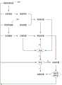
图1是本申请实施例1中设备信号传递的流程示意图;FIG. 1 is a schematic flowchart of device signal transmission in Embodiment 1 of the present application;
图2是本申请实施例1中工作流程的示意图;Fig. 2 is the schematic diagram of the workflow in the embodiment 1 of the present application;
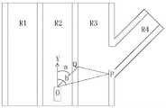
图3是本申请实施例1中车辆在车道R3中行驶时的结构示意图;FIG. 3 is a schematic structural diagram of the vehicle in the first embodiment of the present application when driving in the lane R3;
图4是本申请实施例1中车辆在车道R2中行驶时的结构示意图;FIG. 4 is a schematic structural diagram of a vehicle when driving in lane R2 in Embodiment 1 of the present application;
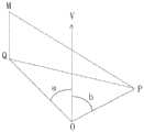
图5是本申请实施例1中确定车辆侧向位置的几何原理分析示意图;5 is a schematic diagram of the analysis of the geometric principle of determining the lateral position of the vehicle in Embodiment 1 of the present application;
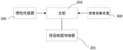
图6是本申请实施例2中模块连接关系示意图。FIG. 6 is a schematic diagram of a connection relationship of modules in
附图标记:Reference number:
100、惯性传感器;100. Inertial sensor;
200、主机;200, host;
201、预设地图;201. Preset map;
300、图像采集装置。300. An image acquisition device.
具体实施方式Detailed ways
为使本申请实施例的目的、技术方案和优点更加清楚,下面将结合本申请实施例中的附图,对本申请实施例中的技术方案进行清楚、完整地描述,显然,所描述的实施例是本申请一部分实施例,而不是全部的实施例。基于本申请中的实施例,本领域普通技术人员在没有作出创造性劳动前提下所获得的所有其他实施例,都属于本申请保护的范围。In order to make the purposes, technical solutions and advantages of the embodiments of the present application clearer, the technical solutions in the embodiments of the present application will be described clearly and completely below with reference to the drawings in the embodiments of the present application. Obviously, the described embodiments It is a part of the embodiments of the present application, but not all of the embodiments. Based on the embodiments in the present application, all other embodiments obtained by those of ordinary skill in the art without creative work fall within the protection scope of the present application.
在本申请实施例中使用的术语是仅仅出于描述特定实施例的目的,而非旨在限制本申请。在本申请实施例中所使用的单数形式的“一种”、“所述”和“该”也旨在包括多数形式,除非上下文清楚地表示其他含义。The terms used in the embodiments of the present application are only for the purpose of describing specific embodiments, and are not intended to limit the present application. As used in the embodiments of this application, the singular forms "a," "the," and "the" are intended to include the plural forms as well, unless the context clearly dictates otherwise.
应当理解,本文中使用的术语“和/或”仅仅是一种描述关联对象的关联关系,表示可以存在三种关系,例如,A和/或B,可以表示:单独存在A,同时存在A和B,单独存在B这三种情况。另外,本文中字符“/”,一般表示前后关联对象是一种“或”的关系。It should be understood that the term "and/or" used in this document is only an association relationship to describe the associated objects, indicating that there may be three kinds of relationships, for example, A and/or B, which may indicate that A exists alone, and A and B exist at the same time. B, there are three cases of B alone. In addition, the character "/" in this document generally indicates that the related objects are an "or" relationship.
取决于语境,如在此所使用的词语“如果”、“若”可以被解释成为“在……时”或“当……时”或“响应于确定”或“响应于检测”。类似地,取决于语境,短语“如果确定”或“如果检测(陈述的条件或事件)”可以被解释成为“当确定时”或“响应于确定”或“当检测(陈述的条件或事件)时”或“响应于检测(陈述的条件或事件)”。Depending on the context, the words "if", "if" as used herein may be interpreted as "at" or "when" or "in response to determining" or "in response to detecting". Similarly, the phrases "if determined" or "if detected (the stated condition or event)" can be interpreted as "when determined" or "in response to determining" or "when detected (the stated condition or event)," depending on the context )" or "in response to detection (a stated condition or event)".
还需要说明的是,术语“包括”、“包含”或者其任何其他变体意在涵盖非排他性的包含,从而使得包括一系列要素的商品或者系统不仅包括那些要素,而且还包括没有明确列出的其他要素,或者是还包括为这种商品或者系统所固有的要素。在没有更多限制的情况下,由语句“包括一个……”限定的要素,并不排除在包括所述要素的商品或者系统中还存在另外的相同要素。It should also be noted that the terms "comprising", "comprising" or any other variation thereof are intended to encompass non-exclusive inclusion, such that a commodity or system comprising a list of elements includes not only those elements, but also includes not explicitly listed other elements, or elements inherent to the commodity or system. Without further limitation, an element defined by the phrase "comprising a..." does not preclude the presence of additional identical elements in the article or system that includes the element.
实施例1Example 1
如图1和图2所示,本实施例提供一种定位方法,包括以下步骤:As shown in FIG. 1 and FIG. 2 , this embodiment provides a positioning method, which includes the following steps:
A1、采集场景图像;A1. Collect scene images;
A2、提取场景图像中的场景特征;A2. Extract the scene features in the scene image;
A3、将场景特征与预设地图中的预设特征匹配,若场景特征与预设特征相匹配,则将预设特征在预设地图中的位置作为推测位置。A3. Match the scene feature with the preset feature in the preset map. If the scene feature matches the preset feature, use the location of the preset feature in the preset map as the estimated location.
B1、采集车辆的运动数据;B1. Collect the motion data of the vehicle;
B2、利用运动数据计算得到计算位置;B2. Calculate the calculated position using motion data;
C1、选择推测位置和/或计算位置作为暂选位置。C1. Select the estimated position and/or the calculated position as the tentative position.
场景使用图像采集装置300进行采集,图像采集装置300可使用车辆上的摄像头或行车记录仪等,图像采集装置300采集实时环境图像,车载的主机200 对实时环境图像进行分割,根据预先训练好的识别模型对场景特征进行分类提取,提取到的信息包括车道线长度、与车辆之间的距离、相对于车辆的方向(或夹角)等信息,再将这些信息与预设地图中的信息匹配计算从而得到定位。The scene is collected by the
如图3和图4所示,图3和图4中的R1、R2、R3、R4表示交通车道,匹配计算定位的原理是,将场景特征与预设特征匹配后,主机200计算场景特征与车辆之间的夹角,并计算对应的预设特征之间的距离,由于场景特征与预设特征是相匹配的,所以可以将预设特征之间的距离作为场景特征之间的距离,通过场景特征之间的距离以及其与车辆之间的夹角能够计算出场景特征与车辆之间的距离。As shown in FIG. 3 and FIG. 4 , R1, R2, R3, and R4 in FIG. 3 and FIG. 4 represent traffic lanes. The principle of matching calculation and positioning is that after matching the scene features with the preset features, the
对应附图3和图4,车辆位置为O点,第一个场景特征位置为Q点,第二个场景特征位置为P点,车辆行驶方向为V向,Q与V之间的方向a作为第一个场景特征与车辆之间的夹角,P与V之间的方向b作为第二个场景特征与车辆之间的夹角,第一个场景与第二个场景特征之间的距离为距离PQ,车辆与第一个场景特征之间的距离为OQ,车辆与第二个场景特征之间的距离为OP。其中PQ是已知的,需要计算获得的是OP、OQ、a和b,a和b分别根据Q和P偏离其所在场景图像(例如照片)中心的距离计算得到,偏离中心的距离越大,夹角越大。Corresponding to Fig. 3 and Fig. 4, the vehicle position is point O, the feature position of the first scene is point Q, the feature position of the second scene is point P, the driving direction of the vehicle is the V direction, and the direction a between Q and V is taken as The angle between the first scene feature and the vehicle, the direction b between P and V is the angle between the second scene feature and the vehicle, and the distance between the first scene and the second scene feature is Distance PQ, the distance between the vehicle and the first scene feature is OQ, and the distance between the vehicle and the second scene feature is OP. Among them, PQ is known, and what needs to be calculated are OP, OQ, a and b. A and b are calculated according to the distances of Q and P from the center of the scene image (such as a photo) where they are located. The greater the distance from the center, the greater the distance from the center. The larger the angle is.
由余弦定理:By the law of cosines:

可知,两个场景特征无法确定场景特征与车辆之间的距离,因为OP和OQ 的大小互换后等式仍然可以成立,所以至少还需要第三个场景特征,第三个场景特征与O以及Q构成三角形,三个场景特征相对于车辆的方位关系可以确定下来,主机200通过计算三个场景特征之间的距离以及夹角,并计算场景特征分别与车辆之间的夹角,再结合三角函数定理计算得到OQ和OM。对OQ和OM 沿垂直于V的方向正交分解即可得到车辆侧向的位置。获得车辆侧向位置后,即可通过预设地图确定车辆所在的车道或者确定车辆与侧边障碍物之间的距离,当车辆由人驾驶时,便可以避免R3上的车辆误入支路R4,或者本应进入 R4时错过了进入R4的时间。It can be seen that the two scene features cannot determine the distance between the scene feature and the vehicle, because the equation can still be established after the sizes of OP and OQ are interchanged, so at least a third scene feature is required, and the third scene feature is related to O and Q constitutes a triangle, and the azimuth relationship of the three scene features relative to the vehicle can be determined. The
结合图5,例如,第三个场景特征位置为M,MQ、MP、PQ以及M、P、Q相互之间的夹角均为已知,因此M、P、Q相对于车辆O的方位可以确定,结合上述的余弦定理公式即可推导得出OQ以及OP之间的距离。Referring to Figure 5, for example, the feature position of the third scene is M, and the angles between MQ, MP, PQ and M, P, and Q are all known, so the orientations of M, P, and Q relative to vehicle O can be Determined, the distance between OQ and OP can be derived by combining the above cosine theorem formula.
在另一种可能的示例中,还可以通过计算场景特征在场景图像中的大小通过缩放比例与距离之间的关系换算得到车辆与场景特征之间的距离。In another possible example, the distance between the vehicle and the scene feature can also be obtained by calculating the size of the scene feature in the scene image by converting the relationship between the zoom ratio and the distance.
场景特征包括:车道线,和/或灯杆,和/或栏杆,和/或标识牌,和/或马路边缘。还包含车道线长度,距车辆距离方向等3D信息。Scene features include: lane lines, and/or light poles, and/or railings, and/or signage, and/or road edges. It also contains 3D information such as lane line length, distance and direction from the vehicle.
在另一种可能的示例中,通过获取车辆左侧车道线数量和距离灯杆和/或道路边缘的距离得到车辆当前的车道编号,进而得到周围路况信息。In another possible example, the current lane number of the vehicle is obtained by obtaining the number of lane lines on the left side of the vehicle and the distance from the light pole and/or the road edge, and then the surrounding road condition information is obtained.
预先训练好的识别模型,可以通过采集大量的场景图像,然后使用主机200 对场景图像中的特征进行选取并与预设地图匹配,每次匹配过程中用到的特征匹配策略以及匹配准确度都记录下来,在下一次匹配时参考上一次记录的匹配策略,匹配策略包括场景特征与预设特征的尺寸、场景特征与预设特征的颜色、场景特征与预设特征的方向、场景特征与预设特征的数量等的相似度,还包括各特征匹配的顺序、匹配过程所花时间等。The pre-trained recognition model can collect a large number of scene images, and then use the
通过基础传感器(车辆自带的传感器)感知周围环境特征,并经过主机200 计算分析提取场景特征与预设地图匹配实现车辆定位。基础传感器是指惯性传感器100例如IMU、轮速计等。基础传感器感知周围环境特征的方法包括:行车记录仪或摄像头采集场景图像,从场景图像中提取场景特征;GPS实时记录车辆地理位置(GPS在本实施例中不是必要的);轮速计和IMU记录车的运动数据,通过速度、方向、加速度等参数计算出车辆当前所在位置相对于上一次准确定位时所在位置之间的变化值,最终计算得出当前车辆所在的准确位置,因此在即使没有GPS定位的情况下,也能够通过惯性传感器100能够实现准确定位。The characteristics of the surrounding environment are sensed by basic sensors (sensors built into the vehicle), and the
预设地图可采用例如高精度地图,高精度地图是一种预先采集好并可以提供可行驶区域全部特征信息的地图,其中包含车道线类型、车道线颜色、车道线位置、几何形状、颜色信息、灯杆、栏杆、标识牌、马路边缘高度、方向(或角度)、数量等特征信息,为车辆提供更丰富的环境特征,便于快速采集并提取出场景特征。The preset map can be, for example, a high-precision map. A high-precision map is a map that has been collected in advance and can provide all the characteristic information of the drivable area, including the lane line type, lane line color, lane line position, geometric shape, and color information. , light poles, railings, signs, road edge height, direction (or angle), quantity and other feature information to provide vehicles with richer environmental features, which is convenient for rapid collection and extraction of scene features.
采用定位系统的车辆能够在GPS信号弱的环境中(例如山区、偏远地区等) 借助自带的惯性传感器100获取运动数据(例如速度、加速度、位移、方向等),提取摄像头采集的图像中的场景特征并将该特征与预设地图中的图像对比,若预设地图中存在与场景特征相同的特征,则将预设地图中对应特征所在位置作为场景特征所在的位置,从而实现定位功能。Vehicles using the positioning system can obtain motion data (such as speed, acceleration, displacement, direction, etc.) with the help of the built-in
在光线弱的环境中(例如晚上或地下室等),摄像头无法采集到准确的场景图像,因此,从光线充足到光线弱的过程中,惯性传感器100能够持续记录车辆的行驶路径,通过对行驶路径进行计算可以得到车辆进入光线弱的环境之后的实时位置,将进入光线弱的环境之后的实时位置与预设地图结合就能够检测车辆的实时位置。In a low-light environment (such as at night or in a basement), the camera cannot capture an accurate scene image. Therefore, the
综上,强光弱GPS环境中,摄像头采集场景图像,主机200提取场景特征与预设地图匹配实现定位;弱光弱GPS环境中,惯性传感器100从强光至弱光的过渡过程中持续计算并记录车辆的运动数据,通过主机200计算再与预设地图匹配实现实时定位,避免了因GPRS信号弱情况下导致定位不准的情况,提高了定位的鲁棒性。To sum up, in a strong light and weak GPS environment, the camera collects scene images, and the
选择推测位和/或计算位置作为暂选位置,包括:Select speculative bits and/or calculated positions as candidate positions, including:
C11、判断是否对推测位置和计算位置组合使用;C11. Determine whether to use a combination of the estimated position and the calculated position;
若不组合使用,则选择推测位置或计算位置作为暂选位置;If not used in combination, select the presumed position or the calculated position as the tentative position;
若组合使用,则利用推测位置与计算位置进一步处理,得到组合推算位置并作为暂选位置。If used in combination, the estimated position and the calculated position are used for further processing to obtain the combined estimated position and use it as a tentative position.
C111、若组合使用时,则判断推测位置和计算位置是否经过校正,若没有经过校正则将组合使用时对应的暂选位置作为初定位置,若经过校正则将组合使用时对应的暂选位置作为准确位置。C111. If used in combination, judge whether the presumed position and the calculated position have been corrected. If they have not been corrected, the tentatively selected position corresponding to the combined use will be used as the initial position. If corrected, the corresponding tentatively selected position will be used in combination. as the exact location.
组合使用包括:Combinations include:
C112、判断推测位置和计算位置之间的相对误差是否超出预设误差范围,若没有超出预设误差范围,则利用推测位置与计算位置进一步处理,得到组合推算位置并作为暂选位置;若超出预设误差范围则退出组合使用。C112. Determine whether the relative error between the estimated position and the calculated position exceeds the preset error range. If it does not exceed the preset error range, use the estimated position and the calculated position for further processing to obtain a combined estimated position and use it as a tentative position; The preset error range is out of combination use.
定位方法还包括:Positioning methods also include:
D1、对初定位置持续检测,判断其精度是否满足准确位置的要求,若满足则将初定位置确定为准确位置,否则基于初定位置误差情况对用于采集场景图像和运动数据的设备进行校正。D1. Continuously detect the initial position to determine whether the accuracy meets the requirements of the accurate position. If so, determine the initial position as the accurate position; Correction.
暂选位置属于临时检测到的位置,是一个没有经过检验准确度的定位信息,主要用于需要快速确定位置信息的情况,作为预先确定的位置,暂选位置可以临时使用并作为后续获得更高精度位置信息的基础数据,从而提高效率和工作的连续性,连续性指的是位置信息反馈给车辆运动控制系统的连续性,车辆控制系统基于位置信息控制车辆的运动方向和速度,当位置精度要求特别高的时候,位置信息反馈速度就会降低,而且会出现断续现象,通过将精度较低的暂选位置信息连续反馈给车辆的运动控制系统,计算出更高精度的位置信息后再将更高精度的位置信息反馈给车辆的运动控制系统用以取代暂选位置信息。The tentative location is a temporarily detected location, which is positioning information that has not been tested for accuracy. It is mainly used in situations where location information needs to be quickly determined. As a pre-determined location, the tentative location can be temporarily used as a follow-up to obtain higher Accuracy is the basic data of position information, thereby improving efficiency and continuity of work. Continuity refers to the continuity of position information fed back to the vehicle motion control system. The vehicle control system controls the vehicle's movement direction and speed based on position information. When the position accuracy When the requirements are particularly high, the feedback speed of position information will be reduced, and there will be intermittent phenomena. By continuously feeding back the temporarily selected position information with lower accuracy to the motion control system of the vehicle, after calculating the position information with higher accuracy, The higher-precision position information is fed back to the vehicle's motion control system to replace the tentative position information.
若要进一步获知定位信息的准确度,可以将暂选位置作为初定位置,在车辆行驶过程中,持续对初定位置进行检测,若检测过程中,若每次更新的初定位置与实际的场景对应预设地图上的位置差别不大,则将初定位置确定为准确位置。To further know the accuracy of the positioning information, the tentatively selected position can be used as the initial position. During the driving process of the vehicle, the initial position is continuously detected. If there is little difference between the locations on the preset map corresponding to the scene, the initial location is determined as the accurate location.
或者将推测位置和暂选位置组合并进行比较,若精度合格则表示经过校正,选择推测位置或计算位置作为准确位置,若精度不合格,则将其作为初定位置,继续检测初定位置的变化情况,若初定位置合格则将其作为准确位置,若初定位置不合格,则对用于采集实时场景图像以及运动数据的设备参数或数据进行调试维护。例如:若定位的位置偏后,则对设备采集的与车辆前后位置对应的参数或数据进行调整,若定位的位置偏左,则对设备采集的与车辆侧向位置对应的参数或数据进行调整,直到满足校正要求,最后将满足校正要求的推测位置或计算位置或初定位置作为准确位置。Or combine and compare the estimated position and the tentative position. If the accuracy is qualified, it means that it has been corrected. Select the estimated position or the calculated position as the accurate position. If the accuracy is unqualified, it will be used as the initial position, and continue to detect the initial position. If the initial position is qualified, it will be regarded as the accurate position. If the initial position is not qualified, the equipment parameters or data used to collect real-time scene images and motion data will be debugged and maintained. For example: if the positioning position is backward, adjust the parameters or data collected by the device corresponding to the front and rear positions of the vehicle; if the positioning position is left, adjust the parameters or data collected by the device corresponding to the lateral position of the vehicle , until the correction requirements are met, and finally the presumed position or the calculated position or the pre-determined position that meets the correction requirements is taken as the accurate position.
精度是否合格的判断方法:根据实验数据统计得到的经验数据定义一个精度标准,例如图像采集装置300采集的场景特征与对应的预设特征色差值RGB (±5,±5,±5)、高度H(±0.01m)、尺寸(±0.01m)、角度α(±1°)以及惯性传感器100检测到的速度v(±0.01m/s)、加速度a(±0.01m/s2)等,根据实验得出这些对于定位哪些参数影响权重,再结合实验数据得出判断规则,判断规则可以是,多个准确对单个偏差原则,即多个参数合格而单个参数不合格,则将该单个参数作为不合格的主要因素,主要对该参数对应的检测设备进行调整修正。The method for judging whether the accuracy is qualified: define an accuracy standard according to the empirical data obtained from the experimental data statistics, for example, the scene features collected by the
场景特征包括车道线颜色、路面颜色、灯杆形状、马路边缘高度等信息。Scene features include information such as lane line color, road surface color, light pole shape, and road edge height.
实施例2Example 2
如图6所示,本实施例提供一种用于车辆的定位系统,应用实施例1中任意一种方法,定位系统包括图像采集装置300、惯性传感器100、预设地图存储器201和主机200;图像采集装置300与主机200通讯连接,图像采集装置 300用于采集场景图像;惯性传感器100与主机200通讯连接,惯性传感器100 用于记录车辆的运动数据;预设地图保存在预设地图存储器201中,主机200 用于接收场景图像和运动数据并将场景图像与预设地图匹配。As shown in FIG. 6 , this embodiment provides a positioning system for a vehicle. Any method in Embodiment 1 is applied. The positioning system includes an
图像采集装置300使用车辆上的摄像头,图像采集装置300采集实时环境图像,主机200对实时环境图像进行分割,根据预先训练好的识别模型对场景特征进行分类提取,提取到的信息包括车道线长度、与车辆之间的距离、相对于车辆的方向等信息,再将这些信息与预设地图中的信息匹配从而得到定位。The
基础传感器使用IMU、GPS和轮速计,通过基础传感器感知周围环境特征,并经过主机200计算分析提取场景特征与预设地图匹配实现车辆定位。The basic sensor uses the IMU, GPS and wheel speedometer to perceive the surrounding environment features through the basic sensor, and the
预设地图可采用例如高精度地图,高精度地图是一种预先采集好并可以提供可行驶区域全部特征信息的地图,其中包含车道线类型、车道线颜色、车道线位置、几何形状、颜色信息、灯杆、栏杆、标识牌、马路边缘高度等特征信息,为车辆提供更丰富的环境特征,便于快速采集并提取出场景特征。The preset map can be, for example, a high-precision map. A high-precision map is a map that has been collected in advance and can provide all the characteristic information of the drivable area, including the lane line type, lane line color, lane line position, geometric shape, and color information. , light poles, railings, signs, road edge height and other feature information, to provide vehicles with richer environmental features, easy to quickly collect and extract scene features.
实施例3Example 3
本实施例提供一种车辆,包括车辆本体和定位系统,定位系统包括图像采集装置300、基础传感器、预设地图和主机200;图像采集装置300与主机200 通讯连接,图像采集装置300用于采集实时场景图像;基础传感器与主机200 通讯连接,基础传感器用于记录车辆的运动数据;预设地图保存在主机200中,主机200用于接收场景图像和运动数据并将场景图像与预设地图匹配。This embodiment provides a vehicle, including a vehicle body and a positioning system. The positioning system includes an
图像采集装置300使用车辆上的摄像头,图像采集装置300采集实时环境图像,主机200对实时环境图像进行分割,根据预先训练好的识别模型对场景特征进行分类提取,提取到的信息包括车道线长度、与车辆之间的距离、相对于车辆的方向等信息,再将这些信息与预设地图中的信息匹配从而得到定位。The
通过基础传感器(车辆自带的传感器)感知周围环境特征,并经过主机200 计算分析提取场景特征与预设地图匹配实现车辆定位。基础传感器是指惯性传感器100例如IMU、轮速计等。基础传感器感知周围环境特征的方法包括:行车记录仪或摄像头采集场景图像,从场景图像中提取场景特征;GPS实时记录车辆地理位置(GPS在本实施例中不是必要的);轮速计和IMU记录车的运动数据,通过速度、方向、加速度等参数计算出车辆当前所在位置相对于上一次准确定位时所在位置之间的变化值,最终计算得出当前车辆所在的准确位置,因此在即使没有GPS定位的情况下,也能够通过惯性传感器100能够实现准确定位。The characteristics of the surrounding environment are sensed by basic sensors (sensors built into the vehicle), and the
预设地图可采用例如高精度地图,高精度地图是一种预先采集好并可以提供可行驶区域全部特征信息的地图,其中包含车道线类型、车道线颜色、车道线位置、几何形状、颜色信息、灯杆、栏杆、标识牌、马路边缘高度、方向(或角度)、数量等特征信息,为车辆提供更丰富的环境特征,便于快速采集并提取出场景特征。The preset map can be, for example, a high-precision map. A high-precision map is a map that has been collected in advance and can provide all the characteristic information of the drivable area, including the lane line type, lane line color, lane line position, geometric shape, and color information. , light poles, railings, signs, road edge height, direction (or angle), quantity and other feature information to provide vehicles with richer environmental features, which is convenient for rapid collection and extraction of scene features.
采用定位系统的车辆能够在GPS信号弱的环境中(例如山区、偏远地区等) 借助自带的惯性传感器100获取运动数据(例如速度、加速度、位移、方向等),提取摄像头采集的图像中的场景特征并将该特征与预设地图中的图像对比,若预设地图中存在与场景特征相同的特征,则将预设地图中对应特征所在位置作为场景特征所在的位置,从而实现定位功能。Vehicles using the positioning system can obtain motion data (such as speed, acceleration, displacement, direction, etc.) with the help of the built-in
在光线弱的环境中(例如晚上或地下室等),摄像头无法采集到准确的场景图像,因此,从光线充足到光线弱的过程中,惯性传感器100能够持续记录车辆的行驶路径,通过对行驶路径进行计算可以得到车辆进入光线弱的环境之后的实时位置,将进入光线弱的环境之后的实时位置与预设地图结合就能够检测车辆的实时位置。In a low-light environment (such as at night or in a basement), the camera cannot capture an accurate scene image. Therefore, the
综上,强光弱GPS环境中,摄像头采集场景图像,主机200提取场景特征与预设地图匹配实现定位;弱光弱GPS环境中,惯性传感器100从强光至弱光的过渡过程中持续计算并记录车辆的运动数据,通过主机200计算再与预设地图匹配实现实时定位。To sum up, in a strong light and weak GPS environment, the camera collects scene images, and the
上述实施例中的“车辆”特别适用于无人车,但是不局限于无人车,有人驾驶的车辆同样可以使用上述实施例中的定位方法和定位系统。The "vehicle" in the above embodiments is particularly suitable for unmanned vehicles, but is not limited to unmanned vehicles, and a manned vehicle can also use the positioning method and positioning system in the above embodiments.
本领域技术人员可以清楚地了解到,为描述的方便和简洁,仅以上述各功能模块的划分进行举例说明,实际应用中,可以根据需要而将上述功能分配由不同的功能模块完成,即将装置的内部结构划分成不同的功能模块,以完成以上描述的全部或者部分功能。上述描述的装置的具体工作过程,可以参考前述方法实施例中的对应过程,在此不再赘述。Those skilled in the art can clearly understand that, for the convenience and brevity of the description, only the division of the above functional modules is used for illustration. The internal structure is divided into different functional modules to complete all or part of the functions described above. For the specific working process of the apparatus described above, reference may be made to the corresponding process in the foregoing method embodiments, and details are not described herein again.
值得注意的是,上述方法和系统实施例中,所包括的各个模块只是按照功能逻辑进行划分的,但并不局限于上述的划分,只要能够实现相应的功能即可;另外,各功能模块的具体名称也只是为了便于相互区分,并不用于限制本申请的保护范围。It is worth noting that in the above method and system embodiments, the modules included are only divided according to functional logic, but are not limited to the above division, as long as the corresponding functions can be realized; The specific names are only for the convenience of distinguishing from each other, and are not used to limit the protection scope of the present application.
另外,本领域普通技术人员可以理解实现上述各实施例方法中的全部或部分步骤是可以通过程序来指令相关的硬件来完成,相应的程序可以存储于一计算机可读取存储介质中,所述的存储介质,如ROM/RAM、磁盘或光盘等。In addition, those of ordinary skill in the art can understand that all or part of the steps in implementing the methods of the above embodiments can be completed by instructing relevant hardware through a program, and the corresponding program can be stored in a computer-readable storage medium. storage medium, such as ROM/RAM, magnetic disk or optical disk, etc.
最后应说明的是:以上各实施例仅用以说明本申请的技术方案,而非对其限制;尽管参照前述各实施例对本申请进行了详细的说明,本领域的普通技术人员应当理解:其依然可以对前述各实施例所记载的技术方案进行修改,或者对其中部分或者全部技术特征进行等同替换;而这些修改或者替换,并不使相应技术方案的本质脱离本申请各实施例技术方案的范围。Finally, it should be noted that the above embodiments are only used to illustrate the technical solutions of the present application, but not to limit them; although the present application has been described in detail with reference to the foregoing embodiments, those of ordinary skill in the art should understand that: The technical solutions described in the foregoing embodiments can still be modified, or some or all of the technical features thereof can be equivalently replaced; and these modifications or replacements do not make the essence of the corresponding technical solutions deviate from the technical solutions of the embodiments of the present application. scope.
Claims (12)
Priority Applications (1)
| Application Number | Priority Date | Filing Date | Title |
|---|---|---|---|
| CN202010151781.XACN111307165B (en) | 2020-03-06 | 2020-03-06 | Vehicle positioning method and system and unmanned vehicle |
Applications Claiming Priority (1)
| Application Number | Priority Date | Filing Date | Title |
|---|---|---|---|
| CN202010151781.XACN111307165B (en) | 2020-03-06 | 2020-03-06 | Vehicle positioning method and system and unmanned vehicle |
Publications (2)
| Publication Number | Publication Date |
|---|---|
| CN111307165Atrue CN111307165A (en) | 2020-06-19 |
| CN111307165B CN111307165B (en) | 2021-11-23 |
Family
ID=71152267
Family Applications (1)
| Application Number | Title | Priority Date | Filing Date |
|---|---|---|---|
| CN202010151781.XAActiveCN111307165B (en) | 2020-03-06 | 2020-03-06 | Vehicle positioning method and system and unmanned vehicle |
Country Status (1)
| Country | Link |
|---|---|
| CN (1) | CN111307165B (en) |
Cited By (9)
| Publication number | Priority date | Publication date | Assignee | Title |
|---|---|---|---|---|
| CN111959505A (en)* | 2020-06-29 | 2020-11-20 | 北京百度网讯科技有限公司 | Vehicle cruise control method, device, electronic equipment and storage medium |
| CN112284396A (en)* | 2020-10-29 | 2021-01-29 | 的卢技术有限公司 | Vehicle positioning method suitable for underground parking lot |
| CN112833880A (en)* | 2021-02-02 | 2021-05-25 | 北京嘀嘀无限科技发展有限公司 | Vehicle positioning method, positioning device, storage medium and computer program product |
| CN113008252A (en)* | 2021-04-15 | 2021-06-22 | 西华大学 | High-precision navigation device and navigation method based on panoramic photo |
| CN113537314A (en)* | 2021-06-30 | 2021-10-22 | 上海西井信息科技有限公司 | Longitudinal positioning method and device for unmanned vehicle, electronic equipment and storage medium |
| CN114117113A (en)* | 2022-01-28 | 2022-03-01 | 杭州宏景智驾科技有限公司 | Multi-feature point vehicle positioning method and device, electronic device and storage medium |
| CN115236713A (en)* | 2021-09-28 | 2022-10-25 | 上海仙途智能科技有限公司 | Device positioning system and method |
| CN116794702A (en)* | 2023-05-30 | 2023-09-22 | 名商科技有限公司 | GPS blind zone navigation method, system and readable storage medium |
| CN117590444A (en)* | 2024-01-16 | 2024-02-23 | 深圳市奇果物联科技有限公司 | Real-time tracking method and system based on asset cargo positioning information |
Citations (14)
| Publication number | Priority date | Publication date | Assignee | Title |
|---|---|---|---|---|
| CN101078632A (en)* | 2006-05-26 | 2007-11-28 | 富士通株式会社 | Mobile robot, and control method and program for the same |
| US20110118979A1 (en)* | 2009-11-19 | 2011-05-19 | Robert Bosch Gmbh | Automotive location data integrity |
| CN102620732A (en)* | 2011-01-27 | 2012-08-01 | 凹凸电子(武汉)有限公司 | Object positioning method, position calculation system, map system and positioning system |
| CN103033184A (en)* | 2011-09-30 | 2013-04-10 | 迈实电子(上海)有限公司 | Error correction method, device and system for inertial navigation system |
| US20140172293A1 (en)* | 2012-12-17 | 2014-06-19 | Industrial Technology Research Institute | Map matching device, system and method |
| CN103954275A (en)* | 2014-04-01 | 2014-07-30 | 西安交通大学 | Lane line detection and GIS map information development-based vision navigation method |
| CN104390643A (en)* | 2014-11-24 | 2015-03-04 | 上海美琦浦悦通讯科技有限公司 | Method for realizing indoor positioning based on multi-information fusion |
| CN104977011A (en)* | 2014-04-09 | 2015-10-14 | 广东融讯信息科技有限公司 | Positioning method and positioning device based on street-photographing image in electronic map |
| CN105953796A (en)* | 2016-05-23 | 2016-09-21 | 北京暴风魔镜科技有限公司 | Stable motion tracking method and stable motion tracking device based on integration of simple camera and IMU (inertial measurement unit) of smart cellphone |
| CN106370193A (en)* | 2016-08-30 | 2017-02-01 | 上海交通大学 | Vehicle integrated positioning system and method based on map matching |
| CN106556397A (en)* | 2015-09-25 | 2017-04-05 | 大唐半导体设计有限公司 | A kind of GNSS map-matching methods and device |
| US20180080775A1 (en)* | 2016-09-20 | 2018-03-22 | Trimble Inc. | Vehicle navigation by dead reckoning and GNSS-aided map-matching |
| CN108489482A (en)* | 2018-02-13 | 2018-09-04 | 视辰信息科技(上海)有限公司 | The realization method and system of vision inertia odometer |
| CN109239752A (en)* | 2018-09-29 | 2019-01-18 | 重庆长安汽车股份有限公司 | Vehicle positioning system |
- 2020
- 2020-03-06CNCN202010151781.XApatent/CN111307165B/enactiveActive
Patent Citations (14)
| Publication number | Priority date | Publication date | Assignee | Title |
|---|---|---|---|---|
| CN101078632A (en)* | 2006-05-26 | 2007-11-28 | 富士通株式会社 | Mobile robot, and control method and program for the same |
| US20110118979A1 (en)* | 2009-11-19 | 2011-05-19 | Robert Bosch Gmbh | Automotive location data integrity |
| CN102620732A (en)* | 2011-01-27 | 2012-08-01 | 凹凸电子(武汉)有限公司 | Object positioning method, position calculation system, map system and positioning system |
| CN103033184A (en)* | 2011-09-30 | 2013-04-10 | 迈实电子(上海)有限公司 | Error correction method, device and system for inertial navigation system |
| US20140172293A1 (en)* | 2012-12-17 | 2014-06-19 | Industrial Technology Research Institute | Map matching device, system and method |
| CN103954275A (en)* | 2014-04-01 | 2014-07-30 | 西安交通大学 | Lane line detection and GIS map information development-based vision navigation method |
| CN104977011A (en)* | 2014-04-09 | 2015-10-14 | 广东融讯信息科技有限公司 | Positioning method and positioning device based on street-photographing image in electronic map |
| CN104390643A (en)* | 2014-11-24 | 2015-03-04 | 上海美琦浦悦通讯科技有限公司 | Method for realizing indoor positioning based on multi-information fusion |
| CN106556397A (en)* | 2015-09-25 | 2017-04-05 | 大唐半导体设计有限公司 | A kind of GNSS map-matching methods and device |
| CN105953796A (en)* | 2016-05-23 | 2016-09-21 | 北京暴风魔镜科技有限公司 | Stable motion tracking method and stable motion tracking device based on integration of simple camera and IMU (inertial measurement unit) of smart cellphone |
| CN106370193A (en)* | 2016-08-30 | 2017-02-01 | 上海交通大学 | Vehicle integrated positioning system and method based on map matching |
| US20180080775A1 (en)* | 2016-09-20 | 2018-03-22 | Trimble Inc. | Vehicle navigation by dead reckoning and GNSS-aided map-matching |
| CN108489482A (en)* | 2018-02-13 | 2018-09-04 | 视辰信息科技(上海)有限公司 | The realization method and system of vision inertia odometer |
| CN109239752A (en)* | 2018-09-29 | 2019-01-18 | 重庆长安汽车股份有限公司 | Vehicle positioning system |
Cited By (15)
| Publication number | Priority date | Publication date | Assignee | Title |
|---|---|---|---|---|
| US11305771B2 (en) | 2020-06-29 | 2022-04-19 | Beijing Baidu Netcom Science And Technology Co., Ltd. | Method and apparatus for controlling cruise of vehicle, electronic device, and storage medium |
| CN111959505A (en)* | 2020-06-29 | 2020-11-20 | 北京百度网讯科技有限公司 | Vehicle cruise control method, device, electronic equipment and storage medium |
| CN112284396B (en)* | 2020-10-29 | 2023-01-03 | 的卢技术有限公司 | Vehicle positioning method suitable for underground parking lot |
| CN112284396A (en)* | 2020-10-29 | 2021-01-29 | 的卢技术有限公司 | Vehicle positioning method suitable for underground parking lot |
| CN112833880A (en)* | 2021-02-02 | 2021-05-25 | 北京嘀嘀无限科技发展有限公司 | Vehicle positioning method, positioning device, storage medium and computer program product |
| CN113008252A (en)* | 2021-04-15 | 2021-06-22 | 西华大学 | High-precision navigation device and navigation method based on panoramic photo |
| CN113008252B (en)* | 2021-04-15 | 2023-08-22 | 东莞市异领电子有限公司 | High-precision navigation device and navigation method based on panoramic photo |
| CN113537314A (en)* | 2021-06-30 | 2021-10-22 | 上海西井信息科技有限公司 | Longitudinal positioning method and device for unmanned vehicle, electronic equipment and storage medium |
| CN115236713A (en)* | 2021-09-28 | 2022-10-25 | 上海仙途智能科技有限公司 | Device positioning system and method |
| CN114117113A (en)* | 2022-01-28 | 2022-03-01 | 杭州宏景智驾科技有限公司 | Multi-feature point vehicle positioning method and device, electronic device and storage medium |
| CN114117113B (en)* | 2022-01-28 | 2022-06-10 | 杭州宏景智驾科技有限公司 | Multi-feature point vehicle positioning method and device, electronic device and storage medium |
| CN116794702A (en)* | 2023-05-30 | 2023-09-22 | 名商科技有限公司 | GPS blind zone navigation method, system and readable storage medium |
| CN116794702B (en)* | 2023-05-30 | 2023-12-22 | 名商科技有限公司 | GPS blind zone navigation method, system and readable storage medium |
| CN117590444A (en)* | 2024-01-16 | 2024-02-23 | 深圳市奇果物联科技有限公司 | Real-time tracking method and system based on asset cargo positioning information |
| CN117590444B (en)* | 2024-01-16 | 2024-04-12 | 深圳市奇果物联科技有限公司 | Real-time tracking method and system based on asset cargo positioning information |
Also Published As
| Publication number | Publication date |
|---|---|
| CN111307165B (en) | 2021-11-23 |
Similar Documents
| Publication | Publication Date | Title |
|---|---|---|
| CN111307165A (en) | A vehicle positioning method, positioning system and unmanned vehicle | |
| CN101447019B (en) | Image recognition device and image recognition method | |
| CN112991791B (en) | Traffic information identification and intelligent driving method, device, equipment and storage medium | |
| CN102208012B (en) | Landscape coupling reference data generation system and position measuring system | |
| KR101919366B1 (en) | Apparatus and method for recognizing vehicle location using in-vehicle network and image sensor | |
| CN108573611B (en) | Speed limit sign fusion method and speed limit sign fusion system | |
| CN102997926B (en) | A kind of method for obtaining navigation data | |
| CN113508277A (en) | Lane Marking Localization and Fusion | |
| CN113643431B (en) | A system and method for iterative optimization of visual algorithms | |
| CN110164164B (en) | The method of using the camera shooting function to enhance the accuracy of mobile phone navigation software to identify complex roads | |
| US20220355818A1 (en) | Method for a scene interpretation of an environment of a vehicle | |
| CN113850237B (en) | Internet vehicle target detection and evaluation method and system based on video and track data | |
| CN111127874B (en) | Overhead identification method and identification system | |
| CN110660113A (en) | Method and device for establishing characteristic map, acquisition equipment and storage medium | |
| CN113566824A (en) | Vehicle positioning method and device, electronic equipment and storage medium | |
| CN114199188A (en) | Intelligent detection system and method for bump at bridge head based on vehicle dynamics model | |
| CN110018503B (en) | Vehicle positioning method and positioning system | |
| CN118691779A (en) | A Transformer-based global positioning method for autonomous commercial vehicles on structured roads | |
| CN114910085B (en) | A vehicle fusion positioning method and device based on road administration facility recognition | |
| CN116448126A (en) | A navigation electronic map data generation automatic compensation verification system | |
| CN113627273B (en) | Expressway mileage stake mark positioning method based on vision | |
| CN114581509B (en) | A method and device for locating a target | |
| JP2001296138A (en) | Travel curvature calculation device | |
| CN111766619A (en) | A fusion navigation and positioning method and device assisted by intelligent identification of road signs | |
| CN115824231A (en) | Intelligent positioning management system for automobile running |
Legal Events
| Date | Code | Title | Description |
|---|---|---|---|
| PB01 | Publication | ||
| PB01 | Publication | ||
| SE01 | Entry into force of request for substantive examination | ||
| SE01 | Entry into force of request for substantive examination | ||
| GR01 | Patent grant | ||
| GR01 | Patent grant | ||
| TR01 | Transfer of patent right | Effective date of registration:20230712 Address after:200120, 1st and 2nd floors, No. 7, Lane 999, Haike Road, China (Shanghai) Pilot Free Trade Zone, Pudong New Area, Shanghai Patentee after:Neolithic Zhongyan (Shanghai) Technology Co.,Ltd. Address before:102209 Room 122, No. 3 Institute of Future Iron and Steel Research, Anshan Iron and Steel Co., Ltd., North Second Street, Future Science City, Changping District, Beijing Patentee before:NEOLIX TECHNOLOGIES Co.,Ltd. | |
| TR01 | Transfer of patent right | ||
| TR01 | Transfer of patent right | Effective date of registration:20250813 Address after:100176 Beijing City, Daxing District, Beijing Economic and Technological Development Zone, No. 10 Ronghua Central Road, Building 1, 17th Floor, Room 1703 Patentee after:NEOLIX TECHNOLOGIES Co.,Ltd. Country or region after:China Address before:201210 Shanghai Pudong New Area, China (Shanghai) Pilot Free Trade Zone, No. 7, Lane 999, Haikexi Road Patentee before:Neolithic Zhongyan (Shanghai) Technology Co.,Ltd. Country or region before:China | |
| TR01 | Transfer of patent right |