CN110889834A - A method for classification of surrounding rock of highway tunnel based on cloud computing - Google Patents
A method for classification of surrounding rock of highway tunnel based on cloud computingDownload PDFInfo
- Publication number
- CN110889834A CN110889834ACN201911133442.2ACN201911133442ACN110889834ACN 110889834 ACN110889834 ACN 110889834ACN 201911133442 ACN201911133442 ACN 201911133442ACN 110889834 ACN110889834 ACN 110889834A
- Authority
- CN
- China
- Prior art keywords
- surrounding rock
- tunnel
- grading
- rock
- classification
- Prior art date
- Legal status (The legal status is an assumption and is not a legal conclusion. Google has not performed a legal analysis and makes no representation as to the accuracy of the status listed.)
- Pending
Links
Images


Classifications
- G—PHYSICS
- G06—COMPUTING OR CALCULATING; COUNTING
- G06T—IMAGE DATA PROCESSING OR GENERATION, IN GENERAL
- G06T7/00—Image analysis
- G06T7/0002—Inspection of images, e.g. flaw detection
- G06T7/0004—Industrial image inspection
- G—PHYSICS
- G06—COMPUTING OR CALCULATING; COUNTING
- G06F—ELECTRIC DIGITAL DATA PROCESSING
- G06F18/00—Pattern recognition
- G06F18/20—Analysing
- G06F18/24—Classification techniques
- G—PHYSICS
- G06—COMPUTING OR CALCULATING; COUNTING
- G06T—IMAGE DATA PROCESSING OR GENERATION, IN GENERAL
- G06T7/00—Image analysis
- G06T7/10—Segmentation; Edge detection
- G06T7/11—Region-based segmentation
- G—PHYSICS
- G06—COMPUTING OR CALCULATING; COUNTING
- G06T—IMAGE DATA PROCESSING OR GENERATION, IN GENERAL
- G06T7/00—Image analysis
- G06T7/10—Segmentation; Edge detection
- G06T7/13—Edge detection
- G—PHYSICS
- G06—COMPUTING OR CALCULATING; COUNTING
- G06T—IMAGE DATA PROCESSING OR GENERATION, IN GENERAL
- G06T7/00—Image analysis
- G06T7/10—Segmentation; Edge detection
- G06T7/187—Segmentation; Edge detection involving region growing; involving region merging; involving connected component labelling
- G—PHYSICS
- G06—COMPUTING OR CALCULATING; COUNTING
- G06T—IMAGE DATA PROCESSING OR GENERATION, IN GENERAL
- G06T2207/00—Indexing scheme for image analysis or image enhancement
- G06T2207/20—Special algorithmic details
- G06T2207/20081—Training; Learning
- G—PHYSICS
- G06—COMPUTING OR CALCULATING; COUNTING
- G06T—IMAGE DATA PROCESSING OR GENERATION, IN GENERAL
- G06T2207/00—Indexing scheme for image analysis or image enhancement
- G06T2207/30—Subject of image; Context of image processing
- G06T2207/30108—Industrial image inspection
- G06T2207/30132—Masonry; Concrete
Landscapes
- Engineering & Computer Science (AREA)
- Theoretical Computer Science (AREA)
- Physics & Mathematics (AREA)
- Computer Vision & Pattern Recognition (AREA)
- General Physics & Mathematics (AREA)
- Data Mining & Analysis (AREA)
- Artificial Intelligence (AREA)
- Bioinformatics & Cheminformatics (AREA)
- Bioinformatics & Computational Biology (AREA)
- Evolutionary Biology (AREA)
- Evolutionary Computation (AREA)
- Life Sciences & Earth Sciences (AREA)
- General Engineering & Computer Science (AREA)
- Quality & Reliability (AREA)
- Image Processing (AREA)
Abstract
Description
Translated fromChinese技术领域technical field
本发明涉及一种基于云计算的公路隧道围岩分级方法,属于岩土工程技术领域。The invention relates to a road tunnel surrounding rock classification method based on cloud computing, and belongs to the technical field of geotechnical engineering.
背景技术Background technique
公路隧道围岩分级是根据围岩完整程度、破碎程度和地下水发育程度等指标将围岩划分维具有不同稳定程度的类别。围岩分级是确定隧道结构荷载、选择施工方法及支护形式的依据。总结国内外多种围岩分级方法可以看出,围岩分级从单因素逐渐发展为多因素表述方法,从定性描述逐步转化为定量的划分方式,近些年来发展为多种因素复合并加上了各种修正系数来评价。The classification of surrounding rock of highway tunnel is to divide the surrounding rock into categories with different degrees of stability according to the indicators such as the integrity degree, fragmentation degree and groundwater development degree of the surrounding rock. The classification of surrounding rock is the basis for determining the load of tunnel structure, selecting construction method and supporting form. Summarizing the various methods of classification of surrounding rock at home and abroad, it can be seen that the classification of surrounding rock has gradually developed from a single factor to a multi-factor expression method, and gradually transformed from a qualitative description to a quantitative classification method. Various correction factors were used to evaluate.
通常而言,围岩分级不仅对隧道的设计产生影响,还会决定工程的施工和造价。在设计阶段,围岩分级是根据数量有限的钻孔和物理勘探获得的岩石指标结合设计人员的工程经验对围岩初步分级;施工阶段根据施工中所揭示的岩体情况进行动态分级设计。Generally speaking, the classification of surrounding rock not only affects the design of the tunnel, but also determines the construction and cost of the project. In the design stage, the surrounding rock classification is a preliminary classification of the surrounding rock based on a limited number of drilling holes and rock indexes obtained from physical exploration combined with the designer's engineering experience; in the construction stage, the dynamic classification design is carried out according to the rock mass conditions revealed in the construction.
围岩分级指标的获取方法通常包括掌子面地质素描、室内抗压试验和现场地质调查等方法。虽然这些方法能得围岩进行分级所需参数,但是由于岩体性质和赋存条件十分复杂,仅用少数参数和某个数学公式难以全面准确概括所有情况,而且参数测试数量有限,数据的代表性和抽样的代表性均存在一定的局限,实施时难度较大。数码摄像及深度学习技术获取围岩结构面发育程度参数的方法,可以极大的减少施工阶段围岩分级指标获取时间,同时借助回弹试验确定岩体强度,通过云计算技术确定岩体的完整程度,提高施工阶段围岩分级指标可靠度,并可以将隧道掌子面图片保存于云端,便于类似工程参考交流、核查协作。The methods of obtaining the surrounding rock grading index usually include methods such as face geological sketch, indoor compression test and on-site geological survey. Although these methods can obtain the parameters required for the classification of the surrounding rock, due to the complex nature and occurrence conditions of the rock mass, it is difficult to comprehensively and accurately summarize all the conditions with only a few parameters and a certain mathematical formula, and the number of parameter tests is limited. There are certain limitations in the representativeness of the sample and the sampling, and it is difficult to implement. The method of obtaining the development degree parameters of the surrounding rock structure plane by digital camera and deep learning technology can greatly reduce the time for obtaining the surrounding rock classification index during the construction stage. It can improve the reliability of the surrounding rock grading index during the construction stage, and save the tunnel face pictures in the cloud, which is convenient for reference, exchange, verification and collaboration of similar projects.
发明内容SUMMARY OF THE INVENTION
本发明所要解决的技术问题在于克服现有围岩分级方法的不足,提供一种利用云计算技术自动化判定围岩等级的方法,解决传统分级方法施工成本高、效率低下、实时难度等缺点。The technical problem to be solved by the present invention is to overcome the deficiencies of the existing surrounding rock classification methods, and to provide a method for automatically determining surrounding rock grades using cloud computing technology, and to solve the shortcomings of traditional classification methods such as high construction cost, low efficiency, and real-time difficulty.
本发明采用以下技术方案解决上述技术问题:The present invention adopts the following technical solutions to solve the above-mentioned technical problems:
一种基于云计算的公路隧道围岩分级方法,步骤如下:A method for classifying surrounding rock of a road tunnel based on cloud computing, the steps are as follows:
S1获取公路隧道掌子面高清图像;S1 obtains high-definition images of the road tunnel face;
S2通过深度学习技术以及围岩图像识别技术,识别掌子面图像关于围岩分级的特征参数;S2.1利用深度学习技术处理掌子面高清图像,获取围岩特征基本参数,描绘结构面主要类型,获取围岩分级完整性系数;S2 uses deep learning technology and surrounding rock image recognition technology to identify the characteristic parameters of the face image related to surrounding rock classification; S2.1 uses deep learning technology to process high-definition images of the face face, obtain the basic parameters of surrounding rock characteristics, and describe the main structural plane. Type, obtain the surrounding rock classification integrity coefficient;
S2.2使用深度学习技术提取岩土边界,利用HIS值进行种类识别,对照普氏硬度系数表得出该种岩土的坚硬程度;S2.2 Use deep learning technology to extract rock and soil boundaries, use HIS value to identify types, and compare the hardness of the rock and soil with the Platts hardness coefficient table;
S2.3利用裂隙特征识别提取技术和形态分析方法计算节理组数和间距,获取结构面发育程度;S2.3 Calculate the number and spacing of joint groups by using fracture feature identification and extraction technology and morphological analysis methods to obtain the development degree of structural planes;
S2.4判断结构面是否有涌水状态出现及是否考虑地应力影响;S2.4 Judging whether there is water gushing on the structural surface and whether the influence of ground stress is considered;
S3利用MySQL技术建立公路隧道围岩特征图像数据库;S3 uses MySQL technology to build a feature image database of road tunnel surrounding rock;
S4利用C++语言在Matlab平台上编译公路隧道分级软件;S4 uses C++ language to compile highway tunnel classification software on Matlab platform;
S5上传掌子面高清图像到云分级系统,得出围岩分级的最终结果。S5 uploads the high-definition image of the face to the cloud grading system to obtain the final result of surrounding rock grading.
附图说明Description of drawings
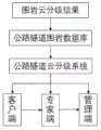
图1主要是公路隧道围岩云分级系统的组成图。Figure 1 is mainly the composition diagram of the surrounding rock cloud classification system of the highway tunnel.
图2是公路隧道围岩云分级具体流程图。Figure 2 is a detailed flow chart of the classification of surrounding rock clouds in highway tunnels.
图3掌子面图像识别围岩分级所需的基本参数示意图。Fig. 3 Schematic diagram of the basic parameters required for the identification of surrounding rock classification in the face image.
具体实施方案specific implementation
下面参照附图,对本发明的具体实施方案做进一步说明。The specific embodiments of the present invention will be further described below with reference to the accompanying drawings.
首先,在展开具体说明之前,如前所述,本发明属于(隧道工程)岩土工程中围岩分级识别技术领域,特别是涉及一种应用于公路铁路施工过程中的围岩等级划分,依靠高清掌子面图片自动识别出围岩分级所需的基本参数以及修正系数,最终确定掌子面围岩等级的方法。First of all, before the specific description, as mentioned above, the present invention belongs to the technical field of classification and identification of surrounding rock in geotechnical engineering (tunnel engineering), and in particular relates to a classification of surrounding rock used in highway and railway construction. The high-definition face picture automatically identifies the basic parameters and correction coefficients required for the classification of surrounding rock, and finally determines the method for the surrounding rock grade of the face.
图1主要是介绍公路隧道围岩云分级系统的组成,由图可以看出系统主要分为专家端、客户端、管理端,主要是通过对客户端中输入的高清掌子面图片识别计算来实现公路隧道围岩的等级;若是使用者认为客户端识别结果不够精确,可使用联网模式登陆专家端,通过专家进一步确认后获取隧道围岩的结果;最后通过系统中的管理端来实现隧道围岩分级案例的多样化和数据化。其中客户端主要由三部分组成:图片的储存、图片通过云端进行传输、图片的计算;管理端主要是对隧道围岩分级案例进行处理、统计和储存,以便遇到相似的隧道掌子面图片,可以对两者进行对比分析,形成隧道围岩数据的多样化和数据化,并进一步组成公路隧道围岩云分级系统大数据库。Figure 1 mainly introduces the composition of the highway tunnel surrounding rock cloud classification system. It can be seen from the figure that the system is mainly divided into an expert end, a client end, and a management end. Realize the grade of road tunnel surrounding rock; if the user thinks that the identification result of the client is not accurate enough, he can use the network mode to log in to the expert terminal, and obtain the result of the tunnel surrounding rock after further confirmation by the expert; finally, the management terminal in the system is used to realize the tunnel surrounding rock. Diversification and digitization of rock grading cases. The client is mainly composed of three parts: image storage, image transmission through the cloud, and image calculation; the management terminal mainly processes, counts and stores tunnel surrounding rock classification cases, so as to encounter similar tunnel face images , the two can be compared and analyzed to form the diversification and digitization of tunnel surrounding rock data, and further form a large database of highway tunnel surrounding rock cloud classification system.
图2中展示的是公路隧道围岩云分级具体流程。Figure 2 shows the specific process of classification of surrounding rock clouds in highway tunnels.
图3中展示了高清掌子面图片自动识别出围岩分级所需的基本参数的基本示意图。需要了解的是掌子面基本参数是节理的数量及间距。岩石节理裂隙是常见的一类结构面,具有分布广、粗细各异等特点,岩石表面残留部分挖机破坏痕迹,增加了裂隙图像处理的难度。基本的围岩分级需获取节理组数、间距两个指标来确定结构面完整程度。根据图1还需对岩石种类进行分类。主要是依据HIS值描述颜色特征,即按照掌子面图像中的一些HIS值特征将具有相似特征的像素的掌子面图像组成一个像素集 ,将其所代表的含义识别出来,并得到隧道围岩的岩石种类。综合以上的岩石种类、结构面完整程度、考虑地下水修正系数,得出围岩分级的最终结果。Figure 3 shows the basic schematic diagram of the high-definition face image to automatically identify the basic parameters required for the classification of surrounding rock. What needs to be understood is that the basic parameters of the face are the number and spacing of joints. Rock joints and fissures are a common type of structural plane, which has the characteristics of wide distribution and different thicknesses, and some traces of excavator damage remain on the rock surface, which increases the difficulty of fissure image processing. The basic surrounding rock classification needs to obtain the number of joint groups and spacing to determine the integrity of the structural plane. The rock types also need to be classified according to Figure 1. The color feature is mainly described according to the HIS value, that is, according to some HIS value features in the face image, the face image of the pixels with similar characteristics is formed into a pixel set, the meaning represented by it is identified, and the tunnel circumference is obtained. rock type. Based on the above rock types, structural plane integrity, and groundwater correction factor, the final result of surrounding rock classification is obtained.
图3中围岩分级中围岩特征模块分为以下几个步骤。The surrounding rock feature module in the surrounding rock classification in Figure 3 is divided into the following steps.
1.利用卷积神经网络alexnet模型对隧道采集的10000张掌子面图片分析。1. Use the convolutional neural network alexnet model to analyze the 10,000 face images collected by the tunnel.
(1)利用收集的代表签开挖掌子面图片进行训练,图片集由10000张掌子面高清图像组成,共7大类围岩形态。其中2000张作为测试集,8000张作为训练集,训练集中单一裂隙1100张,溶洞1100张,粗糙且成份单一1100张,平整1200张,成份复杂1100张,碎石1200张,密集节理1200张,测试集中单一裂隙裂隙300张,溶洞300张,粗糙且成份单一300张,平整300张,成份复杂300张,碎石300张,密集节理200张,由于本文模型修改自ImageNet模型,因此图片基本采用Imagenet模型所设大小和模式来进行训练和测试,图片的大小固定为256*256大小,储存为RGB格式JPG文本,原图像经过一些预处理将台车等干扰因素去除,收集的环境较好,大探照灯照射,光线较为充足,空气中粉尘颗粒较为稀少。高清的图片有利于获得较为准确的结果。(1) The excavation face images of the collected representatives are used for training. The image set consists of 10,000 high-definition images of the face, with a total of 7 types of surrounding rock shapes. Among them, 2000 are used as the test set, 8000 are used as the training set, 1100 single cracks, 1100 karst caves, 1100 rough and single composition, 1200 flat, 1100 complex composition, 1200 gravel, 1200 dense joints, In the test set, there are 300 single cracks, 300 karst caves, 300 rough and single components, 300 flat, 300 complex components, 300 gravel, and 200 dense joints. Since the model in this article is modified from the ImageNet model, the pictures are basically used. The size and mode set by the Imagenet model are used for training and testing. The size of the image is fixed at 256*256, and it is stored as JPG text in RGB format. The original image undergoes some preprocessing to remove interference factors such as trolleys, and the collection environment is better. The large searchlight is illuminated, the light is relatively sufficient, and the dust particles in the air are relatively rare. High-definition pictures are beneficial to obtain more accurate results.
(2)利用MATLAB软件中图像识别技术对10000张掌子面图片进行分割识别。主要对掌子面中围岩进行分类及识别掌子面围岩中的节理; 图像识别就是根据隧道围岩一些基本特征对图像进行分类和识别, 具体地说, 就是按照掌子面图像中的一些固有的特征将具有相似特征的像素的掌子面图像组成一个像素集 ,将其所代表的含义识别出来,并得到隧道围岩的一些基本参数, 其目的是研究出能够对隧道围岩图片自动进行识别分类的机器系统以完成人类模式识别功能 。(2) Use the image recognition technology in MATLAB software to segment and recognize 10,000 palm face images. It mainly classifies the surrounding rock in the tunnel face and identifies the joints in the surrounding rock of the tunnel face; image recognition is to classify and identify the image according to some basic characteristics of the tunnel surrounding rock, specifically, according to the image of the tunnel face. Some inherent features combine the face images of pixels with similar features into a pixel set, identify the meanings they represent, and obtain some basic parameters of the tunnel surrounding rock. A machine system that automatically performs recognition and classification to perform human pattern recognition.
2. 图像识别过程可分为2个阶段, 即图像分割、特征提取及分类。2. The image recognition process can be divided into two stages, namely image segmentation, feature extraction and classification.
(1)图像分割:即利用MATLAB软件中的图像分割技术对图片进行预处理,分离出掌子面中的岩石与土。(1) Image segmentation: that is, using the image segmentation technology in MATLAB software to preprocess the image to separate the rock and soil in the face.
(2)特征提取与分类:由(1)中分离出的岩石图片,利用颜色参量的统计特征法对关于岩土进行分类,具体分类方法步骤如下:(2) Feature extraction and classification: From the rock images separated in (1), the rock and soil are classified by the statistical feature method of color parameters. The specific classification method steps are as follows:
提取隧道围岩的RGB 颜色空间 ;RGB 颜色空间是一种根据人眼对不同波长的红、绿、蓝光做出锥状体细胞的敏感度描述的基础彩色模式,R、G、B 分别为图像红、绿、蓝的亮度值,大小限定在 0~1 或者在 0~255;Extract the RGB color space of the surrounding rock of the tunnel; RGB color space is a basic color mode to describe the sensitivity of cone cells to different wavelengths of red, green, and blue light, and R, G, and B are images respectively. The brightness values of red, green and blue are limited to 0 to 1 or 0 to 255;
提取隧道围岩的HIS 颜色空间;HIS 颜色空间是指颜色的色调、亮度和饱和度,H表示色调,描述颜色的属性,如黄、红、绿,用角度 0~360度来表示;S 是饱和度,即纯色程度的量度,反映彩色的浓淡,如深红、浅红,大小限定在 0~1;I 是亮度,反映可见光对人眼刺激的程度,它表征彩色各波长的总能量,大小限定在 0~1;Extract the HIS color space of the surrounding rock of the tunnel; HIS color space refers to the hue, brightness and saturation of the color, H represents the hue, and describes the attributes of the color, such as yellow, red, and green, which are represented by an angle of 0 to 360 degrees; S is the Saturation, that is, a measure of the degree of pure color, reflects the shade of color, such as dark red, light red, and the size is limited to 0 to 1; I is the brightness, which reflects the degree of visible light stimulation to the human eye, which represents the total energy of each wavelength of color, The size is limited to 0 to 1;
提取颜色特征,对颜色参量进行分析、统计、处理, RGB 和 HIS 颜色空间在颜色参量的统计特征中具有重要的作用;Extract color features, analyze, count and process color parameters, RGB and HIS color spaces play an important role in the statistical features of color parameters;
提取每个类别中和围岩分级相关的基本参数并记录。Extract and record the basic parameters related to surrounding rock classification in each category.
(3)识别掌子面围岩中的节理,得出节理的数量及间距的相关参数并记录。操作步骤如下:(3) Identify the joints in the surrounding rock of the face, and obtain and record the relevant parameters of the number and spacing of the joints. The operation steps are as follows:
a.把原图(彩色)二值化;a. Binarize the original image (color);
b.运用形态学闭运算对其进行处理;b. Use morphological closing operation to process it;
c.对二值图像进行中值滤波来降低噪声;c. Perform median filtering on the binary image to reduce noise;
d.提取滤波后图像中的小连通区域并与原图进行色彩比较, 然后根据比较结果来填充需要填充的区域;d. Extract the small connected areas in the filtered image and compare the colors with the original image, and then fill in the areas that need to be filled according to the comparison results;
e.用形态学细化算法细化;e. Refinement with morphological refinement algorithm;
f.需要的话将较短的节理擦除, 来研究主要节理;f. Erasing the shorter joints if necessary to study the main joints;
g.得出掌子面图片中节理的数量及间距,并确定围岩等级参数。g. Obtain the number and spacing of joints in the face picture, and determine the surrounding rock grade parameters.
3.综合以上的分类表格,考虑地下水修正系数,得出围岩分级的最终结果。3. Based on the above classification table and considering the groundwater correction factor, the final result of surrounding rock classification is obtained.
Claims (4)

Priority Applications (1)
| Application Number | Priority Date | Filing Date | Title |
|---|---|---|---|
| CN201911133442.2ACN110889834A (en) | 2019-11-19 | 2019-11-19 | A method for classification of surrounding rock of highway tunnel based on cloud computing |
Applications Claiming Priority (1)
| Application Number | Priority Date | Filing Date | Title |
|---|---|---|---|
| CN201911133442.2ACN110889834A (en) | 2019-11-19 | 2019-11-19 | A method for classification of surrounding rock of highway tunnel based on cloud computing |
Publications (1)
| Publication Number | Publication Date |
|---|---|
| CN110889834Atrue CN110889834A (en) | 2020-03-17 |
Family
ID=69747935
Family Applications (1)
| Application Number | Title | Priority Date | Filing Date |
|---|---|---|---|
| CN201911133442.2APendingCN110889834A (en) | 2019-11-19 | 2019-11-19 | A method for classification of surrounding rock of highway tunnel based on cloud computing |
Country Status (1)
| Country | Link |
|---|---|
| CN (1) | CN110889834A (en) |
Cited By (3)
| Publication number | Priority date | Publication date | Assignee | Title |
|---|---|---|---|---|
| CN112348014A (en)* | 2020-11-03 | 2021-02-09 | 招商局重庆公路工程检测中心有限公司 | Rapid identification method of surrounding rock level of tunnel face based on machine vision |
| KR102344741B1 (en)* | 2020-06-30 | 2021-12-29 | 주식회사 대림 | Method for analysis of blind ends in tunnels using artificial intelligence and Method for predicting front blind ends |
| CN114140448A (en)* | 2021-12-06 | 2022-03-04 | 广西路信云信息技术有限公司 | Tunnel face surrounding rock intelligent grading method and device based on deep learning |
Citations (5)
| Publication number | Priority date | Publication date | Assignee | Title |
|---|---|---|---|---|
| CN105842168A (en)* | 2016-03-17 | 2016-08-10 | 河海大学 | Surrounding rock grading method based on laser scanning technique |
| CN106570292A (en)* | 2016-11-14 | 2017-04-19 | 中建山东投资有限公司 | Super-large-cross-section tunnel-based surrounding rock classification method |
| CN106596896A (en)* | 2016-12-30 | 2017-04-26 | 山东大学 | On-site tunnel real-time surrounding rock classification system and method |
| CN109852165A (en)* | 2019-01-29 | 2019-06-07 | 长沙理工大学 | Super-hydrophobic mud stone modifying agent and preparation method thereof and mud stone modification method |
| CN110109895A (en)* | 2019-03-29 | 2019-08-09 | 山东大学 | Fender graded unified prediction and application suitable for TBM driving tunnel |
- 2019
- 2019-11-19CNCN201911133442.2Apatent/CN110889834A/enactivePending
Patent Citations (5)
| Publication number | Priority date | Publication date | Assignee | Title |
|---|---|---|---|---|
| CN105842168A (en)* | 2016-03-17 | 2016-08-10 | 河海大学 | Surrounding rock grading method based on laser scanning technique |
| CN106570292A (en)* | 2016-11-14 | 2017-04-19 | 中建山东投资有限公司 | Super-large-cross-section tunnel-based surrounding rock classification method |
| CN106596896A (en)* | 2016-12-30 | 2017-04-26 | 山东大学 | On-site tunnel real-time surrounding rock classification system and method |
| CN109852165A (en)* | 2019-01-29 | 2019-06-07 | 长沙理工大学 | Super-hydrophobic mud stone modifying agent and preparation method thereof and mud stone modification method |
| CN110109895A (en)* | 2019-03-29 | 2019-08-09 | 山东大学 | Fender graded unified prediction and application suitable for TBM driving tunnel |
Non-Patent Citations (1)
| Title |
|---|
| 李汪石: ""公路隧道围岩云分级系统的开发与应用"", 《中国优秀博硕士学位论文全文数据库(硕士)工程科技Ⅱ辑》* |
Cited By (3)
| Publication number | Priority date | Publication date | Assignee | Title |
|---|---|---|---|---|
| KR102344741B1 (en)* | 2020-06-30 | 2021-12-29 | 주식회사 대림 | Method for analysis of blind ends in tunnels using artificial intelligence and Method for predicting front blind ends |
| CN112348014A (en)* | 2020-11-03 | 2021-02-09 | 招商局重庆公路工程检测中心有限公司 | Rapid identification method of surrounding rock level of tunnel face based on machine vision |
| CN114140448A (en)* | 2021-12-06 | 2022-03-04 | 广西路信云信息技术有限公司 | Tunnel face surrounding rock intelligent grading method and device based on deep learning |
Similar Documents
| Publication | Publication Date | Title |
|---|---|---|
| CN108898085B (en) | An intelligent detection method of road diseases based on mobile phone video | |
| CN108416985B (en) | Geological disaster monitoring and early warning system and method based on image recognition | |
| CN101493888B (en) | PDC debris digital picture logging method | |
| CN110889834A (en) | A method for classification of surrounding rock of highway tunnel based on cloud computing | |
| CN109993766A (en) | Deep learning-based particle size detection method for sand and gravel images | |
| CN112232328A (en) | Remote sensing image building area extraction method and device based on convolutional neural network | |
| CN111626358B (en) | A Classification Method of Tunnel Surrounding Rock Based on BIM Image Recognition | |
| CN111882573B (en) | A method and system for extracting cultivated land plots based on high-resolution image data | |
| CN104217440B (en) | A kind of method extracting built-up areas from remote sensing images | |
| CN114140703A (en) | Intelligent recognition method and system for forest pine wood nematode diseases | |
| CN114663787A (en) | A single-wood segmentation method fused with UAV CHM and RGB images | |
| CN110672072A (en) | An information multivariate interpretation and characterization method for fractured rock mass structure | |
| CN107977968B (en) | Building Hierarchical Detection Method Based on Building Shadow Information Mining | |
| CN105243387A (en) | Open-pit mine typical ground object classification method based on UAV image | |
| CN115330664A (en) | Image recognition-based surrounding rock weathering degree full-automatic recognition method and device | |
| JP2021183774A (en) | Face evaluation system, face evaluation learning system, face evaluation method, face evaluation learning method, computer program | |
| CN114419088A (en) | Tunnel surrounding rock information extraction method based on digital image | |
| CN116503391A (en) | Tunnel face rock mass joint crack identification method and identification device | |
| CN109034189A (en) | Forest type identification method based on high score remote sensing image | |
| CN117372710A (en) | Forest gap extraction method based on Sentinel-2MSI remote sensing image | |
| CN103413131A (en) | Tower crane recognition method based on spectral and geometric characteristics | |
| CN103106655B (en) | The non-supervisory extracting method in a kind of building site based on remote sensing image | |
| CN116503331B (en) | Rapid and intelligent analysis method for rock mass quality grade | |
| CN117351358A (en) | Lin Dehua slope collapse identification method based on visible spectrum visual remote sensing | |
| CN119206468A (en) | Tunnel surrounding rock dynamic grading method based on geological radar and transfer learning |
Legal Events
| Date | Code | Title | Description |
|---|---|---|---|
| PB01 | Publication | ||
| PB01 | Publication | ||
| SE01 | Entry into force of request for substantive examination | ||
| SE01 | Entry into force of request for substantive examination | ||
| WD01 | Invention patent application deemed withdrawn after publication | ||
| WD01 | Invention patent application deemed withdrawn after publication | Application publication date:20200317 |