CN110333735B - A system and method for realizing secondary positioning of unmanned aerial vehicle in water and land - Google Patents
A system and method for realizing secondary positioning of unmanned aerial vehicle in water and landDownload PDFInfo
- Publication number
- CN110333735B CN110333735BCN201910592091.5ACN201910592091ACN110333735BCN 110333735 BCN110333735 BCN 110333735BCN 201910592091 ACN201910592091 ACN 201910592091ACN 110333735 BCN110333735 BCN 110333735B
- Authority
- CN
- China
- Prior art keywords
- positioning
- uav
- camera
- gps
- coordinate system
- Prior art date
- Legal status (The legal status is an assumption and is not a legal conclusion. Google has not performed a legal analysis and makes no representation as to the accuracy of the status listed.)
- Active
Links
- 238000000034methodMethods0.000titleclaimsabstractdescription35
- XLYOFNOQVPJJNP-UHFFFAOYSA-NwaterSubstancesOXLYOFNOQVPJJNP-UHFFFAOYSA-N0.000titleclaimsabstractdescription25
- 238000012545processingMethods0.000claimsabstractdescription40
- RZVHIXYEVGDQDX-UHFFFAOYSA-N9,10-anthraquinoneChemical compoundC1=CC=C2C(=O)C3=CC=CC=C3C(=O)C2=C1RZVHIXYEVGDQDX-UHFFFAOYSA-N0.000claimsabstractdescription18
- 238000005259measurementMethods0.000claimsdescription12
- 230000003287optical effectEffects0.000claimsdescription11
- 238000005516engineering processMethods0.000claimsdescription7
- 230000005540biological transmissionEffects0.000claimsdescription5
- 230000006698inductionEffects0.000claimsdescription5
- 230000003321amplificationEffects0.000claimsdescription3
- 238000006243chemical reactionMethods0.000claimsdescription3
- 238000003199nucleic acid amplification methodMethods0.000claimsdescription3
- 238000005070samplingMethods0.000claimsdescription3
- 230000001360synchronised effectEffects0.000claimsdescription3
- 125000004122cyclic groupChemical group0.000claimsdescription2
- 238000003384imaging methodMethods0.000claimsdescription2
- 239000011159matrix materialSubstances0.000claimsdescription2
- 238000013519translationMethods0.000claimsdescription2
- 239000003643water by typeSubstances0.000abstractdescription12
- DMBHHRLKUKUOEG-UHFFFAOYSA-NdiphenylamineChemical compoundC=1C=CC=CC=1NC1=CC=CC=C1DMBHHRLKUKUOEG-UHFFFAOYSA-N0.000abstract2
- 230000006870functionEffects0.000description6
- 238000011160researchMethods0.000description6
- 239000000463materialSubstances0.000description5
- 238000004364calculation methodMethods0.000description4
- 230000008447perceptionEffects0.000description4
- 230000009466transformationEffects0.000description4
- 230000003750conditioning effectEffects0.000description3
- 230000009429distressEffects0.000description3
- 239000000306componentSubstances0.000description2
- 238000010586diagramMethods0.000description2
- 230000000007visual effectEffects0.000description2
- 230000005856abnormalityEffects0.000description1
- 230000009286beneficial effectEffects0.000description1
- 210000004556brainAnatomy0.000description1
- 239000003638chemical reducing agentSubstances0.000description1
- 239000008358core componentSubstances0.000description1
- 230000007812deficiencyEffects0.000description1
- 238000012544monitoring processMethods0.000description1
- 230000002093peripheral effectEffects0.000description1
- 239000000725suspensionSubstances0.000description1
Images


Classifications
- G—PHYSICS
- G05—CONTROLLING; REGULATING
- G05D—SYSTEMS FOR CONTROLLING OR REGULATING NON-ELECTRIC VARIABLES
- G05D1/00—Control of position, course, altitude or attitude of land, water, air or space vehicles, e.g. using automatic pilots
- G05D1/10—Simultaneous control of position or course in three dimensions
- G05D1/101—Simultaneous control of position or course in three dimensions specially adapted for aircraft
- Y—GENERAL TAGGING OF NEW TECHNOLOGICAL DEVELOPMENTS; GENERAL TAGGING OF CROSS-SECTIONAL TECHNOLOGIES SPANNING OVER SEVERAL SECTIONS OF THE IPC; TECHNICAL SUBJECTS COVERED BY FORMER USPC CROSS-REFERENCE ART COLLECTIONS [XRACs] AND DIGESTS
- Y02—TECHNOLOGIES OR APPLICATIONS FOR MITIGATION OR ADAPTATION AGAINST CLIMATE CHANGE
- Y02A—TECHNOLOGIES FOR ADAPTATION TO CLIMATE CHANGE
- Y02A90/00—Technologies having an indirect contribution to adaptation to climate change
- Y02A90/30—Assessment of water resources
Landscapes
- Engineering & Computer Science (AREA)
- Aviation & Aerospace Engineering (AREA)
- Radar, Positioning & Navigation (AREA)
- Remote Sensing (AREA)
- Physics & Mathematics (AREA)
- General Physics & Mathematics (AREA)
- Automation & Control Theory (AREA)
- Control Of Position, Course, Altitude, Or Attitude Of Moving Bodies (AREA)
- Navigation (AREA)
- Position Fixing By Use Of Radio Waves (AREA)
Abstract
Description
Translated fromChinese技术领域technical field
本发明涉及无人机定位指挥技术,具体涉及一种实现无人机在水域和陆地之间实现二次定位的系统和方法。The invention relates to a positioning command technology of an unmanned aerial vehicle, in particular to a system and a method for realizing the secondary positioning of an unmanned aerial vehicle between water and land.
背景技术Background technique
无人机是利用无线电遥控设备和自备的程序控制装置进行操纵的无人驾驶飞行器。无人机不仅在军事侦察、作战等方面有所应用,近年来在危险环境如火灾、地震等灾害现场的搜查和救援领域也有广泛应用,目前更是大量应用在商业、娱乐等领域。在无人机配送方面国内外均在积极布局,研发专用配送无人机。UAV is an unmanned aerial vehicle that is controlled by radio remote control equipment and its own program control device. UAVs are not only used in military reconnaissance, combat, etc., but also have been widely used in the field of search and rescue in dangerous environments such as fires, earthquakes and other disaster sites in recent years. At present, they are widely used in business, entertainment and other fields. In terms of UAV distribution, both at home and abroad are actively deploying and developing special distribution UAVs.
随着人们对无人机的需求日益增加,越来越多的研究团队将精力投入到改善无人机相关功能和稳定性,并且在许多技术上获得了很大进展。但是无人机水陆定位方向的研究上,目前仍然没有低成本、高精度和高稳定性的方案。With the increasing demand for drones, more and more research teams have devoted their energy to improving the functions and stability of drones, and have made great progress in many technologies. However, there is still no low-cost, high-precision and high-stability solution for the research on the UAV's surface and land positioning direction.
定位控制技术是无人机关键技术之一,目前大多数的无人机使用GPS和/或北斗定位系统等其他粗略定位信号定位系统,因为GPS和/或北斗定位系统等其他粗略定位相关卫星数量足够多,并且分布均匀,可以确保全球全天候连续的导航定位服务,观测时间短,并且GPS和/或北斗定位系统等其他粗略定位测量的自动化程度较高,仪器操作简便。GPS和/或北斗定位系统等其他粗略定位的定位精度通常在几米左右,在一些对定位精度要求较高的场合,只使用GPS定位和/或北斗定位系统等其他粗略定位误差较大,无法满足要求,若要提高GPS精度,相应的成本会大幅提升,环境恶劣,天气情况较差或目标较为隐蔽的情况下,GPS信号和/或北斗定位系统等其他粗略定位信号容易丢失或受到干扰。GPS信号和/或北斗定位系统等其他粗略定位信号在传递过程中如果碰到水,传递也将会受到阻碍,接收器只能接收到微弱的讯号,且信号不够稳定,因此当定位涉及到水陆时,GPS信号和/或北斗定位系统等其他粗略定位信号效果较差。Positioning control technology is one of the key technologies of UAVs. At present, most UAVs use other rough positioning signal positioning systems such as GPS and/or Beidou positioning system because of the number of satellites related to other rough positioning such as GPS and/or Beidou positioning system. There are enough and evenly distributed to ensure global all-weather continuous navigation and positioning services, short observation time, and a high degree of automation of other rough positioning measurements such as GPS and/or Beidou positioning systems, and the instrument is easy to operate. The positioning accuracy of other rough positioning such as GPS and/or Beidou positioning system is usually around a few meters. In some occasions that require high positioning accuracy, only using GPS positioning and/or Beidou positioning system and other rough positioning errors are large and cannot be satisfied It is required that if the GPS accuracy is to be improved, the corresponding cost will be greatly increased. In the case of harsh environments, poor weather conditions or relatively hidden targets, GPS signals and/or other rough positioning signals such as Beidou positioning systems are easily lost or interfered. If GPS signals and/or other rough positioning signals such as Beidou positioning systems encounter water during the transmission process, the transmission will also be hindered. The receiver can only receive weak signals, and the signals are not stable enough. Therefore, when the positioning involves water and land , GPS signals and/or other rough positioning signals such as Beidou positioning systems are less effective.
针对GPS定位和/或北斗定位系统等其他粗略定位存在的部分缺点,视觉辅助导航以其低成本、高可靠性得到了研究者的广泛关注,视觉辅助导航是从图像中获取有效信息,将相关信息进行处理后实现无人机的定位,但是目前研究的视觉辅助系统不够成熟,并且大部分研究基于空旷陆地定位。Aiming at some of the shortcomings of other rough positioning such as GPS positioning and/or Beidou positioning system, visual aided navigation has received extensive attention from researchers due to its low cost and high reliability. After the information is processed, the positioning of the UAV can be realized, but the visual aid system currently researched is not mature enough, and most of the research is based on the open land positioning.
尽管目前很多研究人员对于提高无人机定位精度有所研究,但是相关研究停留在仅在陆地上实现无人机精准定位,而水域上多研究无人艇定位方案,针对无人机水陆二次定位的研究尚未出现,也没有将GPS定位和/或北斗定位系统等其他粗略定位与摄像机定位相结合应用在无人机水陆二次定位的方案。Although many researchers have done research on improving the positioning accuracy of UAVs, the related research is only on land to achieve accurate positioning of UAVs. The research on positioning has not yet appeared, and there is no scheme that combines GPS positioning and/or Beidou positioning system with other rough positioning and camera positioning in the secondary positioning of UAVs.
发明内容SUMMARY OF THE INVENTION
本发明所要解决的技术问题是针对现有技术的不足,提供一种无人机在水域和陆地之间实现二次定位的系统及其控制方法。The technical problem to be solved by the present invention is to provide a system and a control method for realizing secondary positioning between water and land by an unmanned aerial vehicle, aiming at the deficiencies of the prior art.
本发明的目的是通过以下技术方案实现的:一种具有二次定位功能的无人机智能系统,包括无人机,飞行控制系统,云台摄像机,机载中央处理器,地面测控站。The purpose of the present invention is achieved through the following technical solutions: an unmanned aerial vehicle intelligent system with a secondary positioning function, including an unmanned aerial vehicle, a flight control system, a pan-tilt camera, an airborne central processing unit, and a ground measurement and control station.
所述的无人机是利用无线电遥控设备和自备的程序控制装置的不载人飞机,可以在无人驾驶的条件下完成复杂空中飞行任务和各种负载任务,市面上常见的无人机即可,包括螺旋桨、电机马达、机体外壳、电池等硬件组成。The UAV described is an unmanned aircraft using radio remote control equipment and self-provided program control device, which can complete complex aerial flight tasks and various load tasks under unmanned conditions. Common UAVs on the market That is, it includes hardware components such as propellers, motors, body shells, and batteries.
所述的无人机飞行控制系统简称飞控,是指能够稳定无人机飞行姿态,并能控制无人机自主或半自主飞行的控制系统,其作用相当于无人机的大脑。飞行控制系统按照功能划分,其硬件组成部分包括主控制模块、信号调理及接口模块、数据采集模块和舵机驱动模块。数据采集模块实时采集各个传感器测量的无人机飞行状态数据,并将这些数据通过信号调理及接口模块通过相应算法计算后传输到主控制模块,主控制模块通过对数据进行处理后输出控制指令至舵机驱动模块,相应的无人机的飞行状态有所调整。The UAV flight control system referred to as flight control refers to a control system that can stabilize the flight attitude of the UAV and control the autonomous or semi-autonomous flight of the UAV, and its function is equivalent to the brain of the UAV. The flight control system is divided according to functions, and its hardware components include the main control module, the signal conditioning and interface module, the data acquisition module and the steering gear drive module. The data acquisition module collects the UAV flight state data measured by each sensor in real time, and transmits these data to the main control module through the signal conditioning and interface module through corresponding algorithm calculation. The main control module processes the data and outputs control commands to the For the servo drive module, the flight status of the corresponding UAV has been adjusted.
所述的主控制模块是指无人机飞行控制器,为无人机飞行控制系统的核心部件,通常为单片机和/或DSP和/或FPGA等操作系统模块,是把中央处理器的频率与规格做适当缩减,并将内存、计数器、USB、A/D转换、UART、PLC、DMA等周边接口,甚至LCD驱动电路都整合在单一芯片上,形成芯片级的计算机,对无人机飞行状态进行控制,其性能决定了飞行器是否能够飞得足够稳定,灵活。The main control module refers to the UAV flight controller, which is the core component of the UAV flight control system. The specifications are appropriately reduced, and peripheral interfaces such as memory, counter, USB, A/D conversion, UART, PLC, DMA, and even the LCD driver circuit are integrated on a single chip to form a chip-level computer. Control, its performance determines whether the aircraft can fly sufficiently stable and flexible.
所述的信号调理及接口模块是指无人机机载中央处理器和信号输入/输出设备,机载中央处理器主要用于数据处理及发送控制指令,其处理的数据主要包括所述的无人机数据采集模块监测到的数据,所述的云台摄像头识别的目标物体的数据以及所述的地面测控站发送的数据,对相关数据进行处理后,发送飞行指令至所述无人机主控制模块,调整无人机飞行轨迹及飞行状态。The signal conditioning and interface module refers to the UAV airborne central processing unit and signal input/output equipment. The airborne central processing unit is mainly used for data processing and sending control instructions. The data monitored by the man-machine data acquisition module, the data of the target object recognized by the PTZ camera and the data sent by the ground measurement and control station, after processing the relevant data, send flight instructions to the drone master. The control module adjusts the flight trajectory and flight status of the UAV.
所述的数据采集模块包含陀螺仪(即角速度计,用于飞行姿态感知)、加速度计、地磁感应、气压传感器(用于粗略计算悬停高度)、超声波传感器(用于低空高度精确控制及避障)、光流传感器(用于精确测量悬停水平位置)、GPS模块和/或北斗定位系统等其他粗略定位模块(用于粗略定位无人机水平位置)。上述传感器可以监测无人机飞行状态所有相关数据。The data acquisition module includes a gyroscope (that is, an angular velocity meter, used for flight attitude perception), an accelerometer, a geomagnetic induction, a barometric pressure sensor (used to roughly calculate the hovering height), and an ultrasonic sensor (used for accurate control and avoidance of low-altitude altitudes). obstacle), optical flow sensor (for accurate measurement of hovering horizontal position), GPS module and/or other rough positioning modules such as Beidou positioning system (for rough positioning of UAV horizontal position). The above sensors can monitor all relevant data of the flight status of the drone.
所述的舵机驱动模块即执行机构,负责无人机的动作执行,对于不同的输入信号将会有不同的输出信号,作为位置反馈的伺服系统,舵机主要由伺服放大器、直流伺服电机、减速器、位置反馈电位计和输出齿条组成。The steering gear drive module is the actuator, which is responsible for the action execution of the UAV. There will be different output signals for different input signals. As a servo system for position feedback, the steering gear is mainly composed of servo amplifiers, DC servo motors, It consists of a reducer, a position feedback potentiometer and an output rack.
所述的云台摄像机,即为机载摄像机,云台为稳定平台,其作用是为了给相机增稳,通过传感器感知机身动作,通过电机驱动使得相机保持在原来位置,抵消机身晃动的影响,机载摄像机是为了追踪目标物体,无人机飞至目标物体附近时,GPS定位和/或北斗定位系统等其他粗略定位精度无法精确目标物体位置,这时无人机采用摄像头定位。The PTZ camera is an airborne camera, and the PTZ is a stable platform. Its function is to increase the stability of the camera, sense the movement of the fuselage through the sensor, and keep the camera in the original position through the motor drive to offset the shaking of the fuselage. Influence, the on-board camera is used to track the target object. When the drone flies near the target object, other rough positioning accuracy such as GPS positioning and/or Beidou positioning system cannot accurately locate the target object. At this time, the drone uses the camera to locate.
所述的机载中央处理器是用于协调所述无人机的数据处理及控制指令发送的工作,包括处理GPS信号和/或北斗定位系统等其他粗略定位信号以及所述的云台摄像机采集到的定位数据,发送飞行指令到所述的无人机飞行控制系统,控制飞行器按照预设方向轨迹飞行。接收所述地面数据处理基站发送的数据,发送飞行指令到所述无人机飞行控制器,控制无人机飞行速度。The onboard central processing unit is used to coordinate the data processing of the UAV and the sending of control instructions, including processing GPS signals and/or other rough positioning signals such as the Beidou positioning system, as well as the collection of the PTZ camera. The received positioning data, send flight instructions to the UAV flight control system, and control the aircraft to fly according to the preset direction trajectory. Receive data sent by the ground data processing base station, and send flight instructions to the UAV flight controller to control the UAV flight speed.
所述的地面测控站,即地面控制中心,是一种由无线电遥控设备或对自身程序控制装置操纵,协调无人机的飞行任务,其功能是对无人机飞行全程监控、远程控制、实时获取传感器数据以及数据链路保障。无人机上的远距离数据链以及稳定的视频画面需要实时传输到地面测控站,当出现异常时,地面控制人员可以随时发出指令,对无人机下达新的任务规划。The ground measurement and control station, that is, the ground control center, is a radio remote control device or its own program control device to coordinate the flight tasks of the UAV. Get sensor data and data link assurance. The long-distance data link and stable video images on the UAV need to be transmitted to the ground measurement and control station in real time. When an abnormality occurs, the ground controller can issue instructions at any time to issue a new mission plan to the UAV.
目标船只通过手机发出信息至地面控制中心,控制中心接收信息后,发出指令给执行船只和无人机,执行船只由所述的无人机进行指挥,水域、空域协同工作,所述的无人机通过所述的水陆二次定位方法寻找目标船只,确定目标船只位置,并指挥执行船只到达目标船只附近,执行船只中安装压力传感器,压力传感器信号与所述的地面测控站之间实时传输,所述的无人机可以接收到地面测控站传输的信号,待检测到压力传感器相关信息后,指挥执行船只进行返程。The target ship sends information to the ground control center through the mobile phone. After the control center receives the information, it sends out instructions to the execution ship and the drone. The execution ship is commanded by the drone, and the waters and airspace work together. The aircraft finds the target ship through the said surface and land secondary positioning method, determines the position of the target ship, and directs the execution ship to reach the vicinity of the target ship, installs a pressure sensor in the execution ship, and transmits the signal of the pressure sensor to the ground measurement and control station in real time. The unmanned aerial vehicle can receive the signal transmitted by the ground measurement and control station, and after detecting the relevant information of the pressure sensor, instruct the execution vessel to make a return trip.
所述的实现无人机水陆二次定位的系统和方法分为两部分,在陆地范围及水域粗略定位采用GPS定位和/或北斗定位系统等其他粗略定位方法为主,GPS和/或北斗定位系统等其他定位方法只能获取粗略定位,无法获得更加精确的定位,到达目标船只附近,需通过无人机摄像头定位获得精确位置。The system and method for realizing the secondary positioning of the UAV on water and land is divided into two parts. The rough positioning in the land range and water area mainly adopts other rough positioning methods such as GPS positioning and/or Beidou positioning system, and GPS and/or Beidou positioning. Other positioning methods such as the system can only obtain rough positioning, and cannot obtain more precise positioning. To reach the vicinity of the target ship, it is necessary to obtain the precise position through the positioning of the drone camera.
所述的GPS定位和/或北斗定位系统等其他粗略定位为无人机常见定位方法,其基本原理是测量出已知位置的卫星到用户接收机之间的距离,综合多颗卫星的数据得到接收机的具体位置。The GPS positioning and/or the Beidou positioning system and other rough positioning methods are common positioning methods for UAVs. The exact location of the receiver.
所述的GPS定位和/或北斗定位系统等其他粗略定位方法具体步骤如下:The specific steps of other rough positioning methods such as the GPS positioning and/or Beidou positioning system are as follows:
1)获取目标船只GPS信号和/或北斗定位系统等其他粗略定位信号:目标船只将信息以及GPS定位信号和/或北斗定位系统等其他粗略定位信号通过手机数据传输发送给地面控制中心。地面控制中心获取目标船只中的手机GPS信号和/或北斗定位系统等其他粗略定位信号后,通过串口指令形式将此信号传输至无人机机载中央处理器,机载中央处理器获得相关信号后对数据进行处理,机载中央处理器将处理好的信号传输至无人机飞行控制器。1) Obtain the target ship's GPS signal and/or other rough positioning signals such as Beidou positioning system: The target ship sends the information and other rough positioning signals such as GPS positioning signal and/or Beidou positioning system to the ground control center through mobile phone data transmission. After the ground control center obtains the GPS signal of the mobile phone and/or other rough positioning signals such as Beidou positioning system in the target ship, it transmits the signal to the onboard CPU of the UAV in the form of serial commands, and the onboard CPU obtains the relevant signals After processing the data, the onboard central processor transmits the processed signal to the UAV flight controller.
2)获取无人机GPS信号和/或北斗定位系统等其他粗略定位信号:无人机包含GPS模块和/或北斗定位系统等其他粗略定位模块,无人机GPS模块和/或北斗定位系统等其他粗略定位模块直接与飞行控制器连接,获取无人机自身位置信息。2) Obtain UAV GPS signals and/or other rough positioning signals such as Beidou positioning system: The drone contains GPS module and/or other rough positioning modules such as Beidou positioning system, UAV GPS module and/or Beidou positioning system, etc. Other rough positioning modules are directly connected to the flight controller to obtain the position information of the drone itself.
3)无人机确定位置:无人机飞控系统获取当前无人机的位置信号以及目标船只的位置信号,此时,完成对目标船只完成初步定位。3) The UAV determines the position: the UAV flight control system obtains the position signal of the current UAV and the position signal of the target ship. At this time, the preliminary positioning of the target ship is completed.
所述的摄像头定位是指无人机携带机载摄像机,识别目标物体。分为两部分,第一部分摄像头需识别执行船只在水域运动过程中的障碍物。第二部分摄像头需检测目标小船的位置。The camera positioning refers to that the drone carries an airborne camera to identify the target object. Divided into two parts, the first part of the camera needs to identify the obstacles in the process of executing the ship's movement in the water. The second part of the camera needs to detect the position of the target boat.
所述的摄像头定位具体步骤为:The specific steps of the camera positioning are as follows:
1)摄像头标定,获取相关参数:本文采用线性模型又称为针孔模型。获得空间某点的三维几何位置坐标和其对应在摄像头中的二维图像位置坐标,通过坐标系转换关系即可获得摄像头内外参数。各坐标系之间转换关系如图7所示。1) Camera calibration to obtain relevant parameters: This paper uses a linear model, also known as a pinhole model. The three-dimensional geometric position coordinates of a point in space and the corresponding two-dimensional image position coordinates in the camera are obtained, and the internal and external parameters of the camera can be obtained through the coordinate system transformation relationship. The conversion relationship between the coordinate systems is shown in Figure 7.
图7中共有四个坐标系,分别为世界坐标系Ow-Xw,Yw,Zw,摄像头坐标系Oc-Xc,Yc,Zc、图像像素坐标系O-uv、图像物理坐标系O-xy,其中,摄像头坐标系原点Oc为摄像头光心,Z轴与光轴重合。图像像素坐标系原点为图像左上角,单位长度为图像像素数。图像物理坐标系的坐标原点为光轴和成像平面的交点,x轴、y轴分别与Xc轴、Yc轴平行。图中f代表焦距,P是三维世界中任意一点,设其在世界坐标系下的坐标为(Xw,Yw,Zw),在摄像头坐标系下的坐标为(Xc,Yc,Zc),在图像物理坐标系下的坐标为(x,y),在图像像素坐标系下的坐标为(u,v)。There are four coordinate systems in Figure 7, namely the world coordinate system Ow-Xw, Yw, Zw, the camera coordinate system Oc-Xc, Yc, Zc, the image pixel coordinate system O-uv, and the image physical coordinate system O-xy, among which , the origin Oc of the camera coordinate system is the optical center of the camera, and the Z axis coincides with the optical axis. The origin of the image pixel coordinate system is the upper left corner of the image, and the unit length is the number of image pixels. The coordinate origin of the image physical coordinate system is the intersection of the optical axis and the imaging plane, and the x-axis and the y-axis are parallel to the Xc-axis and the Yc-axis, respectively. In the figure, f represents the focal length, and P is any point in the three-dimensional world. Let its coordinates in the world coordinate system be (Xw, Yw, Zw), and the coordinates in the camera coordinate system are (Xc, Yc, Zc), in the image The coordinates in the physical coordinate system are (x, y), and the coordinates in the image pixel coordinate system are (u, v).
则(x,y)与(u,v)之间对应关系为:Then the correspondence between (x, y) and (u, v) is:

式中:dx、dy分别为每个像素点对应在图像坐标系x、y轴上的物理尺寸,(u0、v0)为图像物理坐标系的原点对应的图像像素坐标系中的坐标。In the formula: dx and dy are the physical dimensions of each pixel on the x and y axes of the image coordinate system, respectively, and (u0, v0) are the coordinates in the image pixel coordinate system corresponding to the origin of the image physical coordinate system.
(x,y)与(Xc,Yc,Zc)之间对应关系为:The correspondence between (x, y) and (Xc, Yc, Zc) is:

(Xc,Yc,Zc)与(Xw,Yw,Zw)之间对应关系为:The correspondence between (Xc, Yc, Zc) and (Xw, Yw, Zw) is:

式中R=R(α,β,γ)为3×3旋转矩阵,α,β,γ分别为P点在摄像头坐标系下绕Xc,Yc,Zc轴的旋转角度,t为3×1平移向量。0T=[0,0,0]。In the formula, R=R(α, β, γ) is a 3×3 rotation matrix, α, β, and γ are the rotation angles of point P around the Xc, Yc, and Zc axes in the camera coordinate system, and t is the 3×1 translation. vector. 0T = [0, 0, 0].
由式(1)(2)(3)可以推出:It can be deduced from formula (1)(2)(3):


式中
由此可以看出,已知点的图像像素坐标及其和世界坐标系之间的对应关系即可得到摄像头的内参数、外参数,实现摄像头标定。It can be seen from this that the internal parameters and external parameters of the camera can be obtained by knowing the image pixel coordinates of the points and the corresponding relationship between them and the world coordinate system, so as to realize the camera calibration.
2)获取水域中障碍物位置信息,进行路径规划。无人机通过机载摄像机识别水域中的船只等障碍物,并将其参数和提取到的摄像头拍摄照片中部分点的图像像素坐标发送至无人机机载中央处理器,无人机机载中央处理器对数据进行处理之后进行路径规划,保证水域中执行船只实现避障,安全行驶。2) Obtain the location information of obstacles in the waters and carry out path planning. The drone recognizes obstacles such as ships in the water through the onboard camera, and sends its parameters and the image pixel coordinates of some points in the extracted camera photos to the drone's onboard central processor. After processing the data, the central processor performs path planning to ensure that the executing ships in the waters can avoid obstacles and drive safely.
3)到达目标船只附近,识别目标船只。GPS定位和/或北斗定位系统等其他粗略定位确定目标船只大致位置之后,到达目标船只附近,无人机通过机载中央处理器发送一段指令至地面控制中心,地面控制中心将其转化为链接发至送货船只手机中。手机打开链接,闪光灯将以一定频率及步长循环闪烁,将手机放置在露天环境下,无人机机载摄像机进行视频采集,采集过程符合采样定理,将采集到的信息传输至无人机机载中央处理器,无人机机载中央处理器通过欧拉视频放大技术识别闪烁着的闪光灯,分割视频采集到的画面,对信息进行处理,得到不同区域闪光灯循环闪烁频率解码,将所获解码与地面控制中心发送的目标编码进行比对,找到吻合的画面区域,获取目标船只的精确定位信息。若手机可发出特殊光,地面控制中心也可发送特定光编码,视频采集只需对光进行解码即可,将解码与目标编码进行比对,找到吻合的画面区域,亦可获取目标船只的精确定位信息。定位信息传输至无人机飞控系统,无人机飞行控制器进行路径规划,并发送指令至执行船只。3) Reach the vicinity of the target vessel and identify the target vessel. After the approximate position of the target ship is determined by GPS positioning and/or other rough positioning such as Beidou positioning system, the drone reaches the vicinity of the target ship. The UAV sends a command to the ground control center through the on-board central processor, and the ground control center converts it into a link to send to the mobile phone of the delivery vessel. When the mobile phone opens the link, the flash will flash cyclically at a certain frequency and step size. Place the mobile phone in an open air environment, and the onboard camera of the drone will collect video. The acquisition process conforms to the sampling theorem, and the collected information will be transmitted to the drone. On-board central processing unit, the on-board central processing unit of the UAV identifies the flashing flashes through Euler video amplification technology, divides the pictures collected by the video, processes the information, and obtains the flashing cycle frequency decoding of the flashing lights in different areas, and decodes the obtained Compare with the target code sent by the ground control center, find the matching picture area, and obtain the precise positioning information of the target ship. If the mobile phone can emit special light, the ground control center can also send a specific light code, and the video capture only needs to decode the light, compare the decoding with the target code, find the matching picture area, and also obtain the accurate information of the target ship. location information. The positioning information is transmitted to the UAV flight control system, and the UAV flight controller performs path planning and sends instructions to the execution vessel.
所述的无人机飞控系统控制方法及路径规划具体如下:The control method and path planning of the UAV flight control system are as follows:
1)飞行控制器调节:无人机飞行控制器通过数据采集模块采集到的数据包含陀螺仪(即角速度计,用于飞行姿态感知)、加速度计、地磁感应、气压传感器(用于粗略计算悬停高度)、超声波传感器(用于低空高度精确控制及避障)、光流传感器(用于精确测量悬停水平位置)、GPS模块和/或北斗定位系统等其他粗略定位模块(用于粗略定位无人机水平位置)等数据信息,同时接收机载中央处理器传输的飞行指令,按照指令要求,无人机保障自身在空中平稳飞行且按照机载中央处理器规划的路径进行运动。1) Flight controller adjustment: The data collected by the UAV flight controller through the data acquisition module includes gyroscope (ie angular velocity meter, used for flight attitude perception), accelerometer, geomagnetic induction, and air pressure sensor (used for rough calculation of suspension. stop height), ultrasonic sensors (for precise control of low altitude and obstacle avoidance), optical flow sensors (for accurate measurement of hovering horizontal position), GPS module and/or other rough positioning modules such as Beidou positioning system (for rough positioning UAV horizontal position) and other data information, and at the same time receive the flight instructions transmitted by the on-board central processing unit, according to the instruction requirements, the drone guarantees itself to fly smoothly in the air and move according to the path planned by the on-board central processing unit.
2)机载中央处理器调节:机载中央处理器通过目标船只手机发出的GPS信号和/或北斗定位系统等其他粗略定位信号而获得的目标船只大致位置信息、无人机自身的GPS信号模块和/或北斗定位系统等其他粗略定位模块、机载摄像机识别到的水域中障碍物位置信息,以及机载摄像机识别闪光灯频率编码而获得的目标船只具体位置信息,向无人机飞行控制器下达飞行指令,保证无人机朝向目标船只运动,执行船只与无人机保持同步运动,且执行船只运动过程中避开障碍物。机载中央处理器接收地面测控中心数据处理基站发出的数据,包括执行船只中压力传感器的数据以判断送货是否完成。2) Airborne central processing unit adjustment: The airborne central processing unit obtains the approximate position information of the target vessel through the GPS signal sent by the target vessel's mobile phone and/or other rough positioning signals such as Beidou positioning system, and the GPS signal module of the drone itself. and/or other rough positioning modules such as Beidou positioning system, the position information of obstacles in the water identified by the airborne camera, and the specific position information of the target vessel obtained by the airborne camera identifying the flash frequency code, and send it to the UAV flight controller. The flight command ensures that the drone moves towards the target ship, executes the movement of the ship and the drone in synchronization, and avoids obstacles during the movement of the ship. The onboard central processor receives the data sent by the data processing base station of the ground monitoring and control center, including the data of the pressure sensor in the execution vessel to judge whether the delivery is completed.
3)地面计算处理调节:向机载中央处理器发送命令,按照压力传感器输出的结果来指挥无人机返程。3) Ground computing and processing adjustment: send commands to the airborne central processing unit, and command the UAV to return according to the output of the pressure sensor.
附图说明Description of drawings
图1是本系统场景示意图;Figure 1 is a schematic diagram of the system scene;
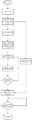
图2是无人机机载摄像机识别障碍物流程图;Figure 2 is the flow chart of the UAV airborne camera to identify obstacles;
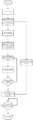
图3是本系统的完整工作流程图(手机使用普通闪光灯);Figure 3 is the complete working flow chart of the system (the mobile phone uses a common flash);
图4是本系统的完整工作流程图(手机可发出特殊光);Figure 4 is the complete working flow chart of the system (the mobile phone can emit special light);
图5是无人机送货的工作流程图(手机使用普通闪光灯);Figure 5 is the workflow of drone delivery (mobile phone uses ordinary flash);
图6是无人机送货的工作流程图(手机可发出特殊光);Figure 6 is the working flow chart of drone delivery (the mobile phone can emit special light);
图7是各坐标系之间变换关系原理图。FIG. 7 is a schematic diagram of the transformation relationship between the coordinate systems.
本发明有益成果:Beneficial achievements of the present invention:
(1)本发明可实现无人机水陆二次高精确定位。(1) The present invention can realize the secondary high-precision positioning of the UAV on water and land.
(2)本发明的无人机可实现自动规划路径及返程的功能。(2) The unmanned aerial vehicle of the present invention can realize the functions of automatic path planning and return trip.
(3)本发明仅使用一个无人机机载摄像机即可完成船只在水域中避障及精确识别目标船只。(3) The present invention can complete obstacle avoidance and accurate identification of target ships in waters by using only one UAV airborne camera.
(4)本发明中无人机通过GPS定位和/或北斗定位系统等其他粗略定位及摄像头定位识别水域中目标船只并指挥水域中船只到达目标船只,系统具备低成本、高自动化和高稳定性等特点。(4) In the present invention, the UAV uses GPS positioning and/or Beidou positioning system and other rough positioning and camera positioning to identify the target vessel in the waters and direct the vessels in the waters to reach the target vessel. The system has low cost, high automation and high stability Features.
具体实施方式Detailed ways
为了更详细地说明本发明的一种实现无人机水陆二次定位的系统和方法,下面根据附图详细说明本发明。In order to describe in more detail a system and method for realizing secondary positioning of unmanned aerial vehicles in water and land of the present invention, the present invention will be described in detail below according to the accompanying drawings.
实施例1:Example 1:
下面以无人机指挥执行船只(送货船只)为目标船只(西湖等景区游船)送货或外卖为例,具体说明一种实现无人机水陆二次定位的系统和方法。In the following, a system and method for realizing the secondary positioning of the UAV on water and land will be described in detail by taking the UAV commanding and executing the vessel (delivery vessel) as the target vessel (the cruise ship in scenic spots such as West Lake) for delivery or takeout as an example.
步骤一,目标船只(游船)通过手机对所需货物进行下单,控制中心接收订单完成配货后,将相关货物放置执行船只(送货船只)中。Step 1, the target vessel (cruise vessel) places an order for the required goods through a mobile phone, and after the control center receives the order and completes the distribution, the relevant goods are placed in the execution vessel (delivery vessel).
步骤二,控制中心发出指令,执行船只(送货船只)及无人机出发,执行船只的前进与无人机保持同步,由所述的无人机进行指挥,水域、空域协同工作。In step 2, the control center issues an instruction to execute the departure of the ship (delivery vessel) and the drone, and the movement of the execution vessel is synchronized with the drone. The drone is commanded, and the waters and airspace work together.
无人机飞行路线规划及控制具体如下:The UAV flight route planning and control are as follows:
1)GPS定位和/或北斗定位系统等其他粗略定位方法获取大致定位信息:游客向地面控制中心发送订单时将手机GPS定位信号和/或北斗定位系统等其他粗略定位信号与地面控制中心共享,地面控制中心通过串口指令形式将游客手机的GPS信号和/或北斗定位系统等其他粗略定位信号传输至无人机机载中央处理器。机载中央处理器接收到游客手机GPS信号和/或北斗定位系统等其他粗略定位信号以及无人机GPS模块和/或北斗定位系统等其他粗略定位模块传输的无人机本身位置信号后对数据进行处理,将处理好的信号传输至无人机飞行控制器,对游船完成初步定位。1) GPS positioning and/or other rough positioning methods such as Beidou positioning system to obtain rough positioning information: when tourists send orders to the ground control center, they share the mobile phone GPS positioning signal and/or other rough positioning signals such as the Beidou positioning system with the ground control center, The ground control center transmits the GPS signal of the tourist's mobile phone and/or other rough positioning signals such as the Beidou positioning system to the UAV's onboard central processor through serial commands. After receiving the GPS signal of tourists' mobile phone and/or other rough positioning signals such as Beidou positioning system, and the position signal of the drone itself transmitted by the GPS module of the drone and/or other rough positioning modules such as Beidou positioning system, the airborne central processor analyzes the data. After processing, the processed signal is transmitted to the UAV flight controller to complete the preliminary positioning of the cruise ship.
2)摄像头识别水域中障碍物(其他船只等):摄像头识别水域中障碍物后进行摄像头标定,通过坐标系转换关系即可获得摄像头内外参数,摄像头内外参数及提取到的摄像头拍摄照片中部分点的图像像素坐标传输至无人机机载中央处理器,无人机机载中央处理器对数据进行处理之后进行路径规划,发送指令至无人机飞行控制系统,保证水域中执行船只实现避障,安全行驶。2) The camera recognizes obstacles in the waters (other ships, etc.): After the camera recognizes the obstacles in the waters, the camera is calibrated, and the internal and external parameters of the camera, the internal and external parameters of the camera, and some points in the extracted camera photos can be obtained through the coordinate system transformation relationship. The image pixel coordinates of the drone are transmitted to the onboard central processing unit of the drone. The onboard central processing unit of the drone processes the data and then performs path planning and sends instructions to the drone flight control system to ensure that ships executing in the waters can avoid obstacles. , drive safely.
3)摄像头定位方法获取精确定位信息:到达目标船只附近,无人机机载中央处理器发送已经到达目标船只附近信息给地面控制中心,地面控制中心收到信息之后,以链接形式发送至游客手机中,游客打开链接,手机闪光灯以一定频率及步长循环闪烁,同时将闪光灯频率编码发送给无人机机载中央处理器。游客接收到消息,开启闪光灯后至船头露天处,无人机机载摄像机进行视频采集,采集过程满足采样定理,将采集到的信息传输至无人机机载中央处理器,无人机机载中央处理器通过欧拉视频放大技术识别闪烁着的闪光灯,分割视频采集到的画面,对信息进行处理,得到不同区域闪光灯循环闪烁频率解码,将所获解码与地面控制中心发送的目标编码进行比对,找到吻合的画面区域,获取目标船只的精确定位信息。3) The camera positioning method obtains precise positioning information: when it reaches the vicinity of the target ship, the on-board central processor of the UAV sends the information that it has reached the vicinity of the target ship to the ground control center. After the ground control center receives the information, it will be sent to the tourists' mobile phones in the form of links , the tourists open the link, the mobile phone flashes cyclically at a certain frequency and step size, and at the same time, the flash frequency code is sent to the UAV's onboard CPU. After receiving the message, the tourists turn on the flash and go to the open air at the bow of the ship. The on-board camera of the UAV performs video collection. The collection process satisfies the sampling theorem, and the collected information is transmitted to the on-board central processing unit of the UAV. The on-board central processing unit recognizes the flashing flashes through Euler video amplification technology, divides the images captured by the video, and processes the information to obtain the cyclic flashing frequency decoding of flashlights in different areas, and then performs the decoding with the target code sent by the ground control center. Compare, find the matching picture area, and obtain the precise positioning information of the target ship.
若手机可发出特殊光,地面控制中心也可发送特定光编码,视频采集只需对光进行解码即可,将解码与目标编码进行比对,找到吻合的画面区域,亦可获取目标船只的精确定位信息。If the mobile phone can emit special light, the ground control center can also send a specific light code, and the video capture only needs to decode the light, compare the decoding with the target code, find the matching picture area, and also obtain the accurate information of the target ship. location information.
4)路径规划及飞行控制:无人机机载中央处理器通过处理GPS信号和/或北斗定位系统等其他粗略定位信号以及摄像头采集到的信息对无人机进行路径规划,实现送货船只避障以及到达目标船只所在位置。无人机飞行控制器接收机载中央处理器传输的飞行指令,按照指令要求保持空中平稳飞行,通过数据采集模块采集到的数据包含陀螺仪(即角速度计,用于飞行姿态感知)、加速度计、地磁感应、气压传感器(用于粗略计算悬停高度)、超声波传感器(用于低空高度精确控制及避障)、光流传感器(用于精确测量悬停水平位置)、GPS模块和/或北斗定位系统等其他粗略定位模块(用于粗略定位无人机水平位置)等数据信息实现对无人机飞行的控制。4) Path planning and flight control: The onboard central processor of the UAV performs path planning for the UAV by processing GPS signals and/or other rough positioning signals such as the Beidou positioning system and the information collected by the camera, so as to realize the avoidance of the delivery vessel. obstacle and reach the position of the target vessel. The UAV flight controller receives the flight instructions transmitted by the on-board central processor, and maintains a stable flight in the air according to the instruction requirements. The data collected by the data acquisition module includes gyroscopes (ie angular velocity meters, used for flight attitude perception), accelerometers , geomagnetic induction, air pressure sensor (for rough calculation of hovering height), ultrasonic sensor (for precise control of low altitude and obstacle avoidance), optical flow sensor (for accurate measurement of hovering horizontal position), GPS module and/or Beidou The data information such as the positioning system and other rough positioning modules (used to roughly locate the horizontal position of the UAV) realizes the control of the UAV flight.
步骤三,无人机指挥送货船只抵达目标船只位置后,游客将货物取下,送货船只中安装压力传感器,压力传感器实时数据传输回地面控制中心,通过压力传感器传送的数据判断取货是否完成,游客取货完成后,地面控制中心将向无人机发送返航指令,无人机及送货船只返航,送货完成。Step 3: After the drone directs the delivery vessel to reach the target vessel, the tourists take off the goods, install a pressure sensor in the delivery vessel, and transmit the real-time data of the pressure sensor back to the ground control center, and judge whether to pick up the goods through the data transmitted by the pressure sensor. Completion, after the tourists pick up the goods, the ground control center will send a return instruction to the drone, the drone and the delivery vessel will return, and the delivery is complete.
实施例2:Example 2:
下面以无人机指挥执行船只(救援船只)为目标船只(被困船只)配送救援物资为例,部分船只被困时,由于被困船只较大搁浅,无法行使,可采用小型船只配送救援物资,为被困人员争取救援时间。以此为例具体说明一种实现无人机水陆二次定位的系统和方法。The following is an example of the delivery of rescue materials to the target ship (trapped ship) by the drone commanding the execution ship (rescue ship), when some ships are trapped, because the trapped ship is too large and cannot be used, small ships can be used to distribute the rescue materials , to gain rescue time for the trapped people. Taking this example as an example, a system and method for realizing the secondary positioning of the UAV on water and land are described in detail.
步骤一,目标船只(被困船只)通过手机向地面控制中心发出求救信号,地面控制中心接收求救信息后,将相关救援物资放置执行船只(救援船只)中。In step 1, the target vessel (trapped vessel) sends a distress signal to the ground control center through a mobile phone. After receiving the distress information, the ground control center places the relevant rescue materials in the execution vessel (rescue vessel).
步骤二,控制中心发出指令,执行船只(救援船只)及无人机出发,执行船只的前进与无人机保持同步,由所述的无人机进行指挥,水域、空域协同工作。In step 2, the control center issues an instruction to execute the departure of the vessel (rescue vessel) and the UAV, and the advancement of the execution vessel is synchronized with the UAV.
无人机飞行路线规划及控制具体如下:The UAV flight route planning and control are as follows:
1)GPS定位和/或北斗定位系统等其他粗略定位方法获取大致定位信息:求救者向地面控制中心发送求救信息时将手机GPS定位信号和/或北斗定位系统等其他粗略定位信号与地面控制中心共享,地面控制中心通过串口指令形式将求救者手机的GPS信号和/或北斗定位系统等其他粗略定位信号传输至无人机机载中央处理器。机载中央处理器接收到求救者手机GPS信号和/或北斗定位系统等其他粗略定位信号以及无人机GPS模块和/或北斗定位系统等其他粗略定位模块传输的无人机本身位置信号后对数据进行处理,将处理好的信号传输至无人机飞行控制器,对被困船只完成初步定位。1) GPS positioning and/or other rough positioning methods such as Beidou positioning system to obtain rough positioning information: When the rescuer sends the distress information to the ground control center, the mobile phone GPS positioning signal and/or other rough positioning signals such as the Beidou positioning system are communicated with the ground control center. Sharing, the ground control center transmits the GPS signal of the rescuer's mobile phone and/or other rough positioning signals such as the Beidou positioning system to the UAV's onboard central processor through serial commands. After receiving the GPS signal of the rescuer's mobile phone and/or other rough positioning signals such as the Beidou positioning system, and the position signal of the drone itself transmitted by the drone GPS module and/or other rough positioning modules such as the Beidou positioning system The data is processed, and the processed signal is transmitted to the UAV flight controller to complete the preliminary positioning of the trapped ship.
2)摄像头识别水域中障碍物(树木、石头等):摄像头识别水域中障碍物后进行摄像头标定,通过坐标系转换关系即可获得摄像头内外参数,摄像头内外参数以及提取到的摄像头拍摄照片中部分点的图像像素坐标传输至无人机机载中央处理器,无人机机载中央处理器对数据进行处理之后进行路径规划,发送指令至无人机飞行控制系统,保证水域中救援船只实现避障,安全行驶。2) The camera recognizes obstacles in the water (trees, stones, etc.): After the camera recognizes the obstacles in the water, the camera is calibrated, and the internal and external parameters of the camera, the internal and external parameters of the camera, and the extracted part of the photos taken by the camera can be obtained through the coordinate system transformation relationship. The image pixel coordinates of the point are transmitted to the onboard central processor of the UAV, and the onboard central processor of the UAV performs path planning after processing the data, and sends instructions to the UAV flight control system to ensure that the rescue ships in the waters can avoid them. obstacle, drive safely.
3)摄像头定位方法获取精确定位信息:到达目标船只附近,无人机机载中央处理器发送到达目标船只附近信息给地面控制中心,地面控制中心收到信息之后,以链接形式发送至被困者手机中,被困者打开链接,手机闪光灯以一定频率及步长循环闪烁,同时将闪光灯频率编码发送给无人机机载中央处理器。被困者接收到消息,开启闪光灯后站至船头露天处,无人机机载摄像机识别闪光灯循环闪烁频率编码并与地面控制中心发布的频率编码进行匹配,获取目标船只的精确定位信息。若手机可发出特殊光,地面控制中心也可发送特定光编码,视频采集只需对光进行解码即可,将解码与目标编码进行比对,找到吻合的画面区域,亦可获取目标船只的精确定位信息。3) The camera positioning method obtains precise positioning information: when it reaches the vicinity of the target ship, the on-board central processor of the UAV sends the information about the arrival of the target ship to the ground control center. After the ground control center receives the information, it is sent to the trapped person in the form of a link In the mobile phone, the trapped person opens the link, the mobile phone flashes cyclically at a certain frequency and step size, and at the same time sends the flash frequency code to the onboard central processor of the drone. After receiving the message, the trapped person turns on the flash and stands in the open air at the bow of the ship. The UAV's onboard camera recognizes the flashing frequency code of the flash and matches it with the frequency code issued by the ground control center to obtain the precise positioning information of the target ship. If the mobile phone can emit special light, the ground control center can also send a specific light code, and the video capture only needs to decode the light, compare the decoding with the target code, find the matching picture area, and also obtain the accurate information of the target ship. location information.
4)路径规划及飞行控制:无人机机载中央处理器通过处理GPS信号和/或北斗定位系统等其他粗略定位信号以及摄像头采集到的信息对无人机进行路径规划,实现救援船只避障以及到达被困船只所在位置。无人机飞行控制器接收机载中央处理器传输的飞行指令,按照指令要求保持空中平稳飞行,通过数据采集模块采集到的数据包含陀螺仪(即角速度计,用于飞行姿态感知)、加速度计、地磁感应、气压传感器(用于粗略计算悬停高度)、超声波传感器(用于低空高度精确控制及避障)、光流传感器(用于精确测量悬停水平位置)、GPS模块和/或北斗定位系统等其他粗略定位模块(用于粗略定位无人机水平位置)等数据信息实现对无人机飞行的控制。4) Path planning and flight control: The on-board central processor of the UAV performs path planning for the UAV by processing GPS signals and/or other rough positioning signals such as the Beidou positioning system and the information collected by the camera, so as to achieve obstacle avoidance for rescue ships and reach the location of the trapped vessel. The UAV flight controller receives the flight instructions transmitted by the on-board central processor, and maintains a stable flight in the air according to the instruction requirements. The data collected by the data acquisition module includes gyroscopes (ie angular velocity meters, used for flight attitude perception), accelerometers , geomagnetic induction, air pressure sensor (for rough calculation of hovering height), ultrasonic sensor (for precise control of low altitude and obstacle avoidance), optical flow sensor (for accurate measurement of hovering horizontal position), GPS module and/or Beidou The data information such as the positioning system and other rough positioning modules (used to roughly locate the horizontal position of the UAV) realizes the control of the UAV flight.
步骤三,无人机指挥救援船只抵达被困船只位置后,被困者将救援物资取下,救援船只中安装压力传感器,压力传感器实时数据传输回地面控制中心,通过压力传感器传回的数据可以判断救援物资是否被取下,被取下后,地面控制中心将发送返航指令,无人机及送货船只返航,救援物资保障被困者暂时没有生命危险,为进一步救援争取时间。Step 3: After the drone directs the rescue ship to reach the position of the trapped ship, the trapped person takes off the rescue materials, and installs a pressure sensor in the rescue ship. The real-time data of the pressure sensor is transmitted back to the ground control center, and the data transmitted through the pressure sensor can be It is judged whether the rescue materials have been taken down. After being taken down, the ground control center will send a return instruction, and the drones and delivery vessels will return to the ship.
Claims (2)
Translated fromChinese


Priority Applications (1)
| Application Number | Priority Date | Filing Date | Title |
|---|---|---|---|
| CN201910592091.5ACN110333735B (en) | 2019-07-02 | 2019-07-02 | A system and method for realizing secondary positioning of unmanned aerial vehicle in water and land |
Applications Claiming Priority (1)
| Application Number | Priority Date | Filing Date | Title |
|---|---|---|---|
| CN201910592091.5ACN110333735B (en) | 2019-07-02 | 2019-07-02 | A system and method for realizing secondary positioning of unmanned aerial vehicle in water and land |
Publications (2)
| Publication Number | Publication Date |
|---|---|
| CN110333735A CN110333735A (en) | 2019-10-15 |
| CN110333735Btrue CN110333735B (en) | 2022-08-12 |
Family
ID=68143884
Family Applications (1)
| Application Number | Title | Priority Date | Filing Date |
|---|---|---|---|
| CN201910592091.5AActiveCN110333735B (en) | 2019-07-02 | 2019-07-02 | A system and method for realizing secondary positioning of unmanned aerial vehicle in water and land |
Country Status (1)
| Country | Link |
|---|---|
| CN (1) | CN110333735B (en) |
Families Citing this family (9)
| Publication number | Priority date | Publication date | Assignee | Title |
|---|---|---|---|---|
| CN111123973A (en)* | 2019-12-05 | 2020-05-08 | 国网山东省电力公司五莲县供电公司 | A kind of unmanned aerial vehicle line tower inspection and guidance system and guidance method |
| CN112660376A (en)* | 2020-12-24 | 2021-04-16 | 中航贵州飞机有限责任公司 | Method for implementing search and rescue by using unmanned aerial vehicle-mounted EPIRB and photoelectric pod equipment |
| CN112558642B (en)* | 2020-12-30 | 2022-09-13 | 上海大学 | A sea-air joint round-up method suitable for heterogeneous multi-unmanned systems |
| CN113873442B (en)* | 2021-09-08 | 2023-08-04 | 宁波大榭招商国际码头有限公司 | Positioning method for external collection card |
| CN113890972A (en)* | 2021-09-22 | 2022-01-04 | 温州大学大数据与信息技术研究院 | A monitoring area target tracking system |
| CN114928812B (en)* | 2022-05-10 | 2023-12-15 | 中国民用航空总局第二研究所 | Emergency search device, system and method for aircraft |
| CN115222814B (en)* | 2022-06-02 | 2023-09-01 | 珠海云洲智能科技股份有限公司 | Rescue equipment guiding method and device, terminal equipment and storage medium |
| CN115586552A (en)* | 2022-08-31 | 2023-01-10 | 东风悦享科技有限公司 | Method for accurately secondarily positioning unmanned truck collection under port tyre crane or bridge crane |
| CN119091328A (en)* | 2024-08-27 | 2024-12-06 | 北京华夏行科技有限公司 | A method, system and edge intelligent device for real-time tracking of single target of unmanned aerial vehicle |
Family Cites Families (6)
| Publication number | Priority date | Publication date | Assignee | Title |
|---|---|---|---|---|
| KR20160043832A (en)* | 2014-10-14 | 2016-04-22 | 금오공과대학교 산학협력단 | Ship salvage and monitoring system. |
| CN107069859A (en)* | 2017-03-30 | 2017-08-18 | 东华大学 | A kind of wireless charging system and method based on unmanned plane base station |
| CN107831469A (en)* | 2017-10-26 | 2018-03-23 | 张斌 | Optical signal positioner, method and system |
| CN109753076B (en)* | 2017-11-03 | 2022-01-11 | 南京奇蛙智能科技有限公司 | Unmanned aerial vehicle visual tracking implementation method |
| CN108583920B (en)* | 2018-04-24 | 2022-04-01 | 上海海洋大学 | Offshore landing platform for unmanned aerial vehicle and control method for landing of unmanned aerial vehicle |
| CN109407708A (en)* | 2018-12-11 | 2019-03-01 | 湖南华诺星空电子技术有限公司 | A kind of accurate landing control system and Landing Control method based on multi-information fusion |
- 2019
- 2019-07-02CNCN201910592091.5Apatent/CN110333735B/enactiveActive
Also Published As
| Publication number | Publication date |
|---|---|
| CN110333735A (en) | 2019-10-15 |
Similar Documents
| Publication | Publication Date | Title |
|---|---|---|
| CN110333735B (en) | A system and method for realizing secondary positioning of unmanned aerial vehicle in water and land | |
| US11914369B2 (en) | Multi-sensor environmental mapping | |
| US11604479B2 (en) | Methods and system for vision-based landing | |
| US10599149B2 (en) | Salient feature based vehicle positioning | |
| CN107014380B (en) | Combined Navigation Method of Visual Navigation and Inertial Navigation Based on Aircraft | |
| CN106873627A (en) | A kind of multi-rotor unmanned aerial vehicle and method of automatic detecting transmission line of electricity | |
| CN107144281B (en) | Unmanned aerial vehicle indoor positioning system and positioning method based on cooperative targets and monocular vision | |
| CN204854730U (en) | Unmanned aerial survey system of multi -angle | |
| CN106647790A (en) | Four-rotor unmanned aerial vehicle aircraft system oriented to complex environment and flying method | |
| CN102190081B (en) | Vision-based fixed point robust control method for airship | |
| CN104880177A (en) | Multi-angle unmanned aerial survey system | |
| CN103365297A (en) | Optical flow-based four-rotor unmanned aerial vehicle flight control method | |
| CN104536456A (en) | Autonomous flight quadrotor drone road and bridge construction patrol system and method | |
| CN106155075B (en) | A detachable unmanned aerial vehicle control system | |
| CN107069859A (en) | A kind of wireless charging system and method based on unmanned plane base station | |
| CN116989771B (en) | Ground-air cooperation method, system and device for detecting structural defects | |
| CN115237158A (en) | Multi-rotor unmanned aerial vehicle autonomous tracking and landing control system and control method | |
| CN204515536U (en) | A kind of autonomous cruise camera system based on four rotors | |
| TWI746234B (en) | Method for distance measurement and positioning of unmanned helicopter to sea surface target | |
| CN116142461A (en) | Intelligent aircraft with extended arms capable of realizing remote control interaction | |
| CN117572879A (en) | Unmanned aerial vehicle based on laser radar SLAM positioning navigation | |
| CN207379510U (en) | Unmanned plane indoor locating system based on cooperative target and monocular vision | |
| CN206421231U (en) | A kind of four axle automated spacecraft autonomous classification devices | |
| CN212008352U (en) | UAV image acquisition device based on tower bolt defect display system | |
| CN117873159A (en) | A method for indoor target visual positioning of multi-rotor UAV |
Legal Events
| Date | Code | Title | Description |
|---|---|---|---|
| PB01 | Publication | ||
| PB01 | Publication | ||
| SE01 | Entry into force of request for substantive examination | ||
| SE01 | Entry into force of request for substantive examination | ||
| GR01 | Patent grant | ||
| GR01 | Patent grant |