CN110307847B - A fixed-wing UAV emergency return route planning and lateral guidance method - Google Patents
A fixed-wing UAV emergency return route planning and lateral guidance methodDownload PDFInfo
- Publication number
- CN110307847B CN110307847BCN201910554865.5ACN201910554865ACN110307847BCN 110307847 BCN110307847 BCN 110307847BCN 201910554865 ACN201910554865 ACN 201910554865ACN 110307847 BCN110307847 BCN 110307847B
- Authority
- CN
- China
- Prior art keywords
- route
- straight
- fixed
- arc
- line
- Prior art date
- Legal status (The legal status is an assumption and is not a legal conclusion. Google has not performed a legal analysis and makes no representation as to the accuracy of the status listed.)
- Active
Links
- 238000000034methodMethods0.000titleclaimsabstractdescription20
- 230000001133accelerationEffects0.000claimsabstractdescription21
- 238000010586diagramMethods0.000description3
- 238000012986modificationMethods0.000description2
- 230000004048modificationEffects0.000description2
- 230000002159abnormal effectEffects0.000description1
- 238000004891communicationMethods0.000description1
- 238000005516engineering processMethods0.000description1
- 238000009434installationMethods0.000description1
- 230000003993interactionEffects0.000description1
- 238000006467substitution reactionMethods0.000description1
Images


Classifications
- G—PHYSICS
- G01—MEASURING; TESTING
- G01C—MEASURING DISTANCES, LEVELS OR BEARINGS; SURVEYING; NAVIGATION; GYROSCOPIC INSTRUMENTS; PHOTOGRAMMETRY OR VIDEOGRAMMETRY
- G01C21/00—Navigation; Navigational instruments not provided for in groups G01C1/00 - G01C19/00
- G01C21/20—Instruments for performing navigational calculations
Landscapes
- Engineering & Computer Science (AREA)
- Radar, Positioning & Navigation (AREA)
- Remote Sensing (AREA)
- Automation & Control Theory (AREA)
- Physics & Mathematics (AREA)
- General Physics & Mathematics (AREA)
- Traffic Control Systems (AREA)
- Navigation (AREA)
Abstract
Description
Translated fromChinese技术领域technical field
本发明涉及自动控制技术领域,具体涉及一种固定翼无人机应急返航航线规划及横侧向制导方法。The invention relates to the technical field of automatic control, in particular to an emergency return route planning and lateral guidance method of a fixed-wing unmanned aerial vehicle.
背景技术Background technique
固定翼无人机需要具备应急返航功能,用来保证当固定翼无人机发生系统(如机械装置、发动机、传感器等)故障导致飞行状态异常时,可以安全地返场着陆。通常,固定翼无人机能否安全返场的前提条件是固定翼无人机当前状态是否具备最低的返程能力,这需要根据固定翼无人机实时的飞行状态来判断。Fixed-wing UAVs need to have an emergency return function to ensure that when the fixed-wing UAV fails in a system (such as a mechanical device, engine, sensor, etc.) and the flight state is abnormal, it can return to the field and land safely. Usually, the prerequisite for the safe return of the fixed-wing UAV is whether the current state of the fixed-wing UAV has the lowest return capability, which needs to be judged according to the real-time flight status of the fixed-wing UAV.
常用的固定翼无人机应急返航功能存在返航路线选择不合理以及制导信息修正不及时的问题,会导致固定翼无人机在应急返航时发生坠毁。The commonly used emergency return function of fixed-wing UAVs has the problems of unreasonable return route selection and untimely correction of guidance information, which will lead to crashes of fixed-wing UAVs during emergency return.
发明内容Contents of the invention
本发明旨在至少在一定程度上解决上述技术中的技术问题之一。为此,本发明的目的在于提出一种固定翼无人机应急返航航线规划及横侧向制导方法,能够提供更为安全合理的应急返航航线,更加精确的横侧向加速度制动信号,可保证固定翼无人机自任意位置安全应急返航着陆。The present invention aims to solve one of the technical problems in the above-mentioned technologies at least to a certain extent. For this reason, the purpose of the present invention is to propose a fixed-wing UAV emergency return route planning and lateral guidance method, which can provide a safer and more reasonable emergency return route, and a more accurate lateral acceleration braking signal, which can Ensure the safe emergency return and landing of fixed-wing UAVs from any position.
为达到上述目的,本发明实施例提出了一种固定翼无人机应急返航航线规划及横侧向制导方法,包括以下步骤:S1,根据已知的机场跑道绝对位置坐标构造一条直线航线和四条与直线航线相切的圆弧航线;S2,获取所述固定翼无人机实时的位置信息,并根据所述实时的位置信息计算所述固定翼无人机距所述直线航线端点的地面距离,根据所述地面距离确定着陆起始点和理想着陆点坐标;S3,计算所述固定翼无人机距位于所述着陆起始点两侧的圆弧航线圆心点的直线距离,以及根据所述直线距离确定切入所述直线航线的圆弧航线;S4,获取所述固定翼无人机实时的地速和航迹角,并根据所述实时的地速、航迹角和位置信息计算所述固定翼无人机的横侧向加速度制导信号。In order to achieve the above purpose, the embodiment of the present invention proposes a fixed-wing unmanned aerial vehicle emergency return route planning and lateral guidance method, including the following steps: S1, according to the known absolute position coordinates of the airport runway, construct a straight line route and four An arc route tangent to the straight route; S2, obtaining the real-time position information of the fixed-wing UAV, and calculating the ground distance between the fixed-wing UAV and the endpoint of the straight-line route according to the real-time position information , determine the landing start point and the ideal landing point coordinates according to the ground distance; S3, calculate the straight-line distance between the fixed-wing UAV and the center point of the circular arc route located on both sides of the landing start point, and according to the straight line Determine the distance to cut into the arc route of the straight route; S4, obtain the real-time ground speed and track angle of the fixed-wing UAV, and calculate the fixed-wing UAV according to the real-time ground speed, track angle and position information. Lateral acceleration guidance signal of wing UAV.
根据本发明实施例提出的固定翼无人机应急返航航线规划及横侧向制导方法,先根据已知的机场跑道绝对位置坐标构造一条直线航线和四条与直线航线相切的圆弧航线,然后根据固定翼无人机实时的位置信息计算距直线航线端点的地面距离,由此确定着陆起始点和理想着陆点坐标,接着计算固定翼无人机距着陆起始点两侧的圆弧航线圆心的直线距离,由此确定切入直线航线的圆弧航线,该圆弧航线和所切入的直线航线可构成固定翼无人机的应急返航航线,最后根据固定翼无人机实时的地速、航迹角和位置信息计算出固定翼无人机的横侧向加速度制导信号,由此,可通过实时获取固定翼无人机当前的飞行状态,规划应急返航航线,计算横侧向加速度制导信号,从而能够提供更为安全合理的应急返航航线,更加精确的横侧向加速度制动信号,保证固定翼无人机自任意位置安全应急返航着陆。According to the fixed-wing UAV emergency return route planning and lateral guidance method proposed in the embodiment of the present invention, first construct a straight line route and four arc routes tangent to the straight line route according to the known absolute position coordinates of the airport runway, and then According to the real-time position information of the fixed-wing UAV, calculate the ground distance from the end point of the straight-line route, thereby determine the coordinates of the landing start point and the ideal landing point, and then calculate the distance between the fixed-wing UAV and the center of the arc route on both sides of the landing start point The straight-line distance determines the arc route that cuts into the straight-line route. The arc route and the cut-in straight-line route can constitute the emergency return route of the fixed-wing UAV. Finally, according to the real-time ground speed and track of the fixed-wing UAV The angle and position information calculates the lateral acceleration guidance signal of the fixed-wing UAV. Therefore, the current flight status of the fixed-wing UAV can be obtained in real time, the emergency return route can be planned, and the lateral acceleration guidance signal can be calculated. It can provide a safer and more reasonable emergency return route, more accurate lateral acceleration and braking signals, and ensure the safe emergency return and landing of fixed-wing UAVs from any position.
另外,根据本发明上述实施例提出的固定翼无人机应急返航航线规划及横侧向制导方法还可以具有如下附加的技术特征:In addition, the fixed-wing UAV emergency return route planning and lateral guidance method according to the above-mentioned embodiments of the present invention may also have the following additional technical features:
进一步地,所述步骤S1包括:根据已知的机场跑道绝对位置坐标获取机场跑道中心点坐标和机场跑道中心线方位角,并在所述机场跑道中心线上构造两个坐标点,构成所述直线航线;在每个所述坐标点的两侧分别构造一个与所述直线航线相切的圆弧航线。Further, the step S1 includes: obtaining the coordinates of the center point of the airport runway and the azimuth angle of the center line of the airport runway according to the known absolute position coordinates of the airport runway, and constructing two coordinate points on the center line of the airport runway to form the Straight-line route: An arc route tangent to the straight-line route is respectively constructed on both sides of each coordinate point.
进一步地,所述直线航线的长度为所述固定翼无人机最大升阻比点对应的飞行地速对应的最短减速距离。Further, the length of the straight-line route is the shortest deceleration distance corresponding to the flight ground speed corresponding to the maximum lift-to-drag ratio point of the fixed-wing UAV.
进一步地,所述四条圆弧航线的半径为所述固定翼无人机最大升阻比点对应的飞行地速和45°滚转坡度所共同决定的转弯半径R。Further, the radius of the four arc routes is the turning radius R jointly determined by the flight ground speed corresponding to the maximum lift-to-drag ratio point of the fixed-wing UAV and the 45° roll slope.
根据本发明的一个实施例,所述位置信息包括经纬度坐标,所述步骤S3包括:将地面距离相对小的坐标点作为所述固定翼无人机着陆起始点,并将地面距离相对大的坐标点作为所述固定翼无人机理想着陆点;根据所述实时的经纬度坐标计算所述固定翼无人机当前位置距所述着陆起始点两侧的圆弧航线圆心点的直线距离,并将直线距离相对小的圆心点所在的圆弧航线确定为所述固定翼无人机切入所述直线航线的圆弧航线。According to an embodiment of the present invention, the position information includes latitude and longitude coordinates, and the step S3 includes: taking the coordinate point with a relatively small ground distance as the landing starting point of the fixed-wing UAV, and setting the coordinate point with a relatively large ground distance point as the ideal landing point of the fixed-wing unmanned aerial vehicle; calculate the straight-line distance between the current position of the fixed-wing unmanned aerial vehicle and the center point of the arc route on both sides of the landing starting point according to the real-time latitude and longitude coordinates, and The arc route where the center point with a relatively small straight-line distance is located is determined as the arc route where the fixed-wing unmanned aerial vehicle cuts into the straight-line route.
根据本发明的一个实施例,所述固定翼无人机应急返航航线由所述直线航线和所述确定的切入所述直线航线的圆弧航线组成。According to an embodiment of the present invention, the emergency return route of the fixed-wing UAV is composed of the straight route and the determined arc route that cuts into the straight route.
根据本发明的一个实施例,所述步骤S4包括:获取所述固定翼无人机实时的地速,并根据所述实时的地速计算所述确定的切入所述直线航线的圆弧航线的最大制导半径和所述直线航线的最大制导半径;获取所述固定翼无人机实时的航迹角,根据所述固定翼无人机实时的经纬度坐标和所述固定翼无人机实时的航迹角计算所述固定翼无人机距直线航线的地面距离、到所述确定的切入所述直线航线的圆弧航线圆心点的方位角和到直线航线的垂直方位角;根据所述固定翼无人机距所述确定的切入所述直线航线的圆弧航线圆心点的直线距离、距直线航线的地面距离、到所述确定的切入所述直线航线的圆弧航线圆心点的方位角、到直线航线的垂直方位角计算圆弧航线制导夹角和直线航线制导夹角;根据所述确定的切入所述直线航线的圆弧航线的最大制导半径、制导夹角和所述直线航线的最大制导半径、制导夹角,计算所述确定的切入所述直线航线的圆弧航线横侧向加速度制导信号和直线航线横侧向加速度制导信号。According to an embodiment of the present invention, the step S4 includes: obtaining the real-time ground speed of the fixed-wing UAV, and calculating the determined arc route that cuts into the straight-line route according to the real-time ground speed. Maximum guidance radius and the maximum guidance radius of the straight-line route; obtain the real-time track angle of the fixed-wing UAV, according to the real-time latitude and longitude coordinates of the fixed-wing UAV and the real-time navigation of the fixed-wing UAV The track angle calculates the ground distance of the fixed-wing UAV from the straight-line route, the azimuth to the center point of the arc route that cuts into the straight-line route, and the vertical azimuth to the straight-line route; according to the fixed-wing The straight-line distance from the UAV to the center point of the arc route that cuts into the straight route, the ground distance from the straight route, the azimuth angle to the center point of the arc route that is determined to cut into the straight route, Calculate the arc route guidance angle and the straight route guidance angle from the vertical azimuth angle of the straight route; according to the determined maximum guidance radius, the guidance angle and the maximum guidance angle of the arc route cut into the straight route and the maximum The guidance radius and the guidance included angle are used to calculate the determined lateral acceleration guidance signal of the arc course and the lateral acceleration guidance signal of the straight course cutting into the straight course.
进一步地,所述圆弧航线的最大制导半径和所述直线航线的最大制导半径分别对应为:Further, the maximum guidance radius of the arc route and the maximum guidance radius of the straight route correspond to:
Lc=2*lg(Vg)*RLc=2*lg(Vg)*R
Ln=2*lg(Vg)*Sqrt(D_os)Ln=2*lg(Vg)*Sqrt(D_os)
其中,lg为对数函数,Vg为地速,R为圆弧航线的半径,Sqrt为开平方,D_os为直线航线的长度;Among them, lg is a logarithmic function, Vg is the ground speed, R is the radius of the arc route, Sqrt is the square root, and D_os is the length of the straight route;
所述固定翼无人机距距直线航线的地面距离、到所述确定的切入所述直线航线的圆弧航线圆心点的方位角、到直线航线的垂直方位角分别对应为:The ground distance of the fixed-wing unmanned aerial vehicle from the straight-line route, the azimuth to the center point of the arc route determined to cut into the straight-line route, and the vertical azimuth to the straight-line route respectively correspond to:
Dn=sin(Psi-∠A)*D_osDn=sin(Psi-∠A)*D_os
Psi_c=arctan(YS1/XS1)Psi_c=arctan(YS1/XS1)
Psi_n=∠A+sign(Psi-∠A)*90°Psi_n=∠A+sign(Psi-∠A)*90°
其中,sin为正弦函数,Psi为实时的航迹角,arctan为反正切函数,∠A为机场跑道中心线方位角,sign为符号函数;Among them, sin is the sine function, Psi is the real-time track angle, arctan is the arc tangent function, ∠A is the azimuth of the centerline of the airport runway, and sign is the sign function;
所述确定的切入所述直线航线的圆弧航线制导夹角和所述直线航线制导夹角分别对应为:The determined arc route guidance angle for cutting into the straight route and the straight route guidance angle respectively correspond to:


其中,Dc为固定翼无人机距确定的切入所述直线航线的圆弧航线圆心点的直线距离,arccos为反余弦函数。Wherein, Dc is the straight-line distance from the fixed-wing unmanned aerial vehicle to the center point of the arc route determined to cut into the straight-line route, and arccos is an arccosine function.
进一步地,所述确定的切入所述直线航线的圆弧航线横侧向加速度制导信号和所述直线航线横侧向加速度制导信号分别对应为:Further, the determined lateral acceleration guidance signal of the arc route cutting into the straight route and the lateral acceleration guidance signal of the straight route respectively correspond to:
Ayg_c=2*(Vg)2*sin(Dpsi_c)/LcAyg_c=2*(Vg)2 *sin(Dpsi_c)/Lc
Ayg_n=2*(Vg)2*sin(Dpsi_n)/Ln。Ayg_n=2*(Vg)2 *sin(Dpsi_n)/Ln.
进一步地,所述固定翼无人机先跟踪所述确定的切入所述直线航线的圆弧航线,并在距着陆起始点的距离小于三分之一的所述确定的切入所述直线航线的圆弧航线的最大制导半径,并且实时的航迹角与机场跑道中心线方位角的差的绝对值小于30°时切入所述直线航线。Further, the fixed-wing unmanned aerial vehicle first tracks the determined arc route that cuts into the straight route, and when the distance from the starting point of landing is less than one-third of the determined cut-in to the straight route, The maximum guidance radius of the arc route, and when the absolute value of the difference between the real-time track angle and the azimuth angle of the centerline of the airport runway is less than 30°, cut into the straight route.
附图说明Description of drawings
图1为本发明实施例的固定翼无人机应急返航航线规划及横侧向制导方法的流程图;Fig. 1 is the flow chart of the fixed-wing unmanned aerial vehicle emergency return route planning and the lateral guidance method of the embodiment of the present invention;
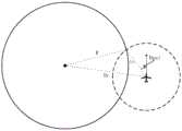
图2为本发明一个实施例的固定翼无人机应急返航导引航线图;Fig. 2 is an emergency return guidance route diagram of a fixed-wing unmanned aerial vehicle according to an embodiment of the present invention;
图3为本发明一个实施例的圆弧航线制导示意图;Fig. 3 is a schematic diagram of arc route guidance according to an embodiment of the present invention;
图4为本发明一个实施例的直线航线制导示意图。Fig. 4 is a schematic diagram of straight line route guidance according to an embodiment of the present invention.
具体实施方式Detailed ways
下面将结合本发明实施例中的附图,对本发明实施例中的技术方案进行清楚、完整地描述,显然,所描述的实施例仅仅是本发明一部分实施例,而不是全部的实施例。基于本发明中的实施例,本领域普通技术人员在没有做出创造性劳动前提下所获得的所有其他实施例,都属于本发明保护的范围。The following will clearly and completely describe the technical solutions in the embodiments of the present invention with reference to the accompanying drawings in the embodiments of the present invention. Obviously, the described embodiments are only some, not all, embodiments of the present invention. Based on the embodiments of the present invention, all other embodiments obtained by persons of ordinary skill in the art without making creative efforts belong to the protection scope of the present invention.
图1为本发明实施例的固定翼无人机应急返航航线规划及横侧向制导方法的流程图。FIG. 1 is a flow chart of a fixed-wing UAV emergency return route planning and lateral guidance method according to an embodiment of the present invention.
如图1所示,本发明实施例的固定翼无人机应急返航航线规划及横侧向制导方法包括以下步骤:As shown in Figure 1, the fixed-wing UAV emergency return route planning and lateral guidance method of the embodiment of the present invention include the following steps:
S1,根据已知的机场跑道绝对位置坐标构造一条直线航线和四条与直线航线相切的圆弧航线。S1, according to the known absolute position coordinates of the airport runway, construct a straight line and four circular arc lines tangent to the straight line.
在本发明的一个实施例中,如图2所示,可根据已知的机场跑道绝对位置坐标获取机场跑道中心点A的经纬度坐标(Lat_A,Lon_A)和机场跑道中心线方位角∠A,并在机场跑道中心线上构造两个坐标点O和S,构成直线航线OS。In one embodiment of the present invention, as shown in Figure 2, the latitude and longitude coordinates (Lat_A, Lon_A) and the azimuth angle ∠A of the airport runway center point A can be obtained according to the known absolute position coordinates of the airport runway, and Construct two coordinate points O and S on the centerline of the airport runway to form a straight line OS.
在本发明的一个实施例中,直线航线OS的长度D_os可由固定翼无人机最小着陆速度对应的最短减速距离所决定,具体为固定翼无人机最大升阻比点对应的飞行地速对应的最短减速距离,可通过下列公式计算:In one embodiment of the present invention, the length D_os of the straight-line route OS can be determined by the shortest deceleration distance corresponding to the minimum landing speed of the fixed-wing UAV, specifically the flight ground speed corresponding to the maximum lift-to-drag ratio point of the fixed-wing UAV. The shortest deceleration distance can be calculated by the following formula:
D_os=最大升阻比点对应的飞行地速*(着陆起始点高度/期望下滑速度)。D_os=flying ground speed corresponding to the point of maximum lift-to-drag ratio*(height of starting point of landing/desired glide speed).
在本发明的一个实施例中,可根据机场跑道中心点A的经纬度坐标(Lat_A,Lon_A)、机场跑道中心线方位角∠A和直线航线OS的长度D_os,计算坐标点O的经纬度坐标(Lat_O,Lon_O)和坐标点S的经纬度坐标(Lat_S,Lon_S),其中:In one embodiment of the present invention, can calculate the latitude and longitude coordinates (Lat_A) of coordinate point O according to the latitude and longitude coordinates (Lat_A, Lon_A) of airport runway center point A, the length D_os of airport runway center line azimuth ∠A and straight line OS ,Lon_O) and the latitude and longitude coordinates (Lat_S,Lon_S) of the coordinate point S, where:
Lat_O=D_os*Cos(∠A)/Cm_lat+Lat_ALat_O=D_os*Cos(∠A)/Cm_lat+Lat_A
Lon_O=D_os*Sin(∠A)/Cm_lon+Lon_ALon_O=D_os*Sin(∠A)/Cm_lon+Lon_A
Lat_S=D_os*Cos(∠A+180°)/Cm_lat+Lat_ALat_S=D_os*Cos(∠A+180°)/Cm_lat+Lat_A
Lon_S=D_os*Sin(∠A+180°)/Cm_lon+Lon_ALon_S=D_os*Sin(∠A+180°)/Cm_lon+Lon_A
其中,Cm_lat=1.113195m,Cm_lon=Cos(Lat_A)*1.113195m。Among them, Cm_lat=1.113195m, Cm_lon=Cos(Lat_A)*1.113195m.
在本发明的一个实施例中,如图2所示,可在坐标点O的两侧分别构造一个与直线航线OS相切的圆弧航线O1和圆弧航线O2,可在坐标点S的两侧分别构造一个与直线航线OS相切的圆弧航线S1和圆弧航线S2。In one embodiment of the present invention, as shown in FIG. 2, an arc route O1 and an arc route O2 tangent to the straight route OS can be respectively constructed on both sides of the coordinate point O. Construct an arc route S1 and an arc route S2 tangent to the straight route OS respectively.
在本发明的一个实施例中,上述四条圆弧航线的半径R可由固定翼无人机当前状态下的转弯性能所决定,具体为固定翼无人机最大升阻比点对应的飞行地速和45°滚转坡度所共同决定的转弯半径,可通过下列公式计算:In one embodiment of the present invention, the radius R of the above-mentioned four arc routes can be determined by the turning performance of the fixed-wing UAV in the current state, specifically the flight ground speed and The turning radius jointly determined by the 45° roll slope can be calculated by the following formula:
R=(最大升阻比点对应的飞行地速)2/9.8。R=(Flying ground speed corresponding to the point of maximum lift-to-drag ratio)2 /9.8.
在本发明的一个实施例中,可根据坐标点O的经纬度坐标(Lat_O,Lon_O)、坐标点S的经纬度坐标(Lat_S,Lon_S)、机场跑道中心线方位角∠A和圆弧航线的半径R,计算圆弧航线O1圆心点的经纬度坐标(Lat_O1,Lon_O1)、圆弧航线O2圆心点的经纬度坐标(Lat_O2,Lon_O2)、圆弧航线S1圆心点的经纬度坐标(Lat_S1,Lon_S1)和圆弧航线S2圆心点的经纬度坐标(Lat_S2,Lon_S2),其中:In one embodiment of the present invention, according to the latitude and longitude coordinates (Lat_O, Lon_O) of coordinate point O, the latitude and longitude coordinates (Lat_S, Lon_S) of coordinate point S, the azimuth angle ∠A of the center line of the airport runway and the radius R of the arc route , calculate the latitude and longitude coordinates (Lat_O1, Lon_O1) of the center point of the arc route O1, the latitude and longitude coordinates (Lat_O2, Lon_O2) of the center point of the arc route O2, the latitude and longitude coordinates (Lat_S1, Lon_S1) of the center point of the arc route S1 and the arc route The latitude and longitude coordinates of the center point of S2 (Lat_S2,Lon_S2), where:
Lat_O1=R*Cos(∠A-90°)/Cm_lat+Lat_OLat_O1=R*Cos(∠A-90°)/Cm_lat+Lat_O
Lon_O1=R*Sin(∠A-90°)/Cm_lon+Lon_OLon_O1=R*Sin(∠A-90°)/Cm_lon+Lon_O
Lat_O2=R*Cos(∠A+90°)/Cm_lat+Lat_OLat_O2=R*Cos(∠A+90°)/Cm_lat+Lat_O
Lon_O2=R*Sin(∠A+90°)/Cm_lon+Lon_OLon_O2=R*Sin(∠A+90°)/Cm_lon+Lon_O
Lat_S1=R*Cos(∠A-90°)/Cm_lat+Lat_SLat_S1=R*Cos(∠A-90°)/Cm_lat+Lat_S
Lon_S1=R*Sin(∠A-90°)/Cm_lon+Lon_SLon_S1=R*Sin(∠A-90°)/Cm_lon+Lon_S
Lat_S2=R*Cos(∠A+90°)/Cm_lat+Lat_SLat_S2=R*Cos(∠A+90°)/Cm_lat+Lat_S
Lon_S2=R*Sin(∠A+90°)/Cm_lon+Lon_S。Lon_S2=R*Sin(∠A+90°)/Cm_lon+Lon_S.
S2,获取固定翼无人机实时的位置信息,并根据实时的位置信息计算固定翼无人机距直线航线端点的地面距离。S2. Obtain the real-time position information of the fixed-wing UAV, and calculate the ground distance between the fixed-wing UAV and the endpoint of the straight-line route according to the real-time position information.
在本发明的一个实施例中,位置信息包括经纬度坐标,可通过获取固定翼无人机实时的经纬度坐标(Lat_P,Lon_P),并根据固定翼无人机实时的经纬度坐标(Lat_P,Lon_P)、坐标点O的经纬度坐标(Lat_O,Lon_O)和坐标点S的经纬度坐标(Lat_S,Lon_S),计算固定翼无人机距直线航线OS两个端点的地面距离,即计算固定翼无人机距坐标点O的地面距离|PO|和距坐标点S的地面距离|PS|,其中:In one embodiment of the present invention, the location information includes latitude and longitude coordinates, which can be obtained by obtaining the real-time latitude and longitude coordinates (Lat_P, Lon_P) of the fixed-wing UAV, and according to the real-time latitude and longitude coordinates (Lat_P, Lon_P) of the fixed-wing UAV, The latitude and longitude coordinates (Lat_O, Lon_O) of the coordinate point O and the latitude and longitude coordinates (Lat_S, Lon_S) of the coordinate point S are used to calculate the ground distance between the fixed-wing UAV and the two endpoints of the straight-line route OS, that is, to calculate the distance between the fixed-wing UAV and the coordinates The ground distance |PO| of point O and the ground distance |PS| from coordinate point S, where:
|PO|=Sqrt(XO2+YO2)|PO|=Sqrt(XO2 +YO2 )
XO=[111412.8*Cos(ZO)-93.5*Cos(3*ZO)]*(Lon_P-Lon_O)XO=[111412.8*Cos(ZO)-93.5*Cos(3*ZO)]*(Lon_P-Lon_O)
YO=[111132.9-559.8*Cos(2*ZO)]*(Lat_P-Lat_O)YO=[111132.9-559.8*Cos(2*ZO)]*(Lat_P-Lat_O)
ZO=(Lat_P+Lat_O)/114.6ZO=(Lat_P+Lat_O)/114.6
|PS|=Sqrt(XS2+YS2)|PS|=Sqrt(XS2 +YS2 )
XS=[111412.8*Cos(ZS)-93.5*Cos(3*ZS)]*(Lon_P-Lon_S)XS=[111412.8*Cos(ZS)-93.5*Cos(3*ZS)]*(Lon_P-Lon_S)
YS=[111132.9-559.8*Cos(2*ZS)]*(Lat_P-Lat_S)YS=[111132.9-559.8*Cos(2*ZS)]*(Lat_P-Lat_S)
ZS=(Lat_P+Lat_S)/114.6ZS=(Lat_P+Lat_S)/114.6
其中,Sqrt为开平方函数。Among them, Sqrt is the square root function.
S3,根据地面距离确定着陆起始点和理想着陆点坐标,并计算固定翼无人机距位于着陆起始点两侧的圆弧航线圆心点的直线距离,以及根据直线距离确定切入直线航线的圆弧航线。S3, determine the coordinates of the landing start point and the ideal landing point according to the ground distance, and calculate the straight-line distance between the fixed-wing UAV and the center point of the arc route located on both sides of the landing start point, and determine the arc that cuts into the straight-line route based on the straight-line distance route.
在本发明的一个实施例中,可通过比较固定翼无人机距直线航线OS坐标点S的地间距离|PS|和距坐标点O的地面距离|PO|的大小,确定着陆起始点和期望着陆点。若|PS|<|PO|,则S点为着陆起始点O点为期望着陆点,若|PS|>|PO|,则O点为着陆起始点S点为期望着陆点。In one embodiment of the present invention, the landing start point and expected landing point. If |PS|<|PO|, point S is the starting point of landing and point O is the expected landing point, if |PS|>|PO|, then point O is the starting point of landing and point S is the expected landing point.
在本发明的一个实施例中,可假设S点为着陆起始点O点为期望着陆点,则可根据固定翼无人机实时的经纬度(Lat_P,Lon_P)、圆弧航线S1圆心点的经纬度坐标(Lat_S1,Lon_S1)和圆弧航线S2圆心点的经纬度坐标(Lat_S2,Lon_S2),计算固定翼无人机当前位置距着陆起始点S两侧的圆弧航线圆心点的直线距离,即计算固定翼无人机当前位置距圆弧航线S1圆心点的直线距离|PS1|和距圆弧航线S2圆心点的直线距离|PS2|,其中:In one embodiment of the present invention, it can be assumed that point S is the starting point of landing and point O is the expected landing point, then it can be based on the real-time latitude and longitude (Lat_P, Lon_P) of the fixed-wing UAV, the latitude and longitude coordinates of the arc route S1 center point (Lat_S1, Lon_S1) and the latitude and longitude coordinates (Lat_S2, Lon_S2) of the center point of the arc route S2, calculate the straight-line distance between the current position of the fixed-wing UAV and the center point of the arc route on both sides of the landing starting point S, that is, calculate the fixed-wing The straight-line distance |PS1| from the current position of the UAV to the center point of the arc route S1 and the straight-line distance |PS2| from the center point of the arc route S2, where:
|PS1|=Sqrt(XS12+YS12)|PS1|=Sqrt(XS12 +YS12 )
XS1=(Lon_P–Lon_S1)*Cm_lonXS1=(Lon_P–Lon_S1)*Cm_lon
YS1=(Lat_P–Lat_S1)*Cm_latYS1=(Lat_P–Lat_S1)*Cm_lat
|PS2|=Sqrt(XS22+YS22)|PS2|=Sqrt(XS22 +YS22 )
XS2=(Lon_P–Lon_S2)*Cm_lonXS2=(Lon_P–Lon_S2)*Cm_lon
YS2=(Lat_P–Lat_S2)*Cm_lat。YS2=(Lat_P−Lat_S2)*Cm_lat.
在本发明的一个实施例中,可通过比较固定翼无人机当前位置距圆弧航线S1圆心点的直线距离|PS1|和距圆弧航线S2圆心点的直线距离|PS2|的大小,确定切入直线航线OS的圆弧航线。若|PS1|<|PS2|,则圆弧航线S1圆心点为固定翼无人机切入直线航线OS的圆弧航线对应的圆心坐标点,若|PS1|>|PS2|,则圆弧航线S2圆心点为固定翼无人机切入直线航线OS的圆弧航线对应的圆心坐标点。In one embodiment of the present invention, it can be determined by comparing the straight-line distance |PS1| from the current position of the fixed-wing UAV to the center point of the arc route S1 and the straight-line distance |PS2| from the center point of the arc route S2. Cut into the arc course of the straight course OS. If |PS1|<|PS2|, the center point of the arc route S1 is the center coordinate point corresponding to the arc route where the fixed-wing UAV cuts into the straight route OS. If |PS1|>|PS2|, then the arc route S2 The center point is the center coordinate point corresponding to the arc route of the fixed-wing UAV cutting into the straight route OS.
在本发明的一个实施例中,固定翼无人机应急返航航线由直线航线OS和确定的切入直线航线OS的圆弧航线组成。In one embodiment of the present invention, the emergency return route of the fixed-wing UAV is composed of a straight-line route OS and a determined circular-arc route cut into the straight-line route OS.
S4,获取固定翼无人机实时的地速和航迹角,并根据实时的地速、航迹角和位置信息计算固定翼无人机的横侧向加速度制导信号。S4, obtain the real-time ground speed and track angle of the fixed-wing UAV, and calculate the lateral acceleration guidance signal of the fixed-wing UAV according to the real-time ground speed, track angle and position information.
在本发明的一个实施例中,可假设圆弧航线S1圆心点为固定翼无人机切入直线航线OS的圆弧航线对应的圆心坐标点,则可通过获取固定翼无人机实时的地速Vg,并根据实时的地速Vg、圆弧航线的半径R和直线航线OS的长度D_os,计算圆弧航线S1的最大制导半径Lc和直线航线OS的最大制导半径Ln,其中:In one embodiment of the present invention, it can be assumed that the center point of the arc route S1 is the center coordinate point corresponding to the arc route where the fixed-wing UAV cuts into the straight-line route OS, then the real-time ground speed of the fixed-wing UAV can be obtained Vg, and according to the real-time ground speed Vg, the radius R of the arc route and the length D_os of the straight route OS, calculate the maximum guidance radius Lc of the arc route S1 and the maximum guidance radius Ln of the straight route OS, where:
Lc=2*lg(Vg)*RLc=2*lg(Vg)*R
Ln=2*lg(Vg)*Sqrt(D_os)Ln=2*lg(Vg)*Sqrt(D_os)
其中,lg为对数函数。Among them, lg is a logarithmic function.
在本发明的一个实施例中,可通过获取固定翼无人机实时的航迹角Psi,并根据固定翼无人机实时的航迹角Psi、机场跑道中心线方位角∠A和直线航线OS的长度D_os,计算固定翼无人机距直线航线OS的地面距离Dn为:In one embodiment of the present invention, by obtaining the real-time track angle Psi of the fixed-wing unmanned aerial vehicle, and according to the real-time track angle Psi of the fixed-wing unmanned aerial vehicle, the azimuth angle ∠A of the center line of the airport runway and the straight-line route OS The length D_os of the fixed-wing UAV and the ground distance Dn of the straight-line route OS are calculated as:
Dn=sin(Psi-∠A)*D_os。Dn=sin(Psi-∠A)*D_os.
在本发明的一个实施例中,可根据固定翼无人机实时的航迹角Psi、实时的经纬度(Lat_P,Lon_P)、圆弧航线S1圆心点的经纬度坐标(Lat_S1,Lon_S1)和机场跑道中心线方位角∠A,计算固定翼无人机到圆弧航线S1圆心点的方位角Psi_c和到直线航线OS的垂直方位角Psi_n,其中:In one embodiment of the present invention, the longitude and latitude coordinates (Lat_S1, Lon_S1) of the center point of the arc route S1 and the center of the airport runway can be based on the real-time track angle Psi of the fixed-wing UAV, the real-time latitude and longitude (Lat_P, Lon_P), Line azimuth ∠A, calculate the azimuth Psi_c from the fixed-wing UAV to the center point of the arc route S1 and the vertical azimuth Psi_n to the straight-line route OS, where:
Psi_c=arctan(YS1/XS1)Psi_c=arctan(YS1/XS1)
Psi_n=∠A+sign(Psi-∠A)*90°Psi_n=∠A+sign(Psi-∠A)*90°
其中,sign为符号函数。Among them, sign is a sign function.
在本发明的一个实施例中,可根据固定翼无人机距圆弧航线S1圆心点的直线距离Dc、距直线航线OS的地面距离Dn、到圆弧航线S1圆心点的方位角Psi_c、到直线航线OS的垂直方位角Psi_n,计算圆弧航线S1制导夹角Dpsi_c和直线航线OS制导夹角Dpsi_n,其中:In one embodiment of the present invention, according to the straight-line distance Dc of the fixed-wing UAV from the center point of the arc route S1, the ground distance Dn from the straight-line route OS, the azimuth Psi_c to the center point of the arc route S1, and the The vertical azimuth angle Psi_n of the straight-line route OS, calculate the arc route S1 guidance angle Dpsi_c and the straight-line route OS guidance angle Dpsi_n, where:


其中,Dc=|PS1|,arccos为反余弦函数。Among them, Dc=|PS1|, arccos is the inverse cosine function.
在本发明的一个实施例中,参照图3和图4,可根据圆弧航线S1的最大制导半径Lc、制导夹角Dpsi_c和直线航线OS的最大制导半径Dn、制导夹角Dpsi_n,计算圆弧航线S1横侧向加速度制导信号Ayg_c和的直线航线OS横侧向加速度制导信号Ayg_n,其中:In one embodiment of the present invention, with reference to Fig. 3 and Fig. 4, can calculate arc The lateral acceleration guidance signal Ayg_c of the course S1 and the straight course OS lateral acceleration guidance signal Ayg_n, where:
Ayg_c=2*(Vg)2*sin(Dpsi_c)/LcAyg_c=2*(Vg)2 *sin(Dpsi_c)/Lc
Ayg_n=2*(Vg)2*sin(Dpsi_n)/Ln。Ayg_n=2*(Vg)2 *sin(Dpsi_n)/Ln.
在本发明的一个实施例中,固定翼无人机先跟踪圆弧航线S1,并在距着陆起始点S的距离小于三分之一的圆弧航线S1的最大制导半径Lc,并且实时的航迹角Psi与机场跑道中心线方位角∠A的差的绝对值小于30°时切入直线航线OS。In one embodiment of the present invention, the fixed-wing UAV first tracks the arc route S1, and the distance from the landing starting point S is less than one-third of the maximum guidance radius Lc of the arc route S1, and the real-time navigation When the absolute value of the difference between the track angle Psi and the azimuth angle ∠A of the centerline of the airport runway is less than 30°, it cuts into the straight-line route OS.
根据本发明实施例提出的固定翼无人机应急返航航线规划及横侧向制导方法,先根据已知的机场跑道绝对位置坐标构造一条直线航线和四条与直线航线相切的圆弧航线,然后根据固定翼无人机实时的位置信息计算距直线航线端点的地面距离,由此确定着陆起始点和理想着陆点坐标,接着计算固定翼无人机距着陆起始点两侧的圆弧航线圆心的直线距离,由此确定切入直线航线的圆弧航线,该圆弧航线和所切入的直线航线可构成固定翼无人机的应急返航航线,最后根据固定翼无人机实时的地速、航迹角和位置信息计算出固定翼无人机的横侧向加速度制导信号,由此,可通过实时获取固定翼无人机当前的飞行状态,规划应急返航航线,计算横侧向加速度制导信号,从而能够提供更为安全合理的应急返航航线,更加精确的横侧向加速度制动信号,可保证固定翼无人机自任意位置安全应急返航着陆。According to the fixed-wing UAV emergency return route planning and lateral guidance method proposed in the embodiment of the present invention, first construct a straight line route and four arc routes tangent to the straight line route according to the known absolute position coordinates of the airport runway, and then According to the real-time position information of the fixed-wing UAV, calculate the ground distance from the end point of the straight-line route, thereby determine the coordinates of the landing start point and the ideal landing point, and then calculate the distance between the fixed-wing UAV and the center of the arc route on both sides of the landing start point The straight-line distance determines the arc route that cuts into the straight-line route. The arc route and the cut-in straight-line route can constitute the emergency return route of the fixed-wing UAV. Finally, according to the real-time ground speed and track of the fixed-wing UAV The angle and position information calculates the lateral acceleration guidance signal of the fixed-wing UAV. Therefore, the current flight status of the fixed-wing UAV can be obtained in real time, the emergency return route can be planned, and the lateral acceleration guidance signal can be calculated. It can provide a safer and more reasonable emergency return route, and a more accurate lateral acceleration braking signal, which can ensure the safe emergency return and landing of fixed-wing UAVs from any position.
在本发明的描述中,“多个”的含义是两个或两个以上,除非另有明确具体的限定。In the description of the present invention, "plurality" means two or more, unless otherwise specifically defined.
在本发明中,除非另有明确的规定和限定,术语“安装”、“相连”、“连接”、“固定”等术语应做广义理解,例如,可以是固定连接,也可以是可拆卸连接,或成一体;可以是机械连接,也可以是电连接;可以是直接相连,也可以通过中间媒介间接相连,可以是两个元件内部的连通或两个元件的相互作用关系。对于本领域的普通技术人员而言,可以根据具体情况理解上述术语在本发明中的具体含义。In the present invention, unless otherwise clearly specified and limited, terms such as "installation", "connection", "connection" and "fixation" should be understood in a broad sense, for example, it can be a fixed connection or a detachable connection , or integrated; it can be mechanically connected or electrically connected; it can be directly connected or indirectly connected through an intermediary, and it can be the internal communication of two components or the interaction relationship between two components. Those of ordinary skill in the art can understand the specific meanings of the above terms in the present invention according to specific situations.
在本发明中,除非另有明确的规定和限定,第一特征在第二特征“上”或“下”可以是第一和第二特征直接接触,或第一和第二特征通过中间媒介间接接触。而且,第一特征在第二特征“之上”、“上方”和“上面”可是第一特征在第二特征正上方或斜上方,或仅仅表示第一特征水平高度高于第二特征。第一特征在第二特征“之下”、“下方”和“下面”可以是第一特征在第二特征正下方或斜下方,或仅仅表示第一特征水平高度小于第二特征。In the present invention, unless otherwise clearly specified and limited, the first feature may be in direct contact with the first feature or the first and second feature may be in direct contact with the second feature through an intermediary. touch. Moreover, "above", "above" and "above" the first feature on the second feature may mean that the first feature is directly above or obliquely above the second feature, or simply means that the first feature is higher in level than the second feature. "Below", "beneath" and "beneath" the first feature may mean that the first feature is directly below or obliquely below the second feature, or simply means that the first feature is less horizontally than the second feature.
在本说明书的描述中,参考术语“一个实施例”、“一些实施例”、“示例”、“具体示例”、或“一些示例”等的描述意指结合该实施例或示例描述的具体特征、结构、材料或者特点包含于本发明的至少一个实施例或示例中。在本说明书中,对上述术语的示意性表述不必须针对的是相同的实施例或示例。而且,描述的具体特征、结构、材料或者特点可以在任一个或多个实施例或示例中以合适的方式结合。此外,在不相互矛盾的情况下,本领域的技术人员可以将本说明书中描述的不同实施例或示例以及不同实施例或示例的特征进行结合和组合。In the description of this specification, descriptions referring to the terms "one embodiment", "some embodiments", "example", "specific examples", or "some examples" mean that specific features described in connection with the embodiment or example , structure, material or characteristic is included in at least one embodiment or example of the present invention. In this specification, the schematic representations of the above terms are not necessarily directed to the same embodiment or example. Furthermore, the described specific features, structures, materials or characteristics may be combined in any suitable manner in any one or more embodiments or examples. In addition, those skilled in the art can combine and combine different embodiments or examples and features of different embodiments or examples described in this specification without conflicting with each other.
尽管已经示出和描述了本发明的实施例,对于本领域的普通技术人员而言,可以理解在不脱离本发明的原理和精神的情况下可以对这些实施例进行多种变化、修改、替换和变型,本发明的范围由所附权利要求及其等同物限定。Although the embodiments of the present invention have been shown and described, those skilled in the art can understand that various changes, modifications and substitutions can be made to these embodiments without departing from the principle and spirit of the present invention. and modifications, the scope of the invention is defined by the appended claims and their equivalents.
Claims (8)
Translated fromChinesePriority Applications (1)
| Application Number | Priority Date | Filing Date | Title |
|---|---|---|---|
| CN201910554865.5ACN110307847B (en) | 2019-06-25 | 2019-06-25 | A fixed-wing UAV emergency return route planning and lateral guidance method |
Applications Claiming Priority (1)
| Application Number | Priority Date | Filing Date | Title |
|---|---|---|---|
| CN201910554865.5ACN110307847B (en) | 2019-06-25 | 2019-06-25 | A fixed-wing UAV emergency return route planning and lateral guidance method |
Publications (2)
| Publication Number | Publication Date |
|---|---|
| CN110307847A CN110307847A (en) | 2019-10-08 |
| CN110307847Btrue CN110307847B (en) | 2023-04-28 |
Family
ID=68077657
Family Applications (1)
| Application Number | Title | Priority Date | Filing Date |
|---|---|---|---|
| CN201910554865.5AActiveCN110307847B (en) | 2019-06-25 | 2019-06-25 | A fixed-wing UAV emergency return route planning and lateral guidance method |
Country Status (1)
| Country | Link |
|---|---|
| CN (1) | CN110307847B (en) |
Families Citing this family (4)
| Publication number | Priority date | Publication date | Assignee | Title |
|---|---|---|---|---|
| CN111537967B (en)* | 2020-05-09 | 2022-05-31 | 森思泰克河北科技有限公司 | Radar deflection angle correction method and device and radar terminal |
| CN115903889A (en)* | 2022-11-11 | 2023-04-04 | 中国航空工业集团公司西安飞行自动控制研究所 | A fast and direct landing trajectory generation method for UAV |
| CN117111625B (en)* | 2023-10-25 | 2024-01-23 | 四川腾盾科技有限公司 | Low-oil-quantity online emergency path planning method for fixed-wing unmanned aerial vehicle |
| CN118131786B (en)* | 2024-01-19 | 2025-08-12 | 成都飞机工业(集团)有限责任公司 | A fixed-wing UAV air glide return strategy and online route planning method |
Family Cites Families (12)
| Publication number | Priority date | Publication date | Assignee | Title |
|---|---|---|---|---|
| CN103176476B (en)* | 2013-03-08 | 2015-07-01 | 北京航空航天大学 | Autonomous approach route planning method for gliding unmanned aerial vehicles |
| US20170364071A1 (en)* | 2016-06-16 | 2017-12-21 | University Of North Texas | Systems and methods for dual operation of unmanned aerial vehicles |
| CN106647801A (en)* | 2016-10-21 | 2017-05-10 | 广东容祺智能科技有限公司 | Planning system for unmanned aerial vehicle's back trip course |
| US11017679B2 (en)* | 2017-01-13 | 2021-05-25 | Skydio, Inc. | Unmanned aerial vehicle visual point cloud navigation |
| CN108496136A (en)* | 2017-05-24 | 2018-09-04 | 深圳市大疆创新科技有限公司 | Control method of making a return voyage, equipment and the unmanned vehicle of unmanned vehicle |
| CN107238389A (en)* | 2017-06-27 | 2017-10-10 | 中国航空工业集团公司沈阳飞机设计研究所 | Course line planing method |
| CN107356907B (en)* | 2017-07-17 | 2019-06-04 | 电子科技大学 | Route design method of jamming source for moving airborne radar |
| CN107291101A (en)* | 2017-07-28 | 2017-10-24 | 江苏理工学院 | A kind of unmanned plane during flying autocontrol method, storage device and unmanned plane |
| CN108592905A (en)* | 2017-12-29 | 2018-09-28 | 王开富 | A kind of accurate air navigation aid of unmanned plane that can quickly correct course |
| CN109253729B (en)* | 2018-09-19 | 2021-02-09 | 沈阳无距科技有限公司 | Unmanned aerial vehicle route planning method and device and electronic equipment |
| CN109582035A (en)* | 2018-11-29 | 2019-04-05 | 沈阳无距科技有限公司 | A kind of aircraft's flight track air navigation aid, device and electronic equipment |
| CN109708639B (en)* | 2018-12-07 | 2022-11-22 | 湖北航天飞行器研究所 | Method for generating lateral guidance instruction of aircraft for tracking straight line and circular arc path in flat flight |
- 2019
- 2019-06-25CNCN201910554865.5Apatent/CN110307847B/enactiveActive
Also Published As
| Publication number | Publication date |
|---|---|
| CN110307847A (en) | 2019-10-08 |
Similar Documents
| Publication | Publication Date | Title |
|---|---|---|
| CN110307847B (en) | A fixed-wing UAV emergency return route planning and lateral guidance method | |
| US12387607B2 (en) | Unmanned aircraft control using ground control station | |
| CN111650958B (en) | Online path planning method for fixed-wing unmanned aerial vehicle takeoff section cut-in route point | |
| US8126599B2 (en) | Method of calculating approach trajectory for aircraft | |
| US8897932B2 (en) | Flight control support device | |
| US7917254B2 (en) | Aircraft guidance using localizer capture criteria for rectilinear displacement data | |
| CN110827581B (en) | System and method for modifying aircraft flight trajectory | |
| US20080195301A1 (en) | Onboard Runway Incursion Alert Method and Device for Aircraft | |
| CN109615936A (en) | Flying nonstop in onboard flight management system and flies nonstop to method at Trajectory Prediction method | |
| CN104991564A (en) | Flight control method and device for unmanned aerial vehicle | |
| US20070250223A1 (en) | Method and a device for monitoring the minimum flying altitude of an aircraft | |
| WO2012002276A1 (en) | Display device, piloting assistance system, and display method | |
| US7084785B2 (en) | Method and device for determining a final approach path of an aircraft for a non-precision approach for the purpose of landing the aircraft | |
| EP1808737B1 (en) | EGWPS flap position enhancement | |
| CN100541371C (en) | Method for switching multi-height types | |
| JP2009515771A (en) | A control system for automatic overturning flight. | |
| US20230076554A1 (en) | Automatic aircraft taxiing | |
| CN109540153B (en) | Method for guiding airplane to enter into field in broken line by microwave landing system | |
| EP4242869A1 (en) | Aerial map layer display method and apparatus | |
| JP7260668B2 (en) | Method and Apparatus for Generating First Map | |
| WO2006125725A1 (en) | Method of providing information relating to an aircraft's situation in relation to an airport | |
| CN114724413B (en) | Guiding method for horizontal route switching of fixed wing aircraft | |
| EP4181104B1 (en) | Systems and methods for providing safe landing assistance for a vehicle | |
| JP2000272592A (en) | Helicopter guidance control device | |
| CN114489123B (en) | A device for switching horizontal routes of fixed-wing aircraft |
Legal Events
| Date | Code | Title | Description |
|---|---|---|---|
| PB01 | Publication | ||
| PB01 | Publication | ||
| SE01 | Entry into force of request for substantive examination | ||
| SE01 | Entry into force of request for substantive examination | ||
| GR01 | Patent grant | ||
| GR01 | Patent grant |