CN109657614B - Automatic road identification method in aerial photography road traffic accident scene investigation - Google Patents
Automatic road identification method in aerial photography road traffic accident scene investigationDownload PDFInfo
- Publication number
- CN109657614B CN109657614BCN201811556585.XACN201811556585ACN109657614BCN 109657614 BCN109657614 BCN 109657614BCN 201811556585 ACN201811556585 ACN 201811556585ACN 109657614 BCN109657614 BCN 109657614B
- Authority
- CN
- China
- Prior art keywords
- road
- image
- new model
- line
- outline
- Prior art date
- Legal status (The legal status is an assumption and is not a legal conclusion. Google has not performed a legal analysis and makes no representation as to the accuracy of the status listed.)
- Expired - Fee Related
Links
Images


Classifications
- G—PHYSICS
- G06—COMPUTING OR CALCULATING; COUNTING
- G06V—IMAGE OR VIDEO RECOGNITION OR UNDERSTANDING
- G06V20/00—Scenes; Scene-specific elements
- G06V20/10—Terrestrial scenes
- G06V20/13—Satellite images
- G—PHYSICS
- G06—COMPUTING OR CALCULATING; COUNTING
- G06F—ELECTRIC DIGITAL DATA PROCESSING
- G06F18/00—Pattern recognition
- G06F18/20—Analysing
- G06F18/24—Classification techniques
- G06F18/241—Classification techniques relating to the classification model, e.g. parametric or non-parametric approaches
- G06F18/2413—Classification techniques relating to the classification model, e.g. parametric or non-parametric approaches based on distances to training or reference patterns
- G—PHYSICS
- G06—COMPUTING OR CALCULATING; COUNTING
- G06V—IMAGE OR VIDEO RECOGNITION OR UNDERSTANDING
- G06V10/00—Arrangements for image or video recognition or understanding
- G06V10/20—Image preprocessing
- G06V10/25—Determination of region of interest [ROI] or a volume of interest [VOI]
- G—PHYSICS
- G06—COMPUTING OR CALCULATING; COUNTING
- G06V—IMAGE OR VIDEO RECOGNITION OR UNDERSTANDING
- G06V2201/00—Indexing scheme relating to image or video recognition or understanding
- G06V2201/08—Detecting or categorising vehicles
Landscapes
- Engineering & Computer Science (AREA)
- Physics & Mathematics (AREA)
- Theoretical Computer Science (AREA)
- General Physics & Mathematics (AREA)
- Data Mining & Analysis (AREA)
- Multimedia (AREA)
- Bioinformatics & Cheminformatics (AREA)
- Evolutionary Biology (AREA)
- Evolutionary Computation (AREA)
- Computer Vision & Pattern Recognition (AREA)
- General Engineering & Computer Science (AREA)
- Bioinformatics & Computational Biology (AREA)
- Artificial Intelligence (AREA)
- Astronomy & Astrophysics (AREA)
- Remote Sensing (AREA)
- Life Sciences & Earth Sciences (AREA)
- Traffic Control Systems (AREA)
- Image Analysis (AREA)
Abstract
Description
Translated fromChinese技术领域technical field
本发明属城市道路识别领域,尤其涉及一种航拍道路交通事故现场勘查中道路自动识别方法。The invention belongs to the field of urban road identification, and in particular relates to an automatic road identification method in field investigation of road traffic accidents by aerial photography.
背景技术Background technique
随着科技不断进步,所获得的航拍图像分辨率不断提升,传统面向中低分辨率的道路识别方法不再适用,考虑面向高分辨率航拍图像的道路提取方法势在必行。航拍技术在快速发展,识别及智能识别技术在发展,大数据挖掘、机器人、区块链等技术都在飞速进步。利用这些技术为人们生活和相关行业提供支持,已经成为国内外企业不断创新研究的努力方向。随着航拍技术的进步,航拍图像分辨率不断提升。分辨率的提升带来了好处,也带来了新的问题。应用在城市道路识别和提取中,可以为人们出行导航提供服务,好处是可以更精准的识别城市道路;新问题是如何高效、准确识别和提取道路,服务即时准确的导航需求。相关需求领域包括民用和军用等。城市道路识别和提取最复杂,因为其周边有大量建筑物,随着光谱的不同,图像不同;因为道路可能发生拥堵,乃至交通事故,图像会发生变化;因为道路可能发生断裂,要尽快识别和提取,提示道路路况。所以研究城市道路识别方法的理论、模型及利用知识判断一直是重要的研究课题。基于高分辨率的航拍图像利用计算机展示更加丰富的细节信息(低层,多特征融合识别),结合高层语义知识,在面对计算量呈指数上升的情况下,高分辨率航拍图像中的城市道路作为研究对象,重点研究城市道路低层特征提取与自动识别方法,研究高层语义指导下的城市道路遮挡及断裂连接问题,从而生成完整的道路网,实现城市道路的自动识别,具有重要意义。With the continuous advancement of science and technology, the resolution of the obtained aerial images continues to increase, and the traditional road recognition methods for medium and low resolutions are no longer applicable. It is imperative to consider road extraction methods for high-resolution aerial images. Aerial photography technology is developing rapidly, recognition and intelligent recognition technology is developing, and technologies such as big data mining, robots, and blockchain are all advancing rapidly. Using these technologies to provide support for people's lives and related industries has become the direction of continuous innovation and research for domestic and foreign companies. With the advancement of aerial photography technology, the resolution of aerial photography images continues to increase. The increase in resolution brings benefits, but also brings new problems. Applied in urban road identification and extraction, it can provide services for people's travel navigation. The advantage is that it can identify urban roads more accurately; the new problem is how to efficiently and accurately identify and extract roads to serve instant and accurate navigation needs. Relevant demand areas include civilian and military applications. The identification and extraction of urban roads is the most complicated, because there are a large number of buildings around it, and the images are different with the spectrum; because the roads may be congested, or even traffic accidents, the images will change; because the roads may be broken, it is necessary to identify and identify them as soon as possible. Extract and prompt road conditions. Therefore, it has always been an important research topic to study the theory, model and knowledge judgment of urban road recognition methods. Based on high-resolution aerial images, use computers to display richer detailed information (low-level, multi-feature fusion recognition), combined with high-level semantic knowledge, in the face of exponentially increasing calculations, urban roads in high-resolution aerial images As the research object, it is of great significance to focus on the low-level feature extraction and automatic recognition methods of urban roads, and to study the occlusion and broken connections of urban roads under the guidance of high-level semantics, so as to generate a complete road network and realize automatic recognition of urban roads.
国内外对航拍图像中城市道路识别和提取问题进行了大量研究,不同方法面向不同的对象,并且适用于不同的场合。根据面向的对象,道路识别包括城市主干道、道路路况、车道线、人行横道、天桥、绿化带、交叉路口等关键处的算法;根据是否需要人工参与,可以分为自动提取方法和半自动提取方法;根据选用的道路特征,可以分为基于边缘和线特征的方法和基于面与形状特征的方法。随机抽样一致性(RANdom SAmple Consensus)则是一种快速的直线拟合方法,该方法优点在于计算简单快捷,在应对大样本数据的时候表现良好,但最终得到的结果不一定是最优解。数学形态学算子则采用化整为零的思想,逐步采用多组不同长度、角度的直线模板对图像进行卷积,从而提取出指定长度和角度的道路目标。城市道路识别和提取应用的方法主要包括:图像预处理、低层特征提取、基于低层特征的道路提取与识别、道路网断裂及遮挡处理等。At home and abroad, a lot of research has been done on the recognition and extraction of urban roads in aerial images. Different methods are oriented to different objects and are suitable for different occasions. According to the object-oriented, road recognition includes algorithms for key places such as urban arterial roads, road conditions, lane lines, crosswalks, overpasses, green belts, intersections, etc.; according to whether manual participation is required, it can be divided into automatic extraction methods and semi-automatic extraction methods; According to the selected road features, it can be divided into methods based on edge and line features and methods based on surface and shape features. Random sampling consistency (RANdom SAmple Consensus) is a fast line fitting method. The advantage of this method is that the calculation is simple and fast, and it performs well when dealing with large sample data, but the final result may not be the optimal solution. Mathematical morphology operators use the idea of breaking the whole into parts, and gradually use multiple groups of straight line templates with different lengths and angles to convolve the image, thereby extracting road targets with specified lengths and angles. The methods of urban road recognition and extraction applications mainly include: image preprocessing, low-level feature extraction, road extraction and recognition based on low-level features, road network fracture and occlusion processing, etc.
现有城市道路识别方法对道路情况尚不能做到实时把控,对事故现场的检测速度也不是很理想。Existing urban road recognition methods are still unable to achieve real-time control of road conditions, and the detection speed of accident scenes is not very ideal.
发明内容Contents of the invention
本发明旨在克服现有技术的不足之处而提供一种能快速准确并且高效实现对道路情况实时把控,为自动化城市道路分析与理解提供支撑的航拍道路交通事故现场勘查中道路自动识别方法。The present invention aims to overcome the deficiencies of the prior art and provide a method for automatic identification of roads in aerial road traffic accident scene surveys that can quickly, accurately and efficiently realize real-time control of road conditions and provide support for automated urban road analysis and understanding .
为解决上述技术问题,本发明是这样实现的:In order to solve the problems of the technologies described above, the present invention is achieved in that:
航拍道路交通事故现场勘查中道路自动识别方法,它包括如下步骤:A road automatic identification method in aerial photography road traffic accident scene investigation, it comprises the following steps:
(1)道路语义标记;(1) Road semantic marking;
(2)深度神经网络训练;(2) Deep neural network training;
(3)转成成IOS支持的新模型;(3) Convert to a new model supported by IOS;
(4)新模型语义预测;(4) New model semantic prediction;
(5)新模型语义去噪处理;(5) Semantic denoising processing of the new model;
(6)新模型矢量化。(6) New model vectorization.
作为一种优选方案,本发明所述步骤(1)通过labelme软件对图像进行多边形,矩形,线,点和图像级标注。As a preferred solution, the step (1) of the present invention carries out polygon, rectangle, line, point and image-level labeling on the image through labelme software.
进一步地,本发明所述步骤(2)采用沙漏型深度神经网络;所述沙漏型深度神经网络包括前后两部分;前半部分为特征提取,每经过一个池化层特征图像尺寸缩小一半;后半部分为特征融合,使用上采样和跳接的方式将提取的特征汇集到一起。Further, the step (2) of the present invention adopts an hourglass-type deep neural network; the hourglass-type deep neural network includes two parts; the first half is feature extraction, and the size of the feature image is reduced by half after each pooling layer; the second half Part of it is feature fusion, which uses upsampling and jumping to bring together the extracted features.
进一步地,本发明将训练好的模型借助 Core ML集成到自己的应用当中。Further, the present invention integrates the trained model into its own application with the help of Core ML.
进一步地,本发明所述步骤(4)中,首先将原图像缩小原来的四分之一大小,再在缩小的图像上使用交叉覆盖的方式截取图像,直到将缩小的图像全部覆盖。之后对数据进行融合处理。Further, in the step (4) of the present invention, the original image is first reduced to a quarter of its original size, and then the reduced image is intercepted in a cross-covering manner until the reduced image is completely covered. The data is then fused.
进一步地,本发明所述步骤(5)中,通过两部分对数据进行优化处理;第一部分为线条线型,将线条线型进行拉伸和收缩,以及曲线的斜率进行预测,通过两条线型的垂直距离是否在可选范围内,符合条件的进行膨胀处理,使之线型融合,不符合条件的线条,采用腐蚀处理,通过使用膨胀与腐蚀的方法,还原图像;第二部分为区域型,使用边缘检测方法,检测出图像中所有灰度值变化较大的点,将这些点连接起来,形成轮廓和区域,将轮廓内部的线型进行拉伸和收缩,通过曲率和两条线型的垂直距离判断是否符合融合条件。Further, in the step (5) of the present invention, the data is optimized through two parts; the first part is the line type, stretching and shrinking the line type, and predicting the slope of the curve, through two lines Whether the vertical distance of the type is within the optional range, if the condition is met, the expansion process will be performed to make the line merge, and the unqualified line will be treated with corrosion, and the image will be restored by using the method of expansion and corrosion; the second part is the area Type, use the edge detection method to detect all points in the image with large gray value changes, connect these points to form contours and regions, stretch and shrink the line type inside the contour, and use curvature and two lines The vertical distance of the type judges whether it meets the fusion condition.
进一步地,本发明所述步骤(6)中,将航拍照片中的道路轮廓和道路元素识别后,以矢量化的方式将道路轮廓和道路元素进行绘制。Further, in the step (6) of the present invention, after identifying the road outline and road elements in the aerial photos, the road outline and road elements are drawn in a vectorized manner.
本发明能准确快速并且高效实现对道路情况的实时把控,与现有技术相比,本发明具有如下特点:The present invention can accurately, quickly and efficiently realize real-time control of road conditions. Compared with the prior art, the present invention has the following characteristics:
(1)准确的识别航拍图像上道路的各种线型。如停止线、等待让行线、双实线、绿化带、人行横道、双虚线、中心超车线、左转待转区、导流线、网格区等,为自动化城市道路分析与理解提供支撑。(1) Accurately identify various line types of roads on aerial images. Such as stop line, waiting line, double solid line, green belt, pedestrian crossing, double dashed line, center overtaking line, left turn waiting area, diversion line, grid area, etc., to provide support for the analysis and understanding of automated urban roads.
(2)快速的对事故现场的检测。因为航拍图片采集会造成道路或者空中的堵塞与干扰, 所以快速的分析与处理至关重要, 所以本发明以达到秒级的处理速度,完成道路线型和感兴趣区域的检测与分析。道路 同时对道路信息的识别对城市交通指挥调度和人们出行道路的导航需要都具有很高的利用价值,实现对城市管理者以及其他决策者和个人用户对道路和城市建设规划提供参考。(2) Rapid detection of the accident scene. Because aerial image collection will cause road or air congestion and interference, fast analysis and processing is very important. Therefore, the present invention completes the detection and analysis of road alignment and ROI with a processing speed of seconds. Road At the same time, the identification of road information is of high value for urban traffic command and dispatch and the navigation needs of people's travel roads, and it can provide reference for city managers, other decision makers and individual users for road and urban construction planning.
(3)系统使用便捷。无人机与Ipad连接,实现了外观小巧,占用空间小,方便携带,并且操纵简单快捷。(3) The system is easy to use. The UAV is connected with the Ipad to achieve a small appearance, a small footprint, easy to carry, and simple and quick operation.
附图说明Description of drawings
下面结合附图和具体实施方式对本发明作进一步说明。本发明的保护范围不仅局限于下列内容的表述。The present invention will be further described below in conjunction with the accompanying drawings and specific embodiments. The scope of protection of the present invention is not limited to the expression of the following content.
图1为本发明航拍嵌入道路识别流程框图;Fig. 1 is a block diagram of the process of aerial photography embedding road recognition in the present invention;
图2A及图2B为本发明道路标记图片;2A and 2B are pictures of road markings of the present invention;
图3为本发明深度神经网络训练示意图;Fig. 3 is a schematic diagram of deep neural network training of the present invention;
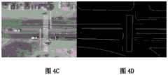
图4A、图4B、图4C及图4D为本发明训练测试结果图。Fig. 4A, Fig. 4B, Fig. 4C and Fig. 4D are diagrams of training test results of the present invention.
具体实施方式Detailed ways
如图所示,航拍道路交通事故现场勘查中道路自动识别方法,包括如下步骤:As shown in the figure, the automatic road identification method in the scene survey of aerial road traffic accidents includes the following steps:
(1)道路语义标记;(1) Road semantic marking;
(2)深度神经网络训练;(2) Deep neural network training;
(3)转成成IOS支持的新模型;(3) Convert to a new model supported by IOS;
(4)新模型语义预测;(4) New model semantic prediction;
(5)新模型语义去噪处理;(5) Semantic denoising processing of the new model;
(6)新模型矢量化。(6) New model vectorization.
本发明所述步骤(1)通过labelme软件对图像进行多边形,矩形,线,点和图像级标注。本发明所述步骤(2)采用沙漏型深度神经网络;所述沙漏型深度神经网络包括前后两部分;前半部分为特征提取,每经过一个池化层特征图像尺寸缩小一半;后半部分为特征融合,使用上采样和跳接的方式将提取的特征汇集到一起。本发明将训练好的模型借助 CoreML集成到自己的应用当中。本发明所述步骤(4)中,首先将原图像缩小原来的四分之一大小,再在缩小的图像上使用交叉覆盖的方式截取图像,直到将缩小的图像全部覆盖。之后对数据进行融合处理。本发明所述步骤(5)中,通过两部分对数据进行优化处理;第一部分为线条线型,将线条线型进行拉伸和收缩,以及曲线的斜率进行预测,通过两条线型的垂直距离是否在可选范围内,符合条件的进行膨胀处理,使之线型融合,不符合条件的线条,采用腐蚀处理,通过使用膨胀与腐蚀的方法,还原图像;第二部分为区域型,使用边缘检测方法,检测出图像中所有灰度值变化较大的点,将这些点连接起来,形成轮廓和区域,将轮廓内部的线型进行拉伸和收缩,通过曲率和两条线型的垂直距离判断是否符合融合条件。本发明所述步骤(6)中,将航拍照片中的道路轮廓和道路元素识别后,以矢量化的方式将道路轮廓和道路元素进行绘制。The step (1) of the present invention carries out polygon, rectangle, line, point and image-level labeling on the image through labelme software. The step (2) of the present invention adopts an hourglass-type deep neural network; the hourglass-type deep neural network includes two parts before and after; the first half is feature extraction, and the size of the feature image is reduced by half after each pooling layer; the second half is feature extraction. Fusion, which uses upsampling and skipping to bring together the extracted features. The present invention integrates the trained model into its own application with the help of CoreML. In the step (4) of the present invention, the original image is first reduced to a quarter of its original size, and then the reduced image is intercepted by cross-covering until the reduced image is completely covered. The data is then fused. In the step (5) of the present invention, two parts are used to optimize the data; the first part is the line type, which stretches and shrinks the line type, and predicts the slope of the curve. Whether the distance is within the optional range, if the condition is met, the expansion process is performed to make the line merge, and the unqualified line is treated with corrosion, and the image is restored by using the method of expansion and corrosion; the second part is the area type, use The edge detection method detects all points with large gray value changes in the image, connects these points to form contours and regions, stretches and shrinks the line type inside the contour, and passes the curvature and the perpendicularity of the two line types The distance judges whether it meets the fusion condition. In the step (6) of the present invention, after identifying the road outline and road elements in the aerial photos, the road outline and road elements are drawn in a vectorized manner.
本发明采用训练-移植-识别的方法完成嵌入式航拍道路识别功能,在训练阶段首先由行业内技术专家人工标记大量航拍道路图片,然后使用深度卷积神经网络(CNN)训练形成参数化模型。概括如以下六点:The invention adopts the method of training-transplantation-recognition to complete the embedded aerial road recognition function. In the training stage, a large number of aerial road pictures are manually marked by technical experts in the industry, and then a deep convolutional neural network (CNN) is used to train to form a parameterized model. It can be summarized as the following six points:
A、道路语义标记A. Road semantic marking
道路标识系统的数据集非常重要,好的数据集直接影响到最后的测试效果,所以本发明的数据集来自专业技术人员使用无人机航拍的河北的街景图像,并从大量图片中挑选出清晰度好的300张图像作为本发明的数据集。为了达到数据的可靠性以及科学性,训练使用的图像的分辨率分别有2k,3k,4k和5k四种尺寸不同的图片,对不同尺寸的图片进行了全面的覆盖。同时监督学习离不开对数据的标注,由于道路的多样性,因此选择一款的好标记软件显得尤其重要,本发明选用了可以对图像进行多边形,矩形,线,点和图像级标注的并且效率高效简单易用的labelme软件,对训练的图片进行标注。参见图2A及图2B。The data set of the road marking system is very important, and a good data set directly affects the final test effect, so the data set of the present invention comes from the street view images of Hebei that professional technicians use drones to take aerial shots, and select clear images from a large number of pictures 300 images with good accuracy are used as the data set of the present invention. In order to achieve the reliability and scientificity of the data, the resolutions of the images used for training include 2k, 3k, 4k, and 5k images of four different sizes, which fully cover the images of different sizes. At the same time, supervised learning is inseparable from the labeling of data. Due to the diversity of roads, it is particularly important to choose a good labeling software. The present invention selects images that can be labeled with polygons, rectangles, lines, points, and images. The efficient and easy-to-use labelme software can label the training pictures. See Figure 2A and Figure 2B.
B、深度神经网络训练B. Deep Neural Network Training
标记完数据集后,就可以对数据集进行训练了,本发明使用的是沙漏型的深度神经网络,该网络可分为前后两部分。前半部分作用是特征提取,每经过一个池化层特征图像尺寸缩小一半。后半部分的作用是特征融合,使用上采样和跳接的方式将提取的特征汇集到一起,以最后一个上采样为例,它的特征既来自第一个卷积block的输出(同尺度特征),也来自上采样的输出(大尺度特征),这样的连接是贯穿整个网络的,你可以看到上图的网络中有四次融合过程,相对应的FCN网络只在最后一层进行融合。本网络训练中我们使用随机截取法和填充法对数据进行处理和比对。借此以达到还原数据的本质。通过这两种方式使训练出来的图片更加可靠,科学性更高。测试结果参见图4A、图4B、图4C及图4D。After the data set is marked, the data set can be trained. The present invention uses an hourglass deep neural network, which can be divided into two parts: front and back. The function of the first half is feature extraction, and the size of the feature image is reduced by half after each pooling layer. The role of the second half is feature fusion, which uses upsampling and skipping to bring together the extracted features. Taking the last upsampling as an example, its features come from the output of the first convolution block (same-scale features ), also from the upsampling output (large-scale features), such connections run through the entire network, you can see that there are four fusion processes in the network in the above figure, and the corresponding FCN network is only fused in the last layer . In this network training, we use random interception and filling methods to process and compare data. In this way, the essence of restoring data can be achieved. Through these two methods, the trained pictures are more reliable and more scientific. The test results are shown in Fig. 4A, Fig. 4B, Fig. 4C and Fig. 4D.
C、模型转换C. Model conversion
训练好的模型借助 Core ML,可以集成到自己的应用当中。同时Core ML 还为Vision提供了图像处理的支持,为Foundation提供了自然语言处理的支持,为GameplayKit提供了对学习决策树 (learned decision tree) 进行分析的支持。并且mlmodel可以在Xcode中轻松的构建机器学习模型,并且可以使用视觉和自然语言技术,创建和针对苹果生态系统的各种任务(包括回归、图像分类、单词标记和句子分类)的优化模型。With the help of Core ML, the trained model can be integrated into your own application. At the same time, Core ML also provides image processing support for Vision, natural language processing support for Foundation, and support for analyzing learned decision trees for GameplayKit. And mlmodel can easily build machine learning models in Xcode, and can use vision and natural language technologies to create and optimize models for various tasks in the Apple ecosystem (including regression, image classification, word tagging, and sentence classification).
D、语义预测D. Semantic prediction
模型转换后为了保证最终结果的可靠性,同时考虑到IOS的内存有限,预测图像大小采用640 * 480,所以在不影响最终结果的科学性情况下。首先先将原图像缩小原来的四分之一大小。再在缩小的图像上使用交叉覆盖的方式截取图像。直到将缩小的图像全部覆盖。之后对数据进行融合处理。In order to ensure the reliability of the final result after model conversion, and considering the limited memory of IOS, the predicted image size is 640 * 480, so it does not affect the scientific nature of the final result. First, the original image is reduced to a quarter of its original size. Then use the cross coverage method to intercept the image on the reduced image. until the reduced image is completely covered. The data is then fused.
E、去噪处理E. Denoising processing
在去噪处理中,我们通过两部分对数据进行优化处理,把预测的结果分为两个部分,第一部分为线条线型,将线条线型进行拉伸和收缩,以及曲线的斜率进行预测,通过两条线型的垂直距离是否在可选范围内,符合条件的进行膨胀处理,使之线型融合。反之,不符合条件的线条,一些干扰线条采用腐蚀处理,通过使用膨胀与腐蚀的方法,还原图像最真实的效果。第二部分为区域部分。比如绿化带、人行横道等。首先先使用边缘检测方法,检测出图像中所有灰度值变化较大的点,而且这些点连接起来,就形成了轮廓和区域。将轮廓内部的线型进行拉伸和收缩,通过曲率和两条线型的垂直距离判断是否符合融合条件。In the denoising process, we optimize the data through two parts, and divide the predicted results into two parts. The first part is the line type, stretching and shrinking the line type, and predicting the slope of the curve. According to whether the vertical distance between the two line types is within the optional range, the expansion process is performed if the conditions are met, so that the line types are merged. On the contrary, for lines that do not meet the conditions, some interference lines are treated with corrosion, and the most realistic effect of the image is restored by using the method of expansion and corrosion. The second part is the regional part. Such as green belts, pedestrian crossings, etc. First, use the edge detection method to detect all the points in the image with large gray value changes, and these points are connected to form contours and regions. Stretch and shrink the line type inside the outline, and judge whether the fusion condition is met by the curvature and the vertical distance between the two line types.
F、矢量化F. Vectorization
最终将航拍照片中的道路轮廓和道路元素识别后,以矢量化的方式将道路轮廓和道路元素进行绘制。以此为依据,开始对识别结果的矢量化过程。首先将识别结果中的每类像素点以相同位置分别保存至各子图中,即30个子图对应30种类别的结果,这样不仅避免了像素点之间的干扰,而且降低了时间复杂度,再调用本发明的边缘检测方法,以此便将同种像素分开得到多个道路轮廓或道路元素,继而再对每个轮廓进行骨架点提取,便可以骨架点为依据绘制道路轮廓和道路元素,至此完成道路轮廓和道路元素的矢量化过程。Finally, after the road outline and road elements in the aerial photos are recognized, the road outline and road elements are drawn in a vectorized manner. Based on this, the vectorization process of the recognition result is started. Firstly, each type of pixel in the recognition result is saved in each sub-image at the same position, that is, 30 sub-images correspond to 30 types of results, which not only avoids the interference between pixels, but also reduces the time complexity. Call the edge detection method of the present invention again, so that the same kind of pixels are separated to obtain multiple road contours or road elements, and then the skeleton points are extracted for each contour, and the road contours and road elements can be drawn on the basis of the skeleton points. So far, the vectorization process of road outline and road elements is completed.
线段拟合。首先对于每个像素区域做8邻域区域检测,得到邻接区域像素坐标集合,然后对该坐标集合做二次曲线拟合,得到曲线,以最小二乘距离作为拟合代价函数,如式(1)所示。line fitting. Firstly, 8 neighborhood area detections are performed for each pixel area, and the pixel coordinate set of the adjacent area is obtained, and then quadratic curve fitting is performed on the coordinate set to obtain a curve, and the least square distance is used as the fitting cost function, as shown in formula (1 ) shown.

由于道路检测的间断性,所以在得到各区域曲线断并不是连续的,所以还需要进一步的小线段合并处理,该过程的主要参考个线段的方向一致性和距离相近性。假定曲线断


最后使用端点与一阶导数一致性约束创建连接弧线,形成连续的道路曲线线型。Finally, connecting arcs are created using endpoint and first-order derivative consistency constraints to form a continuous road curve alignment.
本发明任意尺寸的图像都可以作为本发明的数据集而进行训练,而且可以实时性的快速的识别道路上的各种线型并反映出道路的实时情况。实时分析道路状态,给管理者以及使用者路线规划及城市建设提供参考。本发明适应各种机型,方便携带而且操作简单。An image of any size in the present invention can be used as the data set of the present invention for training, and can quickly recognize various line types on the road in real time and reflect the real-time situation of the road. Real-time analysis of road status provides reference for managers and users in route planning and urban construction. The invention is suitable for various models, and is convenient to carry and easy to operate.
本发明采用训练-移植-识别的方法完成嵌入式航拍道路识别功能,在训练阶段首先由行业内技术专家人工标记大量航拍道路图片,然后使用深度卷积神经网络(CNN)训练形成参数化模型。得到模型后还需要转换成ios系统兼容的mlmodle格式。在识别阶段,首先将图片输入到mlmodel之内,得到30维度的道路语义图,预处理和去噪之后再通过矢量化模块得到最终的道路标线矢量图。The invention adopts the method of training-transplantation-recognition to complete the embedded aerial road recognition function. In the training stage, a large number of aerial road pictures are manually marked by technical experts in the industry, and then a deep convolutional neural network (CNN) is used to train to form a parameterized model. After obtaining the model, it needs to be converted into the mlmodel format compatible with the ios system. In the recognition stage, the image is first input into mlmodel to obtain a 30-dimensional road semantic map. After preprocessing and denoising, the final road marking vector map is obtained through the vectorization module.
本发明的图片来自业内专业人士使用无人机拍摄,高度在20~50米之间,采用自动曝光保持图片清晰度。图像为彩色图像。图像格式为jpg。挑选出一部分清晰的图像作为训练的数据集。然后使用labelme软件,给数据集中的图片进行标记:如实线,直线,虚线,停止线,等待让行线,双实线,路肩,绿化带,人行横道,人行道,护栏,双虚线,不规则绿化带,中心超车线,左转待转,左转待转区,左转待行区,导流渠,导流线,桥梁,单实线,停车位,网格区,直行待行区,实虚线,减速让行,右转,直行,直行右转,直行左转,人行道预告,左转,左转掉头,掉头,左右转弯,中心线,直行左右转弯等道路标线。每标记完一张图片就会对应生成一个.json文件。数据集标记完成后,将数据集和生成的.json文件在paycharm下生成语义图。完成之后再调用ubuntu下的模块进行训练。数据集训练完成之后调用相应的预测模块,生成model,再将生成的model转换成IOS支持的mlmodel。之后再调用IOS的Xcode开发软件将mlmodel生成可执行的app文件。将mlmodel转化之后的数据进行语义预测,语义去噪和矢量化处理,生成新的图形。The pictures of the present invention are taken by professionals in the industry using drones, the height is between 20 and 50 meters, and automatic exposure is used to maintain the clarity of the pictures. The images are color images. The image format is jpg. Select a part of clear images as the training data set. Then use the labelme software to mark the pictures in the data set: such as solid lines, straight lines, dashed lines, stop lines, waiting to give way, double solid lines, road shoulders, green belts, crosswalks, sidewalks, guardrails, double dashed lines, irregular green belts , overtaking line in the center, waiting for turning left, waiting area for turning left, waiting area for turning left, diversion channel, diversion line, bridge, single solid line, parking space, grid area, straight line waiting area, solid dashed line , slow down and give way, turn right, go straight, go straight and turn right, go straight and turn left, sidewalk forecast, turn left, turn left and turn around, turn around, turn left and right, center line, turn straight and turn left and other road markings. Each time a picture is marked, a .json file will be generated correspondingly. After the data set is marked, the data set and the generated .json file are generated under paycharm to generate a semantic map. After the completion, call the module under ubuntu for training. After the data set training is completed, the corresponding prediction module is called to generate a model, and then the generated model is converted into the mlmodel supported by IOS. Then call the IOS Xcode development software to generate an executable app file from mlmodel. Perform semantic prediction, semantic denoising and vectorization processing on the data converted by mlmodel to generate new graphics.
以上关于本发明的具体描述,仅用于说明本发明而并非受限于本发明实施例所描述的技术方案。本领域的普通技术人员应当理解,仍然可以对本发明进行修改或等同替换,以达到相同的技术效果。只要满足使用需要,都在发明的保护范围内。The above specific descriptions about the present invention are only used to illustrate the present invention and are not limited to the technical solutions described in the embodiments of the present invention. Those skilled in the art should understand that the present invention can still be modified or equivalently replaced to achieve the same technical effect. As long as the requirements for use are met, they all fall within the scope of protection of the invention.
Claims (2)
Translated fromChinesePriority Applications (1)
| Application Number | Priority Date | Filing Date | Title |
|---|---|---|---|
| CN201811556585.XACN109657614B (en) | 2018-12-19 | 2018-12-19 | Automatic road identification method in aerial photography road traffic accident scene investigation |
Applications Claiming Priority (1)
| Application Number | Priority Date | Filing Date | Title |
|---|---|---|---|
| CN201811556585.XACN109657614B (en) | 2018-12-19 | 2018-12-19 | Automatic road identification method in aerial photography road traffic accident scene investigation |
Publications (2)
| Publication Number | Publication Date |
|---|---|
| CN109657614A CN109657614A (en) | 2019-04-19 |
| CN109657614Btrue CN109657614B (en) | 2023-02-03 |
Family
ID=66115206
Family Applications (1)
| Application Number | Title | Priority Date | Filing Date |
|---|---|---|---|
| CN201811556585.XAExpired - Fee RelatedCN109657614B (en) | 2018-12-19 | 2018-12-19 | Automatic road identification method in aerial photography road traffic accident scene investigation |
Country Status (1)
| Country | Link |
|---|---|
| CN (1) | CN109657614B (en) |
Families Citing this family (6)
| Publication number | Priority date | Publication date | Assignee | Title |
|---|---|---|---|---|
| CN110060251A (en)* | 2019-04-26 | 2019-07-26 | 福州大学 | A kind of building surface crack detecting method based on U-Net |
| CN110795514B (en)* | 2019-04-29 | 2020-06-09 | 当家移动绿色互联网技术集团有限公司 | Road element identification and road network construction method, device, storage medium and electronic equipment |
| CN113743163A (en)* | 2020-05-29 | 2021-12-03 | 中移(上海)信息通信科技有限公司 | Traffic target recognition model training method, traffic target positioning method and device |
| CN111815741B (en)* | 2020-08-27 | 2021-01-05 | 杭州今奥信息科技股份有限公司 | Road drawing method and system based on image texture recognition |
| CN112287876B (en)* | 2020-11-18 | 2021-07-30 | 广东新禾道信息科技有限公司 | Blockchain-based UAV environmental pollution telemetry data processing method and system |
| CN114299404A (en)* | 2021-12-16 | 2022-04-08 | 中国科学院深圳先进技术研究院 | A UAV vehicle detection method and system based on vehicle detection model |
Citations (6)
| Publication number | Priority date | Publication date | Assignee | Title |
|---|---|---|---|---|
| CN105488534A (en)* | 2015-12-04 | 2016-04-13 | 中国科学院深圳先进技术研究院 | Method, device and system for deeply analyzing traffic scene |
| CN206173826U (en)* | 2016-10-12 | 2017-05-17 | 揭阳市公安局交通警察支队 | On --spot multistage protection system of road traffic accident investigation |
| CN106845324A (en)* | 2015-12-03 | 2017-06-13 | 高德软件有限公司 | The treating method and apparatus of guideboard information |
| CN106997466A (en)* | 2017-04-12 | 2017-08-01 | 百度在线网络技术(北京)有限公司 | Method and apparatus for detecting road |
| CN108171220A (en)* | 2018-01-31 | 2018-06-15 | 南京云思创智信息科技有限公司 | Road automatic identifying method based on full convolutional neural networks Yu CRF technologies |
| CN108831161A (en)* | 2018-06-27 | 2018-11-16 | 深圳大学 | A kind of traffic flow monitoring method, intelligence system and data set based on unmanned plane |
Family Cites Families (1)
| Publication number | Priority date | Publication date | Assignee | Title |
|---|---|---|---|---|
| CN106205144B (en)* | 2016-09-07 | 2018-06-19 | 东南大学 | Highway Emergency Vehicle Lane occupies supervision punishment method and system |
- 2018
- 2018-12-19CNCN201811556585.XApatent/CN109657614B/ennot_activeExpired - Fee Related
Patent Citations (6)
| Publication number | Priority date | Publication date | Assignee | Title |
|---|---|---|---|---|
| CN106845324A (en)* | 2015-12-03 | 2017-06-13 | 高德软件有限公司 | The treating method and apparatus of guideboard information |
| CN105488534A (en)* | 2015-12-04 | 2016-04-13 | 中国科学院深圳先进技术研究院 | Method, device and system for deeply analyzing traffic scene |
| CN206173826U (en)* | 2016-10-12 | 2017-05-17 | 揭阳市公安局交通警察支队 | On --spot multistage protection system of road traffic accident investigation |
| CN106997466A (en)* | 2017-04-12 | 2017-08-01 | 百度在线网络技术(北京)有限公司 | Method and apparatus for detecting road |
| CN108171220A (en)* | 2018-01-31 | 2018-06-15 | 南京云思创智信息科技有限公司 | Road automatic identifying method based on full convolutional neural networks Yu CRF technologies |
| CN108831161A (en)* | 2018-06-27 | 2018-11-16 | 深圳大学 | A kind of traffic flow monitoring method, intelligence system and data set based on unmanned plane |
Non-Patent Citations (5)
| Title |
|---|
| Inferring 3D Layout of Building Facades from a Single Image;Jiyan Pan et al;《2015 IEEE Conference on Computer Vision and Pattern Recognition 》;20151015;第2918-2926页* |
| 深度学习在目标视觉检测中的应用进展与展望;张慧 等;《自动化学报》;20170201;第43卷(第8期);第1289-1305页* |
| 电力大数据驱动的新能源项目投资效益;高骞 等;《现代图书情报技术》;20161225(第12期);第57-65页* |
| 结合深度特征与多标记分类的图像语义标注;李志欣 等;《计算机辅助设计与图形学学报》;20180215;第30卷(第2期);第318-326页* |
| 视频和图像文本提取方法综述;蒋梦迪 等;《计算机科学》;20171130;第44卷(第11A期);第8-18页* |
Also Published As
| Publication number | Publication date |
|---|---|
| CN109657614A (en) | 2019-04-19 |
Similar Documents
| Publication | Publication Date | Title |
|---|---|---|
| CN109657614B (en) | Automatic road identification method in aerial photography road traffic accident scene investigation | |
| KR102379287B1 (en) | Method, apparatus and medium for detecting lane line | |
| CN109190481B (en) | Method and system for extracting road material of remote sensing image | |
| CN109785298B (en) | Multi-angle object detection method and system | |
| CN106127204A (en) | A kind of multi-direction meter reading Region detection algorithms of full convolutional neural networks | |
| Mi et al. | A two-stage approach for road marking extraction and modeling using MLS point clouds | |
| CN110188807A (en) | Tunnel pedestrian target detection method based on cascaded super-resolution network and improved Faster R-CNN | |
| Kong et al. | Enhanced facade parsing for street-level images using convolutional neural networks | |
| Xu et al. | csboundary: City-scale road-boundary detection in aerial images for high-definition maps | |
| CN107918753A (en) | Processing Method of Point-clouds and device | |
| CN108830171A (en) | A kind of Intelligent logistics warehouse guide line visible detection method based on deep learning | |
| CN110555420A (en) | fusion model network and method based on pedestrian regional feature extraction and re-identification | |
| CN111709387A (en) | A method and system for building segmentation of high-resolution remote sensing images | |
| CN114037966A (en) | High-precision map feature extraction method, device, medium and electronic equipment | |
| CN114419603A (en) | An automatic driving vehicle control method, system and automatic driving vehicle | |
| CN117011413B (en) | Road image reconstruction method, device, computer equipment and storage medium | |
| CN116778241A (en) | Logo recognition method based on multi-mode fusion and metric learning | |
| CN114817600A (en) | Method, device and platform for generating automatic driving simulation test scene library | |
| CN113435354B (en) | Image processing method, device, electronic device and computer readable storage medium | |
| Jin et al. | A semi-automatic annotation technology for traffic scene image labeling based on deep learning preprocessing | |
| CN117333665A (en) | A road crack segmentation method based on DeepLabv3+ | |
| CN117612122A (en) | Blind lane area extraction method based on codec-based sliding window attention network | |
| CN120318777A (en) | Vehicle violation detection model training method and vehicle violation detection method | |
| CN104331708B (en) | A kind of zebra crossing automatic detection analysis method and system | |
| Zhao et al. | Automatic generation of high-quality building samples using OpenStreetMap and deep learning |
Legal Events
| Date | Code | Title | Description |
|---|---|---|---|
| PB01 | Publication | ||
| PB01 | Publication | ||
| SE01 | Entry into force of request for substantive examination | ||
| SE01 | Entry into force of request for substantive examination | ||
| GR01 | Patent grant | ||
| GR01 | Patent grant | ||
| CF01 | Termination of patent right due to non-payment of annual fee | ||
| CF01 | Termination of patent right due to non-payment of annual fee | Granted publication date:20230203 |