Movatterモバイル変換


[0]ホーム

URL:


CN109152332B - Planning and Control of Autonomous Agricultural Operations - Google Patents

Planning and Control of Autonomous Agricultural Operations
Download PDF

Info

Publication number
CN109152332B
CN109152332BCN201780030303.XACN201780030303ACN109152332BCN 109152332 BCN109152332 BCN 109152332BCN 201780030303 ACN201780030303 ACN 201780030303ACN 109152332 BCN109152332 BCN 109152332B
Authority
CN
China
Prior art keywords
implement
agricultural
path
vehicle
segment
Prior art date
Legal status (The legal status is an assumption and is not a legal conclusion. Google has not performed a legal analysis and makes no representation as to the accuracy of the status listed.)
Expired - Fee Related
Application number
CN201780030303.XA
Other languages
Chinese (zh)
Other versions
CN109152332A (en
Inventor
C·A·福斯特
J·H·波斯留斯
B·T·特平
D·J·莫伍德
J·B·斯图尔特
J·H·亨利
Current Assignee (The listed assignees may be inaccurate. Google has not performed a legal analysis and makes no representation or warranty as to the accuracy of the list.)
CNH Industrial America LLC
Autonomous Solutions Inc
Original Assignee
CNH Industrial America LLC
Autonomous Solutions Inc
Priority date (The priority date is an assumption and is not a legal conclusion. Google has not performed a legal analysis and makes no representation as to the accuracy of the date listed.)
Filing date
Publication date
Application filed by CNH Industrial America LLC, Autonomous Solutions IncfiledCriticalCNH Industrial America LLC
Publication of CN109152332ApublicationCriticalpatent/CN109152332A/en
Application grantedgrantedCritical
Publication of CN109152332BpublicationCriticalpatent/CN109152332B/en
Expired - Fee Relatedlegal-statusCriticalCurrent
Anticipated expirationlegal-statusCritical

Links

Images

Classifications

Landscapes

Abstract

An agricultural control system (10) is disclosed that includes a controller (128), the controller (128) including a memory (140) and a processor (134). The controller (128) is configured to determine a first segment (34) of an implement path (26) that enables an agricultural implement (14) to perform an agricultural operation on a first area of an agricultural field (16). The controller (128) is configured to determine a first segment (34) of a vehicle path (24) of an agricultural vehicle (12) coupled to the agricultural implement (14) based at least in part on the first segment (34) of the implement path (14) to direct the agricultural implement (14) along a first region. The controller (128) is configured to determine a first tail turn (30) of the vehicle path (24) at an end of the first segment (34) of the vehicle path (24) independent of the implement path (26) between the first segment (34) of the implement path (26) and the second segment of the implement path (26), and to output a first signal indicative of the vehicle path (24).

Description

Translated fromChinese
自主农业操作的规划和控制Planning and Control of Autonomous Agricultural Operations

相关申请的交叉引用CROSS-REFERENCE TO RELATED APPLICATIONS

本申请要求于2016年6月10日提交的标题为“PLANNING AND CONTROL OFAUTONOMOUS AGRICULTURAL OPERATIONS”的美国申请序列No.15/179,367的优先权和权益,该申请通过引用整体并入本文。This application claims priority to and the benefit of US Application Serial No. 15/179,367, filed June 10, 2016, entitled "PLANNING AND CONTROL OF AUTONOMOUS AGRICULTURAL OPERATIONS," which is hereby incorporated by reference in its entirety.

技术领域technical field

本文公开的主题一般而言涉及农业操作,并且更具体而言,涉及自主农业操作的规划和控制。The subject matter disclosed herein relates generally to agricultural operations, and more particularly, to the planning and control of autonomous agricultural operations.

背景技术Background technique

近年来,诸如农用拖拉机之类的车辆已被设计成至少部分地自主(例如,没有来自车辆乘员的输入)操作以在农作物田地上执行各种操作。已经开发了一系列农用机具,并且目前用于耕作、种植、收割等。这种机具通常耦接到农用车辆并拖曳在车辆后面以执行这些操作。在操作员期望执行农业操作的情况下,操作员可以接合控制系统,该控制系统指示农用车辆沿着田地内的路径(例如,引导带状区域(guidance swath))行驶。但是,某些农用机具不遵循与拖曳车辆相同的路径,这可能导致机具跳过田地的某些区域或多次覆盖其它区域(例如,重叠)。例如,由于跳过田地的某些区域,因此农业操作可能使土壤未被耕作或未被种植,或者使作物未被收割。另外,例如,重叠区域可以被过度耕作或被过度种植。因此,由于机具跳过(例如,错过)或重叠的区域而导致农作物的产量可能会降低。In recent years, vehicles, such as agricultural tractors, have been designed to operate at least partially autonomously (eg, without input from a vehicle occupant) to perform various operations on crop fields. A range of agricultural implements have been developed and are currently used for farming, planting, harvesting, etc. Such implements are typically coupled to agricultural vehicles and towed behind the vehicle to perform these operations. Where the operator desires to perform an agricultural operation, the operator may engage a control system that instructs the agricultural vehicle to follow a path (eg, a guidance swath) within the field. However, some agricultural implements do not follow the same path as the towed vehicle, which may result in the implement skipping certain areas of the field or covering other areas multiple times (eg, overlapping). For example, agricultural operations may leave soil unploughed or unplanted, or crops unharvested, by skipping certain areas of the field. Additionally, for example, overlapping areas can be over-farmed or over-planted. Consequently, crop yields may be reduced due to implements skipping (eg, missing) or overlapping areas.

发明内容SUMMARY OF THE INVENTION

下面阐述本文公开的某些实施例的概述。应该理解的是,提供这些方面仅仅是为了向读者提供这些特定实施例的简要概述,并且这些方面不旨在限制本公开的范围。实际上,本公开可以包含可能未在下面阐述的各种方面。A summary of certain embodiments disclosed herein is set forth below. It should be understood that these aspects are provided merely to provide the reader with a brief summary of these specific embodiments and that these aspects are not intended to limit the scope of the present disclosure. Indeed, the present disclosure may contain various aspects that may not be set forth below.

在第一实施例中,一种农业控制系统包括控制器,该控制器包括存储器和处理器,其中控制器被配置为确定使农用机具能够在农田的第一区域上执行农业操作的机具路径的第一段,至少部分地基于机具路径的第一段来确定耦接到农用机具的农用车辆的车辆路径的第一段,以沿着第一区域引导农用机具,独立于机具路径的第一段和机具路径的第二段之间的机具路径确定车辆路径的第一段的末尾处的车辆路径的第一行尾转弯,以及输出指示车辆路径的第一信号。In a first embodiment, an agricultural control system includes a controller including a memory and a processor, wherein the controller is configured to determine an implement path that enables an agricultural implement to perform an agricultural operation on a first area of a field A first segment to determine a first segment of a vehicle path of an agricultural vehicle coupled to the agricultural implement based at least in part on the first segment of the implement path to guide the agricultural implement along the first region independently of the first segment of the implement path The implement path between the implement path and the second segment of the implement path determines a first end-of-line turn of the vehicle path at the end of the first segment of the vehicle path, and outputs a first signal indicative of the vehicle path.

在第二实施例中,一种农业控制系统包括基础控制系统,该基础控制系统被配置为与农用车辆的车辆控制系统通信,其中该基础控制系统被配置为确定使耦接到农用车辆的农用机具能够在农田的第一区域上执行农业操作的机具路径的第一段,至少部分地基于机具路径确定农用车辆的车辆路径的第一段,以及向车辆控制系统发送指示车辆路径的第一信号。In a second embodiment, an agricultural control system includes a base control system configured to communicate with a vehicle control system of an agricultural vehicle, wherein the base control system is configured to determine which agricultural vehicle to couple to the agricultural vehicle an implement capable of performing a first segment of an implement path for an agricultural operation on a first area of a field, determining a first segment of a vehicle path for an agricultural vehicle based at least in part on the implement path, and sending a first signal indicative of the vehicle path to a vehicle control system .

在第三实施例中,至少一种非瞬态、有形的和计算机可读的介质包括被配置为由控制器的处理器执行的指令,其中所述指令包括被配置为使得处理器执行以下的指令:确定使耦接到农用车辆的农用机具能够在农田的第一区域上执行农业操作的机具路径的第一段,至少部分地基于机具路径确定农用车辆的车辆路径的第一段,以及输出指示车辆路径的第一信号。In a third embodiment, at least one non-transitory, tangible, and computer-readable medium includes instructions configured to be executed by a processor of a controller, wherein the instructions include instructions configured to cause the processor to execute the following instructions: determine a first segment of an implement path that enables an agricultural implement coupled to the agricultural vehicle to perform an agricultural operation on a first area of the agricultural field, determine a first segment of a vehicle path of the agricultural vehicle based at least in part on the implement path, and output A first signal indicating the path of the vehicle.

附图说明Description of drawings

当参考附图阅读以下详细描述时,将更好地理解本公开的这些和其它特征、方面和优点,附图中相同的字符在整个附图中表示相同的部分,其中:These and other features, aspects and advantages of the present disclosure will be better understood when reading the following detailed description with reference to the accompanying drawings, in which like characters refer to like parts throughout, wherein:

图1是包括耦接到农田内的农用机具的农用车辆的全局控制系统的实施例的示意图;1 is a schematic diagram of an embodiment of a global control system including an agricultural vehicle coupled to an agricultural implement within a field;

图2是包括耦接到另一个农田内的农用机具的农用车辆的全局控制系统的另一个实施例的示意图;2 is a schematic diagram of another embodiment of a global control system including an agricultural vehicle coupled to an agricultural implement within another field;

图3是包括耦接到另一个农田内的农用机具的农用车辆的全局控制系统的实施例的示意图;3 is a schematic diagram of an embodiment of a global control system including an agricultural vehicle coupled to an agricultural implement within another field;

图4是可以被采用以控制图1-3的农用车辆的控制系统的实施例的框图;以及4 is a block diagram of an embodiment of a control system that may be employed to control the agricultural vehicle of FIGS. 1-3; and

图5是用于规划和控制农用车辆的方法的实施例的流程图。5 is a flowchart of an embodiment of a method for planning and controlling agricultural vehicles.

具体实施方式Detailed ways

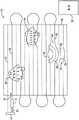
现在转到附图,图1是包括耦接到农田16内的农用机具14的农用车辆12的全局控制系统10的实施例的示意图。农用车辆12(例如,拖拉机或其它原动机)被配置为沿着行驶方向18拖曳农用机具14,以在农田16上执行各种农业操作。例如,农用机具14可以是耕作工具、施肥工具、播种或种植工具、或收割工具等等。虽然在所示实施例中由农用车辆12使用联接装置(hitch)20(诸如牵引杆、两点联接装置或三点联接装置)拖曳(例如,在农用车辆12的前面或后面)农用机具14,但应该认识到的是,在某些实施例中,农用机具可以被集成到农用车辆中。另外,虽然控制系统10被称为“全局”控制系统10,但“全局”仅标识控制系统(例如,以将全局控制系统10与本文公开的其它控制系统区分开)。应该认识到的是,虽然可以用执行某些操作的基础控制系统(例如,基站控制器)和执行其它操作的车辆控制系统来描述所示实施例,但是可以使用基础控制系统和车辆控制系统的任何合适的组合来执行各种操作。例如,可以在没有基站的情况下对车辆执行操作。Turning now to the drawings, FIG. 1 is a schematic diagram of an embodiment of aglobal control system 10 including anagricultural vehicle 12 coupled to anagricultural implement 14 within anagricultural field 16 . The agricultural vehicle 12 (eg, a tractor or other prime mover) is configured to tow theagricultural implement 14 in the direction oftravel 18 to perform various agricultural operations on thefield 16 . For example, theagricultural implement 14 may be a tilling implement, a fertilizing implement, a seeding or planting implement, a harvesting implement, and the like. While theagricultural implement 14 is towed (eg, in front of or behind the agricultural vehicle 12) by theagricultural vehicle 12 using a hitch 20 (such as a drawbar, two-point hitch, or three-point hitch) in the illustrated embodiment, It should be appreciated, however, that in some embodiments, the agricultural implement may be integrated into an agricultural vehicle. Additionally, although thecontrol system 10 is referred to as a "global"control system 10, "global" merely identifies the control system (eg, to distinguish theglobal control system 10 from other control systems disclosed herein). It should be appreciated that although the illustrated embodiments may be described with a base control system (eg, a base station controller) that performs certain operations and a vehicle control system that performs other operations, combinations of base control systems and vehicle control systems may be used. any suitable combination to perform various operations. For example, operations can be performed on a vehicle without a base station.

在所示实施例中,农用车辆12被配置为至少部分地自主操作(例如,没有来自农用车辆12的驾驶室中存在的操作员的输入)。因此,自动系统(例如,控制系统)可以在农田16中引导农用车辆12和农用机具14,而无需操作员直接控制(例如,转向控制、速度控制等)。在所示实施例中,自主农用车辆12被配置为与全局控制系统10的基站22的控制器通信。如下面详细讨论的,全局控制系统10可以包括农用车辆12的控制器、基站22的控制器、农用机具14的控制器或其组合。在还有的实施例中,农用车辆12的一些方面可以基本上是手动控制的。例如,操作员可以位于基站22内并操作某些控制以控制农用车辆12和/或农用机具14。由此,农用车辆12可以在没有来自农用车辆12内的操作员直接控制农用车辆12的操作的情况下穿过农田16(例如,自主操作)。In the illustrated embodiment, theagricultural vehicle 12 is configured to operate at least partially autonomously (eg, without input from an operator present in the cab of the agricultural vehicle 12). Thus, automated systems (eg, control systems) may guideagricultural vehicles 12 andagricultural implements 14 infield 16 without direct operator control (eg, steering control, speed control, etc.). In the illustrated embodiment, the autonomousagricultural vehicle 12 is configured to communicate with a controller of thebase station 22 of theglobal control system 10 . As discussed in detail below, theglobal control system 10 may include a controller of theagricultural vehicle 12, a controller of thebase station 22, a controller of theagricultural implement 14, or a combination thereof. In still other embodiments, some aspects of theagricultural vehicle 12 may be substantially manually controlled. For example, an operator may be located withinbase station 22 and operate certain controls to controlagricultural vehicle 12 and/oragricultural implement 14 . As such, theagricultural vehicle 12 may traverse theagricultural field 16 without direct control of the operation of theagricultural vehicle 12 from an operator within the agricultural vehicle 12 (eg, autonomously operated).

为了穿过农田16,基站22可以向农用车辆12发送指令以遵循通过农田16的规划的车辆路径24(例如,引导带状区域)。“路径”可以包括距离和方向以及/或者目标地点,其中农用车辆12和/或机具14被引导行驶以覆盖农田16的各个区域。虽然在图1-3中路径被指示在田地上,但基站22可以发送指示到农用车辆的距离和方向的指令或发送用于插补的地点。如果农用机具14在农用车辆12后面居中(例如,没有偏移),则通过田地的机具路径可以对应于通过田地的车辆路径。在某些实施例中,全局控制系统10可以通过考虑机具的几何形状(诸如,偏移)和/或车辆和/或机具的能力来确定定位农用机具14以显著减少田地的跳过或重叠的区域的车辆路径。农用机具14的几何形状和/或农用车辆12的几何形状可以包括车辆和/或机具尺寸、形状和/或重量、用于将机具连接到车辆的联接装置的类型、机具的车轮的类型(例如,脚轮的(castering)或非脚轮的)、其中机具执行农业操作的区域等。另外,车辆和/或机具能力可以包括车辆的转弯半径(例如,最小转弯半径)、机具的转弯半径(例如,最小转弯半径)、车辆和机具的组合的转弯半径(例如,基于机具和拖拉机的几何形状拖拉机的轮胎接触机具之处的转弯半径)、机具被升高时的转弯半径(例如,在运输中)、机具被降低时的转弯半径(例如,在操作中)、车辆方向的变化率、机具的车轮是否可控制等。通过考虑农用机具14的几何形状和/或农用车辆12和农用机具的能力,实现了机具的更准确的路径规划,使得农业操作的效率(例如,耕作操作、种植操作、收割操作等)显著增强。To traverse thefield 16 , thebase station 22 may send instructions to theagricultural vehicle 12 to follow a planned vehicle path 24 (eg, a guide strip) through thefield 16 . The "path" may include the distance and direction and/or target location where theagricultural vehicle 12 and/orimplement 14 are directed to travel to cover various areas of thefield 16 . Although the path is indicated on the field in Figures 1-3, thebase station 22 may send commands indicating distance and direction to the agricultural vehicle or a location for interpolation. If theagricultural implement 14 is centered behind the agricultural vehicle 12 (eg, not offset), the implement path through the field may correspond to the vehicle path through the field. In certain embodiments,global control system 10 may determine to positionagricultural implement 14 to significantly reduce skipping or overlapping of fields by considering implement geometry (such as offset) and/or vehicle and/or implement capabilities Vehicle paths in the area. The geometry of theagricultural implement 14 and/or theagricultural vehicle 12 may include vehicle and/or implement size, shape and/or weight, type of coupling for connecting the implement to the vehicle, type of wheels of the implement (eg, , castering or non-caster), areas where implements perform agricultural operations, etc. Additionally, vehicle and/or implement capabilities may include a turning radius of the vehicle (eg, a minimum turning radius), a turning radius of the implement (eg, a minimum turning radius), a combined turning radius of the vehicle and implement (eg, implement and tractor-based Geometry turning radius of the tractor where the tires contact the implement), turning radius when the implement is raised (eg, in transport), turning radius when the implement is lowered (eg, in operation), rate of change of vehicle orientation , Whether the wheels of the machine can be controlled, etc. By taking into account the geometry of theagricultural implement 14 and/or the capabilities of theagricultural vehicle 12 and the agricultural implement, more accurate path planning of the implement is achieved, resulting in a significant increase in the efficiency of agricultural operations (eg, tillage operations, planting operations, harvesting operations, etc.) .

基站22可以规划用于农用机具14的机具路径26。在所示实施例中,基站22基于机具几何形状规划机具路径26以覆盖农田16,同时显著减少重叠或跳过的区域。基站22根据农田16的几何形状和/或农用机具14的几何形状和/或能力规划机具路径26的第一段34(例如,在行尾转弯30之前的田地的部分)以覆盖农田16的边界。在规划农田16的第一段34以在农田16的第一区域上执行农业操作之后,基站22基于第一段34的机具路径26和农用机具14的几何形状和/或能力规划第二段36(例如,以在与第一区域相邻的在行尾转弯30和行尾转弯32之间的第二区域农田上执行农业操作)。例如,第二段36被规划为,其中在第一段34上的农业操作期间农用机具14的操作区域(即,由耕作、种植、收割或其它操作所覆盖的区域)的末尾与在第二段36上的农业操作期间农用机具14的操作区域的末尾对齐,如线38所示。即,基站22以通过基于农用机具14的几何形状和/或能力对齐机具路径26的每个段34、36的操作区域来显著减少重叠和/或跳过的区域的方式来规划机具路径26的第二段36。Base station 22 may plan implementpath 26 foragricultural implement 14 . In the illustrated embodiment,base station 22 plans implementpath 26 based on implement geometry to coverfield 16 while significantly reducing overlapping or skipped areas. Thebase station 22 plans thefirst segment 34 of the implement path 26 (eg, the portion of the field prior to the end-of-row turn 30 ) to cover the boundaries of thefield 16 based on the geometry of thefield 16 and/or the geometry and/or capabilities of theimplement 14 . After planning thefirst segment 34 of thefield 16 to perform agricultural operations on the first area of thefield 16 , thebase station 22 plans thesecond segment 36 based on theimplement path 26 of thefirst segment 34 and the geometry and/or capability of theagricultural implement 14 . (eg, to perform agricultural operations on a second area of farmland adjacent to the first area between end-of-row turns 30 and end-of-row turns 32). For example, thesecond segment 36 is planned such that the end of the area of operation of the agricultural implement 14 (ie, the area covered by tilling, planting, harvesting or other operations) during the agricultural operation on thefirst segment 34 is the same as at the end of thesecond segment 34. The ends of the operating area ofagricultural implement 14 during agricultural operations onsegment 36 are aligned, as shown byline 38 . That is, thebase station 22 plans the path of theimplement 26 in a manner that significantly reduces the area of overlap and/or skipping by aligning the operating area of eachsegment 34 , 36 of theimplement path 26 based on the geometry and/or capability of theimplement 14 .Second paragraph 36.

基站22可以规划沿着机具路径26移动机具的车辆路径24。例如,基站22可以基于农用机具14的偏移28和/或几何形状(例如,宽度)来确定规划的车辆路径24。偏移28是农用机具14的横向中心线和农用车辆12的横向中心线之间的差。因为规划的车辆路径24是基于规划的机具路径26确定的,因此基站22(例如,基站控制器)规划车辆路径24为具有距离车辆路径的第二段36第一距离40的第一段34和距离车辆路径的第三段44第二距离42的车辆路径的第二段36。Thebase station 22 may plan avehicle path 24 to move the implement along theimplement path 26 . For example,base station 22 may determine plannedvehicle path 24 based onoffset 28 and/or geometry (eg, width) ofagricultural implement 14 . Theoffset 28 is the difference between the lateral centerline of theagricultural implement 14 and the lateral centerline of theagricultural vehicle 12 . Because the plannedvehicle path 24 is determined based on the plannedimplement path 26, the base station 22 (eg, base station controller) plans thevehicle path 24 as thefirst segment 34 having thefirst distance 40 from thesecond segment 36 of the vehicle path and Thesecond segment 36 of the vehicle path is asecond distance 42 from thethird segment 44 of the vehicle path.

基站22(例如,基站控制器)至少部分地基于机具路径26的第一段34来规划车辆路径24的第一段34,以沿着第一区域引导农用机具14。基站22(例如,基站控制器)可以至少部分地基于机具路径26的第二段36确定车辆路径24的第二段36,以沿着第二区域引导农用机具14。即,基站22(例如,基站控制器)可以至少部分地基于机具路径26的第二段36确定车辆路径24的第二段36,以沿着第二区域驱动农用机具14。如下面所讨论的,基站22(例如,基站控制器)可以确定车辆路径24的第一段34的末尾31和车辆路径24的第二段36的开始33之间的车辆路径24的第一行尾转弯30,以使农用车辆12能够转向并在第二区域上执行农业操作。然后,基站22(例如,基站控制器)可以输出指示车辆路径的第一信号。农用车辆12、农用机具14和基站22各自可以包括使得能够在每个元件的控制系统之间进行通信的收发器。The base station 22 (eg, base station controller) plans thefirst segment 34 of thevehicle path 24 based at least in part on thefirst segment 34 of the implementpath 26 to guide the agricultural implement 14 along the first area. The base station 22 (eg, a base station controller) may determine thesecond segment 36 of thevehicle path 24 based at least in part on thesecond segment 36 of the implementpath 26 to guide the agricultural implement 14 along the second area. That is, the base station 22 (eg, base station controller) may determine thesecond segment 36 of thevehicle path 24 based at least in part on thesecond segment 36 of the implementpath 26 to drive the agricultural implement 14 along the second area. As discussed below, the base station 22 (eg, base station controller) may determine the first row of thevehicle path 24 between theend 31 of thefirst segment 34 of thevehicle path 24 and thestart 33 of thesecond segment 36 of the vehicle path 24 Atail turn 30 is made to enable theagricultural vehicle 12 to steer and perform agricultural operations on the second area. The base station 22 (eg, a base station controller) may then output a first signal indicative of the path of the vehicle. Theagricultural vehicle 12, the agricultural implement 14, and thebase station 22 may each include a transceiver that enables communication between the control systems of each element.

在图1的行尾转弯30和32期间,可以在不考虑机具相对于田地的位置的情况下规划车辆路径24,因为农用机具14在行尾转弯30和32上不与土壤接合。例如,基站22(例如,基站控制器)可以独立于机具路径的第一段34和机具路径的第二段36之间的机具路径26确定在车辆路径24的第一段34的末尾31处的车辆路径24的第一行尾转弯30。即,在第一段的末尾31之后,独立于机具路径26和/或不考虑在行尾转弯30期间机具相对于田地的位置来规划车辆路径24。然后,基站22(例如,基站控制器)可以确定将在行尾转弯30的末尾处的车辆路径24和/或机具路径26与第二段36的开始33对齐以在第二区域上执行农业操作的行尾转弯30的车辆路径24。例如,基站控制器可以被配置为至少部分地基于农用车辆12的能力、农用机具14的能力或两者来确定第一行尾转弯30。此外,可以在规划行尾转弯30时考虑机具段36。即,基站控制器可以被配置为以连接第一机具段34与第二机具段36的方式确定第一行尾转弯30。另外,基站控制器可以独立于机具路径26的第二段36和机具路径26的第三段44之间的机具路径确定在车辆路径24的第二段36的末尾35处的车辆路径的第二行尾转弯32。During end-of-row turns 30 and 32 of FIG. 1 ,vehicle path 24 may be planned without regard to the position of the implement relative to the field, since agricultural implement 14 does not engage the soil on end-of-row turns 30 and 32 . For example, the base station 22 (eg, a base station controller) may determine at theend 31 of thefirst segment 34 of thevehicle path 24 independently of the implementpath 26 between thefirst segment 34 of the implement path and thesecond segment 36 of the implement path The end of the first line of thevehicle path 24 turns 30 . That is, after theend 31 of the first segment, thevehicle path 24 is planned independently of the implementpath 26 and/or without regard to the position of the implement relative to the field during the end-of-row turn 30 . The base station 22 (eg, base station controller) may then determine to align thevehicle path 24 and/or implementpath 26 at the end of the end-of-line turn 30 with thestart 33 of thesecond segment 36 to perform agricultural operations on the second area End-of-line turn 30 ofvehicle path 24 . For example, the base station controller may be configured to determine the first end-of-row turn 30 based at least in part on the capabilities of theagricultural vehicle 12, the capabilities of the agricultural implement 14, or both. Additionally, implementsegments 36 may be considered when planning end-of-row turns 30 . That is, the base station controller may be configured to determine the first end-of-row turn 30 in a manner that connects the first implementsegment 34 and the second implementsegment 36 . Additionally, the base station controller may determine the second portion of the vehicle path at theend 35 of thesecond segment 36 of thevehicle path 24 independently of the implement path between thesecond segment 36 of the implementpath 26 and thethird segment 44 of the implementpath 26 End ofline turn 32.

基站22规划车辆路径24,使得农用车辆12行驶使农用机具14能够覆盖机具路径26的路径。在常规系统中,如果农用机具14偏移农用车辆12的中心,那么偏移可能导致农用机具14在穿过农田16时跳过或重叠区域,因为规划的车辆路径24可能没有考虑农用机具14的几何形状。通过基于机具路径26规划车辆路径24,控制系统10显著减少了区域的跳过和重叠,从而例如留下更少的未耕作、未种植或未收割区域或者过耕作、过种植或过收割区域。Thebase station 22 plans thevehicle path 24 so that theagricultural vehicle 12 travels a path that enables the agricultural implement 14 to cover the implementpath 26 . In conventional systems, if the agricultural implement 14 is offset from the center of theagricultural vehicle 12 , the offset may cause the agricultural implement 14 to skip or overlap areas as it traverses thefield 16 because the plannedvehicle path 24 may not take into account the agricultural implement 14 geometric shapes. By planning thevehicle path 24 based on the implementpath 26 , thecontrol system 10 significantly reduces skipping and overlapping of areas, eg, leaving less uncultivated, unplanted or unharvested or over-tilled, over-planted or over-harvested areas.

虽然下面描述的一些实施例可以包括附加路径规划(例如,机具路径),但是其它实施例可以考虑偏移而不执行附加路径规划。例如,在一些实施例中,基础控制系统(例如,基站控制器)可以被配置为至少部分地基于车辆和机具之间的偏移来规划车辆路径。基础控制系统可以基于偏移来规划车辆路径的第一段并且与偏移无关地规划行尾转弯30(例如,不考虑机具相对于农田的位置)。然后,基础控制系统可以发送指示车辆路径的信号。While some embodiments described below may include additional path planning (eg, implement paths), other embodiments may account for offsets without performing additional path planning. For example, in some embodiments, an underlying control system (eg, a base station controller) may be configured to plan a vehicle path based at least in part on the offset between the vehicle and the implement. The base control system may plan the first segment of the vehicle's path based on the offset and plan the end-of-row turn 30 independently of the offset (eg, regardless of the position of the implement relative to the field). The base control system can then send signals indicative of the vehicle's path.

图2是包括耦合到另一个农田48内的农用机具14的农用车辆12的全局控制系统10的另一个实施例的示意图。如上所述,可以通过联接装置20将农用机具14耦合到农用车辆12来拖曳农用机具14。在某些实施例中,由于大约联接装置角度的旋转,农用机具14相对于农用车辆的朝向可以随着机具跟随农用车辆12而变化。例如,如果田地具有斜坡,那么农用机具14可以相对于农用车辆12枢转,使得农用机具14可以不沿着农用机具14在平坦表面上将会遵循的相同路径。该处理可以被称为机具漂移。因为农用机具14相对于农用车辆12的朝向可以随着农用车辆12穿过农田16而变化,因此可能期望基于农用机具14的能力以及农田48的一个或多个特征来确定考虑农用机具14的预期朝向(例如,机具漂移)的机具路径26。FIG. 2 is a schematic diagram of another embodiment of theglobal control system 10 including theagricultural vehicle 12 coupled to the agricultural implement 14 within anotherfield 48 . As described above, the agricultural implement 14 may be towed by coupling the agricultural implement 14 to theagricultural vehicle 12 through thecoupling device 20 . In certain embodiments, the orientation of the agricultural implement 14 relative to the agricultural vehicle may change as the implement follows theagricultural vehicle 12 due to rotation about the coupling angle. For example, if the field has a slope, agricultural implement 14 may pivot relative toagricultural vehicle 12 so that agricultural implement 14 may not follow the same path that agricultural implement 14 would follow on a flat surface. This process may be referred to as implement drift. Because the orientation of farm implement 14 relative to farmvehicle 12 may vary asfarm vehicle 12 traversesfarm field 16 , it may be desirable to determine expectations considering farm implement 14 based on the capabilities of farm implement 14 and one or more characteristics offarm field 48 . The implementpath 26 toward (eg, implement drift).

在所示实施例中,农用车辆12从基站22接收指示车辆路径50和/或机具路径52的指令。可以至少部分地基于农田48的特征(诸如地形(例如,斜坡、隆起(bump)、山丘等)和/或障碍物(例如,水、巨石等))来确定车辆路径50。基站22(例如,基站控制器)可以首先确定机具路径52,并且然后确定基本上建立所确定的机具路径52的车辆路径50。如上所述,机具路径52是指农用机具14通过田地的规划路径。与不考虑农用机具14的位置的车辆路径相比,该车辆路径被确定为使得机具路径显著减少了田地的重叠和/或跳过区域。In the illustrated embodiment, theagricultural vehicle 12 receives instructions from thebase station 22 indicating thevehicle path 50 and/or the implementpath 52 .Vehicle path 50 may be determined based at least in part on features offarmland 48 such as terrain (eg, slopes, bumps, hills, etc.) and/or obstacles (eg, water, boulders, etc.). The base station 22 (eg, base station controller) may first determine the implementpath 52 and then determine thevehicle path 50 that substantially establishes the determined implementpath 52 . As mentioned above, implementpath 52 refers to the planned path of agricultural implement 14 through the field. The vehicle path is determined such that the implement path significantly reduces overlapping and/or skipping areas of the field compared to a vehicle path that does not take into account the location of the agricultural implement 14 .

在所示实施例中,基站22(例如,基站控制器)确定基本上建立规划的机具路径52的车辆路径50。车辆路径50可以至少部分地基于农用车辆12的几何形状、农用机具14的几何形状、农田48的特征(例如,地形)或其组合以及其它因素。另外,车辆路径50可以至少部分地基于农用车辆12的至少一个能力、农用机具14的至少一个能力、农用车辆12和农用机具14之间的联接装置的至少一个能力或其组合。例如,农用车辆的至少一个能力中的能力可以包括农用车辆的转弯半径、车辆的方向的变化率或其任何组合,并且农用机具的至少一个能力可以包括农用机具的转弯半径、机具的至少一个车轮是否是可控制的,或其任何组合。In the illustrated embodiment, base station 22 (eg, a base station controller) determinesvehicle path 50 that substantially establishes planned implementpath 52 . Thevehicle path 50 may be based, at least in part, on the geometry of theagricultural vehicle 12 , the geometry of the agricultural implement 14 , the characteristics of the field 48 (eg, terrain), or a combination thereof, among other factors. Additionally,vehicle path 50 may be based at least in part on at least one capability ofagricultural vehicle 12 , at least one capability of agricultural implement 14 , at least one capability of a coupling betweenagricultural vehicle 12 and agricultural implement 14 , or a combination thereof. For example, the capability of the at least one capability of the agricultural vehicle may include the turning radius of the agricultural vehicle, the rate of change of the direction of the vehicle, or any combination thereof, and the at least one capability of the agricultural implement may include the turning radius of the agricultural implement, the at least one wheel of the implement is controllable, or any combination thereof.

农田48包括山丘56,山丘56具有相对于周围地形的斜坡。规划的机具路径52大致直地越过山丘56。为了维持大致直的机具路径52,基站22(例如,基站控制器)可以确定考虑当农用车辆12和农用机具在山坡56上移动时农用机具14围绕联接装置的旋转的车辆路径50。例如,基站22(例如,基站控制器)可以基于联接装置角度和山丘坡度大小之间的关系(例如,经由查找表、方程式、模拟等)确定车辆路径50。另外,机具的传感器可以用于测量机具漂移量。类似地,对于具有朝向相反方向的斜坡的另一个山丘58,基站22(例如,基站控制器)可以确定建立规划的机具路径52的车辆路径50。Thefarmland 48 includeshills 56 having slopes relative to the surrounding terrain. The planned implementpath 52 crosses thehill 56 substantially straight. To maintain a substantially straight implementpath 52 , the base station 22 (eg, base station controller) may determine avehicle path 50 that takes into account rotation of the agricultural implement 14 about the hitch as theagricultural vehicle 12 and the implement move on thehillside 56 . For example, base station 22 (eg, a base station controller) may determinevehicle path 50 based on a relationship (eg, via look-up tables, equations, simulations, etc.) between coupling angle and hill slope magnitude. Additionally, implement sensors can be used to measure implement drift. Similarly, for anotherhill 58 with a slope facing in the opposite direction, the base station 22 (eg, base station controller) may determine thevehicle path 50 that establishes the planned implementpath 52 .

此外,在所示实施例中,基站22(例如,基站控制器)至少部分地基于农用车辆12、农用机具14、联接装置20的几何形状和能力等来确定车辆路径62。可以规划在段64处围绕障碍物60的车辆路径62以建立调整后的机具路径66,该调整后的机具路径66显著减少田地的重叠和/或跳过的区域,同时满足与障碍物相关的几何形状、农用车辆12的几何形状、农用机具14的几何形状、联接装置20的几何形状、农用车辆12的能力、农用机具14的能力、联接装置20的能力或其组合。例如,可以基于障碍物的地点、尺寸和形状来建立规划的机具路径52。然后,基站22(例如,基站控制器)可以确定具有弯曲路径68的车辆路径62,该路径建立规划的机具路径同时满足农用车辆12的能力(例如,最小/最大转弯半径、最小/最大转弯速率等)。另外,基站22(例如,基站控制器)基于弯曲路径66确定调整后的机具路径76,其再次显著减少了重叠和/或跳过的区域。例如,基站22(例如,基站控制器)规划调整后的机具路径,其包括曲线78以减少重叠和/或跳过的区域。如果未确定满足车辆能力的车辆路径,那么基站控制器可以调整机具路径、基于调整后的机具路径确定第二车辆路径、并确定第二车辆路径是否满足车辆的能力。以这种方式,基站22(例如,基站控制器)可以经由迭代处理重复地调整车辆路径和机具路径,以减少重叠和/或跳过的区域,同时满足车辆能力、机具能力、联接装置能力或其任何组合。虽然图2的基站22(例如,基站控制器)初始地建立机具路径并且然后调整路径以满足车辆能力/几何形状、机具能力/几何形状、联接装置能力/几何形状和地形信息,但是在其它实施例中,基站22(例如,基站控制器)可以相反地通过建立满足车辆的能力的车辆路径开始,并且然后重复地调整机具路径,直到机具路径显著减少重叠和/或跳过的区域为止。在由基站22(例如,基站控制器)确定机具路径和车辆路径之后,农用车辆12可以开始穿过农田48。确定机具和车辆路径的处理也可以在车辆上执行。在一些实施例中,基站可以向车辆指派任务,并且车辆控制器可以确定机具路径和车辆路径。Furthermore, in the illustrated embodiment, the base station 22 (eg, base station controller) determines thevehicle path 62 based at least in part on theagricultural vehicle 12 , the agricultural implement 14 , the geometry and capabilities of thecoupling 20 , and the like. Thevehicle path 62 around theobstacle 60 atsegment 64 may be planned to establish an adjusted implementpath 66 that significantly reduces overlapping and/or skipped areas of the field while meeting the obstacle-related criteria. Geometry,agricultural vehicle 12 geometry, agricultural implement 14 geometry, coupling 20 geometry,agricultural vehicle 12 capabilities, agricultural implement 14 capabilities, coupling 20 capabilities, or a combination thereof. For example, the planned implementpath 52 may be established based on the location, size, and shape of the obstacle. The base station 22 (eg, base station controller) may then determine avehicle path 62 having acurved path 68 that establishes the planned implement path while meeting the capabilities of the agricultural vehicle 12 (eg, minimum/maximum turn radius, minimum/maximum turn rate Wait). Additionally, the base station 22 (eg, base station controller) determines an adjusted implementpath 76 based on thecurved path 66, which again significantly reduces the area of overlap and/or skipping. For example, base station 22 (eg, a base station controller) plans an adjusted implement path that includescurve 78 to reduce overlapping and/or skipped areas. If a vehicle path that satisfies the vehicle capabilities is not determined, the base station controller may adjust the implement path, determine a second vehicle path based on the adjusted implement path, and determine whether the second vehicle path satisfies the vehicle's capabilities. In this manner, base station 22 (eg, a base station controller) may repeatedly adjust vehicle paths and implement paths via an iterative process to reduce overlapping and/or skipped areas while meeting vehicle capabilities, implement capabilities, linkage capabilities, or any combination thereof. While the base station 22 (eg, base station controller) of FIG. 2 initially establishes an implement path and then adjusts the path to meet vehicle capabilities/geometry, implement capabilities/geometry, hitch capabilities/geometry, and terrain information, in other implementations For example, base station 22 (eg, a base station controller) may instead begin by establishing a vehicle path that meets the vehicle's capabilities, and then repeatedly adjust the implement path until the implement path significantly reduces overlapping and/or skipped areas. After the implement paths and vehicle paths are determined by the base station 22 (eg, a base station controller), theagricultural vehicle 12 may begin traversing thefield 48 . The process of determining implement and vehicle paths may also be performed on the vehicle. In some embodiments, the base station may assign tasks to the vehicle, and the vehicle controller may determine the implement path and the vehicle path.

图3是包括耦合到农田86内的农用机具14的农用车辆12的全局控制系统10的示意图。例如,农用车辆12和农用机具可以穿过农田,如图中虚线所示。当农用车辆12沿着车辆路径88移动以穿过农田86时,农用车辆12和/或机具14可能遇到障碍物,诸如岩石、斜坡、水塘、松土等。由于干扰,农用车辆12、农用机具14或两者可能偏离期望路径。为了考虑这些干扰,农用车辆的控制器可以控制农用车辆12以使车辆与车辆路径88对齐和/或使农用机具14与机具路径92对齐。FIG. 3 is a schematic diagram of theglobal control system 10 including theagricultural vehicle 12 coupled to the agricultural implement 14 within thefield 86 . For example,agricultural vehicles 12 and agricultural implements may traverse the field as shown in phantom. As theagricultural vehicle 12 moves along thevehicle path 88 to traverse theagricultural field 86 , theagricultural vehicle 12 and/or the implement 14 may encounter obstacles, such as rocks, slopes, ponds, loosening, and the like. Due to the disturbance, theagricultural vehicle 12, the agricultural implement 14, or both may deviate from the desired path. To account for these disturbances, the agricultural vehicle's controller may control theagricultural vehicle 12 to align the vehicle with thevehicle path 88 and/or align the agricultural implement 14 with the implementpath 92 .

如图所示,当农用车辆12拖曳农用机具14时,农用机具14遇到岩石90,该岩石90使农用机具14偏转机具路径92。农用机具14的实际路径94由于遇到岩石90而偏离机具路径92,并且农用车辆12的控制器和/或基站的控制器调整农用车辆12的路径以减小实际路径94与规划的机具路径92之间的差异。例如,农用车辆的控制器和/或基站的控制器在方向98上引导农用车辆12,以使农用机具14与机具路径92重新对齐。例如,农用车辆的控制器可以从基础控制系统接收指示车辆路径的第一信号。然后,控制器可以发送指示控制转向控制系统、速度控制系统或其组合的指令的第二信号,以沿着车辆路径行驶。控制器可以接收指示农用车辆、农用机具或其任何组合的位置的第三信号,以基于农用车辆的位置、农用机具的位置或其任何组合来调整车辆路径。例如,控制器可以从传感器组件的传感器之一接收信号。控制器可以发送指示控制转向控制系统、速度控制系统或其任何组合的指令的第三信号,以基于基于农用车辆的位置、农用机具的位置或其组合调整的车辆路径调整农用车辆、农用机具或其任何组合的方向、速度或其组合。As shown, when the agricultural implement 14 is being towed by theagricultural vehicle 12 , the agricultural implement 14 encounters arock 90 which causes the agricultural implement 14 to deflect the implementpath 92 . Theactual path 94 of the agricultural implement 14 deviates from the implementpath 92 due to encountering arock 90 and the controller of theagricultural vehicle 12 and/or the controller of the base station adjusts the path of theagricultural vehicle 12 to reduce theactual path 94 from the planned implementpath 92 difference between. For example, the controller of the agricultural vehicle and/or the controller of the base station directs theagricultural vehicle 12 in thedirection 98 to realign the agricultural implement 14 with the implementpath 92 . For example, a controller of an agricultural vehicle may receive a first signal from an underlying control system indicative of the vehicle's path. The controller may then send a second signal indicative of instructions to control the steering control system, the speed control system, or a combination thereof, to travel along the vehicle path. The controller may receive a third signal indicative of the location of the agricultural vehicle, the agricultural implement, or any combination thereof, to adjust the vehicle path based on the location of the agricultural vehicle, the location of the agricultural implement, or any combination thereof. For example, the controller may receive a signal from one of the sensors of the sensor assembly. The controller may send a third signal indicative of an instruction to control a steering control system, a speed control system, or any combination thereof, to adjust the agricultural vehicle, agricultural implement or direction, velocity, or any combination thereof in any combination.

在某些实施例中,农用车辆12可以控制农用机具14以避免接触岩石90。例如,农用车辆控制器和/或基站控制器可以接收指示农田中的岩石90的信号。农用车辆控制器和/或基站控制器可以确定使农用机具14能够躲避岩石90的车辆路径。如果在基站处执行路径确定,那么基站控制器可以将车辆路径传送到车辆控制器。另外,农用车辆控制器可以发送指示控制农用车辆12的转向控制系统的指令的信号,以使农用车辆12沿着路径99行驶,从而使农用机具14躲避岩石90。由此,车辆控制器可以调整农用车辆路径以使农用机具14避开岩石90。In certain embodiments, theagricultural vehicle 12 may control the agricultural implement 14 to avoid contact with therock 90 . For example, an agricultural vehicle controller and/or a base station controller may receive signals indicative ofrocks 90 in the field. The agricultural vehicle controller and/or the base station controller may determine a vehicle path that enables the agricultural implement 14 to avoid therocks 90 . If the path determination is performed at the base station, the base station controller may communicate the vehicle path to the vehicle controller. Additionally, the agricultural vehicle controller may send signals indicative of commands to control the steering control system of theagricultural vehicle 12 to drive theagricultural vehicle 12 along thepath 99 to cause the agricultural implement 14 to avoid therocks 90 . As such, the vehicle controller may adjust the agricultural vehicle path to keep the agricultural implement 14 clear of therocks 90 .

虽然所示实施例被描述为农用车辆12的控制器控制农用车辆行驶的路径,但是在其它实施例中,(例如,基站、另一个车辆等的)基础控制系统可以接收来自农用车辆的控制器的信号并确定基于农用车辆的位置、农用机具的位置或其组合调整的车辆路径。此外,在农业操作期间发生针对干扰的调整之后,农用车辆控制器和/或基站的控制器可以向基站22(例如,基站控制器)发送(一个或多个)信号以将干扰合并到未来的路径规划操作中。例如,可以包括岩石90作为关于参考图2描述的路径规划的田地信息之一。例如,基站22(例如,基站控制器)可以在机具执行农业操作时生成与控制农用车辆12相关联的先前干扰的地图。例如,控制器可以利用该地图来基于先前的干扰识别农田的特征。例如,控制器可以确定斜坡、岩石、水体、田地边界、田地的潮湿区域或与田地内的布局和/或障碍物相关的其它特征的地点、尺寸和/或形状。Although the illustrated embodiment is described as the controller of theagricultural vehicle 12 controlling the path traveled by the agricultural vehicle, in other embodiments, the underlying control system (eg, of a base station, another vehicle, etc.) may receive the controller from the agricultural vehicle signal and determine a vehicle path adjusted based on the location of the agricultural vehicle, the location of the agricultural implement, or a combination thereof. Additionally, after adjustments for interference have occurred during agricultural operations, the agricultural vehicle controller and/or the controller of the base station may send a signal(s) to the base station 22 (eg, the base station controller) to incorporate the interference into future Path planning is in progress. For example, therock 90 may be included as one of the field information regarding the path planning described with reference to FIG. 2 . For example, the base station 22 (eg, a base station controller) may generate a map of previous disturbances associated with controlling theagricultural vehicle 12 while the implement is performing agricultural operations. For example, the controller may utilize the map to identify features of the field based on previous disturbances. For example, the controller may determine the location, size, and/or shape of slopes, rocks, bodies of water, field boundaries, wet areas of the field, or other features related to layout and/or obstructions within the field.

图4是可以用于控制图1-3的农用车辆12和/或农用机具14的全局控制系统10的实施例的示意图。在所示实施例中,全局控制系统10包括基础控制系统100、车辆控制系统102和机具控制系统104,并且每个控制系统分别具有收发器106、108和110,以建立(一个或多个)无线通信链路。例如,收发器106可以与收发器108和110无线通信。另外,虽然每个控制系统包括单个收发器,但是可以使用任何控制系统中的多个收发器在电磁频谱内的各种频率范围进行通信。例如,车辆控制系统和机具控制系统可以彼此(例如,无线地或有线地)通信。例如,车辆控制系统和机具控制系统可以经由通信协议(例如,本地互连网络(LIN)通信、WiFi通信、以太网通信、控制器局域网(CAN)通信、国际标准化组织11783(ISO总线)通信等)彼此通信。另外,收发器108和110,或者车辆和机具控制系统102和104的另一个收发器分别可以使用另一种标准协议(例如,蜂窝网络)或专有协议进行通信。FIG. 4 is a schematic diagram of an embodiment of aglobal control system 10 that may be used to control theagricultural vehicle 12 and/or agricultural implement 14 of FIGS. 1-3 . In the illustrated embodiment, theglobal control system 10 includes abase control system 100, avehicle control system 102, and an implementcontrol system 104, and each control system hastransceivers 106, 108, and 110, respectively, to establish (one or more) wireless communication link. For example, transceiver 106 may communicate wirelessly withtransceivers 108 and 110 . Additionally, while each control system includes a single transceiver, multiple transceivers in any control system may be used to communicate in various frequency ranges within the electromagnetic spectrum. For example, the vehicle control system and the implement control system may communicate with each other (eg, wirelessly or by wire). For example, the vehicle control system and implement control system may communicate via a communication protocol (eg, Local Interconnect Network (LIN) communication, WiFi communication, Ethernet communication, Controller Area Network (CAN) communication, International Organization for Standardization 11783 (ISO bus) communication, etc. ) communicate with each other. Additionally,transceivers 108 and 110, or another transceiver of vehicle and implementcontrol systems 102 and 104, respectively, may communicate using another standard protocol (eg, a cellular network) or a proprietary protocol.

在所示实施例中,农用车辆12和农用机具14分别包括空间定位设备112和114,它们分别被安装在农用车辆12和农用机具14中的相应一个上,并且被配置为分别确定农用车辆12或农用机具14的位置。如将认识到的,空间定位设备112和114可以包括被配置为分别确定农用车辆12的位置和/或农用机具14的位置的任何合适的系统,诸如例如全球定位系统(GPS)、接收器。另外,空间定位设备112和114可以包括惯性测量单元(IMU),其可以用于航位推算(dead-reckoning)处理以验证GPS位置相对于加速度测量的运动。例如,IMU可以用于地形补偿以校正或消除由于农用车辆12的俯仰和侧倾而引起的GPS位置的运动。在某些实施例中,空间定位设备112和/或114可以被配置为确定农用车辆12和/或农用机具14分别相对于固定的全球坐标系(例如,经由GPS)或固定的局部坐标系的位置。另外,在一些实施例中,可以推断农用车辆12或农用机具14的空间地点。例如,农用机具地点可以基于农用机具14的几何形状、农用车辆12的几何形状、农用车辆12的地点、联接装置角度或其组合来推断。在某些实施例中,收发器108和/或110将指示农用车辆12和/或农用机具14的(一个或多个)位置的(一个或多个)信号广播到基站22(例如,基站控制器)的收发器106。In the illustrated embodiment, theagricultural vehicle 12 and the agricultural implement 14 includespatial positioning devices 112 and 114 , respectively, mounted on a respective one of theagricultural vehicle 12 and the agricultural implement 14 , respectively, and configured to locate theagricultural vehicle 12 , respectively or the location of the agricultural implement 14 . As will be appreciated,spatial positioning devices 112 and 114 may include any suitable system, such as, for example, a global positioning system (GPS), receivers configured to determine the location ofagricultural vehicle 12 and/or agricultural implement 14, respectively. Additionally,spatial positioning devices 112 and 114 may include inertial measurement units (IMUs), which may be used in a dead-reckoning process to verify motion of GPS position relative to acceleration measurements. For example, the IMU may be used for terrain compensation to correct or cancel motion of the GPS position due to pitch and roll of theagricultural vehicle 12 . In certain embodiments,spatial positioning devices 112 and/or 114 may be configured to determine the position ofagricultural vehicle 12 and/or agricultural implement 14 relative to a fixed global coordinate system (eg, via GPS) or a fixed local coordinate system, respectively. Location. Additionally, in some embodiments, the spatial location of theagricultural vehicle 12 or agricultural implement 14 may be inferred. For example, the farm implement location may be inferred based on the geometry of the farm implement 14, the geometry of thefarm vehicle 12, the location of thefarm vehicle 12, the coupling angle, or a combination thereof. In certain embodiments,transceivers 108 and/or 110 broadcast signal(s) indicative of location(s) ofagricultural vehicle 12 and/or agricultural implement 14 to base station 22 (eg, the base station controls Receiver) transceiver 106.

此外,农用车辆12包括传感器组件120以促进农用车辆12的自主控制。例如,传感器组件120可以包括用于控制农用车辆12的多个传感器(例如,红外传感器、超声波传感器,磁传感器等)。在某些实施例中,传感器组件120可以包括联接装置角度传感器119,其确定农用车辆12与农用机具14之间的联接装置20的角度。农用车辆12包括转向控制系统121和速度控制系统124,转向控制系统121被配置为控制农用车辆12的移动方向,并且速度控制系统124被配置为控制农用车辆12的速度。Additionally, theagricultural vehicle 12 includes asensor assembly 120 to facilitate autonomous control of theagricultural vehicle 12 . For example, thesensor assembly 120 may include a plurality of sensors (eg, infrared sensors, ultrasonic sensors, magnetic sensors, etc.) for controlling theagricultural vehicle 12 . In certain embodiments, thesensor assembly 120 may include a hitch angle sensor 119 that determines the angle of thehitch 20 between theagricultural vehicle 12 and the agricultural implement 14 . Theagricultural vehicle 12 includes asteering control system 121 configured to control the direction of movement of theagricultural vehicle 12 and aspeed control system 124 configured to control the speed of theagricultural vehicle 12 .

车辆控制器136可以生成并发送(一个或多个)信号以控制农用车辆12和/或农用机具14的一个或多个操作。例如,车辆控制器136可以向转向控制系统121发送控制农用车辆12的移动方向的(一个或多个)信号和/或向速度控制系统125发送控制农用车辆12的速度的(一个或多个)信号。转向控制系统121可以包括车轮角度控制系统122、差动制动系统123和扭矩向量化系统124。车轮角度控制系统122可以自动地旋转农用车辆12的一个或多个车轮和/或履带(例如,经由液压致动器),以沿着期望路线操纵农用车辆12。举例来说,车轮角度控制系统122可以单独地或成组地旋转农用车辆的前轮/履带、后轮/履带和/或中间轮/履带。差动制动系统123可以独立地改变农用车辆12的每个横向侧上的制动力,以沿着期望路线引导农用车辆12。类似地,扭矩向量化系统124可以差动地将来自引擎的扭矩施加到农用车辆12的每个横向侧上的车轮和/或履带,从而沿着期望路线引导农用车辆12。虽然图示的转向控制系统121包括车轮角度控制系统122、差动制动系统123和扭矩向量化系统124,但是应该认识到的是,替代性实施例可以以任何合适的组合包括这些系统中的一个或两个系统。还有的实施例可以包括具有其它和/或附加系统的自动化转向控制系统,以促进沿着期望路线引导农用车辆。Vehicle controller 136 may generate and transmit signal(s) to control one or more operations ofagricultural vehicle 12 and/or agricultural implement 14 . For example,vehicle controller 136 may send signal(s) tosteering control system 121 that control the direction of movement ofagricultural vehicle 12 and/or to speedcontrol system 125 to send signal(s) that control the speed ofagricultural vehicle 12 Signal.Steering control system 121 may include wheelangle control system 122 ,differential braking system 123 andtorque vectoring system 124 . The wheelangle control system 122 may automatically rotate one or more wheels and/or tracks of the agricultural vehicle 12 (eg, via hydraulic actuators) to steer theagricultural vehicle 12 along a desired route. For example, the wheelangle control system 122 may rotate the front wheels/tracks, rear wheels/tracks, and/or intermediate wheels/tracks of the agricultural vehicle individually or in groups. Thedifferential braking system 123 may independently vary the braking force on each lateral side of theagricultural vehicle 12 to guide theagricultural vehicle 12 along a desired route. Similarly, thetorque vectoring system 124 may differentially apply torque from the engine to the wheels and/or tracks on each lateral side of theagricultural vehicle 12 to guide theagricultural vehicle 12 along a desired path. Although the illustratedsteering control system 121 includes a wheelangle control system 122, adifferential braking system 123, and atorque vectoring system 124, it should be appreciated that alternative embodiments may include any suitable combination of these systems. one or two systems. Still other embodiments may include automated steering control systems with other and/or additional systems to facilitate steering the agricultural vehicle along a desired route.

在图示的实施例中,自动化速度控制系统125包括引擎输出控制系统126、变速控制系统127和制动控制系统129。引擎输出控制系统126被配置为改变引擎的输出以控制农用车辆12的速度。例如,引擎输出控制系统126可以改变引擎的油门设置、引擎的燃料/空气混合、引擎的定时、控制引擎输出的其它合适的引擎参数或其组合。此外,变速控制系统127可以调整变速器内的档位选择以控制农用车辆12的速度。此外,制动控制系统129可以调整制动力,从而控制农用车辆12的速度。虽然图示的自动化速度控制系统125包括引擎输出控制系统126、变速控制系统127和制动控制系统129,但是应该认识到的是,替代性实施例可以以任何合适的组合包括这些系统中的一个或两个系统。还有的实施例可以包括具有其它和/或附加系统的自动化速度控制系统,以促进调整农用车辆的速度。In the illustrated embodiment, the automatedspeed control system 125 includes an engineoutput control system 126 , atransmission control system 127 and a brake control system 129 . The engineoutput control system 126 is configured to vary the output of the engine to control the speed of theagricultural vehicle 12 . For example, the engineoutput control system 126 may vary the throttle setting of the engine, the fuel/air mixture of the engine, the timing of the engine, other suitable engine parameters that control engine output, or combinations thereof. Additionally, theshift control system 127 may adjust gear selection within the transmission to control the speed of theagricultural vehicle 12 . Additionally, the brake control system 129 may adjust the braking force to control the speed of theagricultural vehicle 12 . While the illustrated automatedspeed control system 125 includes an engineoutput control system 126, atransmission control system 127, and a brake control system 129, it should be appreciated that alternative embodiments may include one of these systems in any suitable combination or two systems. Still other embodiments may include automated speed control systems with other and/or additional systems to facilitate adjusting the speed of the agricultural vehicle.

在所示实施例中,基础控制系统100、车辆控制系统102和机具控制系统104各自包括控制器,即,基站控制器128、车辆控制器130和机具控制器132。每个控制器128、130和132分别包括处理器134、136和138。控制器128、130和132还可以分别包括分别可操作地耦接到处理器134、136和138以执行软件(诸如用于控制农用车辆12和农用机具14的软件等)的一个或多个存储设备和/或其它合适的部件,诸如存储器设备140、142和144。此外,处理器134、136和138可以各自包括多个处理器、一个或多个“通用”微处理器、一个或多个专用微处理器和/或一个或多个专用集成电路(ASICS),或其一些组合。例如,每个处理器134、136和138可以包括一个或多个精简指令集(RISC)处理器、高级RISC机器(ARM)处理器、具有增强型RISC(PowerPC)处理器的性能优化,现场可编程门阵列(FPGA)集成电路、图形处理单元(GPU)或任何其它合适的处理设备。In the illustrated embodiment,base control system 100 ,vehicle control system 102 , and implementcontrol system 104 each include controllers, ie,base station controller 128 ,vehicle controller 130 , and implementcontroller 132 . Eachcontroller 128, 130 and 132 includes aprocessor 134, 136 and 138, respectively.Controllers 128, 130, and 132 may also include one or more stores operably coupled toprocessors 134, 136, and 138, respectively, to execute software, such as software for controllingagricultural vehicle 12 and agricultural implement 14, respectively, etc. devices and/or other suitable components, such asmemory devices 140 , 142 and 144 . Additionally,processors 134, 136, and 138 may each include multiple processors, one or more "general-purpose" microprocessors, one or more special-purpose microprocessors, and/or one or more application-specific integrated circuits (ASICS), or some combination thereof. For example, eachprocessor 134, 136, and 138 may include one or more reduced instruction set (RISC) processors, advanced RISC machine (ARM) processors, performance-optimized with enhanced RISC (PowerPC) processors, field available Program a gate array (FPGA) integrated circuit, a graphics processing unit (GPU), or any other suitable processing device.

每个存储器设备140、142和144可以包括易失性存储器(诸如随机存取存储器(RAM))、非易失性存储器(诸如只读存储器(ROM)、闪存)或其任何组合。每个存储器设备140、142和144可以存储可以用于各种目的的各种信息。例如,每个存储器设备140、142和144可以存储用于相应的处理器134、136和138执行的处理器可执行指令(例如,固件或软件),诸如用于控制农用车辆12和/或农用机具14的指令。(一个或多个)存储设备(例如,非易失性存储装置)可以包括ROM、闪存、硬盘驱动器或任何其它合适的光学、磁性或固态存储介质,或其组合。(一个或多个)存储设备可以存储数据(例如,车辆的规划路径、机具的规划路径、障碍物信息等)、指令(例如,用于控制车辆的软件或固件等)以及任何其它合适的数据。Eachmemory device 140, 142, and 144 may include volatile memory (such as random access memory (RAM)), nonvolatile memory (such as read only memory (ROM), flash memory), or any combination thereof. Eachmemory device 140, 142, and 144 may store various information that may be used for various purposes. For example, eachmemory device 140, 142, and 144 may store processor-executable instructions (eg, firmware or software) for execution by therespective processors 134, 136, and 138, such as for controllingagricultural vehicle 12 and/or agricultural Instructions for implement 14 . The storage device(s) (eg, non-volatile storage devices) may include ROM, flash memory, hard drives, or any other suitable optical, magnetic, or solid-state storage media, or combinations thereof. The storage device(s) may store data (eg, planned paths for vehicles, planned paths for implements, obstacle information, etc.), instructions (eg, software or firmware for controlling vehicles, etc.), and any other suitable data .

在所示实施例中,基础控制系统100包括具有显示器148的用户界面146。控制器128可以(例如,经由显示器148(诸如触摸屏显示器)、鼠标、键盘等)接收与农用车辆12、农用机具14或两者的规划路径相关的(一个或多个)输入。虽然这些是示例,但是可以接收/发送各种输入和/或输出以使操作员能够控制与车辆和/或机具相关的各方面。In the illustrated embodiment, thebase control system 100 includes auser interface 146 having adisplay 148 .Controller 128 may receive input(s) related to the planned path ofagricultural vehicle 12, agricultural implement 14, or both (eg, via display 148 (such as a touch screen display), mouse, keyboard, etc.). While these are examples, various inputs and/or outputs may be received/transmitted to enable the operator to control various aspects related to the vehicle and/or implement.

基站控制系统100的控制器128被配置为经由收发器166接收指示农田的一个或多个特征的(一个或多个)信号。虽然基站控制系统100被示出为具有一个收发器,但是可以使用任何合适数量的收发器。此外,虽然所示实施例具有位于基站18处的基础控制系统(例如,基站控制器128),但是基础控制系统可以位于农用车辆、另一个农用车辆或任何其它合适的地点。例如,农用车辆控制器可以用于执行路径规划步骤和/或控制步骤中的一个或多个步骤。在某些实施例中,控制器128可以从农用车辆12接收指示与田地内的布局和/或障碍物相关的斜坡、岩石、水体、田地边界或其它特征的地点、尺寸和/或形状的信号(例如,经由收发器106和108)。替代性地和/或附加地,控制器128可以从存储器140获得农田的一个或多个特征(例如,从其它处理、从农业操作、从到用户界面146的输入等存储的)。在其它实施例中,控制器128可以经由空间定位设备112和114或适合于识别农田16、48和86的特征的其它系统获得田地的一个或多个特征。然后,控制器128至少部分地基于一个或多个特征(例如,机具几何形状和/或机具能力)确定机具路径。例如,控制器128可以确定显著减少农田的重叠和/或跳过区域的机具路径。Thecontroller 128 of the basestation control system 100 is configured to receive, via thetransceiver 166, a signal(s) indicative of one or more characteristics of the field. Although basestation control system 100 is shown with one transceiver, any suitable number of transceivers may be used. Additionally, while the illustrated embodiment has the base control system (eg, base station controller 128) located at thebase station 18, the base control system may be located at the agricultural vehicle, another agricultural vehicle, or any other suitable location. For example, an agricultural vehicle controller may be used to perform one or more of the path planning steps and/or the control steps. In certain embodiments, thecontroller 128 may receive signals from theagricultural vehicle 12 indicative of the location, size and/or shape of slopes, rocks, bodies of water, field boundaries or other features related to the layout and/or obstructions within the field (eg, via transceivers 106 and 108). Alternatively and/or additionally,controller 128 may obtain one or more characteristics of the field from memory 140 (eg, stored from other processing, from agricultural operations, from input touser interface 146, etc.). In other embodiments,controller 128 may obtain one or more characteristics of the fields viaspatial positioning devices 112 and 114 or other systems suitable for identifying characteristics offields 16 , 48 and 86 . Thecontroller 128 then determines an implement path based at least in part on the one or more characteristics (eg, implement geometry and/or implement capability). For example, thecontroller 128 may determine implement paths that significantly reduce overlapping and/or skip areas of the field.

然后,控制器128可以确定建立规划的机具路径的车辆路径。例如,控制器128可以至少部分地基于农田的一个或多个特征来确定车辆路径,并且调整期望的机具路径26、52和92,使得车辆路径24、50和88以及机具路径26、52和92考虑农田16、48和86、农用车辆12和/或农用机具14的至少一个特征,诸如障碍物、车辆尺寸、机具偏移、转弯半径等,如以上所讨论的。另外,可以至少部分地基于为特定农业操作选择的农用机具14来确定机具路径。在某些实施例中,控制器128可以从装备库接收农用机具的几何形状或能力中的至少一个。例如,耕作工具可以具有与播种工具不同的特征,诸如不同的尺寸、转弯半径等。例如,耕作工具可以具有第一偏移,并且播种工具可以具有与第一偏移不同的第二偏移。由此,控制器128可以至少部分地基于所选择的耕作工具的特征来确定耕作工具的机具路径。Thecontroller 128 may then determine a vehicle path that establishes the planned implement path. For example, thecontroller 128 may determine the vehicle path based at least in part on one or more characteristics of the field and adjust the desired implementpaths 26 , 52 and 92 such that thevehicle paths 24 , 50 and 88 and the implementpaths 26 , 52 and 92 Consider at least one characteristic offields 16, 48, and 86,agricultural vehicle 12, and/or agricultural implement 14, such as obstacles, vehicle dimensions, implement offset, turning radius, etc., as discussed above. Additionally, the implement path may be determined based at least in part on the agricultural implement 14 selected for a particular agricultural operation. In some embodiments, thecontroller 128 may receive at least one of the geometry or capability of the agricultural implement from an equipment library. For example, tillage tools may have different characteristics than seeding tools, such as different sizes, turning radii, and the like. For example, the tillage tool may have a first offset, and the seeding tool may have a second offset that is different from the first offset. As such, thecontroller 128 may determine an implement path for the tillage tool based at least in part on the characteristics of the selected tillage tool.

在所示实施例中,在控制器128确定车辆路径和机具路径之后,控制器128(例如,经由收发器106)向农用车辆12的收发器108输出指示车辆路径和/或机具路径的(一个或多个)信号,以使农用车辆12的控制器130能够沿着路径引导农用车辆。在控制器130从基站22接收到车辆路径和/或机具路径之后,控制器130可以基于接收到的车辆路径和/或机具路径来控制农用车辆12。在某些实施例中,机具的控制器132可以接收机具路径并基于机具路径控制机具的车轮或履带。另外,在一些实施例中,机具的控制器可以控制机具(例如,经由可转向的机具车轮以相对于农用车辆控制机具)沿着机具路径行驶,并且农用车辆的控制器可以控制农用车辆沿着车辆路径行驶。In the illustrated embodiment, after thecontroller 128 determines the vehicle path and the implement path, thecontroller 128 outputs (eg, via the transceiver 106 ) to thetransceiver 108 of the agricultural vehicle 12 (a) indicating the vehicle path and/or implement path. or more) signals to enable thecontroller 130 of theagricultural vehicle 12 to guide the agricultural vehicle along the path. Aftercontroller 130 receives the vehicle path and/or implement path frombase station 22 ,controller 130 may controlagricultural vehicle 12 based on the received vehicle path and/or implement path. In some embodiments, the implement'scontroller 132 may receive the implement path and control the implement's wheels or tracks based on the implement path. Additionally, in some embodiments, the controller of the implement may control the implement (eg, via steerable implement wheels to control the implement relative to the agricultural vehicle) to travel along the implement path, and the controller of the agricultural vehicle may control the agricultural vehicle to travel along the implement path Vehicle path travel.

控制器130可以从传感器组件120(例如,联接装置角度传感器)、空间定位设备112和/或114接收指示农用车辆12和/或农用机具14的地点的(一个或多个)地点信号。控制器130可以通过将农用车辆12和/或农用机具14的地点与车辆路径和/或机具路径进行比较来确定农用车辆12和/或农用机具14的实际地点与车辆路径和/或机具路径上的目标地点之间的差异。另外,控制器130可以控制农用车辆12和/或农用机具14以减小差异以更好地将机具14与所确定的机具路径对齐。Controller 130 may receive location signal(s) indicative of the location ofagricultural vehicle 12 and/or agricultural implement 14 from sensor assembly 120 (eg, a coupling angle sensor),spatial positioning device 112 and/or 114 . Thecontroller 130 may determine the actual location of thefarm vehicle 12 and/or farm implement 14 and the vehicle path and/or implement path by comparing the location of thefarm vehicle 12 and/or farm implement 14 to the vehicle path and/or implement path differences between target locations. Additionally, thecontroller 130 may control theagricultural vehicle 12 and/or the agricultural implement 14 to reduce the variance to better align the implement 14 with the determined implement path.

图5是用于控制农用车辆12和/或农用机具14的方法152的实施例的流程图。方法152可以被存储在存储器140、142和144中的一个或多个中并分别由处理器134、136和138中的一个或多个作为指令(例如,代码)来执行。在所示实施例中,在方框154处,基站22的控制器128(例如,基站控制器)可以执行与其中确定机具路径和车辆路径的全局规划阶段相关的操作。然后,农用车辆12的控制器130执行与控制农用车辆12以沿着车辆路径移动农用车辆12相关的操作。FIG. 5 is a flowchart of an embodiment of amethod 152 for controlling theagricultural vehicle 12 and/or the agricultural implement 14 .Method 152 may be stored in one or more ofmemories 140, 142, and 144 and executed as instructions (eg, code) by one or more ofprocessors 134, 136, and 138, respectively. In the illustrated embodiment, atblock 154, thecontroller 128 of the base station 22 (eg, a base station controller) may perform operations related to a global planning phase in which implement paths and vehicle paths are determined. Thecontroller 130 of theagricultural vehicle 12 then performs operations related to controlling theagricultural vehicle 12 to move theagricultural vehicle 12 along the vehicle path.

在全局规划阶段,在方框158处,控制器128确定机具路径。例如,控制器128可以接收农田16、48和86的一个或多个特征以及农用车辆12和/或农用机具14的一个或多个特征。基于农用机具14的尺寸、农用车辆12的转弯半径和其它特征,控制器128规划最大化农田16、48和86的覆盖范围(例如,减少跳过的覆盖范围)同时最小化覆盖范围的重叠的机具路径26、52和92。During the global planning phase, atblock 158 , thecontroller 128 determines an implement path. For example, thecontroller 128 may receive one or more characteristics of thefields 16 , 48 , and 86 and one or more characteristics of theagricultural vehicle 12 and/or the agricultural implement 14 . Based on the size of the farm implement 14, the turning radius of thefarm vehicle 12, and other characteristics, thecontroller 128 plans to maximize the coverage of thefields 16, 48, and 86 (eg, reduce skipped coverage) while minimizing overlapping coverage. Implementpaths 26 , 52 and 92 .

在方框160处,控制器134然后至少部分地基于机具路径确定车辆路径。控制器134确定车辆路径,使得该路径满足农用车辆12的能力,以使农用车辆12能够在该路径上驾驶同时减少对机具路径26、52和92的影响。在方框162处,控制器134可以确定对机具路径26、52和92的影响是否超过阈值容差。在对机具路径26、52、92的影响大于阈值的情况下,控制器128可以继续细化车辆路径24、50和88和/或机具路径26、52和92。一旦建立了车辆路径24、50和88和机具路径26、52和92,在方框164处,控制器134就可以生成向农用车辆12发送车辆路径24、50和88和/或机具路径26、52和92的信号。Atblock 160 , thecontroller 134 then determines a vehicle path based at least in part on the implement path. Thecontroller 134 determines the vehicle path such that the path meets the capabilities of theagricultural vehicle 12 to enable theagricultural vehicle 12 to drive on the path while reducing the impact on the implementpaths 26 , 52 and 92 . Atblock 162 , thecontroller 134 may determine whether the impact on the implementpaths 26 , 52 and 92 exceeds a threshold tolerance. Thecontroller 128 may continue to refine thevehicle paths 24 , 50 and 88 and/or the implementpaths 26 , 52 and 92 in the event that the impact on the implementpaths 26 , 52 , 92 is greater than the threshold. Once thevehicle paths 24 , 50 and 88 and the implementpaths 26 , 52 and 92 are established, atblock 164 thecontroller 134 may generate and transmit thevehicle paths 24 , 50 and 88 and/or the implementpaths 26 , 50 and 88 to theagricultural vehicle 12 , 52 and 92 signals.

控制器130接收(例如,经由收发器108)车辆路径和/或机具路径。然后农用车辆12继续沿着车辆路径移动。在控制阶段期间,在方框166处,控制器136接收指示农用机具14和/或农用车辆12的地点的信号。在方框168处,控制器136然后将农用机具的地点与所确定的机具路径进行比较。例如,控制器136可以将农用车辆和/或农用机具的实际位置之间的距离与阈值距离进行比较。在一些实施例中,当农用车辆和/或农用机具之间的距离低于阈值距离时,控制器136可以不基于距离控制车辆。在距离大于阈值距离的情况下,在方框170处,控制器136然后控制农用车辆12以减小距离,从而使农用车辆和/或农用机具与车辆路径和/或机具路径对齐以减少重叠和/或跳过的区域。可以将地点的变化发送回基站22(例如,基站控制器)以用于以后的路径规划。例如,基站控制器可以接收指示农用车辆和/或农用机具的地点的信号,以使基站控制器能够识别农田的至少一个附加特征,诸如斜坡、隆起、山丘等。虽然所示实施例包括农用车辆,但是在农田中可以使用任何合适数量的农用车辆。Thecontroller 130 receives (eg, via the transceiver 108 ) the vehicle path and/or the implement path. Theagricultural vehicle 12 then continues to move along the vehicle path. During the control phase, atblock 166 , thecontroller 136 receives a signal indicative of the location of the agricultural implement 14 and/or theagricultural vehicle 12 . Atblock 168, thecontroller 136 then compares the location of the agricultural implement to the determined implement path. For example, thecontroller 136 may compare the distance between the actual locations of the agricultural vehicle and/or agricultural implement to a threshold distance. In some embodiments, when the distance between the agricultural vehicle and/or agricultural implement is below a threshold distance, thecontroller 136 may not control the vehicle based on the distance. Where the distance is greater than the threshold distance, thecontroller 136 then controls theagricultural vehicle 12 to decrease the distance atblock 170 to align the agricultural vehicle and/or agricultural implement with the vehicle path and/or implement path to reduce overlap and / or skipped areas. Changes in location can be sent back to base station 22 (eg, a base station controller) for later path planning. For example, the base station controller may receive signals indicative of the location of the agricultural vehicle and/or agricultural implement to enable the base station controller to identify at least one additional feature of the field, such as slopes, bumps, hills, and the like. Although the illustrated embodiment includes agricultural vehicles, any suitable number of agricultural vehicles may be used in the field.

虽然本文仅图示和描述了本发明的某些特征,但是本领域技术人员将想到许多修改和变化。因此,应该认识到的是,所附权利要求旨在覆盖落入本发明的真正精神内的所有这些修改和变化。While only certain features of the invention have been illustrated and described herein, many modifications and changes will occur to those skilled in the art. Therefore, it should be realized that the appended claims are intended to cover all such modifications and changes as fall within the true spirit of the invention.

Claims (10)

Translated fromChinese
1.一种农业控制系统(10),包括:1. An agricultural control system (10), comprising:基站控制器(128),包括存储器(140)和处理器(134),其中基站控制器(128)被配置为确定使农用机具(14)能够在农田(16)的第一区域上执行农业操作的机具路径(26)的第一段(34),至少部分地基于机具路径(26)的第一段(34)来确定耦接到农用机具(14)的农用车辆(12)的车辆路径(24)的第一段(34)以沿着第一区域引导农用机具(14),确定使农用机具(14)能够在农田(16)的第二区域上执行农业操作的机具路径(26)的第二段(36),至少部分地基于机具路径(26)的第二段(36)来确定车辆路径(24)的第二段(36)以沿着第二区域驱动农用机具(14),并且确定在车辆路径(24)的第一段(34)的末尾处和机具路径(26)的第二段(36)的开始处的车辆路径(24)的第一行尾转弯(30),以及输出指示车辆路径(24)和机具路径(26)的第一信号;以及A base station controller (128) including a memory (140) and a processor (134), wherein the base station controller (128) is configured to determine to enable the agricultural implement (14) to perform agricultural operations on the first area of the field (16) A first segment (34) of the implement path (26) of the implement path (26) determines a vehicle path ( 24) to guide the agricultural implement (14) along the first area, determining the extent of the implement path (26) that enables the agricultural implement (14) to perform agricultural operations on the second area of the field (16) a second segment (36) for determining the second segment (36) of the vehicle path (24) to drive the agricultural implement (14) along the second area based at least in part on the second segment (36) of the implement path (26), and determining a first end-of-line turn (30) of the vehicle path (24) at the end of the first segment (34) of the vehicle path (24) and at the beginning of the second segment (36) of the implement path (26), and outputting a first signal indicative of the vehicle path (24) and the implement path (26); and车辆控制器(130),被配置为接收第一信号以沿着车辆路径(24)引导农用车辆(12),并且控制农用车辆(12)和农用机具(14)减少差异来更好地对齐农用机具(14)和所确定的机具路径(26);A vehicle controller (130) configured to receive a first signal to guide the agricultural vehicle (12) along the vehicle path (24), and to control the agricultural vehicle (12) and the agricultural implement (14) to reduce differences to better align the agricultural vehicle an implement (14) and the determined implement path (26);其中基站控制器(128)被配置为至少部分地基于农用机具(14)和农用车辆(12)之间的偏移(28)来确定车辆路径(24)的第一段(34),并且所述偏移(28)包括农用机具(14)的横向中心线与农用车辆(12)的横向中心线之间的距离。wherein the base station controller (128) is configured to determine the first segment (34) of the vehicle path (24) based at least in part on the offset (28) between the agricultural implement (14) and the agricultural vehicle (12), and the The offset (28) includes the distance between the lateral centerline of the agricultural implement (14) and the lateral centerline of the agricultural vehicle (12).2.如权利要求1所述的农业控制系统(10),包括具有基站控制器(128)的基础控制系统(100),其中基站控制器(128)被配置为向农用车辆(12)的车辆控制系统(102)输出指示车辆路径(24)的第一信号。2. The agricultural control system (10) of claim 1, comprising a base control system (100) having a base station controller (128), wherein the base station controller (128) is configured to control a vehicle of the agricultural vehicle (12) The control system (102) outputs a first signal indicative of the vehicle path (24).3.如权利要求1所述的农业控制系统(10),其中基站控制器(128)被配置为至少部分地基于第一区域来确定使农用机具(14)能够在与第一区域相邻的农田(16)的第二区域上执行农业操作的机具路径(26)的第二段(36)。3. The agricultural control system (10) of claim 1, wherein the base station controller (128) is configured to determine, based at least in part on the first area, to enable the agricultural implement (14) to operate in an area adjacent to the first area. A second segment (36) of the implement path (26) for performing agricultural operations on a second area of the field (16).4.如权利要求3所述的农业控制系统(10),其中基站控制器(128)被配置为至少部分地基于机具路径(26)的第二段(36)来确定车辆路径(24)的第二段(36),以沿着第二区域引导农用机具(14),并且独立于机具路径(26)的第二段(36)与机具路径(26)的第三段(44)之间的机具路径(26)来确定车辆路径(24)的第二段(36)的末尾处的车辆路径(24)的第二行尾转弯(32)。4. The agricultural control system (10) of claim 3, wherein the base station controller (128) is configured to determine the vehicle path (24) based at least in part on the second segment (36) of the implement path (26). A second segment (36) to guide the agricultural implement (14) along the second area and independent of between the second segment (36) of the implement path (26) and the third segment (44) of the implement path (26) The implement path ( 26 ) of the vehicle path ( 24 ) is determined to determine a second end turn ( 32 ) of the vehicle path ( 24 ) at the end of the second segment ( 36 ) of the vehicle path ( 24 ).5.如权利要求1-4中任一项所述的农业控制系统(10),其中基站控制器(128)被配置为从装备库接收农用机具(14)的几何形状或能力中的至少一个。5. The agricultural control system (10) of any of claims 1-4, wherein the base station controller (128) is configured to receive at least one of a geometry or capability of the agricultural implement (14) from an equipment depot .6.如权利要求1-4中任一项所述的农业控制系统(10),其中基站控制器(128)被配置为至少部分地基于农用车辆(12)的能力、农用机具(14)的能力或两者来确定第一行尾转弯(30)。6. The agricultural control system (10) of any of claims 1-4, wherein the base station controller (128) is configured to be based at least in part on the capabilities of the agricultural vehicle (12), the capability or both to determine the first row end turn (30).7.如权利要求1-4中任一项所述的农业控制系统(10),其中基站控制器(128)被配置为至少部分地基于农用机具(14)的几何形状来确定机具路径(26)的第一段(34)。7. The agricultural control system (10) of any of claims 1-4, wherein the base station controller (128) is configured to determine the implement path (26) based at least in part on the geometry of the agricultural implement (14) ) first paragraph (34).8.如权利要求1-4中任一项所述的农业控制系统(10),其中基站控制器(128)被配置为至少部分地基于农田(16)的边界和农用机具(14)的几何形状来确定机具路径(26)的第一段(34)。8. The agricultural control system (10) of any of claims 1-4, wherein the base station controller (128) is configured to be based at least in part on the boundaries of the field (16) and the geometry of the agricultural implement (14) shape to determine the first segment (34) of the implement path (26).9.如权利要求1-4中任一项所述的农业控制系统(10),其中基站控制器(128)被配置为独立于机具路径(26)的第一段(34)和机具路径(26)的第二段(36)之间的机具路径(26)来确定在车辆路径(24)的第一段(34)的末尾处的车辆路径(24)的第一行尾转弯(30)。9. The agricultural control system (10) of any of claims 1-4, wherein the base station controller (128) is configured to be independent of the first segment (34) of the implement path (26) and the implement path ( 26) between the second segment (36) of the implement path (26) to determine the first line end turn (30) of the vehicle path (24) at the end of the first segment (34) of the vehicle path (24) .10.一种农业控制方法,包括:10. An agricultural control method comprising:确定使耦接到农用车辆(12)的农用机具(14)能够在农田(16)的第一区域上执行农业操作的机具路径(26)的第一段(34);determining a first segment (34) of the implement path (26) that enables the agricultural implement (14) coupled to the agricultural vehicle (12) to perform agricultural operations on the first area of the field (16);至少部分地基于机具路径(26)来确定农用车辆(12)的车辆路径(24)的第一段(34);determining a first segment (34) of the vehicle path (24) of the agricultural vehicle (12) based at least in part on the implement path (26);输出指示车辆路径(24)和机具路径(26)的第一信号;outputting a first signal indicative of the vehicle path (24) and the implement path (26);接收第一信号以沿着车辆路径(24)引导农用车辆(12),并且控制农用车辆(12)和农用机具(14)减少差异来更好地对齐农用机具(14)和所确定的机具路径(26);receiving a first signal to guide the agricultural vehicle (12) along the vehicle path (24), and controlling the agricultural vehicle (12) and the agricultural implement (14) to reduce differences to better align the agricultural implement (14) and the determined implement path (26);从装备库接收农用机具(14)的几何形状或能力中的至少一个;receiving at least one of the geometry or capability of the agricultural implement (14) from an equipment depot;独立于机具路径(26)的第一段(34)和机具路径(26)的第二段之间的机具路径(26)来确定在车辆路径(24)的第一段(34)的末尾处的车辆路径(24)的第一行尾转弯(30);Determining at the end of the first segment (34) of the vehicle path (24) independently of the implement path (26) between the first segment (34) of the implement path (26) and the second segment of the implement path (26) end of the first line of the vehicle path (24) of the turn (30);至少部分地基于农用机具(14)的几何形状来确定机具路径(26)的第一段(34);以及determining the first segment (34) of the implement path (26) based at least in part on the geometry of the agricultural implement (14); and至少部分地基于农用机具(14)和农用车辆(12)之间的偏移来确定车辆路径(24)的第一段(34),并且所述偏移包括农用机具(14)的横向中心线与农用车辆(12)的横向中心线之间的距离。A first segment (34) of the vehicle path (24) is determined based at least in part on an offset between the agricultural implement (14) and the agricultural vehicle (12), and the offset includes a lateral centerline of the agricultural implement (14) Distance from the transverse centerline of the agricultural vehicle (12).
CN201780030303.XA2016-06-102017-06-09 Planning and Control of Autonomous Agricultural OperationsExpired - Fee RelatedCN109152332B (en)

Applications Claiming Priority (3)

Application NumberPriority DateFiling DateTitle
US15/179,367US10251329B2 (en)2016-06-102016-06-10Planning and control of autonomous agricultural operations
US15/179,3672016-06-10
PCT/US2017/036830WO2017214554A1 (en)2016-06-102017-06-09Planning and control of autonomous agricultural operations

Publications (2)

Publication NumberPublication Date
CN109152332A CN109152332A (en)2019-01-04
CN109152332Btrue CN109152332B (en)2022-06-07

Family

ID=59078262

Family Applications (1)

Application NumberTitlePriority DateFiling Date
CN201780030303.XAExpired - Fee RelatedCN109152332B (en)2016-06-102017-06-09 Planning and Control of Autonomous Agricultural Operations

Country Status (5)

CountryLink
US (1)US10251329B2 (en)
EP (1)EP3468335B8 (en)
CN (1)CN109152332B (en)
BR (1)BR112018075498A8 (en)
WO (1)WO2017214554A1 (en)

Families Citing this family (28)

* Cited by examiner, † Cited by third party
Publication numberPriority datePublication dateAssigneeTitle
US10144453B2 (en)*2016-04-132018-12-04Cnh Industrial America LlcSystem and method for controlling a vehicle
US10143126B2 (en)2016-06-102018-12-04Cnh Industrial America LlcPlanning and control of autonomous agricultural operations
US20200051035A1 (en)*2016-07-042020-02-13Perfect Flight Assessoria E Controle De Pulverizacao LtdaSystem and method for control and audit of chemical products application made by vehicles
BR112020008778B1 (en)*2017-10-312023-11-28Agjunction Llc TERRAIN MAPPING SYSTEM FOR A VEHICLE, NON-TRANSIENT AND TANGIBLE COMPUTER READABLE METHOD AND MEDIUM
US10806079B2 (en)2018-02-262020-10-20Deere & CompanyAutomatic product harvesting method and control system
DE102018108024A1 (en)2018-04-052019-10-10Horsch Maschinen Gmbh Autonomous agricultural vehicle
US11641790B2 (en)*2018-05-092023-05-09Deere & CompanyMethod of planning a path for a vehicle having a work tool and a vehicle path planning system
US20190353483A1 (en)*2018-05-152019-11-21Deere & CompanyCoverage-based system and method of planning a turn path for a vehicle
JP6958497B2 (en)*2018-06-282021-11-02井関農機株式会社 Work vehicle
US10820477B2 (en)*2018-07-302020-11-03Cnh Industrial America LlcSystem and method for automatic implement depth measurement control
US11054831B2 (en)*2018-09-272021-07-06Caterpillar Paving Products Inc.Automatic site planning for autonomous construction vehicles
JP7106443B2 (en)*2018-12-262022-07-26株式会社クボタ Driving support device, work vehicle equipped with driving support device, and driving support method
DE102019204241A1 (en)*2019-03-272020-10-01Zf Friedrichshafen Ag Method and control system for controlling an agricultural vehicle
CN110209154B (en)*2019-04-092022-10-14丰疆智能科技股份有限公司Residual harvesting path planning system and method of automatic harvester
US11770992B2 (en)2019-05-152023-10-03Cnh Industrial America LlcPosition monitoring for agricultural system
US11528836B2 (en)2019-11-222022-12-20Cnh Industrial America LlcSystem and method for sequentially controlling agricultural implement ground-engaging tools
FR3103674B1 (en)2019-12-032022-03-25Agreenculture Method for controlling by a supervisor at least one autonomous agricultural robot comprising geolocation means
US12016257B2 (en)2020-02-192024-06-25Sabanto, Inc.Methods for detecting and clearing debris from planter gauge wheels, closing wheels and seed tubes
DE102020109013A1 (en)*2020-04-012021-10-07Horsch Leeb Application Systems Gmbh Method for planning the lane of several agricultural machines
US11639856B2 (en)*2020-05-112023-05-02Toyota Motor Engineering & Manufacturing North America, Inc.Infrastructure planning tool
CA3124082C (en)*2020-10-282024-01-09Mojow Autonomous Solutions Inc.Autonomous folding farm implement and method
GB202017236D0 (en)*2020-10-302020-12-16Agco Int GmbhAutomatic manoeuvring of an agricultural vehicle at a farmyard
US20250124747A1 (en)*2021-09-142025-04-17Intelliculture Inc.Systems and methods of tracking farm vehicle performance
US12085955B2 (en)2021-10-192024-09-10Deere & CompanyMethods, apparatus, and articles of manufacture to select track paths for one or more vehicles in a field
US12185651B2 (en)2021-12-232025-01-07Cnh Industrial America LlcSystem and method for adjusting swath lines for a work vehicle
US12178149B2 (en)*2022-04-272024-12-31Deere & CompanyHeadland guidance tracks for farm machinery
US12171154B2 (en)2022-06-072024-12-24Deere & CompanyWork vehicle guidance and/or automation of turns with respect to a defined work area
WO2024081972A1 (en)*2022-10-142024-04-18Autonomous Solutions, Inc.Auto-tunable path controller with dynamic avoidance capability

Family Cites Families (55)

* Cited by examiner, † Cited by third party
Publication numberPriority datePublication dateAssigneeTitle
DE19629618A1 (en)1996-07-231998-01-29Claas Ohg Route planning system for agricultural work vehicles
EP0975209B1 (en)1997-04-162003-05-21Carnegie Mellon UniversityAgricultural harvester with robotic control
US6141614A (en)1998-07-162000-10-31Caterpillar Inc.Computer-aided farming system and method
US6088644A (en)1998-08-122000-07-11Caterpillar Inc.Method and apparatus for determining a path to be traversed by a mobile machine
US6236924B1 (en)1999-06-212001-05-22Caterpillar Inc.System and method for planning the operations of an agricultural machine in a field
US6804587B1 (en)*2000-11-152004-10-12Integrinautics CorporationAdjustment of vehicle-implement trajectories to compensate for lateral implement offset
US6865465B2 (en)2002-05-062005-03-08Csi Wireless, Inc.Method and system for implement steering for agricultural vehicles
US8634993B2 (en)2003-03-202014-01-21Agjunction LlcGNSS based control for dispensing material from vehicle
US6907336B2 (en)2003-03-312005-06-14Deere & CompanyMethod and system for efficiently traversing an area with a work vehicle
US7216033B2 (en)2003-03-312007-05-08Deere & CompanyPath planner and method for planning a contour path of a vehicle
DE102004027242A1 (en)2004-06-032005-12-22Claas Selbstfahrende Erntemaschinen Gmbh Route planning system for agricultural machines
US7580783B2 (en)2004-12-292009-08-25Cnh America LlcCorrection in position with hitch position sensor
US7451030B2 (en)2005-02-042008-11-11Novariant, Inc.System and method for interactive selection and determination of agricultural vehicle guide paths offset from each other with varying curvature along their length
US7490678B2 (en)2005-04-212009-02-17A.I.L., Inc.GPS controlled guidance system for farm tractor/implement combination
US7860628B2 (en)2005-06-092010-12-28Trimble Navigation LimitedSystem for guiding a farm implement between swaths
CA2539354A1 (en)2006-03-102007-09-10Straw Track Manufacturing Inc.Guiding agricultural implements
DE102006015204A1 (en)2006-03-302007-10-18Claas Selbstfahrende Erntemaschinen Gmbh Method for creating a route plan for agricultural machine systems
US7509199B2 (en)*2006-06-302009-03-24Deere & CompanySystem and method for calculating instantaneous placement corrections to achieve towed implement placement on curved paths
US20080262669A1 (en)2006-09-222008-10-23Jadi, Inc.Autonomous vehicle controller
US7715979B2 (en)2006-10-272010-05-11Cnh America LlcNudge compensation for curved swath paths
DE102007008624A1 (en)2007-02-222008-08-28Hella Kgaa Hueck & Co.Motor vehicle i.e. train, steering method, involves forming control input signal for controller i.e. proportional integral controller, from feedback vector, and determining desired speed from plan speed, web guiding vector and variable
US7706948B2 (en)2007-03-022010-04-27Cnh America LlcMethod for creating spiral swaths for irregular field boundaries
US7747370B2 (en)*2007-04-032010-06-29Cnh America LlcMethod for creating end of row turns for agricultural vehicles
US8209075B2 (en)2007-07-312012-06-26Deere & CompanyMethod and system for generating end turns
US8635011B2 (en)2007-07-312014-01-21Deere & CompanySystem and method for controlling a vehicle in response to a particular boundary
US8131432B2 (en)2008-02-272012-03-06Deere & CompanyMethod and system for managing the turning of a vehicle
US8204654B2 (en)2008-03-202012-06-19Deere & CompanySystem and method for generation of an inner boundary of a work area
US8428831B2 (en)2008-05-012013-04-23Cnh Canada, Ltd.Automatic steering system for an agricultural implement
US8190364B2 (en)2008-06-302012-05-29Deere & CompanySystem and method for providing towed implement compensation
US8116977B2 (en)*2008-10-022012-02-14Trimble Navigation LimitedAutomatic control of passive, towed implements
US8112201B2 (en)2008-10-022012-02-07Trimble Navigation LimitedAutomatic control of passive, towed implements
WO2010101749A1 (en)2009-03-052010-09-10Massachusetts Institute Of TechnologyPredictive semi-autonomous vehicle navigation system
US8649930B2 (en)2009-09-172014-02-11Agjunction LlcGNSS integrated multi-sensor control system and method
US8655536B2 (en)2009-11-162014-02-18Trimble Navigation LimitedMethod and system for augmenting a guidance system with a path sensor
US20110160961A1 (en)2009-12-292011-06-30Agco CorporationGuidance using a worked edge for wayline generation
BE1019422A3 (en)2010-07-142012-07-03Cnh Belgium Nv METHOD AND APPARATUS FOR PREDICTIVE CONTROL OF AN AGRICULTURAL VEHICLE SYSTEM.
US8576056B2 (en)*2010-11-102013-11-05Deere & CompanyVehicle guidance system
US9058560B2 (en)2011-02-172015-06-16Superior Edge, Inc.Methods, apparatus and systems for generating, updating and executing an invasive species control plan
US20120283909A1 (en)2011-05-032012-11-08Dix Peter JSystem and method for positioning a vehicle with a hitch using an automatic steering system
US8494726B2 (en)*2011-05-162013-07-23Trimble Navigation Ltd.Agricultural autopilot path adjustment
US8589013B2 (en)2011-10-252013-11-19Jaybridge Robotics, Inc.Method and system for dynamically positioning a vehicle relative to another vehicle in motion
US20130173321A1 (en)2011-12-302013-07-04Jerome Dale JohnsonMethods, apparatus and systems for generating, updating and executing a crop-harvesting plan
US8807261B2 (en)2012-01-312014-08-19Caterpillar Inc.Articulation control system having steering path tracking
US8983767B2 (en)2012-03-022015-03-17Jaybridge Robotics, Inc.Computer-implemented method and system for generating swath coverage patterns for polygonal and pseudo-polygonal shaped fields
US9020757B2 (en)2012-05-112015-04-28Trimble Navigation LimitedPath planning autopilot
US8825263B1 (en)2013-03-122014-09-02Raven Industries, Inc.Vehicle guidance based on tractor position
US9709969B2 (en)2013-03-152017-07-18Deere & CompanyMethods and apparatus to control machine configurations
US8626408B1 (en)2013-05-062014-01-07Ronald L. SatzlerRow-producing system for agricultural crops
WO2015057638A1 (en)2013-10-142015-04-23Kinze Manufacturing, Inc.Autonomous systems, methods, and apparatus for ag based operations
CN105980949B (en)*2014-02-062019-12-24洋马株式会社 parallel operating system
US9454155B2 (en)*2014-06-022016-09-27Trimble Navigation LimitedImplement guidance
US9420737B2 (en)*2014-08-272016-08-23Trimble Navigation LimitedThree-dimensional elevation modeling for use in operating agricultural vehicles
CN104571109A (en)*2015-01-042015-04-29南京农业大学Agricultural vehicle independent navigation steering control method based on disturbance observer
US10139826B2 (en)*2015-04-242018-11-27Autonomous Solutions Inc.Apparatus and method for controlling a vehicle
US10143126B2 (en)*2016-06-102018-12-04Cnh Industrial America LlcPlanning and control of autonomous agricultural operations

Also Published As

Publication numberPublication date
BR112018075498A2 (en)2019-03-19
CN109152332A (en)2019-01-04
EP3468335A1 (en)2019-04-17
US10251329B2 (en)2019-04-09
US20170354078A1 (en)2017-12-14
EP3468335B1 (en)2021-04-21
EP3468335B8 (en)2021-06-30
BR112018075498A8 (en)2021-10-26
WO2017214554A1 (en)2017-12-14

Similar Documents

PublicationPublication DateTitle
CN109152332B (en) Planning and Control of Autonomous Agricultural Operations
AU2017203876B2 (en)Planning and control of autonomous agricultural operations
US11052943B2 (en)System and method for controlling a vehicle
US10459447B2 (en)System and method for generating partitioned swaths
RU2728604C2 (en)System and method of lane tracking for off-road vehicle and off-road vehicle
US12078996B2 (en)System and method for implementing end-of-row turns for agricultural machines
US11224154B2 (en)Headland turn planning for a work vehicle
US9968025B2 (en)System and method for generating and implementing an end-of-row turn path
US9974225B2 (en)System and method for generating and implementing an end-of-row turn path
US11006564B2 (en)Path planning system for autonomous off-road vehicles
US10729055B2 (en)System and method for determining swath connections
US7747370B2 (en)Method for creating end of row turns for agricultural vehicles
US10390474B2 (en)Path planning system for a work vehicle
EP3149552B1 (en)Implement guidance
US10492355B2 (en)Path planning system for a work vehicle
US20220167543A1 (en)System and method for implementing end-of-row turns with agricultural vehicles
US20170355398A1 (en)System and method for vehicle steering calibration
AU2023203706A1 (en)Autoscaling rows of travel for an off-road vehicle
US20210191387A1 (en)System and method for assisted teleoperations of vehicles

Legal Events

DateCodeTitleDescription
PB01Publication
PB01Publication
SE01Entry into force of request for substantive examination
GR01Patent grant
GR01Patent grant
CF01Termination of patent right due to non-payment of annual fee

Granted publication date:20220607

CF01Termination of patent right due to non-payment of annual fee

[8]ページ先頭

©2009-2025 Movatter.jp