CN109147316B - Urban lane vehicle statistical method based on V2X communication and high-precision positioning - Google Patents
Urban lane vehicle statistical method based on V2X communication and high-precision positioningDownload PDFInfo
- Publication number
- CN109147316B CN109147316BCN201810811992.4ACN201810811992ACN109147316BCN 109147316 BCN109147316 BCN 109147316BCN 201810811992 ACN201810811992 ACN 201810811992ACN 109147316 BCN109147316 BCN 109147316B
- Authority
- CN
- China
- Prior art keywords
- vehicle
- road
- lane
- intersection
- statistical
- Prior art date
- Legal status (The legal status is an assumption and is not a legal conclusion. Google has not performed a legal analysis and makes no representation as to the accuracy of the status listed.)
- Active
Links
- 238000004891communicationMethods0.000titleclaimsabstractdescription58
- 238000007619statistical methodMethods0.000titleclaims2
- 238000000034methodMethods0.000claimsabstractdescription24
- 230000006978adaptationEffects0.000claimsdescription12
- 230000008859changeEffects0.000claimsdescription5
- 230000008569processEffects0.000claimsdescription5
- 230000001133accelerationEffects0.000claimsdescription4
- 239000008358core componentSubstances0.000claimsdescription2
- 238000013461designMethods0.000claimsdescription2
- 238000009826distributionMethods0.000abstractdescription4
- 230000033001locomotionEffects0.000abstractdescription4
- 238000007726management methodMethods0.000description7
- 238000005516engineering processMethods0.000description5
- 238000011161developmentMethods0.000description3
- 238000011160researchMethods0.000description3
- 230000005540biological transmissionEffects0.000description2
- 230000001413cellular effectEffects0.000description2
- 238000010276constructionMethods0.000description2
- 238000013500data storageMethods0.000description2
- 238000010586diagramMethods0.000description2
- 238000009472formulationMethods0.000description2
- 239000003550markerSubstances0.000description2
- 239000000203mixtureSubstances0.000description2
- 238000012986modificationMethods0.000description2
- 230000004048modificationEffects0.000description2
- 230000006855networkingEffects0.000description2
- 241000497429ObusSpecies0.000description1
- 238000004458analytical methodMethods0.000description1
- 238000013459approachMethods0.000description1
- 230000003416augmentationEffects0.000description1
- 238000005452bendingMethods0.000description1
- 230000009286beneficial effectEffects0.000description1
- 238000004364calculation methodMethods0.000description1
- 230000010267cellular communicationEffects0.000description1
- 238000007405data analysisMethods0.000description1
- 201000010099diseaseDiseases0.000description1
- 208000037265diseases, disorders, signs and symptomsDiseases0.000description1
- 238000004519manufacturing processMethods0.000description1
- 239000013307optical fiberSubstances0.000description1
- 238000012545processingMethods0.000description1
- 239000002699waste materialSubstances0.000description1
Images


Classifications
- G—PHYSICS
- G08—SIGNALLING
- G08G—TRAFFIC CONTROL SYSTEMS
- G08G1/00—Traffic control systems for road vehicles
- G08G1/01—Detecting movement of traffic to be counted or controlled
- G08G1/0104—Measuring and analyzing of parameters relative to traffic conditions
- G08G1/0108—Measuring and analyzing of parameters relative to traffic conditions based on the source of data
- G08G1/0116—Measuring and analyzing of parameters relative to traffic conditions based on the source of data from roadside infrastructure, e.g. beacons
- G—PHYSICS
- G08—SIGNALLING
- G08G—TRAFFIC CONTROL SYSTEMS
- G08G1/00—Traffic control systems for road vehicles
- G08G1/01—Detecting movement of traffic to be counted or controlled
- G08G1/0104—Measuring and analyzing of parameters relative to traffic conditions
- G08G1/0108—Measuring and analyzing of parameters relative to traffic conditions based on the source of data
- G08G1/012—Measuring and analyzing of parameters relative to traffic conditions based on the source of data from other sources than vehicle or roadside beacons, e.g. mobile networks
- G—PHYSICS
- G08—SIGNALLING
- G08G—TRAFFIC CONTROL SYSTEMS
- G08G1/00—Traffic control systems for road vehicles
- G08G1/01—Detecting movement of traffic to be counted or controlled
- G08G1/0104—Measuring and analyzing of parameters relative to traffic conditions
- G08G1/0137—Measuring and analyzing of parameters relative to traffic conditions for specific applications
- G—PHYSICS
- G08—SIGNALLING
- G08G—TRAFFIC CONTROL SYSTEMS
- G08G1/00—Traffic control systems for road vehicles
- G08G1/07—Controlling traffic signals
- G08G1/08—Controlling traffic signals according to detected number or speed of vehicles
Landscapes
- Physics & Mathematics (AREA)
- General Physics & Mathematics (AREA)
- Chemical & Material Sciences (AREA)
- Analytical Chemistry (AREA)
- Traffic Control Systems (AREA)
- Navigation (AREA)
Abstract
Translated fromChinese
Description
Translated fromChinese技术领域technical field
本发明属于智能交通以及车联网技术领域,涉及一种基于V2X通信和高精度定位的按车道进行车辆统计的架构和方法。The invention belongs to the technical field of intelligent transportation and vehicle networking, and relates to a structure and method for vehicle statistics by lane based on V2X communication and high-precision positioning.
背景技术Background technique
现阶段,交通拥堵已成为世界性“城市病”,我国各个地区每年因交通拥堵不仅造成了严重的能源浪费,而且对国家经济和环境也造成了严重影响;然而,汽车的数量仍然处于上升趋势,从1985年开始到2011年,我国的汽车总量每五年至少增加一倍,截止到2010年时,我国私人汽车总量相比2005年甚至增加到2.2倍。据公安部交管局统计,截至2018年6月底,全国机动车保有量达3.04亿辆,其中汽车2.05亿辆;随着汽车数量的不断增加,各大城市都出现了不同程度的交通拥堵,以北京、上海、深圳等大型城市最为明显,因此治理交通拥堵迫在眉睫。At this stage, traffic congestion has become a worldwide "urban disease". Every year in various regions of my country, traffic congestion not only causes serious energy waste, but also has a serious impact on the national economy and environment; however, the number of cars is still on the rise. , From 1985 to 2011, the total number of cars in my country has at least doubled every five years. By 2010, the total number of private cars in my country has even increased by 2.2 times compared with 2005. According to the statistics of the Traffic Management Bureau of the Ministry of Public Security, as of the end of June 2018, the number of motor vehicles in the country reached 304 million, of which 205 million were cars. Large cities such as Beijing, Shanghai, and Shenzhen are the most obvious, so it is urgent to control traffic congestion.
很多地区想通过增加道路的建设和建立先进公共交通系统来缓解交通拥堵问题,但是道路建设远远赶不上车辆增长,并且公共交通系统因未充分利用系统收集到的数据导致其运行效率明显偏低;目前国际上解决交通拥堵主流技术方案是对车辆进行有效的交通管理和调度,即智能交通系统ITS(Intelligent Transportation Systems)。Many regions want to alleviate the problem of traffic congestion by increasing the construction of roads and establishing advanced public transport systems, but road construction is far from keeping up with the growth of vehicles, and the operation efficiency of the public transport system is obviously low due to the insufficient use of the data collected by the system; At present, the mainstream technical solution to solve traffic congestion in the world is to carry out effective traffic management and scheduling of vehicles, namely Intelligent Transportation Systems (ITS).
随着车联网(V2X)短距离通信技术的发展,使得车与其他设备之间的通信变成现实。V2X是一种在智能交通系统中车辆和其他元素之间进行高可靠和低时延信息传输来提升交通效率和安全的通信方式,主要包括V2V(Vehicle-to-Vehicle)、V2I(Vehicle-to-Infrastructure)、V2P(Vehicle-to-Pedestrian)和V2N(Vehicle-to-Network)。目前,V2X通信已经被标准化和使用的解决方案主要有两种:一种是适用于美国和欧洲的基于IEEE802.11p的DSRC(Dedicated Short Range Communications),另一种是适用于中国复杂网络环境的基于4G蜂窝网标准的C-V2X(Cellular-V2X)。并且V2X通信也是即将到来的5G通信的重要组成部分,很多针对5G V2X通信的研究成果使得V2X通信在不就将来将会变得更加成熟。With the development of vehicle-to-everything (V2X) short-range communication technology, communication between vehicles and other devices has become a reality. V2X is a highly reliable and low-latency information transmission between vehicles and other elements in an intelligent transportation system to improve traffic efficiency and safety. It mainly includes V2V (Vehicle-to-Vehicle), V2I (Vehicle-to-Vehicle) -Infrastructure), V2P (Vehicle-to-Pedestrian) and V2N (Vehicle-to-Network). At present, there are two main solutions for V2X communication that have been standardized and used: one is DSRC (Dedicated Short Range Communications) based on IEEE802.11p for the United States and Europe, and the other is for China's complex network environment. C-V2X (Cellular-V2X) based on the 4G cellular network standard. And V2X communication is also an important part of the upcoming 5G communication. Many research results on 5G V2X communication make V2X communication more mature in the near future.
另外,高精度地图和高精度定位作为智能网联汽车的基础技术,在近几年也得到了快速发展,相关的研究也取得了突破性进展。我国北斗三号环球定位系统已经进入研制生产环节,35颗北斗卫星全球组网计划预计在2020年完成;北斗三号系统的定位精度相比北斗二号将提升1至2倍,达到2.5米至5米的水平,并在保存北斗二号短报文功能的同时提升相关性能。在2017年6月,北斗地基增强系统提供初始服务,可提供米级、亚米级、分米级,甚至厘米、毫米级的服务,可以满足智能网联汽车的高精度地图和高精度定位需求分米级甚至是厘米级的高精度定位对智能交通来说是至关重要的。在智能交通中高精度定位的策略主要是相对定位,包括差分定位和RTK定位技术,目前很多针对相对定位的研究使得定位精度进一步提高。不仅如此,很多商用定位芯片也能支持厘米级定位和惯性导航等功能,像u-blox F9,千寻魔方MC100M等等,其不仅可以输出精确地位置,而且能够精确测量出车辆的运动数据,如实时车速、加速度以及航向角;另外,5G通信标准中增加了高精度定位的服务,使得高精度定位覆盖范围进一步扩大,应用场景更加的丰富。In addition, high-precision maps and high-precision positioning, as the basic technologies of intelligent networked vehicles, have also developed rapidly in recent years, and related research has also made breakthroughs. my country's Beidou-3 global positioning system has entered the development and production stage, and the global networking plan of 35 Beidou satellites is expected to be completed in 2020; 5 meters, and improve the related performance while preserving the short message function of Beidou-2. In June 2017, the Beidou ground-based augmentation system provided initial services, which can provide meter-level, sub-meter-level, decimeter-level, and even centimeter- and millimeter-level services, which can meet the high-precision map and high-precision positioning requirements of intelligent networked vehicles. High-precision positioning at the decimeter level or even the centimeter level is crucial for intelligent transportation. The strategy of high-precision positioning in intelligent transportation is mainly relative positioning, including differential positioning and RTK positioning technology. At present, many researches on relative positioning have further improved the positioning accuracy. Not only that, many commercial positioning chips can also support functions such as centimeter-level positioning and inertial navigation, such as u-blox F9, Qianxun Cube MC100M, etc., which can not only output accurate positions, but also accurately measure vehicle motion data, Such as real-time vehicle speed, acceleration and heading angle; in addition, the 5G communication standard has added high-precision positioning services, which further expands the coverage of high-precision positioning and enriches application scenarios.
目前车辆统计的方法主要是通过地感线圈和交通摄像头的图像识别的方法进行车辆计数,这种方式不能准确的和全面的获得运动中的车辆数据,包括车牌号、速度、加速度、经纬度、航向角以及车辆所在车道信息;而随着V2X通信和高精度定位技术的发展,使用这两种技术实时地对城市中各个车道的车辆分布情况进行精确探测是可能的,也是智能交通的基础要求。At present, the method of vehicle statistics is mainly to count vehicles through the image recognition method of ground sensing coil and traffic camera. This method cannot accurately and comprehensively obtain vehicle data in motion, including license plate number, speed, acceleration, longitude and latitude, and heading. With the development of V2X communication and high-precision positioning technology, it is possible to use these two technologies to accurately detect the vehicle distribution in each lane in the city in real time, which is also the basic requirement of intelligent transportation.
发明内容SUMMARY OF THE INVENTION
本发明旨在解决以上现有技术的问题。提出了一种实现对交通的智能管理;通过这种分级统计数据存储的方式使得统计数据利用效率最大化和统计实时性提升的同时,保证了交通管理策略制定的合理性的方法。本发明的技术方案如下:The present invention aims to solve the above problems of the prior art. A method to realize the intelligent management of traffic is proposed; through this method of hierarchical statistical data storage, the utilization efficiency of statistical data is maximized, the real-time performance of statistics is improved, and the rationality of the formulation of traffic management strategies is ensured. The technical scheme of the present invention is as follows:
一种基于V2X通信和高精度定位的城市车道车辆统计方法,其包括以下步骤:An urban lane vehicle statistics method based on V2X communication and high-precision positioning, which includes the following steps:
OBU设备在收到RSU设备广播的当前路口MapData数据包后,在第一次检测到通过起始线StartLine时,通过V2I通信向RSU设备发送进入统计区域类型的消息,检测到通过终止线EndLine时,向RSU设备发送离开统计区域类型的消息;当OBU检测到车辆在统计区域内改变车道时,发送改变车道类型的统计消息;此外,车辆因交通拥堵或者等待红灯而停止运动一段时间后,OBU设备在第一次检测到车辆重新开始运动时发送重新运动类型的统计消息。After receiving the MapData data packet of the current intersection broadcasted by the RSU device, the OBU device will send a message of entering the statistical area type to the RSU device through V2I communication when it detects the starting line StartLine for the first time. , send a message of leaving the statistical area type to the RSU device; when the OBU detects that the vehicle changes lanes in the statistical area, it sends a statistical message of changing the lane type; in addition, after the vehicle stops moving for a period of time due to traffic congestion or waiting for a red light, The OBU device sends a statistical message of the type of re-movement when it first detects that the vehicle has resumed movement.
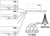
进一步的,所述OBU设备(1)是车辆统计的核心部件,其主要完成车辆统计过程中的本车的位置判断、车道适配以及消息发送;RSU设备(2)是车辆统计的中间设备,其收集并整理覆盖区域内的OBU设备(1)发送的相关统计数据,用于当前路口交通信号灯的实时控制,并将当前路口的车辆统计数据以固定周期向MEC服务器(3)发送;MEC服务器将RSU设备(2)发送的统计消息进行整理并存储在数据库中,以供区域内的交通管理和控制使用。Further, the OBU device (1) is the core component of vehicle statistics, and it mainly completes the position judgment, lane adaptation and message transmission of the vehicle in the vehicle statistics process; the RSU device (2) is an intermediate device for vehicle statistics, It collects and organizes the relevant statistical data sent by the OBU device (1) in the coverage area for real-time control of traffic lights at the current intersection, and sends the vehicle statistical data at the current intersection to the MEC server (3) in a fixed period; the MEC server The statistical messages sent by the RSU device (2) are organized and stored in a database for use in traffic management and control in the area.
进一步的,还包括在车辆统计前行车道有效范围的设计配置步骤:首先,当前路口统计道路仅选择进入该路口方向的道路,离开该路口方向的道路为下一个路口的统计区域;其次,具体道路的统计有效范围由起始线StartLine和终止线EndLine来确定,终止线EndLine设定在当前路口的停止线处,其由各车道在此位置的中心点坐标相连而成;起始线StartLine位置是可变的,需根据具体路口道路情况以及RSU设备的最大通信范围而设定,其由道路两侧的两点的坐标相连而成。Further, it also includes the design and configuration steps of the effective range of the lane before vehicle statistics: first, only the road entering the direction of the intersection is selected for the current intersection statistics road, and the road leaving the direction of the intersection is the statistical area of the next intersection; secondly, the specific road is selected. The statistical valid range of the road is determined by the start line StartLine and the end line EndLine. The end line EndLine is set at the stop line of the current intersection, which is formed by connecting the coordinates of the center points of each lane at this position; the position of the start line StartLine It is variable and needs to be set according to the specific road conditions at the intersection and the maximum communication range of the RSU device. It is formed by connecting the coordinates of two points on both sides of the road.
进一步的,车辆统计前还包括进行车辆车道匹配的步骤:OBU设备对本车进行车道匹配时是借助RSU设备广播的MapData数据包而完成的;首先,OBU将自身的位置与MapData中的所有标定点的距离进行对比,以及将自身航向角与MapData中各路段的航向角进行对比,从而确定车辆所在道路,得到在某一交叉路口具有唯一性的道路标识码;之后,在车辆通过该道路的StartLine后,依次使用GuideLine1,GuideLine2(如果存在则使用)和最后的EndLine中的各个标定点与本车实时坐标进行距离对比,确定车辆所在具体车道,得到某条道路上唯一的车道标识码,完成车道适配过程。Further, before the vehicle statistics, it also includes the step of matching the vehicle lanes: when the OBU device performs lane matching on the vehicle, it is completed with the help of the MapData data packet broadcast by the RSU device; first, the OBU matches its own position with all the calibration points in the MapData. The distance of the vehicle is compared, and the heading angle of the vehicle is compared with the heading angle of each road section in MapData, so as to determine the road where the vehicle is located, and obtain a unique road identification code at a certain intersection; After that, use GuideLine1, GuideLine2 (if it exists) and each calibration point in the last EndLine to compare the distance with the real-time coordinates of the vehicle, determine the specific lane where the vehicle is located, get the unique lane identification code on a certain road, and complete the lane. adaptation process.
进一步的,所述RSU设备向OBU设备广播的当前路口的MapData数据包的内容,MapData数据包包括当前交叉路口各车道的位置及标号在内的基础地理数据,主要包括当前路口标识码,StartLine、GuideLine和EndLine中各点坐标,各路段的航向角,道路的标识码,车道标识码在内的道路基础数据。Further, the content of the MapData data packet of the current intersection broadcasted by the RSU device to the OBU device, the MapData data packet includes the basic geographic data including the position and label of each lane of the current intersection, mainly including the current intersection identification code, StartLine, The coordinates of each point in GuideLine and EndLine, the heading angle of each road segment, the road identification code, and the road basic data including the lane identification code.
进一步的,OBU设备向RSU设备发送的车辆统计消息的内容,车辆统计消息发送的统计数据类型有:进入统计区域,离开统计区域,改变车道,停止运动一段时间后重新运动四种;此外,统计消息内容主要包括当前路口标识码、所在道路标识码、车辆标识码、时间、车辆速度、加速度、航向角、3-D坐标(经纬度和海拔)和数据类型标识。Further, the content of the vehicle statistics message sent by the OBU device to the RSU device, the types of statistics data sent by the vehicle statistics message are: entering the statistics area, leaving the statistics area, changing lanes, and re-moving after stopping for a period of time; The content of the message mainly includes the current intersection identification code, road identification code, vehicle identification code, time, vehicle speed, acceleration, heading angle, 3-D coordinates (latitude and longitude and altitude) and data type identification.
进一步的,所述EndLine设置在当前交叉路口中的道路的实际停止线位置,由车道中心点位置坐标形成,以辅助车辆进行车道适配;而StartLine的位置是可变的,是根据V2X的最大通信距离以及大致需要进行车辆统计的道路区域而定的;若城市道路两个相邻交叉路口间距一般小于V2X最大通信距离,StartLine设置在该道路在上一个路口开始的位置;若两个相邻路口之间的距离大于V2X通信范围,则将该道路上的StartLine设置在能够与RSU设备进行可靠通信且距离RSU设备最远的位置,因此车辆统计有效范围为StartLine与EndLine之间的道路。Further, the EndLine is set at the actual stop line position of the road in the current intersection, and is formed by the position coordinates of the lane center point to assist the vehicle in lane adaptation; and the position of the StartLine is variable, according to the maximum value of V2X. It depends on the communication distance and the road area where vehicle statistics are roughly required; if the distance between two adjacent intersections on an urban road is generally less than the maximum V2X communication distance, StartLine is set at the position where the road starts at the previous intersection; if two adjacent intersections are If the distance between intersections is greater than the V2X communication range, the StartLine on the road is set at the position that can reliably communicate with the RSU device and is the farthest from the RSU device. Therefore, the effective range of vehicle statistics is the road between StartLine and EndLine.
进一步的,GuideLine位于StartLine和EndLine之间,用于辅助车辆进行车道匹配,其数量需要根据道路弯曲情况设定,若统计区域内的道路笔直,一般在50米左右的间距,从StartLine向EndLine方向依次设定,若统计区域内的道路存在弯道,则在保证车道适配准确性的前提下多弯道处增加GuideLine的数量。Further, GuideLine is located between StartLine and EndLine, and is used to assist vehicles in lane matching. The number of GuideLines needs to be set according to the road curvature. If the road in the statistical area is straight, it is generally about 50 meters away from StartLine to EndLine. Set in order, if the road in the statistical area has curves, the number of GuideLines will be increased at multiple curves under the premise of ensuring the accuracy of lane adaptation.
进一步的,所述MapData数据包由包括StartLine、GuideLine和EndLine、各路段航向角值以及道路标识码在内的数据编码而成,首先,采集各道路的航向角值,即道路方向与正北方向沿顺时针方向的夹角,如果道路存在弯道,则采集两条GuideLine之间的大致航向角值;然后,将以上的三种辅助线中的各标定点的坐标、各路段航向角值,以及路口标识码、道路标识码、车道标识码和每个车道相连的下一路口ID等信息存储在所负责的RSU设备中的MapData数据中,以固定周期通过V2X通信进行广播,以用于辅助车辆OBU设备确定所在的车道位置。Further, the MapData data packet is encoded by data including StartLine, GuideLine and EndLine, the heading angle value of each road section and the road identification code. First, the heading angle value of each road is collected, that is, the road direction and the true north direction. The angle along the clockwise direction, if the road has a curve, collect the approximate heading angle value between the two GuideLines; Information such as intersection identification code, road identification code, lane identification code, and the next intersection ID connected to each lane are stored in the MapData data in the responsible RSU device, and broadcast through V2X communication at a fixed period for assistance. The vehicle OBU device determines the lane location.
进一步的,如果交叉路口附近道路存在弯道,首先根据V2X通信范围以及大致统计区域选择统计起始线StartLine的位置,统计区域终止线EndLine设置在该路口的实际停止线位置,而GuideLine需要根据道路弯曲程度进行适当增加,主要以两GuideLine之间的道路航向角内改变范围不超过45度为原则。Further, if there is a curve in the road near the intersection, first select the position of the start line StartLine according to the V2X communication range and the approximate statistical area, and set the end line of the statistical area EndLine at the actual stop line position of the intersection, and GuideLine needs to be based on the road. The degree of bending should be appropriately increased, mainly based on the principle that the change range of the road heading angle between the two GuideLines does not exceed 45 degrees.
本发明的优点及有益效果如下:The advantages and beneficial effects of the present invention are as follows:
1.在没有车道级地图的前提下,通过对统计区域的道路进行特殊点的位置标定,使用所提出的车道识别算法以及越线算法实现了对道路中车辆进行车道级的高效统计。1. On the premise of no lane-level map, by calibrating the location of special points on the road in the statistical area, using the proposed lane recognition algorithm and line crossing algorithm to achieve efficient lane-level statistics on vehicles in the road.
2.统计数据存储在负责当前交叉路口或者路段的RSU设备中,可以保证RSU设备根据当前交叉路口车辆分布情况实时周期性控制交通灯,以应对突发性的交通状况;另外统计数据在每个交通灯的周期结束时向MEC服务器发送汇总的当前周期内的统计数据,以供大数据平台分析,实现对交通的智能管理;通过这种分级统计数据存储的方式使得统计数据利用效率最大化和统计实时性提升的同时,保证了交通管理策略制定的合理性。2. The statistical data is stored in the RSU device responsible for the current intersection or road section, which can ensure that the RSU device periodically controls the traffic lights in real time according to the current intersection vehicle distribution to cope with sudden traffic conditions; At the end of the traffic light cycle, the aggregated statistical data in the current cycle is sent to the MEC server for analysis by the big data platform to realize intelligent management of traffic; this hierarchical statistical data storage method maximizes the efficiency of statistical data utilization and While the real-time performance of statistics is improved, the rationality of the formulation of traffic management strategies is ensured.
3.车道车辆位置的判断过程是在OBU设备实时进行的,减少了路侧设备的负载;RSU设备发送基础定位的MapData数据包以及接收各个车辆中的OBU设备发送的不同类型的统计消息即可完成车辆统计;这样可以在保证车辆统计数据的实时性和准确性的同时,降低RSU设备的计算压力,以及减少V2X通信信道服务压力。3. The process of judging the position of the vehicle in the lane is carried out in real time in the OBU device, which reduces the load of the roadside device; the RSU device sends the MapData data packets of basic positioning and receives different types of statistical messages sent by the OBU device in each vehicle. Complete vehicle statistics; in this way, while ensuring the real-time and accuracy of vehicle statistics, the calculation pressure of RSU equipment can be reduced, and the service pressure of V2X communication channel can be reduced.
附图说明Description of drawings
图1是本发明提供优选实施例统计区域内的无弯道情况下道路关键位置标定示意图;1 is a schematic diagram of the road key position calibration under the condition of no curve in the statistical area provided by the preferred embodiment of the present invention;
图2是车辆统计架构模型;Figure 2 is a vehicle statistical architecture model;
图3是OBU设备进行车道适配流程图;Figure 3 is a flowchart of lane adaptation performed by OBU equipment;
图4是统计区域内有弯道情况下道路关键位置标定示意图。Figure 4 is a schematic diagram of the road key position calibration when there are curves in the statistical area.
具体实施方式Detailed ways
下面将结合本发明实施例中的附图,对本发明实施例中的技术方案进行清楚、详细地描述。所描述的实施例仅仅是本发明的一部分实施例。The technical solutions in the embodiments of the present invention will be described clearly and in detail below with reference to the accompanying drawings in the embodiments of the present invention. The described embodiments are only some of the embodiments of the invention.
本发明解决上述技术问题的技术方案是:The technical scheme that the present invention solves the above-mentioned technical problems is:
1.基于V2X通信和高精度定位的车辆统计硬件架构及各设备间的通信方式1. Vehicle statistics hardware architecture based on V2X communication and high-precision positioning and communication methods between devices
A.硬件架构包含三种类型的设备:OBU设备、RSU设备以及MEC服务器。三者之间的通信连接关系如图2所示,其中OBU与RSU之间使用C-V2X来实现V2I通信,RSU与MEC服务器之间使用蜂窝通信网及光纤通信网进行通信。A. The hardware architecture includes three types of devices: OBU devices, RSU devices, and MEC servers. The communication connection relationship between the three is shown in Figure 2, where C-V2X is used between OBU and RSU to realize V2I communication, and cellular communication network and optical fiber communication network are used for communication between RSU and MEC server.
B.OBU设备中使用相关的模块能够进行高精度定位,V2X通信,通过Wi-Fi通信建立车内互联网络,以及运行操作系统和相关应用。The related modules used in B.OBU equipment can perform high-precision positioning, V2X communication, establish in-vehicle interconnection network through Wi-Fi communication, and run operating system and related applications.
C.RSU设备能够进行V2X通信,以及通过蓝牙与交叉路口内各组交通信号灯通信,通过移动蜂窝网络与MEC服务器进行通信,通过高精度定位对其自身位置进行定位,以及运行操作系统和相关应用。C. The RSU device can communicate with V2X, communicate with each group of traffic lights in the intersection through Bluetooth, communicate with the MEC server through the mobile cellular network, locate its own position through high-precision positioning, and run the operating system and related applications .
2.基于V2X和高精度定位的城市车道车辆统计实现方法2. Implementation method of vehicle statistics in urban lanes based on V2X and high-precision positioning
A.首先对统计区域以及区域内的各路段进行划分。路段划分由三种辅助线(StartLine、GuideLine和EndLine)来确定,这三种辅助线是对统计区域内的道路的关键位置进行坐标标定而形成,统计区域内各辅助线设置如图4所示。其中EndLine设置在当前交叉路口中的道路的实际停止线位置,由车道中心点位置坐标形成,以辅助车辆进行车道适配;而StartLine的位置是可变的,是根据V2X的最大通信距离以及大致需要进行车辆统计的道路区域而定的;若城市道路两个相邻交叉路口间距一般小于V2X最大通信距离,StartLine一般设置在该道路在上一个路口开始的位置;若两个相邻路口之间的距离大于V2X通信范围,则将该道路上的StartLine设置在能够与RSU设备进行可靠通信且距离RSU设备最远的位置,因此车辆统计有效范围为StartLine与EndLine之间的道路。另外,GuideLine位于StartLine和EndLine之间,用于辅助车辆进行车道匹配,其数量需要根据道路弯曲情况设定,若统计区域内的道路笔直,一般在50米左右的间距,从StartLine向EndLine方向依次设定,若统计区域内的道路存在弯道,则在保证车道适配准确性的前提下多弯道处适当增加GuideLine的数量。A. First, divide the statistical area and each road section within the area. The road segment division is determined by three auxiliary lines (StartLine, GuideLine and EndLine). These three auxiliary lines are formed by the coordinate calibration of the key positions of the roads in the statistical area. The auxiliary lines in the statistical area are set as shown in Figure 4. . Among them, EndLine is set at the actual stop line position of the road in the current intersection, which is formed by the coordinates of the lane center point to assist the vehicle in lane adaptation; and the position of StartLine is variable, according to the maximum communication distance of V2X and the approximate It depends on the road area that needs to be counted; if the distance between two adjacent intersections on an urban road is generally less than the maximum communication distance of V2X, StartLine is generally set at the position where the road starts at the previous intersection; If the distance is greater than the V2X communication range, the StartLine on the road is set at the position that can reliably communicate with the RSU device and is the farthest away from the RSU device. Therefore, the effective range of vehicle statistics is the road between StartLine and EndLine. In addition, GuideLine is located between StartLine and EndLine, which is used to assist vehicles in lane matching. The number of GuideLines needs to be set according to the road curvature. If the road in the statistical area is straight, it is generally about 50 meters away, from StartLine to EndLine. Setting, if the roads in the statistical area have curves, the number of GuideLines will be appropriately increased at multiple curves under the premise of ensuring the accuracy of lane adaptation.
B.将上述三条辅助线、各路段航向角值以及道路标识码等数据编码成MapData数据包。首先,采集各道路的航向角值,即道路方向与正北方向沿顺时针方向的夹角,如果道路存在弯道,则采集两条GuideLine之间的大致航向角值。然后,将以上的三种辅助线中的各标定点的坐标、各路段航向角值,以及路口标识码、道路标识码、车道标识码和每个车道相连的下一路口ID等信息存储在所负责的RSU设备中的MapData数据中,以固定周期通过V2X通信进行广播,以用于辅助车辆OBU设备确定所在的车道位置。B. Encode the above three auxiliary lines, the heading angle value of each road section and the road identification code into a MapData packet. First, collect the heading angle value of each road, that is, the clockwise angle between the road direction and the true north direction. If the road has a curve, collect the approximate heading angle value between the two GuideLines. Then, the coordinates of each calibration point in the above three auxiliary lines, the heading angle value of each road section, and the intersection identification code, road identification code, lane identification code and the next intersection ID connected to each lane are stored in the The MapData data in the responsible RSU device is broadcast through V2X communication at a fixed period to assist the vehicle OBU device to determine the lane location.
C.OBU接收并筛选所需要的MapData数据包。当某一车辆接近路口时,其车载终端会接收到附近一个或多个路口的路侧设备发送的MapData,并解析;借助MapData中的全国唯一的路口标识码和路口中心点3-D(经纬度和海拔)坐标,以及车辆导航线路中即将通过的路口标识码,来筛选并只存储即将抵达的路口的路侧设备发送的MapData数据包。C.OBU receives and filters the required MapData packets. When a vehicle approaches an intersection, its on-board terminal will receive and parse the MapData sent by roadside devices at one or more nearby intersections; with the help of the nationally unique intersection identification code and intersection center point 3-D (latitude and longitude) in MapData and altitude) coordinates, and the identification code of the upcoming intersection in the vehicle navigation route, to filter and store only the MapData data packets sent by the roadside equipment at the upcoming intersection.
D.OBU设备使用MapData中的数据确定车辆所在的道路。首先,OBU设备借助车载高精度定位中的位置坐标,实时地与MapData中的标志线(StartLine、GuideLine和EndLine)的坐标点和一些特殊的标记点坐标数据进行比较,确定车辆大致所在道路;然后,OBU再通过本车航向角与该道路各个路段的航向角值进行对比,最终确定车辆所在道路,获得该道路在MapData中的道路标识码。D. The OBU device uses the data in MapData to determine which road the vehicle is on. First, the OBU device compares the coordinate points of the marker lines (StartLine, GuideLine and EndLine) in MapData and some special marker point coordinate data in real time with the help of the position coordinates in the vehicle high-precision positioning to determine the approximate road where the vehicle is located; then , OBU then compares the heading angle of the vehicle with the heading angle value of each section of the road, finally determines the road where the vehicle is located, and obtains the road identification code of the road in MapData.
E.OBU设备使用MapData中的StartLine判断车辆是否进入统计区域。假设现在已确定车辆在图1中的Road4的道路上,OBU首先判断车辆是否进入统计路段,即本车是否通过Road4中的起始线StartLine,若未通过,车辆不进行其他判断,仅循环判断是否通过StartLine;当OBU设备第一次检测到通过StartLine时,通过V2X通信向RSU设备发送进入统计区域的消息,统计消息内容包括当前路口标识码、所在道路标识码、车辆标识码、时间、车辆速度、航向角、3-D坐标(经纬度和海拔)和数据类型标识等数据。The E.OBU device uses the StartLine in MapData to determine whether the vehicle enters the statistical area. Assuming that it is now determined that the vehicle is on the road of Road4 in Figure 1, the OBU first determines whether the vehicle enters the statistical road section, that is, whether the vehicle passes the start line StartLine in Road4. If it does not pass, the vehicle does not make other judgments, only loop judgment Whether to pass StartLine; when the OBU device detects that it has passed the StartLine for the first time, it sends a message entering the statistical area to the RSU device through V2X communication. The content of the statistical message includes the identification code of the current intersection, road identification code, vehicle identification code, time, vehicle Data such as speed, heading angle, 3-D coordinates (latitude and longitude and altitude) and data type identification.
F.车辆进入统计区域后,OBU使用辅助线GuideLine和EndLine判断车辆所在的具体车道。在车辆进入统计区域后,OBU首先通过自身实时的位置坐标与GuideLine1中的每个点的坐标进行距离对比,从而得到车辆所在车道及其标识码LaneID;当检测到车辆通过GuideLine1后,使用GuideLine2(如果MapData中有此辅助线时)进行辅助车道适配,当通过GuideLine2后使用下一条辅助线,直到最后车辆通过EndLine。F. After the vehicle enters the statistical area, OBU uses the auxiliary lines GuideLine and EndLine to determine the specific lane where the vehicle is located. After the vehicle enters the statistical area, OBU first compares its real-time position coordinates with the coordinates of each point in GuideLine1 to obtain the lane where the vehicle is located and its identification code LaneID; when it detects that the vehicle passes through GuideLine1, use GuideLine2 ( If there is this auxiliary line in the MapData), the auxiliary lane will be adapted, and the next auxiliary line will be used after passing through GuideLine2 until the vehicle finally passes through the EndLine.
G.当车辆在统计区域内时,OBU在特定位置和时刻通过V2I通信发送车辆统计消息。当车辆在StartLine和EndLine之间行驶时,如果OBU设备检测车辆有变道时,将通过V2X通信向RSU设备发送变道类型的统计消息,包括当前路口标识码、所在道路标识码、车辆标识码、时间、车辆速度、航向角、3-D坐标(经纬度和海拔)和数据类型标识等数据;另外,如果车辆在统计区域内出现因交通拥堵或者等待红灯等情况而停车,OBU设备将在车辆重新开始运动时通过V2X发送重新运动类型的统计消息,包括当前路口标识码、所在道路标识码、车辆标识码、时间、车辆速度、航向角、3-D坐标(经纬度和海拔)、停车等待时间和数据类型标识等数据。G. When the vehicle is in the statistical area, the OBU sends the vehicle statistics message through V2I communication at a specific location and time. When the vehicle is driving between StartLine and EndLine, if the OBU device detects that the vehicle has changed lanes, it will send a statistical message of the lane change type to the RSU device through V2X communication, including the current intersection identification code, road identification code, and vehicle identification code. , time, vehicle speed, heading angle, 3-D coordinates (latitude, longitude and altitude) and data type identification; in addition, if the vehicle stops due to traffic congestion or waiting for a red light in the statistical area, the OBU device will When the vehicle starts to move again, send the statistics message of the re-movement type through V2X, including the current intersection identification code, road identification code, vehicle identification code, time, vehicle speed, heading angle, 3-D coordinates (latitude and longitude and altitude), parking waiting Data such as time and data type identification.
H.OBU设备使用MapData中的EndLine判断车辆是否离开统计区域。OBU通过车辆与EndLine之间的距离变化判断车辆是否离开通过EndLine,当第一次检测到本车通过时,OBU通过V2I通信向RSU设备发送离开该统计区域类型的统计消息,其内容包括当前路口标识码、所在道路标识码、离开时的车道标识码、车辆标识码、时间、车辆速度、航向角、3-D坐标(经纬度和海拔)和数据类型标识等数据,并开始下一个交叉路口的车辆统计。The H.OBU device uses the EndLine in MapData to determine whether the vehicle leaves the statistical area. The OBU judges whether the vehicle leaves the EndLine through the change in the distance between the vehicle and the EndLine. When it detects the passing of the vehicle for the first time, the OBU sends a statistical message of the type of leaving the statistical area to the RSU device through V2I communication, the content of which includes the current intersection. Identification code, road identification code, lane identification code when leaving, vehicle identification code, time, vehicle speed, heading angle, 3-D coordinates (latitude and longitude and altitude) and data type identification, and start the next intersection. Vehicle Statistics.
I.RSU设备过滤并接收统计区域内的车辆统计消息。由于RSU可以收到其通信范围内的所有OBU发送的统计数据,所以RSU在存储统计数据前需根据路口标识码判断该数据是否是其所负责的统计路段的OBU发送的统计数据。如果是,则将该数据存储在本地数据库中;如果不是,则丢弃处理。The I.RSU device filters and receives vehicle statistics messages within the statistics area. Since the RSU can receive the statistical data sent by all OBUs within its communication range, before storing the statistical data, the RSU needs to judge whether the data is the statistical data sent by the OBU of the statistical road section it is responsible for according to the intersection identification code. If it is, store that data in the local database; if not, discard processing.
J.将统计数据进行两级存储。RSU收到并确认为当前统计区域内的OBU发送的车辆统计数据后,RSU将其存储在本地数据库中,用于应对突发交通状况下的当前路口的交通信号灯的实时控制;另外,RSU设备在一个交通信号灯周期即将结束时向MEC服务器发送本地统计数据,以供大数据分析,实现对区域内的各路口的交通灯的智能控制。J. The statistical data is stored in two levels. After the RSU receives and confirms the vehicle statistics data sent by the OBU in the current statistical area, the RSU stores it in the local database for real-time control of the traffic lights at the current intersection under unexpected traffic conditions; in addition, the RSU equipment When a traffic light cycle is about to end, local statistical data is sent to the MEC server for big data analysis to realize intelligent control of traffic lights at various intersections in the area.
以下对本发明的优选实例进行详细的描述:应当理解,优选实例仅为了说明本发明,而不是为了限制本发明的保护范围。The preferred examples of the present invention are described in detail below: it should be understood that the preferred examples are only for illustrating the present invention, rather than for limiting the protection scope of the present invention.
优选实例1:统计道路笔直Preferred Example 1: Statistical Road Straightness
在城市道路中,交叉路口附近道路一般是没有弯道或者道路接近笔直;并且两个相邻交叉路口距离不会超过V2X通信范围。因此,如图1所示,统计道路中起始线StartLine设定在上一个路口的位置,终止线EndLine设定在该路口的实际停止线位置,并在两线之间每隔50米设定一条辅助线GuideLine。In urban roads, the road near the intersection generally has no curves or the road is nearly straight; and the distance between two adjacent intersections will not exceed the V2X communication range. Therefore, as shown in Figure 1, the starting line StartLine in the statistical road is set at the position of the previous intersection, and the ending line EndLine is set at the actual stop line position of the intersection, and is set every 50 meters between the two lines. An auxiliary line GuideLine.
优选实例2:统计路段存在弯道情况Preferred Example 2: Statistical Road Sections Existing Curves
在特殊城市道路中,如果交叉路口附近道路存在弯道,如图4所示,首先是根据V2X通信范围以及大致统计区域选择统计起始线StartLine的位置,统计区域终止线EndLine设置在该路口的实际停止线位置,而GuideLine需要根据道路弯曲程度进行适当增加,主要以两GuideLine之间的道路航向角内改变范围不超过45度为原则,当然如果在弯道区域设定的GuideLine密度越大,车辆进行车道适配的结果越精确,但是MapData的数据包会变大,导致V2X通信信道服务压力增大,同时RSU设备广播MapData前,对其编码的时间以及OBU设备解码的时间会增加,因此GuideLine的密度需要合理设置。In a special urban road, if there is a curve near the intersection, as shown in Figure 4, the first step is to select the position of the start line of the statistics based on the V2X communication range and the approximate statistical area, and the end line of the statistical area EndLine is set at the intersection. The actual stop line position, and GuideLine needs to be appropriately increased according to the degree of road curvature, mainly based on the principle that the change range of the road heading angle between the two GuideLines does not exceed 45 degrees. Of course, if the density of GuideLines set in the curve area is greater, The more accurate the result of the vehicle's lane adaptation, but the larger the MapData data packet will be, which will increase the service pressure of the V2X communication channel. At the same time, before the RSU device broadcasts the MapData, the encoding time and the OBU device decoding time will increase. Therefore, The density of GuideLine needs to be set reasonably.
以上这些实施例应理解为仅用于说明本发明而不用于限制本发明的保护范围。在阅读了本发明的记载的内容之后,技术人员可以对本发明作各种改动或修改,这些等效变化和修饰同样落入本发明权利要求所限定的范围。The above embodiments should be understood as only for illustrating the present invention and not for limiting the protection scope of the present invention. After reading the contents of the description of the present invention, the skilled person can make various changes or modifications to the present invention, and these equivalent changes and modifications also fall within the scope defined by the claims of the present invention.
Claims (7)
Translated fromChinesePriority Applications (1)
| Application Number | Priority Date | Filing Date | Title |
|---|---|---|---|
| CN201810811992.4ACN109147316B (en) | 2018-07-23 | 2018-07-23 | Urban lane vehicle statistical method based on V2X communication and high-precision positioning |
Applications Claiming Priority (1)
| Application Number | Priority Date | Filing Date | Title |
|---|---|---|---|
| CN201810811992.4ACN109147316B (en) | 2018-07-23 | 2018-07-23 | Urban lane vehicle statistical method based on V2X communication and high-precision positioning |
Publications (2)
| Publication Number | Publication Date |
|---|---|
| CN109147316A CN109147316A (en) | 2019-01-04 |
| CN109147316Btrue CN109147316B (en) | 2022-05-03 |
Family
ID=64801444
Family Applications (1)
| Application Number | Title | Priority Date | Filing Date |
|---|---|---|---|
| CN201810811992.4AActiveCN109147316B (en) | 2018-07-23 | 2018-07-23 | Urban lane vehicle statistical method based on V2X communication and high-precision positioning |
Country Status (1)
| Country | Link |
|---|---|
| CN (1) | CN109147316B (en) |
Families Citing this family (17)
| Publication number | Priority date | Publication date | Assignee | Title |
|---|---|---|---|---|
| CN109862086B (en)* | 2019-01-21 | 2020-10-09 | 华北电力大学 | Task allocation strategy based on matching algorithm in vehicle-mounted edge calculation |
| US11462111B2 (en)* | 2019-04-29 | 2022-10-04 | Qualcomm Incorporated | Method and apparatus for vehicle maneuver planning and messaging |
| CN110588726A (en)* | 2019-09-26 | 2019-12-20 | 公安部交通管理科学研究所 | A LTE-V2X-based tram signal priority control system and method |
| CN110827555B (en)* | 2019-10-24 | 2020-08-21 | 浩鲸云计算科技股份有限公司 | Traffic signal control system and method based on software definition |
| CN110782703A (en)* | 2019-10-30 | 2020-02-11 | 长安大学 | Forward collision early warning method based on LTE-V communication |
| CN110823242B (en)* | 2019-11-23 | 2023-03-21 | 芜湖雄狮汽车科技有限公司 | Path planning system applied to vehicle steering at road intersection |
| EP4088493A4 (en)* | 2020-01-07 | 2024-01-17 | Qualcomm Incorporated | DETERMINATION AND ANNOUNCEMENT OF AN INTERSECTION PATH |
| CN114079854A (en)* | 2020-08-17 | 2022-02-22 | 华为技术有限公司 | C-V2X low power consumption method, electronic device and chip system |
| CN112071087B (en)* | 2020-08-18 | 2022-12-23 | 浙江吉利汽车研究院有限公司 | A V2I-based speed limit early warning method, system, vehicle and storage medium |
| CN112906742B (en)* | 2021-01-19 | 2023-03-28 | 重庆邮电大学 | Two-wheel vehicle identification system and method based on 5G + V2X mobile terminal and high-precision map |
| CN113156938A (en)* | 2021-02-23 | 2021-07-23 | 深圳优地科技有限公司 | Method and device for controlling robot to run, terminal equipment and storage medium |
| CN113124894B (en)* | 2021-03-24 | 2024-05-31 | 联想(北京)有限公司 | Information processing method, information processing device and electronic equipment |
| CN113570868A (en)* | 2021-09-26 | 2021-10-29 | 华砺智行(武汉)科技有限公司 | Intersection green light passing rate calculation method, device, equipment and storage medium |
| CN116233795A (en)* | 2021-12-03 | 2023-06-06 | 北京万集科技股份有限公司 | Information interaction method, device, terminal and storage medium |
| CN114339678A (en)* | 2022-01-06 | 2022-04-12 | 高新兴智联科技有限公司 | Vehicle driving assisting communication method and communication system based on V2X |
| CN115690162B (en)* | 2022-12-28 | 2023-03-10 | 武汉凡德智能科技有限公司 | Method and device for detecting moving large target in fixed video |
| CN116013071B (en)* | 2022-12-30 | 2025-01-21 | 云控智行科技有限公司 | A data collection method, device and equipment based on electronic fence |
Citations (10)
| Publication number | Priority date | Publication date | Assignee | Title |
|---|---|---|---|---|
| CN103745607A (en)* | 2014-01-09 | 2014-04-23 | 中国科学技术大学苏州研究院 | Cooperative vehicle infrastructure-based curve speed warning method |
| CN104021684A (en)* | 2014-06-19 | 2014-09-03 | 奇瑞汽车股份有限公司 | Collaborative vehicular access traffic control system |
| CN104537848A (en)* | 2015-01-08 | 2015-04-22 | 南开大学 | Urban road traffic state detecting method based on vehicle ad-hoc network |
| CN104637315A (en)* | 2015-02-06 | 2015-05-20 | 北京交通大学 | Non-signalized crossing optimization control method and system in cooperative vehicle infrastructure environment |
| CN104835321A (en)* | 2015-05-04 | 2015-08-12 | 石立公 | Lane vehicle flow statistical system and lane vehicle flow statistical method |
| CN105206090A (en)* | 2015-10-13 | 2015-12-30 | 厦门星辰天羽汽车设计有限公司 | Vehicle positioning method |
| CN105588576A (en)* | 2015-12-15 | 2016-05-18 | 重庆云途交通科技有限公司 | Lane level navigation method and system |
| CN105844904A (en)* | 2016-04-22 | 2016-08-10 | 北京航空航天大学 | Vehicle abnormal behavior detection and tracking method based on DSRC |
| CN106056100A (en)* | 2016-06-28 | 2016-10-26 | 重庆邮电大学 | Vehicle auxiliary positioning method based on lane detection and object tracking |
| US20170301232A1 (en)* | 2016-04-13 | 2017-10-19 | Here Global B.V. | Intersection Map Message Creation for Vehicle Communication |
- 2018
- 2018-07-23CNCN201810811992.4Apatent/CN109147316B/enactiveActive
Patent Citations (10)
| Publication number | Priority date | Publication date | Assignee | Title |
|---|---|---|---|---|
| CN103745607A (en)* | 2014-01-09 | 2014-04-23 | 中国科学技术大学苏州研究院 | Cooperative vehicle infrastructure-based curve speed warning method |
| CN104021684A (en)* | 2014-06-19 | 2014-09-03 | 奇瑞汽车股份有限公司 | Collaborative vehicular access traffic control system |
| CN104537848A (en)* | 2015-01-08 | 2015-04-22 | 南开大学 | Urban road traffic state detecting method based on vehicle ad-hoc network |
| CN104637315A (en)* | 2015-02-06 | 2015-05-20 | 北京交通大学 | Non-signalized crossing optimization control method and system in cooperative vehicle infrastructure environment |
| CN104835321A (en)* | 2015-05-04 | 2015-08-12 | 石立公 | Lane vehicle flow statistical system and lane vehicle flow statistical method |
| CN105206090A (en)* | 2015-10-13 | 2015-12-30 | 厦门星辰天羽汽车设计有限公司 | Vehicle positioning method |
| CN105588576A (en)* | 2015-12-15 | 2016-05-18 | 重庆云途交通科技有限公司 | Lane level navigation method and system |
| US20170301232A1 (en)* | 2016-04-13 | 2017-10-19 | Here Global B.V. | Intersection Map Message Creation for Vehicle Communication |
| CN105844904A (en)* | 2016-04-22 | 2016-08-10 | 北京航空航天大学 | Vehicle abnormal behavior detection and tracking method based on DSRC |
| CN106056100A (en)* | 2016-06-28 | 2016-10-26 | 重庆邮电大学 | Vehicle auxiliary positioning method based on lane detection and object tracking |
Non-Patent Citations (1)
| Title |
|---|
| "Sensing Traffic Density Combining V2V and V2I Wireless Communications";Julio A. Sanguesa;《sensors》;20151231;第31794-31810页* |
Also Published As
| Publication number | Publication date |
|---|---|
| CN109147316A (en) | 2019-01-04 |
Similar Documents
| Publication | Publication Date | Title |
|---|---|---|
| CN109147316B (en) | Urban lane vehicle statistical method based on V2X communication and high-precision positioning | |
| CN109003467B (en) | Method, device and system for preventing vehicle collision | |
| An et al. | A survey of intelligent transportation systems | |
| CN101270997B (en) | Floating car dynamic real-time traffic information processing method based on GPS data | |
| CN105654562B (en) | A kind of system and method for highway non-parking charge | |
| WO2011063607A1 (en) | Expressway charging system and expressway charging method based on gps navigation technology | |
| CN105588576A (en) | Lane level navigation method and system | |
| CN102521997A (en) | System and method of open type service for parking space | |
| CN103208180B (en) | Based on Dispatch system of ITS and the method for multiple agent interaction technique | |
| CN103383811A (en) | Intelligent traffic solution scheme based on GID | |
| CN105225505A (en) | crossing bus signal priority control system | |
| KR20210069954A (en) | Artificial Intelligence-based Integrated Traffic Signal Control System and Method Using Big-data | |
| CN107564310A (en) | A kind of bus or train route interacted system and method based on the processing of Traffic Information cloud | |
| CN103177561A (en) | Method and system for generating bus real-time traffic status | |
| CN106971535B (en) | A kind of urban traffic blocking index computing platform based on Floating Car GPS real time data | |
| CN101436346A (en) | Traffic intelligent management system and method | |
| CN108039046A (en) | A kind of city intersection pedestrian detection identifying system based on C-V2X | |
| CN105096625A (en) | Method of acquiring real-time road condition information, system and server | |
| CN106097718A (en) | Signal cross port area transit time method of estimation based on gps data | |
| WO2024114414A1 (en) | Method and apparatus for pushing v2x event | |
| CN102129774A (en) | Intelligent traffic self-networking system with cloudlet function | |
| CN105118317A (en) | Traffic management service system based on cloud services | |
| JP2020024693A (en) | Moving space information processing system, moving space information processing method and communication device | |
| CN103514741A (en) | Traffic jam information processing system and mobile communication terminal | |
| CN109658691A (en) | The recording method of electric vehicle red light violation and system |
Legal Events
| Date | Code | Title | Description |
|---|---|---|---|
| PB01 | Publication | ||
| PB01 | Publication | ||
| SE01 | Entry into force of request for substantive examination | ||
| SE01 | Entry into force of request for substantive examination | ||
| GR01 | Patent grant | ||
| GR01 | Patent grant |